The health of our waters is the principal measure of how we live on the land — Luna Leopold
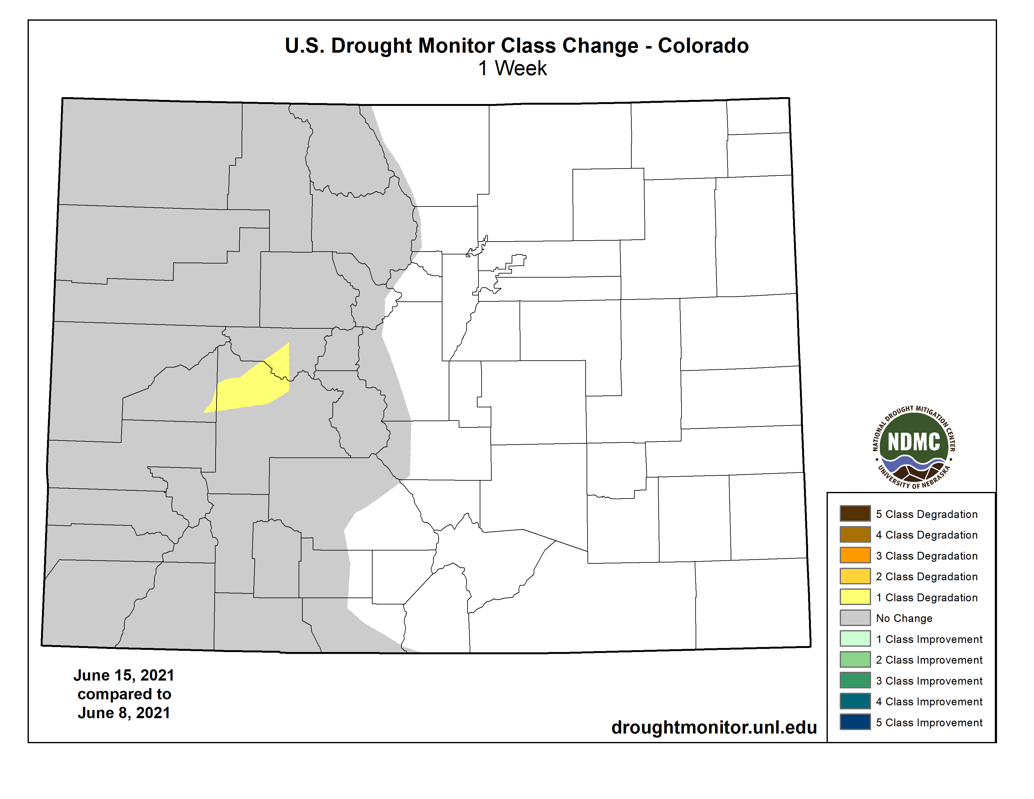
#Drought news: One class degradation in parts of Gunnison, Pitkin, and Delta counties
Click on a thumbnail graphic to view a gallery of drought data from the US Drought Monitor.
US Drought Monitor map June 15, 2021.
High Plains Drought Monitor map June 15, 2021.
West Drought Monitor map June 15, 2021.
Colorado Drought Monitor map June 15, 2021.
Click here to go to the US Drought Monitor website. Here’s an excerpt:
This Week’s Drought Summary
Warmer than normal temperatures continued their hold this week on the northern tier of the Lower 48, particularly in the northern Great Plains and Upper Midwest. Across the north, widespread degradation of drought conditions occurred in areas where heavy rainfall missed. A few areas that received heavy precipitation and saw localized improvements were coastal Oregon and Washington, western Montana, and eastern Montana and western North Dakota. Widespread heavy rain occurred in the Southeast and Mid-Atlantic, where drought conditions improved or ceased in many locations. Scattered storms over the last few weeks in the southern Great Plains and eastern New Mexico led to isolated improvements to drought conditions, and a few degradations to drought conditions in western Oklahoma where heavier storms missed. Conditions improved after beneficial rainfall in eastern Puerto Rico. Continued drying in Hawaii led to degradation in drought conditions on many of the islands…
Colorado Drought Monitor one week change map ending June 15, 2021.
Precipitation across the High Plains region varied significantly this week, though very warm temperatures were consistent across the region. Notably, many places in the central and northern Great Plains have had warmer daytime high temperatures than much of the southern Great Plains, leading to potentially large losses of surface moisture to the atmosphere through evaporation and transpiration in the northern Great Plains. A few areas in the western half of North Dakota received enough rain from several thunderstorm events to improve their drought status, though this primarily occurred in areas with very heavy rain amounts (some locales received over 5 inches). For the most part, while welcome, the heavy rains have come after months of warm and dry conditions, and the widespread severe, extreme, and exceptional drought has been slow to improve as impacts to plants and livestock continue. In north-central and northeast South Dakota, and adjacent portions of North Dakota, moderate and severe drought expanded…
Three notable widespread precipitation events occurred in the northwestern United States this week, which led to limited improvements in northeast Montana, western Montana, and coastal regions of Washington and Oregon. Recent scattered rainfall from thunderstorms in the high plains and high desert of eastern and south-central New Mexico improved drought conditions locally, though widespread moderate-to-exceptional drought maintained its grip on most of the state. Northeast Montana received locally enough rain from severe thunderstorms for limited improvement from extreme to severe drought. However, similar to North Dakota and South Dakota, agricultural impacts and warm temperatures continued, limiting the rain’s benefit on conditions in the area. A swath of precipitation covered areas from southwest Idaho to the high country of western Montana, leading to a small area of improved conditions in western Montana. Finally, a late-season atmospheric river event delivered welcome precipitation to coastal portions of Washington and Oregon, which improved short- and long-term precipitation deficits enough for localized one- and two-category improvements in drought conditions. Unfortunately, most of the rest of the West received little to no precipitation, and warmer than normal temperatures plagued much of the region. Degradations to conditions occurred in northeast California and south-central Oregon, southern Montana, central and western Wyoming, far east-central Wyoming, and the high country of west-central Colorado. All of these locations saw short- and long-term precipitation deficits continue to mount. Most of the West region remained in moderate, severe, extreme, or exceptional drought. In central California, farmers have been warned about potential water cutoffs, while wildfire concerns and firework restrictions are prevalent in Utah, Arizona, and New Mexico…
Scattered heavy rain fell across the eastern half of the region this week, while rains were much spottier (though locally heavy) in Texas and Oklahoma. Moderate and severe drought conditions shifted northwest in western Oklahoma in response to changing conditions after rain this week, leaving some areas improved and others degraded. Several areas in southwest Texas saw improvement this week after rain from the last couple of weeks improved conditions there. In southwest Texas, the Trans-Pecos, and along the Rio Grande to near Laredo, abnormal dryness and all drought categories continued…
Looking Ahead
As of June 16, the National Weather Service (NWS) Weather Prediction Center is forecasting two areas of significant precipitation through the evening of June 21. One area of forecast rain covers much of the Great Lakes and Ohio Valley regions, and could be highly beneficial to southern Wisconsin and northern Illinois if it occurs. Large rain amounts are also forecast from the central Gulf Coast to Georgia, northwest Florida, and western South Carolina, in association with a tropical disturbance being monitored by the NWS National Hurricane Center as of the afternoon of June 16th. For more information on this system, please monitor forecasts from the National Hurricane Center, the Weather Prediction Center, and your local National Weather Service forecast. The NWS Climate Prediction Center forecast for June 22-26 favors above normal precipitation in the western Great Lakes, lower Missouri River Valley, and the Southeast (excluding South Florida), while below normal precipitation is favored in the Pacific Northwest, Intermountain West, and North Dakota. During this period, warmer than normal temperatures are favored in the western Great Plains and West, while below normal temperatures are more likely from the Great Lakes to the central and eastern Gulf Coast). In Alaska, above normal temperatures are favored in the north from June 22-26, below-normal precipitation is favored in east-central Alaska, while above normal precipitation is favored elsewhere in the state.
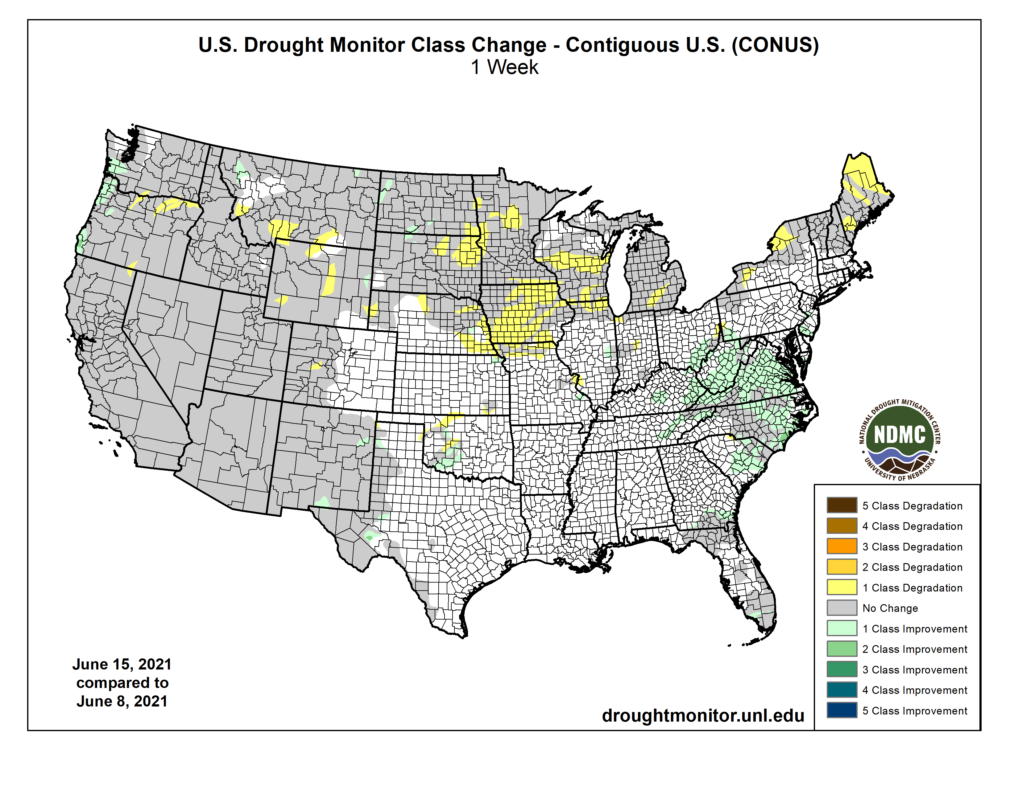
Here’s the US Drought Monitor one week change map ending June 15, 2021.
US Drought Monitor one week change map ending June 15, 2021.