FromKRCC (Shanna Lewis) via Colorado Public Radio:
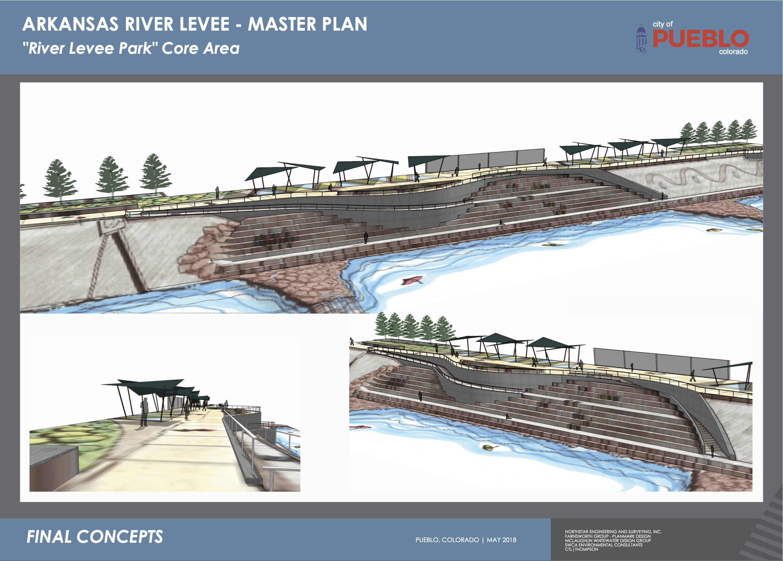
Pueblo is remembering the victims of the flood that devastated the city a century ago. And on June 3, exactly 100 years later, celebrating its newly rebuilt Arkansas River levee.
The original flood control structure was constructed after the deadly 1921 deluge. Repairs to bring the 2.8-mile long levee up to current FEMA standards began in 2014 and cost some $25 million…
The top of the levee now sports a walking trail, and a million-dollar pedestrian suspension bridge connects the trail to the bike path on the other side of the river.
Grants from the Colorado Department of Transportation and Department of Local Affairs paid for the bridge. Leaf-shaped shade structures, benches and bike racks will be added to the trail later this year.
It’s all part of a larger recreation plan that includes a second bridge, upgrades to the existing whitewater park and better access to the river from various neighborhoods.
Along with flood protection and outdoor fun, there’s also a cultural aspect to the levee. Artists covered the old concrete facing of the levee with huge murals over the years, like a giant outdoor art gallery…
The Pueblo Downtown Association and Pueblo Arts Alliance are hosting a celebration of the new levee on Saturday, June 5, from 9 a.m. to 1 p.m. Activities will include a walk on the levee, actors telling the story of the 1921 flood and group drone photos on the new bridge.
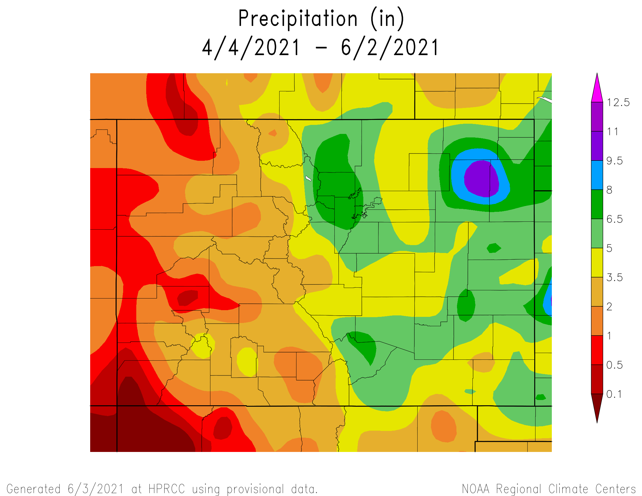
May in Pueblo brought nearly five inches of rain to the county, marking the month as the third wettest May in the region’s history, and also colder than average.
Only May 2015, where 5.5 inches of rainfall was recorded, and May 1957, when 5.43 inches of rainfall was recorded, beat the nearly five inches of rainfall in May 2021.
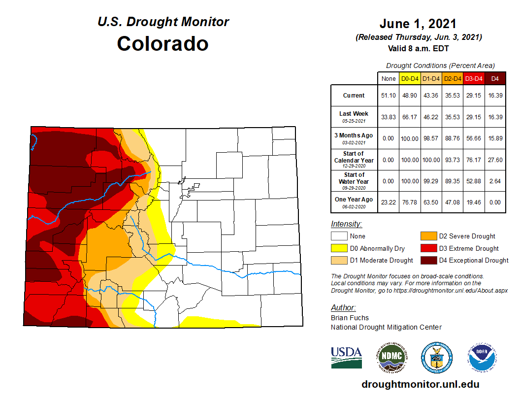
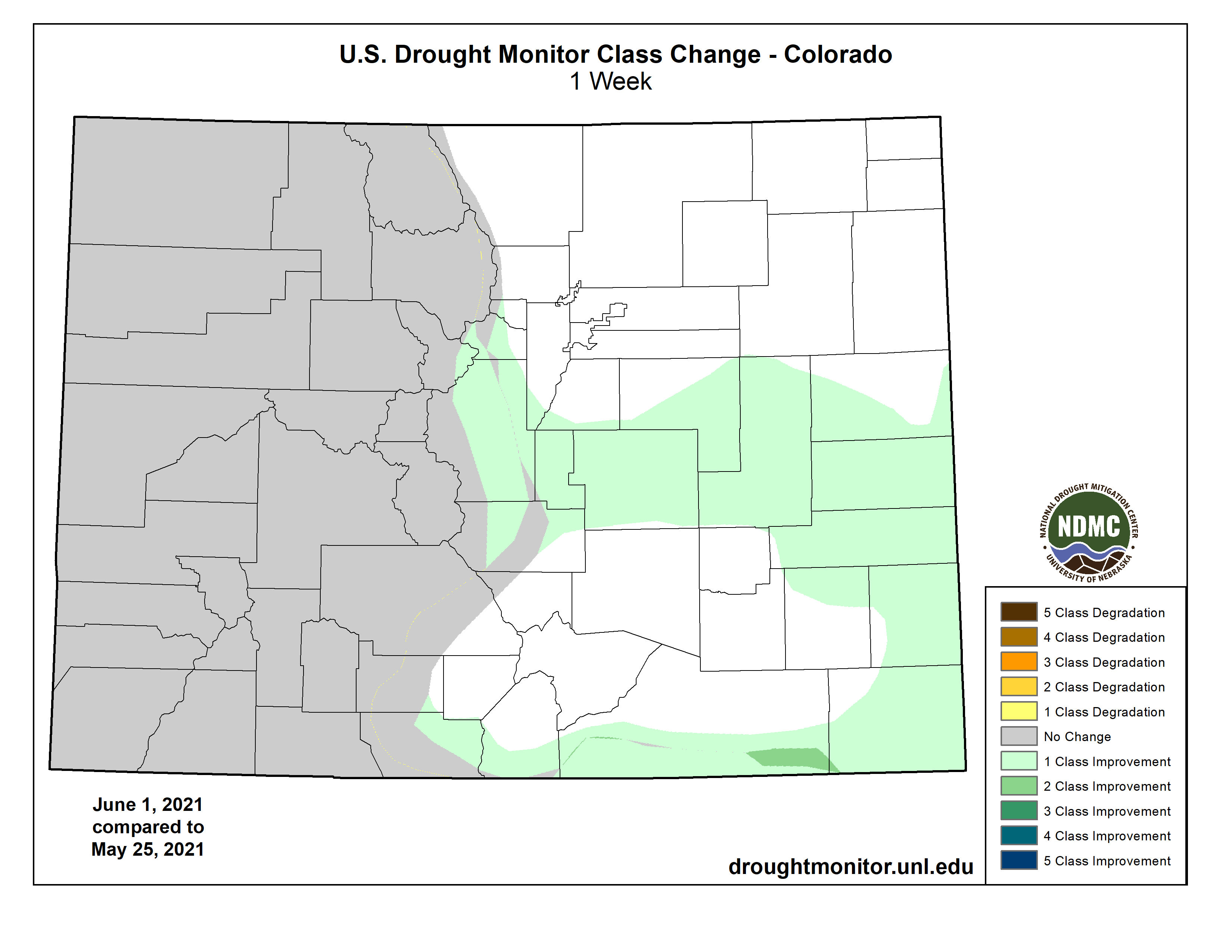
On May 25th, most of the eastern plains and eastern mountainous region of Colorado have been declared drought-free, defying forecasts from earlier in the year that predicted low precipitation amounts throughout the spring, leading to further drought levels in the summer.
Colorado Drought Monitor map June 1, 2021.
In fact, drought levels west of the Continental Divide remain in extreme and exceptional levels, while east of the Divide has shifted the opposite direction. The shift is dramatic, as severe to extreme drought levels have persisted since August 2019…
Pueblo averages about 1.6 inches of rainfall in May, [Tony] Anderson explained, and the area received about 4.95 inches this May. The trend was similar across the region, with areas like Colorado Springs recording almost double rainfall amounts from the averages used by the National Weather Service.
Anderson called the drought clearing “remarkable,” but also expressed concerns that the area could still have a poor water year…
He also noted that reservoir levels are part of the bad news in this “good news/bad news year.” He said the Arkansas river reservoirs are on average about 80% full, and reservoirs in the Rio Grande are averaging about 67%. “So there’s a lot of storage to fill up going into next year,” he said…
Anderson explained that the split of drought and non-drought levels in Colorado resulted from storms rising from the east and dropping precipitation as it hit the mountains, instead of the standard Colorado weather pattern of storms approaching from the west.
Todd Ballard, an agronomy extension agent with Colorado State University who works in Sedgwick County, noted in a recent column that the above average rainfall could be a boon for the state’s eastern agricultural businesses.
The U.S. is in far different shape today than it was last Memorial Day, and many Americans are, too.
According to a recent survey by the American Psychological Association, undesired changes in weight driven by pandemic stress are widespread: 42% of adults reported gaining weight, with a median weight gain of 15 pounds, while 18% reported undesired weight loss. About 66% of people reported changes in their sleep habits, and 23% of respondents reported an increase in alcohol use.
The switch that got flipped in March 2020 to social distancing, remote schooling, mask-wearing and long-distance work – or no work – is switching back almost as abruptly. With little preparation time, many people are faced with wanting to be in top form for reentry. Resuming – or beginning – healthier habits is a wonderful goal. Trying to get back to normal too quickly, however, may be hard on joints and hearts. Here is a guide to help you get back in shape without hurting yourself.
Attitude matters
It is vital to begin with acceptance of your current state while you plan and implement changes. It may be necessary to hold two seemingly contradictory truths at once – a core tenet of dialectical behavioral therapy, or DBT. A classic example of DBT is when a therapist tells a client, “I love you exactly the way you are, and I’m here to help you change.” The statements are simultaneously in opposition to each other and true.
Doing this in terms of pandemic-driven changes involves three steps:
Take note of the current reality, such as, “I am up 10 pounds,” “I am drinking more than before the pandemic,” or “I’m not getting enough exercise anymore,” but without negative self-judgment.
Make realistic, measurable goals for change: “I want to lose a pound in four weeks,” “I want to climb a flight of stairs without becoming breathless,” or “I will drink alcohol only when out with friends.”
Create a plan to achieve these goals.
Also, wanting to take good care of oneself, rather than wanting to look or be a certain way, is an important focus. A little self-knowledge goes a long way here. People who tend to go “all in,” rather than doing things gradually, need to be sure their plans are safe by seeking professional guidance from a reliable source, such as getting weight loss advice from a family doctor rather than from people or companies that a New York Times opinion writer recently described as “weight-loss profiteers.”
How can this process be applied to some common pandemic-driven health problems? Here are some suggestions.
Sleep
One of the most effective and “simple but not easy” ways to normalize sleep is to pay attention to one’s sleep hygiene. Good sleep hygiene includes having a distraction-free, dark, quiet place to sleep. This may require using a sleep mask, blackout curtains or a white noise machine, and having no TV in the bedroom.
Even parents of very young children who may find these steps unrealistic can make some changes to help improve sleep, such as avoiding naps, sticking to a schedule, developing a routine, and engaging in some physical activity to tire oneself out before bedtime. Having a cutoff time for caffeinated beverages, as well as avoiding late night dining and too much alcohol, also help.
If excessive snoring is a problem, or getting very sleepy and dozing off throughout the day, or any other unusual symptoms, consulting a doctor should be part of the plan.
If you’re concerned, try a brief self-screening test and talk with your physician.
Physical activity
To come up with a safe exercise plan, start with an honest self-assessment. This includes looking at your current age and physical condition (particularly knees, hips, lungs, heart and balance); weight and weight changes during the pandemic; and activity levels before and during lockdown. The National Academy of Sports Medicine offers a downloadable questionnaire that can help with making this self-assessment.
Checking in with your body can help you safely and effectively reach your health targets. Bruno Nascimento/Unsplash, CC BY
Remember there are weight bearing, aerobic and stretching types of exercises. With each, begin at a level of comfort and gradually go slightly further. For example, if the goal is to start running, consider starting small, with a 30-minute routine a few days a week that involves a jog for one minute followed by walking for four minutes. Each week up the ante, such as shifting on the second week to jogging for two minutes then walking for three.
If the goal is to start walking, setting a time limit can help to achieve tangible goals: a 10-minute walk a few days the first week, 15 minutes the next week and so on, until the walk lasts 30 minutes and happens a few times a week. Then focus on increasing the pace.
Chest or arm pain, dizziness or extreme discomfort, are all signs to stop. While it’s useful to get to know what it feels like to be a little sore from working hard and how that differs from pushing it too far, it’s also a good idea to become familiar with the warning signs of a heart attack.
Whether they involve mental or physical health – while this tends to be an artificial separation – post-lockdown behavior changes should begin with an accurate assessment of how things are, a realistic goal for what they will become, and a plan to get there. All of these should reflect care and love for one’s self and one’s body.
With a sodium fast reactor, integrated energy storage and flexible power production, the Natrium technology offers carbon-free energy at a competitive cost and is ready to integrate seamlessly into electric grids with high levels of renewables. Graphic credit: http://NatriumPower.com
Here’s the release from Governor Gordon’s office (Michael Perlman):
Natrium™ Reactor Demonstration Project will bring new energy development and jobs to the state
TerraPower and PacifiCorp, today announced efforts to advance a Natrium™ reactor demonstration project at a retiring coal plant in Wyoming. The companies are evaluating several potential locations in the state.
“I am thrilled to see Wyoming selected for this demonstration pilot project, as our great state is the perfect place for this type of innovative utility facility and our coal-experienced workforce is looking forward to the jobs this project will provide,” said Wyoming Governor Mark Gordon. “I have always supported an all-of-the-above energy portfolio for our electric utilities. Our state continues to pave the way for the future of energy, and Wyoming should be the place where innovative energy technologies are taken to commercialization.”
The development of a nuclear energy facility will bring welcome tax revenue to Wyoming’s state budget, which has seen a significant decline in recent years. This demonstration project creates opportunities for both PacifiCorp and local communities to provide well-paying and long-term jobs for workers in Wyoming communities that have decades of energy expertise.
“This project is an exciting economic opportunity for Wyoming. Siting a Natrium advanced reactor at a retiring Wyoming coal plant could ensure that a formerly productive coal generation site continues to produce reliable power for our customers,” said Gary Hoogeveen, president and CEO of Rocky Mountain Power, a business unit of PacifiCorp. “We are currently conducting joint due diligence to ensure this opportunity is cost-effective for our customers and a great fit for Wyoming and the communities we serve.”
“I commend Rocky Mountain Power for joining with TerraPower in helping Wyoming develop solutions so that our communities remain viable and continue to thrive in a changing economy, while keeping the state at the forefront of energy solutions,” said Wyoming Senate President Dan Dockstader.
“Wyoming has long been a headwaters state for baseload energy. This role is proving to be ever more important. This effort takes partnerships, and we welcome those willing to step up and embrace these opportunities with us,” said Wyoming Speaker of the House Eric Barlow.
The location of the Natrium demonstration plant is expected to be announced by the end of 2021. The demonstration project is intended to validate the design, construction and operational features of the Natrium technology, which is a TerraPower and GE Hitachi technology.
“Together with PacifiCorp, we’re creating the energy grid of the future where advanced nuclear technologies provide good-paying jobs and clean energy for years to come,” said Chris Levesque, president and CEO of TerraPower. “The Natrium technology was designed to solve a challenge utilities face as they work to enhance grid reliability and stability while meeting decarbonization and emissions-reduction goals.”
Wyoming’s Governor Gordon committed in early 2021 to lead the state in becoming carbon net negative while continuing to use fossil fuels through the advancement and utilization of next-generation technologies that can provide baseload power to the grid, including nuclear and carbon capture solutions. Wyoming is the largest net energy exporter in the United States and finding carbon solutions will ensure the state continues to provide energy to consumers across the nation while decreasing CO2 emissions.
In October 2020, the U.S. Department of Energy (DOE), through its Advanced Reactor Demonstration Program (ARDP), awarded TerraPower $80 million in initial funding to demonstrate the Natrium technology. TerraPower signed the cooperative agreement with DOE in May 2021. Next steps include further project evaluation, education and outreach as well as state and federal regulatory approvals, prior to the acquisition of a Natrium facility.
The Yampa River, June 29, 2019. Credit: Kelsey Ray, CU News Corps, The Water Desk From Water Education Colorado (Sara Kuta):
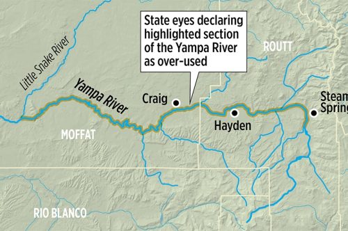
With drought and climate change continuing to dry the American West, the state of Colorado is moving to declare one of its last, mostly free-flowing rivers, the Yampa, over-appropriated.
The action, initiated in March, is emblematic of the water situation across Colorado and the West: growing demand, shrinking supplies.
“It’s a sign of the times, that is, it’s happening in the context of lower flows and increased demand — and we’re seeing that all over the West,” said Anne Castle, senior fellow at the Getches-Wilkinson Center for Natural Resources, Energy, and the Environment at the University of Colorado Law School. “The majority of the problem in the Yampa is created by a decrease in flows, although there has been some increase in demand.”
According to a recent analysis by the state, the Yampa’s flows have dropped roughly 25 percent over the past 100 years, from 1.5 million acre-feet to 1.12 million acre-feet annually, a change attributed to sustained drought and climate change.
“The combination of continued adjudication of new water rights and the potential for a hotter, drier climate will likely cause the trend of declining streamflows to continue,” wrote Erin Light, the top water regulator in the region, in her report detailing why she’s recommending the over-appropriation designation.
The river is important not just because of its key role in Northwestern Colorado, but also because it is one of the largest tributaries to the drought-stressed seven-state Colorado River system.
Kevin Rein, the state engineer and Colorado Division of Water Resources director, is still considering Light’s March 17 recommendation, which encompasses the Yampa River and all of its tributaries upstream of its confluence with the Little Snake River to the town of Steamboat Springs. If approved, the designation will affect 2,321 total square miles, which includes 148 miles of the Yampa itself.
Credit: Chas Chamberlin via Water Education Colorado
At a virtual meeting in March, some Yampa-area stakeholders expressed concerns about the quick pace of the process and the lack of in-person conversations. They also asked for more information and more time to understand the implications and potential ripple effects of the designation.
Before he makes his decision, Rein said he wants to be able to meet in person with the basin’s residents, something the COVID-19 pandemic has so far prevented. He said he did not yet have an anticipated timeline.
“I’m not confident that people understand some of the nuances, and so I want people to be believers in why we’re doing this,” Rein said. “I want to be out there meeting with people in person, answering all the hard questions before we make a decision that sets things in motion.”
Over-appropriation, explained
The state uses the over-appropriation designation when it has determined that there’s not enough water in a stream system, some or all of the time, for all of the people and organizations who hold water rights in the system.
Over-appropriation is the norm in Colorado — other portions of the Yampa system are already designated as over-appropriated, as are the majority of other stream systems in the state.
Still, the recommendation to designate this new section of the basin as over-appropriated is a major change to the status quo in this region, where water has historically been so abundant and demand so low that a majority of water users never measured what they took from the stream.
Scott Hummer, water commissioner for District 58 in the Yampa River basin, checks out a recently installed Parshall flume on an irrigation ditch. Hummer said most water users in the Yampa are complying with a state order issued 2019 that requires measuring devices. Photo credit: Heather Sackett/Aspen Journalism
To more accurately glean the full water picture in the Yampa Basin, the state ordered water users there to install measuring devices in September 2019. Though installation was initially slow-going, the state and several local community groups have been working with water users in the intervening months, which has brought the proportion of water users with measuring devices up to 58 percent as of April 2021, according to state officials.
“It’s normal for people to want to be able to continue the water use they’ve enjoyed in the past, but the hydrology is changing,” Castle said. “The overall balance of the system is different and that means that the way we do business in terms of administering water has to change as well. It’s quite understandable that people may not be welcoming this kind of additional state regulatory overlay that they are used to doing without.”
For divvying up the state’s water, Colorado uses a “first in time, first in right” system known as prior appropriation. This means that the people or organizations with the oldest decreed water rights, known as senior water rights, get priority over later-decreed, or junior, water rights.
When there isn’t enough water to satisfy those senior water rights, the state can stop or slow the flow for junior water rights, a measure known as a call or a curtailment.
This temporary action, taken to ensure that senior water rights holders can get all of the water they’re legally entitled to, is becoming more and more common in the Yampa River Basin. State officials have implemented calls in two of the last three years — in 2018 and 2020.
There would likely have been additional calls in the basin, but the community avoided them by sharing water, getting by with less, and releasing stored water from reservoirs into the river and allowing it to remain there rather than diverting it for irrigation or drinking water, according to Light.
“We have many stream systems where water rights are not fully met but owners opt to not request our office to place a call,” Light wrote in her recommendation. “While their cooperative approach to ‘make do’ with water they have and/or share it among their neighbors is admirable, it is yet one more indicator that, more and more frequently, the water supply of the Yampa River Basin cannot support the … demand.”
Groundwater vs. surface water
The overarching goal of the over-appropriation designation is to protect the rights of senior water rights holders moving forward, Light said.
If the designation is applied, people will still be able to obtain new surface water rights, for instance to take water from streams and rivers for approved uses like irrigation, but they should be aware that there may not be enough water available to satisfy those rights, Light said.
The over-appropriation designation would also affect groundwater rights, or water pumped up from below ground. More specifically, the designation will affect residents’ ability to drill new wells and bring into compliance existing wells with unpermitted uses.
Under the designation, landowners who want permission to drill a new well would need to meet stricter criteria and might need to be prepared to replenish that well water to the river, a process known as augmentation.
The reason for the distinction between surface and groundwater? Groundwater diversions like wells have a delayed impact on rivers and streams, whereas surface water diversions like ditches have a more immediate impact.
When water is in short supply, state officials can simply stop the flow to junior ditches to ensure there’s enough water for senior water rights holders. They can’t do that as easily with wells, which is where plans for augmentation come into play.
For some landowners in the proposed over-appropriation region, creating an augmentation plan will be a difficult process, one requiring lawyers, court filings and engineers. For others, it will be as simple as reaching out to a nearby reservoir manager and paying for stored water to meet the augmentation needs.
The Upper Yampa Water Conservancy District, for example, has a blanket augmentation plan that covers some of the proposed over-appropriation area. Landowners within the plan’s boundaries can apply to the district for augmentation water, which costs from $212.54 to $248 per acre-foot, according to district spokesperson Holly Kirkpatrick.
Meanwhile, augmentation is less straightforward for water users who live outside of those bounds.
“The community really has a choice of whether to continue with the status quo where people have to have their individual augmentation plans … or come together and implement some sort of blanket augmentation plan to remove that barrier to water development,” said Hunter Causey, senior water resources engineer for the Colorado River District, during the 2021 Yampa Valley State of the River meeting in May.
Sarah Kuta is a freelance writer based in Longmont, Colorado. She can be reached at sarahkuta@gmail.com.
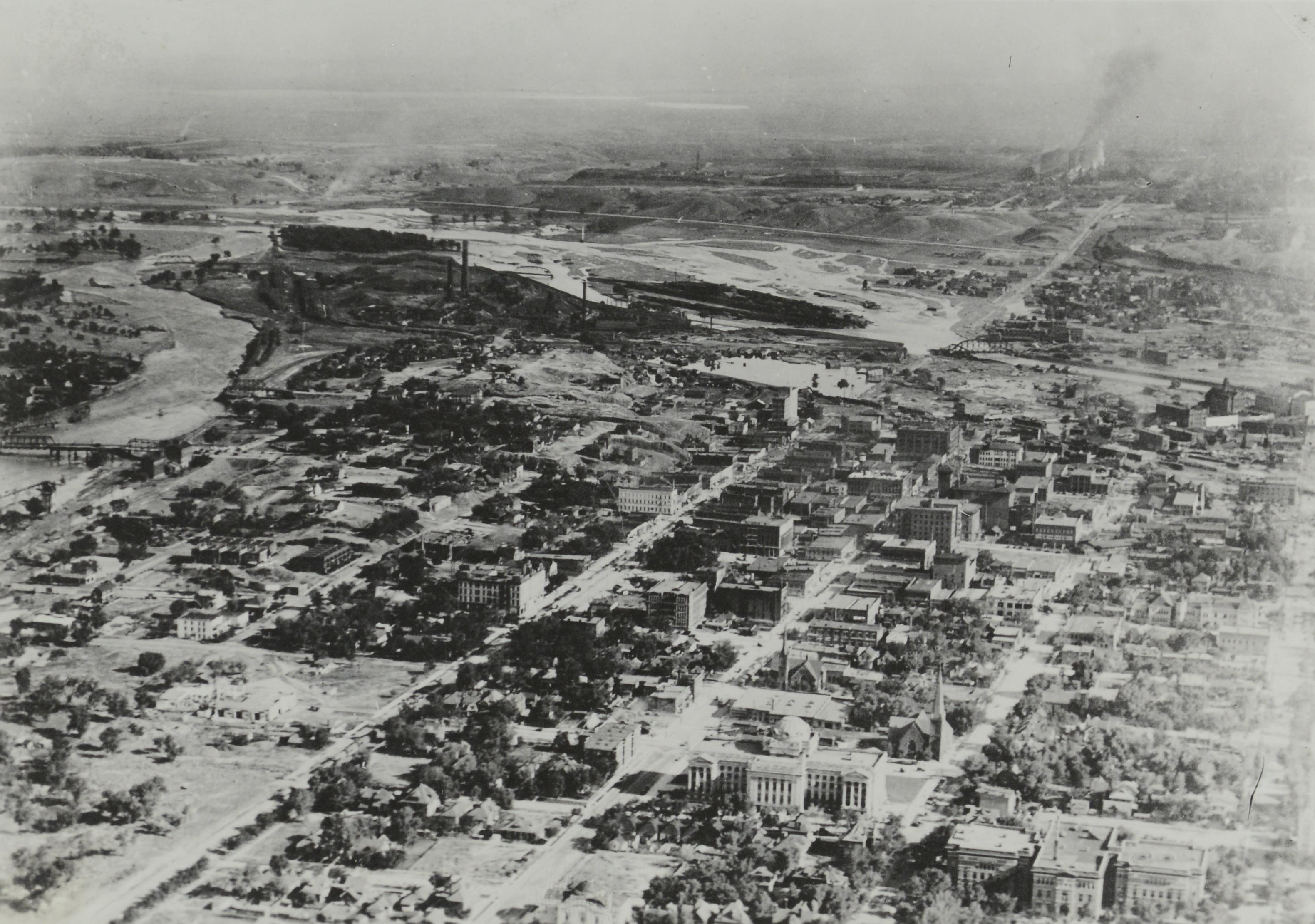
Over three days in June 1921, Pueblo experienced a natural disaster that forever changed the course of its history.
Even a century later, the effects of the Great Flood of 1921 can be seen throughout the Home of Heroes, particularly in the city’s infrastructure and economy, which were completely transformed by the devastating flood and Pueblo’s decades-long recovery.
Many Pueblo natives know most of the city’s seminal story by heart: a cloudburst brought heavy rains to the area on June 2, causing the Arkansas River – which was already prone to seasonal flooding – to swell. More intense rain on June 3 caused the Arkansas River to overflow Pueblo’s levee at just more than 18 feet and envelope downtown Pueblo in water.
By midnight on June 4, according to the Colorado Encyclopedia, the flooding peaked at more than 241 2 feet. The im- mense volume was enough to break levees in several spots and it took only two hours for Pueblo’s entire business district to become submerged.
Men stand outside the Union Depot in Pueblo (Pueblo County), Colorado. One man wears a badge. Shows water, mud and debris on the ground, and a flood damaged passenger car wrecked beside the stone depot. Probably a cleaning crew works on mud covered tracks nearby June 1921. Photo credit: Denver Public Library Special Collections
Damage from the flood, most of which occurred on the second day when both the Arkansas River and Fountain Creek overran their banks, was unimaginable. The flood inundated 300 square miles. More than 500 homes were carried away in the floodwaters along with 98 businesses or industrial buildings, 61 stores, 46 locomotives and more than 1,200 railroad cars. A local lumberyard caught fire; burning lumber was sent floating down flooded city streets. Telephone lines were destroyed, and corpses of cows, horses and other livestock littered the valley. A 1921 report on the flood by the United States Geological Survey estimated the total property damage to be more than $19 million. Adjusted for inflation, that equates to more than $280 million today. Other estimates go as high as $25 million in damage, or nearly $373 million today. The death toll was also catastrophic, though there’s no universally accepted total. Estimates range from fewer than 100 deaths to more than 1,500. The USGS report said 78 bodies were recovered in the aftermath, which is likely a fraction of the actual lives lost. Many bodies washed downstream and were either recovered months later or never found. And many of the dead were poor immigrants, making their absence more difficult for authorities to detect. But even after the water receded, mud and debris had been removed from city streets and the recovered dead were buried, the impacts of the flood on Pueblo were just beginning.
View of damage from the Arkansas River flood at the Union Depot rail yard in Pueblo (Pueblo County), Colorado. Denver and Rio Grande Western passenger cars are near the passenger platform. Damaged cars are turned over and logs and lumber is scattered across the rail yard June 6, 1921. Photo credit: Denver Public Library Special Collections
A recovery with dire consequences
In the aftermath of the flood, it became apparent that Pueblo’s infrastructure was not sufficient to prevent another devas- tating flood event. The city needed a new, larger river channel to ensure that when the Arkansas swelled from spring rains and Rocky Mountain snowmelt, it could not cause such destruction again. Legislation was passed at the Colorado Capitol to create the Pueblo Conservancy District, which set about building a new channel to divert the river away from Downtown Pueblo. “When it was set up years ago, the conservancy district had to move the river to its current location,” said Corinne Koehler, the current president of the Pueblo Conservancy District.
“Back then, that’s where a lot of the train tracks were, so they had to tear up and move the train tracks, they had to rebuild bridges, it was a multi-faceted project. It wasn’t just putting up a levee, they had to redo roads, bridges, anything that was destroyed that would have been crossing over the Arkansas River.” The levee was completed ahead of schedule in March 1926. And although its completion was a breath of relief for Pueblo in terms of preventing future floods, the creation of the conservancy district came with dire conse- quences to the Pueblo economy.
Peggy Willcox, a researcher with the Pueblo County Historical Society who helped write a recently published book about the flood entitled, ‘Mad River,’ said the district’s creation was a necessity following the flood, but the legislation enacted had major drawbacks for Pueblo.
“In order to create the conservancy district to pay for the flood control, they had to get the legislature to approve it,” Willcox said.
“Well the northern counties, some of them had been wanting a tunnel west from Denver ever since (Gen. William Jackson Palmer) built the (Denver & Rio Grande Western Railroad), because there was no viable way to ship goods from Denver west on the D& RG.” Prior to that time, every train going west had to come through Pueblo. So northern Colorado counties, particularly in the Denver area, sought to bypass Pueblo by building a tunnel that could ship freight or passenger trains directly west.
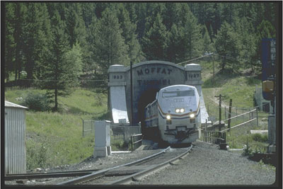
West Portal Moffat Tunnel.
To get its conservancy district, Pueblo would have to approve the construction of the Moffat Tunnel – a railroad and water tunnel that cuts through the Continental Divide. It officially opened in 1928.
“They held Pueblo hostage,” Koehler said, “And said, ‘If you want a conservancy district and a levee, you have to vote for the Moffat Tunnel.” The creation of the Moffat Tunnel was the beginning of the end of Pueblo’s prominence as a railroad hub…
Aerial view of the flooded Arkansas River in Pueblo (Pueblo County), Colorado. Shows freight cars at the washed out Missouri Pacific Railway Company yard, railroad bridges over the river and the Nuckolls Packing Company building beside standing water. Photo credit: Denver Public Library Special Collections
Economic impacts in the aftermath of Pueblo’s great flood
Pueblo’s eventual fall from grace as Colorado’s primary railroad hub was far from the only way the flood devastated the city’s economy. In the days immediately following June 5, many businesses were severely damaged and closed their doors, some forever. “After the flood there were industries that never reopened,” Willcox said. “Pueblo was then the smelter capital of the world, that’s what they called it, and there were only two smelters left and both of them were severely damaged by the flood and never really reopened. ‘So that was a large number of jobs.” Not long after the flood, Willcox said, the CF& I steel mill shut down for several months due to a shortage of raw supplies as well as a lack of railroad access, as the flood heavily damaged lo- cal rails. Several smaller manufactories in flooded areas closed. Many of those that eventually reopened did so in cities outside of Pueblo where there were more workers and easier access to rail transporta- tion. But the bigger impact, Willcox said, was how the flood seemed to dry up investments from out-ofstate capitalists, which were common prior to 1921. “That money kind of dried up after the flood,” Willcox said. “The investment from outside of Pueblo diminished greatly.”
There was a decades-long recovery effort in Pueblo after the flood
With some of its most prominent economic drivers devastated by the flood, Willcox said Pueblo’s economy seemed to become more one-di- mensional. “It’s not so much that Pueblo never recovered, it’s that it never recovered the growth rate that it had prior to the flood,” Willcox said. “When you look at the city’s population and the number of industries that were here prior to the flood Pueblo was a manufacturing center it was really a diverse group of manufactories. “And then after the flood some of them never came back but some of them were no longer as prevalent in the market as they had been and eventually died out. So I think, anecdotally, we became more dependent on the steel mill because of that.” Jonathan Rees, a history professor at Colorado State University Pueblo who has researched the flood extensively, said one of the biggest impacts of the flood was the opportunity cost Pueblo paid in the years that fol- lowed. “There’s the cost of rebuilding the town, there is the economic damage caused by the lost business but there’s also a cost as to what doesn’t happen because Pueblo has to spend so much time rebuilding from the flood,” Rees said. “Different things could have happened to Pueblo but didn’t because we were too busy trying to prevent future disasters.” In the 1920s, the United States economy was seeing one of its strongest periods of prosperity. But while other communities were able to leverage those desirable economic factors for improvement, Pueblo was stuck rebuilding. “You’re investing in the future in the sense that you’re trying to prevent future floods, but you’re not growing businesses, you’re not helping businesses that might not have been able to reopen, you’re not doing the kinds of things that cities that aren’t effected by the flood are doing at the same time,” Rees said.
“So when America is roaring, Pueblo isn’t.” After the Great Depression came the New Deal, and Rees said although Pueblo did benefit some from the New Deal, it likely would have had a greater effect on Pueblo and its growth if flood recovery efforts were not still taking place. As Pueblo struggled, its neighbor to the north, Colorado Springs, was put in a position to pros- per. “I would simply imagine that any program that came to Colorado Springs between 1921 and 1965, could have come to Pueblo under different circum- stances,” Rees said. “It’s safe to say that before World War II we were a much bigger place. We have certain advantages over Colorado Springs like our steady supply of water. However, we are engaged in rebuilding the entire downtown for a very long time.” Rees said that rebuilding Pueblo and redesigning its infrastructure was a necessary endeavor, but one that set Pueblo’s development back years, if not decades.
“While we’re doing that to guarantee our future existence, other places are taking advantage of good economic times or government programs in bad economic times to help become bigger and more economically active than they had before,” Rees said.
“And Pueblo was essentially holding in place for most of the 20th century.”
View of a flood on Fountain Creek in Pueblo (Pueblo County), Colorado. Shows a washed out railroad bridge partly buried in mud and silt in the creek. A Denver and Rio Grande Western train is beside the creek in the distance. June 1921. Photo credit: Denver Public Library Special Collections
When it came to covering the flood of June 3, 1921, The Colorado Daily Chieftain, also known as The Pueblo Chieftain, went to extraordinary measures to keep the citizens of Pueblo informed as news of the devastation unfolded. It all started with a Saturday, June 4, 1921, special edition emblazoned with the all-caps headline, “FLOOD EXTRA.” The two-page special edition had no photographs and no advertisements. It even had empty space at the bottom of the second page, a testament to how hastily it was put together. A June 9 edition of the Chieftain reported, “it was utterly impossible” to print regular editions of the paper, “because of the failure of electric power and gas,” and the editor promised to republish the extra editions “when regular conditions are restored.” That first extra edition was chock full of stories about “The largest flood visiting Pueblo since Decoration Day 1894,” which “gutted the business and wholesale business districts of the city.” Initially, the paper announced, “More than a score of lives were reported lost when both the Missouri Pacific and the Denver and Rio Grande passenger trains were swept into the river near Nuckolls Packing company. Many others were reported dead.”
View of flooded buildings, debris and flood water from the Arkansas River in Pueblo (Pueblo County), Colorado. Shows submerged commercial buildings, houses and telephone poles in Goat Hill (Tenderfoot Hill) in northeast Pueblo June 6, 1921. Photo credit: Denver Public Library Special Collections
Puebloans faced rebuilding one-seventh of the city
By June 12, the newspaper reported the city faced “the necessity of rebuilding about one-seventh of its present area. It is inconceivable that this great industrial city, so favorably located for commerce, should drop out of existence or shrink to the proportions of a village.” That same issue shared stories of large objects moved by the flood waters like a freight car forced sideways through a brick apartment house, another freight car carried a block and a half and a 3,000-pound safe that traveled across Union Avenue.
There also was an instance of a body in a steel casket that traveled a distance of more than a mile. Tales of Puebloan’s generosity were shared as both known and unidentified bodies were laid to rest with flowers paid for by “warm sympathetic hearts. Pueblo’s undertakers and florists have bestowed the humane tribute in every case, whether high or low, rich or poor, black or white, known or unknown.” Official water depths were reported including the McCarthy block, at North Main and Union, where the water reached a depth of 12-feet-6 inches. The width of the flood was reported as one mile “through the center of the city’s business section, with losses totaling more than $3 million.” The city’s drinking water was finally declared safe to drink on June 12. One story reported that P.A. Payne of Pueblo, who had been arrested by Colorado Springs police on a bootlegging charge, was saved from certain death as “the flood sweat away every vestige of the house.” Another story reported the body of Missouri Pacific passenger train Engineer S.G. Evans was recovered 10 miles downriver and shortly afterwards, “the body of a two-day old baby was recovered in the same district.” By June 15, the newspaper looked to the future and urged, “The matter of making the Arkansas flood proof is the big subject now in hand. ‘Pueblo’s flood was not one of something breaking, accidental or unforeseen, but has been a real live danger of the past and is a remaining danger of the future unless checked,” one prominent businessman, who was unnamed, was quoted. The June 15 issue also had a story under the headline, “How the flood left the heart of Pueblo,” indicated that once the water subsided, the mud was “over 2 feet deep” and “workers prodded through the mud in search of victims buried in the slime.” The June 16 issue of the newspaper had a story about the brave dog “Casabianca” who stayed on a shed roof for three days even though the distance to the dry land was short. Other dogs even waded out to visit her, but she stayed put until her owner arrived and carried her to safety along with a bundle of clothes which she had apparently been guarding. By June 16, the newspaper also was reporting on damage downstream of Pueblo in La Junta.
View of a small house that was carried by the flood waters of the Arkansas River and came to rest against the side of a brick garage in Pueblo, Colorado. The garage has damaged walls. Two men pose beside the garage. Ruts in the deep mud are near the buildings. Photo credit: Denver Public Library Special Collections
Meteorologically speaking, an event like this can and will happen again. The largest floods in state history generally happen along the front range, specifically along main rivers (Arkansas, Cache La Poudre, Big Thompson, South Platte, etc.).
The north-south oriented Rockies create a barrier for wind flow, forcing air to rise and condense along the front range, creating rain and thunderstorms.
During the June 1921 flood, a persistent easterly flow of warm and humid was funneled along the Arkansas River from wide-open Pueblo county into the sharper canyon in Fremont county. This led to 5 days of heavy rain totaling over 6 inches in Florence and Pueblo. This rain was most intense the night of June 3rd and the morning of June 4, where a cloudburst (extremely heavy burst of rain) led to the Arkansas river cresting at a whopping 24.66 feet.
At its peak, the Arkansas river flow was at 103,000 cubic feet per second (cfs), where the levees were built for 40,000 cfs at the time.
Pueblo levee Arkansas River.
The main concern about future floods is whether infrastructure can withstand them. Pueblo was able to rebuilt just a few years after the flood and increased the city’s ability to withstand another flood of 1921.
Click on a thumbnail graphic to view a gallery of drought data from the US Drought Monitor website>
US Drought Monitor map June 1, 2021.
High Plains Drought Monitor map June 1, 2021.
West Drought Monitor map June 1, 2021.
Colorado Drought Monitor map June 1, 2021.
Click here to go to the US Drought Monitor website. Here’s an excerpt:
This Week’s Drought Summary
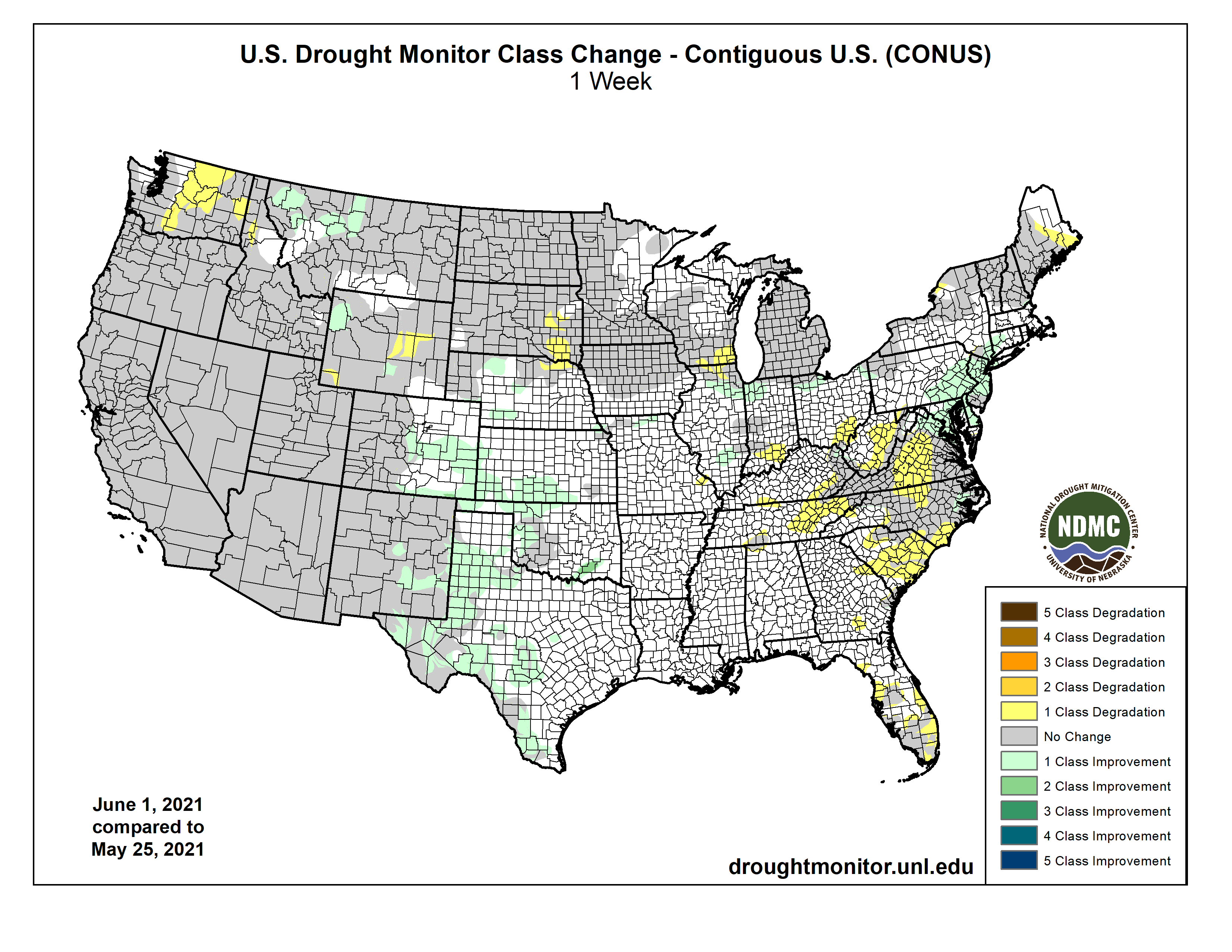
Precipitation this past week was most active in the southern Plains and the Mid-Atlantic into the Northeast, helping to ease and improve drought in those regions. Some precipitation also occurred in the South and portions of the Midwest, but the Southeast and Southwest remained dry through the week. For the time of year, temperatures were well below normal over most of the country, with departures of 9-12 degrees below normal in the Dakotas. Portions of the Southeast and Southwest did have pockets of above-normal temperatures, but even those areas were close to normal…
Colorado Drought Monitor one week change map ending June 1, 2021.
Temperatures were 4-6 degrees below normal, with even greater departures in the Dakotas where some areas were 8-10 degrees below normal for the week. Much of eastern Colorado, southern Nebraska, Kansas and northwest South Dakota into southwest North Dakota received well over 150% of normal precipitation for the week. In Nebraska, abnormally dry conditions were improved over the north central, southwest and extreme southeast portions of the state while moderate drought expanded over northeast Nebraska. Severe drought was introduced over southeast South Dakota, with an expansion of moderate drought and abnormally dry conditions too. Southern Kansas and eastern Colorado had improvements to abnormally dry and moderate drought conditions while Wyoming had a mix of improvements and degradations to moderate and severe drought in the state…
The warmest temperatures in the region were over California and Nevada, where departures for the week were 3-6 degrees above normal. Most of the rest of the region was near normal for temperatures. Most of the West was dry for the week but eastern New Mexico and western Montana received enough precipitation to allow for some improvements to their drought status. Impacts are building in the region with water cutback anticipated on Lake Mead as it is currently 37% full and fell below the critical 1,075-foot level triggering cutbacks to Arizona, Nevada, and Mexico. Abnormally dry and moderate drought conditions were improved over western Montana while New Mexico had a large area of exceptional drought improve due to recent rains. In Washington, conditions continue to dry out, and abnormally dry and both moderate and severe drought conditions continued to expand…
Much of the region had abundant precipitation during the week with many areas recording over 200 percent of normal rain. Along with the precipitation, cooler than normal temperatures were widespread with most areas 3-6 degrees below normal for the week. The ongoing wet pattern allowed for continued improvements over most of Texas during the week, with most areas having a full reduction of the previous drought intensity level. Southeast Oklahoma had moderate drought and abnormally dry conditions removed while portions of western Oklahoma also had abnormally dry conditions improve…
Looking Ahead
Over the next 5-7 days, it is anticipated that much of the West as well as the central Plains will remain dry. The southern Plains and portions of the Carolinas are expected to see the most rain. Warmer than normal conditions are supposed to dominate the West and into the northern Plains, with departures of 12-15 degrees above normal in portions of California and Nevada. Cooler than normal temperatures are expected over the southern Plains and South in response to the anticipated rain.
The 6-10 day outlooks show the majority of the country has above normal chances of recording temperatures above normal during the period with the northern Plains, upper Midwest, and into the Northeast having the greatest likelihood. Cooler than normal temperatures are expected over Alaska, the West Coast, and into the southern Plains. It is anticipated that dry conditions will continue to dominate the Plains and West with the highest likelihood over the Great Basin. The greatest odds of above normal precipitation will be along the Mississippi Valley and into the southern Plains.
Here’s the one week US Drought Monitor change map.
US Drought Monitor one week change map ending June 1, 2021.
Just for grins here are the early June US drought monitor maps for the past few years.
Here’s an excerpt from the Spring 2021 issue of Headwaters Magazine (Caitlin Coleman):
INTO THE MODERN STORAGE ERA
Most Coloradans rely on some form of water storage in order to live. Water is collected when available and later released when and where it’s needed. Water storage is a necessity, providing year-round access to water that would otherwise come in a rush each spring as snow melts into runoff and flows hurriedly out of state.
“If we were to leave it up to the natural systems, we would be dry for a big part of the year,” says Lauren Ris, deputy director of the Colorado Water Conservation Board. (Ris also serves on the Water Education Colorado Board of Trustees.)
Farview Reservoir Mesa Verde NP
The Ancestral Puebloans, who once inhabited the Four Corners region, knew this and relied on water storage like Morefield Reservoir, which anthropologists indicate was used between 750-1100 A.D. and is still evidenced by mounds in Mesa Verde National Park.
Standley Lake sunset. Photo credit Blogspot.com.
Years later, upon settlement by non-native populations including land grant recipients, homesteaders and miners, reservoir construction proved vital to sustain a larger population. Dams were rapidly constructed in the late 1800s through 1910, primarily for agricultural water needs. In the early 1900s some 290 dams were built in Colorado, the most dams erected in a single decade.
Grays and Torreys, Dillon Reservoir May 2017. Photo credit Greg Hobbs.
The 1930s through 1970s brought a boom of reservoir construction to meet the demands of the state’s growing municipal water needs. Toward the end of this municipal era, the 1960s saw the greatest water storage volume constructed in any decade, with more than 1.8 million acre-feet, including two of the state’s largest water bodies: Blue Mesa Reservoir near Gunnison and Denver Water’s Dillon Reservoir.
Graphic credit: RogerWendell.com
The rapid construction of big storage projects in Colorado and the West slowed starting in the 1970s as environmental laws and community concern about environmental impacts grew stronger and project permits became more difficult to obtain. The 1980s Two Forks dam and reservoir project debate and subsequent veto, where local community groups raised enough opposition to stop a planned 615-foot dam southwest of Denver, was a turning point. Two Forks marked the very end of the era in which big reservoirs were the primary answer to Colorado’s water supply, and the start to substantial community involvement.
The past 10 years have brought the fewest new dams and least amount of new storage volume in 120 years. Yet the call for storage from stakeholders across the state continues. Through the 2015 statewide water planning process, basin roundtables — stakeholder groups who have been working together on a regional, river-basin-wide scale to develop water priorities, assessments and goals — developed Basin Implementation Plans. All of the eight plans identified the need for new, restored or better-maintained storage.
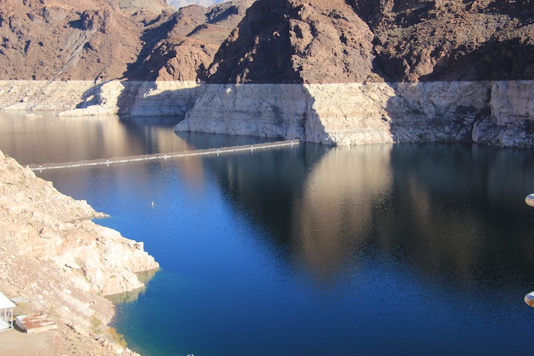
Lake Mead on the Colorado River, a major source of water for MWD. Photo/Allen Best
Here’s an in-depth look at the Lower Colorado River Basin’s intentionally created surplus accounts in Lake Mead from Brett Walton, that’s running in Circle of Blue. Click through and read the whole thing. Here’s an excerpt:
This year and next, Arizona and California intend to draw on water they banked in the big reservoir, even as water levels drop.
A complex and arcane water banking program in the lower Colorado River basin, adopted in 2007 and later amended, was designed to incentivize water conservation, prevent waste, and boost storage in a waning Lake Mead.
The program has already proved its worth, lifting Lake Mead dozens of feet higher than it otherwise would have been and nurturing collaboration among states that will need to work together to surmount daunting challenges of water availability. In the next two years, the program will be tested in another way, becoming a small but important source of water for Arizona and California even as the lake continues to fall to levels that haven’t been witnessed in several generations.
Water managers in the basin view the program, called intentionally created surplus or ICS, as a flexible tool for adapting to a drying climate. It is a tool that they will soon call upon. Bill Hasencamp from the Metropolitan Water District of Southern California, a large regional wholesaler, told Circle of Blue that the district intends to draw between 100,000 and 150,000 acre-feet from its savings this year.
Arizona officials, meanwhile, plan to use 69,100 acre-feet of ICS credits to reduce mandatory cutbacks that will be required in 2022 if Mead declines as projected. The state already used this maneuver to deal with a cutback last year, albeit in a smaller amount. Instead of taking a big cut in one year, ICS allows Arizona to “smooth the reduction,” as Chuck Cullom of the Central Arizona Project put it. CAP delivers the bulk of Arizona’s Colorado River allocation and is first in line in the state when cutbacks are required.
These amounts are small but significant, especially in these times. An acre-foot is 325,851 gallons, or the amount of water that will flood an acre of land to a depth of one foot. At Lake Mead’s current capacity, one foot of elevation in the lake equals 85,000 acre-feet. These ICS uses, at the high end, amount to two and a half feet of elevation in Lake Mead.
At the same time that water users plan to tap their savings, scholars in the basin are calling for more analysis of the ICS program, especially as Lake Mead’s decline accelerates. They would like to check how the system responds to ICS use under a range of water supply scenarios.
Ever since the mid-2000s, the last time that water supplies in Colorado River reservoirs reached critically low levels, the biggest water users in Arizona, California, and Nevada have been stashing water in Lake Mead, in preparation for another emergency to come — and in an attempt to avoid a catastrophic collapse of the region’s water storage system.
With the federal government now projecting that Lake Mead will drop precipitously in the next two years — perhaps to levels not seen since the Great Depression, when the country’s largest reservoir was first filled — that emergency has arrived.
“While Colorado River water users have invested billions of dollars to reduce consumption and increase resiliency, the situation we face today is real and urgent,” John Entsminger, the general manager of the Southern Nevada Water Authority, said at a House Natural Resources subcommittee hearing on May 25…
Because of record-high temperatures and a drying climate, the basin is also dangerously parched. Thirsty soils gulp melting snow before it reaches streams. Lake Mead, which is just 36 percent full, is in poor health. So is Lake Powell, located upstream and only 34 percent full.
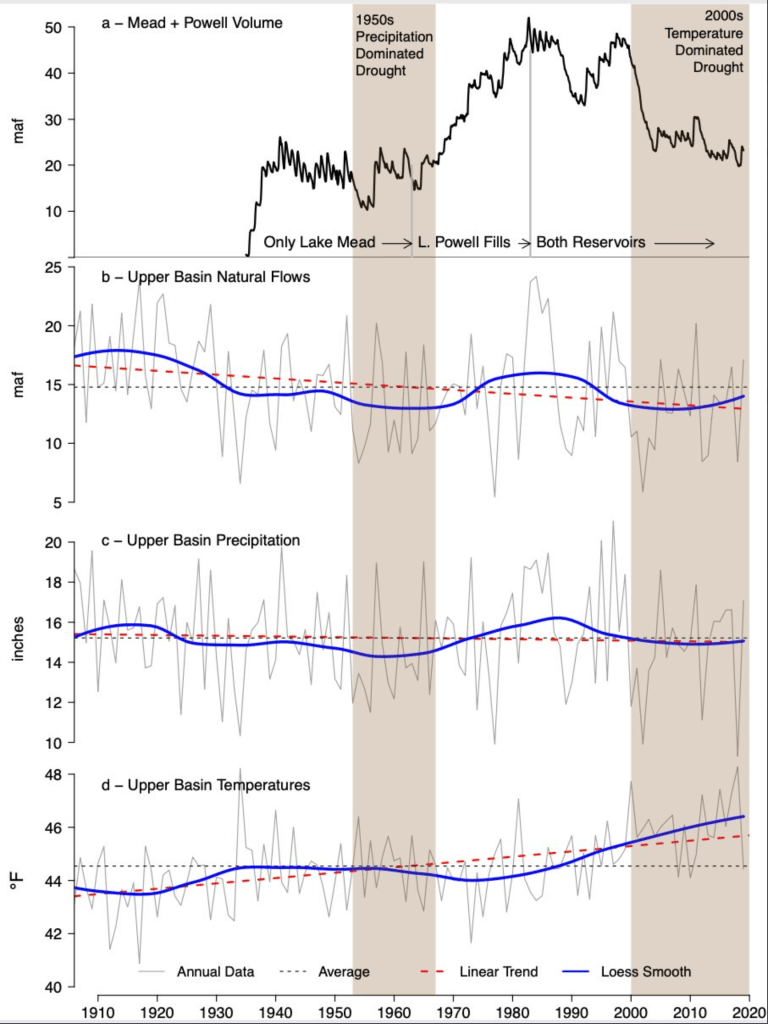
Brad Udall: Here’s the latest version of my 4-Panel plot thru Water Year (Oct-Sep) of 2019 of the #coriver big reservoirs, natural flows, precipitation, and temperature. Data goes back or 1906 (or 1935 for reservoirs.) This updates previous work with @GreatLakesPeck
Creating Surplus
ICS was conceived during negotiations between the seven states that led to a milestone agreement in 2007 that transformed how the basin operates. At the time, Lake Powell had experienced the driest five-year period in the region in a century and there were unresolved questions about delivering water under such conditions. The 2007 Interim Guidelines, which expire at the end of 2025, were a landmark document that secured three substantial changes.
First, the guidelines developed a formula for determining how much water is released from Lake Powell into Lake Mead. The releases are designed to keep the reservoirs roughly in balance.
The guidelines also set Lake Mead elevations at which lower basin states would be required to reduce their withdrawals. The first of these shortage tiers — at 1,075 feet above sea level — is expected to be breached next year. (Mead is currently at 1,073 feet, but for shortage determinations, it is the projected level in the following January that matters. Right now that projection is 1,066 feet.)
The third change was establishing intentionally created surplus, or ICS. The program allows big water users in the lower basin to open a savings account in the lake. To bank water in their account, they must take an action that reduces water consumption. That banked water is credited to the user that created it. ICS is not conservation in the household sense of simply using less. It is not taking a shorter shower or only watering the lawn once a week. ICS is instead more comparable to a personal savings account. Water banked now becomes an asset that can be withdrawn later, subject to certain conditions…
With a bit of linguistic maneuvering, the rules were written so that agencies like Met could create “surplus” by investing in conservation. Say, for example, that Met paid to line a canal with concrete so water would not seep into the soil, or paid farmers to fallow their fields. The Bureau of Reclamation, playing the oversight role in the lower basin, checks that the lining kept water in the canal and the alfalfa fields were not irrigated. That amount of water — the difference between what would have been delivered without the intervention and what was actually delivered — would then be credited to Met in the form of ICS, minus a small percentage that is the lake’s share.
A few years later these rules were altered to bring Mexico into the program. U.S. entities can pay a counterpart in Mexico for conservation and reap the ICS asset. The rules were changed again in 2019, in an agreement called the Drought Contingency Plan, or DCP, that welcomed certain tribal nations into the fold. Banked water is now subjected to a one-time tax of 10 percent, a cut that is credited to the storage system as a whole.
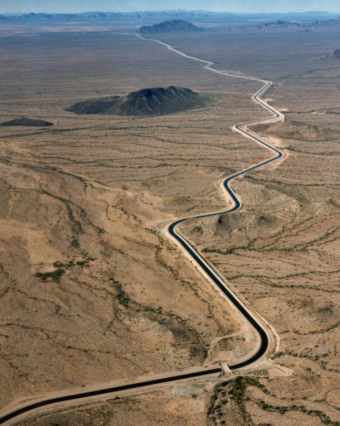
Aerial photo – Central Arizona Project. The Central Arizona Project is a massive infrastructural project that conveys water from the Colorado River to central and southern Arizona, and is central to many of the innovative partnerships and exchanges that the Gila River Indian Community has set up. Public Domain, https://commons.wikimedia.org/w/index.php?curid=326265
Only six entities have created ICS, according to Jeremy Dodds, who is responsible for ICS accounting and verification at the Bureau of Reclamation. Those six are some of the largest water users in the basin: Met, Gila River Indian Community, Colorado River Indian Tribes, Southern Nevada Water Authority, Imperial Irrigation District, and the Central Arizona Water Conservation District, which manages CAP. Within the four categories of ICS, there are limits on the ICS each water user can create, the amount they can take out in a year, and the total amount stored.
With children and families out floating the Las Colonias River Park behind them, community leaders gathered to celebrate the opening of the park amenity and recognize the work it took, over more than 30 years, to clean up the area and turn it into the park it is today.
The River Park has been open since May of 2020, but the celebration had to be delayed, as most things were, due to the COVID-19 pandemic. However, a year later leaders from the city of Grand Junction, Colorado Mesa University, Great Outdoors Colorado (GOCO) and others came together Thursday afternoon to speak about the impact of the park.
Parks and Recreation Director Ken Sherbenou spoke about the history of the Las Colonias Park, which had previously been the site of a junkyard that was contaminated with uranium mill tailings. In the late 1980s, a group of citizens got together to clean the area up…
Throughout this project the community had support from GOCO, which helped with the original Watson Island cleanup with a grant in 1995 to the River Park itself, which used a $350,000 GOCO grant, as well as funding from the Colorado Water Conservation Fund, for its construction…
There were many partners that made Las Colonias and the River Park possible, Sherbenou said, which included a number of federal and state agencies, as well as local partners. He said going forward it will lead to more people becoming stewards of the Colorado River.
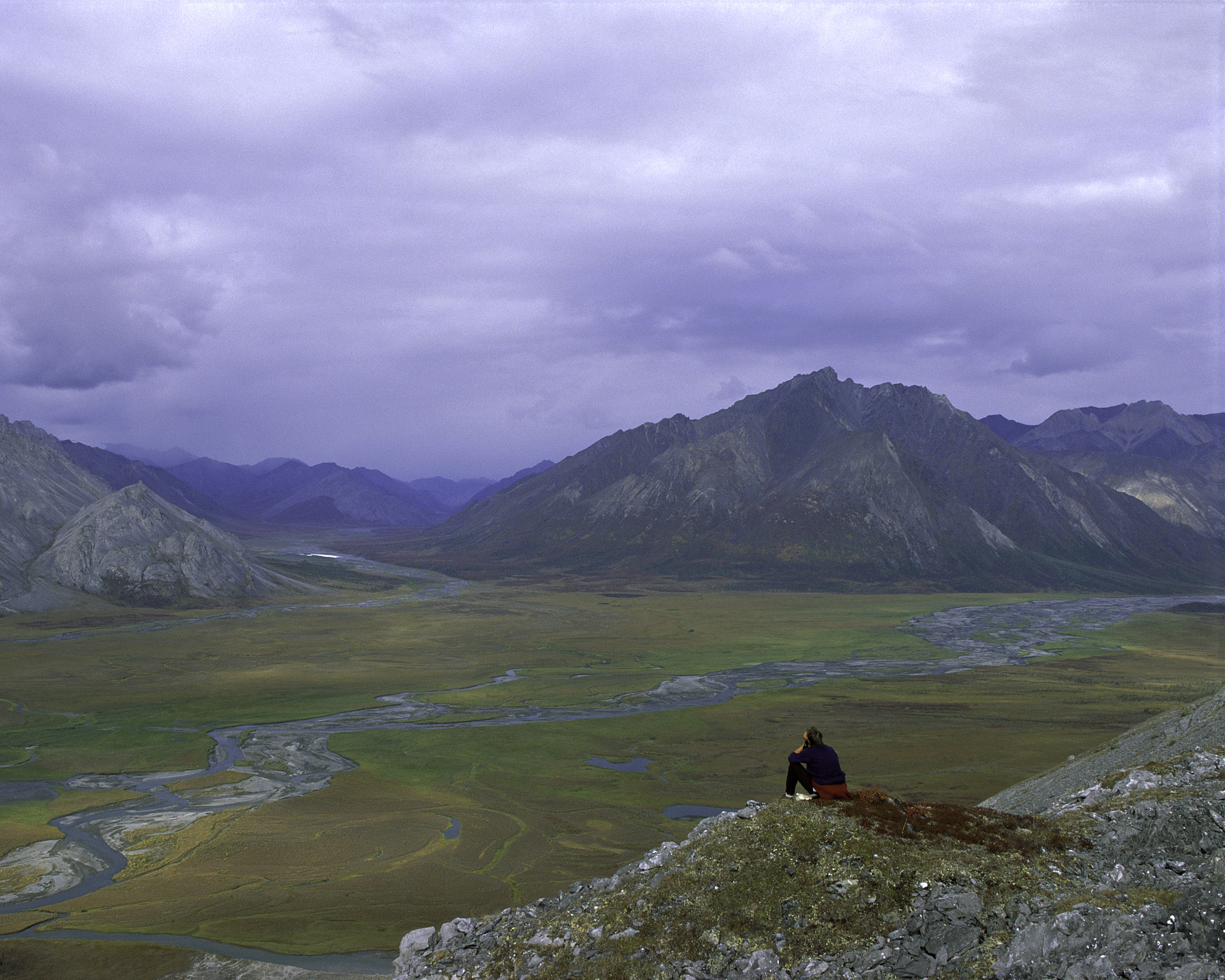
Arctic National Wildlife Refuge. Photo credit: Steven Chase, U.S. Fish and Wildlife Service, Public domain, via Wikimedia Commons
FromThe Washington Post (Juliet Eilperin and Joshua Partlow):
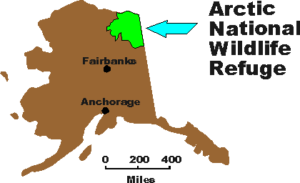
The Biden administration on Tuesday suspended oil and gas leases in the Arctic National Wildlife Refuge, targeting one of President Donald Trump’s most significant environmental acts during his last days in office.
The move by the Interior Department, which could spark a major legal battle, dims the prospect of oil drilling in a pristine and politically charged expanse of Alaskan wilderness that Republicans and Democrats have fought over for four decades. The Trump administration auctioned off the right to drill in the refuge’s coastal plain — home to hundreds of thousands of migrating caribou and waterfowl as well as the southern Beaufort Sea’s remaining polar bears — just two weeks before President Biden was inaugurated.
Now the Biden administration is taking steps to block those leases, citing problems with the environmental review process. In Tuesday’s Interior Department order, Secretary Deb Haaland said that a review of the Trump administration’s leasing program in the wildlife refuge found “multiple legal deficiencies” including “insufficient analysis” required by environmental laws and a failure to assess other alternatives. Haaland’s order calls for a temporary moratorium on all activities related to those leases in order to conduct “a new, comprehensive analysis of the potential environmental impacts of the oil and gas program.”
The step, coming just days after the Justice Department defended another drilling project on Alaska’s North Slope, underscores the balancing act the new administration aims to strike as it slows fossil fuel development on public lands. While Biden has paused new federal oil and gas leasing and pledged to drastically cut the nation’s greenhouse gas emissions, he has taken a much more cautious approach toward most oil and gas operations approved under his predecessor.
Last week, Justice Department attorneys filed a brief defending ConocoPhillips’s Willow project, an oil reservoir on the National Petroleum Reserve-Alaska that could hold up to 300 million barrels of oil. The administration also has defended the Trump administration’s decision to issue oil and gas leases in Wyoming and declined to press for the shutdown of the Dakota Access pipeline, a project Haaland protested while serving in Congress.
But Tuesday’s move signaled that the new administration was willing to take aggressive action in an area that has been a rallying cry for environmentalists for decades.
Area of the Arctic National Wildlife Refuge coastal plain, looking south toward the Brooks Range. By U.S. Fish and Wildlife Service – images.fws.gov (image description page), Public Domain, https://commons.wikimedia.org/w/index.php?curid=5787251
Small subsets of the electrical grid, or microgrids, that can stand alone in an emergency and keep critical services or businesses going, could be integrated into the Colorado Springs Utilities system in the coming years.
Utilities is working with Quanta Technology to identify the best locations for microgrids that could keep community services such as fire stations or wastewater treatment plants operational in a larger power outage, said Gabriel Caunt, principal engineer for the demand side management and distributed energy group within Utilities. The microgrids could also serve businesses with data centers that suffer major financial ramifications in a power outage, he said. Microgrids have been employed by military bases like Fort Carson for years to ensure power is available even when the larger grid goes down.
Fort Carson, which is home to several solar power projects, has a battery bank on the post that can supply power for several hours if electricity goes out.
The Utilities study will help determine “where the community can gain true resiliency value” from such grids, he said.
The microgrids include stand-alone generation, such as a solar array and battery, to provide power when the other parts of the grid are down.
The systems’ can also ensure excess electricity from renewable energy sources, such as solar panels and wind turbines, don’t have to be cut back because it is not meeting an immediate demand, Caunt said. Instead the electricity generation could be stored in batteries, he said.
Storing renewable electricity for peak demand times, such as when everyone is running their air conditioners, can help limit the need to build new power plants, said Keith Hay, director of policy and the Colorado Energy Office. As electric cars become more common, their batteries could help store electricity generated from renewable sources until it’s needed, he said.
Utilities granted Quanta a $398,000 contract to develop the Community Microgrid and Distributed Generation Plan by October and as part of that work the company will identify five candidate sites for a microgrid and design one, Caunt said. The work will be partially paid for by a $150,000 grant, said Natalie Watts, a spokeswoman for Utilities.
The city-owned utility has set an ambitious goal to cut its carbon emissions by 80% by 2030 and that could be reached without new microgrids, Caunt said. But the smaller grids will help Utilities make the most of solar panels that private companies are installing to meet their own sustainability goals.
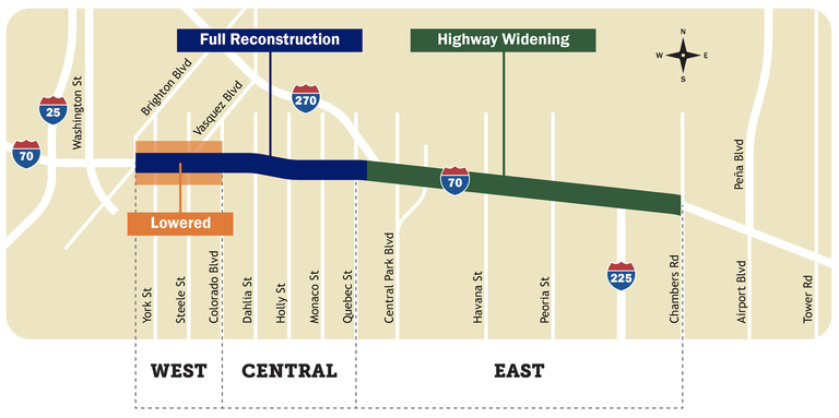
The lowered section of I-70 opened May 24, taking traffic off the remaining portion of the viaduct near the Purina plant.
Before the roadway was built, pipes were laid down. Some are 20 feet by 6 feet and can be driven through. Others are 6 feet by 6 feet and big enough to walk through.
The water from Central 70 flows to one of eight detention ponds. According to CDOT, the largest can hold 26 football fields worth of water: 8.5 million gallons. The smallest can hold 6,400 bathtubs full of water: 320,000 gallons.
The water from the tunnel portion of Central 70 gets some help getting back to the surface.
“We pump it to a very large holding tank,” said Inzeo…
A pump station near York Street brings the water to one of the detention ponds. From there, the water goes through a micro-pool, to get the solids and sediments taken out before the water ends up in the South Platte River behind the Denver Coliseum.
Half of the pump station is for taking water out, the other half is to support the fire suppression system inside the tunnel.
The brewing battle over the century-old Klamath Project is an early window into the water shortfalls that are likely to spread across the West as a widespread drought, associated with a warming climate, parches watersheds throughout the region…
In Nevada, water levels have dropped so drastically in Lake Mead that officials are preparing for a serious shortage that could prompt major reductions in Colorado River water deliveries next year. In California, Gov. Gavin Newsom has placed 41 counties under a state of emergency.
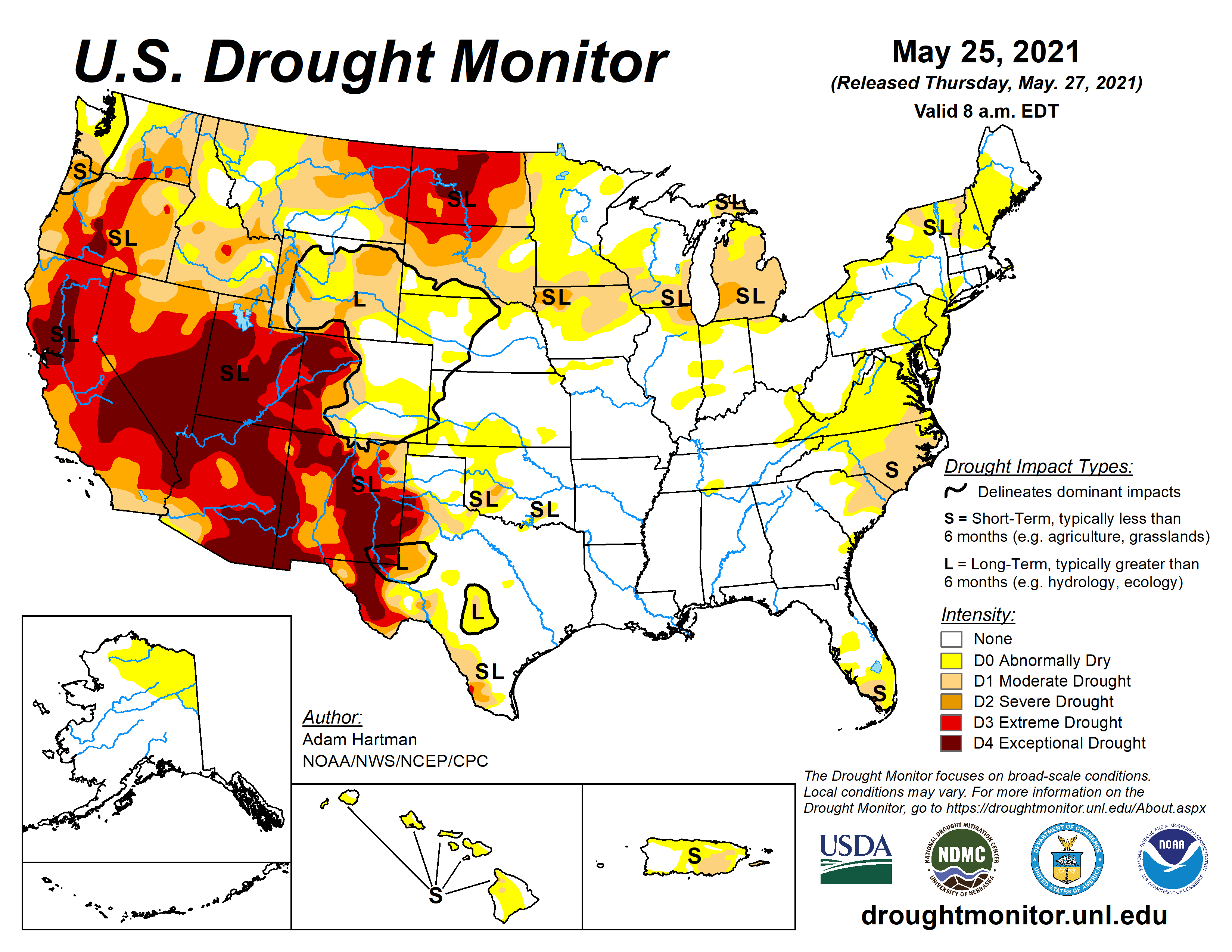
US Drought Monitor map May 25, 2021.
While drought consumed much of the West last year, setting the stage for an extensive wildfire season, the conditions this spring are far worse than a year ago. More than half of the West faces “extreme” drought conditions, according to the U.S. Drought Monitor, including wide areas of California and Oregon. Scientists have said the region may be going through the worst drought period in centuries.
Here in Oregon, conservationists, Native American tribes, government agencies and irrigators are squaring off, and local leaders fear that generations of tensions could escalate in volatile new ways.
“There are folks on both sides that would really like to throw down and take things in an ugly direction,” said Clayton Dumont, a member of the Klamath Tribal Council. “I hope it doesn’t happen, but it’s a possibility.”
Some landowners have openly talked about breaching the fence surrounding the dam property and forcing open the irrigation gates. Already, they have purchased property adjacent to the head gates and staged protests there. Ammon Bundy, who led an armed takeover of an Oregon wildlife refuge in 2016, said he was ready to bring in allies to help keep the gates open, saying that people need to be prepared to use force to protect their rights even if law enforcement arrives to stop them.
“Who cares if there is violence? At least something will be worked out,” Mr. Bundy said in an interview, ridiculing those not prepared to fight for the nation’s food supply. “‘Oh, we don’t want violence, we’ll just starve to death.’ Heaven forbid we talk about violence.”
The region has a deep history rooted in violence and racial division. In 1846, U.S. War Department surveyors, led by John C. Frémont and Kit Carson, slaughtered more than a dozen Native Americans on the shores of Klamath Lake. The Klamath Tribes eventually signed a treaty surrendering some 20 million acres of their historic lands in exchange for a reservation along Upper Klamath Lake and the perpetual right to hunt and fish.
For the United States, the Klamath Project became a keystone for settling and developing the region. Homestead opportunities for veterans after the two world wars helped to stimulate the economy and to build a new kind of community.
In 1954, Congress moved to terminate recognition of the Klamath Tribes, which held lucrative timberlands, and authorized the sale of tribal lands.
And the government’s guarantee to the Klamath Tribes that they would at least be able to continue fishing ran into trouble decades ago, when populations of native sucker fish — known to the tribes as C’waam and Koptu — along with coho salmon farther downriver slipped into a perilous decline, prompting mandatory protections under the Endangered Species Act.
During a drought in 2001, the federal Bureau of Reclamation initially planned for the first time to fully cut off water for farmers over the summer. That order spurred an uprising of farmers and ranchers who used saws, torches and crowbars to breach the facilities and open the canal head gates.
U.S. Marshals eventually stepped in to protect the gates, and the Bureau of Reclamation later released some water to help farmers…
Now some in the basin are worried that the unresolved divisions are poised to erupt again…
This year shows how critical the shortage is already: Even with farmers cut out of the water supply, fish are suffering…
Lake levels fell below the minimum thresholds set by federal scientists, prompting litigation and spurring fears that algae blooms this summer could devastate the imperiled fish populations above the dam; tribal researchers say insufficient flushing downstream from the dam has allowed parasites to flourish.
Already this year, juvenile salmon are turning up dead with parasitic infections. Michael Belchik, a senior water policy analyst at the Yurok Tribe, said the die-off could end up being the worst on record…
Also cut off from water supplies this year are several wildlife refuges that are home to 25 at-risk species of birds and fish…
But on Thursday night, about 100 people gathered under a large tent next to the head gates on property bought recently by two farmers, Dan Nielsen and Grant Knoll, who say they have a legal entitlement to the water behind the gates in Upper Klamath Lake under state water law. They contend that the federal government’s shut-off is a violation of state and federal law and the U.S. Constitution.
Tribes and irrigators have each notched victories in court over water rights, and the legal cases are continuing.
At the event, organized by local activists in Mr. Bundy’s network, speakers talked about the need to take back their rights. Some floated unfounded conspiracy theories, linking the water crisis to George Soros, Bill Gates or the United Nations. A Betsy Ross flag flew above the tent while a poster inside featured a quote about freedom attributed to LaVoy Finicum, who was killed by federal agents during the standoff that Mr. Bundy led in 2016. Mr. Bundy faced federal charges for his role in the standoff but was acquitted by a jury…
Facing a similar standoff two decades ago, in 2001, the federal government relented with a limited delivery of water to farmers, but there was no sign that agencies, facing an already depleted lake, would budge this time. An initial plan to provide a small water allocation to farmers was canceled when conditions worsened.
Water levels at Lake Powell, the second-largest reservoir in the country, fell to 3,559.95 feet above sea level on Monday, down from an average of 3,604.09 at this time (May 26) last year, according to the Lake Powell Water Database.
Lake Powell is at 34.2% of full pool (24,322,000 acre-feet) and 140.8 feet below full pool (3,700) as of Wednesday morning.
The primary factors influencing Lake Powell – as well as Lake Mead, the largest reservoir in the country – are inflows into Lake Powell, according to the Bureau of Reclamation.
Upper Basin hydrology accounts for about 92% of the total streamflow in the basin. Inflow into Lake Powell is also affected by Upper Basin water use and the operation of reservoirs above Lake Powell…
The Colorado River, Tooh Bikooh Dinék’ehjígo, originates on the Colorado western slope. Over 25 significant tributaries join it. The Green River in Utah is the largest by both length and discharge.
Tooh Bikooh flows to the Gulf of California. It provides water to nearly 40 million people for municipal use, to irrigate nearly 5.5 million acres of land, and is the lifeblood for at least 22 federally recognized tribes, seven national wildlife refuges, four national recreation areas, and 11 national parks, according to Reclamation.
In August 2020, a 24-month study projected the Jan. 1, 2021, Lake Powell elevation below the 2021 Equalization Elevation of 3,659 feet and above 3,575 feet. The lake level was 3,582.06 feet that day, according to the Lake Powell Water Database.
With an 8.23-million-acre-foot release from Lake Powell in the water year 2021, an April 2021 24-month study projects the end-of-water-year elevation here below 3,575 feet. Lake Powell will continue to release 8.23 million acre-feet through the remainder of the water year.
The Bureau of Reclamation will release its subsequent major study in August…
The current water level at Mead is 1,074.84, which is 154.16 feet below the full pool of 1,229 feet, as of Wednesday morning.
Arizona, Nevada, and Mexico are making contributions to Mead in a collaborative effort to maintain water levels and avoid severe shortage conditions at least through 2022.
But a first-ever official shortage declaration from the Department of the Interior is almost certain later this year…
Because Tooh Bikooh is over-allocated – and because drought and climate change are likely to worsen as the region gets hotter and drier — the seven Colorado River Basin states in 2019 agreed on a plan to manage the river by voluntarily cutting their water use to prevent the federal government from imposing mandatory water restrictions on the supply.
As part of the Lower Basin’s drought contingency plan, the CAP would see its water supply cut by about one-third in 2022 because of its junior water rights in the river’s water. And farms in central Arizona would experience those water cuts.
Reclamation’s projections continue to show a very high likelihood of Tier 1 reductions in 2022 and in 2023, as well as an increased risk of Tier 2 conditions in the future, according to the CAP.
The three biggest wildfires in Colorado history all occurred last year. The biggest fire in 2020 — that is, the state’s biggest fire ever — was more than 50% bigger than the biggest fire in any other year in the state’s history. The 20 biggest fires in state history have all occurred in the past 20 years.
And it’s no secret why: climate change.
Fire officials say a decades-long regional drought and forests plagued by bark beetles were largely to blame for the ferocious fire season, and those conditions, according to scientists, in turn are attributable to rising average temperatures. Many parts of Colorado have gotten hotter by almost 4 degrees Fahrenheit above pre-industrial levels.
Climate change has battered the state in other ways. Warming can cause river flows to decrease, and nowhere is this phenomenon a greater emergency than in the Colorado River, the headwaters of which are near Grand Lake. The river supplies water for more than 5 million acres of farmland and about 40 million people in seven states, including Colorado. But it’s drying up. It could lose a quarter of its flow by 2050, scientists say. So little water is expected to run down through the Southwest states this year that the U.S. Bureau of Reclamation could declare the first official shortage for the river.
Wildlife populations throughout the country are suffering from drought and other climate change impacts. In Colorado, climate change threatens deer, bighorn sheep, pronghorn, birds and other familiar creatures. Birds are especially vulnerable. Half of the birds in Colorado are said to be in decline because of changing climate conditions.
This is all due to human activity, mostly related to oil and gas extraction and consumption, which releases greenhouse gas emissions into the atmosphere. Colorado is one of the country’s top five oil-producing states and among the top natural gas producing states. The scale of fossil fuel production that occurs in Colorado gives the state a colossal carbon footprint.
That’s why Colorado has an administrative and moral duty to rigorously regulate oil and gas extraction. Available to Coloradans are at least three avenues by which to better resist this toxic industry — local fracking bans, robust severance taxes, and more money for environmental clean-up…
If oil and gas companies are going to rip natural resources from the Earth and pollute public spaces, it’s only fair for the public to ask those companies for just compensation. “What we are talking about is the oil and gas industry’s social license to operate — if they are using public resources and polluting a public good, our environment, our communities, they need to be paying into the system,” said Jessica Goad, the deputy director of Conservation Colorado, according to The Colorado Sun.
But these companies don’t pay a fair amount. Not in Colorado.
The minimal sums Colorado collects from oil and gas companies in the form of severance taxes was detailed in stark terms early last year when the Colorado Office of the State Auditor released a report on severance taxes. For years extraction companies have received hundreds of millions of dollars in savings due both to government leniency and systemic problems. The audit found that Colorado offers enormous gifts to fossil fuel interests in the form of exemptions, credits and deductions.
When a company takes something of nonrenewable value from the Earth, such as oil and gas, coal and metals, that value is lost to the public and accrues to private interests in the form of profits. Governments apply severance taxes to capture some of that lost wealth.
Colorado’s severance tax system imposes rates between 2% and 5%, depending on gross income, against oil and gas sales. These rates roughly align with those found in other comparable states. However, the state’s severance tax system is objectionable in ways that go beyond the base rates. The auditor’s office found that the Colorado Oil and Gas Conservation Commission failed to collect from extraction operators tens of thousands of required monthly well production reports, and some submitted reports were incomplete. The reports are a key component in the severance tax calculation system.
Furthermore, state rules call for a fine of $200 a day per well for missing reports, but for the years reviewed — 2016 to 2018 — the commission demanded no fines. The auditor’s office estimated that the failure to fine companies for delinquent reports alone amounted to a loss of more than $300 million.
A bigger giveaway to oil and gas companies comes in the form of an ad valorem tax credit, which allows company owners to claim a credit against their severance tax bill at a rate of 87.5% of the ad valorem property taxes they paid to local governments. Only two other oil and gas-producing states allow for this type of credit against the severance tax. And Colorado’s method of calculating the credit is extremely complex, which itself leads to problems. The auditors wrote that “the application of the ad valorem tax credit is the most problematic aspect of severance tax returns and frequently contributes to taxpayer noncompliance.”
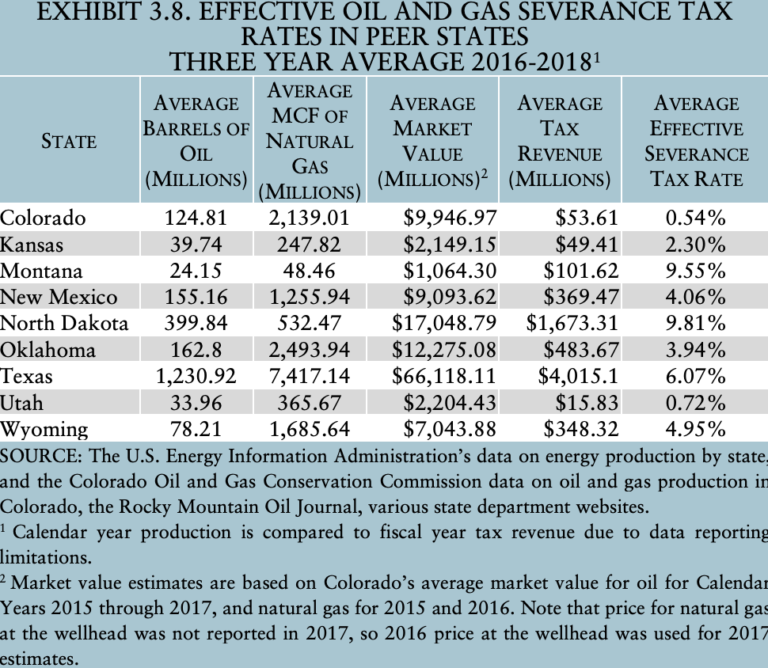
This table from the January 2020 severance taxes audit from the Colorado Office of the State Auditor shows the average effective oil and gas severance tax rates from 2016 to 2018 in Colorado and eight other peer states. Colorado’s, at 0.54%, was the lowest. (Colorado Office of the State Auditor)
Colorado allows a severance-tax exemption for low-producing wells, also known as “stripper” wells. This equates to a massive gift to the industry. The auditor’s report found that 70% of the wells in Colorado in 2016 met state law’s definition of a stripper well. Exempting all these producing wells cost the state up to $55 million that year. This isn’t some industry norm — few states offer such special treatment of polluters, according to the report.
All together, the exemptions, credits and deductions that Colorado grants to industry meant the state’s effective severance tax rate was estimated in the report at only 0.54%. That was the lowest effective severance tax rate among nine oil and gas-producing states analyzed by the auditor.
Some lawmakers have long understood the untenable state of severance taxes in Colorado, but a combination of ineffective leadership, complications foisted by the state’s Taxpayer’s Bill of Rights, and the deep-pocketed industry lobby so far has put reform out of reach. Early last year members of the General Assembly had planned to convene a study committee to examine oil and gas taxes. But such committees were canceled due to COVID-19, and none are planned for this year, according to a spokesperson for Colorado Senate Democrats.
Following the audit, the oil and gas commission implemented an automated system that sends an email to operators when a well production report is overdue. But the commission has yet to issue any fines for delinquent reports. In the current state legislative session, House Bill 21-1312 and Senate Bill 21-281 propose improvements to the way the severance tax is applied. But even if they become law they’re tweaks, not reform. The stupendously generous ad valorem tax credit remains Colorado law, as does the freebie on stripper wells.
It is intolerable for the state to behave with such generosity and permissiveness toward a whole industry, but it is also self-destructive when that industry is responsible for planet-wide ruin. State lawmakers must not put off severance tax reform any longer.
In the issue, read about the cornerstone role that water storage has played in Colorado for more than a century, the Colorado Water Plan goal to develop additional storage by 2050, challenges and opportunities with specific projects, and some of the many ways that Coloradans are looking toward the next era of storage.
Experts from different organizations presented updates specific to their work, all focusing on water rights, drought outlooks and river basin updates.
Russ Schumacher, director of the Colorado Climate Center at Colorado State University, went through the recent history of the ongoing drought in the state. He said throughout the past few months, eastern Colorado has seen decent drought improvement, but western Colorado has remained about the same.
Schumacher presented a chart showing average temperatures and precipitation from April through September, which showed that 2020 was somewhat of an outlier.
“It was the driest April through September on record and one of the few hottest on record, and that is a recipe for a drought that develops quickly,” Schumacher said…
Richard Van Gytenbeek, Colorado River Basin outreach coordinator for Trout Unlimited, provided an overview of the goals and accomplishments from phase one of the Blue River Integrated Water Management Plan. The first objective of the plan, which Van Gytenbeek said the group has spent most of its time on, is to understand potential causes for declining fish populations between the Dillon and Green Mountain reservoirs and how the decline can be mitigated…
The second objective is what Van Gytenbeek called a “literature search,” which aims to compile information regarding physical and biological aspects of the Blue River Basin’s water resources. This would then formulate objectives and goals for future phases of the plan.
Van Gytenbeek said the phase one report is currently being finalized, and they intend to submit it to an advisory committee in the middle of June. He said he expects the report to be made public in July or early August.
Once the report is completed the second phase of the project will continue, with hopes of having the final phase two report ready for the public by March 2022. Van Gytenbeek said he thinks integrated water management plan organizations like the Blue River Watershed Group should get some support to keep the dialogue going past the life of phase two of the project.
Dave Kanzer, deputy chief engineer at the Colorado River District, talked about supply issues within the Colorado River Compact…
Nathan Elder and Jason Finehout of Denver Water said there is a low likelihood of filling the Dillon Reservoir this year, predicting an inflow of about 50-60% of normal. Finehout went on to explain that many of Denver Water’s annual summer watering rules are the same as many jurisdictions’ stage one drought restrictions…
Swan River restoration Reach A gravel removal. Photo credit: Summit County
Brian Lorch, trails director of Summit County Open Space and Trails, provided an update on the Swan River Restoration Project, which aims to naturalize more than two miles of the Swan River Valley impacted by historical dredge mining.
Lorch said this summer, Reach B of the project will start to take shape, as contractors will create about another mile of stream channel.
New research shows forests not bouncing back from fires as quickly, which could lead to erosion and strains on drinking water
The U.S. Forest Service and Boulder County have begun a $6.5 million emergency push to try to stabilize slopes here before hard summer rain. It’s an immediate fix for what research indicates could be a long-term problem…
In Washington, D.C., Democratic Sen. Michael Bennet and Rep. Joe Neguse are pushing legislation to deploy tens of thousands of workers to thin western forests before fires break out — a technique Boulder County land managers have used repeatedly over the last decade. Federal land managers, meanwhile, said they’re evaluating whether to replant and how much in an effort to promote at least partial recovery from a wildfire…
Focus on forest health
Wildfires played key roles in forming forests over thousands of years, bringing balance and diversity. But natural cycles were distorted by decades of humans aggressively suppressing fire, which is still a priority in Colorado and other western states. The resulting tree density, along with high temperatures and aridity, led to last year’s record-breaking megafires in California and Colorado.
“In many recently burned areas, trees aren’t reestablishing. We’re seeing this especially in wildfires that burned in Ponderosa pine forests,” said Tony Cheng, director of the Colorado Forest Restoration Institute and professor of forest and rangeland stewardship at Colorado State University.
Cheng recently testified in Congress, warning that forest fires are releasing more carbon into the atmosphere, that forest recovery may take centuries — if it happens at all — and that the United States’ capacity to sequester carbon is diminishing.
“If recent research is providing insight into the future, the prospects are low for forests to return to what people were used to seeing,” Cheng told The Denver Post. “Forest cover could be sparser, trees would be replaced with shrubs and other plants, the wildlife might be different, and the water-holding and filtering capacity of forests would be altered for a long time.”
A University of Colorado study published in February tracks with his assessment and blames climate warming. A 2017 study using data from 1,485 burn sites found increasingly unfavorable conditions for forests to regenerate throughout the Rocky Mountain West.
Slopes above Cheesman Reservoir after the Hayman fire photo credit Denver Water.
And northwest of Colorado Springs, the 70-square-mile core of the 214-square-mile scar from the 2002 Hayman fire shows how severe burning can reduce a towering 200-year-old Ponderosa and Douglas fir forest to grasses and shrubs two decades later.
Fighting to ‘keep the soil on the slopes’
Up on the blackened mountainsides between standing dead pines, orange-vested contractors recently were scoping sites to install 30 small dams and a pond to try to keep soil, crucial for new growth, from eroding.
Ground crews sawed into the pines, leaving roots in place. Amid a staccato thudding, red helicopters crisscrossed overhead, hoisting cut trunks using dangling hooks and hauling them into massive piles. A tractor-sized grinder turned the trunks to tons of mulch, which helicopters hauled in nets and dropped over severely scorched slopes six inches thick.
This emergency effort must stabilize the burned terrain as quickly as possible, Glowacki said, adding, “Our role in this is to keep the soil on the slopes.”
But by May 21, only 200 acres out of 1,800 acres prioritized in the project had been covered. The grinder had broken.
If scorched slopes remain barren, hard rain likely will cause flooding, possible slides and wash sediment into Geer and Plumley creeks, which flow into Lefthand Creek, the drinking water source for communities north of Boulder.