Click on a thumbnail graphic to view a gallery of drought data from the US Drought Monitor.
US Drought Monitor map October 5, 2021.
High Plains Drought Monitor map October 5, 2021.
West Drought Monitor map October 5, 2021.
Colorado Drought Monitor map October 5, 2021.
Click here to go to the US Drought Monitor website. Here’s an excerpt:
This Week’s Drought Summary
Several storm systems impacted various regions of the country this week as the transition to autumn continues. Temperatures through the Midwest and northern Plains remained unseasonal with departures of 9-12 degrees above normal. As cooler air came into the West, temperatures were 3-6 degrees below normal in the region and into the Southwest. The Pacific Northwest had several rain events that brought needed moisture into the region. Areas of eastern Arizona, New Mexico and Colorado also had above-normal precipitation for the week. A slow-moving cold front brought with it a line of showers from the Dakotas into Texas. This slow-moving rain maker brought relief to many dry areas of the Plains. Dry conditions dominated the northern Rocky Mountains as well as the coastal regions of the East from the Mid-Atlantic into Florida…
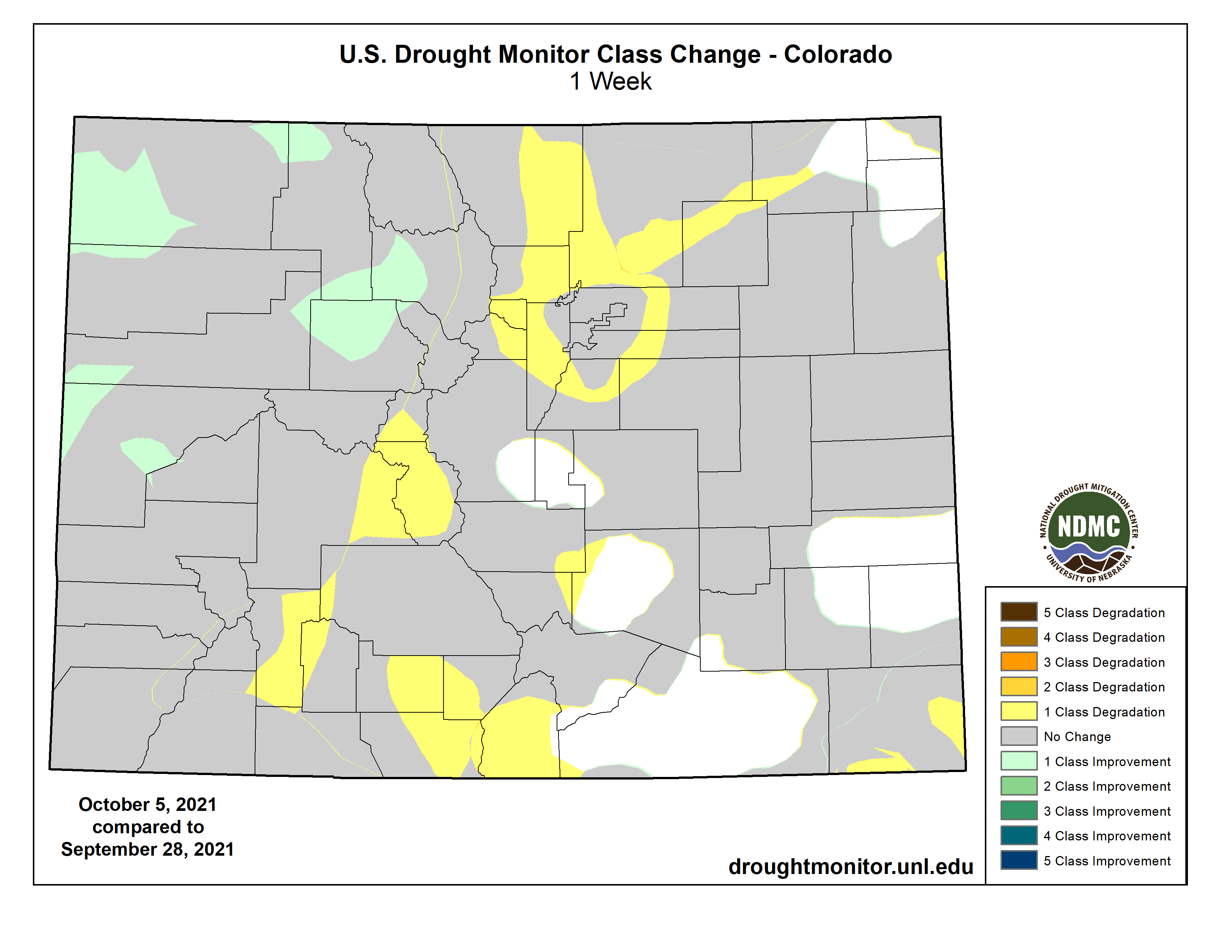
Significant rains fell over portions of western and central Kansas, central and northeast Nebraska and into central South Dakota as well as southeast North Dakota. Temperatures were warm over almost the entire region with departures of 9-12 degrees above normal in North Dakota and northern areas of South Dakota, and generally 3-6 degrees above normal elsewhere. Those areas that have been in long-term drought will continue to see challenges to pasture and rangeland conditions as well as available forage. Hay stockpiles continue to decline and will be more expensive on the open market compared to past years. Improvements to the drought status were made in areas that received the most rain and the indicators showed improvements. In South Dakota, extreme and severe drought was improved in the south and north areas while moderate drought and abnormally dry conditions were improved in the east. Where it remained dry in the western portions of the state, extreme and severe drought were expanded this week. In Nebraska, the dryness over the Panhandle remained a concern and a new area of extreme drought was introduced this week that went into southeast Wyoming. Areas of improvement were confined to central and southwest Nebraska where moderate drought and abnormally dry conditions were improved in response to the recent rains. Areas of eastern Colorado had moderate drought conditions expand this week while severe drought expanded in far southeast Colorado and into southwest Kansas. Areas of northwest Kansas saw improvements of abnormally dry and moderate drought conditions this week…
Colorado Drought Monitor one week change map ending October 5, 2021.
As the 2020-21 water year ended, several places set records for driest years ever recorded. In northern California, Redding ended up with 14.24 inches, breaking the previous record low of 19.38 inches in 1990-91 and a normal of 33.52 inches. Red Bluff recorded 9.48 inches compared to the previous record of 10.98 inches in 1975-76 and a normal of 23.12 inches. The Sacramento Executive Airport recorded only 6.61 inches of precipitation for the water year, breaking the record from 1976-77 of 6.62 inches, with normal being 18.14 inches. Rains in the Pacific Northwest and into the Four Corners regions were the only areas with above-normal precipitation for the week. The conditions brought with them cooler than normal temperatures with departures mainly 3-6 degrees below normal, with some even cooler readings in those areas that had the most rain. Warmer than normal conditions dominated the northern Rocky Mountains and into northern Wyoming where temperatures were 3-6 degrees above normal. Some improvements to the extreme drought were made over portions of northwest Colorado into eastern Utah. Extreme drought was also improved over western New Mexico while moderate drought was improved in central New Mexico. Exceptional drought was improved over northeast Washington into northern Idaho while extreme drought was expanded over southern Montana into northern Wyoming with severe and extreme drought expanding over western Montana. Areas of southwest and southern Colorado had moderate and severe drought conditions expand…
Temperatures across the region were generally warmer than normal with departures of 4-6 degrees above normal common. In contrast to last week, much of the region did see some beneficial rains that put the brakes on the recent dryness. Some areas did miss out, with the Oklahoma and Texas panhandles, east and west Texas and western Arkansas being the driest. Much of the abnormally dry areas introduced last week in Texas were improved this week with even some areas of moderate drought being removed in the south and central portions of Texas. Eastern Texas had an expansion of abnormally dry and moderate drought conditions, and in the Oklahoma panhandle, severe drought was expanded and a new area of extreme drought was introduced that also went into portions of southeast Colorado. Severe drought was expanded slightly in north central Oklahoma where rains missed while other areas of central Oklahoma had improvements to the drought status this week. Most of northern Arkansas had precipitation that helped to improve the abnormally dry conditions, but the spottiness of the rains also means that some areas continue to dry out…
Looking Ahead
Over the next 5-7 days, it is anticipated that warmer than normal temperatures will continue to dominate the eastern United States from the Rocky Mountains to the Atlantic coast. Temperatures will be warmest over the Great Lakes region where high temperatures will be 12-15 degrees above normal. The West will have below-normal temperatures with departures of 3-6 degrees below normal throughout the region. The best chances for precipitation will be over the Southeast, with areas of northern Georgia and Alabama and eastern Tennessee projected to record the most rain. The coastal regions of the Pacific Northwest look to stay wet, and wet conditions are anticipated over Nevada, Utah, western Colorado, Wyoming, Idaho and southern Montana. Up to an inch of rain is also anticipated over the northern Plains and Midwest.
The 6-10 day outlooks show the high probability of warmer than normal temperatures over the eastern half of the United States, where the greatest chances of above-normal temperatures are over the Great Lakes region and into the Mid-Atlantic. Above-normal chances of below-normal temperatures are anticipated over the West, with the greatest probabilities over the Great Basin. The best chance of above-normal precipitation is through the Rocky Mountains and Plains states, with the highest probabilities over the northern Plains. The best chances for below-normal precipitation are over the southern deserts of New Mexico, New England, and northern Florida into southern Georgia.
US Drought Monitor one week change map ending October 5, 2021.
Just for grins here’s a gallery of US Drought Monitor maps from early October for the past few years.
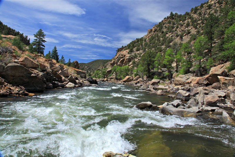
The playground that flows through Chaffee County delivered the goods this summer, with fat waves and tourist dollars churning out what Bob Hamel calls a banner season on the Arkansas River.
“If it’s a good rafting year, that drives the economy,” says Hamel, Executive Director of Arkansas River Outfitters Association and who sits at the Arkansas Basin Water Roundtable. “Everybody I talked to was up.”
The number of visitors to the 143-mile Arkansas River Recreation Area was already up 18 percent in 2020. The river economy typically flows more than $70 million a year into local communities.
But Hamel, like so many in the water community, is acutely aware of potential shoe dropping in the Upper Colorado River Basin, which ultimately plays out on the Arkansas River.
None of the water in America’s West, or anywhere, for that matter, operates in a vacuum. When the U.S. Bureau of Reclamation made its historic shortage declaration on the Colorado River on Aug. 16, the famed waters through Browns Canyon National Monument, as well as the local economy and environment that ripple out from them, were arguably in a stranger position than the day before.
In the words of Federal Water Master John Thorson, “Water links us to our neighbor in a way more profound and complex than any other.”
Browns Canyon via BrownsCanyon.org
Upon the Aug. 16 announcement, Arizona farmers braced for 512,000 fewer acre-feet in the 2022 water year. The news was no surprise, really; they’d anticipated it for months.
For now, Nevada will lose 21,000 acre-feet. California, with the most senior water rights among the three states that comprise the Lower Colorado River Basin along with Mexico, has been spared for the time being.
The situation has players in the water industry girding for more news nobody wants to hear. Lake Mead, the major reservoir for the lower basin states, had hit a historic low of 1,067 feet, threatening the levels for hydropower for 1.3 million people. Without significant changes to two decades of drought driven by changing climate, more restrictions are likely on tap.
And with that, talk is intensifying in the upper basin, where the Bureau could declare a shortage as soon as 2022. Colorado, Wyoming, Utah and New Mexico comprise the upper basin states that rely on Colorado River water…
Just as Lake Mead’s ability to supply water and electricity in the lower basin has been threatened, the levels at Lake Powell and the threshold required for hydropower could trigger cutbacks for the upper states. Glen Canyon Dam generates 5 billion kilowatt hours of electricity annually.
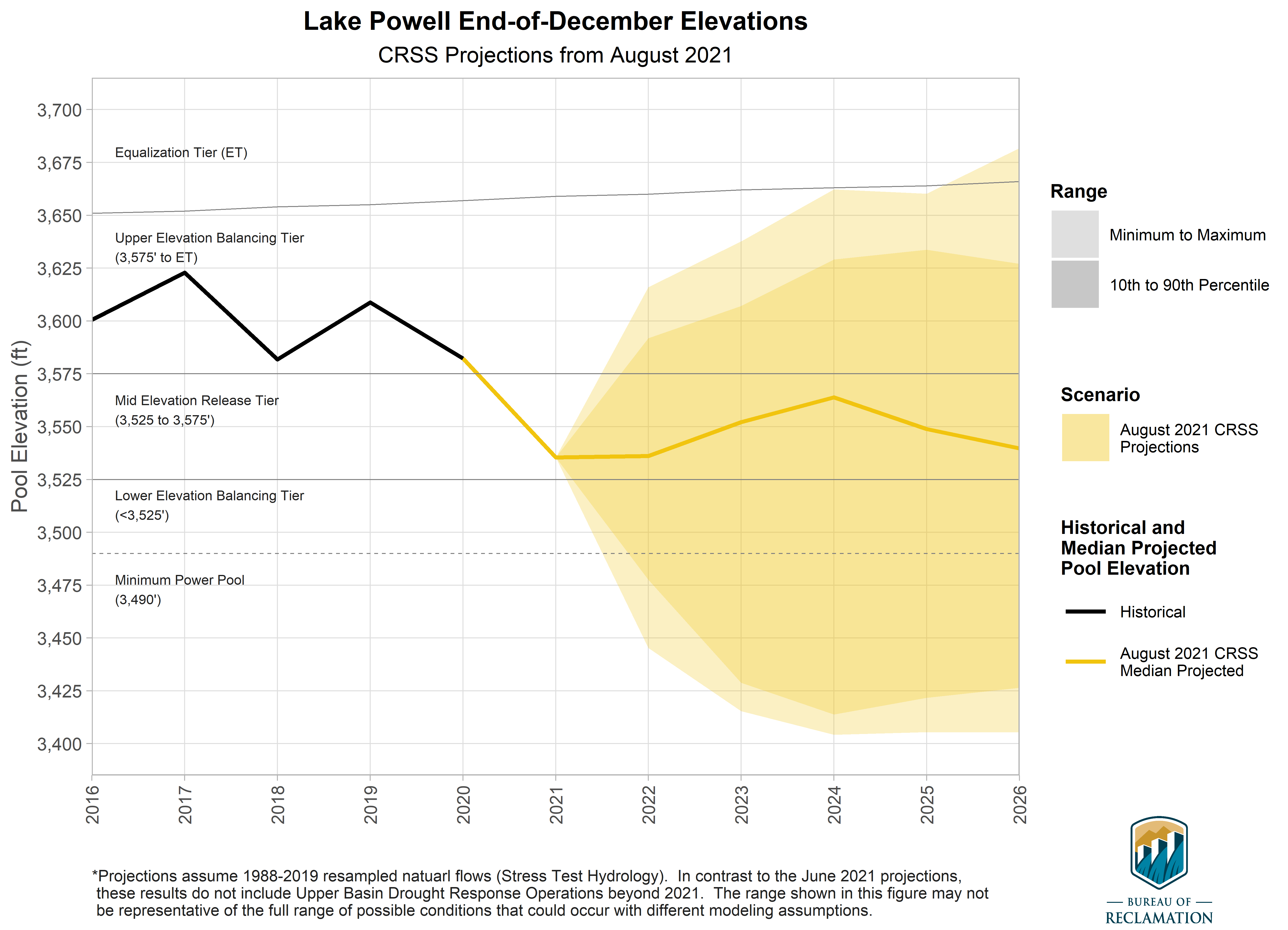
Projection of Lake Powell end-of-December reservoir elevations. The colored region, or cloud, for the hydrology scenario represents the minimum, 10th percentile, 90th percentile, and maximum of the projected reservoir elevations. Solid lines represent historical elevations (black), and median projected elevations for the scenario (yellow). Dashed gray lines represent important elevations for operations, and the vertical line marks the adoption of the 2019 Drought Contingency Plans. Graphic credit: Bureau of Reclamation
For the record, things at Lake Powell aren’t great. While Lake Mead is sitting at about 35 percent capacity – a level not seen since it started to fill with the completion of Hoover Dam in 1936 – Lake Powell, which began forming in 1963 with the construction of Glen Canyon Dam, is a scant 30 percent of full pool.
The reservoir, which straddles Utah into Arizona, is down 50 feet from a year ago, evidenced by a stark white ring against the red desert rock, representing former water levels. Canyons that were once underwater are emerging, and houseboat rental companies cancelled reservations through August. Responding to the historic low water levels, the National Park Service issued a ban on launching the boats in mid-July.
Colorado River “Beginnings”. Photo: Brent Gardner-Smith/Aspen Journalism
The Hardest-working River in the West
The Colorado could easily be called the hardest-working river in the West, originating as a modest creek in Grand County and eventually draining a massive watershed that serves 40 million people before it ends, 1,450 miles later, at its battered delta in the Gulf of California.
A map of the Fry-Ark system. Aspen, and Hunter Creek, are shown in the lower left. Fryingpan-Arkansas Project western and upper eastern slope facilities.
The Upper Arkansas River Basin eventually echoes what’s happening on the Colorado. The Fry-Ark, the trans-basin diversion project originating on the Frying Pan River in Pitkin County, bears notable responsibility for the fun and stream ecology hereabouts, and in turn, the local economy between July 1 and Aug. 15. During that timeframe up to 10,000 acre-feet in supplemental flows are set free from the Twin Lakes and Turquoise Lake reservoirs…
Fry-Ark, short for Frying Pan-Arkansas, was authorized in 1962 and completed in 1981. President John F. Kennedy called what would be a $585 million endeavor a game changer, a model for the future owned by all Americans.
Not that the proposal rolled in unscathed for a few approval strokes of Kennedy’s pen. A change-up from the considerably larger and scuttled Gunnison-Arkansas proposal, Fry-Ark would not happen easily. Enduring nearly endless political stalling from its genesis – mostly from Western Slope residents who weren’t keen on seeing their water sent to the eastern side of the Continental Divide – it also caught the wrath of California and Arizona politicos, who argued that any water diverted from the Colorado River Basin was ultimately bad news for them.
During that time, Americans also became increasingly concerned about the environmental issues surrounding the big resource development projects springing up, and Fry-Ark met opposition from groups such as the Sierra Club, Isaac Walton League and the Wilderness Society. But severe drought in the West in the 1950s was close enough to the 1930s Dust Bowl era to gather steam in Congress for water development.
The blue expanse of Ruedi Reservoir as seen from the air. Students with the Carbondale-based Youth Water Leadership Program took to the air with EcoFlight to see how people have modified water in the Roaring Fork watershed. Photo credit: Heather Sackett/Aspen Journalism
In the end, after considerable pitchfork throwing, the Ruedi Dam and Reservoir were offered up to the Western Slope as a storage solution and compromise of sorts. Construction began in 1964. The project was the first step of the massive, gutsy Fry-Ark. Its network of storage, tunnels and canals would in time send a reliable supply of water to east slope farmers, industries and cities, plump the summer waves moving through Chaffee County and help support a Gold Medal fishery in the off seasons…
Editor’s note: In late July, Gates Family Foundation and the Colorado News Collaborative announced that Ark Valley Voice (AVV) Journalist Tara Flanagan was awarded a water fellowship, to participate in a statewide newsroom effort to strengthen water reporting at newsrooms across Colorado. This is the first in a series of stories about the importance of water in the west, specifically focused on the Arkansas River basin.
Colorado West Slope water officials turned up the volume on the call for action around water and climate change, calling it a “train wreck.”
Andy Mueller photo credit MountainLawFirm.com.
At the Colorado River District’s Annual Water Seminar Oct. 1, Andy Mueller, general manager of the Glenwood Springs-based district, described climate change as a train wreck that needs to be stopped.
“For a decade or more, we have seen the train wreck slowly moving this way. It has picked up speed pretty significantly in the last couple of years, and the question is how do we avert the train wreck,” Mueller said.
He pointed to changes already underway as a result of the warming climate, and those that will be necessary. Uses of the Yampa River as it flows through Steamboat Springs have been curtailed for eight of the last 14 years because of high temperatures and low flows, he said. There have been fish kills in the Colorado River and other impacts to outdoor recreation. Ski areas face a shorter operating season and those in lower elevations may not survive. Agriculture users may need to remove marginal land from irrigation and take stock of their least productive crops.
“I think at every level our folks who are paying attention to the science and the hydrology, there is an increasing sense of urgency in the Colorado River Basin, and it’s shared by folks on the ground today, from ranchers in the Yampa River Valley to farmers in the Uncompaghre Valley to major urban providers like Denver Water. We all recognize there is something very different going on than there was 10 years ago in the Colorado River.”
“Climate change is barreling through the doors of America,” said Michael Connor, the second-highest ranking official in the Interior Department during the Obama administration and now a Washington D.C.-based attorney.
Brad Udall, a senior scientist and scholar at Colorado State University, said he began working on climate change in 2003. “I mostly got a lot of dirty looks,” he said. That has changed. “I have decided that misery loves company.”
Senior water and climate research scientist at Colorado State University and one of the authors of the National Climate Assessment. Photo credit: Colorado State University Water Institute
Udall stressed the importance of inflows into Lake Powell from Colorado, New Mexico, Wyoming and Utah, the states that comprise the Upper Colorado River Basin. Those inflows have averaged 8.4 million-acre feet since 2000.
Each year 500,000 acre-feet is lost to evaporation, leaving 7.9 million-acre-feet for release from Lake Powell. That’s less water than is needed to comply with the requirements of the 1922 Colorado River Compact. Unless flows improve, said Udall, the Upper Basin states may have to forego use of some of their own Colorado River supplies to ensure Arizona, California and Nevada, the Lower Basin states, receive their legal share.
Brad Udall: Here’s the latest version of my 4-Panel plot thru Water Year (Oct-Sep) of 2019 of the #coriver big reservoirs, natural flows, precipitation, and temperature. Data goes back or 1906 (or 1935 for reservoirs.) This updates previous work with @GreatLakesPeck
How did we get to this point? Several researchers in the last five years have fingered rising temperatures as a crucial factor in creating what Udall and his collaborator, the University of Michigan’s Jonathan Overpeck, in a famous 2017 paper, called “hot drought.” They said temperatures alone explained at least a third of the lesser river flows.
Loss of snow may further exacerbate warming. A 2020 paper by P.C.D. Milly and K.A. Dunne in Science found a 9.3% loss in Colorado River flows with each one degree Centigrade in warming. A key finding, said Udall, was that as shiny, reflective snow recedes, the amount of absorbed radiation rises.
A decade ago, there was no clear signal whether a warming climate would affect precipitation on the Western Slope. A picture is starting to emerge, with Southwestern Colorado now at significant risk of precipitation — and runoff — declines, he said.
The San Juan River near Bluff, Utah, had 30% less water in 2000-2019 as compared to 1906-1999. The Colorado River at Glenwood Springs had a 6% decline.
Soil moisture also matters. If the soil remains dry from the previous year, it sops up more of the potential runoff. In 2020, the snowpack was 100% of average but the runoff was 50%. That soil-moisture deficit played into this year’s even worse runoff, 30% of average from a snowpack that was 90% of average.
Gigi Richard via Fort Lewis College
Dr. Gigi Richard, director of the Four Corners Water Center at Ft. Lewis College in Durango, was asked whether she detects more acceptance of climate change as impacting water.
“Yes,” she answered. “In Western Colorado, it’s really hard to deny that from day to day, year to year, that we are feeling the impacts of climate change.”
Many Indian reservations are located in or near contentious river basins where demand for water outstrips supply. Map courtesy of the Bureau of Reclamation.
Connor, the former Interior official, pointed out that tribes in the Colorado River Basin have reserved rights, making them superior to the terms of the Colorado River Compact. Because of the sheer volume of those rights, especially in Arizona, many see them as crucial in whatever new Colorado River operating agreements are negotiated going forward.
“You need to be able to provide the tribes value for their rights,” if tribes are asked to give up use of those water rights, Connor said.
Muller warned of the need for adaptation and offered a conciliatory approach, saying water interests would need to unite to find solutions.
The River District, he noted, sought and obtained a tax increase from voters in an election that was supported by both the Grand Junction Chamber of Commerce and the Environmental Defense Fund. “When,” he asked, “is the last time you saw those two groups on the same page?”
Long-time Colorado journalist Allen Best publishes Big Pivots, an e-magazine that covers energy and other transitions in Colorado. He can be reached at allen@bigpivots.com and allen.best@comcast.net.
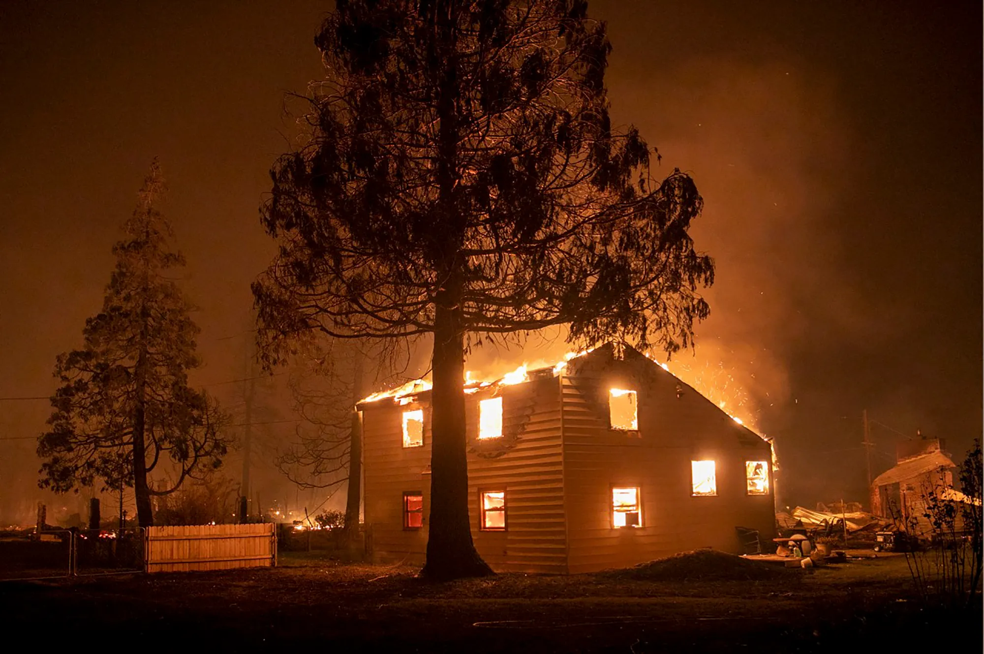
The Dixie Fire destroys a home in the Plumas County town of Greenville, Aug. 4, 2021. Photo by Karl Mondon, Bay Area News Group
Here’s a guest column from Maria Nájera that’s running in The Colorado Sun:
Across Colorado and the West, the intensifying effects of climate change are evident, from record-breaking heat to prolonged drought, erratic weather patterns, intense wildfires, and toxic air pollution that blots the sunlight and catches in our throats. The Intergovernmental Panel on Climate Change, a group of global scientists convened by the United Nations, noted in its major new report released in September that some of the devastating impacts of climate change cannot be averted, due to our decades of fossil-fuel use.
But we still have a small window of time to act and take steps that will help reduce greenhouse gas emissions and avoid the worst impacts of climate crisis.
Colorado and the rest of the nation must shift away from fossil-fuel reliance and cut the harmful carbon emissions that are heating our planet. Colorado has taken important steps to address climate change, and federal support for clean energy and climate action will help Colorado achieve its science-based climate goals.
The Biden administration’s Build Back Better plan is a much needed, pivotal set of federal actions and includes significant provisions we need to address climate change.
Tesla Power Wall.
A crucial part of Build Back Better is the American Jobs Plan’s Clean Electricity Standard, which would put the United States on a path to achieving, by 2035, a clean and reliable electricity system, by which we mean one free of greenhouse-gas emissions, and preferably powered by renewable sources. A June survey by Data for Progress and Western Resource Advocates shows that a large majority of Colorado voters support the key climate and clean energy provisions in the American Jobs Plan, and 73% of those voters support the plan’s provisions to transition to a 100% clean electricity grid.
The Climate Action Plan to Reduce Pollution, a Colorado bill signed into law in 2019, sets science-based targets of reducing statewide greenhouse-gas pollution 26% by 2025, 50% by 2030, and 90% by 2050 from 2005 levels. Earlier this year, Colorado Gov. Jared Polis released his Colorado Greenhouse Gas Pollution Reduction Roadmap outlining a plan to reach those targets. And Colorado legislators this year passed measures to reduce greenhouse-gas pollution from most electricity production 80% by 2030 compared to 2005 levels, as well as cut energy waste and power homes and businesses with clean electricity.
But further emissions reduction work at Colorado’s regulatory agencies and in future legislative sessions is needed to get the state on track to reach its climate goals. Complementary federal action will help Colorado achieve its climate commitments.
The Build Back Better plan aims to invest in creating a resilient grid, lowering energy bills for middle class Americans, improving air quality, and creating good-paying jobs on the path to achieving carbon-free electricity by 2035. Importantly, the plan would provide tax credits to incentivize the building of high-capacity power transmission lines that would help make the grid stronger.
Communities that have disproportionately borne the effects of climate change would benefit from billions of federal dollars as part of a framework called Justice40 – a plan that prioritizes investing in communities impacted by environmental racism. Under the initiative, the federal government would ensure 40% of climate and clean energy investments are directed to communities that have historically been marginalized. This includes funding for programs to clean up hazardous brownfield and Superfund sites, replace lead pipes, and invest in zero-emission public transit. Workers and communities who have relied on fossil-fuel extraction and power generation would have a path forward to new economic opportunities through the plan’s job-creation provisions.
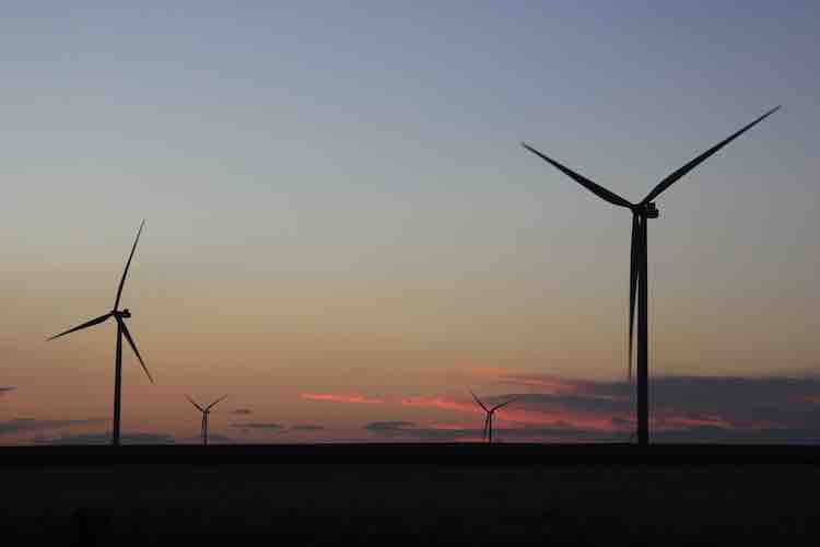
Wind turbines on the Cheyenne Ridge. Photo credit: Allen Best/The Mountain Town News
Colorado and the West need significant federal investment to accelerate our clean energy transition. While Colorado has passed some important legislation and regulations aimed at reducing greenhouse gas pollution, a substantial gap remains between our current emissions and our science-based climate goals.
Federal funding can support and accelerate state efforts, by providing necessary resources to supplement state and local budgets for activities like constructing clean energy projects, plugging abandoned oil and gas wells, or building electric vehicle charging infrastructure. Significant federal spending also can speed deployment of emerging technologies, which brings down costs for everyone through economies of scale.
We face the increasing and devastating effects of climate change every day, and the science is clear: We must act now to protect Colorado.
We urge our federal lawmakers to take the courageous action needed in these pivotal times. Passage of the Build Back Better plan’s provisions would provide a much needed tailwind to accelerate Colorado’s existing efforts and address the climate challenges ahead.
Maria Nájera, of Denver, is government affairs director for Western Resource Advocates.