Click on a thumbnail graphic to view a gallery of drought data from the US Drought Monitor.
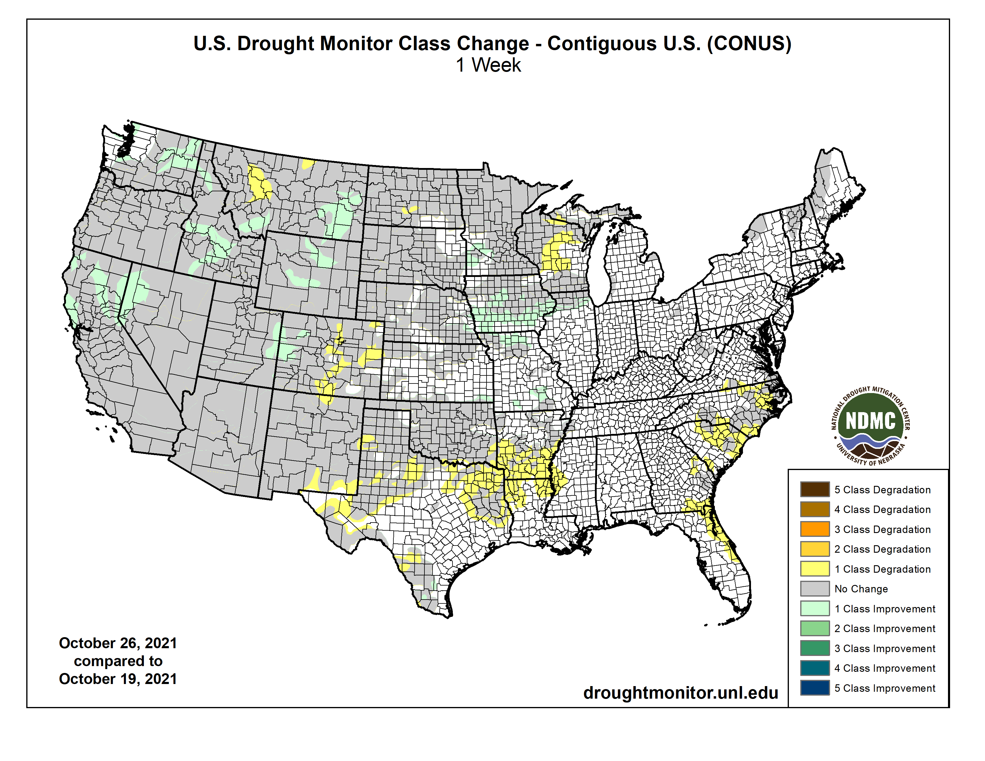
US Drought Monitor map October 26, 2021.
High Plains Drought Monitor map October 26, 2021.
West Drought Monitor map October 26, 2021.
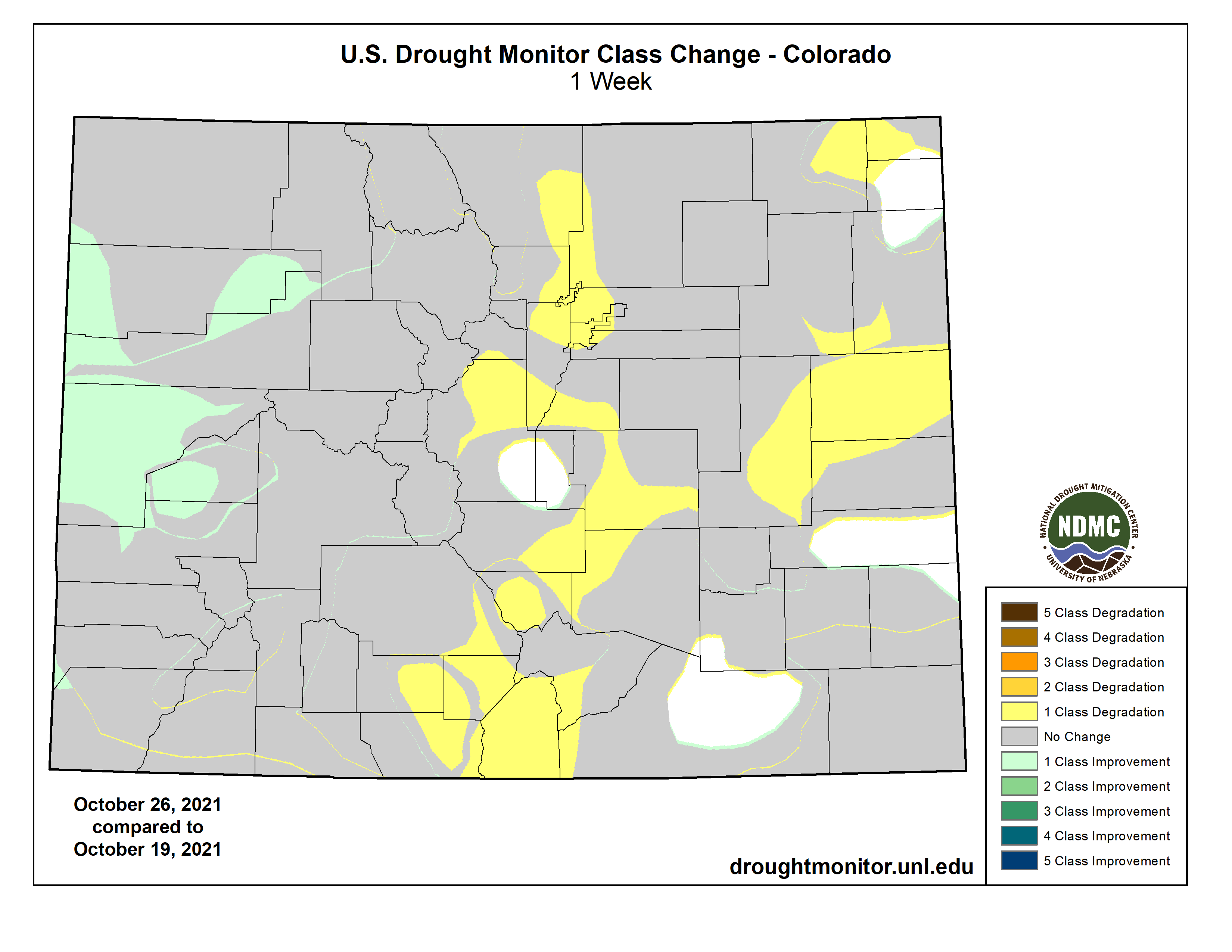
Colorado Drought Monitor map October 26, 2021.
Click here to go to the US Drought Monitor website. Here’s an excerpt:
This Week’s Drought Summary
A series of strong Pacific weather systems moved across the contiguous U.S. (CONUS) during this U.S. Drought Monitor (USDM) week. The first system early in the week spread precipitation across Wyoming to the Upper Mississippi Valley, then left scattered showers over the Northeast before moving off into the Atlantic. The second brought precipitation to northern California and the Pacific Northwest. Its surface low weakened as it crossed the Rockies, but it was re-energized over the Plains and generated precipitation across the central Plains, Great Lakes, and Northeast. The third system slammed into the West Coast near the end of the week. Fed by an atmospheric river of Pacific moisture, its surface low and front left heavy precipitation across California with widespread rain and some high elevation snow from California and the Pacific Northwest to the Great Basin. According to the National Weather Service Weather Prediction Center, as the third low pressure system approached the Pacific Northwest coast, it set a pressure record, testifying to the strength of the system. The October 24th pressure was 942.5 mb, which is a record low pressure for the Pacific Northwest. The end result of these weather systems was above-normal precipitation for the week across much of the West, including the Pacific Northwest, California, Nevada, and the central to northern Rocky Mountains; across eastern portions of the northern and central Plains, the southern Great Lakes, and western and southern portions of the Northeast; and a band of precipitation from southeast Kansas to eastern Kentucky. The precipitation improved short-term conditions, especially in the West, with soil moisture, streamflow, and 1-month to 6-month Standardized Precipitation Index (SPI) indicators sliding into the wet categories. Other drought indicators, such as vegetation-based VHI and VegDRI, were slower to respond. Groundwater, reservoir levels, and longer-term (9-month to 72-month) SPI indicators still indicated very dry long-term drought conditions in the West and northern Plains. The rest of the CONUS was drier than normal, with little to no precipitation falling across much of the Southwest, central and southern Plains, Lower Mississippi Valley to Southeast, northern reaches of the Upper Mississippi Valley, and northern Maine. Weekly temperatures were warmer than normal in the Pacific Northwest to northern and central Rockies, the southern Plains to Gulf of Mexico coast, and along the eastern seaboard. Temperatures averaged cooler than normal in California and the northern Plains to Upper Mississippi Valley. Drought contracted or was reduced in intensity in parts of the West and Midwest, but expanded or intensified in the southern Plains, central High Plains, and Southeast…
Half an inch to an inch of rain was widespread across Wyoming and South Dakota to eastern Nebraska, with up to 2 inches falling across southeast Kansas. Otherwise, little to no precipitation occurred elsewhere in the High Plains region. D0 was trimmed in eastern Nebraska and D0-D1 trimmed in southeast Kansas. D1 and D3 (extreme drought) were reduced in Wyoming, and D2 and D3 contracted in western Colorado, but D0-D2 expanded in eastern, central, and southern Colorado. According to USDA statistics, 73% of the pasture and rangeland in North Dakota was in poor to very poor condition, with the statistics 78% in South Dakota, 55% in Wyoming, 49% in Colorado, 31% in Nebraska, and 26% in Kansas…
Colorado Drought Monitor one week change map ending October 26, 2021.
Two inches to over 10 inches of precipitation fell across the West from the coast to the Sierra Nevada and Cascade ranges, over 2 inches was widespread across central Idaho and in parts of Nevada and Utah, with over half an inch over the rest of the Pacific Northwest into southern California, most of Nevada, and western and northern sections of Utah. Less than half an inch to no precipitation fell over the deserts of southern California and southern Nevada, over southeast Utah, and most of Arizona. New Mexico and parts of Montana were dry this week. A volunteer observer west of Reno, Nevada, recorded 6.83 inches of precipitation from the storm, while South Lake Tahoe measured 7.07 inches for the USDM week. Some all-time daily precipitation records were broken October 24 in northern California. These include 5.44 inches at Sacramento City (breaks the previous record of 5.28 inches from April 20, 1880), 5.41 inches at Sacramento Exec Airport (previous record was 3.77 inches on October 13, 1962), and 10.40 inches at Blue Canyon (exceeded the previous record of 9.33 inches from December 22, 1964). The heavy rains which fell over a short period of time resulted in transient rises on local creeks, ponding of water, mud and rock slides, and some debris flows over recent burn areas. So much rain falling so quickly likely mostly ran off and had little chance to soak into the soil. But the rain wetted the soils prior to the building of the winter snowpack which will help in the future. While beneficial, the precipitation improved hydrological conditions only marginally. In the Sacramento area, there were limited inflows into the major flood control and water storage reservoirs, which remain well below normal storages. The water level at Lake Tahoe rose only about 7 inches. In southern California, Big Bear Lake was two feet away from the record level of 18 feet below, and avocado production was reduced roughly 22% in the southern California growing belt.
Topsoil moisture improved considerably from the rains this week, according to USDA statistics. California went from 75% of the topsoil moisture short or very short last week to 40% this week, Oregon improved 16% to 53% short or very short this week, Washington improved 9% to 78%, and Idaho improved 17% to 45%. But Montana still had 96% of the topsoil moisture short or very short. The rain was not enough to replenish significantly low reservoirs. From October 21 to 26, reservoirs rose very little. Some examples for larger reservoirs: in Idaho, American Falls reservoir went from 15% full to 17% full, while Palisades stayed at 6% full; in California, Shasta rose from 21% of total capacity to 22%, Lake Oroville from 22% to 27%, Trinity Lake from 26% to 27%, and Folsom rose from 22% to 31%; in Oregon, Wickiup went from 4% full to 7%, while Owyhee stayed at 11%; and in Washington, Cle Elum went from 21% full to 22%.
D3 and D4 (exceptional drought) were pulled back in northern California, northwest Nevada, and parts of Idaho where the heaviest rains fell; D0, D3, and D4 contracted in Washington; and D3 and D4 contracted in Montana. The contraction of D3-D4 in eastern Montana reflected cumulative effects of above-normal precipitation over the last 2 to 4 weeks. However, D4 expanded along the east slopes in western Montana and D3 expanded in north central Montana to reflect intensifying dry conditions over the last 2 months…
Temperatures were hot this week in the South, with some record high temperatures recorded in Louisiana. Parts of northern Tennessee received an inch or more of precipitation, and patches of half an inch occurred over parts of central Arkansas, southern Mississippi, and coastal southeast Texas. Otherwise, most of the South received no precipitation this week. Drying soils and vegetation prompted expansion of D0 and D1 from the ArkLaTex region to west-central Mississippi. D0, D1, and D2 (severe drought) expanded in parts of eastern, northern, and southern Texas…
Looking Ahead
A frontal low pressure system will complete its trek across the central to eastern CONUS during the next USDM week. For October 26-November 2, up to 3 inches of precipitation is expected from the eastern edge of the Plains to the Mississippi Valley, in parts of the Mid-Atlantic region, and along coastal New England, with 1 to 2 inches widespread in the South, Southeast, and Ohio Valley. Coastal Washington and northwest Oregon could receive 1 to over 5 inches, while the northern Rockies may receive a couple inches of precipitation. Much of the West outside of the Pacific Northwest and northern Rockies, western parts of the Great Plains, and the northern Great Lakes should receive little to no precipitation. Temperatures are expected to average near to above normal. The outlook for November 2-6 shows drier-than-normal weather favored over the Southwest and Upper Mississippi Valley, with wetter-than-normal weather favored from the Pacific Northwest to southern Plains and eastward to the East Coast (except New England). Odds favor colder-than-normal weather for most of the CONUS east of the Rockies. The outlook shows drier-than-normal weather in northeast Alaska and wetter than normal in the south, with warmer-than-normal temperatures for most of the state.
US Drought Monitor one week change map ending October 26, 2021.
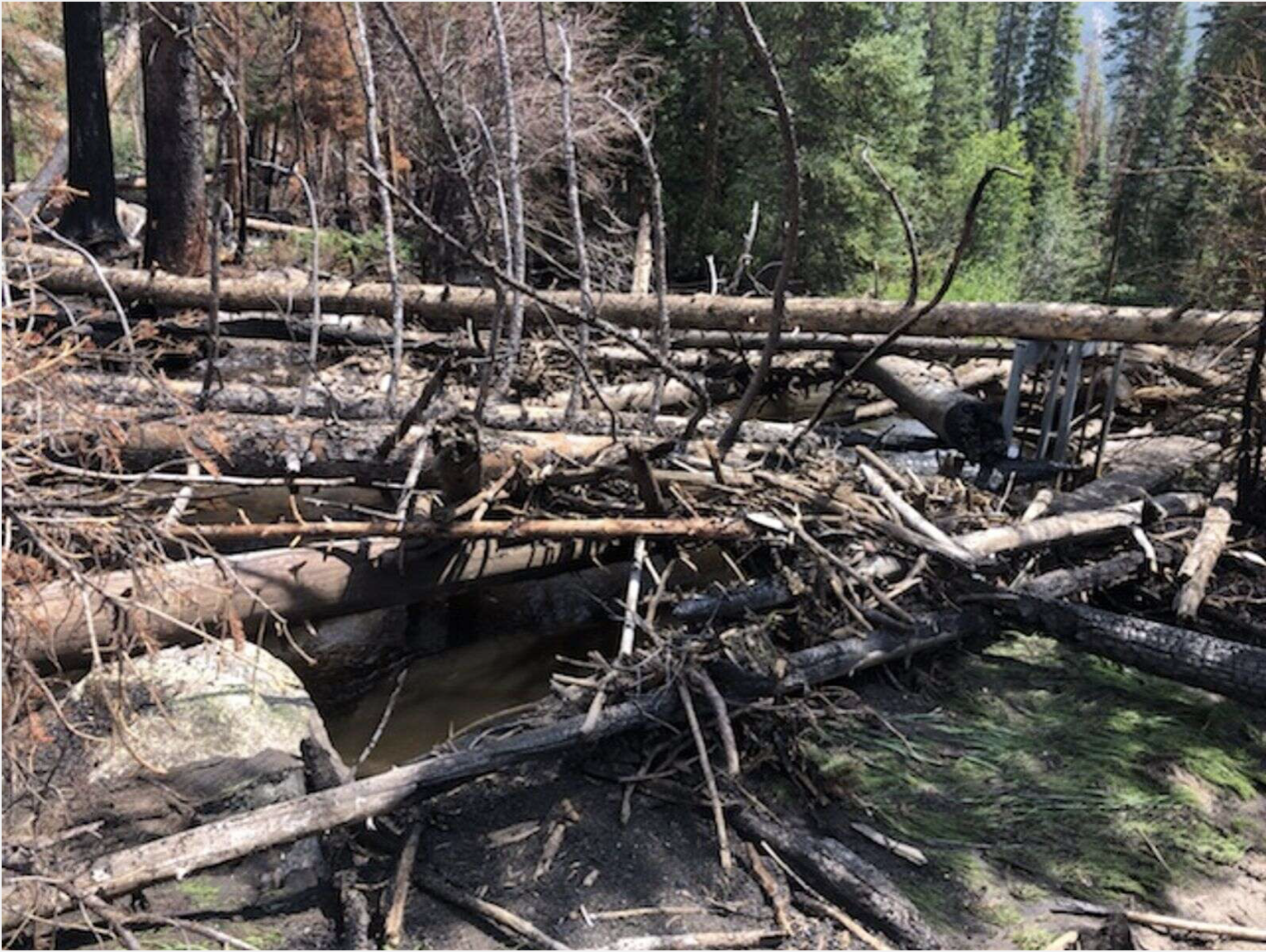
The head gate to Grand Lake’s hydro power plant is blocked by trees washed up during July 2021’s flash flooding. You can see the head gate on the right side of the picture. Photo credit: Town of Grand Lake
Intense rainfall, raging wildfires and deadly heat waves. The effects of climate change are no longer an abstraction. They are happening now, and with greater frequency.
At least 85 percent of the world’s population has felt its effects, according to research published in the journal Nature Climate Change. The devastations from the past 10 months alone have stunned climate experts.
“This was a really extreme year,” said Radley Horton, a research professor focused on climate extremes at Columbia University’s Lamont-Doherty Earth Observatory. “Right now we’re seeing the climate extremes changing so fast that that alone is demonstrating that going past 1.5 Celsius will be something we won’t adapt to.”
Despite the 2015 Paris climate conference promise to limit global warming to “well below” 2 degrees Celsius, country commitments have not come close to that goal. The United Nations says the world is on pace to experience an average temperature rise of 2.7 Celsius by the end of the century.
As leaders descend on Glasgow, Scotland, for this year’s climate conference, most of the world is already feeling the repercussions of their inaction.
From China to Germany, California to Siberia, the extreme weather events of 2021 have broken records and destroyed lives.
Students in Sam Ng’s Field Observation of Severe Weather class hit the road every spring to observe storm structures, like this mesocyclone in Imperial, Nebraska. Photo by Sam Ng via Metropolitan State University of Denver
Precipitation
“It’s way beyond what our aging infrastructure was designed for.” — Radley Horton, research professor at Columbia University’s Lamont-Doherty Earth Observatory
Parts of the world were inundated with deadly, record-breaking precipitation. Infrastructure buckled under torrential downpours. Hundreds of people died in the ensuing floods.
In July, Germany’s heaviest rainfall in a century left over 150 people dead.
“We have never experienced something like this,” said Franz-Josef Molé, head of the German Weather Service’s Forecast and Advisory Center. “It’s beyond comprehension.”
Scientists linked the heavy rainfall to climate change, since a warmer atmosphere retains more water…
In South Sudan, October flooding from torrential rain affected more than 700,000 people, according to the United Nations refugee agency. The organization described people “marooned on islands on islands surrounded by water, sheltering under trees and unable to cross to safety.” There were also fears that waterborne diseases would spread.
UNHCR stressed that the impacts of climate change are “profoundly felt in East Africa,” where communities “are facing unprecedented floods and storms, unreliable rainfall, and distress under hotter and drier conditions as their basic needs and rights to water, food, livelihoods, land, and a healthy environment are hit hard.”
China and New York City also saw extreme rainfall this year. In July, a deadly downpour fell on the city of Zhengzhou, the heaviest rains ever recorded in the country with nearly 8 inches of rain falling in one hour. More than 300 people died in the floods and landslides. Rain cascaded down on the city, turning Metro stations into to swamps and highways into rivers.
In New York City, Central Park experienced record rainfall on Sept. 1, with 3.15 inches coming down in just one hour. The deluge filled up basements and tunnels within minutes. More than 40 people were killed.
In October, more than 29 inches of rain fell in northwestern Italy in just 12 hours setting a record for all of Europe.
The extreme flooding proved the effects of climate change were taking hold “faster than our climate models predicted,” with effects “way beyond what any of our aging infrastructure was designed for,” Horton said.
Photo credit: Elisa Stone via the World Weather Attribution
Heat
“Human bodies are really resilient. But there are thresholds for what we can withstand.” — Kristie Ebi, epidemiologist at the Center for Health and the Global Environment at the University of Washington
Other places saw unexpected heat waves that left many dead and showed that even regions accustomed to cooler weather are not immune from the effects of a warming world.
Brutal temperature spikes swept through the Pacific Northwest this summer, killing hundreds of people in the United States and Canada. Streetcar cables in Portland melted. Pavements in Washington cracked from the pressure…
The waves pushed many into cooling centers for shelter and emergency rooms for care. They also drew lines between the privileged and the vulnerable: Access to air conditioning and proper health care were, for some, the difference between life and death.
While heat is not officially deemed a disaster like fire or flooding, it can be even more deadly. Sixty-four percent of Americans lived in places that saw multiday heat waves this summer, according to a Post analysis.
July was the earth’s hottest month on record for the planet. The United States and Europe recorded their hottest summers ever in 2021.
The temperature swelled to nearly 120 degrees in Sicily which, if confirmed, would be the highest temperature ever recorded in Europe.
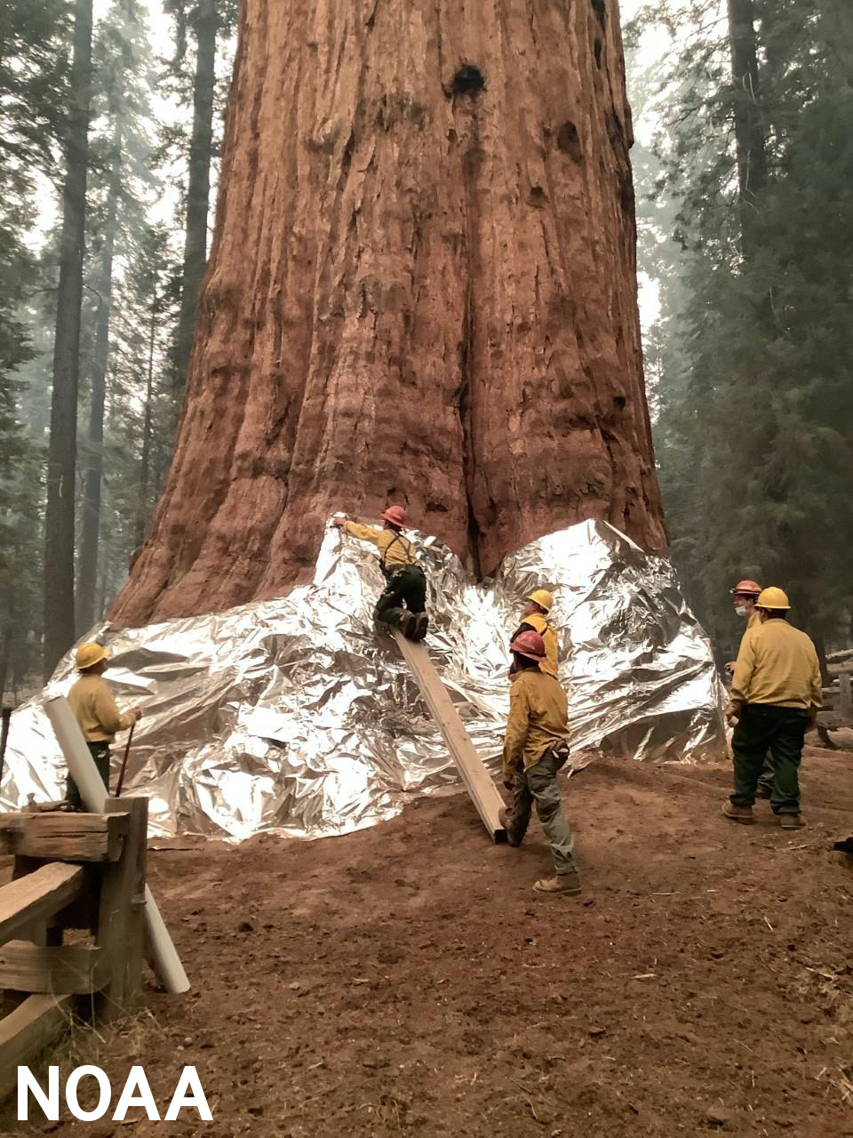
Wildland firefighters apply structure wrap to the base of a giant sequoia tree to protect it from the KNP Complex Wildfire, September 17, 2021. Photo credit: Inciweb.org
Fires
“It’s a global year of fire.” — Merritt Turetsky, professor of ecology at University of Colorado Boulder
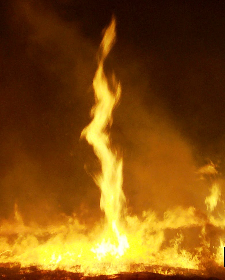
Heat waves left landscapes dry and brittle, paving the way for an apocalyptic fire season in the northern hemisphere as well.
“We knew this was coming,” said Merritt Turetsky, professor of ecology at University of Colorado Boulder. “Fire was going to follow those heat waves.”
Wildfires in North America, Siberia and the Mediterranean contributed to record-high carbon emissions in the months of July and August, according to Copernicus, the European Union’s atmospheric monitoring service.
The Dixie Fire became the second-largest in California history, destroying almost 1 million acres of land. More than three months later that fire is still burning.
In September, evacuations were ordered in Old Station, as strong winds in the area created a “fire whirl,” a tornado-like phenomenon that can fling flaming embers miles ahead of its wake.
In northeast Siberia, blazes swelled to become larger than all of the world’s active fires combined in August. The cloud of smoke it created traveled over the north pole. It consumed more than 40 million acres of land, according to Greenpeace Russia, and resulted in the worst fire season ever recorded in the country.
Wildfires also broke out in densely populated tourist destinations along the Mediterranean Sea, prompting evacuations of thousands of people. Blazes raged in Greece, Italy and Turkey, after prolonged heat waves in southeast Europe.
The year of extreme weather presented a devastating new reality as leaders meet in Glasgow.
“The climate system is going to keep shocking us,” Turetsky said. It’s going to happen again.”
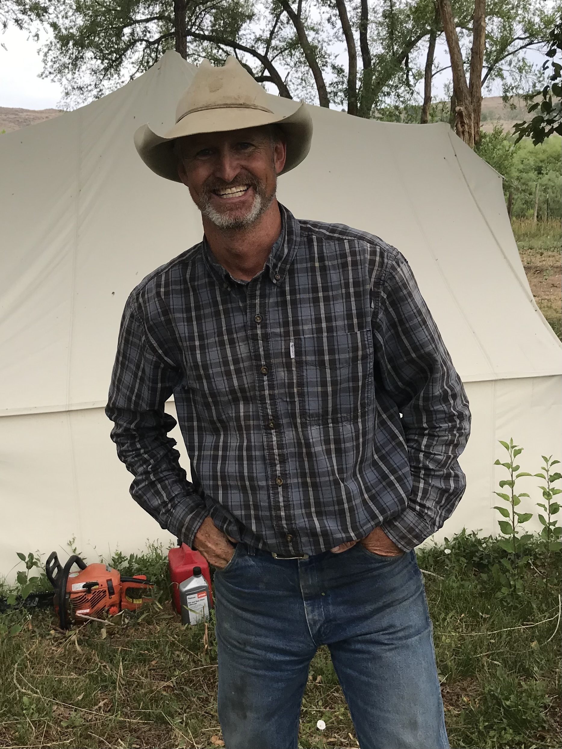
If Jim Howell, a fourth-generation rancher in Western Colorado, has a guru, he’s Allan Savory, the champion of intensive cattle grazing even on semi-arid land.
Howell, 52, says Savory’s methods, which require moving cattle quickly from pasture to pasture, enable him to keep adding thousands more animals as the ground recovers. He says the method is so efficient he can even foresee leasing out irrigation water that he doesn’t need.
If all this sounds unbelievable, Howell, who is ranch manager for Eli Feldman in Ridgway, Colorado, understands the skepticism. But he says the ranch speaks for itself.
Western States Ranches is huge, a 213,000-acre spread that’s a mix of 3,000 acres of irrigated bottom land in Delta and Montrose counties, plus 210,000 acres of mostly leased federal rangeland that sprawls from western Colorado to eastern Utah. There’s forested, high elevation range, but half of the ranch is semi-arid. Rainfall can be a scant 10 inches per year.
Jim Howell, a fourth-generation rancher in Western Colorado. (Photo Credit: Dave Marston)
The herd is also large at 3,300 head, with 1,800 pregnant cows. What makes Savory’s approach effective, Howell says, is speed: In a day or two, cows eat fresh grass and weeds, then move on to new pasture before an enclosed pasture is damaged. Ten cowhands make the process work by moving miles of electric fencing, even though they’re traditionally loath to get off their horses. Feldman found Howell by consulting the Savory Institute, where Howell’s wife, Daniella Ibarra-Howell, is director.
The man and the money behind this enterprise is Eli Feldman, whose Conscience Bay Company is mostly staked by lifelong friends, the Laufer family of Stony Brook, New York.
East Coast money and Western know-how might seem an odd combo, but Howell studies the land with total concentration. He says his rule of thumb is to make a grazing plan and then rip it up as changing conditions dictate.
Howell has made dry, overgrazed range bloom before. Using Savory methods, he boosted the number of cattle on his former family ranch on Blue Mesa in Western Colorado. He went from 150 cows to 450, while also attracting herds of elk.
But if demand management gets going — the controversial plan of leasing water temporarily and voluntarily to fulfill downstream obligations – Feldman and Howell are on board. Feldman asked Trout Unlimited to administer a demand management study on part of his ranch that lies in Eckert, Colorado, where ground is irrigated only until July 1.
Howell derides programs that encourage leasing water for full seasons. “It’s going to be seen as socially untenable for ranchers in the upper basin to be over-irrigating hay fields when downstream users are running out of water.”
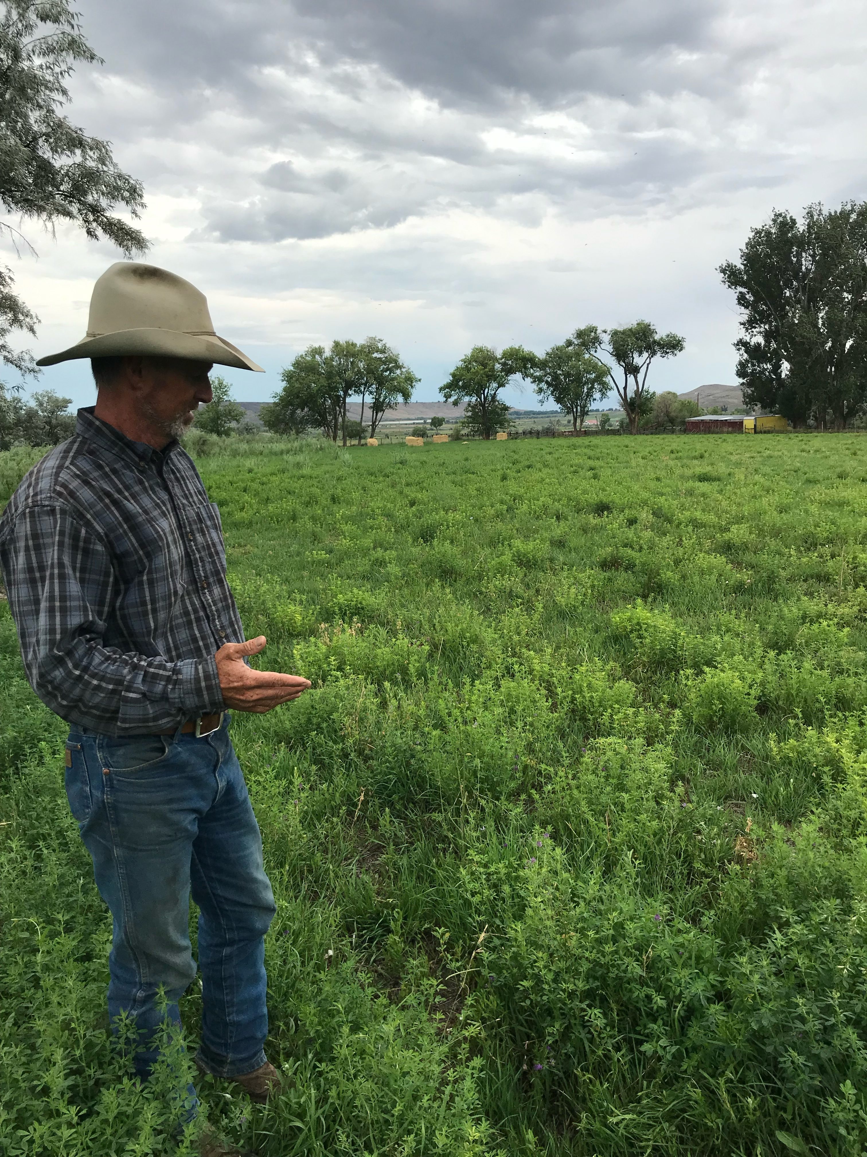
Howell in a small 24 acre irrigated pasture. After being grazed by 900 cows for one and a half days the pasture is growing back lush and green. (Photo Credit: Dave Marston)
Because Feldman is an outsider with a formidable operation, he says he’s been a target since the ranch got going in 2018. Shortly afterward, he recalls, a Delta County commissioner poked him in the chest with a finger, saying, “I’ve got my eye on you.”
Feldman figures he’s been cast as a water speculator. “But when a ranch was auctioned off recently,” he says, “we passed on the irrigated land (with senior water rights) and purchased the herd and grazing permits only.”
For both Feldman and Howell, one of their goals is to restore grass on ground that’s been ranched “old-school.” By that they mean trampled creek beds where cows for generations wallowed away the summers.
Howell says he has all sorts of tricks to get lazy cows moving. Artificial watering holes are scattered across dry range, while gullied creeks are fenced off and left to recover. The payoff is growing grass-fed, certified organic beef, and Howell says it commands a 15-20% premium over cattle grown for the commodity market.
Despite the ranch’s sprawl, it seems a lean operation. Howell manages it halftime from a small tent, which also doubles as his sleeping quarters. His cowhands are equipped with little besides horses, trailers and portable electric fence. Still, Howell has his share of environmental critics. The Center for Biological Diversity charges that grazing any cattle on marginal land leads to degraded water and spurs desertification.
Howell shrugs off the charge. “These native rangelands evolved with hooved animals,” he says. “To say they are not meant to be grazed is total BS. They were meant to be grazed — but as nature intended.”
Dave Marston is the publisher of Writers on the Range, http://writersontherange.org, a nonprofit dedicated to spurring lively conversation about the West.
The U.S. Department of Agriculture (USDA) is investing $21 million as part of the Natural Resources Conservation Service’s (NRCS) collaboration with the Department of Interior’s (DOI) WaterSMART Initiative to help farmers and ranchers conserve water and build drought resilience in their communities. These investments complement projects by irrigation districts, water suppliers and other organizations receiving WaterSMART Program funds from the Department of Interior’s Bureau of Reclamation. NRCS works with Reclamation to coordinate investments in the same community for accelerating water conservation and drought resilience and making a bigger impact where it is most needed.
“The consequences of drought have continued to impact farms, ranches and communities across much of the West and other parts of the country,” NRCS Chief Terry Cosby said. “Drought is a complex challenge, and our collaboration on WaterSMART is part of our strategic approach to help producers conserve water and build resilience while also bringing important partners to the table. Bringing as many like-minded individuals and groups as possible to innovate together is our best solution for water management in the West.”
“Reclamation’s collaboration with NRCS maximizes each agency’s investment in tackling conservation and building drought resiliency in the West,” said DOI Bureau of Reclamation Deputy Commissioner Camille Calimlim Touton. “Earlier this year, Reclamation awarded $42.4 million to 55 WaterSMART Water and Energy Efficiency Projects to support on-the-ground improvements to conserve water and build resilience to drought. Many of the projects announced by NRCS today will complement existing WaterSMART projects, maximizing the benefits of each agency’s conservation programs.”
In fiscal year 2022, NRCS will invest in 15 new priority areas and 25 existing priority areas with continued need, assisting producers and communities in 13 states across the West. NRCS is providing the funding through Environmental Quality Incentives Program (EQIP).
In total, there are 46 active projects for delivering WaterSMART assistance. Visit the WaterSMART webpage to learn more.
How WaterSMART Works
Private land managers such as farmers and ranchers can leverage money and resources of irrigation districts, water districts, and other organizations with water delivery authority in their community by coordinating their efforts to conserve and use water more efficiently; increasing the production of renewable energy; mitigating future water conflict in areas at a high risk; and other activities that contribute to water supply sustainability in the Western United States.
Through the WaterSMART Initiative, funds are allocated to targeted areas for eligible participants to enter contracts. Each WaterSMART Initiative project area is carrying out different phases of program delivery at the same time— funding, implementation and evaluation.
NRCS and Reclamation, the nation’s largest wholesale water supplier and second largest producer of hydroelectric power, have been coordinating EQIP and WaterSMART investments since 2011, the effort began as a pilot in California .
This federal collaboration works to provide states, Tribes, local water management entities, and water users alike with coordinated resources to plan and implement actions which balance water supply and demand through modernizing existing infrastructure, improving agricultural landscapes to conserve water resources and bringing attention to local water conflicts.
More Information
In addition to helping producers build resilience, USDA is also helping drought-impacted producers recover. Other recent actions include:
USDA is coordinating with federal agencies, state governments, Tribes, and others to address the impacts of drought. This includes a new interagency working group created in April by the Biden-Harris Administration’s National Climate Task Force to address the worsening drought conditions in the West and support farmers. USDA co-chairs the task force with the Department of Interior.
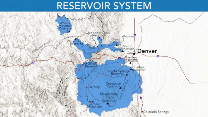
Denver Water relies on a network of reservoirs to collect and store water. The large collection area provides flexibility for collecting water as some areas receive different amounts of precipitation throughout the year. Image credit: Denver Water.
The Denver Board of Water Commissioners agreed on Wednesday to raise water rates and fixed monthly charges, which will all go into effect Jan. 1, 2022.
For typical single-family residences using the same amount of water each year, this would shake out to an increase of 47 cents to $1.34 per month, or about $5.64 to $16.08 per year. However, these rates are also dependent on where in the Denver metro a customer lives, since rates are higher in the suburbs due to the rules of the Denver City Charter.
There are also multiple charging tiers at Denver Water, beginning with the lowest rates for water used for essential things like bathing and cooking, calculated by assessing water consumption during the winter. Other water usage, mainly for outdoor watering in the summer, is charged at higher tiers.
Denver Water is funding upgrades through these extra charges. These projects include expanding the Gross Reservoir near Boulder to increase storage capacity during wet years and boosting the entire system’s resilience as climate change leads to more unpredictable weather patterns. Other projects include the city’s efforts to replace old lead-containing pipes… as well as the city’s creation of new water quality laboratories and treatment centers.
he Gunnison Basin is facing a climate emergency, putting our farm and food systems at severe risk. This map shows the warming that has already occurred in this Gunnison watershed since 1895. Graphic credit: The Washington Post via the Colorado Farm & Food Alliance
The Upper Gunnison River Water Conservancy District continues to change, grow and adapt its public outreach efforts, directing the public to the main focus of their mission — managing the basin’s limited water supply.
Upper Gunnison is an active leader in all issues affecting the water resources of the Upper Gunnison River Basin. Their role in the valley has grown in importance as the basin continues to experience worsening drought conditions. In response, the district has continued to try and raise awareness of the community’s water use.
Sonja Chavez via Gunnison Basin Roundtable.
Upper Gunnison General Manager Sonja Chavez said that, after the drought year the basin experienced, it’s about getting a message out to the community.
“Water is a finite resource,” Chavez said. “I think most people don’t realize or understand that the whole Colorado River Basin is over allocated, we’re using more water than we actually have. As temperatures increase and stream flows decrease, it’s just going to become a greater challenge.”
The district’s education and outreach budget increased from $34,000 in 2021 to almost $42,000 for 2022. Although part of it is driven by the rising cost of promotional products and an increased sponsorship to the Gunnison River Festival, Chavez said overall, public outreach is “central and important” to the district’s mission…
Within their education action plan, staff began to break the public down into age groups, from elementary through high school as well as growing their relationship with Western Colorado University. The district’s goal was to try and be intentional about where they put the funding, who they reach out to and making sure it’s age appropriate.
Historically the Upper Gunnison helped fund the Water Workshop, which was renamed and reorganized into the Western Water Future Games. The Water Workshop, based at Western, has a 45-year history.
It was created to give more of a voice to the people of the Western Slope because at that time it was perceived that the Front Range was the dominant voice in water issues in the state, said Jeff Sellen, who oversees the program…
With a small staff of five, the Upper Gunnison has limited manpower. To make their outreach efforts more effective and far-reaching, their strategy has been “figuring out where they can add value” to existing events or programs, Chavez said.
Where there is an access to water the Upper Gunnison tries to build upon that opportunity for education. The Upper Gunnison has its hands in the River Festival, the 4-H Program and the Taylor Challenge. It also has an established mini-grant program designed to support educational projects intended to expand the awareness of water-related issues.
Name recognition is another important aspect of increasing the visibility and effectiveness of the Upper Gunnison’s water messaging in the valley. The district has used a newsletter, radio advertisements, yard signs and promotional items to spread the word that “water doesn’t grow on trees.”
Chavez said she thinks “a lot of people within the community don’t know exactly who we are or what we do.” But this is something that even larger districts still struggle with…
Upper Gunnison has started taking a harder look at its education and outreach in terms of who it’s reaching, and how successful it’s been, Chavez said. When people have an issue or question about water “I would want them to first think of the Upper Gunnison District.”
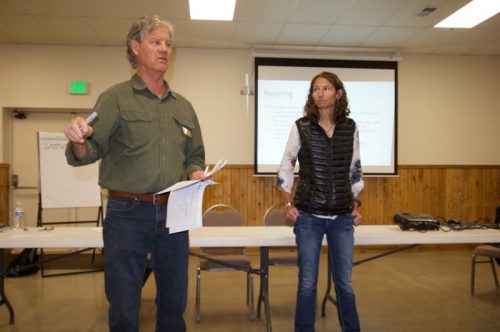
Ranchers and other water users gather at a stakeholder meeting in North Park on Oct. 22 to ask questions and provide input as state officials make case for measuring devices and recording. Credit: Allen Best
As the gap between water supplies and demands narrows in northwestern Colorado, state officials want to ensure that, as best as reasonably can be done, every last drop gets measured and recorded.
They made their case to about 60 ranchers in North Park’s Walden, Colo., on Friday in the fifth of six stakeholder meetings during October that will conclude tonight with a meeting in Craig.
The proposed rules governing the Yampa, White and North Platte River basins would require that headgates, which allow water diversions into ditches, be supplemented with measuring infrastructure, either flumes or weirs, to track the amount of water being diverted. The rules would also institute protocols for reporting the measurements, for collection in state databases. Authority to require the measuring and reporting is clearly defined by state law, but the law leaves room for discretion about the particulars, hence the stakeholder process.
In an already drought-stricken region likely to become hotter and drier yet in the 21st century, those measurements will become ever-more important in administering water rights. The Yampa River this century has carried on average 6% less water than it did during the 20th century. On the White River, flows have fallen 19%.
Already, there is concern that Colorado will be forced to curtail diversions of water rights dated later than the 1922 Colorado River Compact if the aridification of the Colorado River Basin continues, said Kevin Rein, the state water engineer, at the outset of the meeting in Walden.
The compact specifies that Colorado along with Wyoming, Utah and New Mexico “will not cause the flow of the river” at Lee Ferry, at the top of the Grand Canyon, “to be depleted below an aggregate” of 75 million-acre feet for an period of 10 consecutive years. Colorado and the three other upper basin states are in relatively good shape—for at least the next couple of years. In the last decade, 92 million acre-feet have flowed past Lee Ferry toward Arizona, Nevada, California and, eventually, Mexico.
Kevin Rein, Colorado state water engineer, explains why Colorado needs stepped-up measuring of water diversions in the North Park and other rivers in Northwest Colorado while Erin Light, Division 6 engineer, looks on during a meeting in Walden on Oct. 22. Credit: Allen Best
But if below-average becomes the new normal, as climate scientists warn almost certainly will be the case, Colorado may be forced to defend its diversions in light of the compact. “When they come in and ask for water, we can’t refuse if we have no data,” said Mike Sullivan, the deputy state water engineer.
The state water officials pointed to the Aug. 2021 report Lessons Learned from Colorado Experiences with Interstate Compact Administration issued by the Hutchins Water Center at Colorado Mesa University and MacIlroy Research and Consulting. “Confronting the limits of a water supply is a painful experience,” the report said after studying the Republican, Arkansas and Rio Grande basins. “Across each of the basins, earlier action to address potential compact and supply issues has enhanced the control communities have to develop and choose their own, less painful, options.”
The North Platte River does not flow into the Colorado River. It’s east of the Continental Divide but separated from the Front Range by the Medicine Bow and other mountain ranges. So why the need to measure water in North Park the same as in the Yampa and White river valleys?
Because it’s good to have the data should it be necessary as required by other interstate agreements, in this case involving Wyoming and Nebraska, said Sullivan.
But there’s another reason for more rigorous accounting of diversions, said the state water officials. Owners of water rights can best look out after their own interests by documenting their water use. This guards against those rights being placed on lists of abandoned water rights that state law requires be issued every 10 years. The most recent list for all river basins, including North Park, was issued last year.
Measuring devices also give those with more senior water appropriations the right to divert their legal entitlements in water-scarce years. And in the case of land sales with connected water rights, it gives owners the proof of water use to demonstrate value to potential purchasers.
In several river basins in Colorado, notably those east of the Continental Divide, measurements became crucial as early as the 19th century. In those river basins where water users experienced an earlier squeeze between supplies and demands, those with senior water rights began placing calls that required those with newer—and hence more junior— rights upstream to cease or cut back diversions.
In Water Division 6, which includes the North Platte, Yampa and White river basins, 54% of headgates had appropriate measuring devices as of April. This compares with upwards of 90% in several other water divisions of Colorado.
Overlapping the new rules is a proposal being considered by the Colorado Division of Water Resources to designate the Yampa River as over-appropriated. Most rivers in the state are already considered over-appropriated, in some cases over a century ago. Segments of the Yampa—including the river upstream from Steamboat Springs and several tributaries—already have been so designated. This designation will require irrigators drilling wells to have water that they can use to augment streamflows if there is a call on the river by a senior user. Improved measuring will assist in administration. Meetings to gather input were scheduled for Monday night in Craig and Thursday night in Hayden.
State officials hope to get the measurement rulemaking as well as the Yampa designation completed by early next year. Rules will be unique to the needs of Northwest Colorado, just as rules governing the Republican and Arkansas River basins are unique to the interstate water agreements and other circumstances governing water use in those basins.
North Park was particularly warm and dry last winter. One rancher after the Walden meeting recalled that it was possible to drive across his hay meadows all of last winter whereas many years he has to plow the driveway almost daily.
“It was pathetic, really,” said Keith Holsinger, standing on a bridge over the Michigan River east of Walden where he grows hay on 800 acres. One of his neighbors, who usually gets 500 to 600 tons of hay, got only 90 tons this year, he reported.
Holsinger has lived on the ranch all of his 77 years. His water rights range from among the oldest in North Park, an 1885 decree with a priority number of 32, to more junior rights of 240th in priority.
He remembers putting in the first measuring device sometime after the drought of 1977. His last device, a weir, he had installed last year.
Keith Holsinger has been installing measuring devices on ditches for his ranch along the Michigan River in North Park for several decades. Credit: Allen Best
During the meeting, some skepticism was voiced about the coming measurement rules. State representatives characterized the relationship between water users and state authorities as one of cooperation and trust. But one audience member pushed back. Implementation seemed to be discretionary, he said. “It’s a trust issue, and I’m sorry to say I don’t have a lot of faith.”
But as for the need for the rules, Holsinger is already persuaded. “If it’s free water in priority, if you want that water, you had better have a headgate and weir,” he said. “It’s as simple as that.”
The most significant discontent voiced in the background of the meeting agenda was about the high turnover in water commissioners. It’s a common problem across Colorado, say state water officials, as the job is by nature semi-seasonal. But in conversations after the meeting, North Park residents suggested that if the state wants water users to be partners in administration, the state needs to allow proper resources. A water commissioner has between 350 and 500 headgates to check, and there’s a learning curve.
Some people wanted to know why the state wanted the ability to lock headgates. State representatives said they rely primarily on voluntary compliance with water allocations but need the ability to force compliance if diverters take more than they are entitled to.
“In 20-some years, I have probably ordered a half-dozen headgates locked,” said Sullivan. “If we can’t get someone to keep their hands out of the cookie jar, we lock the cookie jar.”
As for the specific type of weir or flume, there are several formal varieties as well as less formal ones. They can be expensive, but none of the irrigators in Walden indicated that cost alone is an issue. Erin Light, the Steamboat Springs-based water engineer for Division 6, said she had seen a flume made of a road sign. It worked, she reported. Sullivan reported seeing one made of rock that worked effectively.
Said Sullivan, speaking to people mostly old enough to remember a bestselling small-model car in 1979 and 1980, “We don’t want to require a gold-plated Cadillac headgate when a Chevette will do.”
Long-time Colorado journalist Allen Best publishes Big Pivots, an e-magazine that covers energy and other transitions in Colorado. He can be reached at allen@bigpivots.com and allen.best@comcast.net.
Map of the North Platte River drainage basin, a tributary of the Platte River, in the central US. Made using USGS National Map and NASA SRTM data. By Shannon1 – Own work, CC BY-SA 4.0, https://commons.wikimedia.org/w/index.php?curid=79266632