Click on a thumbnail graphic to view a gallery of drought data from the US Drought Monitor.
US Drought Monitor map September 28, 2021.
High Plains Drought Monitor map September 28, 2021.
West Drought Monitor map September 28, 2021.
Colorado Drought Monitor map September 28, 2021.
Click here to go to the US Drought Monitor website. Here’s an excerpt:
This Week’s Drought Summary
Warm and dry conditions dominated much of the western half of the United States while some needed rain fell on portions of the Midwest, Mid-Atlantic, and into the Northeast. Some late summer precipitation also fell in the deserts of Arizona and New Mexico as well as along the coastal regions of the Pacific Northwest. As the 2021-22 water year came to a close, the West, northern Plains and upper Midwest had the poorest recorded precipitation while portions of the South and Southeast have recorded 110-150 % of normal precipitation during this time. Over the last week, temperatures were well below normal in the South and Southeast with some areas of Alabama and Mississippi at 4-8 degrees below normal. The warmest temperatures were in the northern Rocky Mountains and into New England where readings were 6-8 degrees above normal…
Colorado Drought Monitor one week change map ending September 28, 2021.
Almost the entire region was dry this week with only light precipitation recorded in portions of the region. Most all of the region was at or above normal for temperatures this week with the warmest readings in the Dakotas where temperatures were 6-8 degrees above normal. The dry weather coupled with the warm temperatures accelerated grain dry down and maturity, kickstarting harvest in the area. It also allowed for drought to both expand and intensify. Portions of northwest North Dakota had extreme drought conditions return. Moderate and severe drought were expanded over portions of eastern Colorado, northern and southern Kansas, western and central Nebraska, southwest South Dakota and southeast Wyoming. Severe and extreme drought were also expanded over north central Wyoming. The warm and dry conditions, especially in September, have been the catalyst for degradation over the region that has remained dry…
Coastal areas from northern California to Washington as well as Arizona and western New Mexico did record some decent precipitation. For the water year ending at the end of September, the 2021-22 period will go down as one of the driest in portions of California and Nevada, where many areas are at 50% or less of their normal values for the time period. Temperatures this last week were near to slightly above normal, with most places 1-2 degrees above normal for the week. Portions of central and southern Arizona continued to record much-needed rains and areas of moderate drought were improved there this week, with the “L” designation being the prominent impacts in most of southern Arizona where long-term hydrological issues remain. Some exceptional drought was removed in northeast Nevada and into western Utah while exceptional drought was expanded over western Montana. Moderate drought was intensified to severe drought in the northwest portion of Montana while some exceptional drought was improved over northeast Montana…
Temperatures for the week were cooler than normal over most of the region with departures of 2-4 degrees below normal quite common. Portions of west Texas and the panhandles of both Oklahoma and Texas were at to slightly above normal for weekly temperatures. Only a few areas of Arkansas had much measurable precipitation this week, with dryness dominating the region. Winter wheat being planted into dry soils as well as deteriorating grazing lands have many producers concerned. Almost all of Oklahoma had drought conditions worsen this week with degradation being shown on moderate and severe drought conditions as well as abnormally dry regions expanding. These changes bled into northern and central Texas where large areas of abnormally dry conditions were introduced based upon mainly the last 60 to 90 days…
Looking Ahead
Over the next 5-7 days, it is anticipated that the best chances of precipitation will be over the southern Rocky Mountains, Plains, South and into the Midwest and Northeast. The greatest amounts are anticipated over Texas, where up to 4 inches of rain could occur. Temperatures are anticipated to be warmest over the West, northern Plains and Midwest with departures of 9-12 degrees above normal during the period. Cooler than normal temperatures are anticipated over the Four Corners region with departures of up to 3 degrees below normal.
The 6-10 day outlooks show the high probability of above-normal temperatures over the northern Plains and into the northern Rocky Mountains. Near-normal temperatures are expected over portions of the southern Plains and South while there are higher probabilities of below-normal temperatures along the coastal regions of the Pacific Northwest. Precipitation probabilities are greatest over the West and eastern portions of the country while the upper Midwest and Plains have the greatest chances of below-normal precipitation.
US Drought Monitor one week change map ending September 28, 2021.
Much above average rainfall in Utah and western Wyoming during August caused some improvement to drought conditions in the Intermountain West, but drought persists across nearly the entire region except eastern Colorado. Improvements to drought conditions were aided by a return to near normal temperatures during August. Despite near-normal August temperatures, much of Utah and parts of western Colorado and Wyoming experienced record hot summer (June-August) temperatures. There is a 60 – 80% probability of La Niña conditions developing during fall and persisting through winter.
Precipitation was much above normal during August for much of the region, especially in Utah and western Wyoming due to a strong North American monsoon that brought precipitation further west and north than normal. Much of Utah and western Wyoming received 150-200% of normal August rainfall; many of these locations received up to 400% of normal August precipitation and isolated areas received even greater rainfall totals. August is a dry month in the Intermountain West and even 400% of normal is not enough to recover from long-term drought, however areas of northern Utah and northwest Wyoming received 1.5 – 3 inches more rainfall than typically falls in August. The eastern two-thirds of Colorado, including the Front Range and eastern Wyoming received below normal precipitation during August.
During August, Intermountain West temperatures were near-normal. In much of Utah and Wyoming, temperatures that were up to 2 degrees below normal and temperatures were up to 2 degrees above normal for much of Colorado. Despite a near-normal August temperatures, nearly half of Utah and parts of northwestern Colorado and western Wyoming experienced the hottest June – August on record. June – August 2021 was among the 12 hottest summers on record for the nearly the entire region.
Prior to the onset of monsoonal rains in July and August, many regional rivers were approaching record-low streamflow values. A relatively wet August increased streamflow so that large areas of Colorado, Utah and Wyoming saw near-normal streamflow during August. Despite recent rainfall, rivers in western Utah, western Wyoming and northwestern Colorado were flowing below to much-below normal during August. Record low August streamflow was observed in the Weber and Logan Rivers in northern Utah.
Above average August monsoonal rains led to a one category improvement of drought conditions across portions of Utah and western Wyoming. Extreme and exceptional drought (D3-D4) persist across Utah, Wyoming and western Colorado, but conditions improved slightly during August. Improvements to drought conditions were most significant in Utah. In Utah, areal coverage of extreme drought decreased from 99% to 88% during August and the area of exceptional drought decreased by a factor of two, from 52% to 24% of the state. In Wyoming, drought conditions improved slightly in the western portion of the stated but worsened in the southeastern corner. Drought conditions improved by one category in portions of western Colorado, but a dry August caused areas of abnormally dry and D1 drought conditions to develop in the eastern plains of Colorado.
Eastern Pacific Ocean temperatures are slightly below normal, but regional climate remains in an ENSO-neutral condition. There is a 60 – 80% chance of La Niña conditions developing during fall and greater than a 50% probability of La Niña conditions persisting through late winter. There is an increased probability for above average precipitation during September in southern Colorado. During September – November, the NOAA seasonal forecast predicts an increased probability for above average temperatures and below average precipitation for the entire region.
Significant August weather event. Heavy monsoonal rains caused record August precipitation in parts of northern Utah. August rainfall was above to much-above normal for two-thirds of Utah and half of Wyoming during August. While rainfall was not great enough to alleviate multi-year drought, the heavy rainfall did improve drought conditions and eased fire danger during August. In Utah, parts of Carbon, Davis, Duchesne, Juab, Millard, Salt Lake, Summit, and Wasatch Counties received record amounts of August precipitation. Daily precipitation records were set at 43 locations in Utah during August. On August 18-19, 36 sites in Utah broke daily precipitation records.
FromThe High Country News [September 21, 2021] (Jonathan Thompson):
Late on the hot and sunny morning of July 13, 2021, a distribution troubleman for Pacific Gas & Electric drove up the Feather River Canyon in Northern California to check out a possibly blown fuse on one of the utility’s lines. His route took him past the blackened skeletons of trees burned by the Camp Fire in 2018. Sparked by PG&E’s equipment, it raged through the town of Paradise, killing at least 86 people.
The troubleman — delayed by roadwork — reached the location of the tripped fuse, near the Cresta Dam, at 4:40 p.m. Sure enough, two of the three fuses on the Buck Line had been tripped. As his truck’s cherry-picker bucket lifted him up to the fuses, he suddenly noticed a fire, estimated at about 600 square feet in size. There was a Douglas fir leaning against the line nearby.
He shut off the third fuse, killing power to the system, then descended to the ground to call dispatch, emptying first one, then another extinguisher on the flames, to no avail. Shortly thereafter Cal Fire aircraft arrived, followed by a ground crew. But the grass, shrubs and trees were simply too dry — baked by the kiln-like combination of drought and hot temperatures — and the flames swiftly got away from them, crawling and then exploding up the canyon’s slopes.
By the next day, the 600-square-foot blaze had grown to 600 acres and was spreading north and east at a rate of thousands of acres per day. It joined up with the 2,000-acre Fly Fire — which may have been started by a white fir toppling onto PG&E electrical equipment — and leveled the town of Greenville, forcing the evacuation of tens of thousands of residents. The pyrocumulonimbus plume it spawned rose thousands of feet into the air and sent smoke wafting across the West, affecting the air quality of communities as far away as Colorado. More than six weeks after it started, in early September, the Dixie Fire was still raging, having burned more than 800,000 acres of forest and hundreds of structures. And it was just one of a dozen or so blazes tearing across the state and the region.
PG&E’s equipment, with some help from that errant Douglas fir, may have provided the spark that ignited California’s second-largest fire on record — the exact cause is still under investigation — but climate change clearly fueled it and numerous other recent megafires, from last year’s record-breaking conflagrations in Colorado, to this summer’s destructive blazes in Montana and Oregon. The entire West has been heating up significantly over the past century, exacerbating the effects of two decades of drought and priming dry forests to burn more intensely than ever before.
Graphic credit: The High Country News
15,000
Number of firefighters on the frontlines of 16 major California fires as of Sept. 1.
1.88 million
Acres burned in California this year as of Sept. 1.
2.68 million
Total acreage of 86 large fires burning across the Western U.S. as of Sept. 1.
August 30
Date on which the U.S. Forest Service closed all national forests in California due to extreme wildfire hazard.
80 degrees Fahrenheit
California’s average temperature for July 2021, the hottest July ever for the state as well as for Nevada, Oregon and Washington.
153,000
Acres of forest in California’s carbon offset program that had been burned in wildfires this year as of Aug. 24.
1,282
Number of structures destroyed by the Dixie Fire as of Sept. 1, when it had reached a size of 844,801 acres, making it the second-largest fire in California history.
1.03 million acres
Size of the largest fire in California history — the August Complex — which burned in the northern part of the state in 2020.
811
Number of structures destroyed by the Caldor Fire as of Sept. 1; an additional 35,000 structures were threatened.
Graphic credit: The High Country News
Utility ignitions, payouts, plunges
Some of the most destructive fires in California history were ignited by electrical utility equipment, and Northern California’s Pacific Gas & Electric is one of the worst offenders in this regard.
6
Minimum number of the 20 most destructive fires ignited by electrical equipment in California.
122
Minimum number of fatalities resulting from California fires sparked by electrical equipment.
84
Number of counts of manslaughter PG&E pled guilty to for its role in starting the 2018 Camp Fire, which leveled the town of Paradise. The official death toll was 86, but an investigation by the Chico Enterprise-Record found an additional 50 deaths indirectly linked to the fire.
$13.5 billion
Amount of a PG&E fund — half of it made up of company stock — for compensating victims of past fires caused by the utility’s equipment.
$2.6 billion
Amount by which the value of the stock in the compensation fund dropped after PG&E indicated it may have ignited the Dixie Fire this year.
$15 billion to $20 billion
Estimated cost of PG&E’s project to bury 10,000 miles of powerlines to reduce wildfire hazard.
The Dixie Fire destroys a home in the Plumas County town of Greenville, Aug. 4, 2021. Photo by Karl Mondon, Bay Area News Group
Infographic design: Luna Anna Archey/High Country News
Sources: Cal Fire, National Interagency Fire Center, Documents from the U.S. District Court Northern District Of California, PG&E, National Oceanic and Atmospheric Administration
We welcome reader letters. Jonathan Thompson is a contributing editor at High Country News. He is the author of Sagebrush Empire: How a Remote Utah County Became the Battlefront of American Public Lands. Email him at jonathan@hcn.org
The biggest blow came in August, when the U.S. government issued its first ever water shortage declaration for the Colorado River, triggering water use restrictions.
These strategies conceal a more fundamental problem: the unchecked growth of water consumption. The Southwest is in an “anthropogenic drought” created by the combination of natural water variability, climate change and human activities that continuously widen the water supply-demand gap.
In the long run, this can lead to “water bankruptcy,” meaning water demand invariably exceeds the supply. Trying to manage this by cranking up water supply is destined to fail.
A California farmer tore out dead almond trees in July 2021 because of a lack of water to irrigate them. Robyn Beck/AFP via Getty Images
More than 7,000 miles away, Iran is grappling with water problems that are similar to the U.S. Southwest’s but more severe. One of the driest years in the past five decades, on the back of several decades of mismanaged water resources, brought warnings of water conflicts between Iranian provinces this year.
Asenvironmentalengineers and scientists – one of us is also a former deputy head of Iran’s Department of Environment – we’ve closely studied the water challenges in both drought-prone regions. We believe past mistakes in the U.S. and Iran offer important lessons for future plans in the U.S. Southwest and other regions increasingly experiencing drought and water shortages.
Groundwater pumping: A temporary fix with consequences
Iran offers a case study in what can go wrong with that approach, as our research shows. The country nearly doubled its groundwater extraction points between 2002 and 2015 in an attempt to support a growing agricultural industry, which drained aquifers to depletion. As its water tables drastically declined, the groundwater’s salinity increased in aquifers to levels that may no longer be readily suitable for agriculture.
As water-filled pores in the soil are drained, the weight of the overlying ground compresses them, causing the aquifers to lose their water holding capacity and accelerating land subsidence. Iran’s capital, Tehran, with more than 13 million residents, subsided more than 12 feet between 2003 and 2017. Similarly, some areas of California are sinking at a rate of up to 1 foot each year.
Kaveh Madani discusses the drying of the Zayandeh Rud riverbed in Isfahan, Iran.
In Iran, multiple interbasin water transfer projects doubled the flow of the Zayandeh Rud, a river in the arid central part of the country. The inflow of water supported unsustainable growth, creating demand without enough water to support it. In dry years now, no one has enough water. Many people in Khuzestan – the region supplying water to central Iran – lost their livelihood as their farms dried out, wetlands vanished, and livestock died of thirst. People in central Iran also lost crops to the drought as incoming water was cut. Both regions saw protests turn violent this year.
Another project, the California Aqueduct, was constructed in the 1960s to transfer water from the Sacramento-San Joaquin Delta in Northern California to the Central Valley and southern parts of the state to support agriculture and some urban demand. This also did not close the water demand-supply gap, and it pushed economically and culturally important native fish species and ecological systems in the delta to the point of collapse.
Looking ahead in light of looming water bankruptcy
As the continued influx of population into the U.S. Southwest raises water demand in the face of shrinking water supply, we have to wonder whether the Southwest is heading toward water bankruptcy.
While there is no easy solution, a number of actions are possible.
First, recognize that water shortages cannot be mitigated only by increasing water supply – it’s also important to manage water demand.
U.S. Geological Survey researcher Joseph Poland shows the high rate of subsidence in California’s San Joaquin Valley. USGS
Cities can save water by curbing outdoor water losses and excess water use, such as on ornamental lawns. Californians successfully reduced their water demand by more than 20% between 2015 and 2017 in response to severe drought conditions. Replanting urban landscapes with native drought-tolerant vegetation can help conserve water.
[Over 110,000 readers rely on The Conversation’s newsletter to understand the world.Sign up today.]
There are also emerging technological solutions that could boost water resources in some regions, including fog water collection, which uses sheets of mesh to capture moisture from fog, and desalination plants that turn seawater and saline groundwater into drinking water. One new desalination plant planned for Huntington Beach, California, is awaiting final approval. Environmental consequences of these measures, however, should be carefully considered.
Yampa River. Photo credit: Yampa River Integrated Water Management Plan website
FromThe Steamboat Pilot & Today (Gene Hinkemeyer):
Did you know the Colorado Department of Natural Resources calls for 80% of prioritized rivers to be covered by a stream management plan by 2030? Yes, that includes our Yampa River Basin.
The Yampa-White-Green Basin Roundtable — YWG BRT — is one of nine grassroots water policy roundtables throughout Colorado working to develop locally driven, collaborative solutions to water supply challenges. The YWG BRT has been working on an integrated water management plan for the past several years.
The overall goal of the integrated water management plan is to use science, data and community input to build a healthy, productive water future in the Yampa basin for all water users. A committee of volunteers selected by and reporting to the YWG BRT coordinates the project.
Over the past two years, the integrated water management plan has focused on four geographic segments in the basin: upper, middle and lower main stem of the Yampa and the Elk River. Stakeholder interviews were conducted of agricultural, environmental/recreational and municipal/industrial water stakeholders in the basin. Interviews were conducted to learn about stakeholder’s operation and diversion infrastructure, water and riparian land management related concerns and opportunities for improvement.
Diversion assessments were also conducted to identify, evaluate and recommend multibenefit projects. The diversion infrastructure assessment report, which can be found at http://YampaWhiteGreen.com, represents the findings of the structures assessed. The primary goal of the diversion assessments was to gain an understanding of infrastructure used for diversions and to identify locations where infrastructure improvements could provide multiple benefits to the river and water users. These assessments evaluate opportunities that could benefit the structure owner(s), fish passage, recreational boating and overall river health.
So, what do we do with all this information? The integrated water management plan volunteer committee organized three focus areas around key topics to learn more and help identify projects for future work: ag infrastructure; riparian habitat/wetland/natural bank stability; and flows/shortages. A few projects are already in the works, with other projects to begin later this year.
The ag infrastructure work group has identified an initial set of agricultural diversion infrastructure projects that the integrated water management plan hopes to support and fund starting in 2022. Using data collected from interviews, the riparian focused work group has identified landowners with concerns related to erosion, bank stability and riparian habitat. Follow up interviews over the next few months are planned to better characterize their concerns and learn more about potential solutions.
Additional work has been completed, including a remote assessment that provided geomorphic, hydrological and ecological context for the integrated water management plan planning effort. This broad characterization applies remote sensing and GIS-based tools and techniques to assess moderate-resolution data sets across watershed and planning segment scales to identify and map trends and characteristics in physical and biological functions within the basin. Field assessments are underway to ground truth and verify the remote assessment findings.
A fluvial hazard mapping project is also in progress to delineate areas vulnerable to sediment and debris impacts spurred by rainfall or rapid snowmelt. As a final product, these maps can be used to inform land use planning, stream interventions and to identify and prioritize the conservation or restoration of natural geomorphic floodplains, wetlands and river corridors within the basin.
The integrated water management plan volunteer committee has been busy and continues to work hard on community driven plans for the Yampa Basin. We can only be successful with input and ideas from all stakeholders. If you would like to learn more, please visit our website, http://YampaWhiteGreen.com/iwmp.
Gena Hinkemeyer is segment coordinator of the Yampa-White-Green Basin Roundtable.
A stock pond that is normally full of water stands dry because of drought on the Little Bear Ranch near Steamboat Springs, Colo., on Aug. 11, 2021. Due to low snowpack, warming temperatures and dry soil during the past two years, followed by the same in 2021, Northwest Colorado is in a severe drought. Credit: Dean Krakel, special to Fresh Water News.
Colorado’s water forecast, already strained by back-to-back drought years, is unlikely to brighten this fall and winter, as forecasts indicate more dry weather lies ahead.
Water planners use something known as the water year to track and predict snow and rain, as well as winds and soil conditions. It begins Oct. 1, leading into the period of critical mountain snows and the spring runoff they generate, and estimations of what it will yield help farmers, cities and others determine how much H20 they will have to work with.
But water year 2022 is getting off to another dusty, dry start.
“The seasonal outlook is not pointing in a favorable direction,” said Peter Goble, a climate specialist at Colorado State University’s Colorado Climate Center. “We’re a lot better off than we were a year ago. Having blue skies as opposed to smoke is a big improvement, but we are going into water year 2022 on shaky footing.”
Goble was referring to Colorado’s disastrous fire season during last year’s drought, when the state saw three of the largest wildfires in its history erupt in late summer and early fall.
Last week, at a meeting of the state’s Water Availability Task Force, forecasters said Colorado was likely to experience another La Niña this coming year, a weather pattern that can bring healthy moisture to the Northern Rockies but which often leaves the southwestern portion of the state dry. Because 2020 saw the same La Niña develop, this year’s may bring less moisture.
In the broader Colorado River Basin, water storage levels continue to drop, with total storage at lakes Powell and Mead down to a combined 39% full, below last year’s already low 49% full mark, according to an update released Sept. 22 by the U.S. Bureau of Reclamation. The Colorado River Basin is made up of seven states. Colorado, Utah, Wyoming and New Mexico comprise the Upper Basin, while Arizona, California and Nevada comprise the lower basin.
In July, Reclamation began a series of emergency water releases from Flaming Gorge, Blue Mesa and Navajo reservoirs in the Upper Basin to help bolster Lake Powell and protect its hydropower generating stations. But conditions there continue to deteriorate.
Lake Powell could see just 44% of average inflows starting in October. Without a snowy winter and spring, hydropower generation at Powell’s Glen Canyon Dam could come to a halt as early as July 2022, according to Reclamation.
“The latest outlook for Lake Powell is troubling,” said Wayne Pullan, director of Reclamation’s Upper Colorado Basin Region.
Weather experts are also deeply worried about a phenomenon that continues to grow in intensity: the arrival of healthy snows that evaporate or seep into parched soils, never reaching streams in the volumes they once did.
Karl Wetlaufer, who is assistant snow survey supervisor at the Natural Resources Conservation Service, said water planners have long relied on a solid connection between snow and subsequent water supplies, where healthy snowpacks were reflected in healthy streamflows.
But with Colorado and other Western states mired in a 20-year drought, where soils get drier and drier each year, streamflow forecasts are becoming less predictable.
“Snowpack [last winter] was not terrible, but with those dry soils and a warm and dry summer we really saw dramatically decreased streamflows,” said Wetlaufer, who is a member of the state’s Water Availability Task Force.
In Northwest Colorado’s Yampa River Basin, snowpack peaked at 90% of average last winter, but streamflows this spring and summer reached only 30% of average.
“As long as I can remember, this is the most dramatic example of the multi-decadal drought’s impact. We are really going to have to start paying closer attention to these dry soils,” Wetlaufer said.
Jerd Smith is editor of Fresh Water News. She can be reached at 720-398-6474, via email at jerd@wateredco.org or @jerd_smith.
Colorado Parks and Wildlife (CPW) continues to reintroduce one of the state’s prized animals to its natural habitat.
This week, CPW officers released infant Colorado River Cutthroat Trout to waterways in Southern Colorado. These fish were released into the North French Creek drainage because this body of water does not contain fish in its higher regions, allowing the trout to grow and reproduce.
The fish being stocked are the descendants of roughly 200 fish taken out of Hayden Creek near Salida, Colorado, during the Hayden Pass Fire in 2016. The fish were then taken to a CPW fish hatchery for their protection.
CPW said because of the fire, the creek is still uninhabitable, which is why they are putting the fish in other areas.
“When we have three to five stable populations in the Arkansas watershed, I’ll know we are preserving this unique species,” said PSICC Fisheries Biologist Janelle Valladares. “When I’m working on this project, I always think about conservationist Aldo Leopold. He said, ‘To keep every cog and wheel is the first precaution of intelligent tinkering’. We may not know just how this fish fits into the larger picture, but despite fires and flooding, it is important to preserve as many species as possible until we have a more complete understanding of their contribution to the environment.”
Crews will stock about 2,000 fish over the next few weeks and plan to stock more over the next three years.
“Actively managing these increasingly rare fisheries habitats is critical to maintaining the viability of these rare cutthroat,” said Pikes Peak District Ranger Oscar Martinez. “I am excited we can capitalize on the unique characteristics of Ruxton and French Creeks to help us with the stewardship of the cutthroat in response to an increasing number of stressors, like climate change and wildland fire events.”
The fish are most closely related to the Colorado River cutthroat trout, but with unique genetics that do not exist in any other trout population. The genetics of these cutthroat trout match museum specimens collected from Twin Lakes, near Leadville, Colorado, in 1890, according to CPW.
Map of the San Juan River Basin showing tributary sites in the inset maps, relevant endangered fish habitat: Credit: ResearchGate.net
From email from Reclamation (Susan Novak Behery):
In response to increasing flows in the critical habitat reach, the Bureau of Reclamation has scheduled a decrease in the release from Navajo Dam from 850 cubic feet per second (cfs) to 700 cfs today, September 29th, at 1:00 PM. Releases are made for the authorized purposes of the Navajo Unit, and to attempt to maintain a target base flow through the endangered fish critical habitat reach of the San Juan River (Farmington to Lake Powell).
The San Juan River Basin Recovery Implementation Program recommends a target base flow of between 500 cfs and 1,000 cfs through the critical habitat area. The target base flow is calculated as the weekly average of gaged flows throughout the critical habitat area from Farmington to Lake Powell. This release change is calculated to be the minimum release required to maintain the minimum target base flow.
Projection of Lake Powell end-of-December reservoir elevations. The colored region, or cloud, for the hydrology scenario represents the minimum, 10th percentile, 90th percentile, and maximum of the projected reservoir elevations. Solid lines represent historical elevations (black), and median projected elevations for the scenario (yellow). Dashed gray lines represent important elevations for operations, and the vertical line marks the adoption of the 2019 Drought Contingency Plans. Graphic credit: Bureau of Reclamation
From email from the Colorado Water Conservation Board:
On September 22, the Bureau of Reclamation released updated projections for levels in the Colorado River’s major reservoirs – Lake Powell and Lake Mead. As a result of continued historic drought and low runoff conditions, both reservoirs are at risk of reaching critically low levels.
In Lake Powell, projections indicate that the critical elevation of 3,525 feet now has a near 90% chance of being reached next year. In Lake Mead, elevation 1,025 feet (the third shortage trigger) is as high as 66% in 2025.
Statement from Colorado River Commissioner Rebecca Mitchell:
“Though deeply troubling, these projections tell us what we already know and have experienced in Colorado and the whole Upper Basin – that this has been a very dry and challenging year and these conditions will continue into the future. Our water users have already experienced painful and deep cuts, and these will continue. Colorado is fully committed to working with the basin states and the Bureau of Reclamation to chart a course that provides additional security to the entire Colorado River Basin and its water users during this challenging time and into the future.”
I recently had the opportunity to speak with the “Science Moab Podcast” about my views on Indigenous Archaeology as well as on-going conservation work in Southeastern Utah. This interview was included as a part of the Moab Festival of Science. You can hear the interview here–>https://sciencemoab.org/perspectives-from-a-hopi-archaeologist/ The interview was followed by a live-stream Q & […]
The Department of the Interior plays a central role in how the United States stewards its public lands, increases environmental protections, pursues environmental justice, and honors our nation-to-nation relationship with Tribes.
Our mandate from President Biden is clear: we must address the four intersecting challenges of COVID-19, economic recovery, racial equity and climate change.
We have no time to waste in taking action to protect public lands, the environment and Americans’ lives and futures. Interior is ready to take the bold action desperately needed to ensure all communities — including communities of color and urban, rural, and Indigenous communities — benefit from an aggressive and whole-of-government response.
To meet the scope of our challenges and the multiple, overlapping crises, we are:
Identifying steps to accelerate responsible development of renewable energy on public lands and waters. We are investing in climate research and environmental innovation to incentivize the rapid deployment of clean energy solutions, while reviewing existing programs to restore balance on America’s public lands and waters to benefit current and future generations.
Strengthening the government-to-government relationship with sovereign Tribal Nations. We understand that Tribal sovereignty and self-governance, as well as honoring the federal trust responsibility to Tribal Nations, must be the cornerstones of federal Indian policy.
Making investments to support the Administration’s goal of creating millions of family-supporting and union jobs. This includes establishing a new Climate Conservation Corps Initiative to put a new generation of Americans to work conserving and restoring public lands and waters, increasing reforestation, increasing carbon sequestration in the agricultural sector, protecting biodiversity, improving access to recreation, and addressing the changing climate.
Working to conserve at least 30% each of our lands and waters by the year 2030. We will work to protect biodiversity, slow extinction rates and help leverage natural climate solutions by conserving 30% of America’s lands and waters by 2030. This relies on support for local, state, private, and Tribally-led nature conservation and restoration efforts that are underway across America.
Centering equity and environmental justice. The impacts of the multiple crises in the United States are not evenly distributed in our society. Communities of color, low-income families, and rural and Indigenous communities have long suffered disproportionate and cumulative harm from air pollution, water pollution, and toxic sites. At every step of the way, Interior will engage diverse stakeholders across the country, as well as conduct formal consultation with Tribes in recognition of the U.S. government’s trust responsibilities.
Lake Mead low elevation. Photo credit: Department of Interior via ensia
Water authorities in the Western U.S. don’t know what the future will bring, but they are working collaboratively and with scientific rigor to make sure they’re prepared for anything.
September 27, 2021 — Editor’s note: This story is part of a four-part series — “Hotter, Drier, Smarter: Managing Western Water in a Changing Climate” — about innovative approaches to water management in the U.S. West and Western tribal nations. The series is supported by The Water Desk , an independent journalism initiative based at the University of Colorado Boulder’s Center for Environmental Journalism. You can read the other stories in the series, along with more drinking water reporting, here.
In a thirsty Western United States that has become increasingly vulnerable to extreme weather events, rampant wildfires and years of unprecedented drought, those at the helm of the region’s water agencies are accelerating their plans to grapple with climate change.
“The Western United States — especially the 40 million people who use the Colorado River — we’re in the bullseye of climate change,” says Cynthia Campbell, water resource management advisor for the City of Phoenix. “This is not a conceptual conversation anymore. We’re in full-on adaptation.”
With that reality comes the need to plan around the future of water for the people and wildlife who call the Colorado River Basin home.
“You can’t just plan for one future.” –Carly Jerla
But, says Carly Jerla, an operations research analyst for the United States Bureau of Reclamation’s Lower Colorado Region, “you can’t just plan for one future.”
As climate change casts its shadow over water resources in the Western U.S., water authorities must navigate uncertainty in the form of the many possible futures in front of them. Those futures almost certainly hold more of what climate change has already brought — rising temperatures, changes in precipitation, shifts in snowpack, longer and more severe droughts, more frequent flooding — plus people’s responses to those changes. Taken together, these fateful forecasts go into climate projections: models that explore an array of possible future climate conditions or scenarios.
Today, planning agencies are working together to diversify the technology they’re using and integrate scientific research into local and regional adaptation strategies in an effort to be rigorous in their analysis of the uncertainty.
Adapting to climate change “shouldn’t be scatter-shot,” Campbell says. “It can actually be more scientific.”
Mix of Solutions
Although local regulations vary among Western water agencies, the inclusion of climate projections into authorities’ planning processes has become all but universal. Grappling with uncertainty requires water managers to account for supply and demand challenges that are (and will be) driven by climate change, says Jerla, who is currently stationed at the University of Colorado Boulder. On the supply side, she explains, are factors such as higher temperatures, precipitation and snowpack changes, and droughts and flooding. Shifts in demand, meanwhile, are from things like rising evapotranspiration rates in agriculture and impacts to residential irrigation.
A longtime expert on modeling applications and planning operations for the Lower Colorado Region, Jerla was the study manager for the Bureau of Reclamation’s Colorado River Basin Water Supply and Demand Study. The assessment was completed in 2012, and its technical foundations helped guide climate adaptation policies. The research, which occurred under the umbrella of the agency’s larger Basin Study Program, quantified water imbalances through 2060 and suggested potential strategies for mitigation and adaptation.
The Colorado River Compact divided the basin into an upper and lower half, with each having the right to develop and use 7.5 million acre-feet of river water annually. (Source: U.S. Geological Survey via The Water Education Foundation)
The study identified shortfalls between projected supplies and projected demand in the Colorado River Basin by looking at a range of possible future climatic scenarios and analyzing many possible outcomes, according to Jerla. One particular scenario, called a downscaled general circulation model (GCM), forecasted that as the climate continues to warm, the mean natural flow of the Colorado River at Lees Ferry, Arizona — significant because it’s the point that separates the river’s Upper and Lower Basin, and from which water allocations for the Basin states are determined depending on river measurements — would decrease by about 9% over the next 50 years, alongside longer, more frequent droughts.
“One of the things that this opened our eyes to is the importance of communicating the uncertainty with respect to future outcomes, especially when you’re looking 50 years in the future,” Jerla says.
In addition to examining these scenarios, she and her colleagues evaluated adaptation and mitigation strategies that might reduce supply and demand imbalance. One important conclusion, according to Jerla, was the notion that water agencies would need to diversify their portfolios to include a variety of mechanisms like water reuse, desalination and increased water transfers to urban areas.
“There was no one solution that was going to be a fix-it,” Jerla says. “It has to be a mix of stakeholders involved.”
A Critical Period
The next few years will be a critical policy planning period for Western water agencies, culminating in the particularly pivotal year of 2026. The drought contingency plans for the Upper and Lower Basins of the Colorado River, which have helped further the understanding that the status quo is no longer sustainable, will expire that year and likely undergo significant changes. In the plans, first approved by Congress in 2019, the seven Colorado River Basin states committed to protect the water levels of Lake Powell and Lake Mead — the human-made reservoirs that store Colorado River water and serve the basin states — through various conservation mechanisms.
Not only will the Colorado River Drought Contingency Plan expire in 2026, so too will the 2007 Colorado River Interim Guidelines for Lower Basin Shortages and Coordinated Operations for Lake Powell and Lake Mead, as well as the terms of the International Boundary and Water Commission’s Minute 323 — an updated “implementing agreement” of the Mexican Water Treaty of 1944 that established U.S.-Mexico protocols for collaborative management of the Colorado River. Experts agree that new negotiations on the interim guidelines, as well as between the U.S. and Mexico on a new Minute, will be instrumental in shaping collaborative water management for the future, which will no doubt involve serious consideration of climate change projections.
This animation shows a comparison of Lake Mead water levels from 2000 to 2015. Images by Joshua Stevens, using Landsat data from the U.S. Geological Survey, courtesy of NASA Earth Observatory (public domain)
“In the Colorado River Basin, we’ve been at work really since the Interim Guidelines for Powell and Mead Operations, since 2007, slowly building and adding to our operational decisions, planning efforts, policies — all with a mind toward more flexibility, enhanced resiliency, preparing for the challenges ahead, building science into the activities,” Jerla says.
For the Colorado River, Jerla and her colleagues have been making projections about relevant reservoir elevations through 2025, as they know what the operational guidelines will be until 2026. Generating such projections and sharing them with their local and regional partners remains crucial in order to help stakeholders understand what water reductions they might need to make.
Jerla says she is confident in the “robust set of policies” in place through 2026, which specify the water reductions that both U.S. states and Mexico will need to implement when the basins reach specified levels. Although she acknowledges the “dismal hydrology” that the region will likely encounter for the next five years, Jerla expresses hope that through “the spirit of cooperation the basin will come together.”
A Collaborative Approach
Beyond 2026, once new guidelines are in place, Jerla says she envisions more collaborative decision-making, more incorporation of science and more involvement from area tribes and Mexico as the region embraces new action plans for coping with a drier future.
While the Bureau of Reclamation has taken responsibility for many of the climate modeling efforts and continues to work collaboratively with local programs, it is the states that “have the most primary responsibility for allocating and receiving the water in their own state,” with their own sets of water laws and systems, Jerla explains. Down another level, she adds, local government authorities, urban municipalities, water councils and water associations employ the state regulations to manage water supplies on a local level. As a federal body, the Bureau’s role is to facilitate agreements across state boundaries — a process that has largely gone smoothly through mutual consensus.
“All the states have interests and priorities. The Colorado River ties us together.” –Amy Ostdiek
“All the states have interests and priorities,” says Amy Ostdiek, deputy section chief at the Colorado Water Conservation Board, a cohort appointed by the governor to represent each major Colorado basin and relevant state agencies. “The Colorado River ties us together.”
As demands have continued to shift, the Colorado River Basin states have been “negotiating and renegotiating,” with a keen interest in furthering collaborative solutions, Ostdiek says. The Bureau of Reclamation, she explains, has always played a key role in this process, but planning occurs at the state level.
Individual states are now implementing the commitments made in the 2019 Drought Contingency Plan. Upper Basin states, which sit upriver from the Lower Basin states and are therefore responsible for not depleting the flow of the Colorado River, are focused on planning for a future with less water. Colorado itself sits at the headwaters of the river and is exploring options such as temporary compensated reduction of use, in which water users could get paid for using less water, Ostdiek explains.
West Drought Monitor map September 21, 2021.
Internally, state water agencies also have individual programs that focus on a sustainable future, such as the 2015 Colorado Water Plan. The Water Plan was Colorado’s first such program and in its first five years funded more than 241 water projects, such as infrastructure improvements, irrigation efficiency measures and engagement projects like taking science teachers on a five-day trip of the Rio Grande to show them various water issues facing Colorado. Set to be updated in 2022, the Water Plan builds upon previous supply planning and projects how much water the state will need in the future, according to Megan Holcomb, climate change risk management specialist at the Colorado Water Conservation Board.
A recent pilot initiative of the Water Conservation Board, the Future Avoided Cost Explorer (FACE:Hazards), aims to anticipate Colorado’s economic impacts from flood, drought and wildfires in 2050. The study, funded predominantly by the Federal Emergency Management Agency, according to Holcomb, paired four population scenarios (ranging from current population to high growth) with three climate scenarios (current, moderate and more severe change). The authors then discussed actions that Coloradans could take to reduce economic impacts from these hazards, as well as the relative cost associated with each action.
“If we can quantify what impacts from climate change will be without any action, then we have a baseline to say why resilience investments are worthwhile now,” Holcomb says.
Another internal Coloradan water program that takes climate change into account is the Drought Task Force, which is able to recommend mitigation measures as necessary statewide. While the governor makes the ultimate decision regarding these measures, the Task Force involves representatives from departments of natural resources, public safety and agriculture, among others.
Moving forward, both Ostdiek and Holcomb say that operational flexibility and a willingness to adopt creative solutions will be key to coping with climate change in water planning. Due to Colorado’s unique headwater position — which already limits how much Colorado River water the state is entitled to each year — Holcomb argues that Colorado needs to be particularly creative about water rights by furthering innovative tools like water leasing, which allows water rights holders to lease their water to other users.
Collaboration and scientific rigor are key, all these experts agree, to making sure the region is as prepared as possible for any future that may present itself.
“We can all acknowledge that we need to be able to share within the state as well,” she says.
At the other end of the Colorado River Basin, water officials in Phoenix, Arizona, are recognizing that some 40% of the city’s water supply may be in jeopardy due to climate change, according to Campbell from Phoenix Water.
That’s one reason, Campbell explains, planners in Arizona are observing shifts in the flow pattern of the Colorado River that are the direct result of climate change. She and her colleagues are strategizing how they might replace the supplies that are in jeopardy — looking at exact times and places where reductions can be made through “targeted demand management.”
For example, Campbell suggests, a project could work to reduce the amount of water used by cooling towers at a power plant by studying the precise impact of changing the water used by certain towers. Such adaptation tactics, according to Campbell, would have a much more significant impact than, for example, shutting off the water while brushing teeth — a practice that, while good for conservation, is “not going to yield the type of water we’re talking about.”
And because the amounts of water experts are talking about are not set in stone, dealing with that uncertainty will continue to be a critical responsibility of water agencies going forward. Collaboration and scientific rigor are key, all these experts agree, to making sure the region is as prepared as possible for any future that may present itself.
Editor’s note: The main image is courtesy of the U.S. Department of the Interior. The original can be found here.
We are excited to debut Splash Lab, a series of short videos where our own research scientists make science simple and fun. This episode is about source water monitoring. Let’s dive in!
The risk of lower and lower water levels in Lake Powell and other reservoirs in the Colorado River Basin keep getting higher and higher.
An analysis by the U.S. Bureau of Reclamation released Sept. 22 finds an elevated risk of 25% to 35% of the water level in Powell falling below the minimum power pool by July 2022.
Minimum power pool is the level below which there is insufficient power to produce electricity.
The drought began in 2000, but as several studies have concluded that drought fails to fully describe what is happening in the river basin. Those studies point to rising temperatures that have produced aridification. Even with the same volume of water falling from the sky, less of it will become river water.
As an Aug. 24 article in Science magazine pointed out, about 17% of baseline precipitation ended up in the Colorado River in the 1930s and ‘40s, with a majority of that water coming from Colorado in the form of snowmelt. Today, it’s about 14%.
Since July, the Bureau of Reclamation began releasing water from its smaller reservoirs upstream of Powell—Flaming Gorge, Blue Mesa and Navajo—with the hope of augmenting Powell sufficiently. The headwaters states for the Colorado River had an exceptionally dry spring, exactly opposite of what was happening east of the Continental Divide in Colorado. The runoff into Lake Powell was 26% of average, despite near-average snowfall last winter.
otal storage in the Colorado River reservoirs today is 39% of capacity, down from 49% at this time last year.
John Fleck, writing on his website, Inkstain, called the latest announcement “something remarkable.” The government predictions used something pioneered a decade by Eric Kuhn and Dave Kanzer of the Glenwood Springs-based Colorado River District along with John Carron of Boulder-based Hydros Consulting. They thought it not useful to base predicts on the full hydrologic record of the Colorado River going back to 1906. Instead, they said, better would be to use a short-term frame, the last 30 years. They call it the stress test.
“The idea is that the traditional approach—using the entire period of record to model the probabilities of future river flows—is no longer valid because climate change is changing the river,” he explained.
From Allen’s latest newsletter:
The letter finally arrived. The Internal Revenue Service has recognized Big Pivots as a 501(c)3 non-profit.
Precious little journalistic income has rolled in the door during the last two years. This will help immediately. Two grants previously rewarded can be realized. Together, they’re a strong start. In coming weeks, I will return to you with suggestions about how you might want to assist the forward movement of Big Pivots.
I also want to recognize two “advertisers” in this issue of Pivots. Mike Foote, a former state senator from Erie, has a law office specializing in land and water. His is a sponsorship ad, meaning he has his name and website but mostly he’s saying he wants Big Pivots to go forward.
Might others want to do so also?
There’s also an advertisement from Colorado Solar and Storage Association about their November conference (and discount on registration if you say Big Pivots).
Then there was a reader from North Park who, after the last issue, sent this message.
“I just have to tell you how much I learn from every issue. I’m printing this one out as as write,” wrote Debby Burnett, whose home lies near the Wyoming border. She was hoping to mount a campaign against U.S. Rep. Lauren Boebert. “I’ve been faithfully reading every issue of yours to make sure I can communicate effectively about the issues facing Colorado, specifically rural Western Colorado. … I will continue to scour each issue for the incredible nuggets of information you’ve packed onto every page.”
In this endeavor, many days have felt uncertain. That day was bright.
NOAA has awarded more than $5 million to the CU Boulder-based Western Water Assessment to advance climate resilience in Intermountain West communities facing low river flows, wildfires, heat, drought and major economic transitions.
With renewed support from NOAA for five years, the Western Water Assessment will work with the University of Wyoming, the University of Utah, water providers, rural communities and Tribes, to understand the compounding effects of rapid economic transitions and climate change, and build regional resilience. Organized around two major themes—resilient water supply and resilient communities—the research will directly involve partners on the ground to define what resilience in our region means and how best to achieve and measure success.
“Our work has never been more urgent,” said WWA director Lisa Dilling, a CIRES Fellow and Professor of Environmental Studies at CU Boulder. “The region’s institutional, infrastructural and societal capacity to support the well-being of its residents is being severely tested.” The work will examine the connections between climate variability and change as they cascade through impacts on forest health, water supply and quality, and wildfire risk, and intersect with economic opportunity, tourism, community well-being, and justice and equity. The ultimate goal is to build usable knowledge that communities and water managers can use in their own decision making as they navigate the Intermountain West’s rapidly changing conditions, Dilling said.
The Western Water Assessment, which is part of CIRES, has been a NOAA RISA program—Regional Integrated Sciences and Assessments—for over 20 years. These regional teams of experts conduct user-driven research designed to expand and build the nation’s capacity to prepare for and adapt to climate variability and change.
With the latest funding from NOAA, the WWA will focus particularly on the needs of, and challenges faced by, communities on the frontline of climate change—particularly Tribes and smaller rural communities, said WWA managing Director Benét Duncan: “Frontline communities are experiencing the impacts of climate change, but have less access to information and resources to help build resilience. This is a critical need in our region.”
In recent years, towns and cities across Colorado, Wyoming and Utah have seen historically low river flows, record-setting wildfires, and extreme heat and drought, Duncan and Dilling said. Compounding those challenges are the impacts of dramatic economic transitions for rural communities and rapid population growth across the region.
“Understanding the connections between extreme weather and climate events and societal stressors is challenging and critical work,” said CIRES Director Waleed Abdalati. “WWA’s activities will increase the resilience of Western communities.”
American Whitewater floated a plan last year to expand protections for recreational river flows in Colorado. Maybe, the nonprofit protector of rivers thought, communities should not need to build whitewater parks to secure rights for recreational flows.
“It definitely, you know, got some ears perked,” said Hattie Johnson, American Whitewater’s southern Rockies stewardship director.
Colorado officially recognized recreation in a river as a beneficial use of water in 2001, enabling riverside communities to file for water rights to support whitewater parks. Those recreational in-channel diversion water rights, or RICDs, set a minimal stream flow between structures to support “a reasonable recreation experience.”
This map shows a stretch of the upper Colorado River, between Kremmling and Glenwood Springs, that is subject to a new framework designed to protect ecological and recreational values, in balance with the needs of water users on the Western Slope and Front Range. Graphic credit: Upper Colorado River Wild and Scenic Stakeholder Group
In the 20 years since the creation of RICDs and further legislation in 2006, Colorado communities have built dozens of whitewater parks, with 13 of them using RICD water rights. Some parks have delivered lasting economic benefits to riverside communities. But there hasn’t been a new RICD filing since 2013, when Glenwood Springs proposed three whitewater parks and found itself locked in Colorado water court for more than a year…
The nonprofit river conservation group American Whitewater is advancing a plan that structures in the river are not necessary for river recreation and communities should be able to file for RICD water rights without expensively engineered features that create waves and holes for kayaking, rafting and stand-up paddling. While there are 13 official RICD water rights in the state, there are more than 130 stretches of whitewater that can be rafted, kayaked and stand-up paddled in the state…
Early talks with Colorado’s sharp-elbowed water community have not gone well. No lawmaker took up American Whitewater’s proposed legislation, which has been scrapped. And opposition to a plan that expands recreational protection of water is stiff.
Montrose Water Sports Park. Photo credit: Google
The gist of opposition, which was voiced earlier this month at the meeting of the statehouse Water Resources Review Committee, is this: If any community can file for RICD water rights without actually building anything in the river, the expansion of those recreational rights could muddy Colorado’s already complicated water dealing.
Denver Water met with American Whitewater, where the powerful water utility expressed concerns over how changes to the RICD statute might “impact previous, hard-won agreements” that allowed recreational water rights, Hartman said. There is a lot of water trading that goes on in Colorado as the state’s water users navigate senior and junior water rights while meeting regional requirements to deliver Colorado River water to downstream users in Arizona, Nevada, California and Mexico.
“Reopening the statute to loosen it would probably make for a significant undertaking,” Hartman said.
The red dots show communities who have applied for Recreational In-Channel Diversion water rights in Colorado. The green, blue, black and red lines indicate stretches of whitewater paddled by rafters, kayakers and stand-up paddlers. The nonprofit American Whitewater group is exploring a possible amendment to the state’s water laws that would allow communities to more easily protect recreational water rights. (Provided by American Whitewater)
American Whitewater is adjusting its plan to accommodate flexible exchanges of water and what Johnson called “creative water management we are going to need in a hotter, drier future.”
“Having larger decrees for in-stream flows for recreation would make that really difficult and prevent it when it would be needed to deliver water to people’s homes and fields,” she said. “That is understandable.”
While old-guard water users may be chafing at a plan to expand recreational water rights, they are not dismissing recreation as an invalid use of Colorado’s water.
“Recreational water use and recreational enjoyment of the state’s waters are integral to Western Colorado’s lifestyle and economy,” said Zane Kessler, the head of government relations for the Colorado River Water Conservation District, adding that the current RICD water laws in Colorado “provide a good amount of flexibility.”
Kessler said the 15-county Western Slope river district “is sympathetic to the goals of American Whitewater,” but he wonders about the necessity of amending Colorado water law to allow communities like Craig and Sterling and Del Norte to increase the recreational appeal of their riverfront land.
The river district’s policy, he said, says that a RICD should not be granted if it would “materially impair” Colorado’s ability to meet its water delivery obligations under the Colorado River Compact agreements of 1922 and 1948. Colorado is part of a coalition of upper basin states — with New Mexico, Wyoming and Utah — who must deliver 7.5 million acre feet of Colorado River water to lower basin states as part of a nearly century-old agreement allocating river water that now supports some 40 million users…
Johnson said American Whitewater will continue talks with Colorado water users about how communities can protect recreational flows without having to build whitewater features. The group hopes to craft an amendment to the state’s recreational water rights rules that will both protect recreational use of river water while preventing a flood of applications for RICD water rights.
Developer 4 Site Investments plans to build more than 3,200 homes north of Judge Orr Road adjacent to Eastonville Road and U.S. 24. County commissioners on Tuesday, Sept. 28, 2021, voted to approve a service plan for four new metropolitan districts that will fund the subdivision. Courtesy of Grandview Reserve Sketch Plan
El Paso County commissioners on Tuesday approved four new metropolitan districts that will fund a proposed subdivision of more than 3,200 homes in Peyton, a move some locals say could alter the area’s “small-town feel” as thousands of expected residents move in.
Commissioners voted unanimously to form the metropolitan districts that propose issuing $290 million in debt over 30 years to build the planned Grandview Reserve subdivision on about 768 acres between U.S. 24 and Eastonville Road, near Falcon Regional Park.
Grandview Reserve developers expect to build up to 3,260 single-family homes in the new subdivision over 14 years, said Russell Dykstra of law firm Spencer Fane LLC, representing developer 4 Site Investments LLC. About 244 homes would be built each year from 2022 through 2032 before construction gradually tapers down between 2033 and 2036, according to meeting documents. Previously, anticipated build-out was planned to occur over eight years.
County planner Kari Parsons said homes were expected to sell on average for about $340,000. Developers will charge each future property owner special district taxes to finance the $295 million debt. Owners of a newly built $400,000 home in the subdivision could owe about $1,859 in taxes annually, Dykstra said.
The proposal presented Tuesday was revised from a previous request to form five new metropolitan districts that proposed issuing $250 million in debt to build the new development. Parsons said developers now proposed issuing $290 million in debt because of increased construction costs…
Developers contended several other nearby districts — including the 4-Way Ranch, Meridian Ranch and Woodmen Hills metro districts — cannot support nor pay for traffic, water and storm drainage improvements planned for the area, meeting documents show.
In a March 31 letter addressed to commissioners and included in meeting documents Tuesday, the 4-Way Ranch Metropolitan District said it cannot provide services to the proposed Grandview Reserve subdivision because it does not have enough water. The district also said forming four new Grandview Reserve Metropolitan Districts “would provide an economic alternative for services and would eliminate undo [sic] financial burden” on the 4-Way Ranch Metro District No. 2.
The Grandview Reserve Metro District would provide water to the Grandview Reserve subdivision, which needs about 1,200 acre-feet a year, developers said. An acre-foot of water is enough to cover an acre of land to a depth of about one foot and is considered the amount needed by a family of four for about a year.
Denver Basin Aquifer System graphic credit USGS.
The metro district would source mostly from the Arapahoe and Laramie-Fox Hills aquifers, but offsite wells from neighboring lands owned by 4 Way Ranch will “likely be needed” for full development, meeting documents show.
Upper Black Squirrel Creek Designated Groundwater Basin
Mirko Cruz of Trout Raley law firm, representing the Upper Black Squirrel Creek Ground Water Management District, said the developer hasn’t “provided sufficient evidence” that the new metro district owns or controls adequate water rights to service the development. Developers have a purchase and sale agreement “for a portion of the water needed” to meet the subdivision’s demands but it doesn’t prove their guaranteed right to use the water, he said…
Cherokee Metropolitan District will provide wastewater services to the subdivision, developers said.
The water resource fee of $35,290 would be charged to new residential customers who want to connect to both water and sewer service. Extra funds would enable the district to purchase more water shares to keep up with demand.
Currently, new construction permits are about $20,000 for water and sewer or $11,000 for water only, said Jim Blasing, director of utilities for Pueblo West. Board Vice President Matt Smith said the $35,290 price tag seemed high when compared with communities in the area…
Options outlined for proposed rate increases
Melanie Hobart, project manager for FCS Group, shared with the board three scenarios for water fees to help the district realize growth. That growth would call for a $15 million water treatment plant expansion in 2027.
If the district wants new growth to pay for itself, it could enact the $35,290 water resource fee and charge existing customers a 4.6% annual increase. If new growth is charged just 50% of the water resource fee, existing customers would be charged 8.3% more annually.
Smith said he would prefer to see a medium between the first two choices.
In the third water scenario, without a water resource fee, there would be a 20% increase in all water bills next year and 10% annually from 2023 onward. Sewer rate scenarios included one the consultants recommended where customers would see a 20.3% increase in 2022, a 6.5% increase from 2023 to 2027 and a 3.25% increase the following four years.
The second sewer option, which would prevent the district from going into debt, would call for a 48% bill increase for customers in 2022 and a 23.5% increase in 2023.
Pueblo West resident Joe Mahaney suggested the district prioritize a capital improvement project that would enable the use of treated wastewater for non-potable uses like parks. He also suggested higher water rates for users who consume more than 9,000 gallons a month.
Residents will have a chance to weigh in on the proposed rate increases the district settles on at a public meeting set for 5 p.m. Nov. 8 at Fire Station 3, 729 E. Gold Drive.
Rancher and fly-fishing guide Paul Bruchez raises cattle on 6,000 acres near Kremmling. Bruchez has taken an active role in Colorado River issues ever since his family suffered from a critical water shortage during the 2002 drought. Photo credit: Russ Schnitzer via Aspen Journalism
Not long after Paul Bruchez’s family bought a ranch along the Colorado River near Kremmling, his father became ill amid a crippling drought in 2002 that left them without irrigation water.
“The family conversation was we either need to be involved and create some positive change or we need to go,” Bruchez recalled. “Dad said we’re going to fight for what we have. I’ve been doing it ever since then.”
The 40-year-old Bruchez is a fifth-generation Colorado farmer and rancher and is vice chairman of the Colorado Basin Roundtable. He works with area ranchers, environmentalists, scientists and local and state officials on conserving water and restoring stretches of the Colorado River for irrigators and wildlife.
“From my perspective, if we don’t fight for it, no one will,” said Bruchez.
Bruchez acknowledges the fight farmers and ranchers are in could determine not just the future of his family’s ranch, but the future of agriculture in Colorado and beyond. Whether it’s called climate change or long-term drought, the hotter, drier weather is threatening water supplies and crop yields, and is driving ranchers to cut herd sizes or find greener pastures elsewhere for the animals.
Agriculture is one of Colorado’s major industries, contributing $47 billion annually and supporting nearly 200,000 jobs, according to state data. A state task force projects that drought could cost the state an additional $830 million in annual damages by 2050, with $511 million of that occurring agriculture alone.
An analysis by The Washington Post highlights the climate change challenge facing the region. Based on National Oceanic and Atmospheric Administration data between 1895 and 2019, the analysis found that a group of counties in northwest Colorado and eastern Utah warmed more than 3.6 degrees Fahrenheit. That’s double the global average.
According to the Colorado Climate Center, this summer has been the second-warmest on record for western Colorado…
Colorado Drought Monitor December 1, 2020.
But the rest of Colorado has not been spared. Statewide, this August was the 14th-warmest August in 127 years. In 2020, all of Colorado was declared in drought or abnormally dry for the first time in eight years…
Governor Hickenlooper, John Salazar and John Stulp at the 2012 Drought Conference
Lamar farmer and rancher John Stulp said a former state climatologist told him that Colorado is so large, there’s rarely a part of the state that isn’t in drought…
Southeast Colorado, where his family has farmed dryland wheat for about 50 years, is always on the edge of a drought, Stulp said. This year, the fields started turning brown when the moisture didn’t come in March and April…
And while he ended up with a good crop, Stulp called the warming trend “a slow moving train coming down the track,” straining water supplies and producing less snowpack in the mountains to feed the rivers. Agriculture will face pressure to use less…
Growing food for the world
As in other Western states, the lion’s share of the water in Colorado goes to agriculture. The Colorado Department of Natural Resources figures put the percentage at 85.2%, while 6.6% goes to commercial and municipal uses.
Bruchez was on a panel discussion three years ago when a reporter asked if there are problems with water quality and supply and if agriculture uses most of the water, why not just cut the flows to farmers and ranchers? He said he asked the reporter if he enjoyed his lunch that day. The reporter did.
“And I’m like, ‘When you say ag water, that’s what we do, grow food to feed the world,’” Bruchez recounted.
Funds provided by grants and landowners near Kremmling, Colorado, have facilitated improvements such as this back stabilization project. (Source: Paul Bruchez)
The Colorado River, which runs through the family’s ranch, is key to being able to keep producing food, Bruchez said. The lifelong fly fisherman who oversees the family’s fishing guide business worked with the conservation group Trout Unlimited and area ranchers to raise money and obtain grants to build riffles in the river. The structures mimic natural features where rocks break the water surface, improving fish habitat by increasing oxygen and the presence of insects that feed fish.
Riffles also help to raise the water table, which greatly aided Bruchez’s neighbors, Bill and Wendy Thompson. The structures raised the water levels at their irrigation intakes on the river…
Bruchez has rallied area ranchers to participate in a study to figure out how much water hay grown at high altitudes consumes and how long it takes a field to recover after a period of no irrigation. Results will provide information the Colorado Water Conservation Board needs as it determines the feasibility of voluntary reductions in irrigation…
[Harrison] Topp said everyone has a stake in figuring out if agriculture is sustainable in certain parts of the state. He said farmers and ranchers can stay in business with access to adequate water and support from state and federal governments to recover from extreme weather and natural disasters…
Colorado Drought Monitor map September 21, 2021.
Monsoon rains, absent three of the last four summers, showed up this year, providing relief for the southwest part of the state and pulling the Eastern Plains out of drought. However, Bolinger, assistant state climatologist, said short-term dryness is returning after several hot days and spotty rainfall.
And much of northwest and southwest Colorado remain in exceptional, extreme or severe drought, according to the U.S. Drought Monitor…
Another goal is to show that ranching can be part of the solution to a warming climate by keeping range land intact to help store carbon dioxide. John Sanderson at Colorado State University is one of the authors of a paper that says range land stores up to 20% of the world’s organic carbon and that not enough attention is paid to the drawbacks of converting it to other uses.
Activities like oil and gas production and transportation generate atmosphere-warming carbon dioxide. But methane is even more potent than carbon dioxide at trapping heat in the short term and cow belches and manure are big sources.
The agriculture industry is looking at whether food additives, such as seaweed, could significantly reduce methane emissions from cows.
The weather is expected to be more variable, including more intense drought and more intense rainfall as well low as lower snowpack, said Kim Stackhouse-Lawson, an animal science professor and director of CSU’s AgNext. There are a number of stratgies farmers and ranchers can use to adapt, she said…
“There are definitely ways to adapt. I don’t have any illusion that it’s going to be easy,” [Kate] Greenberg said. “But I think what’s exciting about this is that (agriculture) can be such an important part of the solution when it comes to making sure we have the resilience and the natural reserves, not to mention the food production capacity, we’re going to need moving into this more volatile, more uncertain future.”
Opinion: The chances are increasing for lakes Mead and Powell to reach dangerously low levels. There are basically two solutions, and neither will be easy.
Lake Mead and Lake Powell are in trouble.
It’s hard to view the latest five-year projections released from the federal Bureau of Reclamation any other way.
Projection of Lake Mead end-of-December reservoir elevations. The colored region, or cloud, for the hydrology scenario represents the minimum, 10th percentile, 90th percentile, and maximum of the projected reservoir elevations. Solid lines represent historical elevations (black), and median projected elevations for the scenario (yellow). Dashed gray lines represent important elevations for operations, and the vertical line marks the adoption of the 2019 Drought Contingency Plans. Graphic credit: Bureau of Reclamation
At Lake Mead – the reservoir Arizona depends on for about 40% of its water supply – there is now a 66% chance of falling below 1,025 feet of elevation in 2025. And a 41% chance of enacting a Tier 3 shortage that year, the worst for which we have planned and one that would begin cutting into the supplies that feed metro Phoenix’s major cities.
That’s up from a 25% chance in April.
There also is a 1 in 5 chance of dipping below 1,000 feet of elevation in 2025, a dangerously low level that would likely force Hoover Dam, which supplies hydropower to 1.3 million people, to cease production.
Projection of Lake Powell end-of-December reservoir elevations. The colored region, or cloud, for the hydrology scenario represents the minimum, 10th percentile, 90th percentile, and maximum of the projected reservoir elevations. Solid lines represent historical elevations (black), and median projected elevations for the scenario (yellow). Dashed gray lines represent important elevations for operations, and the vertical line marks the adoption of the 2019 Drought Contingency Plans. Graphic credit: Bureau of Reclamation
The scenarios are just as bad on Lake Powell – or maybe worse, considering it is facing the possibility of turning off its generators much sooner. There is an 88% chance of dipping below 3,525 feet of elevation next year (a buffer meant to help protect power production) and a 1 in 3 chance of falling below 3,490 feet in 2023 – the point at which power can no longer be generated.
That would cause immediate problems for the 5 million people that rely on this power, not to mention nix revenues from generation that are used to fund a slew of programs along the Colorado River.
This forecast is our ‘new normal’
It’s important to understand how Reclamation arrived at these projections. The agency has in recent years begun using what’s called the “stress test hydrology” in its modeling, which is based on runoff for the last three decades or so.
But until this forecast, that hydrology was used as a supplement. The model also included projections based on the “full hydrology,” which also includes decades of unusually wet years.
The September update includes only the stress test – which as water blogger John Fleck noted, makes it the “new normal.”
The stress test is hardly the worst-case scenario for the Colorado River. Some consider it more of the middle-of-the-road view – not the hotter, drier future we are expected to experience (and may already now be experiencing), thanks to climate change.
Still, it’s a more realistic forecast that should help us get a better handle on how extensive the problem is and what we must do to fix it.
Mead is tanking because Powell is tanking
Mead is in trouble because Powell is in trouble.
Low inflows plus steady demand for the water have drained Powell far quicker than most folks imagined. Mead relies on annual releases from this upstream reservoir to stay somewhat stable, and because Powell is so low, the most likely scenario for the next few years involves a much smaller release (7.48 million acre-feet, as compared to the 8.23 million acre-feet we typically receive).
Those forecast lower releases have already triggered a provision requiring the lower basin states of Arizona, California and Nevada to decide what additional steps they’ll take to prop up lake levels.
Tom Buschatzke, Arizona’s water department director, has said there are basically two options, given the urgency: Either we agree to deeper, more painful cuts, or we find others willing to voluntarily store more water in the lake to cushion the blow.
Neither is a long-term solution, but that’s not the goal. It’s simply to buy time while we figure out how to sustain ourselves given this new, drier reality.
We need more than a Band-Aid to stabilize the lakes
If this sounds familiar, it’s because it is.
Mead was facing roughly a 1 in 5 chance of dipping below 1,000 feet before we passed the Drought Contingency Plan in 2019. And make no mistake: Were it not for that plan, we would be in much worse shape today.
But its million acre-feet in cuts has always been a Band-Aid – one that, unfortunately, has not protected the wound long enough to even begin to heal.
If anything, Reclamation’s latest forecast is proof that we must do more to ensure that what we consume from the Colorado River better matches what the river can realistically produce now.
Other modeling has suggested that we could find that equilibrium if the upper basin states agree not to grow their water usage, as they have long planned, and the lower basin remains in roughly a Tier 3 shortage from here on out.
George Frayne, who led the country-rock band Commander Cody and His Lost Planet Airmen, died today (September 26, 2021), at age 77. The announcement of his passing was posted on his Facebook page by his wife, Sue Casanova…
The eight-piece band, with Frayne on keyboards and as one of their many vocalists, was formed in 1967, and brilliantly fused country, rockabilly, western swing, R&B and vintage rock ’n’ roll.
The news of his death arrived three days after another post from his wife asked, “Can you send George some brilliantly good energy and love right now?”
The announcement of his death was written in the form of a poem:
Early this morning
As I lay my head upon his shoulder
George’s soul took to flight
I am heartbroken and weary
And I know you are too
Thank you so much for all the love you gave
And the stories you shared
We are working on 2 big gatherings
On both the east and west coast
(The Island and the Bay Area)
To celebrate the Old Commander’s phenomenal life
And to benefit musicians in need.
The band’s name was inspired by 1950s film serials featuring the character Commando Kody and from a feature version of an earlier serial, King of the Rocket Men, released under the title Lost Planet Airmen.
The Cody band’s classic lineup, whose members came from such far-flung locales as Alabama, California, Connecticut, Michigan, West Virginia, Idaho and New York, also featured Billy C. Farlow (harmonica, vocals), John Tichy (guitar, vocals), Bill Kirchen (guitar, vocals), Andy Stein (saxophone, fiddle), “Buffalo” Bruce Barlow (bass guitar), Lance Dickerson (drums), and Steve “The West Virginia Creeper” Davis, followed by Bobby Black (pedal steel guitar).
They toured non-stop to a legion of dedicated fans and recorded seven studio albums, preferring a no-frills, back-to-basics approach. Their 1971 debut, Lost in the Ozone, released by the Paramount label, included their sole Top 40 hit, a cover of “Hot Rod Lincoln.”
Here’s the release from the USGS (Elizabeth Goldbaum):
Right where the Colorado River flows into the mouth of the Grand Canyon, an inconspicuous 20-foot-high concrete tower rises from the riverbank.
Inside the tower is a U.S. Geological Survey streamgage that will mark its centennial year of monitoring the river on October 1, 2021. At a time when the Roaring Twenties were in full swing, the streamgage began collecting information about the water’s level and flow. USGS scientists chose the site in 1921 because it was readily accessible and strategically located to study the hydrology of the Colorado River drainage basin.
Now, seven states within the basin depend on the river for water supply and hydropower production. Natural resource managers look to the 100-year-old streamgage to make informed decisions while recreationists and trout seekers check the streamgage’s information before they set off in their boats and scientists use it to study region’s geology and ecology.
The gauge sits right across the river from Lees Ferry, named after John Doyle Lee. In a twist of fate, Lee started the ferry in the late 1800s after John Wesley Powell, the second USGS director, gifted him a boat while he was exploring the Grand Canyon.
Although its equipment has been updated over the last century, the streamgage is not that different from its initial installation a century ago.
“The gauge at Lees Ferry is among the most watched and accurate big-river monitoring locations in the country and is an excellent example of how consistent, long-term scientific information beneficially informs water-management decisions in a changing world,” Jim Leenhouts, the Director of the USGS Arizona Water Science Center, said.
September 21, 1923, 9:00 a.m. — Colorado River at Lees Ferry. From right bank on line with Klohr’s house and gage house. Old “Dugway” or inclined gage shows to left of gage house. Gage height 11.05′, discharge 27,000 cfs. Lens 16, time =1/25, camera supported. Photo by G.C. Stevens of the USGS. Source: 1921-1937 Surface Water Records File, Colorado R. @ Lees Ferry, Laguna Niguel Federal Records Center, Accession No. 57-78-0006, Box 2 of 2 , Location No. MB053635.
A basin splits into two
One year after the gauge was established, the seven states in the Colorado River Basin negotiated the 1922 Colorado River Compact that divided it into the Upper and Lower Basins. The Lees Ferry gauge as well as a streamgage on the Paria River are used as critical, continuous measurement points to determine how much water passes to the Lower Basin each year.
USGS scientists have collected various data at the site, from streamflow to water quality. The gauge’s longevity means scientists have been able to tease out long-term trends and note how dramatic changes impact the river.
Glen Canyon Dam as seen from an overlook on the south side, downstream of the dam in Page, Arizona. (Public domain.)
In 1963, the basin experienced a particularly dramatic change – the construction of the Glen Canyon Dam 15 miles (24 km) upstream of the streamgage. The gauge recorded the difference between unregulated water flow, prior to the construction of the dam, and regulated flow following the dam’s completion.
The U.S. Bureau of Reclamation constructed the dam to harness the power of the Colorado River and provide water to millions of people in the West. Glen Canyon Dam impounded 186 miles (300 km) of the Colorado River, creating Lake Powell.
The dam stores water for the Upper Colorado River Basin states of Utah, Colorado, Wyoming and New Mexico to ensure those states are able to access the river especially during droughts. Releases from the dam ensure that the Lower Basin states of California, Nevada and Arizona are able to access these essential water supplies from the Colorado Rivers.
“We built this streamgage in the Middle Ages of gauging,” Daniel Evans, a USGS scientist said. “And yet, it has consistently collected accurate information that accounts for how much water is released by the Glen Canyon Dam and enters the Grand Canyon on its way to Lake Mead,” Evans said.
“Per the 1922 Colorado River Compact, the states of the Upper Division must ensure the flow of the river at Lee Ferry doesn’t deplete below an aggregate of 75 million acre-feet for any period of 10 consecutive years,” said Reclamation’s Upper Colorado Basin hydraulic engineer Heather Patno. “Reclamation works closely with the USGS and utilizes the gauge at Lees Ferry to calculate the flow of the Colorado River at this important measuring point,” Patno said.
When in drought, check the streamgage
Since 2000, the Colorado River Basin has been in a historic drought. The combined water storage in Lake Powell and Lake Mead are at their lowest levels since Lake Powell initially began to fill in the 1960s.
On August 16, 2021, the Bureau of Reclamation announced the first-ever water shortage declaration for the Lower Basin. Downstream releases from both Glen Canyon Dam and Hoover Dam will be reduced in 2022. The streamgage at Lees Ferry, as well as other streamgages in the area, will be there to capture how changing dam operations affect streamflow.
“Like much of the West, and across our connected basins, the Colorado River is facing unprecedented and accelerating challenges,” said Assistant Secretary for Water and Science Tanya Trujillo in an August 2021 statement. “The only way to address these challenges and climate change is to utilize the best available science and to work cooperatively across the landscapes and communities that rely on the Colorado River.”
Lees Ferry streamgage and cableway downstream on the Colorado River, Arizona. (Public domain.)
Once upon a streamgage
The streamgage at Lees Ferry is one of over 8,000 that measure streamflow year-round in every state as well as the District of Columbia and the territories of Puerto Rico and Guam.
The gauges are often stored in waterproof boxes perched near flowing water. They contain instruments that measure and record the amount of water in a river or stream approximately every 15 minutes. If there’s a flood, the gauge will collect measurements more frequently.
The Grand Canyon survey party at Lees Ferry. Left to right: Leigh Lint, boatman; H.E. Blake, boatman; Frank Word, cook; C.H. Birdseye, expedition leader; R.C. Moore, geologist; R.W. Burchard, topographer; E.C. LaRue, hydraulic engineer; Lewis Freeman, boatman, and Emery Kolb, head boatman. Boatman Leigh Lint, “a beefy athlete who could tear the rowlocks off a boat…absolutely fearless,” later went to college and became an engineer for the USGS. The Grand Canyon survey party at Lees Ferry in 1923. (Public domain.)
Sometimes, as in the case of the streamgage at Lees Ferry, the only way to access the gauge is by boat or cableway. “With a cableway, we basically zipline across the river to the streamgage,” Kurt Schonauer, a USGS scientist, said.
Schonauer visits the gauge about 10 times a year to ensure it’s working properly, do any necessary repairs and soak in its majestic locale. “It may not have a whole lot of fancy instrumentation, but it produces high-quality data,” Schonauer said.
The streamgage at Lees Ferry measures water height using a stilling well. Water from the river enters and leaves the well through underwater pipes, allowing the water surface in the well to be at the same level as the water in the river. The water level is measured inside the well using a float and noted in an electronic data recorder.
To determine how fast the water is flowing, USGS hydrologists and hydrologic technicians take streamflow measurements on the river or stream. Then, they develop a mathematical relation between the streamflow measurement and the water height values that the streamgage regularly collects. They use that mathematical relation to compute streamflow information every 15 minutes.
Anglers on rafts departing the boat dock at Lees Ferry, AZ. v(Credit: Lucas Bair, USGS. )
“This streamgage is at a really beautiful site,” Schonauer said. It’s a popular spot for recreation and a renowned trout fishing area. “A lot of people who go on rafting trips down the Grand Canyon check the gauge to make sure conditions are safe on the river,” Schonauer said.
When he’s not gazing at the beautiful layers of geology, working on the streamgage, or taking a streamflow measurement, Schonauer likes to check in on the local wildlife. “We have a resident beaver that we see from time to time,” Schonauer said.
As scientists, decision makers, recreationalists, fishermen, and, possibly, a beaver or two, celebrate the streamgage’s 100th birthday, they also look forward to 100 more years of robust and reliable information.
Members from Colorado Parks and Wildlife, Trout Unlimited, US Fish and Wildlife Service, the USDA Forest Service, Rocky Mountain National Park and the Greenback Cutthroat Trout Recovery Team meet up by Jones Pass before stocking 6,000 greenback cutthroat trout into the West Fork of Clear Creek September 22, 2021. Photo credit: Colorado Parks & Wildlife
Here’s the release from Colorado Parks & Wildlife (Reid Armstrong and Jason Clay):
The USDA Forest Service, Colorado Parks and Wildlife, Trout Unlimited, and a host of volunteers stocked 6,000 greenback cutthroat trout fry into Upper West Fork Clear Creek near Jones Pass on Wednesday, Sept. 22.
This is the third location in the Clear Creek drainage where the Greenback Cutthroat Trout Recovery Team has stocked greenbacks into, joining Dry Gulch and Herman Gulch.
“Greenback cutthroat trout reintroductions such as the West Fork Clear Creek are really only able to occur due to the coordination and efforts of each cooperating agency and non-profit partners such as Colorado Parks and Wildlife, Trout Unlimited, US Fish and Wildlife Service, the USDA Forest Service and the Greenback Cutthroat Trout Recovery Team to name a few,” said Valerie Thompson, South Zone Fisheries Biologist for the Forest Service. “Each partner contributes in unique ways that enable the success of major conservation projects such as this one on West Fork Clear Creek, where over fourteen years of stream health data was collected, an old mine site was remediated, and stream banks were restored to allow for habitat that is suitable to sensitive aquatic life and now a new home to the Colorado State Fish, the Greenback Cutthroat Trout.”
The fact that this tributary was fishless to begin with made it a good candidate for the greenbacks, among other factors.
“We’ve done temperature monitoring and the temperatures are conducive to support natural reproduction,” said Paul Winkle, Aquatic Biologist for CPW. “It is a goal to get another population of fish on the landscape, so this is definitely an important thing for the recovery of greenbacks.”
This stretch of stream was fishless due to downstream barriers, such as a quarter-mile-long culvert underneath the Henderson Mine Site, among other natural barriers. That saved some heavy lifting, not requiring a reclamation of the stream to remove other non-native species of fish. Removal of all other species is necessary to ensure the successful reestablishment of greenbacks, which are native to the South Platte River basin.
“We knew that there were no fish in that section of Clear Creek and what a great thing to be able to put fish in without having to do a reclamation,” Winkle said. “The more streams of greenbacks we stock along the Front Range drastically improves the conservation status of the species.”
Today, the greenbacks are listed by the U.S. Fish and Wildlife Service as a threatened species. Greenbacks have previously been stocked into Herman Gulch, Dry Gulch, the East Fork of Roaring Creek and Zimmerman Lake. Those all reside within the South Platte River drainage. The sixth body of water in Colorado where the official state fish currently resides is in Bear Creek outside of Colorado Springs.
These rare fish, twice believed to be extinct, are descendants of the last wild population of native greenback cutthroat trout. Researchers from CU Boulder in partnership with CPW discovered in 2012 that the cutthroat in Bear Creek were the last remaining population of greenback cutthroat trout.
CPW’s Mount Shavano Hatchery in Salida is responsible for rearing and delivering all greenbacks that get stocked. They hatch fertilized eggs in its Isolation Unit. Extra milt collected from male greenbacks in Bear Creek goes to the U.S. Fish and Wildlife Service’s Leadville National Fish Hatchery to fertilize eggs from the greenbacks in its brood stock.
The eggs are then taken to Salida to be hatched and eventually stocked onto the landscape at various sizes. Sometimes those fish are of fingerling lengths (one to two inches), sometimes they are fry. Fry is a recently hatched fish that has reached the stage where its yolk-sac has almost disappeared and its swim bladder is operational to the point where the fish can actively feed for itself.
“Trout Unlimited and our West Denver Chapter have a long history of supporting the Forest Service and Colorado Parks and Wildlife in stewardship of the Clear Creek drainage,” said David Nickum, executive director of Trout Unlimited. “We are so pleased to see those efforts coming to fruition with our volunteers working side by side with our partners to finally return greenbacks to their home waters in the West Fork headwaters.”
Stocking Greenback cutthroat trout September 22, 2021. Photos credit: Colorado Parks & Wildlife
It’s been almost exactly a year since the Cameron Peak Fire tore through the foothills outside of Fort Collins, Colorado, on its way to becoming the largest fire in state history. Now, restoration efforts are underway. About 1 million people rely on water moving through this canyon, and one of the most effective ways to protect the area’s watershed uses these helicopters. Instead of scooping up water to drop on flames, pilots dip low and pick up bulging nets full of wood mulch to dump on the charred hillside.
Randy Gustafson, water resource administrator for the City of Greeley, looks on as a helicopter hovers near the ground, rumbling loudly over a pile of mulch bigger than a house. Then, it’s off as quickly as it came, zipping back and forth into the burn scar with heaving payloads in tow…
Even though Greeley is a two-hour drive away from this “aerial mulching” operation in Poudre Canyon, this is where the city’s water comes from. Snowmelt and rain make their way down from the foothills into the Cache la Poudre River before that water is piped over to the city. But Gustafson said a charred slope is slick like a frying pan. Water will run off of it, carrying dirt, ash and other debris into that water supply. So his team has to stabilize the hillside with mulch.
“I look at the Poudre as a living organism,” Gustafson said. “How do you keep it functional and operational and make it produce good, clean water for everybody down below?”
[…]
A burnt sign on Larimer County Road 103 near Chambers Lake. The fire started in the area near Cameron Peak, which it is named after. The fire burned over 200,000 acres during its three-month run. Photo courtesy of Kate Stahla via the University of Northern Colorado
Gustafson’s team is just one part of the city’s strategy to keep the water clean. Another effort is underway above Chambers Lake, less than a mile from where the fire began. Here, fire debris threatens to cause harmful algae blooms in the reservoir. So big bundles of spongy wood shavings, held together by biodegradable nets, are laid out on the hillside.
“They form a baffle,” Gustafson said. “They stop the debris, soil, ash, and keep it from coming down into the reservoir.”
On a visit to the site, Gustafson shows how the baffles are successfully holding back sludgy piles of gray dirt in one of the most severely burned parts of forest…
In the grand scheme of things, though, these efforts could be little more than a Band-Aid. The expensive and time-consuming mulching work can only cover a fraction of the burn’s sprawling footprint. And more are likely on the way…
“These megafires are unfortunately not going to be going anywhere anytime soon,” said Hally Strevey, director of the Coalition for the Poudre River watershed. “We’re trying not to lose hope. There are plenty of things we can still do, working together collaboratively.”
That includes her organization’s precautionary forest management in areas prone to burning. The fact it’s carried out by a watershed group just further emphasizes how deeply water and fire are connected. Even after a fire is put out, it takes a lot of work to keep the water clean.
But restoration projects like the one in Poudre Canyon are not cheap. Keeping just one helicopter in the air costs $87 per minute. Greeley’s deputy water director, Adam Jokerst, says the high costs are worth it for two reasons…
The money spent on recovery work is also a precautionary measure against purification costs that could be incurred if ash finds its way into the water supply…
Greeley’s water team says restoration work will carry into the next few years, but because of the size and severity of the burn, it may never truly be the same as it was before the fire.
Chambers Reservoir July 2016. Photo credit: Greg Hobbs
From the My Public Lands Magazine, Summer 2014: “Midnight Mustang” While camping overnight on a solo rafting trip down Utah’s aptly-named “Desolation Canyon,” BLM River Ranger Mick Krussow has a midnight rendezvous with a wild mustang… story by Mick Krussow, BLM Utah illustration by Matt Christenson, BLM Oregon Read the story: http://on.doi.gov/1n1pepx. By Bureau of Land Management – My Public Lands Magazine, Summer 2014, Public Domain, https://commons.wikimedia.org/w/index.php?curid=42090064
A thin haze appeared in the afternoon between our rubber boats and distant fins of burnt-orange rock, while a hot wind touched our faces, hands—any skin not taking refuge beneath cool, wet cloth. Later, the haze thickened, mixed with cirrus clouds and gave the golden-hour light a reddish tint.
The river still rushed by, and vibrant leaves in our camp’s young cottonwood gallery fluttered above me. The voice of the yellow-breasted chat that had berated us from cliff walls echoed in my mind, along with the scent of sage and sumac from a lunchtime visit to petroglyphs up a tributary canyon. I was fully immersed in this place, Desolation Canyon on the Green River in eastern Utah. No internet, no phone reception, no news or other distractions. Just the river, the canyon, and my companions on this week-long writing retreat.
But the sky’s tint and the hot wind hinted at what was happening outside the sheltering canyon walls. Record-breaking heat and nearby wildfires, starting early this year. The river itself gave more clues, to those who knew how to recognize them. Low flows and tame rapids, in June. A bear and cub were by the river when they should have been finding forage at higher elevations. We followed a long, irregular stripe of mineral crust punctuated by half-dead clumps of grass on the eastern wall. An extended seep that wasn’t seeping, the ghosts of hanging gardens.
Colorado Basin River Forecast Center Drought Monitor Map September 21, 2021.
Extended drought—or more accurately, aridification—is making its mark on the landscape and on people’s lives. News that I didn’t read during those days on the river was about ever shrinking forecast inflows into Lake Powell and how the states that share the Colorado River might manage reduced water supplies within a legal framework based on imagined bounty.
I write about these things, too, but on the river, I was trying to find words beyond my habitual short-hand to describe our hydrology and water policy developments. For over ten years, I’ve been learning and communicating about how people built an unbalanced system in the Colorado River Basin, constructing the plumbing for demands to exceed supplies, and how we can worm our way out of the worst consequences of that fundamental problem for fish and farms. I still think that matters, and I still think we have options.
But the river showed me that the transformation in our landscape is bigger than that, beyond the reach of our tinkering. Even far from ditches and diversions, seeps go dry and forage for bears thins out. We can micromanage irrigation water to get the most from every drop, clean up toilet water to a pristine state, and adjust reservoir releases to help endangered fish. We can pay farmers to fallow fields. But we can’t pay the hot wind to stop taking water from the sage, the sumac and the dirt. There’s no negotiating on this point, and no escape, not even in one of the most remote canyons in the lower 48.
Aridification carries a heavier emotional weight when I see it on the land than when I read papers about it or watch presentations in windowless conference rooms. It’s hard to see things change, irrevocably. To walk through a sick forest and know that it won’t grow back the same. To know that going away from people and the things we’ve built can’t actually take me back to a less damaged state of nature.
Since that trip down Desolation Canyon, back home in Grand Junction, Colorado, the temperatures have eased from the 100s into the 90s, and the summer rains we’ve missed for a couple of years have come back. It’s a welcome respite, and the dwarf ash and pinyon pines I see on my trail runs look perkier than they have in ages. I know these rains aren’t enough to reverse the harsh trend we’re in, but they lift my spirits and give all living things a break, a chance to gather strength before facing the next onslaught of hot wind.
We can’t turn back the clock and we can’t run away, but we can gather strength from an unexpected storm. We can diligently tinker where tinkering can work. And we can dip cloth into cool water, feel it dribble across our skin, and listen to the birds as we drift down the river.
FromThe Walton Family Foundation (Moira Mcdonald):
In the Colorado River Basin, the Walton Family Foundation is committed to ensuring a healthier watershed with improved flows that help the region adapt to climate change
The future of the American West depends on water – on having enough of this scarce resource to sustain the region’s growing population and maintain a healthy environment.
In the face of extreme droughts in the Colorado River Basin, the threat of water shortages is real and immediate. And the need to find solutions so people and nature can thrive together has never been more urgent.
Even as climate change portends a hotter, drier future for the Colorado River, we believe there are practical reasons to be hopeful and take action to protect the region’s water.
Signing ceremony for the Colorado River upper and lower basin Drought Contingency Plans. Back Row Left to Right: James Eklund (CO), John D’Antonio (NM), Pat Tyrell (WY), Eric Melis (UT), Tom Buschatzke (AZ), Peter Nelson (CA), John Entsminger (NV), Front Row: Brenda Burman (US), and from DOI – Assistant Secretary of Water and Science Tim Petty. Photo credit: Colorado River Water Users Association
When the seven Colorado River Basin states signed a historic drought plan two years ago, they sealed a conservation victory to manage the water supply, and end chronic overuse of the river. A separate agreement between the U.S. and Mexico ensures additional water efficiency while also providing water explicitly for the river and habitat restoration.
Jayne Harkins (seated, far left), as executive director of the Colorado River Commission of Nevada, was one of the signers in 2017 of domestic agreements that were part of Minute 323, the addendum to the 1944 U.S.-Mexican Water Treaty. (Image: U.S. Bureau of Reclamation)
The Walton Family Foundation supported both of those agreements and we will continue to support water conservation measures that help us all find a pathway through coming water shortages.
In the foundation’s new five-year Environment program strategy, we will increase our efforts to get more water into the Colorado River and its tributaries by supporting natural infrastructure projects throughout the basin. By working with nature, rather than against it, we can build healthier watersheds with improved flows that help us adapt to climate change.
To confront the challenges facing the Colorado River, we will increase engagement with communities across the region – including ranchers, tribal leaders, and local communities – to improve the health of nature and create long-term, collaborative plans for smart water management.
We’re also working with partners looking for ways to increase the use of nature-based solutions and innovative practices that use less water and leave more water in the river. We see progress in places like Arizona’s Verde River, a Colorado River tributary, where farmers are shifting production from water-intensive crops like alfalfa and finding new markets for barley, which requires less water and improves river flows.
Because we believe those closest to the water challenges in the Colorado River Basin are closest to the solution, we’re working more intentionally with community organizations and increasing outreach to diverse constituencies who deserve a greater voice in water management decisions that impact them.
It’s said that necessity is the mother of invention. There are no easy solutions to the water challenges now gripping parts of the West. But we believe the urgency of this moment can be a catalyst for creativity and collaboration that ensures a secure and stable water future for the region.
Click to enlarge. Graphic credit: The Walton Family Foundation
Dwindling water levels at Lake Powell could make it impossible for its dam to generate hydropower in 2023, according to new projections from the U.S. Bureau of Reclamation.
Projection of Lake Powell end-of-December reservoir elevations. The colored region, or cloud, for the hydrology scenario represents the minimum, 10th percentile, 90th percentile, and maximum of the projected reservoir elevations. Solid lines represent historical elevations (black), and median projected elevations for the scenario (yellow). Dashed gray lines represent important elevations for operations, and the vertical line marks the adoption of the 2019 Drought Contingency Plans. Graphic credit: Bureau of Reclamation
Lake Powell, the second-largest human-made reservoir in the United States, stretches from northern Arizona into southern Utah on the Colorado River. With severe heat and persistent drought sapping the river, water levels at Lake Powell fell to 3,554 feet this summer, the lowest level on record. If trends continue, there is a 34 percent chance that, in 2023, water levels could dip below 3,490 feet, the minimum needed to produce hydropower at the Glen Canyon Dam, the bureau said. The dam supplies power to 5.8 million customers.
“The latest outlook for Lake Powell is troubling,” Wayne Pullan, the bureau’s Upper Colorado Basin regional director, said in a statement. “This highlights the importance of continuing to work collaboratively with the Basin States, Tribes and other partners toward solutions.”
Projection of Lake Mead end-of-December reservoir elevations. The colored region, or cloud, for the hydrology scenario represents the minimum, 10th percentile, 90th percentile, and maximum of the projected reservoir elevations. Solid lines represent historical elevations (black), and median projected elevations for the scenario (yellow). Dashed gray lines represent important elevations for operations, and the vertical line marks the adoption of the 2019 Drought Contingency Plans. Graphic credit: Bureau of Reclamation
At Lake Mead, further down the Colorado River, there is 22 percent chance that in 2025 water levels will dip below 1,000 feet, close to the level where water can no longer flow through the Hoover Dam, the bureau said. Drought has already limited hydropower in other parts of the West. In August, officials shut down the Hyatt Power Plant at Lake Oroville in northern California after water levels dropped near the minimum needed to generate electricity.
Colorado Basin River Forecast Center Drought Monitor Map September 21, 2021.
The Colorado River’s flow has fallen roughly 20 percent over the last century, and rising temperatures are responsible for more than half of that decline, according to a 2020 study. The region is now enduring its worst drought in 1,250 years, fueling a crisis on the river. With water supplies growing increasingly scarce, some have called for draining Lake Powell — and shutting off the Glen Canyon Dam — to supply more water to Lake Mead downstream.
With big spending bills on the horizon, Congress needs to prioritize water security for people and birds.
As Congress considers several major pieces of legislation to address urgent needs in the United States, Audubon’s Western Water team is keeping a close eye on funds to address the unprecedented drought emergency in the West. Congress should use all available options to invest in immediate and long-term solutions to mitigate current disasters and enhance the climate resilience of states affected by historic drought conditions.
In the West, snowpack has been at historic lows, and the major reservoirs that supply drinking water for 40 million people along the Colorado River are now less than half-full. This summer, more than 93% of the western United States has experienced drought conditions.
2021 has brought yet another year of record-breaking climate extremes. The Colorado River’s two largest reservoirs—Lake Mead and Lake Powell—are at their lowest levels ever. So is Great Salt Lake. The Rio Grande, Salton Sea, Klamath River Basin, and wetlands and tributaries across the West are also struggling. Because of the dire situation on the Colorado River, the Bureau of Reclamation announced that 2022 will bring unprecedented water shortages to Arizona, Nevada and the Republic of Mexico.
The ongoing drought crisis has been accelerated by climate change, which is the single biggest threat to birds, with more than 67% of bird species in the Americas at risk of extinction if we fail to meet our goals of reducing greenhouse gas emissions.
Currently, Congress is working to pass several important funding bills that will significantly improve our waterways and wetlands in the West—for people and birds.
Specifically, as Congress considers funding packages, Audubon is supporting the following priorities and projects that give federal agencies critically needed resources:
U.S. Bureau of Reclamation, Drought response programs and projects:
$500M for the Colorado River Drought Contingency Plan. This will address near-term risks to Lake Powell and Lake Mead in the face of significant water scarcity.
$300M for the implementation of Minute 323 to the 1944 Mexican Water Treaty, which includes funding for binational water conservation investments, development and maintenance of critical bird habitat in the Colorado River Delta.
$250 million to support the Salton Sea Projects Improvements Act to work with the State of California, local counties, tribal governments, and nonprofits to mitigate the environmental and public health crises—a result of the Sea’s receding shoreline.
$400 for WaterSMART, including $100M for natural infrastructure. WaterSMART programs provide a federal cost-share for the development of local watershed management programs; improve water delivery, efficiency, and reliability; support multi-benefit projects; and reduce conflicts over water-use in the West.
$50 million for multi-purposes watershed protection and restoration projects in the West.
$50 million for Colorado River Upper Basin Fish Recovery Implementation Plans and Endangered Species Act compliance in the Lower Colorado River Basin.
United States Geological Survey (USGS) science and monitoring:
$200 million for USGS science and monitoring. These additional resources could support programs like a federally coordinated assessment of the conservation needs across Saline (Salt) Lake Ecosystems, championed by Audubon and the development of OpenET, an online, satellite-driven water data platform.
U.S. Fish and Wildlife Service (FWS)
$150 million for the effective and efficient implementation of the National Environmental Policy Act (NEPA) and $40 million for Endangered Species Act interagency consultation. This funding will help ensure that infrastructure projects can advance efficiently while avoiding adverse environmental impacts.
$162M for Klamath River Basin and Wildlife Refuge to support infrastructure. We also encourage Congress to find additional funding to support water acquisition or invest in permanent solutions that protect fish and wildlife in Klamath. This includes a permanent bird hospital and more funding for operations and maintenance.
$25M for the Lahontan Valley and Pyramid Lake Fish and Wildlife Fund to ensure long-term availability of water at important habitats.
U.S. Department of Agriculture (USDA):
Double the amount of funding for Farm Bill voluntary, private land conservation programs (such as the Environmental Quality Incentives Program), which provide critical financial and technical assistance to help landowners protect and enhance natural spaces on their property. Funding through these programs should prioritize projects that increase bird habitat, benefit underserved farmers and ranchers, and provide carbon sequestration and increased resilience co-benefits.
More than $2B in additional funding for the U.S. Forest Service for restoration, land management, and emergency response recent wildfires.
These funds will make drought, limited water supplies, and decreasing bird habitat less dire. After this year’s catastrophic wildfires and historic drought, we urge Congress—and particularly our delegations in the West—to ensure that federal investments increase community resilience to the effects of climate change by promoting nature-based solutions for restoring watersheds and ecosystems.
In addition, Congress has several pending bills with bipartisan support that respond to the many needs of tribal communities and western states’ water supply needs that we are supporting, including access to clean water and water settlements.
Do masks work? And if so, should you reach for an N95, a surgical mask, a cloth mask or a gaiter?
Over the past year and a half, researchers have produced a lot of laboratory, model-based and observational evidence on the effectiveness of masks. For many people it has understandably been hard to keep track of what works and what doesn’t.
Recently, I was part of the largest randomized controlled trial to date testing the effectiveness of mask-wearing. The study has yet to be peer reviewed but has been well received by the medical community. What we found provides gold-standard evidence that confirms previous research: Wearing masks, particularly surgical masks, prevents COVID-19.
Laboratory studies help scientists understand the physics of masks and spread.
During the coronavirus pandemic, the focus has been on masks as a way of preventing infected persons from contaminating the air around them – called source control. Recent laboratory evidence supports this idea. In April 2020, researchers showed that people infected with a coronavirus – but not SARS-CoV-2 – exhaled less coronavirus RNA into the air around them if they wore a mask. A number of additional laboratory studies have also supported the efficacy of masks.
Out in the real world, many epidemiologists have examined the impact of masking and mask policies to see if masks help slow the spread of COVID-19. One observational study – meaning it was not a controlled study with people wearing or not wearing masks – published in late 2020 looked at demographics, testing, lockdowns and mask-wearing in 196 countries. The researchers found that after controlling for other factors, countries with cultural norms or policies that supported mask-wearing saw weekly per capita coronavirus mortality increase 16% during outbreaks, compared with a 62% weekly increase in countries without mask-wearing norms.
Researchers gave surgical masks to adults in 200 villages in Bangladesh to test whether they reduce COVID-19. Innovations for Poverty Action, CC BY-ND
From November 2020 to April 2021, my colleagues Jason Abaluck, Ahmed Mushfiq Mobarak, Stephen P. Luby, Ashley Styczynski and I – in close collaboration with partners in the Bangladeshi government and the research nonprofit Innovations for Poverty Action – conducted a large-scale randomized controlled trial on masking in Bangladesh. Our goals were to learn the best ways to increase mask-wearing without a mandate, understand the effect of mask-wearing on COVID-19, and compare cloth masks and surgical masks.
The study involved 341,126 adults in 600 villages in rural Bangladesh. In 300 villages we did not promote masks, and people continued wearing masks, or not, as they had before. In 200 villages we promoted the use of surgical masks, and in 100 villages we promoted cloth masks, testing a number of different outreach strategies in each group.
Over the course of eight weeks, our team distributed free masks to each adult in the mask groups at their homes, provided information about the risks of COVID-19 and the value of mask-wearing. We also worked with community and religious leaders to model and promote mask-wearing and hired staff to walk around the village and politely ask people who were not wearing a mask to put one on. Plainclothes staff recorded whether people wore masks properly over their mouth and nose, improperly or not at all.
Both five weeks and nine weeks after starting the study, we collected data from all adults on symptoms of COVID-19 during the study period. If a person reported any symptoms of COVID-19, we took and tested a blood sample for evidence of infection.
Based on current evidence, many places across the U.S. have some form of mask requirements. AP Photo/LM Otero
Mask-wearing reduced COVID-19
The first question my colleagues and I needed to answer was whether our efforts led to increased mask-wearing. Mask usage more than tripled, from 13% in the group that wasn’t given masks to 42% in the group that was. Interestingly, physical distancing also increased by 5% in the villages where we promoted masks.
In the 300 villages where we distributed any type of mask, we saw a 9% reduction in COVID-19 compared with villages where we did not promote masks. Because of the small number of villages where we promoted cloth masks, we were not able to tell whether cloth or surgical masks were better at reducing COVID-19.
We did have a large enough sample size to determine that in villages where we distributed surgical masks, COVID-19 fell by 12%. In those villages COVID-19 fell by 35% for people 60 years and older and 23% for people 50-60 years old. When looking at COVID-19-like symptoms we found that both surgical and cloth masks resulted in a 12% reduction.
The body of evidence supports masks
Before this study there was a lack of gold-standard evidence on the effectiveness of masks to reduce COVID-19 in daily life. Our study provides strong real-world evidence that surgical masks reduce COVID-19, particularly for older adults who face higher rates of death and disability if they get infected.
Policymakers and public health officials now have evidence from laboratories, models, observations and real-world trials that support mask-wearing to reduce respiratory diseases, including COVID-19. Given that COVID-19 can so easily spread from person to person, if more people wear masks the benefits increase.
So next time you are wondering if you should wear a mask, the answer is yes. Cloth masks are likely better than nothing, but high-quality surgical masks or masks with even higher filtration efficiency and better fit – such as KF94s, KN95s and N95s – are the most effective at preventing COVID-19.
Last month, the Intergovernmental Panel on Climate Change released their Working Group 1 report on the Physical Science Basis of Climate Change (1). This huge report, both in terms of importance and length (the thing is nearly 4000 pages!), covers literally everything you can possibly imagine about Earth’s climate. Past changes, current observations, future projections of warming are all in there. So what does this exhaustive summary of climate research have to say about the El Niño-Southern Oscillation (ENSO) and climate change? Let’s dig in!
How has ENSO changed in the past?
Often when discussing climate change, the conversation stays firmly placed in discussing future changes. But it’s clear that the climate is changing already. Before we can jump into what, if any, ENSO changes are expected for the future, it’s important to look back and see if ENSO is ALREADY changing. And then determine if THOSE changes are influenced by our insatiable appetite for emitting greenhouse gases (GHG). So what’s up?
The Oceanic Niño Index, or ONI, from 1950-present. The ONI is the three-month sea surface temperature anomaly in the Niño3.4 region of the tropical Pacific Ocean. Red indicates above-average temperatures and blue indicates below-average temperatures. Climate.gov image using data from NOAA NWS Climate Prediction Center.
It’s changed!… kinda. (WITH LOTS OF NUANCE!) The amplitude (strength) of ENSO along with the frequency of high-magnitude events (aka the BIG ones) are higher since 1950 than from 1850-1950 to as far back at 1400-1950. (2) The IPCC report also noted that a higher number of El Niño events in the last 20-30 years have been associated with temperature changes that are stronger in the central Pacific rather than the east.
But those differences don’t necessarily mean that human-caused climate change is behind them (there’s that nuance!). The instrumental record and paleoclimate proxy evidence (coral, tree rings, sediment cores) all show that throughout the Holocene (the last 11,700 years), ENSO has displayed all sorts of different patterns and amplitudes. There is no clear evidence that any changes since 1950 in ENSO are all that unusual. Plus, climate model simulations that do not include rising greenhouse gases produce similarly large variations in ENSO behavior over long periods of time due solely to the chaotic nature of the climate system.
The same holds true for the trend in recent years for central Pacific El Niño events. Both paleoclimate data and climate models indicate that any changes seen are well within the range of natural variability. That’s just how the earth works sometimes.
It’s like student scores in weekly pop quizzes in high school before and after using a study aide. Before, the scores ranged from 0 to 100 with periods of consistent scores above 90 and other times of consistent 60s (or worse. Hey, it could be senior year and prom is coming up!). If you were the teacher, you wouldn’t feel confident that the student “turned a corner” from using that specific study aide until you saw a long consistent streak of higher scores. You’d seen scores like that on occasion before, after all. Maybe the flash cards work. Maybe they don’t. It’s too hard to say.
What’s going to happen to ENSO in a warming world?
First things first, it is virtually certain that ENSO will not only exist in a warming world, but that it will continue to play a huge role in affecting earth’s climate patterns (3).
But what can we say about climate change changing ENSO in the future? Especially, if we can’t say with much confidence if climate change is affecting ENSO already.
Changes in amplitude of ENSO variability of both (top) sea surface temperatures and (bottom) precipitation anomalies averaged over Niño3.4 region for 1950–2014 from CMIP6 climate model historical simulations and for 2015–2100 four shared socioeconomic pathways (SSP) scenarios. Thick lines stand for multi-model mean and shading is the 5–95% range across CMIP6 models for historical simulation (grey), SSP1-2.6 (blue) and SSP3-7.0 (pink), respectively. Climate.gov figure adapted from Figure 4.10 in IPCC AR6 WG1 Physical Science Basis report.
There is no climate model consensus on a change in ENSO-related sea surface temperature over the next century in any of the greenhouse gas emission scenarios used in the report. But regardless of any changes in ENSO sea surface temperatures, in intermediate to very high GHG scenarios, it is very likely that rainfall variability over the east-central tropical Pacific will increase significantly (4). Basically, we may expect El Niño to be wetter in this region and La Niña may be drier.
Importantly, this is NOT saying that the climate models all show no change in ENSO over the next century in these scenarios. Some of the models certainly do show change. The issue is that there is no clear consistency not just among different models, but also among different runs of the same model made with slightly different initial conditions (ensembles). Some show higher amplitude ENSO events. Others project lower amplitude events. It’s this wide range of outcomes that has led to the IPCC’s low confidence in how ENSO could change in a warming world.
Why is this all so complicated?
ENSO is a super-duper complex give and take between the ocean and the atmosphere. Changes in global surface temperatures…PSHT…that’s easy compared to ENSO.
ENSO mechanisms showing the complexity of processes involved in ENSO. Dashed contour shows the location of the strongest positive SST anomaly during El Niño (the Niño 3 region). NOAA Climate.gov, based on original provided by Eric Guilyardi.
How is it complex? Seven years ago, I described ENSO as the light in a room controlled by hundreds of dimmer switches. This is because ENSO is controlled by multiple feedbacks, which we discussed in this blog post. Climate change is like a bratty kid who goes into the room and fiddles with each switch, turning some up and others down. Whether the end result is a brighter room (stronger or more frequent ENSO) or a darker room (weaker or less frequent ENSO) is hard to predict.
Even without climate change affecting things, modeling ENSO is hard! With so many influences, it’s easy for a climate model to get the “right” answer (the light in the room) for the “wrong” reasons (adjusting different dimmer switches to get the final “correct” amount of light). Climate models can show a wide range of potential ENSO outcomes for the future by slightly changing a whole bunch of “dimmer switches.” It’s hard to say which switches are more “right” than the others.
A generalized look at how general circulation models can predict different impacts on ENSO from various mechanisms or processes related to ENSO, yet still predict the same resulting ENSO amplitude. Occasionally, models can even predict a different sign for a mechanism (see equatorial ocean dynamics in blue for model C), and still have the resulting ENSO amplitude be the same. It is therefore important to verify that models correctly predict the final ENSO amplitude as well as the correct ENSO mechanisms, or processes. Graphic by Fiona Martin, based on work by Eric Guilyardi.
And of course, the last complicating thing is just how different ENSO has been over the long-term past. With such a variable history, it makes it more difficult to see a climate change specific signal pop out.
Any new research shed any light on ENSO and Climate Change?
Yes, and no. Yes in a sense that new research is seemingly released monthly. And no in a sense that the new research is still often at odds. One week an article might suggest that ENSO events will get stronger in a warming world. And the next week a paper comes out and says “Nuh uh, it’ll be weaker”.
If anything, this just gives more credence to the conclusions of the IPCC report of low confidence in how ENSO, overall, will change. That’s not to say that it won’t. We just don’t know yet exactly how things will play out.
Any last IPCC WG1 Physical Science Basis report thoughts?
There is no actual new science done in this report. Instead, the scientists who authored this report were tasked with assessing the state of the science to come to conclusions about what can be said about climate change and its impact on everything. It should be expected that some individual scientists might feel that their research wasn’t given enough credence. But the authors’ goal is to reflect the research in totality. Believe me, there will be plenty more research into how ENSO might change due to climate change, so stay tuned!
Footnotes
(1) The report is the first of three reports to be released as part of the sixth assessment report from the Intergovernmental Panel on Climate Change. The next two reports to be released in the first half of 2022 will be on adaptation and mitigation of climate change.
(2) How can scientists reconstruct the state of ENSO back to the 1400s? Through the use of climate proxies like fossil coral. We’ve covered this topic a couple of times on the ENSO Blog. First in a guest post by Dr. Kim Cobb and second in a post by me on volcanos.
(3) The exact phrasing found in the IPCC AR6 WG1 report is that “it is virtually certain that the El Niño–Southern Oscillation (ENSO) will remain the dominant mode of interannual variability in a warmer world.”
(4) The reason for this is that the average sea surface temperatures are expected to warm more in the eastern and central tropical Pacific relative to the rest of the tropics, which makes it easier for an ENSO sea surface temperature anomaly to induce a rainfall anomaly even if the ENSO sea surface temperature anomalies do not change.
Deep in the Cameron Peak burn scar, nestled among charred hills, there’s an oasis of green — an idyllic patch of trickling streams that wind through a lush grass field. Apart from a few scorched branches on the periphery, it’s hard to tell that this particular spot was in the middle of Colorado’s largest-ever wildfire just a year ago.
This wetland was spared thanks to the work of beavers.
The mammals, quite famously, dam up streams to make ponds and a sprawling network of channels. Beavers are clumsy on land, but talented swimmers; so the web of pools and canals lets them find safety anywhere within the meadow.
On a recent visit to that patch of preserved land in Poudre Canyon, ecohydrologist Emily Fairfax emphasized the size of the beavers’ canal network.
“Oh my gosh, I can’t even count them,” she said. “It’s a lot. There’s at least 10 ponds up here that are large enough to see in satellite images. And then between all those ponds is just an absolute spiderweb of canals, many of which are too small for me to see until I’m here on the ground.”
The very infrastructure that gives beavers safety from predators also helps shield them from wildfire. Their work saturates the ground, creating an abnormally wet patch in the middle of an otherwise dry area. Dams allow the water to pool, and the channels spread it out over a wide swath of valley floor.
Fairfax researches how beavers re-shape the landscapes where they live. Across the West, she’s seen beaver-created wetlands survive wildfires.
“When you’re at this beaver complex,” she said, “it never stops being green. Everything else in the landscape – the hill slopes on either side, they both charred. They lost all their vegetation during this fire. But this spot, it did not. These plants were here last year and they’re still here today.”
This week, a reintroduction of D1 Moderate drought levels has returned to Crowley county and surrounding areas as well as Baca county.
We are in much better shape this September versus September 2020, where the majority of the state was under severe and extreme drought. And last fall brought one of the worst wildfire seasons in state history.
Colorado Drought Monitor September 22, 2020.
Until now, Colorado Springs has been riding on a precipitation surplus from wet weather in Spring and early Summer. For the first time this year, Colorado Springs is at a deficit for the water year.
Drought is a marathon, not a sprint. It takes a long time to develop and a long time to fix. This summer’s initial improvement in drought across eastern Colorado now seems to be tipping the other way.
Looking ahead, the Climate Prediction Center anticipates precipitation leaning below average in Fall, and temperatures will likely be above average.
This Fall forecast supports drought persisting or worsening into 2022.
NASA Earth Observatory images by Lauren Dauphin, using Landsat data from the U.S. Geological Survey and lake elevation data from the Bureau of Reclamation. Story by Michael Carlowicz.Lake Powell September 1, 2017. Photo credit: NASA
As North America approaches the end of the 2021 water year, the two largest reservoirs in the United States stand at their lowest levels since they were first filled. After two years of intense drought and two decades of long-term drought in the American Southwest, government water managers have been forced to reconsider how supplies will be portioned out in the 2022 water year.
Straddling the border of southeastern Utah and northeastern Arizona, Lake Powell is the second largest reservoir by capacity in the United States. In July 2021, water levels on the lake fell to the lowest point since 1969 and have continued dropping. As of September 20, 2021, the water elevation at Glen Canyon Dam was 3,546.93 feet, more than 153 feet below “full pool” (elevation 3,700 feet). The lake held just 30 percent of its capacity. To compensate, federal managers started releasing water from upstream reservoirs to help keep Lake Powell from dropping below a threshold that threatens hydropower equipment at the dam.
The natural-color images above show Lake Powell in the late summer of 2017 and 2021, as observed by the Operational Land Imager on Landsat 8. The September 2017 image was chosen because it represents the highest water level (3,630.76 feet) from the past decade. The line plot below shows water levels since 1999, when Lake Powell approached 94 percent capacity.
Lake Powell elevation 1999 – 2021. Graphic credit: NASA
Downstream in the Colorado River water management system, Lake Mead is filled to just 35 percent of capacity. More than 94 percent of the land area across nine western states is now affected by some level of drought, according to the September 23 report from the U.S. Drought Monitor.
In an announcement on September 22, the U.S. Bureau of Reclamation (USBR) explained that updated hydrological models for the next five years “show continued elevated risk of Lake Powell and Lake Mead reaching critically-low elevations as a result of the historic drought and low-runoff conditions in the Colorado River Basin. At Lake Powell, the projections indicate the potential of falling below minimum power pool as early as July 2022 should extremely dry hydrology continue into next year.” Minimum power pool refers to an elevation—3,490 feet—that water levels must remain above to keep the dam’s hydropower turbines working properly.
With the entire Lower Colorado River water storage system at 39 percent of capacity, the Bureau of Reclamation recently announced that water allocations in the U.S. Southwest would be cut over the next year. “Given ongoing historic drought and low runoff conditions in the Colorado River Basin, downstream releases from Glen Canyon Dam and Hoover Dam will be reduced in 2022 due to declining reservoir levels,” the USBR statement said. “In the Lower Basin the reductions represent the first “shortage” declaration—demonstrating the severity of the drought and low reservoir conditions.”
The natural-color images above were acquired in March 1999, April 2005, May 2011, and April 2021 by the Landsat 5, 7, and 8 satellites. Springtime typically marks the lowest water levels before mountaintop snow starts to melt and run down into the watershed. The images capture years with the two highest and lowest levels over the past 22 years. (For a year-by-year view, see the Earth Observatory feature World of Change: Water Level in Lake Powell.)
The Colorado River basin is managed to provide water to millions of people—most notably the cities of San Diego, Las Vegas, Phoenix, and Los Angeles—and 4 to 5 million acres of farmland in the U.S. and Mexico. Water is allotted through laws like the 1922 Colorado River Compact and by a recent drought contingency plan announced in 2019.
In a report and op-ed released on September 22, members of a NOAA Drought Task Force offered some context for the low water levels across the region. “Successive dry winter seasons in 2019-2020 and 2020-2021, together with a failed 2020 summer southwestern monsoon, led precipitation totals since January 2020 to be the lowest on record since at least 1895 over the entirety of the Southwest. At the same time, temperatures across the six states considered in the report (Arizona, California, Colorado, Nevada, New Mexico and Utah) were at their third highest on record. Together, the exceptionally low precipitation and warm temperatures reduced snowpack and increased evaporation of soil moisture, leading to a persistent and widespread drought over most of the American West.“
Redistricting Commissioner Simon Tafoya’s proposed 3rd Congressional District boundary deserves strong consideration
On Aug. 17, 1962, President John F. Kennedy spoke to a capacity crowd at Pueblo’s Dutch Clark Stadium.
“I don’t think there is any more valuable lesson for a President or Member of the House and Senate than to fly as we have flown today over some of the bleakest land in the United States and then to come to a river and see what grows next to it, and come to this city and come to this town and come to this platform and know how vitally important water is.”
Kennedy had traveled to Pueblo to announce the Fryingpan-Arkansas project, an enormous trans-mountain project to divert Western Slope water to the Arkansas River basin. In all, it required six storage dams, 17 diversion dams and structures, hundreds of miles of combined canals, conduits, tunnels and transmission lines, and two power plants, switchyards and substations. The project took 10 years for authorization, spark-plugged throughout by Colorado’s powerful 4th District Congressman Wayne [Aspinall], a Palisade Democrat, and another 20 years to construct.
“This is a national responsibility,” Kennedy said in 1962. “When Theodore Roosevelt became President after being Vice President, the leader of his state said, ‘my God, they have put that cowboy in the White House.’ Well, because he had been a cowboy in North Dakota, and had spent some of the most significant years of his life there, he became committed to the development of the resources of the West, and every citizen who lives in the West owes Theodore Roosevelt, that cowboy, a debt of obligation.”
These words uttered by one of this country’s most-iconic leaders, delivered in a football stadium in the heart of Colorado’s 3 rd Congressional District, are as prescient now as they were nearly 60 years ago.
Consider the Colorado River Compact, a 1922 agreement among seven U.S. states within the Colorado River basin governing the allocation of the water rights among the parties to the compact. It serves to this day as a foundational document in water law.
Colorado transmountain diversions via the State Engineer’s office
Or the Colorado-Big Thompson Project, the largest trans mountain diversion project in the state, which annually delivers some 213,000 acre-feet of water from the headwaters of the Colorado River to the South Platte River Basin.
Then there’s Dillon Reservoir and the Harold Roberts Tunnel, which delivers Colorado River headwaters to the North Fork of the Platte River to serve a thirsty Denver metro area.
The list goes on.
The point is, past projects to divert and share water have been expensive, generational endeavors involving participation and coordination, arm-twisting and teeth gnashing, among all manner of federal, state and local officials. And the fights over Colorado’s headwaters will only gain in importance over the coming decades, as global climate change influences our weather and thirsty citizens clamor for their piece of a dwindling pie.
In pondering the boundaries of a 3rd Congressional District that must by nature encompass nearly half of Colorado’s land area; water policy is the one, clear, universal “community of interest” that has historically impacted the entire area, continues to do so today, and will continue to do so well into the future.
In this context, I urge the Commission to give its utmost consideration to Commissioner Simon Tafoya’s redistricting plan, illustrated in the “P.005.Tafoya” map submitted Sept. 13, 2021.
Tafoya’s plan is the only one among the 120-or-so I have reviewed and continually reported on that puts this vital community of interest front and center in constructing the boundaries of the 3rd District.
It seems like the kind of plan that would have brought the rousing support of a young president from Massachusetts, a powerful Congressman from Palisade, and “that cowboy from South Dakota.”
It is a nod to our region’s past and a powerful recognition of our inevitable future.
Americans are becoming painfully aware that U.S. energy grids are vulnerable to extreme weather events. Hurricanes in the east, wildfires in the west, ice storms, floods and even landslides can trigger widespread power shortages. And climate change is likely making many of these extreme events more frequent, more severe or both.
As a long-time researcher of the electric utility industry, I’ve noticed that the U.S. tends to treat extended power cuts from natural disasters as an unfortunate fact of life. Even in states like Pennsylvania, where I live, that aren’t typically in the path of major tropical storms, a surprising amount of energy infrastructure is potentially vulnerable to extreme weather.
But in my view, major energy disruptions are not inevitable consequences beyond our control. Rather, the rising number of large weather-related blackouts in recent years shows that utilities, regulators and government agencies aren’t planning for these events in the right way. What’s needed is an understanding that extreme weather events are fundamentally different from other kinds of power blackouts, and that resilience is not just about the grid itself, but also the people that it serves.
How power companies plan for disasters
In most areas of the U.S., power grids tend not to fail unless they are pushed really hard. Utilities have built a tremendous amount of redundancy into energy delivery systems – extra generating capacity and transmission lines that can get electricity to customers if part of the system fails. That’s the right approach if major threats are things like equipment overloads on very hot days, or random equipment failures that could cascade into much bigger problems.
Utilities and regulators have planned grid design around these kinds of failures for decades. And for the most part, this approach has worked well. Truly severe power outages from causes other than extreme weather don’t happen very often in the U.S. The last really big one, on Aug. 14-15, 2003, affected some 50 million people across the U.S. Northeast and Midwest and southern Canada.
Redundancy is a good strategy for keeping the grid stable following an unexpected malfunction of one or two pieces of equipment. It also allows utilities to do more of what they are good at – building, maintaining and operating power grid infrastructure.
But in the face of extreme weather events, the system needs a different kind of redundancy. Building more equipment in vulnerable places won’t keep the lights on if the entire area is hit by a disruptive event all at once. In Louisiana, Hurricane Ida was so fierce that it took down multiple power transmission lines that feed electricity into New Orleans and surrounding parishes. Some of this damaged infrastructure had been upgraded or put in place following previous severe storms.
Hurricane Ida took down nearly twice as many electric power distribution poles as Hurricane Katrina in 2005. Entergy
Rethinking resilience planning
Planning properly for resilience to extreme weather events requires doing some things differently.
First, it means realizing that a lot of equipment in the same place will be affected all at once. One reason that Ida led to such large blackouts in New Orleans was that some older transmission lines going into the city hadn’t been upgraded to withstand more severe weather, even though they ran beside new equipment.
Second, the goal should be to get people the services that they need, not necessarily to keep the grid up and running, which is very costly and just won’t be possible in all circumstances.
This means thinking about solutions outside of the traditional utility business model – for example, deploying lifeline systems such as solar panels, batteries or generators. This isn’t how utilities traditionally do business, but it will tide people over while power companies make large-scale grid repairs after storms.
Third, it’s time to acknowledge that the risks of extreme events are increasing faster than many utilities have been adapting their plans. For example, Pacific Gas and Electric in California has only recently incorporated wildfire risk into its transmission planning, and now is more seriously considering burying power lines.
Entergy, which serves much of the area hit hardest by Ida, has upgraded its transmission design standards so that newer lines can withstand higher winds. This is a useful step, but it did not prevent catastrophic power outages during a period of dangerously hot weather. Utilities and regulators still assume that the scale and likelihood of many weather-related risks has not changed in the past several decades. As climate change accelerates, utilities and regulators should be working to understand which risks are changing and how.
[Over 110,000 readers rely on The Conversation’s newsletter to understand the world.Sign up today.]
Some utilities, like those in New York, are learning from recent experiences with extreme weather events and trying to solve these problems. Con Edison, for example, has focused not only on restoration plans following extreme events, but has also tried to model and quantify the changing risks that it faces. Others, like those in Vermont and California, are weighing how they can achieve extreme-weather resilience as their grids become more dependent on renewables.
How much money to spend for resilient grids is a major question. What’s already clear is that building more, bigger infrastructure is not necessarily better.
Seth Blumsack, Professor of Energy and Environmental Economics and International Affairs, Penn State
Using the state-of-science and the collective expertise of the NOAA Drought Task Force, this report addresses three questions about the period of below normal rain, snow, runoff, and soil moisture, known as the 2020–21 U.S. Southwest drought: (1) How bad is it? (2) What caused it? And (3) When will it end?
For the six states of the U.S. Southwest (Arizona, California, Colorado, Nevada, New Mexico, and Utah)i, January 2020 through August 2021 have been exceptional in the instrumental climate record since 1895, with the lowest total precipitation and the third-highest daily average temperatures recorded, which together imposed an unyielding, unprecedented, and costly drought. This exceptional drought punctuates a two-decade period of persistently warm and dry conditions throughout the region. The low precipitation across U.S. states and seasons appears to have been largely due to natural, but unfavorable, variations in the atmosphere and ocean. As such, predicting when total precipitation will return to pre-drought levels is a challenge. While summer 2021 brought welcome monsoon rains to parts of the Southwest, several seasons, or years, of above-average rain and high elevation snow are needed to replenish rivers, soils, and reservoirs across the region. This suggests that for much of the U.S. Southwest, the present drought will last at least into 2022, potentially longer. At the same time, exceptionally warm temperatures from human-caused warming have melted snowpack and drawn water from the land surface more rapidly than in previous years. The warm temperatures that helped to make this drought so intense and widespread will continue (and increase) until stringent climate mitigation is pursued and regional warming trends are reversed. As such, continued warming of the U.S. Southwest due to greenhouse gas emissions will make even randomly occurring seasons of average- to below-average precipitation a potential drought trigger, and intensify droughts beyond what would be expected from rainfall or snowpack deficits alone. Human-caused increases in drought risk will continue to impose enormous costs upon the livelihoods and well-being of the ~60+ million people living in the six states of the U.S. Southwest, as well as the broader communities dependent on the goods and services they produce.
_____________
i The2021 drought covers much of Western North America, including parts of Canada and Mexico. This report centers on the U.S. Southwest as the 2020–21 drought has been most persistent and severe there.
If we are to successfully restore the natural world, we’ll need to focus on some of the smallest creatures in the ecosystem, says the author of the new book, Rebugging the Planet.
What is rewilding? Basically, it’s the attempt to recreate the natural ecological systems that once covered our landscapes — woods, rivers, wetlands — and trusting nature to look after itself, perhaps with some help at the start to fix the most broken pieces.
Many rewilding projects are large in scale, to allow nature to really do its stuff without interference and pollution from us. It is about vast estates and landscapes, large herbivores or carnivores and huge decisions made by distant landowners or institutions. These are invaluable. But is not always about completely removing people — after all, humans are part of the natural world.
Instead, we need to find new ways to live while reconnecting with the ecosystems we live in, creating a richer world in which people and nature can thrive together. We can live alongside more bees, worms and flies, and I believe there is a benefit to taking the debate on rewilding down to the tiny scale of some of the smallest creatures on the planet.
Invertebrates are core to any rewilding project: ideal foot soldiers for the cause at every level as they travel, adapt and multiply so brilliantly. And, aside from farmed honeybees, silk moths and biological control agents, almost all the invertebrates we encounter, wherever we encounter them, are wild. They may be there because we created the environment for them, but they are not domesticated or tame — or even that interested in us.
How Does Rewilding Help Bugs?
Rebugging is looking at the ways, small and large, to nurture complex communities of these tiny, vital players in almost all the natural and not-so-natural places on earth. It means conserving them where they are managing to hang on, and restoring them where they are needed as part of a rewilding movement. And it means putting bugs back into our everyday lives, our homes and where we play and work.
But what does “good” look like for the bugs? We need to better know what the “perfect” habitats and conditions would be for bugs to thrive: the baselines against which recent losses occurred. We can’t tell what the true losses are as we don’t know what was there before people arrived, or even a hundred years ago. But how exciting to discover more new insect habitats through rebugging, as we let nature make its way.
Even rewilding a relatively small area can create something akin to the original habitats of the invertebrates, and we will discover so many intriguing aspects in the process. Rewilding projects are already throwing up some challenges to our previous knowledge about their favored habitats as species take to a habitat in a rewilded area that we had no idea they liked.
Bringing Back Lost Species
Which animals belong where is a fascinating issue in rewilding. It can involve reintroducing a species to re-establish it or to boost numbers of a native animal or plant at risk of going extinct. Or it can be about recreating an ecosystem that has got out of balance, such as a flood plain that needs the plants and animals back to slow water flow.
Would we want to bring invertebrate species back into countries and regions that have lost them? The removal of keystone species — a species that is fundamental to the existence of a particular ecosystem — can be catastrophic for a wild ecosystem, but reintroduction can work in unforeseen ways.
The reintroduction of wolves to Yellowstone National Park in the western U.S. created unexpected and positive results for the park ecology. When wolves were removed from the park 70 years ago, elk overgrazing became a problem and only resolved when the wolves were reintroduced, and so elks were naturally managed better. But there was a further impact: beaver populations grew now that their willow trees were not overgrazed by the elk. This created new fish and water invertebrate habitats, which then influenced other species feeding on the bugs and fish. Everything is connected, and while many focus on the furry vertebrate species, we need to recognize and nurture the bugs, too, as vital parts of the arrangement.
Beavers are also being reintroduced into U.K. river systems, leading to new habitats, more diversity, and even floodwater management and boosting green tourism. Sometimes iconic species can be hugely important for building public support for conservation, but also can help fund projects through carefully managed tourism.
But what about invertebrates? Rebugging could allow species lost to an area to be introduced successfully and this is indeed happening.
Given their size and ability to produce numerous offspring quickly, invertebrates have the wonderful ability to recolonize far more quickly when they spot the opportunity than larger species. Just take the aphid, which can produce five to 10 offspring every day. The African driver queen ant can produce an estimated three to four million eggs a month. And they do not need so much careful handling as, say, a wolf.
However, it makes sense also to focus on protecting the native bug species that are still in their habitats, but are just hanging on in pockets of scrub, hedgerows or small woodlands, and even urban parks, where once their habitats would have been far more widespread. And they can help rewild the small spaces as well as the big ones.
The School of Rebugging
Critical to keeping places wild and protected will be helping people to have a stronger relationship with nature. Making public access safe and easy in rewilded space will help create a movement for rebugging. Great wilderness parks such as the 63 federally designated U.S. national parks present a whole other level of invertebrate opportunity. As these areas are managed by government bodies largely for wildlife, rather than farming or other purposes, they can be described as wild — and over 80% of the areas involved are managed as wilderness.
They maintain some of the best habitats, perfect for invertebrates to thrive. This is an extraordinary asset, but one which compares dramatically with other land management in the U.S.: the empty prairies and often car-filled cities, where insects and other invertebrates are subject to massive pressures from industrial farming, pollution and development.
Take the sub-arctic Denali National Park and Preserve in Alaska where there is an abundance of invertebrates such as bees and flower flies. People visit this park to see the grizzly bears but the other fur-covered animals should also gain attention. Alongside the flies, the bumblebees are critical for pollination and they have recently found a new species of bumblebee in this park — always an exciting moment.
These are keystone species and the Denali park’s grizzly bears, caribou and wolves would not survive without the bugs because they all need the wildflowers and shrubs for their food or the food of their prey. The grizzlies in particular need the bees to pollinate the blueberries, one of the bear’s main foods. As we know, honeybees are under threat globally, so it is vital that we protect the other pollinators like bumblebees so they can pollinate both wild plants and farmed crops.
Wildlife parks do have threats such as the pressure of visitors, especially at peak holiday periods. Other dangers respect no boundaries — for instance, climate change, illegal hunting and invasive species. But these places provide a fantastic way to conserve bugs in their natural world and to show what they can do.
Rebugging Actions
The joy of rebugging is that you can do it almost anywhere. Give people the chance to act and to encourage some bees, or even hummingbird hawkmoths, in a green patch of land, and you can start to change hearts and minds. From a Costa Rican municipality giving bees citizenship to an amazing three thousand food-growing spaces making space for nature in London, it is possible — and it is happening.
The “rebugging” title of this book was inspired by another, recent book Rebirding: Rewilding Britain and its Birds by Benedict Macdonald, who argues that to have more birds around, larger mammals must be allowed to do their work and re-engineer the landscapes. Letting nature heal itself and letting it get messy is key to a revival in birds and other species. If we can use the lens of birds and beavers to understand rewilding, we should also use bugs.
Gore Creek is healthy as it emerges from the Eagles Nest Wilderness Area, but has problems soon after, via The Mountain Town News. All photos by Jack Affleck.
An algaecide that was toxic to fish entered Mill Creek this week, the Colorado Department of Public Health and Environment has learned based on discussions with Vail Resorts.
Colorado Parks and Wildlife recorded 120 dead fish Tuesday in Mill Creek and Gore Creek in Vail, where a spill was reported to the Colorado Department of Public Health and Environment by Vail Resorts…
The department said it is inspecting Mill and Gore creeks to determine if there were possible violations of the Colorado Water Quality Control Act, Nason said.
The department coordinated with Colorado Parks and Wildlife to provide the initial investigation Tuesday. Friday’s inspection was a follow-up to that effort, Nason said…
On Monday, Vail Resorts was contacted by the Eagle River Water and Sanitation District, which had noticed an abnormally high water demand in the core Vail area over the weekend.
The water and sanitation district had narrowed down the high use to a storage tank at Golden Peak. The major customer user from that tank is Vail Resorts for its snowmaking system, which, according to a memo from the town of Vail’s Environmental Sustainability Department, is not usually online until Oct. 1.
Vail Resorts, according to the memo, discovered that a few isolation valves on their snowmaking setup had been left open since March. Maintenance had been performed on the snowmaking system on Sept. 17, which required the drain line to be opened for repair work.
On Monday, the valves for the snowmaking setup were shut, which stopped the discharge of water to Mill Creek…
Copper Sulfate
The discharged water was blue-gray, and bugs, fish and algae had been killed in 1,500 feet of affected creek. Common algaecides contain copper sulfate, which is blue and can be toxic to fish.
“Based on discussions with Vail Resorts, we learned that the spilled water to the river is a combination of potable water and pond water with algaecide, which in this case was toxic to fish given the dead fish,” Nason said. “While events that lead to fish kills are an immediate concern, dead fish doesn’t always mean there is an urgent public health threat.”
The fish were surrounded by high levels of the spilled and contaminated water, Nason said.
But for people or dogs playing near or in this area, Nason said the risk of health impacts are expected to be low “because much of that spilled water has been washed away and diluted as it moves downstream — otherwise we would be seeing many more dead fish downstream.”
FromColoradoPolitics.com (Marianned Goodland) via The Colorado Springs Gazette:
The summer monsoons brought good moisture to the Western slope, relieving some of the two-year drought that has plagued areas west of the Continental Divide.
But higher than average demand for water, spurred by growth in some parts of the state, means some reservoirs are at their lowest levels, approaching the records set in 2002 and 2018. And one particular river basin is in pretty bad shape, according to Thursday’s reports.
The reports came out during the monthly meeting of the state Water Availability Task Force, a collection of state water officials, climatologists, municipal water providers and federal water watchers.
According to Assistant State Climatologist Becky Bolinger of the Colorado Climate Center, the Yampa/White River basin, primarily in Routt and Moffat counties, has seen the worst of it this year, with below average precipitation and, even more concerning, below average stream flows. Based on the most recent reports from the U.S. Drought Monitor, the Yampa basin is in the most severe drought level, known as D4 for exceptional drought, since the first monitoring of drought levels started in 2000, and that level has persisted for almost 52 straight weeks, also a record.
Colorado Drought Monitor map September 21, 2021.
It’s meant that the large sections of the Yampa have been closed to fishing for virtually the entire summer, according to the state division of parks and wildlife.
Bolinger said the 2021 summer was the fourth warmest on record, going back 127 years. There was only one month — February — where temperatures were below average for the entire water year that runs from Oct. 1 to Sept. 30.
Monsoons, however, kept the state from setting records for dry conditions, Bolinger indicated. There was above average rainfall in Western Colorado, particularly for the Colorado River basin, but not enough to overcome drought conditions in northwestern Colorado counties such as Moffat, Rio Blanco and Routt.
And drought conditions are starting to rise on Colorado’s Eastern Plains. Bolinger noted that Washington County had the driest summer on record. About 41% of the state is in some form of drought, although that’s better than it was in January, when the entire state was in drought…
Bolinger said there is a high likelihood that Colorado will experience a weak “La Niña” winter, meaning a wet pattern that may provide more snowfall over the northern mountains but drier conditions and less snowfall in the San Juan Mountains in southwestern Colorado and the Eastern Plains.
Karl Wetlaufer of the Natural Resources Conservation Service, part of the U.S. Department of Agriculture, tracks reservoir levels and precipitation by river basins. Wetlaufer said the Yampa got a bit of a reprieve with precipitation in August and above average rainfall in September. His biggest concern was for declining reservoir storage in almost every basin except for the South Platte, where reservoir levels have been well above average. The South Platte was the only basin where reservoir levels actually increased in 2021…
In the Gunnison River basin, where the Bureau of Reclamation is tapping Blue Mesa Reservoir to keep electrical generation going at Lake Powell, reservoir levels are almost at the lowest in history, Wetlaufer said. Statewide, reservoir storage is at about 80% of average, down from 85% a year ago, and at 48% of capacity…
Stream flows are also well below normal, Wetlaufer explained, even in areas of the state that had good snowpack. The effect of very dry soils from the winter months, combined with a warm and dry summer, meant some parts of the state, like the Yampa, saw their stream flows drop to 32% of normal flows…
Colorado snowpack April 1, 2021 via the NRCS.
Colorado streamflow April 1, 2021 through August 31, 2021 via the NRCS.
The impact of this year’s precipitation has meant struggles for farmers planting millet and winter wheat, according to Joel Schneekloth, a regional water resources specialist at Colorado State University. He explained that for some farmers, the rainfall has been so spotty that they’re checking fields to see which ones caught rain and then immediately move to plant wheat in those fields. The good news seems to be that while fields have been drier than average, crops don’t seem to be using as much water, which he theorized could be due to higher humidity levels.
Three water projects in the region will get $4.7 million from the Colorado Water Conservation Board. The board’s giving doubled this year due to COVID-related stimulus funds.
Northern Colorado Water Conservancy District in Berthoud is getting $3.8 million toward connecting the Windy Gap reservoir in Grand County to one at Chimney Hollow in Larimer County…
Restoring a river channel in the Upper Colorado Basin. Graphic credit: Northern Water
The grant goes for the [bypass] channel, which is still being designed.
“Colorado River Connectivity Channel is a major modification to Windy Gap Reservoir,” Stahla said. He said the channel’s funding is nearly complete. The grant “isn’t the final piece. We anticipate all the pieces coming together” by mid-2022…
Two other area projects got grants.
Bypass structure Grand River Ditch July 2016. Photo credit: Greg Hobbs
A “Poudre Headwaters Restoration — Grand Ditch Barrier” effort by Colorado Trout Unlimited in Denver got about $300,000 toward restoring 38 miles of stream and 110 acres of lake habitat.
The specific project involves the greenback cutthroat trout.
Efficient irrigation systems help save water and decrease leaching of salts. Photo credit: U.S. Climate Resilience Toolkit
A $1.2 million irrigation infrastructure effort got half its costs from this round of water board funds. The grantee is Colorado State University, through its Fort Collins campus, to use on work to boost water and energy efficiency and agricultural production.
The specific project is to build storage ponds, upgrade the existing equipment and add irrigation systems and other infrastructure for research on soil and crops and to launch a farm management competition to improve agricultural profitability.
Some boats were still in the water the first week of September at the Lake Fork Marina. Across Blue Mesa Reservoir, the Elk Creek Marina’s boat slips were emptied early because of declining water levels in the reservoir. CREDIT: HEATHER SACKETT/ASPEN JOURNALISM
FromColorado Public Radio (Michael Elizabeth Sakas):
Human-caused climate change is intensifying the 20-year drought that’s plaguing Colorado and the Southwest, according to a new report from the National Oceanic and Atmospheric Administration.
Without “stringent” climate mitigation, the region will continue to warm, a consortium of federal and university scientists who are part of the agency’s drought task force concluded in their analysis. Increased temperatures likely mean drought conditions will remain even if there’s an average amount of snow and rainfall. Exceptionally warm temperatures melt snowpack and cause more water to evaporate from the land than in previous years, the scientists wrote.
Human-caused increases in drought risk are expected to continue to impose “enormous costs” on roughly 60 million people who live in the Southwest and other communities that depend on the goods and services produced in the region, the scientists wrote.
The 20 months between January 2020 and August 2021 saw the lowest total precipitation and the third-highest daily average temperatures on record for the Southwest, data show. That combination imposed an “unyielding, unprecedented and costly drought,” researchers wrote.
The report suggests it would take several years of above-average rain and snow to replenish rivers, soils and reservoirs — and that drought conditions will last at least into 2022 or potentially longer for much of the Southwest.
The drought is drying up the Colorado River, which supplies 40 million people in the Southwest and Mexico. Lake Powell and Lake Mead, the two largest reservoirs in the U.S., both hold Colorado River water and hit their lowest levels on record earlier this summer.
A longer walk from the dock to the water is in store for boaters at the Elk Creek marina, Blue Mesa Reservoir. Blue Mesa is being drawn down to feed critically low Lake Powell, as continued dry weather and rising demand deplete the Colorado River. (Courtesy photo/National Park Service) August 2021 via the Montrose Daily Press
Emergency action was needed to keep the dam at Lake Powell producing hydropower, which meant sending water from Colorado’s largest reservoir to Lake Powell. The drought also led the federal government to officially declare the first-ever water shortage in the Colorado River basin, which means mandatory water cuts in some states and Mexico in 2022.
The economic cost of the drought and wildfires in 2020 is between $1 and $2 billion for Colorado, according to the National Centers for Environmental Information, a figure included in the drought report from the National Oceanic and Atmospheric Administration.
Colorado gaming officials on Thursday [September 23, 2021] announced that the first full year of legal sports betting in the state produced nearly $8 million in tax revenue that will help the state implement its water resiliency plan.
The Colorado Limited Gaming Control Commission approved the allocation at its meeting Thursday.
“In all, the state received nearly $8.6 million in revenue, that’s discounting $1.6 million state gaming officials returned to the general fund in March to reimburse for start-up costs covered to launch wagering in May 2020.”
The Colorado Water Plan was established in November 2015 to help ensure the state’s long-term water needs would be met amid concerns about climate change and other challenges the state faces…
Despite the water plan funding representing less than 1 percent of the actual bets placed, state officials are still pleased with the results so far.
Teenage boys, young men, and a girl pose on the steps of a building, clothes include turtleneck sweaters, knee pants, a leather helmet, and duster hats. One holds a football. photographed by either Fred Garrison or Ola Aftinson Garrison.; History Colorado
FromThe Denver Post (Conrad Swanson) via The Lamar Ledger:
Since Colorado launched legalized sports betting in May 2020, the state has collected nearly five times more money for water projects than anticipated, gaming officials said.
The start of the National Football League’s season provided yet another welcome financial bump, with about $44 million in bets during its first weekend (Sept. 9-13), according to Daniel Hartman, director of the state’s Division of Gaming…
Money collected from gambling proceeds goes toward work meant to conserve water, protect natural habitats, improve infrastructure and more, according to Lauren Ris, deputy director of the Colorado Water Conservation Board. And more money equals funding new projects under the Colorado Water Plan at a time when Colorado River reservoirs downstream are low.
Hartman said his office earmarked about $8 million from sports betting for the plan, which sets priorities through 2050 for projects in the following five categories: agriculture; conservation and land use; engagement and innovation; environment and recreation; and water storage and supply.
The Colorado Water Conservation Board doles out the money, and Ris said it tries to fund projects that check more than one box, like work with Colorado Springs Utilities that brings water from the Eagle River Basin to Colorado Springs and Aurora — which she said “opened up quite a bit of fish and boating habitat.”
Before voters legalized sports betting, Ris said her department was awarding grants with whatever money officials found in their “couch cushions.”
At the outset, legislative analysts projected gambling could bring in between $9.7 million to $11.2 million in its first year, revenue department spokeswoman Suzanne Karrer said. But shortly after voters agreed to legalize the practice, state officials cut their estimates for 2020-2021 to between $1.5 million and $1.7 million in part because casinos weren’t willing to pay $125,000 every other year to host sports betting, Karrer said.
Even when the pandemic shut down leagues for a few months, gamblers flocked to sports betting — made easy through apps. The $3 billion in bets from May 2020 to July 31, 2021, translates into $9.4 million in state revenue, Hartman said…
Ris said the board can’t give out any of this windfall until next summer, after the 2022 General Assembly grants it permission to spend the money.
Click on a thumbnail graphic to view a gallery of drought data from the US Drought Monitor.
US Drought Monitor map September 21, 2021.
High Plains Drought Monitor map September 21, 2021.
West Drought Monitor map September 21, 2021.
Colorado Drought Monitor map September 21, 2021.
Click here to go to the US Drought Monitor website. Here’s an excerpt:
This Week’s Drought Summary
For much of the drought-monitoring period, the remnants of Hurricane Nicholas continued to produce heavy showers across the South. Toward the end of the period, residual tropical moisture was drawn northward in advance of a strong cold front, further enhancing rainfall in several areas. At the Tuesday morning (September 21) cutoff, rain was falling in several areas—including parts of the Midwest—that have been experiencing dryness or drought. Meanwhile, the Northwest also received some precipitation, including high-elevation snow, providing limited drought relief. In many sections of the country, however, dry weather favored summer crop maturation and harvesting, but reduced topsoil moisture for newly planted winter grains. Some of the most significant short-term dryness, aggravated by late-season heat, existed across the southern Plains. Mostly dry weather also prevailed across the nation’s southwestern quadrant, including central and southern California. Near- or above-normal temperatures covered much of the country, except briefly in the wake of the previously mentioned cold front…
Heavy rain clipped some eastern sections of the region, but many areas were dry, or nearly so, during the drought-monitoring period. A surge of heat in advance of a cold front, peaking on September 18, resulted in unusually high temperatures, followed by cooler conditions. On the 18th, there was a flurry of daily-record highs, including 98°F in Chadron, Nebraska; and 96°F in Dickinson, North Dakota. Still, drought conditions in many parts of the High Plains have modestly improved in recent weeks. Due to that beneficial rain, exceptional drought (D4) was removed from central North Dakota. A few other areas also noted drought improvements of up to one category, as moisture has generally increased for newly planted winter wheat—and some pastureland has begun to respond. Even with the rain, the U.S. Department of Agriculture reported that on September 19, topsoil moisture across the region ranged from 41% very short to short in Nebraska to 88% in Wyoming. Some rangeland and pastures continue to reel from drought that appears to have peaked earlier in the year; on September 19, the Dakotas led the region in very poor to poor ratings—83% in North Dakota and 80% in South Dakota. Wyoming’s rangeland and pastures were rated 71% very poor to poor…
Colorado Drought Monitor one week change map ending September 21, 2021.
Any meaningful precipitation was confined to the northern Rockies and the Pacific Northwest, resulting in modest improvement in the drought depiction for those areas. As colder air arrived on September 19, precipitation changed to snow in Yellowstone National Park and other high-elevation sites in the northern Rockies and Northwest. In Oregon, record-setting rainfall totals for September 18 reached 1.31 inches in Portland and 1.13 inches in Salem. With a 0.42-inch sum, Spokane, Washington, also collected a record-setting total for September 18. Portland’s 3-day (September 17-19) rainfall reached 2.52 inches. However, Washington’s topsoil moisture, as reported by the U.S. Department of Agriculture, improved only from 100 to 90% very short to short during the week ending September 19. The precipitation had little impact east of the northern Rockies; Montana led the nation on the 19th with topsoil moisture rated 95% very short to short. Meanwhile, producers along and northwest of a line from California to Wyoming continued to deal with abysmal rangeland and pasture conditions, which (as reported by USDA) ranged from 55% very poor to poor in Idaho to 91% in Montana and Washington. Farther south, the 2021 North American monsoon has withdrawn from the Southwest, roughly on schedule, following a summer of beneficial rainfall that provided relief from short-term drought but left significant, underlying long-term drought issues such as groundwater depletion and low reservoir levels. Areas that received substantial monsoon-related rainfall are designated on the map with an “L” label, indicating that long-term drought persists. Elsewhere, several wildfires continued to actively burn, especially in parts of California. The latest “hot spot” for wildfire activity was the southern Sierra Nevada, where the Windy Fire and the KNP Complex were the most significant incidents. The KNP Complex, a 28,000-acre, lightning-sparked fire, was burning in California’s Sequoia National Park. The Windy Fire, which has charred more than 31,000 acres of vegetation and was also igniting by lightning, was burning in several jurisdictions, including the Tule River Indian Reservation and the Sequoia National Forest…
The region remained a contrast between wetness in areas affected by the remnants of Hurricane Nicholas (and previous tropical systems) and rapidly developing dryness (D0) and moderate to extreme drought (D1 to D3) in Arkansas, Oklahoma, and Texas. According to the U.S. Department of Agriculture, topsoil moisture rated very short to short increased at least 10 percentage points during the week ending September 19 to reach 72% in Oklahoma and 69% in Texas. Broad deterioration of up to one category was observed across the driest areas. One of the driest spots was Tulsa, Oklahoma, where August rainfall totaled 0.78 inch (23% of normal) and September 1-21 precipitation stood at one-tenth of an inch (4% of normal). Tulsa also reported high temperatures of 90°F or greater on each of the last 26 days of August and first 20 days of September, but the 46-day streak finally ended with a high of 80°F on September 21. By September 19, USDA reported that winter wheat was 20% planted in Texas and 15% planted in Oklahoma; that crop will soon need rain to ensure germination and proper establishment…
Looking Ahead
On September 22, a slow-moving cold front will press toward the Atlantic Seaboard, delivering some additional heavy rain. Rain will also linger through Thursday in the lower Great Lakes region. Although cool, dry air will overspread much of the East by Friday, rain will continue into the weekend across New England and southern Florida. However, most of the remainder of the country will experience dry weather during the next 5 days. In fact, any precipitation west of the Mississippi Valley should be limited to showers in the Desert Southwest and Pacific Northwest. From the Pacific Coast to the Plains, summer-like warmth will accompany the mostly dry conditions. The NWS 6- to 10-day outlook for September 28 – October 2 calls for the likelihood of near- or above-normal temperatures nationwide, except for cooler-than-normal conditions in the Pacific Coast States and the western Great Basin. Meanwhile, below-normal rainfall in most areas from the Mississippi Valley to the East Coast should contrast with wetter-than-normal weather in other areas, including northern California, the Northwest, the Intermountain West, and the central and southern High Plains.
US Drought Monitor one week change map ending September 21, 2021.
For the past two decades, the southwestern United States has been desiccated by one of the most severe long-term droughts—or ‘megadroughts’—of the last 1,200 years. And now, scientists say the risk of similar extreme megadroughts and severe single-year droughts will increase in the future as Earth’s temperature continues to rise, according to a new study in Earth’s Future sponsored by CPO’s Modeling, Analysis, Predictions, and Projections (MAPP) program and led by NASA’s Goddard Institute for Space Studies (GISS). The study was also supported by the CPO-led National Integrated Drought Information System (NIDIS).
More specifically, the study showed that, regardless of future levels of greenhouse gas emissions, the warming climate has locked in an elevated risk of intense megadroughts for the region. However, mitigation measures—efforts to reduce the amount of greenhouse gases in the atmosphere—can and do reduce the risk of intense single-year droughts. The severity of megadroughts declines with mitigation as well, making their impacts less damaging.
“The ongoing Southwestern drought highlights the profound effects dry conditions have on people and the economy,” said Ko Barrett, NOAA Research Senior Advisor for Climate and Vice-Chair of the Intergovernmental Panel on Climate Change (IPCC). “The study clearly highlights the positive impact that greenhouse gas mitigation could have on the occurrence and severity of Southwestern drought. It is not too late to act and blunt impacts.”
Co-author Kate Marvel, a research scientist at GISS and Columbia University, added, “There is never going to be a temperature threshold we exceed where mitigation is not going to have an impact or where it’s not going to matter.”
The graphs show the risk of severe single-year droughts (left) and 21-year megadroughts (right) by 2100 under low, intermediate, and high emissions scenarios compared to observations and modeled history. The risk of both single-year and 21-year drought events increases with higher levels of greenhouse gas emissions. Even under a low emissions scenario, the research team found at least a roughly 50% chance of severe megadroughts by the end of the century. Graphic credit: Cook et al. 2021
Megadroughts are intense drought events that last for at least 20 years. The research team selected the severe 21-year megadrought of 2000-2020 and single-year drought of 2002 and as analogs, or representatives, of extreme droughts that could become more prevalent as the climate changes under future emissions trajectories. Severe single-year droughts can drain water resources, wither crops, and fuel fires, causing major economic losses. And the longer droughts last, the more their many impacts get compounded and the longer recovery takes—meaning even one or two really wet years may not be enough for a return to pre-drought conditions.
To see how rising temperatures might contribute to severe droughts like the analogs in the future, the authors examined historical reconstructions, models and instrument measurements of soil moisture data, as well as projections out to the year 2100 using the latest generation of climate models. They also investigated how mitigation under three different emissions scenarios would affect the outcomes.
The results showed that in both the past and the future, as temperatures rise, the factors contributing to drought intensify, increasing the risk of severe short- and long-term droughts on par with the 2002 and 2000-2020 droughts. Notably, the research team found at least a roughly 50% chance of severe megadroughts by the end of the century, even under a low emissions scenario. However, mitigation measures do reduce long-term drought intensity by lowering the risk of extreme single-year droughts during megadrought events, according to the findings.
Rising temperatures, thirsty atmosphere
The authors point to precipitation changes and a “thirstier” atmosphere as the main drivers of increasing extreme drought risk in the Southwest.
Ideally, winter snow in the mountains melts to fill streams and lakes in the spring, its slow release and accompanying spring rains supplying a steady source of water for drinking and agriculture. But warming temperatures disrupt this process. More precipitation falls as rain instead of snow, and the smaller snowpack melts earlier. If the soil is already dry from the previous year, it may simply absorb the melting snow, instead of leaving excess that runs off into bodies of water, said lead author Ben Cook, research associate at NASA GISS, an adjunct associate research scientist at Columbia University, and a member of the Drought Task Force organized by CPO’s MAPP program. This is one variable that has contributed to historic droughts in California and other parts of the west in 2021.
As the atmosphere warms, it also gets temporarily drier, or “thirstier.” Dry air acts like a sponge, absorbing water out of plants and soil. Because warm air can hold more moisture than cold air, rising temperatures mean more moisture getting pulled from the ground into the atmosphere.
Results show that both of these factors contribute to pronounced, widespread drying in all three warming scenarios.
The maps show the projected change in summer soil moisture by the late 21st century under low, intermediate, and high emissions scenarios. Darker shades of brown mean drier soil and darker shades of green mean wetter soil. Both precipitation changes and a “thirstier” atmosphere contribute to pronounced, widespread drying under all three scenarios. Credit: NOAA
The southwestern United States has been prone to drought for millennia, and as the warming temperatures make the soil drier, that natural dryness becomes the backdrop for a higher risk of severe droughts, Marvel said.
Mitigate or Adapt? Yes.
Despite a dry future, mitigation can still reduce drought severity and adaptation can help communities plan for the worst. Mitigation can include preventing new emissions, such as by shifting to clean energy, or removing greenhouse gases already in the atmosphere, such as by planting trees or through technology. In contrast, adaptation refers to actions that help humans and the environment prepare for changes that are already happening or cannot be avoided.
“Mitigation has clear benefits for reducing the frequency and severity of single-year droughts,” Cook said. “We may have more of these 20-year drought periods, but if we can avoid the really sharp, short-term, extreme spikes, then that may be something that’s easier to adapt to.”
The graph shows the risk of extreme single-year droughts during 21-year megadrought events under low, intermediate, and high emissions scenario. Results show that mitigation measures reduce long-term drought intensity by lowering the risk of extreme single-year droughts during megadrought events. Credit: NOAA
This means even if global warming is not halted immediately, taking action can still help, said Marvel.
“There’s going to be a new normal regardless,” Marvel said. “There’s going to have to be some adaptation to a drier regional climate. But the degree of that adaptation—how often these droughts happen, what happens to the drought risk—that’s basically under our control.”
NOAA and NASA’s freely available data are a vital part of both mitigation and adaptation efforts. By studying and understanding our planet, scientists, resource managers, farmers, policymakers and others can make decisions that not only help mitigate climate change, but adapt to a warmer future as well.
The Water for Colorado Coalition today released the following statement in response to the release of the U.S. Bureau of Reclamation’s 2-Year and 5-Year Probabilistic Projections. The projections, which come shortly after the first-ever Tier 1 shortage declaration in the Colorado River Basin, indicate a high likelihood that water levels in Lake Powell and Lake Mead could reach critically low levels as early as next year, and demonstrate the immediate need for action.
“These latest projections from the Bureau of Reclamation further demonstrate the risk that Colorado faces as water levels in Lakes Powell and Mead are likely to continue to decline. Our state is rapidly warming, and flows in several of our major rivers have dropped drastically in the face of ongoing drought and climate change. Coloradans are already experiencing the effects of a changing climate and today’s projections confirm that incremental solutions to protect the Colorado River and our state’s water future are no longer enough.
“These new projections signal a paradigm shift in Colorado River Basin conditions, and they must be met with bold climate and water management action by leaders that prepare our state for a hotter and drier future. We must improve protection for, and restoration of, our rivers and watersheds through policy change and targeted funding for high-impact water and river pilots and projects. Additionally, Colorado can – and should – implement common-sense strategies that prioritize conservation and efficiency in the near term to help increase our resilience to drought and provide long-term water security for all Coloradans. As Colorado works to update its state Water Plan, leaders must continue to engage with all communities across the state to understand local needs while also planning for how to best deploy any infusion of federal or state funding to support the protection and restoration of working lands and healthy, flowing rivers.
Brad Udall: Here’s the latest version of my 4-Panel plot thru Water Year (Oct-Sep) of 2019 of the #coriver big reservoirs, natural flows, precipitation, and temperature. Data goes back or 1906 (or 1935 for reservoirs.) This updates previous work with @GreatLakesPeck
“As climate change continues to reduce flows in our rivers and threaten Colorado’s water supply, it is time to acknowledge that we are living in an era of less and thus must take meaningful action to improve the resilience of our rivers for all people, wildlife, and economies that rely on them.”
About the Water for Colorado Coalition
The Water for Colorado Coalition is a group of nine organizations dedicated to ensuring our rivers support everyone who depends on them, working toward resilience to climate change, planning for sustained and more severe droughts, and enabling every individual in Colorado to have a voice and the opportunity to take action to advocate for sustainable conservation-based solutions for our state’s water future. The community of organizations that make up the Water for Colorado Coalition represent diverse perspectives and share a commitment to protecting Colorado’s water future to secure a reliable water supply for the state and for future generations.
Colorado River “Beginnings”. Photo: Brent Gardner-Smith/Aspen Journalism
Here’s the release from the Bureau of Reclamation (Becki Bryant and Patti Aaron):
The Bureau of Reclamation today [September 22, 2021] released updated modeling projections of major reservoir levels within the Colorado River system over the next five years. These projections are used by Reclamation and water users in the basin for future water management planning. The new projections show continued elevated risk of Lake Powell and Lake Mead reaching critically-low elevations as a result of the historic drought and low-runoff conditions in the Colorado River Basin.
Today’s announcement comes as the Administration pursues a whole-of-government approach to drought mitigation via the Interagency Drought Relief Working Group, co-chaired by the Department of the Interior. The Working Group is coordinating with partners across the federal government, providing assistance to impacted communities, and developing long-term solutions to climate change.
Projection of Lake Powell end-of-December reservoir elevations. The colored region, or cloud, for the hydrology scenario represents the minimum, 10th percentile, 90th percentile, and maximum of the projected reservoir elevations. Solid lines represent historical elevations (black), and median projected elevations for the scenario (yellow). Dashed gray lines represent important elevations for operations, and the vertical line marks the adoption of the 2019 Drought Contingency Plans. Graphic credit: Bureau of Reclamation
Lake Powell Projections
At Lake Powell, the projections indicate the potential of falling below minimum power pool as early as July 2022 should extremely dry hydrology continue into next year. Beyond 2022, the chance Lake Powell could fall below minimum power pool ranges from about 25% to 35%. Elevation 3,525 feet, the target elevation in Lake Powell, has an almost 90% chance of being reached next year. That target elevation provides a 35 vertical-foot buffer designed to minimize the risk of dropping below the minimum power pool elevation of 3,490 feet and balances the need to protect the infrastructure at Glen Canyon Dam and meet current operational obligations to the Lower Basin States of Arizona, California and Nevada.
“The latest outlook for Lake Powell is troubling,” said Reclamation’s Upper Colorado Basin Regional Director Wayne Pullan. “This highlights the importance of continuing to work collaboratively with the Basin States, Tribes and other partners toward solutions.”
After consultation with – and acknowledgement from – all seven Basin States and other partners, under the emergency provisions of the 2019 Drought Response Operations Agreement (DROA), Reclamation started supplemental water deliveries in July 2021 to Lake Powell from the upper reservoirs of Flaming Gorge, Blue Mesa and Navajo. Those supplemental deliveries will provide up to an additional 181 thousand acre-feet of water to Lake Powell by the end of the 2021.
As the Upper Basin States continue to work towards the development of a Drought Operations plan that will govern potential future supplemental deliveries, previous modeling assumptions regarding any additional or continued DROA releases have been removed to provide a clearer representation of future risk. The removal of these assumptions was the main contributor in the increase in risk between the last set of projections released in June of this year.
Projection of Lake Mead end-of-December reservoir elevations. The colored region, or cloud, for the hydrology scenario represents the minimum, 10th percentile, 90th percentile, and maximum of the projected reservoir elevations. Solid lines represent historical elevations (black), and median projected elevations for the scenario (yellow). Dashed gray lines represent important elevations for operations, and the vertical line marks the adoption of the 2019 Drought Contingency Plans. Graphic credit: Bureau of Reclamation
Lake Mead Projections
At Lake Mead, today’s projections indicate the chance of Lake Mead declining to elevation 1,025 feet (the third shortage trigger) is as high as 66% in 2025, and that there is a 22% chance of the reservoir elevation dropping to 1,000 feet the same year.
Reclamation continues to work with all seven Colorado River Basin States to address current conditions in the Colorado River Basin.
“This five-year probability table underscores the need for additional actions beyond the 2007 Guidelines and the 2019 Drought Contingency Plan to be taken to enhance our efforts to protect Lake Mead, Lake Powell and the Colorado River system overall,” said Tom Buschatzke, Director of the Arizona Department of Water Resources.
Most of the flow of the Colorado River originates in the Rocky Mountains. The Upper Basin experienced an exceptionally dry spring in 2021, with April to July runoff into Lake Powell totaling just 26% of average, despite near-average snowfall last winter. Total Colorado River system storage today is 39% of capacity, down from 49% at this time last year.
Today’s release also includes updated presentations that utilize additional forecast information to improve public understanding of Reclamation’s future hydrologic projections. In keeping with its commitment to better inform all water users and the public regarding the hydrologic tools available, Reclamation has added in-depth information on its website about modeling and projections in the Colorado River system. A new interactive tool also allows users to explore projected reservoir conditions under a range of inflow forecasts.
“We’re providing detailed information on our modeling and projections to further generate productive discussions about the future of Lake Powell and Lake Mead based on the best data available,” said Reclamation’s Lower Colorado Basin Regional Director Jacklynn Gould. “Being prepared to adopt further actions to protect the elevations at these reservoirs remains a Reclamation priority and focus.”
U.S. Secretary of State John F. Kerry, left, talks with China’s special representative on climate change Xie Zhenhua prior to the opening of the COP21 conference in Le Bourget, France on Saturday. (Francois Mori / AP)
John Kerry, the former United States senator and secretary of state, is now a kind of pedigreed traveling salesman for the environment, shuttling from country to country, with an urgent pitch to save the planet.
He’s visited 14 countries in nine months, some of them more than once. He flies commercial these days and, at 77, the travel is tiring. But President Biden’s special climate envoy is under mounting pressure.
The graph shows average annual global temperatures since 1880 (source data) compared to the long-term average (1901-2000). The zero line represents the long-term average temperature for the whole planet; blue and red bars show the difference above or below average for each year. (These data were among the sources of data used in the State of the Climate in 2020’s temperature analysis, but here are compared to the 20th-century average. In the report, they are compared to the 1981-2010 average.)
With just 40 days before leaders from around the world gather in Glasgow, Scotland, for a pivotal United Nations climate summit, Mr. Kerry needs to convince other countries to commit to sharply turn away in this decade from burning coal, oil and gas and cut the resulting carbon emissions, which are heating the planet to dangerous levels.
His sales approach is simple. “We’ve got to do what the science tells us to do,” he said.
But his task is enormous. Mr. Kerry is trying to reassert American leadership and illustrate Mr. Biden’s claim that “America is back.” That’s a difficult proposition following the go-it-alone approach of former President Donald J. Trump, who questioned the science behind climate change and pulled the United States from the 2015 Paris climate accord, the only one out of 197 nations to withdraw.
Allies openly ask Mr. Kerry whether they can still count on the United States. “I said ‘Look, come next election, you may have Trump back,” R.K. Singh, India’s power minister said a day after meeting with Mr. Kerry. “So then what happens?”
Mr. Kerry’s mission is further complicated by political fissures at home and the fact that President Biden’s ambitious climate agenda may not survive a divided Congress.
Republican leaders argue that transitioning away from the fossil fuels that have underpinned the American economy for more than a century risks national security…
Mr. Kerry described his decision to return to government as “what the fight of public life is all about.”
“I deeply believe that this is a major crisis for our world,” he said, as he relaxed in his hotel suite after a battery of meetings with Indian ministers and business leaders. “And this is a moment where we have a chance to do something about it. And who can say no to a president of the United States who asks you to do that at this particular moment in time.”
[…]
His trip last week ended without a commitment from India, the world’s third largest greenhouse gas emitting country, that it would raise its ambitions to fight climate change. He ended a recent trip to China, the top emitter, similarly empty-handed. Brazil, which plans to continue burning coal for the next 30 years and where deforestation of the Amazon is a major contributor to climate change, skipped a virtual climate meeting convened by Mr. Biden last week.
Richard N. Haass, president of the Council of Foreign Relations, said signs don’t portend well for Mr. Kerry’s efforts and the looming U.N. summit in November. “Glasgow will come up short,” he predicted.
Still, Mr. Kerry pushes on. He plans to meet again with China’s top climate diplomat, Xie Zhenhua. It will be the 19th discussion between the two men since January, according to his staff.
As part of the Paris accord, countries agreed to restrain the increase in average global temperature “well below” 2 degrees Celsius and, preferably 1.5 degrees, compared with temperatures before the Industrial Revolution. For every fraction of a degree of warming, the world will see more frequent, intense and deadly heat waves, wildfires, drought and floods as well as species extinction.
What’s more, a new analysis released last week by the United Nations found that the Paris commitment is insufficient; even if countries carry through on the promises they made in 2015, the global average temperature will rise 2.7 degrees Celsius above preindustrial levels by century’s end. “The world is on a catastrophic pathway,” United Nations Secretary General António Guterres said.
The goal at Glasgow is to compel the biggest polluting countries to commit to action that is more ambitious than outlined in the Paris accord.
Mr. Kerry said he believed that nations would rise to meet the challenge.
“I’m an optimist,” he said. “I think most of the problems on Earth are caused by human beings. And if we cause them, we ought to be able to solve them or prevent them.”
[…]
As secretary of state during the Obama administration, Mr. Kerry was confident that the United States and China could cooperate on climate and end the “You go first. No, you go first,” stalemate that had stalled action for decades.
So he initiated secret negotiations, including hosting Chinese leaders at a Legal Sea Foods restaurant on the docks of Boston Harbor. That laid the groundwork for a joint pledge in 2014 by the United States and China to cut emissions, albeit at different paces. The following year in Paris, nations took the unprecedented step of pledging climate action in their own countries — an accord that Mr. Kerry helped craft.
Mr. Kerry’s approach to diplomacy remains largely the same today: optimistic and relentless, according to interviews with more than a dozen current and former aides and colleagues.
“He doesn’t believe in walking away, and that’s his strength as a negotiator. If the door is closed, he looks for an open window,” said Martin Indyk, Mr. Kerry’s former Mideast envoy.
“He’s quintessentially American,” Mr. Indyk said. “He never met a problem he didn’t think he couldn’t solve.”
Aides say he is focused on details, texting his staff late into the night to seek a country’s solar capacity statistics or economic data or with more obscure questions, like Mr. Modi’s stated spiritual connection to environmental issues…
During his brief hiatus from public life, Mr. Kerry created an interdisciplinary climate program at Yale University, his alma mater, and launched “World War Zero,” a bipartisan group of world leaders and celebrities to combat climate change…
Friends and colleagues were not surprised when in January he accepted Mr. Biden’s offer to serve as the first presidential climate envoy.
Retirement never suited Kerry, who wants to be in the arena, said Thomas Vallely, a longtime friend who is a senior adviser for Mainland Southeast Asia at Harvard University’s Ash Center. “This is like bullfighting. He’s addicted.”
Upon his return to government, Mr. Kerry said he found that the Trump years damaged America’s credibility, saying it “was chewed up and spat out” after Mr. Trump’s decision to withdraw from the Paris agreement…
As a result, Mr. Kerry’s approach is a delicate attempt to try to understand what countries need, as opposed to making demands. In India, for example, he announced a partnership to help the country meet its goal of ramping up its renewable energy capacity.
He won’t even suggest what emissions target should be set by China, the biggest emitter, even as that country plans to develop 247 gigawatts of coal power domestically, nearly six times Germanyʼs entire coal-fired capacity. “I don’t want to be in a position where China reads it and they say, ‘Oh, there’s Kerry, telling us what we have to do.’”
Mr. Kerry and his team of about 35 policy experts have had some success. On Tuesday, President Xi Jinping announced at the United Nations that China will stop financing overseas coal projects, an issue that Mr. Kerry had made a priority during his discussions with Chinese leaders. Earlier this year Canada, South Korea and Japan raised their climate targets, all in large part because of prodding from the United States. And several administration officials said that President Biden’s announcement Tuesday that he intends to double aid on climate change to developing countries was a result of direct conversations with Mr. Kerry who argued that increasing climate finance will be critical to the success of the Glasgow summit.
Mr. Kerry insisted he is “hopeful” that the biggest economies will take meaningful climate action in Glasgow, if not because of the scientific imperative but because of market forces. Capital is shifting away from fossil fuels and towards new global investment in wind, solar and other renewable energy that does not emit greenhouse gases, he said. About 70 percent of the $530 billion spent worldwide on new power generation this year is expected to be invested in renewable energy, according to the International Energy Agency. Technology is improving, the costs of clean energy are dropping and markets are moving.
“You know, right now, everything’s a question mark,” Mr. Kerry said. But, he added, “I think the world is coming around.”
ooking west across the 445 acre-foot Windy Gap Reservoir, which straddles the Colorado River (Summer 2011). Photo By: Jeff Dahlstrom, NCWCD via Water Education Colorado
Thanks to a major infusion of COVID-related state stimulus cash earlier this year, nearly $13M in grants was awarded by the Colorado Water Conservation Board on Sept. 16 to projects designed to improve irrigation systems, aid the environment, improve water storage, and reconnect a critical channel on the Colorado River in Grand County.
The Colorado Water Conservation Board (CWCB) has historically dispensed $7.5 million annually in grants to assist projects that align with the goals of the 2015 Colorado Water Plan.
Thanks to the state stimulus funding, state legislators delivered $15 million in cash to the grant program, more than double last year’s amount. The funds must be awarded by July 2023.
In addition to supporting the water plan, the grants are designed to benefit multiple segments of the state’s economy, according to Anna Mauss, the CWCB’s chief financial officer.
“That can be hard to define,” she says, “but we are looking at solutions that benefit all sectors.”
Environment and recreation projects represented the largest slice of the pie at $6.6 million. The second largest slice, at $4.2 million, went to water storage and supply projects. Four agriculture projects together got $1.5 million.
The largest recipient of grants funds, at $3.8 million, is the Windy Gap Dam bypass, a project that will reconnect a critical channel on the Colorado River in Grand County. It has federal, state and county funding and cash from conservation organizations and landowners, all working under the umbrella of the Northern Water Conservancy District, which oversees Windy Gap for its owner, the U.S. Bureau of Reclamation.
Proposed bypass channel for the Colorado River with Windy Gap Reservoir being taken offline, part of the agreements around Northern Water’s Windy Gap Firming project.
The dam was constructed in the 1980s just below the confluence of the Fraser with the Colorado River west of Granby. Aquatic life has since diminished. The new channel is to reconnect the Colorado downstream from the dam with its upstream habitat.
According to the application, the project will expand the river’s gold medal trout fishery and make this segment more resilient in the face of increased water diversions, wildfires and climate change.
Center pivot sprinklers in the Arikaree River basin to irrigate corn. Each sprinkler is supplied by deep wells drilled into the High Plains (Ogallala) aquifer.
The Colorado Department of Agriculture got nearly $300,000 for a soil health project that will focus on the Republican River watershed for three years. Program directors expect 10 farmers to participate, incorporating water-saving actions into their land-use planning in a way that will conserve 47,000 acre-feet annually. In this way, according to the grant application, the project will also help sustain the Ogallala Aquifer.
Barr Lake State Park photo via Colorado Parks and Wildlife.
Two other projects getting funding are on the Front Range. At Barr Lake, located along Interstate 76 northeast of Denver, the Farmers Reservoir and Irrigation Co. plans to enlarge the storage capacity. A new study of regional extreme precipitation by the Colorado Dam Safety found that raising the spillway culvert would safely accommodate 1,500 acre-feet of additional storage. This, however, will inundate structures in the surrounding state park. The $279,000 granted the company will provide partial funding to mitigate the higher water levels on the park facilities.
Cutthroat trout historic range via Western Trout
Trout Unlimited was awarded $300,000 for efforts to restore populations of the greenback cutthroat trout, Colorado’s state fish, at the headwaters of the Cache la Poudre River. The species is native to the Eastern Slope, but the Poudre is augmented by diversions from the headwaters of the Colorado River in Rocky Mountain National Park. Most prominent of those diversions is the Grand River Ditch. The $300,000 granted to Trout Unlimited will go to creating a fish barrier in the Grand Ditch where it flows across the Continental Divide and into a tributary of the Poudre River.
David Nickum, executive director of Colorado Trout Unlimited, said that the project will take about 10 years. The greenback is currently federally listed as threatened by the Environmental Protection Agency, but Trout Unlimited hopes that a recovery stronghold on the Poudre can result in delisting. The full project will provide connected habitat for the trout species to more than 38 miles of stream and more than 110 acres of lakes and reservoirs.
Long-time Colorado journalist Allen Best publishes Big Pivots, an e-magazine that covers energy and other transitions in Colorado. He can be reached at allen@bigpivots.com and allen.best@comcast.net.


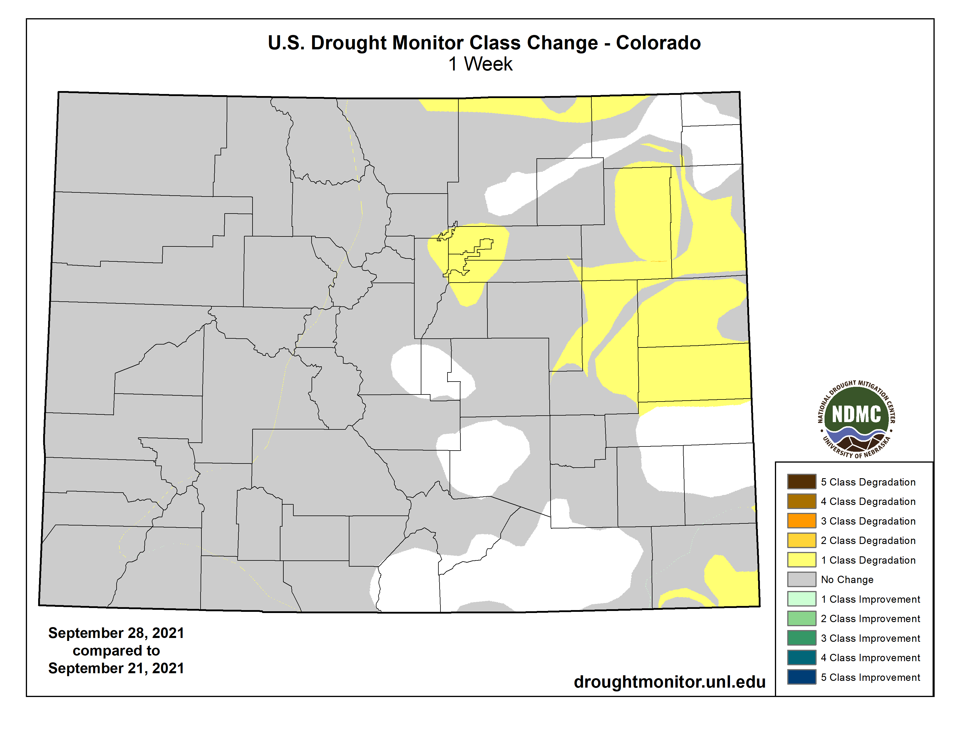
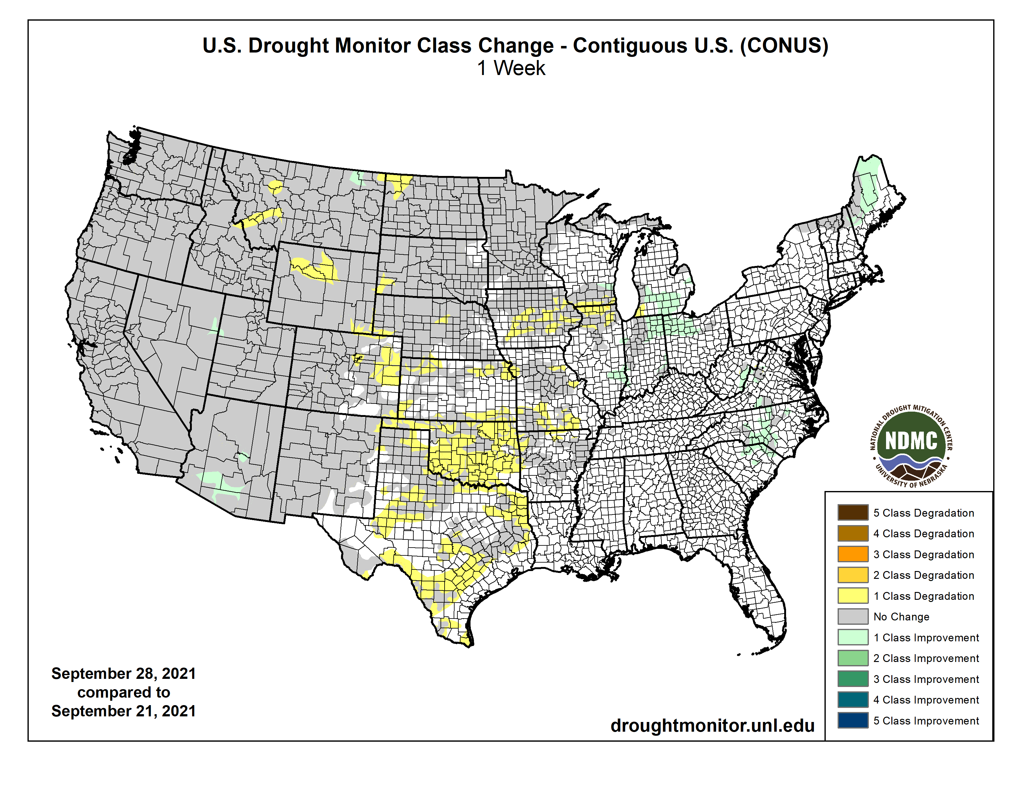
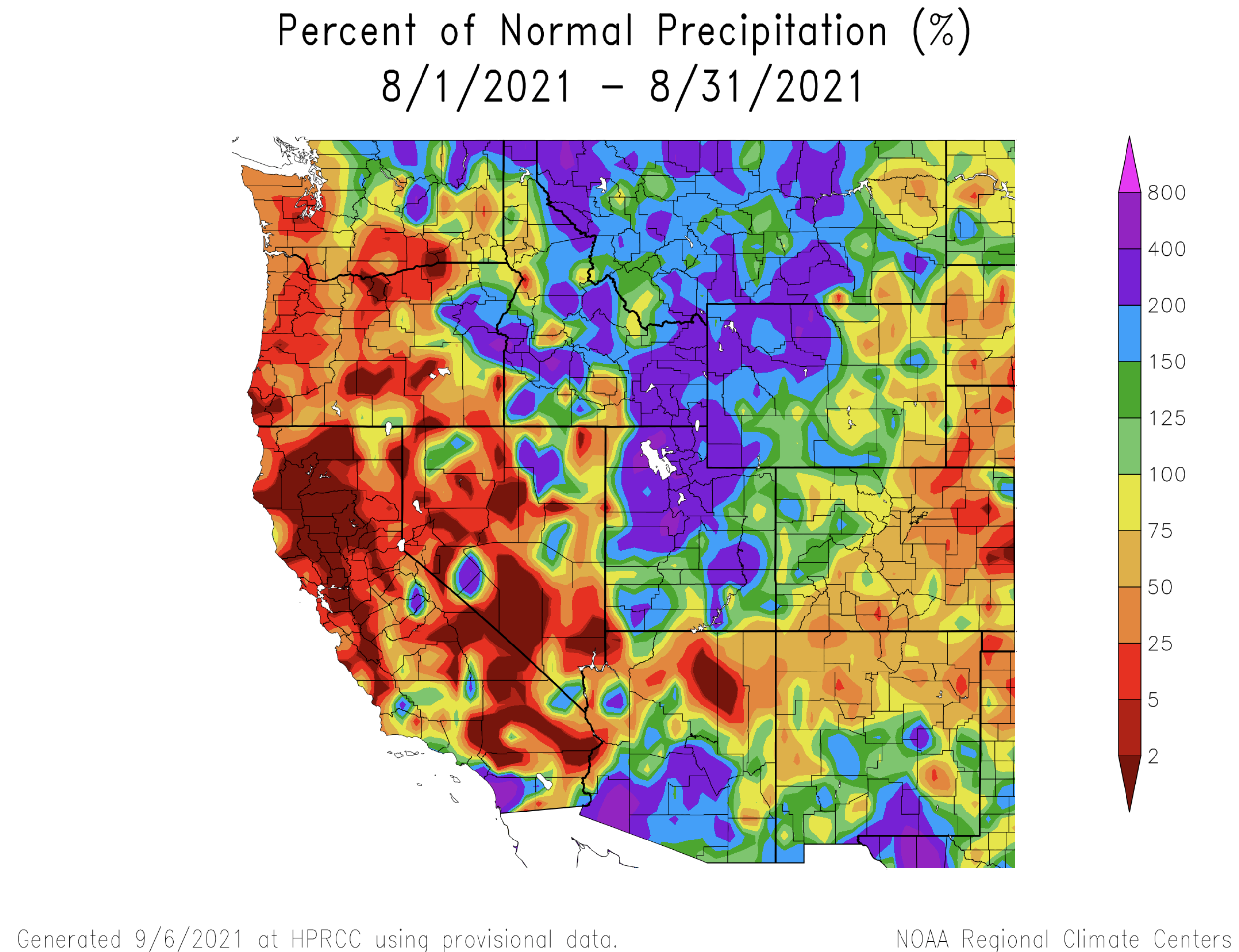
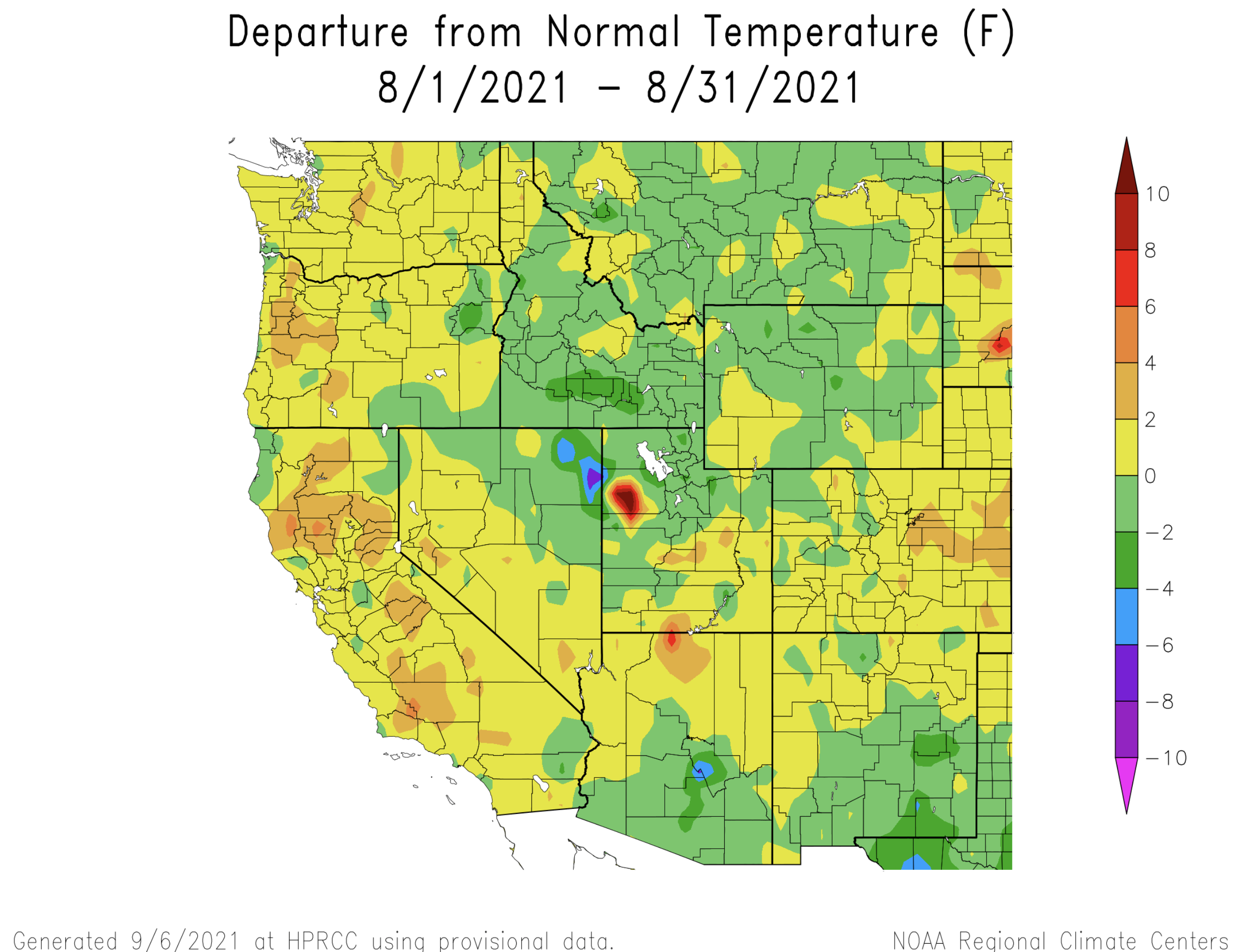
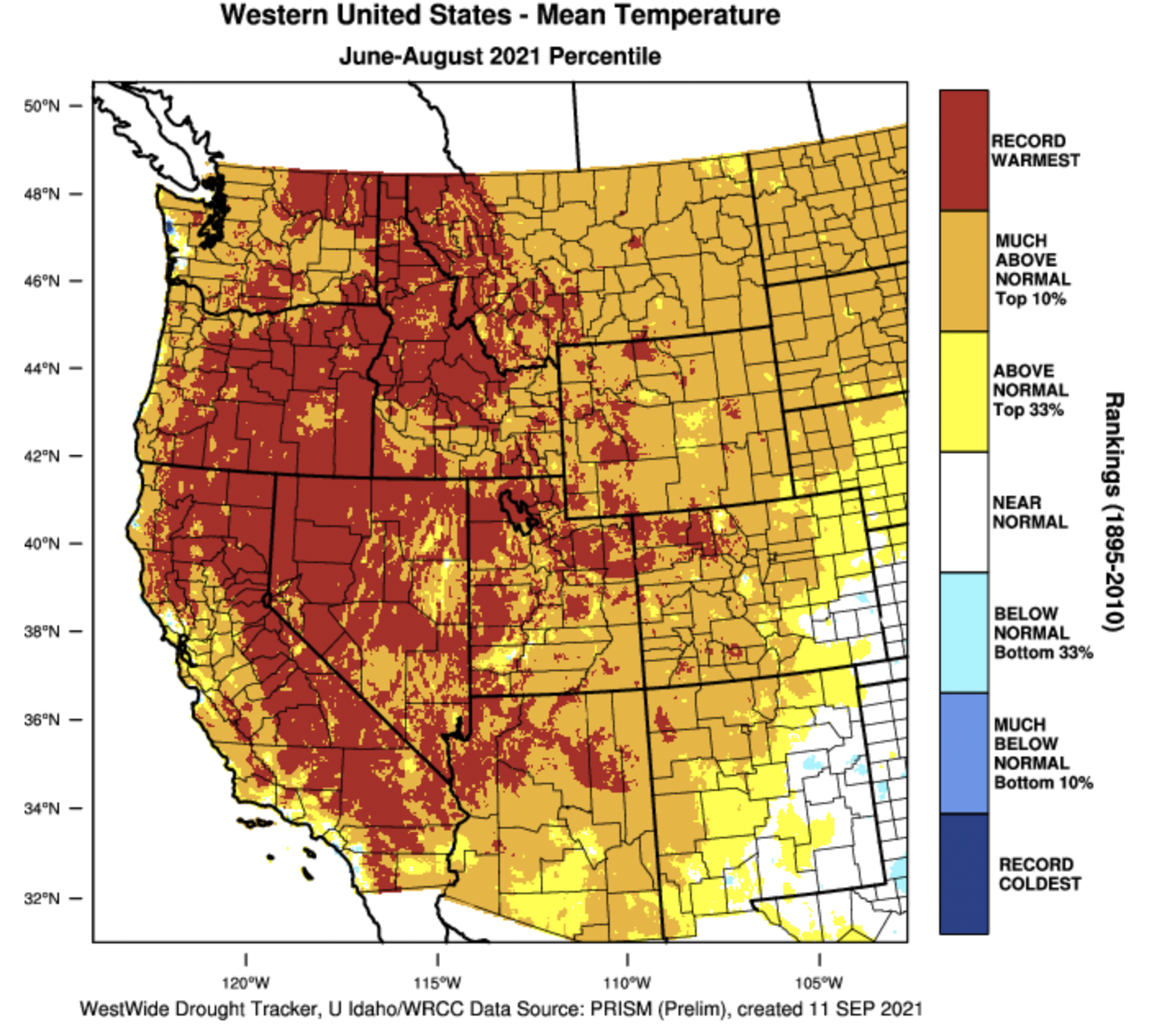
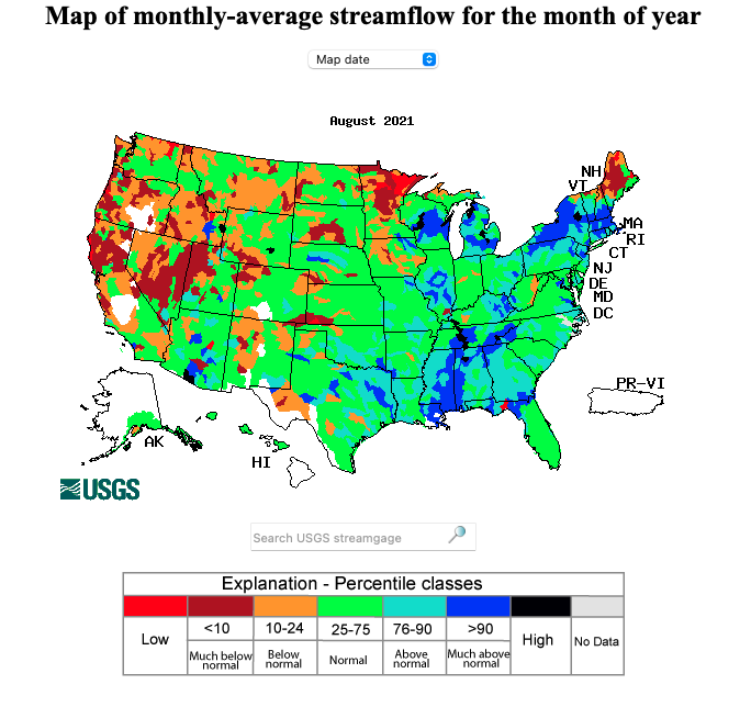

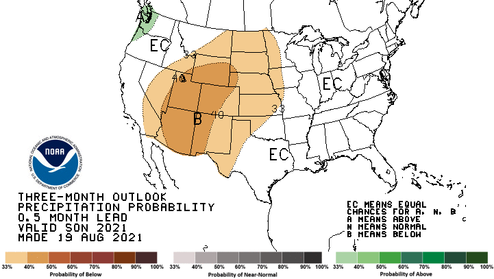
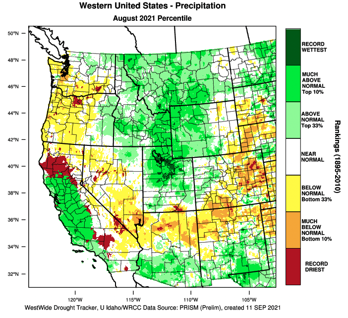
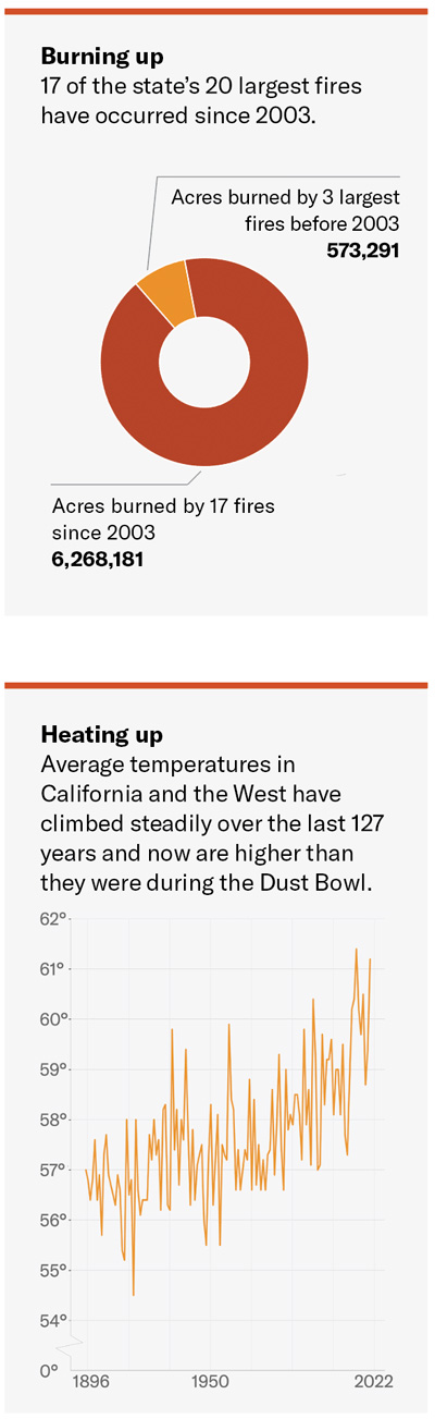

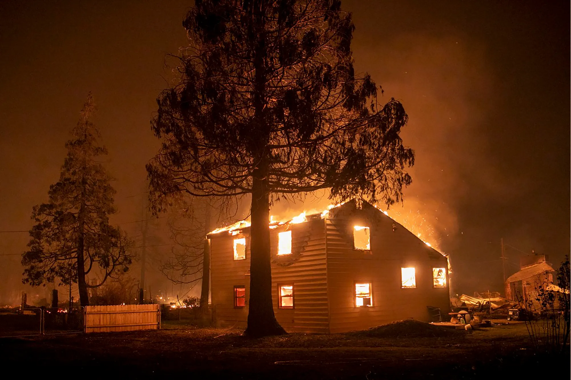
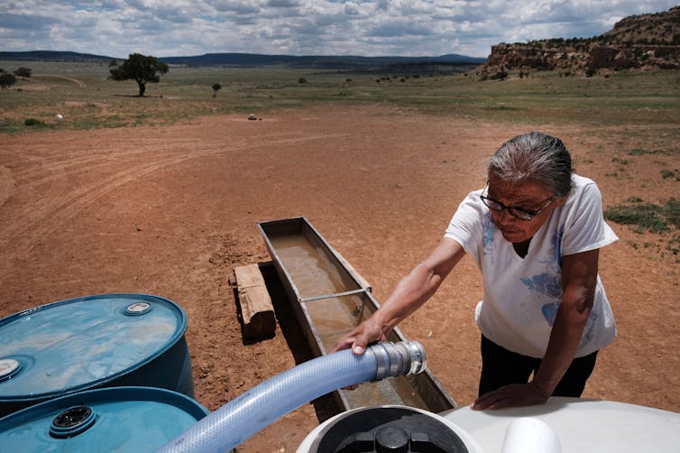
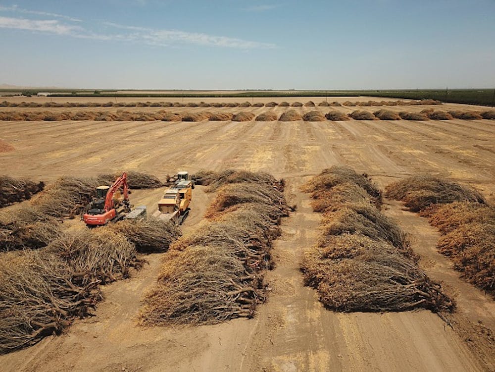
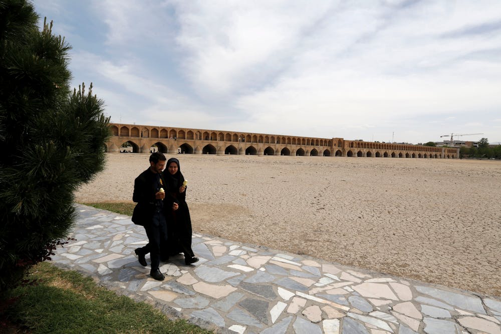
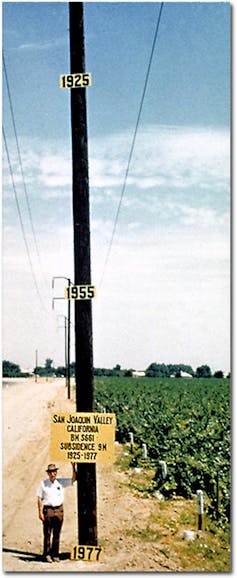

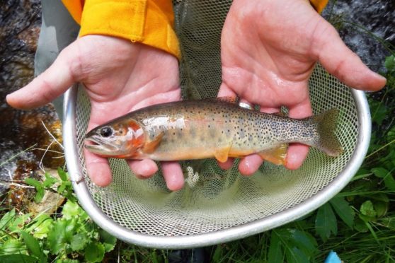
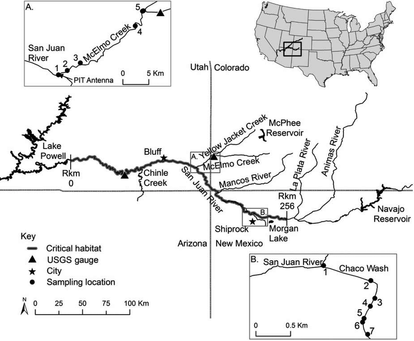
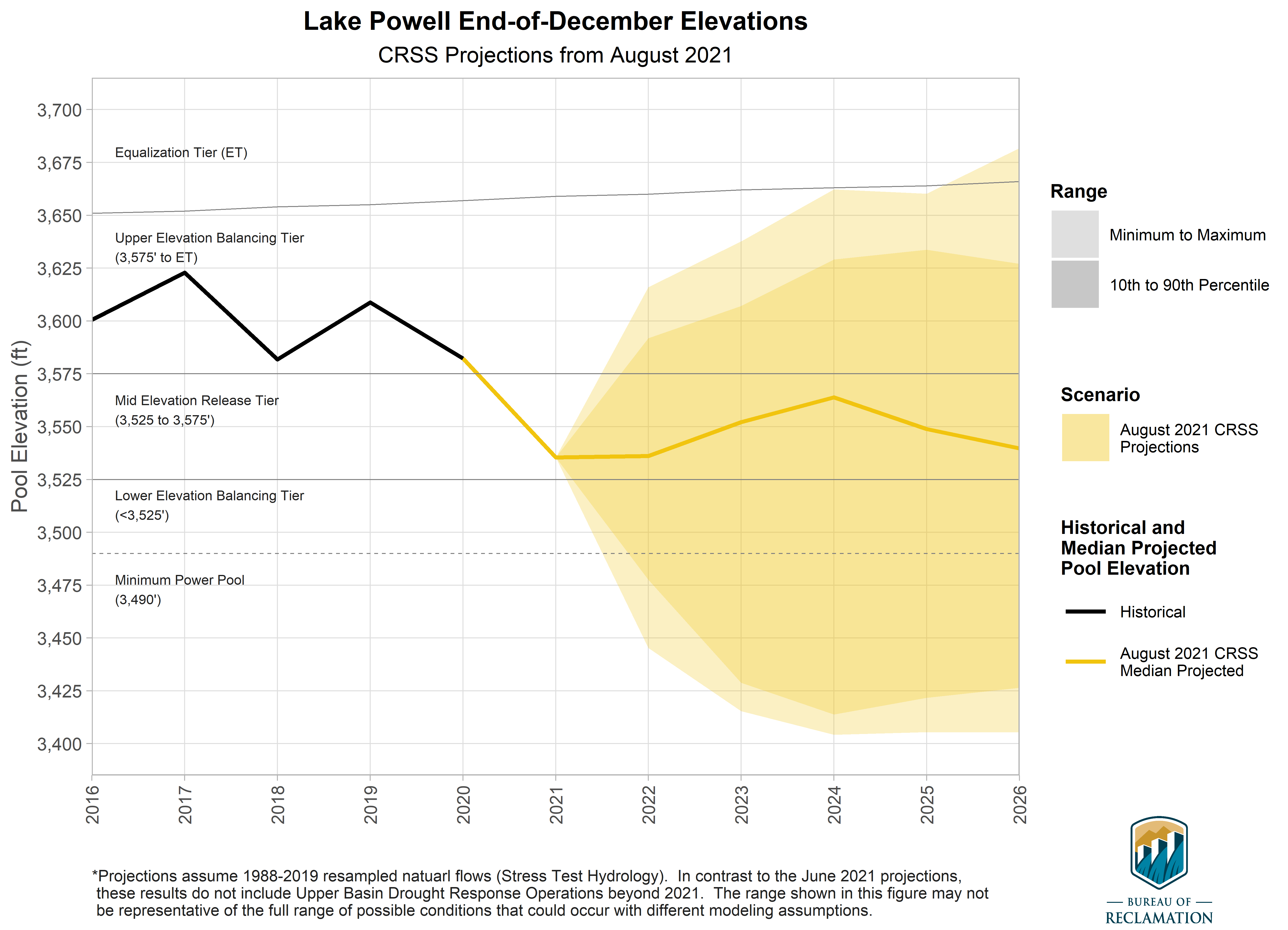

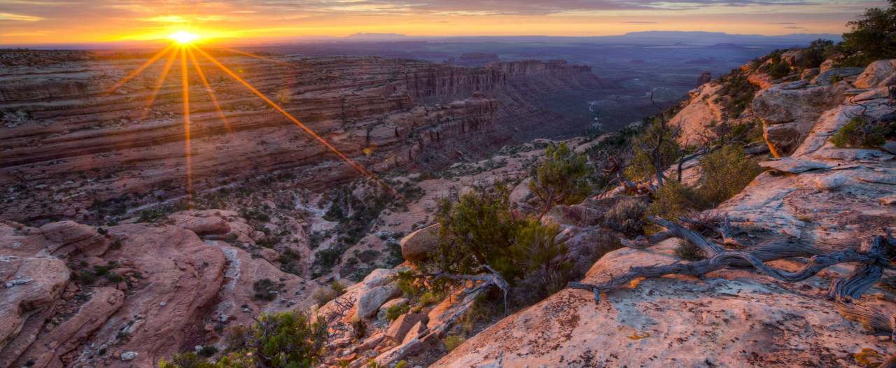


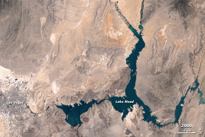
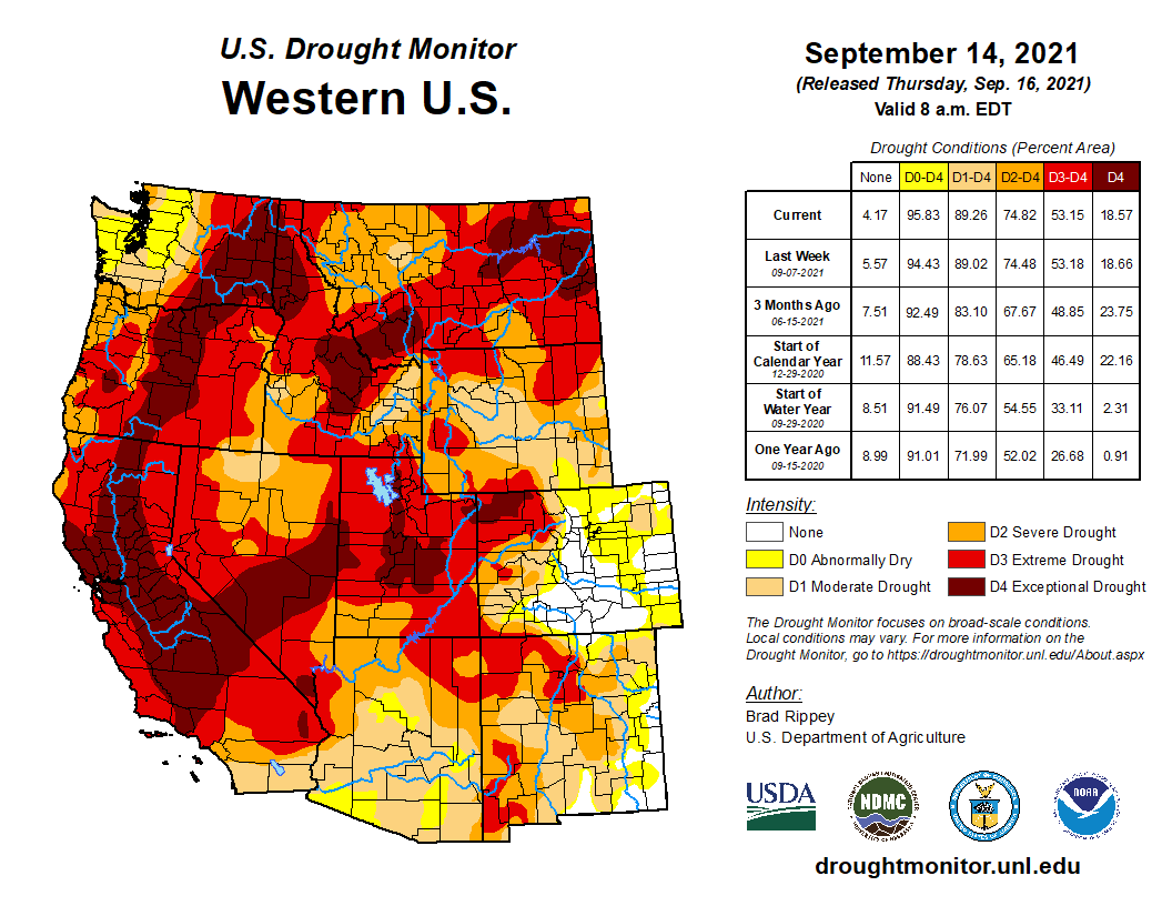
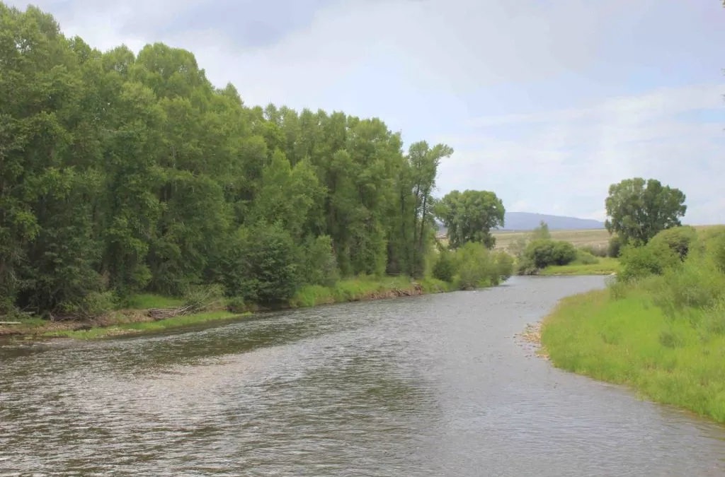
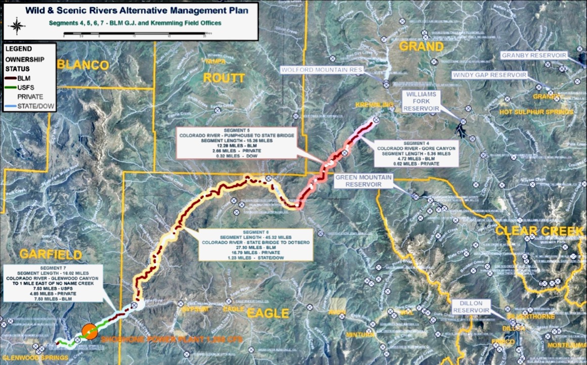

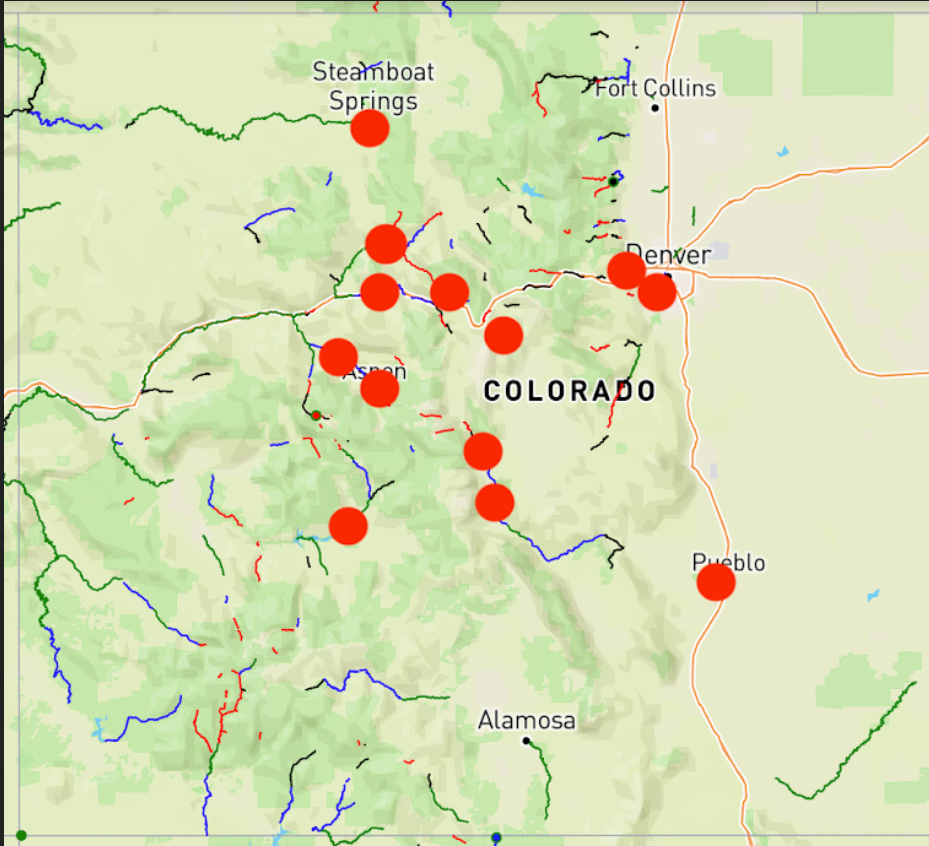


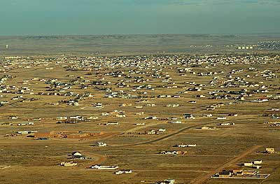

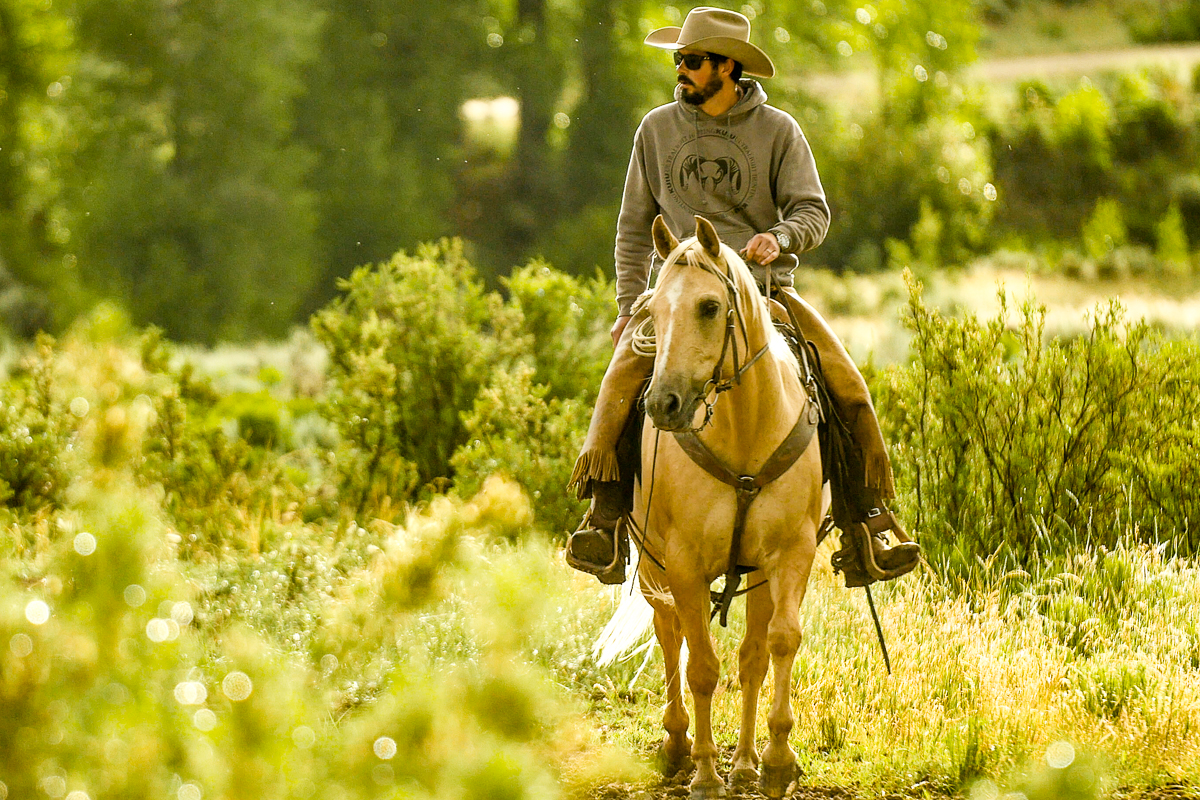
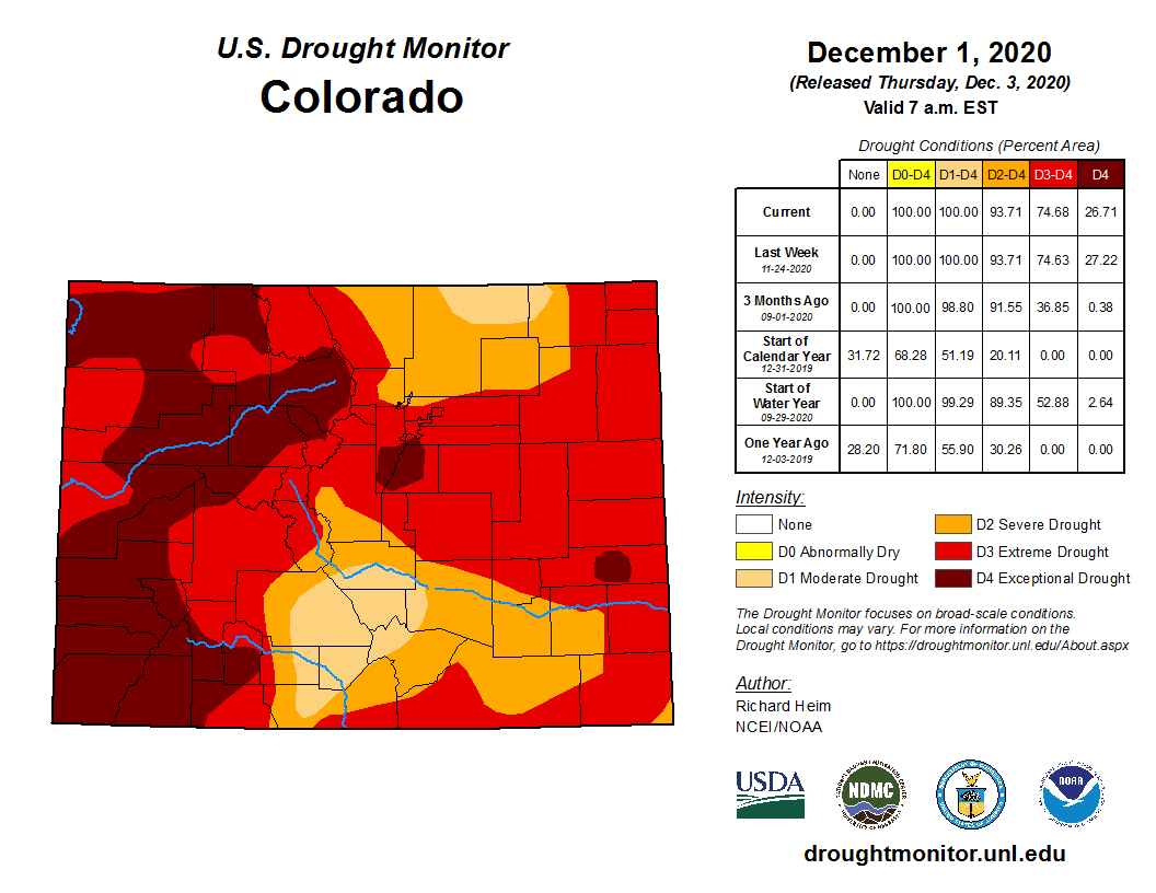

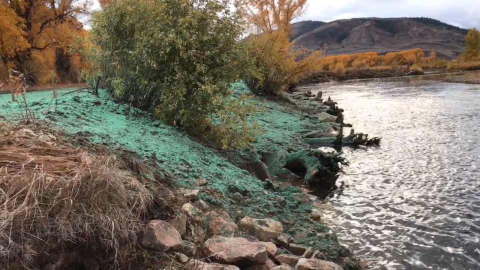
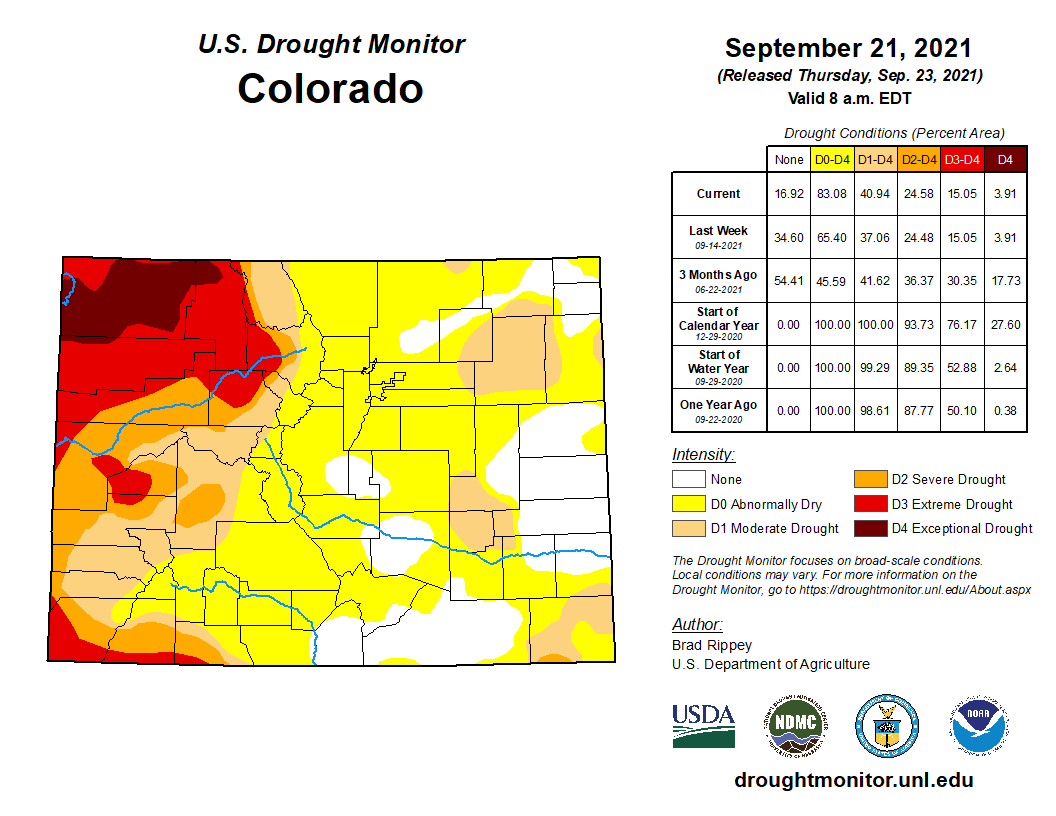

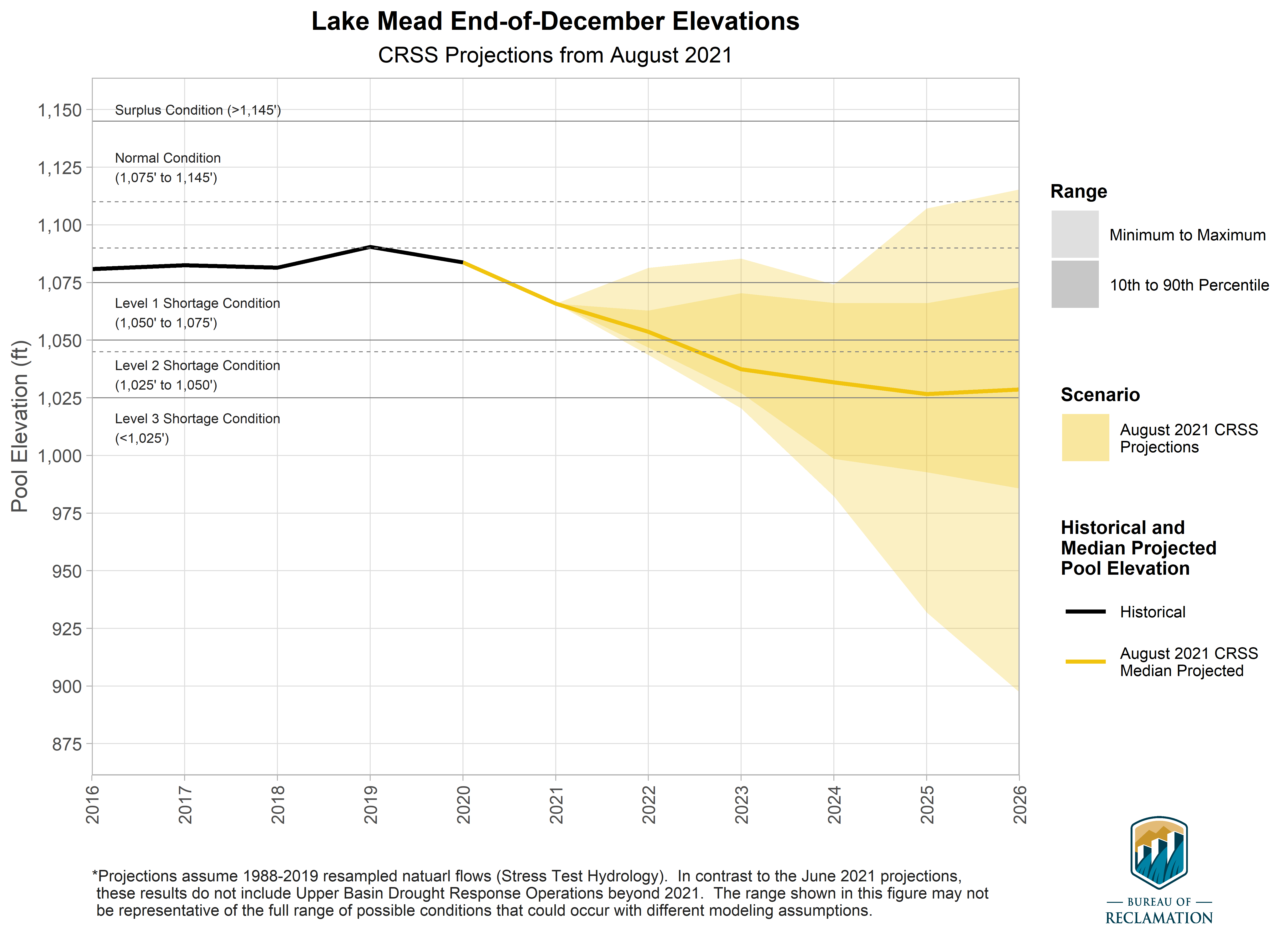


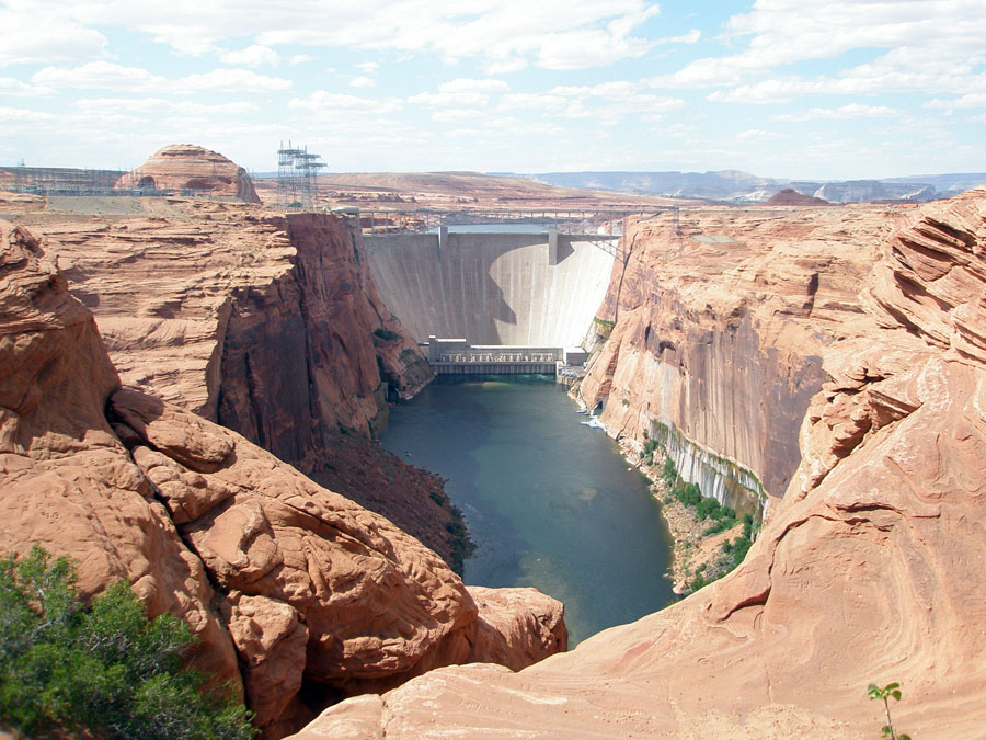


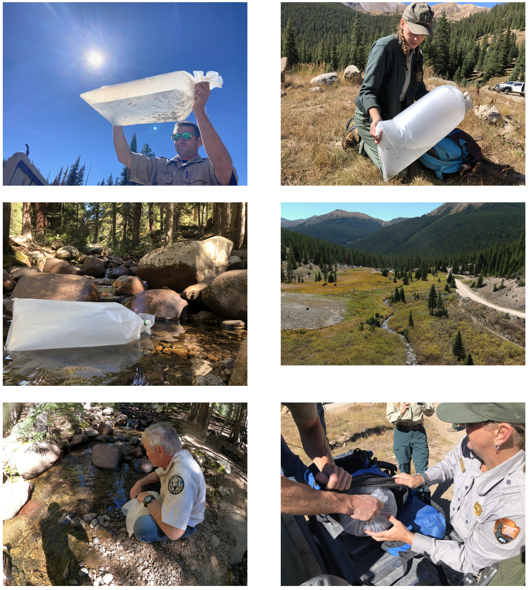


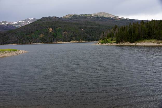

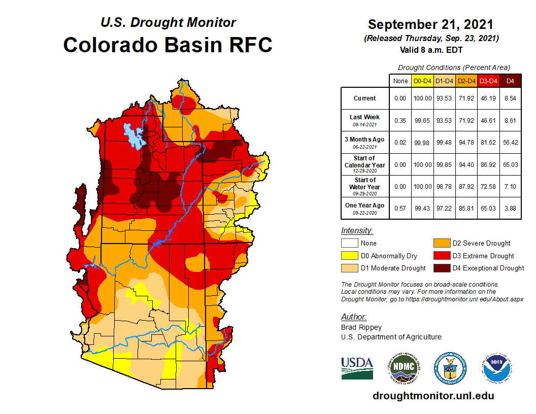


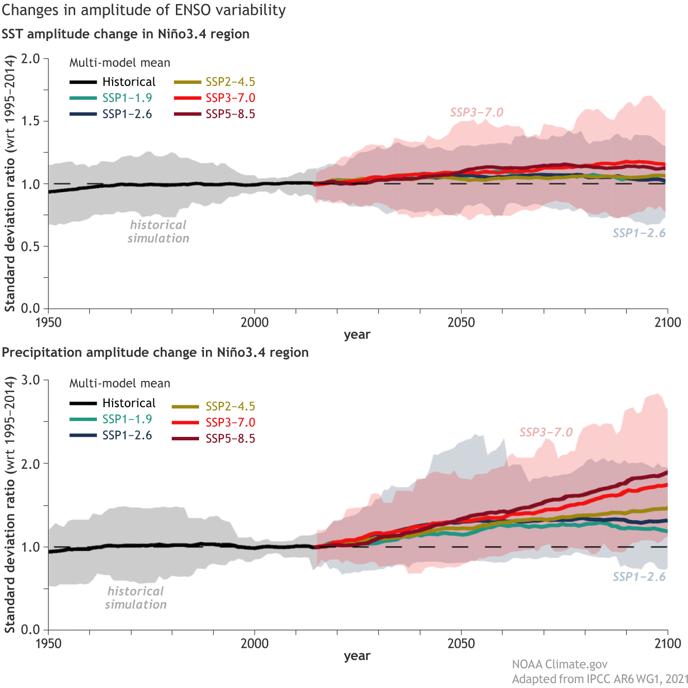


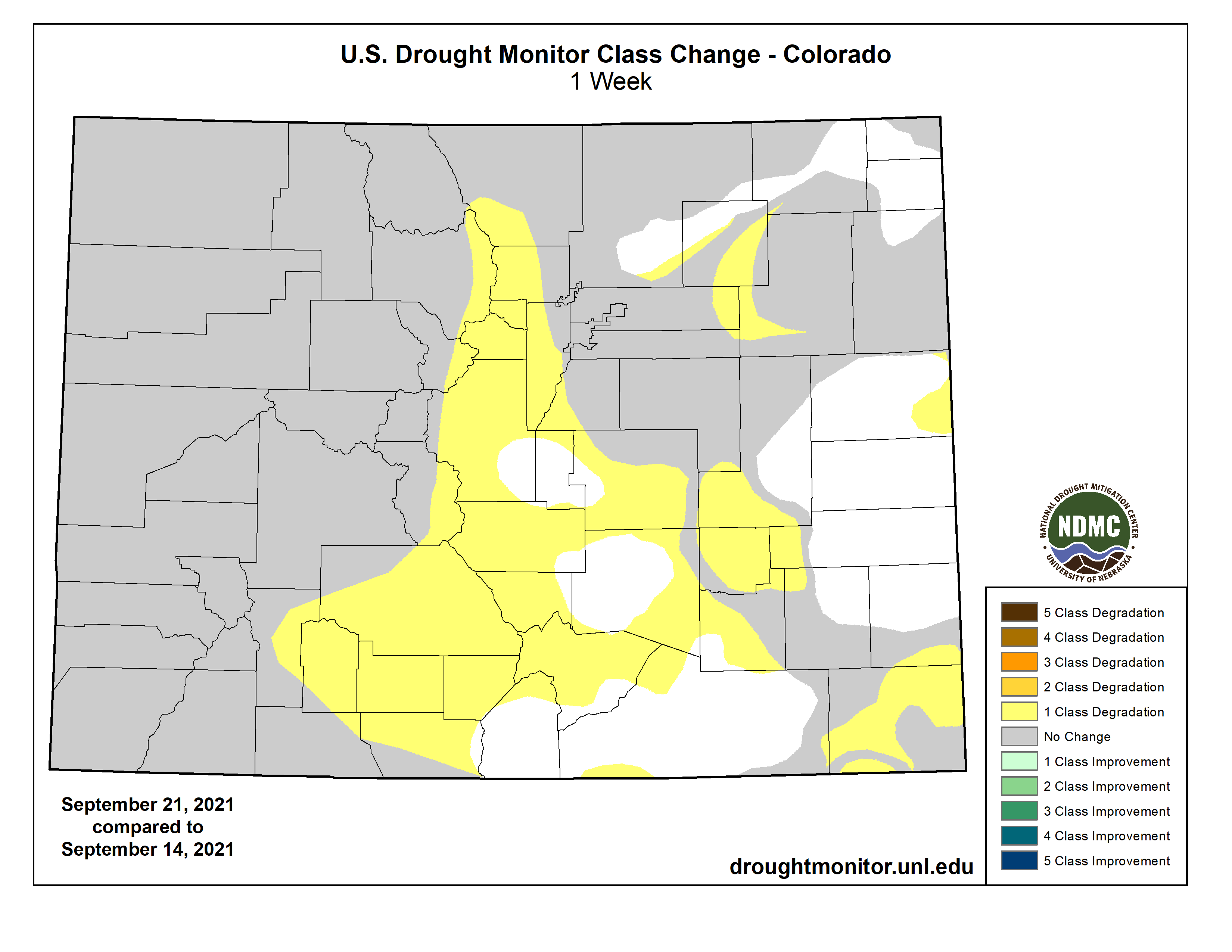

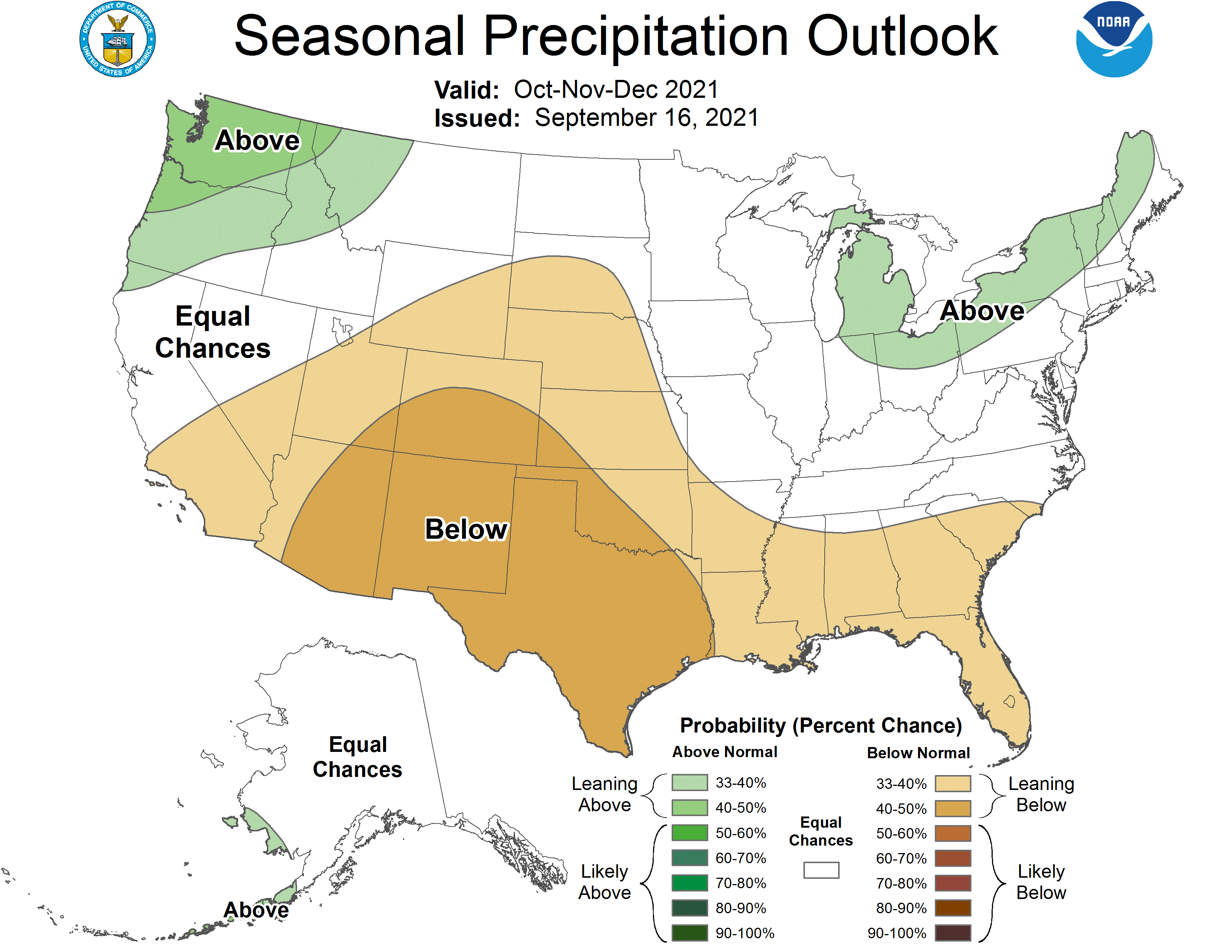
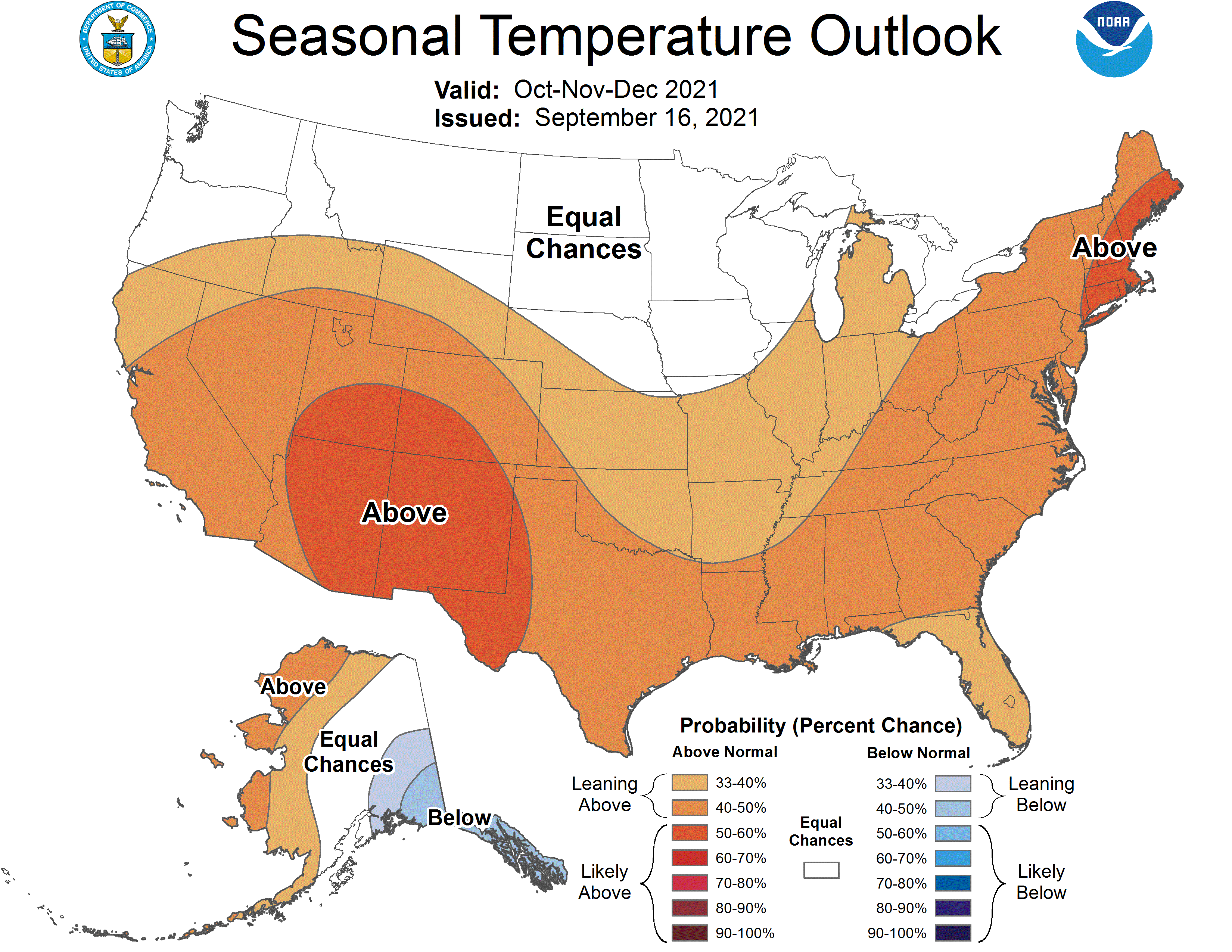
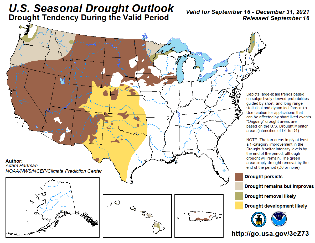
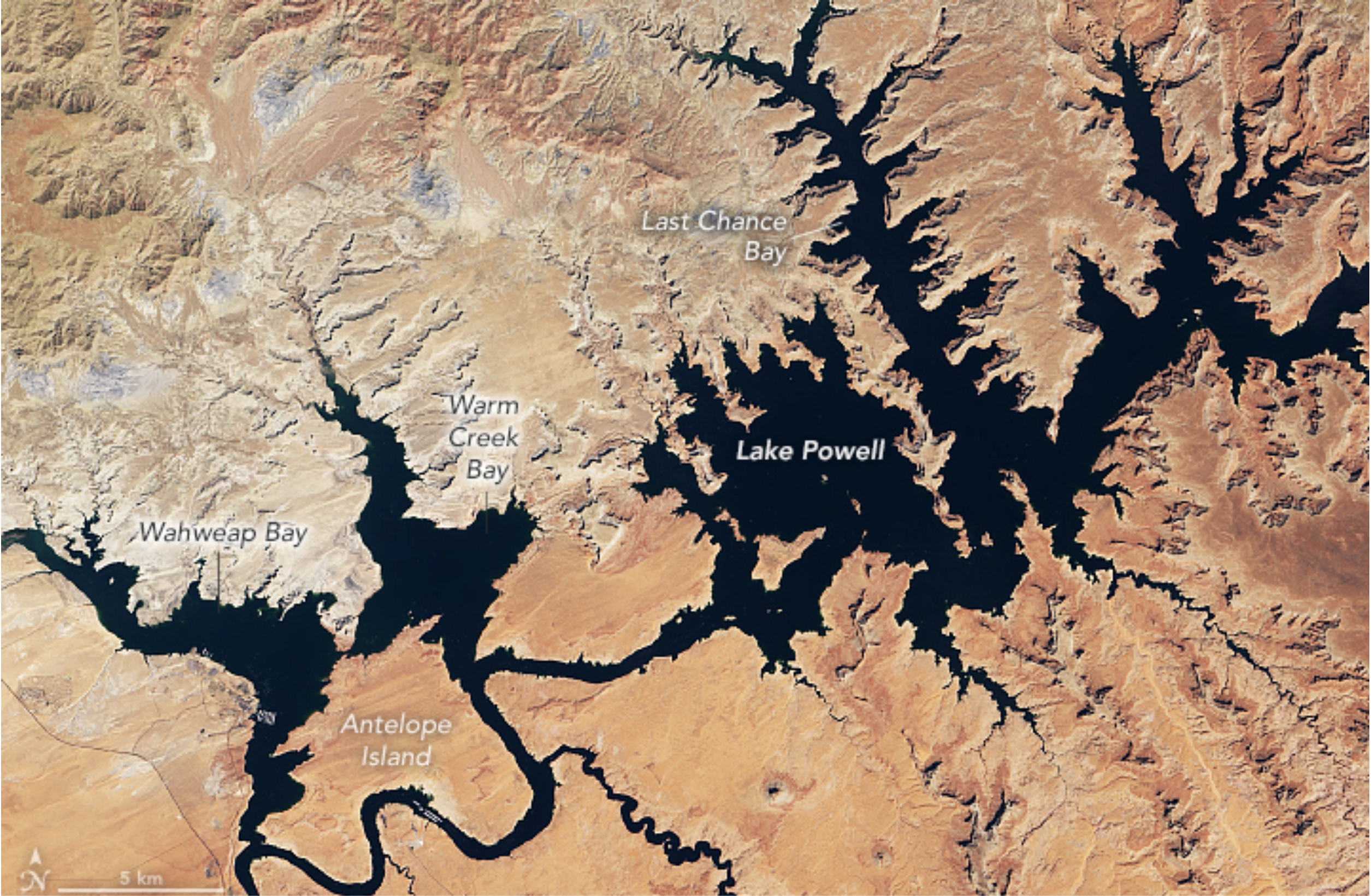
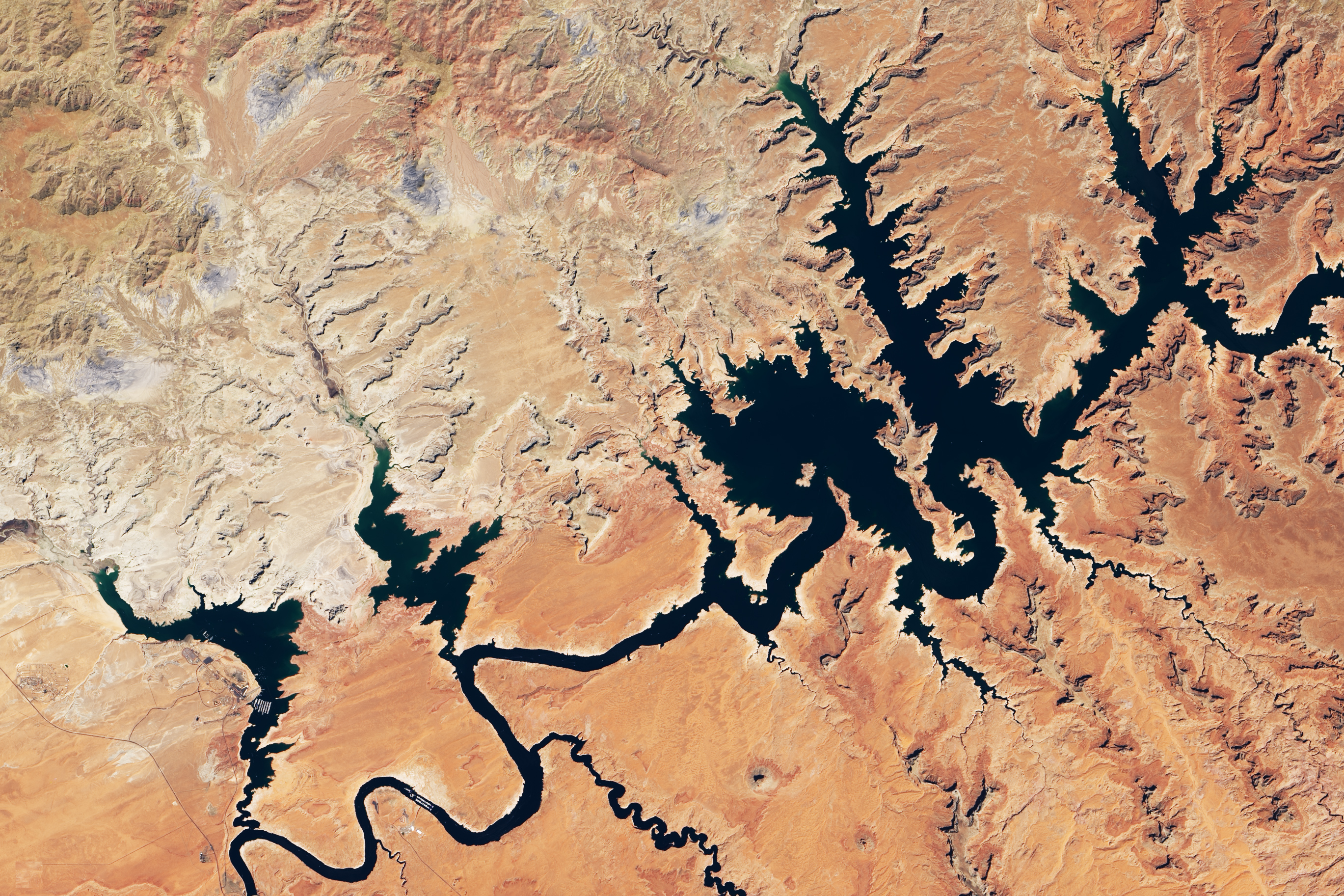
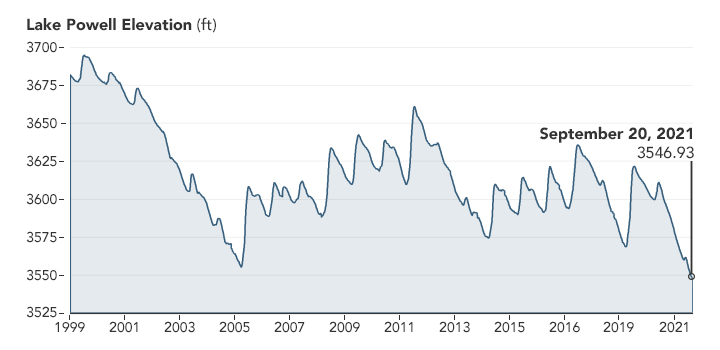
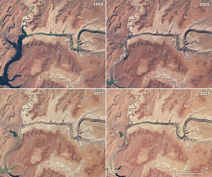

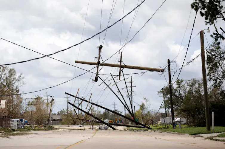
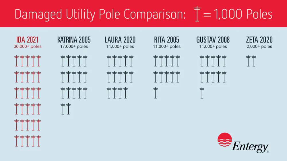
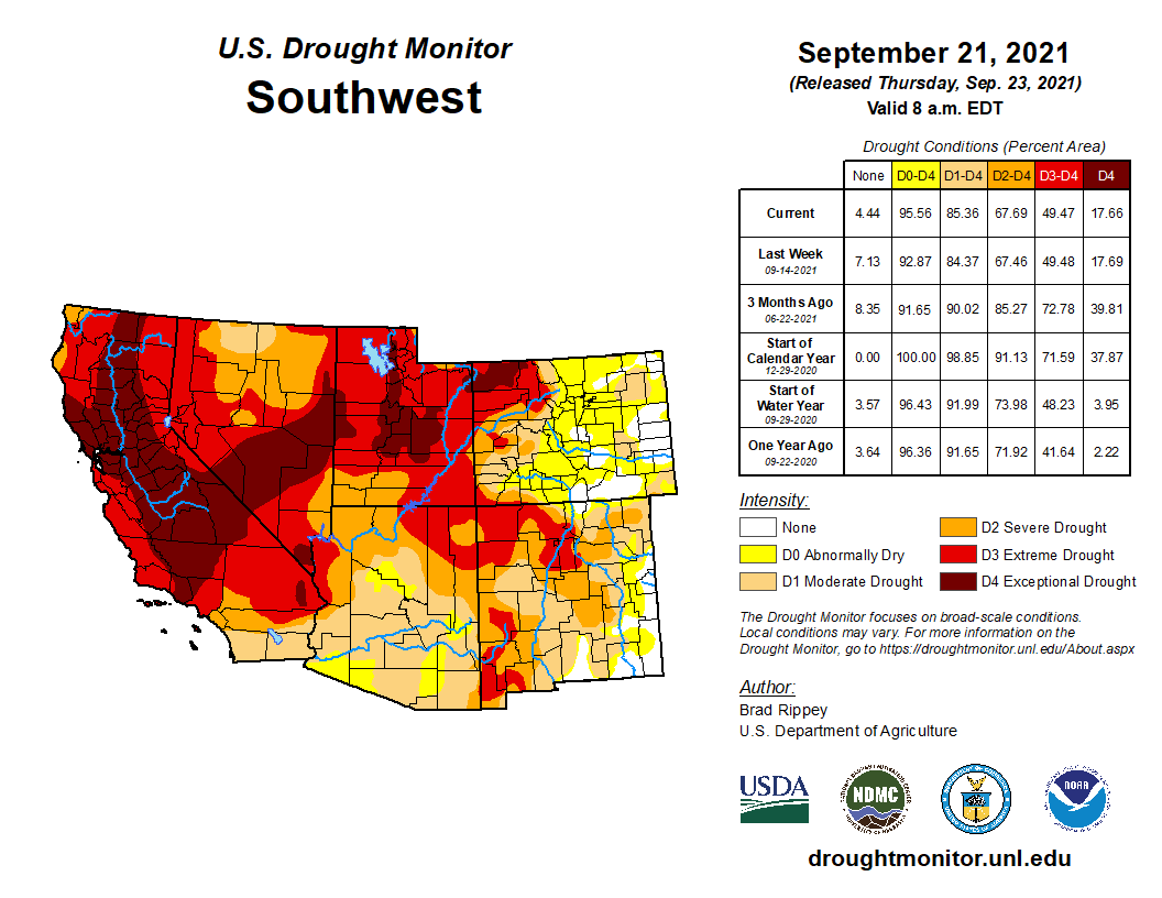


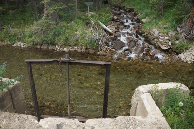

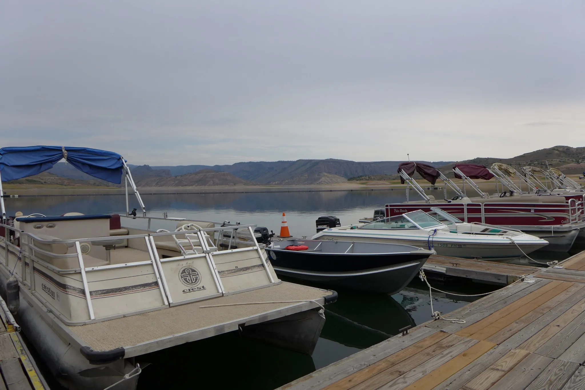
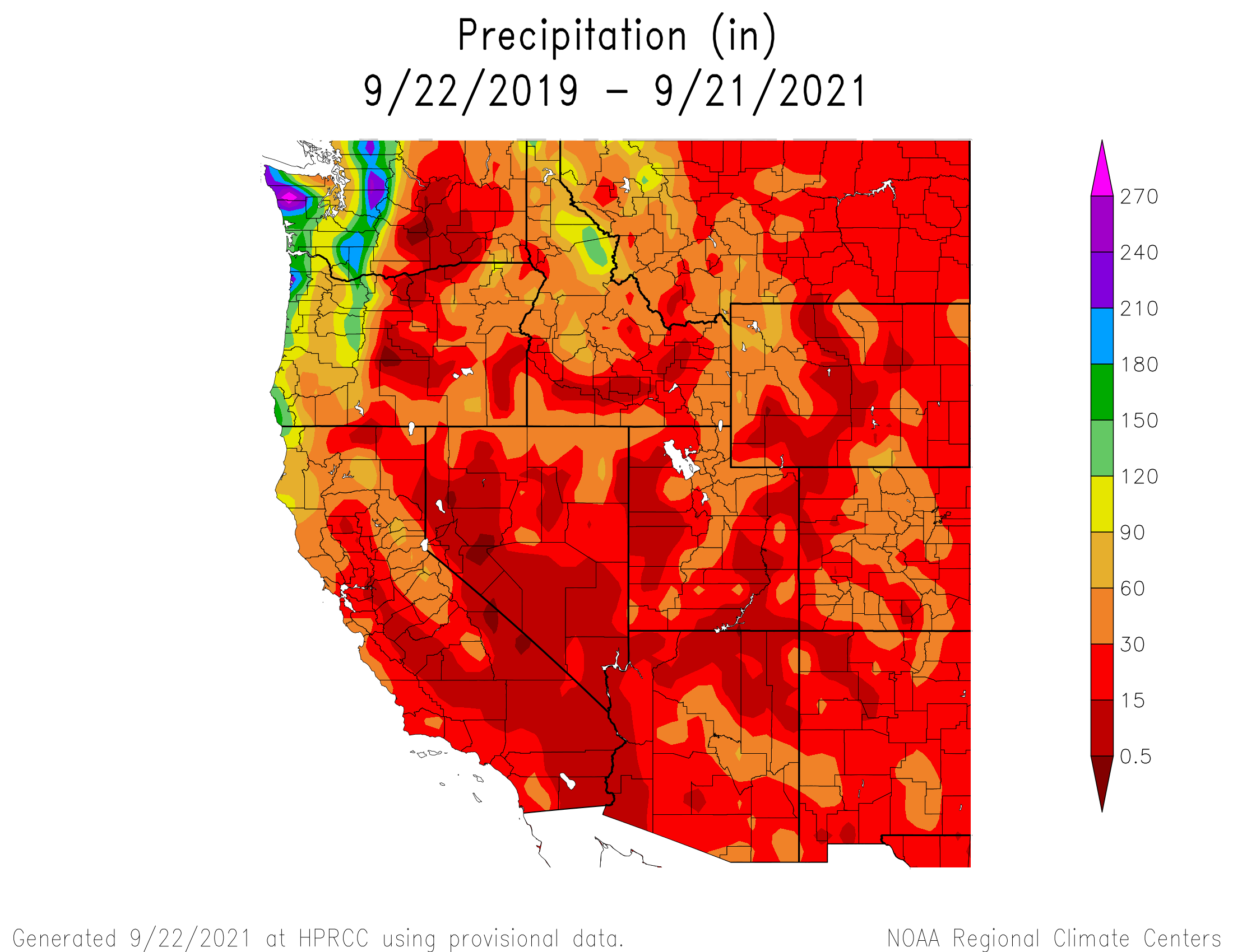


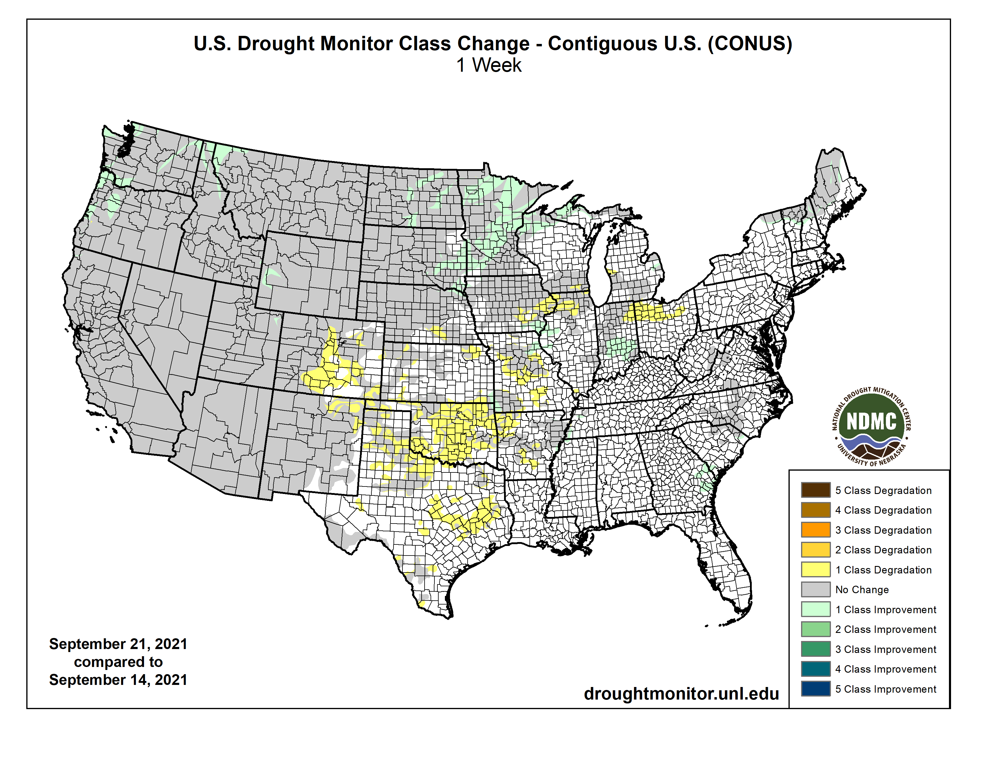
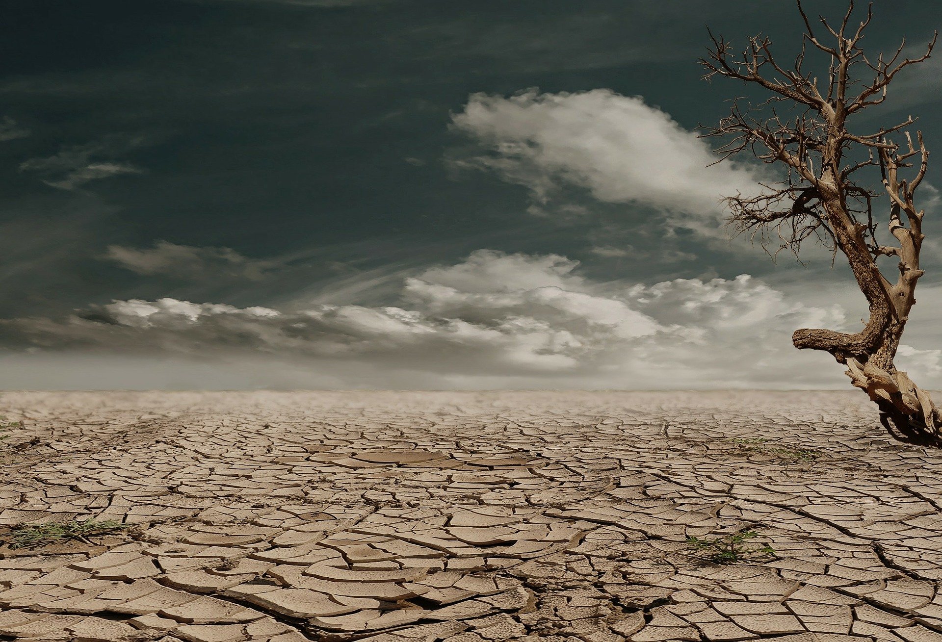
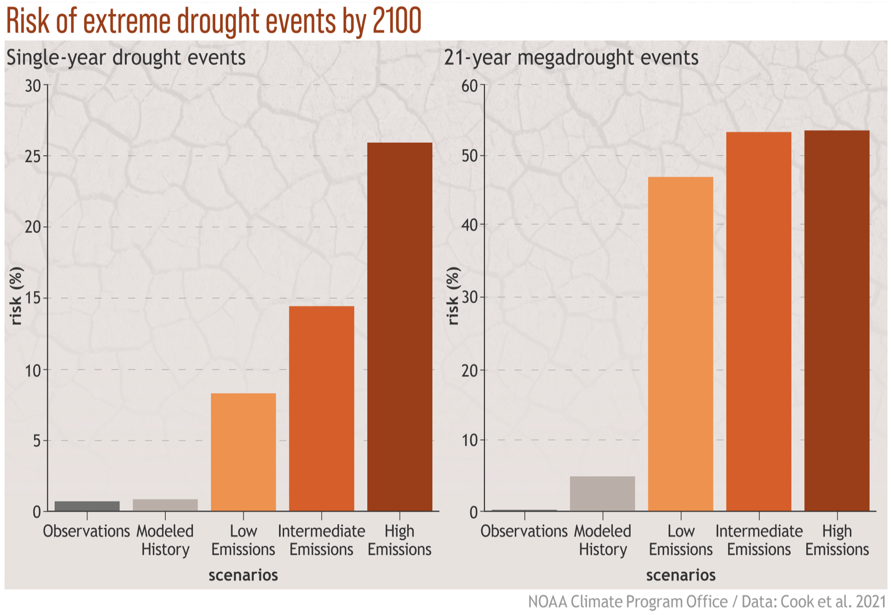
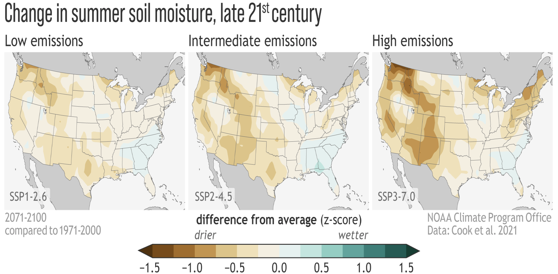
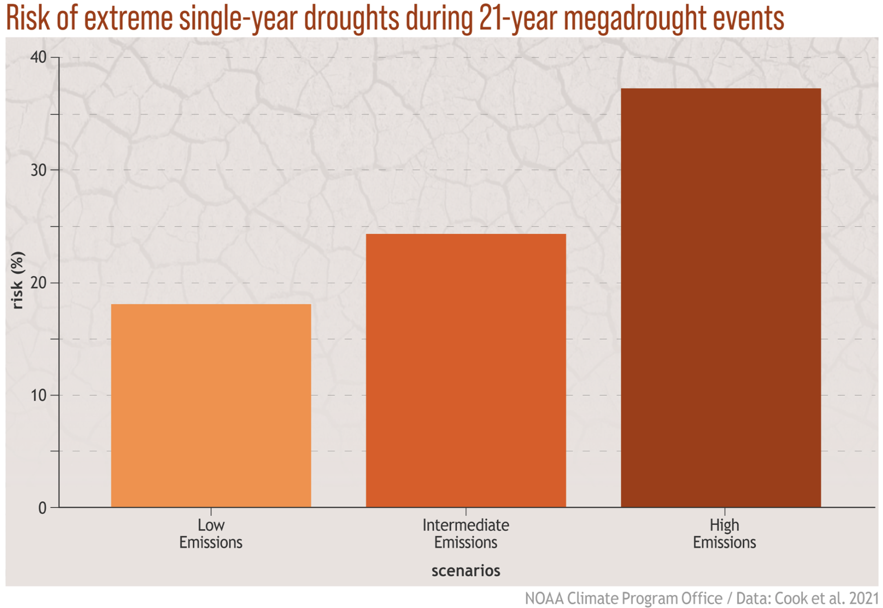
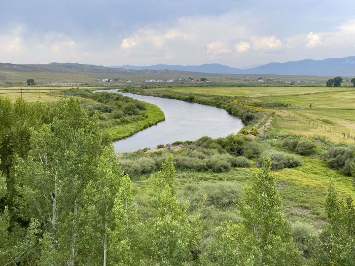

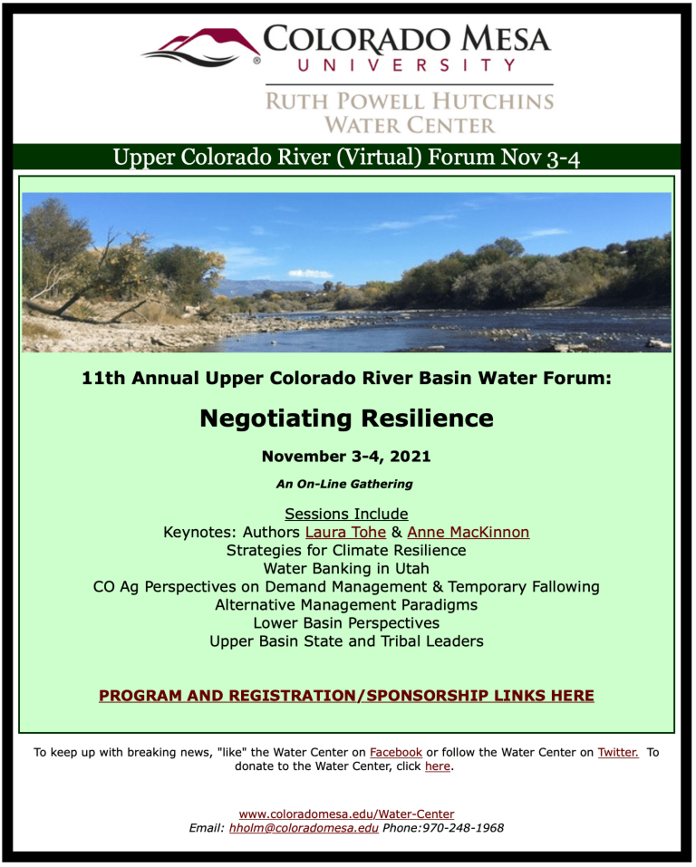


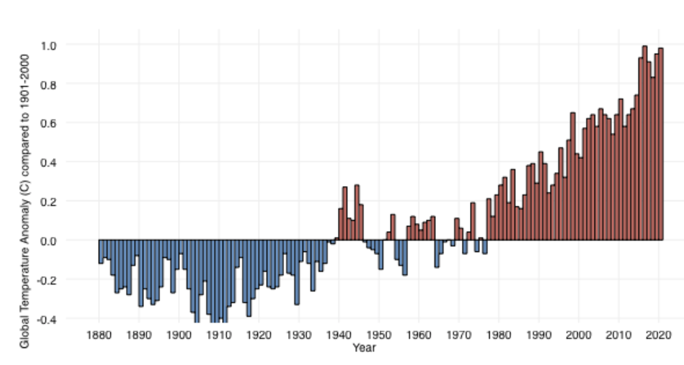

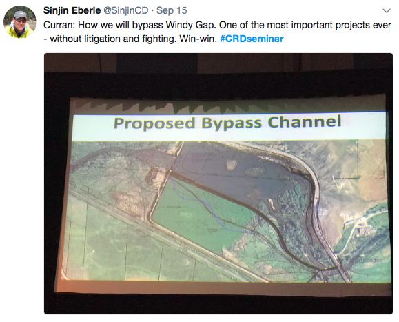


