The news on climate this summer has been grim. Not only did an Intergovernmental Panel on Climate Change report paint a depressing future, the dire consequences of unchecked emissions are already wreaking havoc across the globe. Those effects include powerful storms across the eastern half of the United States, and brutal heat that seared the West, killing more than 200 people. It did a number on birds, too.
The temperatures, which exceeded 110°F in places where it rarely gets above 85°F, drove young birds to fling themselves from their nests in a desperate attempt to escape the heat. In Seattle, most of the chicks in a Caspian Tern colony leapt from their rooftop nesting site; Seattle Audubon and Audubon Washington worked with rehabbers to save as many birds as they could, but many chicks died of their injuries. In Portland, more than 100 young raptors—mostly Cooper’s Hawks—did the same, and Portland Audubon Society helped rescue those birds, too.
Compounding the effects of the increasing temperatures, a long-term megadrought now affects the western half of the United States. Water levels are at historic lows, threatening communities, public health, and birds as well as critical ecosystems. In August the Bureau of Reclamation declared reductions in water deliveries to Arizona, Nevada, and the Republic of Mexico. This crisis is urgent for people—their businesses, their families—as well as for birds, a fact that they are telling us loud and clear.
But birds also tell us when we do something right.
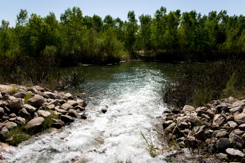
The first water from the 2021 “pulse flow” is delivered at the Chausse restoration site in the Colorado River Delta. Photo Credit: Jesús Salazar/Raise the River via the Walton Family Foundation
The Colorado River is flowing again in its delta. Thanks to the Colorado River binational agreement with Mexico, Minute 323, more than 11 billion gallons of water will be delivered to the area this year for restored habitat. As the latest issue of Audubon magazine reports, with a relatively small amount of water committed to the delta—less than 1 percent of its former annual flow—more than 42,000 acres of riparian forest and wetlands can be protected and restored. In fact, targeted flows through the delta in 2014 led to a 20 percent increase in bird abundance and a 42 percent increase in bird diversity.
Our current water and climate crises are decades in the making, but there is still time to take action and reduce the damage. Good planning is critical to maintaining reliable water supplies for people and nature alike. Focusing on policy changes, research, and on-the-ground actions, we can unify the needs of birds with the water needs of cities and agriculture by helping communities adapt to climate change, reducing pressure on water supplies, and investing in natural climate solutions that absorb carbon pollution. By working together with Indigenous communities, governments, water agencies, and landowners, we can collectively protect birds and create an equitable and sustainable future for us all.
This piece originally ran in the Fall 2021 issue. To receive our print magazine, become a member by making a donation today.
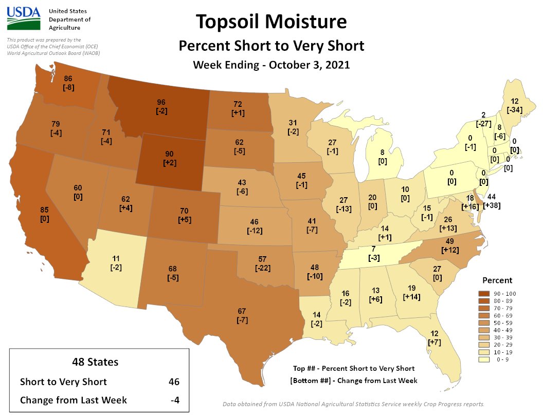
Mild drought conditions hit Littleton and the rest of metro Denver in mid-September, and since then, the drought has worsened, according to the latest U.S. Drought Monitor…
Drought spread from western Colorado across Denver’s metro area, which was classified as ‘D0: Abnormally dry’ in mid-September. By the end of the month, our region worsened to ‘D1: Moderate Drought,’ according to the monitor, which is published by the National Oceanic and Atmospheric Administration.
Rainfall kept Littleton drought-free throughout the summer, but recent dry conditions have increased, weather officials said.
Colorado Drought Monitor map September 28, 2021.
Western Colorado has battled extreme drought for several months. Moffat, Routt, Rio Blanco and Montezuma counties remain under ‘extreme’ or ‘exceptional’ drought conditions, according to the National Oceanic and Atmospheric Administration.
Rio Grande and Pecos River basins. Map credit: By Kmusser – Own work, Elevation data from SRTM, drainage basin from GTOPO [1], U.S. stream from the National Atlas [2], all other features from Vector Map., CC BY-SA 3.0, https://commons.wikimedia.org/w/index.php?curid=11218868
Attorneys laid out their arguments Monday during the first day of a virtual trial in a lawsuit over Rio Grande water with Texas and the federal government alleging that New Mexico’s use of groundwater cut into Texas’ share of river water.
The appointed special master, Michael Melloy, a senior judge for the U.S. 8th District Court of Appeals, is hearing arguments in the 8-year-old case and will compile a report for the U.S. Supreme Court.
Melloy determined in late August that the long-awaited three-month trial would be split into two portions, one virtual and one in-person later in Cedar Rapids, Iowa. He cited a health emergency for one of the Texas attorneys and concerns about the increase of COVID-19 cases for splitting the trial.
Virtual testimony from a mix of members of federal agencies, farmers, irrigation managers, hydrologists and city officials from El Paso and Las Cruces will continue over several weeks.
In the 2014 complaint in the case, officially called No. 141 Original: Texas v. New Mexico and Colorado, Texas attorneys allege New Mexico’s groundwater pumping reduced Texas’ Rio Grande portion by tens of thousands of acre feet each year, and owes Texas damages. An acre-foot of water is equal to about 325,851 gallons.
Colorado is named as a defendant only because it is a signatory to the 82-year-old Rio Grande Compact…
The longstanding tug-of-war over the river’s water between the states and the federal government started a decade ago. In a 2011 federal lawsuit, New Mexico alleged the federal government shorted New Mexico its Rio Grande water, and gave too much to Texas. It escalated when Texas filed a new lawsuit against New Mexico in the U.S. Supreme Court three years later.
On Monday, attorney Stuart Somach, who represents Texas, opened with an apology for repeating arguments, saying he’s presented Texas’ case since 2012…
The basis for Texas’ case, Somach said, was that New Mexico’s groundwater pumping south of the Elephant Butte Reservoir depleted the Rio Grande and violated the Rio Grande Compact.
Historically, the Rio Grande was split 57% to New Mexico and 43% to Texas. Somach said that the increased groundwater use from the city of Las Cruces, New Mexico State University and agriculture in New Mexico reduces the total amount of river water available to Texas.
“We don’t quibble with the fact that we get 43% of something,” Somach said. “But what we’re entitled to is 43% of the conditions that existed in 1938, not the conditions that have been created by New Mexico groundwater pumping.”
Somach said over the next few weeks, Texas farmers, the irrigation district and officials from the city of El Paso will testify to the “injury caused directly by New Mexico’s actions.”
James DuBois, an attorney in the Department of Justice, told the court that New Mexico has known that groundwater pumping would impact the amount of water in the Rio Grande…
DuBois said New Mexico’s actions threatened the compact, and the 1906 treaty that guarantees Mexico’s portion of the Rio Grande, up to 60,000 acre-feet…
DuBois said the court would hear from federal officials at the U.S. Bureau of Reclamation, which oversees irrigation projects in the West, about a 2008 operating agreement between the federal government and irrigation districts that updated allocations.
He said to expect testimony from the International Boundary and Water Commission, a binational agency which enforces the water treaty with Mexico, in coming weeks.
The opening arguments for New Mexico were split between the outside counsel and New Mexico Attorney General Hector Balderas.
Balderas said the uncertain climate future and a shrinking river make this case pressing…
Balderas said the state maintains that New Mexico is not receiving its fair share of water. He referenced the federal civil case from 2011, when the then-Attorney General Gary King sued the federal government over the 2008 operating agreement with the irrigation districts. King alleged the agreement gave too much water to Texas and shorted New Mexico. That 2011 case remains unresolved, because when Texas filed the lawsuit in the Supreme Court in 2014, action halted in the lower courts.
“It’s not Texas that is being harmed in this case, it is New Mexico,” Balderas said…
Attorney Jeff Wechsler, representing New Mexico, said the 2008 operating agreement meant that New Mexico is shorted on surface water, making area farmers more reliant on groundwater pumping…
Wechsler said that additional water in Texas is sold by the El Paso irrigation district to Hudspeth County, which is allowed to use Rio Grande project waste water…
Wechsler went on to say that groundwater pumping in the Hueco Bolson by El Paso, a major source of water for the city, has impacted Rio Grande project waters.
Wechsler said that New Mexico farmers, relying on groundwater because of the federal government’s allocation changes since 2008, are paying more in maintenance and in soil changes, which he said amount to millions in damages.
Weschler asked the court to rule that “New Mexico receives 57% of project water” and allow the state to collect damages.
It was a strange water year in San Juan County, with months of deepening drought and three glorious months of rain. The overall result for the water year, which wrapped up on September 30, was remarkably close in some areas to the precipitation amounts for a normal water year.
For the water year, Monticello received 14.91 inches of precipitation. This is 99 percent of the multiyear average of 15.1 inches.
The year-end total represents a remarkable turnaround from the year-to-date totals in June, before the arrival of the annual monsoon season. On June 30, Monticello had just 66 percent of normal precipitation.
Since that time, Monticello has received 8.67 inches of rain, which is 172 percent of the normal three-month average of 5.03 inches.
In contrast, the monsoon season brought wet weather to other locations of San Juan County, but not in as dramatic a fashion. Bluff finished the water year with 4.53 inches of precipitation, which is just 58 percent of the historic average of 7.76 inches. Bluff received 2.04 inches of rain during the monsoon season.
Blanding received ten inches of rain for the water year, which is 75 percent of the historic average of 13.3 inches. Blanding received 5.46 inches of rain during the monsoon season.
For the water year, the Camp Jackson weather station in the Abajo Mountains received 25.4 inches of precipitation.
The months of wet weather have given a wonderful start to the dryland farmers who plant crops in the fall. The winter wheat crop appears to be green and healthy and gives hope to farmers who have struggled during the drought. Similarly, the landscape is greener than normal, offering hope to the ranchers who rely on grazing for their livestock.
While the monsoon season has alleviated the stress of the continued drought on dryland agriculture and ranching, the water storage situation remains a major concern.
The water level in Lake Powell, the massive reservoir on the Colorado River, has fallen to record levels…
Lake Powell currently holds less than 30 percent of its capacity, with a water level 155 feet below capacity. The water is 50 feet below the level one year ago.
Similarly, the level of local reservoirs – including Loyds Lake and Recapture Reservoir – is significantly below full capacity and below the levels of one year ago.
In the past summer, Loyds Lake has dropped ten feet and Recapture Reservoir has dropped seven feet.
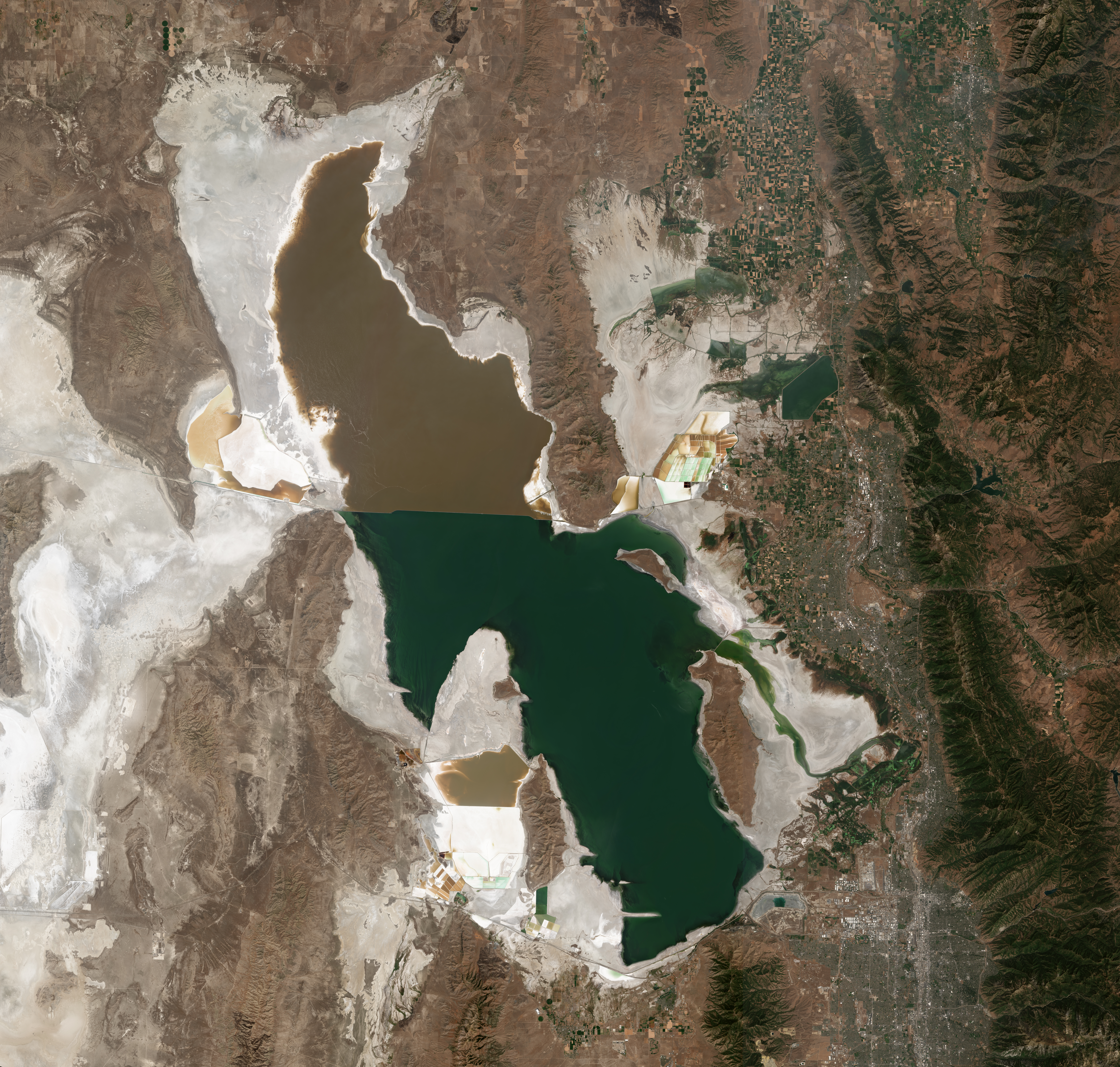
Satellite photo of the Great Salt Lake from August 2018 after years of drought, reaching near-record lows. The difference in colors between the northern and southern portions of the lake is the result of a railroad causeway. The image was acquired by the MSI sensor on the Sentinel-2B satellite. By Copernicus Sentinel-2, ESA – https://scihub.copernicus.eu/dhus/#/home, CC BY-SA 3.0 igo, https://commons.wikimedia.org/w/index.php?curid=77990895
With the news this week regarding the approval by the Utah Division of Water Rights for applications to deliver water to Farmington Bay of Great Salt Lake via the Jordan River, Dave Merritt former Board President of the Colorado River Water Conservation District forwarded a link to a New York Times article concerning a very different problem in 1987, that is, the Great Salt Lake was too full. From article (Thomas J. Knudson):
About the Archive
This is a digitized version of an article from The Times’s print archive, before the start of online publication in 1996. To preserve these articles as they originally appeared, The Times does not alter, edit or update them.
Occasionally the digitization process introduces transcription errors or other problems; we are continuing to work to improve these archived versions.
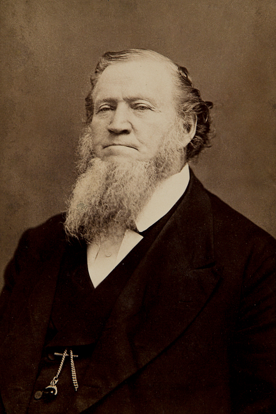
Brigham Young – Latter Day Saint movement leader (1801-1877). By Charles William Carter – Harvard Art Museum/Fogg Museum, Historical Photographs and Special Visual Collections Department, Fine Arts Library, 119.1976.1501
In the 1870’s, the Mormon leader Brigham Young was so concerned about the threat to farmland from the rising level of the Great Salt Lake that he dreamed of pumping excess water out onto the desert, but the idea was never accomplished.
Today, more than a century later, Brigham Young’s dream was realized when Gov. Norman H. Bangerter of Utah helped start the first of three giant pumps that will pull water out of the Great Salt Lake, now at the highest level in recorded history. The water will be dumped onto the Bonneville salt flats to the west, creating a smaller version of the Great Salt Lake that will cover 500 square miles, roughly 22 times the size of Manhattan.
The project, completed under harsh, desert conditions at breakneak speed, seeks to control a lake whose slowly rising waters have flooded highways, railroads, homes and businesses, causing some fatalities and an estimated $200 million in damage over the last five years.
“This is a project we have long waited for,” Governor Bangerter said. “We think Utah will now be in control of its destiny.”
Project Being Questioned
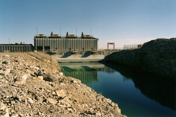
The West Desert Pumping Station is a series of three pumps designed to reduce the water level of the Great Salt Lake, the level of which had been rising steadily through the 1980s, threatening the shoreline industries, Salt Lake City International Airport, railroads, and even I-80 with flooding. The pumping plan called for a system to pump water from the lake to the adjacent Newfoundland Basin, located to the west. The south end of Hogup Ridge, a few miles further down the causeway northwest of Lakeside, was selected as the pump site, and six and a half miles of canals were dug to and from the pumps. Completed rapidly in less than a year, at a cost of nearly $60 million in state funds, the pumps went on line in April 1987. At the same time, a drought began, causing the lake level to subside naturally. The pumps were mothballed in 1989. Photo credit: The Center for Land Use Interpretation Attribution-Noncommercial-Share Alike 3.0 Creative Commons License.
The $60 million West Desert Pumping Project is one of the most ambitious and conflict-ridden in Utah history. And now, just as the pumps are being turned on, the cycle of wet weather that caused the flooding is passing. Many wonder if the state is spending $60 million to solve a problem that nature would have repaired free of charge.
“If the West goes into a dry cycle and the lake starts to recede naturally, the state will look foolish,” said Tony Willardson, associate director of the Western States Water Council here. “It will look like they spent a lot of money they didn’t need to.”
But Utah officials said the rising water left them little choice but to act. ”Everybody says let Mother Nature take her course, but she has already created $200 million in damage,” said W. James Palmer, an engineer with the Utah Department of Natural Resources who is coordinator of the pumping project. ”That’s a little bit hard to swallow. You can’t just keep backing away and backing away.
”I don’t know anyone who can tell me what the weather is going to do. If precipitation remains high, this is the only way possible to exercise any control over the lake.”
Situated on the barren and almost unpopulated northwest shore of the lake about 100 miles from Salt Lake City, the pumping station is a monument to the Mormon spirit of enterprise.
Technological Marvel
Every bolt, bucket of concrete and load of steel had to be hauled across 30 miles of open desert, through an Air Force bombing range and then down a narrow service road for 10 miles to the site. A natural gas line 37 miles long was installed. A canal was carved, up to 60 feet deep, through four miles of rock, sand and soil.
The three 16-cylinder engines that power the pumps are 27 feet long, and 17 feet high and weigh 81 tons each. The pumps, with propellers 10 feet in diameter, will lift water 15 feet out of the lake, up vertical chambers at a rate of 1.3 million gallons a minute, and spill it out into the canal.
”A project of this magnitude usually takes 18 to 24 months to complete,” said Mr. Palmer. ”We did it in nine-and-a-half months, because we just got to get rid of the water. Each day the lake sets a new record level.”
In the first year the pumping is expected to reduce the level of the 2,400-square-mile lake by as much as 16 inches, a process that could be likened to trying to drain a swimming pool with a soda straw. Fed by several major rivers, and containing no outlet, the lake has risen more than 12 feet since 1982. Engineers are hoping to lower the lake from 4,212 to 4,208 feet above sea level, the point at which the most serious flooding is expected to subside.
That is about $15 million a foot, a seemingly expensive solution, but one that officials said was necessary to prevent further destruction to Interstate 80, the Southern Pacific and Union Pacific Railroads and various lakefront enterprises. The project is expected to take three to four years.
Fog and Traffic Problems
It is, by anyone’s measure, a gargantuan task. The broad, shallow lake being created will be about one-fifth the size of the Great Salt Lake itself, and it is expected to generate huge banks of fog that could create traffic problems along the east front of the Wasatch Range, 90 miles away, and delays at the Salt Lake City International Airport.
The new lake will even have a name – West Pond – but it will be no sportsman’s paradise; it will be no more than 2 1/2 feet deep and heavily laden with salt. “There’s virtually nothing out there, maybe a few lizards and one or two rabbits,” said Mr. Palmer. “It will probably be nice to look at, but that’s about all.”
The key to the whole operation is evaporation. “The principle is very simple,” Mr. Palmer. “Evaporation is directly related to surface area. By increasing the surface area, we are increasing the evaporation.”
After months of preparation, the mood here today was one of gritty determination. “We’re not exactly jumping up and down because we get to do this,” said Mr. Palmer. “This is a project we had to do.”
Brigham Young felt that same way more than a hundred years ago. But after years of looking for a way to lower the Great Salt Lake, he eventually watched the water level recede naturally with the onset of drier weather. “He’s probably up there looking down on us right now,” said Mr. Palmer, “and saying good luck, suckers.”
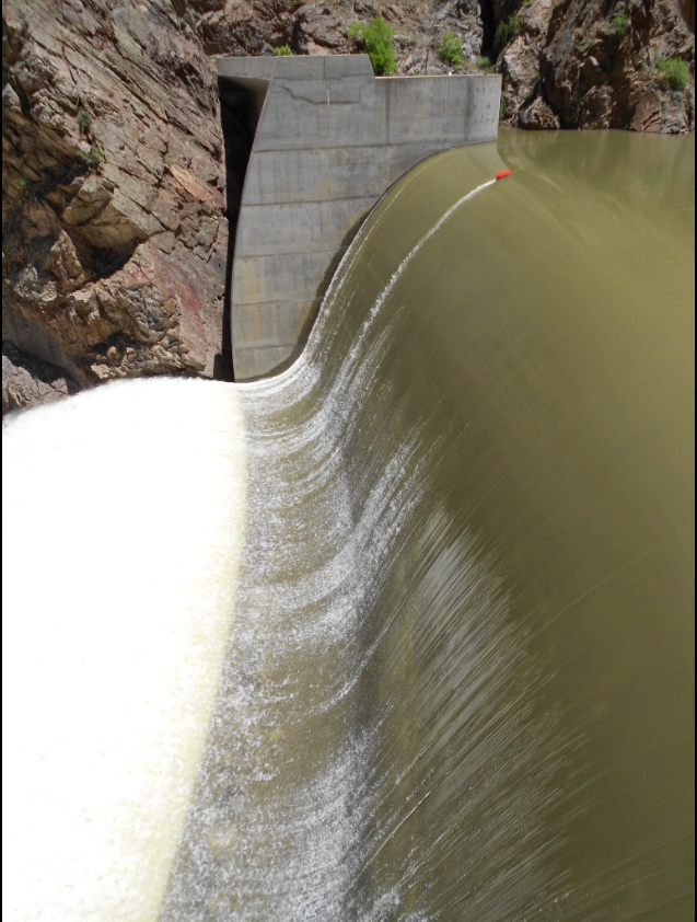
Crystal Dam, part of the Colorado River Storage Project, Aspinall Unit. Credit Reclamation.
From email from Reclamation (Erik Knight):
Releases from the Aspinall Unit will be decreased from 1315 cfs to 1050 cfs late on Wednesday, October 6th. Releases are being decreased to bring an end to the Drought Response Operations Agreement (DROA) emergency releases to Lake Powell.
Flows in the lower Gunnison River are currently above the baseflow target of 790 cfs. River flows are expected to stay at levels above the baseflow target for the foreseeable future.
Pursuant to the Aspinall Unit Operations Record of Decision (ROD), the baseflow target in the lower Gunnison River, as measured at the Whitewater gage, is 790 cfs for October and November.
Currently, Gunnison Tunnel diversions are 700 cfs and flows in the Gunnison River through the Black Canyon are 590 cfs. After this release change Gunnison Tunnel diversions will still be around 700 cfs and flows in the Gunnison River through the Black Canyon will be near 325 cfs. Current flow information is obtained from provisional data that may undergo revision subsequent to review.
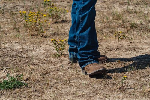
A rancher digs a boot heel into the dry ground of the Little Bear Ranch near Steamboat Springs, Colo., during the Northwest Colorado Drought Tour on August 11, 2021. Credit: Dean Krakel, special to Fresh Water News.
Click here to access the report from Nature (Nathan J. Steiger, Jason E. Smerdon, Richard Seager, A. Park Williams & Arianna M. Varuolo-Clarke. Here’s the abstract:
Geological evidence from the last millennium indicates that multidecadal megadroughts may have occurred simultaneously in California and Patagonia at least once. However, it is unclear whether or not megadroughts were common in South America, whether or not simultaneous megadroughts in North and South America occurred repeatedly, and what would cause their simultaneous occurrence. Here we use a data-assimilation-based global hydroclimate reconstruction, which integrates palaeoclimate records with constraints from a climate model, to show that there were about a dozen megadroughts in the South American Southwest over the last millennium. Using dynamical variables from the hydroclimate reconstruction, we show that these megadroughts were driven by the El Niño/Southern Oscillation (ENSO). We also find that North American Southwest and South American Southwest megadroughts have occurred simultaneously more often than expected by chance. These coincident megadroughts were driven by an increased frequency of cold ENSO states relative to the last millennium-average frequency. Our results establish the substantial risk that exists for ENSO-driven, coupled megadroughts in two critical agricultural regions.