The health of our waters is the principal measure of how we live on the land — Luna Leopold
A blast from the past: Pumping is begun to create a second #GreatSaltLake — The New York Times (April 11, 1987)
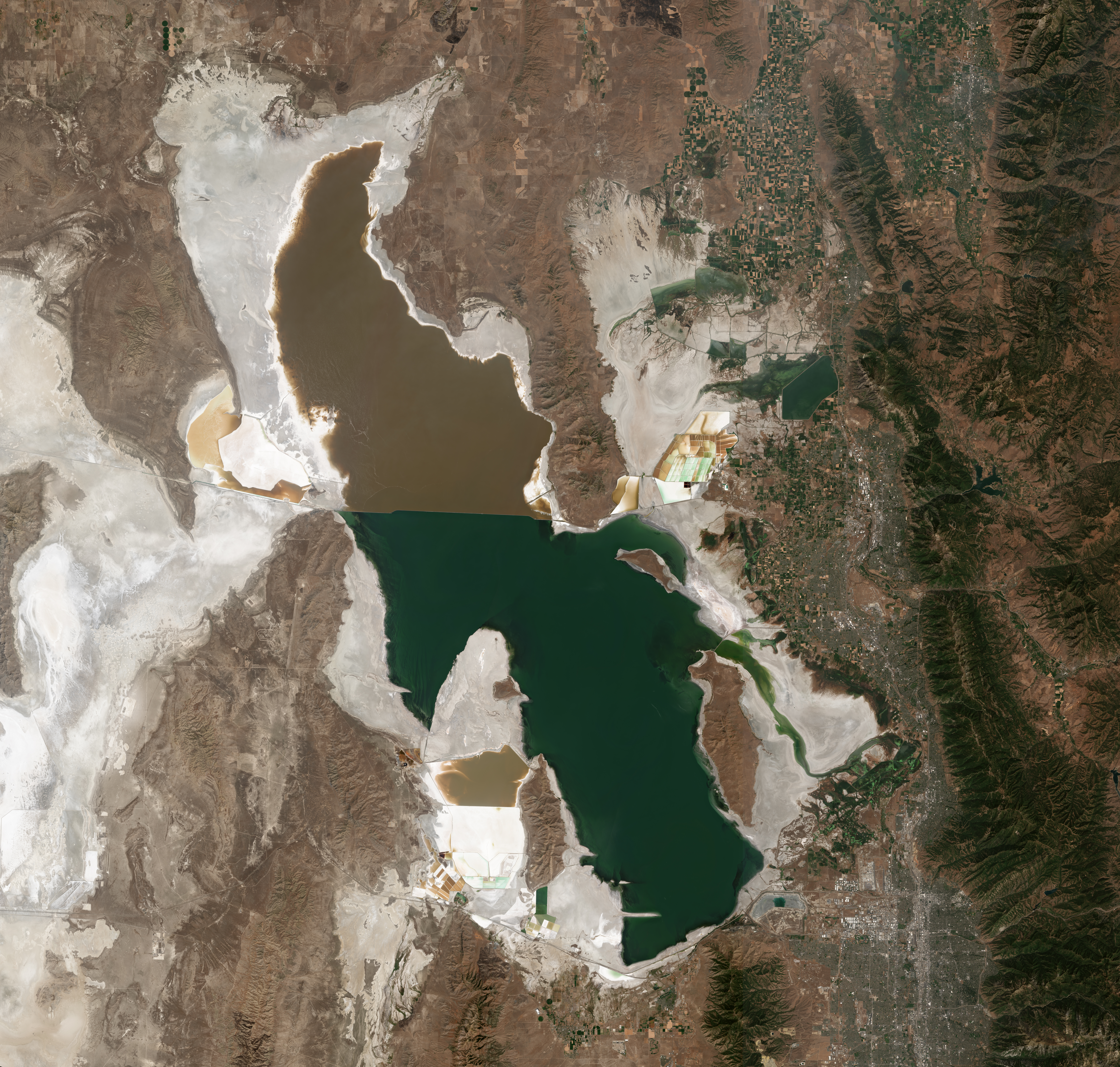
Satellite photo of the Great Salt Lake from August 2018 after years of drought, reaching near-record lows. The difference in colors between the northern and southern portions of the lake is the result of a railroad causeway. The image was acquired by the MSI sensor on the Sentinel-2B satellite. By Copernicus Sentinel-2, ESA – https://scihub.copernicus.eu/dhus/#/home, CC BY-SA 3.0 igo, https://commons.wikimedia.org/w/index.php?curid=77990895
With the news this week regarding the approval by the Utah Division of Water Rights for applications to deliver water to Farmington Bay of Great Salt Lake via the Jordan River, Dave Merritt former Board President of the Colorado River Water Conservation District forwarded a link to a New York Times article concerning a very different problem in 1987, that is, the Great Salt Lake was too full. From article (Thomas J. Knudson):
About the Archive
This is a digitized version of an article from The Times’s print archive, before the start of online publication in 1996. To preserve these articles as they originally appeared, The Times does not alter, edit or update them.
Occasionally the digitization process introduces transcription errors or other problems; we are continuing to work to improve these archived versions.
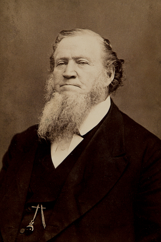
Brigham Young – Latter Day Saint movement leader (1801-1877). By Charles William Carter – Harvard Art Museum/Fogg Museum, Historical Photographs and Special Visual Collections Department, Fine Arts Library, 119.1976.1501
In the 1870’s, the Mormon leader Brigham Young was so concerned about the threat to farmland from the rising level of the Great Salt Lake that he dreamed of pumping excess water out onto the desert, but the idea was never accomplished.
Today, more than a century later, Brigham Young’s dream was realized when Gov. Norman H. Bangerter of Utah helped start the first of three giant pumps that will pull water out of the Great Salt Lake, now at the highest level in recorded history. The water will be dumped onto the Bonneville salt flats to the west, creating a smaller version of the Great Salt Lake that will cover 500 square miles, roughly 22 times the size of Manhattan.
The project, completed under harsh, desert conditions at breakneak speed, seeks to control a lake whose slowly rising waters have flooded highways, railroads, homes and businesses, causing some fatalities and an estimated $200 million in damage over the last five years.
“This is a project we have long waited for,” Governor Bangerter said. “We think Utah will now be in control of its destiny.”
Project Being Questioned
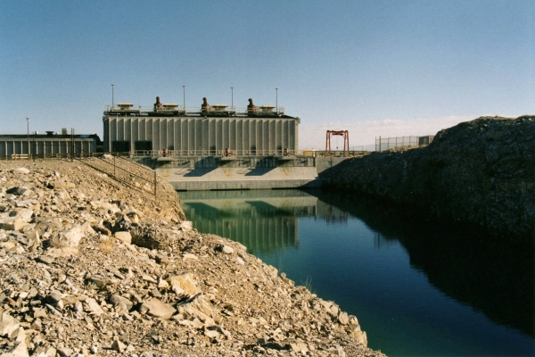
The West Desert Pumping Station is a series of three pumps designed to reduce the water level of the Great Salt Lake, the level of which had been rising steadily through the 1980s, threatening the shoreline industries, Salt Lake City International Airport, railroads, and even I-80 with flooding. The pumping plan called for a system to pump water from the lake to the adjacent Newfoundland Basin, located to the west. The south end of Hogup Ridge, a few miles further down the causeway northwest of Lakeside, was selected as the pump site, and six and a half miles of canals were dug to and from the pumps. Completed rapidly in less than a year, at a cost of nearly $60 million in state funds, the pumps went on line in April 1987. At the same time, a drought began, causing the lake level to subside naturally. The pumps were mothballed in 1989. Photo credit: The Center for Land Use Interpretation Attribution-Noncommercial-Share Alike 3.0 Creative Commons License.
The $60 million West Desert Pumping Project is one of the most ambitious and conflict-ridden in Utah history. And now, just as the pumps are being turned on, the cycle of wet weather that caused the flooding is passing. Many wonder if the state is spending $60 million to solve a problem that nature would have repaired free of charge.
“If the West goes into a dry cycle and the lake starts to recede naturally, the state will look foolish,” said Tony Willardson, associate director of the Western States Water Council here. “It will look like they spent a lot of money they didn’t need to.”
But Utah officials said the rising water left them little choice but to act. ”Everybody says let Mother Nature take her course, but she has already created $200 million in damage,” said W. James Palmer, an engineer with the Utah Department of Natural Resources who is coordinator of the pumping project. ”That’s a little bit hard to swallow. You can’t just keep backing away and backing away.
”I don’t know anyone who can tell me what the weather is going to do. If precipitation remains high, this is the only way possible to exercise any control over the lake.”
Situated on the barren and almost unpopulated northwest shore of the lake about 100 miles from Salt Lake City, the pumping station is a monument to the Mormon spirit of enterprise.
Technological Marvel
Every bolt, bucket of concrete and load of steel had to be hauled across 30 miles of open desert, through an Air Force bombing range and then down a narrow service road for 10 miles to the site. A natural gas line 37 miles long was installed. A canal was carved, up to 60 feet deep, through four miles of rock, sand and soil.
The three 16-cylinder engines that power the pumps are 27 feet long, and 17 feet high and weigh 81 tons each. The pumps, with propellers 10 feet in diameter, will lift water 15 feet out of the lake, up vertical chambers at a rate of 1.3 million gallons a minute, and spill it out into the canal.
”A project of this magnitude usually takes 18 to 24 months to complete,” said Mr. Palmer. ”We did it in nine-and-a-half months, because we just got to get rid of the water. Each day the lake sets a new record level.”
In the first year the pumping is expected to reduce the level of the 2,400-square-mile lake by as much as 16 inches, a process that could be likened to trying to drain a swimming pool with a soda straw. Fed by several major rivers, and containing no outlet, the lake has risen more than 12 feet since 1982. Engineers are hoping to lower the lake from 4,212 to 4,208 feet above sea level, the point at which the most serious flooding is expected to subside.
That is about $15 million a foot, a seemingly expensive solution, but one that officials said was necessary to prevent further destruction to Interstate 80, the Southern Pacific and Union Pacific Railroads and various lakefront enterprises. The project is expected to take three to four years.
Fog and Traffic Problems
It is, by anyone’s measure, a gargantuan task. The broad, shallow lake being created will be about one-fifth the size of the Great Salt Lake itself, and it is expected to generate huge banks of fog that could create traffic problems along the east front of the Wasatch Range, 90 miles away, and delays at the Salt Lake City International Airport.
The new lake will even have a name – West Pond – but it will be no sportsman’s paradise; it will be no more than 2 1/2 feet deep and heavily laden with salt. “There’s virtually nothing out there, maybe a few lizards and one or two rabbits,” said Mr. Palmer. “It will probably be nice to look at, but that’s about all.”
The key to the whole operation is evaporation. “The principle is very simple,” Mr. Palmer. “Evaporation is directly related to surface area. By increasing the surface area, we are increasing the evaporation.”
After months of preparation, the mood here today was one of gritty determination. “We’re not exactly jumping up and down because we get to do this,” said Mr. Palmer. “This is a project we had to do.”
Brigham Young felt that same way more than a hundred years ago. But after years of looking for a way to lower the Great Salt Lake, he eventually watched the water level recede naturally with the onset of drier weather. “He’s probably up there looking down on us right now,” said Mr. Palmer, “and saying good luck, suckers.”