Click on a thumbnail graphic to view a gallery of drought data from the US Drought Monitor.
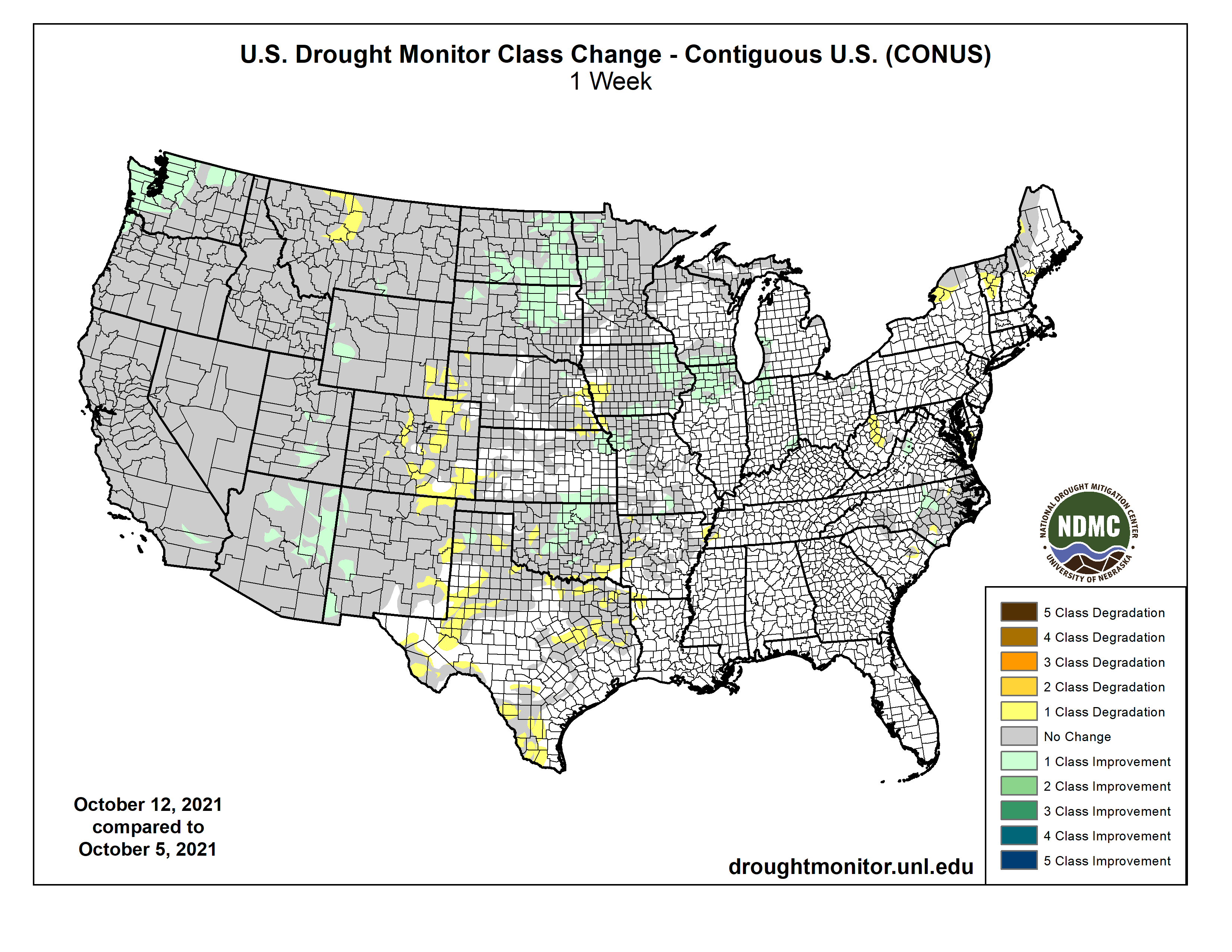
US Drought Monitor map October 12, 2021.
High Plains Drought Monitor map October 12, 2021.
West Drought Monitor map October 12, 2021.
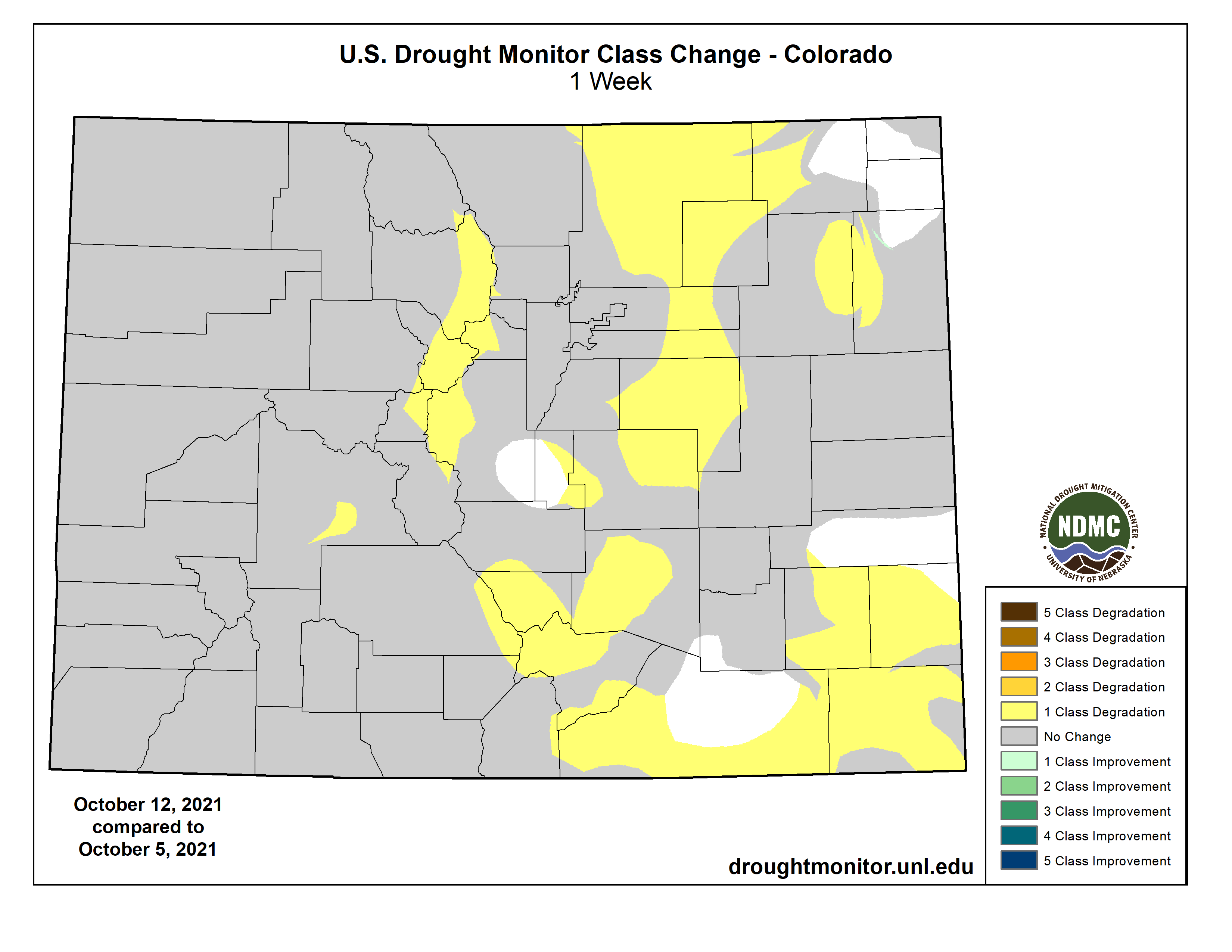
Colorado Drought Monitor map October 12, 2021.
Click here to go to the US Drought Monitor website. Here’s an excerpt:
This Week’s Drought Summary
A long wave trough resulted in seasonal to below-normal temperatures across the western third of the contiguous U.S. (CONUS). A ridge of high pressure dominated the eastern two-thirds of the CONUS leading to above-normal temperatures, with the highest positive anomalies across the Northern Plains and Midwest. Despite the amplified ridge in the East, early in the week an upper level low pressure system drifted slowly northward from the Southeast to the Great Lakes bringing unsettled weather and keeping many areas across the Southeast and Ohio Valley wet. A coastal low pressure system along the coastal Carolinas brought some additional precipitation to coastal and inland areas of the Carolinas, leading to mixed reductions and expansion in coverage of abnormal dryness across the Carolinas and Virginia. In the Northeast, little to no precipitation fell and above-normal temperatures, coupled with long-term deficits, led to degradation and expansion of abnormally dry and severe drought areas across Upstate New York and New England. The Northern Plains and Upper Midwest experienced some of the largest positive temperature anomalies (8-10°F above normal) this week. However, a strong surface low pressure system brought heavy rainfall across the Dakotas and northern Minnesota, leading to broad 1-category improvements. In the wake of this storm system, a surface low pressure system developed in the lee of the Rockies over the Southern Plains dropping several inches of rainfall, further improving drought conditions (1-category improvements) in areas affected by the recent rapid onset and intensification of drought during September. As this low pressure system moved across the Midwest later in the week, it led to further improvements across portions of the western Corn Belt, due to heavy rainfall. Areas that missed out on the rainfall over the Great Plains experienced worsening conditions due to above-normal temperatures and high winds increasing evaporation and leading to increased soil moisture loss. An active storm track in the West, associated with a long wave trough, resulted in improving conditions along fringe drought areas in the Pacific Northwest and the Four Corners, where antecedent wetness leading up to this week resulted in more immediate improvements. Given the intensity and duration of drought across the remainder of the West, more precipitation will be needed to warrant more meaningful improvements…
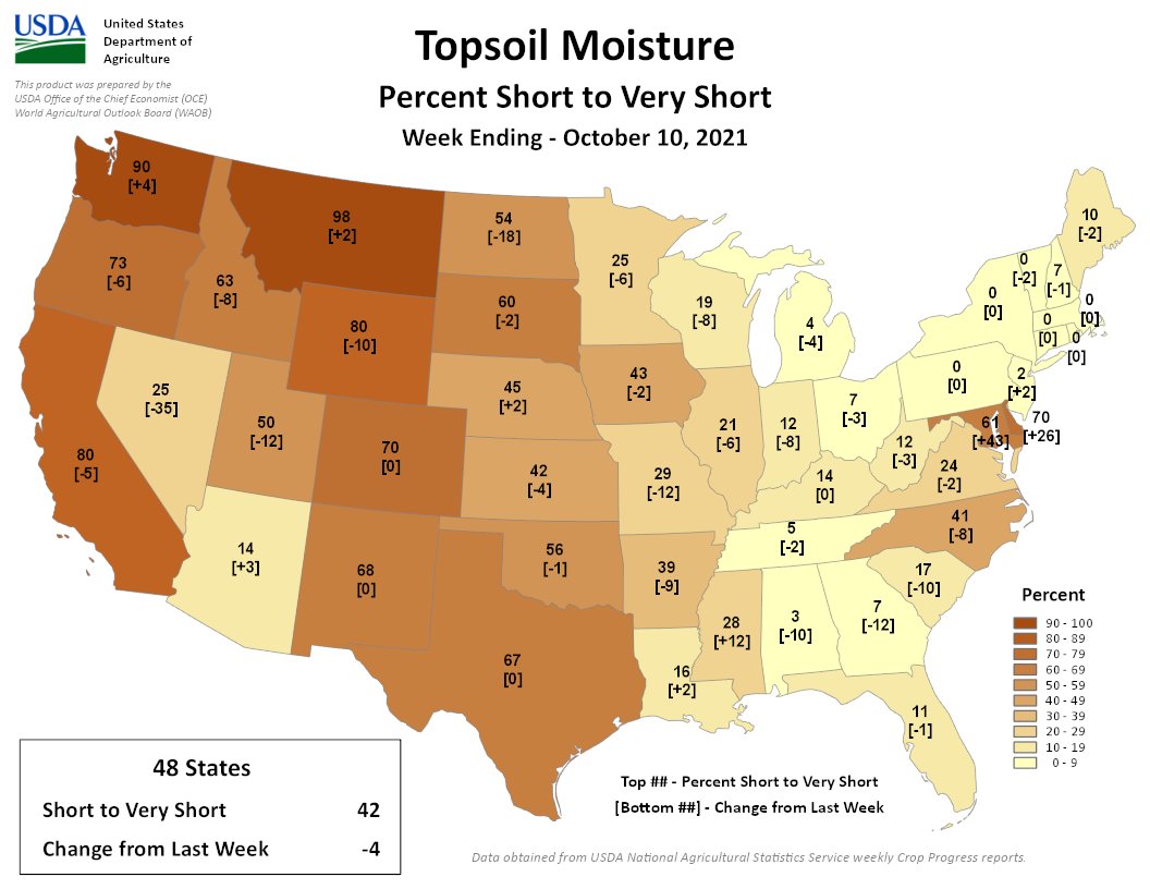
Similar to the Southern Plains, much of the High Plains region is susceptible to extended periods of above-normal temperatures and high winds. In areas where little to no rain fell, these conditions helped to further degrade ongoing drought east of the Front Range across portions of Colorado, Wyoming, Kansas, and Nebraska, where many areas have seen drastic deterioration in topsoil moisture in recent weeks (widespread D1-D4 equivalent NASA SPoRT soil moisture percentiles down to 10 cm). Farther north over the Dakotas, a strong low pressure system brought widespread heavy rainfall over the weekend, where several areas received more than 2 inches of rain, with some localized areas of more than 4 inches. This warranted 1-category improvements across large portions of the Dakotas. However, improvements were targeted in nature due to the longer-term deficits and above-normal temperatures increasing the evaporative demand and slowing soil recharge. Farther south in the High Plains Region, surface low pressure developed late in the period in the wake of the system farther north and moved north-northeastward across the central U.S. Rainfall from this system mainly fell over drought-free areas of eastern Kansas before moving into the Midwest and Great Lakes. However, some locations did receive meaningful rainfall; enough to warrant 1-category improvements in northeastern and southeastern corners of the state. Another storm system began propagating across the western U.S. on the final day of the period (Monday-Tuesday), bringing precipitation in various forms to the eastern Rockies. However, given the intensity of drought in the higher-terrain areas of the High Plains Region, the late arrival of precipitation did little to warrant any improvements this week, given the duration and intensity of drought in those areas…
Colorado Drought Monitor one week change map ending October 12, 2021.
An active storm track across the western U.S. this week brought seasonal to cooler than normal temperatures and beneficial precipitation to much of the region. Improvements were mainly limited to portions of the Pacific Northwest and Four Corners due to improving soil moisture conditions. For the Four Corners region, this precipitation was on the heels of an active Southwest Monsoon season, so reduced evaporative demand coupled with above-normal precipitation led to immediate improvements. For much of the remainder of the West, more precipitation is needed to recharge soil moisture and increase groundwater levels, stream flows, and reservoir levels. The only minor degradations of drought in the Western Region was in southeastern New Mexico and western Montana, where above-normal temperatures and high evaporative demand warranted expansion of D0 (abnormally dry) and D3 (extreme drought) areas, respectively…
Ahead of a long-wave trough across the western U.S., an area of low pressure developed over the Southern Plains, bringing with it much needed precipitation to areas affected by the rapid onset of drought conditions in recent weeks. This has helped to improve conditions, mainly across parts of Oklahoma, where many locations received 2-3 inches of rainfall (greater than 1 inch positive weekly anomalies). Unfortunately, many locations outside of Oklahoma in the Southern Region continued to see further degradation and expansion of drought conditions in, and adjacent to, areas where the rains did not fall or was insufficient. Worsening conditions were observed across Texas and the Ark-La-Tex region were exacerbated by above-normal temperatures and high winds leading to increased evaporation and evapotranspiration rates…
Looking Ahead
During the next 5 days (October 14 – 18, 2021), a strong surface low pressure system will track across the Northern Plains and Upper Midwest, bringing the potential for heavy rainfall. Along the tail end of the trailing frontal boundary associated with this low pressure system, the remnants of Tropical Depression Pamela from the East Pacific are expected to bring a surge of moisture to the south-central U.S. Surface low pressure is expected to develop along the remnant frontal boundary and move quickly northeastward bringing increased chances of rainfall from the Middle Mississippi Valley to the Northeast. Despite the active pattern across the central and eastern U.S., temperatures are likely to moderate across the Northern Plains and Midwest by the end of the week, while in the East temperatures will likely be more variable due to the passage of frontal boundaries. In the West, temperatures are expected to be relatively seasonal during the next 5 days, with an abrupt cool down toward Tuesday.
The CPC 6-10 day extended range outlook (October 19 – 23, 2021) favors below-normal rainfall from the eastern Rockies to the East Coast, with weak tilts in the odds toward above-normal precipitation across portions of the Southern Plains and the Florida Peninsula. Enhanced chances of above-normal precipitation are favored along the West Coast inland to the western Great Basin. Above-normal temperatures are favored across much of the CONUS, with the exception of portions of southern and central California, where near to below-normal temperatures favored.
US Drought Monitor one week change map ending October 12, 2021.
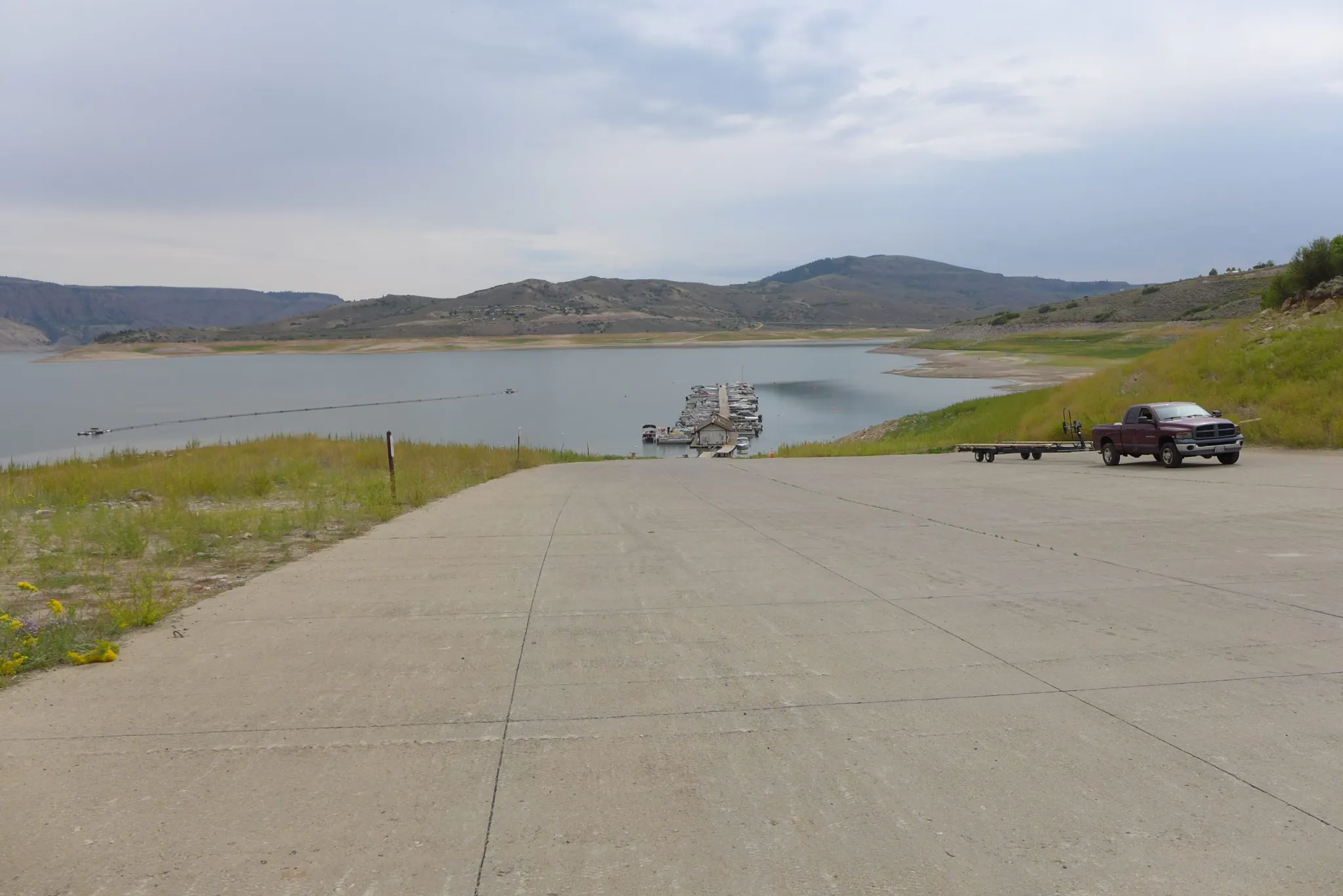
The boat ramp at the Lake Fork Marina closed for the season on Sept. 2 due to declining reservoir levels. The Bureau of Reclamation is making emergency releases out of Blue Mesa Reservoir to prop up levels in Lake Powell and preserve the ability to make hydropower. CREDIT: HEATHER SACKETT/ASPEN JOURNALISM
A Colorado water seminar always had climatechange on the agenda, but the tone was different this year, more alarmed, more worried, if still optimistic
What a flip-flop from 2001. We were going to war in Afghanistan, worrying about terrorists in our midst, and anthrax arriving in the mail.
The reservoirs of the Colorado River were close to full.
At the time I had given little thought to climate change, other than to be somewhat skeptical about the alarm. That changed in 2003, when I was given an assignment by the editor of Ski Area Management to round up what was being said. I read a year’s worth of articles in the New York Times and then—my eyes widened considerably—set out to find much more. It has been front and center for me ever since.
Brad Udall also immersed himself in climate change beginning in 2003. He had been trying to preserve open space in Eagle County for a few years but then returned to the Front Range. There, he directed the Western Water Assessment in Boulder and, more recently, joined the staff of the Colorado State University Water Institute as a scholar and scientist. He has expertise in hydrology but also in crunching numbers.
Over the years, Udall has distinguished himself as an expert on the effects of the warming climate on the Colorado River. His most prominent insight was a paper published in 2017 by the prestigious journal Science. Udall and Jonathan Overpeck, who also was originally schooled in Boulder and I believe still has a cabin in the San Juan Mountains near Telluride, sifted through the data before concluding that at least a third of the reduced flows in the Colorado River should be attributed to heat, not reduced precipitation.
On Oct. 1, speaking to the Colorado River District’s annual seminar in Grand Junction remotely from Boulder, Udall described the strengthened evidence that half of the reduced flows could be explained by rising temperatures. He calls it aridification.
Much worse, he said, is yet to come.
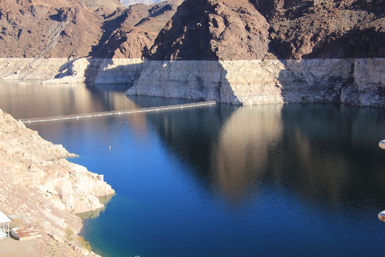
Lake Mead was 40% full and the surface was at 1090 feet in elevation when this photo was taken in December 2019. As of Saturday it had dropped 23 feet. The U.S. Bureau of Reclamation issued a model in September that projected a 66% chance that the reservoir level will drop below 1,025 within the next 5 years. That would put the reservoir level 75 feet below what you see in this photo. Photo/Allen Best
Andy Mueller, the general manager of the Glenwood Springs-based River District, had introduced the session, using words of greater alarm than I had heard at the annual seminar—and I’ve attended most, in person or virtually, since the first session in 2003. He used the metaphor of a train wreck.
“For a decade or more, we have seen the train wreck slowly moving this way,” he reiterated afterwards when I spoke to him for a story published by Fresh Water News. “It has picked up speed pretty significantly in the last couple of years. The question is how do we avert the train wreck (from coming into our station).”
Mueller had described reduced flows and warm temperatures in the Yampa River as it flows through Steamboat Springs that have caused the river to be closed to recreation something like 8 of the last 14 years. There were fish kills in the Colorado River this year. He told of shortening ski seasons and warned lower-elevation ski areas may not make it in the future.
He had also told the audience in Grand Junction that adaptations to lower flows would be necessary. Farmer and ranchers might have to cut irrigation to marginal areas, forego low-income crops. He vowed that Front Range cities would have to conserve and not expect the Western Slope to bear the burden.
Climate change has never been a verboten word at River District seminars, even if this is from an area that elected Lauren Boebert to Congress. Udall, for example, has spoken at least three times in my memory and probably more.
This year’s outlook was different, less cautious, more worried. The tone was reflected in the seminar title: “Wake-Up Call on the Colorado River.”
National publications this summer brimmed with stories about the distress of the Colorado River, especially after the Bureau of Reclamation on Aug. 16 issued a shortage declaration. Arizona is most immediately affected, but this is huge for the five other basin states, including Colorado.
Mueller agreed with me when we talked by phone that none of what happened this year was surprising. Most people involved with the river saw it coming.
I remember talking with Udall in 2019 (for a story in Headwaters, the magazine), when something called the Drought Contingency Plan was completed. That agreement tightened the belt of Arizona but kicked the fundamental decisions down the road to a plan projected to be implemented in 2026. Udall was skeptical that the emergency would be that slow to arrive.
Now there’s an awareness in the public of the brittleness of the hydraulic empire created in the 20th century in Southwest states, including Colorado. A decade, ago, there was hope that some big snow years like we had in the ‘80s and ‘90s would fill the reservoirs. We’ve had some big snow years, but the runoff doesn’t show it.
Now, one major question is whether they will go so low as to make it impossible to generate electricity.
I asked Mueller about his remarks, the tone of this year’s session. “The tone has to reflect the reality on the ground,” he said.
“I think at every level our folks who are paying attention to the science and the hydrology, there is an increasing sense of urgency in the Colorado River Basin, and it’s shared by folks on the ground today, from ranchers in the Yampa River Valley to farmers in the Uncompahgre Valley to major urban providers like Denver Water. We all recognize there is something very different going on than there was 10 years ago in the Colorado River,” he said.
“People like Brad have been saying for years that this is coming. I have seen lots of people in power turn their backs to Brad when he’s talking,” he said, likely meaning that metaphorically. “They’re not doing that so much anymore.”
What is happening is complex but understandable. There is drought, as conventionally understood, but then the overlay of higher temperatures. The warmer temperatures cause more evaporation. They cause more transpiration from plants. More precipitation can overcome this, but particularly in Southern Colorado, there’s actually been less.
The most interesting slide Udall showed compared the runoff of several rivers over time. The San Juan River—which originates in Colorado, near Pagosa Springs—had 30% less water in 2000-2019 at Bluff, Utah, as compared to 1906-1999. The decline of the Colorado River at Glenwood Springs was 6%.
Another compelling statistic reported during the seminar was about soil moisture. Dry soil sops up snowmelt before it can get to the stream. Runoff from deep snows can be lost to the previous years’ dry soils.
In 2020, the snowpack was 100% but the runoff was 50%. That soil-moisture deficit played into this year’s even worse runoff, 30% of average from a snowpack that was 90% of average.
The U.S. Bureau of Reclamation during the Trump years operated well, although I do remember a session at the Colorado River Water Users Association in December 2019 of top Trump water officials who sat on a panel and patted themselves on the back for the better part of an hour, seemingly oblivious to the big issue of that day. It was like the famous Trump cabinet meeting where the cabinet heads took turns praising Trump like he was the North Korean dictator.
Udall, in his presentation to the River District seminar, pointed to the tremendous drop in storage. The two giant reservoirs, Mead and Powell, in January 2020 were 90% full and held 47 million acre-feet. They are projected to fall to 15 million acre-feet combined by April 22, leaving them 30% full.
This has manifold implications—including for Colorado. In 2009, I wrote my first story about Colorado’s possible need to curtail diversions in order to comply with the Colorado River Compact. That possibility is far more concrete now, and Udall mentioned it in his presentation.
But even when it was more remote, water managers in Colorado were talking about various programs that could allow cities to pay farmers and ranchers, especially on the Western Slope, to use their water (for a price, of course). The farmers and ranchers tend to have the oldest and most senior water rights; the cities tend to have the more junior rights – almost exclusively junior to the Colorado River Compact.
Looking around me on the Front Range, I don’t see a response that I think the situation justifies. From Pueblo to Fort Collins, we all depend greatly upon imported water. That will almost certainly change. We’re going to see a very different water paradigm a decade from now. Predicting the changes is beyond me, but the water in the 21st century isn’t there to satisfy 20th century expectations.
There may be implications in other realms. I am reminded what Colorado State Sen. Chris Hansen said at a fundraiser this summer, about the growing room for new alliances with conservatives to move forward on climate action. The evidence—wildfires, heat waves, the drying of the Colorado River – is becoming overwhelming.
Visiting Greeley to attend the Energy and Environmental Leadership Symposium on Oct 8-9, I was struck by the shift. This is in Weld County, where 90% of oil and gas production occurs in Colorado. The keynote speaker, Chris Wright, the chief executive of Liberty Oilfield Services, downplayed the risks and costs of climate change and emphasized the cost of trying to shift from fossil fuels. This will be a 200-year journey, he said, not something done in 30 years.
But for the next day and a half, whether talking about fossil fuels or renewables, all the sessions in some way had to do with a carbon-constrained world.
To modify Mueller’s cliché about the train, it seems like the train has left the station on this energy transition and it’s picking up speed. This train will have to move a lot quicker. Just what value will those giant reservoirs built during the 20th century on the Colorado River have in the 21st century? It’s an open question.
In his 2021 letter to CEOs, Larry Fink, the CEO and chairman of BlackRock, the world’s largest investment manager, wrote: “No issue ranks higher than climate change on our clients’ lists of priorities.”
His comment reflected a growing unease with how the climate crisis is already disrupting businesses.
Companies’ concerns about climate change have typically been focused on their operational, financial and reputational risks, the latter associated with the growing importance of the issue among young people. Now, climate change is calling into question the traditional paradigm of corporate sustainability and how companies address their impacts on society and the planet overall.
Over the past few decades, many companies came to embrace sustainability. It became the corporate norm to seek ways to reduce a company’s negative impacts on society and the planet and operate more responsibly.
Sustainability-as-usual is the slow and voluntary adoption of sustainability in business, where companies commit to changes they feel comfortable making. It’s not necessarily the same as what science shows is needed to slow climate change, or what the United Nations recommends for an equitable society. Businesses’ response to both will be drawing global attention in November when world leaders gather for the annual U.N. climate conference.
One notable example is Heinz. The ketchup maker announced a cap for its ketchup bottle that is 100% recyclable. It was the outcome of $1.2 million invested and 185,000 hours of work over eight years, according to the company.
Climate change requires a new approach
While companies appear to grasp the magnitude of the climate crisis, they have been trying to address it mainly in a sustainability-as-usual fashion – one ketchup bottle cap at a time.
Consider emissions reductions. Companies have been slow to commit to reducing their emissions to zero no later than mid-century, a target that the Intergovernmental Panel on Climate Change considers necessary to limit global warming to 1.5 degrees Celsius – roughly 2.7 degrees Fahrenheit – and avoid the worst effects of climate change. Only about one-fifth of the major companies have 2030 goals that are in line with reaching net-zero goals by 2050 at the latest.
Companies have tried to rebrand their efforts in ways that sound more sophisticated, moving from terms like “corporate social responsibility (CSR)” to “environmental, social and governance (ESG),” “purposeful companies” and “carbon-neutral products.”
Business is at a strategic inflection point, which Andy Grove, the former CEO of computer chip-maker Intel, described as “a time in the life of a business when its fundamentals are about to change.”
This transformation could evolve in different ways, but as I suggest in my book, fighting climate change effectively requires a new mindset that shifts the relationships between profit maximization and sustainability to prioritize sustainability over profit.
Early signs of evolution
There are early signs of evolution, both within companies and from the forces that shape the environment in which companies operate.
Another example is changes in companies’ relationships with suppliers – for example, the business software company Salesforce added a sustainability clause to its contracts requiring suppliers to set carbon reduction goals.
Add to these bright spots changes in regulation and policy worldwide that aim to put in place key sustainability principles and push to cut emissions at a faster pace, plus the changing expectations of young job seekers when it comes to environmental and social issues, such as inclusion and diversity, and you can start to see how the end of sustainability-as-usual may be closer than many people think. Due to climate change, the question is more “when” than “if” it will happen.
[Over 110,000 readers rely on The Conversation’s newsletter to understand the world.Sign up today.]
Senior Nebraska Mesonet technician Glen Roebke runs tests on a set of barometers for weather station sensors. A new sensor calibration lab has been developed by the Nebraska State Climatology Office at the University of Nebraska-Lincoln School of Natural Resources. October 7, 2021. Photo by Craig Chandler / University Communication
Here’s the release from the University of Nebraska Lincoln (Cory Matteson):
To provide people with accurate data about rainfall, temperature, wind speed and more, climatologists in states across the nation lead strategic installations of research-grade weather stations across their states. Weather stations are finely tuned machines, expected to record key data within finite margins of error. But even high-tech systems need a tune-up once in a while, Nebraska State Climatologist Martha Shulski observes.
This past summer, the State Climate Office in the University of Nebraska–Lincoln’s School of Natural Resources began offering weather station sensor calibration services for research-grade equipment used in other states.
The State Climate Office stepped in to consolidate and streamline a calibration process that is often time-consuming, Shulski said. Four different companies manufacture the sensors on a typical U.S. weather station, she said, meaning a state office must send parts to multiple companies that often have backlogs.
The Nebraska program began with a shipment from the North Dakota Agricultural Weather Network, which sent a set of 17 temperature and humidity sensors from weather stations to Hardin Hall. There, in a basement lab, senior Nebraska Mesonet technician Glen Roebke ran the meteorological instruments through a battery of tests with instruments that can calibrate air temperature, humidity, barometric pressure readings and more.
The calibration center is an extension of the work the Nebraska State Climate Office has long performed for weather station sensors in its statewide Nebraska Mesonet weather-monitoring network, Shulski said.
“We’ve always calibrated our instrumentation in house,” Shulski said. “Now we’re opening up this service to other state weather networks. We’ve got the expertise. Glen has been doing this for roughly 20 years. He looked at what manufacturers do when you ship sensors to them for calibration tests and determined what we could replicate here in the lab. He looked at what other weather networks use for their sensors and equipment and developed techniques based on that.”
That effort led to the development of, among other tools, an indoor solar calibration table that is now located in the basement lab. Roebke previously only had a finite window of time to test the solar readings of the Nebraska State Climate Office’s pyranometers, which measure solar radiation.
“We’ve done a study in the past on when the best time of year to calibrate is, and the magic month is May,” Roebke said. “There are a lot of things that go into it. We want clear days, but there are a lot of clouds in the month of May, so it limits the number of days we can use it. And the other thing that’s a huge variable is temperature. Temperature affects how these instruments work. So we don’t want to do it in late July or the middle of August, because temperature changes the output. We want to stabilize it.”
Before the table was installed, Roebke could be found in the Hardin Hall elevators every spring, bringing pyranometers up to be tested on a platform on the 10-story building’s roof, where a precision spectral pyranometer was installed.
The indoor solar calibration table allows any time in the basement lab to simulate a sunny day in May, as far as a weather station’s pyranometer is concerned.
The lab also features equipment that can test each of the typical sensors that would have normally been sent to a manufacturer when they required calibration, Shulski added.
A weather station in Nebraska observes air temperature, relative humidity, wind speed and direction, barometric pressure, solar radiation, warm-season liquid precipitation every minute, and soil temperature and soil moisture at five depths every hour. Checking equipment yearly, Roebke said, helps the Nebraska Mesonet sensors stay within a half-percent margin of error, rather than drifting 2% to 4% off, as equipment can when it’s not checked over two- or three-year stretches. “It’s a huge difference in the world of meteorology,” he said. It costs about $2,600 a year, per weather station, to run and calibrate the equipment, Shulski said. The stations are often sponsored by natural resource districts, and the equipment is in service for about a decade before its components are all replaced.
Some maintenance still requires field trips, she said. Lightning, gophers and coyotes are among a weather station’s natural enemies. If rain is measured in an area surrounding another weather station but not at that particular station, for instance, there’s a good chance that a spider web has been constructed atop its precipitation gauge. (Shulski said they spray vinegar on the gauges to prevent that.) Nebraska Mesonet’s 63 stations get inspected, and the grass around them mowed, at least four times a year.
The information collected from the sensors feeds into critical weather information systems, such as the National Weather Service. It is used to determine when to issue flood warnings and when to declare drought emergencies. It helps ag producers make irrigation decisions and parents decide whether their kids need coats at recess. It helps track the changing climate over time. Shulski said it’s imperative to make sure the weather stations are providing readings that are as accurate as possible.
Shulski said the University of Nebraska has the people, knowledge and gear to offer calibration services to states that don’t have similar in-house setups. The services help augment operational funding for the Nebraska Mesonet, she said, and could help contribute to continued expansion of the network.
Currently, 47 of the state’s 93 counties have weather stations, a strong spatial representation of what’s going on with Nebraska weather, Shulski said. However, she hopes to install at least one weather station in each of the remaining counties without one.
As more states utilize Nebraska’s calibration lab, the revenue that the project brings in will allow for students to learn on-the-job calibration training in the lab, while also testing new equipment and sensors as weather station technology evolves.
“The calibration facility is part of our long-term vision for the (Nebraska) Mesonet, and it’s quite exciting to see it come to fruition in such a short time,” Shulski said.
Just like your car doesn’t reach top speed the instant you step on the gas, Earth’s temperature doesn’t react instantly to each year’s new record-high carbon dioxide levels. Thanks to the high heat capacity of water and the huge volume of the global oceans, Earth’s surface temperature resists rapid changes. Said another way, some of the excess heat that greenhouse gases force the Earth’s surface to absorb in any given year is hidden for a time by the ocean. This delayed reaction means rising greenhouse gas levels don’t immediately have their full impact on surface temperature. Still, when we step back and look at the big picture, it’s clear the two are tightly connected.
Yearly temperature compared to the twentieth-century average (red and blue bars) from 1880–2019, based on data from NOAA NCEI, plus atmospheric carbon dioxide concentrations (gray line): 1880-1958 from IAC, 1959-2019 from NOAA ESRL. Original graph by Dr. Howard Diamond (NOAA ARL), and adapted by NOAA Climate.gov.
As the graph above shows, both global temperature (colored bars) and atmospheric carbon dioxide (gray line) increased more slowly during the first half of the observational record in the late nineteenth and early twentieth centuries. Atmospheric carbon dioxide levels rose by around 20 parts per million over the 7 decades from 1880–1950, while the temperature increased by an average of 0.04° C per decade.
Over the next 7 decades, however, carbon dioxide climbed nearly 100 ppm—5 times as fast! To put those changes in some historical context, the amount of rise in carbon dioxide levels since the late 1950s would naturally, in the context of past ice ages, have taken somewhere in the range of 5,000 to 20,000 years; we’ve managed to do it in about 60. At the same time, the rate of warming averaged 0.14° C per decade. The rapid rate of temperature rise over such a short period time points to only one thing, and that is the addition of greenhouse gases, primarily carbon dioxide, into the environment.
Within any given decade, however, the temperature bounces around between warm and cool years. The warmest years are usually El Niño years, when the eastern and central tropical Pacific is warmer than average. The coldest years are generally La Niña years. On a longer time scale, warm decades are often associated with strongly positive phases of the Pacific Decadal Oscillation, and cool decades with strongly negative phases.
Annual global surface temperature (gray bars), grouped by decade, from 1950 to 2017. The warmest and coldest years of each decade are topped with circles: red for El Niño years and blue for La Niña years. El Niño/La Niña labels are based on the December-February anomaly of the Oceanic Niño Index. In general, the warmest year of any decade will be an El Niño year, the coldest a La Niña one. Only two decades seem to violate the general rule: the 1960s and the 1990s. By our definition, 1963 did not qualify as El Niño year because the December–February ONI value was neutral. However, El Niño did emerge later in the year, and it persisted for 7 months. The bigger surprise was 1992, which was the coldest year of the 1990s despite being an El Niño year. The 1991 eruption of Mount Pinatubo was likely to blame. Graphic by NOAA Climate.gov, based on data from NCEI.
And while these natural climate patterns—through which the ocean alternately accumulates and releases heat—are the most important cause of short-term variations in global surface temperature, other factors occasionally contribute: volcanic eruptions, solar variability, and smoke and other pollution particles.
Pros and cons of thermal inertia
The global ocean buffers Earth’s temperature from rapid change; that stability has been fundamental to the evolution of complex life on our planet over millions of years. Even with respect to global warming, the ocean’s inertia works in our favor in one way: it provides us with a modest window of time to adapt to and begin to combat climate change before we are forced to confront its full effects on human health, coastal communities, and agriculture.
Like a room’s worth of mess stuffed into an overflowing closet, excess heat from carbon dioxide is being hidden in the ocean—thanks to its tremendous heat capacity and volume. NOAA Climate.gov cartoon by Emily Greenhalgh.
But there’s a downside to the delayed reaction, too. Like a speeding train, the warming won’t stop the instant we hit the brakes. At whatever point we manage to halt or reverse the trend in greenhouse gases, some additional warming will occur due to the heating imbalance that is already in the pipeline. A recent special report from the Intergovernmental Panel on Climate Change (IPCC) estimates how much we could currently expect based on emissions to date:
“If all anthropogenic emissions…were reduced to zero immediately, any further warming beyond the 1°C already experienced would likely be less than 0.5°C over the next two to three decades (high confidence), and likely less than 0.5°C on a century time scale (medium confidence)…. A warming greater than 1.5°C is therefore not geophysically unavoidable: whether it will occur depends on future rates of emission reductions.”
References
Allen, M.R., O.P. Dube, W. Solecki, F. Aragón-Durand, W. Cramer, S. Humphreys, M. Kainuma, J. Kala, N. Mahowald, Y. Mulugetta, R. Perez, M. Wairiu, and K. Zickfeld, 2018: Framing and Context. In: Global Warming of 1.5°C. An IPCC Special Report on the impacts of global warming of 1.5°C above pre-industrial levels and related global greenhouse gas emission pathways, in the context of strengthening the global response to the threat of climate change, sustainable development, and efforts to eradicate poverty [Masson-Delmotte, V., P. Zhai, H.-O. Pörtner, D. Roberts, J. Skea, P.R. Shukla, A. Pirani, W. Moufouma-Okia, C. Péan, R. Pidcock, S. Connors, J.B.R. Matthews, Y. Chen, X. Zhou, M.I. Gomis, E. Lonnoy, T. Maycock, M. Tignor, and T. Waterfield (eds.)]. In Press.
Cheng, L., K. Trenberth, J. Fasullo, T. Boyer, J. Abraham, and J. Zhu, 2017: Improved estimates of ocean heat content from 1960-2015. Sci. Adv. 3, 3, e1601545, Doi:10.1126/sciadv.1601545. http://advances.sciencemag.org/content/3/3/e1601545
Lindsey, Rebecca. (2018, Sep 4). Did global warming stop in 1998? NOAA Climate.gov. Accessed September 5, 2019 [https://www.climate.gov/news-features/climate-qa/did-global-warming-stop-1998].
Kokanee Salmon are another species we sometimes encounter in the fall on the Dream Stream (South Platte River in South Park). Photo credit: Colorado Trout Hunters
This stretch of the South Platte and its world-class fishing have been damaged by floods, but borrowed root wads and other material could repair and protect it for years to come
Situated at 8,700-feet elevation in one of the largest plateau basins in North America, cradled by hills with snow-dusted peaks in the distance, this stretch of the South Platte owes its reputation to a combination of circumstances that create ideal habitat for fish — largely brown and rainbow trout but also species like kokanee salmon. They not only breed in sustainable numbers but also live long and grow to eye-popping sizes.
The stretch of river meanders through easily accessible flatlands between two reservoirs, Spinney Mountain to the northwest and Eleven Mile to the southeast, for three miles as the crow flies, though anglers walk its winding path for closer to five miles. But multiple floods over the past several years have chipped away at the banks and vegetation that provided safe harbor and attractive spawning grounds for the fish, threatening the optimal conditions.
Last month, Colorado Parks and Wildlife workers launched a project to restore the banks of this picturesque and prolific fishery in South Park, about 45 minutes west of Colorado Springs. And in a unique twist, the project was linked with another several miles away, focused on improving habitat for elk and mule deer.
Matt Kondratieff, aquatic researcher and stream restoration manager, already had done significant restoration on the Dream Stream back in 2013, but the project took a major hit months after its 2015 completion when a major flood ripped through the river and undid much of the work…
This wasn’t just any stretch of river. The Dream Stream ranks in the highest tier of Colorado fisheries, called Gold Medal waters. Those areas can produce 60 pounds of trout per acre, including a dozen that measure 14 inches or larger. Of the state’s roughly 9,000 miles of trout streams, only 322 miles meet those criteria — and this section of the South Platte exceeds the standards significantly.
“When we look at the Dream Stream numbers, the number of pounds per acre, we are 4.25 times the Gold Medal standards for biomass,” says Tyler Swarr, a CPW aquatic biologist whose territory includes the waterway. “And we’re almost five times the Gold Medal standard for the number of quality trout. So it’s a very robust fishery — really phenomenal, especially the brown trout population.”
The portion of the river that connects Spinney and Eleven Mile reservoirs now lies within what since 2010 has been known as the Charlie Meyers State Wildlife Area, named for the longtime Denver Post outdoors writer whose combination of eloquence and policy-minded conservation advocacy defined Colorado’s landscape. A memorial near the parking area celebrates Meyers, who died at 72 of complications from lung cancer…
Reality behind the dream
It may fly-fish like a dream, but there are plenty of reasons — both biological and hydrological — for this waterway’s abundance.
Start with Eleven Mile Reservoir, built in 1970. Lake species like brown and rainbow trout do well in the deep (more than 100 feet) and cool habitat, where they remain largely safe from predators and reside for most of the year — until it’s time to spawn. Then, they head upriver into the South Platte, where undercut banks provide further refuge while they pursue their journey to deposit their eggs in the river’s riffle habitat.
Riffles are generally shallower, faster parts of a stream where protruding rocks churn and oxygenate the water — which in turn aids water-dwelling insects, which become a current-driven buffet for fish. The gravel beneath provides the ideal repository for trout eggs.
Spinney Mountain Reservoir formally opened in 1982, providing a bookend to a remarkable ecosystem. The standing water of Spinney, plus gravity, creates groundwater movement that eventually rises into the Dream Stream from below — and the gentle upwelling provides prime conditions for trout eggs.
Too much sediment in a stream can smother them, but the rising water essentially cleans the gravel where the eggs lie and tumbles them in oxygen to enhance their development. Hatcheries replicate that natural water movement.
But as flooding washed away the river banks, once-prime spawning areas began accumulating fine sediment that hindered egg development. Left unrepaired, the stream would continually widen and become shallower. Water temperature would rise — a detriment to cold-water species like trout — and crucial hiding spots would disappear, exposing fish to predators from above…
Since water is released into the South Platte from the depths of Spinney, not the surface, the temperature remains hospitably cool, even in the heat of summer…
While Spinney also provides water to Aurora, the city has been accommodating in scheduling releases so that they don’t impact fish health or spawning — especially for the large population of browns in the area, notes John Davenport, chapter president for Denver Trout Unlimited.
“The way it has been managed and improved,” he says, “and with Aurora such a good partner to keep water flowing and take into consideration fish health, those fish grow large. If you’re not from Colorado, the Dream Stream will look nothing like your preconceptions. This is a meandering stream through flat, dry, sagebrush desert. It’s more like you’re on the plains than into the mountains. But as soon as visiting fishermen hook into big fish, they forget all about that.”
[…]
An unusual repair project
When Matt Kondratieff started formulating a plan for restoring the Dream Stream, he huddled with the project’s primary architects: CPW engineers, aquatic researchers and biologists Swarr and Spohn — people with decades of experience in the watershed.
He also consulted with several outfitters and anglers — including Landon Mayer — to fine tune the plans…
The project’s primary goal was to repair damage resulting from record high runoff in 2015, and two years later from a storm cell over the drainage that produced flash flooding. The use of toewood — a technique that employs submerged wood to reinforce the stream bank — would be augmented by other materials like cobble (basically rocks ranging from baseball- to basketball-size), large gravel and sod transferred from upland areas.
The area has a history of periodic flooding, often from localized storms that drench the region. One particularly freak storm just a few years ago dumped 3 inches of rain in less than an hour. Then rain turned to heavy hail and triggered a wall of water estimated at 10 feet high on the river.
What made the Dream Stream project unusual is that it fed off another CPW land management effort several miles away to enhance habitat for elk and mule deer. As the proliferation of mature conifer trees began to crowd out stands of aspen, a favored food source, crews worked in the James Mark Jones State Wildlife Area to thin the conifer.
“Bottom line,” Kondratieff says, “we needed large trees with root wads. So they figured out where there was overcrowding, took those trees and trucked them down. We used the root wad with the stem to weave into the banks, leaving root wads toward the channel, which creates complex habitat trout love.”
In all, workers moved nearly 60 15-foot tall trees, root wads still in place, four that measured 35 feet, plus 102 logs and more than 200 cubic yards of slash. Those elements were woven into the banks, while 15 tons of rock and boulders were strategically placed to enhance riffles…
By repairing the Dream Stream’s banks, CPW also aims to maintain a narrower channel that will effectively transport the fine sediment that can threaten egg-laying areas farther down the river to the next reservoir…
CPW research has determined that adding in-stream wood more than doubles trout abundance, as the root wads in particular provide cover for the fish to avoid predators, Swarr explains. Aside from anglers, the fish also must be wary of predatory birds that patrol the area, including eagles, herons, pelicans and osprey.
The project was funded largely by insurance money from the 2015 flood — about $60,000 — along with about $40,000 from CPW’s capital construction fund. Swarr estimates that to pay a private contractor for the work would have cost about $1.2 million compared to a little over $100,000 that it cost CPW to keep the work in-house, source materials on its own and combine it with the work on the department’s high-country project…
The heavy equipment required for the bank repair work is gone, but tracks remain as lingering evidence of the short-term disruption of the Dream Stream. Although plant life requires time to take hold and flourish — it could be a decade before it matures — the fish adapt quickly to the changes. Often it takes only days or weeks for them to adjust to the river’s new design, to discover new safe havens and food-rich riffles.
Spinney Mountain Reservoir
Managed flows along the South Platte River in Eleven Mile Canyon have helped rainbow trout eggs and young fish survive during spring runoff.
WHILE Colorado remains largely an observer in the ongoing federal court case over the Rio Grande Compact, the issues that could increase its involvement have become clearer since Texas filed its initial complaint eight years ago.
Texas originally made no claims against Colorado as its arguments focused on New Mexico’s delivery obligations and the use of groundwater below Elephant Butte Reservoir. Colorado was named a party to the initial complaint simply because it is a signatory to the 1938 compact. But the state’s role in the proceedings could change, depending on whether the case impacts Colorado’s ability to manage Platoro Reservoir, the Upper Rio Grande Basin’s largest post-compact reservoir, and the debits the state is allowed to accrue under the compact. Likewise, court decisions might change how federal water compacts are interpreted, which could also spur greater involvement by Colorado.
In August, Special Master Michael J. Melloy ordered Texas to file a supplemental complaint with the U.S. Supreme Court because it raised issues distinct from the original complaint and had the potential to greatly expand the scope of the lawsuit. That supplemental complaint claimed, among other issues, that New Mexico violated the compact by not keeping a pool of water equal to the delivery debits it is allowed to accrue in reservoir storage.
While Colorado was not named directly in the complaint, Colorado sees that claim as an attack on how the state manages its reservoirs and the 100,000 acre-feet of debits it is allowed to accrue against its downstream delivery obligation. “It is a bigger concern because it directly affects us,” Division Engineer Craig Cotten said earlier this month.
Water users in Colorado’s section of the Rio Grande have also informed Attorney General Phil Weiser that they would seek amicus status to join the case should Texas prevail with its claim. “If Texas were to prevail on its claimed interpretation of Arts. VI-VIII, Platoro Reservoir would be rendered effectively useless to the Conejos District because it would be the only reservoir where Colorado could store debit water,” stated the memorandum signed by the Rio Grande Water Conservation District, the Conejos Water Conservancy District and the Rio Grande Water Users Association.
Platoro Reservoir has a storage capacity of only 53,571 acre-feet, which would put Colorado in the position of losing roughly half of its allowable debits under the compact. Those debits, as the memorandum noted, were intended to recognize that variations in stream flow would impact Colorado’s ability to strictly adhere to the delivery obligations laid out by the compact.
Colorado is also leery of the proceedings giving the Rio Grande Project, which is made up mainly of Elephant Butte and Caballo reservoirs in New Mexico, an authority not called for by the compact. Both the United States, which operates the reservoirs under the Bureau of Reclamation, and New Mexico have argued that the project and its contracts with downstream irrigation districts are silently incorporated into the compact. “They’re really trying to add a lot to the compact,” Cotten said. A brief by Colorado has asked the special master to rule as a matter of law that the Rio Grande Project is not incorporated into the compact and does not impose obligations to the states under the compact. The issue of obligations under those contracts should be addressed outside the compact, Colorado argued.
Virtual testimony in the case began last week, with in-person testimony coming later in Cedar Rapids, Iowa. Both Cotten and Deputy State Engineer Mike Sullivan are expected to testify as fact witnesses, although they may not take the stand until a second phase of the trial in spring.
“It’s a fluid situation,” Cotten said.
Rio Grande and Pecos River basins. Map credit: By Kmusser – Own work, Elevation data from SRTM, drainage basin from GTOPO [1], U.S. stream from the National Atlas [2], all other features from Vector Map., CC BY-SA 3.0, https://commons.wikimedia.org/w/index.php?curid=11218868
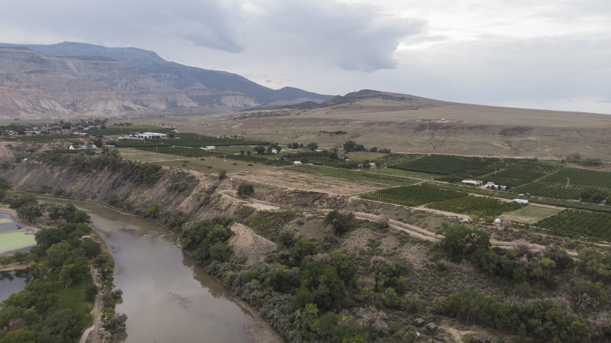
The 96-degree heat has barely broken early on a September evening near Fruita, Colo. As the sun prepares to set, the ailing Colorado River moves thick and quiet next to Interstate 70, crawling across the Utah state line as it prepares to deliver billions of gallons of water to Lake Powell, 320 miles south.
This summer the river has been badly depleted—again—by a drought year whose spring runoff was so meager it left water managers here in Western Colorado stunned. As a result Lake Powell is just one-third full and its hydropower plants could cease operating as soon as July of 2022, according to the U.S. Bureau of Reclamation.
“We’re looking at a very serious situation from Denver all the way to California and the Sea of Cortez,” said Ken Neubecker, an environmental consultant who has been working on the river’s issues for some 30 years. “I’ve never seen it in a worse state.”
The Colorado River Basin is made up of seven states. Colorado, Wyoming, Utah and New Mexico comprise the upper basin and are responsible for keeping Lake Powell full.
Arizona, California and Nevada comprise the lower basin and rely on Powell’s larger, downstream sister reservoir, Lake Mead, just outside Las Vegas, to store water for delivery to Las Vegas, Phoenix, Los Angeles and more than 1 million acres of farmland.
These are two of the largest reservoirs in the United States. Few believed Mead, built in the 1930s, and Powell, built in the 1960s when the American West had just begun a 50-year growth spurt, would face a future where they were in seeming freefall. The two reservoirs were last full in 2000. Two years ago they dropped to 50% of capacity. Now they are operating at just over one-third their original 51 million-acre-foot combined capacity.
First-ever drought accord
Two years ago, this unprecedented megadrought prompted all seven states to agree, for the first time, to a dual drought contingency plan—one for the upper basin and one for the lower. In the lower basin, a specific set of water cutbacks, all tied to reservoir levels in Mead, were put in place. As levels falls, water cutbacks rise.
Those cutbacks began this year in Arizona.
But in the upper basin, though the states agreed to their own drought contingency plan, they still haven’t agreed on the biggest, most controversial of the plan’s elements: setting aside up to 500,000 acre-feet of water in a special, protected drought pool in Lake Powell. Under the terms of the agreement, the water would not have to be released to lower basin states under existing rules for balancing the contents of Powell and Mead, but would remain in Powell, helping to keep hydropower operations going and protecting the upper basin from losing access to river water if they fail to meet their obligations to Arizona, Nevada and California.
Rancher Bryan Bernal irrigates a field that depends on Colorado River water near Loma, Colo. Credit: William Woody
The pool was considered a political breakthrough when it was approved, something to which the lower basin states had never previously agreed.
“It was a complete reversal by the lower basin,” said Melinda Kassen, a retired water attorney who formerly monitored Colorado River issues for the Theodore Roosevelt Conservation Partnership.
But the idea was controversial among some powerful upper basin agricultural interests. Ranchers, who use some 80% of the river’s water, feared they would lose too much control of their own water supplies.
Seeking volunteers
As proposed, the drought pool would be filled voluntarily, largely by farmers and ranchers, who would be paid to temporarily dry up their hay meadows and corn fields, allowing the saved water to flow down to Powell.
Two years ago, when the drought contingency plan was approved, the four upper basin states thought they would have several years to create the new pool if they chose to.
But Powell’s plunging water levels have dramatically shortened timelines. With a price tag likely in the hundreds of millions of dollars, confusion over whether saved farm water can be safely conveyed to Powell without being picked up by other users, and concerns over whether there is enough time to get it done, major water players are questioning whether the pool is a good idea.
“It was probably a good idea at the time and it’s still worth studying,” said Jim Lochhead, CEO of Denver Water, the largest water utility in Colorado. “But it can’t be implemented in the short term. We don’t have the tools, we don’t have the money to pay for it, and we don’t have the water.”
Neubecker has similar concerns. “I fear it’s going to be Band-Aid on an endlessly bleeding problem…we need to do more.”
Since 2019 the State of Colorado has spent $800,000 holding public meetings and analyzing the legal, economic and water supply issues that would come with such a major change in Colorado River management.
Still no decisions have been made.
A call to act
Becky Mitchell is director of the Colorado Water Conservation Board, which is overseeing the analysis.
Aware of frustration with the state’s progress on studying the drought pool’s feasibility, formally known as its demand management investigation, Mitchell said the work done to date will help the state better manage the river in a drier future with or without the drought pool.
“We’re still ahead of the game in terms of what we’ve done with the study. The other states are looking at feasibility investigations but ours has been incredibly robust,” Mitchell said. “If we’re going to do it we have to do it right and factor all these things in. Otherwise we’re going to be moving backward.”
One example of a step forward is that new tools to measure water saved from fallowing agricultural land are now being developed.
A large-scale experiment in a swath of high-altitude hayfields near Kremmling has demonstrated that ranchers can successfully dry their fields and deliver Colorado River water to the stream in a measurable way, and the data is considered strong enough that it could be used to quantify water contributions to the drought pool.
Ranchers Joe Bernal, left, and his son Bryan inspect a feed corn field that depends on Colorado River water near Loma, Colo. Credit: William Woody
But other regulatory and physical barriers remain.
Under Colorado’s water regulations, rivers are only regulated where they cross state boundaries when water is scarce and the state would otherwise be unable to meet the terms of agreements with downstream states. But this is not yet the case on the Colorado River and its tributaries, so rules for determining who would get what in the event of cutbacks haven’t been developed.
In addition, because there has never been a so-called “call” on the Colorado River, the state has yet to require that all those who have diversion structures pulling from the Colorado River system measure their water use.
The situation is changing fast, though, with the 20-year drought and the storage crisis at Powell and Mead increasing pressure on state regulators to take action.
Now the state is taking steps to better monitor the river and its tributaries, moving to require that all diversion structures have measuring devices so it has the data it needs to enforce its legal obligations to the lower basin. If, for instance, some water users had to be cut off to meet the terms of the 1922 Colorado River Compact, the state could manage those cutbacks based on the water right decrees users hold that specify amount and priority date of use.
Such data would also be needed to administer a mass-fallowing program to help fill the Lake Powell drought pool.
Kevin Rein, Colorado’s State Engineer and top water regulator, said what’s known as the mainstem of the Colorado River is fairly well monitored but major tributaries, such as the Yampa and Gunnison, are not.
“A lot of tributaries don’t have the devices,” Rein said, adding that the state doesn’t know the extent of the problem. “But in important areas a lot of commissioners know there is a significant lack of measurement devices and that makes water administration difficult.”
Joe Bernal is a West Slope rancher whose family has been farming near Fruita since 1920. He has water rights that date back to 1898 and, like others in this rich agricultural region, he and his family have abundant water.
Bernal was an early supporter of the drought pool. He and his family participated in an experimental fallowing program in 2016, where they were paid to dry up their fields. He’s confident the problems can be solved.
But he’s also worried that the 500,000 acre-foot pool may not hold enough water to stabilize the river system and that it may not be done fast enough.
“We want to be sure the solution does some good, but the clock is ticking,” he said. “We don’t want to change the culture of this valley or our ability to produce food. But I think things need to move faster. We are taking too long implementing these solutions.”
Checking the averages
As Powell and Mead continue to drop—they were roughly half full just two years ago— Mitchell and Rein are quick to point out that Colorado remains in compliance with the 1922 Compact, which requires the upper basin to ensure 7.5 million acre-feet of water reaches the lower basin at Lee Ferry, Ariz., based on a 10-year rolling average. Right now the average is at roughly 9.2 million acre-feet, although it too is declining as the upper basin’s supplies continue to erode due to drought and climate change.
The Colorado River flows past fruit orchards near Palisade, Colo. Credit: William Woody
Climate scientist and researcher Brad Udall has estimated that the upper basin may not be able to deliver the base 7.5 million acre-feet in a year as soon as 2025. But the upper basin would remain in compliance with the 1922 Compact even then because the rolling average remains healthy.
Still, if the reservoirs continue to plummet as quickly as they have in the past two years, when they dropped from 50% to 30% full, the upper basin could face a compact crisis faster than anyone ever anticipated.
Major water users in the state, such as Denver Water, Northern Water and Pueblo Water, have water rights that post-date, or are junior to, the 1922 water compact, meaning their water supplies are at risk of being slashed to help meet lower basin demands.
The big dry out
Many river advocates hope the drought pool is approved because they believe it is an opportunity to test how the river and its reservoirs will work as the region continues to dry out.
“What we knew in 2018 [when the drought pool was conceived] is that we have more to do,” said Kassen. The drought pool, she said, “was a big win and offers a way of testing what the upper basin can do. It’s squandered if they don’t use it.”
Neubecker and others say it’s becoming increasingly clear that the river’s management needs to be re-aligned with the reality of this new era of climate change and multi-year drought cycles.
And that means that water users in the lower basin and upper basin will need to learn to live with how much water the river can produce, rather than how much a century-old water decree says they’re legally entitled too.
“We’re facing a 21st Century situation that was totally unforeseen by anyone,” Neubecker said, “and we no longer have the luxury of time.”
Jerd Smith is editor of Fresh Water News. She can be reached at 720-398-6474, via email at jerd@wateredco.org or @jerd_smith.