The health of our waters is the principal measure of how we live on the land — Luna Leopold
#Drought news: Further degradation of ongoing drought east of the Front Range across portions of #Colorado, #Wyoming, #Kansas, and #Nebraska, where many areas have seen drastic deterioration in topsoil moisture in recent weeks
Click on a thumbnail graphic to view a gallery of drought data from the US Drought Monitor.
US Drought Monitor map October 12, 2021.
High Plains Drought Monitor map October 12, 2021.
West Drought Monitor map October 12, 2021.
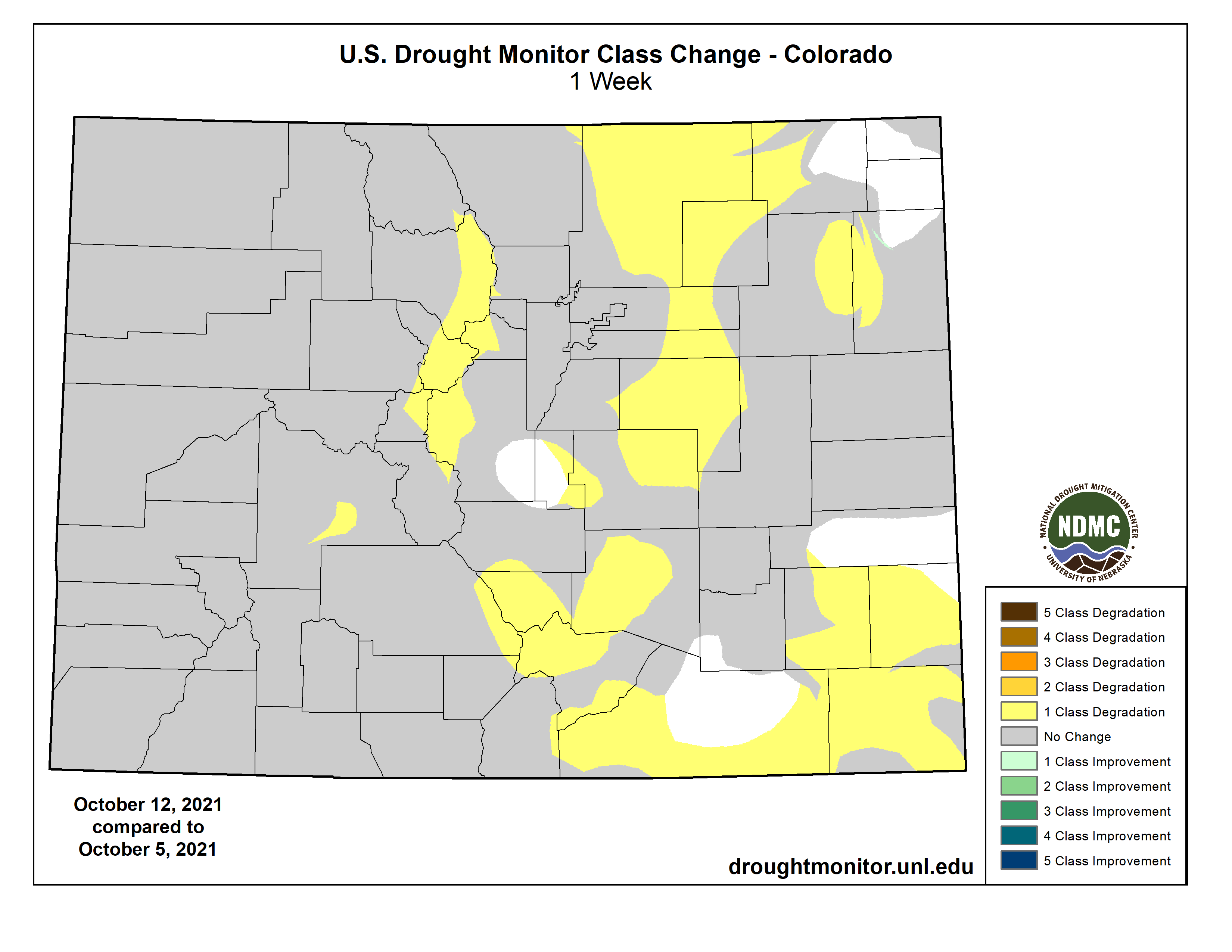
Colorado Drought Monitor map October 12, 2021.
Click here to go to the US Drought Monitor website. Here’s an excerpt:
This Week’s Drought Summary
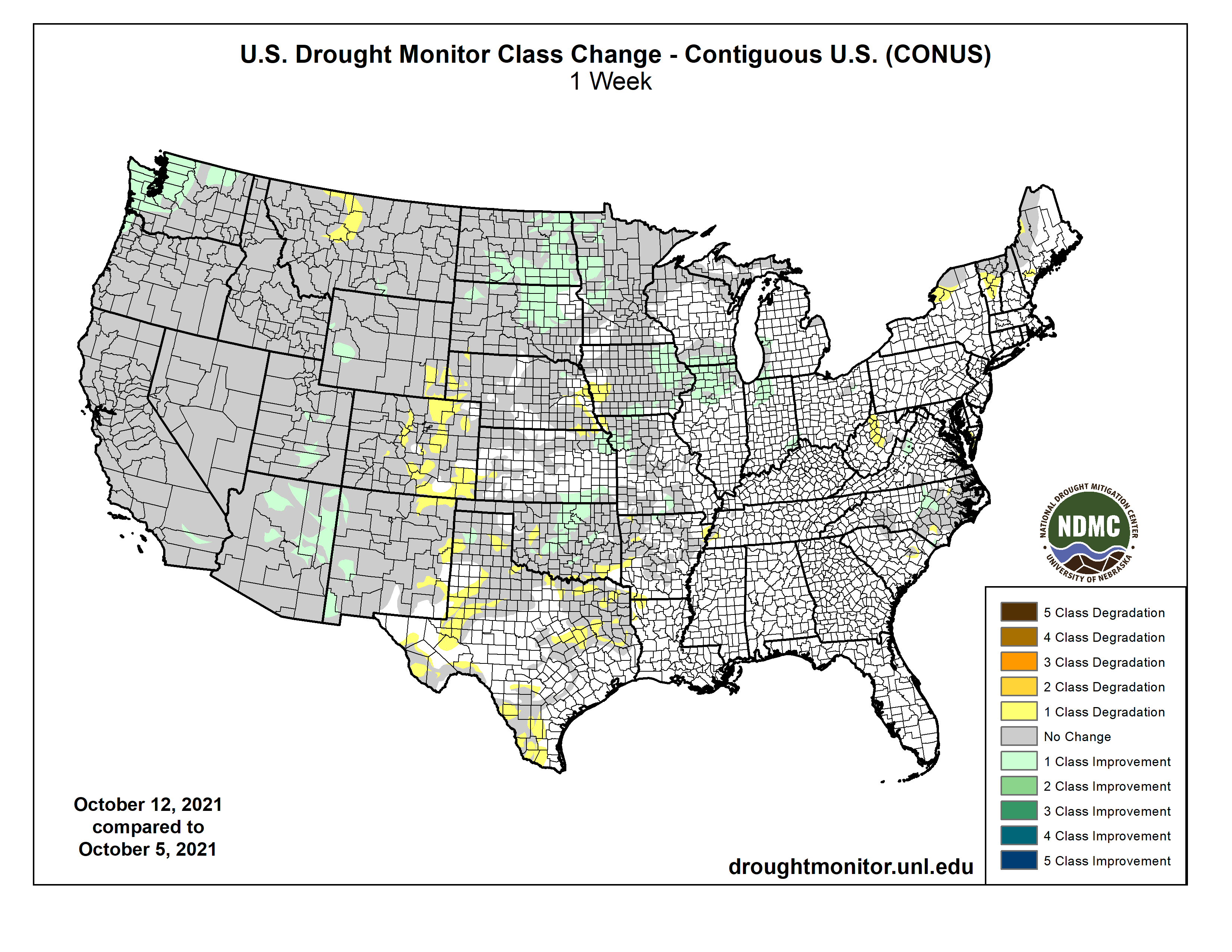
A long wave trough resulted in seasonal to below-normal temperatures across the western third of the contiguous U.S. (CONUS). A ridge of high pressure dominated the eastern two-thirds of the CONUS leading to above-normal temperatures, with the highest positive anomalies across the Northern Plains and Midwest. Despite the amplified ridge in the East, early in the week an upper level low pressure system drifted slowly northward from the Southeast to the Great Lakes bringing unsettled weather and keeping many areas across the Southeast and Ohio Valley wet. A coastal low pressure system along the coastal Carolinas brought some additional precipitation to coastal and inland areas of the Carolinas, leading to mixed reductions and expansion in coverage of abnormal dryness across the Carolinas and Virginia. In the Northeast, little to no precipitation fell and above-normal temperatures, coupled with long-term deficits, led to degradation and expansion of abnormally dry and severe drought areas across Upstate New York and New England. The Northern Plains and Upper Midwest experienced some of the largest positive temperature anomalies (8-10°F above normal) this week. However, a strong surface low pressure system brought heavy rainfall across the Dakotas and northern Minnesota, leading to broad 1-category improvements. In the wake of this storm system, a surface low pressure system developed in the lee of the Rockies over the Southern Plains dropping several inches of rainfall, further improving drought conditions (1-category improvements) in areas affected by the recent rapid onset and intensification of drought during September. As this low pressure system moved across the Midwest later in the week, it led to further improvements across portions of the western Corn Belt, due to heavy rainfall. Areas that missed out on the rainfall over the Great Plains experienced worsening conditions due to above-normal temperatures and high winds increasing evaporation and leading to increased soil moisture loss. An active storm track in the West, associated with a long wave trough, resulted in improving conditions along fringe drought areas in the Pacific Northwest and the Four Corners, where antecedent wetness leading up to this week resulted in more immediate improvements. Given the intensity and duration of drought across the remainder of the West, more precipitation will be needed to warrant more meaningful improvements…
Similar to the Southern Plains, much of the High Plains region is susceptible to extended periods of above-normal temperatures and high winds. In areas where little to no rain fell, these conditions helped to further degrade ongoing drought east of the Front Range across portions of Colorado, Wyoming, Kansas, and Nebraska, where many areas have seen drastic deterioration in topsoil moisture in recent weeks (widespread D1-D4 equivalent NASA SPoRT soil moisture percentiles down to 10 cm). Farther north over the Dakotas, a strong low pressure system brought widespread heavy rainfall over the weekend, where several areas received more than 2 inches of rain, with some localized areas of more than 4 inches. This warranted 1-category improvements across large portions of the Dakotas. However, improvements were targeted in nature due to the longer-term deficits and above-normal temperatures increasing the evaporative demand and slowing soil recharge. Farther south in the High Plains Region, surface low pressure developed late in the period in the wake of the system farther north and moved north-northeastward across the central U.S. Rainfall from this system mainly fell over drought-free areas of eastern Kansas before moving into the Midwest and Great Lakes. However, some locations did receive meaningful rainfall; enough to warrant 1-category improvements in northeastern and southeastern corners of the state. Another storm system began propagating across the western U.S. on the final day of the period (Monday-Tuesday), bringing precipitation in various forms to the eastern Rockies. However, given the intensity of drought in the higher-terrain areas of the High Plains Region, the late arrival of precipitation did little to warrant any improvements this week, given the duration and intensity of drought in those areas…
Colorado Drought Monitor one week change map ending October 12, 2021.
An active storm track across the western U.S. this week brought seasonal to cooler than normal temperatures and beneficial precipitation to much of the region. Improvements were mainly limited to portions of the Pacific Northwest and Four Corners due to improving soil moisture conditions. For the Four Corners region, this precipitation was on the heels of an active Southwest Monsoon season, so reduced evaporative demand coupled with above-normal precipitation led to immediate improvements. For much of the remainder of the West, more precipitation is needed to recharge soil moisture and increase groundwater levels, stream flows, and reservoir levels. The only minor degradations of drought in the Western Region was in southeastern New Mexico and western Montana, where above-normal temperatures and high evaporative demand warranted expansion of D0 (abnormally dry) and D3 (extreme drought) areas, respectively…
Ahead of a long-wave trough across the western U.S., an area of low pressure developed over the Southern Plains, bringing with it much needed precipitation to areas affected by the rapid onset of drought conditions in recent weeks. This has helped to improve conditions, mainly across parts of Oklahoma, where many locations received 2-3 inches of rainfall (greater than 1 inch positive weekly anomalies). Unfortunately, many locations outside of Oklahoma in the Southern Region continued to see further degradation and expansion of drought conditions in, and adjacent to, areas where the rains did not fall or was insufficient. Worsening conditions were observed across Texas and the Ark-La-Tex region were exacerbated by above-normal temperatures and high winds leading to increased evaporation and evapotranspiration rates…
Looking Ahead
During the next 5 days (October 14 – 18, 2021), a strong surface low pressure system will track across the Northern Plains and Upper Midwest, bringing the potential for heavy rainfall. Along the tail end of the trailing frontal boundary associated with this low pressure system, the remnants of Tropical Depression Pamela from the East Pacific are expected to bring a surge of moisture to the south-central U.S. Surface low pressure is expected to develop along the remnant frontal boundary and move quickly northeastward bringing increased chances of rainfall from the Middle Mississippi Valley to the Northeast. Despite the active pattern across the central and eastern U.S., temperatures are likely to moderate across the Northern Plains and Midwest by the end of the week, while in the East temperatures will likely be more variable due to the passage of frontal boundaries. In the West, temperatures are expected to be relatively seasonal during the next 5 days, with an abrupt cool down toward Tuesday.
The CPC 6-10 day extended range outlook (October 19 – 23, 2021) favors below-normal rainfall from the eastern Rockies to the East Coast, with weak tilts in the odds toward above-normal precipitation across portions of the Southern Plains and the Florida Peninsula. Enhanced chances of above-normal precipitation are favored along the West Coast inland to the western Great Basin. Above-normal temperatures are favored across much of the CONUS, with the exception of portions of southern and central California, where near to below-normal temperatures favored.
US Drought Monitor one week change map ending October 12, 2021.