Representatives from more than a dozen Indigenous tribes spoke at a CU Boulder law conference last week about their interests in the Colorado River from each of their perspectives. Many of the prominent state and federal officials who manage the water attended the conference. But as they and other water authorities prepare to negotiate the river’s future, it’s unclear how tribes will participate, to what degree tribes will be treated as equal sovereigns, and how their desire to use all the water they legally have rights to will be considered. It’s also unclear whether negotiators will aim for a way to make the long-term reductions in water usage that a decades-long megadrought has made necessary or whether they will propose more short-term changes.
The gathering happened at a critical time: Collectively, Colorado River users have to figure out how to live with significantly less water going forward, and the federal government is forcing states to come to an agreement…
The group of tribal representatives and state water officials, along with academics who study the river, used the two-day conference for discussions about how to make their collective use of the river more sustainable over the long term…The tribes have a shared history of using the river and its tributaries over thousands of years and migrating based on water availability. In the century since the river has been dammed and diverted across seven states, each tribe has a different story about how their water rights have been denied and what they seek to change in the river’s management going forward…
Some river scholars and even people with roles in the negotiations are unclear about what’s possible as they determine longer-term allocations of the water…A lot is at stake for tribes, and each circumstance is unique…For example, Hopi Tribe council member Dale Sinquah said his people still need to have their water rights settled. Southern Ute Tribal Council Vice Chair Lorelei Cloud said the tribe wants to use water they have legal rights to in southwestern Colorado, but they don’t have the infrastructure. She said about 1,000 tribal members still have to manually haul water to their homes, and the tribe hasn’t been able to develop farmland…Crystal Tulley-Cordova from the Navajo Nation said her tribe couldn’t rely on groundwater because of abandoned uranium mines on their land. Dwight Lomayesva, vice chairman of the Colorado River Indian Tribes on the border of California and Arizona, said his people would like to upgrade their farming and water infrastructure to make it more efficient, but the federal government still owns it. “The last major change in our irrigation infrastructure was made in 1942, when the United States government built some canals for the Japanese who were interned on our reservation,” he said. Each needs to negotiate for themselves individually.
“To think that there’s an ‘Indian solution,’ really dishonors that individuality and the uniqueness of each one of those tribes,” said Daryl Vigil, a Jicarilla Apache water leader who used to direct a tribal partnership in the Colorado River basin.
From the 2018 Tribal Water Study, this graphic shows the location of the 29 federally-recognized tribes in the Colorado River Basin. Map credit: USBR
The Colorado River in McInnis Canyons National Conservation Area, near Grand Junction, Colorado, on April 26, 2019. Photo by Mitch Tobin/The Water Desk
To save the Colorado River, its water users must look at radical new options, including a hard stop on new diversions, dams and reservoirs across the seven-state river basin, managing lakes Powell and Mead as one entity, and paying millions to farmers who agree to permanently switch to water saving crops and to change irrigation practices.
Those were among suggestions experts offered at a University of Colorado conference focused on the river June 8 and June 9 presented by the Getches-Wilkinson Center for Natural Resources, Energy and the Environment and the Colorado River Basin’s Water & Tribes Initiative.
Mark Squillace, a University of Colorado law professor who specializes in water law acknowledged that the ideas, such as banning nearly all new development of water on the river, weren’t likely to be popular among established water users.
“But we can’t just keep appropriating water,” he said. Already heavily overused, the river’s dwindling supplies must still be reallocated to set aside water for the 30 Native American tribes whose reservations are located within the basin. Several of them have been waiting more than a century to win legal access to water promised to them by the federal government.
Pushed to the brink by a 22-plus year drought, overuse and shrinking flows caused by climate change, the river’s dwindling supplies prompted the federal government last summer to order the seven states to permanently reduce water use by 2 million to 4 million acre-feet annually.
The call to stop water development on the Colorado River is being heard more often due to the crisis, but it is a tough sell, especially in states, such as Colorado, that have not developed all the water to which they are legally entitled.
The basin is divided into two segments, with Colorado, New Mexico, Utah and Wyoming comprising the Upper Basin, and Arizona, California and Nevada making up the Lower Basin.
The river’s two largest reservoirs, Lake Powell in the Upper Basin and Lake Mead in the Lower Basin, have long been managed separately with different rules, including the time periods in which water is measured, a critical component of forecasting supplies. But experts say that approach isn’t working and is making it more difficult to rebalance the system.
Map credit: AGU
“Why not do things far more simply,” said Brad Udall, a senior scientist and climate expert at Colorado State University. “Let’s give up the game on Upper Basin and Lower Basin. It just seems stupid. The old system is overly complex. It allows people to game the system.”
Udall was referring, in part, to a set of operating rules adopted in 2007, known as the Interim Operating Guidelines, that were intended to better coordinate operations between the two reservoirs, but which some now believe exacerbated the river’s problems.
This year, thanks to abundant mountain snows and a cool, rainy spring, the river is enjoying a bit of a reprieve. But critical negotiations on how to manage it in the future are set to begin this year, with painful decisions facing the seven states, the tribes and Mexico.
Lessening some of that pain is hundreds of millions of dollars in new federal funding dedicated to helping the basin reduce water use and find more sustainable ways to support critical industries, including agriculture, which uses roughly 80% of the river’s supplies.
But agricultural water use is critical to feeding the nation, and finding ways to reduce it without crippling rural farm economies and threatening the food supply is a major challenge.
To that end, Squillace and others say simple steps will deliver big results. Take alfalfa hay production. Most alfalfa growers irrigate their fields all summer, harvesting the crop multiple times over the course of a growing season. Eliminating one of those harvests late in the growing season could save as much as 845,000 acre-feet of water in the Lower Basin states each year. That alone would cover nearly one-quarter of the water use experts say is needed to help the river recover and sustain itself in an era of dwindling flows.
Also high on the list of important steps to better balance the river is to use most of the tens of million in federal funding to pay for permanent reductions water use.
“I would hate to see us waste our money on temporary things when we know we have a permanent problem,” Squillace said.
Colorado’s U.S. Senator John Hickenlooper, who made a brief video appearance at the conference, said he and other senate colleagues did not want to interfere in state-level talks.
“None of the senators want to meddle in state efforts to come to an agreement,” Hickenlooper said, “But we have to make sure that money is spent wisely, and we also have to look at lasting solutions … we recognize that a lot of traditional landscapes and lifestyles are dependent on us finding the right solutions.”
Jerd Smith is editor of Fresh Water News. She can be reached at 720-398-6474, via email at jerd@wateredco.org or @jerd_smith.
Colorado River “Beginnings”. Photo: Brent Gardner-Smith/Aspen Journalism
After graduating from Stanford Law School and practicing with prestigious firms in Phoenix and San Francisco, Wilkinson embarked on a remarkable career that encompassed teaching, writing, and advocating for the rights of Indigenous Peoples and the environment. In 1971, he joined the newly formed Native American Rights Fund in Boulder, Colorado as a staff attorney, helping to shape the organization’s pathbreaking advocacy for Tribes. Together with the late Dean David Getches, Professor Richard Collins, and NARF Executive Director John Echohawk, Wilkinson helped to secure landmark victories in tribal treaty rights litigation and establish a relationship between Colorado Law and NARF that endures to this day.
Wilkinson was a passionate and inventive teacher and mentor, educating and inspiring thousands of students and scores of colleagues at law schools throughout the country. As his colleagues and students would attest, Wilkinson left an indelible mark, not just on legal education and scholarship, but on those attributes that are the very essence of the American West.
“Charles’s enormous legacy touches every aspect of public lands, natural resources, and American Indian law,” reflected Professor Sarah Krakoff. “He blended fierce advocacy with deep scholarship. He wrote in ways that were accessible to the general public while also influencing policy makers at the highest levels of government. And he was a ceaselessly generous, optimistic, kind, and huge-hearted friend and mentor to generations of students and colleagues. To put it in a way Charles himself might have—Dammit we will miss him, but how very lucky we were to know him.”
Most of Wilkinson’s teaching career was spent at the Oregon and Colorado law schools, where his influence and impact were deeply felt. In 1997, the regents of the University of Colorado recognized Wilkinson as a Distinguished Professor, one of only twenty-five at the University. His gift for teaching and deep commitment to research were repeatedly acknowledged through numerous teaching and research awards throughout his illustrious career. Wilkinson was famous for hiring law students as research assistants and sending them out in the world to learn about legal problems. These opportunities were often life-changing, with dozens of his students going on to practice Indian Law and Public Land Law over the decades.
As a prolific writer, Wilkinson authored fourteen books, which stand as seminal works that shaped the fields of Indian Law and Federal Public Land Law. These include highly regarded casebooks and general audience books, including Crossing the Next Meridian, that tackled pressing issues related to land, water, the West, Indigenous rights, and the complex histories that shape our nation. His writings, marked by their clarity and profound insights, resonated with scholars, practitioners, and the general public, making him an influential voice in legal and environmental discourse. He was an early thought leader in the field of environmental justice, seeing early on that the rights of Native Americans had to be considered at the heart of public lands and conservation policy.
“Charles was a beloved person in Indian country,” said Professor Kristen Carpenter who directs the American Indian Law Program. “From the Navajo and Hopi people in the southwest deserts and canyons to the Yurok, Nisqually, and Siletz people along the rivers and coasts of the northwest, Charles spent much of his life working with tribes and they came to trust him. Charles Wilkinson’s deep, respectful engagement with Indigenous Peoples is a model that the AILP will always share with our students.”
Beyond the classroom, the written word, his work with tribes, and support for students, Wilkinson devoted himself to numerous special assignments for the U.S. Departments of Interior, Agriculture, and Justice. His expertise was sought after, and he played instrumental roles in critical negotiations and policy development. From facilitating agreements between the Timbisha Shoshone Tribe and the National Park Service to serving as a special advisor for the creation of Grand Staircase-Escalante National Monument and Bears Ears National Monument, Wilkinson’s successes extended far beyond the confines of academia.
Charles Wilkinson’s exceptional achievements were recognized through a multitude of prestigious awards and honors. These accolades include the National Wildlife Federation’s National Conservation Award, which acknowledged his unwavering commitment to the preservation of our natural heritage. The Earle A. Chiles Award from the Oregon High Desert Museum celebrated his career-long dedication to the High Desert region, while the Twanat Award from the Warm Springs Museum recognized his tireless work in support of Indian people.
Wilkinson’s visionary leadership and dedication to the Colorado Plateau were honored with the John Wesley Powell Award from the Grand Canyon Trust. Additionally, the Federal Bar Association bestowed upon him the Lawrence R. Baca Award for Lifetime Achievement in Indian Law, recognizing his profound contributions to the field. In 2021, the Colorado Center for the Book and Colorado Humanities honored Charles Wilkinson with the Colorado Book Awards Lifetime Achievement Award for his contributions to the Colorado and national literary, history, and legal communities.
“Charles Wilkinson’s passing brings into sharp focus his extraordinary legacy—a legacy that embodies the very best of what our law school stands for. He was a brilliant advocate, and his life’s work will continue to guide and inspire us,” remarked Dean Lolita Buckner Inniss. “His memory will remain a source of comfort and strength for so many as they carry forward his remarkable dedication and honor the profound difference he made.”
Charles Wilkinson’s legacy will indeed continue to inspire generations to come, as those who knew him directly and those who were touched through his work strive to emulate his vision, passion, and commitment to creating a more just and sustainable world.
To Charles Wilkinson’s family and loved ones, the University of Colorado Law School offers our deepest condolences during this difficult time.
Details regarding a celebration of life will be shared as soon as possible.
Above normal precipitation and below normal temperatures resulted in another week of targeted improvements across portions of the Intermountain West, adding to recent precipitation totals that have continued to improve long-term drought conditions. The exception is the Pacific Northwest, where below normal precipitation and above normal temperatures resulted in worsening drought conditions along the northern Cascades. There is a mix of improving and worsening drought conditions across the Great Plains. Improvements are mainly confined to the western Great Plains, where widespread 7-day rainfall totals exceeded 200 percent of average for the week, further adding to short-term precipitation surpluses. From the eastern Great Plains to the Eastern Seaboard, 7-day rainfall surpluses are more scattered in nature, leading to only modest improvements in areas seeing the heaviest amounts. In areas that received below normal rainfall this week, drought worsened, as rainfall deficits continue to increase…
Although much of the High Plains region received above-normal precipitation this week, the region as a whole is a tale of 2 halves. Improvement to the drought depiction is warranted across western portions of the Central and Northern Plains, where 7-day precipitation totals exceeded 200 percent of average across most areas, adding to precipitation surpluses in recent weeks and improving long-term drought indicators. Conversely, deteriorating conditions are warranted across eastern parts of the High Plains region where heavy, convective rainfall was not enough to overcome predominantly near and above normal temperatures and high rates of evaporation from the soils and vegetation (known as evapotranspiration). For example, parts of South Dakota reported evapotranspiration rates from crops averaging around 0.25 inches per day, which varied slightly depending on the type of crop, essentially eliminating the effects of beneficial rainfall for several locations…
Colorado Drought Monitor one week change map ending June 13, 2023.
The Intermountain West is the beneficiary of another week of widespread above normal precipitation for many locations, with large portions of the Four Corners region, the Great Basin, and the southern and central Rockies also experiencing below normal temperatures. Improvements are warranted in locations where long-term drought indicators, such as groundwater, continue to improve. In addition, the above-normal snowpack from the active winter rainy season across much of the West continues to keep stream flows near and above average. Unfortunately, degradations are warranted across parts of the Cascades in the Pacific Northwest, which experienced a near- to below-average winter rainy season, which has been exacerbated by below average precipitation since that time. Soil moisture and groundwater continue to decline and 7 to 14 day average stream flows have fallen into the bottom 30 percent (and in many cases, the bottom 10 percent) of their historical distributions. In addition, above average temperatures this week (4 to 10°F above normal) have acted to accelerate this deterioration…
Several locations across Louisiana, Mississippi, and Tennessee experienced degradation this week, as the frontal boundary draped across the southern tier states did not result in enough precipitation to stave off degradation for those experiencing antecedent dryness. This is also the case in portions of central Texas and parts of the middle Red River basin, where targeted degradations are also warranted. However, farther westward across western portions of the Southern Plains, pockets of heavy rainfall continued to add to 60-day precipitation surpluses, particularly for parts of the Texas and Oklahoma Panhandles. Rainfall has been plentiful in these areas in recent weeks and months. For example, Amarillo Texas recently set a new record of 20 days with measurable precipitation during May; the previous record being 15 days. In addition, Lake Meredith, located north of Amarillo has reached 45.8 percent of its capacity, its highest since 2001, according to Texas Water Development Board data…
Looking Ahead
According to the Weather Prediction Center, over the next 6 days (June 15 – 20) warm temperatures are forecast to build across central portions of the lower 48 states, with cooler temperatures forecast across much of the Intermountain West and the West Coast leading up to June 20. Generally seasonal temperatures are likely east of the Mississippi River. Rainfall is forecast across a large swath of the lower 48 states from the Pacific Northwest to the Southeast, and northward along the East Coast. In the Southeast, heavy precipitation (in excess of 5 inches) is forecast for parts of the Deep South and the central and eastern Gulf Coast region.
During the next 6 to 10 days (June 20 – 24), the Climate Prediction Center favors below normal temperatures across the western third of the lower 48 states, and across parts of the Mid-Atlantic coast and Appalachians. Above normal temperatures are favored for the Great Plains, Mississippi River Valley, Great Lakes, interior Northeast, and southern Florida. Above normal precipitation is indicated across northwestern and north-central portions of the lower 48 states, and across the Southeast and Mid-Atlantic states. Below normal precipitation is weakly favored across parts of southern Texas and extending into the Four Corners region, parts of the Midwest, and northern New England.
US Drought Monitor one week change map ending June 13, 2023.
A tower, pictured June 23, 2022 supports high-voltage transmission lines as part of PacifiCorp’s new Gateway West transmission project in Carbon County. Construction will soon begin on the TransWest Express transmission project nearby to carry Wyoming wind energy to the Southwest. (Dustin Bleizeffer/WyoFile)
After 15 years of planning and permitting, construction will begin this year on the TransWest Express high-voltage transmission line — a milestone expansion of Wyoming’s electric power export industry to markets in the American Southwest and one of the largest transmission upgrades to the western grid in decades.
The Bureau of Land Management granted TransWest Express LLC a “notice to proceed” in April, culminating years of work and millions of dollars invested in a “vision” to bring Wyoming’s renewable energy potential to the rest of the West, according to company officials.
“It’s a day that’s been long coming,” TransWest Express Executive Vice President and COO Roxane Perruso said. A groundbreaking event will take place Tuesday, she said, with a special appreciation for the Carbon County community’s integral support. That support represented a leap-of-faith for a region with its cultural and economic roots in coal.
Power project
While TransWest Express LLC was mired in planning and a painstaking bureaucratic permitting process that included obtaining rights-of-way from hundreds of entities across the 732-mile route, its affiliate Power Company of Wyoming was already doing preliminary construction work on the wind farm that will energize the line. The Anschutz Corporation owns both companies.
The Chokecherry and Sierra Madre wind energy project will span some 320,000 acres in Carbon County and generate 3,000 megawatts of electricity — representing about 28% of Wyoming’s current electrical generation capacity today, according to U.S. Energy Information data. It will be the largest onshore wind energy facility in North America, according to Power Company of Wyoming.
This map depicts the route of the TransWest Express transmission line connecting Wyoming wind energy to the Southwest. (TransWest Express)
Phased construction of the 732-mile TransWest Express high voltage transmission system will begin later this year, according to company officials. The first phase includes a new substation in Carbon County. From there, crews will erect towers and string high-voltage lines to a station in Delta, Utah. That portion of the project will initially begin moving up to 1,500 megawatts of wind-generated electricity via direct current by December 2027.
The second phase includes an alternate current line to connect with other powerline systems in southern Nevada. By the end of 2028, the final phases of the system will ramp up to 3,000 megawatts and four system interconnections in the Southwest, according to TransWest Express officials.
“These components will provide important new bulk transmission capacity and connectivity with the PacifiCorp system in Wyoming, with the Los Angeles Department of Water & Power and Intermountain Power systems in Utah, with the NV Energy system in Nevada and with the California Independent System Operator,” Perruso said.
New dynamic
Aside from transporting power from Wyoming’s Chokecherry and Sierra Madre wind facility, TransWest may also serve as an onramp for other energy projects, such as the hydrogen energy proposal at the Intermountain Power Project in Utah, and potentially new nuclear power facilities, according to TransWest officials.
“As Wyoming looks at more carbon-free [energy] resources, we are going to be that pathway that allows those resources to get to the market,” Perruso said. “We’re opening up the new market for renewables and also creating a pathway for future carbon-free resources.”
Crews work on road and wind turbine pad construction June 23, 2022 at the future site of the Chokecherry and Sierra Madre wind energy project in Carbon County. (Dustin Bleizeffer/WyoFile)
Some clean energy and climate advocates hail the TransWest Express project as a vital step forward in “decarbonizing” the western grid. Once completed, the transmission line will serve as a “backbone,” increasing connectivity between large demand centers — southern Nevada, Utah and southern California — and rural areas that can generate commercial-scale renewable energy, such as Wyoming’s abundant capacity for wind power generation.
“This is an example of infrastructure that is needed and should be built,” Western Resource Advocates Deputy Director of Regional Markets Vijay Satyal said. “It is definitely very important for the West.”
Together, the TransWest line and CCSM wind facility represent a new dynamic — as well as a gamble that too few entities have been willing or able to take on, according to Satyal and other utility market watchers. It’s a rare move that requires a lot of patience with the permitting process, according to one TransWest Express official, as well as deep pockets, according to others.
Going independent
Most consumers don’t get to choose their electricity provider, whether they’re powering a home in Casper or a chain restaurant in Evanston, but the TransWest project diverges from that paradigm. For example, PacifiCorp, which also operates as Rocky Mountain Power, is one of several electric utility monopolies in Wyoming. It serves captive customers in certain areas because, generally speaking, it owns the power infrastructure exclusively.
As a monopoly, PacifiCorp is regulated by the Wyoming Public Service Commission, as well as service commissions in the five other states it operates. It is required to justify and win approval for its electricity rates. In return, it has a guaranteed, captive ratepayer base to finance system operations and necessary upgrades.
Just southeast of the Jim Bridger Plant in August 2019, PacifiCorp workers erect towers that will carry new transmission lines, predominantly for wind energy, to tie into the regional electrical grid where it leaves the plant. (Andrew Graham/WyoFile)
There are variations, such as rural electric co-ops that work under different sets of rules and authorities. But the same geographically limited market for grid infrastructure plays out all over Wyoming, the West and the nation. Although utilities like PacifiCorp are shifting from burning coal to cleaner forms of electric generation within their own service territories, Satyal said, it isn’t enough to achieve the level of connectivity between hundreds of individual service systems to allow for new sources of renewable and low-carbon energy.
The strategy behind Power Company of Wyoming and TransWest Express is to operate as independent merchants, selling and delivering renewable and low-carbon energy to any utility it can reach via the three major operating regions that TransWest will connect to on the western grid.
“We’re broadening the [Wyoming and western] market to include these new interconnections and new customers,” Perruso said. “We’re not constrained by a service territory.
“That also means it’s risky,” Perruso continued. “This is why you don’t see [a lot of] developers doing this, because it’s a risky and an entrepreneurial proposition.”
Big gamble, deep pockets
Unlike a regulated utility, neither TransWest Express LLC nor Power Company of Wyoming have a captive ratepayer base to leverage upfront financing or a guaranteed paying customer base for ongoing operations. That’s where both the gamble and the deep pockets come in.
Both companies are affiliates of the Denver-based Anschutz Corporation. The worldwide oil, investment, sports, real estate, entertainment and publishing company headed by Philip Anschutz is worth some $10.8 billion, according to Forbes.
“Thanks to the deep pockets or the financial muscle the owners had, they survived a long [permitting] process to comply with all the environmental requirements,” Satyal said. “This is a good example of a company seeing the value proposition and the economic benefits of exporting Wyoming-rich wind and moving into the decarbonization of the future.”
A truck hauls a wind turbine blade through Medicine Bow in July 2020. (Dustin Bleizeffer/WyoFile)
TransWest Express doesn’t yet have customers contracted to take the power it plans to deliver from Wyoming. But, Satyal said, the rush to renewables to meet self-imposed carbon emission standards — particularly in the Southwest — is a good bet with a potentially lucrative payoff.
“God forbid California has a reliability crisis. This line will be a very important lifeline in providing energy — and at high [profit],” he said. “That’s competition at work, which I think is what Wyoming wants to support — a competitive market.”
Wyoming Energy Authority Executive Director Rob Creager agrees.
“Our state is in the business of producing and selling world-class energy,” Creager said. “So projects like TransWest Express opening up entirely new consumer markets for our energy products have tremendous potential for Wyoming.”
Dustin Bleizeffer is a Report for America Corps member covering energy and climate at WyoFile. He has worked as a coal miner, an oilfield mechanic, and for 25 years as a statewide reporter and editor primarily… More by Dustin Bleizeffer
The bodacious snowpack means the chance of Lake Mead dropping below elevation 1,000 is zero.
We still need to cut 1.5 million acre feet of Colorado River water use, at least. We still have no plan to do that.
We remain at risk of river flows past Lee’s Ferry dropping low enough by 2026 to trigger a legal argument about what the Upper Basin really owes the Lower Basin.
We have what was called a “historic accord” to reduce Lower Basin use in the short run, which muchly revolves around paying people to not use water.
The “historic accord” does not take any steps toward resolving longstanding tribal and environmental inequities.
The problem of what economist Gordon Tullock called “the transitional gains trap” is a very real obstacle to moving forward on the Colorado River.
WHATEVER, LET’S JUST PAY ’EM: THE “TRANSITIONAL GAINS TRAP”
In a seminal 1975 paper, economist Gordon Tullock nailed the problem at the heart of the current Colorado River policy dilemmas:
Thus farmers in places like Palo Verde, Yuma, and Imperial umpty generations ago benefited from the significant subsidies from the rest of us (federal taxpayers) that enabled Lower Colorado River agriculture to flourish. The benefit of that subsidy has now been fully capitalized in the land and the structures of the communities.
As Tullock’s work so clearly notes, termination of this “scheme” (I love his word) would “lead to large losses for the entrenched interests.”
While there’s a lot of “property rights” framing around our 21st century arguments about this, it’s important to remember that the perfection and continued use of those water rights was enabled by massive collective action on the part of others in establishing the needed institutions, and funding and building infrastructure.
But whatever, right? That’s where we are now, and a fatalistic attitude of “let’s just pay ’em” seems to have settled over basin problem solving, at least in the short term.
IS THERE A “TRANSITIONAL LOSSES TRAP” TOO?
I’m definitely out over the tips of my conceptual skis here, but one of the things that was made clear at the Boulder meeting was something I’ll glibly dub “the transitional losses trap”: the same decisions over the last century that locked in “transitional gains” for Lower Basin farmers also locked in “transitional losses” for Native American communities dispossessed of their land and water.
In a powerful panel last Thursday afternoon, a stage full of tribal leaders one at a time talked about that dispossession. The sheer weight of their words, and the range of their concerns, was breathtaking.
Some progress has been made on this issue, especially in Arizona. But there is no escaping the reality that all that water providing “transitional gains” to Lower Basin farmers is, acre foot for acre foot, a “transitional loss” for Native American communities. And now we’re paying those Lower Basin farmers to not use this very same water.
I get that some of the money we’re paying to reduce water use will go to Arizona and California tribes with settled water rights. But there are many tribes without settled water rights, or with rights that are settled but not yet put to use. They’re getting nothing out of any deal to pay water rights holders not to use their water. We need to remember this fact every time we pay a non-Indian farmer not to farm.
It’s a Lower Basin agreement, among Arizona, California, and Nevada. One of the things that was abundantly clear at the Boulder meeting was that Upper Basin states are withholding judgment until the details are fleshed out.
But it’s already clear that those who negotiated the deal want our money – federal tax dollars – to solve the transitional gains trap, but not to solve any of the other problems worth talking about:
the Colorado River Basin’s tattered environment
unresolved Native American water rights and other needs
As I’ve pointed out previously, with other people’s money should come other people’s values.
THE LEE’S FERRY CONUNDRUM
My buddy/collaborator/coauthor/mentor Eric Kuhn threw up a scary slide during his talk:
The crucially nerdy backstory is in Article III(c) and (d) of the Colorado River Compact, which seem to say the Upper Basin is required to send 82.5 million acre feet every ten years. As Hamby noted, one of the premises of “we need to cut 1.5maf in the Lower Basin” is that the Upper Basin continues to hit that target. Lawyers will argue forever about Article III interpretation, but I’d prefer not to hand over our management of the Colorado River to a judge’s ruling on who’s right.
But the deep entanglement between this question and the transitional gains trap stuff I mentioned before isn’t going away. California farmers have benefited from a “property right” essentially created in 1968 through the use of power politics, but that property right, as Tullock would say, is now priced into the value of their assets. And we’ve now set a “whatever, let’s just pay ’em” precedent (at an unprecedented scale), which does seem historic, but maybe not in a good way.
West snowpack basin-filled map April 16, 2023 via the NRCS.
Denver Water is helping ensure its future water security with the Gross Reservoir Expansion Project. When the project is complete, it will nearly triple the Boulder County reservoir’s capacity to 119,000 acre-feet. CREDIT: HEATHER SACKETT/ASPEN JOURNALISM
Climate change is robbing the Colorado River of water and threatening water security for 40 million people living in the Southwest. But prominent Colorado water managers, citing political concerns, are shying away from action on climate, favoring instead adaptation to rising temperatures and sustainability in their own operations.
The climate news surrounding the river is often grim. Scientists have shown that flows have declined nearly 20% from the 20th century average and that human-caused higher temperatures are responsible for about one-third of that. They have also shown that every 1 degree Celsius of warming results in a 9% reduction in flows. A record-setting snowpack this past winter led to above-average runoff conditions, but that good news follows the fact that water levels in the nation’s two largest reservoirs, Lake Powell and Lake Mead, dropped to historic lows early this year.
And it is predicted to get worse. Scientists at the World Meteorological Organization said last month that we are more than likely headed for a period of warming in the next four years, driven by El Nino, that will see record-breaking heat. This will push the Earth 1.5 degrees Celsius (2.7 degrees Fahrenheit) above pre-industrial levels for at least one year between now and 2027. The 1.5-degree Celsius mark is a major threshold; experts have warned that this amount of warming will result in far more impacts such as droughts and heatwaves.
Yet, despite a cleareyed recognition of the scale of the climate problem, Colorado water managers have done remarkably little when it comes to pushing for climate action on a main cause of water shortages: rising temperatures caused by humans burning fossil fuels such as coal, oil and natural gas. Experts agree the world needs to quickly transition away from fossil fuels to renewable sources of energy such as solar and wind power.
Managers instead have focused almost entirely on climate resilience and adaptation by funding programs that help water users adjust to the impacts of shortages and, in some cases, have worked to reduce their own carbon footprint and increase sustainability in their operations. “Climate resilience” and “drought resilience” have become popular buzz phrases in the Colorado water world.
But experts say these approaches don’t address the root cause of the problem and that water managers have a responsibility to pivot from climate adaptation to mitigation. According to the Intergovernmental Panel on Climate Change (IPCC) — an arm of the United Nations representing 195 countries and considered an international authority on climate change — adaptation and mitigation are necessary to avoid the worst losses and damages.
“This is their resource,” said John Berggren, a water policy analyst with Western Resource Advocates, referring to Colorado River water managers. “It’s not disconnected, it’s not tangential. Climate change is impacting their ability to provide water, and therefore I think they have a responsibility to be advocating for policy change at every level of government.”
Climate scientist Brad Udall has been beating the drum on this issue for years. Udall’s 2017 paper with researcher Jonathan Overpeck was one of the first to illustrate just how much of an effect rising temperatures were having on the Colorado River. A hotter atmosphere can hold more water through evaporation, and plants suck up more water as heat increases. Udall and Overpeck’s research found that an average of one-third of the declines in flows can be attributed to human-caused higher temperatures.
September 21, 1923, 9:00 a.m. — Colorado River at Lees Ferry. From right bank on line with Klohr’s house and gage house. Old “Dugway” or inclined gage shows to left of gage house. Gage height 11.05′, discharge 27,000 cfs. Lens 16, time =1/25, camera supported. Photo by G.C. Stevens of the USGS.
Source: 1921-1937 Surface Water Records File, Colorado R. @ Lees Ferry, Laguna Niguel Federal Records Center, Accession No. 57-78-0006, Box 2 of 2 , Location No. MB053635.
Udall’s family is steeped in the history of the Colorado River. As he writes in the forward to the book “Cornerstone at the Confluence: Navigating the Colorado River Compact’s Next Century” (2022),his father, Morris, was a U.S. congressman from Arizona who shepherded the Colorado River Basin Project Act through the House of Representatives in 1968 and his uncle Stewart was secretary of the interior during the 1960s, who promoted the U.S. Bureau of Reclamation’s vision for the river. His great-great-grandfather John D. Lee founded the famous Lee’s Ferry, now the dividing point between the upper and lower Colorado River basins.
Udall, a senior water and climate research scientist at Colorado State University, has been one of the loudest voices in recent years calling for audacious leadership on issues of climate change and the river. He often says that climate change means water change. He said water managers have a responsibility to address climate change and that it’s frustrating to watch people retreat to their silos.
“It’s disheartening to me, the idea that it’s somebody else’s problem and the potential for disaster that exists because people are just focused on their little areas of expertise and what they think is their responsibility as defined by their job title versus what I would argue is their responsibility to humanity as a whole, which might not be in their job title but should be,” Udall said.
During his presentation at the 2019 Upper Colorado River Commission meeting in Las Vegas, Udall told water managers that adapting to impacts doesn’t go far enough, and he suggested tools for mitigation such as carbon pricing and tax credits for renewable energy. He said not nearly enough is being done.
“How many times can we say this is a full-on, five-alarm fire that we’ve got to address immediately and yet nothing happens?,” Udall said. “It’s kind of as if people don’t understand the historic times in which we are operating right now. This is a once-in-human-history pivot point.” [ed. emphasis mine]
Water and climate scientist Brad Udall speaks at the annual Colorado Law Conference on Natural Resources at the University of Colorado Boulder last week. Udall has been one of the loudest voices calling for audacious leadership on issues of climate and the Colorado River. Photo credit: Heather Sackett/Aspen Journalism
Hot-spot mission scope
When General Manager Andy Mueller was hired at the Colorado River Water Conservation District in 2017, he told his new board the two biggest challenges facing the district were its anemic bank account and climate change. The money problem was largely remedied in 2020 when voters throughout the 15-county district overwhelmingly approved ballot measure 7A, raising an additional $5 million a year for the River District. The majority of that new taxpayer money now goes to fund water projects, many of which are aimed at helping water users across the Western Slope adapt to the impacts of climate change.
The River District has funded projects that create a redundant water supply so that cities aren’t at risk if a wildfire affects one water source; projects that help farmers and ranchers figure out how to still grow crops with a smaller supply of water; and projects that try to predict water availability such as soil moisture monitoring and remote-sensing snowpack monitoring. Mueller said adapting to climate change underlies everything they do at the River District.
Andy Mueller, the general manager of the Colorado River District, speaking at the district’s annual seminar on the Colorado RIver, on Sept. 14, 2018 in Grand Junction. Muller expressed concerns about how the state of Colorado might deal with falling water levels in Lake Powell and Lake Mead. Photo credit: Brent Gardner-Smith/Aspen Journalism
“Conversations today are largely driven by the fact that climate change has impacted the availability of water,” Mueller said. “Everything we think about at the River District is how do we prepare our water users and how do we help protect our water users in our communities from that hotter and drier future from the water-security perspective.”
The area covered by the River District is feeling climate change impacts more acutely than other areas in the West. According to a 2020 analysis by The Washington Post, a cluster of counties on the Western Slope has warmed more than 2 degrees Celsius (3.6 degrees F), which is double the global average. The hot spot spans more than 30,000 square miles; is the largest hot spot in the contiguous United States; and includes some of western Colorado’s largest irrigation districts in the Grand Valley and Uncompahgre River Valley.
It’s likely that the River District’s mission — to lead in the protection, conservation, use and development of Colorado River water for the welfare of the district — will be made all the more challenging in years to come as rising temperatures cause flows to decrease even more. But Mueller said he sees addressing the causes of climate change — humans burning fossil fuels — as outside the scope of that mission. The River District hires lobbyists and has staff focused on government relations, but it does not push for climate policies that aim to curb carbon emissions.
Turning from adaptation to prevention is a massive lift and one that would change the focus of the organization, Mueller said. Add to that the fact that some of the counties represented on the district board have economies still partly dependent on extracting oil, gas and coal and it becomes even harder to take action.
“I think we have a responsibility to give voice to what climate change is doing to our communities and our water supply, and I do think the River District does a good job with that,” he said. “Do we have an obligation to lead in the prevention of climate change? I would say no, we don’t … . We have identified climate change as a threat, but the idea that we have the ability to meaningfully prevent the root cause of climate change isn’t within our traditional abilities and our mission.”
The trust of the customer
Denver Water is Colorado’s oldest and largest public water utility, supplying water to 1.5 million people. The water provider gets about half of its supply from the Colorado River through transmountain diversions that take from the headwaters to the Front Range via a system of pumps, pipes, tunnels and reservoirs. Its operations and water quality have been impacted by climate-change-fueled wildfires in the watersheds where it draws this water, with post-fire debris and ash being washed into reservoirs and clogging infrastructure.
Denver Water’s departing CEO, Jim Lochhead, who has led the utility since 2010, is an attorney and the former head of Colorado’s Department of Natural Resources. He has received a Water Leader of the Year award from the Colorado Water Congress.
Lochhead and Denver Water are powerful political players in Colorado. For example, after he and heads of other water utilities that pull some of their supply from the Colorado River testified at a state Senate hearing this year, lawmakers added more seats for Front Range water providers to a drought task force.
Lochhead said that every aspect of Denver Water’s operation is impacted by climate change and that climate change, population growth and the resulting impact on the Colorado River are the utility’s greatest challenges. He said Denver Water walks the talk by doing stream-restoration projects in the headwaters to mitigate the impacts of its diversions and forest health initiatives that mitigate impacts of wildfires. The utility is preparing for a future with a less consistent water supply through increased efficiency, water recycling and projects such as the expansion of Gross Reservoir in Boulder County. That project is raising the height of a dam in the foothills west of Boulder by 131 feet, nearly tripling the reservoir’s capacity from 42,000 to 119,000 acre-feet.
Denver Water CEO/Manager Jim Lochhead accepts the 2021 AMWA Sustainable Water Utility Management Award from AMWA President Angela Licata and AMWA Vice President John Entsminger, at the group’s annual meeting in early October, 2021 in Denver. Photo credit: Denver Water.
Lochhead said Denver Water is addressing climate change in a major way: through sustainability, water conservation and energy efficiency efforts at its new campus, which has solar panels, blackwater reuse and rainwater capture for irrigation, LED lighting and has been awarded multiple LEED Green Building certifications.
“We wanted it to be a vision of the future and a vision of sustainability,” Lochhead said. “This is the most sustainable campus that has been developed in Colorado.”
Denver Water’s goal is to reduce by 2025 overall energy use and greenhouse gas emissions by 50% from a 2015 baseline, and Lochhead said they are on track to meet that goal.
But addressing the root cause of warming is a bridge too far for Lochhead, as it is for Mueller and the River District. Lochhead called climate change “a hot-button political issue.”
“We are created to be nonpolitical, and part of the trust our customers have for us is that we are nonpolitical,” he said. “To the extent that we are operating politically or we have stepped out of that role, we actually risk losing some of the trust of our customers.”
Last year, Denver Water joined a memorandum of understanding with other large municipal water providers to commit to reducing nonfunctional turf grass — a major water hog — by 30% and other efficiency upgrades. This type of collective action, along with promoting an ethic of sustainability, is how Lochhead sees Denver Water’s role in the climate crisis.
“There hasn’t been, to my knowledge, a collective discussion around reducing carbon emissions,” he said.
A POW delegation in front of the U.S. Capitol in this 2013 photo includes Roaring Fork Valley leaders including Gretchen Bleiler, far left, Penn Newhard, fourth from left, Chris Davenport, far right, and Auden Schendler, fifth from right.
Making the shift to activists
Auden Schendler, vice president of sustainability at Aspen Skiing Co. and a thought leader on climate issues in the ski industry, said water managers need to engage in solving climate change not just in their own operations but at the policy level.
A water utility getting its own sustainability house in order doesn’t do enough to make a difference and takes the blame off of where it belongs: the fossil fuel industry, which has long misled the public about the impacts of burning its products, Schendler said.
“By definition, it doesn’t do the things that fossil-fuel-industry people fear,” Schendler said. “What do they fear? Active voters, movements, legislation, public shaming, public exposure — that kind of thing. The fact that very powerful entities, businesses, water districts and trade groups won’t speak up is an astounding win for the fossil fuel status quo power structure … . I would argue that it’s negligent for a water district to not engage in those things.”
In recent years, SkiCo has become a leader on climate, aligning itself with Protect Our Winters, a group that harnesses the power of outdoor athletes and recreationists to solve the climate crisis. POW focuses on large collective action and political action for systemic change, an approach that the IPCC says can work.
“Effective climate action is enabled by political commitment, well-aligned multilevel governance, institutional frameworks, laws, policies and strategies and enhanced access to finance and technology,” reads the latest IPCC assessment report.
SkiCo has made the shift from a business that merely worked to make its operations “green” to climate activists promoting policies that combat climate change. Schendler said SkiCo’s role is to wield power, model solutions, lobby, help build movements, get involved in politics and basically engage in civics. So far, water managers have not made a similar shift, even though rising temperatures represent as much of a threat to their mission as they do to the snowy winter slopes relied upon by ski resorts.
Although things can often look grim, one of the points stressed in the latest report from the IPCC is that there is still time to avoid the worst impacts if people act now to limit warming. The window to secure a livable and sustainable future is rapidly closing, but there is a window nevertheless. Seeing climate change only as an inevitability that is global in nature can contribute to inaction, said Berggren, of Western Resource Advocates.
“Sure, maybe you as a water provider aren’t going to be writing or developing international climate policy, but as a water provider whose entire mission is dependent on a resource that is being negatively impacted by this issue, … you do have maybe even a moral obligation to be advocating for our national elected leaders to do something.”
During Aspen Journalism’s interviews with a wide swath of Colorado River experts, politics emerged again and again as the main barrier for the water community taking action on climate change. Most experts echoed the conclusions reached by Mueller and Lochhead: Climate action is perceived as a liberal issue, and taking more aggressive action is seen as an overreach.
The future of water in the West may depend on shifting those perceptions. With the Colorado River crisis making international headlines, many are looking to see what water leaders will do during this pivotal time.
“It’s a moral obligation on the part of leaders in our community to depoliticize climate,” Schendler said. “If water districts can’t think 100 years in the future, who can?”
The Bureau of Reclamation will reduce the release from 4,300 cfs to 4,000 cfs today at 12:00 PM. The release will be further ramped down beginning Thursday, June 15th, at 12:00 PM. The updated schedule is in the following table and posted to the website at the link below.
Areas in the immediate vicinity of the river channel may continue to be unstable and dangerous. Please use extra caution near the river channel and protect or remove any valuable property in these areas.
For more information, please see the following resources below:
Bureau of Reclamation:
• Susan Behery, Hydrologic Engineer, Reclamation WCAO (sbehery@usbr.gov or 970-385-6560).
Gallup Mayor Louis Bonaguidi was serving on city council in 1988 when a geologist the city hired to evaluate its water supplies informed Gallup that it would run out of water within a matter of decades.
It didn’t take long for the city to discover that its neighbor, the Navajo Nation, was also looking for ways to increase access to water.
On Friday, the city and Nation got one step closer to achieving a reliable water supply that will serve more than 250,000 people on Navajo Nation, the Jicarilla Apache Nation and in the Gallup area.
The Public Service Company of New Mexico handed over the virtual keys–as company president and Chief Operating Officer Don Tarry called it–to the reservoir that once provided water from the San Juan River for San Juan Generating Station operations to the U.S. Bureau of Reclamation for use in the Navajo-Gallup Water Supply Project.
“There is a significant connection between energy and water,” Tarry said, explaining that the coal-fired power plant that ceased operations last fall required a large amount of water.
Bart Deming is the construction engineer and manager for the BOR’s Four Corners Construction Office. He said when the supply project began, the plan was that there would be a direct intake off of the San Juan River. But turbidity concerns led to the planned intake being relocated to an area near Hogback where there could be turbidity control.
Turbidity is the measurement of how cloudy the water is, or how much sediment it is carrying.
Preliminary designs had been completed when PNM approached the bureau in November 2018 with a proposal to repurpose the reservoir at the power plant.
Deming said a lot of studies followed over the next four years to ensure the reservoir could meet that need, including making sure it was not contaminated by nearby power plant operations.
Using the reservoir and associated infrastructure reduced project costs by about $70 million compared to the Hogback plans.
The reservoir also comes with other advantages, including increased storage that will allow for better water resilience in the face of drought and climate change. Deming said that the intake can also be shut off when there is a lot of turbidity in the water, such as during monsoon season, or if another incident like the Gold King Mine spill was to occur.
The bureau purchased the reservoir and associated infrastructure for $8 million using funding available through the Infrastructure Investment and Jobs Act, or bipartisan infrastructure bill.
The use of the reservoir meant delaying completion of the project until 2028 or 2029.
The Navajo water rights settlement of 2005 that led to the Navajo-Gallup Water Supply Project required the project to be completed by the end of 2024.
U.S. Rep. Teresa Leger Fernandez introduced legislation on Friday that will amend the 2009 project authorization in light of increased costs and the delay. She said the bill will also expand the number of Navajo communities that will benefit from it.
“It is a beautiful day, not just because we get to see this beautiful water that reflects the wonderful blue sky above it, but (because of) what we are celebrating,” she said. “Today’s transfer is more than just a transaction…it is the symbol of water itself.”
She said it represents both life and a future for the communities.
Frank G. Willetto, a Navajo Code Talker, renders honors during the playing of the national anthem at a ceremony commemorating the 65th anniversary of the Battle of Iwo Jima at the National Museum of the Marine Corps in Triangle, Va., Feb. 19, 2010. In February 1945 the United States launched its first assault against the Japanese at Iwo Jima, resulting in some of the fiercest fighting of the war. By Cpl. Scott Schmidt – This image was released by the United States Marine Corps with the ID 100219-M-1318S-092 (next).
The reservoir has been named Frank Chee Willeto Reservoir after a late code talker who was influential in getting the Navajo water rights settlement and also served as vice president of Navajo Nation.
His family was there for the ceremony and members of his family helped unveil the new sign that will be displayed there.
Arvin Trujillo, who was involved in the project during his time as director of the Navajo Nation Department of Natural Resources, spoke on behalf of President Buu Nygren.
He said over the years, those pushing for the project kept having people tell them, “you can’t do this. It’s not possible.”
But now sections of the pipeline are already supplying water to communities that have had to haul water in the past.
At the same time, Trujillo urged people not to lose sight of the end goal and to continue working together to complete the pipeline.
Once finished, the project will feature approximately 300 miles of pipeline, two pumping plants and two water treatment plants.
It will supply about 250,000 people with water over the next 40 years.
Today [June 12, 2023] marks the beginning of an unprecedented two-week climate trial in Montana. In the first youth-led climate case to go to trial in the United States, 16 young people are accusing the government of Montana of violating their right to a “clean and healthful environment,” which is enshrined in the state constitution, by promoting fossil fuel development…
“A strong decision could have ripple effects and inspire more climate litigation around the world,” Michael Gerrard, faculty director of Columbia Law School’s Sabin Center for Climate Change Law, said in an email.
The Details
The 16 young people — represented by Oregon-based nonprofit law firm Our Children’s Trust — filed their lawsuit in March 2020. At the time, their ages ranged from 2 to 18. The case, Held v. Montana, is named for Rikki Held, the only plaintiff who was 18 at the time. Held grew up on a 7,000-acre cattle ranch and saw how the effects of climate change — including raging wildfires and relentless droughts — threatened her family’s business. The lawsuit lists many other ways that climate change has harmed the young challengers. For example, it says dangerous air quality from wildfire smoke has made it difficult for another plaintiff to breathe.
The youths are seeking a verdict that Montana — the country’s fifth-largest coal producer and 12th-largest oil producer — has unlawfully approved fossil fuel projects without considering their climate impact. Such a ruling could require state agencies to weigh these effects before permitting any more oil, gas and coal development. It could also give more teeth to the state constitution and others like it. Two other states — New York and Pennsylvania — have established constitutional rights to a healthy environment by adopting “green amendments.” More states could follow.
“To have a court say that these plaintiffs are having their constitutional rights violated would be a bellwether for the rest of the country,” said Mat dos Santos, general counsel and managing attorney with Our Children’s Trust.
On the last day of Colorado’s 2023 legislative session, Senate Bill 23-266 was signed by leaders of the state Senate and House. The bill limits the sale of a class of pesticides, neonicotinoids, or “neonics,” which are known for killing bees and other pollinators. The governor signed the bill a little over one week later, making Colorado the ninth state in the country to take steps against neonics.
Specifically, SB-266 requires the Colorado commissioner of agriculture to designate neonics as a “limited use pesticide.” Only licensed dealers will be authorized to sell neonics, which excludes the average home and garden store, significantly reducing the use of neonics in residential areas.
Neonics are the most common class of pesticide in the world, even though several studies suggest neonics provide negligible economic benefits to corn and soy crops. Neonics are often applied via seed treatments, which distributes the chemical throughout the entire plant as it grows. As a result, neonics cannot be washed off the surface of plants prior to eating. This quality, combined with their ubiquity, is perhaps the reason that neonics are the most prevalent pesticide in infant and baby food. While there are documented cases of neonics’ toxicity to humans, there is no scientific consensus regarding the chemicals’ threat to human health.
However, neonics’ toxicity to bees, our food supply, and the country’s economy is very well understood.
Native solitary bee. Photo: The Xerces Society / Rich Hatfield
Bees pollinate 75% of the fruits, nuts and vegetables in the United States, and contribute $24 billion to the U.S. economy. Bees are often exposed to neonics while gathering pollen or drinking nectar from crops in agricultural fields, clover on golf courses, and even ornamental flowers in residential neighborhoods. If the bees don’t consume a fatal dose, the poison interferes with key grooming and sleep behaviors, leading to a slow death or lack of reproduction.
The number of bees in Colorado has declined by more than 70% in the past 20 years. Bee populations have been decimated by pesticides, habitat fragmentation and competition with invasive species, such as the European honey bee.
A bumble bee does its thing with a flower on Pennsylvania Mountain. Photo/Christine Carlson
Although it’s an important agricultural pollinator, the familiar European honey bee is not representative of our country’s incredible bee diversity. And the notoriety of honey bees obscures the real bee-pocalypse occurring in the U.S. and Colorado: native bees’ slow descent into extinction. Colorado alone has 950 native bee species, placing the state in the top five for most biodiverse bee habitats in the country. Because Colorado’s native bees, including bumblebees, sweat bees and leaf-cutting bees, do the yeoman’s share of pollinating native plants, their fate will affect all of Colorado’s ecosystems. That’s why Colorado’s induction into the club of states working to restrict neonics is vital.
Eight states besides Colorado restrict the use of neonics, either by legislative or administrative action. The restrictions vary in scope — some apply only to residential areas and others, such as in New Jersey, prohibit the use of neonics on lawns, golf courses, and more. There have been no successful bans on the use of neonics in agriculture.
If history is any indication, there’s little chance that the agriculture industry will ever be subjected to neonic restrictions. The powerful agriculture lobby has doggedly avoided environmental regulations for decades, paying for exemptions from the Clean Water Act, and securing reporting exemptions from the Emergency Planning and Community Right to Know Act. That nearly half of Colorado’s land is devoted to agriculture underscores the importance of SB-266 — if state leaders can’t make Colorado’s farms safe for bees, it’s imperative that they target low-hanging fruit by discouraging the use of neonics in residential areas.
SB-266 isn’t a complete reprieve for our state’s bees, but it is a start. What’s the next step? Hopefully, a ban on all uses of neonics, except for the stubborn agriculture industry.
Click the link to read the article on the Ark Valley Voice website (Daniel Smith). Here’s an excerpt:
Salida’s signature summertime event, the nationally-recognized FIBArk Whitewater Festival, takes place in and around Salida June 15 through 18, 2023 heralding fine whitewater event competition. There are other athletic and fun events like the Raft Rodeo and foolish Hooligan Race downtown as well as musical events throughout. This, the 75th Diamond Anniversary promises to be one for the record books.
The crowd-favorite event, the Hooligan Race, runs from just north of the Whitewater Park, finishing at the park. Crowds line the riverbanks cheering and jeering as they witness competitors literally try to keep it all together in the homemade craft. Anything that floats (and is not a boat) qualifies.
Cleverly-designed (if not well-constructed) “craft” careen downriver, often leading to self-destruction as the occupants try to snag cash envelopes hung from lines across the river. While always a spectacle, safety is key and emergency crews are on hand to snag the unfortunate before they end up down in Cañon City.
A standup surfer in the Arkansas River at Salida during Fibark, the river celebration held in late June. Photo/Allen Best
"Anything else you’re interested in is not going to happen if you can’t breathe the air and drink the water. Don’t sit this one out. Do something. You are by accident of fate alive at an absolutely critical moment in the history of our planet." — Carl Sagan pic.twitter.com/tOteEvNaRR
North Lake Powell October 2022. With the Colorado River’s woes, Boulder County towns are looking to diversify their water sources Photo credit: Alexander Heilner via The Water Desk
This winter dropped a lot of snow on the mountains above Boulder. Our reservoirs are in good shape for now as Boulder Creek babbles. But that’s not our only water source.
Boulder and many other cities along the Front Range rely, at least in part, on water from the strained Colorado River. Younger cities with fewer senior rights for local water sources — like Superior and Erie — rely on it almost entirely.
Because every city is responsible for its own water portfolio, as the Colorado River becomes a potentially unreliable source, wholly dependent cities could be far worse off than others. This isn’t a far-fetched idea. A Colorado State University study shows that for every degree Fahrenheit of global warming, flows of the Colorado River decrease by 4%. And already, the Windy Gap Project — responsible for supplying a portion of Colorado River water to Front Range cities — sometimes doesn’t provide any water at all.
Yet for now, many municipalities in the Boulder County area seem reluctant to even discuss sharing water.
“Right now, we’re all trying to do the best job for our [own] residents and our customers,” said Melanie Asquith, the water resources manager for the City of Lafayette. “Everybody’s situation is different. Everybody’s storage is different. Everybody’s rights are different.”
Interviews with water managers across the county revealed potential stage-setting for a “Mad Max” situation. Each municipality is concerned only with securing water rights for its own residents. This means that unless the mindset in Colorado changes to one of greater collaboration, it’s safe to assume future droughts will hit some communities harder than others. And those hard-hit communities may be on their own.
“The citizens and businesses of Louisville are paying their water bills to ensure their supplies are covered — not necessarily Lafayette’s or Broomfield’s or anybody else in the region,” said Cory Peterson, the City of Louisville’s deputy director of utilities. “There’s not a regional or state presence that would do those types of activities. That’s just the way the system is set up.”
Where do Boulder County communities get their water from?
Peterson of Louisville said a foreshadowing of droughts’ impacts in Boulder County happened in 2001.
“You had some communities that were doing very aggressive water restrictions, had very low water supplies, and were really struggling to make it through,” Peterson said. “And you had other communities that had very light restrictions and had, I don’t want to say an easy time, but they were able to manage through those impacts.” (We saw a lesser instance of this last summer when Lafayette imposed year-round water restrictions while Boulder didn’t.)
This has led to water resource managers up and down the Front Range to chase water diversity to ensure they’re not the worst off. If one water source fails, it’s good to have another to lean on.
“Our biggest gift is our diversity, that we are not wholly dependent on the [Colorado River], that if we had to rely only on eastern water, we could do it,” Asquith of Lafayette said.
Age matters for water rights
Because of the way Colorado water rights work, it pays to be old. The “prior appropriation doctrine” — summed up as “first in time, first in right” — heavily favors cities that started getting water for their residents earlier. Being first has landed them “senior” water rights from local sources like Boulder Creek or St. Vrain Creek.
“Longmont is fortunate that a majority of the water rights in our water rights portfolio are very senior water rights,” said Wes Lowrie, a water resources analyst for the City of Longmont. “We feel very strong in our ability to meet our future demands for Longmont.”
Boulder, Louisville and Longmont have senior rights to local creeks, requiring them to get only a third of their water from the Colorado River. That insulates them from future uncertainty on the Colorado River and provides some resilience against climate change through diversification. Lafayette gets less than a quarter of its water from the Colorado River.
Pretty much all of Erie’s water, on the other hand, comes from the Colorado River. All of Superior’s does as well.
California, Nevada and Arizona recently reached an agreement to temper their use of water from the Colorado River. With federal assistance, the worst repercussions of overuse from the river will hopefully be avoided, for now. But Colorado wasn’t a part of the recent Colorado River agreement, because Colorado is part of the Upper Basin states: those using water above parched Lake Powell. Unlike the Lower Basin, Upper Basin states have thus far used less water than is available to them. But that could change as the river reduces more.
Looking west across the 445 acre-foot Windy Gap Reservoir, which straddles the Colorado River (Summer 2011). Photo By: Jeff Dahlstrom, NCWCD via Water Education Colorado
When a water source is diminishing, you want a senior right on that source to make sure you get your water before it runs out. Yet some of the water coming from the shrinking Colorado River to the Front Range isn’t even close to a senior right. The Windy Gap project, a water right that provides some cities with a considerable chunk of their water, only dates back to 1968 — very young by Colorado River standards.
“The Windy Gap water right is a very junior water right on the Colorado River,” said Jeff Stahla, a public information officer at Northern Water, which manages Windy Gap. “The Windy Gap Project in some years yields zero water.”
The project — which includes a diversion dam and reservoir on the Colorado River — is just one of the water rights allotting Colorado River water to eastern cities. Originally funded by Boulder, Estes Park, Fort Collins, Greeley, Longmont and Loveland to cope with booming populations, the project started delivering water across the Continental Divide in the 1980s.
Today, some Front Range municipalities are investing further in Windy Gap water. By building a new reservoir in southern Larimer County, the cities hope to store Windy Gap water from wet years to get them through the dry ones when Windy Gap may provide no water.
Site of Chimney Hollow Reservoir via Northern Water.
Called the Chimney Hollow Reservoir, the project broke ground in 2021 and is on track to cost upwards of $700 million. A dozen different water districts are funding the reservoir to add an additional fail-safe to their water supply. Involved cities include Louisville, Lafayette, Longmont, Erie and Superior. Broomfield is leaning especially heavily on the new reservoir, voting in 2021 to foot $176.4 million of the bill. (Boulder is not involved in the Chimney Hollow project.)
According to City of Broomfield staff, this investment will increase Broomfield’s reliance on Colorado River water from 60% of their source water to 70%. Broomfield’s water not delivered by Northern Water comes from Denver Water, which also gets a portion of its water from a tributary of the Colorado River. Piped through the Moffat Tunnel, water previously destined for the Colorado River is stored in Gross Reservoir that recently began a controversial expansion project.
Yet Windy Gap water isn’t the only water coming from the Colorado River. The Colorado-Big Thompson Project, or C-BT, has been pumping water east since 1947. With its right dating to the 1930s, that water “is much more guaranteed,” according to Stahla.
Almost all cities who get Windy Gap water also get a portion of C-BT water.
Pete Johnson, a water attorney for the town of Erie, said the town’s water comes from a mix of C-BT water and Windy Gap water with an investment in the Chimney Hollow project — all Colorado River water.
“The long term goal is to diversify the town’s portfolio,” Johnson said.
But C-BT water isn’t infallible either. “The CB-T water right, I don’t want to say it’s junior, junior,” Stahla said. “But certainly a 1930s water right is not senior in the state of Colorado.”
Water stored in Colorado’s Denver Basin aquifers, which extend from Greeley to Colorado Springs, and from Golden to the Eastern Plains near Limon, does not naturally recharge from rain and snow and is therefore carefully regulated. Courtesy U.S. Geological Survey.
Setting up a Mad Max future
Robert Crifasi, a former City of Denver hydrologist and Boulder Open Space and Mountain Parks water resources administrator, and author of a new book “Western Water A to Z: the History, Nature and Culture of a Vanishing Resource,” said one of the most important steps to avoiding a Mad Max future is ensuring water availability before building new developments. Because of overzealous development companies, Crifasi said, some Denver suburbs are now reliant on nonrenewable Denver Basin groundwater. What will those communities do when the aquifer runs dry? Rely on the Colorado River?
“There is no magic bullet in any of this,” Crifasi said. “But I do think the most important action is to legislatively require vigorously integrated water and land-use planning.”
Kim Hutton, the City of Boulder’s water resources manager, said in addition to conservation and planning, there’s a need for collaboration and coordination among municipalities around water. As it currently stands, it’s every city for itself.
“Right now, with the water rights system, individual water users really are responsible for developing a supply to meet their needs,” she said.
Lowrie of Longmont, for instance, said that Longmont has always required that developers prove a reliable water source before moving forward into construction. “And that planning has served us well,” he said.
When asked if Longmont had talked about possibly sharing with other municipalities that might, in the future, not have enough water for their residents, he suggested that long-term aid would be viewed very differently than short-term aid.
“The decision to share water on an ongoing basis might be a different conversation than if there was an emergency situation, like if somebody’s water treatment plant went out,” he said. “That’s a different scenario than saying, ‘Hey, we didn’t plan as well as Longmont, and now we don’t have enough supply.’”
Boulder Reporting Lab is a nonprofit newsroom serving Boulder County. Sign up for their newsletter here.
Updated Colorado River 4-Panel plot thru Water Year 2022 showing reservoirs, flows, temperatures and precipitation. All trends are in the wrong direction. Since original 2017 plot, conditions have deteriorated significantly. Brad Udall via Twitter: https://twitter.com/bradudall/status/1593316262041436160
Click the link to read the article on the Big Pivots website (Allen Best):
What can Colorado expect of its changing climate going forward?
The Colorado Water Conservation Board has commissioned a study overseen by Becky Bolinger, the assistant state climatologist, and Jeff Lukas, whose business is called Lukas Climate Research and Consulting, to update projections from two previous studies, in 2008 and again in 2014.
Newer climate models have been issued, they explained in a presentation at the Colorado Drought Summit on May 31, and more weather data has been accumulated to compare against what had previously had been projected.
Rising temperatures in the last 20 years roughly align with what climate models had suggested would happen. That falls short of verification of the models, said Lukas, but it does suggest stronger confidence in what the models today say about the future.
The base period is 1970 to 2000. Against the historical record, temperatures have been 1.5 degrees F higher in the 21st century. The best estimate is for another 2.5 degrees of warming by mid-century, but warming of 5 to 6 degrees is possible. “That is an uncomfortable future,” said Lukas.
“Climate models were very clearly telling us to expect more heat proportionate to the amount of emissions,” said Bolinger. If 2012—a year of wildfires—remains the warmest year in records, it likely won’t stand.
“By 2050 and beyond, things really be different,” she said, depending upon continued emissions. Earlier in the month, gauges on volcanoes in Hawaii recorded at 424 parts per million, the fourth highest rise since measurements began in 1958.
Another way of understanding this warming is to look at the warmest four-day periods of a year above a certain threshold. That threshold was achieved maybe once a year before the turn of this century. It has now accelerated and will increase to about five times a year by mid-century.
As for precipitation, that’s still unclear. It might produce more. The models have no consensus. Even if winters do produce more precipitation, though, that gain will be offset by impacts during other seasons beginning with earlier runoff. Warming alone also increases the thirst of the atmosphere, which dries out plants and soils and causes water to evaporate.
“It’s very certain that we are going to get a couple of degrees more warming over the next several decades, and that will continue to dry our watersheds, our water cycles, our crops,” said Lukas.
Impacts to river flows in summer and fall could be particularly severe. And droughts will be intensified.
“The worst droughts of the next several decades will likely exceed those of the past 100-plus years,” he said.
Jeff Lukas explains what can be said with high confidence about the evolving climate in Colorado and what can be said with only low confidence.
Lukas and Bolinger emphasized that their conclusions, a synthesis of other work, remained preliminary. Just prior to their presentation at the drought conference, they had sent their report for review by 50 others. The final report is to be issued this summer.
A few of the projections as defined by confidence levels: low, medium, high, and very high:
In runoff, the recent trend has been toward earlier in spring, and there’s high confidence that runoff will occur even earlier.
Evaporative demand similarly has been trending higher, robbing the soil and plants of moisture, and all the available literature points in the same direction with a very high confidence level.
Snowpack has been trending lower (this year being a notable exception), and that’s the projected future trend, too, but this projection has only a medium confidence level.
Heat waves? They’ve become more frequent and intense, and that is the projected change for the future — this coming with a very high confidence.
Cold waves. Fewer of them as compared to a half-century ago, and even fewer in the future. That comes with a high confidence.
Wildfire threat? The risk has grown, and it will continue to grow even more. This comes with a high confidence level.
Windstorms. The recent trend is uncertain, and the future change is uncertain. That comes with a low confidence level.
Allen Best is a Colorado-based journalist who publishes an e-magazine called Big Pivots. Reach him at allen.best@comcast.net or 720.415.9308.
Colorado statewide annual temperature anomaly (F) with respect to the 1901-2000 average. Graphic credit: Becky Bolinger/Colorado Climate Center
Real estate developers interested in exporting water they own from the San Luis Valley to fast-growing, water-short Douglas County have contributed thousands of dollars to candidates for the Parker Water & Sanitation District Board, one of the largest water providers in the county.
Last month, Robert Kennah won a seat on the Parker water board and had received two donations from partners in Renewable Water Resources, a real estate development group whose principals include former Colorado Governor Bill Owens. The contributions were made by RWR principals John Kim and Hugh Bernardi, according to filings at the Colorado Secretary of State’s office.
A second RWR-backed candidate, Kory Nelson, also received $10,000 in donations from RWR, but did not win a seat on the Parker water board. Nelson is contesting the results of the election. If Nelson had won, RWR would have ties to three members of the five-member board, according to Parker Water and Sanitation District Manager Ron Redd.
Parker board member Brooke Booth is related by marriage to RWR principal Sean Tonner, Redd said.
Big money
Neither Booth, Kennah nor RWR responded to a request for comment. Nelson could not be reached for comment.
Such large contributions are unusual in low-profile water district board elections, where candidates often provide their own funding for their campaigns of a few hundred dollars, rather than thousands, according to Redd.
“That’s a lot of money for a water board race,” Redd said.
The donations come after Douglas County Commissioners last year declined to invest in RWR’s controversial $400 million San Luis Valley pipeline proposal using COVID-19 relief funding. Douglas County Commissioners Lora Thomas and Abe Laydon voted against the funding, while Commissioner George Teal supported the proposal.
San Luis Valley Groundwater
Among other objections, the county said that RWR’s claim that there was enough water in the San Luis Valley’s aquifers to support the export plan, was incorrect, based on hydrologic models presented over the course of several public work sessions.
The county’s attorneys also said the proposal did not comply with the Colorado Water Plan, which favors projects that don’t dry up productive farmland and which have local support.
Opposition to the proposal in the San Luis Valley is widespread. The Rio Grande Water Conservation District in Alamosa argues that no water should be taken from the San Luis Valley because it is already facing major water shortages due to the ongoing drought and over-pumping of its aquifers by growers. The valley faces a looming well shutdown if it can’t reduce its water use enough to bring its fragile water system back into balance.
Out of compliance
That lack of compliance means that Douglas County would likely not win any potential state funding for the export proposal.
Last year, after the county rejected the San Luis Valley proposal, RWR said it would continue to work with Douglas County to see if its objections could be overcome. It has also maintained that the agricultural water it owns in the San Luis Valley would be pulled from a portion of the valley’s aquifer system that is renewable, minimizing any damage that might occur from the project, and that even though farmlands would be dried up when the water is exported, the valley’s water situation would benefit from a reduction in agricultural water use.
RWR’s water rights, however, have not yet been converted to municipal use, as is required under Colorado law. That process could take years to complete and would likely be fiercely contested by farm interests in the San Luis Valley, as well as other opponents.
Still RWR continues to deepen its ties to Douglas County water districts. RWR principal John Kim, one of the contributors to the Parker water board elections, won a seat last year on the Roxborough Water and Sanitation District Board, according to the district’s website. Kim lives in that district. He declined a request for comment.
Douglas County government does not deliver water to its residents, but relies on more than a dozen individual communities and water districts to provide that service. Fast-growing towns and water districts early on simply drilled wells into aquifers, but the aquifers have been declining and water districts have been forced to implement aggressive water conservation programs, water reuse programs, and use of local surface supplies to meet their needs.
Lawn sizes in Castle Rock are sharply limited to save water, with some homeowners opting to use artificial turf for convenience and to help keep water bills low. Oct. 21, 2020. Credit: Jerd Smith, Fresh Water News
No support
Two of the largest water providers in Douglas County, Parker Water and Sanitation District and Castle Rock Water, have said they would not support the RWR proposal because they had already spent millions of dollars developing new, more sustainable, politically acceptable projects. Those projects include a South Platte River pipeline that is being developed in partnership with farmers in the northeastern corner of the state.
A host of politicians across the political spectrum came out against the RWR proposal as well, including Gov. Jared Polis and Rep. Lauren Boebert, who represents the San Luis Valley.
Still, Douglas County’s Teal, who has also received funding from RWR principals, said he believes the RWR water could have a role to play in helping ensure the county has enough water to grow over the next 50 years.
“I don’t know [if we have enough water,]” Teal said. “That is part of what makes me wonder if we do have enough. Water projects take time. There is no snapping your fingers and then delivering 10,000 acre-feet of water.”
But Douglas County Commissioner Lora Thomas says the county’s water providers are well prepared for the future and there is no need to spend money on a project that has little public support and which may never come to fruition.
“We are secure without it,” Thomas said. “But I think that RWR is doing everything it can to get Douglas County to buy into their scheme.”
Long shot?
Floyd Ciruli, a pollster and veteran observer of Colorado politics who has done extensive work in the past for Douglas County water providers, said the RWR initiative faces an uphill battle.
“They have resistance at both ends,” Ciruli said, referring to opposition in the San Luis Valley and in the metro area. “It’s interesting that [RWR] is contributing to these boards. It’s is a real long shot.”
Parker Water and Sanitation District says it plans to continue its development of the South Platte pipeline project in northeastern Colorado and to craft deals with farmers so that agricultural water won’t be removed from farmlands, helping preserve the rural economy there. Most of Parker’s water rights have already been approved for municipal use, according to Redd.
“We’re concerned because Parker water has no interest in the RWR project and we basically stated that a year ago when Douglas County was looking at their project. It has no clear path to being done. It’s years if not decades before they could even get started,” Redd said.
“We have a clear path. We already have the water. I am not sure what the intent was to try and get people on our board. It is just concerning.”
Jerd Smith is editor of Fresh Water News. She can be reached at 720-398-6474, via email at jerd@wateredco.org or @jerd_smith.
Potential Water Delivery Routes. Since this water will be exported from the San Luis Valley, the water will be fully reusable. In addition to being a renewable water supply, this is an important component of the RWR water supply and delivery plan. Reuse allows first-use water to be used to extinction, which means that this water, after first use, can be reused multiple times. Graphic credit: Renewable Water Resources
El Niño is officially here, and while it’s still weak right now, federal forecasters expect this global disrupter of worldwide weather patterns to gradually strengthen.
That may sound ominous, but El Niño – Spanish for “the little boy” – is not malevolent, or even automatically bad.
Here’s what forecasters expect, and what it means for the U.S.
What is El Niño?
El Niño is a climate pattern that starts with warm water building up in the tropical Pacific west of South America. This happens every three to seven years or so. It might last a few months or a couple of years.
Normally, the trade winds push warm water away from the coast there, allowing cooler water to surface. But when the trade winds weaken, water near the equator can heat up, and that can have all kinds of effects through what are known as teleconnections. The ocean is so vast – covering approximately one-third of the planet, or about 15 times the size of the U.S. – that those sloshings of warm water have knock-on effects around the globe. https://www.youtube.com/embed/_Tuou_QcgxI?wmode=transparent&start=0 The National Oceanic and Atmospheric Administration explains teleconnections and the impact of El Niño.
That warming at the equator during El Niño leads to the warming of the stratosphere, starting about 6.2 miles (10 kilometers) above the surface. Scientists are still studying how exactly this teleconnection occurs.
At the same time, the lower tropical stratosphere cools.
That combination can shift the upper-level winds known as the jet stream, which blow from west to east. Altering the jet stream can affect all kinds of weather variables, from temperatures to storms and winds that can tear hurricanes apart.
Basically, what happens in the Pacific doesn’t stay in the Pacific.
So, what does all that mean for you and me?
With apologies to Charles Dickens, El Niño tends to create a tale of two regions: the best of times for some, and the worst of times for others.
On average, El Niño years are warmer globally than La Niña years – El Niño’s opposite. Globally, a strong El Niño can boost temperatures by about 0.7 degrees Fahrenheit (0.4 Celsius). But in North America, there is a lot of local variation.
El Niño years tend to be warmer across the northern part of the U.S. and in Canada, and the Pacific Northwest and Ohio Valley are often drier than usual in the winter and fall. The Southwest, on the other hand, tends to be cooler and wetter than average.
El Niño typically shifts the jet stream farther south, so it blows pretty much due west to east over the southern U.S. That shift tends to block moisture from the Gulf of Mexico, reducing the fuel for thunderstorms in the Southeast. La Niña, conversely, is associated with a more wavy and northward-shifted jet stream, which can enhance severe weather activity in the South and Southeast.
Over the Atlantic, El Niño tends to increase wind shear – the change in wind speed with height in the atmosphere – which can tear apart hurricanes. But El Niño has the opposite effect in the eastern Pacific, where it can mean more storms. The ocean heat can also raise the risk of marine heat waves that can devastate corals and ecosystems fish rely on.
In the middle of the U.S., El Niño is generally associated with warmer and drier conditions that can mildly increase the chances of a bountiful corn crop.
Australia endured its worst drought in decades in 2005 with the combined effect of increasing temperatures and an El Niño. Ian Waldie/Getty Images
Of course, just because this is normally what happens doesn’t mean it happens every time. Witness California’s record rainfalls from multiple atmospheric rivers at the end of the last La Niña, which normally would mean dry conditions.
Every weather event is somewhat different, so the influence of El Niño is a matter of probability, not certainty. How El Niño and La Niña will be influenced over time by climate change isn’t yet clear.
The forecasts don’t all agree
Is 2023 going to be a record-breaking year? That’s the multibillion-dollar question.
The National Weather Service declares the onset of El Niño when water temperatures are at least 0.9 F (0.5 C) above normal for a three-month period in what’s known as the Niño3.4 region. That’s a large imaginary rectangle south of Hawaii along the equator.
Watching El Niño develop in the tropical Pacific, January to June 2023. The box shows the Niño3.4 region. NOAA Climate.gov
For a strong El Niño, the Niño3.4 region needs to warm by 2.7 F (1.5 C) for three months. It’s not clear as of right now whether this El Niño will meet that threshold this year.
The National Oceanic and Atmospheric Administration’s first El Niño advisory of the year, released on June 8, sees an 84% chance of El Niño being greater than moderate by winter and a 56% chance that it will be strong.
“Dynamical” models, similar to the models used for typical weather forecasts, have projected a very strong El Niño, whereas “static” or statistical models are far less optimistic. Personally, I’m a statistical modeler, and my own model doesn’t suggest a strong El Niño in 2023. Rather, my model – like other static models – predicts that 2023 will fizzle out, and after a couple of quiet, or neutral, years, we will see a strong El Niño in 2026. I did get the recent unusual “triple dip” La Niña right, but I’m willing to be proved wrong by observations, as any good scientist should be.
But no computer model of any flavor has had experience with the globally super-high ocean temperatures that are occurring right now. The Atlantic is unusually warm, and that could offset some of the usual forces that come with El Niño.
Leyden street and turf. Photo credit: Allen Best/Big Pivots
Click the link to read the article on the Big Pivots website (Allen Best):
Like hard rains amid the Dust Bowl, Colorado has lots of water almost everywhere now amid long-term drought. That’s exactly the time to talk about what do as hotter and drier inevitably return.
The Colorado Water Conservation Board chose an awkward time to conduct a drought summit, launching the two-day event on the last day of May at History Colorado in downtown Denver.
It was the fourth wettest month in Denver since 1876, before Colorado was a state, and June got off to a soggy start, too. This followed one of the snowiest winters in decades in some parts of Colorado. The only part of Colorado still in drought is in the state’s southeastern corner.
The somewhat awkward timing was noted by Anne Castle, of the Getches-Wilkinson Center for Natural Resources, Energy and Environment at the University of Colorado Law School. “It’s perfect time to hold a drought summit,” she said with intended irony.
Like others, though, she doesn’t expect this wetness to last. Most of Colorado, including cities and farms east of the Continental Divide, depends upon water from the Colorado River and its tributaries, and it should be news to exactly no one that those who depend upon the largesse of that river have a serious re-reckoning underway. Too slow in some places, according to at several speakers at the conference.
Unlike last year, though, the heat is off. That is good, said Castle. “We can make better decisions when we’re not right in the midst of a crisis, as long as we recognize that one winter does not solve our long-term problems.”
That problem is not necessarily drought, although Colorado and Southwestern states clearly have seen less precipitation in the last 20-plus years. Droughts come and go, and this one in the Colorado River Basin is the worst in at least 1,200 years. Something more is happening here, what scientists call aridification. In aridification, it can snow just as much, but warmer temperatures draw more of the precipitation into the atmosphere. At least one study found that up to 50% of the declined flows in the Colorado River could be attributed to the warming now underway.
Aridification doesn’t roll off the tongue quite so easily as drought, noted Russ Sands, section chief for water supply planning at the CWCB.
Make no mistake, though. Climate change, a subject approached gingerly 20 years ago by state water officials, has become part of the conversation. Consider Greeley.
The once-smallish city located at the confluence of the Poudre and South Platte Rivers has grown to a population of more than 110,000 residents. That is almost certainly just the beginning.
Sean Chambers, director of water and utility services for Greeley, said the city expects to need to expand its water portfolio, currently at 35,000 acre-feet, to 80,000 acre-feet by 2080. “That does not get Greeley to build-out; it’s only half-way there,” he said.
The city gets about 40% of its water from the Colorado River Basin.
Chambers said Greeley is starting to integrate the impacts of climate change into its planning, among them pressures on reservoirs, different times of runoff, and more watershed disruptions.
“All of these risks and challenges on the water system driven by climate change come on top of managing for growth and uncertainties around supply,” he said.
As for its planning, Greeley hopes to keep ahead of hard pressures. Last year, the city gained access to an aquifer to the north of the city that it plans to manage in conjunctive fashion. It can be drawn upon when needed but also used as a storage vessel.
“It’s really difficult to innovate when your back is against the wall,” he said during a panel discussion under a heading of “storage, conservation and innovations.”
Peter Mayer, a Boulder-based consultant who has worked for 30-plus years in water demand management, said conservation has worked very well in Colorado, especially in urban sectors. “That is my specialty. We started in the late 1980s and 1990s and have seen a gradual decline in per-capita use across the state.”
Mayer argued that this has allowed Colorado’s population to grow in a way that has been much less expensive “Because conserved water is much, much cheaper generally than (developing) new supply.”
Greg Fisher, who supervises conservation efforts for Denver Water, talked about the major water reductions in its service territory since 2000, which has allowed Denver to better keep water in its reservoirs. “Conservation really works,” he said.
But there can be tensions within water agencies between programs to reduce water use and the revenue needed to pay for the infrastructure that has been installed, as described by representatives for both Colorado Springs and Durango.
“Your leaders say (conservation) is first, but in the process of setting rates, you tend to find out it’s second or third,” said Jarrod Biggs, from the City of Durango.
“Every councilor wants to make sure that they are saving the last drop and doing what is right for the community and regional partners. When talk gets to dollars and cents, conservation ends up being somewhat important, but it does kind of fall down that list, particularly if you have a very noisy political constituency.”
Castle, from the University of Colorado, who had a law practice for much of her career, pointed out the need for getting land use right, to produce urban landscapes that are less water-intensive. “It’s really the initial configuration of development that is the primary factor that influences future water demand,” she said. We have land-use plans, master plans, comprehensive plans, subdivision improvement agreements. That is where you can deal with and incentivize water conservation and incorporate that into any new development plans.”
Municipal use represents only 7% of total water consumption in Colorado, said Mayer, compared to 91% for agriculture. “What is the agriculture sector doing?” he asked. He suggested the answers can be found with better measuring.
Taylor Hawes, who directs the Colorado River program for The Nature Conservancy with 26 years of experience, talked about the need to pick up the pace.
“We have lost 20% of the Colorado River supply since 2002,” she said. The pace of change must accelerate to correspond with the need. “The longer we wait, the harder it gets.”
Allen Best is a Colorado-based journalist who publishes an e-magazine called Big Pivots. Reach him at allen.best@comcast.net or 720.415.9308.
Updated Colorado River 4-Panel plot thru Water Year 2022 showing reservoirs, flows, temperatures and precipitation. All trends are in the wrong direction. Since original 2017 plot, conditions have deteriorated significantly. Brad Udall via Twitter: https://twitter.com/bradudall/status/1593316262041436160
This image, acquired on 7 June 2023 by a Copernicus Sentinel-3 satellite, shows plumes from the Canadian fires reaching the American East Coast. In a region-spanning event, New York City found itself shrouded in thick smoke while Philadelphia and Washington DC declared a ‘code red’ emergency. By Contains modified Copernicus Sentinel data, Attribution, https://commons.wikimedia.org/w/index.php?curid=132854025
Hundreds of wildfires have been burning across Canada in what has been called an “unprecedented” start to the nation’s fire season.
Huge clouds of smoke from the blaze have blown thousands of kilometres down to the eastern US, shrouding cities such as New York and Washington DC in an orange haze and causing levels of toxic air pollution to reach record levels.
Scientists have been quick to make the link with climate change. The hot and dry conditions resulting from rising global temperatures are known to make wildfires more extreme.
Many US commentators said the fires should act as a “wake-up call” for climate action.
Meanwhile, the nation’s influential right-leaning media channels were quick to downplay the severity of the toxic smoke filling US streets.
In this article, Carbon Brief examines the role of climate change in the Canadian wildfires and how the media has responded.
What is happening with the wildfires in Canada?
In late April, forest fires began in British Columbia and Alberta, expanding to cover nine of Canada’s 13 provinces and territories. While wildfires are fairly common in the country’s western provinces, fires have opened new fronts, spreading to the eastern provinces of Nova Scotia, Quebec and Ontario, according to ABC News.
Quebec has been particularly affected, with multiple being started by lightning strikes, ABC continues. As of Tuesday 6 June, there were around 160 forest fires, which displaced some 10,000 people in the province alone, it added.
“The distribution of fires from coast to coast this year is unusual. At this time of the year, fires usually occur only on one side of the country at a time, most often that being in the west,” Michael Norton, an official with Canada’s Natural Resources ministry told Reuters.
The fires are taking place after the provinces of Alberta, Nova Scotia and Quebec experienced record heat this year, according to the Washington Post. Edmonton in Alberta, for example, saw average temperatures 6C above normal in May, hitting 17.2C, according to CBC.
Canada’s Atlantic region has also been experiencing droughts since February, with, for example, the town of Sydney, Nova Scotia, receiving only 15% of normal moisture in April, the paper says. Parts of the Atlantic region, including Nova Scotia, New Brunswick, Prince Edward Island and Newfoundland, recorded their driest April on record, it adds.
As such, by the end of April, 49% of the Atlantic Region was classified as “abnormally dry or in moderate drought”, including 77% of the region’s agricultural landscape, according to the Canadian government.
Such conditions made wildfires more likely, according to the Washington Post, although it also noted that a long-running forest management practice of fire suppression in many provinces has caused combustible vegetation that fuels fires to build up and dry out on the forest floor, playing a role in the severity.
55 million+ people across the US under air quality alerts. 9 million acres charred by wildfires in Canada this year — 15x normal. 400+ fires still burning across Canada.
Forests cover about a third of the total land area or 3.62m km2 of Canada. As of Thursday, around 2,300 wildfires had burned roughly 42,897 km2, according to Reuters. The newswire says this is more than 15 times the 10-year average for this time of year.
More than half of the 437 active fires across Canada – some 248 – were out of control as of Thursday morning, according to the Canadian Interagency Forest Fire Center (CIFFC). With the hottest and driest period of the year still to come, the country is on track for its “worst ever” wildfire season, according to Reuters.
Across Canada, more than 20,000 people have been evacuated as firefighters continue to tackle the blazes, according to the Associated Press. To support this, firefighters from the US, South African, Australia, New Zealand, France, Portugal and Spain have been deployed in the country, Reuters reports.
200+ South African firefighters landed in Edmonton, Canada to assist in the fight against the raging wildfire. 🇿🇦🇨🇦pic.twitter.com/flXKqlvYxG
A day after he spoke to Canadian prime minister Justin Trudeau, US president Joe Biden said in a statement on Thursday:
“Since May, more than 600 US firefighters, support personnel and firefighting assets have been deployed, working alongside Canadian firefighters to tackle what is likely to be the worst fire season in Canadian history and one that has huge impacts here in the US.”
Earlier this week, the Canadian government outlined a number of measures it was taking in response to the wildfires, including approving requests for federal assistance from the provinces of Alberta and Nova Scotia, partnering with provincial and territorial governments, and launching a “Wildfire Resilient Futures Initiative” with a proposed investment of $284m.
In a statement released alongside the announcements, Steven Guilbeault, minister of environment and climate change, made a clear link between the threat of wildfires and global warming. He said:
“We are already seeing one of the worst wildfire seasons on record and we must prepare for a long summer. The government of Canada is stepping up to the request for assistance from Quebec and will immediately begin mobilising Canadian Armed Forces, firefighting resources and assistance with planning to support the wildfire response in the province.
“The threat of increased fires due to climate change is one of the many reasons our government is developing a robust national adaptation strategy with all levels of government and Indigenous groups, so we can be sure our communities are well prepared for the impacts of climate change.”
What are the wider effects across North America?
Haze blanketed much of the eastern US this week as prevailing winds carried the smoke southwards from Canada.
At least 100 million Americans – nearly one-third of the US population – were under air-quality alerts on Wednesday, with the smoke spreading as far west as Chicago and as far south as Atlanta, according to USA Today.
The north-east, including major population centres such as New York City, Philadelphia and Washington DC, bore the brunt of the haze. Reuters reported that New York City temporarily had the world’s worst air quality of any major city on Wednesday afternoon. On Thursday, CBS News Philadelphia noted that that city now had the world’s worst air quality.
The Toronto Star wrote on Thursday that the city was “brac[ing] for what might be the worst air quality levels it has ever seen”, warning readers that Toronto’s air quality index might approach the levels seen in New York the previous day.
Check out this almost unbelievable time-lapse of wildfire smoke consuming the World Trade Center and the New York City skyline.
Those vulnerable to poor air quality, including seniors and young children, should limit time outdoors if possible.
Heatmap News wrote that air quality in the eastern US “has reached the worst level since 2005, when modern records began”. The piece noted that the air quality on the east coast “was comparable” to that regularly seen on the west coast during fire season, but added that “it is unheard of for such toxic air to afflict such a densely populated part of the country”.
The Atlantic advised: “It is, to put it lightly, an absolutely terrible time to go outside.” The piece noted that “masks are being urged as a precaution against the thick, choking plumes of smoke from Canada”.
The Federal Aviation Administration temporarily grounded or otherwise restricted flights into several east coast airports on Wednesday and Thursday, according to CNN.
Taking a look west from the top of the Washington Monument. You can make out the Lincoln Memorial and Potomac River some. But Virginia is not visible. The other picture shows what it looked like 3 days ago. #dcwx#vawxpic.twitter.com/p5rRFowDRZ
All along the east coast, sporting events – including baseball games, indoor basketball games and horse racing – were cancelled or postponed due to unsafe air quality on Wednesday and Thursday, the AssociatedPress reported.
The Washington Post reported that several New York City theatres had also cancelled performances on Wednesday. The White House postponed its pride month event, originally scheduled for Friday, to Saturday, according to Bloomberg.
Reuters wrote that “schools up and down the east coast called off outdoor activities, including sports, field trips and recesses”; New York City public schools announced on Thursday that Friday would be a remote-instruction day. Washington, DC suspended some non-essential city services, such as roadwork and rubbish collection, according to the local outlet DCist.
Axios reported that the US had dispatched more than 600 “firefighting personnel”, as well as firefighting equipment, to help battle the blazes in Canada.
US senator Bernie Sanders and New York representative Alexandria Ocasio-Cortez, both Democrats, took to Twitter to “issue stark warning[s]” about the connection between the wildfires and climate change, the Independent wrote.
Right now, 98 MILLION people on the East Coast are under air quality alerts from Canadian fires and, last night, NYC had the worst air quality in the world. Climate change makes wildfires more frequent and widespread. If we do nothing, this is our new reality. It's time to act.
Meanwhile, the New Republic criticised US representative Marc Molinaro, a Republican, for saying “this isn’t the moment to start lecturing people about the science of climate change”. The New Republic wrote:
“It’s almost comical the extent Republican politicians will go to deny reality…While nearly a third of the country is at risk of breathing in a dark haze straight out of dystopia, Republicans are still lecturing us for having the nerve to say enough is enough.”
Does climate change have a role in driving the fires?
There is a wide body of evidence to show that climate change is making wildfire conditions more likely in many parts of the world.
For example, dry conditions intensified by climate change can cause fires to spread more quickly over large areas.
Heat, malnutrition and harm from wildfire are some of the adverse impacts on health and well-being from human-caused #climatechange that will continue to intensify, according to #IPCC’s Synthesis Report.
The IPCC said with high confidence that “compound hot and dry conditions become more probable in nearly all land regions as global mean temperature increases”.
There is an increasing risk of forest fires in North America, the IPCC said, and the fire season across this region “expands dramatically”, if global warming exceeds 2C.
In the western US, climate change has made – and will continue to make – fires larger and more destructive, Carbon Brief reported in 2018.
No attribution studies have so far made a climate connection with the ongoing wildfires in Canada.
But previous studies have looked at the link between climate change and other extreme weather events. One study found that climate change made a 2020 Siberian heatwave at least 600 times more likely. This heat broke temperature records and led to wildfires.
Additionally, the IPCC said that wildland fire has been “identified as a top climate-change risk facing Canada”.
[…]
News outlets and experts have also been making the climate connection in recent days.
Mohammadreza Alizadeh, a researcher at McGill University in Montreal, told the Guardian that the Canadian fires are a “really clear sign of climate change”.
“The climate signal is very strong” given the size and severity of the fires, according to Robert Scheller, a professor of forestry at North Carolina State University, quoted by BBC News.
Here at #CCNow, we help journalists produce more informed and urgent climate stories. This week's wildfire smoke & very unhealthy air in the Northeastern US presents an opportunity for journalists to make the connection with climate change. Here are a few examples we applaud…🧵 pic.twitter.com/6PUXV1PbJr
— Covering Climate Now (@CoveringClimate) June 8, 2023
Experts have “pointed to a warmer and drier spring than normal” as the reason for heightened wildfire conditions in Canada, another BBC News piece said, adding:
“Fires across Canada have already burned more than 3.8m hectares (9.4m acres) of land – an area 12 times the 10-year average for this time of year.”
According to Al Jazeera, New York City mayor Eric Adams told a press briefing:
“While this may be the first time we’ve experienced something like this on this magnitude, let’s be clear: it is not the last. Climate change [has] accelerated these conditions.”
More extreme wildfires are clearly linked to climate change, and the relationship is strongest at high latitudes, like in Siberia, Canada, Alaska, and Northern Europe. Remember the wildfires in London last summer? Heatwave + dry veg. That’s all it takes.
— Dr. Crystal A. Kolden 🔥 (@pyrogeog) June 8, 2023
It is “unusual” for fires to occur “from coast to coast” at this time of the year, according to Michael Norton, an official with Canada’s Natural Resources ministry. He told Reuters:
“The rate of increase of area burned is also high…if this rate continues, we could hit record levels for area burned this year.”
The newswire further quoted Yan Boulanger, a researcher with Natural Resources Canada, who said that “partially because of climate change, we’re seeing trends toward increasing burned area throughout Canada”.
“Higher-than-normal” fire activity is possible across most of Canada during this year’s wildfire season due to ongoing drought and expected high temperatures, the country’s government said.
The fires “remind us that carbon pollution carries a cost on our society, as it accelerates climate change”, Steven Guilbeault, Canada’s environment and climate change minister, said on Twitter.
Extreme and prolonged hot and dry conditions in Canada are setting records and making it effortless for wildfires to rage.
Canada was at the epicenter of the most significant heat anomaly on the planet in May. pic.twitter.com/YlvtOvihwP
Elsewhere, however, a Yahoo News article said that, “while it may seem obvious to blame climate change for these extreme conditions, one expert clarifies that there’s more factors at play”.
Carbon Brief’s climate science contributor Dr Zeke Hausfather took a closer look at studies on Canada’s wildfires and climate change.
He wrote on his Substack that, while climate attribution studies are needed to assess the current fires, “it is clear that these sort of events are likely to become more common as the world warms”.
(For more details on how climate change affects wildfires, read Carbon Brief’s in-depth explainer from 2020.)
How has the media responded to the wildfires?
Media in Canada, the US and around the world covered the fires, the smoke and the eerie orange tint that settled on swathes of the eastern seaboard.
However, much of the ensuing commentary on the wildfires came from the US east coast. The location of some of the world’s most influential news organisations was blanketed in smoke, giving many journalists and news anchors first-hand experience of the event.
An editorial in the Washington Post said the fires were a sign that the US had to ramp up its preparations for climate change – for example, by assessing wildfire risks in areas previously considered too wet. It concluded:
“In some ways, the haze could be making everyone see more clearly what lies ahead.”
The idea that the wildfires should galvanise climate action was a common one. “Will nature’s smoke alarm serve as an American wakeup call?” asked Will Bunch, a columnist for the Philadelphia Inquirer. In his Washington Post column, Eugene Robinson wrote that, “once again, nature is sending us an unambiguous message”.
Concluding her account of a day spent in a smoke-choked New York, Carolyn Kormann wrote in the New Yorker: “We know the story of the climate crisis…Yet we live as though we do not, and we breathe the consequences.”
In his newsletter for the New York Times, David Wallace-Wells wrote that the fires could mark a shift in perceptions “away from the American West as the fountainhead of wildfire”.
From his home in Vermont, veteran climate activist and author Bill McKibben wrote in The Crucial Years, his Substack, that the fires brought people in the US closer to how “a huge percentage of the world’s people breathe every single day of their lives”. (He was referencing cities such as New Delhi and Beijing that have high rates of air pollution.)
Everyone who has lived in a big Chinese / Indian city during the past couple of decades, or in Pacific NW / SF Bay area / SoCal during US/Canadian wildfires is thinking:
Yes, we feel for everyone in smoke-ridden NYC!
And, we can't help but notice the diff in press attention.
Some, such as former Atlantic national correspondent James Fallows, pointed out what they viewed as a media bias towards the events on the east coast of the US.
Responding to this in his New York Times column, Paul Krugman wrote:
“That’s a minor issue compared with the importance of learning from these crises, now that enough influential people have seen with their own eyes what’s happening.”
I've met many people who say that California's 2020 orange sky day was the moment they understood what a warming world really looks like.
It was a wake up call. Some changed careers. Others got politically involved.
Meanwhile, as clouds of smoke billowed through some of the nation’s largest cities, many right-leaning US news outlets responded with a shrug. Their attitude was summarised by a Rolling Stone article titled: “Right-wing media is saying the wildfire smoke is good, actually.”
The article quoted lobbyist Steve Milloy, a “big oil mouthpiece who has long denied climate change”, who appeared on Fox News host Laura Ingraham’s show and said:
“This doesn’t kill anybody, it doesn’t make anybody cough, this is not a health event…This has got nothing to do with climate. This is wildfire smoke. This is natural.”
Fox guest: There's just no health risk…We have this kind of air in India and China all the time, no public health emergency… this doesn't kill anybody, this doesn't make anybody cough, this is not a health event… particulate matter is just very fine soot, they're innocuous. pic.twitter.com/DB0hDmqRwC
Another Fox News host, Jeanine Pirro said it was “insanity” for people to wear masks to protect themselves from wildfire smoke. She also referenced a Fox News line that left-leaning politicians, such as Democrat congresswoman Alexandria Ocasio-Cortez, were “seiz[ing] on” the fires to push for a Green New Deal.
According to the Daily Beast, Sean Hannity, another popular Fox News host, asked a guest on the show if people complaining about breathing difficulties due to the smoke were merely “snowflakes”.
The NGO Media Matters for America summarised the coverage in a piece titled “with Canadian wildfires, Fox News follows its Covid playbook” – referencing the channel’s tendency to downplay the risks of the pandemic.
Greg Kelly, a host on another right-leaning news channel, Newsmax, attributed the smoke in New York to “our woke friends to the north in Canada” and also played down the risks, describing the smoke as “not an unpleasant odour, to be honest”.
An editorial in the climate-sceptic comment pages of the Wall Street Journal also took the opportunity of the fires to take aim at US climate policy, stating:
“Progressives are proclaiming that the smoky skies engulfing the eastern US from Canadian wildfires are another sign that the climate apocalypse is nigh. Instead, they’re a reminder that government policies to mitigate the impact of natural disasters matter more than those to reduce CO2 emissions.”
The newspaper said land management policies ”such as prescribed burns” to prevent wildfires spreading “would reduce CO2 emissions more than offshore wind or electric-vehicle mandates”. Australian columnist Miranda Devine wrote a piece in the New York Post echoing this sentiment, calling links to climate change “propaganda”.
Click the link to read the article on the Pagosa Springs Sun website (Josh Pike). Here’s an excerpt:
River levels across the region remain above average while the snowpack on Wolf Creek Pass was 79 percent of median as of June 7, according to the U.S. Department of Agriculture (USDA) National Water and Climate Center’s snowpack report. The USDA report indicates that the pass had 10.9 inches of snow water equivalent on Wednesday, June 7, below the median of 13.8 inches.
Area rivers also remain high, with the San Juan River in Pagosa Springs running at 2,470 cubic feet per second (cfs) at 9 a.m. on June 7, down from a nighttime peak of 2,930 cfs at 2 a.m., according to data from the U.S. Geological Survey (USGS). The mean flow for June 7 is 1,550 cfs, while last year’s flow on the date was 1,100 cfs, according to the USGS. The San Juan River has remained consistently above the median flow for the last 30 days, only briefly dipping below the median on June 4.
Other regional rivers are also high, with the Animas River in Durango flowing at 4,410 cfs at 9 a.m. on June 7, well above the mean flow of 3,100 cfs for that date based on USGS data. The Piedra River near Arboles was flowing at 1,980 cfs at 9 a.m. on June 7, according to the USGS, compared to a mean flow of 1,170. The Los Pinos River above Vallecito Reservoir near Bayfield was flowing at 1,090 cfs at 9 a.m. on June 7, according to the USGS, above the mean flow of 670 cfs. The Animas, San Juan, Los Pinos and Piedra rivers all saw sharp increases in flow levels on Wednes- day morning due to recent pre- cipitation, but, even before that, remained at or near median flows.
The Rio Grande River near Cerro, N.M., was flowing at 2,150 cfs at 9 a.m. on June 7, according to the USGS. This is considerably above the mean flow of 1,050 for the date. Cerro is the closest USGS monitoring station to the Rio Grande headwaters that provides cfs data. It is located to the north of Taos, N.M.
Colorado Drought Monitor map June 6, 2023.
The National Oceanic and Atmospheric Administration (NOAA) National Integrated Drought Information System (NIDIS) pro- vides another view on current climate conditions, indicating that Archuleta County is not currently experiencing drought. The NIDIS indicates that April was the eighth driest in 129 years, with 1.3 less inches of precipitation than normal, but that January to April of 2023 has been the 26th wettest in the past 129 years with 2.25 more inches of precipitation than normal…
Pagosa Area Water and Sanitation District (PAWSD) District Engineer/Manager Justin Ramsey also noted the wet conditions and stated that all PAWSD reservoirs are full. He added that there has not yet been a call on water in the Fourmile Creek drainage, meaning that water is continuing to flow into Lake Hatcher. Ramsey stated he does not expect a call before early July given current conditions, which he noted would be significantly later than the median call date of approximately June 4. He added that last year the call of Fourmile was made in the middle of May.
L to R: Becky Mitchell, Chuck Cullom, Lorelei Cloud and Amy Ostdiek. Photo credit: Allen Best/Big Pivots
Click the link to read the article on the Big Pivots website (Allen Best):
Chuck Cullom was speaking before a friendly audience on June 1 when he shared his perspective on the messy story in the Colorado River Basin.
“Is the press here?” he asked early in his remarks, surely knowing that the event, the Colorado Drought Summit, was being taped for later posting on the website of the Colorado Water Conservation Board, the sponsor of the two-day meeting. “Is anybody here from a ski town?”
Since 2021, Cullom has directed the Upper Colorado River Commission, which represents Colorado and three other upper-basin states of Utah, Wyoming, and New Mexico. This is distinct from the lower basin, which consists of Arizona, California and Nevada.
The bifurcation, primarily a legal one but a hydrologic one, too, was created by the Colorado River Compact in 1922. The division is marked by Lee Ferry, just below what is now Glen Canyon Dam and the launch point for boaters rafting the Grand Canyon. Most of the water in the Colorado River Basin comes from upstream, especially from snow and especially in Colorado.
For the 25 years prior to his current position, Cullom was in the lower basin, most immediately before at the Central Arizona Project. That giant straw, the last major one stuck into the Colorado River, delivers water to Phoenix, Tucson, and other cities as well as some agriculture users in Arizona. It’s also worth noting that there has always been friction between Arizona and California.
Now, from his base in the greater Salt Lake City area, he’s just across the hill from Park City, one of the top mountain resorts.
“So we have what are referred to as the trustafarians, which is a tribe of people who live off their trust funds,” he said. “Trustafarians tend to drive something between a new Subaru and a Range Rover, but with the latest kit bolted atop. I don’t know if they ever take it off, but they do have skis and mountains bikes and stuff—and they expect their paycheck every month from daddy or whomever. And they are insufferable.”
“You better be going someplace with this,” quipped another panelist, Becky Mitchell, the director of the Colorado Water Conservation Board, known in water circles by CWCB. She is also Colorado’s voice on Colorado River affairs.
Mitchell had just wrapped up a critique of the recently announced agreement in which the federal government is to give lower-basin states $1.2 billion to curtail about 10% of their withdrawals from the Colorado River during the next three years. During that time, at least in theory, the basin states will have figured out how to solve their bad-math problem. During the 21st century, they’ve been withdrawing more water than the river has delivered. The two basins – upper and lower – do not share equal responsibility. The lower-basin has been drafting on the water banked during wetter times.
Like ski town trustafarians, Cullom explained, the lower-basin has a sense of entitlement. Trustafarians don’t have to get a job when the money runs out, and the lower-basin states for most of the last century have never had to live within the limitations of natural runoff.
Upstream of the desert empires lies Hoover Dam and, above that, Glen Canyon Dam – plus a lot of other much smaller dams and reservoirs, about 50 million acre-feet in total capacity, which provide assurances that the water will be available, no matter what is happening in the headwaters. But what has been happening most years in the 21st century has been drought and its longer-term and less reversible component, aridification.
On May 17, Rabbit Ears Pass still had plentiful snow for Muddy Creek, a tributary to the Colorado, and for the Yampa River tributaries. Photo/Allen Best
Mitchell, who was first in the batting order in the program, has never been one to mince words. She seemed particularly animated as she described being in Phoenix the previous day to present the upper-basin’s perspective. The majority of the day was devoted to sharing “their concerns over security and certainty that they felt they were entitled to,” she said.
One can wonder how her message may have been delivered on the road as opposed to a home-court crowd.
“When we talk about security and certainty, the way that water is being used in the lower basin is damaging all of our security and certainty, not just their own.”
As did Cullom, Mitchell described a system that has shielded the lower-basin states from the hydrologic realities.
Colorado and other upper-basin states must largely live within the natural water budget, what falls from the sky. There are many dams and reservoirs, but even the largest are almost tiny in their capacities compared to the behemoths of Powell and Mead. Having those giant reservoirs above them allows California and Arizona to be certain that the water will be there for their cities and crops, be it lettuce in winter, or alfalfa and almond groves in summer. Agriculture, particularly in the Imperial Valley of California and the Yuma area of Arizona, has the most secure water systems.
In a sense, Mead and Powell represent savings accounts. Now, as all of the nation understands, the result of new and devoted national media interest, those bank accounts have verged on functional depletion. Going into this winter, the two reservoirs were 26% and 23% full. There was legitimate worry that, given just another dry winter, hydroelectric production at Glen Canyon would cease and, with another dry winter or two, Powell might drop to levels such that it could not allow water to go downstream, a level called dead pool.
Graphic credit: Becky Mitchell/CWCB
The marvel in all this is that California, especially, and to a lesser extent Arizona, have not fundamentally changed anything in the last 20 years. According to Cullom, the lower basin states have been consuming about 10 million acre-feet. This compares to about 3.5 to 3.75 million acre-feet by the upper-basin states.
The Colorado River Compact stipulates equal apportionment between the two basins of 7.5 million acre-feet on a rolling 10-year average.
Almost everybody has heard talk about whether the Colorado River Compact needs to be renegotiated, said Mitchell. It does not, she declared. Instead, it needs to be honored.
“The foundational principle of that compact is equity. Sit with that for a little bit,” she said.
“While these quantities are distracting and we know that the river is suppling less than it did a 100 years ago, that doesn’t take away from the foundation principles of this compact. With that being said, I believe that the compact is flexible enough to adapt to these conditions. We, as humans, are flexible enough to include other voices in these conversations,” added Mitchell, a reference to Lorelei Cloud, a representative of the Southern Utes who was also on the Colorado River panel at the conference.
Native Americas, if almost completely ignored when the waters of the Colorado River were being apportioned, in fact have the most senior of rights as determined by the U.S. Supreme Court in a 1908 case that yielded the Winters Doctrine. Those rights in the Colorado River Basin are estimated to be 20% to 25% of the river’s total flows. Tribes in Colorado and other upper-basin states have had their allocations determined, but the work remains incomplete in the lower basin.
Mitchell and Cullom also described efforts by upper basin states, if not always successful, to begin pruning water use in anticipation of possibly hotter, drier times ahead. Lower basin states have made some adjustments, but the question is whether they are remotely close to what is needed.
“When we saw the flags of a crisis coming, there was a choice by some to not make changes that are going to be painful,” said Mitchell, alluding to the lower basin.
Upper-basin states, she went on to explain, did make choices. In her description, users in upper-basin states did suffer, pointing to the divergent numbers of the upper-basin and the lower basin. in a chart on the screen behind her. (See above).
“These numbers tell the story of how change has to happen. And so when people get tired of us sharing the numbers, we’re going to share them some more.”
Cullom made a similar point. “It’s a threshold difference when you live downstream of 50-plus million acre-feet of storage. Your concerns about your year-over-year precipitation and runoff in operations are pretty marginal. It’s very, very different up here. Last summer, fully one-third of Wyoming’s users on the Green (a tributary to the Colorado) were shut off, regulated off.”
That, he added, is not something understood in the lower basin. “It means you are out of priority.”
It means that you are out of priority that day, that week, that month. And the state engineer, who in Wyoming is a law-enforcement official, comes and shuts you off. That is not a thing in the lower basin. But in August and September (of 2022, fully one-third of growers in the Green were curtailed. Ninety percent of the Ute Mountain Ute water was curtailed, their agricultural productivity was reduced because of hydrology.”
There’s another difference, he went on to say: the upper basin has tens of thousands of individual water users and “turnouts,” places where water is diverted. In the lower basin, there are probably 30 main-stem turnouts of which fewer than 10 really matter.
The upper basin, he said, is “small, messy and complicated. The lower basin is just a corporate machine of giant turnouts.”
Water levels in Lake Powell have been rising rapidly this year, but in May 2022 there was a very real risk that levels would drop too low for hydroelectric generation. Photo/Allen Best
A bit of history: The reservoirs entered the 20th century close to full. The 1990s had been good snow years and the upper basin states had not developed their full allocation of 7.5 million acre-feet. California famously had been allocated 4.4 but was using about 5.5
Then came the lean years, worst of all 2002. The river carried only 4.5 million acre-feet of water. Attorneys who framed the Colorado River Compact had assumed 20 million acre-feet of water on average. The thin “bathtub rings” on the sides of the reservoirs representing high marks widened considerably—and then widened more in subsequent years.
The first response was the Interim Guidelines of 2007. Then came other very small belt-tightening measures. California, for example, cut back to its legal entitlement.
By 2015, though, it had become clear that more would be needed. A modestly good water year allowed the lower-basin states to postpone any serious talk. Then came a bad year—and finally there was action. The result was the 2019 drought contingency plan.
Updated Colorado River 4-Panel plot thru Water Year 2022 showing reservoirs, flows, temperatures and precipitation. All trends are in the wrong direction. Since original 2017 plot, conditions have deteriorated significantly. Brad Udall via Twitter: https://twitter.com/bradudall/status/1593316262041436160
At the time, Brad Udall, who has family roots in Arizona but a lifetime mostly in Colorado, told me that he believed that 2019 agreement that was broadly heralded was not close to being enough. “I hope I’m wrong,” he said.
He wasn’t.
More lean years followed, the reservoirs shrank, and the small measures weren’t near enough.
In their remarks at the Drought Summit in Denver on June 1, Mitchell and Cullom mentioned several of those efforts in the upper basin, with Mitchell describing one as “clumsy.” Cullom said something similar, noting the call for accelerated action as not without risk. “Part of the challenge with picking up the pace is you stub your toe,” he said, alluding to mistakes made in the system conservation pilot program.
The Yampa River emerging from Cross Mountain Canyon in northwest Colorado had water in October 2020, but only the second “call” ever was issued on the river that year. Photo/Allen Best
Finally, in August 2021, the Colorado River story became national in a way that it had not been before. “In a First, U.S. Declares Shortage on Colorado River, Forcing Water Cuts,” announced the New York Times.
That cut off some farmers in Arizona. More reduction was needed, though.
On June 14, 2022, Camille Calimlim Touton, the commissioner of the Bureau of Reclamation, which is sort of the task-master on the Colorado River because of its role in regulating the dams, told the Senate Committee on Energy and Natural Resources that between 2 and 4 million acre-feet of additional conservation was needed just to protect reservoir levels. She gave the basin states 60 days to come up with a plan.
To compare, the entire state of Colorado uses about 2.2 million acre-feet from the river each year.
“I wasn’t surprised by the two-million acre-feet,” recounted Mitchell last week. “It wasn’t rocket science. It was addition and subtraction. It’s not even multiplication and division. It didn’t work. There was an overuse that was not sustainable.”
That deadline from the Bureau of Reclamation was missed, as was an extension.
Finally, in late January, something came out, if it also fell short. California wasn’t on board.
“Cut the crap,” Udall was quoted as saying in a Denver Post story in January.
Finally in late May, a new agreement was announced, getting front page attention from New York and Washington DC to Los Angeles (and, of course, in Denver).
Center-pivot sprinklers on the Ute Mountain Ute Reservation in southwestern Colorado were mostly sitting idle in May 2022 after another low-snow and warm year in the San Juan Mountains. Photo/Allen Best
“We’ve received a page and a half of bullet points saying what the lower-basin intends to do. We don’t know how they’ll do it. We don’t know where the water will come from (among existing uses). We don’t know if it will be binding and enforceable,” said Mitchell.
She said Colorado and other upper basin states are waiting to see a revised draft supplement environmental impact statement.
Mitchell was unsparing. “I think it’s also important to recognize that we don’t get paid for the conservation that happens in the upper-basin states, because it’s in response to hydrology,” she said.
There is yet another bone of contention, one that all but Colorado River wonks will have a hard time understanding. That is who takes responsibility for evaporation from the reservoirs as well as transmission loss.
Hydrologists estimate a million acre-feet of evaporation occurs on Lake Mead – but in the accounting of the lower-basin states, he said, it doesn’t exist.
“In the lower basin,” said Cullom, “they, uh, somehow , uh, there’s an atmospheric thing that prevents evaporation from being considered. Apparently physics doesn’t work (the same) everywhere.”
By that point, Cullom had left his metaphor for ski town trustafarians alone. Do you think he uses that when he speaks in Las Vegas, Phoenix or Needles?
Allen Best is a Colorado-based journalist who publishes an e-magazine called Big Pivots. Reach him at allen.best@comcast.net or 720.415.9308.
The Remaining Carbon Budget for 1.5°C has gone from 500 GtCO₂ to 250 GtCO₂ in three years: we emitted an extra 3*40=120 GtCO₂ & the science was updated… Oops… pic.twitter.com/Q2EYkJAkyq
Matthew Anderson, left, a water quality technician with Roaring Fork Conservancy, takes water samples while Chad Rudow, the water quality program manager, records the numbers on Avalanche Creek during the late-May runoff season. RFC is trying to get an Outstanding Waters designation on several local tributaries, which would protect water quality at the time of designation. CREDIT: HEATHER SACKETT/ASPEN JOURNALISM
Environmental groups in western Colorado are working to designate more reaches of high-elevation tributaries as Outstanding Waters, the state health department’s highest water-quality rating.
The Outstanding Waters designation can be awarded to streams with high water quality and exceptional recreational or ecological attributes, and the intent is to protect the water quality from future degradation. The program, established as part of the federal Clean Water Act, is administered through the state’s water quality control commission.
To get the OW designation, a steam’s water quality must meet 12 different standards for pH, dissolved oxygen, nitrate, E. coli and ammonia, and be under a threshold for seven dissolved metals: cadmium, copper, lead, manganese, selenium, silver and zinc. The designation is the highest level of three anti-degradation classifications awarded by the state. The OW designation does not affect current uses on streams; it only protects against activities with new or increased water quality impacts.
The Roaring Fork Conservancy is working to get an OW designation on potential candidate stream reaches in the watershed, including on tributaries and segments of Woody Creek and Hunter Creek, both tributaries of the Roaring Fork River; and on Bulldog Creek, a tributary of Avalanche Creek, and tributaries of Middle Thompson Creek, which all flow into the Crystal River. Chad Rudow, the conservancy’s water quality program manager, is leading the effort to collect baseline water samples on the streams in all four seasons and submit them for testing. Sometimes that requires skiing or snowmobiling into remote areas to access the streams in winter.
“As part of the water quality requirements for an Outstanding Waters designation, you want to establish that the stream has healthy characteristics and healthy water quality throughout all the major flow seasons,” Rudow said. “So we are trying to establish the water quality is consistently high across all the seasonal variation.”
After taking samples last month, staff whisked them to the lab at the Snowmass Water and Sanitation District, which tests for E. coli, and packed in ice other samples bound for a lab in Durango.
“So far, our results that have been coming back are high quality, and pollutants are coming back in really low quantities, which is what we are looking for,” Rudow said.
Roaring Fork Conservancy staff will do seven rounds of sampling over two years. So far, they have done four rounds in all four seasons, with three rounds to go. In addition to the water sampling, the potential candidate stream reaches go through a rule-making process with three public hearings — the first of which occurred in November — before CDPHE makes a final decision about whether to add them to the Outstanding Waters list.
The effort at designating more streams as Outstanding Waters is happening across the state. In the southwest corner, environmental group American Rivers and others worked to get more than 20 segments of streams designated. The Eagle River Watershed Coalition is working to get Big Alkali Creek, East Brush Creek and West Brush Creek on the list. And in the northwest part of the state, the nonprofit group Friends of the Yampa is working on getting 14 tributaries designated.
“It is a really fulfilling and rewarding thing I feel proud we are a part of,” said Lindsey Marlow, executive director of Friends of the Yampa. “When we were asked to identify which would be great, we shot for the sky and we did 14.”
According to Aimee Konowal, watershed section manager for CDPHE’s water quality control division, there are 88 stream segments and water bodies with an OW designation in Colorado; 57 are streams, which represent 7,600 miles of waterways.
Spring runoff boosted flows on a segment of Avalanche Creek during May 2023 where the Roaring Fork Conservancy is working to get an Outstanding Waters designation. The upper reaches of the creek already have the designation, which is awarded by the Colorado Department of Public Health and Environment.
How does OW protect water quality?
There are two main ways an OW designation can keep streams pristine, according to Konowal.
The first is through CDPHE-issued permits for point-source dischargers such as a wastewater treatment plant. If a future-project proponent proposed discharging to a stream with an Outstanding Waters designation, they would have to ensure — by adding conditions to the permit — that the project wouldn’t degrade the water quality. The second is through projects that need a permit from the U.S. Army Corps of Engineers, which also require a water quality certification from CDPHE (excluding smaller projects applying under a general or nationwide Army Corps of Engineers permit).
But it’s unclear what practical effect that the designation has had on streams, because these mechanisms remain untested.
“In my time here, we have not seen one of these larger federal permits impact Outstanding Waters,” Konowal said. “We have not been in that scenario where that has happened.”
There are also no instances of a wastewater treatment plant requiring a state permit discharging into Outstanding Waters, she said.
That is probably because most of the streams both seeking designation and those previously designated are in high-alpine wilderness areas, national parks or national forest land, which means there are already limits on some development that could affect water quality.
“Streams that are generally looked at as potential candidate reaches for Outstanding Waters, they are traditionally in areas that are pretty high up in the watershed,” said Fay Hartman, southwest region conservation director for American Rivers. “I think there usually is not as much development that would go on there.”
American Rivers is helping to lead the effort and outreach for OW designations throughout the state and Hartman said it’s an excellent way to help preserve high-water-quality streams in the future.
Existing activities such as grazing are compatible with the OW designation, since the high level of water quality required would be attained with these uses in place. Grazing is also a nonpoint source of water contamination, which is not subject to any Water Quality Control Commission regulations, Hartman said.
There is an open question of how or if the federal agencies would consider OW when managing their lands, but according to David Boyd, public affairs specialist with the White River National Forest, a state designation would not directly affect the Forest Service’s management of these areas.
One of the major issues affecting streams in western Colorado is the dwindling quantity of water, a problem not addressed by an OW designation. Transmountain diversions that take flows from some Western Slope headwaters to the Front Range, as well as diversions for agriculture and cities, leave less water in rivers for ecosystems and recreation. Drought and increased temperatures from climate change decrease flows even more, driving shortages. An Outstanding Waters designation does nothing to ensure there is enough water in rivers.
“It’s not intended to protect flows, which is what the majority of people in the Western U.S. are most concerned about, especially in the headwaters tributaries,” said Matt Rice, southwest regional director with American Rivers.
Still, Rudow and others say the Outstanding Waters designation on local streams is worthwhile, especially in light of the uncertainties that come with a hotter, drier future. Pitkin County Healthy Rivers board agreed last month to write a letter of support for the effort.
“If we can get these protections applied to these streams, it covers things we don’t even know are on our radar,” he said. “We are looking at the unknown and trying to provide a level of protection for the future and for things we might not even be able to anticipate.”
In North America and Europe, cropland that had a 32% annual chance of a flash drought a few years ago could have as much as a 53% annual chance of a flash drought by the final decades of this century. The result would put food production, energy and water supplies under increasing pressure. The cost of damage will also rise. A flash drought in the Dakotas and Montana in 2017 caused US$2.6 billion in agricultural damage in the U.S. alone.
Stunted corn in Nebraska struggles to grow during the 2012 flash drought that covered much of the central U.S. AP Photo/Nati Harnik
How flash droughts develop
All droughts begin when precipitation stops. What’s interesting about flash droughts is how fast they reinforce themselves, with some help from the warming climate.
When the weather is hot and dry, soil loses moisture rapidly. Dry air extracts moisture from the land, and rising temperatures can increase this “evaporative demand.” The lack of rain during a flash drought can further contribute to the feedback processes.
Under these conditions, crops and vegetation begin to die much more quickly than they do during typical long-term droughts.
Global warming and flash droughts
In our new study, we used climate models and data from the past 170 years to gauge the drought risks ahead under three scenarios for how quickly the world takes action to slow global warming.
If greenhouse gas emissions from vehicles, power plants and other human sources continue at a high rate, we found that cropland in much of North America and Europe would have a 49% and 53% annual chance of flash droughts, respectively, by the final decades of this century. Globally, the largest projected increases would be in Europe and the Amazon.
Slowing emissions can reduce the risk significantly, but we found flash droughts would still increase by about 6% worldwide under a low-emissions scenario.
Climate models indicate that more land will be in flash drought in every region in the coming decades. Three scenarios show how low (SSP126), medium (SSP245) and high (SSP585) emissions are likely to affect the amount of land in flash drought. In some regions, rising global emissions will bring more extreme rainfall, offsetting drought. Jordan Christian
Timing is everything for agriculture
We’ve lived through a number of flash drought events, and they’re not pleasant. People suffer. Farmers lose crops. Ranchers may have to sell off cattle. In 2022, a flash drought slowed barge traffic on the Mississippi River, which carries more than 90% of U.S. agriculture exports.
If a flash drought occurs at a critical point in the growing season, it could devastate an entire crop.
Corn, for example, is most vulnerable during its flowering phase, called silking. That typically happens in the heat of summer. If a flash drought occurs then, it’s likely to have extreme consequences. However, a flash drought closer to harvest can actually help farmers, as they can get their equipment into the fields more easily.
During Europe’s flash drought in 2022, floating houses were left sitting on a dry riverbed in the Netherlands. Thierry Monasse/Getty Images
In the southern Great Plains, winter wheat is at its highest risk during seeding, in September to October the year before the crop’s spring harvest. When we looked at flash droughts in that region during that fall seeding period, we found greatly reduced yields the following year.
Looking globally, paddy rice, a staple for more than half the global population, is at risk in northeast China and other parts of Asia. Other crops are at risk in Europe.
Ranches can also be hit hard by flash droughts. During the huge flash drought in 2012 in the central U.S., cattle ran out of forage and water became scarcer. If rain doesn’t fall during the growing season for natural grasses, cattle don’t have food, and ranchers may have little choice but to sell off part of their herds. Again, timing is everything.
It’s not just agriculture. Energy and water supplies can be at risk, too. Europe’s intense summer drought in 2022 started as a flash drought that became a larger event as a heat wave settled in. Water levels fell so low in some rivers that power plants shut down because they couldn’t get water for cooling, compounding the region’s problems. Events like those are a window into what countries are already facing and could see more of in the future.
One way to help agriculture adapt to the rising risk is to improve forecasts for rainfall and temperature, which can help farmers as they make crucial decisions, such as whether they’ll plant or not.
When we talk with farmers and ranchers, they want to know what the weather will look like over the next one to six months. Meteorology is pretty adept at short-term forecasts that look out a couple of weeks, and at longer-term climate forecasts using computer models. But flash droughts evolve in a midrange window of time that is difficult to forecast.
We’re tackling the challenge of monitoring and improving the lead time and accuracy of forecasts for flash droughts, as are other scientists. For example, the United States Drought Monitor has developed an experimental short-term map that can display developing flash droughts. As scientists learn more about the conditions that cause flash droughts and about their frequency and intensity, forecasts and monitoring tools will improve.
Increasing awareness can also help. If short-term forecasts show that an area is not likely to get its usual precipitation, that should immediately set off alarm bells. If forecasters are also seeing the potential for increased temperatures, that heightens the risk for a flash drought’s developing.
Nothing is getting easier for farmers and ranchers as global temperatures rise. Understanding the risk from flash droughts will help them, and anyone concerned with water resources, manage yet another challenge of the future.
Monarch butterfly on milkweed in Mrs. Gulch’s landscape July 17, 2021.
Click the link to read the article on the NOAA website:
Key Points:
Millions of people were placed under heat advisories as a heat wave brought record-breaking temperatures to parts of the Northwest during mid May. Temperatures reached 89°F in Seattle and 92°F in Portland, setting daily records in both cities.
Over the spring season, less than two inches of rain fell over parts of eastern Nebraska, resulting in the driest conditions for the region since 1934 during the Dust Bowl.
Nine billion-dollar weather and climate disasters have been confirmed this year. These disasters consisted of seven severe storm events, one winter storm and one flooding event.
Drought coverage in the contiguous U.S. has dropped nearly 44% over the last seven months, from 63% on November 1, 2022 to 19% on May 30, 2023—the fastest reduction in drought coverage since the start of the U.S. Drought Monitor (since 2000), and the smallest drought footprint since May 26, 2020.
Much of the eastern U.S. had a warm start to 2023. For the January–May period, 28 states experienced a top-10 warmest event and Florida was record warm.
In May, the average temperature was 11th warmest and precipitation ranked in the driest third of the historical record.
Other Highlights:
Temperature
The average temperature of the contiguous U.S. in May was 62.4°F, 2.2°F above average, ranking 11th warmest in the 129-year record. Generally, May temperatures were below average along the East Coast, from Vermont to northern Florida. Temperatures were above average across much of the West to the Mississippi River Valley and in the Florida Peninsula. Washington ranked warmest on record for May while Oregon, Idaho and Montana each ranked fifth warmest on record. Four additional states ranked among their top-10 warmest May on record. Conversely, South Carolina ranked 10th coldest on record for the month.
The Alaska statewide May temperature was 39.8°F, 2.0°F above the long-term average, ranking in the middle third of the 99-year period of record for the state. Temperatures were above average across much of the north, east and Panhandle, with near-normal temperatures observed across much of the western and southern portions of the state, including the Aleutians, during the month.
The meteorological spring (March–May) average temperature for the contiguous U.S. was 51.5°F, 0.6°F above average, ranking in the middle third of the record. Temperatures were above average from the southern Plains and Great Lakes to the East Coast and in parts of the Northwest. Temperatures were below average from parts of the West Coast to the northern Plains. Florida ranked fourth warmest while Massachusetts ranked 10th warmest on record for this spring season.
The Alaska spring temperature was 23.3°F, 0.7°F below the long-term average, ranking in the coldest third of the record for the state. Temperatures were below average across much of interior Alaska and in parts of the west, southwest and Panhandle, while parts of the North Slope and Aleutians saw above average spring temperatures.
For the January–May period, the average contiguous U.S. temperature was 45.2°F, 1.9°F above average, ranking 18th warmest on record for this period. Temperatures were above average across much of the eastern U.S. and parts of the Northwest, with near- to below-average temperatures from the northern Plains to the West Coast. Florida ranked warmest on record while Massachusetts, Rhode Island, Connecticut, New Jersey, Delaware and Maryland each had their second warmest January–May period. An additional 22 states had a top-10 warmest year-to-date period. No state experienced a top-10 coldest event for this five-month period.
The Alaska January–May temperature was 17.4°F, 1.6°F above the long-term average, ranking in the middle third of the historical record for the state. Much of the state was near-normal for the five-month period while temperatures were above average across much of the North Slope and in parts of the southeast, Kodiak Island and the Aleutians.
Precipitation
May precipitation for the contiguous U.S. was 2.56 inches, 0.35 inch below average, ranking in the driest third of the historical record. Precipitation was above average across much of the western Plains and West and in parts of the Southeast and New England. Precipitation was below average from the Mississippi River Valley to the Mid-Atlantic and southern New England, and in parts of the Northwest and central Rockies. Wisconsin ranked fourth driest while Pennsylvania ranked fifth, Maryland eighth and Michigan ninth driest on record.No state experienced a top-10 wettest event for this month.
Across the state of Alaska, the average monthly precipitation was 2.98 inches, making last month the fourth-wettest May in the 99-year record. Conditions were wetter than average across most of the state while parts of the Southeast were record wettest. Near-average precipitation was observed in parts of the Aleutians and the Panhandle during the month.
The U.S. spring precipitation total was 7.86 inches, 0.08 inch below average, ranking in the middle third of the March–May record. Precipitation was above average from the West Coast to the Rocky Mountains, and in parts of the western Plains, northern Great Lakes and Southeast. Spring precipitation was below average from the central Plains to the Mid-Atlantic and in parts of the central and northern Rockies, as well as Maine. Pennsylvania and Maryland each ranked ninth driest while Kansas ranked 13th driest on record for the spring season.
For spring season precipitation, Alaska ranked in the middle third of the record with wetter-than-average conditions observed across most of the state. Precipitation was near average in parts of south-central Alaska and along the Gulf of Alaska coast.
The January–May precipitation total for the contiguous U.S. was 12.82 inches, 0.43 inch above average, ranking in the middle third of the 129-year record. Precipitation was above average across much of California and the Southwest, and in parts of the southern Mississippi Valley, Southeast, northern Plains and Great Lakes. Utah and Nevada ranked 11th and 13th wettest on record, respectively. Conversely, precipitation was below average across much of the Mid-Atlantic and in parts of the Northwest and central Plains during the January–May period. Maryland ranked fifth driest while Pennsylvania ranked 12th driest on record.
The January–May precipitation ranked in the wettest third of the 99-year record for Alaska, with above-average precipitation observed across much of the eastern Interior, North Slope, West Coast and in parts of the Panhandle. The central Interior and parts of the Southwest and Southeast were near average while south central Alaska and parts of the Aleutians experienced below-average precipitation during this period.
Billion-Dollar Disasters
There have been nine confirmed weather and climate disaster events, each with losses exceeding $1 billion this year. These disasters consisted of seven severe storm events, one winter storm and one flooding event. The total cost of these events exceeds $23 billion, and they have resulted in 99 direct and indirect fatalities.
The U.S. has sustained 357 separate weather and climate disasters since 1980 where overall damages/costs reached or exceeded $1 billion (including CPI adjustment to 2023). The total cost of these 357 events exceeds $2.540 trillion.
Other Notable Events
Several notable weather systems produced severe thunderstorms and tornadoes that impacted portions of the U.S. in May.
On May 7, a line of severe thunderstorms moved into southern Indiana and northern Kentucky. A total of six tornadoes was confirmed by the National Weather Service, five of which occurred within a 15-minute span.
A tornado outbreak occurred across areas of central Oklahoma on May 11. The National Weather Service confirmed a total of nine tornadoes, which snapped utility poles and damaged homes.
On May 12, severe thunderstorms produced several tornadoes, up to grapefruit-sized hail and flooding in parts of Nebraska. A total of 19 tornadoes, including three rated as EF-2, was confirmed by the National Weather Service.
During late April and early May, spring melting of record winter snowfall caused the Mississippi River to crest, resulting in near-record flooding in cities along the Mississippi River in Minnesota, Wisconsin and Iowa.
A coastal low brought rainfall of up to five inches and over 50 mph wind gusts to the Carolina coast over the Memorial Day weekend. The low also brought rainfall and thunderstorms to much of the Southeast.
US Drought Monitor map June 6, 2023.
Drought
According to the May 30 U.S. Drought Monitor report, about 19.0% of the contiguous U.S. was in drought, down about 5.4% from the beginning of May. Moderate to exceptional drought was widespread across much of the Great Plains, with moderate to extreme drought in parts of central to west Texas. Moderate to severe drought was present in parts of the Northwest, northern Rockies, Southwest and Florida as well as moderate drought in parts of the Mid-Atlantic and Puerto Rico.
Drought or abnormally dry conditions expanded or intensified in parts of the Midwest, Mid-Atlantic and central Plains this month. Drought contracted or was reduced in intensity across western parts of the Great Plains, the Florida peninsula, parts of the West and in western Puerto Rico.
Monthly Outlook
According to the May 31 One-Month Outlook from the Climate Prediction Center, areas from the Northwest to the Ohio River Valley and into the Northeast, along the Gulf Coast and from northern Alaska to the Panhandle favor above-normal monthly average temperatures in June, with the greatest odds in Washington and parts of the northern Plains. The best chances for below-normal temperatures are forecast from southern California to the central Rockies and in parts of southwest Alaska. Much of the Northwest to southern Plains, as well as parts of Florida and southwest Alaska, are favored to see above-normal monthly total precipitation.Below-normal precipitation is most likely to occur from the northern Plains to the Great Lakes and in the interior parts of central and eastern Alaska. Drought improvement or removal is forecast across much of the Plains and portions of the northern Rockies and Florida, while persistence is more likely in portions of the Northwest, Southwest and parts of the central Plains and northwest Puerto Rico. Drought development is likely from the middle Mississippi Valley to parts of the Northeast and in parts of Hawaii.
According to the One-Month Outlook issued on June 1 from the National Interagency Fire Center, portions of the Northwest, northern Great Lakes and eastern Alaska have above-normal significant wildland fire potential during June, while portions of California and the Southwest are expected to have below-normal potential for the month.
Boulder District Attorney Michael Dougherty shares results from the investigation into the cause of the Marshall Fire, June 8, 2023, in Boulder. (Sara Wilson/Colorado Newsline)
Click the link to read the article on the Colorado Newline website (Sara Wilson):
The Marshall Fire in Boulder County was caused by two distinct ignitions, one sparked by an unmoored Xcel Energy power line and another from embers of a week-old trash fire at the nearby Twelve Tribes property, that eventually merged into the larger fire, investigators announced Thursday.
The Marshall Fire began on Dec. 30, 2021, amid intense high winds and quickly became the most destructive fire in Colorado history, burning over 6,000 acres, damaging more than 1,000 homes in Boulder County, Louisville and Superior, and killing two people.
The Boulder County Sheriff’s Office, in conjunction with the Boulder district attorney and other agencies, concluded its investigation nearly 18 months later.
“I recognize that the investigation into the cause of origin of the Marshall Fire has taken a significant amount of time to complete,” Boulder County Sheriff Curtis Johnson said at a Thursday press conference. “While it took time, I can confidently say that we know what happened and why.”
District Attorney Michael Dougherty said that no criminal charges will be filed against Xcel or Twelve Tribes residents.
One of the fires responsible started at the Marshall Mesa Trailhead, likely due to sparks from a sagging Xcel power line that cast hot particles onto surrounding dry vegetation. The investigation found that the high winds caused the power line to disconnect from its pole and contact other lines.
Johnson said underground coal fires can’t be ruled out as a cause, but the “unmoored” power line is likely to blame.
In the days after the Marshall Fire, Xcel reattached the line to its crossarm despite an Xcel-issued “do not repair order,” to restore power during a freeze. Investigators didn’t find evidence that Xcel repaired the line in order to hide evidence or wrongdoing.
Dougherty said investigators found no evidence of criminal recklessness or negligence by Xcel.
“This is a different discussion and a different decision, if that wire was worn or shoddy or they had maintenance issues in the past. There was no such record of that, no indication of that,” he said.
Xcel disputes the claim that its power line caused the ignition.
“We strongly disagree with any suggestion that Xcel Energy’s power lines caused the second ignition, which according to the report started 80 to 110 feet away from Xcel Energy’s power lines in an area with underground coal fire activity. Xcel Energy did not have the opportunity to review and comment on the analyses relied on by the Sheriff’s Office and believes those analyses are flawed and their conclusions are incorrect,” an Xcel spokesman said in a statement Thursday. They said that after reviewing maintenance records, they believe everything was properly maintained.
There is still the possibility of civil charges against Xcel.
“The information we’ve shared today and conclusions we’ve reached could certainly play a role in civil litigation,” Doughery said.
Marshall Fire December 30, 2021. Photo credit: Boulder County
Twelve Tribes
The other ignition point was at 5325 Eldorado Springs Drive, the site of the property owned by the Twelve Tribes religious group.
Investigators say residents at the property started a fire there on Dec. 24, 2021, to burn old fencing material, tree branches and other junk. Firefighters responded to the property that day, but they were unconcerned with the legal, intentional fire and were satisfied with the residents’ plan to let the fire burn out and extinguish it by burying it. The conditions on Dec. 24 were rainy, damp and cool. The winds were calm and there wasn’t a “red flag” warning in effect.
Less than a week later, however, winds picked up drastically and uncovered smoldering material from the old fire. That ignited a new fire, about an hour before the fire at the trailhead began 2,000 feet away, investigators say. Winds were blowing east on the day of the Marshall Fire. Though the trailhead fire began after the Twelve Tribes fire, it is located south and west of the property. Eventually, the two fires merged, though investigators can’t pinpoint when or where.
Investigators did not find evidence that residents at the property were criminally reckless or had knowledge that their legal, controlled burn on Dec. 24 would reignite and cause the Marshall Fire.
“This fire was terribly destructive and traumatic for so many people. We make our decisions on criminal charges based on evidence, not based on emotion,” Dougherty said. “If we were to tell you that we were filing charges, it would be wrong and it would be unethical.”
Since the Marshall Fire, Boulder County has changed its fire burning ordinance to say that fires should be extinguished with both water and dirt, not just dirt, as the Twelve Tribes residents did.
“I know personally the last 18 months have been hard and not having answers creates stress and challenges that we don’t need,” Johnson, who lost his own home in the fire, said. “And I hope that now we can focus on rebuilding our lives and getting back to our homes and our community.”
THE cooler, cloudy days in May and early June have helped maintain the snowpack in the high country and extended the spring runoff on the Upper Rio Grande and Conejos River systems.
“It is difficult to tell if we are going to see a higher peak in the near future than what we have seen so far this spring, but it is definitely possible on some of the river systems,” Craig Cotten, Division 3 engineer for the Colorado Division of Water Resources told Alamosa Citizen this week.
“I am fairly certain that we will see a higher combined flow (Conejos plus Platoro storage) in the near future on the Conejos River than what we have seen before,” Cotten said.
Terrace Reservoir
Terrace Reservoir in Conejos County is close to being full now, and Platoro Reservoir will get close to full from runoff, Cotten said.
Platoro Reservoir. Photo credit: Rio de la Vista
Neither reservoir has filled in the last 20 years, Cotten said. But this year is different, giving indication to the amount of water in the 2023 spring runoff.
The National Weather Service is forecasting a warmer trend ahead. There’s an expectation of an El Niño summer materializing, which would bring a warmer and dry July and August.
USBR Commissioner Touton giving a diplomatic speech at Getches-Wilkinson/Water and Tribes Initiative conference, outlining the ongoing federal spending and the upcoming SEIS revisions. One big upshot from her: There’s no reason to believe this winter wasn’t a “one-off.” Photo credit: Kyle Roerink via Twitter: https://twitter.com/KyleRoerink1/status/1666853176299991061
Click the link to read the article on the KUNC website (Alex Hager). Here’s an excerpt:
Hot on the heels of a short-term agreement to cut back on Colorado River water use, states are looking ahead to talks about more permanent cuts. The Bureau of Reclamation, the federal agency which manages the West’s water, announced that those negotiations will formally begin next week with a notice in the Federal Register. The announcement came at an environmental law conference in Boulder, Colorado on Thursday [June 8, 2023], where scientists, state and federal governments, and tribes met at the University of Colorado’s law school…
It still remains unclear how exactly the states plan to arrive at permanent cutbacks that will likely be painful to some of the farms and cities that depend on the river’s water, which flows to tens of millions of people and a multi-billion dollar agriculture industry. Pressed for details, state leaders shared little beyond high-level ideas about the need for water conservation across all seven states that use the Colorado River…Becky Mitchell, director of the Colorado Water Conservation Board, emphasized that post-2026 guidelines need to “acknowledge that climate change is real.”
[…]
Camille Calimlim Touton, commissioner of the Bureau of Reclamation, shared new details about the agency’s upcoming plans for water management. The agency has withdrawn its draft Supplemental Environmental Impact Statement while it reviews the proposal, and plans to arrive at a final plan – or “Record of Decision” – by the end of 2023. Reclamation has so far been tight-lipped with details about negotiations related to the 2026 deadline, but Touton said the agency will “formally advance” the process for those multi-year talks starting the week of June 12. Starting the process next week, she said, will allow the agency to publish a new draft SEIS by the end of 2024…
A panel with representatives from 13 tribes spoke about the evolving role of tribes in water negotiations. Officials and attorneys spoke about their current struggles to maintain steady access to clean water, the historic aggression and exclusion that drove them away from water management and the need for tribes’ input as talks continue.
Hopi tribal members collecting spring water at Yam’taqa –Place of ever-flowing water- (vasey’s paradise) in the Grand Canyon. Photo credit: From the Earth Studio
Although Indigenous people in the Southwest have been using Colorado River water longer than any other group in the region, they have largely been excluded from discussions about how the river is shared. The 30 federally-recognized tribes that use the river control about a quarter of its flow, but most lack the money and infrastructure to use their full allotments. Tribal leaders said their millennia-long history in the region could offer lessons for the future of water management.
Heavy rains fell this week across some of the western parts of the Central and Southern Great Plains, especially in the Texas Panhandle and western Oklahoma and Kansas, leading to widespread improvements to ongoing drought in the western Great Plains. Heavy rains in the central and southern Florida Peninsula also led to improvements to ongoing drought and abnormal dryness in the southwest Florida Peninsula. Widespread degradations occurred in the Midwest and western portions of the Northeast, amid very dry and warm recent weather. In the West, some minor improvements occurred in parts of Nevada, Utah and Idaho, where high streamflows and large precipitation amounts from the winter into May led to a reassessment of conditions. Degradations were made in a few parts of western Montana and northwest Washington, where precipitation deficits mounted amid declining soil moisture and streamflow…
Heavy rains fell over parts of the Colorado, Kansas, Nebraska and southeast Wyoming plains again this week, leading to widespread one-category improvements in areas with increasing soil moisture and lessening precipitation deficits. After recent heavy rains, some improvements were also made in northeast and east-central Kansas. In eastern Nebraska, some heavier rains fell, but these were quite spotty, so drought areas remained mostly unchanged. Conditions improved in a small area southeast of Lincoln where rainfall amounts locally exceeded 4 inches. North of Omaha, extreme drought expanded slightly, as soil moisture and precipitation deficits worsened alongside poor streamflow. During May, Lincoln and Omaha both received much less than an inch of rainfall, and much of Saunders County received less than an inch of rain as well. Omaha’s May total of 0.17 inches of rain came in as the driest May on record there. In South Dakota, moderate and severe drought increased in coverage in the southeast, where short-term precipitation deficits mounted amid decreased streamflow and soil moisture. Rolling corn was reported north of Mitchell, and very dry soils were reported in far southeast South Dakota, where impacts to agriculture and need for irrigation are quickly ramping up…
Colorado Drought Monitor one week change map ending June 6, 2023.
Small-scale improvements were made in parts of southern and central Idaho, Nevada and northwest Utah, where high streamflows and large precipitation amounts from the winter into May led to a reassessment of conditions. Moderate and severe drought increased in coverage in northwest Montana and northwest Washington, where short-term precipitation deficits were occurring amidst low streamflow and decreasing soil moisture. In Oregon, a tight gradient in temperature and precipitation anomalies has been present recently, resulting in worsening conditions in the north and west portions of the state, while conditions have improved in the southeast part of Oregon. In some areas, streamflow and snow cover has quickly decreased as a result of early melt off and recent dry weather. Due to heavy rains associated with a storm system responsible for the heavy rain in the southern Great Plains, some improvements were also made in the plains of east-central New Mexico…
Relatively dry weather occurred this week in Arkansas, Tennessee, Mississippi and east-central and northeast Oklahoma. Farther west, in the Texas Panhandle, northwest Oklahoma and the eastern Oklahoma Panhandle, the recent wet pattern continued, and widespread 2- to 5-inch rains fell, with localized higher amounts. Widespread improvements were made to the drought and dryness depiction in this region, where soil moisture improved and precipitation deficits lessened. The rest of Texas saw a mixture of a few improvements and degradations, as heavier precipitation amounts around the state were more spotty. Farther east in eastern Oklahoma and northern Arkansas, abnormal dryness and moderate drought were introduced or expanded in areas that have recently seen growing short-term precipitation deficits, declines in soil moisture, and lowering streamflows…
Looking Ahead
For June 8-13, an inch or more of rain is forecast from the Pacific Northwest to the western interior, then across the central Plains, northern parts of the Southeast, and much of the Midwest. Local amounts up to or exceeding 3 inches of rain is forecast in northern and central Montana and the northern Rockies of Colorado. Far southern Florida may also see an inch or so of rain during this period. A quarter inch or more can be expected in the northern Plains into the western Midwest, the Northeast and the South from Texas to Florida. Little to no precipitation is predicted for the lower four-corners area and Pacific West Coast.
For the period from June 13-17, the National Weather Service Climate Prediction Center forecast favors below-normal precipitation across parts of the south-central and southeast United States, especially the central and western Gulf Coast areas into southwest Texas and southern New Mexico. Above-normal precipitation is favored in the Intermountain West and Great Basin, and with lesser confidence also favored from the Central Great Plains eastward into the Ohio Valley, Mid-Atlantic, and Northeast. Below-normal precipitation is favored in the Great Lakes vicinity. Above-normal precipitation is favored in most of Alaska, with the exception of the far southern reaches of the southeast Panhandle, where below-normal precipitation is more likely. Temperatures in Alaska are likely to be below normal in most areas, excluding the far north, with the highest forecast confidence centered over south-central and southeast Alaska. In the Lower 48, cooler-than-normal temperatures are favored in the Southwest and Intermountain West, excluding southeast New Mexico, and in the Upper Ohio River Valley. Warmer-than-normal temperatures are more likely in the north-central and northwest United States, especially in Minnesota and surrounding states, and from Texas and Oklahoma southeast into southern Alabama and Georgia and all of Florida.
US Drought Monitor one week change map ending June 6, 2023.
Just for grins here’s a slideshow of early June US Drought Monitor maps for the past few years.
Mount Bierstadt May 27, 2023. Photo credit: NRCS Colorado Snow Survey
Click the link to read the release on the NRCS website:
Above normal streamflow volumes were observed in all major basins of Colorado during the month of May. Across Western Colorado streamflow volumes were near to above 200 percent of normal total monthly volumetric flow.
Denver, CO – June 7th, 2023 – Above normal streamflow volumes were observed in all major basins of Colorado during the month of May. Across Western Colorado streamflow volumes were near to above 200 percent of normal total monthly volumetric flow. Following the significant streamflow volumes during May the streamflow forecasts for the June through July period are for a lower percent of normal than the full April through July period. However, substantial volumes are still anticipated in many parts of the state. NRCS Hydrologist Karl Wetlaufer comments that “Even with significant snowmelt driven runoff in the month of May well above normal streamflow volumes are still anticipated through June and July particularly across much of the Western Slope and the Rio Grande Basin.” The averaged streamflow forecasts in the Colorado, Arkansas, and North Platte are for near normal volumes over the next two months but with considerable variability. Wetlaufer continued “The South Platte Basin should anticipate large discrepancies in June-July streamflow volumes between the drier mainstem headwaters and the tributaries of the Northern Front Range where flows are forecasted to be largely below, but much closer to normal volumes.”
Credi: NRCS Colorado Snow Survey
Ample streamflow in April and May has greatly improved reservoir storage volumes in the basins of Colorado that have struggled recently. Reservoir storage in the Gunnison and the combined San Miguel–Dolores-Animas-San Juan River basins has risen from about 70 percent of normal on April 1st to 100 and 92 percent, respectively, on June 1st. Wetlaufer notes “This month is the first time since May, 2020 that total reservoir storage in the State of Colorado is above the median volume for a given month. This is great news from a water supply standpoint both for this summer and going forward into future years.” Currently all major basins in Colorado are holding between 92 and 114 percent of normal reservoir storage for June 1st. These values will also likely continue to increase over the coming month in most basins of the state.
While we never fully know what the future may hold, so far Water Year 2023 has been a welcome reprieve from the previous three years with above normal snowpack, precipitation, and streamflow runoff across much of the state. Some areas that stand out as remaining drier than most include basins flowing out of the Sangre de Cristo Mountains and the headwaters of the main stem South Platte. That said, those regions have fared substantially better than Western Colorado with respect to accumulated precipitation over the last month, improving hydrologic and drought conditions. “In addition to how this water year has improved hydrologic conditions such as streamflow and reservoir storage, dramatic improvements have been observed in drought designations across the state since last fall” Wetlaufer concluded.
Colorado’s Snowpack and Reservoir Storage as of June 1st, 2023
Colorado’s Snowpack and Reservoir Storage as of June 1st, 2023
The June 1st forecast for the April – July unregulated inflow volume to Blue Mesa Reservoir is 845,000 acre-feet. This is 133% of the 30 year average. Snowpack in the Upper Gunnison Basin peaked at 138% of average. Blue Mesa Reservoir current content is 625,000 acre-feet which is 75% of full. Current elevation is 7496 ft. Maximum content at Blue Mesa Reservoir is 828,00 acre-feet at an elevation of 7519.4 ft.
High flows along tributaries downstream of the Aspinall Unit helped with meeting the Aspinall Unit ROD targets on the lower Gunnison River as measured at the Whitewater gage. Releases to meet ROD targets were lower than expected and with the increase in the runoff forecast there is now a need to increase releases from the Aspinall Unit.
Therefore ramp up of releases from the Aspinall Unit will begin on Wednesday, June 21st, with the peak release being achieved by Tuesday, June 27th. The timing of the peak release will be coordinated with required spillway gate inspections at Morrow Point Dam. The full schedule of releases from Crystal Dam with estimated Gunnison River flows is shown in the table below.
Ephemeral streams are streams that do not always flow. They are above the groundwater reservoir and appear after precipitation in the area. Via Socratic.org
Like icebergs and human beings, waterways are made up of more than what’s visible on the surface. Take Lapwai Creek, near Lewiston, Idaho: At a casual glance, it’s a ribbon of cool water, shaded by cottonwood trees and alive with steelhead and sculpin, mayfly and stonefly larvae. An adult could wade across it in a few strides without getting their knees wet. But that’s just the part people can see. Beneath the surface channel, coursing through the rounded cobbles below, is what scientists call the hyporheic zone: water flowing along underground, which can be a few inches deep, or 10 yards or more, mixing with both surface water and groundwater. Microbes that purify water live down there, and aquatic insects — food for fish and other animals — can use it as a sort of underground highway, traveling more than a mile away from a river.
A creek, in other words, is more than just the water in its channel; it’s also the water underground, and it’s connected to everything else in its watershed, including wetlands and channels upstream that might dry up during some years, or perhaps go years between getting wet. Whatever happens there — pollution or protection — happens to the entire creek. In the case of Lapwai Creek, which flows into the Clearwater River and then the Snake River, it’s a small but fundamental part of the complex ecosystem that salmon, humans and countless other creatures in the Pacific Northwest rely on.
Lapwai Creek, Idaho, which flows into the Clearwater River and then the Snake River. Photo credit: USGS
But those ecological realities are strikingly absent from last week’s U.S. Supreme Court decision in Sackett v. EPA.The ruling strips federal protections from all ephemeral streams and, as reported by E&E News, more than half of the previously protected wetlands in the U.S. It limits Clean Water Act protections to “relatively permanent, standing or continuously flowing bodies of water.” That includes some wetlands — those that are “indistinguishable” from protected oceans, lakes, rivers and streams “due to a continuous surface connection.”
“It doesn’t reflect reality, or the scientific understanding of how watersheds and the river networks within them function,” said Ellen Wohl, a river researcher and professor in the Geosciences Department at Colorado State University. Wohl helped review the scientific evidence used to develop an earlier, and much more expansive, Obama-era definition of which bodies of water fall under the jurisdiction of the Clean Water Act.
The act itself says it covers “the waters of the United States,” often abbreviated WOTUS, but what exactly that means has been the subject of decades of litigation and conflicting rule-making by federal administrations. In this decision, the Supreme Court took up the question in the context of a lawsuit Michael and Chantell Sackett brought against the Environmental Protection Agency in 2008. The case concerned whether or not there were protected wetlands on a property the couple owns near Priest Lake, Idaho. If there were, the Sacketts would have needed to get a Clean Water Act permit before filling the lot with dirt, and would now owe the agency hefty fines for having filled it without one; if there weren’t, then they could proceed with building a house on the lot without the permit.
All nine Supreme Court justices agreed that there were no protected wetlands on the property. And five of them — Justices Samuel Alito, John Roberts, Clarence Thomas, Neil Gorsuch and Amy Coney Barrett — went further. The majority opinion, written by Alito, focused in part on defining the word “adjacent” — as in, wetlands adjacent to protected waterbodies — to mean inseparable. That’s a stricter interpretation of the law, and leaves more wetlands unprotected, than any definition put forth by a federal administration since 1977, including the Trump administration’s 2020 rule. The remaining four justices spell that out in a concurring opinion, written by Justice Brett Kavanaugh: “The Court’s ‘continuous surface connection’ test disregards the ordinary meaning of ‘adjacent.’ … As a result, the Court excludes wetlands that the text of the Clean Water Act covers — and that the Act since 1977 has always been interpreted to cover.”
Sunrise March 10, 2023 Alamosa Colorado with the Rio Grande in the foreground. Photo credit: Chris Lopez/Alamosa Citizen
In addition to wetlands, the decision excludes many — or perhaps most, or even all; the ruling is unclear — temporary streams. These include ephemeral streams, which flow only after snow- or rainfall — such as floodingdesertwashes — and intermittent ones, which sometimes go dry, often seasonally, like the Rio Grande in New Mexico.
Temporary streams and rivers exist primarily in the arid West, particularly in the Great Plains and the Great Basin. And they’re important for both ecosystems and humans: According to EPA data, 70% of the miles of streams supplying public water systems that more than 3 million people in Arizona’s Maricopa County relied on in 2009 were ephemeral or intermittent. In fact, 96% of Arizona’s total stream mileage is ephemeral or intermittent; New Mexico, too, has very few relatively permanent waterways. “So, arguably, (nearly) all the rivers and streams in those two states are no longer protected by the Clean Water Act,” said Mark Ryan, a retired EPA lawyer who specialized in the act and represented the EPA in the Sackett case until he left the agency in 2014.
That “arguably” is important. It’s now up to the EPA to interpret the ruling and define what exactly “relatively permanent” means, because the majority opinion itself is silent on the matter. In fact, it doesn’t mention intermittent or ephemeral streams at all, though it does say, in reference to protected waters, that “temporary interruptions in surface connection may sometimes occur because of phenomena like low tides or dry spells.” The phrases “temporary interruptions” and “dry spells” seem to leave the door open for protecting some intermittent streams, but the absence of details — like how long of a dry spell is acceptable — leaves the matter up to agency rules, and litigation over them.
Weaker protections mean that more wetlands and temporary streams will be destroyed, filled in with dirt for houses or other development. Ecosystems and people alike will lose the benefits they provide: biodiversity and abundance of species; space to absorb extra water during storms, preventing deadly floods; natural storage of that same water, so it’s available later, during dry times; the natural purification that occurs when water is filtered through the ground.
Take, for example, a desert playa in the Great Basin, which might be dry for years at a time. When rainwater falls on it or snowmelt flows into it, it acts like “a big sponge,” Wohl said. A sponge that can store water for later, and clean it, too. But if you turn it into a parking lot by filling or building on it, as the Supreme Court ruling makes it easier to do, water will pour off it, rather than soak in. And what was once a playa — part of an intricate system changing across space and time — will become simply an asphalt wasteland.
The tallest dunes in North America are the centerpiece of a diverse landscape of grasslands, wetlands, forests, alpine lakes and tundra at Great Sand Dunes National Park in Colorado. Photo credit: The Department of Interior
Dave Barjenburch, National Weather Service meteorologist in Boulder, said our moisture streak is much more related to where high- and low-pressure ridges are located than to the transition from a La Nina pattern to El Nino. Typically, he said, Colorado weather this time of year is dominated by a high-pressure ridge in the Southwest, which produces warmer and drier conditions for Colorado. This spring, that high-pressure ridge has moved north into the upper Midwest, which has blocked or slowed our storm track over Colorado while creating above-average temperatures and below-average moisture in Canada, resulting in devastating wildfires. A deep low-pressure ridge in the western U.S. combined with the high pressure in the upper Midwest have funneled a consistent plume of Gulf of Mexico moisture into Colorado for several weeks, and Barjenburch said that pattern “isn’t going anywhere in a hurry.”
I hope someone’s keeping track of the re-submergence of the Lake Mead shipwrecks.. Photo credit: John Fleck
Click the link to read the article on the InkStain website (John Fleck):
Lake Mead ended May 2023 at elevation 1,054.28 feet above sea level. That’s up five feet in a month, at a time of year when the reservoir is usually dropping, so I guess yay? It’s also up 6 1/2 feet from last year, so I guess yay?
But also worth noting: Mead is down 32 feet from May of 2019, the year the oddly-named “Drought Contingency Plan” was signed. I say “oddly named” because the clear outcome here suggests that our plan for the contingency of drought must have been to drain Lake Mead.
2023 WATER USE FORECAST
We’re far enough into the year that we can get a pretty good feel for how deeply Lower Basin water users are cutting in response to the current crisis.
Total cuts from the states’ base allocations are 1.079 million acre feet, which is less than the 1.2 million acre feet in Reclamation’s classic “Structural Deficit” calculation, and well below the 1.5 million or more – a 20 percent reduction – that’s been widely discussed as the need in a climate-change altered Colorado River Basin.
Here’s how the cuts are being made in 2023:
California: 4.178 million acre feet, a 5 percent reduction from California’s base allocation
Arizona: 2.031 million acre feet, a 27 percent reduction from Arizona’s base allocation
Nevada: 212,000 acre feet, a 29 percent reduction from Nevada’s base allocation
We can argue over whether this is “fair” – I’ve made my case here – but the reality is that Arizona and Nevada right now are contributing disproportionately to the cuts needed to save Lake Mead.
A big part of the reductions for 2023 are based on the requirements of the 2007 Interim Guidelines and the Drought Contingency Plan. (Puzzled over why Arizona and Nevada have to make cuts under the ’07/DCP and California doesn’t? California’s power politics in the 1960s gave it higher priority rights.)
In response to the near term crisis on the river, California is taking an additional 5 percent in cuts this year beyond the ’07/DCP requirements, Arizona is taking 6 percent, and Nevada is taking 24 percent.
state
base allocation
2023
2023 reduction
percent cut from base
07/DCP
Cut beyond ’07/DCP
California
4,400,000
4,178,000
222,000
5%
0
5%
Arizona
2,800,000
2,031,000
769,000
27%
592,000
6%
Nevada
300,000
212,000
88,000
29%
17,000
24%
END OF YEAR FORECAST
The latest Reclamation 24-month study has Mead ending calendar 2023 at elevation 1,062.32.
Despite this year’s monster snowpack and the gazillions of federal dollars currently chasing water use reductions, that’s still down 28 feet since the end of 2019, the year the DCP was signed.
THANKS
A big thanks to my supporters – Inkstain will always be free, your help makes it possible.
The Colorado Water Center at Colorado State University will welcome the Universities Council on Water Resources (UCOWR) annual conference June 13-15, UCOWR’s first in-person gathering since 2019. The event kicks off June 12 with the Norm Evans Lecture featuring science communication expert Faith Kearns.
UCOWR is a consortium of academic institutions and affiliates invested in water resources research, education and outreach. The annual conference connects member universities and partners, including federal and state agencies and private consultants, to develop new collaborations and transdisciplinary solutions to complex water problems.
John Tracy, director of the Colorado Water Center, said the conference is an important venue for discussing emerging water issues and how they are being handled in different parts of the United States. It’s also beneficial for water resource leaders to understand the outreach, education and research happening at universities across the country.
“Communities develop where there’s adequate water resources, so it becomes a very localized topic when you’re dealing with the challenges,” Tracy said, citing as an example the fact that Colorado is the only state with water courts, while other states have other methods. “If you don’t step out and listen to other people, you don’t get perspectives that may help you address your problems. That’s why these conferences are important.”
The conference includes technical sessions, workshops, panels, field trips and networking opportunities. The three-day event will feature more than 200 presentations, with sessions covering topics as diverse as the Colorado River, water contamination by PFAS (per- and polyfluoroalkyl substances) and better ways to estimate crop consumption of water.
Faith Kearns
The Norm Evans Lecture, which highlights an innovative voice in water resources, will set the tone for the conference. Kearns is a scientist and science communicator who focuses on water, wildfire and climate change in the western United States. Her talk will address inclusive science communication.
“Effectively communicating the science is essential to good water management,” Tracy said.
Kearns has worked in science communication for more than 25 years, starting with the Ecological Society of America and serving as an American Association for the Advancement of Science Policy Fellow at the U.S. Department of State. She authored the book Getting to the Heart of Science Communication, and her work has been published in New Republic, On Being, Bay Nature and more.
The Norm Evans Lecture is supported by the Dr. Norm Evans Endowment, established by Ken and Ruth Wright of Wright Water Engineers to honor the director of the Colorado Water Center from 1967 to 1988. This annual lecture brings distinguished experts to CSU to speak on water management, education and policy.
CSU will host this year’s UCOWR conference at the Lory Student Center, which was also the site of the conference in 2017.
Norm Evans Lecture
“Getting to the Heart of Science Communication” Speaker: Faith Kearns When: 6-7 p.m. Monday, June 12, followed by a reception Where: Lory Student Center Theatre Free and open to the public
Comb Wash and tributaries in southeastern Utah, all of which are undeserving of Clean Water Act protection according to the majority of Supreme Court justices. Jonathan P. Thompson photo.
THE NEWS: The U.S. Supreme Court hands down a ruling in the long-running Sackett v. Environmental Protection Agency case that significantly alters and narrows the scope of the Clean Water Act.
THE CONTEXT: Sometimes it feels like the Supreme Court doesn’t like — or maybe just doesn’t get — the arid Western U.S. Last week’s ruling is a prime example: It potentially removes federal protections from thousands of miles of Western waterways, making it far easier for developers to pollute or destroy arroyos, wetlands and ephemeral streams.
The specific case dates back to 2007, when EPA officials ordered Chantell and Michael Sackett to stop backfilling their soggy half-acre lot on the shores of Idaho’s Priest Lake, where they wanted to build a cabin. The EPA had determined that since the wetlands were adjacent to a navigable, interstate water (Priest Lake), it could be classified as “waters of the United States,” or WOTUS, and was therefore protected by the Clean Water Act. The Sacketts disagreed and took the feds to court. As the case wound its way through the legal system, the Sacketts’ cabin site transformed into the front line of a 50-year ideological battle over the definition of what constitutes legally decreed “waters.”
For years, the Environmental Protection Agency and Army Corps of Engineers—the agencies charged with enforcing the CWA—considered WOTUS to include everything from arroyos to prairie potholes to sloughs to mudflats, so long as the destruction or degradation thereof might ultimately affect traditionally navigable waters or interstate commerce (which could include recreation, sightseeing, or wildlife watching). It was a broad definition that gave the agencies latitude to “restore and maintain the chemical, physical, and biological integrity of the Nation’s waters,” as Congress mandated when creating the law in 1972.
Property rights ideologues pushed back on the definition, saying it was too broad and therefore gave the feds too much power to curb pollution or restrict development. Occasionally a developer would use this rationale to flout the rules, and a few of the cases made their way to the Supreme Court. In the 1985 Bayview case, the justices upheld the broad definition of WOTUS, and in the 2001 SWANCC case they left the definition alone but found that isolated ponds were not protected by the Clean Water Act simply because they were migratory bird habitat.
Then, in his plurality opinion on the 2006 Rapanos case, the late Justice Antonin Scalia wrote what would become the right-wing’s preferred definition of waters of the U.S. He argued that they should include only “relatively permanent, standing or continuously flowing bodies of water … described in ordinary parlance as streams[,] . . . oceans, rivers, [and] lakes.” Scalia’s definition emphatically excluded “ephemeral streams” and “dry arroyos in the middle of the desert.” (He also referred to the “immense arid wastelands” of the Western U.S., giving an idea of where this guy’s coming from.)
Justice Scalia’s opinion in the Rapanos case, and now Alito’s in the Sackett decision, would remove most or all intermittent or ephemeral streams from Clean Water Act protections. That would leave 94% of Arizona’s streams more vulnerable to development. Source: U.S. EPA.
Justice Anthony Kennedy disputed Scalia, saying instead the CWA should extend to any stream or body of water with a “significant nexus” to navigable waters, determined by a wetland’s or waterway’s status as an “integral part of the aquatic environment.”
The two conflicting Rapanos opinions have guided the agencies’ enforcement of the CWA ever since, with the George W. Bush and Trump administrations leaning toward Scalia’s narrow, anti-arroyo definition, and the Obama and Biden administrations adopting Kennedy’s “significant nexus” test.
Fast forward to the recent Sackett decision, which has two parts. First, the justices all agreed that the EPA should not have fined the Sacketts for filling in their wetland, because it does not fall under the Clean Water Act’s jurisdiction. But the wider ramifications come from Justice Samuel Alito’s rewriting of the definition of “waters of the U.S.” in his majority opinion — and the debate among justices it sparked.
Sackett overtly focuses on wetlands, as did most of the back-and-forth between the disagreeing justices, who sparred over the definition of “adjacent.” Alito and the majority essentially believe “adjacent” and “adjoining” are synonymous, which removes any wetland lacking a continuous surface connection to a navigable body of water from federal jurisdiction. He also puts the kibosh on the “significant nexus” test. (Justices Clarence Thomas and Neil Gorsuch go even further, trying to reduce waters of the U.S. to rivers or lakes that can actually be navigated by ships.) Even Justice Brett Kavanaugh disagreed with Alito’s narrow definition, pointing out that “adjacent” is not the same as “adjoining.”
You might be wondering how any of this effects the arid West, where wetlands — either adjacent or adjoining — aren’t all that common. After all, intermittent streams only got passing mentions in the opinions and not once does the term “arroyo” appear. But there’s little question that arroyos and ephemeral streams will end up suffering collateral damage. The Sackett majority defers to Scalia’s Rapanos definition, writing: “ … we conclude that the Rapanos plurality was correct: the CWA’s use of ‘waters’ encompasses ‘only those relatively permanent, standing or continuously flowing bodies of water forming geographical features that are described in ordinary parlance as streams oceans, rivers and lakes.’”
So, yeah, we Southwesterners do refer in our ordinary parlance to many an intermittent stream as a “river,” e.g. the Santa Fe River, the Santa Cruz River, the Rio Puerco(s), and so forth. But I doubt that would have been adequate for Scalia and now for Alito and friends.
It’s not clear yet how all of this will play out on the ground, except that the Sacketts can finally build their cabin without fear of an EPA fine. The Clean Water Act, one of the nation’s most important environmental laws, is now weaker than it was a couple of weeks ago, and countless wetlands, sloughs, arroyos and ponds are now more vulnerable to development and pollution. Justice Elena Kagan summed it up in her response to Alito: “The majority thus alters—more precisely, narrows the scope of—the statute Congress drafted,” she wrote, adding that the opinion “ … is an effort to cabin the anti-pollution actions Congress thought appropriate.”
Steve Bannon, former President Donald Trump’s right-hand man, once said the goal of the administration was the “deconstruction of the administrative state. He wanted to eviscerate regulations protecting human health and the environment so they would no longer “burden” corporations or stand in their way of reaping boundless profit. Trump may no longer be president, and both he and Bannon may be headed to jail soon. But their agenda lives on among the majority of the nation’s highest court, which, Kagan wrote, has appointed “itself as the national decision-maker on environmental policy.”
She continued, referring to last year’s decision that hindered the EPA from enforcing clean air laws: “So I’ll conclude, sadly, by repeating what I wrote last year, with the replacement of only a single word. ‘[T]he Court substitutes its own ideas about policymaking for Congress’s. The Court will not allow the Clean [Water] Act to work as Congress instructed. The Court, rather than Congress, will decide how much regulation is too much.’ Because that is not how I think our Government should work — more, because it is not how the Constitution thinks our Government should work …”
Read more of my writing on Sackett, WOTUS, Rapanos, and SCOTUS in High Country News at the Landline and in the Land Desk:
Colorado River Dry Delta, terminus of the Colorado River in the Sonoran Desert of Baja California and Sonora, Mexico, ending about 5 miles north of the Sea of Cortez (Gulf of California). Date: 12 January 2009. Photographer: Pete McBride, U.S. Geological Survey
Click the link to read the article on the Time Magazine website (Anisha Koli). Here’s an excerpt:
…in recent years, the countries’ relationship, when it comes to the river at least, has entered a new era of agreement and mutual advancement, as both countries face unprecedented drought and a need to revamp water systems.
“On earlier occasions, what I’ve seen is two countries that had a bilateral water management agreement where the gains from one country would equal the losses of the other country,” Carlos de la Parra, who leads Restauremos El Colorado, an environmental nonprofit, tells TIME. “They’ve migrated into a regional approach, realizing that it’s the same river, it’s the same basin and investments on one side of the border will benefit both sides of the border.”
Under a 1944 treaty established between the U.S. and Mexican governments, Mexico was allotted a guaranteed annual quantity of water. The agreement had flaws though. It didn’t mention water quality, and in the 1960s when the river’s salinity rose dramatically, the water directed to Mexico was too salty for human consumption or agriculture. Following farmer protests and threats from the Mexican government to take the dispute to the International Court of Justice, the U.S. agreed to an updated treaty in 1973 that ensured equal water quality. Most recently in 2017, the two governments revisited the negotiating table to strike Minute 323, a nine-year deal that set standards for how water should be allocated during surpluses and reduced during droughts. It also committed both countries to pledge resources and funding for environmental restoration. John Shepard, senior advisor at the Sonoran Institute, a non-profit that advocates for Colorado River restoration, notes that a new deal could be on the horizon. “If the lower basins agreed to cuts as they’re being articulated in this agreement, then Mexico will likely agree to a proportional share of cuts.”
[…]
Keeping the river and its ecosystems healthy has been a source of argument over the years. In the U.S. the prevailing view has been that it’s Mexico’s responsibility to protect and restore the delta because it’s chiefly located in Mexico, where it then flows into the Gulf of California. Mexico has argued that the U.S. should take responsibility because the country’s management and control of the river caused poor water quality and decimated habitats. Now, experts on both sides of the border are working to find a more collaborative way forward.
“There’s a saying that, ‘a crisis is a terrible thing to waste.’ In many ways, that’s how I’m approaching this,” De la Parra says. “Many people like myself are hard at work, thinking about how we can capitalize the crisis and move the irrigation district and other water uses into a more productive, more sustainable model.”
Map of the Colorado River drainage basin, created using USGS data. By Shannon1 Creative Commons Attribution-Share Alike 4.0
North Lake Powell October 2022. Photo credit: Alexander Heilner via The Water Desk
Click the link to read the article on the Popular Science website (Zayna Syed). Here’s an excerpt:
For more than a hundred years, California, Arizona, and Nevada never accounted for evaporation on the lower basin of the Colorado River as they divided its water between themselves and later with Mexico. Their logic held that as long as there was more water than people used, they could ignore small losses from natural processes. More importantly, it was politically fraught—for decades, the lower basin states have been unable to reach an agreement about how evaporation should be taken into account when sharing the river’s waters. Even as a 23-year-long megadrought sucked moisture out of the already arid region, evaporation stayed off the books with decision making. But now, as water managers scramble to find a solution to a river that’s been overused, mostly for irrigation-heavy crops like livestock feed, they’re forced into a harsh reality: every drop counts, including those that disappear into the air.
Map credit: AGU
One way to measure how much water dries up in the system each year is by looking at the evaporation losses on Lake Mead and Lake Powell, the nation’s two largest reservoirs, located in Nevada and Arizona and Utah and Arizona, respectively. About 1.9 million acre-feet or 13 percent of the water from the reservoirs across the entire river is lost to evaporation each year, says Jack Schmidt, director of the Center for Colorado River Studies at Utah State University. In particular, the lower basin (which includes Lakes Mead, Mohave, Havasu, and a few smaller mainstream reservoirs) lost an average of 906,000 acre-feet of water per year to evaporation from 2016 to 2020, according to Schmidt, who cites data from the Bureau of Reclamation. To put that number into context, Nevada can legally use about 300,000 acre-feet per year with the existing deal. “The evaporation of water in the lower basin is equal to three Nevadas. Some people would say that’s a big number,” Schmidt says. Other estimates put the amount of water lost to evaporation even higher at about 1.5 million acre-feet per year, or about five Nevadas. But the overall amount of water that evaporates hasn’t actually changed that much in the past decade. That’s because there’s just less water in the reservoirs, which means there’s less water to lose,” according to Katherine Earp, a hydrologist for the Nevada Water Science Center. At the same time, she adds, as the reservoirs become shallower, the water becomes warmer, and evaporation increases slightly…
Evaporation and transpiration graphic via the USGS
Earp cautions that scientists don’t know how much climate change and evaporation will cut into water held in the lower basin. She says there are two factors that could see direct impacts: the reservoirs’ temperature and depth. “Those are changing as the [lakes along the Colorado River] are changing,” she says. “Most of the evaporation is being done right at the surface with the wind. So that’s not changing. We’ve always had a big hot desert—we will continue to have a big hot desert.”
[…]
[Schmidt] outlines two potential solutions: consolidating water from the two major reservoirs into one or pumping some of the water underground. Schmidt did the math behind the first option. In a white paper published in 2016, he examined how much water might be saved if the lower basin states fill Lake Mead and put any remaining water into Lake Powell. “Right now we manage the system to equalize the storage contents in Lake Mead and Lake Powell, and so we sort of maximize the surface area exposed to the sun,” he says. But he found the savings would be minimal, about 50,000 acre-feet of water across the two reservoirs, and says it should be used as a second-tier strategy…In the second option, water from the reservoirs would slowly be cached underground. Arizona and California already store some water underground in recharge basins with the intention to put water back into local aquifers. But there’s a risk of not being able to track and recover all of the water that seeps back into the ground. Still, Schmidt says recharge basins might be a good option if evaporation gets worse. “It’s a technique trusted by water managers,” Schmidt says. “Yes, it’s uncertain. But those uncertainties do not concern people enough that they don’t do it.”
RiversEdge West, a Grand Junction-based nonprofit, received $22,035 from the Colorado River District’s Community Funding Partnership and $34,433 from the Colorado Water Conservation Board to restore two river sites owned by the city of Montrose.
According to RiversEdge West Restoration Coordinator Montana Cohn, the two sites together total around 70 acres, and the project will allow the group to remove about 8 acres worth of invasive tamarisk and Russian olive plants and replace them with native species…One site is off Mayfly Drive, and the other is near Home Depot off Ogden Road. Cohn said restoration efforts at these sites have yielded positive results before, and the new project will expand on previous work. He explained invasive thorns and plants like Russian olive and tamarisk crowd out native vegetation, degrade soil quality and, since some are thorny, block access to the river for wildlife, livestock and recreationists…
The project will go down in phases, starting with volunteer efforts this summer. Then in the fall, paid crews from the Americorps program Western Colorado Conservation Corps will come in with herbicides and chainsaws and remove as many of the invasive plants as possible. Efforts, including volunteer replanting efforts of native plants, will continue into 2024.
A diversion on the Mimbres River in southern New Mexico pictured on Feb. 21, 2023. Environmental advocates are concerned that intermittent and seasonal rivers and many wetlands protections will be rolled back across the country as the result of a U.S. Supreme Court water decision on May 25, 2023. (Photo by Megan Gleason / Source NM)
Click the link to read the article on the Source NM website (Danielle Prokop):
After landmark SCOTUS ruling limits what waters federal agencies protect under Clean Water Act, advocates concerned that NM is vulnerable.
A U.S. Supreme Court ruling changed water law overnight last week – and the impacts will ripple through New Mexico over coming months.
New Mexico’s complicated water landscape, coupled with the fact it’s one of three states that does not have a state agency regulate pollution in surface water, leaves it uniquely vulnerable, officials for the New Mexico Environment Department said.
The case
In their 9-0 decision in a case called Sackett vs. EPA the court ruled the federal government overreached in the case of Idaho couple Chantell and Michael Sackett. The court said the wetlands on their property were not classified as “waters of the United States,” and multiple rounds of permitting in order to infill and build a house on that land.
“Waters of the United States,” legal designation for the waters protected in 1972 Clean Water Act, which allows the federal government to limit pollutants such as livestock waste and industrial discharge and construction runoff.
The opinion limits the definition of what wetlands would be protected alongside “navigable waters,” defined in other cases as “relatively permanent, standing or continuously flowing bodies” – likes streams, oceans rivers and lakes.
“These wetlands must qualify as “waters of the United States” in their own right,” Justice Samuel Alito wrote for the majority opinion. “In other words, they must be indistinguishably part of a body of water that itself constitutes “waters” under the [Clean Water Act].”
While all the justices concurred with the judgment – to send the case back to lower courts for further proceedings in the Sacketts’ favor – Justice Brett Kavanaugh, joined by four other justices disagreed with the majority narrowing the definition from “adjacent” wetlands to “adjoining” wetlands.
New Mexico’s vulnerabilities
That distinction leaves New Mexico – and other parts of the arid Southwest – high and dry, said Tannis Fox, an environmental attorney for conservation nonprofit Western Environmental Law Center.
Fox said the rules limiting how much and what type of pollution from wastewater plants, construction sites and agriculture will still protect the state’s largest rivers but can’t say the same for tributaries.
“There are waters, same with wetlands within the entirety of a watershed, that are now at risk of not being protected under the Clean Water Act,” she said. “If there were a point source discharge into that body of water, you may not have to get a permit.”
The New Mexico Environment Department estimated that 93% of New Mexico’s streams and rivers are intermittent – seasonal rivers for example – or ephemeral – only running when there’s heavy rain, in a comment to the EPA in 2019.
These include “localized monsoonal downpours, ephemeral arroyos, cienegas, effluent-dependent streams, playa lakes, and other man-made reservoirs, waterways,” and canals.
The oxbow, a horseshoe curve of the river that has transformed over time into a marsh, as seen from the San Antonio Bluffs on Albuquerque’s Westside. Consecutive years of drought dried parts of the marshland that are crucial habitats for birds, beavers and other animals. (Photo by Diana Cervantes for Source NM)
Fox said this raises the question for existing permits on pollution, and future permitting landscape. The U.S. Environmental Protection Agency directly administers pollution programs for New Mexico, Massachusetts and New Hampshire.
Currently, the agency reviews EPA permit applications, and “certifies” them based on if they meet state water quality standards.
Environment Protection Agency Region 6 officials – which oversees New Mexico, Texas, Oklahoma Arkansas and Louisiana – declined an interview or comment.
In a written statement, EPA Administrator Michael Regan, said he was disappointed by the decision, saying it “erodes longstanding clean water protections.” He said the agency will review the decision, “and consider next steps,” but did not elaborate further.
Fox said New Mexico’s broad definition of waters of the state enshrined in the state’s constitution offers some protection beyond the federal definition, but it’s hard to enforce without a state permitting program.
“The immediacy of the need for a surface water program dramatically changed between today and yesterday,” Fox said.
Where is the state in getting a permitting program?
Since the court limited the federal scope, state officials said they anticipate more litigation to determine which waters will be protected, slowing down efforts to develop its own permitting program.
New Mexico Environment Department Secretary James Kenney said the science, technical and legal staff may have their hands full if permits are terminated prematurely.
“Because we may very well disagree that while not a “water of the U.S.,” we still have waters of the state to protect,” he said.
Kenney said the agency plans to bring rules for the program by December 2025, based on current funding and staff.
There’s several layers of red tape to get there, though.
The agency has to draft a resolution to be passed by the state legislature, seek input from New Mexicans and tribes, bring rules to it’s pollution authority board for passage, and get EPA approval after the statute passes.
Currently, the agency is funded for outreach in 2023.
Kenney said the ruling should be a “wake-up call” for lawmakers.
“Right now, we have $680,000 and a special appropriation to carry us through fiscal year 24. Maybe, maybe that increases so that we can get something done sooner,” he said, adding that there would probably be a presentation during the interim session.
As far back as 2019, the agency has testified that if the Clean Water Act no longer applies, more strict state and federal laws governing hazardous waste may apply. Kenney said he understands that for permit holders, this is a “nonstarter,” as hazardous waste laws have more restrictions and culpability.
Kenney warned that individuals and entities should think twice before petitioning to remove the permit and failing to include the state agency in that discussion.
“I will have no sympathy with respect to what transpires as a result of that, whether that’s protracted litigation, or robust enforcement for failing to include us in that discussion,” he said.
Climatologists are now expecting an El Niño pattern in 2023, after three years of La Niña. [Becky] Bolinger said that during El Niño winters, wetter conditions are expected in the American Southwest and along the Gulf of Mexico while drier conditions are expected in the Pacific Northwest. But in Colorado, the effects of El Niño tend to be less strong. The state is thousands of miles away from the ocean, so there tend to be additional variables that affect its climate…
The state can expect somewhat drier winters in the northern mountains and more moisture in the southern mountains from El Niño, Bolinger said. [Kyle] Mozley said that El Niño’s effects on Southern Colorado can vary depending on when El Niño starts and how strong it is. When El Niño is less intense, the Eastern Plains tend to get more moisture — but that can go away when the system is stronger. Mozley said that the current water temperatures in the Pacific Ocean indicate this El Niño will be moderate to strong in intensity…But the mountains in southern Colorado tend to get more precipitation in the fall, Mozley said. That can wane in the early months of the winter, then pick back up again in the spring.
Mauna Loa is WMO Global Atmosphere Watch benchmark station and monitors rising CO2 levels Week of 23 April 2023: 424.40 parts per million Weekly value one year ago: 420.19 ppm Weekly value 10 years ago: 399.32 ppm 📷 http://CO2.Earthhttps://co2.earth/daily-co2. Credit: World Meteorological Organization
As part of a deal struck by President Biden and House Speaker Kevin McCarthy to suspend the nation’s debt ceiling — and avoid an economically devastating default — federal officials would issue permits for the Mountain Valley Pipeline, which is designed to carry planet-warming natural gas from West Virginia. The pipeline would worsen the climate crisis. But it’s a top priority for West Virginia Sen. Joe Manchin III, a conservative Democrat without whom the party would lose control of the Senate…
The bill would set a two-year deadline for federal agencies reviewing energy projects to issue environmental reports, and set a page limit on those reports (150 pages, or 300 for “extraordinarily complex” projects). It would allow energy companies to hire a third-party consultant to write those reports, rather than having a slow-moving federal agency take responsibility. Other changes would make battery-storage facilities eligible for quicker approval under the Obama-era FAST Act, and help federal agencies avoid duplicative environmental analyses of energy technologies that other agencies have already studied…
But it’s a double-edged sword. Most of those provisions could also be used to speed up permitting for fossil fuel infrastructure, such as pipelines, power plants and export terminals. Other provisions could limit the number of coal, oil and gas projects subject to federal scrutiny under the National Environmental Policy Act, conservationists say — and in the process harm the Black, Latino and low-income communities that have long suffered the injustice of fossil-fueled air and water pollution.
The National Environmental Policy Act “is one of the most powerful tools that environmental justice communities have on the books,” said Jean Su, a Washington, D.C.-based attorney with the nonprofit Center for Biological Diversity. “If we keep making these exemptions … then we’re undercutting the whole point of the [law], which is to give voice to these environmental justice communities and the public to weigh in on how projects will affect them.”
[…]
Scientists say the United States must dramatically pick up the pace of building solar farms, wind turbines, batteries and electric power lines to have any hope of avoiding the worst consequences of global warming. Those consequences include deadlier heat waves, harsher droughts, more powerful storms, larger wildfires and more destructive coastal flooding. But across the country, local opposition has made it increasingly difficult to build clean energy. Conservationists, rural residents and Native American tribes are pushing back against projects they say would destroy wildlife habitat, spoil beautiful views and desecrate sacred sites. A report released Wednesday by Columbia Law School found that local governments across 35 states have implemented 228 ordinances blocking or restricting renewable energy facilities.
Climate change has come home to Durango, with a new study indicating that the once water-rich mining and railroad mecca is much drier than it once was, so dry in fact that the city can no longer depend solely on direct flow from the Florida and Animas rivers for a reliable supply of water.
Like other small towns in Colorado, Durango has very little water storage, enough to last for less than 10 days. It has always relied on its ability to pull water directly from the Florida River, using the Animas River as backup. But that is no longer possible, prompting the city to fast-track a major regional pipeline project to tap storage in Lake Nighthorse and to double down on conservation.
Larger cities often have water storage reservoirs that can carry them for months if not years during dry periods. But that’s not necessarily the case in smaller rural and mountain towns.
A new study of stream gage data conducted for Durango by the Silverton-based Mountain Studies Institute (MSI) shows that average annual precipitation in one of the town’s major watersheds has declined as much as 19.7% annually since the late 1980s and runoff, the water that eventually makes it to the stream, has dropped even more, as much as 35.7% in the Florida (pronounced Floreeeda) River watershed. The same trend, though to a much lesser extent, is also showing up in the Animas River watershed.
“It’s eye opening,” said Jarrod Biggs, Durango’s assistant finance director who has overseen much of the city’s recent water planning efforts. “It’s confirmation of what our anecdotal evidence has told us. It doesn’t go down to nothing, but it is a significant difference from where we were a decade or two ago.”
Jake Kurzweil, a hydrologist and associate director of water programs at MSI who conducted the study, said the declines help illustrate on a local level how watersheds have begun to dry out as the climate warms. The data also measures how much water the natural environment uses, essentially intercepting runoff before it can reach streams, which cities, farmers and industry tap for their water supply needs.
In the Florida River analysis, a measure known as the runoff ratio is markedly declining. The ratio is obtained by taking annual runoff and dividing it by precipitation.
Changes if Florida River water supply. Credit: Chas Chamberlin/Water Education Colorado
“The runoff ratio is showing us how efficient the watershed is at generating water. Not only are we getting less precipitation, the efficiency of the watershed is also declining. My hypothesis is that we are well below the environmental demand for water,” Kurzweil said.
Similar trends are showing up in the Animas watershed, but right now they are not as alarming as those in the Florida. Kurzweil said because the Animas watershed is bigger and its terrain is more diverse, it is better protected from the harsh temperatures and strong sunlight that have driven the drying trends on the Florida River.
Peter Goble, a climatologist at the Colorado Climate Center housed at Colorado State University, cautioned that the region’s 1,200-plus-year megadrought likely exaggerates the level of declines seen in the MSI data. He also said that long-term climate warming forecasts don’t show dramatic drying trends in the next 30 to 40 years.
“[Kurzweil] is comparing a time when we scarcely had any droughts to a period that has been quite dry. Precipitation can vary widely and our climate models don’t show this clear drying signal…if anything climate models show that precipitation may increase just a little bit,” Goble said.
“Yes it’s getting warmer, yes we do need to be concerned about that, yes it does put pressure on our environmental systems. However I don’t like comparing [1985-1999 to 2010-2021] specifically because you are capturing the high side and the low side,” Goble said, referring to the time periods MSI used in its analysis.
Kurzweil acknowledges that the megadrought has exacerbated the drying seen in Durango’s river systems, but he said he thinks the trend will likely continue, in part because though Northern Colorado could see more precipitation as its climate warms, Southwestern Colorado could be drier because it is so much farther south.
The Florida and Animas rivers are part of the San Juan/Miguel/Dolores river basin. Regional officials are tracking the local trends closely.
Ken Curtis is general manager of the Dolores Water Conservancy District in Cortez, a 50-minute drive west of Durango. Curtis is working with a slate of forest, climate and water specialists to find ways to create healthier forests that are less prone to wildfires and better able to sustain water production as the climate continues to warm up.
“Clearly the southwest is a drier area than the northern parts of Colorado,” Curtis said. “Climatologically we’re closer to a desert and we are at lower latitudes.”
Durango’s Biggs said the city had been planning to build a pipeline from Lake Nighthorse, a federal reservoir built in the early 2000s, at some point in the future to provide access to more storage. But such a project, likely to cost tens of millions of dollars, had been seen as a long-term goal, not an immediate need.
The new analysis has prompted Durango to fast-track the project and to keep its eye on ongoing and new conservation efforts.
“Presenting the data to our decision makers compelled them to move ahead with something we had been thinking about for quite some time,” Biggs said.
“Now, we want to activate this water in the near term. We don’t want to be in a situation where in five years we need it and we still haven’t built the pipeline,” Biggs said.
Durango is working with regional partners including the Southern Ute Tribe, in Ignacio, and the Ute Mountain Ute Tribe, in Towaoc, as well as the U.S. Bureau of Reclamation and others to see if the pipeline can be built in the next five years and provide benefits to everyone in the region.
“We all know the future is uncertain, but Kurzweil painted a realistic picture that shows that everybody’s sentiments are true. We are going to have to do with less water…so in the same breath when we talk about a pipeline we also have to talk about conservation,” Biggs said.
And it’s not just conservation and storage. Local planners are also thinking about worst-case scenarios and emergency backups.
“It’s really tricky,” Kurzweil said. “When you’re trying to do municipal planning you need to look at not just the day-to-day but at the catastrophic. There is a real-life scenario on the Florida when supply is critically low, and a pipeline breaks and there is wildfire and an unplanned spill.”
“There is a universe where that exists. I hope it’s not ours,” he said.
Jerd Smith is editor of Fresh Water News. She can be reached at 720-398-6474, via email at jerd@wateredco.org or @jerd_smith.
Click the link to read the article on the Vail Daily website (Ali Longwell). Here’s an excerpt:
Supported by a Colorado Department of Health and Environment Grant, Frog Creek Partners installed 278 new Gutter Bins throughout town
Last week, a crew from Frog Creek Partners traveled throughout Vail to install Gutter Bin stormwater filtration systems across a quarter of the town’s stormwater drains to capture debris and pollution before it reaches Gore Creek. Each year, these 278 Gutter Bins will stop approximately 27.8 tons (or 55,600 pounds) of pollution from reaching Gore Creek, according to Brian Deurloo, Frog Creek’s president and founder. Vail has a total of 1,100 stormwater inlets — the open grates in the street — that flow to about 550 outfalls in Gore Creek. These open grates are different from sanitary sewers, which take water from items like sinks, toilets and washing machines through a wastewater treatment process before being discharged to the creek…
What this equates to is “a lot of opportunities for pollution to be introduced into Gore Creek through our stormwater system,” said Pete Wadden, the town’s watershed health specialist.
This pollution comes both directly from people dumping things into the stormwater drains or indirectly from the pollutants that run off the roadways, Wadden said. The latter include road salt, sand, cinders, dust from brakes, leaked oil from cars, and more…
…for many years, the town has been seeking cheaper alternatives to capture pollutants. In 2018, Vail discovered Frog Creek Partners’ Gutter Bins and installed several at the public works site and at Stephens Park…
“We’ve been really happy with how they’ve performed. They’re capturing something like 40 to 80 pounds of sediment and trash every six months when we go out and empty them,” Wadden said.
There is no better time to invest in rural Colorado and in climate action. The best science is telling us that the window is still slamming shut for staving off significantly worse effects from climate change. Congress might be focused on the debt limit and spending cuts, but we should not be distracted by the drama.
Still, for those who insist on weighing the price of action or inaction today as a bottom line, take note: The future in which we do not act to avert this cascading catastrophe will be far more expensive than almost any future in which we did.
The good news is that there is more funding available than ever to help rural communities transition into 21st century economies that center conservation, climate action, and prosperity. The catch is that they need to participate to get these resources. And for many small communities, that in itself is a burden that may be too much to overcome.
Smart investment in frontline climate action needs to make it to the regions facing the most severe risk from climate change. It needs to reach the places that have borne and will bear the impacts from past and current fossil fuel activity. And it needs to be accessed by the communities that have the furthest to go to catch up in metrics of prosperity, including income, education, and access to housing, jobs, and services. But many of these places, needing such investments the most, do not have development staff or lobbyists in Denver or Washington, D.C.
In response to these constraints, my organization, the Colorado Farm & Food Alliance, is seeking to assist the North Fork Valley, where we are based, to find these federal and state partnerships that can bring those resources here. And we want to do it in a way that serves as a model for what rural climate leadership looks like.
Crops below solar panels. Credit: NREL
Recently we were the named recipient in a national prize to spur community solar projects. This award is for a collaborative, community-based project that we are helping lead that will pair solar energy and farming in a practice called agrivoltaics. As exciting as this pilot project is, for us and we hope for others watching, it will truly be a success if it is followed by meaningful investments that make more ideas like this possible — such as state policy changes to smooth the way for rural electric co-ops to facilitate and integrate more community solar projects.
For starters, here are three places where smart state and local policy should align to ensure that historic federal investments are making a difference for rural communities.
Expanding community-based rural renewables
Strengthening land and watershed health and resilience
Boosting and incentivizing farm-based ecosystem services
So, while it is the case that the debt-ceiling debate has shifted media and other attention to competing economic needs and proposals, it is worth recounting why investment now in climate action remains more critical than ever.
In our recent report, “Gunnison Basin-Ground Zero in a Climate Emergency,” we lay out clearly the high stakes of failure to act. It all adds up to more human suffering, declining environmental health, and severe economic hardship. Most importantly, though, and on point, is that this report lays out the path for action. It makes the case that western Colorado is particularly well suited to be a national leader in rural-based climate leadership. But to get there, we need government partners that prioritize those outcomes.
We are grateful for federal investments that can drive this type of thoughtful, innovative and scalable climate action, especially for frontline, transitioning, and disproportionately impacted communities. And certainly, Congress ought not “claw back” or otherwise diminish that funding. Climate action is an imperative and rural America should not be left behind.
So we are also eager to see that investment show up in our communities now. We are ready to make a difference before the window for effective climate action slams shut. There is no more time to delay and an incredible opportunity to act. Smart investment now will help rural Colorado, and help all of us to succeed.
Click the link to read the article on the Pagosa Springs website (Josh Pike). Here’s an excerpt:
On May 16, the Archuleta County Board of County Commissioners (BoCC) approved a budget amendment allocating $225,331 in Local Assistance and Tribal Contingency Fund (LATCF) monies received from the federal government to the Development Services Division and $137,428 in LATCF monies to the Public Health Department to support transition to a county health department. The money allocated to Development Services is intended to support the county’s water quality program, including permitting for on- site wastewater treatment systems (OWTS), as well as other environmental health programs that will be the responsibility of the department, according to Finance Director Chad Eaton…
At the request of [Derek] Woodman, [Pamela] Flowers also discussed process changes in the issuing of OWTS permits and the interactions between SJBPH and the county that had slowed the process of construction for new builds. She also mentioned that the county would need to purchase a permit processing system, although she had not chosen one yet…She noted she is working on regu- lations for OWTS that will need to be approved by the county and the state and will provide the basis for permitting in the county.


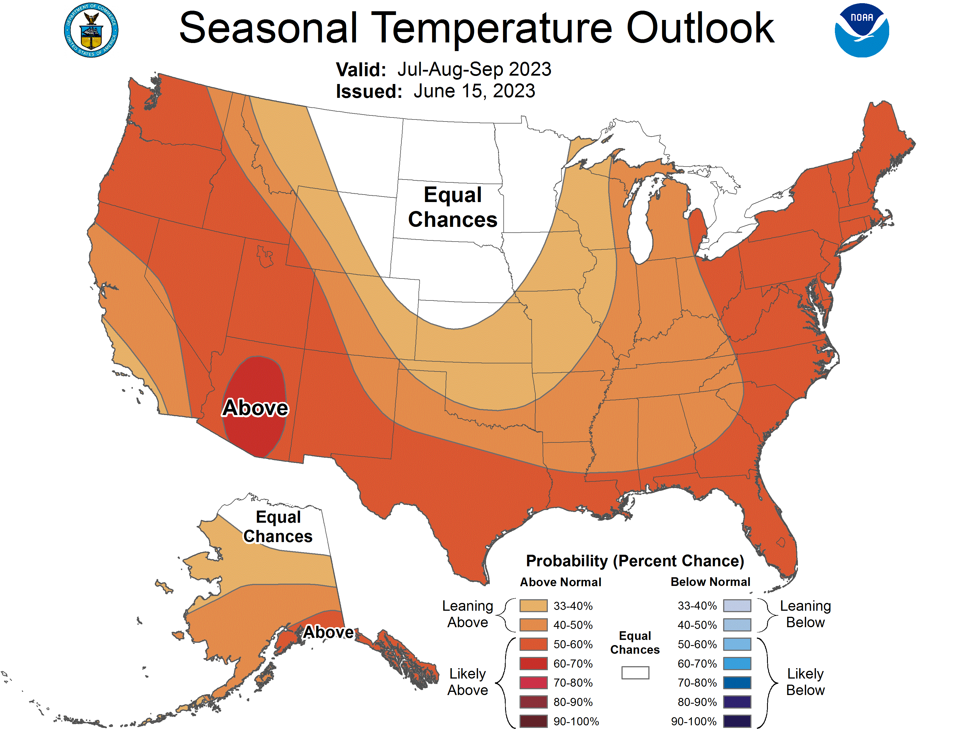
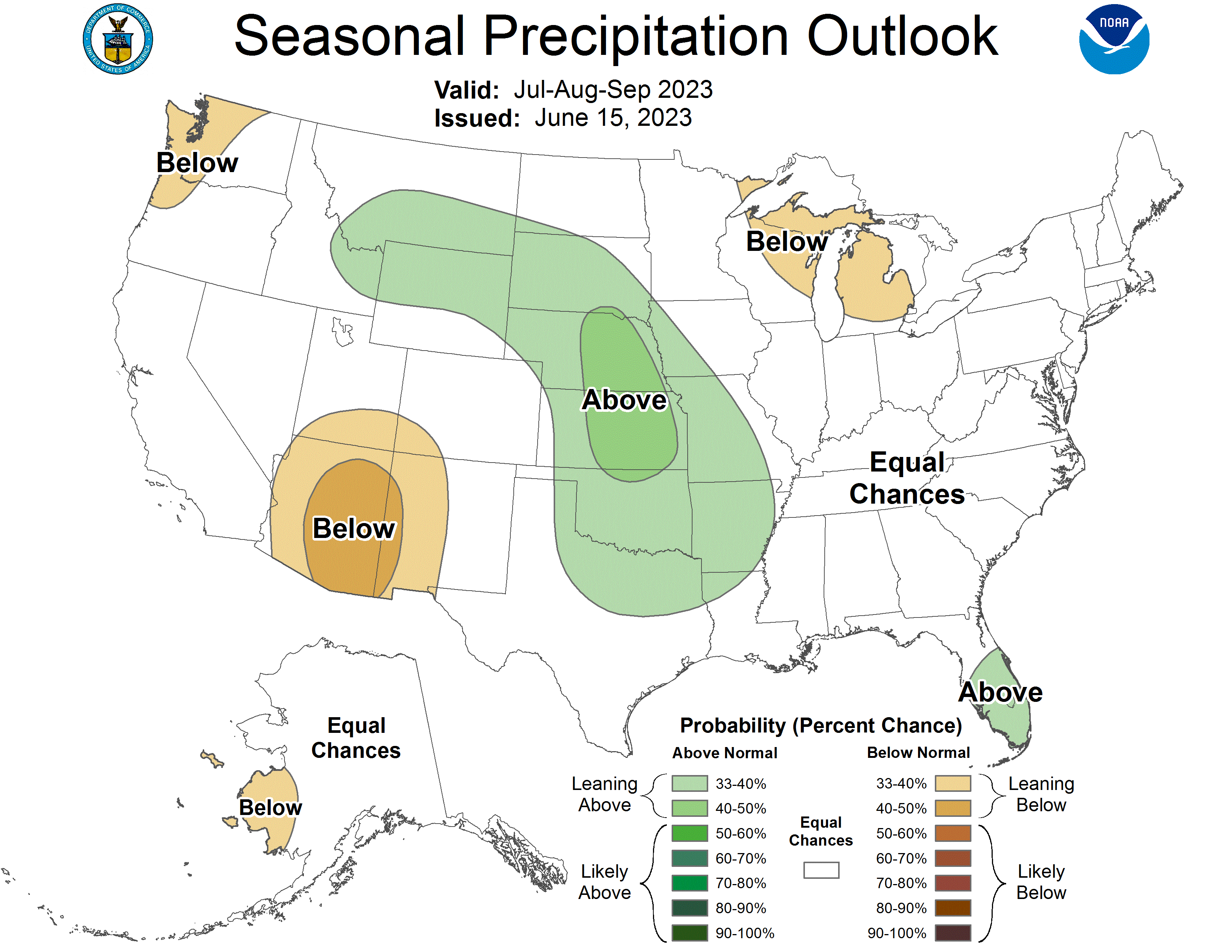
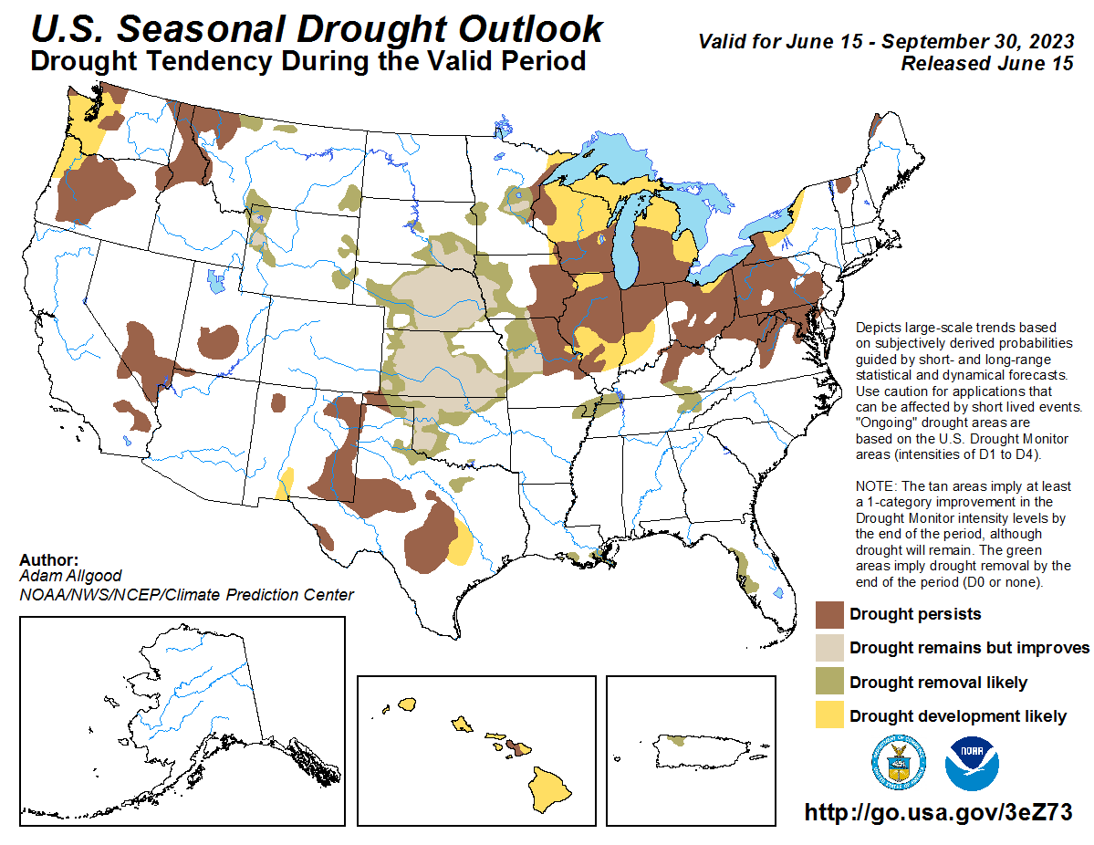
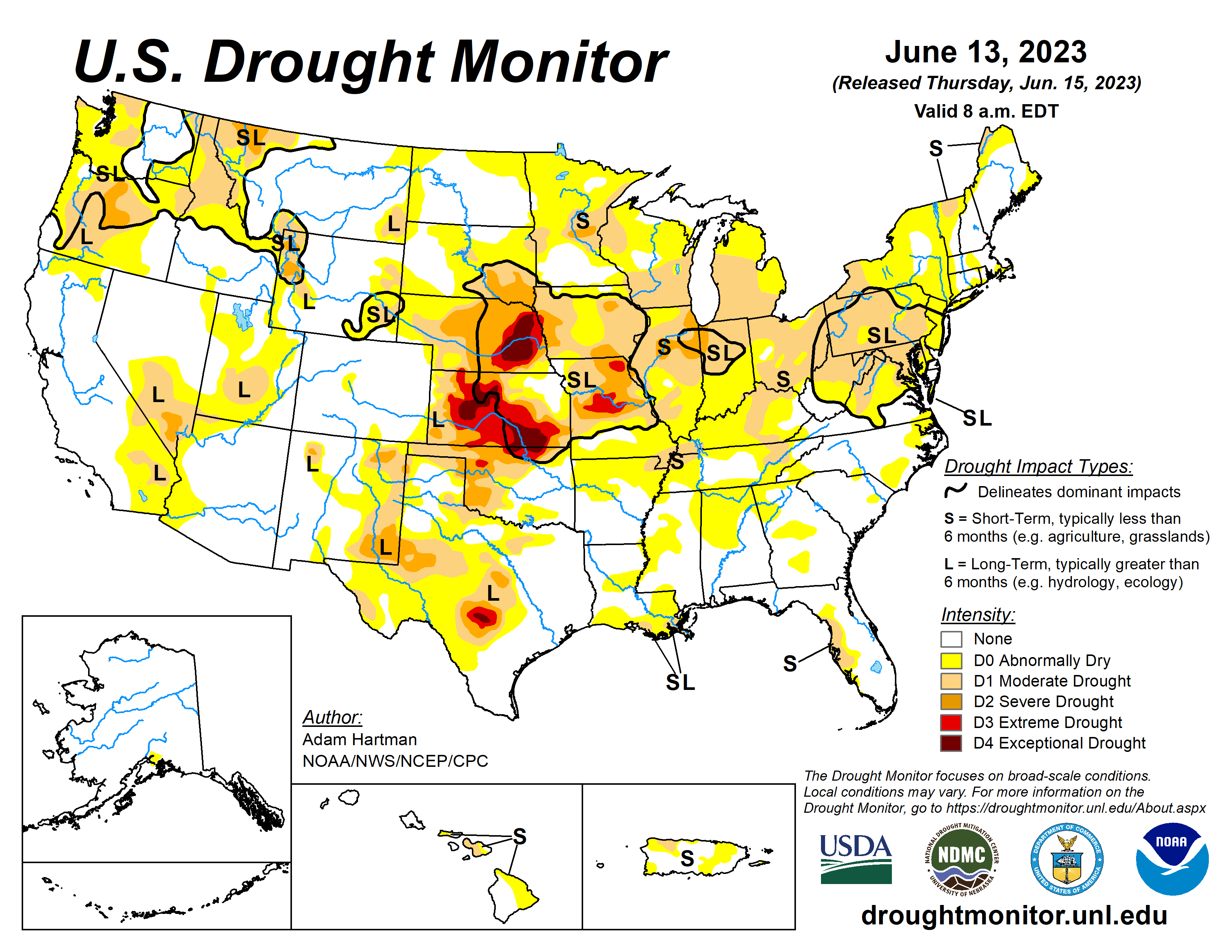
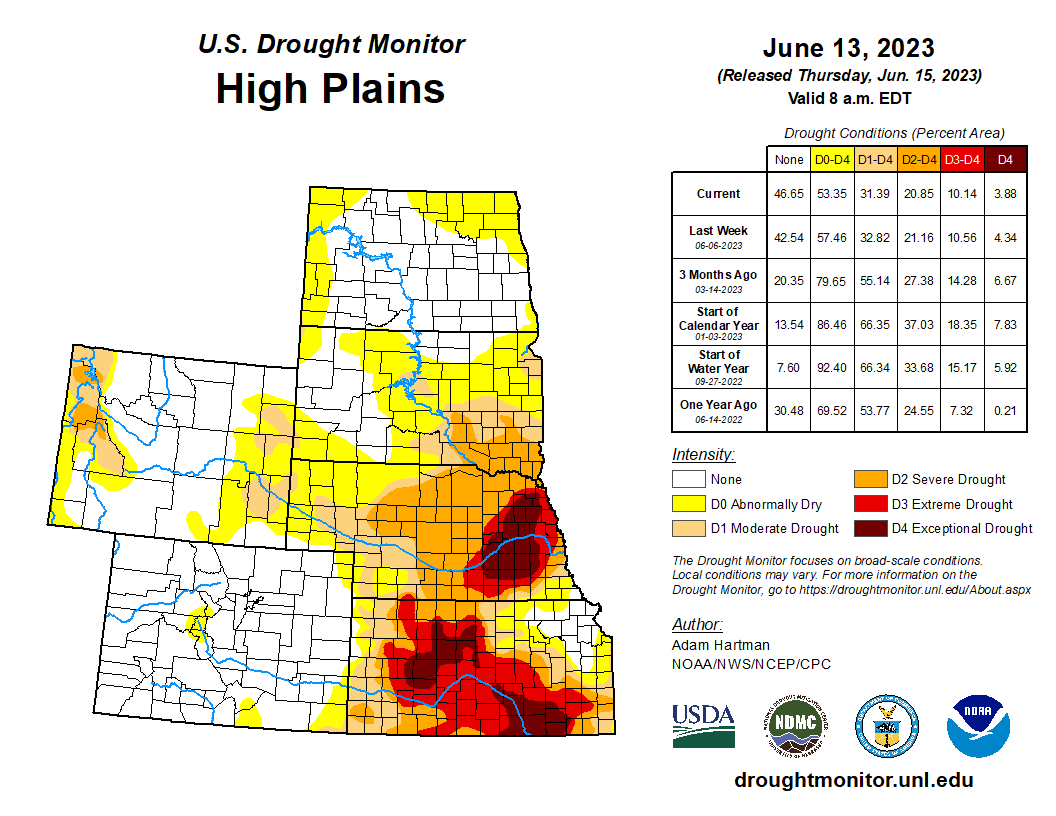

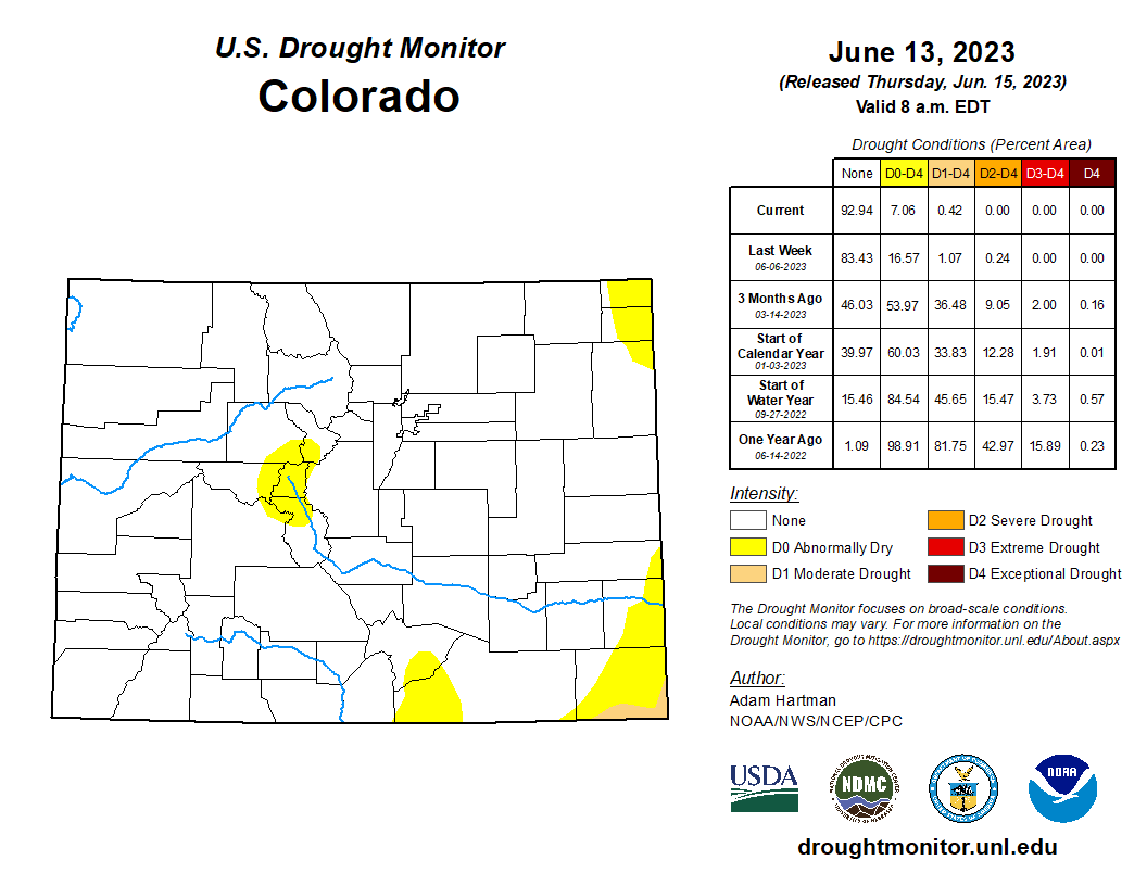
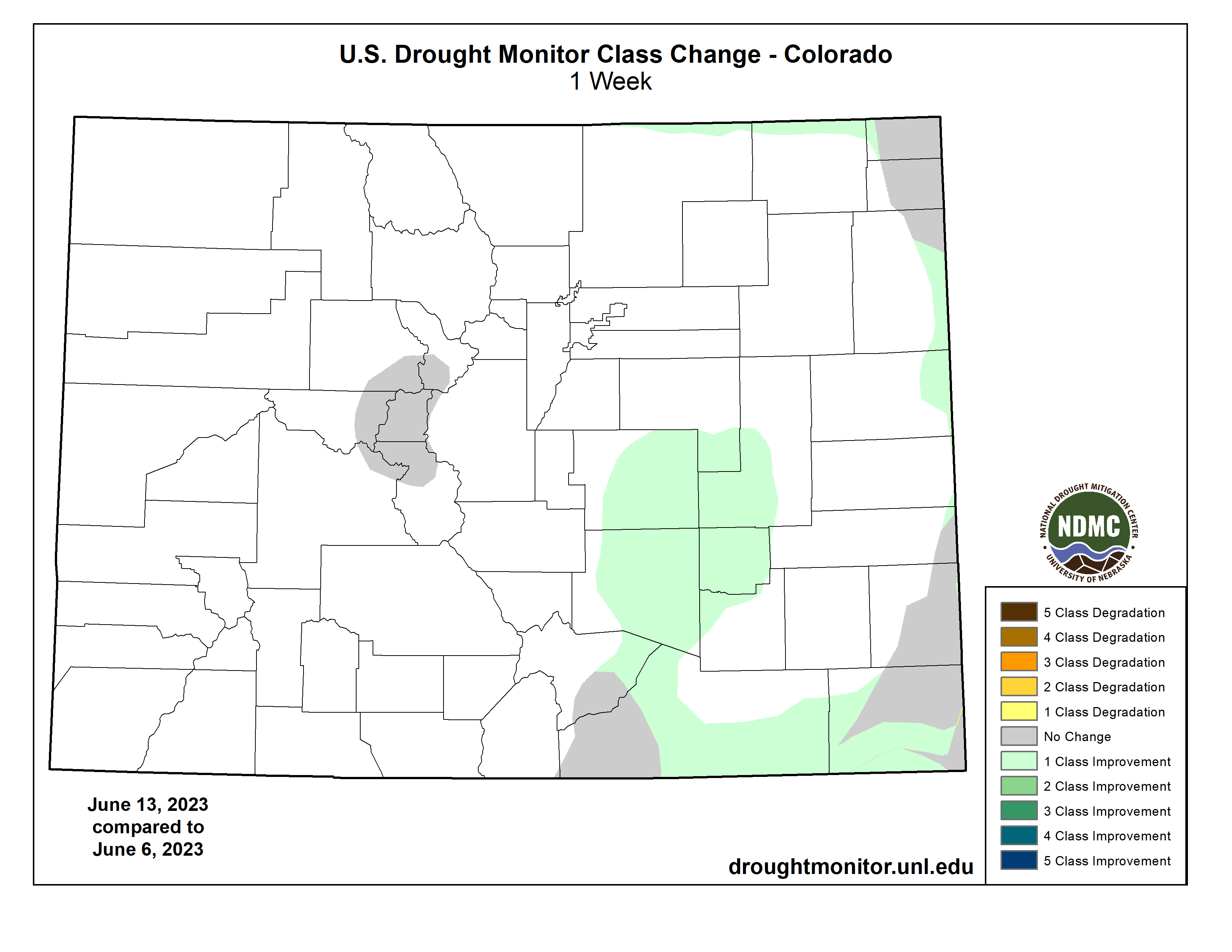
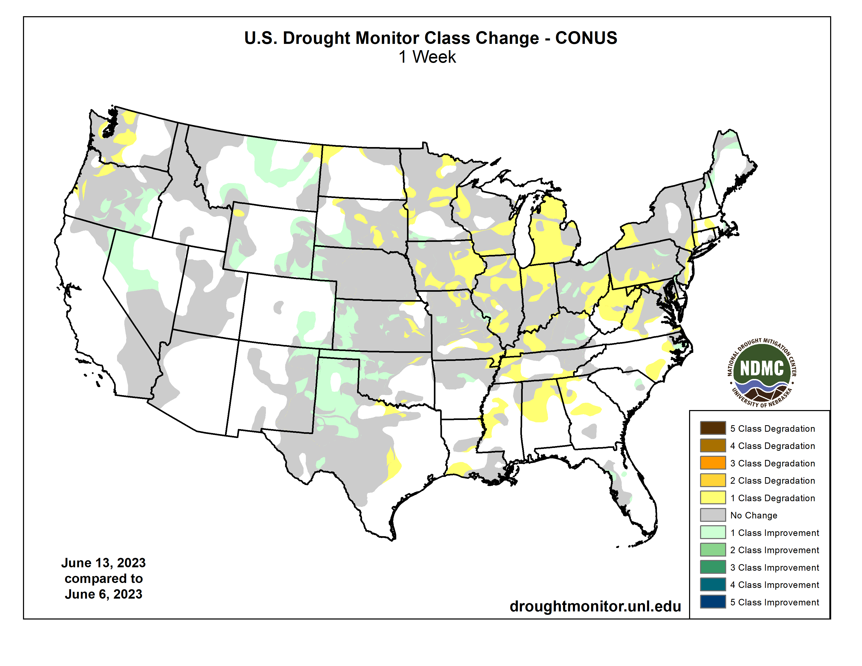


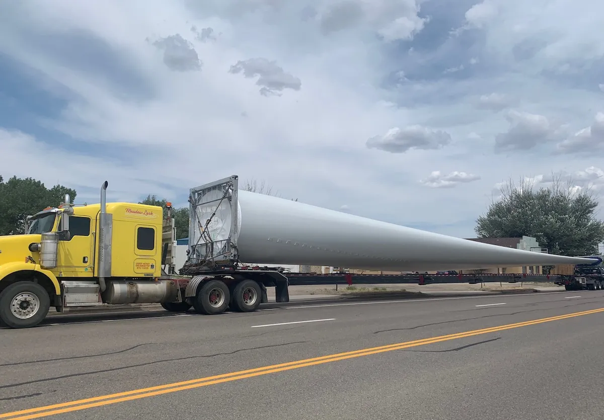
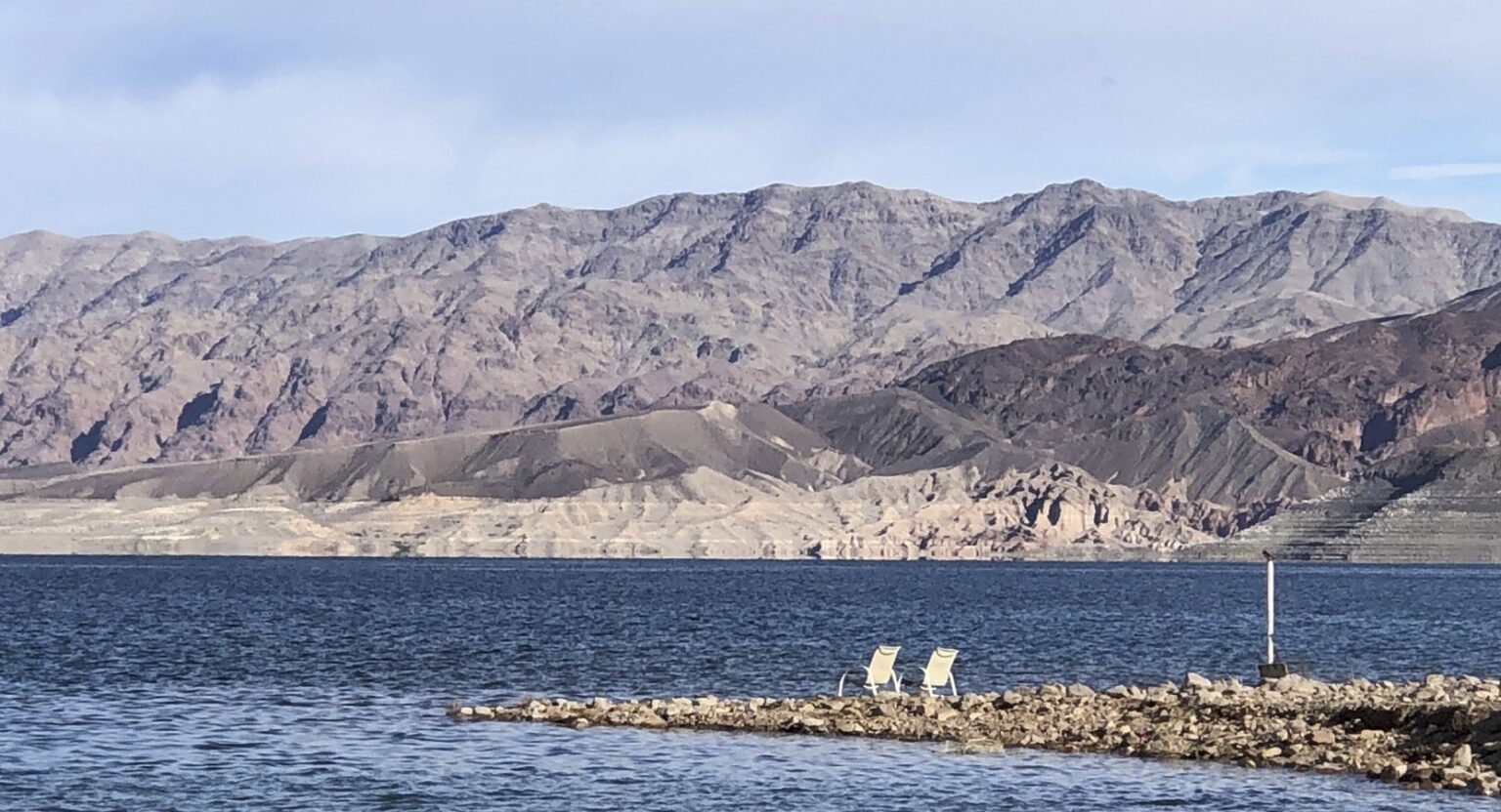
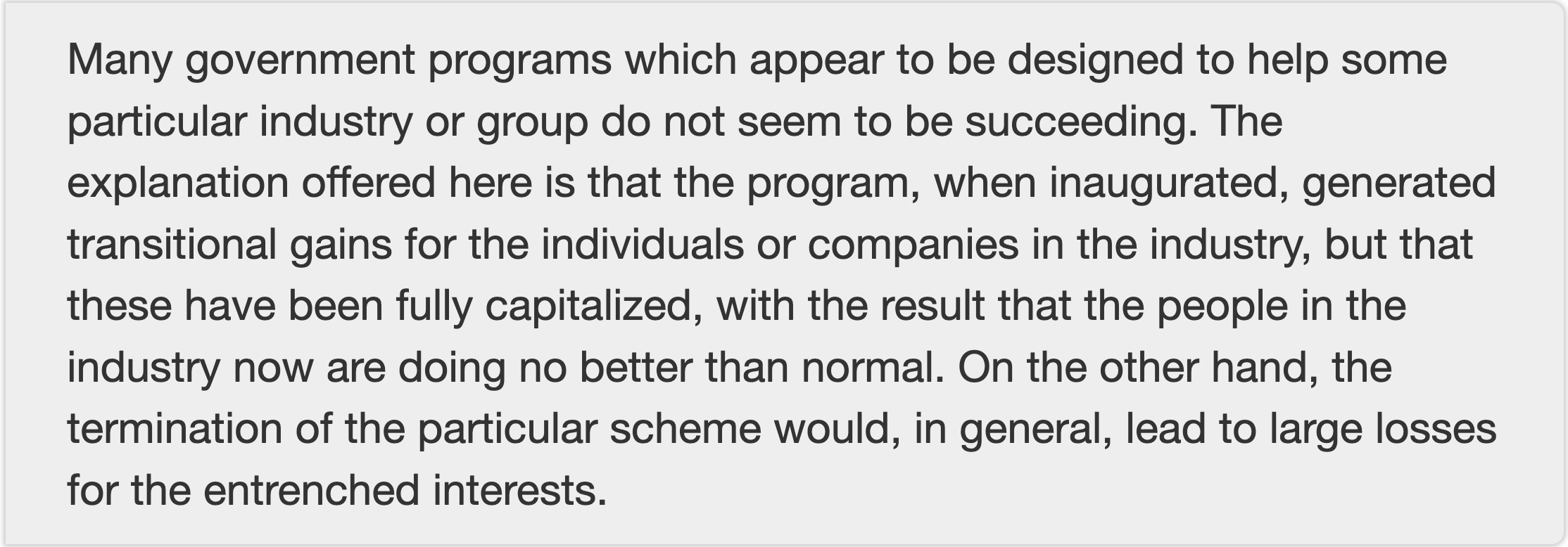

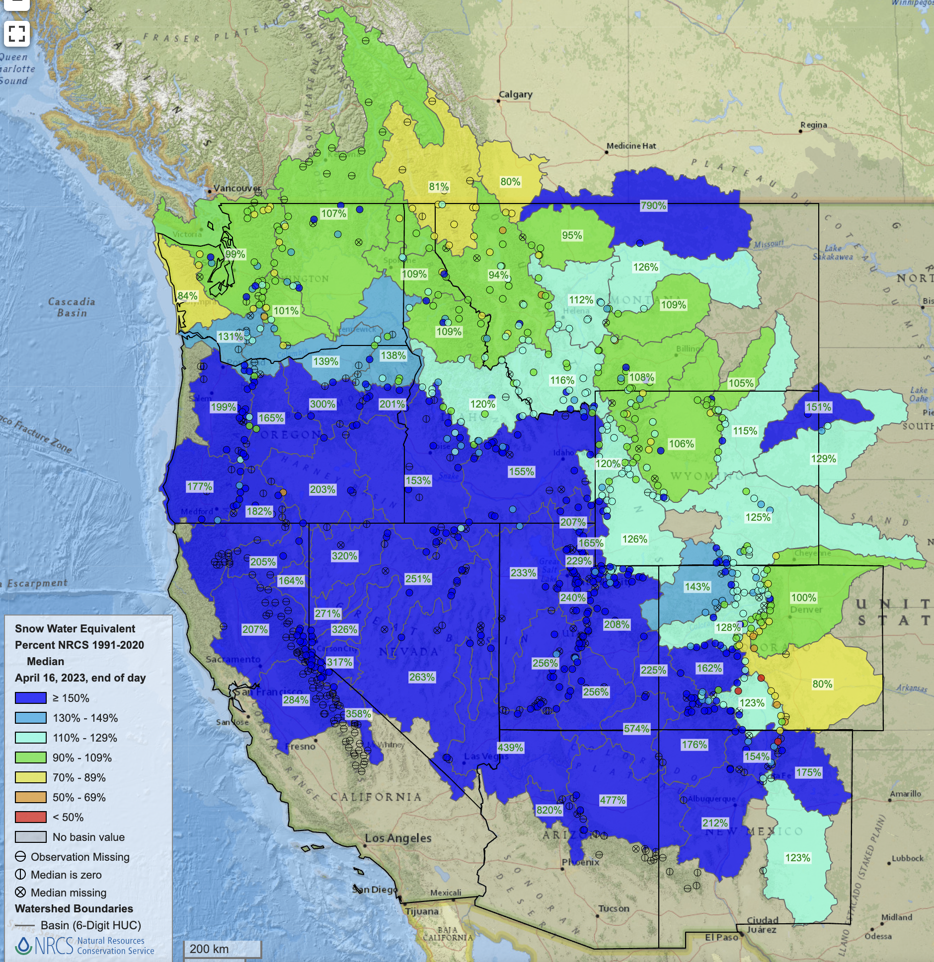
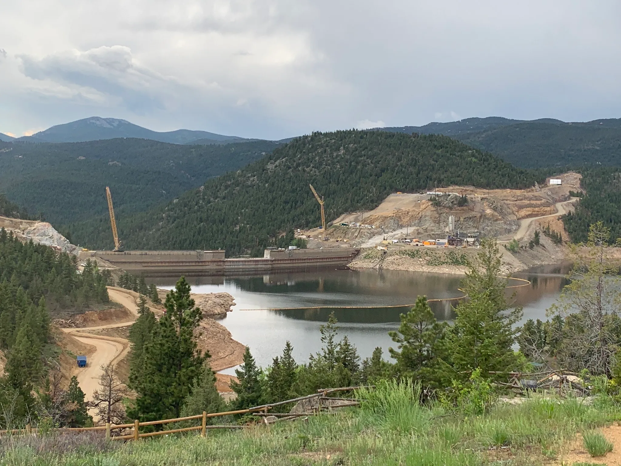

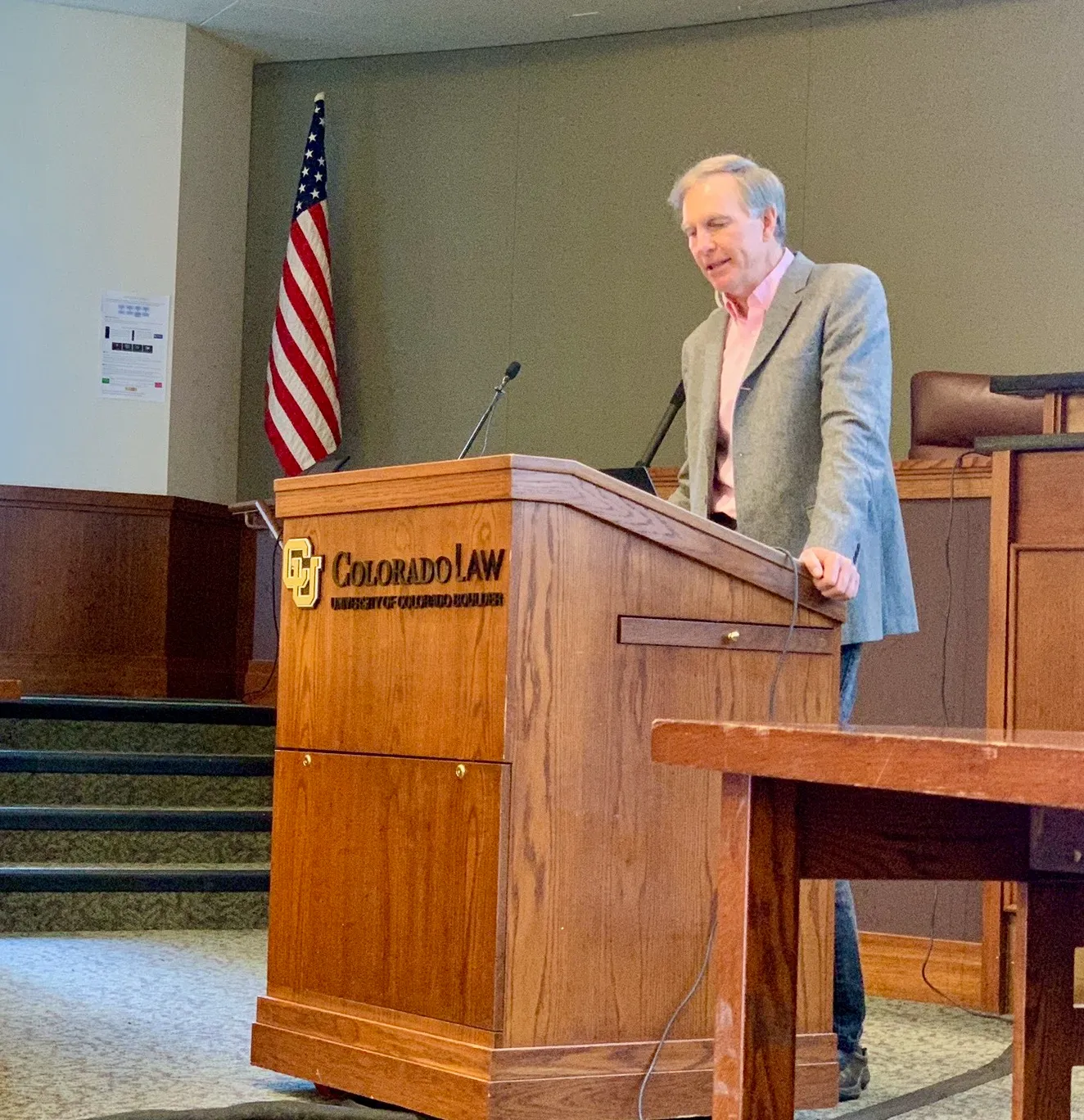
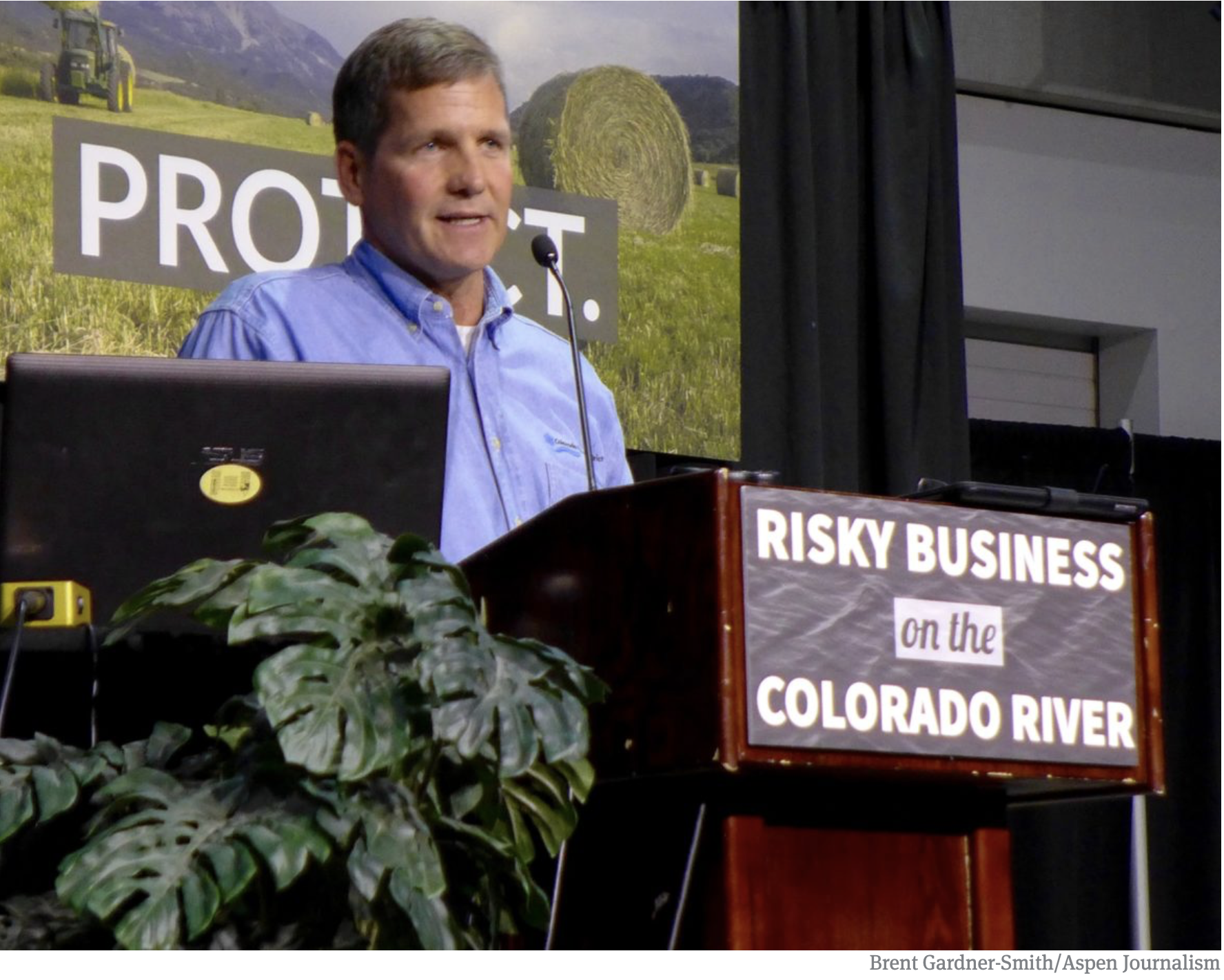
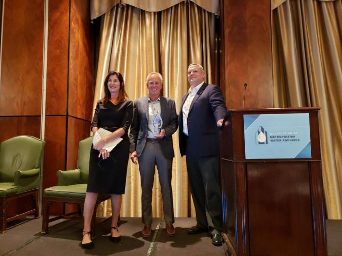
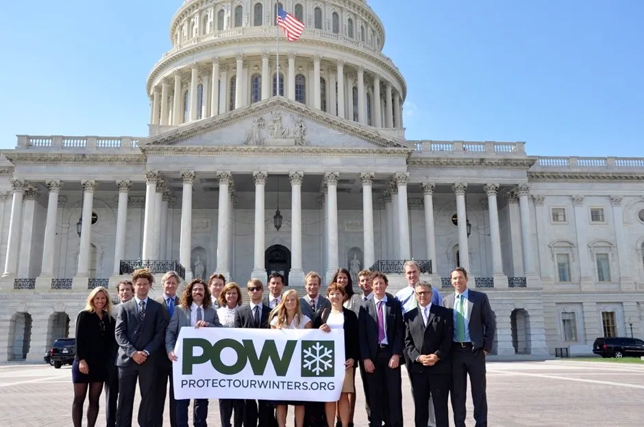

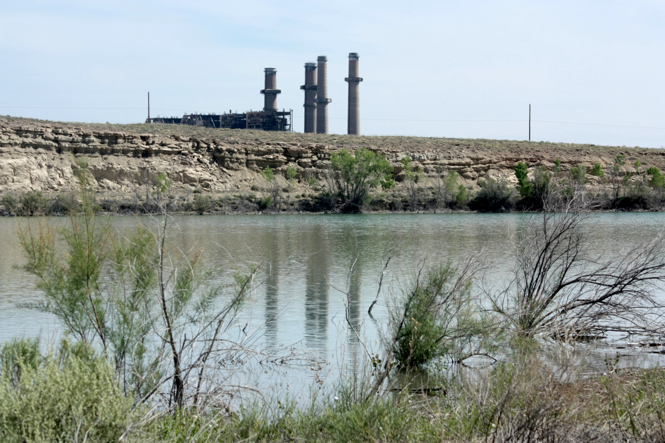

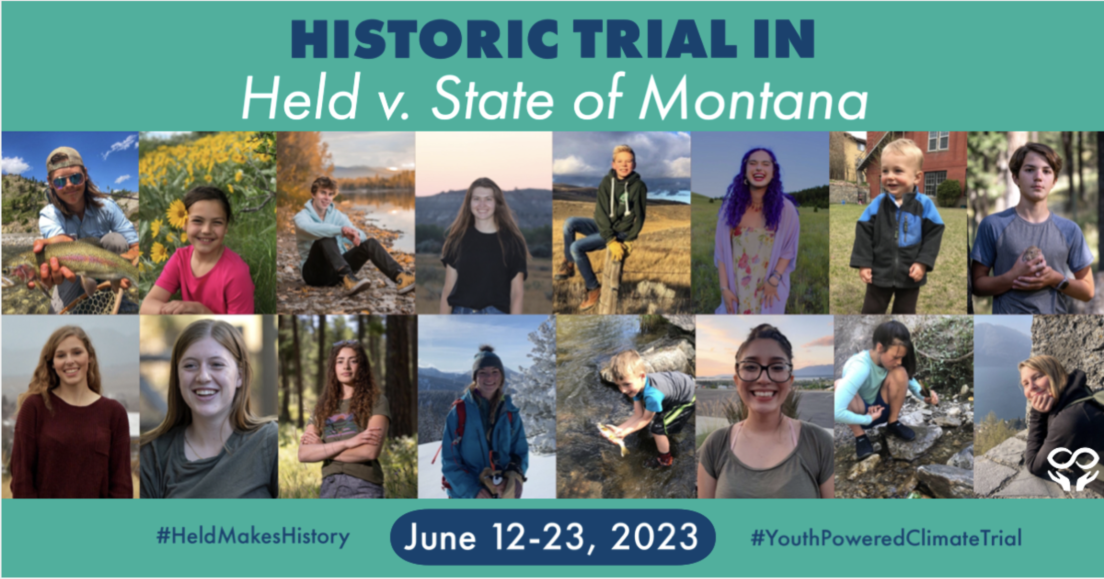
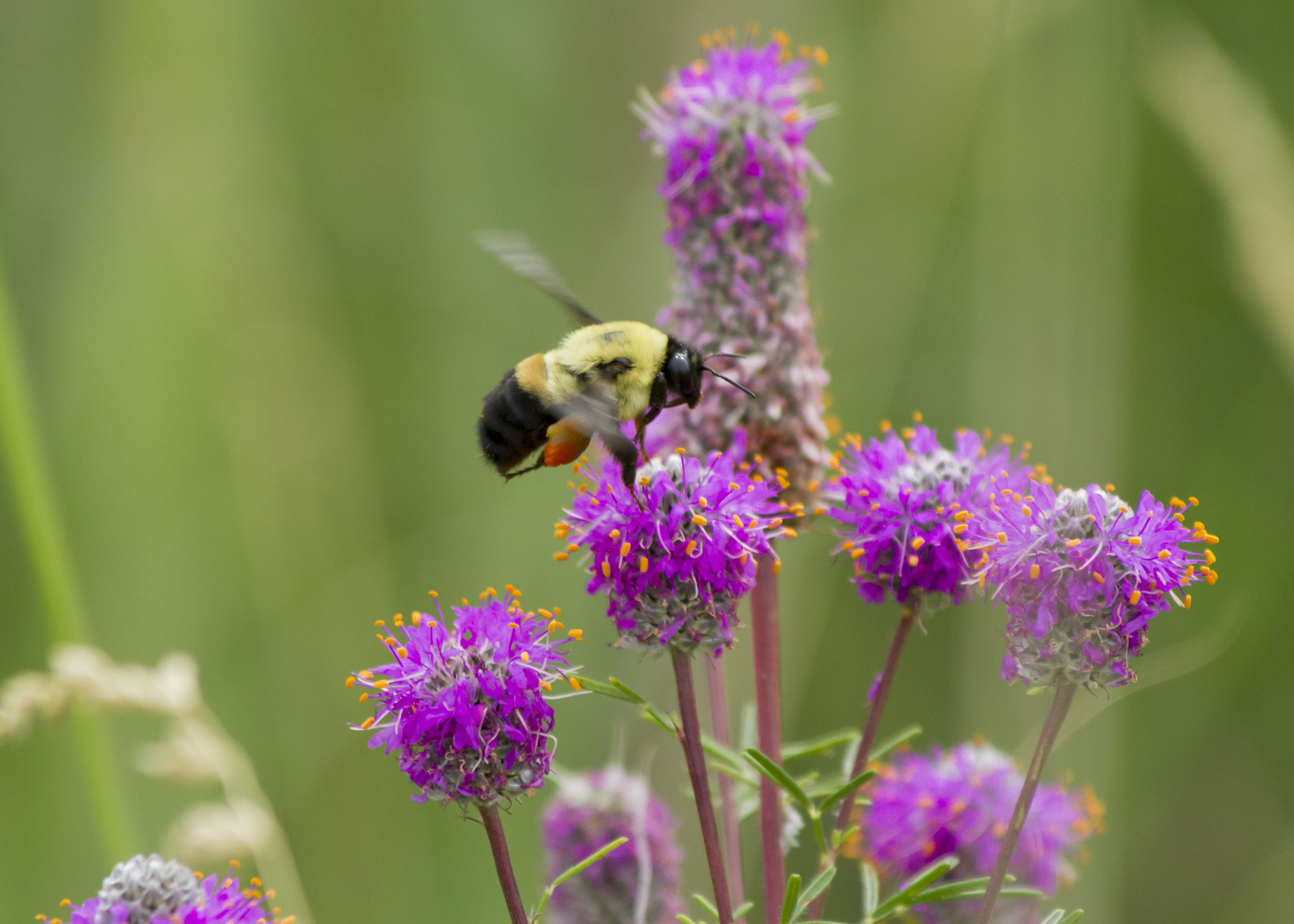


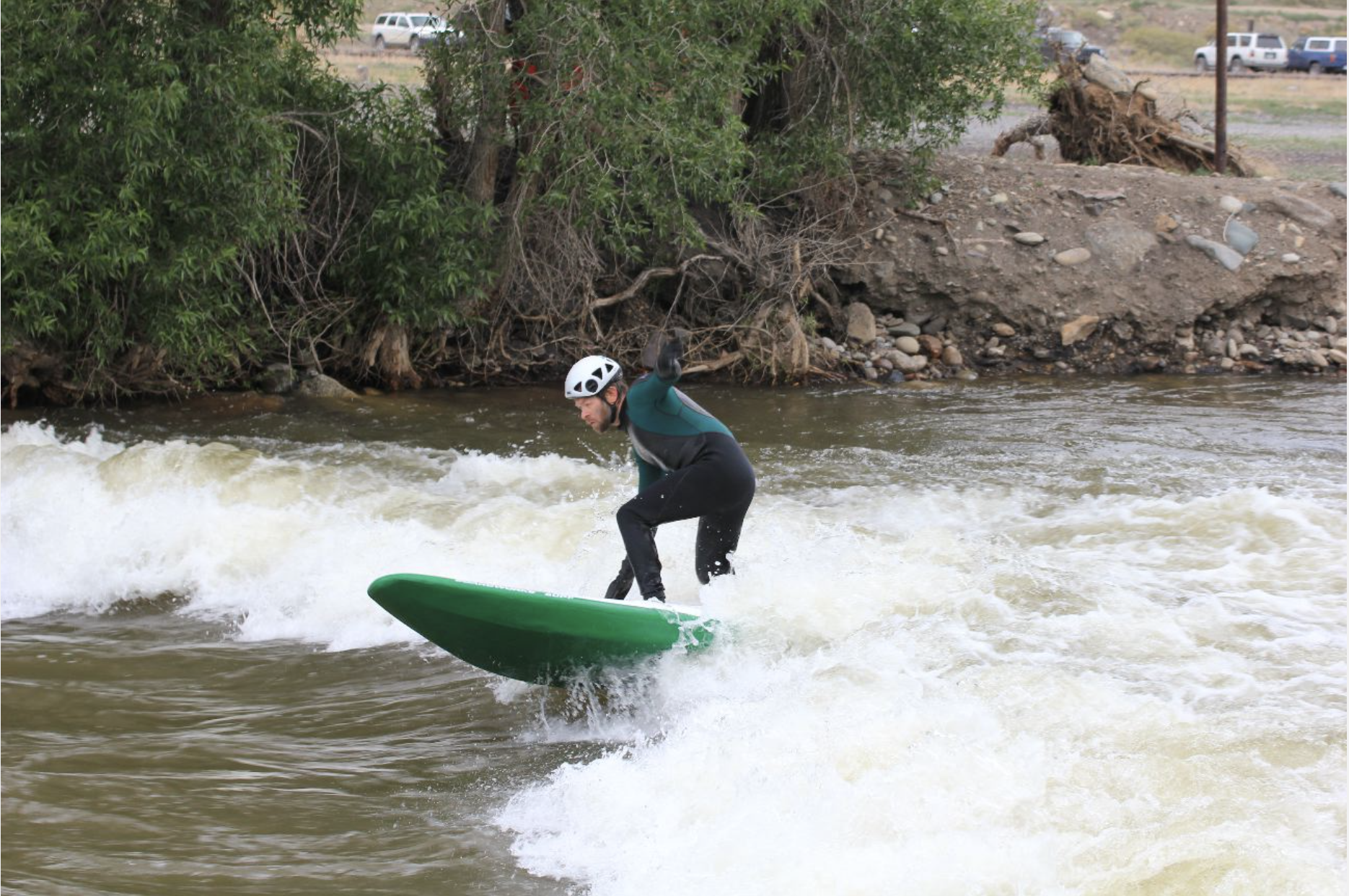


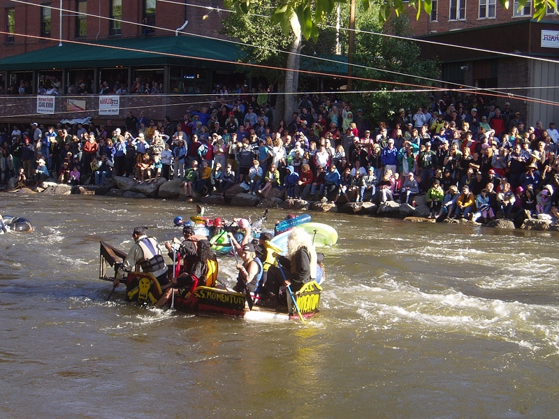


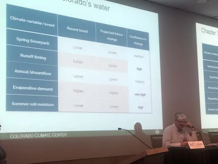


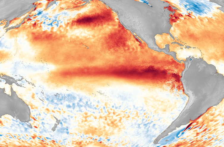
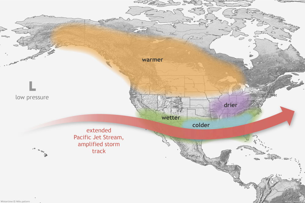
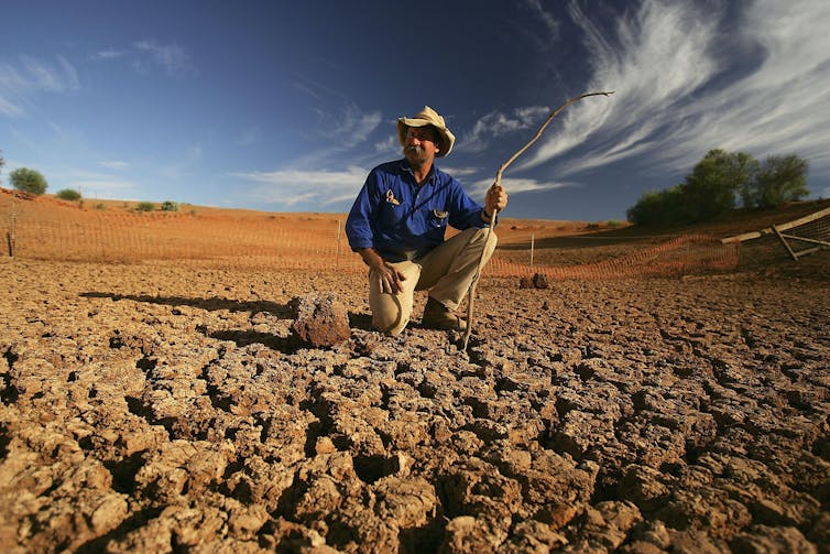
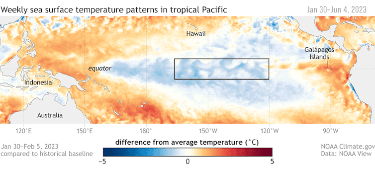
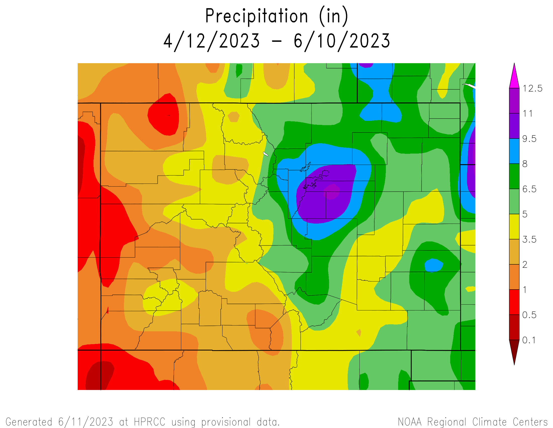


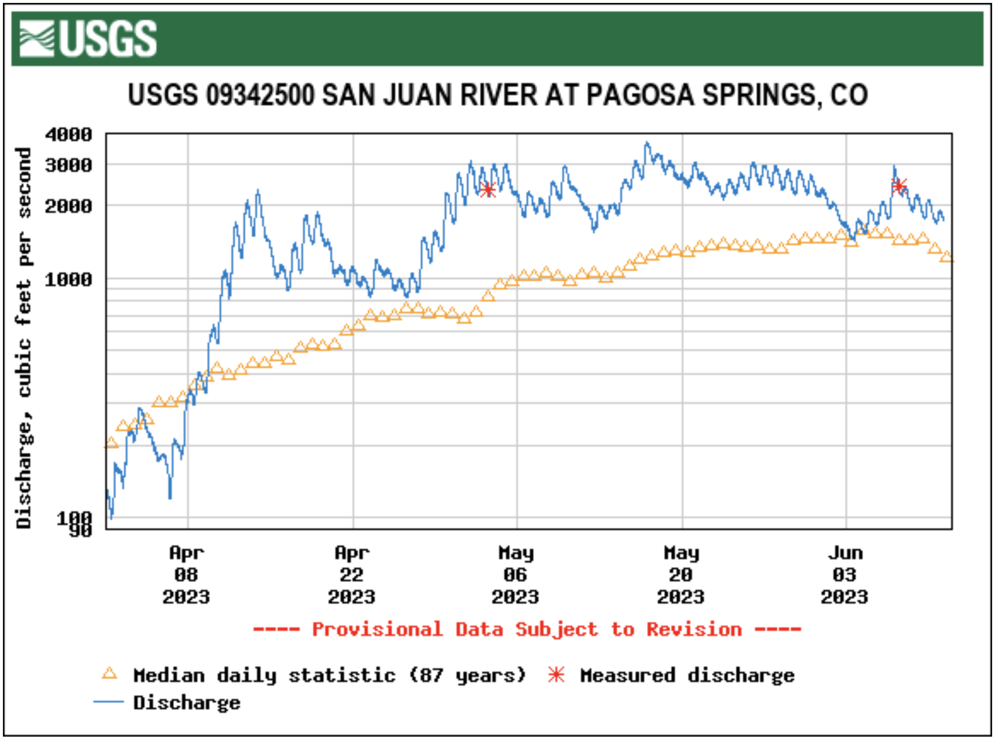

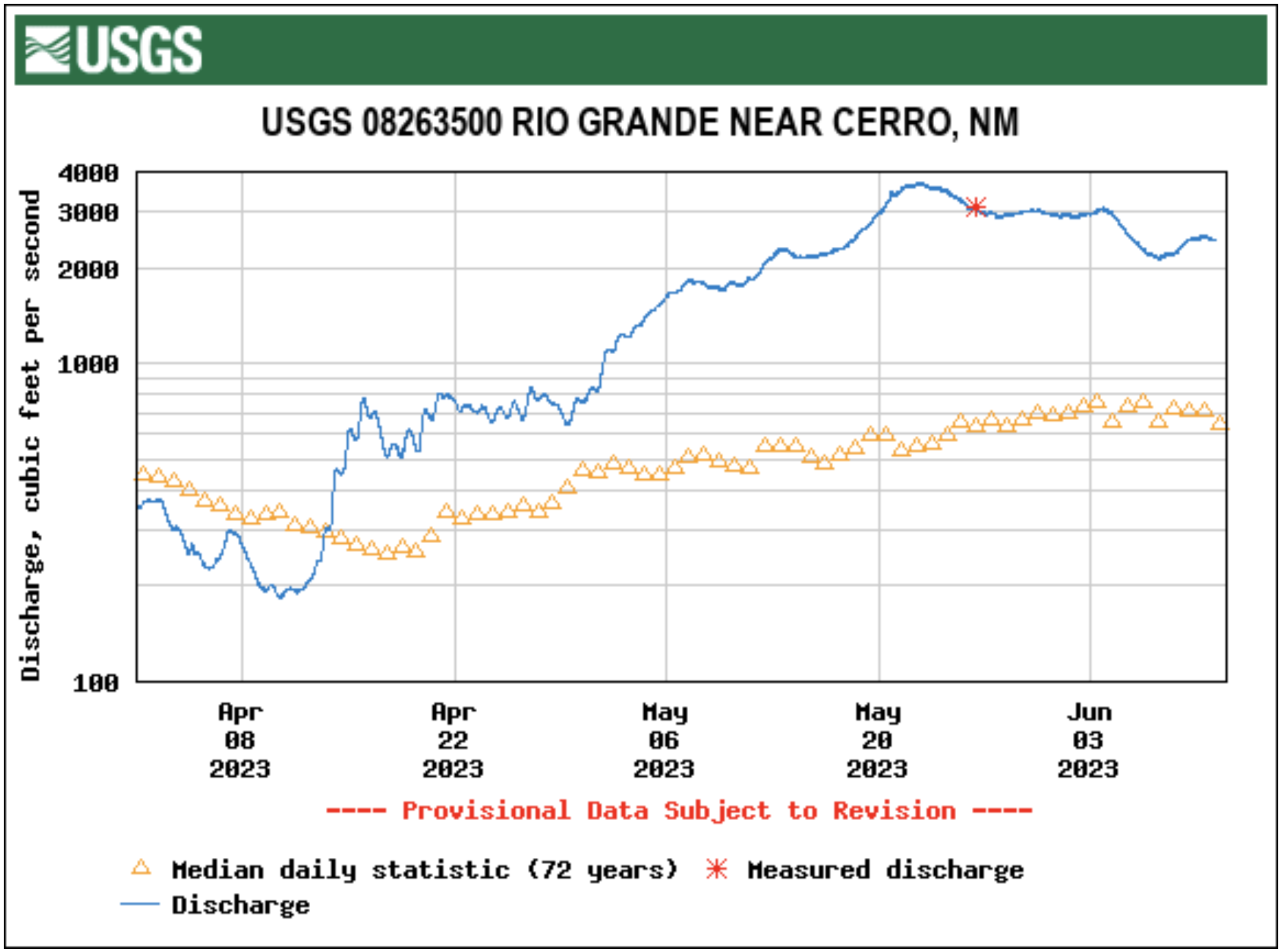
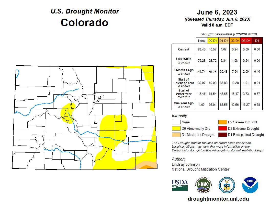

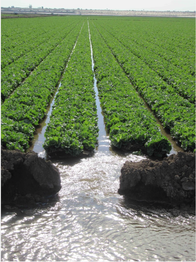
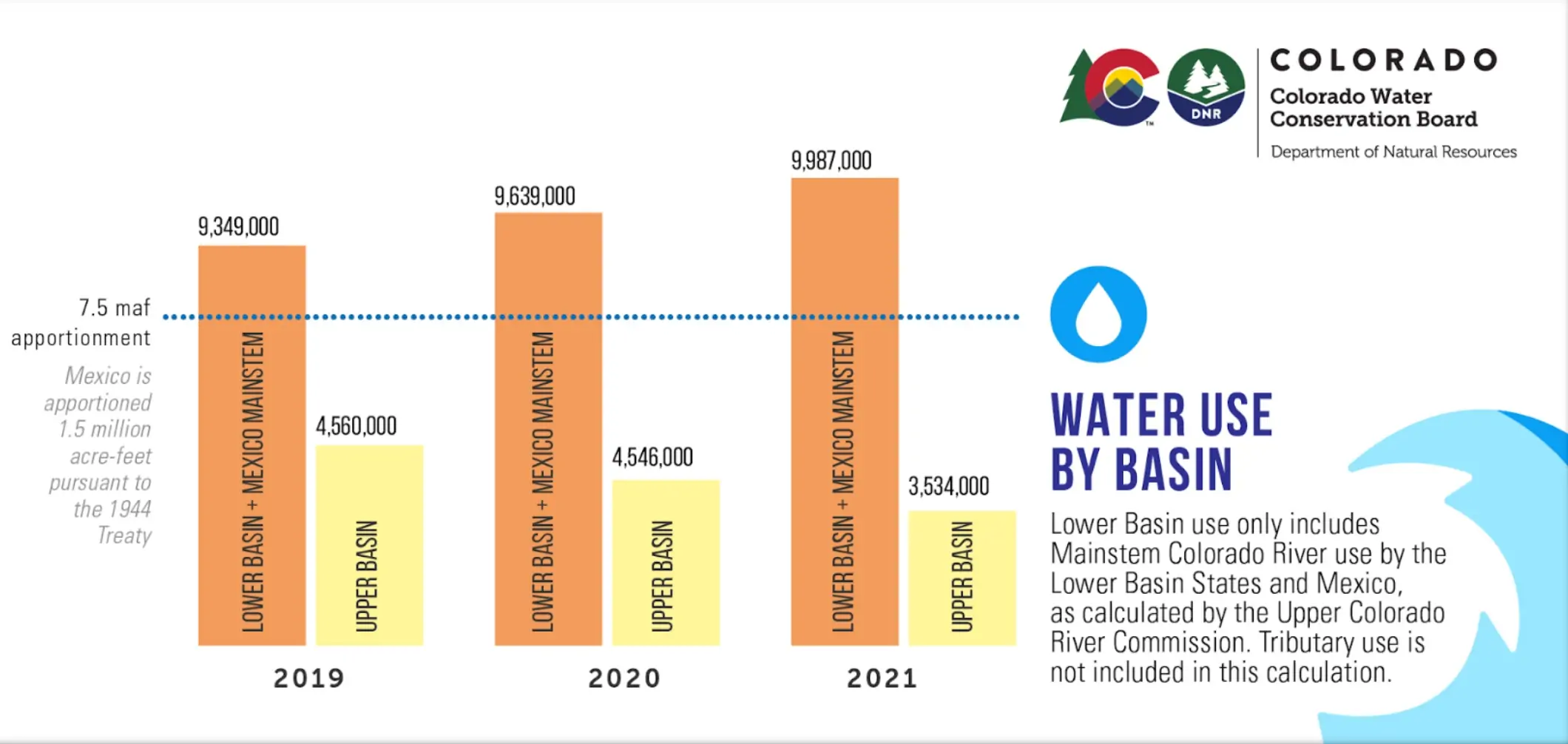

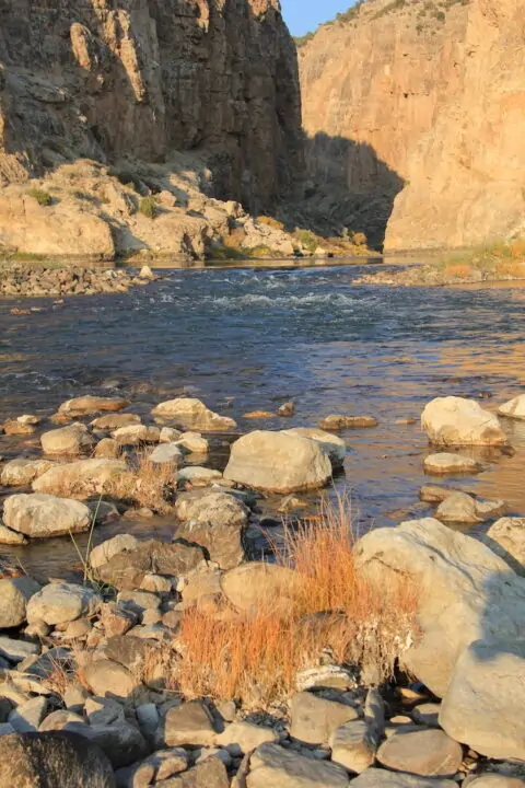

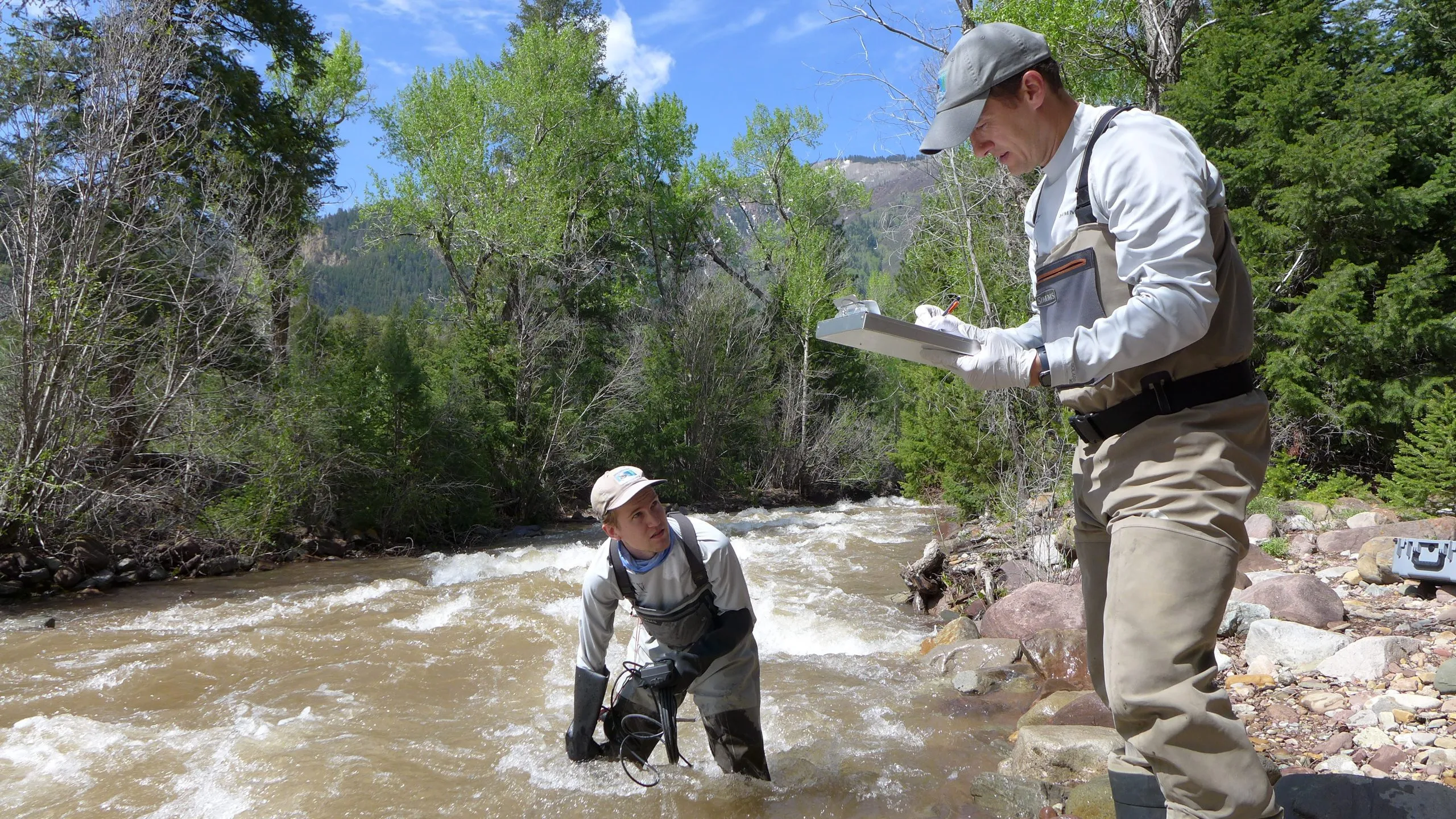

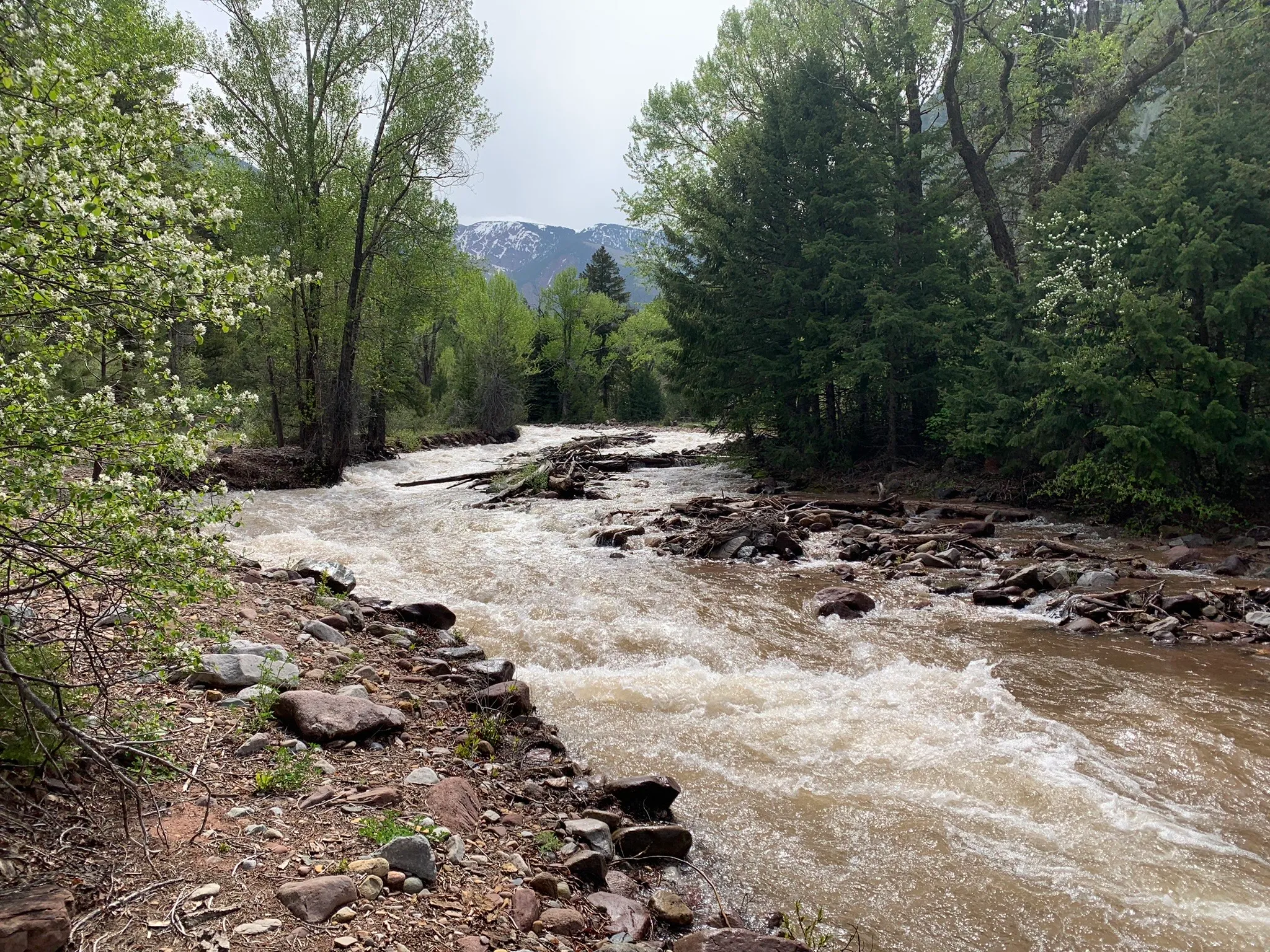
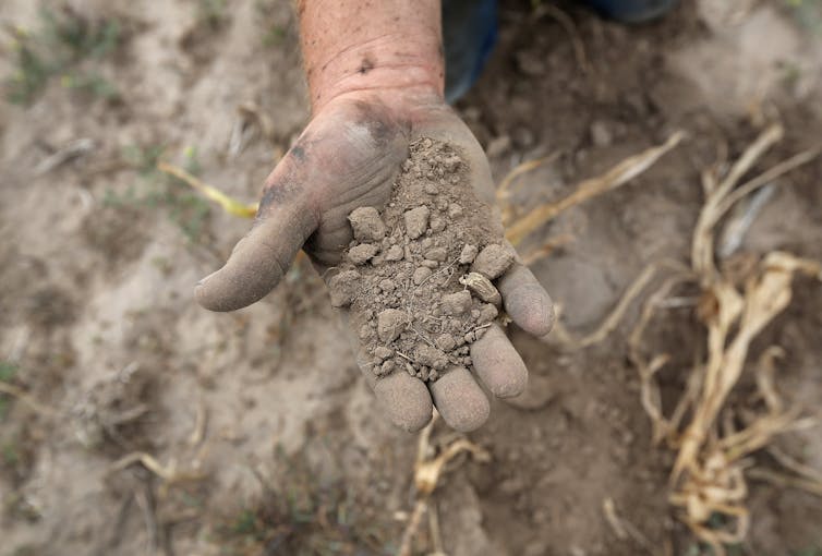

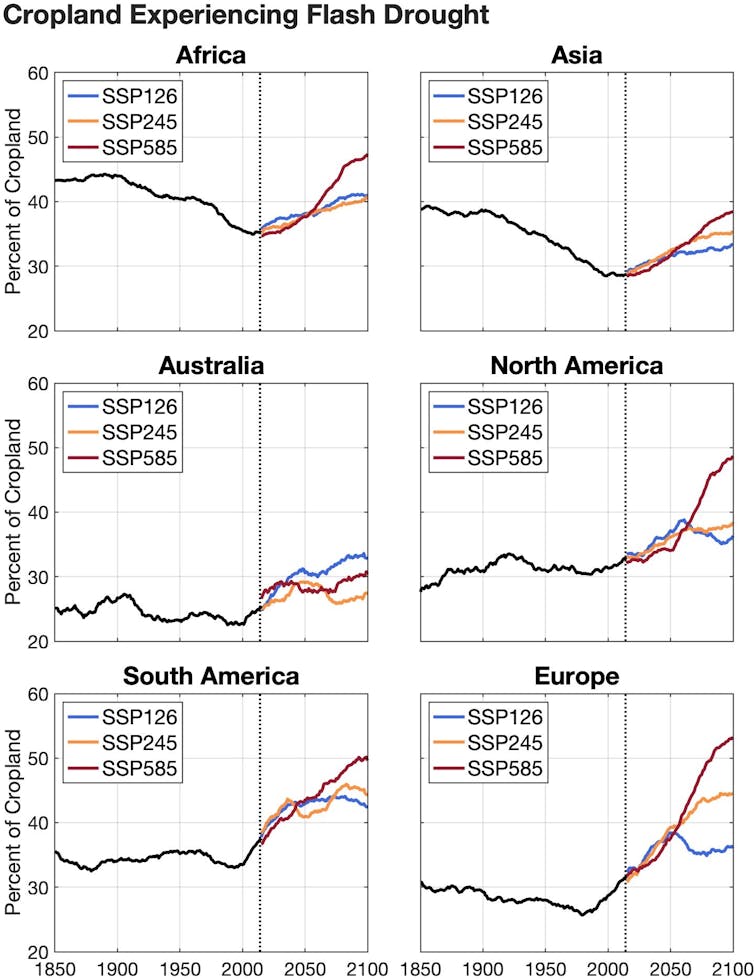

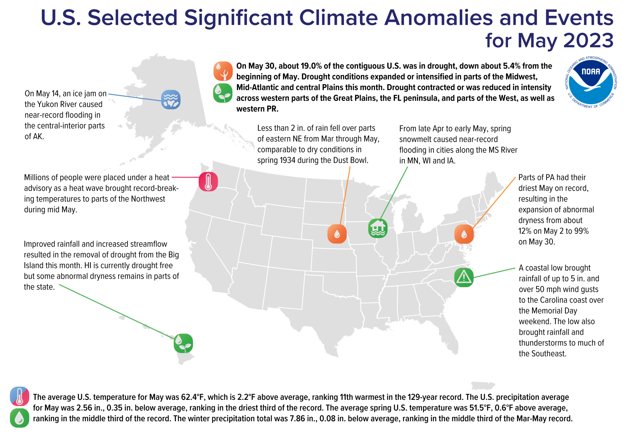
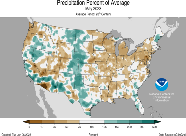
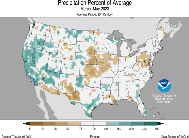
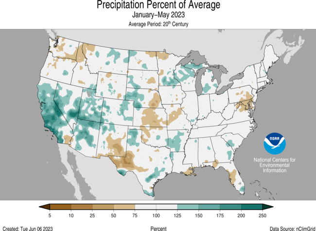
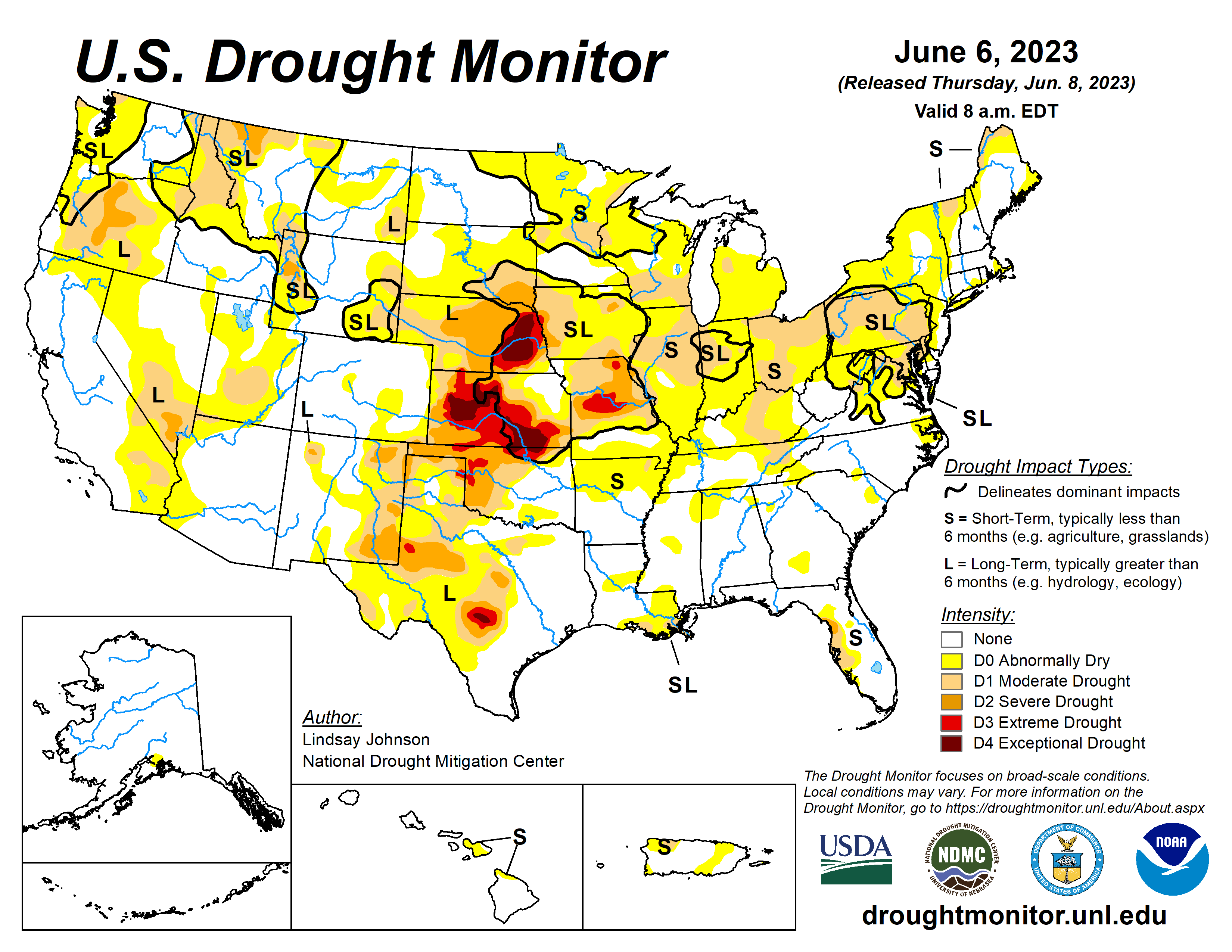
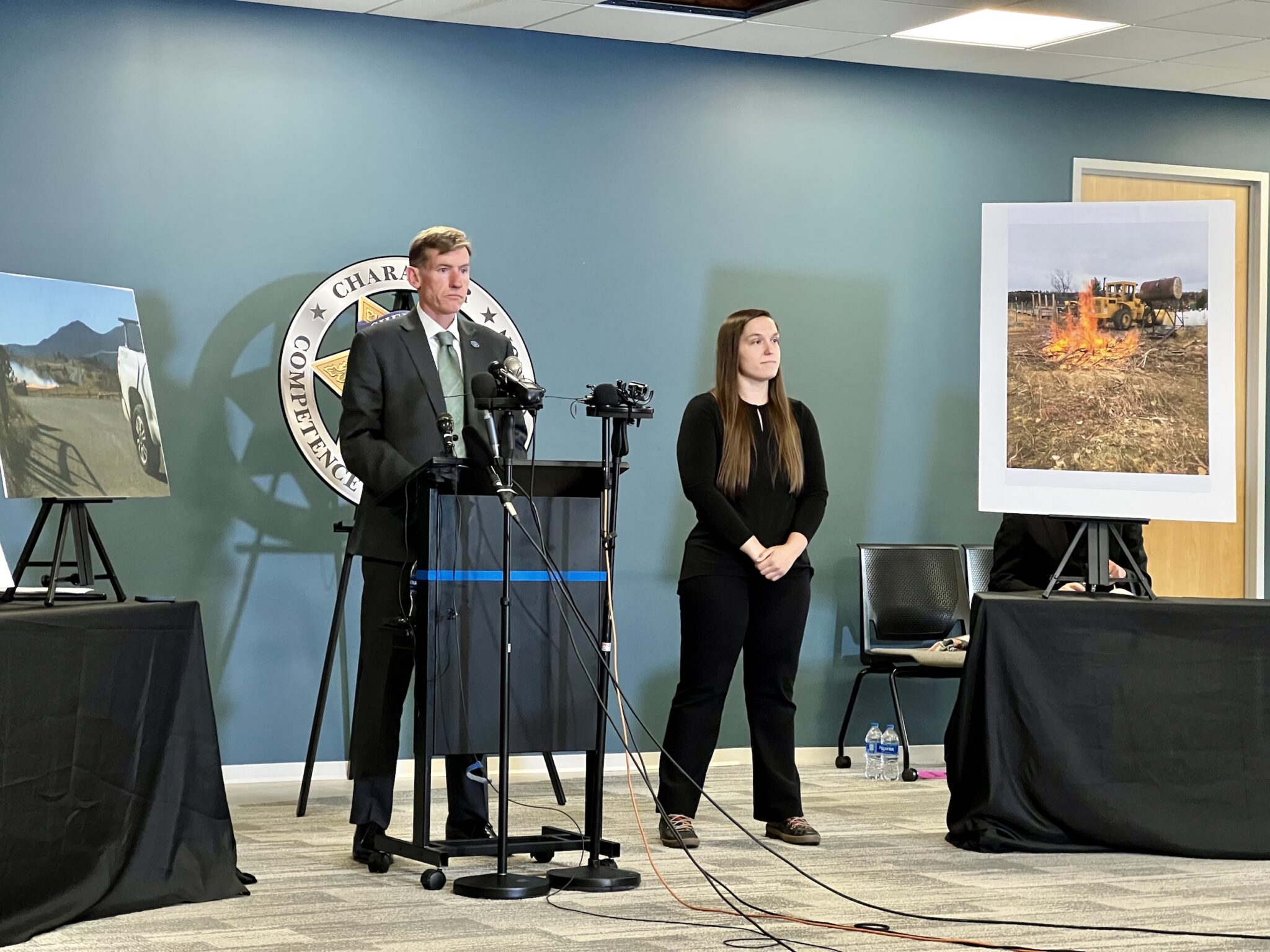
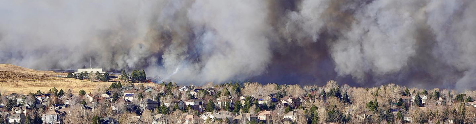


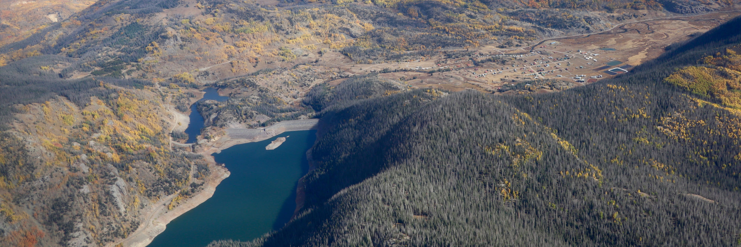
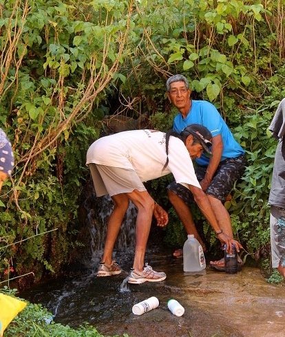
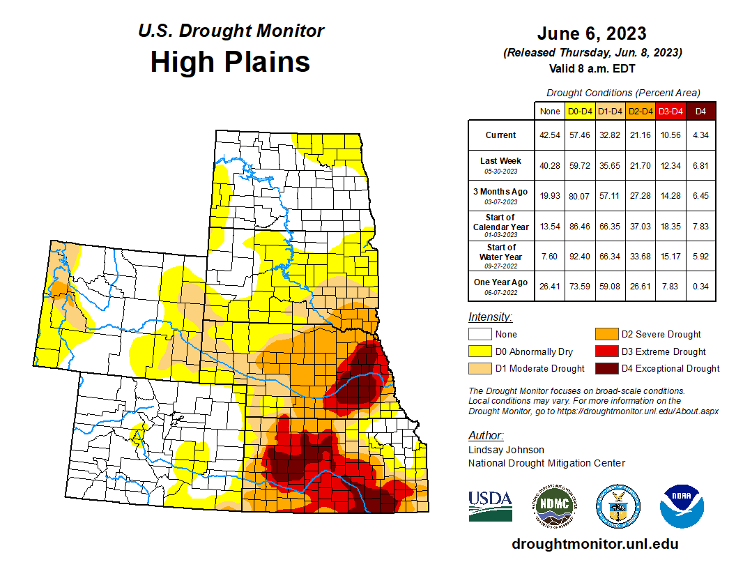
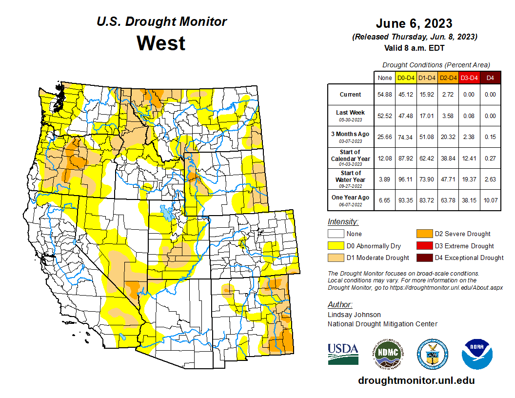

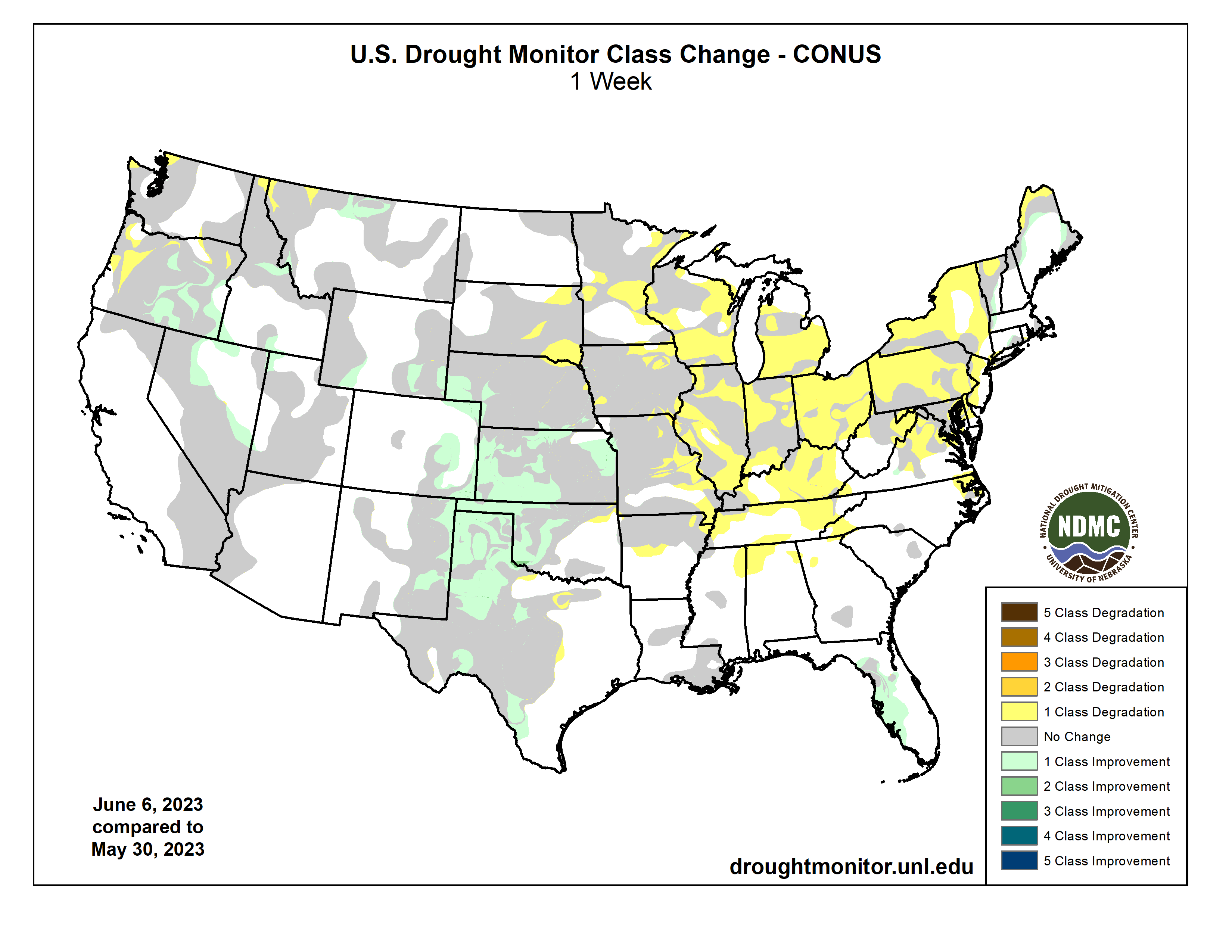


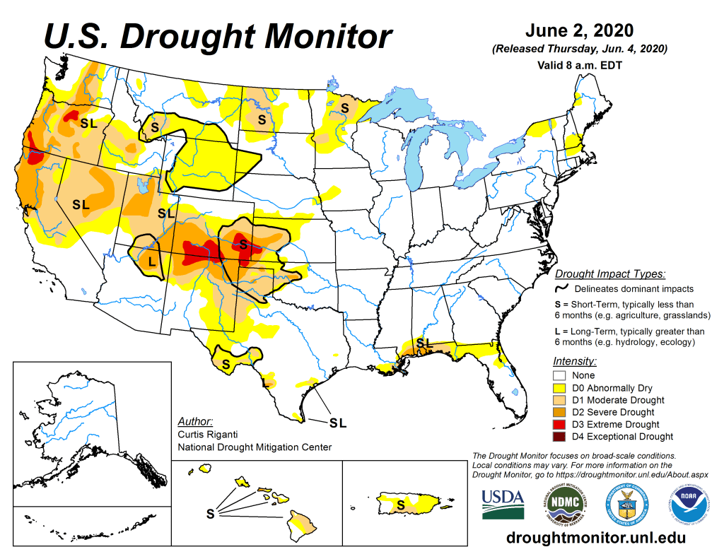

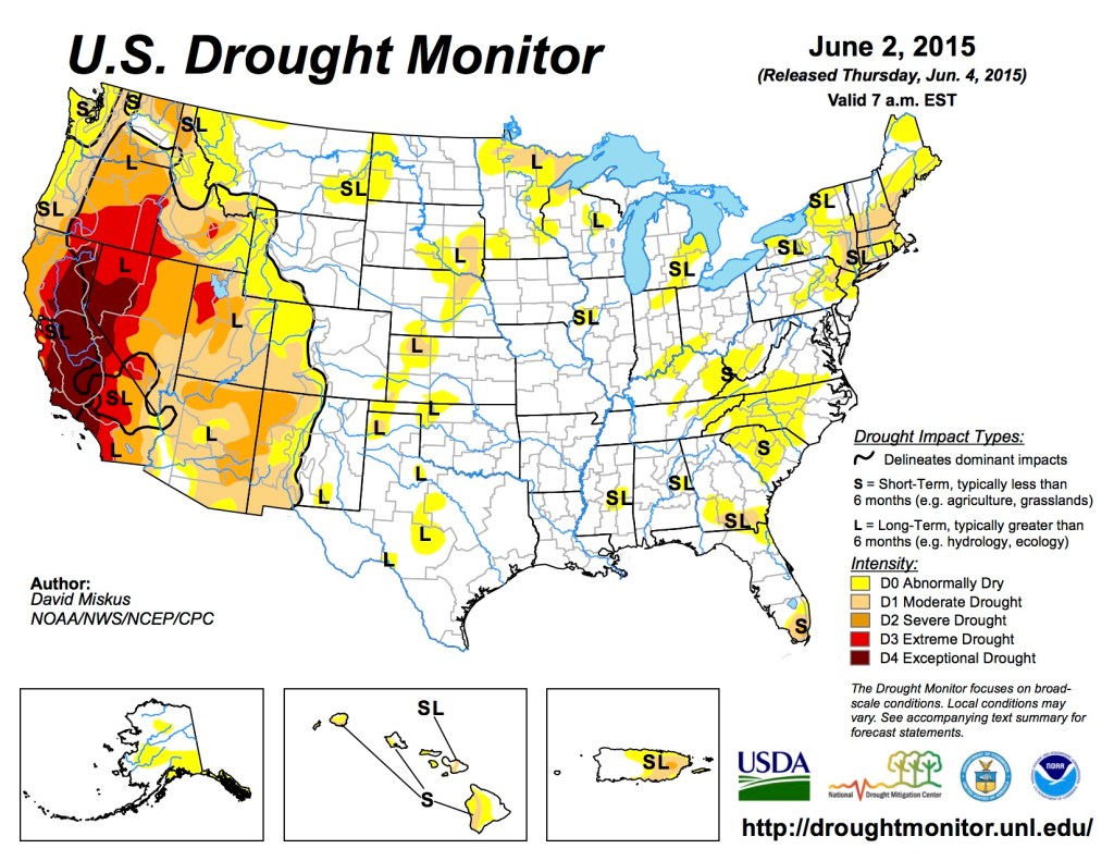
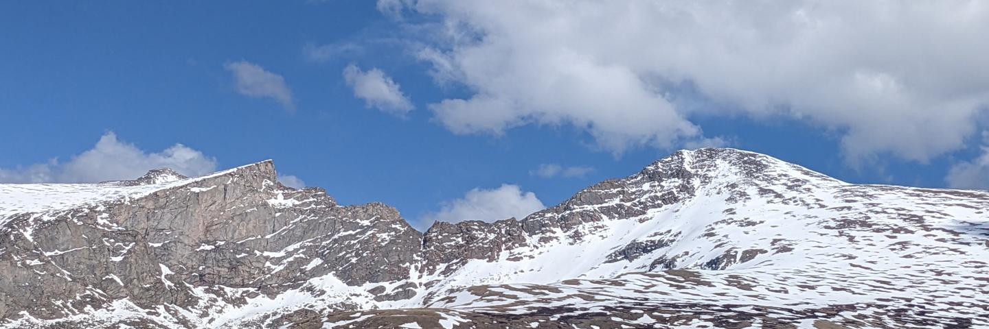
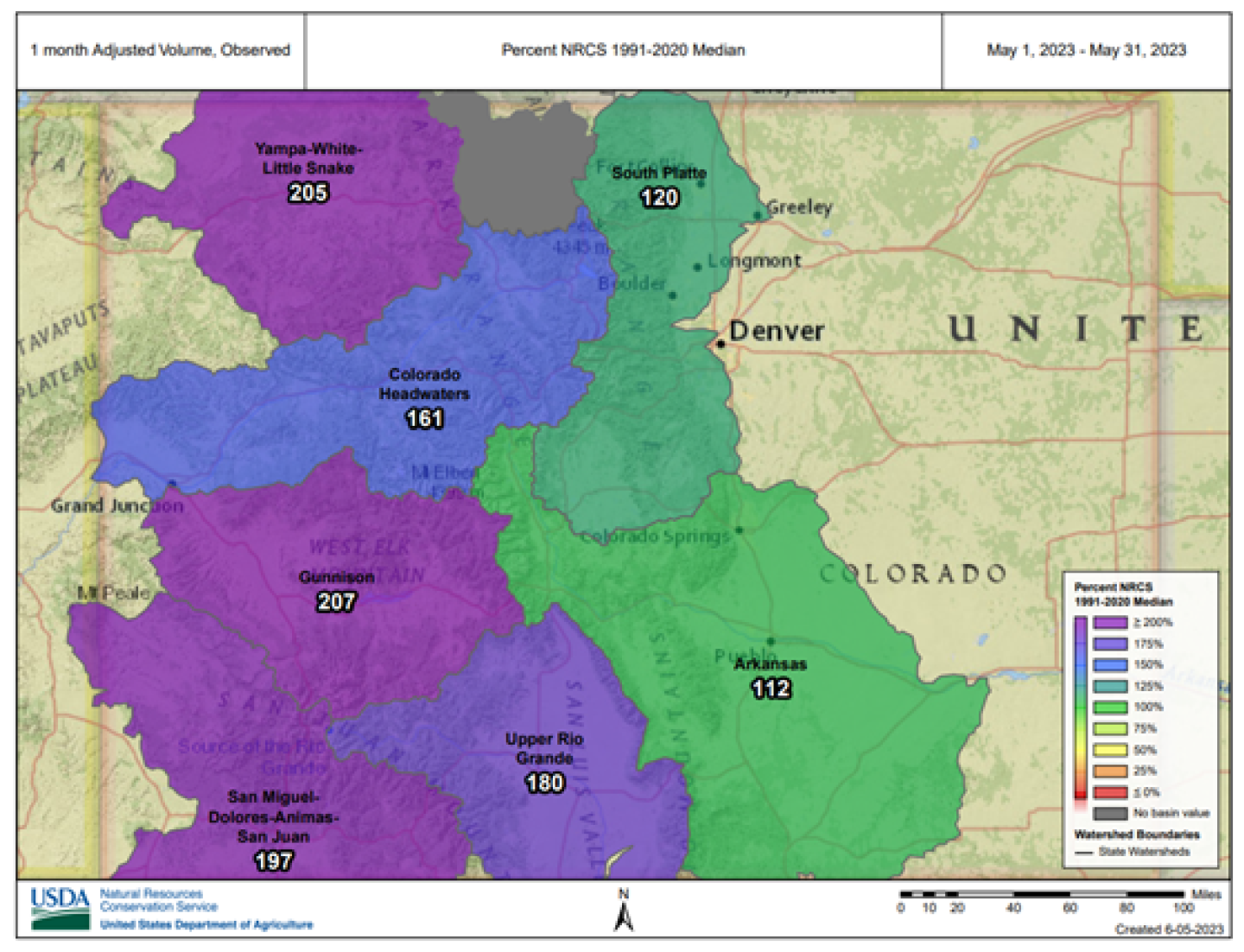
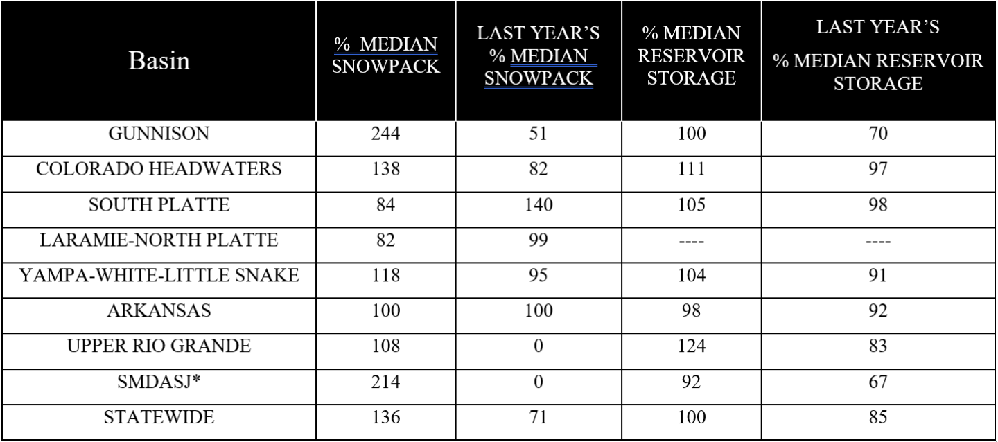

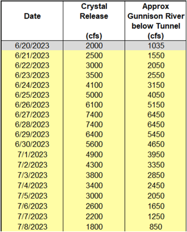

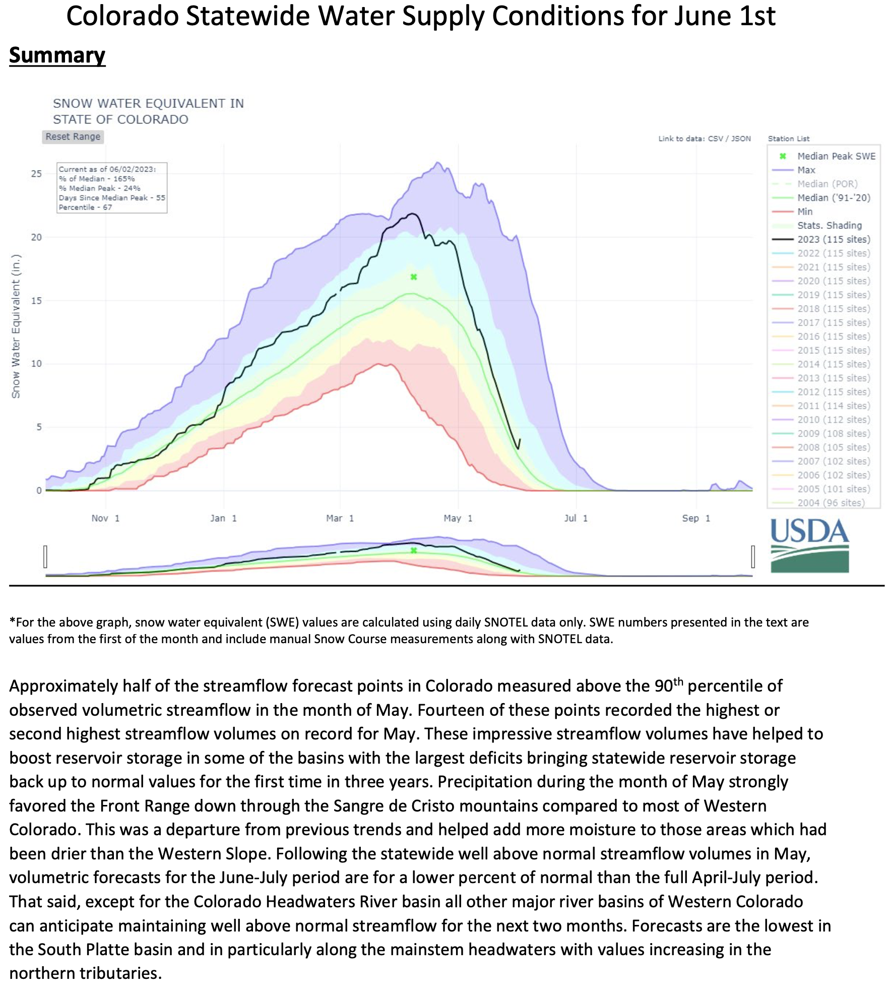
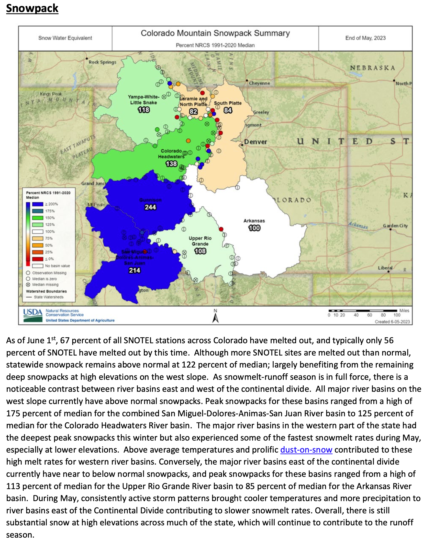
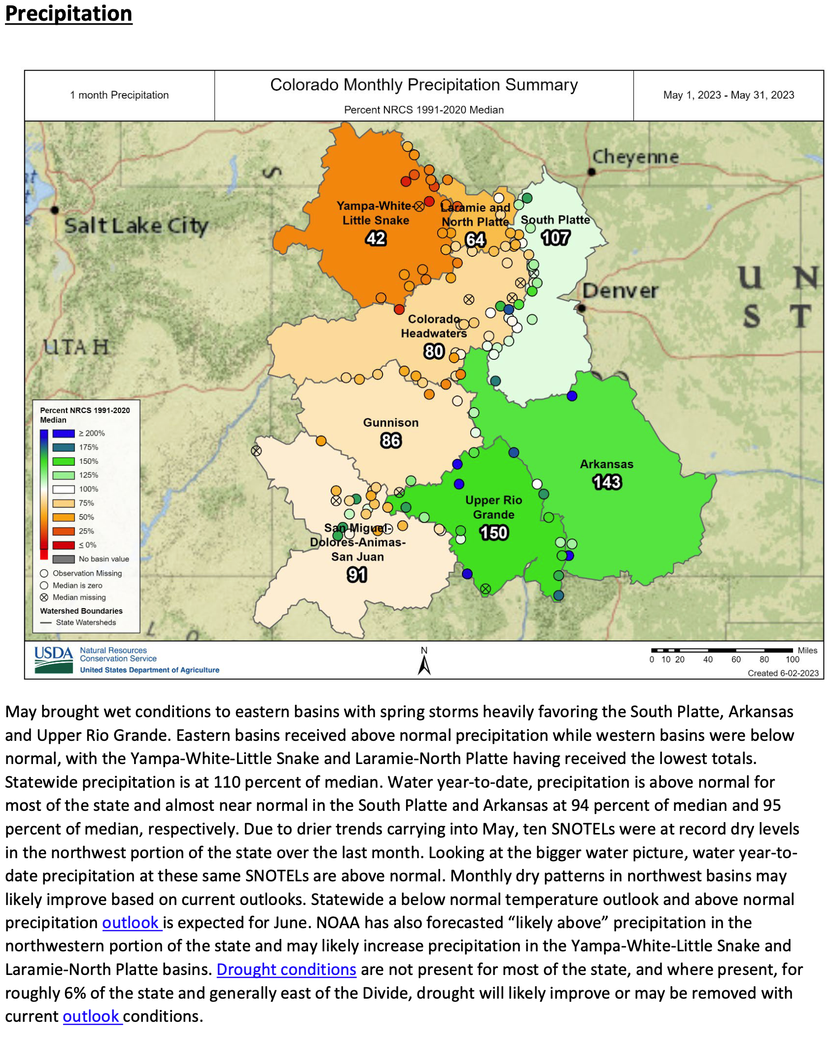
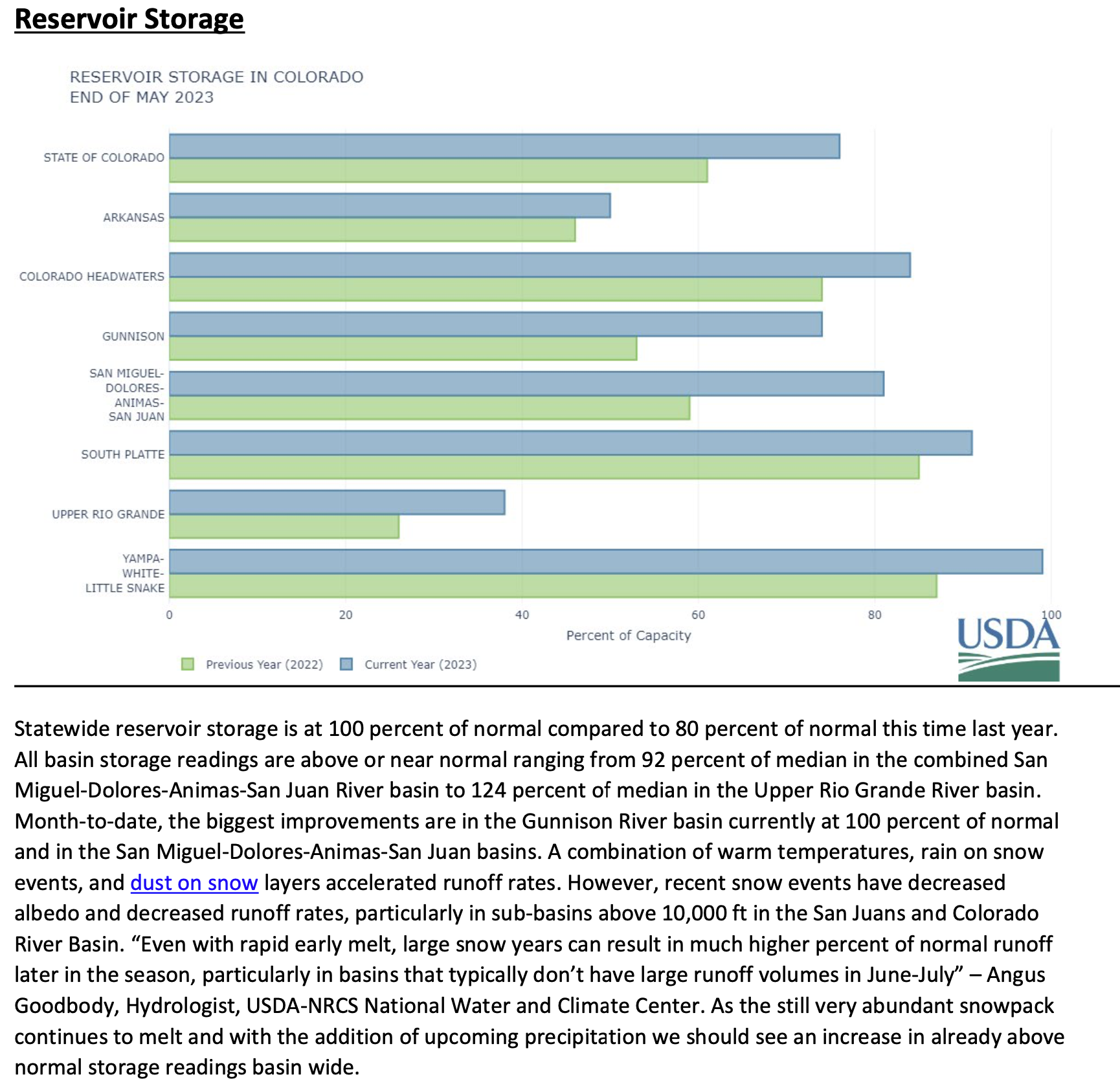


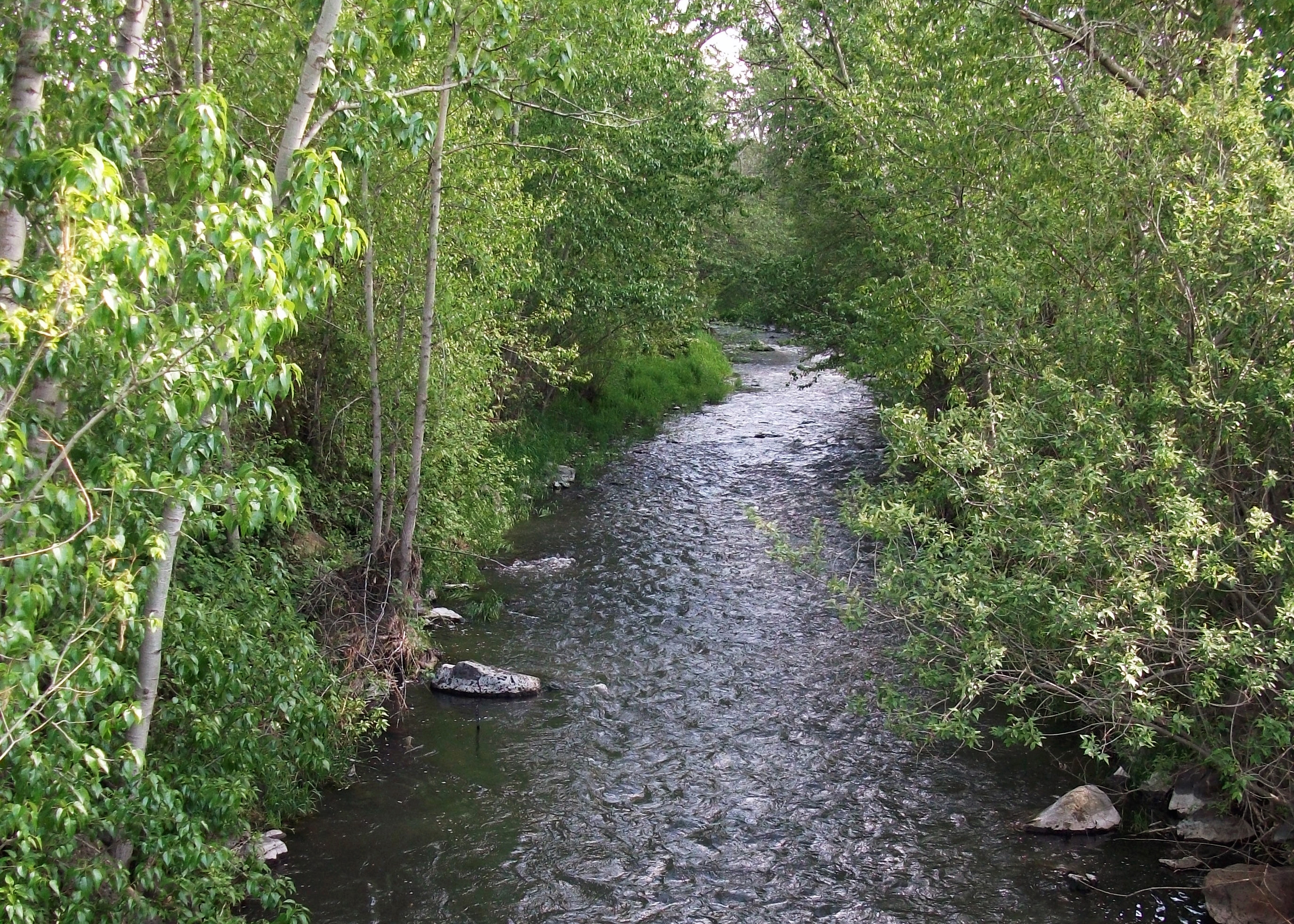


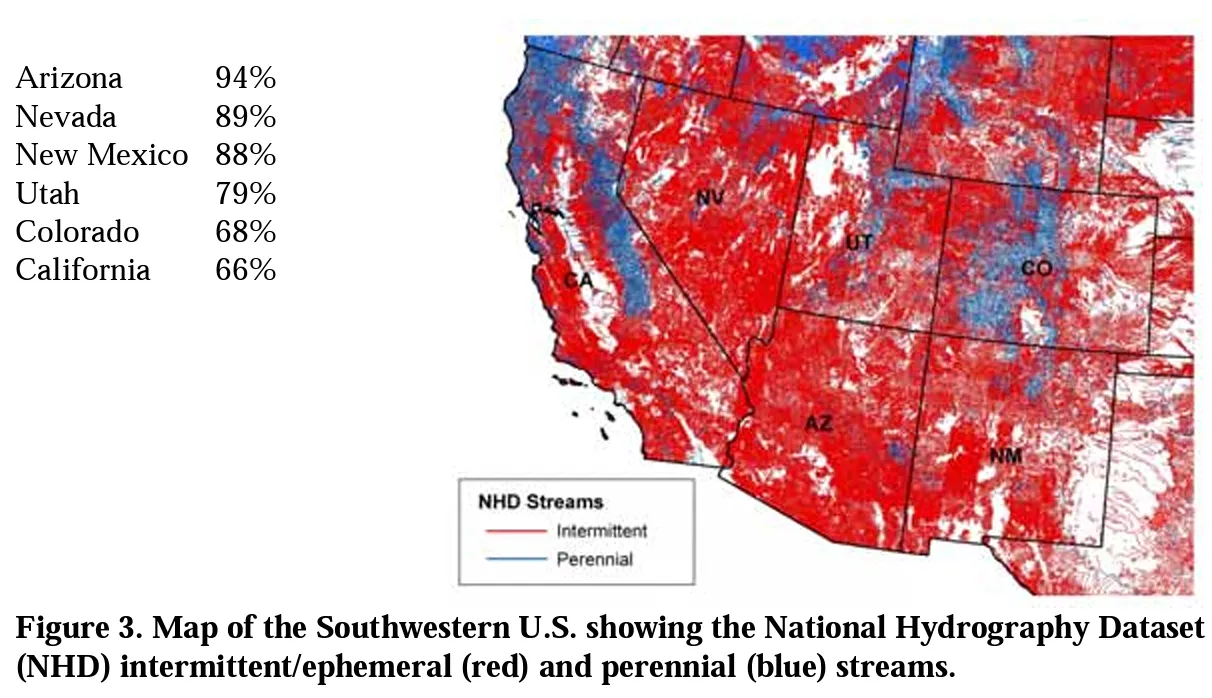


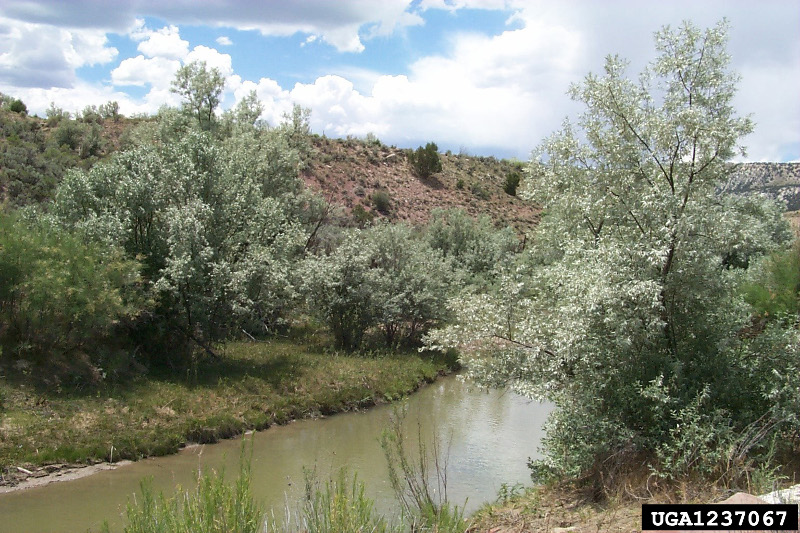


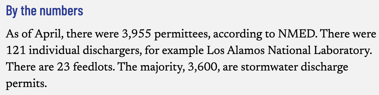

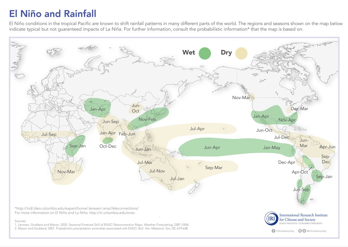
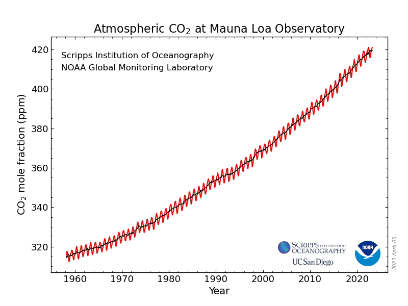


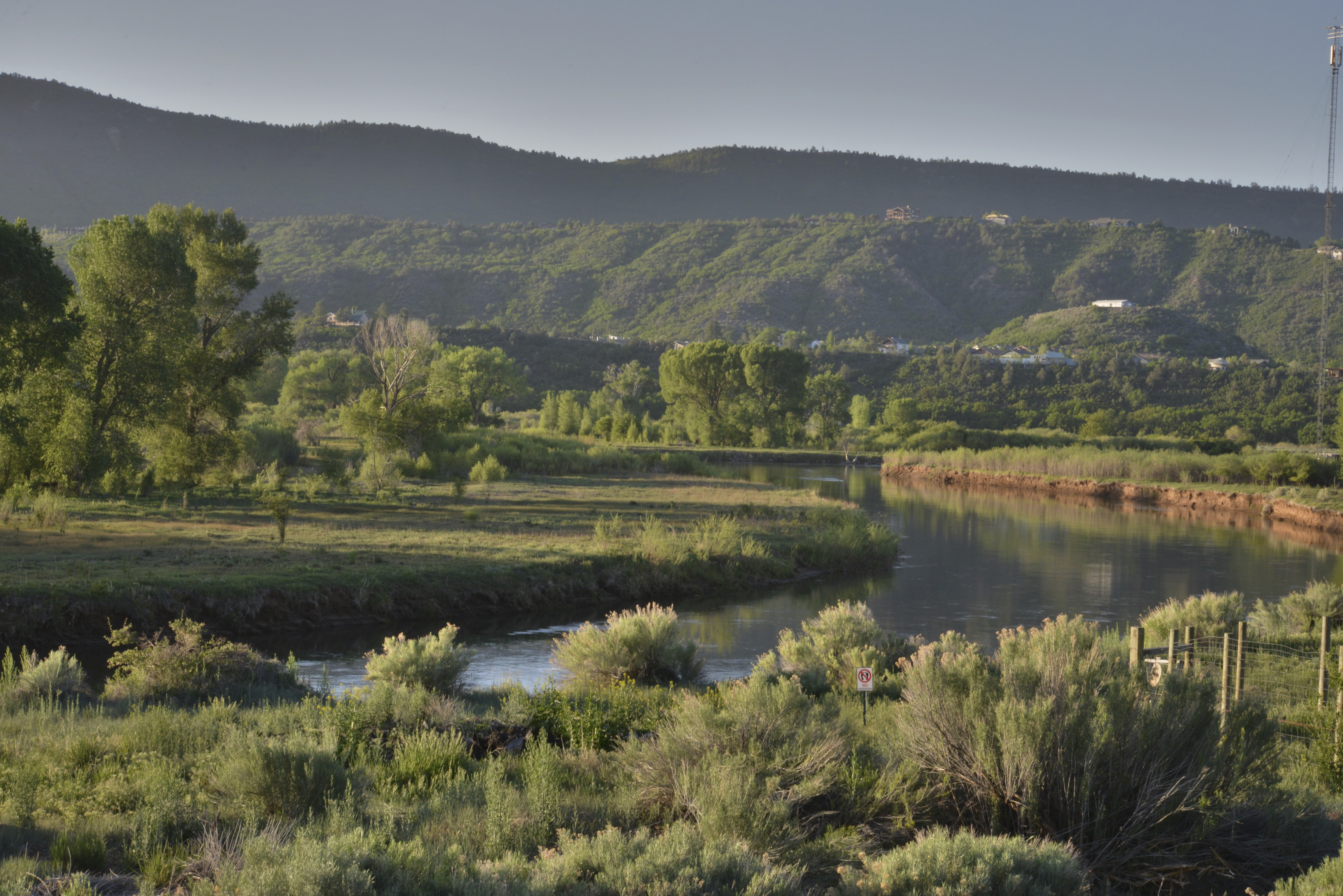

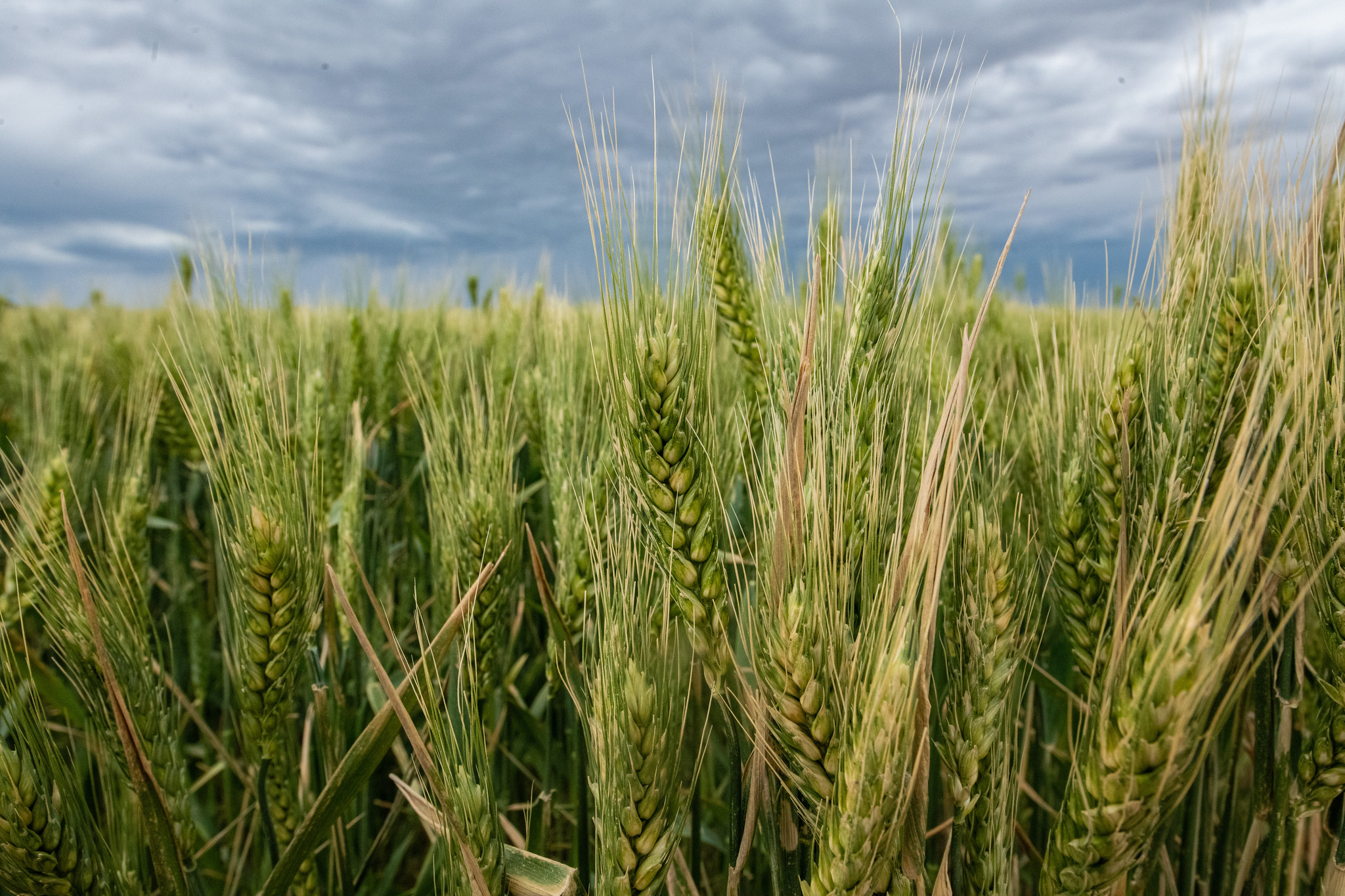

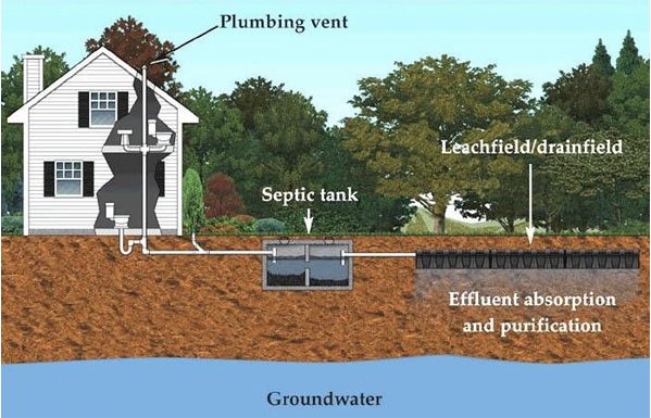
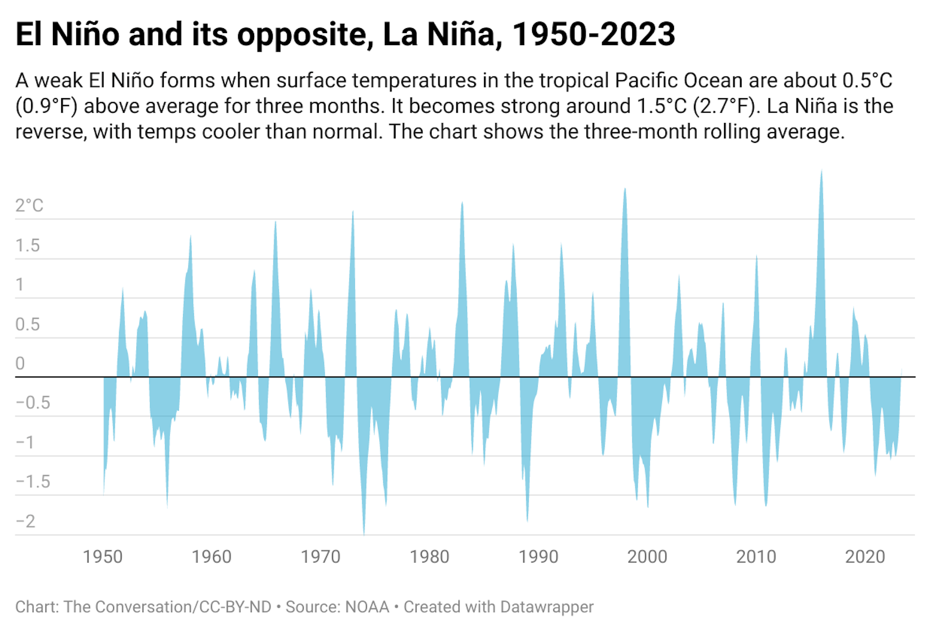