“The Milkmaid” (Dutch: Het Melkmeisje) by Johannes Vermeer, created around 1657–1658. It is one of Vermeer’s most iconic works, depicting a domestic kitchen maid pouring milk in a quiet, intimate moment. The painting is renowned for its exquisite use of light, texture, and detail, capturing the serenity and dignity of everyday life.The Milkmaid (1658–1661). By Johannes Vermeer – Google Arts & Culture — AHrw. Z3. Av6. Zhjg 9. AHrw. Z3. Av6. Zhjg, Public Domain, https://commons.wikimedia.org/w/index.php?curid=13408941
We visited the Rijks Museum yesterday to take in the works of Dutch Golden Age painting, particularly Vermeer and Rembrandt, painters that I’ve heard about. At the Salvador Dali Museum the other day Vermeer was named as an influence. What a treat to be able to view so many beautiful and inspiring works of art in one location.
“The Syndics of the Drapers’ Guild” (Dutch: De Staalmeesters) by Rembrandt van Rijn, completed in 1662. It is housed in the Rijksmuseum in Amsterdam and is one of Rembrandt’s most celebrated group portraits. The painting depicts five drapers and their servant as they assess the quality of cloth, giving a glimpse into the civic and commercial life of 17th-century Amsterdam.
We rented electric bicycles for the journey from out hotel to the museum. Of course I had read about bicycle-friendly Amsterdam but seeing the sheer number of folks on bicycles was fantastic. Moms with children on their bicycles and riding beside them, a seemingly endless stream of bicycles up and down the bikes lanes that lined nearly every thoroughfare, along with a good number of electric bicycles of all types.
Rented electric bicycles near our hotel May 29, 2025.
The Blue River flows through Silverthorne on May 22 on its way to the Colorado River. Photo/Allen Best
Click the link to read the article on the Big Pivots website (Allen Best):
May 29, 2025
Even-steven. That was the intent of delegates from the seven basin states in 1922 when they met near Santa Fe to forge a compact governing the Colorado River.
But what exactly did they agree upon? That has become a sticking point in 2025 as states have squared off about rules governing the river in the drought-afflicted and climate-changed 21st century. The negotiations between the states, according to many accounts, have been fraught with tensions. Becky Mitchell, Colorado’s lead negotiator, delivered a peek into that dispute at a forum on May 22 in Silverthorne along the headwaters of the river.
The Colorado River Compact was a quid pro quo. California, in particular, but also Arizona, was ready to see the highs and lows of the rivers smoothed out. They, as well as Nevada, wanted a giant reservoir in Boulder Canyon near the small town of Las Vegas, which then had a population of 2,300. Those Southwestern states couldn’t do it alone, though. They needed the federal government to build the dam later called Hoover. For that, they needed the support of Colorado and the three other upper-basin states.
Colorado, represented by Delph Carpenter, and the three other headwaters states realized that they had best reach a compromise, as they would more slowly develop the rivers. If the doctrine of prior appropriation that they had all adopted within their own states prevailed on the Colorado River, the water would be gone by the time they found need for it.
This was the foundation for Article III of the Colorado River Compact. It apportions 7.5 million acre-feet in perpetuity for the exclusive beneficial consumption by each of the two basins. On top of this 15 million acre-feet, they knew there would be water lost to evaporation, now calculated at 1.5 million acre-feet annually, plus some sort of delivery obligation to Mexico, which later turned out to be 1.5 million acre-feet.
In Santa Fe, delegates had assumed bounteous flows in the river, as had occurred in the years prior to their meeting. And so, embracing that short-term view of history, they believed the river would deliver 20 million acre-feet.
Source: Colorado River Water Conservation Board.
It has not done so routinely. Even when there was lots of water, during the 1990s and even before, as Eric Kuhn and John Fleck explained in their 2019 book, “Science be Dammed,” troubles ahead could be discerned. And by 1993, when the Central Arizona Project began hoisting water to Phoenix and Tucson, the river ceased absolutely to reach the ocean.
Then came the 21st century drought. Those framing the compact understood drought as a temporary affliction, not the multi-decade phenomenon now perplexing the states in the Colorado River Basin.
Nor did they contemplate a warming, drying climate called aridification. Similar to drought in effects, it is rooted in accumulating atmospheric gases. Unlike drought, it has little to no chance of breaking.
Now, faced with creating new rules governing the sharing of this river, delegates from the seven states are at odds in various ways, but perhaps none so much as in their interpretation of compact’s Article D. It says that the upper-division states “will not cause the flow of the river at Lee Ferry to be depleted below an aggregate of 75,000,000 acre-feet for any period of ten consecutive years.”
The lower division states have so far received 75 million acre-feet over every revolving 10-year period. The upper-basin states have not fully developed their apportionment, although Colorado has come close. In the last 25 years, the upper-basin states have been using 3.5 million to 4.5 million acre-feet. The lower-basin states that a decade ago were still using 10 million acre-feet have cut back their use to 7.5 million acre-feet.
In May 2022, water levels at Glen Canyon Dam were dropping so rapidly as to make relevant discussions about potential loss of hydroelectricity. Photo credit: Allen Best/Big Pivots
Lake Powell serves as a water bank for the upper basin states. The storage in 2022 had declined to 22%, although a good snow winter in 2022-23 restored levels somewhat. Today, the two reservoirs are at a combined 34% of full.
“That means 66% empty,” said Mitchell at the forum along the Blue River in Silverthorne at a “state of the river” forum organized by the Colorado River Water Conservation District.
Mitchell, an engineer by training, has a large on-stage presence. She’s spunky, not one to mince words, sometimes straying into the colloquial. This outspokenness is more evident when she speaks exclusively to a home-town crowd. Silverthorne certainly counted as one.
Shared risk is at the heart of the dispute. Colorado and other upper-basin states want the lower-basin states to accept that the river will not always satisfy all needs.
“How do we handle drought? We know how to do that in the upper basin, and most of the people in this room know that you get less,” said Mitchell, Colorado’s representative on the Upper Colorado River Commission. “That hasn’t been the case in the lower basin.”
The two basins differ in three fundamental ways. One is the pace of development. The lower basin developed quickly. The upper basin still has not used its full allocation. From the upper-basin perspective, that does not mean that the lower-basins states should expect something beyond a 50-50 split.
“The main thing that we got from the compact was the principle of equity and the ability to develop at our own pace,” said Mitchell. “We shouldn’t be punished because we didn’t develop to a certain number. The conversation now, she added, is “what does equity look like right now?”
Another difference is that the upper basin has thousands of individual users. Sure, there are a few big ones, like Denver Water and the other Front Range transmountain water diverters who collectively draw 400,000 to 450,000 acre-feet annually across the Continental Divide. The lower basin has just a handful of diverters, and the diversions are massive.
Also different — as alluded to by Mitchell — is that the lower basin has the big reservoirs lying upstream. The largest is Mead, with a capacity of almost 29 million acre-feet, followed closely by Powell at a little more than 25 million acre-feet. Mead was created expressly to meet needs of irrigators and cities in the desert southwest.
Source: Colorado River Water Conservation Board.
Powell was created essentially to ensure that the upper-basin states could meet their delivery obligations. Mitchell shared a telling statistic: More water has been released from Powell in 8 of the last 10 years than has arrived into it.
Upper-basin states must live within that hydrologic reality, said Mitchell. If it’s a particularly bad snow year in the upper basin, the farms and ranches with junior water rights and even the cities can get shorted. The lower basin states? Not a problem. They always get their water — at least so far. But the two big reservoirs have together lost 50 million acre-feet of stored water.
“We’re negotiating how to move forward in a way different place than we were negotiating 20 years ago,” said Mitchell.
Upper-basin states have managed to deliver the 75 million acre-feet across 10 years that the compact specifies, but what exactly is the obligation? That has long been a gray area.
At a forum two days before Mitchell spoke in Colorado, her counterpart in Arizona, Tom Buschatzke, reiterated at a conference in Tucson that they see the compact spelling out a clear obligation of upper-basin states to deliver 75 million acre-feet plus one-half of the water obligated to Mexico.
What if the water isn’t there? That’s the crux of this dispute as the upper and lower basin states negotiate in advance of a September deadline set by the Bureau of Reclamation.
Denver Water sends diversions from the Ffaser River and other headwater tributaries through the Moffat Tunnel at Winter Park. Photo/Allen Best
In theory, if the situation were dire enough, Colorado could stop all its post-1922 diversions to allow the water to flow downstream. But is that what those gathered in Santa Fe in the shortening days of November 1922 had in mind?
Will lawsuits toss this into the court system for resolution? That process might take decades and, if it ended up at the Supreme Court, it might not yield a nuanced outcome. Mitchell didn’t address that directly, although she did say everybody on the river wants to avoid litigation.
The situation described by Mitchell and other upper-basin proponents is perhaps analogous to a divorce settlement. The settlement may call for a 50-50 split of all earnings between the partners, but what if one becomes destitute and has no money to pool?
Upper-basin states do have reservoirs to help buffer them from short-term droughts. Altogether, however, they don’t come close to matching the capacity of Powell.
Again, from the perspective of upper-basin states, California and Nevada have a sense of entitlement. Not that the upper basin states are angelic, said Mitchell. It’s because they have no choice.
“I say we use three to four million acre-feet less than our apportionment. It varies. You know why? Because hydrology varies. And so we respond to hydrology. It’s all based on snowpack and it’s all gravity. Most of it is gravity dependent. We don’t have those two big reservoirs above us like the lower basin does. We don’t have those reservoirs to equal out the flows or allow us to overuse. We have to live with variable hydrology, and we take cuts every single year.”
Upper-basin states want a willingness in this settlement for agreement that focuses on the water supply, not the demand. “Common sense would tell you, maybe Mother Nature should drive how we operate the system.” That, she said, is the bedrock principle of the proposal from the upper division.
With plentiful snowfall, greater releases from Powell might be possible, said Mitchell, and in times of extreme duress, water from Flaming Gore and perhaps the Blue Mesa and Navajo too. She said there might be room for greater conservation measures in the upper basin states.
But there must be “real work happening down in the lower basin,” she said.
The audience in Silverthorne was comprised of many “rookies” to the water world. Some who might have attended, those more knowledgeable about the negotiations, would have wanted more: What are the deal breakers; what are the red lines, what are the issues they intend to kick down the road?
As the session in Silverthorne neared its end, time remained for one last question, and I asked it:
“I have to wonder about who we have in the White House right now, and how the President might alter the negotiations on the Colorado River. Any thoughts you might be willing to share?
“No!” she barked back without hesitation. “Allen, you know better than that.”
I laughed heartily, and so did many others.
Given what we’ve seen since January, though, I must continue to wonder.
Postscript: Before her remarks in Silverthorne, Becky Mitchell offered the opportunity for an in-depth interview with Big Pivots sometime later in June. I intend to take up that offer.
Delph Carpenter’s original map showing a reservoir at Glen Canyon and one at Black Canyon via Greg Hobbs
The wet May pattern continued to alleviate or bring an end to drought across the Northeast. Severe to extreme drought persists for central to south Florida although locally heavy showers fell across the east-central Florida Peninsula as the rainy season begins to ramp up. Widespread precipitation (2 inches or more) supported improvements to the Central and Southern Great Plains. During recent weeks, drought developed across portions of southwestern Iowa, northern Illinois, and northwestern Indiana. Short-term drought expanded across the Pacific Northwest and intensified for southern Utah and northwestern Colorado during mid to late May. From May 20-26, above-normal temperatures were limited to the southern tier of the contiguous U.S. 7-day temperatures averaged 4 to 10 degrees F below normal across the Northeast, Corn Belt, and Northern to Central Great Plains. Alaska and Puerto Rico are drought-free, while drought of varying intensity continues for parts of Hawaii…
From May 24-26, widespread precipitation (1 to 3 inches, locally more) resulted in a 1-category improvement to portions of southwestern South Dakota, Nebraska, Kansas, and northeastern Colorado. Much cooler temperatures accompanied this widespread precipitation which contributed to topsoil moisture recharge. Based on multiple indicators such as the SPI at various time scales and soil moisture, severe (D2) to extreme (D3) drought was reduced in coverage across central to western Nebraska along with adjacent areas of southwestern South Dakota. Although precipitation was lighter across southeastern Colorado, SPIs at multiple time scales, soil moisture, and VegDri no longer support any D1. Southern Nebraska and northern Kansas missed out on this past week’s precipitation and a couple of small 1-category degradations were made. A 1-category degradation was also warranted for western Colorado based on 90 to 180-day SPI…
Colorado Drought Monitor one week change map ending May 27, 2025.
Based on 6-month SPI, water-year-to-date (October 1, 2024 to May 26, 2025) precipitation deficits, and 28-day average streamflow, moderate drought (D1) was expanded to include more of southwestern Washington. Increasing 30 to 90-day precipitation deficits, low 28-day average streamflows, and declining soil moisture led to the introduction of D1 to parts of northwestern and northeastern Oregon. The 6-month SPI supported the expansion of severe drought (D2) coverage across southwestern Utah. Although precipitation was light this past week, SPIs dating back 120 days along with more favorable soil moisture indicators led to improvements across southwestern and eastern Montana. Conversely, in northwest Montana, D1 was degraded to D2 based on 120-day SPI and declining soil moisture. To the east of the Sierra Nevada Mountains, abnormal dryness (D0) was expanded to the south of Lake Tahoe due to drier-than-normal conditions since April…
Heavy rainfall (2 inches or more) prompted a 1-category improvement to ongoing drought areas of south-central and southeastern Texas. Despite this recent heavy rainfall, levels in the long-term monitoring wells of Bexar and Medina Counties remain at all-time lows. In addition, many of the 28-day average USGS streamflows are below the 5th percentile, supporting the D3-D4 depiction. Since the SPIs dating back 6 months are neutral and considering the major impact is hydrological, the drought impact was changed to long-term only. With drought improvement for northwestern Oklahoma this past week, nearly all of Oklahoma and northern to eastern Texas are drought-free. The Lower Mississippi Valley and Tennessee Valley are also drought-free with surplus 30 to 90-day precipitation…
Looking Ahead
A low pressure system and trailing front are forecast to maintain the wet pattern along the East Coast with the Weather Prediction Center depicting 1 to 2 inches of precipitation from the Mid-Atlantic north to England through June 2. Much-needed precipitation (locally more than 1 inch) is expected for the Florida Peninsula. From May 29 to June 2, mostly dry weather is forecast across the Midwest. By June 2, a low pressure system is forecast to develop and bring another round of precipitation to the Northern and Central High Plains. Much above-normal temperatures and potential record heat are predicted to affect California and the Great Basin to end May.
The Climate Prediction Center’s 6-10 day outlook (valid June 3-7, 2025) favors above-normal precipitation for the Florida Peninsula, Middle to Upper Mississippi Valley, and Great Plains. The precipitation outlook leans towards above-normal precipitation for much of the West. Elevated below-normal precipitation probabilities are forecast across the Mid-Atlantic and Northeast. Alaska and Hawaii are favored to be on the wetter side during the first week of June. Above-normal temperatures are favored from the Mississippi Valley to the East Coast, while below-normal temperatures are more likely throughout the West and Alaska. A slight lean towards above-normal temperatures are forecast for most of Hawaii.
US Drought Monitor one week change map ending May 27, 2025.
We’re in Amsterdam. Day 6 was a travel day from Linz to Amsterdam via Vienna in the Danube Valley. Low hills and farms dominated the view. We enjoyed a wonderful dinner at the restaurant Ali Ocakbaşı in Amsterdam.
View from the Armada Hotel, Amsterdam, May 30, 2025.
In Sequoia and Kings Canyon National Parks in California, trees that have persisted through rain and shine for thousands of years are now facing multiple threats triggered by a changing climate.
Scientists and park managers once thought giant sequoia forests nearly impervious to stressors like wildfire, drought and pests. Yet, even very large trees are proving vulnerable, particularly when those stressors are amplified by rising temperatures and increasing weather extremes.
Nate Stephenson, from the U.S. Geological Survey, talks about the fire damage at Redwood Mountain Grove in the Kings Canyon National Park, Calif., in 2021. AP Photo/Gary Kazanjian
To protect these places, which are valued for their natural beauty and the benefits they provide for recreation, clean water and wildlife, forest and land managers increasingly must anticipate risks they have never seen before. And they must prepare for what those risks will mean for stewardship as ecosystems rapidly transform.
Traditional management approaches focus on maintaining or restoring how ecosystems looked and functioned historically.
However, that doesn’t always work when ecosystems are subjected to new and rapidly shifting conditions.
Ecosystems have many moving parts – plants, animals, fungi and microbes; and the soil, air and water in which they live – that interact with one another in complex ways.
When the climate changes, it’s like shifting the ground on which everything rests. The results can undermine the integrity of the system, leading to ecological changes that are hard to predict.
To plan for an uncertain future, natural resource managers need to consider many different ways changes in climate and ecosystems could affect their landscapes. Essentially, what scenarios are possible?
Preparing for multiple possibilities
At Sequoia and Kings Canyon, park managers were aware that climate change posed some big risks to the iconic trees under their care. More than a decade ago, they undertook a major effort to explore different scenarios that could play out in the future.
It’s a good thing they did, because some of the more extreme possibilities they imagined happened sooner than expected.
While these extreme events came as a surprise to many people, thinking through the possibilities ahead of time meant the park managers had already begun to take steps that proved beneficial. One example was prioritizing prescribed burns to remove undergrowth that could fuel hotter, more destructive fires.
The key to effective planning is a thoughtful consideration of a suite of strategies that are likely to succeed in the face of many different changes in climates and ecosystems. That involves thinking through wide-ranging potential outcomes to see how different strategies might fare under each scenario – including preparing for catastrophic possibilities, even those considered unlikely.
For example, prescribed burning may reduce risks from both catastrophic wildfire and drought by reducing the density of plant growth, whereas suppressing all fires could increase those risks in the long run.
Strategies undertaken today have consequences for decades to come. Managers need to have confidence that they are making good investments when they put limited resources toward actions like forest thinning, invasive species control, buying seeds or replanting trees. Scenarios can help inform those investment choices.
Constructing credible scenarios of ecological change to inform this type of planning requires considering the most important unknowns. Scenarios look not only at how the climate could change, but also how complex ecosystems could react and what surprises might lay beyond the horizon.
Scientists at the North Central Climate Adaptation Science Center are collaborating with managers in the Nebraska Sandhills to develop scenarios of future ecological change under different climate conditions, disturbance events like fires and extreme droughts, and land uses like grazing. Photos: T. Walz, M. Lavin, C. Helzer, O. Richmond, NPS (top to bottom)., CC BY
Key ingredients for crafting ecological scenarios
To provide some guidance to people tasked with managing these landscapes, we brought together a group of experts in ecology, climate science, and natural resource management from across universities and government agencies.
1. Embracing ecological uncertainty: Instead of banking on one “most likely” outcome for ecosystems in a changing climate, managers can better prepare by mapping out multiple possibilities. In Nebraska’s Sandhills, we are exploring how this mostly intact native prairie could transform, with outcomes as divergent as woodlands and open dunes.
2. Thinking in trajectories: It’s helpful to consider not just the outcomes, but also the potential pathways for getting there. Will ecological changes unfold gradually or all at once? By envisioning different pathways through which ecosystems might respond to climate change and other stressors, natural resource managers can identify critical moments where specific actions, such as removing tree seedlings encroaching into grasslands, can steer ecosystems toward a more desirable future.
3. Preparing for surprises: Planning for rare disasters or sudden species collapses helps managers respond nimbly when the unexpected strikes, such as a severe drought leading to widespread erosion. Being prepared for abrupt changes and having contingency plans can mean the difference between quickly helping an ecosystem recover and losing it entirely.
Over the past decade, access to climate model projections through easy-to-use websites has revolutionized resource managers’ ability to explore different scenarios of how the local climate might change.
What managers are missing today is similar access to ecological model projections and tools that can help them anticipate possible changes in ecosystems. To bridge this gap, we believe the scientific community should prioritize developing ecological projections and decision-support tools that can empower managers to plan for ecological uncertainty with greater confidence and foresight.
Ecological scenarios don’t eliminate uncertainty, but they can help to navigate it more effectively by identifying strategic actions to manage forests and other ecosystems.
Lorelei Cloud, Vice-chair of the Southern Ute Tribal Council, and Southwest Colorado’s representative of the Colorado Water Conservation Board, which addresses most water issues in Colorado. Photo via Sibley’s Rivers
The Colorado Water Conservation Board, Colorado’s top water policy agency, has a new leader: Southern Ute tribal member Lorelei Cloud.
The 15-member board sets water policy within the state, funds water projects statewide and works on issues related to watershed protection, stream restoration, flood mitigation and drought planning. On May 21, board members elected Cloud to serve a one-year term as chair, making her the first Indigenous person to hold the position since the board was formed in 1937.
Cloud said her new role gives Indigenous people a long-sought seat at the table where water decisions are made.
“This is history,” Cloud said during the meeting. “What a moment. What a great moment for the state of Colorado.”
In 2023, Gov. Jared Polis appointed Cloud for a three-year term, making her the first known tribal member to hold a seat on the board. Cloud also served as the board’s vice chair for a year starting in May 2024.
Part of the Colorado Water Conservation Board’s purpose is to protect Colorado’s water interests in dealings with other states, like the water sharing agreements among seven states in the Colorado River Basin.
She represents the San Miguel-Dolores-San Juan basin in southwestern Colorado, which is part of the larger Colorado River Basin, a key water source for about 40 million people across the West.
The Colorado River Basin’s water supply has been strained by over two decades of prolonged drought, rising temperatures and an unyielding demand for water.
The rules that govern how water is stored and released from the basin’s reservoirs are set to expire in 2026, leaving officials with the difficult task of negotiating a new set of management rules that will last for years to come.
The seven basin states have been at odds over how water should be managed in the basin’s driest possible conditions. Tribal officials have been working to ensure their priorities are considered in the high-stakes negotiations.
“This moment isn’t just about me or about the Indigenous people — it’s about all of the people in this room,” Cloud said, adding that the board is “making decisions that aren’t just about today. It’s about our future.”
Decision-makers in the Colorado River Basin have a history of excluding tribal nations that dates back to the 1922 Colorado River Compact.
The compact laid the foundation for how water is shared between the Upper Basin — Colorado, New Mexico, Wyoming and Utah — and the Lower Basin — Arizona, California and Nevada. The agreement includes one line about tribal water, and tribal nations were not involved in the negotiations.
Native America in the Colorado River Basin. Credit: USBR
Tribal water is a key issue in the basin: The 30 basin tribes have recognized rights to over 25% of the Colorado River’s average flow.
Cloud said her new role is “part of the reconciliation that we’ve all been waiting for as Indigenous people.”
“Having an Indigenous person in a position that makes water management decisions — it’s a seat at the table that we’ve been wanting for such a long time, and it’s finally here,” Cloud said. “It’s a joyous moment.”
Cloud has twice served as vice chairman of the Southern Ute Tribal Council. She has also held leadership positions in The Nature Conservancy Colorado, the Indigenous Women’s Leadership Network, the Ten Tribes Partnership, and the Water and Tribes Initiative.
As board chair, Cloud will run the meetings, ensure fair voting and represent the board as spokesperson when needed. She will continue to represent the southwestern basin, which reaches 10 counties and includes cities like Cortez, Durango and Telluride.
The Southern Ute Indian Tribe and the Ute Mountain Ute Tribe — the two federally recognized tribes with reservation land in Colorado — are also located in the southwestern basin.
“I’ve been lucky to witness Chair Cloud’s rise as a leader in the Colorado water community,” said Dan Gibbs, Department of Natural Resources executive director. “No one is more deserving or better positioned to chair the CWCB in this critical moment.”
The deck after the last cable car ride up to the “Top of Innsbruck” May 28, 2025.
Wednesday morning in Innsbruck we had the good fortune to go the the “Top of Innsbruck“. I’ve lived my entire life within sight of the Rocky Mountains and climbed many of them so today was a real treat. You take three separate cable cars to get to the last bit of a walk to the summit. Mountains show up in every direction from the top with the City of Innsbruck down below.
The City of Innsbruck from the “Top of Innsbruck” May 28, 2025.
GRACE TWS trend map. (a) The time series of nonseasonal GRACE/FO TWS (km3/year) over UCRB and LCRB for the period (4/2002–10/2024). (b) Spatial variation in TWS trends for the Colorado River Basin for the investigated period (mm/year) (c) Time series comparison of the change in storage ΔS/Δt derived from the water balance equation (Equation 1) and GRACE/FO. ΔS/Δt calculated from GRACE/FO TWS anomalies in km3. The light shading represents uncertainties.
New research based on satellite data shows the depletion of groundwater in the Colorado River Basin far exceeds losses from the river’s reservoirs.
Scientists say overpumping is leading to alarmingly rapid declines in groundwater at a time when climate change is putting growing strains on the Southwest’s water supplies.
Scientists at Arizona State University examined more than two decades of satellite measurements and found that since 2003 the quantity of groundwater depleted in the Colorado River Basin is comparable to the total capacity of Lake Mead, the nation’s largest reservoir. The researchers estimated that pumping from wells has drained about 34 cubic kilometers, or 28 million acre-feet, of groundwater in the watershed since 2003 — more than twice the amount of water that has been depleted from the river’s reservoirs during that time.
“The Colorado River Basin is losing groundwater at an alarming rate,” said Karem Abdelmohsen, the lead author and a researcher at ASU’s School of Sustainability.
[…]
Groundwater movement via the USGS
The losses are being driven largely by heavy pumping to supply agriculture, he said. At the same time, prolonged drought and rising temperatures have sapped river flows and decreased the amount of water percolating underground and recharging aquifers.
“As surface water becomes less dependable, the demand for groundwater is projected to rise significantly,” the researchers wrote in the study, which was published Tuesday in the journal Geophysical Research Letters. “Groundwater is a crucial buffer … but it is rapidly disappearing due to excessive extraction.”
I live in Jackson County, in northern Colorado, where hundreds of inactive and abandoned oil wells litter the landscape. Not only are they an ugly sight, they are also just a few of the estimated 2.6 million unplugged wells across the country that leak methane, benzene and other toxic substances.
The reality is that long after I’m gone, most or all of those wells will remain unplugged. The companies and people who once owned them will have been allowed to walk away from their responsibility to clean up their mess.
Uncapped wells are what happens when the federal government enables the fossil-fuel industry to dominate energy policies, as is happening again now, both in the Interior Department and Congress. The policies emerging would allow companies, including many foreign ones, to profit from public lands and minerals that all Americans own. They would also leave taxpayers holding the bag for cleaning up leaking wells.
These abandoned wells already have consequences for wildlife, air, water and rural people. Kirk Panasuk, a rancher in Bainville, Montana, said: “I have personally experienced serious health scares after breathing toxic fumes from oil and gas wells near my property. And I’ve seen too many of my friends and neighbors in this part of the country have their water contaminated or their land destroyed by rushed and reckless industrial projects.”
Republicans and Democrats in previous administrations and Congresses took pains to reform this historically biased federal energy system because of the damage done to rural communities and American taxpayers. Now, the federal government is rolling back those reforms.
Recently, the Interior Department announced that “emergency permitting procedures” were necessary when carrying out NEPA, the National Environmental Policy Act. Timelines for environmental assessments for fossil-fuel projects were changed from one year to 14 days, without requiring a public comment period. The timeline for more complicated environmental impact statements was cut from two years to 28 days, with only a 10-day public comment period.
In May, the House Natural Resources Committee unveiled its piece of the House budget bill, which enables the federal government to expedite oil, gas, coal and mineral development. It gives Americans basically no say on whether those projects should move ahead, while keeping taxpayers from receiving a fair return on the development of publicly owned lands and minerals.
Both the House bill—just passed and now before the Senate—and the Interior Department’s policies, ignore the long-standing mandate to manage public lands for multiple uses. Instead, the new policies:
Drastically reduce the public’s role in the permitting process.
Allow large corporations to pay to evade environmental and judicial review.
Exempt millions of acres of private lands with federal minerals and thousands of wells on these lands from federal permitting and mitigation requirements.
The House bill would also slash the royalty rate for oil and gas production from 16.67% to 12.5%, depriving state and local governments of funding they depend on for schools, roads and other essential services. An analysis by Resources for the Future found that the proposed lower royalty rates would result in a loss of nearly $5 billion in revenue over the next decade.
The Interior Department’s emergency permitting procedures and the House bill are assaults the federal government has waged on public lands since January. The public has been shoved to the side as oil and gas drillers enjoy their energy dominance throughout our public lands.
Barbara Vasquez. Photo credit: CWCB
Now, it’s up to the Senate to strip out these gifts to the fossil fuel industry, and it’s up to us tell our elected Senate representatives that these policies ignore the wishes of Westerners. We have told pollsters innumerable times that we support conservation, not exploitation of public lands for private interests. What’s happening now is radically wrong.
Barbara Vasquez is a contributor to Writers on the Range, writersontherange.org, an independent nonprofit dedicated to spurring lively conversation about the West. A retired PhD biomedical researcher and semiconductor engineer, she is board chair of the Western Organization of Resource Councils and a board member of the Western Colorado Alliance.
Atlas cedar University of Bern Botanical Garden May 27, 2025.
We’re in Innsbruck, Tyrol, Austria tonight after a beautiful drive over the Jura Mountains from Saint Claude. We stopped for souvenirs and had a nice conversation with a couple who had just re-opened the store. Hellchild scored a bottle of wine that the owner said required an educated taste and that he didn’t like when he first tried it at 18. His wife said, “Then he married a country girl!” Later we ate lunch in Bern (Quiche Lorraine) and stretched our legs with a walk around the University of Bern Botanical Garden and a little “botanizing”.
Northern Alps from the highway between Bern and Innsbruck May 27, 2025.
Heading east towards Zurich we got our first glimpse of the northern Alps.
Click the link to read the article on the InkStain website (John Fleck):
May 26, 2025
The Bureau of Reclamation has released its May 24-Month Study. It confirms that 2025 will be another very dry year and the consequences will be significant. Under the minimum probable forecast, active storage in Lake Powell will fall to an elevation of 3530’ (5.8 maf), only about 9 feet higher than the February 2023 low of 3521’ (5.3maf). Just as alarming, under the “most probable” scenario, 2027 is projected to be another year for a 7.48 maf release from Glen Canyon Dam. This means that the ten-year flows at Lee Ferry are projected to fall well below the 82.0 maf tripwire – the point at which the basin states’ disagreement over interpreting the Colorado River Compact’s Lee Ferry delivery/non-depletion requirement could trigger interstate litigation.
The May 1st “most probable” forecast for unregulated April to July inflow to Lake Powell was 3.5 maf, down from an April 1 st forecast of 4.3 maf. Since May 1st. However, the runoff forecast has continued to decline, down another ~400kaf as we write this (May 26, 2025). No one should be surprised if we end up with an actual inflow closer to the May 1st “minimum probable” forecast of 2.6 maf.
Even with continued crop fallowing programs, storage in Lake Mead also continues to decline, dropping to an elevation of 1047’ at the end of Water Year 2026 under the “most Probable” forecast and to elevation 1041’ under the “minimum probable” forecast.
cloudy forecast, part II
Lower Basin use continues to run well below long term averages, with this year’s consumptive use by Arizona, California, and Nevada forecast at 6.3maf, well below the legal paper water allocation of 7.5maf. Yet Mead keeps dropping. The latest analysis of total reservoir storage from our colleague and collaborator Jack Schmidt (here’s Jack and colleagues from March, with an update expected later this week) clearly shows that we are once again failing to rebuild reservoir storage. We’re draining the system.
Of course, the 2007 Interim Guidelines expire after 2026, so we do not know what the rules will be for Glen Canyon Dam releases in Water Year 2027. Lacking any better information, the Bureau of Reclamation has assumed a continuation of the 2007 Interim Guidelines rules. Another approach would be for the Bureau of Reclamation to assume that absent an agreement among the states, the Secretary of the Interior could return to an annual release of 8.23 maf from Glen Canyon as set by the 1970 Long-range Operating Criteria. And curiously, under the “minimum probable” scenario, assuming a continuation of the 2007 Interim Guidelines, the projected 2027 annual release at Glen Canyon Dam reverts to 8.23 maf. Under a quirk in the 2007 Interim Guidelines, if the December 31, 2026, projected elevation of Lake Powell is below 3525’ and the projected elevation of Lake Mead is below 1075,’ the release reverts to 8.23 maf. This was referred to as the “sacrifice Lake Powell to save Lake Mead” strategy (seriously!).
Unless the 2025-26 winter is very wet or the Basin States can find consensus, the choices facing the Basin are stark: sacrifice Lake Powell for Lake Mead and perhaps keep ten-year Lee Ferry flows above the tripwire (no guarantee) or reduce annual releases from Glen Canyon Dam to maintain a balanced but small amount of storage in both reservoirs, which risks pushing cumulative 10-year flows past Lee Ferry across the tripwire.
City walls with defending towers at Avignon. This is a view of the walls between the Porte de L’Oulle and the Porte du Rhône. The Petit Palais is just visible in the distance above the wall. By Henk Monster, CC BY 3.0, https://commons.wikimedia.org/w/index.php?curid=57881754
We’re in Saint-Claude, Bourgonne-Franche-comté, France after the drive from Avignon.
We drove around Avignon this morning checking out the walls of the Palais des Papes (Palace of the Popes). From Wikipedia: “The walls of Avignon (French: Les Remparts d’Avignon) are a series of defensive stone walls that surround the city of Avignon in the south of France. They were built in the 14th century during the Avignon papacy and have been continually rebuilt and repaired throughout their subsequent history…From the 1350s during the Hundred Years’ War the town became vulnerable to pillage by marauding bands of mercenaries and in 1357 under Innocent VI, the fifth Avignon pope, work began on the construction of a new set of city walls to enclose the expanded town. The walls took nearly 20 years to complete. The walls stretch for 4.3 km (2.7 mi) and enclose an area of 150 ha (370 acres). There were originally twelve gates controlling access to the city but this number was reduced to seven when the fortifications were modified between 1481 and 1487 during the French Wars of Religion. There are now 15 vehicular entrances and 11 pedestrian entrances…The town had always been subject to flooding by the Rhône. In November 1840 the river reached a height of 8.32 metres (27.3 ft), the highest that has ever been recorded. It caused severe flooding in the town with most streets under water. In some areas the water reached the first floor level of the houses. The flooding lasted for over three weeks and deposited large quantities of mud in the streets.Following this event the town decided to make better use of the town walls as a flood barrier and to install sluice gates on all the canals and drains. Each of the city gates was modified to facilitate the construction of a temporary cofferdam to prevent the river water entering the town. A pair of vertical slots were cut into the limestone blocks on either side of the opening. The slots were separated by a distance of between 0.5 m to 1 m and were designed to accommodate wooden planks which could be placed across the gate entrance. The gap between the sets of planks was filled with a mixture of earth and straw to create a dam.
From Wikipedia: “The Palais des Papes (English: Palace of the Popes; lo Palais dei Papas in Occitan) in Avignon, Southern France, is one of the largest and most important medievalGothic buildings in Europe. Once a fortress and palace, the papal residence was a seat of Western Christianity during the 14th century. Six papal conclaves were held in the Palais, leading to the elections of Benedict XII in 1334, Clement VI in 1342, Innocent VI in 1352, Urban V in 1362, Gregory XI in 1370 and Benedict XIII in 1394. The older area of Avignon is inside the walls and our hotel was located there.
Rows of trained Sycamores in Vienne May 26, 2025.
Coyote Gulch and Hellchild with the Rhone River in the background May 26, 2025 in Vienne.
The drive to Saint-Claude is up the Rhone Valley most of the way. Farms are everywhere, mountains in the distance most of the time. We stopped for lunch Vienne. From Wikipedia: “Vienne (French: [vjɛn]; Arpitan: Vièna) is a town in southeastern France, located 35 kilometres (22 mi) south of Lyon, at the confluence of the Gère and the Rhône. It is the fourth-largest commune in the Isèredepartment, of which it is a subprefecture alongside La Tour-du-Pin. Vienne was a major centre of the Roman Empire under the Latin name Vienna. Vienne was the capital of the Allobroges, a Gallic people, before its conquest by the Romans. Transformed into a Roman colony in 47 BC under Julius Caesar, it became a major urban centre, ideally located along the Rhône, then a major axis of communication. Emperor Augustus banished Herod the Great‘s son, the ethnarchHerod Archelaus to Vienne in 6 AD.
The view downriver (Bienne) from our hotel in Saint-Claude May 26, 2025.
From Wikipedia: “Saint-Claude (French pronunciation: [sɛ̃ klod]) is a commune and a sous-préfecture of the Juradepartment in the Bourgogne-Franche-Comtéregion in eastern France. It lies on the river Bienne…The town was originally named Saint-Oyand after Saint Eugendus. However, when St. Claudius had, in 690, resigned his Diocese of Besançon and died in 696 as twelfth abbot, the number of pilgrims who visited his grave was so great that, since the 13th century, the name “Saint-Claude” came more and more into use and has today superseded the other. It was the world capital of wooden smoking pipes crafted by hand from the mid 19th century to the mid 20th century. During WWII the town came under German occupation, yet still remained a haven for Jews escaping to Switzerland due to its proximity to it (about 8 km away, as the crow flies). As a punishment to the locals for consistently assisting and harbouring the fleeing Jews, the Nazis executed all of the town’s males of service age in the town centre.”
The view upriver (Bienne) from our hotel in
Saint-Claude May 26, 2025.
At its May Board meeting in Steamboat Springs this week, the Colorado Water Conservation Board (CWCB) elected Lorelei Cloud as Chair and Barbara Vasquez as Vice Chair.
“It’s a privilege to serve as the CWCB Director under the leadership of these two exceptional women,” said CWCB Director Lauren Ris. “I’m honored to support them as they step into these roles—and proud that this moment marks history. Chair Cloud is the first Indigenous person to lead Colorado’s state water board, and it’s powerful to see three women at the center of these important conversations.”
Lorelei Cloud. Photo credit: Allen Best/Big Pivots
Lorelei Cloud of the Southern Ute Reservation has served as CWCB Vice Chair for the past year and now succeeds Nathan Coombs as Chair. She represents the San Miguel–Dolores–San Juan drainage basin. Cloud also brings a wealth of experience in energy, water and leadership roles across the state and region. She is actively involved with the Water and Tribes Initiative, the Indigenous Women’s Leadership Network and has served on the Southern Ute Tribal Council as the Treasurer and Vice Chairman.
“Having an Indigenous person in a position to make decisions about water, having a seat at the table, is something we’ve been working toward for a long time,” said Chair Cloud. “This is a joyous moment. Colorado has always been a trailblazer, and this isn’t just about me—it’s about all of us. We’re here together, making decisions as a team, and I’m honored to be a part of this group.”
Barbara Vasquez. Photo credit: CWCB
Barbara Vasquez of Cowdrey, Colorado, will serve as Vice Chair. She represents the North Platte drainage basin and brings extensive experience in public land resource management and water issues. Vasquez has served on the Bureau of Land Management’s Northwest Colorado Resource Advisory Council and has been a representative on the North Platte Basin Roundtable since 2006.
“I look forward to supporting Chair Cloud and continuing to strengthen our partnerships across the state over the next year,” said Vice Chair Vasquez. “I’m committed to ensuring that the voices of rural communities and local water users are heard as we navigate the complex challenges ahead.”
“I couldn’t be more honored and excited to have Lorelei Cloud serving as the Chair of the Colorado Water Conservation Board and Barbara Vasquez as Vice Chair” said Dan Gibbs, Executive Director, Department of Natural Resources. “I’ve been lucky to witness Chair Cloud’s rise as a leader in the Colorado water community. No one is more deserving or better positioned to Chair the CWCB in this critical moment. Combined with Vice Chair Vasquez we are very fortunate to have CWCB members who are excellent representatives engaged in Colorado water policy.”
Cloud, Vasquez, and outgoing Chair Nathan Coombs were all appointed to the CWCB in March 2023 and have now each held leadership roles on the Board. Board Chair appointments are for one-year terms. The 15-member Board includes nine representatives from each major Colorado river basin as well as the Denver metropolitan area. Members are appointed by the Governor and confirmed by the Colorado State Senate. Collectively, they bring expertise in water resource management, engineering, law, finance, agriculture and more.
Grays and Torreys, Dillon Reservoir May 2017. Photo credit Greg Hobbs.
Click the link to read the article on the Summit Daily website (Ryan Spencer). Here’s an excerpt:
May 25, 2025
Both the Dillon Reservoir and the Green Mountain Reservoir are expected to reach capacity this summer, Colorado Division of Water Resources division engineer James Heath said at the State of the River in Silverthorne on Thursday, May 22…An about-normal snowpack in Summit County this winter means both reservoirs are expected to “fill and potentially spill,” Heath said. While the snowpack levels were close to normal, the runoff has been slightly below normal because the county went into last winter with dry soils, he said…
The snowpack in the Colorado River Headwaters Basin peaked April 7, about a week earlier than normal, Heath said. At 89% of the 30-year-median…The Blue River Basin [peaked] April 8, at 108% of the 30-year-median, Heath said…
.Dillon Reservoir should reach an elevation of 9,012 feet by June 18, allowing both the Dillon and Frisco marinas to be fully operational by that time. Outflows…should exceed 500 cubic feet per second — the level ideal for rafting the Blue River — around the third week in June and continue until around the Fourth of July weekend, he said.
Green Mountain Reservoir. Photo credit: Colorado Parks & Wildlife
When President Donald Trump took office earlier this year, climate advocates were confident that while the federal government would certainly no longer be tackling the issue of climate change, states wouldhelp pick up some of the slack. There was a sense of hope in that — at least some of this vital work would continue. This prospect has recently been put into question, because the Trump administration is now trying to prevent states from doing much of anything to limit the impacts of climate change.
The Department of Justice is currently suing the states of New York and Vermont to stop them from enforcing laws passed last year that would make fossil fuel companies liable for some of the costs of dealing with climate change. It is also suingHawaii and Michigan over their climate-related lawsuits against fossil fuel companies. Finally, the Trump administration is working to end California’s stringent motor vehicle emissions standards and its cap-and-trade program. (Republicans in the Senate recently moved to end Califonria’s vehicle emission standards.)…The first set of lawsuits pertain to climate “superfund” laws. These are laws based on legislation passed in the 1980s that forced chemical and petroleum companies to pay for the cleanup of hazardous waste. In this scenario, the idea is to force fossil fuel companies to pay for the costs of the damaging effects of climate change. New York and Vermont passed climate superfund laws last year. Numerous states — from Maine to Tennessee — have expressed interest in passing laws like these in recent years…
“They’re going to try to impose some liability — some fees — on these companies as a way of forcing them to internalize the cost of past activities,” Rachel Rothschild, an assistant professor of law at the University of Michigan and an expert on superfunds, tells Rolling Stone. “The companies that would be deemed responsible parties under the bills are those companies that have produced, extracted or sold fossil fuel products above a certain threshold during the time period that the bills are going to impose this retroactive liability.”
[…]
Rothschild says it’s “pretty unprecedented” for the federal government to file lawsuits to block this kind of environmental legislation and that states have historically had the authority to address environmental issues that affect public health. These laws are only just starting to be implemented, so it’s also quite early to be filing lawsuits against them.
“This seems to be part of a larger effort to not only do nothing when it comes to climate change but to actively dismantle the climate science and climate accountability enterprise that is being built in response to the costs of climate change that are manifesting in everyone’s daily lives,” says Justin Mankin, a climate scientist at Dartmouth College. “These costs from climate change — we are just beginning to confront them, and they are astounding.”
Crossed the Rhone River and now we’re in Avignon, Vaucluse, France for the night in a cool hotel in the old part of the city. It looked like we were driving into a castle on the way here. I’ll know better tomorrow when it is light out. The hotel is very old school, including steep winding steps up two floors to the rooms ,with no parking, so the vehicle in on the street a couple of blocks away.
La Sagrada Família Cathedral, Barcelona.
We spent some time this morning and into the afternoon in Barcelona checking out La Sagrada Família Cathedral, purchasing some souvenirs (I got an FC Barcelona hat), and dining on paella. As we approached Figueres Hellchild noticed a sign for the Salvador Dali Museum. While not on the official Coyote Gulch travel plan she insisted on stopping and a few hours later we were back on the road. What a fine experience.
“It’s so imspirational and hopeful knowing that someone can create so much beauty” — Hellchild
The year is off to a warm and dry start, even with some welcome moisture in May. Snowpack across the Gunnison River basin is well below the median at 44% (May 20, 2025) and April was unusually warm.
Dive into the details in our latest climate update, with a focus on the winter that in some ways wasn’t.
Temperatures
In western Colorado April was a month with above average temperatures. For most of Delta county it was the top 20 warmest April’s since 1895.
In fact, many places across Colorado had record-setting temperatures on April 13th, 2025. This excerpt from the Colorado Climate Center explains more about this event:
Snowpack
Warm temperatures contributed to early snowpack melt throughout April, and below-average precipitation did little to replenish the losses. All CO basins finished the month with snowpack below the 1991-2020 median levels, but the situation continues to be most dire across the state’s southernmost river basins, foreshadowing a challenging summer for water supply. The Gunnison river basin is at 31% snow water equivalent as of May 15, 2025.
Gunnison River Basin Reservoir Levels
The major reservoir for the Gunnison River Basin, Blue Mesa, is currently just above average for this time of year. This is a recovery from the record low capacity of 30% in 2021.
Lake Powell and Lake Mead are still at the low capacity of just 10%. According to the Colorado Basin River Forecast Center, runoff into Lake Powell is expected to be just 67% of normal, or 4.3 million acre-feet.
Snow Water Equivalent Gunnison River
The Snow water equivalent for the Gunnison and the North Fork of the Gunnison are unusually low and we have had an early snow melt. A dry winter and warm April have contributed to the low water conditions.
Snow water equivalent for the Gunnison River
Colorado Drought Monitor map May 20, 2025.
Drought conditions worsened throughout April and May for most parts of the state. Along the West Slope, a new area of D3 (extreme drought) was introduced across Mesa, Delta, and Montrose counties. As of May 13, ~44% of the state is experiencing drought conditions (up from 31% at the beginning of April).
Weather predictions for the Summer
With all this early snow melt and hot spring temperatures, what can we expect for the Summer?
“Looking farther out, there is a mix of good and bad news. NOAA’s Climate Prediction Center just released their latest monthly and seasonal outlooks. The outlook for June is for hotter and drier than average conditions across Colorado, and if that is what happens, it will only worsen the drought in the state. But the outlook for July through September hints at an active North American Monsoon season in the southwestern US”. – Russ Schumacher from the Colorado Climate Center
“Naturally, there is a lot of concern for the wildfire potential when we see such low snowpack and growing drought across Colorado, as drought years are when we have also seen intense wildfires. The drought situation this year is not looking quite as bad as 2002, 2012, or 2018, which were all extremely active wildfire years—but it’s at least in the same conversation. A hot and dry June would increase the wildfire risk, as mid-late June is when we saw big wildfires in these years. But if the monsoon is active, that can help to keep the fire season shorter. Predictions of the monsoon a few months in advance always have a lot of uncertainty, but we can keep a little hope that well-timed summer rains might keep the wildfire risk down” — Russ Schumacher from the Colorado Climate Center
Let’s hope for rain in the summer and a good monsoon year. But we need to start adapting to these low water conditions now. Mulch your plants, plant drought-tolerant species, use shade covers, plant fast-ripening plant varieties, and do anything else you need to do to prepare for the irrigation water to run out early this year.
Right now, Congress is working on a giant, fast-track bill that would make historic cuts to basic needs programs to finance another round of tax breaks for the wealthy and big corporations.
As the Communications and Policy Director for the Rural Democracy Initiative, I’ve been hearing from rural leaders across the country about the devastating impacts this bill would have.
The good news is it’s not too late. But there’s little time to spare.
This dangerous, unpopular bill would increase costs for rural working families by thousands of dollars per year, leaving millions hungry and without health care — all to provide tax breaks and handouts to the wealthy and special interests.
Here are just six of the worst provisions.
1. It guts rural healthcare.
The bill would drastically cut Medicaid and impose new barriers to care. It would take healthcare away from 13.8 million Americans and increase the cost for millions more. In some states, 50 percent of rural children get healthcare from Medicaid. Millions more rely on access to clinics and hospitals that would likely close because of these cuts.
2. It takes food off the tables of rural people.
The plan includes approximately $290-$319 billion in cuts to SNAP (the Supplemental Nutrition Assistance Program, formerly known as food stamps) even as the cost of groceries continues to escalate. More than 15 percent of families in small towns and rural areas rely on this support to feed their families.
3. It shifts costs to states and local governments.
State and local governments in rural areas depend more on federal funding from programs like SNAP and Medicaid than other states. Slashing federal funding to states would create new burdens for rural states that are already struggling to provide critical public services like health care, transportation, and emergency response services to local communities.
4. It takes away local control.
Landowners have fought to stop the use of eminent domain for carbon pipelines by passing bans and moratoria, as well as enacting county setbacks and safety requirements to protect their communities.
But this bill would overrule state and local laws and ordinances, override local voices, and deprive residents of a fair opportunity to evaluate the adverse impacts of pipelines. It also sets up a “pay to play” system under which companies can simply pay for pipeline, mining, and drilling permits — and avoid public comment and legal challenges.
5. It ends clean energy and infrastructure funding.
The bill would phase out existing tax credits for wind, solar, batteries, geothermal, clean energy, and advanced manufacturing. It would also take away $262 million in funding for energy efficiency and conservation grants as well as transportation infrastructure.
Ending these tax credits will increase household energy costs, which are already higher in many rural communities. These changes would also reduce new clean energy projects — and jeopardize billions in rural investments in clean energy manufacturing.
6. It gives handouts to agribusiness and mega farms.
Leaders in Congress are using the budget reconciliation process to give big farms a $50 billion windfall. Add the heightened pressures and instability caused by the Trump administration’s erratic trade policy and more family farmers would lose their farms — while Big Ag consolidates more of the market.
In short, this bill would make it harder for rural people to meet their basic needs — all so the wealthy and corporations can avoid paying their fair share of taxes like the rest of us do.
Lawmakers have already heard from the giant corporations who helped write the bill. Now, they need to hear from the rest of us. It’s up to us to alert our communities and tell our lawmakers: Don’t sell rural America out to big corporations and the wealthy.
Drought is starting to creep back into Utah on the heels of an average winter, with long-term forecasts pointing to an abnormally hot summer.
According to the three month seasonal outlook from the National Weather Service, the Beehive State is expected to have above average temperatures through August. Meanwhile, the service says it’s unclear whether there will be above or below average precipitation this summer — according to its models, there’s an equal chance of both.
“Hotter doesn’t always mean drier. We are right now showing for most of the state at about equal chances of average precipitation,” said Joel Williams, deputy director of the Utah Division of Water Resources, speaking to lawmakers earlier this week.
Those three month outlooks are not an exact science — but they do come amid increasingly bleak water conditions for much of the state. Despite an average snow year for northern Utah, the southern regions had a “dismal” winter, Williams said.
Westwide SNOTEL basin-filled map May 22, 2025 via the NRCS.
The snowpack for some basins in the southwest veered into unprecedented territory this winter and according to the Natural Resource Conservation Service, much of southern Utah remained below 45% of normal moisture.
Utah Drought Monitor May 20, 2025.
And across the state, drought is starting to rear its head again after two good years. This time last year, about 25% of the state was considered abnormally dry, while just 0.2% was in moderate drought — now, 39% of Utah is in severe drought, with 3% in extreme drought, according to data from the U.S. Drought Monitor.
Just the high elevation areas of Utah, Salt Lake, Wasatch, Summit and Morgan counties, and a sliver of Box Elder County, are in the clear. The rest of the state is facing at least abnormally dry conditions.
Most of Washington County is in extreme drought, extending into parts of Iron County. And Tooele, Juab, Millard, Beaver, Iron, Kane, Garfield, San Juan, Grand and Uintah counties all have areas in severe drought.
“The last two years of above average snowpack helped us but now we’re starting to see the drought creep back in. And as we say in Utah, we’re either in drought or preparing for the next one,” Williams said.
Eligible farmers can apply for seven-year loans of up to $100,000 each, with two years of no interest and 2.75% interest thereafter, according to the department. Applications for the loans will be accepted until Oct. 23.
The good news, Williams said, is Utah’s reservoirs are in healthy shape. Across the state, reservoir levels are about 20% higher than normal, with nearly every reservoir in northern Utah above 80% capacity. Utah Lake, Strawberry, Jordanelle, Deer Creek, Rockport, Smith and Morehouse, Pineview and Starvation reservoirs are all around 95% or higher.
“Those full reservoirs that we have, those could really help us if we’re heading into another drought,” said Williams.
Glen Canyon Dam during high flow experimental release about a decade ago. These occasional releases are just about the only time the river outlet works (where water is gushing out above) operate. Photo credit: Jonathan P. Thompson/The Land Desk
Click the link to read the article on the AZCentral webiste (Brandon Loomis). Here’s an excerpt:
May 23, 2025
Story Summary
Federal officials have confirmed that they will not flood the Grand Canyon this spring, citing ongoing work on Glen Canyon Dam and in the Colorado River downstream.
Colorado River advocates say failing to flood the Canyon will hurt efforts to restore beaches and preserve the environment below Glen Canyon Dam.
Some river advocates say the government’s decision may run afoul of the Grand Canyon Protection Act, which requires the feds to preserve ecological and recreational aspects of the Canyon.
Federal officials have rejected a plan to release floodwaters from Lake Powell to restore Grand Canyon beaches this spring, frustrating river advocates who question the government’s commitment to protecting the canyon’s environment…With repeated decisions not to open the floodgates even when the sand is available, some are questioning whether the Glen Canyon Dam Adaptive Management Program is preserving Grand Canyon’s ecology and recreation as required under the Grand Canyon Protection Act of 1992…
“We are failing,” said Ben Reeder, a Utah-based river guide who represents the Grand Canyon River Guides on a technical work group that considers management options for the Reclamation Bureau.
Reclamation officials said in April that they would recommend that new Interior Secretary Doug Burgum not authorize the flood because a National Park Service contractor was excavating in a slough downstream of the dam to disrupt its use as a spawning bed by non-native fish, including smallmouth bass. Work on relining the bypass tubes to protect their steel pipes also interfered…The floods cost perhaps $1 million or $2 million in lost hydroelectric production, according to Leslie James, who represents mostly rural and tribal power consumers in the program as executive director of the Colorado River Energy Distributors Association. Last year, when there was no major flood but the dam managers regularly pulsed cold water through the bypass tubes to keep the river inhospitable to bass spawning, the agency said the cost in lost power production was $19 million. The losses deplete a fund that pays for dam maintenance and environmental programs, James noted, and drawing more from that fund this year could cause delays in maintenance.
This historical photo shows the penstocks of the Shoshone power plant above the Colorado River. A coalition led by the Colorado River District is seeking to purchase the water rights associated with the plant. Credit: Library of Congress photo
Denver, Aurora, Colorado Springs and Northern Water voiced opposition Wednesday to the Western Slope’s proposal to spend $99 million to buy historic water rights on the Colorado River.
The Colorado River Water Conservation District has been working for years to buy the water rights tied to Shoshone Power Plant, a small, easy-to-miss hydropower plant off Interstate 70 east of Glenwood Springs. The highly coveted water rights are some of the largest and oldest on the Colorado River in Colorado.
The Front Range providers are concerned that any change to the water rights could impact water supplies for millions of people in cities, farmers, industrial users and more. The Front Range providers publicly voiced their concerns, some for the first time, at a meeting of the Colorado Water Conservation Board, a state water policy agency.
The proposed purchase taps into a decades-old water conflict in Colorado: Most of the state’s water flows west of the Continental Divide; most of the population lives to the east; and water users are left to battle over how to share it.
“If this proposal were to go forward as presented in the application, it could harm our ability to provide water for essential use during severe or prolonged drought. I think it’s important for the board to understand that,” Jessica Brody, an attorney for Denver Water, told the 15-member board Wednesday.
Denver Water, the oldest and largest water provider in Colorado, delivers water to 1.5 million residents in the Denver area.
The Colorado River District, which represents 15 Colorado counties west of the Continental Divide, wants to keep the status quo permanently to support river-dependent Western Slope economies without harming other water users, district officials said.
The overstressed and drought-plagued river is a vital water source for about 40 million people across the West and northern Mexico.
“That right is so important to keeping the Colorado River alive,” Andy Mueller, Colorado River District general manager, said during the meeting’s public comment period. “This is a right that will save this river from now into eternity … and that’s why this is so important.”
Over 70 people, nearly twice the usual audience, attended the four-hour Shoshone discussion Wednesday, which involved 561 pages of documents, over 20 speakers and a public comment period.
The Western Slope aims to make history
The water rights in question, owned by Public Service Company of Colorado, a subsidiary of Xcel, are some of the most powerful on the Colorado River in Colorado.
Using the rights, the utility can take water out of the river, send it through hydropower turbines, and spit it back into the river about 2.4 miles downstream.
One right is old, dating back to 1905, which means it can cut off water to younger — or junior — upstream water users to ensure it gets its share of the river in times of shortage. Some of those junior water rights are owned by Denver Water, Aurora, Colorado Springs Utilities and Northern Water.
The rights are also tied to numerous, carefully negotiated agreements that dictate how water flows across both western and eastern Colorado.
Bicycling the Colorado National Monument, Grand Valley in the distance via Colorado.com
Over time, Western Slope communities have come to rely on Shoshone’s rights to pull water to their area to benefit farmers, ranchers, river companies, communities and more.
The Colorado River District wants to buy the rights to ensure that westward flow of water will continue even if Xcel shuts down Shoshone (which the utility has said, repeatedly, it has no plans to do).
They’ve gathered millions of dollars from a broad coalition of communities, irrigators and other water users. The state of Colorado plans to give $20 million to help fund the effort.
Supporters sent over 50 letters to the Colorado Water Conservation Board before Wednesday’s meeting.
“I wanted to just convey the excitement that the river district and our 30 partners have, here on the West Slope, to really do something that is available once in a generation,” Mueller said.
The Front Range water providers all said they, too, wanted to maintain those status quo flows. They just don’t want to see any changes to the timing, amount or location of where they get their supplies.
Under the district’s proposal, the state would be able to use Shoshone’s senior water rights to keep water in the Colorado River for ecosystem health when the power plant isn’t in use.
The Colorado Water Conservation Board is tasked with deciding whether it will accept the district’s proposal for an environmental use. The meeting Wednesday triggered a 120-day decision making process.
“Any change to the rights will have impacts both intended and unintended, and it is important for the board to understand those impacts to avoid harm to existing water users,” Brody said.
The water provider plans to contest the Colorado River District’s plan within that 120-day period.
How much water is at stake?
The Front Range providers voiced another concern: The River District’s proposal could be inflating Shoshone’s past water use.
Water rights come with upper limits on how much water can be used. It’s a key part of how water is managed in Colorado: Setting a limit ensures one person isn’t using too much water to the detriment of other users.
For those who have a stake in Shoshone’s water rights — which includes much of Colorado — it’s a number to fight over.
The River District did an initial historical analysis, which calculated that Shoshone used 844,644 acre-feet on average per year between 1975 and 2003. One acre-foot of water supplies two to three households for a year.
Denver Water said the analysis ignored the last 20 years of Shoshone operations. Colorado Springs, Northern Water and Aurora questioned the district’s math. Northern was the first provider to do so publicly in August.
“We think the instream flow is expanded from its original historic use by up to 36%,” said Alex Davis, Aurora Water’s assistant general manager of water supply and demand.
She requested the board do its own study of Shoshone’s historical water use instead of accepting the River District’s analysis — which would mean the state agency would side with one side of the state, the Western Slope, against the other, Davis said.
The River District emphasized that its analysis was preliminary. The final analysis will be decided during a multiyear water court process, which is the next step if the state decides to accept the instream flow application.
Water court can be contentious and costly, Davis said.
“This could be incredibly divisive if we have to battle it out in water court, and we don’t want to do that,” Davis said.
Due to decreased water flow from Stagecoach Reservoir, Colorado Parks and Wildlife (CPW) will implement a mandatory full-day fishing closure on a 0.6-mile stretch of the Yampa River between the dam at Stagecoach State Park downstream to the lowermost park boundary.
To avoid and minimize fish mortality within this tailwater fishery, a closure will take effect beginning Monday, May 19, until further notice.
“We are trying to be proactive in protecting the outstanding catch-and-release fishery we have downstream of Stagecoach Reservoir,” said Marisa Eley, CPW Steamboat Springs Area Aquatic Biologist. “This closure is an effort to protect the resource by giving the fish a bit of a reprieve as they are prone to increased stressors related to these low-flow conditions.”
When water flows are minimal, fish become concentrated in residual pool habitat and become stressed due to increased competition for food resources. The fish become much easier targets for anglers, an added stressor that can result in increased hooking mortality.
CPW works closely with the Upper Yampa Water Conservancy District (UYWCD), which owns and operates Stagecoach Reservoir, to stay informed on reservoir releases.
“We are grateful for our partnership with UYWCD,” said Stagecoach State Park Manager Craig Preston. “Their dedication to keeping us updated on water flows in and out of the reservoir greatly contributes to protecting this unique fishery for current and future generations.”
“We will continue to closely monitor the inflow at Stagecoach Reservoir,” said Andy Rossi, UYWCD General Manager. “If we see increased inflow, we can respond quickly to adjust outflow and work with CPW to determine if the closure could be lifted.”
Like many rivers and streams in Western Colorado, the Yampa River offers world-class fishing and attracts thousands of anglers every year.
For more information or current fishing conditions at Stagecoach State Park, call 970-736-2436.
For more information about fishing in Colorado, including current fishing conditions and alternative places to fish, visit the CPW website.
The Northern Integrated Supply Project, currently estimated at $2 billion, would create two new reservoirs and a system of pipelines to capture more drinking water for 15 community water suppliers. An environmental group is now suing the Army Corps of Engineers over a key permit for Northern Water’s proposal. (Save the Poudre lawsuit, from Northern Water project pages)
You might have read recently about how the Northern Integrated Supply Project, or NISP, is contributing $100 million to a fund for projects to improve the Cache la Poudre River in northeastern Colorado. That funding is part of an agreement between the Northern Colorado Water Conservancy District, known as Northern Water, and the nonprofit group Save the Poudre that will conclude a federal lawsuit against the project.
It’s an outcome that both sides can accept because of the importance of both the Poudre River and a much-needed water supply to communities throughout the region.
The agreement should catch the attention of Denver metro-area water providers that are looking to export existing irrigation water supplies out of northeastern Colorado to serve their future customers.
Brad Wind of Loveland is the general manager of Northern Water, which supplies water to more than 1 million people in northeastern Colorado.
For background, NISP was conceived in the 1990s and early 2000s to provide water to the emerging communities of the northern Front Range. The project will consist of two off-channel reservoirs, one located northwest of Fort Collins and one north of Greeley. It also anticipates exchanges of water with nearby farmers eliminating the dry-up of some agricultural land in the future.
Throughout the lengthy permitting process for NISP, the public has had many opportunities to offer comments and concerns to federal, state and local officials. Some of the concerns were incorporated into mitigation and improvement requirements associated with the project, and all written comments were addressed specifically in the final Environmental Impact Statement produced by the U.S. Army Corps of Engineers.
The $100 million settlement of the federal litigation identifies even more improvements that can be made in the region beyond those required by permitting agencies.
Unfortunately, actions by certain Denver metro-area water providers that anticipate removing water from northeastern Colorado do not undergo such robust scrutiny. Oftentimes, advocates for water resources in the region learn about potential water transfers only when an item appears on a meeting agenda of a metro-area water provider. By then it is too late to consider the regional economic, environmental and social impacts that such a change could produce.
Frequently, these water deals are brokered by third parties who quietly accumulate water and land assets to present them behind closed doors in neat and tidy packages to thirsty cities. There are few, if any, opportunities to discuss how these water transfers will impact local communities in northeastern Colorado or how these impacts could be mitigated by those who seek to move water to the Denver metro area.
The half-million residents who receive water from NISP participants are going to pay billions of dollars to develop water resources for their communities while addressing concerns in the Poudre River watershed. At the same time Denver metro communities are working to undercut the existing supplies that previous northeastern Colorado residents have invested in and relied upon for decades.
Water providers in the Denver area need to be part of the long-term solution to how our northeastern Colorado communities remain vibrant, not distant parties to single point-in-time transactions that provide a perpetual benefit to communities beyond the horizon.
If native water supplies must depart for the Denver metro area from northeastern Colorado, it is appropriate that the new water user should not just pay for the costs to acquire water but also offset the impacts to northeastern Colorado’s degraded quality of life, and diminished regional economy.
All of our futures are diminished by the loss of water from our region. Public processes and mitigation can lessen, to a degree, the perpetual impacts such a loss will endure.
This week, widespread precipitation impacted much of the U.S., with heavier amounts (exceeding 1 inch) observed from the northern Rockies eastward to the East Coast, and in portions of the Pacific Northwest, Hawaii, and southern Alaska. Specifically, much of the High Plains reported 2 to 10 inches of rain, while similar totals (2 to 8 inches) were seen across parts of the South, Midwest, and along the East Coast. This above-normal precipitation supported drought improvements across large portions of the High Plains and Northeast, parts of the Midwest and Southeast, and smaller pockets of the West and South. Conversely, below-normal weekly precipitation occurred in parts of the western U.S., the Midwest, and Southeast, leading to the expansion or intensification of drought and abnormal dryness in western High Plains, eastern West, and parts of the Midwest and Southeast. Temperatures were above normal across much of the U.S. this week. The southern U.S., from Texas to Mississippi, saw temperatures up to 10 degrees F above normal. In contrast, below-normal temperatures, with departures up to 10 degrees F below normal, were observed across much of the West and western High Plains, with the largest departures noted in the Dakotas and interior West…
Temperatures varied across the High Plains this week, with departures ranging up to 8 degrees F above normal, while cooler-than-normal temperatures were observed along the western and northern portions of the region. Heavy precipitation fell across much of the region this week, with areas from North Dakota to northern Nebraska reporting weekly precipitation totals between 400% to 600% above normal. These beneficial rains (2 to 8 inches above normal) justified widespread moderate to extreme drought (D1-D3) improvements in the Dakotas and Nebraska. Additionally, improvements of moderate to severe drought (D1-D2) and abnormal dryness (D0) occurred in northern Wyoming and eastern Kansas, where rainfall amounts were up to 3 inches above normal for the week. Conversely, dry conditions resulted in the expansion of extreme drought (D3) in southwest Nebraska and western Wyoming, while severe (D2) and moderate drought (D1) expanded in southern Wyoming and Colorado. Abnormal dryness was also expanded in eastern Colorado this week…
Colorado Drought Monitor one week change map ending May 20, 2025.
Cooler temperatures dominated the West this week, with departures ranging between 1 to 10 degrees F below normal. Much of the interior West experienced temperatures between 4 to 10 degrees below normal. In contrast, above-normal temperatures were observed across the eastern portions of the Southwest and in parts of Montana, eastern Utah, southern Nevada, and northern California. Precipitation varied across the region this week, with beneficial amounts falling in parts of the Southwest and northeastern Oregon. Moderate to extreme drought (D1-D3) were improved in eastern New Mexico, while moderate to severe drought (D1-D2) were trimmed back in western Utah and abnormal dryness (D0) was improved in Oregon. Conversely, below-normal precipitation resulted in the expansion of exceptional drought (D4) in southwestern New Mexico and moderate drought (D1) in northern Montana this week…
Warmer temperatures dominated the South this week, with departures ranging up to 10 degrees F above normal. However, parts of Texas and Oklahoma observed temperatures near or below normal this week. Precipitation varied across the region this week, with heavier amounts (2 to 8 inches) falling across much of Arkansas, eastern Oklahoma, and in parts of Tennessee, northern Mississippi, and small parts of Texas. Unfortunately, not many improvements were made due to rain falling over areas already free of drought and abnormal dryness, but conditions prevent existing drought from expanding or intensifying. Moderate drought (D1) was removed from eastern Tennessee this week, while abnormal dryness (D0) was removed from Mississippi and improved in eastern Tennessee. Arkansas, Louisiana, and Mississippi are free of drought and abnormal dryness this week…
Looking Ahead
During the next five days (May 20–24, 2025), As the medium range period begins Tuesday, a surface low pressure system over the Mid-Mississippi Valley supported by strong upper-level energy will provide ample lift and instability for rain and thunderstorms in the Mississippi and Ohio Valleys. The low is forecast to track east and spread rain and thunderstorm chances to the Mid-Atlantic in particular on Wednesday, and shifting into the Northeast later week as the low pivots northward. Elsewhere, some weak troughing aloft and frontal systems tracking through the Northwest next week could produce rounds of modest precipitation there. Most precipitation should be rain aside from the highest peaks. Warm to hot temperatures are likely across the southeastern U.S. as the subtropical upper ridge reaches the region. Southern Texas in particular will remain hot into Tuesday, with temperatures well into the 100s. The Florida Peninsula should see warm temperatures in the mid 90s. Both areas could see record or near record warm lows and highs. Meanwhile, a trough will promote below normal temperatures across the northern tier, with highs only reaching the 50s in the north-central Plains on Tuesday. As the trough tracks east, cooler than average temperatures are likely in the eastern third of the U.S. under it, moderating temperatures in the South. But upper ridging poking into the southwestern U.S. will raise temperatures to above normal there, expanding east across the Four Corners states by Thursday and into the southern Plains late next week. Highs will be well into the 100s in the Desert Southwest with temperatures nearing 100 in parts of Texas eventually.
The Climate Prediction Center’s 6-10 day outlook (valid May 25–29, 2025) favors above-normal precipitation across most of the U.S., with near-normal precipitation favored from southern California to Montana, as well as parts of the Midwest, northern New England, and northwest Alaska. Below-normal precipitation favored in portions of the Midwest, from northern Minnesota to northern Michigan. Increased probabilities for above-normal temperatures are forecast for Hawaii, much of the West, and along the Gulf, while below-normal temperatures are favored from the central Plains to the Northeast, and in parts of Alaska.
US Drought Monitor one week change map ending May 20, 2025.
Winterized tents house researchers atop the Greenland Ice Sheet at the East Greenland Ice-Core Project. A black geodesic dome and a red mechanic’s garage can be seen in the distance. Photo courtesy of Tyler Jones.
A new study from Chloe Brashear, Tyler Jones and others suggests abrupt warming events were preceded by periods of unusually stable temperatures during the last ice age. The researchers point toward shifting sea ice as a potential driver of the phenomenon.
On July 21, 2019, Chloe Brashear carried another disc of ice through the underground ice cave at the East Greenland Ice-Core project. The cave lay a few meters below the surface of the sprawling Greenland ice sheet, more than 200 miles inland from the coast. Brashear loaded the disc onto a hot aluminum plate and then stepped into the sampling room, where the melt water was pumped through an array of equipment that would filter it, vaporize it and produce a readout of its chemical contents.
Despite the sub-freezing temperatures in the cave, space heaters and an array of whirring instruments kept the sampling room hot. Brashear cast off her parka and got to work.
In most ways, it was a typical day of late-summer field work, but this day was also special. Brashear and her colleagues were analyzing samples extracted from deep within the ice sheet—more than 2,000 meters below the surface. The scientists estimated that the ice was more than 40,000 years old. Later that night, they would celebrate over drinks and grub.
Chloe Brashear poses in the drill trench at the East Greenland Ice-Core Project. Photo courtesy of Chloe Brashear.
New Insights
Five years later, Brashear—now a PhD candidate at Utrecht University in the Netherlands—has teamed up with her former mentor, INSTAAR fellow Tyler Jones, and others to publish new insights from their 2019 expedition. Their new study takes a fresh look at some of the most dramatic climate upheavals in Earth’s history: abrupt warming events that punctuated the last ice age, between 11,000 and 50,000 years ago.
The data revealed something unexpected. On average, the colder periods between warming events displayed variable temperatures—it might be very cold one decade and much warmer the next. But, during the few hundred years before an abrupt warming event, this volatility flattened out. Each rapid warm-up was preceded by centuries of unusually stable temperatures.
“Variability would start to decrease first at decadal and multi-year scales,” Jones said. “Then, a few hundred years later, on average, there would be an abrupt warming event.”
It was as if the climate system was holding its breath before suddenly exhaling in a burst of warmth. But why?
The new paper proposes that shifting sea ice conditions in the North Atlantic may be the missing puzzle piece. If their hypothesis is correct, it could reshape our understanding of Earth’s climate system—especially in times of abrupt change.
Ice age heat
If the phrase “abrupt warming event” makes you think of modern climate change, you’re not wrong. But, the events that Brashear and Jones focused on in their latest paper, known as Dansgaard–Oeschger events, were actually much more intense. Researchers estimate that, in the most extreme version of their projections, temperatures in Greenland may have risen by as much as 29 degrees Fahrenheit in less than a decade.
“As an analogy, imagine you live in Northern Maine when you start college, and by the time you finish college it feels like you’re living in Southern Arizona,” Jones said.
Freshly-drilled ice cores are stored in the ice cave, where they await processing and analysis. Photo courtesy of Tyler Jones.
That changed when Jones and his colleagues, including INSTAAR faculty Bruce Vaughn, Valerie Morris and James White, developed a new methodology for analyzing ice cores: continuous flow analysis. Instead of chopping an ice core into chunks and analyzing each separately, continuous flow analysis melts the core tip to tail, extracting a near-unbroken record of past temperatures. This allows scientists to study changes in climate on a millimeter-by-millimeter scale. In the case of this project, continuous flow analysis allowed Brashear to interpret temperature data for distinct intervals of 7 to 15 years of ancient history.
“If you continuously sample the ice core, you capture all this detail that you are losing with discrete sampling,” she said.
This technique provided the new paper’s biggest insight: the stable temperatures that preceded each of the Dansgaard–Oeschger events. It also provided Brashear with a powerful dataset to compare to sea ice models.
The comparison once again produced an intriguing result. The changes in temperature variability were highly correlated with modeled changes in sea ice variability. In the new paper, Brashear provides a hypothesis: the leading edge of North Atlantic sea ice may have become more stable, which would have decreased its influence on short-term temperature fluctuations in Greenland.
If true, the finding could influence scientists seeking to refine models of Earth’s climate and gain insights into the modern era.
“This result doesn’t directly apply to the modern changes we’re seeing, because they are unprecedented,” Jones said. “But, our hope is that we can shed light on the mechanisms that gave rise to this lead-lag relationship in variability and temperature, and then pass those results on to the modeling community.”
The next chapter
The researchers are cautious to not overstate their results. After all, the sea ice hypothesis is just one of several possible explanations. More evidence is needed.
Some of that evidence may come soon. Jones’ lab has secured funding to reanalyze an ice core extracted in the late 1980s and early 1990s from a site 200 miles south of the East Greenland Ice-Core Project. Using continuous flow analysis, they hope to confirm the patterns Brashear identified and gain further insight into these ancient climate shifts.
“We’re hoping we can replicate the result and push further into modeling,” he said.
The final chapter of Brashear’s research at INSTAAR is now over, but the experience of working in the remote scientific encampment atop the Greenland ice sheet remains vivid. She looks back with fondness on long days in the underground lab, neverending Arctic sun and nights spent celebrating new discoveries with international collaborators.
“It’s awesome to be able to look at a dataset and then have these memories associated with it,” she said. “It helps you stay motivated… I’m still pursuing a career in science, so you could say it had a positive impact.”
A line of national flags waves in the arctic wind. 15 Institutes from 14 different countries participate in research at the East Greenland Ice-Core project. Photo courtesy of Tyler Jones.
The May 1st forecast for the April – July unregulated inflow volume to Blue Mesa Reservoir is 460,000 acre-feet. This is 72% of the 30 year average. Snowpack in the Upper Gunnison Basin peaked at 93% of normal. Blue Mesa Reservoir current content is 527,000 acre-feet which is 64% of full. Current elevation is 7483.4 ft. Maximum content at Blue Mesa Reservoir is 828,00 acre-feet at an elevation of 7519.4 ft.
Based on the May forecasts, the Black Canyon Water Right and Aspinall Unit ROD peak flow targets are listed below:
Black Canyon Water Right
The peak flow target is equal to 2,360 cfs for a duration of 24 hours.
The shoulder flow target is 300 cfs, for the period between May 1 and July 25.
Aspinall Unit Operations ROD
The year type is currently classified as Moderately Dry.
The peak flow target is 4,585 cfs for a duration of 1 day (based on a May 15 forecast of 430 Kaf)
There are no half bankfull duration or peak duration targets.
Pursuant to the Aspinall Unit Operations ROD, releases from the Aspinall Unit will be made in an attempt to match the peak flow of the North Fork of the Gunnison River to maximize the potential of meeting the desired peak at the Whitewater gage, while simultaneously meeting the Black Canyon Water Right peak flow amount. The latest forecast for flows on the North Fork of the Gunnison River shows a period of high and near peak flows beginning on May 29th.
Therefore ramp up for the spring peak operation will begin on Saturday, May 24th, with the intent of timing releases with this potential higher flow period on the North Fork of the Gunnison River. Releases from Crystal Dam will be ramped up according to the guidelines specified in the EIS, with 2 release changes per day, until Crystal begins to spill. The release schedule for Crystal Dam is:
Crystal Dam will be at full powerplant and bypass release on May 28th and Crystal Reservoir will likely begin spilling by the next day. The peak release from Crystal Dam should be reached on May 29th and the peak flow on the Gunnison River at Whitewater should be reached on May 30th.
The current projection for spring peak operations shows flows in the Gunnison River through the Black Canyon peaking around 3700 cfs in order to achieve the desired peak flow at Whitewater. Actual flows will be dependent on the downstream contribution of the North Fork of the Gunnison River and other tributaries. Lower tributary flows could lead to higher releases from the Aspinall Unit and vice versa. Once the peak target has been reached, details of the ramp down operation will be released.
Black Canyon July 2020. Photo credit: Cari Bischoff
We are an empire now, and when we act, we create our own reality…. And while you’re studying that reality—judiciously, as you will—we’ll act again, creating other new realities, which you can study too, and that’s how things will sort out.’
That is indeed the way things seem to be sorting out today, in imperial America, under the imperious Trump, breakers of things. ‘The administration’ breaks a law in the process of creating Trump’s still vaguely formulated imperial reality. Citizen groups bring suit against his action, and the action is studied by judges in the context of the Constitutional rule-of-law, part of our existing (recently existing?) triumvirate reality of legislate-execute-evaluate, checks-and-balances, et cetera.
The judges tell Trump that he is exceeding his Constitutional authority, and he must undo most of what he has done. But by then he has distracted us from that by breaking something else in his chainsaw massacre of 250 years of American evolution, another action the judges must study and pass judgment on, thanks to suits brought by groups faithful to Constitutional reality.
But Trump ignores all of their judgments by appealing them, as he continues to commit actions reshaping reality and warranting further judicial study. And the Constituttional reality we’ve taken for granted for 250 years suddenly begins to seem somewhat less real than it was back in good old 2024. When we should have known better – but those damn grocery prices, and Trump promised that on day one…. Well, fool us once, shame on the fool; fool us twice (or fifty or a hundred times), shame on us.
So on to damage control. Today I want to look at the unfolding situation with the nation’s public lands – always a sore spot with many true conservative Republicans from western states as well as Trump’s Repugnicans. The map below shows the situation – more than 630 million acres of public land, most of it by far in the West: small dots and patches of it east of the Great Plains, but vast swaths west of the plains. This land is our land, as the song says, but how the composite ‘we the people’ can or should relate to and live with this land has been an ongoing debate at all levels of governance for more than 250 years.
You’ll quickly note from the map above that public land is almost half of what we call the ‘Intermountain West’ – the region between (and including) the Rocky Mountains on the east and the Sierra-Cascade ranges on the West. The importance of these particular public lands and their resources extends well beyond their actual geography. Most all of the water for the Colorado River, for example, starts on public lands in the green areas (National Forest lands) in the states of Colorado, New Mexico, Utah and Wyoming, and nurtures the entire River Basin and some out-of-basin extensions all the way to southern California. Coal trains continue to rumble eastward from Wyoming, Utah and Colorado carrying low-sulphur coal to the remaining back-east coal-fired power plants – and the Trumpsters want to make coal great again (‘clean, coal’ of course). Trucks roll down from the public’s mountain forests carrying 150-year-old spruce logs like we will not see again for four or five generations, if then, destined for suburban housing – and the Trumptsters want to increase logging from those lands by 25 percent.
But what I want to focus on today is the yellow land on the map, the Bureau of Land Management (BLM) land that makes up around half of the Intermountain West, and a large portion of the Colorado River Basin, mostly below 8,000 feet elevation. The BLM is a bureaucracy in the Interior Department, I’ll remind you, charged with managing all of the public lands that have not yet been designated for more specific uses, like National Forests or National Parks.
This gets the BLM nicknamed the ‘Bureau of Leftover Management,’ but that misses the real picture. The BLM lands do include a lot of brown or just barren land that makes one think nature is still trying to figure out what to do with it. But the BLM lands also include a very diverse and often spectacularly beautiful array of ecological landscapes from which areas are regularly designated (and sometimes undesignated then redesignated) as National Monuments (28 of them now on former BLM land), Wilderness Areas (221), and more than 600 others areas designated as part of the National Conservation Lands, including National Scenic Rivers, National Scenic and Historic Trails, and,refuges for various threatened and endangered species. There are treasures yet to be discovered, and either used or protected from use, in the BLM lands.
Significant segments of this land made the news recently when my congressman, Jeff Hurd of Colorado’s Third District (the West Slope, headwaters of the Colorado River), introduced a bill for a ‘Productive Public Lands Act.’ Rep. Hurd, I will note, occasionally behaves more like a true Republican than a Repugnican. He was one of the few Republican congressmen brave enough to voice disapproval of Trump’s pardon of all the January Sixth rebels. Most recently, he was the only Republican to vote against the suspicious sale of some BLM lands in the vicinity of ‘growth hot spots’ in Nevada and Utah. He has shown some spine in not drinking all of the Trump koolaid.
But the ‘Productive Public Lands Act’ bill, and the language used to sell it, are pure Trumpish bullshit. I will let Congressman Hurd speak first for it: ‘This bill would force the Bureau of Land Management to reissue nine Biden-era Resource Management Plans (RMPs) which locked up access to viable lands throughout Colorado and the West. A reissuance of [the Trump-era] RMPs will put us on a path to energy dominance allowing for a more secure and prosperous United States.’
A colleague in the Western Republican Caucus, California Congressman Doug LaMalfa, chimes in: ‘The Biden Administration was hell-bent on locking up public lands, threatening the prosperity of rural economies across the country…. Fortunately, a new era has dawned, and we have the opportunity to reverse these lockups and reinstate the multiple-use mandate on America’s public lands.’
That’s raw meat to the Trump base, but it’s also disinformation of the sort that sounds good to the uncommitted but under-informed – and most of us are somewhat under-informed on the public lands. ‘Multiple use’ – who can object to that? Especially if Joe Biden was trying to ‘lock up’ the pubic lands and threatening our rural prosperity!
But as usual the barefoot lie has legs and runs off in all directions while the truth is still pulling on its support hose. The nine Resource Management Plans in question were not created by President Biden and his ‘deep state’ cronies in Washington; they were created in accord with the rule of law, in this case, the Federal Land Policy and Management Act. (FLMPA), passed in 1976 in a couple of remarkable decades of what might be called ‘eco-populism’: a nation of people deeply concerned about the growing impacts of a century of unbridled industrial capitalism supercharged by fossil-fuel technology – acid rain killing the forests, industrial pollution killing the rivers, out-of-sight-out-of-mind buried barrels of unidentified stuff killing people drinking from aquifers. The people elected Congresses in the 1960s and 70s that – imagine this! – actually addressed the people’s concerns with legislation that began to change the game; tempering the enthusiastic power to change the planet with a growing sense of responsibility for the changes being wrought, and their consequences.
American Progress (1872) by John Gast is an allegorical representation of the modernization of the new west. Columbia, a personification of the United States, is shown leading civilization westward with the American settlers. She is shown bringing light from east to west, stringing telegraph wire, holding a book, and highlighting different stages of economic activity and evolving forms of transportation. By John Gast – This image is available from the United States Library of Congress’s Prints and Photographs division under the digital ID 09855.This tag does not indicate the copyright status of the attached work. A normal copyright tag is still required. See Commons:Licensing for more information., Public Domain, https://commons.wikimedia.org/w/index.php?curid=373152
Passage of the FLMPA in 1976 marked a major step in the evolution of public land management – which did not even exist overall until after World War II. From the 1780s until 1946, all of the new nation’s undesignated lands were under the U.S. General Land Office, which essentially had one purpose: to get as much of that land as possible into private hands as soon as possible, through vehicles like the 1864 Homestead Act, the 1872 General Mining Act, and others going back the 1787 Northwest Ordinance. The American expansionist vision was a land full of rugged American individuals, farming, mining, logging, stockgrowing, all with their own piece of land, and all living in modest decentralized self-sufficient communities that would be the safely dispersed foundation of American democracy.
But by 1900 we were beginning to take ever-larger segments of the public lands out of Land Office control, realizing that cheap land was often getting treated cheaply. Congress began setting aside National Parks and Monuments, beginning with Yellowstone in 1872. In the 1890s presidents began establishing ‘Forest Reserves’ to protect valuable forest land from ‘timber miners’; early in the 20th century these became National Forests, and were moved administratively to the Department of Agriculture, with rangers to protect them and set up grazing fees and timber sales.
Charging for uses on the unclaimed public lands that had basically been used free was not popular (still isn’t), but there was a grudging acknowledgment that management was probably necessary. This was affirmed in the 1930s when a group of Colorado ranchers worked with their congressman Edward Taylor to create the 1934 Taylor Grazing Act, and 80 million acres were withdrawn from General Land Office disposition to be managed by a new Grazing Service – with fees for users.
That paralleled another big cultural change happening in America through the first half of the 20th century: rural Americans were moving to the cities; around 1920 the growing urban population passed the declining rural population, and while the nation still paid lip service to the ‘family farm,’ there were few people going out to homestead on the public lands. Instead, an increasingly well-off and mobile urban ‘middle class,’ with two-week paid vacations, rediscovered the public lands as a resource for recreation, relaxation and renewal; they wanted the public lands to stay forever beautiful, spectacular, adventuresome – and accessible.
These two changes led to the Grazing Service and the General Land Office being quietly combined in 1946 into the Bureau of Land Management – with the Land Office gradually fading into irrelevance: the United States were no longer in the business of selling off national treasures cheap.
What we see in this evolution is a nation of people gradually waking up to the reality of needing to begin taking responsibility for the consequences of a century of enthusiastic exploitation. The final step came 30 years later with the Federal Land Management and Planning Act in 1976 noted earlier – following the foundational National Environmental Policy Act of 1970. NEPA mandated that any project involving federal funding would be preceded by a full environmental impact analysis: we will look before we leap. And if it involved public land, it would have to fit in with developed Resource Management Plans, and some larger projects would have to do their own RMP. This was tedious, difficult, often contentious work – but essential to serious democratic governance. Impatience with this hard work is the first seed of submission to tyranny.
The Resource Management Plans for public lands are all required to have two components. One is planning for multiple uses – all the uses practiced or potentially practiced on the land in question had to be fit into the overall purposes of each plan. The other requirement is public participation at every stage of the process, from all groups with a practical or potential use interest in that land.
‘Multiple use’ does not mean ‘everything going on everywhere’; it means determining how much of every use represented at the table can go on with reasonable accommodation to every other use, and where in the planning area it should happen. There are land and resource uses that are compatible with other uses, and there are uses destined to be the only thing happening in specific places. Mining/drilling, logging, and intensive farming are obviously single uses on any given piece of land, while grazing and hiking and some conservation uses can all go on in the same area, with reasonable accommodations to each other. And the ‘mandated’ public participation means that all would-be users will be heard from in the planning process – participate or shut up.
A Gunnison sage-grouse hen leads her chicks in the Gunnison basin during the summer of 2019. Some private landowners have undertaken habitat restoration projects on placed conservation easements on their property in an effort to protect the bird. Photo credit: Greg Petersen via Aspen Journalism
I can’t speak to all nine of the Resource Management Plans that Hurd and LaMalfa want to repeal, but I am quite familiar with one of them: ‘The Gunnison Sage-Grouse Record of Decision and Approved Resource Management Plan Amendment, dated October 2024.’ This is a RMP to try to save a species of Sage Grouse that has been listed as ‘Threatened’ by the U.S. Fish and Wildlife Service, under the Endangered Species Act. Without going into the multiple decades of detail, this plan was worked out among ranchers, outdoor recreational users (both motorized and unmotorized), fishermen, environmental organizations, scientists, local government representatives, state and federal agencies, industrial reps when relevant, and citizens just interested.
There are places in the basin where some of the single-use land users are indeed ‘locked out’ for restoration needs, but this is not ‘Joe Biden locking them out’; this is the people establishing priorities based on difficult efforts to balance economic and ecological needs, in places at least as dependent on recreational uses as extractive uses. Biden’s only relationship with the whole process was to give the rule of law (FLMPA/NEPA) his blessing, and the time and space it warrants to get it hashed out down on the ground where the problem shapes lives.
To hammer the point home, in case you don’t get it – This is not an absence of ‘multiple use planning’; it is a stellar example of it. The RMP has been worked out over the past two decades by multiple users of landscapes shared with a threatened species who are all willing to try to live with the plan – the kind of local governance that was once celebrated by ‘Main Street Republicans’ (as opposed to ‘Wall Street Republicans’). I expect the other eight plans have somewhat the same rooted authenticity.
So long as we have the legal mandate to do this, and the local patience and will to work it out in our down-on-the-ground reality, we have not yet fully succumbed to the imperial ‘created reality’ that Trump and our local Congressman want to impose on us.
The next logical step here is to ask whether the poor oppressed oil and gas industry, which the Repugnicans want to ‘liberate’ through the Productive Public Lands Bill, really needs liberating – which requires looking at what they can and cannot do now, and whose fault that is or isn’t. But I’ve taken so long here in providing some background for that discussion that it’s time to give you a breather. I’ll be back with the rest of the story in a couple weeks. Stay tuned.
Meanwhile, I’ll leave you with this irrelevant reflection on Trump’s rejection of the low-flow showerhead:
An anti-BLM sticker (referring, presumably, to the federal land agency, not the Black Lives Matter movement) at another Phil Lyman rally against “federal overreach” and motorized travel closures in southeastern Utah back in 2014. Photo credit: Jonathan P. Thompson/The Land Desk
North Fork Snake River. Melted snow is the primary source of drinking water for the 1.5 million people who rely on Denver Water every day. Photo credit: Denver Water.
News headlines this spring offered a bleak picture of Colorado’s snowpack heading into the spring runoff season. But, as always with headlines, it is best to also read the story that follows.
Because the story for Denver Water isn’t quite so dour.
Snowpack woes hit Colorado’s southern half hard. For Denver Water, positioned farther north, the water supply looks better.
First, let’s do the numbers.
Denver Water had a weak showing in the South Platte River Basin, with peak snowpack hitting just 84% of normal and — most unhelpful of all — peaking on April 6, 19 days earlier than typical.
The news was far better in the Colorado River Basin (north of the South Platte River Basin), which accounts for the other half of Denver Water’s supply. There, peak snowpack clocked in at 109% on April 25, right on the mark for a typical peak date.
“Overall, not great, but not terrible either,” summed up Nathan Elder, water supply manager for the utility.
The best news for Denver Water: The utility is starting the runoff and reservoir-filling season with existing storage levels about 2% above average.
That’s a credit to its customers’ efforts to conserve water and translates into a good chance that Denver Water will be able to fill its storage reservoirs that help 1.5 million people get through the summer hot season.
But “fill” doesn’t mean “spill.” That is, there won’t be excess water to spill into rivers in what can make for dramatic visuals and provide an extra boost to river flows.
“We hope to fill our reservoirs right to the brim, but that’s where it stops,” Elder said.
Denver Water’s planners are concerned about a hot-and-dry trend taking hold in May, and emphasize the need for residents to adhere to the utility’s annual summer watering rules that allow irrigation only in the evening and morning hours (between 6 p.m. and 10 a.m.) and limit irrigation to no more than three days a week — preferably just one or two days when springtime temperatures are lower.
And watch the skies. When we do get a good rainstorm, turn your sprinkler dial to “off” for a few days.
The generally poor snowpack and early runoff in much of the state, including in the South Platte River Basin, also stokes concerns for a rough fire season, as 9News meteorologist Chris Bianchi pointed out in a May 13, 2025, story:
“This year’s snowpack levels resemble those recorded in 2018, 2012, 2002 and 1992. All of which were marked by intense wildfire activity. Three out of those four years saw large-scale fires, raising concerns that 2025 could follow a similar trajectory unless weather patterns shift dramatically.”
And, on a too-long-didn’t-read basis, here’s Bianchi’s tweet that summed up the story:
Denver Water’s watershed experts agree that conditions could increase wildfire risk.
“The risk of wildfire is relatively low when there is snow on the ground. When snowpack melts rapidly, vegetation can dry out quickly and become susceptible to wildfire ignitions,” said Madelene McDonald, a watershed scientist and wildfire specialist for Denver Water.
Though McDonald notes that experts anticipate “average” wildfire behavior in Colorado in 2025, that still means thousands of fires that could collectively affect more than 100,000 acres in the state.
“It’s important to stay vigilant and prepared to experience wildfire under any snowpack conditions or fire outlook scenarios,” she said.
An April pivot
The current outlook is a pivot from what had been looking like a normal year for snowpack as recently as April 1, Elder said.
“For Denver Water, April is typically a month where we build snow,” he said.
But that didn’t happen this year, and by mid-May the snowpack had shriveled to half its typical percentage.
The tepid spring in the South Platte River Basin also highlights the importance of Denver Water’s Gross Reservoir Expansion Project, which recently has been slowed in federal court. (Read Denver Water’s recent statement on a May 6 court hearing.)
That project will expand the reservoir and add roughly 80,000 acre-feet of water storage capacity in the utility’s north system, which gathers snowmelt from the Upper Colorado River Basin. That additional water storage will provide a buffer to protect the utility’s customers from the effects of years when the snowpack is weaker, like this year, in Denver Water’s separate and unconnected south system.
“Our system is robust but suffers from significant imbalance,” Elder said.
“We rely too heavily on our south system, on the South Platte, which accounts for 90% of our storage,” he said. “Increasing storage to the north will give Denver Water far more flexibility to handle these weaker snowpack years on the South Platte.”
And years marked by a weaker snowpack in the South Platte River Basin have become more common.
In four of the last five years, the South Platte snowpack above Denver Water’s collection system has peaked below normal. And in that fifth year — last year — it barely cleared the “normal” bar at 101%. All of which amplifies the need for the Gross Reservoir Expansion Project.
Raising Gross Dam, seen here on April 8, 2025, will nearly triple the water storage capacity of the reservoir behind it. The project has been in the permitting and review process for 23 years. Photo credit: Denver Water.
Now, as June approaches, water managers will turn their focus to runoff levels, temperatures and fire potential. And come summer, they will once again — as always — hope for a big dose of monsoonal moisture.
Those big rainstorms not only deliver a boost to rivers and reservoirs but prompt attentive customers to turn off their irrigation system and let their grass and plants drink up nature’s soaking bounty.
Remember, the less you pour, the more your water utility can store.
And it’s never a bad time to consider transforming your landscape, or even parts of it.
Denver Water has a new guide to help: the DIY Landscape Transformation Guide, and it includes ways to eradicate grass in the areas where you want to remodel your landscape with native plants and other changes.
Denver Water relies on a network of reservoirs to collect and store water. The large collection area provides flexibility for collecting water as some areas receive different amounts of precipitation throughout the year. Image credit: Denver Water.
Click the link to read the update on the NIDIS website:
May 20, 2025
Record-Breaking Snowpack Melt Out Across the West
Key Points
Above-normal temperatures and below-normal precipitation continued to rapidly melt western U.S. snowpack. Nearly all western basins are now in late season snow drought, despite many stations reaching near to above-average peak snow water equivalent (SWE) during the snow accumulation season. Some stations, including some in Nevada, Colorado, Utah, and New Mexico, saw record early melt out.
The rapid depletion of snow, coupled with increased evaporative demand (the “thirst” of the atmosphere), can rapidly dry soils and vegetation, which can lead to an early start to the fire season.
Snowmelt this time of year is common, but such rapid melt rates are not normal. In some instances, above-normal temperatures such as these can cause snow to sublimate (transition from a solid to a gas) and reduce runoff into streams and reservoirs.
Tracking snow drought during the snowmelt season is important, because the rate and disappearance of snow can cause flooding and impact water supply, soil moisture, ecosystems, recreation, and wildfire potential.
Water supply forecasts for the Colorado River Basin, Rio Grande Basin, and Columbia River Basin declined compared to April 1 forecasts due to well-below-average April precipitation.
This update is based on data available as of Thursday, May 15, 2025 at 12:00 a.m. PT. We acknowledge that conditions are evolving.
Current Conditions
Tracking snow drought during the snowmelt season is important because the rate and disappearance of snow can cause flooding and impact water supply, soil moisture, ecosystems, recreation, and wildfire potential.
Across many basins in the West, late season snow drought (snow water equivalent in the bottom 20% of historical conditions) developed amid above-normal temperatures and a very dry April and early May. Several significant melt out events impacted nearly every major mountain range. Some stations, including some in Nevada, Colorado, Utah, and New Mexico, saw record early melt out. Snowmelt this time of year is common, but such rapid melt rates are not normal. In some instances, above-normal temperatures such as these can cause snow to sublimate (transition from a solid to a gas) and reduce runoff into streams and reservoirs.
Median snowpack values are lower in late spring. As a result, even small precipitation events can cause large changes in percent of median values at this time of year without significantly increasing overall seasonal snowpack totals.
Columbia River Basin
In the Columbia River Basin, May-to-date precipitation has been below 50% of normal across large portions of the state. The Yakima River Basin and some other basins already had long-term precipitation deficits, and multiple years of drought prompted Washington to declare a drought emergency.
Earlier-than-normal snowmelt could deplete reservoir systems earlier in the season than is typical across Idaho. These lower reservoirs could lead to minimal water in storage for next year’s demands. Low reservoir levels could deepen Idaho’s reliance on ample snow next winter to meet water supply. The Middle Snake River Basin saw snow water equivalent (SWE) drop from the 70th percentile to the 30th percentile in a two-week period beginning late April.
Colorado River and Rio Grande Basins
The Colorado River Basin and other portions of the central Rockies in Colorado and Utah that had above-median snowpack at the beginning of April rapidly melted later that month. Snow water equivalent (SWE) in the Colorado Headwaters Hydrologic Unit Code (HUC) 6 Basin dropped from the 30th percentile to the 10th percentile in a 7-day period in mid-April. On April 24, Utah declared a drought emergency in 17 southern Utah counties in response to low streamflow forecasts, increased water demand as temperatures rise, and drought.
As of May 4, parts of Wolf Creek Pass were snow-free, meaning they melted nearly 3-4 weeks early. The SNOTEL station at Wolf Creek Pass entered near-record low SWE totals for this time of year. The Baldy Mountain SNOTEL site in Arizona (9,210-foot elevation) remained mostly snow-free throughout the winter.
Looking Ahead
Low Water Supply Forecast
Water supply forecasts for the Colorado River Basin, Rio Grande Basin, and Columbia River Basin declined compared to April 1 forecasts due to well-below average April precipitation. The northern Rockies in the headwaters of the Missouri River Basin also experienced rapid melt out and early peak snow water equivalent (SWE). With 50% of the Missouri River Basin in drought, persistent dry conditions coupled with early peak SWE have reduced water supply forecasts.
Warm Temperatures, Near-Normal Precipitation Support Early Snowmelt
The NOAA Climate Prediction Center’s June outlook favors above-normal temperatures and below-normal precipitation across most of the West. California, Nevada, Arizona, and southwest Utah have equal chances of above-, below-, or near-normal precipitation. Conditions are favorable for earlier-than-normal snow meltout. Melt out is common this time of year. However, the rapid depletion of snow at higher elevations, coupled with increased evaporative demand, can rapidly dry soils and vegetation. This can lead to an early start to the fire season.
Drought Likely to Persist
The seasonal drought outlook from the Climate Prediction Center favors drought development or expansion across the northern Rockies of Idaho and Montana, which includes some areas that received above-average snowpack earlier in the season but melted rapidly. The southern Rockies saw low snowpack throughout most of the season, and drought is expected to persist across these areas, including southern California, Nevada, Utah, and Colorado, along with Arizona, New Mexico, and a portion of Washington.
Heightened Fire Risk for Parts of the West
Late season snow drought from rapid snowmelt and early melt out, above-normal temperatures, and below-normal precipitation led to significant wildland fire potential. In Arizona and New Mexico, record low snowpack this winter and substantial long-term deficits favor above-normal wildland fire potential in May.
National Interagency Fire Center outlooks for Junefavor above-normal wildland fire potential in areas with significant snow drought, including Arizona and New Mexico. Increased fire potential extends into the southern portions of Nevada, Utah, and Colorado. June outlooks also favor above-normal fire potential in eastern Washington, northern Idaho, and the Sierra Nevada of California.
In July and August, significant wildland fire potential is favored across nearly all of Washington, Oregon, Montana, and Idaho. Significant portions of California, northern Nevada, and northeast Wyoming are also predicted to have increased fire potential.
Late Season Snow Drought Developed Across the West
Spring Heat Wave Rapidly Melts Snow
Rapid Snowmelt Led to Rapid SWE Losses in the Colorado Headwaters Basin
Rapid Snowmelt Led to Rapid SWE Losses in the Middle Snake-Boise Basin
* Quantifying snow drought values is an ongoing research effort. Here we have used the 20th percentile as a starting point based on partner expertise and research. Get more information on the current definition of snow drought. Note that reporting of SWE by Snow Telemetry (SNOTEL) stations may be unavailable or delayed due to technical, weather or other issues, which may affect snow drought depiction in this update.
Grand County is home to numerous lakes, reservoirs and rivers. Currently, the county is sitting better than other areas in Colorado in terms of drought. But as a dry, hot summer is forecast, the Grand County Drought Preparedness Committee declared a drought watch. This is the lowest level of the four drought stages. According to the committee, the county has experienced its two driest decades in history. The drought committee includes stakeholders across the county who look at environmental indicators to determine droughts levels and give recommendations for water conservation…In a news release, the committee states the drought watch is spurred by significant snowmelt that’s occurred since early April. The Upper Colorado River Basin’s snowpack levels were at 67% of median on May 8, the release states…
Foulk said that the preparedness committee will reconvene on May 27 to review the county’s drought indicators. Based on precipitation levels and other factors, the county could move up to Stage 1 drought warning, or go back down from the current drought watch. For each drought stage, the preparedness committee recommends specific water reduction actions. Regardless of the current level of drought, residents are encouraged to conserve water as normal practice. Small steps in community members’ homes and yards can have big impact on the waters that flow through Grand County.
Click the link to read the article on the Summit Daily website. Here’s an excerpt:
May 15, 2025
The Colorado River District will hold one of its 11 “State of the River” events in Silverthorne on Thursday, May 22. The event, held in partnership with the Blue River Watershed Group, will be held at the Silverthorne Pavilion from 6 p.m. to 8 p.m., according to the Colorado River District’s website…
Presentations will cover topics including current river conditions and seasonal forecasts, updates on the Colorado River system, local water projects affecting the Blue River in Summit County, updates on the Shoshone River water rights efforts, conservation efforts in the region and updates on recent legislative efforts. Registration is required. To register for the “State of the River” event visit ColoradoRiverDistrict.org/state-of-the-river-meetings-2025
The central mountains of Colorado, including Aspen, are currently experiencing a snowpack that is only 42% of the seasonal average, a dramatic shortfall that is already producing consequences for river flows, drought conditions, and fire risk across the region. Meteorologist Kris Sanders with the National Weather Service in Grand Junction confirmed the snowpack is not only low, but melting rapidly.
“We peaked at pretty close to normal — around 80% — but normally we see the snowpack last a little longer,” he said. “It has been melting quicker.”
The zero snow water equivalent, a measurement of the amount of water contained in snowpack, is projected by the end of May, Sanders said. In other words, there soon won’t be any water content left in the central mountains’ snowpack…Sanders noted that recent precipitation will offer only short-term relief. He said the Roaring Fork Valley received up to less than one inch of rain, and four to eight inches of snow in the higher elevations, with close to a foot at the highest…He added that the central mountains are forecasted to remain abnormally dry, with moderate drought conditions likely persisting through the summer…[Matthew Anderson]pointed to current Roaring Fork River flows at Glenwood Springs, which are around 900 cubic feet per second (cfs) due to recent cold. The Colorado Basin River Forecast Center expects peak flows to reach 2,000 cfs within 10 days, a steep drop from the usual 6,000 cfs typically seen in early June.
The debate over selling off public land has become more serious, and consequential, than ever. While the urge to transfer public land out of the American public’s hands has flared up many times over the last century or so, never has the concept gained so much support among establishment politicians and pundits. Neither James Watt, the notoriously anti-conservationist Interior Secretary under Ronald Reagan, nor the fossil fuel-loving officials of the George W. Bush administration, nor even Trump I’s Interior Secretary, Ryan Zinke, called for wholesale public land transfers.
And yet, now we have not only Interior Secretary Doug Burgum advocating for selling land to states and real estate developers, but also members of Congress and even prominent newspaper columnists and editorial boards doing so. As this extremist threat becomes more real, public land lovers understandably react in extreme ways — including condemning every public land transfer, no matter how small.
I used to bristle at the mention of public land swaps, until the late Paul Beaber, a long-time US Forest Service surveyor, set me straight. He pointed out that not only does the current law allow federal land agencies to “dispose” of some parcels, but that in some cases exchanges and even sales can make sense and be beneficial to public land users. (And just to be clear, the current proposals by Republicans in Congress and the Trump administration do not make sense and will not benefit public land users).
The point was raised by Land Desk reader James Aldrich in response to last week’s piece on the public land sale amendment in Congress’ budget reconciliation bill. He wrote:
I have to take issue with James’ last sentence here: Saying that public land should be sold because it belongs to all of us is a logical fallacy, since once it is sold it will only belong to one of us! So that’s not the best justification for selling the land. However, he brings up some other good points.
First, there are hundreds if not thousands of this sort of parcel scattered around the West, these little squares of BLM islands in a sea of private land. The BLM is usually eager to get rid of those parcels, because they not only create a management headache, but also end up serving as something like exclusive parks for the private owner(s) that surround it. They are technically public, but practically private, since the public can’t access them without trespassing on private land.
And, as Luke Schafer put it in a response to Aldrich, the BLM does have a mechanism for “disposing” of those parcels.
I’ll get more into how that is typically done in a moment. But first, a bit of history to see how we ended up with these isolated squares of public land.
In 1785, the U.S. Congress of the Confederation passed the Land Ordinance, which in turn created the Public Land Survey System to be applied to the public domain west of the Appalachians (which, at the time, didn’t extend very far). The land was cordoned off into thirty-six-square-mile rectangular townships, which were then sliced into 640-acre sections — a big grid made up of thousands of squares — with zero consideration for topography, watersheds, cultural boundaries, eco-zones, or habitat.
This grid that overlays America is artifice, something seen only on maps, based on nothing real. Yet it has profoundly influenced the way Americans relate to the landscape and to one another, and is manifested physically on the American landscape in its state and county lines, its streets and avenues, its county roads and property lines, and in GPS coordinates. “The grid, not the eagle or the Stars and Stripes,” wrote John Brinckerhoff Jackson in his seminal A Sense of Place, A Sense of Time, “is our national symbol. It is imprinted in every child before birth.”
As the U.S. government continued to expand its empire westward, usually by stealing land from the Indigenous inhabitants, it added the land to the public domain and imposed the grid onto the landscape to create a system that allowed the government to dispose of — i.e. sell or give away — public land to settlers, would-be farmers, railroads, and miners in an orderly fashion.
[⚠️ Suspicious Content] The 1862 Homestead Act was created with subsistence farming in mind and allowed a prospective farmer to stake out a 40- to 640-acre claim on the public domain1. But the claim’s boundaries weren’t determined by the topography or richness of the soil, but rather by the PLSS; every homestead was a perfect square that the claimant could work for five years, and then patent it, or take title to the land. The government also gave railways every other square-mile of land in rail corridors to incentivize the rail corporations and to draw more homesteaders, and it allowed mining claimants to patent their claims too.
Every square of the public domain that was not homesteaded, given to the railway, staked with a mining claim and patented, or put into a forest reserve or park remained in the public domain. And land that was homesteaded or otherwise claimed, but not patented, also reverted back to the public domain. The result are numerous, chaotic land-ownership called “checkerboards” due to the square shape of each parcel, or geometrically-correct, jurisdictionally nightmarish hodgepodges of federal, tribal, state, private, and Indian allotment land.
Congress passed the Federal Land Policy Management Act, or FLPMA, in 1976, which ended the mass disposal of public lands. The Homestead Act was repealed, mining claims can still be staked (very easily), but there is a moratorium on new patents, and no one is giving public land to railroads any more — although some folks sure would like to give it to real estate developers. Still, the BLM does leave the door open for some land transfers, mainly to address islands of public land within a sea of private holdings. The BLM’s website describes the process like this:
The agency also works to clean up the checkerboard via land swaps, in which an isolated federal parcel is exchanged for a private one surrounded by public land. While these can be win-win situations, they can also look a bit like blackmail or a hostage situation. In the 1990s and early 2000s, for example, a real estate developer named Tom Chapman made a habit of acquiring private inholdings — often in wilderness areas — and threatening to develop them if the BLM or Forest Service didn’t exchange the inholdings for much more valuable parcels in or near ski resorts and so forth. The agencies usually had little choice but to comply.
But in many cases, the swaps can be beneficial. In the San Juan Mountains, for example, huge mining companies like ASARCO ended up with big blocks of mining claims in the high country, surrounded by public lands. The companies could sell the claims to private individuals, who could then potentially build on them, creating a nightmare for county land-use planners. Or they could turn them over to the feds in exchange for isolated but more developable public parcels elsewhere, allowing the BLM or Forest Service to consolidate its alpine holdings, while also disposing of private-land-locked parcels elsewhere.
Don’t get the wrong idea: The BLM can’t just sell or swap chunks of land at their whim. To sell parcels like those James referred to, the BLM first would have to identify them as “disposable,” if you will, during the Resource Management Planning process for that particular field office. That is a long process that includes extensive environmental reviews and ample opportunity for public input. Large exchanges, meanwhile, are subject to their own environmental analyses and public comment.
By contrast, the ideologues in Congress now pushing for public land transfers are looking to sell off or give away about a half-million acres. A small portion of the parcels could be considered “scattered, isolated tracts” that are hard to manage. But others are quite large and, if transferred, would create private inholdings surrounded by public land. This would not only take valuable public land out of the public’s hands, but also would further complicate management.
So, yes, there are cases in which selling or swapping public land isn’t the end of the world. But the fact is, there are fewer and fewer instances in which that is the case. And selling or swapping public land without public involvement? That’s always wrong.
📸 Parting Shot 🎞️
Barrel cactus blooming in southeastern Utah. Jonathan P. Thompson photo.
1 The Homestead Act allowed for claims of up to 160 acres, which was deemed insufficient for arid lands in the West, so in 1877 the Desert Land Act allowed for claims up to 640 acres, and in 1909 the Enlarged Homestead Act made provisions for 320-acre claims.
Governor Jared Polis signs HB-1115 in Dillon, CO. Photo: CWCB
From email from the Colorado Water Conservation Board (Katie Weeman):
May 15, 2025 –Yesterday, Governor Jared Polis signed two critical pieces of legislation that will enhance Colorado’s water management and conservation efforts.
“Water is the basis of life in Colorado. Securing our water future is important for our economy, environment and every Colorado family. With these new laws, we will have a better understanding of Colorado’s water resources, invest in efforts to secure our water, and plan for the future, ensuring Colorado’s access to clean water for generations to come,” said Governor Polis.
House Bill 25-1115: Advancing Water Supply Measurement & Forecasting: House Bill 25-1115 launches a new statewide effort to improve water supply measurement and forecasting across Colorado. The bill authorizes the Colorado Water Conservation Board (CWCB) to establish a comprehensive program to collect and share data on snowpack levels—providing essential information to navigate Colorado’s water future amid a changing climate.
The new effort includes a dedicated full-time employee to manage the program, which will focus on: Collecting and disseminating snowpack data, the primary indicator of Colorado’s annual water supply; investigating advanced technologies for snow measurement and water supply forecasting, including airborne and remote sensing tools; and gathering additional water supply data to help water managers, farmers and policymakers make more informed decisions.
Snowpack functions as Colorado’s largest natural reservoir, feeding streams, rivers and reservoirs throughout the year. And with snow levels becoming increasingly variable, better data and forecasting are essential for water planning that supports agriculture, environmental needs and a growing population.
“In Colorado’s challenging water landscape, we need all the tools in the toolkit,” said Lauren Ris, CWCB Director. “Using new technologies to get a clearer picture of our snowpack water supply is a critical step toward sustaining our water resources for future generations.”
The legislation follows years of collaboration between the CWCB and the Colorado Airborne Snow Measurement group, as well as feedback from water leaders across the state. Water managers have consistently voiced the need for a more coordinated, cost-effective approach to snowpack data collection that allows for more timely and reliable water forecasting.
Senate Bill 25-283: Securing Funding for Critical Water Projects: In addition to HB25-1115, Governor Polis also signed Senate Bill 25-283, the CWCB Projects Bill, which allocates approximately $67 million for water projects across Colorado. This annual legislation funds a wide range of initiatives aimed at enhancing water infrastructure and planning efforts statewide.
The 2025–26 funding includes $2 million for the innovative water forecasting initiatives mentioned above, as well as: $1.4 million for a statewide turf analysis; $29 million for Water Plan Grant funding; $6 million for South Fork focus zone irrigated acreage retirement; $5 million to continue Colorado watershed restoration and Wildfire Ready Watershed programs and more. These investments are designed to support the diverse water needs of Colorado’s communities, agriculture and environment, ensuring a resilient water future for all Coloradans.
“High-quality water data and strategic investment in water infrastructure are both essential to preparing for Colorado’s future,” said Dan Gibbs, Executive Director of the Department of Natural Resources. “Together, these bills represent a major step forward—modernizing how we forecast water supplies while also funding critical projects that strengthen our communities, support agriculture and protect our rivers and streams. We’re grateful for the broad bipartisan support that made these efforts possible.”
Snow Water Equivalent measurements as determined by ASO flights over the Upper Rio Grande (March 23), left, and Conejos River (April 28). Credit: Airborne Snow Observatory
There’s more snowmelt to come. At least from the eyes of ASO surveys and those measurements across the Upper Rio Grande Basin.
ASO flights – Airborne Snow Observatory – that were conducted in May show a higher level of snow runoff and corresponding water than earlier spring forecasts from the Natural Resources Conservation Service (NRCS) and National Weather Service. The surveys were conducted by Airborne Snow Observatories, Inc., and along with forecasts from NRCS and NWS, are used by the state to forecast a water season for local irrigators and to help Colorado determine the amount of water to deliver downstream for Rio Grande Compact purposes.
“This year it appears that between the pattern of snow accumulation and the early start to the melt season, the runoff forecasts reliant only on the SNOTEL observations have been lower than our snow and runoff estimates that incorporate the full-basin observations of the snowpack,” said Jeffrey Deems, co-founder and chief technology officer of Airborne Snow Observatories, in an email this week to Alamosa Citizen.
“There is of course plenty of runoff season left,” he said, “and always the potential for spring and summer rain (or snow), so how the season unfolds remains to be seen.”
The company was just completing its second flight over the Rio Grande at Del Norte the week of May 12 and had conducted two flights over the Conejos. Its turnaround time on measurements is about 72 hours, and Deems is confident the latest surveys will confirm earlier ones – that there’s more runoff in the high country than the SNOTEL sites could determine.
Gauging station near Mogote on the Conejos River. Credit: The Citizen
“In the Rio Grande basin, and especially in the Conejos watershed, the sparse SNOTEL network does not reflect the diversity of terrain and snow environments, and therefore can miss important changes in snowpack volume,” Deems said.
“This year it appears that between the pattern of snow accumulation and the early start to the melt season, the runoff forecasts reliant only on the SNOTEL observations have been lower than our snow and runoff estimates that incorporate the full-basin observations of the snowpack.”
State water division engineer Craig Cotten noted the differences in the ASO measurements compared to the NRCS and NWS when briefing members of the Rio Grande Basin Roundtable at their May meeting. The ASO flights were showing “significantly higher” levels of moisture than the other two sources and the state was “trying to figure out what’s going on with that and why their forecasts are so much higher.”
“We have been discussing our forecasts with the DNR and local water district folks in the Rio Grande and Conejos basins,” Deems said. “In contrast to the NRCS and NWS, our forecast model is informed by our airborne snow surveys which measure the snow water volume over the entire watershed(s), as opposed to only relying on the sparse network of SNOTEL stations that provide an index of snow conditions.”
Water managers through the years have complained of inaccurate readings of snow and there has been a push by the San Luis Valley Conservancy District and Rio Grande Water Conservation District to add more SNOTEL stations to fill in particular areas around Creede and Conejos County.
“Our forecasts start from an accurate snow water volume, and then forecast melt and runoff based on forecasts of future weather, “ Deems said of ASO data. “The NWS forecasts do something similar, but start from a simplified snowpack estimate derived from SNOTEL station measurements of precipitation. The NRCS forecasts use the SNOTEL snow measurements in comparison to a 30-year record as a statistical predictor of dry-season runoff volume.”
In a year when the month of February brought record high temperatures that caused an early melt to a light snow season, and then above-normal precipitation in April and snow in the high country and 1.5 inches of rain in early May, and the early spring predictions of a “dry year” look premature from the air.
“As it stands now, our forecasts are in line with the amount of snow water volume we have measured over our two flights in the Conejos,” Deems said. The next forecast updates from the ASO flight will be available in the coming week, data the state and local manager will be anxious to review.
Rio Grande and Pecos River basins. Map credit: By Kmusser – Own work, Elevation data from SRTM, drainage basin from GTOPO [1], U.S. stream from the National Atlas [2], all other features from Vector Map., CC BY-SA 3.0, https://commons.wikimedia.org/w/index.php?curid=11218868
dOak Flat, Arizona features groves of Emory oak trees, canyons, and springs. This is sacred land for the San Carlos Apache tribe. Resolution Copper (Rio Tinto subsidiary) lobbied politicians to deliver this National Forest land to the company with the intent to build a destructive copper mine. By SinaguaWiki – Own work, CC BY-SA 4.0, https://commons.wikimedia.org/w/index.php?curid=98967960
Click the link to read the article on the AZCentral website (Debra Utacia Krol). Here’s an excerpt:
May 15, 2025
Key Points
The San Carlos Apache Tribe wants a federal court to delay a land swap that would allow construction of a copper mine at Oak Flat.
A federal judge ordered a halt to the deal last week after hearing arguments by the grass roots group Apache Stronghold.
The San Carlos Apache Tribe has asked a federal court to block the Trump administration from finalizing a land exchange at Oak Flat Campground, following on the heels of a successful bid by grassroots group Apache Stronghold. The tribe sued to stop the exchange in 2021 after the U.S. Forest Service issued its final environmental impact statement. That opened a 60-day window during which the government could have finalized a deal with copper mining corporation Resolution Copper to take ownership of the site and begin construction on a huge copper mine that would eventually obliterate Oak Flat. San Carlos asked the U.S. District Court on May 14 to stop any progress on a plan that would allow Resolution to take ownership of Oak Flat and begin extracting copper on land considered sacred to Apache and other Native peoples. The tribe wants the order to stand until its own litigation was concluded…
“The Trump Administration is once again planning to violate federal laws and illegally transfer Oak Flat to the two largest foreign mining companies in the world,” said San Carlos Apache Tribe Chairman Terry Rambler. “Oak Flat sits above one of the largest copper deposits in the world. Resolution Copper intends to export the copper while destroying Apache sacred lands that the federal government has a Trust responsibility to protect. We will not allow this to happen.”
U.S. District Judge Steven V. Logan has already ordered a halt to the land swap in an order May 9 that ordered the Forest Service to hold off on issuing the document until one day after the Supreme Court had either refused to take the case of after it had decided in the government’s favor…The struggle over a small plot of land in the mountains is also at the heart of an ongoing national debate about the conflict between First Amendment religious rights, public lands oversight and a 150-year-old mining law’s relevance in the 21st century. [ed. emphasis mine]
In this detailed computer animation, we take a look into the future of Oak Flat, meticulously illustrating the development of subsidence as a result of the block cave mining process over an extensive period of 40 to 50 years. Crafted with transparency and precision, this video is grounded in the findings of multiple technical studies, aiming to provide as realistic a projection as possible of the landscape changes that Oak Flat will undergo. Block cave mining, a method known for its efficiency and low cost, has significant impacts on the terrain above the extraction zone. Through state-of-the-art animation, viewers will gain an understanding of how and why these changes occur, presenting a clear picture of the subsidence process from start to finish. Join us as we explore the intricacies of block cave mining and its effects on Oak Flat, guided by the latest in animation technology and scientific research. Whether you’re a student, a professional in the field, or simply interested in the future of our landscapes, this video is an invaluable resource for grasping the challenges and considerations of modern mining practices. By offering a visual journey through time, we aim to foster a comprehensive understanding of the complexities involved in mining operations and their environmental impacts. Learn more at http://www.resolutioncopper.com
The Colorado River from the Navajo Bridge. Jonathan P. Thompson photo.
Click the link to read the article on the AZCentral.com website (Austin Corona). Here’s an excerpt:
May 15, 2025
Key Points
With no settlement yet on how to manage shortages on the Colorado River, the Trump administration is preparing to fill its last vacant Western water post, commissioner of the Bureau of Reclamation.
The seven states who draw water from the Colorado have struggled for years to agree on a plan to deal with shortfalls. The divisions remain among the states on the upper river and lower river.
Arizona’s top water negotiator says the Trump administration seems more willing to talk about different approaches to shortage sharing, but issues about who should take the largest cuts remain
The Trump administration is preparing to announce its pick to head the Bureau of Reclamation, a crucial position in deciding the future of the Colorado River, a White House spokesperson told The Arizona Republic. The move would effectively complete the new federal team overseeing strained negotiations over one of Arizona’s largest water sources. The new commissioner will take charge amid tense negotiations among the seven states that use the Colorado River, which has strained under multi-decade drought and high water demand…
Experts worry that this year’s poor river flows could trigger lawsuits over foundational river-management laws as soon as 2027. States only have months to reach a deal, and negotiators have not shown signs of progress.
Tom Buschatzke, director of the state Department of Water Resources and Arizona’s Colorado River negotiator, has said the Trump administration is already more “engaged in a much more meaningful way” on the Colorado River than former President Joe Biden’s team and has responded to some of Arizona’s long-unanswered requests in the negotiating process. Trump officials could give Arizona and the other Lower Basin states of California and Nevada a new opportunity to convince federal regulators that those states should not have to take all the cuts on the river. Biden negotiators would not call for cuts in the Upper Basin, while Buschatzke said the new administration may be more open to finding a “collaborative” solution. Even so, Upper Basin states — Colorado, Wyoming, Utah and New Mexico — have continued arguing that they cannot be forced to cut their water use if climate change and drought are the causes of low flows in the river, meaning any attempts to cut their use could lead to a lawsuit. A case could drag on for years, while water levels in the reservoirs continue to drop.
The Cache la Poudre River flows through Bellevue, Colorado on May 12, 2025. Water from the river will be used to fill the nearby Glade Reservoir once it’s built. The cost to build the new water storage project has grown from $400 million to $2.2 billion. Alex Hager/KUNC
Click the link to read the article on the KUNC website (Alex Hager):
May 15, 2025
This story is part of ongoing coverage of water in the West, produced by KUNC in Colorado and supported by the Walton Family Foundation. KUNC is solely responsible for its editorial coverage.
There’s a stretch of highway in Larimer County where prairie grasses sway with each passing vehicle. Cars, horse trailers and semi trucks zip through the valley on their way between Fort Collins and Laramie. Soon, it’ll be under more than 200 feet of water.
U.S. Highway 287 runs through the future site of Glade Reservoir. The Larimer county Board of County Commissioners approved the 1041 Land Use Permit for NISP in September, 2020. Photo credit: Northern Water
It’s the planned site of Glade Reservoir, the cornerstone of a massive new water storage system designed to meet the demands of fast-growing towns and cities in Northern Colorado. After more than two decades of permitting, planning and environmental lawsuits, it’s closer than ever to breaking ground.
But along the way, some things changed. Over the years, costs to build the reservoir system — and reroute seven miles of U.S. Highway 287 — have ballooned. Price estimates for the Northern Integrated Supply Project, often referred to as NISP, went from $400 million to $2.2 billion. Because of that, some of the towns that signed up to use its water are cutting back on their involvement before the reservoir system stores a single drop.
Northern Water, the agency building NISP, has projected confidence that it will still get built as planned. The long road from idea to construction, and the things that have changed along the way, can tell us a lot about how Northern Colorado uses water, and how much it costs to keep taps flowing.
The Northern Integrated Supply Project, currently estimated at $2 billion, would create two new reservoirs and a system of pipelines to capture more drinking water for 15 community water suppliers. (Northern Water project pages)
Rising costs
When it was first pitched, in the early 2000s, NISP garnered support as a way to make sure small towns with fast-growing populations could host new housing developments without going dry.
For a tiny town like Severance, that was an attractive proposition. Just 11 years ago, about midway through the NISP planning process, the town had a population of about 3,000. That’s when Nicholas Wharton took the job as town manager. Since then, he’s overseen the installation of the town’s first stoplight, the from-scratch development of its own police department and a homebuilding boom that has nearly quadrupled Severance’s population.
Signing on to NISP, he said, was a way to make sure Severance had enough water for all that growth.
“I think for smaller towns,” he said, “It was a great idea back when it was affordable to us.”
Wesley Lavanchy, the town administrator for Eaton, Colo., poses outside of his office on April 15, 2025. His town is one of four water agencies that reduced the amount of water it would store in NISP, and the amount it would pay to keep it there. Alex Hager/KUNC
Since then, Severance has cut back on the amount of water it will store in NISP, and the amount it will pay to be a part of the project. At one point, the town held 2,000 shares of the project. In 2024, it sold off 1,500 of those shares. Wharton said the town council might try to sell off even more.
And Severance isn’t alone.
Due West, in Eaton, town officials also got cold feet. They were one of four NISP shareholders to offload a portion of their involvement in the new reservoir project on the same day in July 2024.
For years, the water agencies that were part of NISP were mostly focused on paperwork — making sure the project had the permits it needed to get built. Then, there was a lawsuit from environmentalists standing in the way. But after NISP’s proponents were mostly seeing green lights on permits and decided to settle a major lawsuit, the focus shifted to money.
“I think the question for us now is, how do we afford this?,” said Wesley Lavanchy, Eaton’s town administrator. “Moving forward, how much can we afford? It’s like chocolate cake. You like it, it tastes great, but you can’t eat the whole thing.”
Ultimately, Eaton decided to sell off more than half of its NISP shares.
“I suspect that more entities would have been able to hold their commitment had the permitting process not drug on so long, the cost escalated, the litigation kind of wrapped things up,” Lavanchy said.
Cheaper alternatives
While the cost to build NISP has gone up, the cost of other water sources has gone down. Eaton and Severance said it’s getting easier to afford shares of the Colorado-Big Thompson project, which was a big motivator in their pullback from NISP.
That project, referred to as CBT, pipes water from the Colorado River across the continental divide. It flows underneath Rocky Mountain National Park and into major reservoirs along the Northern Front Range, such as Horsetooth Reservoir near Fort Collins and Carter Lake outside of Loveland.
Water from the Colorado-Big Thompson project is managed by Northern Water, the same agency building and operating NISP.
Boats cruise across Horsetooth Reservoir near Fort Collins, Colorado on May 12, 2025. The reservoir holds water from the Colorado-Big Thompson project, which has seen prices level off in recent years. Glade Reservoir is expected to be even larger than Horsetooth. Alex Hager/KUNC
For years, the CBT system was the main way for growing cities in Larimer and Weld Counties to get water for residential development. Typically, farms have sold their portion of CBT water to cities, towns, or developers. Occasionally, they are taken to auction, where cities bid against one another for water stored in those big reservoirs.
The cost of that water skyrocketed between 2010 and 2022. Estimated prices, adjusted for inflation, went from less than $20,000 per share, to around $100,000 per share, according to data from the consulting firm Westwater research. Since 2022, that soaring rise has leveled out.
“We believe that’s largely driven by a softening in the home construction sector,” said Adam Jokerst, a Fort Collins-based regional director for Westwater. “A lot of CBT purchases are by municipalities and developers who dedicate them to municipalities. And when new home construction slows, we see less demand for those shares.”
How did NISP get so expensive?
Northern Water said the price to build NISP has been climbing for about 15 years. Brad Wind, the agency’s general manager, cited inflation and rising interest rates as major drivers. He doesn’t, however, expect that to stop or significantly change the reservoir project.
“It’s an expensive project,” Wind said. “We and the participants advancing the project like it was envisioned.”
The lengthy process to get the project’s two reservoirs — Glade, and a smaller one called Galeton reservoir — from concept to construction gave time for the winds of economic change to shift direction. It’s not uncommon for a massive dam project like NISP to take more than fifteen years to attain a laundry list of environmental permits.
The project also faced opposition from local governments and nonprofits. At one point, Fort Collins voted to oppose the project. The most significant roadblock came from the environmental nonprofit Save the Poudre.
The group rallied local support and took legal action to try and stop NISP. At a 2015 event, Save the Poudre director Gary Wockner told a crowd of supporters that he would “fight to stop the project for as long as it takes.”
In late February, Wockner’s group settled for $100 million dollars. Northern Water will pay that sum into a trust over the course of the next two decades, and the money will be used to fund river improvement projects. In the intervening time, though, the price tag to build NISP likely grew significantly.
Wind said Northern plans to hire a contractor that could find ways to bring down the price by changing construction methods, but doesn’t expect “substantial reductions” to building costs, especially with rising prices of imported construction materials.
Over the years, the towns and water agencies that wanted to use NISP signed periodic agreements to stay part of the project. Now, time is ticking for those participants to sign a binding contract.
Eaton’s Lavanchy said that upcoming contract made his town take a harder look at their water needs, and whether those needs would be satisfied by NISP.
“We’re not dating anymore,” he said, “We’re getting married, and there’s no way out. Divorce is not an option. So it’s like, ‘Let’s be smart and think about, what are these obligations going to run us?’”
‘Demand continues to increase’
Even as some entities cut back on their financial ties to NISP, the project still has momentum.
For one, those towns and water agencies looking to sell their shares found a willing buyer. Eaton, Severance, Fort Lupton and the Left Hand Water District all sold their shares to the Fort Collins Loveland Water District.
Vehicles drive on U.S. Highway 287, near Bellevue, Colo. on May 12, 2025. The highway will be rerouted to make way for a massive new reservoir. Alex Hager/KUNC
The Fort Collins Loveland Water District, which serves an area roughly between Harmony Road and State Route 34, declined to be interviewed for this story.
Second, NISP has a total of 15 participants, and many of them are still on board for the same amount of water they signed up for years ago.
“No matter what,” Severance’s Wharton said, “In one way, you’ll see those 15 probably still continue to be a part of it no matter what, because everybody does realize how precious that water is and how this will be one of the last [big reservoirs.] I don’t think anybody’s discouraged.”
Even the towns that reduced the amount of water they’ll pay to use from NISP are keeping some. Severance and Eaton said they want to make sure they’re getting water from a diverse group of sources, especially with climate change and political bickering threatening their main source of water — the Colorado River via the CBT.
Ultimately, the fast-growing region served by Northern Water — from Boulder County to Fort Collins, and east to Fort Lupton — will keep needing water for a future that will likely see plenty of new home construction.
“It doesn’t appear that folks are shying away from moving to Northern Colorado,” Brad Wind said. “Either from within our state or from outside of our state, so the demand continues to increase for a high quality water supply, which NISP will produce.”
Regarding the Wolf Creek Reservoir on-going project, the district is still working to get an approval from the Army Corps of Engineers on their purpose and need statement to justify the project. Despite data from NRCS showing a drop of roughly 1/3 in water usage by area irrigators over the past 5 years, they have received funding to assess area water users need and or desire for additional water. The District will pursue a Recreation Survey as well.
The recently released Yampa River Scorecard Project grade of C-plus for the upper segment of the Yampa River shows a need for some improvements for overall river health in the stretch between Stillwater and Stagecoach reservoirs. Jenny Frithsen, environmental program manager at Friends of the Yampa, oversees the long-term river health monitoring and evaluation project. Frithsen said a major reason for the lower score is because that river segment is heavily utilized by agricultural water users but has less water coming in from smaller tributaries compared with downstream sections of the river.
“The first and foremost contributor to river health is water in the river, and the Upper Yampa and the Bear River are arguably the hardest-working and most heavily administered sections of river in the Yampa River system,” Frithsen said. “It probably is no surprise that the flow regime has lower scores for our ecological river health assessment. It is an altered flow regime.”
Frithsen presented a high-level overview of the 2024 river study segment during a South Routt Water Users meeting Monday evening at Soroco High School. The study looks at 45 indicators and nine characteristics of river health to determine and issue a score for combined flow and sediment regime, water quality, habitat and riverscape floodplain connectivity, riparian condition, river form, structural complexity and biotic community. On the positive side, the study team found the Upper Yampa stretch rated good in water quality, structural complexity, beaver activity, channel morphology and invasive weeds. The healthy beaver activity, especially on U.S. Forest Service land, showcases the natural engineering work of the large rodents to help mitigate the impacts of human water use and infrastructure. The beavers’ work maintains minimum flows in late summer and fall and provides a refuge for fish during low flows.
This year marks the 25th anniversary of the establishment of Canyons of the Ancients National Monument. Encompassing 178,000 acres of public land west of Cortez, the Monument was created on June 9, 2000 by President Bill Clinton using the authority of the Antiquities Act. Canyons of the Ancients was the brainchild of Interior Secretary Bruce Babbitt, who had great familiarity with the area owing to his Arizona roots. Canyons of the Ancients is widely renowned for what is often called the highest known density of archaeological sites in the United States, including more than 6,000 recorded sites and a total number of sites estimated as high as 30,000. As such, Canyons of the Ancients offers an unparalleled opportunity to observe, study and experience how cultures lived and adapted over time in the American Southwest.
As explorers and settlers colonized the western United States, the evidence of these ancestral cultures sparked enormous interest and curiosity. The famous western photographer, William Henry Jackson, recorded dramatic photographic images of prehistoric dwellings in the McElmo Valley in 1874. The General Land Office (the original precursor to the Bureau of Land Management) set aside Goodman Point in 1889 and made it off limits to homesteading for the protection of significant cultural resources. Eventually, in 1985, the BLM proposed protection for the larger landscape that today comprises Canyons of the Ancients, labeling it as an Area of Critical Environmental Concern. At the time, the BLM described the cultural resources as “individually and collectively unique and nationally important, representing a successful and challenging adaptation to marginal environments that lasted for 800 years.” A century’s worth of recognition and interest in preserving this cultural landscape set the stage for the presidential proclamation that established Canyons of the Ancients as a National Monument in 2000.
Click the link to read the article on the Summit Daily website (Kyle McCabe). Here’s an excerpt:
May 9, 2025
Snowpack in the Blue River Basin, which encompasses all of Summit County, stood at 90% of the 30-year median as of Friday. The figure shows that Summit is in a good position compared to the state as a whole, which sat at 58% of the median. Aldis Strautins, a service hydrologist with the National Weather Service in Boulder, said that 90% of the median is “within normal ranges.” He added that some lower elevation areas of Summit County, like the 9,350 foot-elevation snow telemetry monitoring site at Summit Ranch, have already melted out or gotten close.
“Some of the higher sites, like your Copper Mountain and Fremont Pass, those are still doing fairly well,” Strautins said. “Still have quite a bit of snowpack up there, which would make sense for this time of year.”
The Dillon Reservoir currently sits at 84% of its capacity, according to the Denver Water website.
The wetlands of the Prairie Pothole Region provide essential benefits to communities and are a premier waterfowl breeding ground. Explore how CASC science is informing the strategic restoration and management of the Prairie Pothole Region in the face of climate change. Photo credit: USGS
Click the link to read the article on the USGS website:
Waterfowl hunting. Credit: Chuck Traxler, USFWS
Climate Change and the Prairie Pothole Region
The Prairie Pothole Region’s economic and recreational significance is deeply rooted in its unique ecological characteristics. Extending across the northern Great Plains, the region’s rich, glaciated soils are a foundation for high-yield agriculture, contributing to the production of key commodities like wheat, soybeans, and corn. Across this landscape, depressional wetlands are interspersed with neighboring grasslands. These wetlands, commonly referred to as prairie potholes, provide essential benefits to communities like mitigating flood risks and regulating water flow, filtering pollutants, improving downstream water quality, storing significant amounts of carbon, and providing habitat for fish and wildlife.
The Prairie Pothole Region is a both a premier waterfowl breeding ground, attracting a large number of hunters, and major contributor to hunting opportunities across the continent. The region’s reputation as “North America’s Duck Factory” draws waterfowl hunters from within and outside the United States. Hunting and associated travel expenditures generate substantial revenue for local communities. An estimated 10,000 jobs and $760 million in labor income is generated in the region due to hunting and wildlife viewing. In recognition of these services provided by prairie pothole landscapes, conservation investment from federal programs like the Farm Bill and the North American Wetlands Conservation Act (NAWCA) provide significant funding for conservation initiatives. These investments support habitat restoration, land management, and research, creating jobs and stimulating economic activity in the conservation sector. Finally, national wildlife refuges and other public lands provide the public with additional access to these habitats so they can enjoy the many recreational opportunities.
Climate change is increasing temperatures and changing precipitation patterns, leading to pronounced shifts in this region. More frequent, high intensity storms over the last 25 years have been observed, causing a shift from snow-melt driven hydrology to summer and fall storm driven hydrology. At the same time, more frequent and severe droughts are causing changes in the diversity of wetland sizes, negatively impacting habitat quality of smaller-sized wetlands and landscape heterogeneity important to diverse waterfowl and wildlife populations. Land-use change, combined with these effects of climate change, are diminishing the region’s capacity to support viable populations of waterfowl and other wildlife populations. Climate adaptation scientists can provide the expertise and research needed to inform future adaptations important to maintaining the recreational and economic benefits of this region.
Supporting Prairie Pothole Management and Sustaining Recreational Opportunities
Since 2018, the USGS Climate Adaptation Science Centers has been documenting key impacts of climate change on this region. Results from multiple research efforts can inform strategic acquisition, restoration, and management in the Prairie Pothole Region to maintain its ecological, economic, and cultural importance to the United States.
Waterfowl on Lake Andes; Lake Andes National Wildlife Refuge. Public domain
Impacts of Climate-Driven Shifts in Prairie Pothole Wetlands on Waterfowl
Recent science indicates that climate and land use change are affecting Prairie Pothole wetlands in unexpected ways, indicating that new areas may need to be targeted for restoration to maintain suitable waterfowl breeding habitat. Partnering with the U.S. Fish and Wildlife Service, CASC scientists used new models to simulate how these wetlands would change under different future climate change scenarios, and how those changes would impact the ability of the wetlands to support waterfowl breeding.
Results showed that areas that currently have the highest densities of intact wetlands and support large numbers of breeding ducks will also likely be the most successful in maintaining these habitats under future climate conditions. Additional follow up work used extensive datasets in collaboration with U.S. Fish and Wildlife Service scientists to generate actionable insights that can inform conservation strategies for grassland and wetland ecosystems in the Prairie Pothole Region.
Prairie Pothole Landscape on Broken Arrow WPA Lake Andes Wetland Management District South Dakota. Sources/Usage Public Domain. Credits: Marcie Hebert, USFWS
How Climate Change is Linking Prairie Pothole Wetlands to River Wetlands
Wetlands in the Upper Mississippi River Basin help control floods, filter pollution, and provide critical habitat for migratory birds. However, high intensity rainfall events can cause these depressional wetlands to overflow and connect with Mississippi River tributaries. This reduces the ability of wetlands to process nutrients and mitigate nutrient pollution in the Mississippi River. These overflow events are expected to increase due to climate change and land management, as extreme precipitation events become more frequent and severe.
CASC scientists are working with managers to identify how wetlands along the Minnesota River, a large tributary of the Mississippi River, will respond to floods, and the resulting implications for water quality and migratory bird habitat. This information will feed into a tool that will allow management agencies to balance wildlife and water quality objectives in future conservation actions.
Mallard Hen in Flight over Lake Andes Wetland Management District South Dakota. Sources/Usage Public Domain.
How Weather Patterns and Land Use Influence Where Ducks are During the Fall and Winter
Ducks from the Prairie Pothole Region are important for both the economy and culture of the region. However, climate and land use change are altering their habitat are causing ducks to move to new areas during the hunting season. Partnering with the U.S. Fish and Wildlife Service and Ducks Unlimited, CASC scientists tracked these changes in duck distributions, using data from bird banding, hunting, and counts. They found that while many ducks are spending winters farther north, but it’s not a simple story. Different duck species are shifting their winter locations in different ways. Understanding these specific changes is key to figuring out what’s driving them and will inform decisions about managing habitats and harvest.
The Nutrient Farm store and greenhouse are located on Garfield County Road 335. Garfield County is considering a PUD application from Nutrient Farm to expand its operations into a restaurant, housing, lodging facilities, a music/entertainment area, campground, a health and wellness retreat, and other agricultural tourism-related operations. Credit: Heather Sackett/Aspen Journalism
The source of water — and whether there’s enough to go around — is at the heart of concerns about a proposed agritourism development for some local residents and Garfield County officials.
Nutrient Farm, an organic farm and ranch on the south side of the Colorado River between Glenwood Springs and New Castle, is seeking approval from Garfield County for a new planned unit development (PUD), which would include a restaurant, housing, lodging facilities, a music/entertainment area, campground, a health and wellness retreat, and other industrial and agricultural tourism-related operations on its 1,140 acres. Nutrient Farm would need water for its planned expansion of outdoor agricultural production including a “u-pick” orchard, nursery trees, pasture grass, hay, corn, vegetables, lawns and landscaping.
At the confluence of Canyon Creek and the Colorado River. Photo credit: Friends of Canyon Creek
Nutrient Farm is proposing that the main water supply would come from Canyon Creek, a tributary on the north side of the Colorado River. It would be taken out of the creek 1.5 miles upstream from its confluence with the Colorado River and conveyed across the river and Interstate 70 via the Vulcan Ditch.
According to Colorado Division of Water Resources records, the Nutrient Farm property has not used water from Canyon Creek or the Vulcan Ditch in more than two decades.
Water supply studies found that there may not be enough water in Canyon Creek for the Vulcan Ditch to take the full amount to which it is entitled during the late irrigation season in dry years, raising questions about the adequacy of the Canyon Creek water supply and the project’s impacts on the creek.
Concerned residents who live on Canyon Creek have formed Friends of Canyon Creek, a group dedicated to maintaining the ecological health of the stream. Six nearby property owners have hired a lawyer to oppose three water court cases related to Nutrient Farm’s water rights.
Sonia Linman lives along the creek and is an outspoken member of Friends of Canyon Creek. She is one of several residents who own property on the creek and don’t want to see the Vulcan Ditch reopened. Linman and others say the draw on the creek that Nutrient Farm is proposing could devastate wetlands, would harm the ecological values of properties that are protected by conservation easements between some landowners and the Aspen Valley Land Trust, and put the wildfire-prone valley at risk if the source of water to fight the frequent blazes is diminished.
“For me, I’d be losing a family member,” Linman said of the creek. “For most of us who believe nature is in an especially tenuous place right now, it would be reflective of a death of hope. We must do what’s right to protect something that is clearly, legally, morally, ethically deserving of that protection.”
Nutrient Farm’s proposal has been contentious, with the overwhelming majority of public comment and letters expressing concern about the project. Many took issue with impacts that the water use could have on Canyon Creek. After being continued twice — in January and March — the PUD application is scheduled to be revisited by the Garfield County Planning Commission on May 28.
AVLT has 12 conservation easements across eight properties in Canyon Creek, with the common goal to preserve and protect the ecological health of the creek and its habitat.
“Not only would [proposed water diversions] have a devastating impact on the ecology of Canyon Creek itself, it would also have extreme, irreversible and likely impermissible
impacts to the conservation values protected by AVLT’s conservation easements,” the letter reads.
But under Colorado water law, drawing a creek down to a trickle is not illegal, as long as the water is being put to beneficial use. And the state has no problem with someone using their water right — especially one that dates to before the 1922 Colorado River Compact — to the fullest extent possible.
Under Colorado’s arcane, century-old system of management, water usually belongs not to those who need it most, nor to the stream itself, but to the legacies of the European American settlers who got there first. Water is treated as both a natural resource that belongs to the public and a potentially valuable private property right. For some observers, Nutrient Farm’s plan highlights the system’s inherent imbalance and demonstrates how few options there are for protecting the health of streams in a warming and drying climate.
Canyon Creek water supply
The Vulcan Ditch snakes across the hillside on the west side of Canyon Creek, roughly parallel to County Road 137. It is filled with downed trees, boulders, marmot holes, and an overgrown tangle of bushes and weeds. Nutrient Farm plans to reconstruct and realign the ditch, and install a 24-inch pipe, work that would require at least a 15-foot-wide — in some places, a 30-feet-wide — construction corridor, according to its PUD application. Water would have to be conveyed south across I-70 and the Colorado River to get to the Nutrient Farm property.
Dave Temple is the only other current water user on the ditch, which he maintains just enough in certain places to get his .13 cubic feet per second of water through a narrow, plastic pipe running along the bottom of the ditch to his property, located north of I-70 and the river. He walks parts of the Vulcan Ditch every other day during irrigation season.
“The ditch is a disaster,” Temple said. “I’ve always done it by myself, and it’s always taken me at least two weeks to get everything cleaned up enough to where I could turn the water in. … It’s in bad shape and even though [Nutrient Farm is] going to put it in pipes, it’s still going to devastate the whole hillside here.”
Nutrient Farm holds two water rights on Canyon Creek: a larger right, from 1908, and a smaller right, from 1952. According to a water supply adequacy report from Glenwood Springs-based engineering firm SGM, in dry years in the late irrigation season (August through October), the available streamflow may be limited to the senior 1908 water right.
A revised version of the SGM report, from this past March, clarified that although Nutrient Farm has the legal right to divert its full Vulcan Ditch right of 8.93 cfs, it will not — and cannot — divert continuously, year-round. The amount of water allowed to be used by crops (known as consumptive use) is capped at 393 acre-feet per year, which limits how much can be taken from the stream. At its maximum diversion rate of 8.93 cfs, Nutrient Farm would be able to divert only 34 days a year.
The report says the legal and physical water supply from Canyon Creek is sufficient.
“Whether diverting at higher rate for fewer hours, or diverting at a lower continuous rate, the proposed diversions are limited and are well within the supply available from Canyon Creek even in a dry year,” the report reads.
At the request of Canyon Creek property owners, Wright Water Engineers reviewed the original report from 2020 and submitted a memo to Garfield County. The Wright engineers agreed that there would be limited water available in Canyon Creek at the Vulcan Ditch headgate during the late irrigation season of dry years. Further, they concluded when using 1977, the driest year on record in the Colorado River Basin, as a benchmark, that the streamflow available at the Vulcan Ditch headgate would be below the property’s average demand at that time.
“Therefore, the Canyon Creek physical and legal supply is not sufficient to provide for Nutrient Farm’s demands during the late irrigation season in dry years,” the memo reads.
During late summer and early fall is when many streams in Colorado experience dry-ups as natural seasonal streamflows dwindle but irrigation continues. Many streams in Colorado are overappropriated, meaning there are more water rights on paper than there is water in rivers, depending on the season, and it’s not uncommon for irrigators to experience shortages during these times.
Nutrient Farm is owned by Andy Bruno, who bought the property in 2018. He did not answer a list of specific questions sent by Aspen Journalism, but he provided a statement about the project’s intended use of Canyon Creek.
“There is a long-standing adjudicated right for the entire Nutrient Farm water supply,” Bruno wrote in an email. “There is more than ample water available in the Canyon Creek to address all needs and Nutrient Farm remains subject to Division of Water Resources oversight. Nutrient Farm owns senior water rights, has a water management plan and will use this resource responsibly.”
Canyon Creek resident Dave Temple at the headgate of the Vulcan Ditch on Canyon Creek. Besides Nutrient Farm, Temple is the only other water user on the ditch, with a .13 cfs water right. Credit: Heather Sackett/Aspen Journalism
Water for fish
In a comment letter to the Garfield County Planning Commission, leaders of the Colorado chapter of Trout Unlimited said that if Nutrient Farm’s water right — in full or in part — was diverted during fall and winter low-flow periods, it could be devastating to spawning fish.
In 2021, Trout Unlimited completed a $250,000 project to upgrade the culvert system that conveys Canyon Creek under I-70 to improve access for spawning fish from the Colorado River. Trout Unlimited representatives said Nutrient Farm should permanently use water from the Colorado River, and that Canyon Creek should be protected from additional diversions.
“TU is primarily concerned about the detrimental impacts of additional diversion from Canyon Creek on brown trout spawning and subsequent egg incubation and fry emergence,” the letter reads. “In a drier, hotter climate, aquatic systems like Canyon Creek should be given special consideration.”
But historically, the health of aquatic ecosystems have been given very little consideration in the laws that govern water use in Colorado. And the section of lower Canyon Creek where the Vulcan Ditch headgate is located lacks one of the only protections available to rivers in Colorado: a minimum instream-flow water right.
These rights are held by the Colorado Water Conservation Board and are designed to preserve the natural environment to a reasonable degree. They date to the 1970s or later, and under the Western water management system of prior appropriation, where the oldest rights get first use of the creek, they aren’t always effective at keeping water in streams because they are so much younger than many big irrigation rights.
An upper reach of Canyon Creek between the confluence with Johnson Creek and the headgate of the Baxter Ditch has a series of minimum instream-flow water rights, but lower Canyon Creek lacks this protection.
Several other ditches besides the Vulcan Ditch take water from Canyon Creek, including the Williams Canal, the Mings-Chenoweth, Wolverton and Johnson ditches.
DWR does not have a problem with a water user taking so much water that it dries up the creek as long as they are not taking more than legally allowed or increasing their overall consumptive use to more than what is allowed in their water court decrees.
“That’s called tough luck,” said Aaron Clay, a retired water attorney, water court referee and expert who teaches community courses about the basics of water law across the Western Slope. “That’s the way the law works and DWR has no control over that. … Unfortunately, the prior appropriation system does not recognize environmental concerns on creeks.”
The Vulcan Ditch, which takes water from Canyon Creek, is overgrown and hasn’t been used in more than two decades. Nutrient Farm plans to pipe the ditch and begin using it for a farm and agritourism business. Credit: Heather Sackett/Aspen Journalism
Vulcan Ditch history
According to Nutrient Farm’s project narrative, “the Vulcan Ditch has historically provided irrigation water to the property from Canyon Creek and will continue to do so.” Nutrient Farm plans to use the Canyon Creek water for potable indoor use, irrigating crops, livestock, landscaping, grass fields, open space and recreational ponds.
But although the Vulcan Ditch may have brought water to what is now the Nutrient Farm property decades ago, state diversion records indicate that hasn’t happened in the past 24 years. The year 2000 was the last year that the ditch took a large quantity of water, about 1,500 acre-feet. Records are spotty for the next decade with either a very small amount of water diverted or no diversions at all, until 2010, when diversions resumed, but at a much lower level than in the 20th century. These numbers reflect the diversions of the only other water user on the ditch: Temple, who uses a small pipe to get water from the headgate to his property downstream.
Under Colorado water law, water rights holders must use the water if they want to keep their legal right to it. If they don’t, the water right could be abandoned. Abandonment is the legal term for one of Colorado’s best-known water adages: Use it or lose it. Abandonment means that the right to use the water is canceled. The principle came about to discourage hoarding of water rights that weren’t being used and to make sure that someone who used water long ago — but then stopped — couldn’t suddenly begin diverting water again and disrupt the flows of a river that more current water users have come to depend on.
“We’re afraid that this kind of precedent is dangerous,” Linman said. “When water has not been used and a ditch has not been maintained, to have the power to reopen a clearly abandoned structure puts residents at risk across the entire West.”
The reason that Nutrient Farm’s water rights on the Vulcan Ditch haven’t been formally abandoned, despite the ditch itself not being used in more than two decades, is because the farm has been taking water from the Colorado River using what’s known as an alternate point of diversion.
But those records are spotty. Diversion records indicate that a small amount of water was taken from the Colorado River to the Nutrient Farm property using a pump in five years between 2006 and 2023. Assistant Division Engineer for Division 5 Caleb Foy said his office must evaluate how to best use its resources in pursuing abandonment cases, which are subject to a determination of the court. For a water right to be abandoned, the water user must intend to abandon it in addition to not having used it in the previous 10 years.
“The water court has typically applied a relatively low standard for users to show they did not intend to abandon their rights,” Foy said in an email. “As such, within Division 5, partial abandonment of rights diverted at structures with a record indicating some water use were generally not a priority… .”
There may be another reason the Vulcan Ditch and associated water rights have not ended up on the state abandonment list: For the past 25 years, the state of Colorado has also given an extra layer of protection to pre-Colorado River Compact water rights. The state engineer’s office has had a policy of keeping them off the abandonment list for the past two cycles.
Nutrient Farm, an organic farm between New Castle and Glenwood Springs, is planning to use water from Canyon Creek for its proposed expansion of outdoor agricultural operations. It would involve reopening the Vulcan Ditch, which hasn’t been used in almost 25 years. Credit: Heather Sackett/Aspen Journalism
Data gaps
Garfield County planning staff has also expressed its concerns with Nutrient Farm’s water plan, which they outlined in two recommended conditions of approval. The county land-use code requires that applications for land-use change permits have an adequate, reliable, physical, long-term and legal water supply. To ensure this, the county wants Nutrient Farm to use water from the Colorado River instead of Canyon Creek and to complete an additional water supply plan analysis, which includes an assessment of impacts on stream flows in Canyon Creek.
However, counties typically don’t have jurisdiction over water rights issues in Colorado. Normally, that is the responsibility of departments of state government such as the water courts, DWR and the CWCB.
In a written response to the county, Nutrient Farm attorney Danny Teodoru said both these conditions are far outside the proper scope of zoning review in Colorado.
“Nutrient Farm, and frankly any water owner in the state of Colorado or the American West, can in no way agree to tie their legal use of legally decreed water rights to a discretionary zoning review,” Teodoru wrote. “Such a notion is absolutely untenable and again flies in the face of long-established Colorado law on incredibly valuable water rights.”
He added that Nutrient Farm would participate in a collaborative stream study if other Canyon Creek water rights holders do.
A stream management plan for Canyon Creek would go a long way to fill what Kate Collins, executive director of the Middle Colorado Watershed Council, called an area with a lot of data gaps. Canyon Creek was not included in the 2021 Middle Colorado Integrated Water Management Plan and was left out of the 2024 Wildfire Ready Action Plan. In addition to having no minimum instream flow for the lower portion of the creek, stream gauge data has been spotty over the years, without a long, consistent record.
“We believe finding out more science and data to make good decisions is always a good idea when it comes to the watershed,” Collins said.
Signs have popped up in yards and along roads around New Castle and Glenwood Springs supporting Friends of Canyon Creek, a group dedicated to protecting the watershed. Nutrient Farm wants to resume using a ditch for its planned development that hasn’t been used in more than two decades. Credit: Heather Sackett/Aspen Journalism
Few options for protecting streams
The issue of who can use water on Canyon Creek gets at a central tension of Western water law: Is water a public resource or a private property right? The answer is both. There are other options for leaving water in streams during environmentally critical times of year, including nondiversion agreements or water leasing programs. But there’s no way to force it to happen without the willing participation of water users.
“It has to be a negotiated deal because it’s a property right and the property right says: ‘I have the right to dry up the stream,’” Clay said. “If the dispute is beyond the headgate, it’s no longer a water rights issue — it’s a private property issue. Those disputes are between private property owners, not DWR.”
The Friends of Canyon Creek have few options to protect their local stream. Linman said her group shouldn’t be responsible for funding an assessment of impacts when they want to leave the creek the way it is. Within the limited confines of the system, the water court process — which seeks to minimize harm to other water users — is the best opportunity to have a say in how Nutrient Farm uses water. Three cases related to Nutrient Farm’s water rights are still pending. However, none of the cases directly affects the project’s right to use water from the Vulcan Ditch.
“Our intention is to protect the creek and make sure that a new draw wouldn’t be pulled from an already threatened watershed that is significantly responsible for fire mitigation, ecological stability and community well-being,” Linman said.
Linman, Temple and others are frustrated by what they say is a lack of communication between them and Bruno and his representatives. Temple said he learned of Nutrient Farm’s plan to reopen and pipe the ditch when he talked with an employee of SGM who was surveying the Vulcan Ditch.
“I have not had any communication,” Temple said. “They have never ever come over here to talk to me. They should understand you can’t just be secretive; you have to communicate with your neighbors.”
Residents worry they will soon live next to a diminished stream, harming their quality of life and ability to fight wildfires. They are also concerned that the construction needed to clear the ditch of debris, repair the ditch and pipe the ditch will damage their property. They said they would be more likely to support Nutrient Farm’s development plan if it used water from the Colorado River, a much bigger water source than Canyon Creek and better able to handle the diversion.
According to SGM’s report, Canyon Creek should be the preferred source for Nutrient Farm’s water supply because it’s better quality than the notoriously silty Colorado. Last year, Nutrient Farm filed water court applications to renew water rights from 1983 that would allow the farm to take an additional 2 cfs from the Colorado River and for a 2,000 acre-foot reservoir in which to store this water.
Basalt attorney and JVAM partner Ryan Jarvis represents six property owners who are opposers in the three water court cases that Nutrient Farm filed last year related to its water use.
“Besides a decreed instream-flow water right, I don’t know of any other way, per se, to protect the flows in the creek for environmental concerns,” Jarvis said.
But residents are holding out hope that there is another potential way forward. They say Nutrient Farm could choose to be a good neighbor.
“There is an easy and achievable solution,” Jarvis said. “Take your water from the Colorado River and don’t unnecessarily harm Canyon Creek and its community. My clients are still here and willing to have conversations and find solutions.”
It appears that Republicans are actually serious about taking America’s public lands out of the public’s hands.
During a late night-early morning move this week, Republican Reps. Mark Amodei of Nevada and Celeste Maloy of Utah sneakily added an amendment to the House reconciliation bill that would open the door to selling off thousands of acres of Bureau of Land Management parcels (and some U.S. Forest Service land) in Utah and Nevada. Revenues would be used to help offset proposed tax cuts for the wealthy. The bill passed through committee, despite strong opposition from Democrats, but has not been voted on by the whole House yet.
The amendment will serve as an important test for Republicans who have condemned or remained ambivalent about public land transfers in the past. Rep. Ryan Zinke, the Montana Republican and Interior Secretary under Trump I, has said public land sales are his “red line” he refuses to cross, which makes sense since his constituents — and the general public — tend to be opposed to this sort of transfer1. We’ll see. The question is whether the GOP’s urge to pass a “big, beautiful bill” for Trump will erase that line for him and others. And if the amendment does pass, it may break the seal, so to speak, and open the door to much larger land transfers.
The whole deal has been wrapped in confusion, due to the rush of adding the amendment and lack of transparency around it, along with its vague language, which points to parcels on maps that are also a bit unclear. But it appears that it includes about 11,000 acres of BLM land in Utah and 200,000 acres or more in Nevada.
At least some of the land earmarked for “disposal” (bureaucratese for selling, giving away, or transferring public land) ostensibly would be used for housing. The amendment specifies that parcels in southern Nevada and in Washoe County be made “available at less than fair market value for affordable housing.” And parcels marked for disposal near Mesquite and Mormon Mesa in Nevada overlap with the American Enterprise Institute’s target areas for its Homesteading 2.0 and Freedom Cities initiatives. The Utah land is all in Washington and Beaver counties, the former of which is one of the nation’s fastest growing areas. The land is all on the urban fringe, meaning developing it would lead to more sprawl.
The Great Basin Water Network notes that some of the Washington County parcels also follow the path of the proposed $2 billion Lake Powell Pipeline, which would pull up to 28 billion gallons of water from the reservoir, use huge amounts of power to pump it across 141 miles of mesas and valleys to southwestern Utah, where it would water lawns and golf courses and irrigate alfalfa. Other parcels are long skinny segments that follow roads.
While some news reports and environmental groups have suggested that the proposed transfer is aimed at facilitating oil and gas drilling, it’s highly unlikely, as none of the parcels are in oil and gas-rich areas.
I did a mashup of the various maps for the Washington County, Utah, parcels, with the maroon and fuchsia indicating transfers requested by Washington County and St. George, and the dark blue by the water conservancy district. (To see a larger version click on it and go to the Land Desk website).
The fuchsia parcels were apparently requested by Washington County, and include the proposed path of the Lake Powell pipeline as well as what look to be parcels intended for housing or commercial development, including one on the border of Zion National Park.
The pink indicates BLM parcels that would be disposed of under the amendment and total about 65,000 acres. If the land were transferred, it would allow for a major expansion of Searchlight, a small former mining town, and Mesquite. It would provide enough acreage for a whole new sprawling city in the Moapa Valley.
🥵 Aridification Watch 🐫
There’s really no avoiding it now: This year’s spring runoff is going to be pretty piddly (in some cases this is in the past tense, since peak runoff has already come and gone). The winter started out pretty strong, and for some areas continued to be average into early spring, but then it all went to hell in a handbasket, despite early May storms.
Hopes for a continued recovery of Lake Powell levels this year are pretty much dashed. The Bureau of Reclamation’s latest 2025 water year unregulated inflow forecast for the reservoir is a meagre 6.78 million acre-feet, or 71% of normal. That would mean Lake Powell will continue to shrink over the next 12 months.
📸 Parting Shot 🎞️
I browse through old newspapers quite often to research the history of things. And lately, when I was looking into wolves in Colorado and Utah, I stumbled across a bunch of ads with a similar theme. And I couldn’t help but be reminded of some of the crazy spam that clogs up my email and social media feeds. These are from the late 1800s and early 1900s, and here merely for your amusement.
1 Let’s just be clear about something here: Zinke and others may express opposition to full-on land transfers, but they strongly support de facto land transfers, i.e. oil and gas and coal leases and mining claims. While they don’t transfer title of the land to the lessee or claimant, they do transfer the American public’s minerals and hydrocarbons to the corporations for little or no cost. And access can be cut off from the land while it’s being drilled or mined, and those activities can not only wreck the land, but also preclude future uses even after mining and drilling has ceased.
South of Hesperus August 2019 Sleeping Ute Mountain in the distance. Photo credit: Allen Best/The Mountain Town News
Click the link to read the article on the NOAA website:
May 12, 2025
April Highlights:
Temperatures were above normal across most land and ocean areas in April.
Preliminary data suggest that global average precipitation in April was record low.
Northern Hemisphere snow cover extent tied for lowest on record for the month.
Sea ice extent was below average around both poles.
Global tropical storm activity was near-normal with four named storms.
Map of global selected significant climate anomalies and events in April 2025.
Temperature
Temperatures were above normal across much of the globe in April. Asia and the Arctic stood out in this regard, though western Antarctica was also warmer than normal, and most of the ocean surface was much above average. A few areas were below normal, such as northern Australia, southern South America and eastern Antarctica, as well as the Norwegian, Greenland and Barents Seas.
For the globe as a whole, April 2025 was 2.20°F (1.22°C) above the 20th-century baseline. This is 0.13°F (0.07°C) below the record-warm April of 2024, thus ranking second in the 1850–2025 period. According to NCEI’s Global Annual Temperature Outlook, there is only a 3% chance that 2025 will rank as the warmest year on record.
Surface Temperature Departure from the 1991–2020 Average for April 2025 (°C). Red indicates warmer than average and blue indicates colder than average.
Precipitation
Large areas in central Asia and southern Africa received record-setting precipitation in April. Parts of northern Australia also experienced abnormally high precipitation. Heavy rainfall during the month caused floods and landslides in Brazil and Congo as well as flooding in western Somalia. Despite these extreme events, the globe as a whole was much drier than the long-term average. In fact, preliminary data indicate that April 2025 might have been the driest April in the historical record, which spans from 1979 to present.
Percent of Normal Precipitation from the 1961–1990 base period for April 2025. Brown indicates drier than average and green indicates wetter than average.
Snow Cover
The Northern Hemisphere snow cover extent in April was 820,000 square miles below average, tying with 2024 as the smallest April snow cover extent on record. Snow cover over North America and Greenland was below average (by 120,000 square miles), and Eurasia was also below average (by 710,000 square miles). A lack of snow cover was particularly obvious over the United States and central Eurasia.
Sea Ice
Global sea ice extent was 480,000 square miles below the 1991–2020 average, ranking in the lowest third of the historical record. Arctic sea ice extent was below average (by 160,000 square miles), with the Barents, Okhotsk, Bering and Labrador Seas having lower-than-normal ice extent. Antarctic extent was also below average (by 320,000 square miles), though extent was above normal in some areas (such as the Weddell and Amundsen Seas).
Map of the Arctic (left) and Antarctic (right) sea ice extent in April 2025.
Tropical Cyclones
Four named storms occurred across the globe in April, which matches the long-term average. Most notable among these was Severe Tropical Cyclone Courtney in the southwestern Indian Ocean. Two other storms occurred in the Australian region, along with one in the southwest Pacific.
Click the link to read the article on the Alamosa Citizen website:
May 14, 2025
OUTDOOR CONDITIONS
The early May rain delivered a recharge to the Upper Rio Grande Basin, and perhaps there’s more snowmelt coming from the higher elevations that forecasters haven’t yet figured out?
Craig Cotten of the Colorado Division of Water Resources, in speaking at this week’s May 13 meeting of the Rio Grande Basin Roundtable, said airborne snow forecasts are predicting “much higher” streamflows on the Rio Grande and Conejos than the other two sources the state relies on to make its predictions – U.S. Natural Resources Conservation Service (NRCS) and National Weather Service.
Cotten explained the state division of water resources uses all three sources to help it forecast the depths and the amount of water in the rivers. Colorado is forecasting 390,000 acre-feet this water year on the Rio Grande and 180,000 acre-feet on the Conejos – both measurements at around 60 percent of the long-term averages for the river system.
While NRCS and National Weather Service have been predicting low river flows from a light snow year, the Colorado Airborne Snow Measurement Program and its ASO Snow Survey has data that suggests “much higher” streamflows and is a source of information that the state is “trying to figure out what’s going on,” Cotten said.
“We still think it’s not going to be a great year on any of our stream systems,” he said.
Six of the seven state representatives who will shape the next chapter of Colorado River rules speak on a panel at the University of Colorado, Boulder on Jun. 6, 2024. The same group is opting not to speak at this year’s conference. Alex Hager/KUNC
Click the link to read the article on the KUNC website (Alex Hager):
May 11, 2025
This story is part of ongoing coverage of the Colorado River, produced by KUNC in Colorado and supported by the Walton Family Foundation. KUNC is solely responsible for its editorial coverage.
As tense negotiations about the future of the Colorado River are stuck at a standstill, the people in charge are retreating further into the shadows.
A group of negotiators – one from each of the seven states that use Colorado River water – will not be speaking at a major water law conference in June. Those representatives have appeared together on a panel at the conference for the last few years, and rarely appear together in public otherwise.
“The unwillingness to answer the public’s questions suggests that negotiations aren’t going well,” said John Fleck, who teaches water policy at the University of New Mexico. “I think it misses an important obligation in democratic governance of a river that serves 40 million people.”
The event, the Getches-Wilkinson Conference at the University of Colorado, Boulder, is typically one of two times each year that the negotiators appear together in public. In recent iterations of the same conference, they all spoke on one panel. Occasionally, a state representative has fallen ill or sent a deputy in their stead.
They seemed starkly divided at the other annual appearance, too. In December, they opted to split into two separate panels at the Colorado River Water Users Association conference in Las Vegas.
Water policymakers from (left to right) Utah, New Mexico, Colorado and Wyoming speak on a panel at the Colorado River Water Users Association conference in Las Vegas on December 5, 2024. The two rival factions of states chose to appear on two separate panels then, and have opted to avoid speaking entirely in June. Alex Hager/KUNC
People with knowledge of the situation confirmed to KUNC that state leaders told conference organizers they did not want to speak publicly. There is currently no seven-state panel on the published conference agenda.
JB Hamby, California’s top water negotiator, said he would attend the conference but not speak, and he was “100%” sure the other top officials wouldn’t be speaking. Representatives from Arizona, Colorado and New Mexico confirmed their states’ Colorado River negotiators would not be speaking.
Unlike many government processes, Colorado River policymakers work in a space that does not involve a mandate for public access. Their meetings are often held behind closed doors, are not listed publicly and do not yield minutes or records that can be viewed by the public.
“You need to listen to and have spaces to discuss with the people who are going to be impacted by your decisions,” Fleck said. “That’s not happening now, and that’s really disturbing.”
Those water policymakers are stuck in a standoff about how to use less water from the shrinking Colorado River. Negotiators seem to agree with the broad concept that the farms, businesses and 40 million people of the Colorado River basin need to cut back on water use as the river gets smaller due to climate change. They don’t, however, agree on who should cut back.
Talks so far have largely stayed divided along a decades-old fault line. On one side is the Upper Basin – which consists of Colorado, Utah, Wyoming and New Mexico. The other side, the Lower Basin, is made up of California, Arizona and Nevada.
The Lower Basin has volunteered relatively modest cuts in proposals for how to manage the river after the current rules expire in 2026. The Upper Basin has not volunteered any cuts, insisting that its states are already forced to use less water due to climate change and a longstanding legal requirement to send a fixed amount of water to those Lower Basin states.
“I am fully focused on the negotiations for post-2026 operations of Lake Powell and Lake Mead,” Becky Mitchell, Colorado’s top negotiator, wrote in an email to KUNC. “As the Getches-Wilkinson conference drew nearer, it was unclear where we would be in that process, and I wanted to be cognizant of the sensitivity of the work. Time is of the essence, and these critical negotiations have my full attention at this time.”
The states have dug their heels in on those positions for months now, and their willingness to talk about the status of their closed-door attempts to break the deadlock has only gone down over time.
Reporters’ requests to state water authorities that once yielded interviews with top policymakers are now often met with written statements that tend to be short on detail.
Glen Canyon Dam holds back the waters of Lake Powell near Page, Arizona on Sunday, Feb. 2, 2025. Lake Powell, has approached dangerously low levels in recent years as policymakers have struggled to come up with a long-term management plan for the water it stores. Photo credit: Spenser Heaps/Utah News Dispatch
“I have a lot of respect for the people who are doing these negotiations,” Fleck said. “They’re trying to solve really hard problems, and I respect the idea that they need some space to do that, but not showing up in public at all is granting them more space than I’m willing to grant them.”
Joanna Allhands, an opinion writer at the Arizona Republic who has written about the Colorado River’s “bankruptcy of leadership,” said more transparency from water policymakers “would be smart as a matter of self preservation.”
“Whatever the decision is made,” she said, “Whatever alternative gets chosen, if people feel like they’ve been left out, guess where we’re headed? We’re going to the Supreme Court.”
Colorado River negotiators have said that they want to avoid taking this issue to the Supreme Court, but have made little recent progress to steer talks away from that outcome.
Colorado River “Beginnings”. Photo: Brent Gardner-Smith/Aspen Journalism


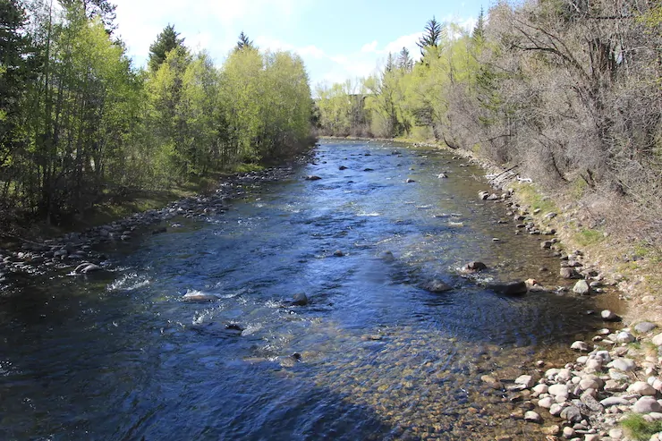

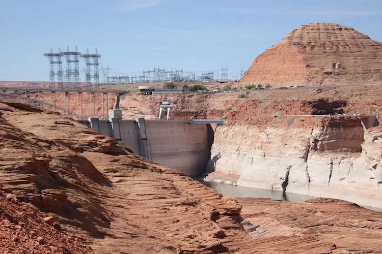


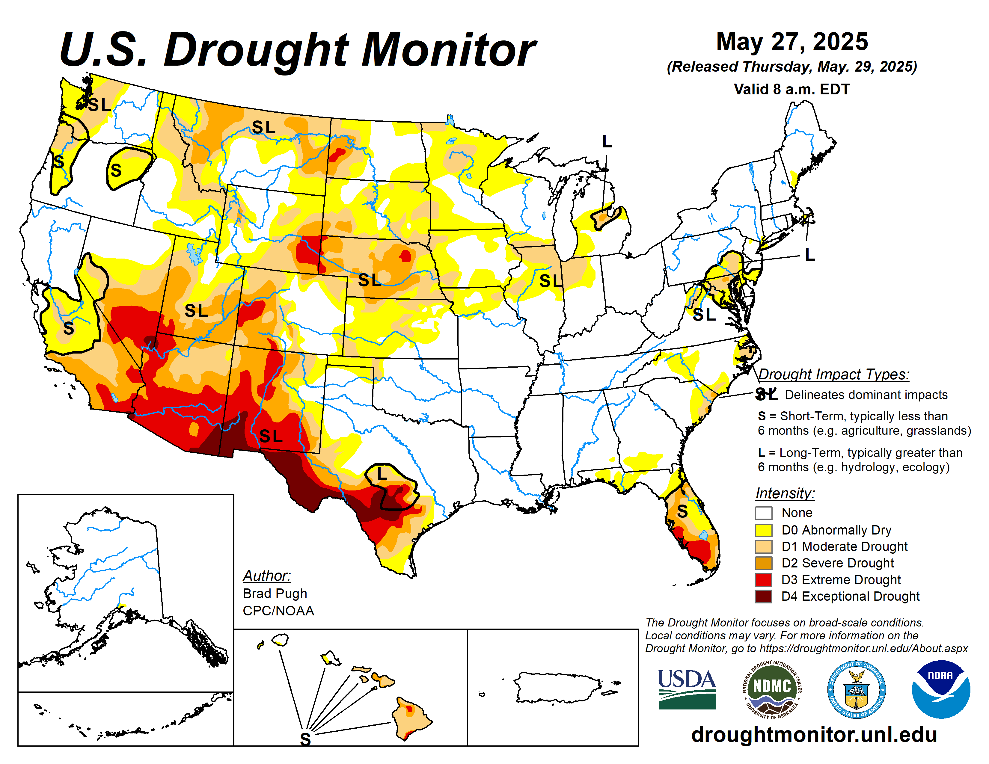
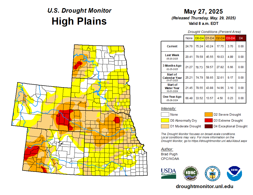
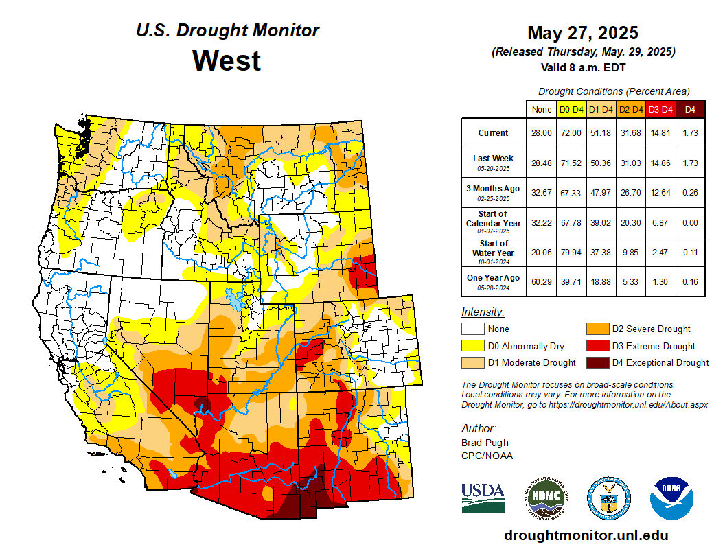
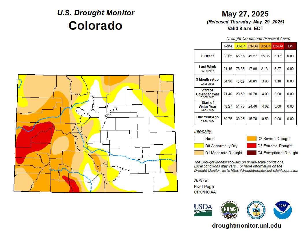
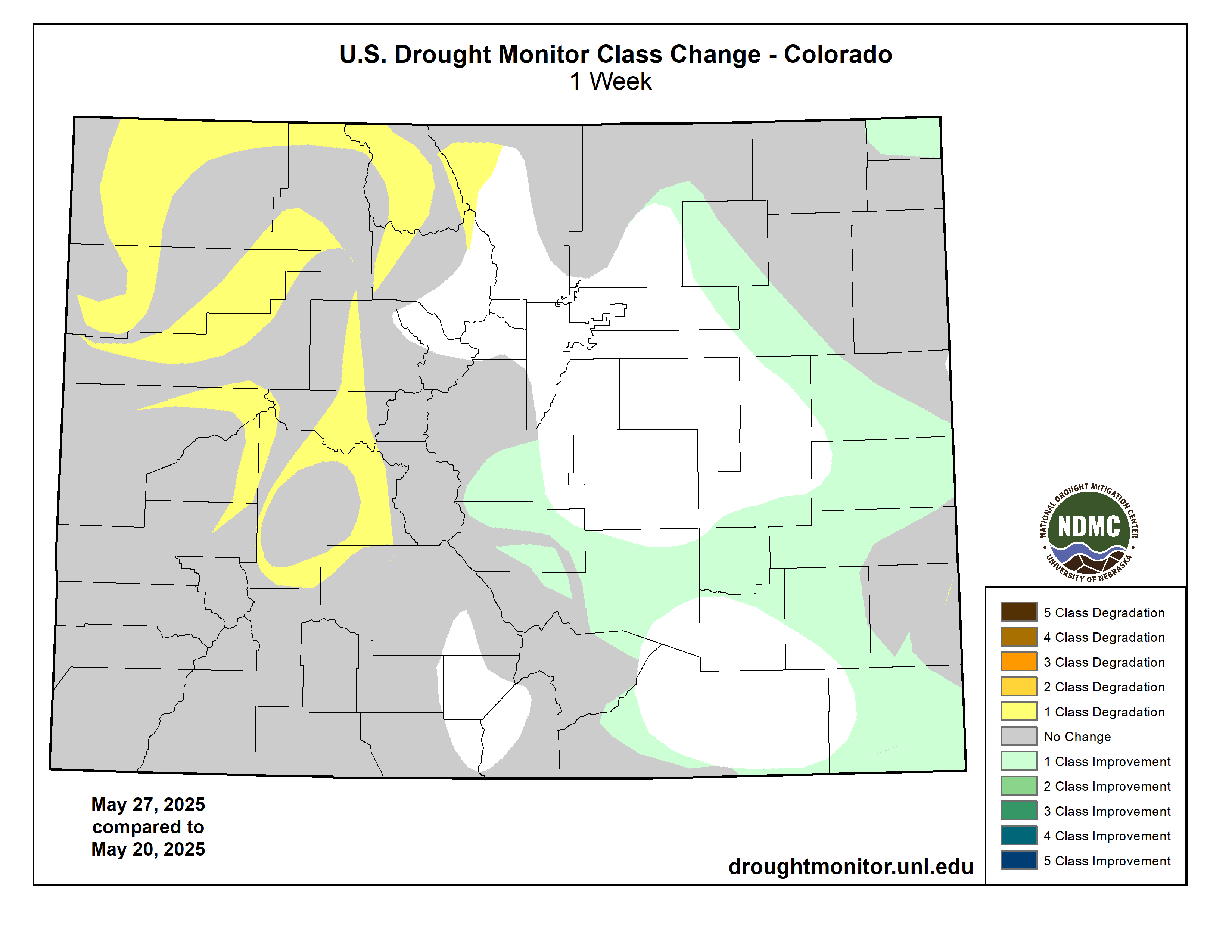
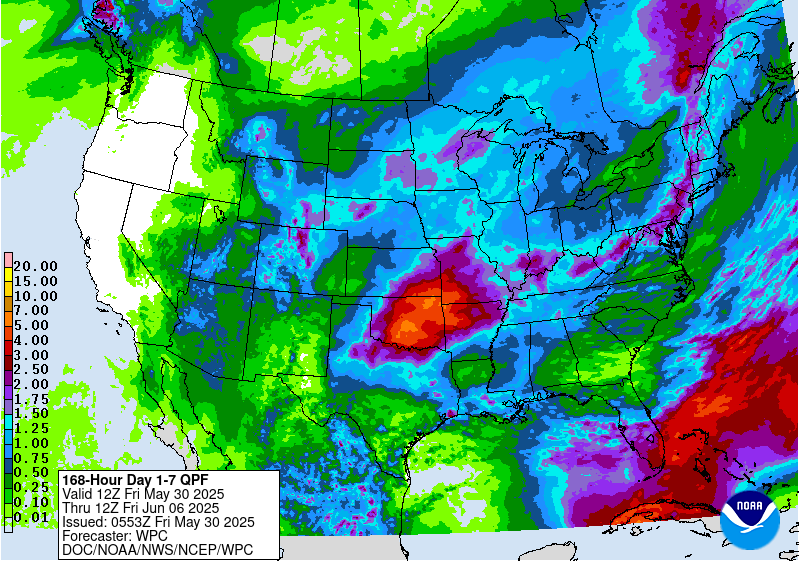
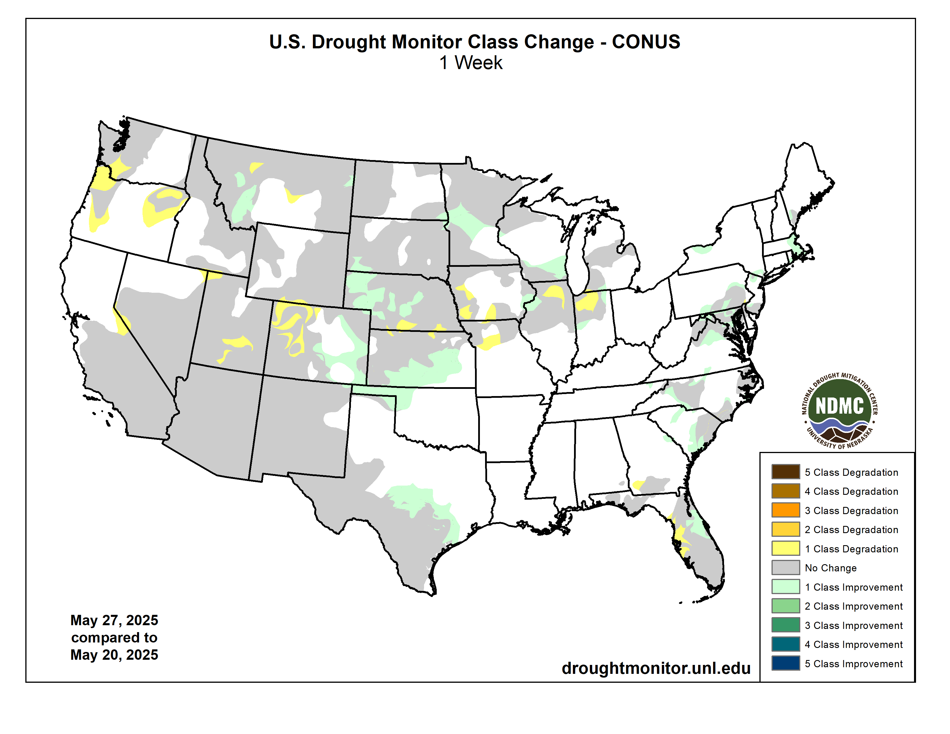


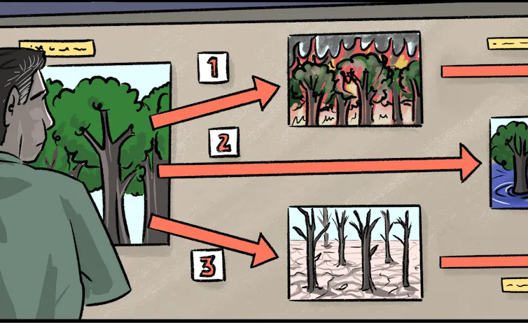
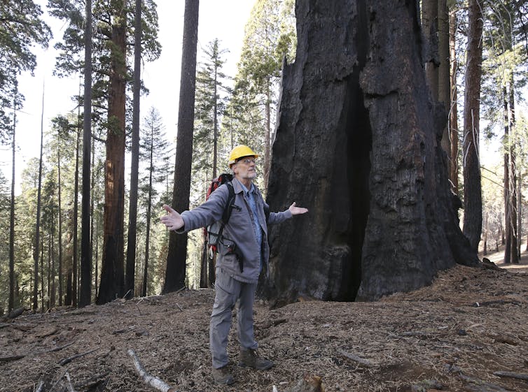
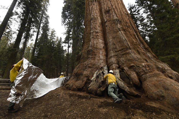
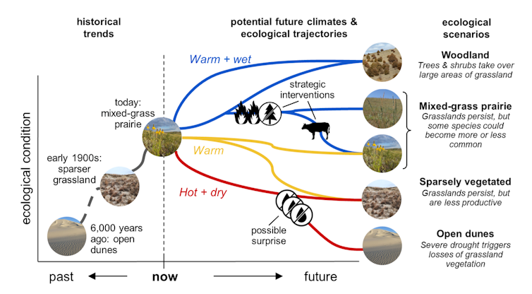
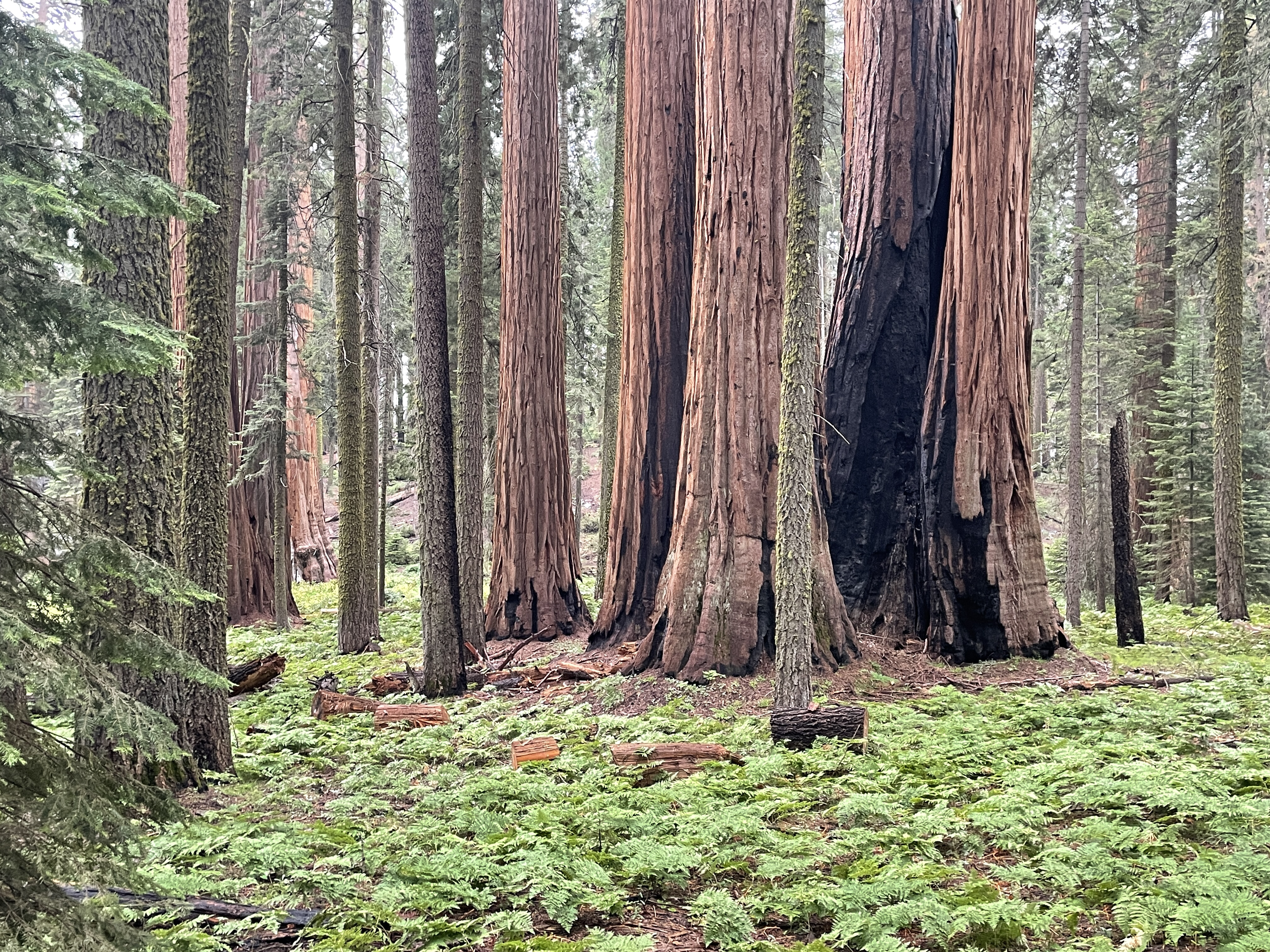


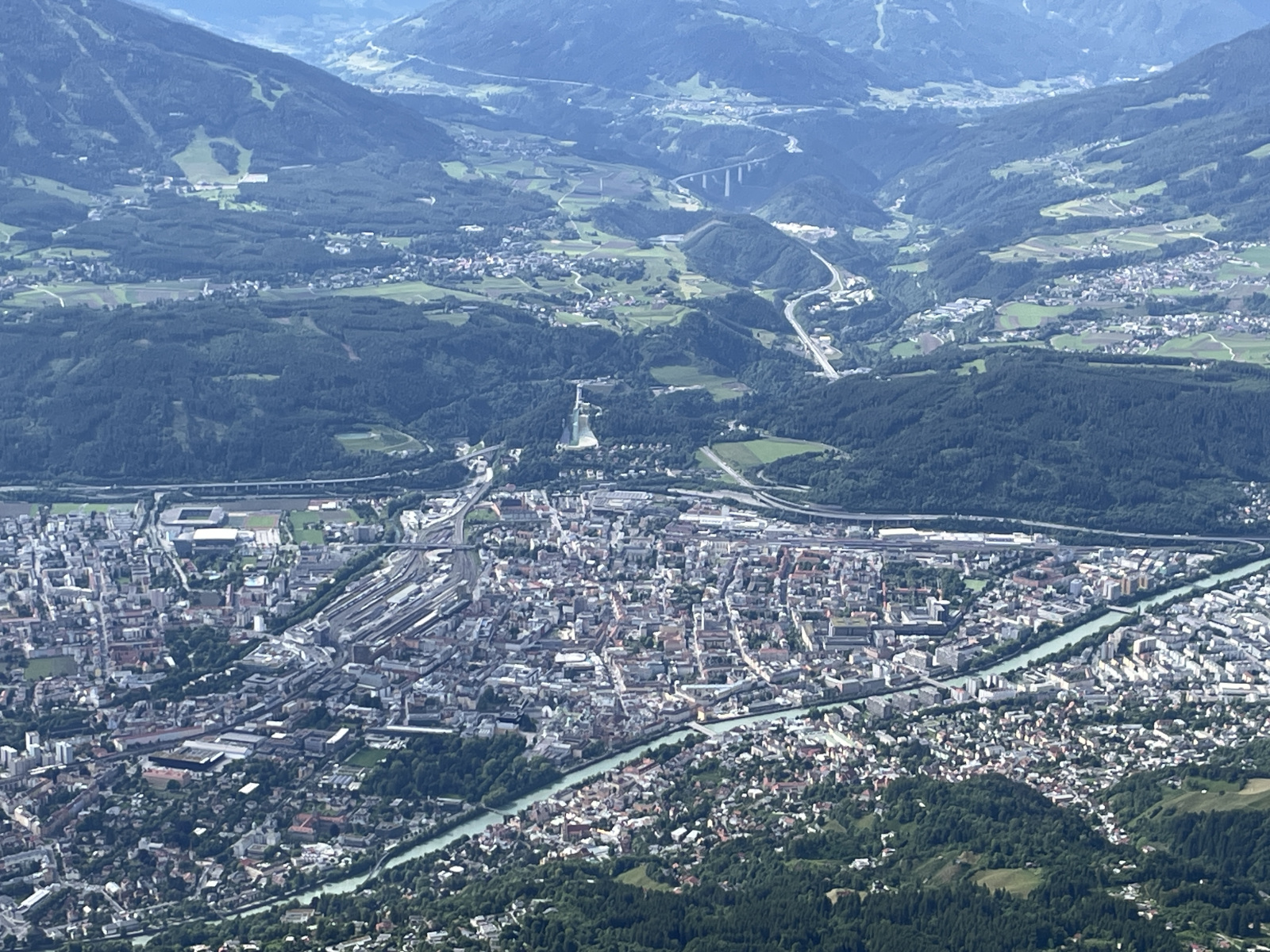

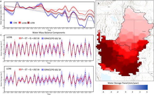


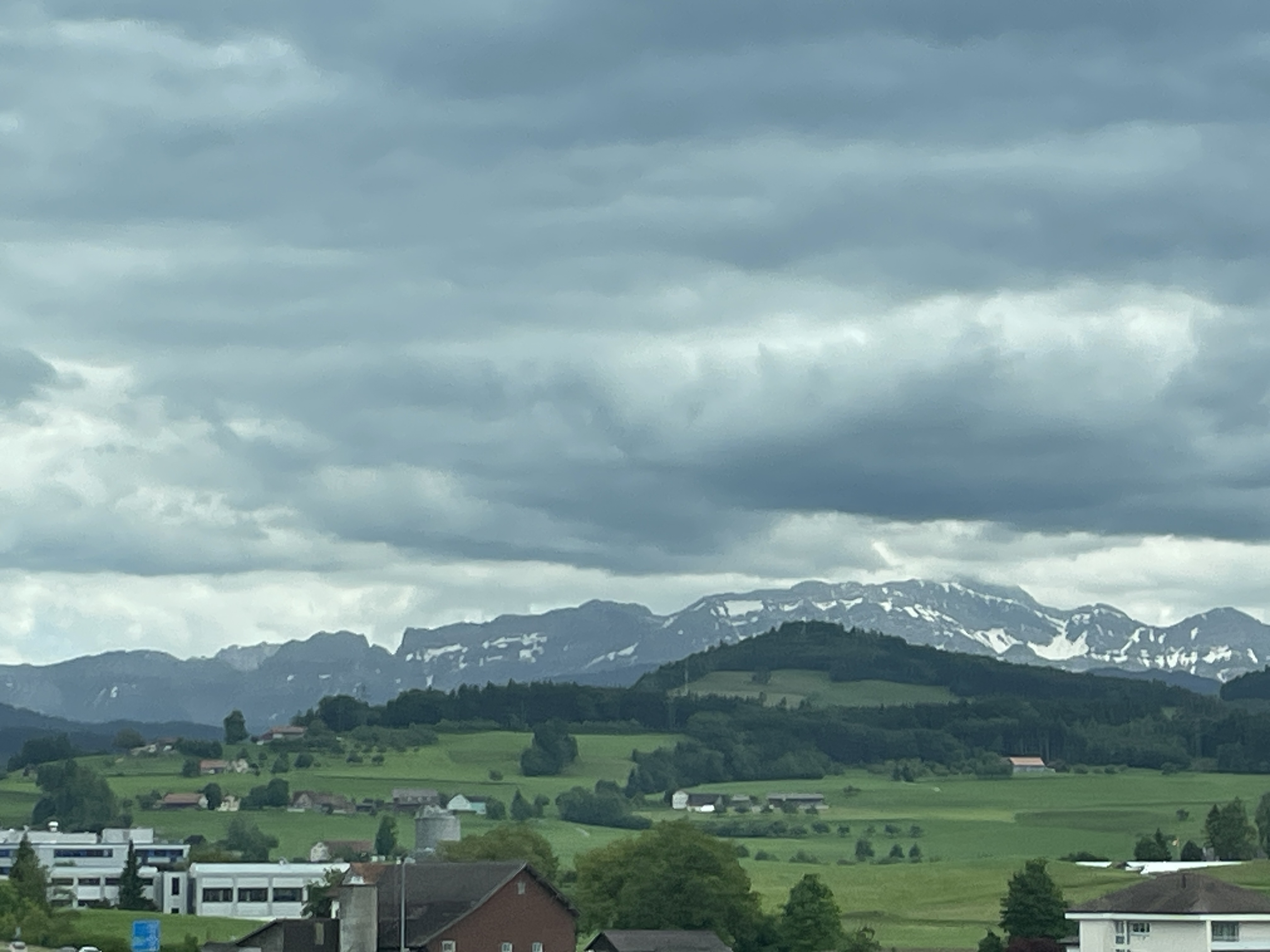
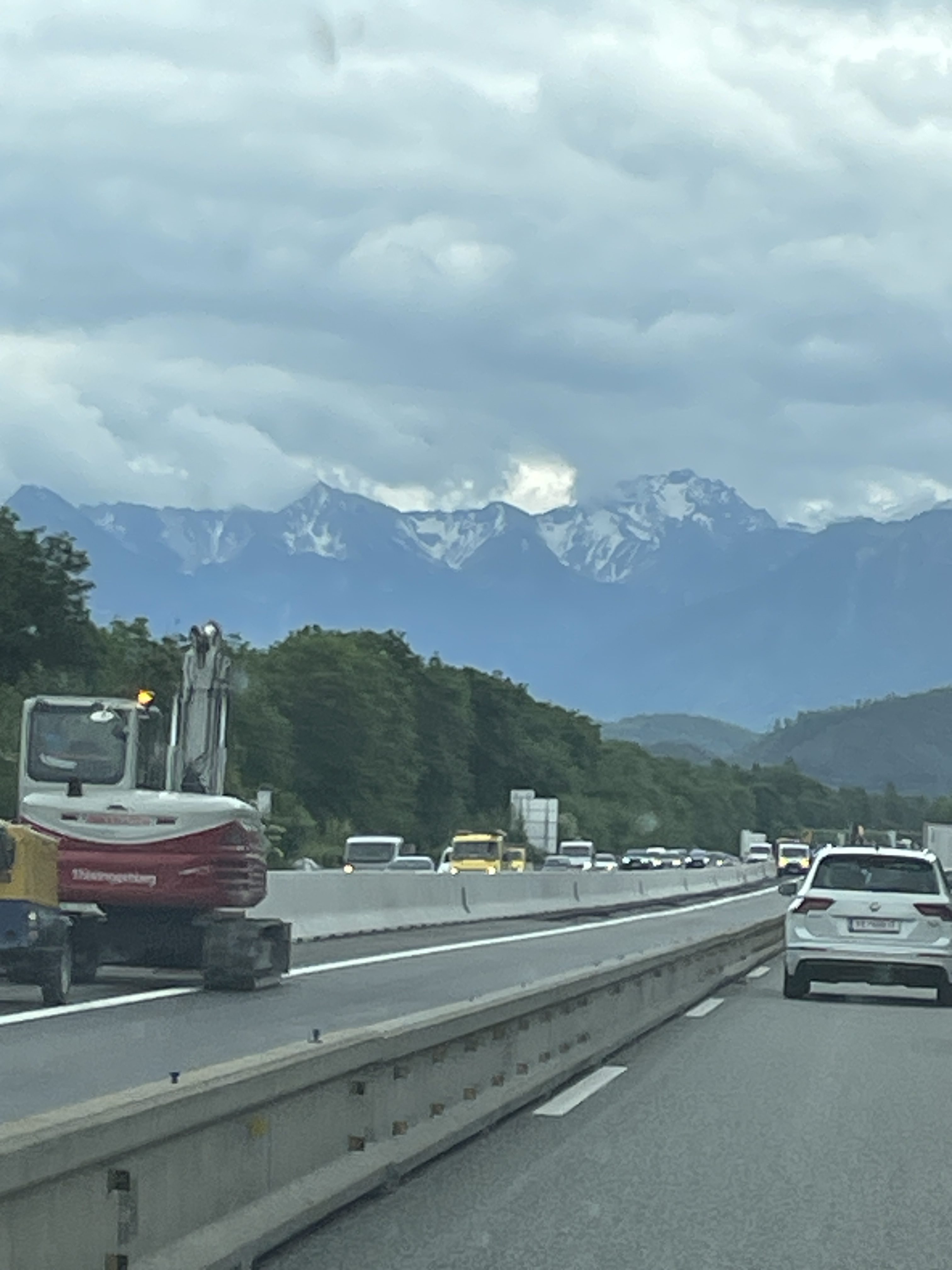


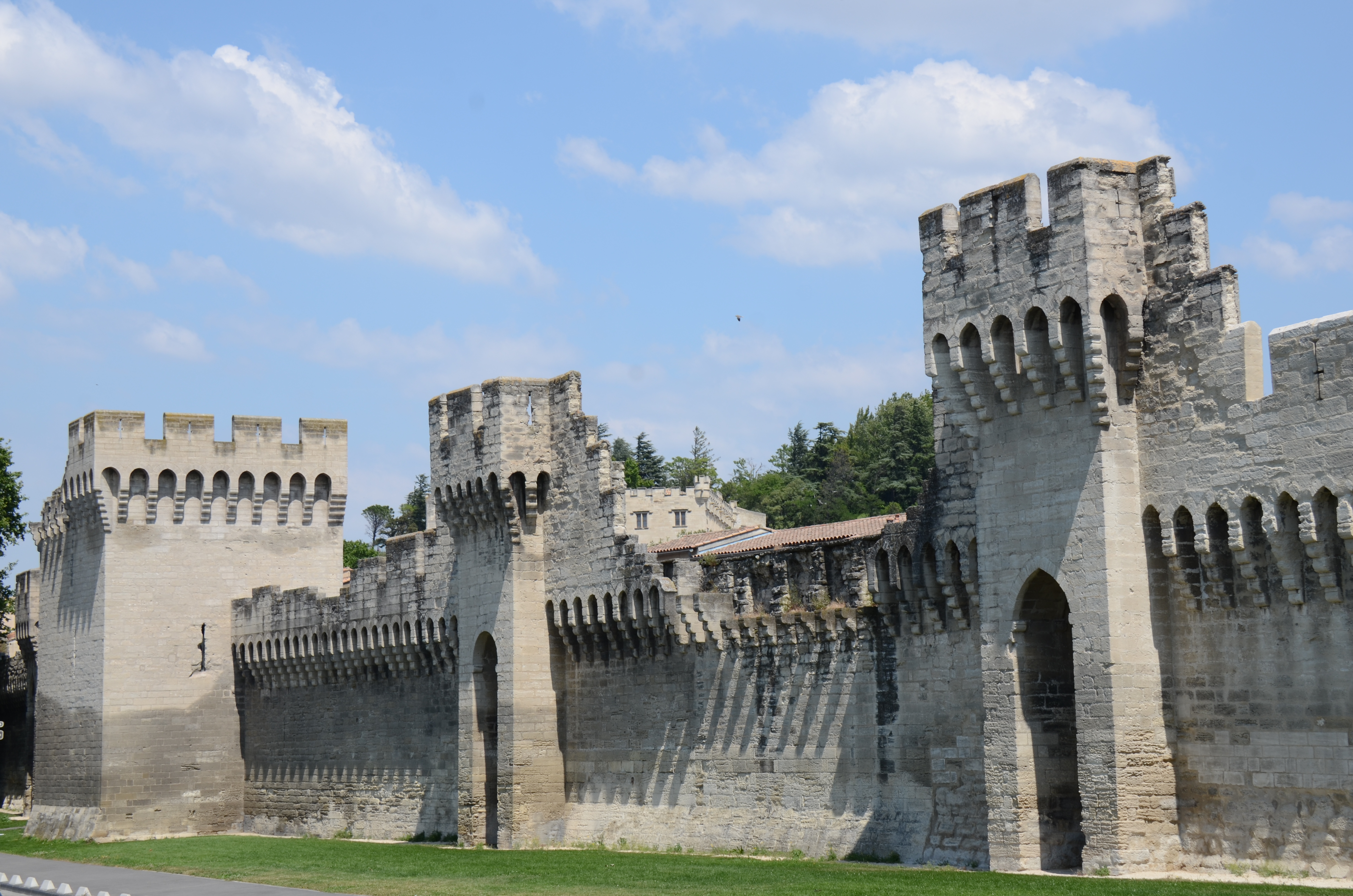


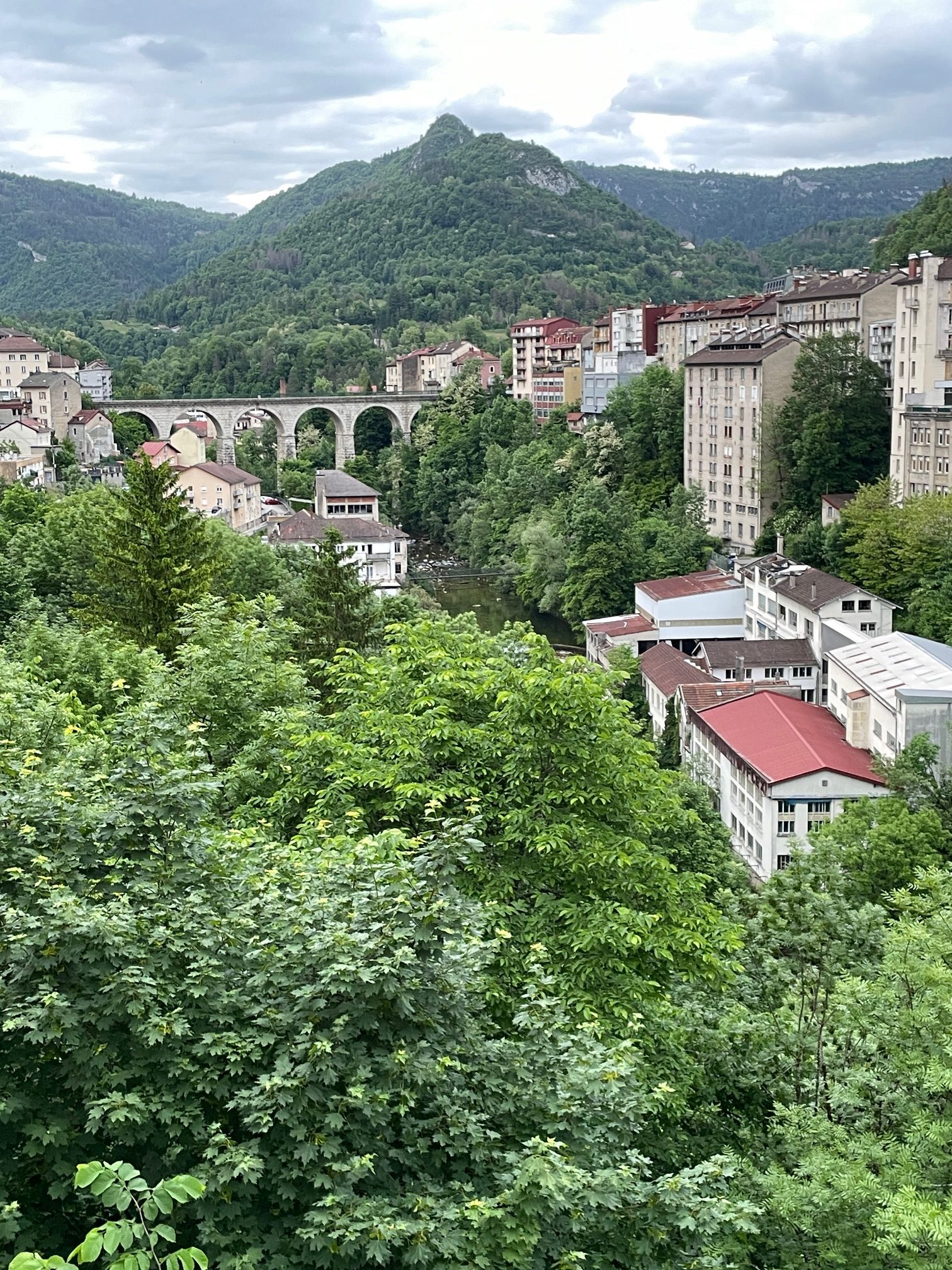
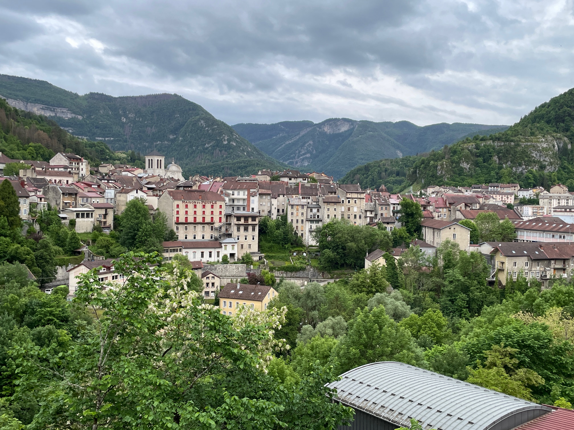


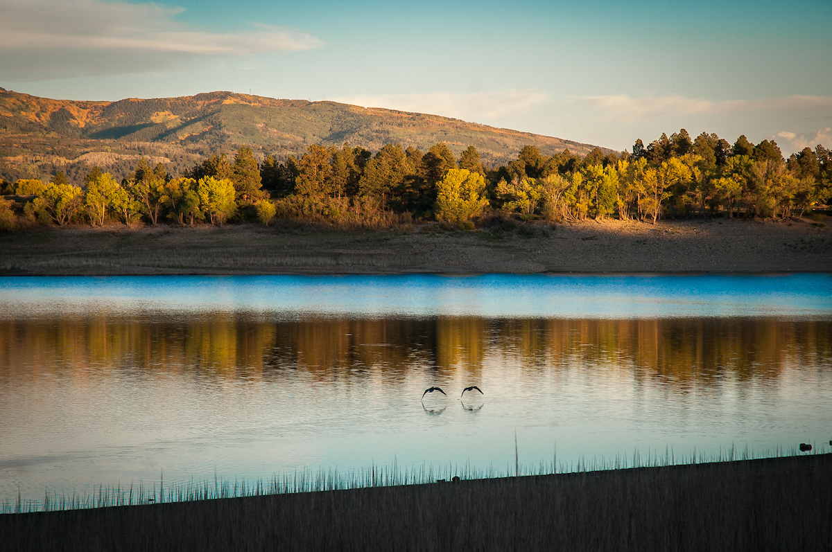


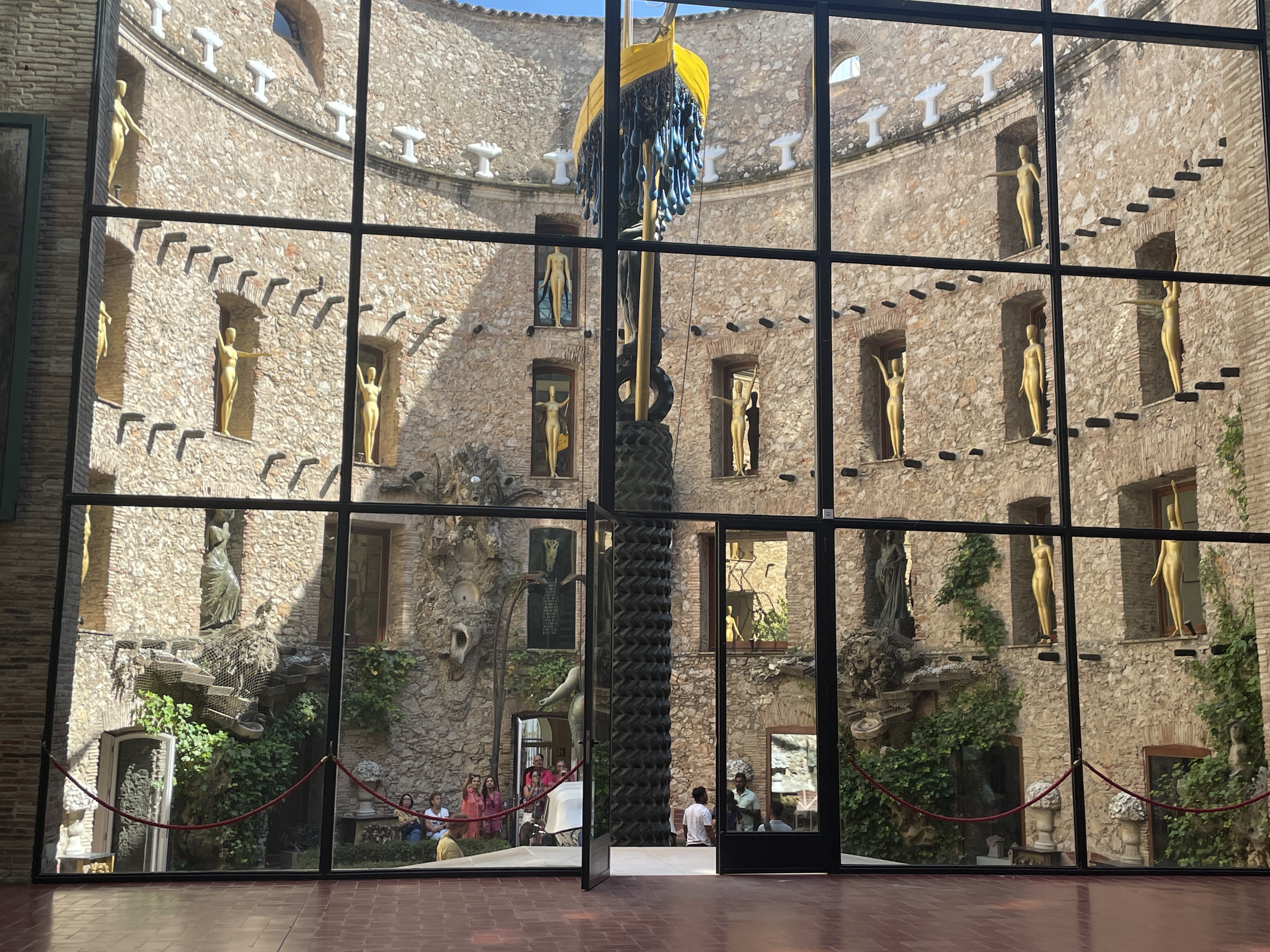


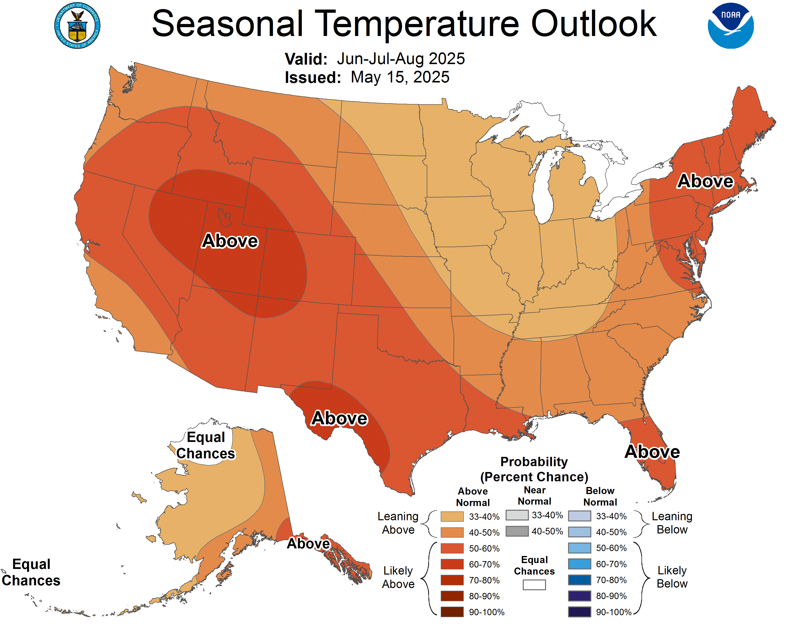


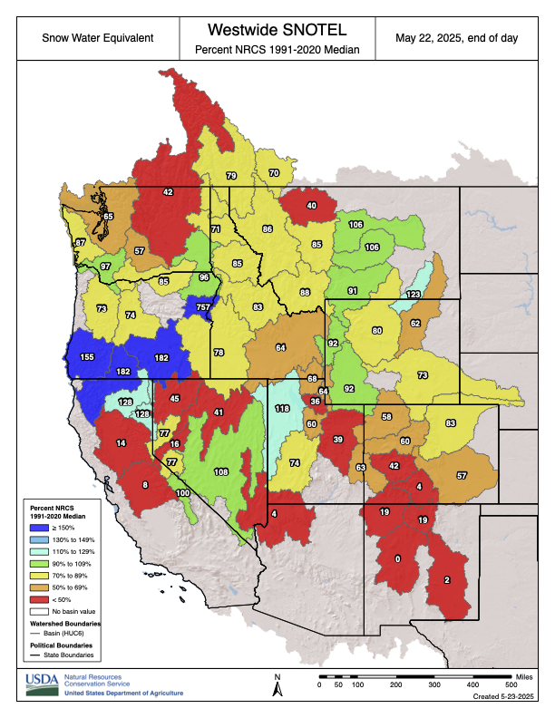
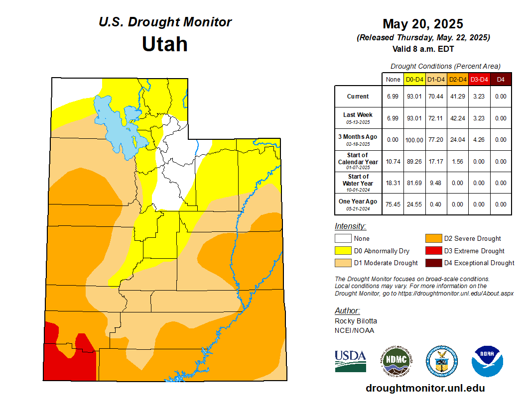


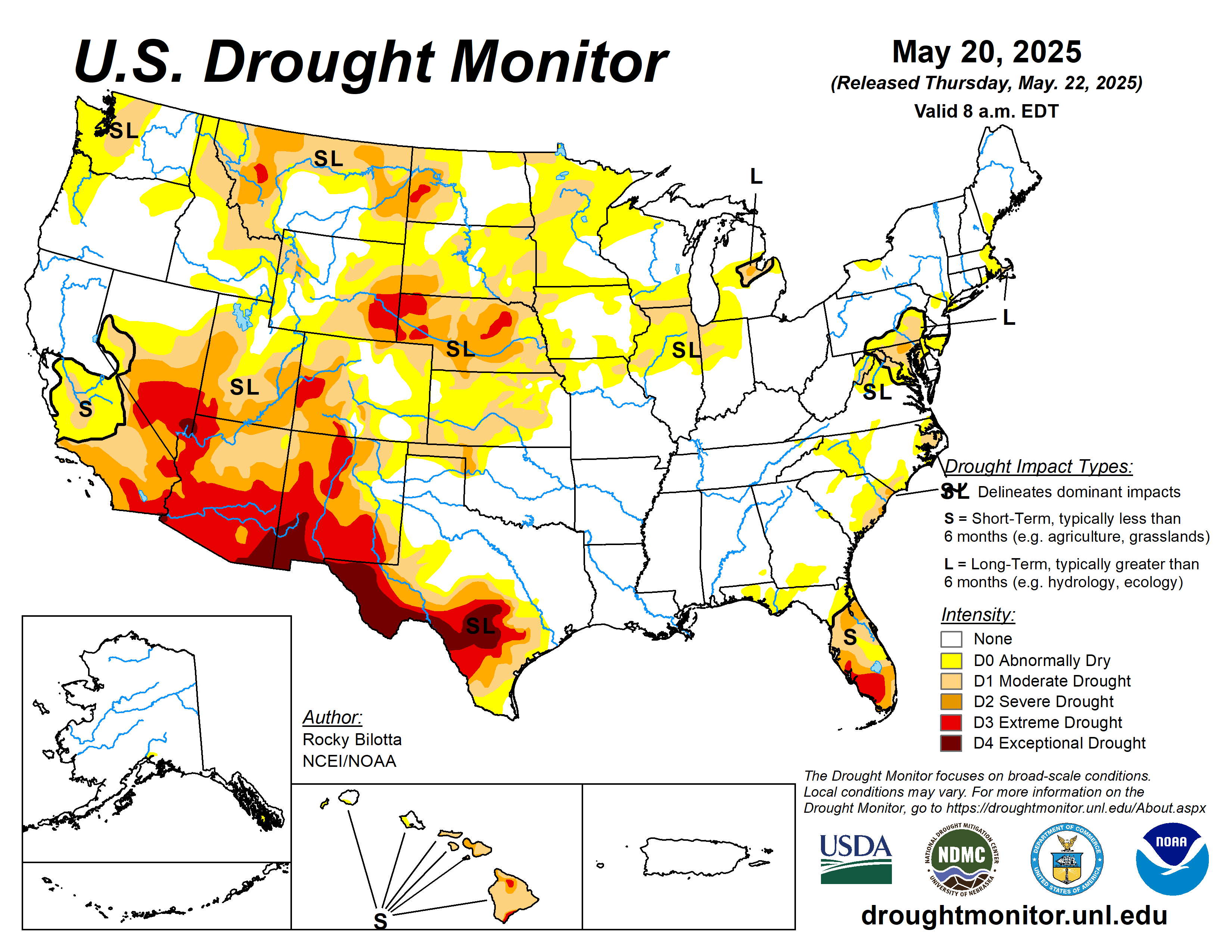
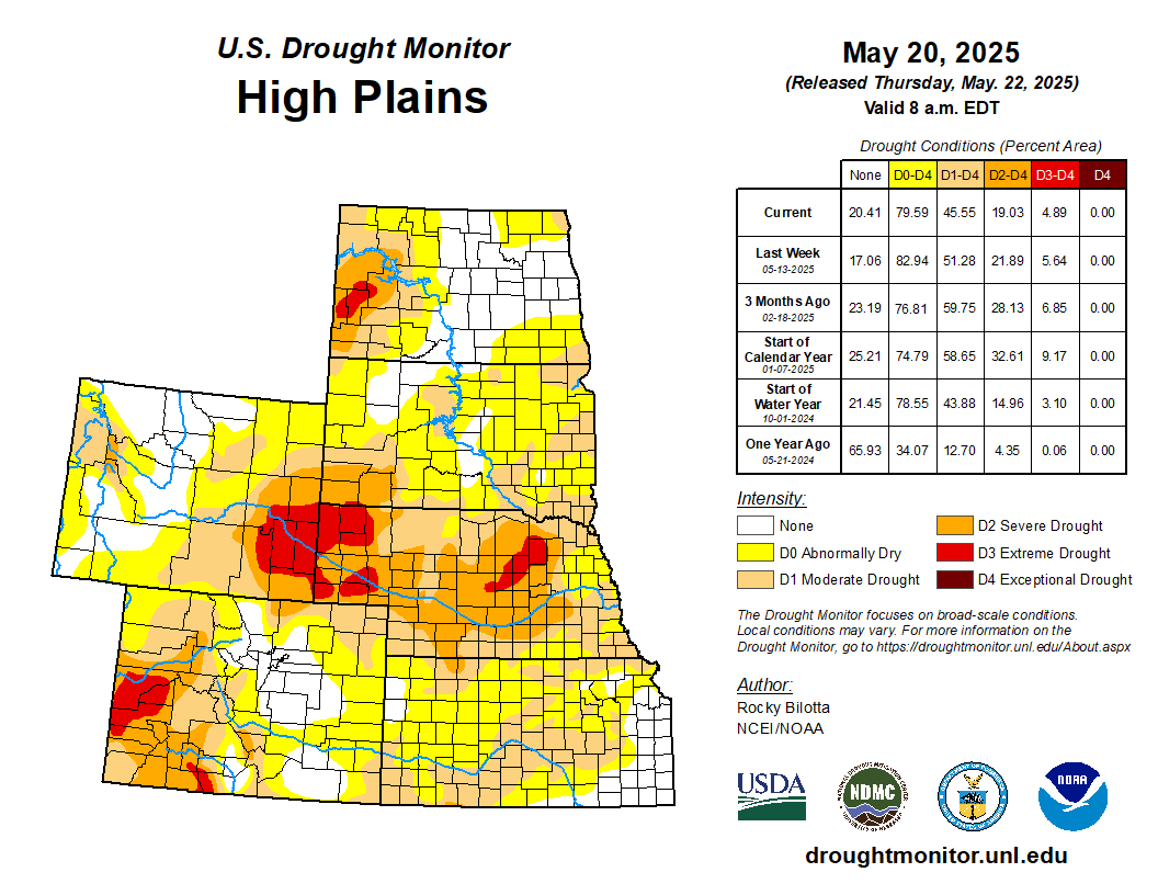
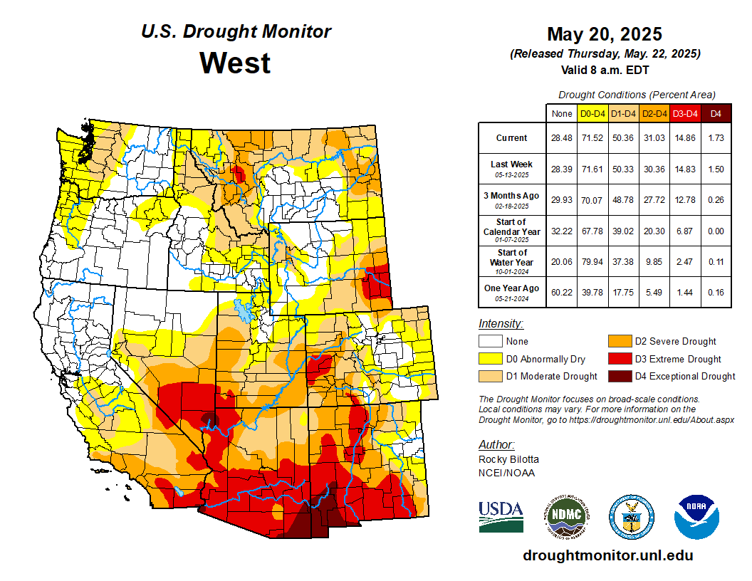
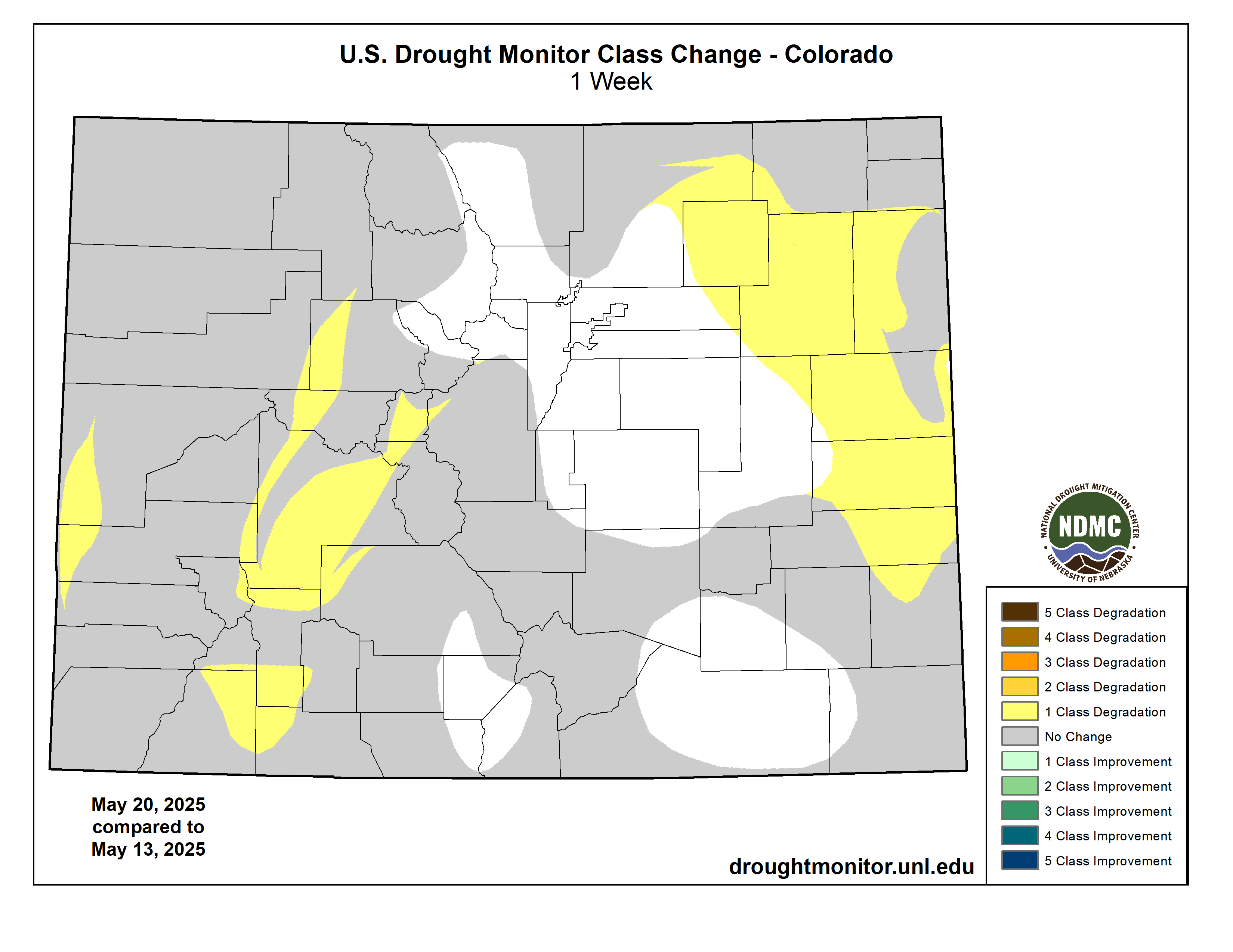
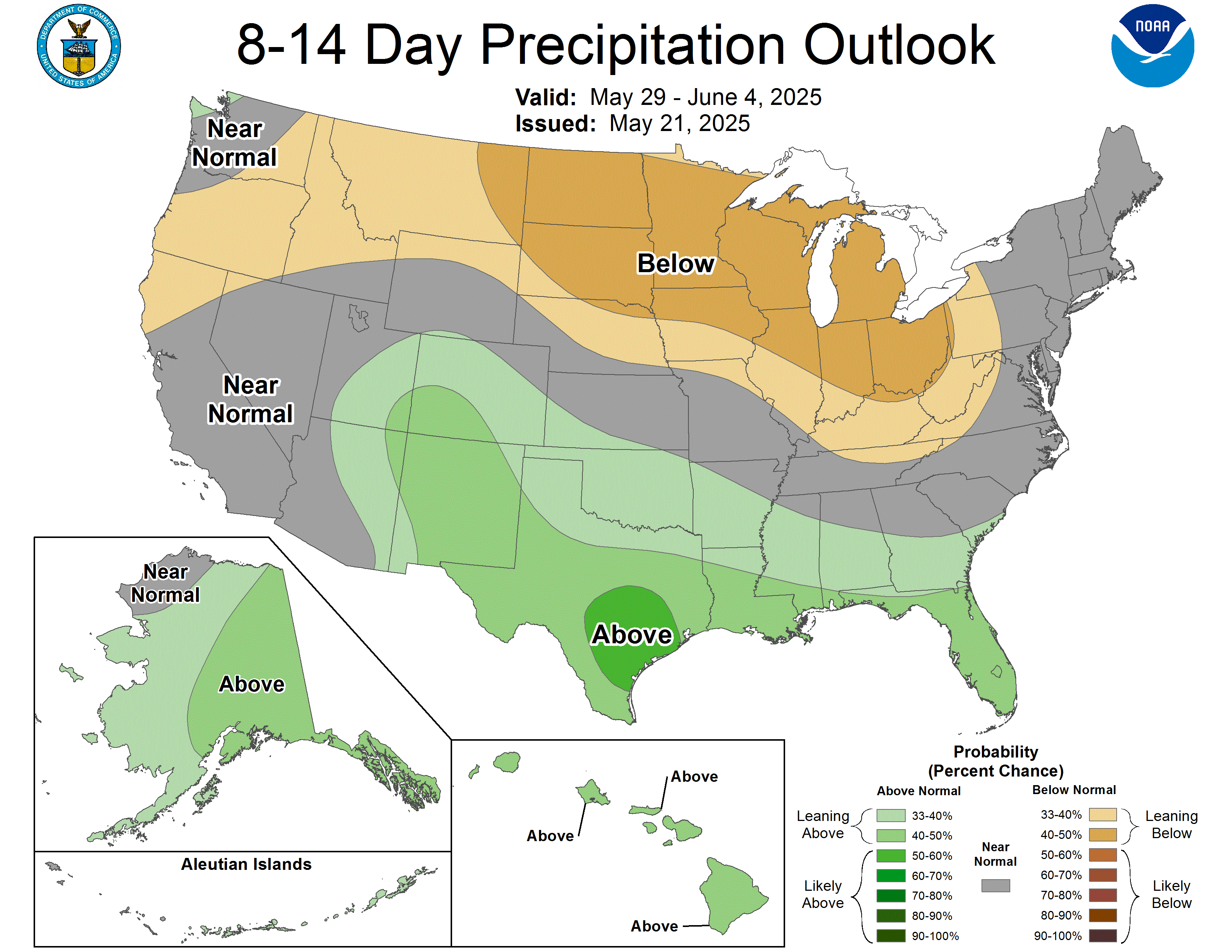
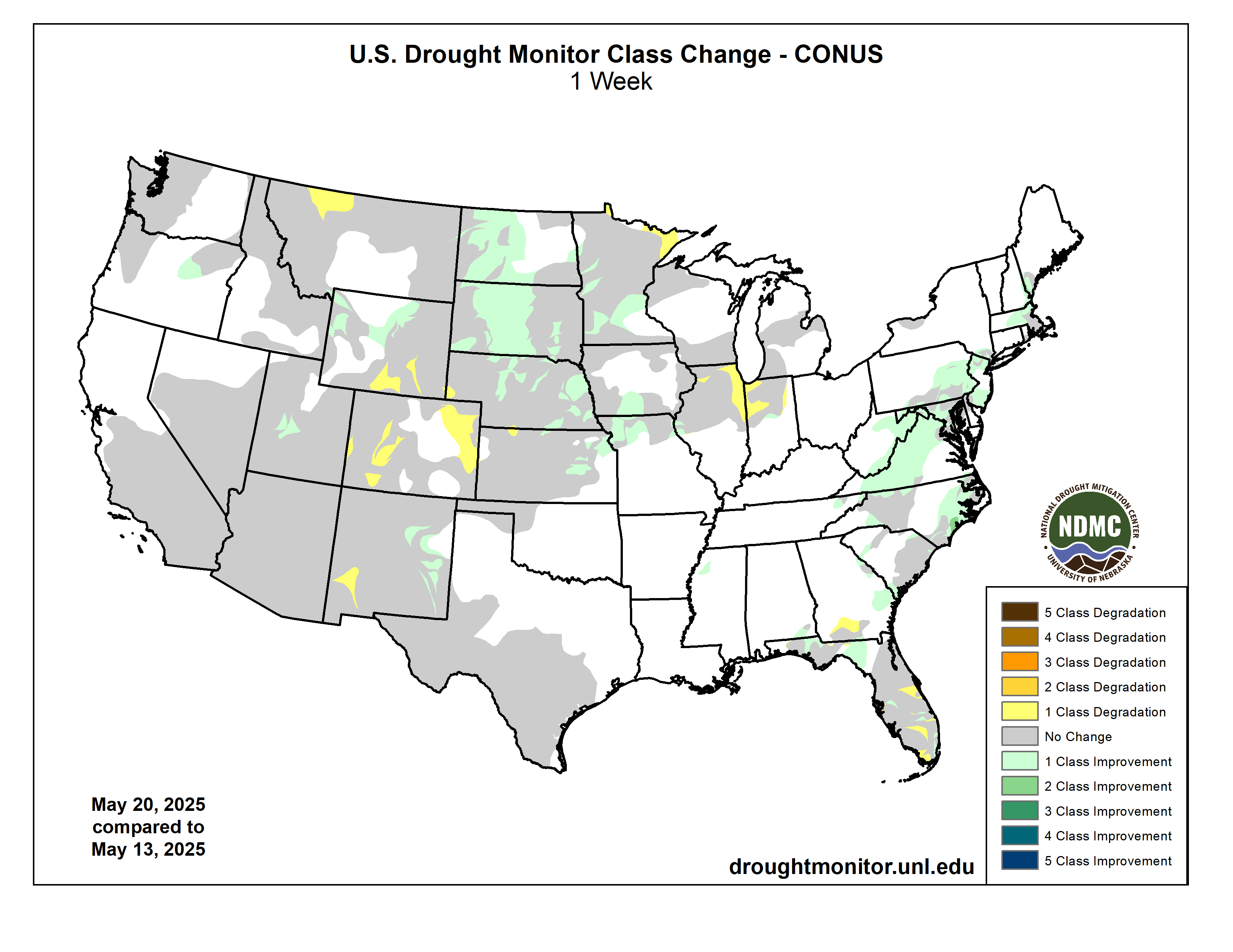


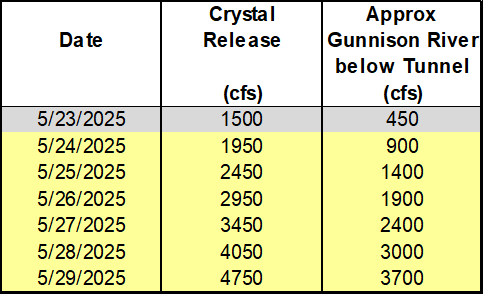


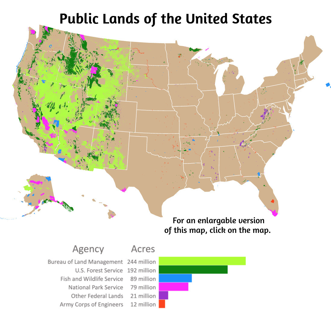
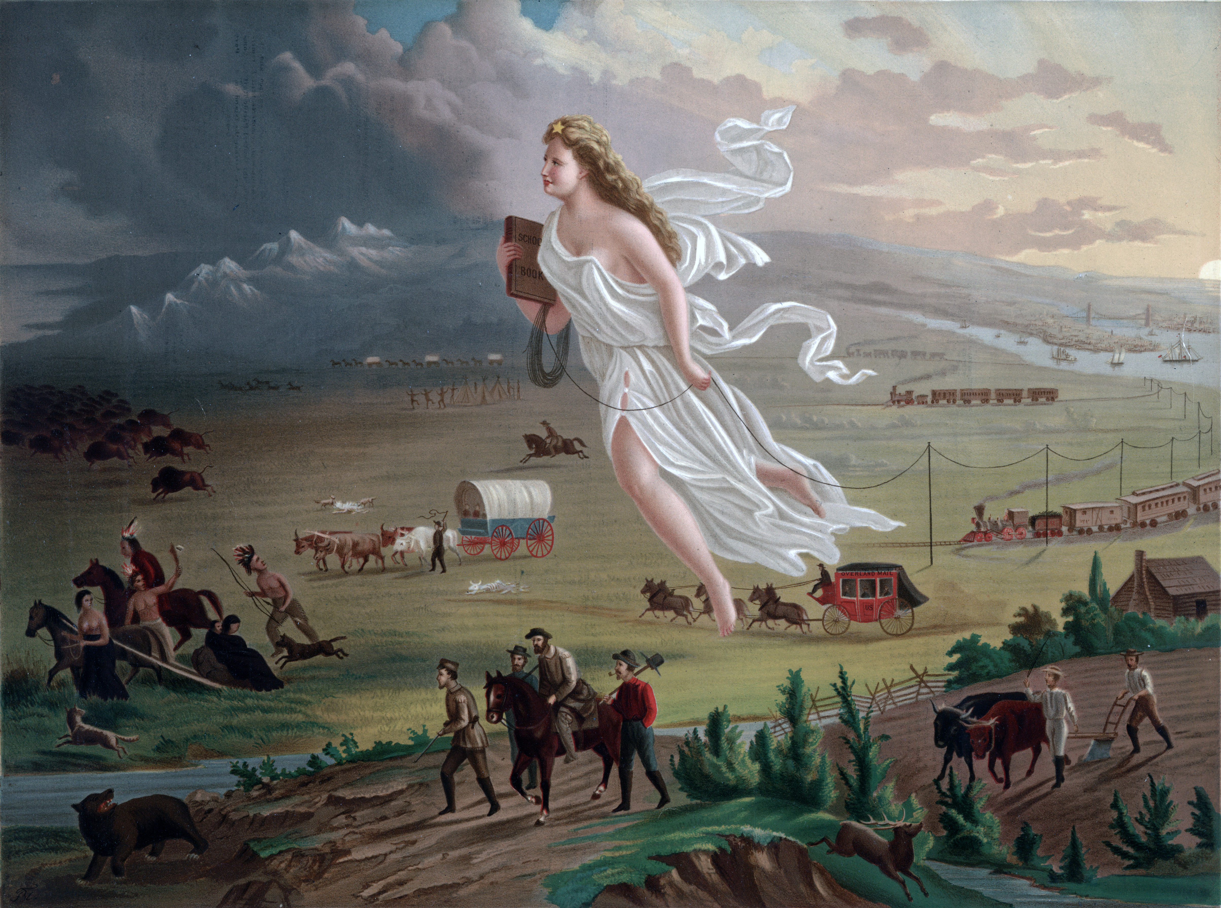


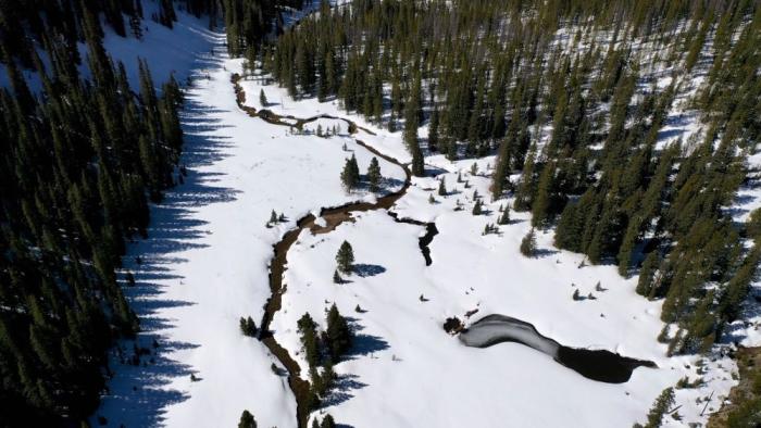

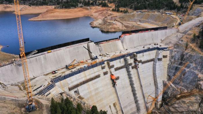
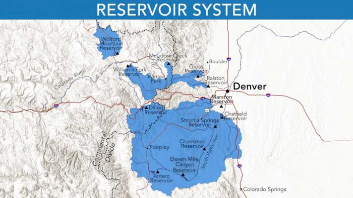

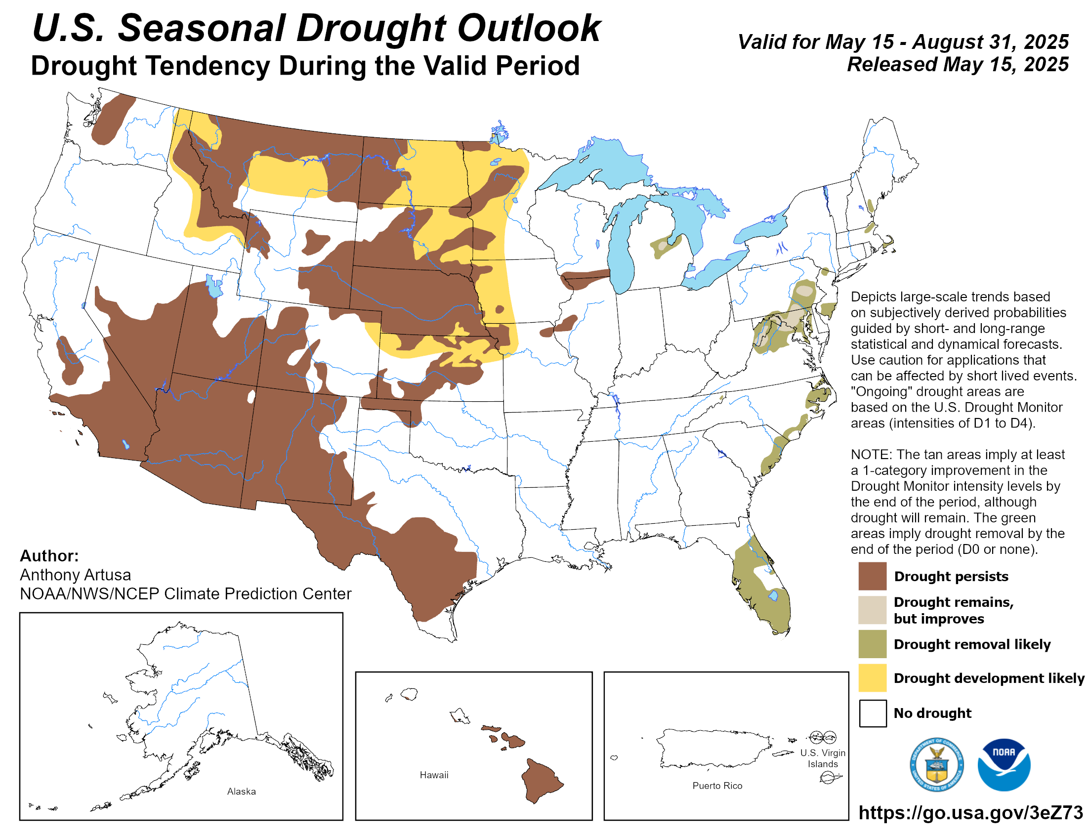


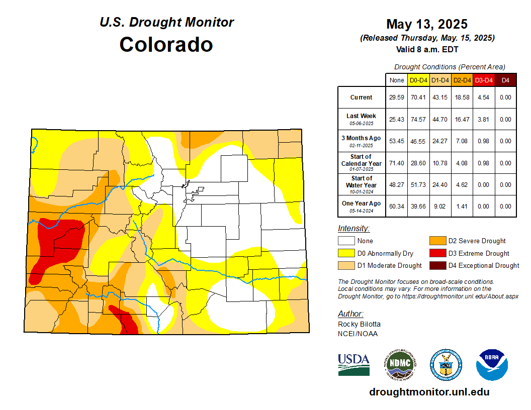


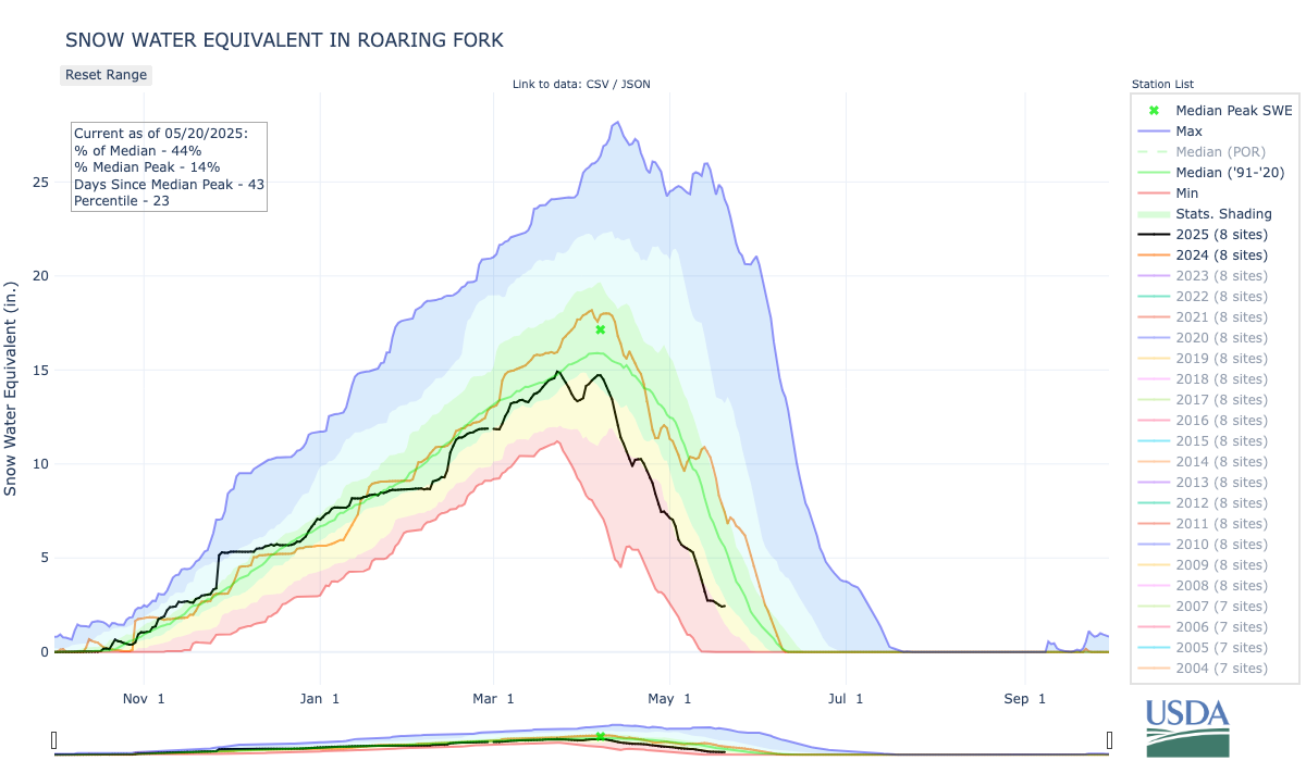


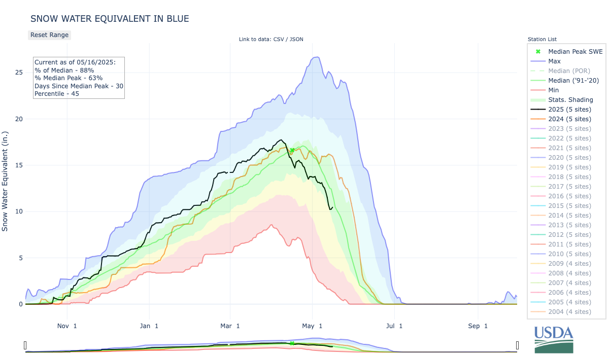

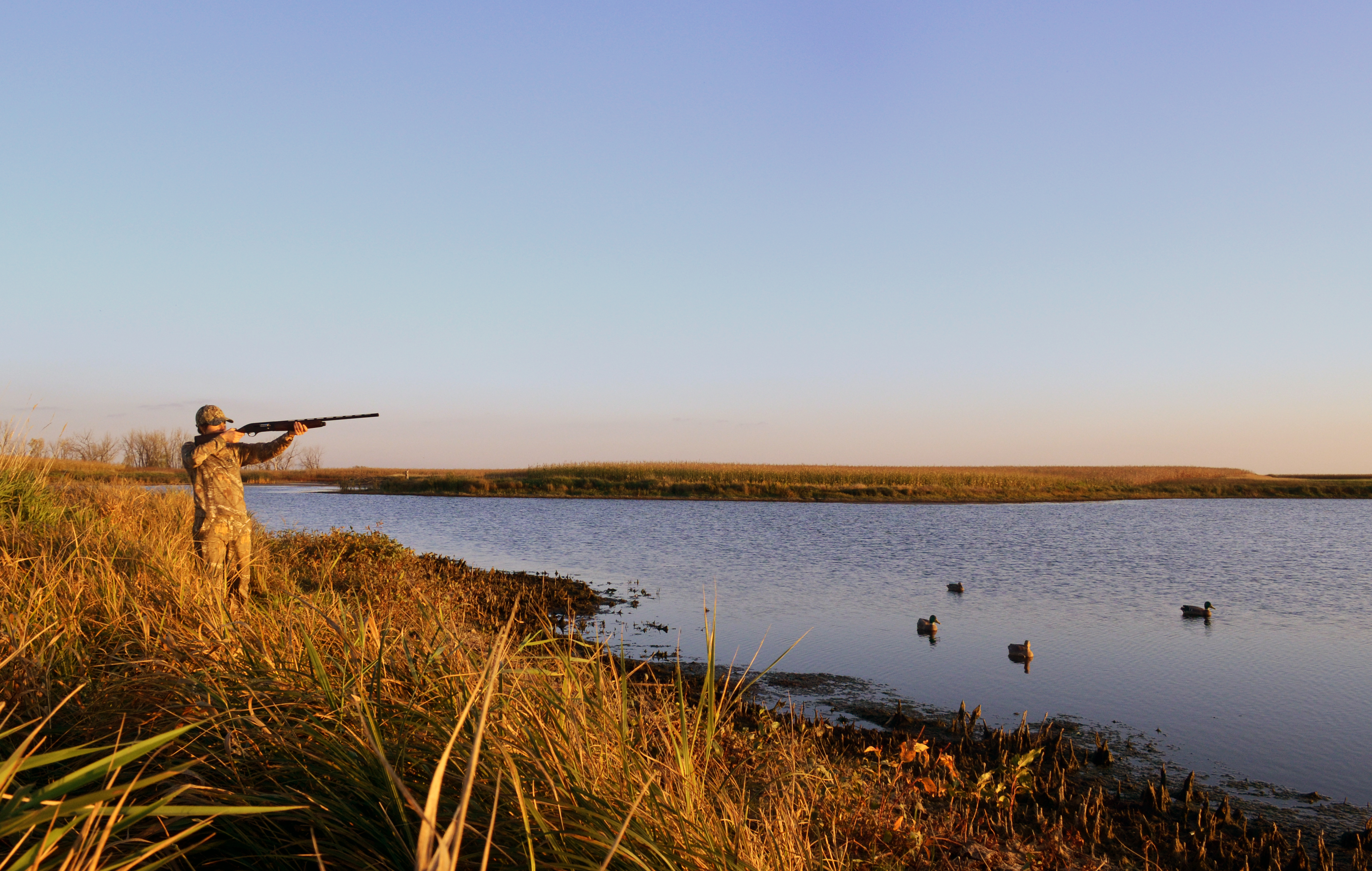
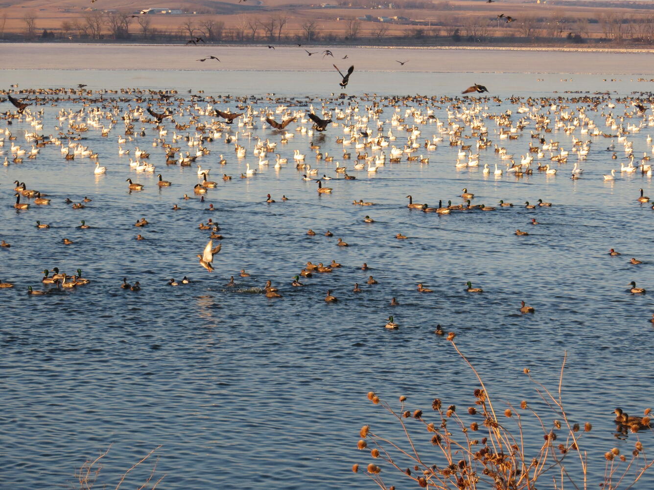

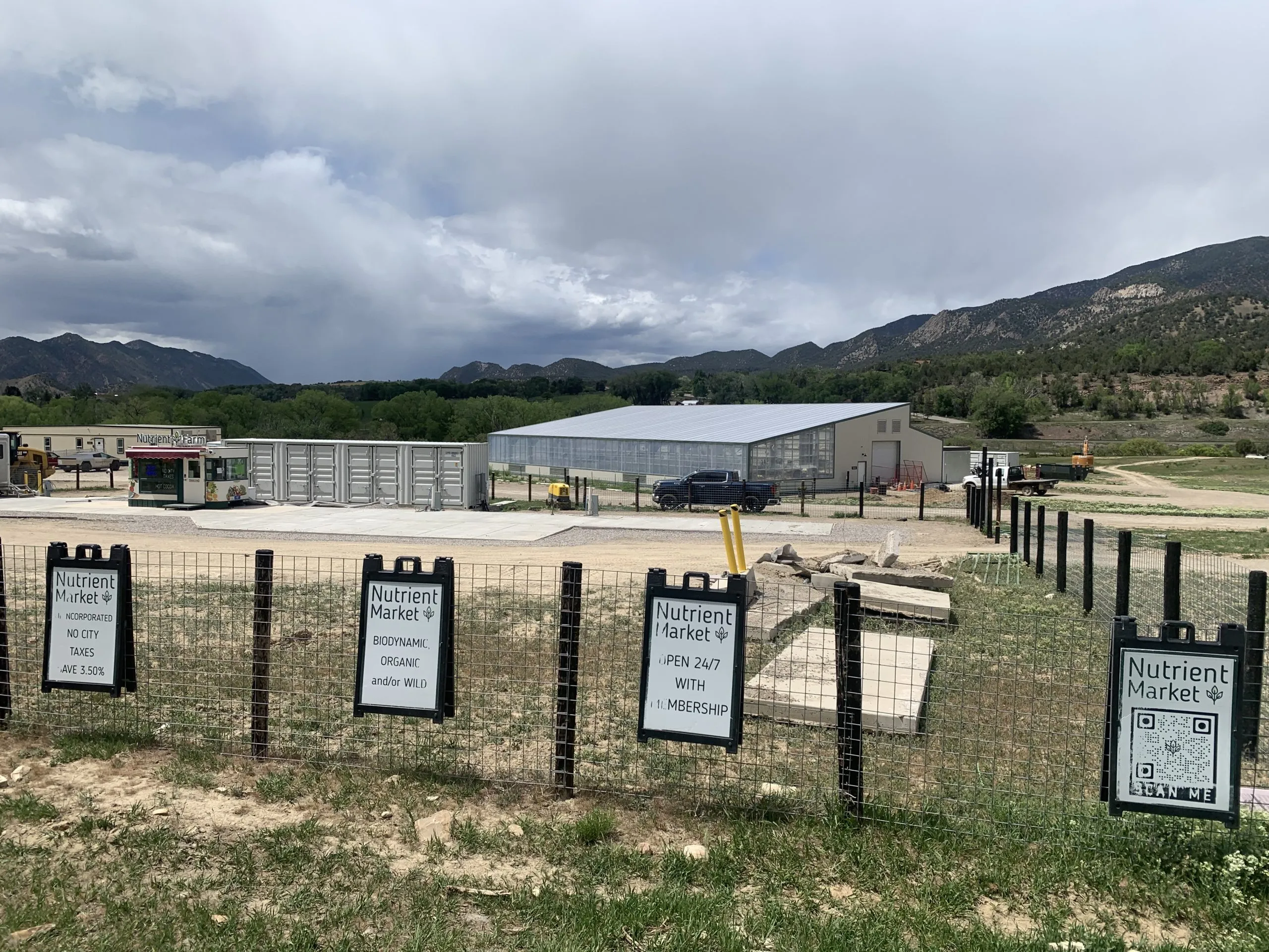


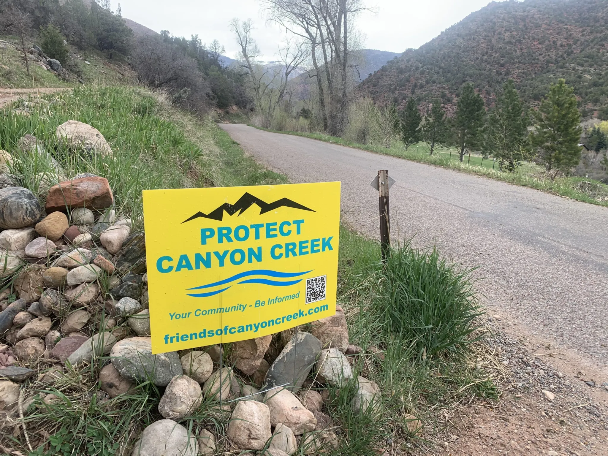
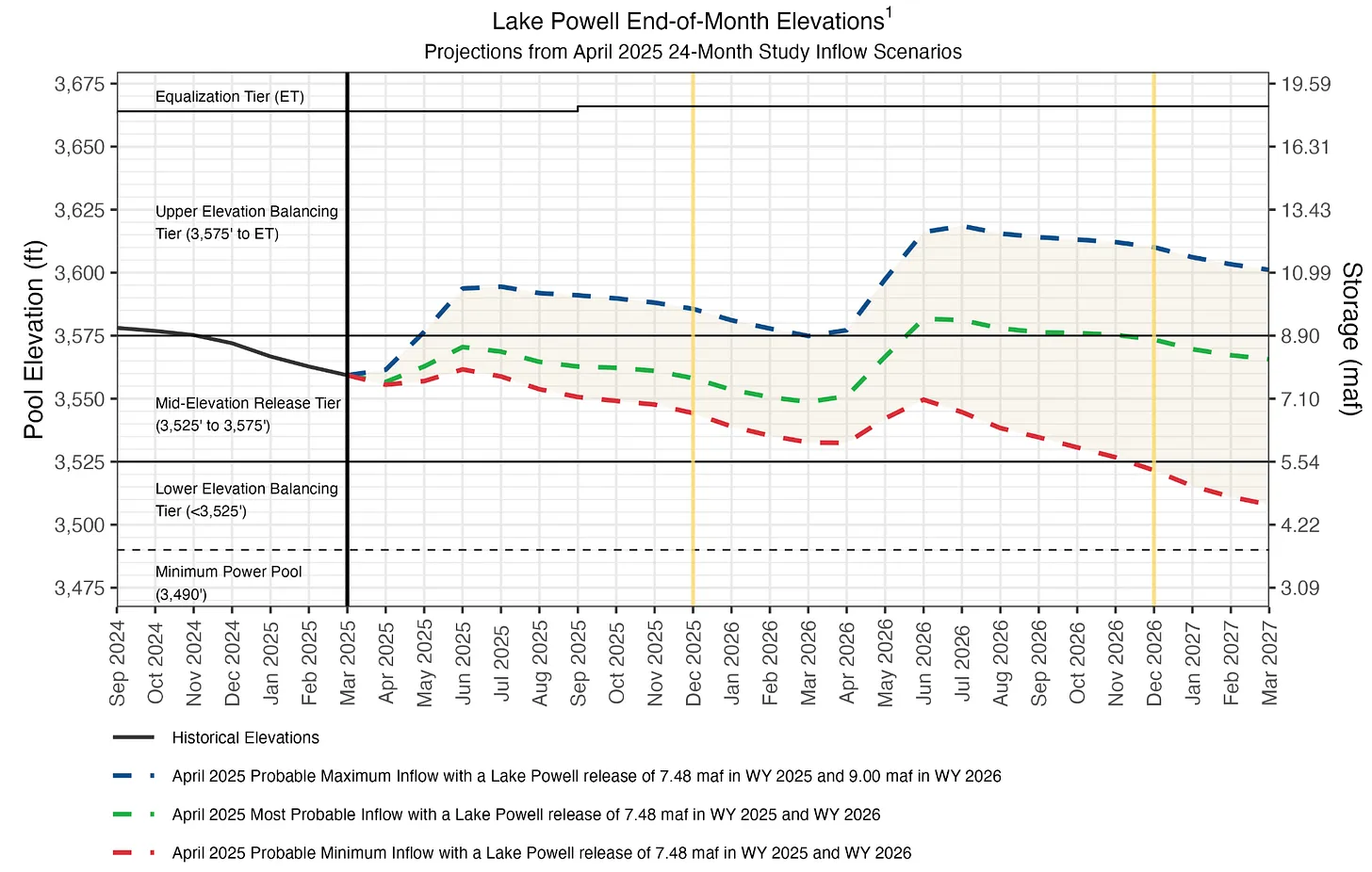


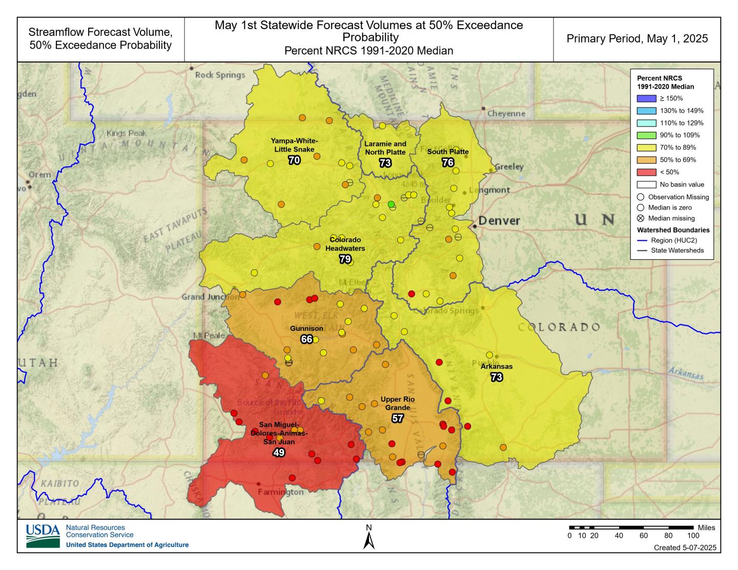


