
Mrs. Gulch’s landscape July 16, 2025


Click the link to read the article on the InkStain website (John Fleck):
July 15, 2025
The “official” call: the Rio Grande went dry in the Albuquerque reach, just upstream of the city’s wastewater treatment plant (click here for the map), on Sunday evening (July 13, 2025), for only the second time in the 21st century.
“Dry” in this case has a formal definition. The thinning ribbons of water you see in the picture above, taken mid-afternoon Monday (July 14, 2025) have to break. It’s still a muddy mess; the river’s subsurface manifestation, the shallow aquifer, still has water in it, the trees (look at their lovely green!) still have access to that part of the river. But if you’re a fish or a turtle, these are sad times.
The fact package
We got an excellent update on river conditions (as we do every month) at the meeting of the Middle Rio Grande Conservancy District, the government agency responsible for river flood control, drainage, and irrigation in New Mexico’s Middle Rio Grande. Most of what follows I learned by attending that meeting.
The last time the river dried in the heart of New Mexico’s largest city was 2022. Before that, it hadn’t happened since the 1980s.
Drying is common to the south, between Albuquerque and Elephant Butte Reservoir. Happens most every year. What’s new is drying in the heart of this large urban area.
Imported Colorado River water, via the San Juan-Chama Project, delayed the Albuquerque drying. The Middle Rio Grande Conservancy District used that water to supplement flows and get water to irrigators from June 16 to July 6, when their San Juan-Chama supplies ran out. (Source: Anne Marken’s report to the MRGCD board)
The Conservancy District is currently operating under the rules of “prior and paramount” operations, meaning a subset of the lands of the valley’s six Native American Pueblos get water, while all non-Indian irrigators upstream of Isleta Pueblo are being curtailed. (Source: Marken, if you wanna understand what’s happening on the Rio Grande, you can do no better than Anne’s monthly report to the board)
As of July 8, the federal government had ~31,545 acre feet of P&P water in storage in El Vado (there’s a bit of space available despite the dam’s problems) and Abiquiu. (Source: USBR report to the MRGCD board)
Downstream from Isleta, once the Pueblos have gotten their P&P water, some irrigation is possible using return flows. Because of the structure of the plumbing, this favors the river’s east side communities. (Source: Matt Martinez report to the MRGCD board, ditto what I said about Marken: “If you wanna understand….”)
The pumps that have kept water flowing to Corrales in the absence of the rickety old siphon that used to get water there were shut down June 26. (Source: Matt Martinez)
Current flow at the Central Avenue Bridge, as measured by the USGS: is it even worth trying to measure this? What does “1.78 cubic feet per second” mean in a river like the one you see in the picture above?
Click the link to read the article on the InkStain website (Jack Schmidt Center for Colorado River Studies, Utah State University):
July 14, 2025
Water stored in the reservoirs of the Colorado River represents the account balance from which we draw water for use. The amount in the account is especially important during dry times when the demand by water users throughout the Basin exceeds income to the account, primarily snowmelt runoff, and is met by account withdrawals.
The annual cycle of reservoir hydrology includes two seasons – a relatively short season when reservoir storage increases and a relatively long season when storage decreases. In wet years, the season when storage increases typically begins in March or early April and may last until late July. In dry years, this season might not begin until May and end in mid-June. During the rest of the year, the Basin’s reservoirs are progressively depleted.
Snowmelt in 2025 was low, similar to what it was in 2012 and 2013; in early June, the Colorado Basin River Forecast Center predicted that this year’s unregulated snowmelt inflow to Lake Powell will end up being 54% of the recent 30-yr average. In the 21st century, only 2002, 2018, and 2021 had lower inflows to Powell. Not surprisingly, the amount of water that accumulated in the Basin’s reservoirs during the 2025 snowmelt season was also unusually low. There are a few ways to consider the Basin’s reservoirs. We can consider every reservoir for which data are readily available[1]; we can consider the major reservoirs actively managed by Reclamation[2]; or, we can consider just Lake Powell and Lake Mead (hereafter, Powell+Mead). Considering only Lake Powell or only Lake Mead doesn’t tell us much, because all of the Rocky Mountain snowmelt is first stored in Lake Powell and subsequently transferred to Lake Mead. In 2025, the 46 Basin reservoirs gained only 0.55 million af (acre feet) of water, of which only 0.28 million af accumulated in the 12 federal reservoirs and only 0.11 million af accumulated in Powell+Mead. That is a very small amount, especially compared to 2023 and 2024 (Fig. 1). That accumulation is being quickly consumed. By 1 July 2025, all of the 2025 accumulation in Powell+Mead had been released downstream or evaporated.
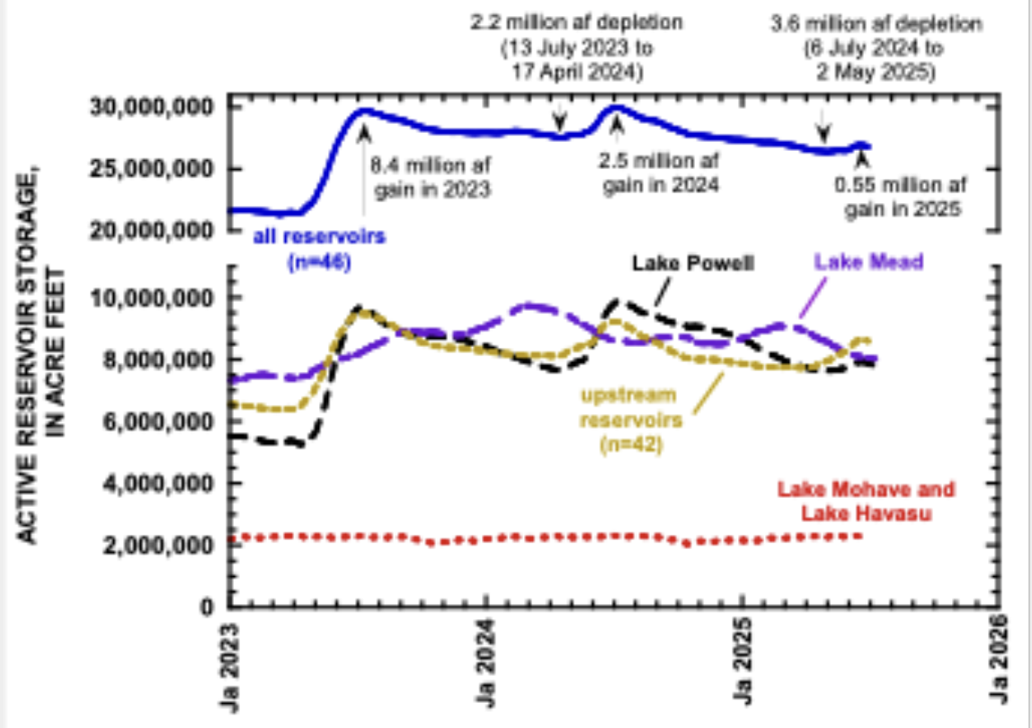
In contrast to previous dry years, however, today’s account balance is unusually low, about the same as in late July 2021 (Fig. 2). Depending on how you think about the reservoir system, today’s contents are between 34 and 45% full in relation to their condition at the beginning of the 21st century (Table 1).
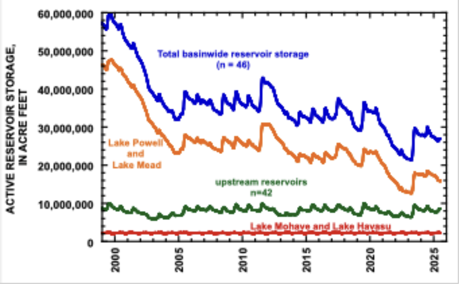
Table 1. Present storage contents of reservoirs in the Colorado River Basin in relation to past conditions.
| Storage contents, in million acre feet | |||
| on 30 June 2025 | Last time storage was as low | Present storage as a percentage of storage in late July 1999 | |
| entire Basin (n=46) | 26.8 | 25-Jul-21 | 45% |
| federal reservoirs (n=12) | 23.64 | 4-Sep-21 | 42% |
| Powell + Mead | 15.93 | 20-Nov-21 | 34% |
The implications for Lake Powell depend on whether Reclamation decides to emphasize water storage in Lake Powell or in Lake Mead, and whether water presently in Flaming Gorge reservoir will be released to supplement storage in Lake Powell. As of June 30, 32% of the reservoir storage in the Basin was in 42 reservoirs upstream from Powell, 30% was in Mead, and 29% was in Powell (Fig. 1). if past management practices prevail, storage upstream from Powell will be quickly reduced, and storage in Powell and Mead will be reduced more slowly. If Reclamation emphasizes storage in Lake Powell by reducing releases to Lake Mead through the Grand Canyon, hydropower production at Glen Canyon Dam will be maintained and the risk of entrainment of smallmouth bass through the turbines will be reduced. But this management approach will cause Lake Mead to fall more quickl, thereby reducing hydropower production at Hoover Dam and perhaps the quality of water withdrawn to southern Nevada. Water storage can’t be maximized in both reservoirs at the same time. Indeed, we are living in dry times!
[1] There are 46, https://www.usbr.gov/uc/water/hydrodata/reservoir_data/site_map.html.
[2] There are 12 included in Reclamation’s monthly 12-month study reports (Taylor Park, Blue Mesa, Morrow Point, Crystal, Fontenelle, Flaming Gorge, Navajo, Vallecito, Lake Powell, Lake Mead, Lake Mohave, and Lake Havasu).