Click the link to read the article on the High Country News website (Natalia Mesa):
July 1, 2025
The U.S. Supreme Court’s 2023 decision on Sackett v. Environmental Protection Agency dramatically weakened protections for millions of acres of the West’s essential wetlands and streams. Under the ruling, only bodies of water with a “continuous surface connection” to a “relatively permanent” traditional, navigable water body can be legally considered part of the waters of the United States (WOTUS) and therefore covered by the Clean Water Act.
The court’s definition excludes wetlands with belowground connections to bodies of water as well as those fed by ephemeral or intermittent streams. In effect, an estimated 60% of wetlands have lost federal protection, according to a National Resources Defense Council report. The language in the decision was ambiguous — exactly how wet a wetland has to be to fall under WOTUS and qualify protections was left up to federal agencies.
Wetlands are critical to both human and ecosystem health as well as for climate change mitigation. But they are also prime targets for dredging, filling and other disruptions because of their proximity to water and rich, fertile soil.
Under President Biden, the EPA broadly interpreted Sackett, focusing on protecting wetlands adjacent to bodies of water, with no explicit threshold for how often they had to be flooded. In March, however, Donald Trump’s EPA released a memoindicating that it plans to restrict all WOTUS, although it’s not yet clear by how much.
“The current EPA seems to be using Sackett as a springboard to find any perceived ambiguities and narrow the definition of WOTUS further,” said Julian Gonzalez, senior legislative counsel at Earthjustice.
In the absence of federal regulations, state dredge-and-fill permitting programs can protect wetlands, and California, Oregon and Washington all have broad protections for non-WOTUS wetlands and streams. And since the Sackett decision, Colorado and New Mexico have passed laws restoring clean water protections for waters excluded from WOTUS. “It’s a dereliction of duty on the federal government’s part by not appropriately protecting the waters of the U.S. and that leaves it up to the states to fill in those protections,” said Rachel Conn, deputy director of Amigos Bravos, a New Mexico conservation organization.
The result is a patchwork of laws protecting the nation’s wetlands. But if more Western states were to emulate their neighbors’ efforts and take action, millions of acres of wetlands could be saved, even in the absence of strong federal protections.
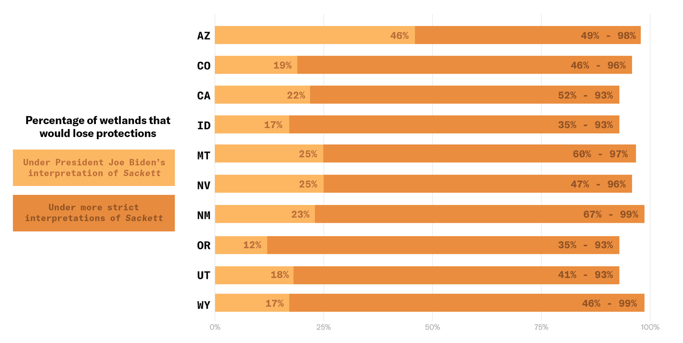
National Resources Defense Council estimates are based on scenarios in which the federal government adopts two interpretations of Sackett that are supported by industry and some states: one, excluding wetlands adjacent to intermittent or ephemeral streams (bottom of range), and another, excluding wetlands that are not wet or flooded most of the year (top of range). According to legal experts, the EPA’s current guidance suggests that the administration will limit WOTUS significantly, excluding most wetlands. Alaska is excluded from this graph due to lack of data. Credit: Hannah Agosta/High Country News
Arizona
Wetland oversight is primarily conducted through the Surface Water Protection Program (SWPP), administered by the Arizona Department of Environmental Quality. House Bill 2691, passed in 2021 before Sackett, established the SWPP, which allows the state to protect some waters not covered under the Clean Water Act.
Wyoming
While Wyoming lacks a permitting program, it does bar the discharge of any pollution or wastes into its waters without a clean water permit. In addition, Wyoming established a Wetland Banking Fund before Sackett to encourage individuals and companies to preserve wetlands. It enables entities to bank wetland credits earned from wetland conservation projects and use them later to offset a development’s impacts on wetlands, with the goal of achieving “no net loss of wetland function and value in the state.”
Colorado
Wetland protections are primarily governed by House Bill 24-1379, a law passed in 2024 that aims to restore Clean Water Act protections to state wetlands that lost them owing to Sackett. It establishes a state permitting program.
New Mexico
The Pollutant Discharge Elimination System Act (SB 21), which was signed into law on April 8, gives the state authority to regulate surface waters. It creates a statewide permitting program and addresses polluted groundwater that falls outside federal programs.
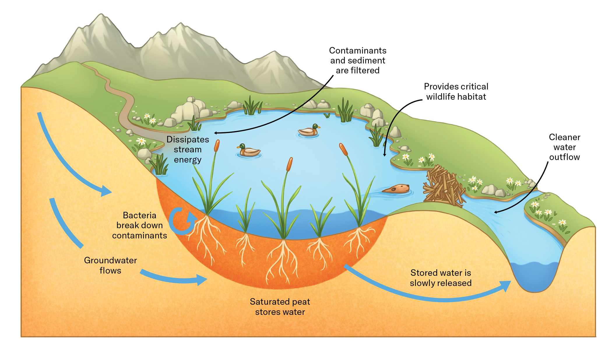
How wetlands work
Approximately 40% of species, including half of all federally listed species, rely on wetlands, which act like sponges for excess water, offering billions of gallons of flood protection and storing this water for later use. Their plants, roots and microbes filter pollution from drinking water and also store 20%-30% of the world’s total soil carbon. But Western states have lost 50% of their wetlands since colonization, and roughly half of the region’s remaining ones are degraded.
Illustrations by Hannah Agosta/High Country News
SOURCES: From Gold, 2024 in Science/Environmental Defense Fund, National Resources Defense Council, U.S. Fish and Wildlife National Wetlands Inventory, Wetlands International.
Blanca Wetlands, Colorado BLM-managed ACEC Blanca Wetlands is a network of lakes, ponds, marshes and wet meadows designated for its recreation and wetland values. The BLM Colorado and its partners have made strides in preserving, restoring and managing the area to provide rich and diverse habitats for wildlife and the public. To visit or get more information, see: http://www.blm.gov/co/st/en/fo/slvfo/blanca_wetlands.html. By Bureau of Land Management – Blanca Wetlands Area of Critical Environmental Concern, Colorado, Public Domain, https://commons.wikimedia.org/w/index.php?curid=42089248
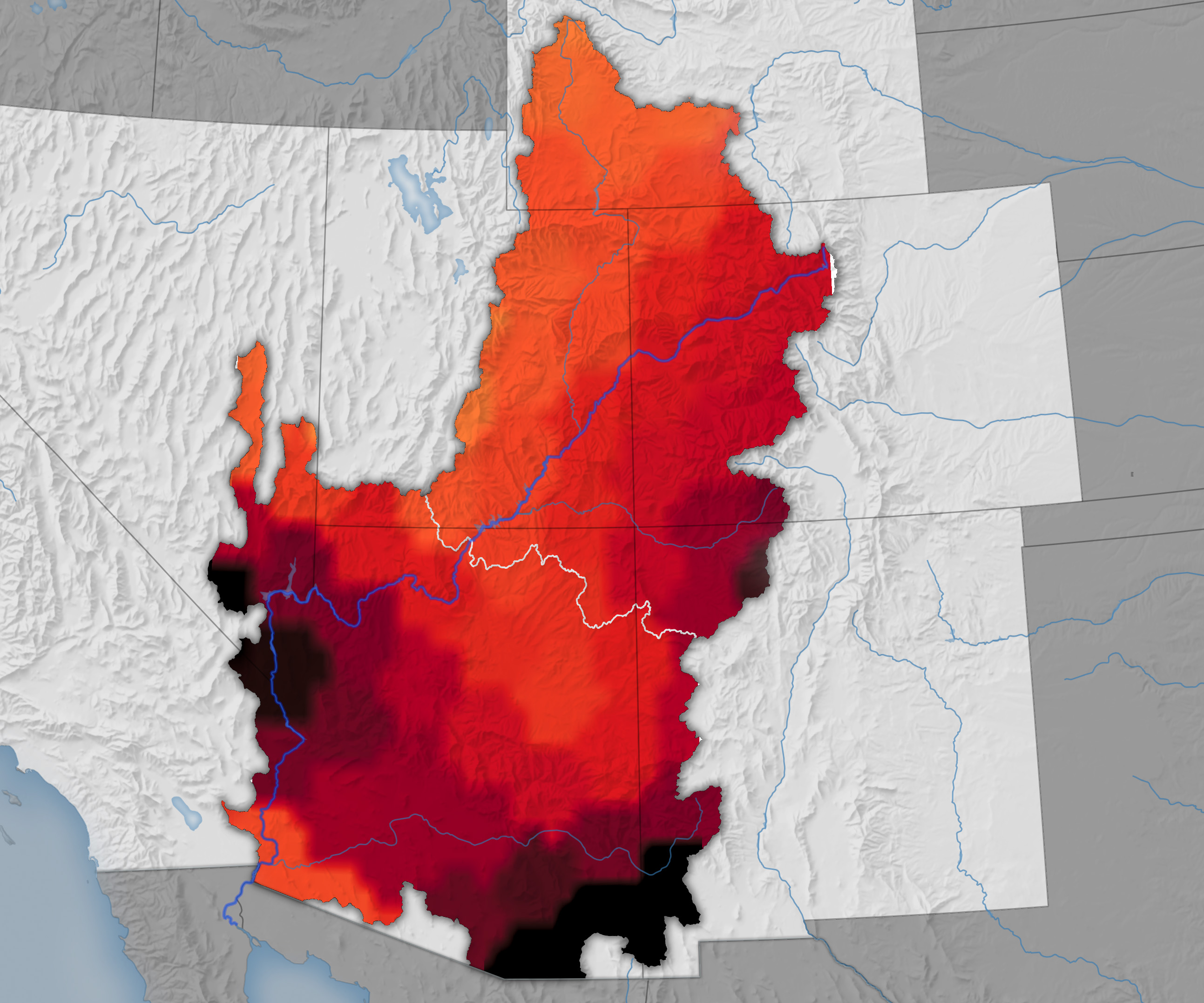
By measuring the gravitational pull of water for more than two decades, NASA satellites have peered beneath the surface and measured changes in the groundwater supplies of the Colorado River Basin for years 2002 to 2024. Credit NASA
By measuring the gravitational pull of water for more than two decades, NASA satellites have peered beneath the surface and measured changes in the groundwater supplies of the Colorado River Basin for years 2015 to 2024. Credit: NASA
By measuring the gravitational pull of water for more than two decades, NASA satellites have peered beneath the surface and measured changes in the groundwater supplies of the Colorado River Basin. In a recent analysis of the satellite data, Arizona State University researchers reported rapid and accelerating losses of groundwater in the basin’s underground aquifers between 2002 and 2024. Some 40 million people rely on water from the aquifers, which include parts of Arizona, California, Colorado, Nevada, New Mexico, Utah, and Wyoming.
The basin lost about 27.8 million acre-feet of groundwater during the study period. “That’s an amount roughly equal to the storage capacity of Lake Mead,” said Karem Abdelmohsen, an associate research scientist at Arizona State University who authored the study.
About 68 percent of the losses occurred in the lower part of the basin, which lies mostly in Arizona. The research is based on data collected by the GRACE (Gravity Recovery and Climate Experiment) and GRACE-FO (GRACE Follow-On) missions. The data were integrated with output from land surface models, such as NASA’s North American Land Data Assimilation System, and in-situ precipitation data to calculate groundwater losses.
The conclusions were similar to those arrived at by Arizona State University Global Futures Professor Jay Famiglietti in an analysis of the Colorado River Basin published in 2014, when his team was at the University of California, Irvine. “If left unmanaged for another decade, groundwater levels will continue to drop, putting Arizona’s water security and food production at far greater risk than is being acknowledged,” said Famiglietti, previously a senior water scientist at NASA’s Jet Propulsion Laboratory and the principal investigator of both studies.
The maps above underscore the accelerating rate of groundwater loss detected by the GRACE missions. In the first decade of the analysis, between 2002 and 2014, parts of the basin in western Arizona in La Paz and Mohave counties and in southeastern Arizona in Cochise County lost groundwater at a rate of about 5 millimeters (0.2 inches) per year. Between 2015 and 2024, the rate of groundwater loss more than doubled to 12 millimeters (0.5 inches) per year. [ed. emphasis mine]
1950 – 2023
Two key factors likely explain the acceleration, the researchers said. First, there was a global transition from one of the strongest El Niños on record in 2014-2016 to a period when La Niña reasserted control, including the arrival of a “triple-dip” La Niña between 2020 and 2023. La Niña typically shifts winter precipitation patterns in a way that reduces rainfall over the Southwest and slows the replenishment of aquifers.
Second, there was an increase in the amount of groundwater being used for agriculture. “2014 was about the time that industrial agriculture took off in Arizona,” Famiglietti said, noting that large alfalfa farms arrived in La Paz and other parts of southern Arizona around that time. Dairies and orchards in southeastern Arizona likely impacted groundwater supplies as well, he added. Other “thirsty” crops grown widely in the state include cotton, corn, and pecans. Data from the U.S. Department of Agriculture’s Cropland Data Layer(CDL) shows that these crops are common in several parts of southern Arizona, including Maricopa, Pinal, and Cochise counties.
Irrigated agriculture consumes about 72 percent of Arizona’s available water supply; cities and industry account for 22 percent and 6 percent, respectively, according to Arizona Department of Water Resources data. Many farms use what Famiglietti described as “vast” amounts of groundwater in part because they use a water-intensive type of irrigation known as flood irrigation (or sometimes furrow irrigation), a technique where water is released into trenches that run through crop fields. The long-standing practice is typically the cheapest option and is widely used for alfalfa and cotton, but it can lead to more water loss and evaporation than other irrigation techniques, such as overhead sprinklers or dripping water from plastic tubing.
Captured by the OLI (Operational Land Imager) on Landsat 8, shows desert agriculture in La Paz and Maricopa counties on July 12, 2025. CDL data from the U.S. Department of Agriculture indicates that most of the rectangular fields around Vicksburg and Wenden are used to grow alfalfa, while the fields around Aguila are typically used for fruits and vegetables, such as melons, broccoli, and leafy greens. Some of the alfalfa fields in Butler Valley (upper part of the image) have gone fallow in recent years following the termination of leases due to concerns from the Arizona State Land Department about groundwater pumping.
The satellite image above, captured by the OLI (Operational Land Imager) on Landsat 8, shows desert agriculture in La Paz and Maricopa counties on July 12, 2025. CDL data from the U.S. Department of Agriculture indicates that most of the rectangular fields around Vicksburg and Wenden are used to grow alfalfa, while the fields around Aguila are typically used for fruits and vegetables, such as melons, broccoli, and leafy greens. Some of the alfalfa fields in Butler Valley (upper part of the image) have gone fallow in recent years following the termination of leases due to concerns from the Arizona State Land Department about groundwater pumping.
The new analysis found some evidence that managing groundwater can help keep Arizona aquifers healthier. For instance, the active management areas and irrigation non-expansion areas established as part of the Arizona Groundwater Management Act of 1980 lessened water losses in some areas. The designation of a new active management area in the Willcox Basin in 2025 will likely further slow groundwater losses. “Still, the bottom line is that the losses to groundwater were huge,” Abdelmohsen said. “Lots of attention has gone to low water levels in reservoirs over the years, but the depletion of groundwater far outpaces the surface water losses. This is a big warning flag.”
NASA supports several missions, tools, and datasets relevant to water resource management. Among them is OpenET, a web-based platform that uses satellite data to measure how much water plants and soils release into the atmosphere. The tool can help farmers tailor irrigation schedules to actual water use by plants, optimizing “crop per drop” and reducing waste.
This is the first part of the series from the summer issue of Headwaters Magazine. Click the link to read the series on the Water Education Colorado website. Click the link to read the article on the Big Pivots website (Allen Best):
July 20, 2025
To understand the predicament in the Republican River Basin of eastern Colorado, you need to appreciate the volume of water being hoisted from the underlying High Plains Aquifer. The most important component is the Ogallala.
Farmers and the few small towns in the Republican River Basin average 720,000 acre-feet of withdrawals annually. In one hot and dry year, 2012, they pumped 940,000 acre-feet. As a point of reference, Blue Mesa Reservoir, the largest water body in the state, can hold 947,435 acre-feet.
Groundwater mining cannot be sustained far into the future in many areas of the Republican River Basin. Wells in some areas have not declined while wells in other areas have declined 13 feet during the last decade. Pumping at existing rates cannot be maintained. Within 25 years, about a third of land that’s now irrigated will have no water. In other places, pumps already sputter.
“Sustainable” and “pumping” do not belong in the same sentence in this basin. The water of the Republican River Basin in the High Plains Aquifer accumulated from 18 to 4 million years ago.
Far from the snowmelt of the Rocky Mountains, it is recharged by minimal surface water. Based on studies, the Republican River Compact of Colorado, Nebraska and Kansas assumes that 17% of the water on the surface trickles down through the ground to the aquifers. So, only very slowly is the aquifer recharged. It’s mostly an ancient bank account with now small, almost tiny deposits and fast-and-furious withdrawals.
The Republican River Basin and several other regions of the state rely largely on groundwater. In a 2024 decision, Colorado Supreme Court justices pointed out that it would be difficult to overstate the importance of groundwater given the state’s population and arid climate. The 285,000 wells poked into the earth across the state deliver 18% of Colorado’s water.
The Republican River Basin, the San Luis Valley, and the south metro area of the Denver Basin are all, to varying degrees, rethinking water — both its sources and uses. All three have historically relied heavily on groundwater, and all have made at least limited progress in shifting toward more sustainable groundwater use in the last 20 years. The cities have adopted policies that foster smaller, less water-intensive lawns. They have diversified their sources. Two south-metro water utilities that 20 years ago pulled nearly all their water from wells, today have lessened that dependency to 60% to 65%.
Farmers in the Republican River Basin and San Luis Valley have somewhat different challenges. They have taken action to use less water and to save their communities, but whether those actions match the scale of the challenges they face is another matter. Changes can best be achieved before emergency sirens wail. In the Republican River Basin, some already see a swirl of red lights warning of catastrophe ahead.
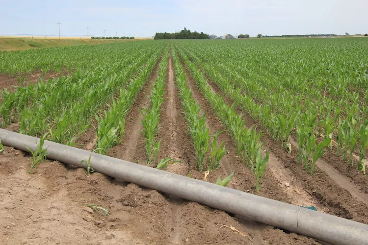
Irrigation pipe and corn crop near Holyoke. Photo credit: Allen Best/Big Pivots
It’s going fast! What needs to be done in the Republican River Basin?
The Republican River Basin consists of 7,000 square miles, an area slightly smaller than New Jersey. It is largely located within a triangle between Julesburg, Limon and Cheyenne Wells. A few businesses cater to travelers but agriculture constitutes nearly all of the basin’s economic foundation.
An average 17 inches of precipitation falls per year across the basin, less in some areas. High-dollar agriculture depends almost entirely upon water drawn from the Ogallala. A 2010 state report found that of the basin’s 600,000 acres then under irrigation, only 1,000 were supplied by surface water. Locals suggest the true number is far, far less.
Dryland farming prevailed until the arrival of high-capacity pumps and rural electrification in the late 1940s. Farmers in the 1950s began converting dryland areas to irrigation, dramatically expanding crop yields. Other farmers arrived to plow hitherto virgin turf. Twice in the 1970s, groundwater extraction exceeded a million acre-feet per year.
Drafting of groundwater via 5,000 wells today produces a bounty of herbaceous crops. Most end up in the bellies of livestock. Two feedlots near Yuma alone can each hold more than 150,000 cattle and several others can accommodate 75,000. The basin also has three hog farms, several dairies, and an ethanol plant.
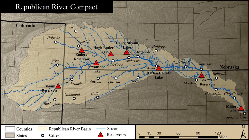
Republican River Basin map. Credit: Republican River Compact Administration
In 1942, Colorado, Nebraska and Kansas allocated the waters of the Republican River and its tributaries in an interstate compact. The state engineer in 1973 ordered a moratorium on new wells. The most powerful limitation did not come until 1990. Rules were changed, reducing the allowed rate of depletion, effectively precluding new well permits.
Existing wells, however, were drawing down the aquifers in the Republican River Basin. Kansas in the 1990s complained that it was getting shorted by Nebraska. Nebraska in turn blamed Colorado. A 2002 settlement stipulation among the three states represented a new line in the sand. By whatever means, Colorado had to figure out how to deliver water to the downriver states.
Colorado responded by forming the Republican River Water Conservation District. In effect, the state gave farmers and others in the eight-county district responsibility for figuring out how to comply with the compact. To help achieve compliance, legislators gave the district authority to levy fees on irrigators. The fee, originally $5 per acre, has been boosted twice and is now $30 per acre annually.
The Ogallala is plumbed by many wells in the Republican River Basin within Colorado.
This $15 million in annual revenue is used in several ways. An early project was a pipeline to boost the amount of water flowing into Nebraska. The pipeline carries water from eight wells previously used for irrigation. They had been drilled amid hills with sugar-like sand between Wray and Holyoke in the deepest part of the aquifer. The water from these wells flows 12.6 miles through the pipeline and into the North Fork near the Nebraska border. The wells are pumped from October to April, ensuring minimal loss to evaporation or riverine trees or grasses.
This pipeline, since its completion in 2012, has allowed Colorado to meet its compact delivery requirements. The cost of the wells, pipeline, and water rights was $72 million. Faced with declining production from these wells, the district in 2025 is planning four more wells and 9.5 miles of pipe at an estimated cost of $14 million to deliver what the compact pledges to Nebraska.
With members and staff of the Republican River Water Conservation District looking on, Colorado Gov. Jared Polis signed a bill in May 2023 that allocated $30 million to be used to retire irrigated acreage as necessary to meet a 2029 deadline. Photo/Office of Jared Polis
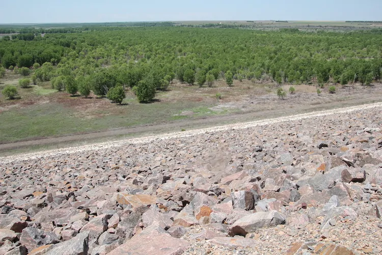
In another move toward compact compliance, Bonny Reservoir, a 165,238 acre-foot impoundment on the South Fork of the Republican, was drained. Prior to the 2011 draining, Bonny had delighted boaters and anglers but lost too much water to evaporation and seepage. Water now flows more efficiently downstream.
More actions were needed to ensure Nebraska and Kansas received their apportioned water. Beginning in 2006, Colorado removed 30,000 to 35,000 acres from irrigation. A multi-state agreement in 2016 specified that Colorado would remove an additional 25,000 acres in the South Fork drainage by 2029. Dick Wolfe, then Colorado’s state engineer, was asked at the time how this was to be done. He paused a moment, then likened it to getting a haircut: a snip here, a snip there.
This snipping of irrigated acreage has been encouraged with financial incentives assembled from pots of local, state and federal funds. The money is delivered via two federal programs: the Conservation Reserve Enhancement Program (CREP), and the Environmental Quality Incentives Program (EQIP). The latter allows farmers to use the land for dryland farming or grazing.
By early 2025, the Republican River Water Conservation District had retired 17,120 of the 25,000 acres as required by the 2016 settlement. It was a milestone, a time for momentary celebration. The harder work lies ahead. Nearly 8,000 additional acres must be retired to meet the December 2029 deadline. If the goal is not met, the state engineer has authority to shut down wells. Nobody wants that, least of all the state engineer. To help sweeten the incentives in 2025, state legislators appropriated $6 million. This adds $750 to the $4,500 per acre paid to farmers participating in CREP and $750 to the $3,500 per acre in EQIP.
By June 2025, Bonny Reservoir had a forest of trees, but the water that had drawn boaters and anglers was drained in 2011. Photo credit: Allen Best/Big Pivots
Using less water is the paramount challenge. This has been accomplished almost exclusively by taking land out of irrigation. There are other ways, too. Today, corn is king, responsible for about 85% of irrigated acres in the basin. It commonly receives 20 to 22 inches of supplemental water. A growing realization of late has been that less can be more. Planting fewer seeds — say 18,000 per acre instead of 30,000 — will save money and require less fertilizer. Fewer seeds will then require only 12 to 14 inches of supplemental water, meaning less pumping and shaving electricity bills. Lower crop yields can counterintuitively produce better profit margins.
Conversations are also underway about water-conserving crop alternatives: milo, millet and wheat, kidney and pinto beans, even black-eyed peas. It’s partly a matter of developing markets. Deb Daniel, the general manager of the district since 2011, has been toying with how to emphasize productivity strategies with the phrase “crop per drop.”
None of this adds up to the scale of the challenge, though.
Above: Most of the water in the Republican River comes from the aquifers, and by Wray, there’s little in the river. Photo credit: Allen Best/Big Pivots
Republican River in Colorado January 2023 near the Nebraska border. During winter, water is pumped from wells north of Wray for delivery into the North Fork of the Republican at the Nebraska state line. Photo credit: Allen Best/Big Pivots
Kenny Helling, a fourth-generation farmer from the Idalia area of Yuma County, believes more is needed than financial incentives to take land out of production. “Continuing to throw money at the problem won’t fix the problem,” he says. Ways must be found to keep land in irrigation, because irrigated land pays more in property taxes. Those taxes are crucial for operating fire departments, schools and other community purposes. “It’s a very big concern to me.”
The answers? Helling sees value in permits specifying reduced volume of pumped water. He would like to see more crop rotation.
Helling was a member of the Republican River Water Conservation District Board of Directors for nine years. He says the district needs other tools. The true authority for limiting pumping belongs to the eight groundwater subdistricts within the basin. They do not use it. Why?
“Everybody on those groundwater management districts are generally irrigators,” says Helling. “Most of them are neighbors. A lot of them go to church together. A lot of them might have kids and grandkids in school together. Nobody wants to make anybody mad. And so, unfortunately, the groundwater management districts do not use all the authority they could to restrict the amount of water used.”
Colorado legislators, he says, need to give the Republican River Water Conservation District more authority. It needs sticks, not just carrots. “We need to use less water.”
Tim Pautler told members of the Colorado Groundwater Commission something similar in May 2025. A dryland farmer from the Stratton area, he has served on the Republican River Water Conservation District’s Board of Directors for 21 years. He says that the board has accomplished almost no basin-wide conservation. It hasn’t figured out how to substantially reduce water use.
Most landowners who have taken advantage of the incentives have been irrigators who have less groundwater available in their wells. Nearly all in the southwestern portion of the basin, where many wells were already sputtering. He says if reduced water use is the goal, the fees charged to farmers must be based on acre-feet of water pumped and not just on irrigated acres.
There’s no pretense of sustainability in the Republican River Basin. The water deposited over millions of years is now being mined. The task is to maximize value of the remaining water, to prolong the availability of the High Plains Aquifer. Few have yet been willing to talk about the gravity of the challenge.
“I hope enough water remains in the hole to sustain society,” says Pautler. “I hope we don’t go completely dry.”
Part II: Entering the 20th century, the Denver metro communities of Castle Rock and Parker were growing fast — and almost entirely reliant upon Denver Basin aquifers. They still are, but they have started diversifying their sources while encouraging conservation of water. You can also download the entire story here in a magazine format.