
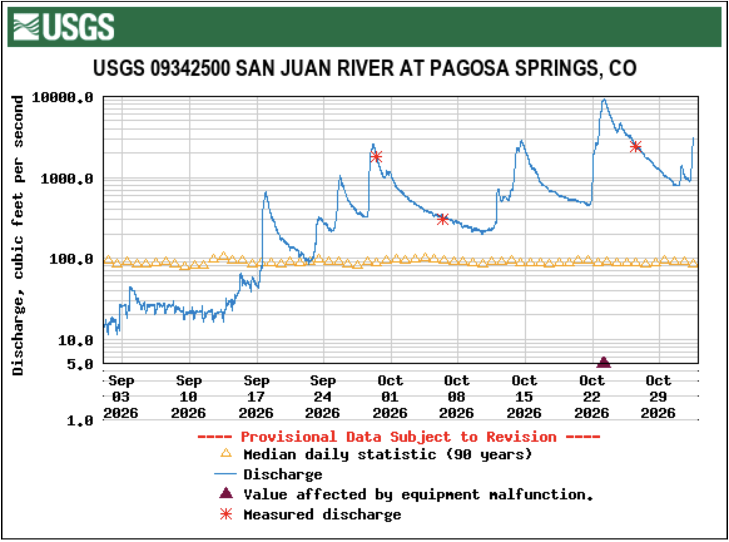
Click the link to read the article on the Pagosa Springs Sun website (Clayton Chaney and Randi Pierce). Here’s an excerpt:
October 29, 2026
The San Juan River peaked at 15.02 feet at about 5:45 a.m. on Friday, Oct. 23, becoming the second highest flooding event in recorded history for the river, short of only the 1911 flood which peaked at 17.8 feet. Extensive damage was caused to roads, homes and other critical infrastructure all throughout the county…There have been no known fatalities or injuries, according to incident officials. Archuleta County Commissioner Warren Brown indicated at a community meeting on Tuesday, Oct. 27, that 800 structures in the county have been impacted by the flood, with 540 of those structures being homes…
During a joint meeting held by the Archuleta County Board of County Commissioners and Pagosa Springs Town Council on Monday, Oct. 26, Archuleta County Sheriff Mike Le Roux and Pagosa Springs Police Chief Bill Rockensock addressed the BoCC and town council, providing a review of how the community prepared and responded throughout the disaster event. Le Roux explained that the Archuleta County Sheriff’s Office (ACSO) began receiving forecasts early in the week, working with the Pagosa Weather team. He explained that based on the flooding that occurred in 2025, “We understood what a forecast level in that flood zone would look like.”
[…]
Le Roux explained how this year’s flooding event was different than last year’s, with the majority of rainfall received during last year’s flood falling in the “catchment area.” He noted there was more localized rain this year.
“The volume and intensity of rain that we received down low started creating localized flooding and which we were starting to see the impact to the community prior to the river level getting to high flood,” he said. Le Roux explained that response crews continued working through the night on Thursday, with the San Juan River peaking the morning of Friday, Oct. 23.
“One of the most amazing things I’ve ever seen, to be honest with you,” Rockensock said.
While the San Juan River hit its second highest level on record, the other three rivers that run through Archuleta County experienced record flows on Friday, Oct. 23, according to National Water Predictions Service data. The Piedra River near Arboles surpassed its previous record of 6.4 feet, hitting 10.48 feet at about 5:45 a.m. The Navajo River near Chromo hit 7.8 feet at about 4:15 a.m., surpassing the previous record of 5.1 feet. The Rio Blanco near Pagosa Springs hit 5.56 feet at about 7 a.m., besting the previous record of 5.26. Late Wednesday morning, Navajo State Park reported the lake’s current elevation is 6,045 feet — 66.29 percent full pool. In a statement on Facebook, the park states that, on Oct. 21, the reservoir’s elevation was 6,022.
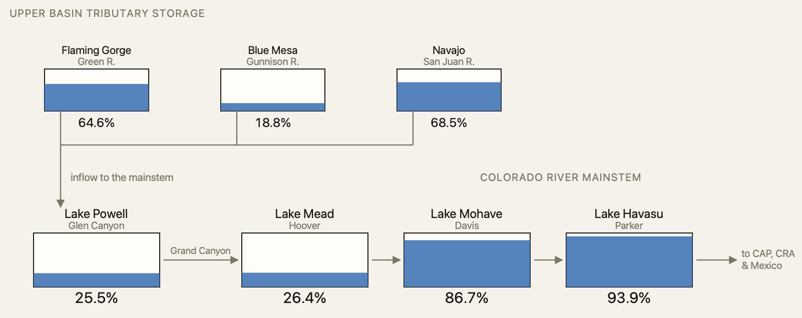
“The reservoir has risen 23 feet in 7 days! On Friday, October 23, in one day, the lake rose 8.89 feet. Unbelievable! The inflow on that day was 45,205 cfs,” the statement reads…
Rain totals
According to reports entered into the Community Collaborative rain, Hail and Snow Network (CoCoRaHS), more than 6 inches of rain fell across all parts of Archuleta County from Oct. 22 through Oct. 26. The highest report was 6.92 inches in the eastern part of the county. A total of 6.55 inches fell south of Pagosa Springs, and 6.56 inches fell near Hatcher Lake. Totals in town ranged from 5.18 inches to 5.83 inches. Higher elevations received snowfall during that time, with Wolf Creek Ski Area reporting 20 inches of fresh snow. According to CoCoRaHS, parts of Archuleta County have received anywhere from 7.52 inches to 10.06 inches of total rainfall from Oct. 1 through Oct. 28. The October rainfall average for Pagosa Springs is 2.27 inches…
[Harris] also provided more information on estimated damage costs, indicating that the town is facing approximately $38 million in damage as of now, compared to $6 million in damage from last year’s floods. Harris also explained that the town’s sewer system is expected to have about $9 million in damage including everything from a missing pipe on the 1st Street bridge and multiple lift stations. He noted that those lift station facilities were not able to keep up with the flood waters.
