Click the link to read the article on The Denver Post website (John Aguilar). Here’s an excerpt:
April 21, 2026
Colorado oil and gas regulators on Tuesday approved a controversial 24-well drilling operation that will sit just over a half-mile from hundreds of Aurora homes and a reservoir that serves as the city’s primary water supply. The 3-2 vote by the state’s Energy and Carbon Management Commission, in favor of the State Sunlight/Long well pad proposed by Crestone Peak Resources, came after about five hours of testimony and deliberation. The decision ends what had become one of the more contentious battles over energy extraction in Colorado. Board Chair Jeff Robbins acknowledged that the application from Crestone had evoked a strong reaction from homeowners living nearby. But in the end, the company complied with rigorous state oil and gas regulations enshrined in a law known as Senate Bill 181, which was passed by state lawmakers seven years ago.
“At the end of the day, State Sunlight/Long achieves the balance we were told to look for,” Robbins said.
[…]
The two commissioners who voted no were Trisha Oeth and John Messner. The approvals process for the Sunlight/Long well pad encompassed seven hearings before the commission, stretching over several months. Nearby homeowners rose up in opposition, claiming that the project would pose health hazards to those living nearby — in particular, to school-age children. They also worried about the drilling’s potential environmental impacts on the Aurora Reservoir, which is a water source for the 400,000 residents of Colorado’s third-largest city.
“I cannot believe that the state came down on the side of the industry yet again,” Randy Willard, the president of opposition group Save the Aurora Reservoir, said in an interview minutes after the vote came down Tuesday afternoon. “The group as a whole is severely disappointed.”
The group had pushed back on the proposed project using the 2019 oil and gas reform law as a guide, Willard said. The 2019 law prioritized public health, safety and the environment when regulators consider oil and gas development — a profound change from the industry-focused approach Colorado had taken for decades.
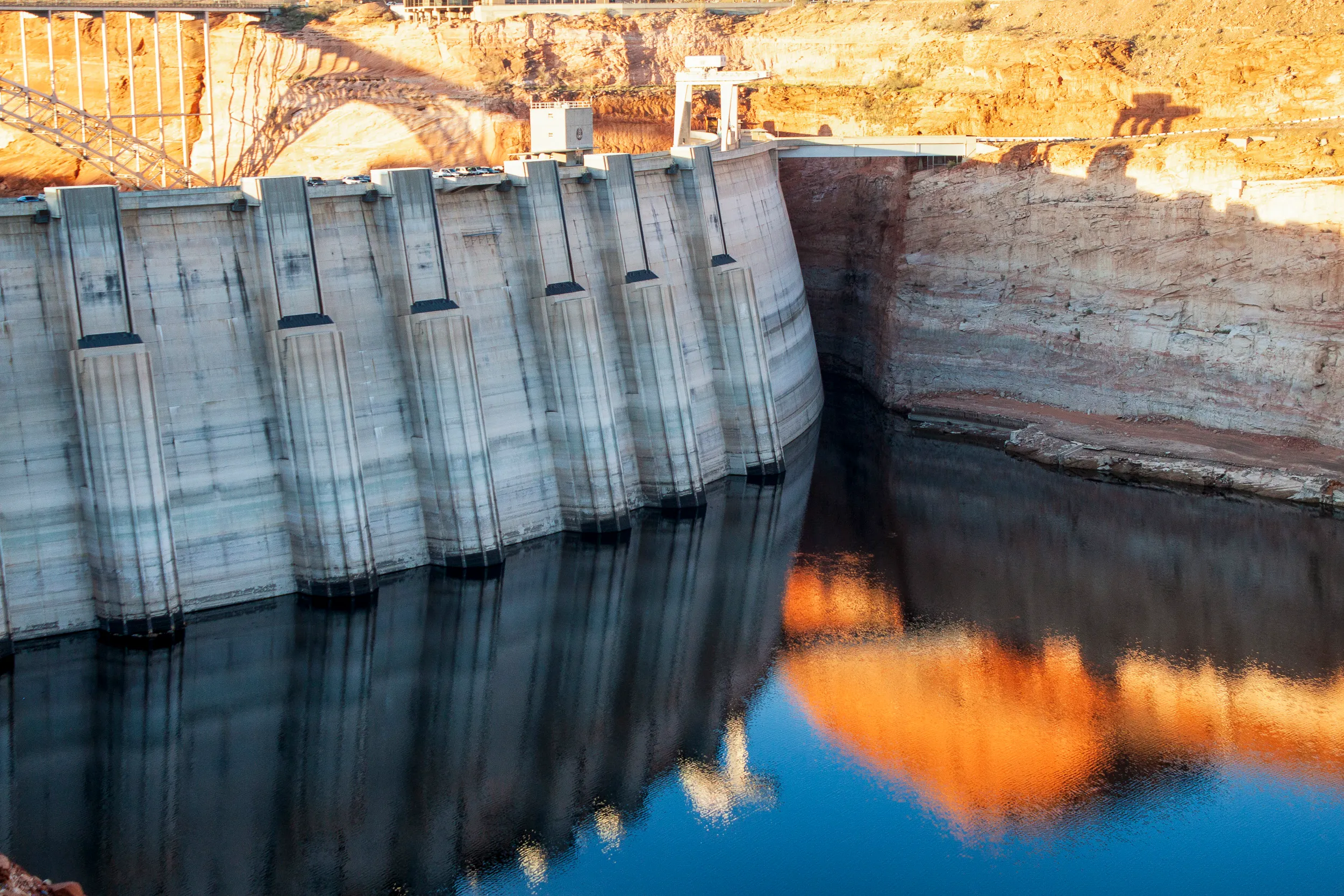
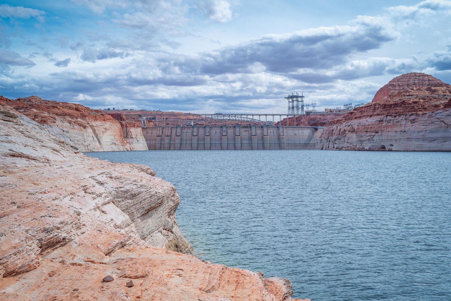
A high desert thunderstorm lights up the sky behind Glen Canyon Dam — Photo USBR
Click the link to read the article on the AZCentral website (Debra Utacia Krol). Here’s an excerpt:
April 17, 2026
Key Points
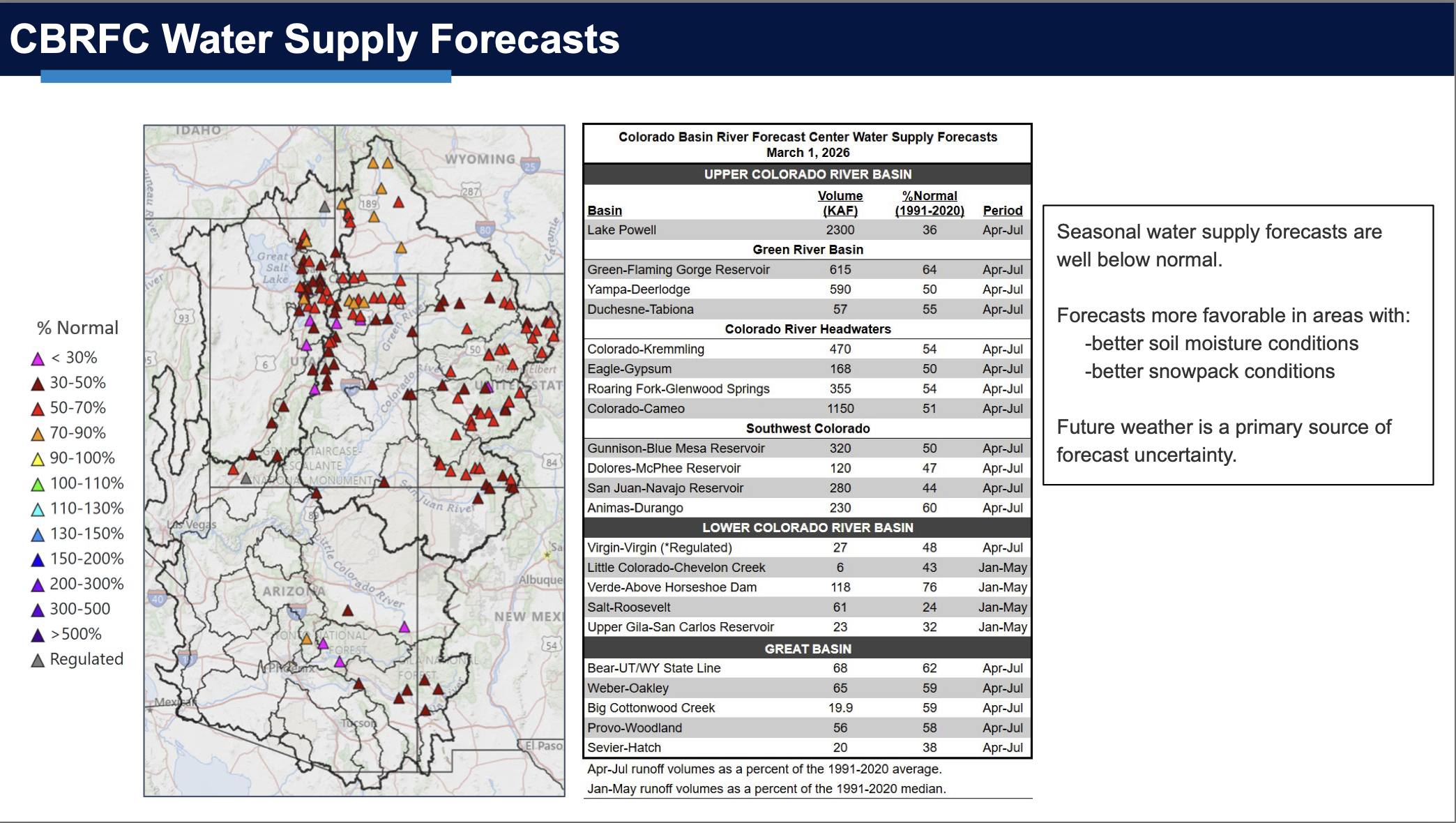
The Colorado River system’s water storage has dropped to 36% of its capacity due to a warm winter and ongoing drought.
Water levels in Lake Powell are projected to fall below the minimum needed for hydropower generation by this fall.
Federal officials are considering moving water from other reservoirs and reducing downstream releases to prevent a shutdown at Glen Canyon Dam.
Within charts listing projections of water levels, inflow and outflow, and anticipated releases for 15 reservoirs in the Colorado River Basin, one message was clear: The river is in dire straits and conditions likely won’t get better anytime soon. The warmest winter on record, coupled with an ongoing drought, has produced dismal conditions for the West’s water lifeline, conditions reflected by the Bureau of Reclamation in its April 24-month report. The system’s storage has plunged to about 36% of its capacity, the agency said in a statement. More alarming in the near term is the threat to hydropower production at Glen Canyon Dam. Water levels in Lake Powell would drop too low to operate the turbines by fall, according to the latest projections, unless the federal government steps in…The situation at Lake Powell raised red flags: The giant reservoir’s “minimum probable inflow,” a measure of winter runoff, is projected to total just 2.78 million acre-feet, or 29% of the historical average, one of the lowest on record, the agency said. By September, projections show the reservoir could decline to below 3,490 feet above sea level, the minimum needed to power the turbines at Glen Canyon Dam that supply electric service to about 5.8 million households and businesses in the region…
Reclamation said it would consider all tools that are available to avoid water levels below 3,500 feet, including a plan to move water from Flaming Gorge Reservoir in Utah and reduce downstream releases from Powell. Flaming Gorge would give up between 660,000 acre-feet up to 1 million acre-feet over the next year. Lake Powell will release about 1.48 million acre-feet less than planned. The move will lower water levels in Lake Mead and potentially reduce Hoover Dam’s hydropower generating capacity by as much as 40%, and would impact recreation throughout the Lower Basin…
The Arizona Department of Water Resources said in its March drought report that most of the state’s snowpack is gone, melted during Arizona’s warmest March on record. The Arizona Drought Monitoring Technical Committee also published its latest three-month drought map, which showed most of the state listed as enduring exceptional drought conditions, the driest level.
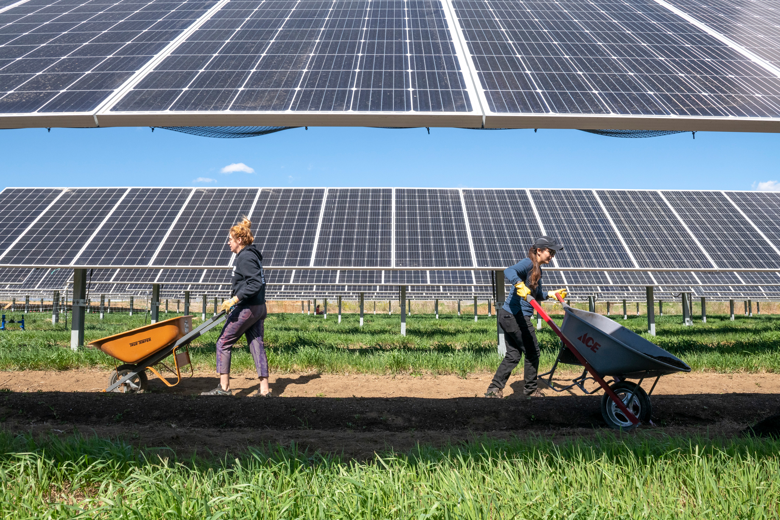
May 6, 2023 – Volunteers with the National Renewable Energy Laboratory’s (NREL’s) ESCAPES (Education, Stewardship, and Community Action for Promoting Environmental Sustainability) program lend a hand to Jack’s Solar Garden in Longmont, Colo. Bethany Speer (left) goes back for more while Nancy Trejo distributes her wheelbarrow load to the agrivoltaic plots. (Photo by Bryan Bechtold / NREL)
Click the link to read the article on the Grist website (Rebecca Egan McCarthy & Kate Yoder):
April 20, 2026
Solar power is cheap, fast, and in demand as data centers consume more and more electricity.
The future looked dire for renewable energy in the United States last spring. Republicans in Congress started gutting the Inflation Reduction Act, forcing its generous tax credits for wind and solar into an early retirement. The Interior Department then rolled out a series of byzantine regulations aimed at restricting clean energy on federal land. Some feared those regulations would curb wind and solar development on private land, too.
Although these restrictions do seem to have hindered the wind industry, there are some signs that its fortunes are changing. But a year later, solar continues to boom. MAGA influencers are promoting it, there’s hope for legislation that would speed up approvals for new projects, and the industry has continued to expand over the last year as energy requirements from data centers demand fast, cheap power. The Trump administration has even signed off on some big solar projects: In February, the administration announced that it would allow several solar projects that had been blocked by the new Interior regulations to move forward.
“I feel like there has been so much written that’s like, ‘The Trump administration is delaying this stuff. It’s holding it all up in red tape. Nothing’s getting built,’” said Hannah Hess, director of the Rhodium Group’s Clean Investment Monitor team. “When we look at the data, that’s not true.” Combined, solar and battery storage (which banks excess energy for use when the sun’s not shining) accounted for 79 percent of power generation brought online in 2025 and are expected to continue to grow by 49 percent before the Inflation Reduction Act tax credits expire at the end of 2027.
Support for solar among rank-and-file-conservatives has fallen in recent years, caught up in partisan culture wars, but it could gain more traction in the party if it’s paired with affordability concerns. Some 69 percent of Republicans say they are supportive of solar, provided it lowered electricity costs, according to a recent poll from the research organizations GoodPower and NORC at the University of Chicago. The Solar Energy Industries Association, the industry’s primary lobbying group, has emphasized that its industry aligns with President Donald Trump’s “energy dominance” agendaand lowers energy costs for families and businesses. “Conservative voters are drawing a clear distinction between rhetoric and practical solutions that lower costs,” read a blog post from the association in February.
Even prominent conservative figures seem to be softening toward solar. Katie Miller, a former Trump administration official and the wife of Stephen Miller, the White House’s deputy chief of staff for policy, has gone so far as to herald solar as the “energy of the future.” In February, she posted to X: “Giant fusion reactor up there in the sky — we must rapidly expand solar to compete with China.” That same month, Energy Secretary Chris Wright, who had been a vocal critic of solar power, started saying it could be beneficial. “Is there a commercial role for solar power that can add to the grid affordable, reliable energy?” he said. “Certainly there is.”
Data center developers have begun looking to solar as a complement to oil and gas, rather than a competitor. The incoming demand “feels crazy,” said Jim DesJardins, executive director of the Renewable Energy Industries Association of New Mexico. “It’s scary, almost. Five years ago, we were talking about an increase in load from EVs and building electrification — we’re not talking about that anymore. It’s all data centers and how are you going to power them.” This year marked the first time, said DesJardins, that the New Mexico Oil and Gas Association reached out to sponsor the renewable energy association’s annual conference.
Solar is, by far, the cheapest and fastest way to bring energy online, especially as the shortage of gas turbines — internal combustion engines that convert fuel into a steady, reliable energy — in the U.S. creates yearslong delays to build new power plants that run on natural gas. [ed. emphasis mine] The technology is crucial for data centers that need to run 24 hours a day, seven days a week. “The backlog alone [for turbines] is five to nine years,” said Mike Hall, CEO of Anza Renewables, an energy intelligence and procurement platform based in California. “Then you’ve got to permit it. Then you’ve got to be near a gas pipeline for fuel, and then you’ve got the climate and the carbon issues.” A recent study from the analytics company Sightline Climate found that half of data center deals were expected to be delayed due to power constraints and local opposition, and developers are beginning to realize that waiting in line for a gas turbine could spell doom for their operation.
There are still some obstacles ahead for solar power, however. “We’ve definitely seen examples from our developer customers where the Department of Interior rules are creating challenges for their projects on federal land, but we haven’t seen that it’s really slowed down development on private land,” said Hall. “The bottlenecks are typically still local permitting and interconnection with utilities — those are still major challenges, and we haven’t seen a lot of improvement in either area yet.”
Shortly before Congress adjourned for its winter recess in December, the House passed the Standardizing Permitting and Expediting Economic Development Act, also known as the SPEED ACT, a bipartisan bill that would streamline the permitting process for energy, infrastructure, and transportation projects by overhauling the National Environmental Policy Act, or NEPA. Signed by President Nixon in 1970, NEPA requires federal agencies to consider how proposed infrastructure projects or drilling permits would affect the environment before approving them. Permitting reform is the rare, bipartisan issue that has sparked real enthusiasm on both sides of the aisle.
After a scuffle over the Trump administration’s decisions to shut down offshore wind projects, which judges ruled invalid, Democratic senators Martin Heinrich and Sheldon Whitehouse are coming back to the negotiating table to hammer out a deal. “Right now, we’re leaving electrons on the table thanks to Trump’s deliberate attacks on clean energy — forcing Americans to pay higher electricity bills,” Heinrich’s office told Grist. “To lower costs, this administration needs to stop stalling and slow walking clean energy projects and take the politics out of permitting reform.”
The war in Iran, which has caused oil prices to skyrocket, may serve to boost interest in solar power even more — especially as a way to combat rising electricity costs and promote energy independence. “Energy poverty has always been a problem in the U.S., and it’s gotten significantly worse in recent years,” said Brad Townsend, vice president of policy and outreach at the Center for Climate and Energy Solutions, an environmental policy nonprofit. He pointed to a study from the nonprofit RMI, formerly the Rocky Mountain Institute, that found 1 in 3 households were struggling to pay their utility bills. “I think folks in the administration are increasingly becoming aware of the fact that we can’t turn away renewable energy.”
In terms of the geopolitical reasons to support solar, “no one has fought a war over the sun,” DesJardins told Grist. “Not yet, anyways.”
Difficult decisions for the Colorado River are starting to be made.
In what will be a defining year for the struggling watershed, the federal agency that manages the basin’s dams took unprecedented actions on Friday to store more water in Lake Powell in order to preserve hydropower generation and protect water-delivery infrastructure at Glen Canyon Dam that the agency says is at risk of damage due to low reservoir levels.
The April 17 announcement from the Bureau of Reclamation will also set in motion events that could result in first-ever lawsuits from Arizona, California, or Nevada against their upstream neighbors over water supply from the shrinking Colorado River.
The Central Arizona Project, which delivers Colorado River water to Phoenix and Tucson, called Reclamation’s actions “a band-aid” and urged the agency to release even more water from upstream reservoirs into Powell. CAP, because it has lowest water-rights priority in the lower basin, is the most vulnerable to proposed water cuts that would attempt to align water supply with demand.
“There is no time to delay,” Patrick Dent, CAP’s assistant general manager for water policy, told Circle of Blue two days before the announcement.
The Bureau of Reclamation will make two moves to support Lake Powell, the huge reservoir formed by Glen Canyon Dam that is less than 25 percent full and shrinking.
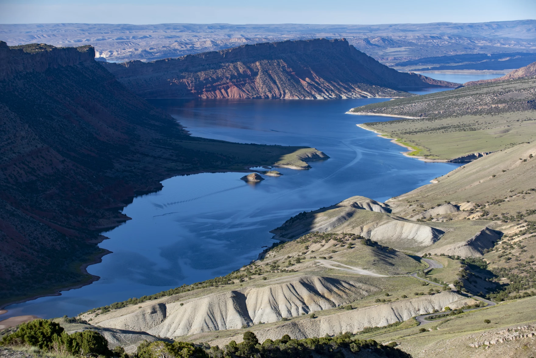
Utah, Colorado, Wyoming and New Mexico are asking the federal government to pause some releases from Flaming Gorge Reservoir, which straddles the border between Wyoming and Utah. The reservoir, pictured here in 2021, is the third-largest in the Colorado River system.
Reclamation’s first move is to release more water from Flaming Gorge, an upstream reservoir that is 82 percent full. With the consent of the four upper basin states, between 660,000 acre-feet and 1 million acre-feet will flow from Flaming Gorge into Powell over the next 12 months.
Reclamation previously used upstream reservoirs to prop up Powell in 2022-23, when some 463,000 acre-feet were released. These extra releases are supposed to be recovered if water supply conditions turn favorable. If more dry years are ahead, then the upstream releases will have been a one-shot intervention.
The agency’s second move is to hold back more water in Powell. Using authority granted in a 2024 decision, the agency will cut Powell’s water releases from 7.48 million acre-feet to 6 million acre-feet. This is the first time that Reclamation has invoked its Section 6(E) authority.
Water supply conditions in the basin worsened each month this year as hot, dry weather drained a meager snowpack that is on a downward trend due to manmade climate change. A heat wave in late March was the most extreme on record in the Southwest for that time of year. Inflows into Lake Powell this year are projected to be the lowest ever measured, breaking a record set in 2002.
The water elevation at Powell currently sits at 3,526 feet. Reclamation has stated that it will do what it can to prevent the reservoir from dropping below 3,500 feet. Hydropower generation stops at 3,490 feet. Without Reclamation’s announced interventions, that level is expected to be breached by August.
With the two interventions, Powell is projected, with average weather conditions, to remain above 3,500 feet by April 2027, but just barely. If the next 12 months continue to be hot and dry, more emergency actions might be necessary.
The back of Glen Canyon Dam circa 1964, not long after the reservoir had begun filling up. Here the water level is above dead pool, meaning water can be released via the river outlets, but it is below minimum power pool, so water cannot yet enter the penstocks to generate electricity. Bureau of Reclamation photo. Annotations: Jonathan P. Thompson
If Powell were to drop below 3,490 feet, water would have to be released through a smaller set of pipes called the river outlet works. Reclamation has said that using these pipes for extended periods of time is untested and risks damaging them.
Reducing outflows from Powell will have two effects. One is that Lake Mead, located downstream, will shrink more quickly, as will its hydropower output. Boating access will be more difficult.
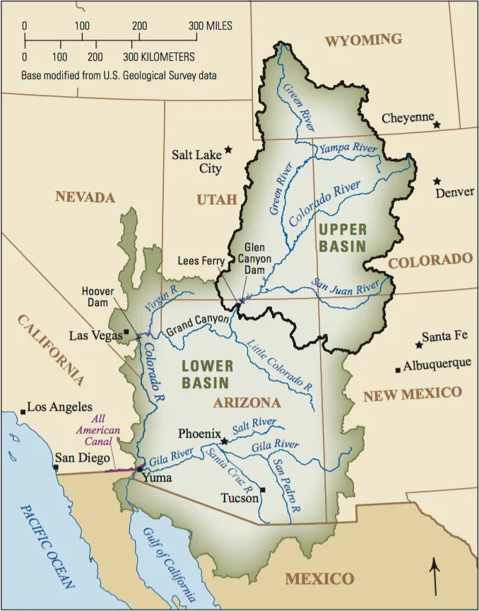
The other consequence is the specter of litigation. The 1922 Colorado River Compact requires the four upper basin states – Colorado, New Mexico, Utah, and Wyoming – to deliver 75 million acre-feet over 10 years. Add in the upper basin’s share of the water required for Mexico and the figure rises to roughly 82.5 million.
Cutting Powell outflows this year to 6 million acre-feet will likely push the 10-year total below the required threshold.
Reclamation is not focusing on the legal implications, says James Eklund, a partner at Taft Law.
“Reclamation is essentially telling the basin states, ‘We are going to protect our billions of dollars’ worth of infrastructure, including Glen Canyon Dam, and if you believe that violates your compact entitlement, you know where the courthouse is’,” Eklund, a former Colorado River commissioner for Colorado, wrote to Circle of Blue.
States in both upper and lower basins have already set aside money for potential litigation or are considering it.
Still, a legal right does not necessarily mean the water is available, Eklund cautions. “No court can conjure acre-feet that aren’t in the reservoir.”
Udall/Overpeck 4-panel Figure Colorado River temperature/precipitation/natural flows with trend. Lake Mead and Lake Powell storage. Updated through Water Year 2025. Note the tiny points on the annual data so that you can flyspeck the individual years. Credit: Brad Udall
Click the link to read the article on The Denver Post website (Elise Schmelzer). Here’s an excerpt:
April 19. 2026
The multitude of water managers tasked with overseeing the drying Colorado River systemstand at a dire crossroads. As a years long stalemate in negotiations persists between the seven states that share the river, it’s become increasingly likely that the federal government will impose its own long-term plan, choosing from a range of proposals officials have outlined in recent months. But experts and water managers across the 250,000-square-mile Colorado River basin are raising the alarm about the five plans, questioning if any of them hold up under the new climate reality. They say the federal plans won’t keep the system from crashing in critically dry years — which are becoming more frequent — and could wreak chaos on the pivotal lifeline for 40 million people in the American Southwest.
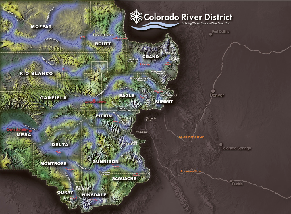
“In every one of those alternatives, under what they call critically dry hydrology, the system is failing,” said Andy Mueller, the general manager of the Colorado River District, a taxpayer-funded agency based in Glenwood Springs that works to protect Western Slope water. “And critically dry hydrology is what we have continued to see consistently in the basin in the last 25 years and what we should expect going forward.”
[…]
In extremely dry years, the longer-term plans under consideration by Reclamation would allow the water levels of the system’s two main reservoirs to repeatedly fall below minimum power pool. Federal officials then would be forced to make recurring emergency cuts to the water supplies of the three states downstream of the reservoirs, creating uncertainty for millions of people and a massive agricultural industry…Letters from a number of Colorado entities — including the Northwest Colorado Council of Governments, irrigation districts, the Western Slope’s Club 20 and county commissions from a vast swath of the state — urged federal officials to present at least one plan that would hold up in extremely dry years.
“Sound science dictates that Colorado River management must evolve to handle a permanently drier future,” Tina Bergonzini, the general manager of the Grand Valley Water Users Association, wrote in her comments to the bureau. “The current federal preference for predictability is an atmospheric impossibility given that studies indicate rising temperatures have already slashed river flows by a fifth.”
[…]
The conflict on the Colorado is likely one of the world’s first major water policy overhauls to grapple with the reality of climate change, said Brad Udall, a senior water and climate research scholar at Colorado State University’s Colorado Water Center. In the past, Colorado River managers made operational tweaks and short-term deals to address drought. This time, it’s different.
“We’re not looking at an incremental step here,” Udall said. “We’re looking at a complete redo of how we operate this resource that affects 40 million people.”
Map of the Colorado River drainage basin, created using USGS data. By Shannon1 Creative Commons Attribution-Share Alike 4.0
Sometimes it feels like there are two parallel Southwestern United States out there.
One is naturally arid, is getting hotter and hotter by the year and is gripped by the most severe drought of the last millennium or more. Its water lifeline, the Colorado River system, is on the brink of collapse, and communities and farmers from Wyoming to Calexico are facing painful mandatory water cutbacks this summer.
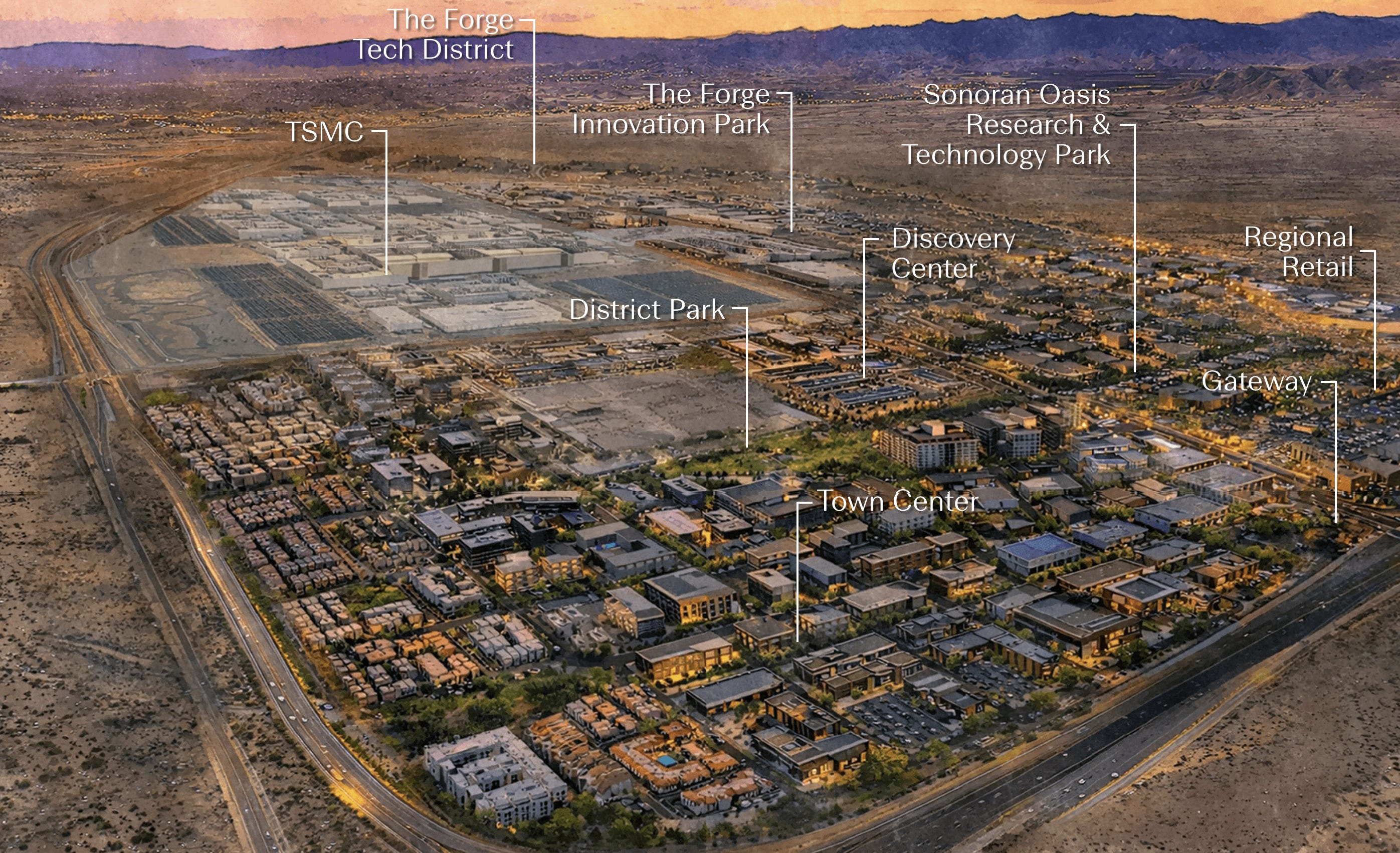
And then there’s the other one, a sort of fantasy world, or maybe just an oblivious one, in which new water diversion projects like the Lake Powell Pipeline remain on the table, state leaders prepare to go to legal war to protect their states’ profligate water consumption, and a developer is breaking ground on a 2,300-acre “city within a city” called Halo Vista in North Phoenix.
Halo Vista’s developers are billing it as a companion development to TSMC’s $165 billion semiconductor fabrication facility complex. It will wrap around the industrial campus (thus the “halo” in the name), and plans call for some 30 million square feet of industrial, retail, office, research, and healthcare spaces along with 9,000 or more residential units.
“You have to think about all the people at full build-out who’ll work in this area — about 60 to 80,000 people,” Greater Phoenix Economic Council President Christine Mackay told AZFamily. “They’ll work in the Halo Vista science and technology park. They need restaurants, hotels, places to live — and places to shop for what they need.”
Historically, Arizona’s economy was said to run on five Cs: copper, cotton, citrus, cattle, and climate. Copper is still going fairly strong, most of the citrus groves have given way to housing developments, alfalfa has surpassed cotton, and the beef-cattle have been replaced by dairy factories. Now another C — computer chips — is being added to the mix, as the Phoenix-area experiences a semiconductor manufacturing boom and a coinciding data-center buildup.
The tech industry’s expansion is adding economic diversity, making the city somewhat less vulnerable to 2008-like financial breakdowns. But as Halo Vista demonstrates, it is also feeding Phoenix’s dominant economic force, the Growth Machine. And both the Growth Machine and the data center/semiconductor boom need water, and quite a lot of it. This, in turn, increases Phoenix’s exposure to future water shortages, which seem more and more likely with each passing day.
According to TSMC’s draft environmental assessment, the first phase of its Phoenix fabrication plants will initially use about 4.75 million gallons of water per day, or 5,320 acre-feet per year, which would jump to about 19,400 acre-feet yearly if and when all three phases are built out. But the company says it will eventually install a recycling system that will bring that number down considerably. The 9,000 residential units in Halo Vista would use about 2,800 acre-feet per year (based on Phoenix’s current per-capita water consumption multiplied by a rough estimate of 20,000 people occupying those residences). Halo Vista’s other industrial and commercial properties will consume an unknown additional amount of water.
So let’s say the whole development, including the “fabs,” will use about 25,000 acre-feet per year — less if the water efficiencies are realized, more if Halo Vista’s tech district includes data centers or other water-intensive industries.
That’s a lot of water, or a drop in the bucket, depending on how you look at it.
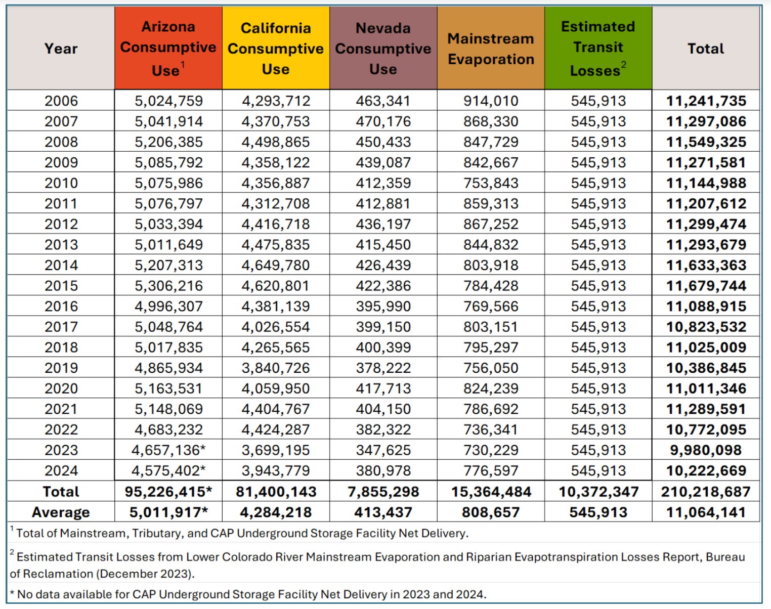
On the one hand it is equal to about one-fourth of Nevada’s total consumptive use from the Colorado River. Yes, the city of sin and excess only uses about four times more water than the TSMC/Halo Vista “city” will use.
On the other, it’s far less than the alfalfa farms in Maricopa County — in which Halo Vista is located — use for irrigation each year, which totals something like 500,000 acre-feet.1 And yet, Halo Vista/TSMC, once all built out in 20 years or so, will have a significantly larger economic output than a bunch of hay fields (which isn’t the only measure of value or even the most important one, and yet, well, water does flow uphill to money).
So yes, it is possible to sidestep water concerns by pulling out the “what about alfalfa” comparison. But it’s also not all that productive.
Halo Vista, which is being built on a plot of uncultivated state land in the desert, is not displacing an alfalfa farm’s water use. Rather, it represents a new water use piled on top of existing consumption. The water will come out of Phoenix’s municipal system, and therefore officially has an “assured and adequate” 100-year water supply, which is necessary in Arizona for this sort of development.
Yet there’s nothing assured about Arizona’s water future. Phoenix’s water comes primarily from high priority rights on the Salt and Verde Rivers, and from the Colorado River via the Central Arizona Project. But those rights will hardly matter if the rivers dry up: This year’s Salt River Basin meagre snowpack had vanished by March 1, spring runoff peaked weeks ago, and flows are rapidly falling. Meanwhile, the Central Arizona Project has relatively low priority rights, meaning it will be the first to take cuts as the river shrinks.
In other words, aridification and the Colorado River crisis pose an existential threat to Phoenix’s tech boom and, well, Phoenix, itself, which is one of the reasons Arizona Gov. Katie Hobbs is preparing for a bitter legal fight with the feds and the Upper Basin states over the Colorado River.
The good news for the developers and the semiconductor makers is that agriculture continues to use a lot of water in Arizona. And where there is large consumptive use, there is also more room for increased efficiencies and, if it comes to it, “buying and drying” the farms for their water — which has its own negative consequences. The bad news is that the shortages to come may very well exceed the amount that could be wrung out of the existing farms.
Halo Vista, which is on a 20-year buildout schedule, is far from the only major water- and energy-guzzling development on slate for the increasingly arid West. And maybe it’s not realistic to expect all such development to come to a screeching halt simply because the water may run out sometime in the future. After all, climate change could cause more precipitation; maybe in 20 years we’ll be worrying more about flooding than desiccation.
But you would think that planners and policymakers and the developers would at least act in line with our current reality, where resources, especially water, are limited. Halo Vista-esque projects should be required not just to certify an “assured” 100-year supply, but they also should have to offset new consumption with cuts somewhere else, whether it’s paying for farmers to install drip irrigation or funding treated wastewater recycling projects.
Continuing to consume water at current rates is one thing. Adding new uses on top of our current overconsumption is quite another.
***
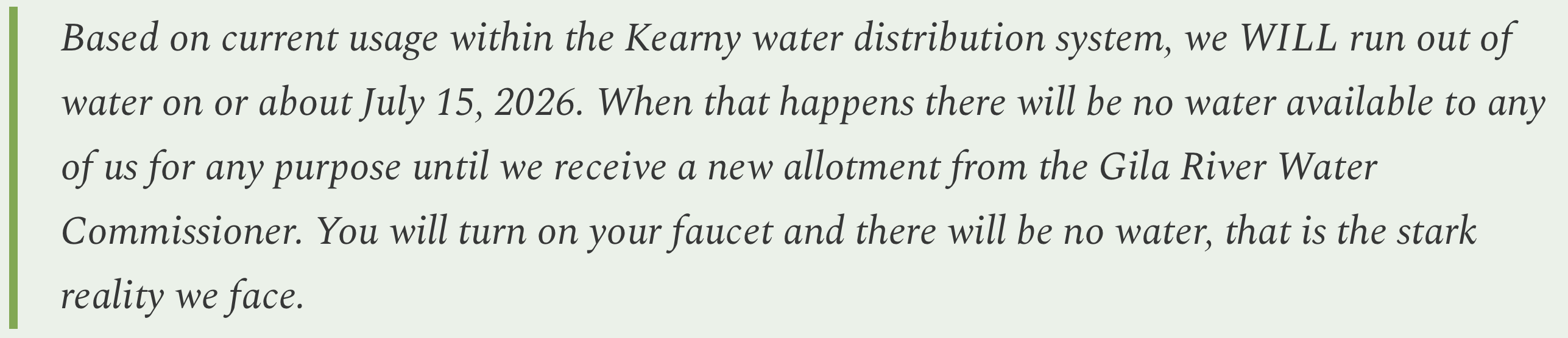
And so it begins. It looks like residents of the small Arizona community of Kearney may lose their water altogether later this summer, making developments like Halo Vista look even more surreal.
The town sent this emergency memo out to residents in April:
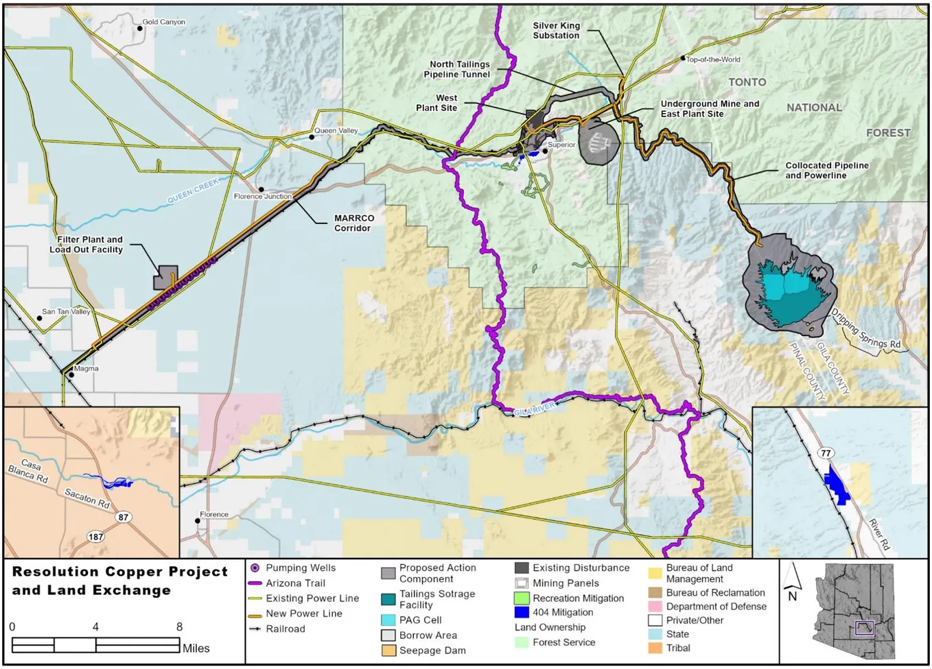
Kearney sits in Arizona’s “Copper Triangle” along the banks of Gila River and in the proverbial shadow of the Hayden copper smelter smokestack. The town was established by the Kennecott Mining Company in 1958 to house residents displaced from Ray, Sonora, and Barcelona as the mine’s gaping Ray mine pit gobbled up the communities. Resolution Copper’s proposed Oak Flat mine is also nearby, as is Faraday’s proposed Copper Creek project.
Kearney has a maximum allotment of 610 acre-feet of water from the Gila River. This year, however, extreme drought conditions have brought the allotment down to just .76 acre-feet, forcing the town to impose severe restrictions on use to try to make it last until the monsoon arrives.
As for all the mines surrounding Kearney? I’m guessing their dealing with their own water issues, but I’d also wager that they’re allowed a heck of a lot more than three-fourths of an acre-foot.
Condors perched on steel girders some 450 feet above the Colorado River. Jonathan P. Thompson photo.
🐟 Colorado River Chronicles 💧
In the comment section on the last Land Desk dispatch, reader wkarls reported on the Colorado River’s flows during a recent raft trip on the Grand Canyon. It got me to thinking about how low those flows might go and what that could mean.
I’ve only boated down the Grand Canyon once, back in October and November of 1995 with a group of slightly crazy Salida rafting folks. It was a beautiful, terrifying, sublime — if somewhat debauched — experience. During the trip, releases from Glen Canyon Dam — which make up about 95% of the flow in the Grand Canyon — fluctuated between 11,000 and 16,000 cubic feet per second, a number that was bolstered downstream after a good rainstorm moved through, turning the river that intimidating blood-and-chocolate-milk color. That seemed like plenty of water to me; it was certainly enough to generate waves big enough to toss our little rafts about like toys (did I mention it was scary as hell?).
Somewhat surprisingly, the releases were about the same in September of last year, bouncing between 10,000 and 16,000 cfs, which appears to have been an effort to get the annual flows past Lees Ferry up to about 7.5 million acre-feet to keep the Upper Basin in compliance with the Colorado River Compact’s non-depletion obligation. Then, on Oct. 1, the beginning of the 2026 water year, releases plummeted. This spring they’ve been in that 7,000 to 9,000 cfs range that wkarls mentioned.
That’s in line with the Bureau of Reclamation’s plan to release just 6 million acre-feet from the dam this water year: 6 million acre-feet per year averages out to about 8,200 cfs. That’s also right in line with the Grand Canyon Protection Act’s operating criteria, which set a minimum allowable release during the day (between 7 a.m. and 7 p.m.) at 8,000 cfs, while the minimum nighttime release is 5,000 cfs.
So, given all of that, we can assume that the flows shouldn’t drop much below current levels this summer. Of course, if conditions are worse than expected, then the reservoir could drop to 3,500 feet earlier than anticipated, which could force dam operators to further curtail releases to “defend” minimum power pool. If so, then you might see nighttime releases drop as low as 5,000 cfs. If that’s not enough, then I suppose dam operators would have to go to a run-of-the-river scenario, where flows could plummet to 2,000 or 3,000 cfs, which would make rafting quite interesting.
📸 Parting Shot 🎞️
Colorado River at/around Lees Ferry in autumn 2024, when Glen Canyon Dam releases were around 8,000 cfs.
Colorado River at/around Lees Ferry in autumn 2024, when Glen Canyon Dam releases were around 8,000 cfs.
Colorado River at/around Lees Ferry in autumn 2024, when Glen Canyon Dam releases were around 8,000 cfs.
The Mexican Hat uranium tailings repository on the Navajo Nation holds contaminated waste from uranium mills in Utah and Arizona. The Navajo Nation has raised concerns about its proximity to the San Juan River, a source of drinking water. Russel Albert Daniels/High Country News
Last fall, constructionon the Velvet-Wood uranium mine broke ground in the sandstone deposits of San Juan County, Utah. It’s the first mine that the federal government has permitted under a new expedited “emergency” process that allows projects to go through the environmental review required by the National Environmental Policy Act (NEPA) in just 14 days, a process that previously took months or even years. Tribal governments were given just seven days to offer feedback, and the standard public comment period was eliminated owing to the project’s “emergency” status. In the past, both tribes and the public had at least 30 days give input.
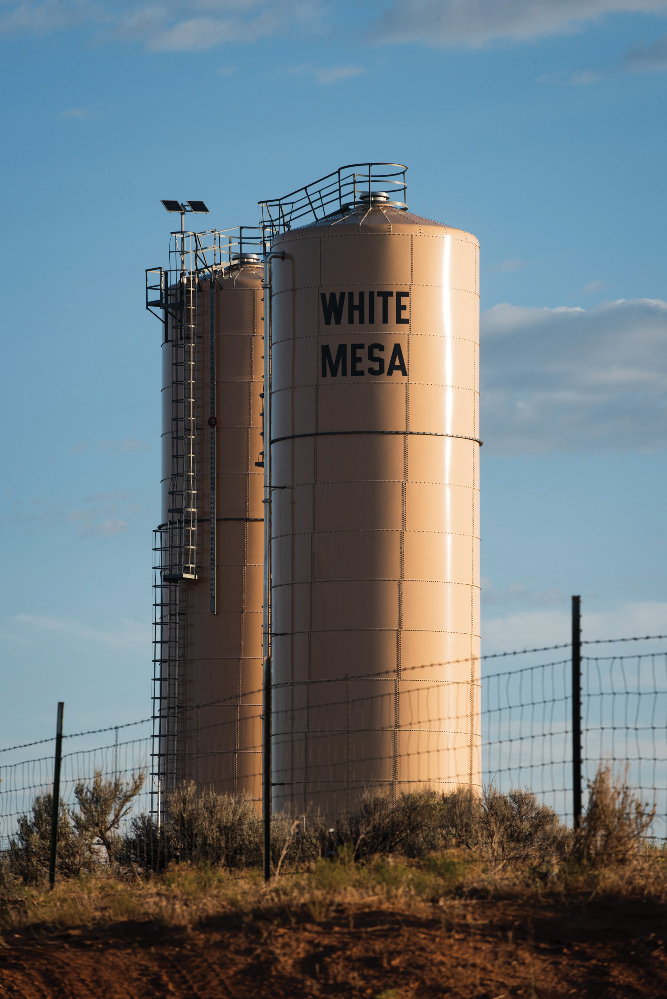
The mine is located in an area already deeply scarred by uranium mining, where the Ute Mountain Ute Tribe has long opposed the White Mesa Uranium Mill, which abuts the community. During the weeklong tribal comment period, six nations shared their concerns with the Bureau of Land Management, citing the expedited process and possible water contamination from the mine’s activities. No changes were made to the project, however.
Earlier this year, in addition to mandating expedited “emergency” processes for NEPA reviews, the Trump administration finalized its proposed elimination of standards — including public comment periods — for how federal agencies carry out NEPA environmental reviews for large-scale projects on public lands. The changes came without consultation with tribal nations and despite their strong opposition.
Water towers in White Mesa, Utah. The Ute Mountain Ute Tribe has long opposed the neighboring White Mesa Uranium Mill. Six tribal nations warned the Bureau of Land Management about possible water contamination from the new Velvet-Wood uranium mine, but no changes were made to the project. Russel Albert Daniels/High Country News
“The announce-and-defend method of developing federal Indian policy is an inappropriate, paternalistic, unjustified, and historically inefficient method of decision-making,” the National Congress of American Indians and National Association of Tribal Historic Preservation Officers said in a joint letter. Eliminating previous standards “ignores federal trust and treaty responsibilities, impinges on roles and sovereignty of Tribal Nations, and flouts longstanding policy and practice by failing to consult with Tribal Nations.”
The federal government is legally required to consult with tribal nations on rules and policies that affect them, but so far the Trump administration has regularly bypassed consultation requirements or sped through them in order to accomplish its “energy dominance” agenda on tribal nations’ ancestral lands. Altogether, the changes represent a shift in the way that tribal nations — and the public — are able to have a say in how land in the Western U.S. is managed.
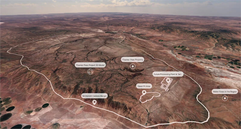
A map of the upcoming Thacker Pass mine in northern Nevada. The federal government has bought stakes in mining companies, including the company behind the Thacker Pass lithium mine in Nevada, which is opposed by some tribal nations and Indigenous communities. Image used courtesy of Lithium Americas
FROM THE START, agencies under Trump have changed or revoked rules and policies to prioritize extraction, citing the so-called energy “emergency.” The BLM and the Forest Service rescinded the Public Lands Rule and the Roadless Rule without tribal consultation, even though both decisions have major implications for tribes’ ability to protect natural and cultural resources on public land. Meanwhile, the administration is seeking to “streamline” Section 106 of the National Historic Preservation Act, one of the most useful tools tribal nations have for ensuring government consultation. Changes are also proposed for Section 401 of the Clean Water Act, which enables tribes to review the impacts of extractive projects within reservation borders before a federal agency permits the project.
“It’s all predicated on something that isn’t true: We don’t have an energy emergency,” said Gussie Lord, managing attorney at Earthjustice’s Tribal Partnerships Programs. Chipping away at public input and tribal consultation will only exacerbate issues that tribal nations face, Lord said. “A lot of their resources, their cultural and environmental resources often are one and the same. The existing laws and regulations that we have are already insufficiently protective of tribal rights and resources.”
The administration’s changes to the NEPA review process took effect immediately last year, also without consultation. Under the Biden administration, the Council on Environmental Quality spent three and a half years updating the implementation regulations by consulting with tribal nations and the public, incorporating provisions requiring agencies to consider climate change and environmental justice impacts when reviewing projects. NEPA applies to all federal agencies, meaning that each agency has to come up with its own implementation guidelines. Tribes and experts worry that, under the new guidelines, agencies may not be compelled to work with tribes.
According to University of Arizona professor of law Justin Pidot, who previously served as general counsel for the White House Council on Environmental Quality, the resulting uncertainty could have serious consequences. “One is the agencies don’t know how to work together. The second is that there’s litigation risk. The third is that project sponsors don’t know what they’re supposed to do,” Pidot said. The removal of those standards “creates lots of complexity for the public, for tribes, for states, for local governments, for nonprofits.”
Under the Interior Department’s new interim set of standards, for example, reviews for something like a mining project will take 28 days. When the “emergency” declaration is added, it could take just 14 days, as it did with the Velvet-Wood mine. Past reviews could take up to four years. “It substantially limits the degree of information flowing from the federal government to the public about big projects, including to tribes,” Pidot said. “What is surprising about this particular decision of theirs is that having a common set of rules makes sense for everyone.”
In comments to the Council on Environmental Quality about the elimination of the NEPA standards, many tribal nations expressed similar concerns. (See sidebar.) Tribes said they were not consulted, and that while dealing with numerous agencies and their different processes was burdensome, the removal of the regulations weakens the whole purpose of NEPA. The National Congress of American Indians and other organizations noted that some streamlining and deregulating could prove useful — but not when tribal perspectives were excluded from the process.
Last year’s federal budget cuts and mass layoffs further complicate matters, affecting agencies’ ability to carry out their work. Meanwhile, congressional budget cuts impacted funding for, among other things, tribal historic preservation officers, which are key to carrying out government-to-government consultation. The idea seems to be to “drown people in an avalanche while providing them with no resources to meet the moment, and call that consultation and collaboration,” Pidot said.
At the same time that the federal government has moved to reduce public and tribal input, it has also been buying stakes in mining companies, including the two companies behind controversial projects opposed by some tribal nations and Indigenous communities: the Thacker Pass lithium mine in Nevada and the Ambler Road project in Alaska. “It’ll be interesting to see if their approval processes for mines in which the federal government has a stake is quicker than it otherwise would have been,” Lord said.
Pidot summed it up this way: “The big theme is that anything and anyone that stands in the way of the kinds of projects that this administration wants to do is an obstacle to progress that they’re going to overrun.”
The Daneros uranium mine in the Red Canyon uranium mining district in San Juan County, Utah. All uranium ore mined from this area travels through Bears Ears National Monument. Russel Albert Daniels/High Country News
Gay Mine, a former phosphate mine and current Superfund site on Fort Hall Reservation, in 1948. P1972-201-101. Courtesy of Idaho State Archives
Tribes’ perspectives on changes to nepa implementation
Shoshone-Bannock Tribes, ID “On the Fort Hall Reservation are environmentally hazardous sites created prior to modern-day NEPA protections. … By stripping away NEPA’s provisions for public participation and environmental review, the federal government would further entrench long-standing historic inequities that have disadvantaged Tribal communities.”
Confederated Salish and Kootenai Tribes, MT “CEQ (Council on Environmental Quality) states that it does not need to consult with Tribes. … This is a tortured and disingenuous reading of EO 13175, in part because it focuses almost exclusively on a federal view of economic impacts on Tribal governments rather than the universe of environmental impacts.”
Susanville Indian Rancheria, CA “The proposed removal of these regulations represents a significant step backward in our nation’s commitment to environmental protection and tribal sovereignty.”
Cheyenne River Sioux Tribe, SD “CEQ is ignoring its established policy of including indigenous traditional ecological knowledge in environmental reviews under NEPA. These issues that have been part and parcel of the implementation of NEPA for decades, such as the consideration of impacts to environmental justice communities, the cumulative effects of projects, and climate change, are being arbitrarily cast aside in contravention of explicit statutory language.”
Bishop Paiute Tribe, CA “Our traditional and ancestral lands extend far beyond the exterior boundaries of our reservation, and the natural resources on these lands are not merely commodities to be exploited. They are vital to the cultural, spiritual, and economic fabric of all Tribal communities, sustaining traditions that have endured for generations.”
Tulalip Tribes, WA “The lack of consultation exacerbates the already existing power imbalances, further diminishing the ability of tribes to exercise meaningful sovereignty and protect their interests.”
Nez Perce Tribe, ID “The Tribe strongly objects to CEQ’s Proposed Rule, which eviscerates the framework that has been relied upon since CEQ first issued NEPA regulations in 1978.”
Big Pine Paiute Tribe, CA “The interim final rule sidesteps NEPA … as it endorses Donald Trump’s personal agenda. The USA is a country of laws, not a place where one’s personal agenda may supersede the law.”
Native land loss 1776 to 1930. Credit: Alvin Chang/Ranjani Chakraborty
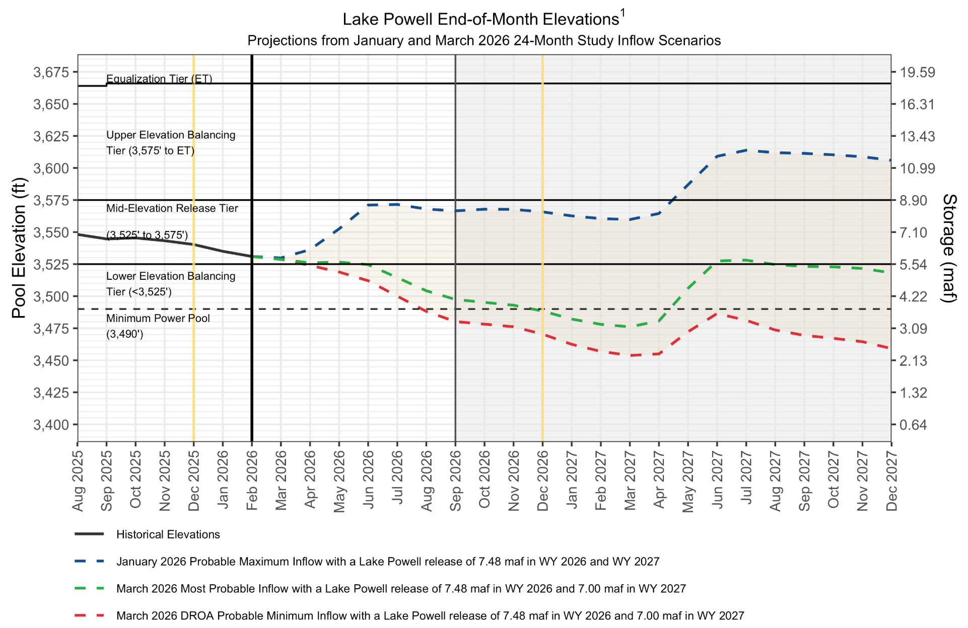
Long-term drought has reduced Colorado River system storage to about 36 percent of capacity, and the combination of the lowest snowpack on record and record-breaking March heat has further intensified drought conditions across the Basin. These compounding factors are creating elevated risks to essential water and power infrastructure that supply water to more than 40 million people, underscoring the need for immediate action.
Lake Powell’s water year minimum probable inflow is forecasted at just 2.78 million acre-feet—29% of historical average and one of the lowest on record. Reclamation’s April “24 Month Study” projects Lake Powell may decline to below 3,490 feet—the minimum power pool level—by August 2026 without major intervention. If Glen Canyon Dam declines below 3,490 feet, water releases would be only through the river outlet works, which could cause operational issues, uncertainty for users, downstream impacts, instability in regional power and water supplies, and a reduction in power generation.
Secretary of the Interior Doug Burgum met with Governors for the seven basin states, Arizona, California, Colorado, Nevada, New Mexico, Utah and Wyoming, and their designees again today to discuss the concerning hydrology and plans for operations.
“I am grateful for the Governors and their teams working diligently to find a solution to the complex challenges created by these unprecedented drought conditions which require immediate action,” said Interior Secretary Doug Burgum. “Interior and Reclamation continue to coordinate with the basin states, tribes, Mexico and basin stakeholders as we make the decisions necessary to operate and protect the system.”
To stabilize the system, Reclamation is moving quickly and initial plans include adding up to about 2.48 maf of water to Lake Powell by moving water from the upstream Flaming Gorge Reservoir and by reducing releases from Lake Powell. [ed. emphasis mine]
Through the 2019 Drought Response Operating Agreements, Reclamation is intending to release 660,000 acre-feet to 1 maf from Flaming Gorge Reservoir from April 2026 through April 2027. In addition, Reclamation is intending to reduce the annual release volume from Lake Powell to Lake Mead by 1.48 maf—from 7.48 maf to 6.0 maf—through September 2026 by utilizing section 6E of the Record of Decision from the final 2024 Supplemental Environmental Impact Statement for near-term Colorado River Operations.
Together, these actions are expected to increase Lake Powell’s elevation by approximately 54 ft to at least elevation 3500 feet by April 2027. Through the current, ongoing DROA process, the basin states, tribes and partners continue to provide feedback related to the proposed releases. A final decision will be coming next week.
Flaming Gorge Reservoir now holds about 3.1 maf of water, which is 83% full. These actions are expected to lower the reservoir’s elevation by roughly 35 feet over the next year to approximately 59% of capacity. This will have no effect on contracted water rights at Flaming Gorge or Lake Powell. No additional releases from the other upstream initial units of the Colorado River Storage Project Act—Blue Mesa and Navajo reservoirs—are planned at this time, due to their low water levels and poor forecasted inflows. [ed. emphasis mine]
“Given the severity of the risks facing the Colorado River system, it is imperative that we take action quickly to protect a resource that supplies water to 40 million people and supports vital agricultural, hydropower production, tribal, wildlife, and recreational uses across the region,” said Assistant Secretary – Water and Science Andrea Travnicek. “As we weigh current conditions and prepare for future operations by working with states, tribal nations and stakeholders, the Department of the Interior and Reclamation remain fully committed to taking the actions necessary to reduce impacts on water deliveries, safeguard critical infrastructure, and preserve as much operational flexibility as possible.”
Basin-wide impacts
Reclamation acknowledges that the proposed reduced releases from Lake Powell will accelerate the downstream decline of Lake Mead, with the potential for up to an additional 40% reduction to Hoover Dam’s hydropower generating capacity as early as this fall. Reclamation and its lower basin partners are collaborating to conserve water in Lake Mead and maintain its water levels, even as releases from Lake Powell are planned to decrease.
The initial proposed drought response actions may also impact recreation across multiple sites. At upstream reservoirs, boating access may be reduced earlier in the season than normal. In the Grand Canyon, lower flow rates will affect rafting conditions, and fishing may be more challenging. At Lake Mead National Recreation Area, reduced water levels may further limit boating access. Reclamation is working with reservoir recreation management partners now and as the summer progresses.
The 2026 operational challenges come at a time of transition as the existing agreements that guided the operations of the Colorado River for the last two decades are set to expire at the end of the year. As we approach the new water year on October 1, the seven basin states have not reached consensus on a new operating framework. With time running out, there is a need for extraordinary collaboration for 2027 and beyond. In the absence of a consensus and following the completion of the NEPA process, the Interior Department will be prepared to determine operations for Post 2026 later this summer to provide certainty and stability for the Colorado River Basin.
To learn more about the Interior Department’s or Reclamation’s activities around the Colorado River, please visit the Colorado River Basin website.
Colorado River “Beginnings”. Photo: Brent Gardner-Smith/Aspen Journalism
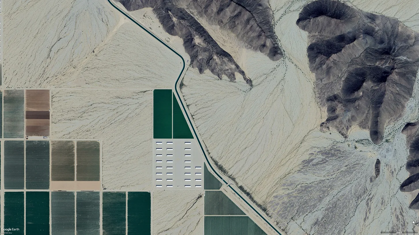
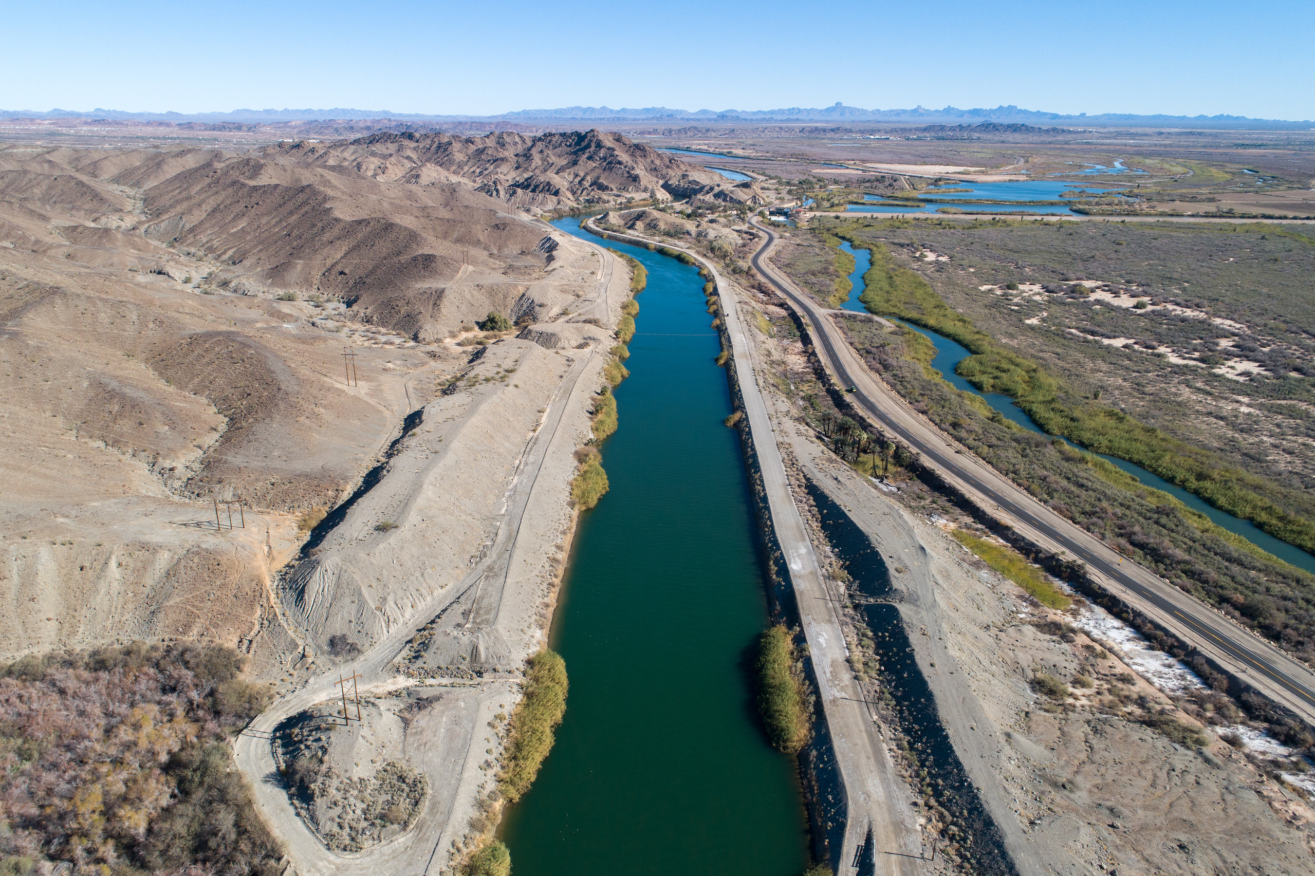
The Central Arizona Project canal, which carries Colorado River water to Phoenix and Tucson, as it runs past fields in the desert (that are irrigated with groundwater, not CAP water). The CAP is not likely to see new cuts this year beyond the levels already imposed. Source: Google Earth.
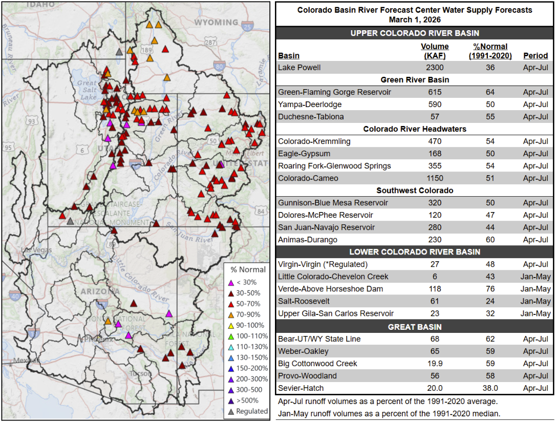
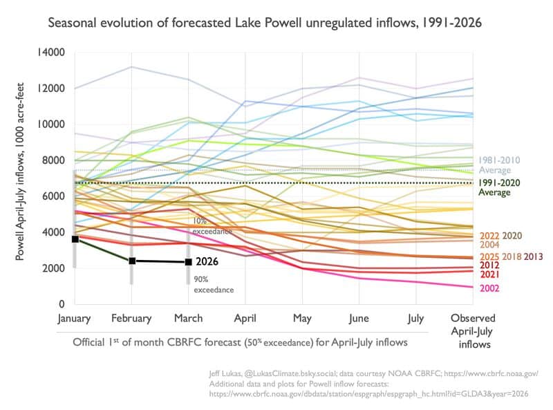
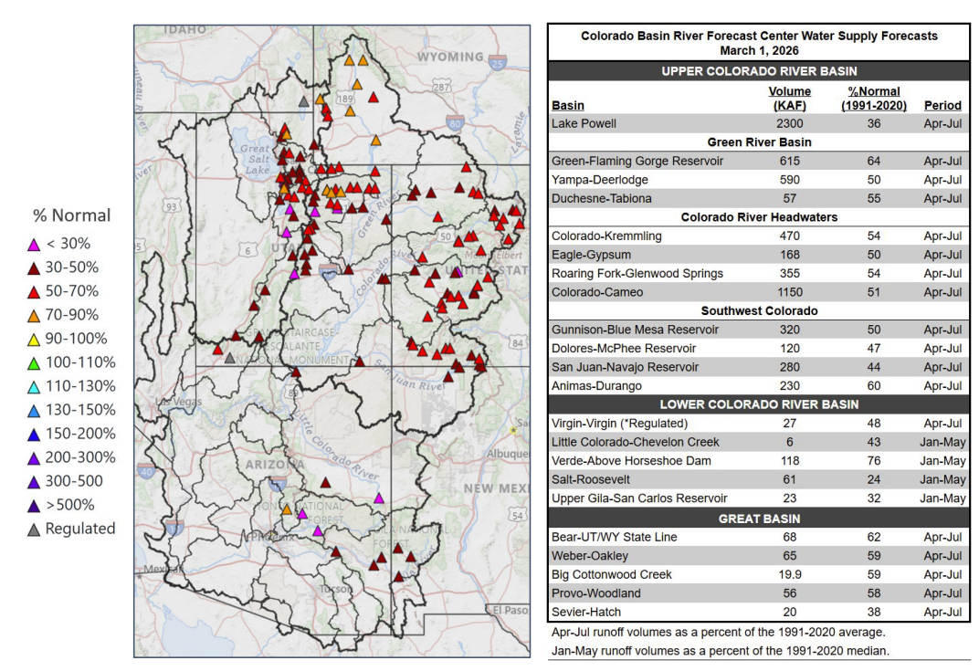
With each passing April day without major snowfall, we gain more clarity on the Colorado River situation and what things might look like this summer, which is, in a word, grim. Or, as Arizona’s top water officials put it: “The winter and spring snowpack and runoff projections in the upper basin are abysmal.”
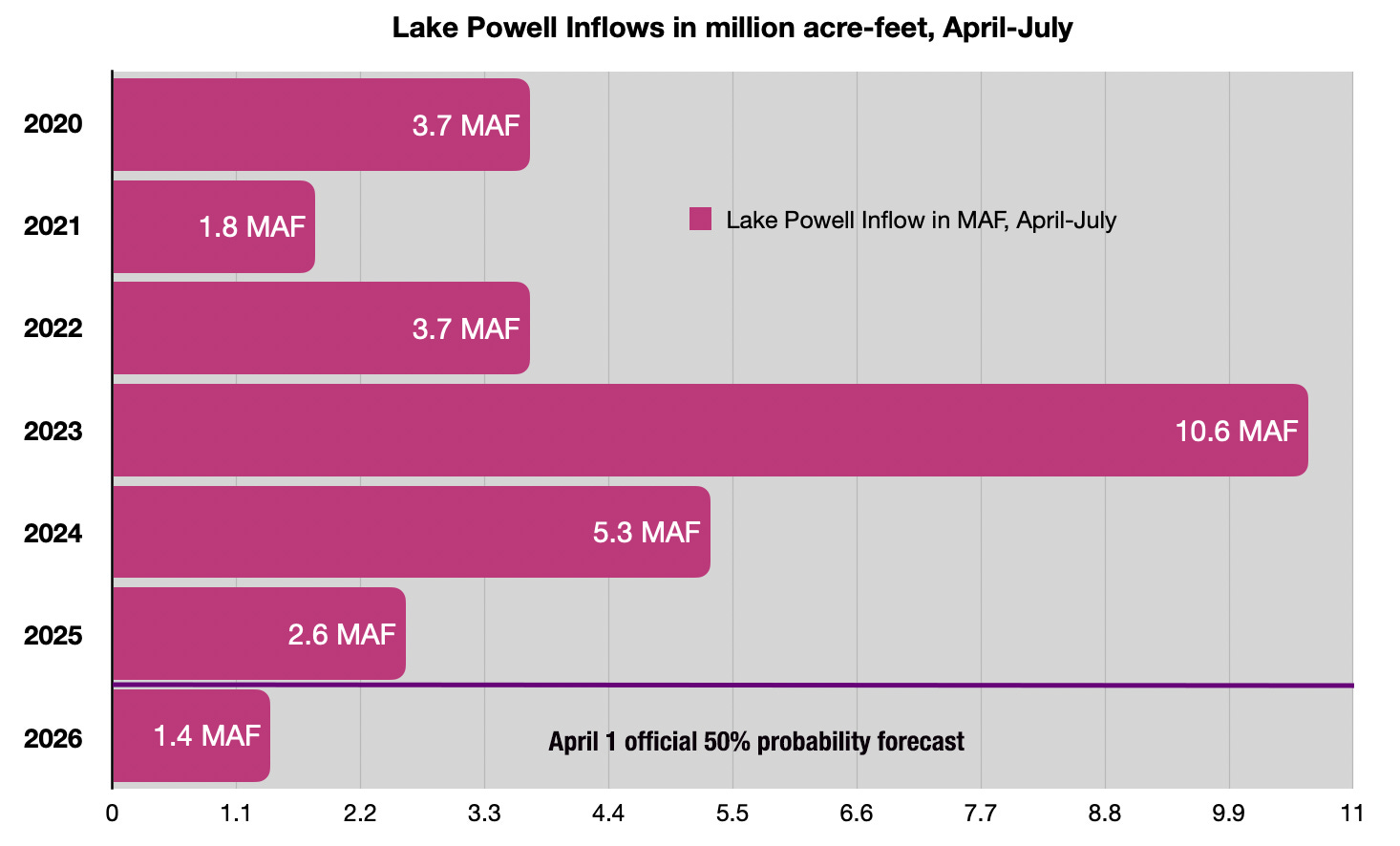
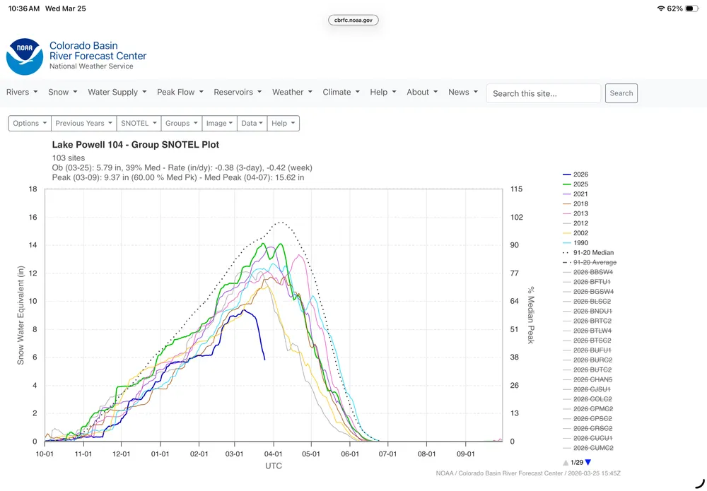
The Colorado River Basin Forecast Center is putting a number to that term by predicting that the Colorado River system will deliver about 1.4 million acre-feet1 of water to Lake Powell from April 1 through July 31. That’s about 23% of the median for the spring runoff season, which is when flows are most abundant, and just over half of last year’s not so great figure of 2.6 MAF.
This year’s Upper Colorado Basin spring runoff is forecast to be about 1.4 million acre-feet. That isn’t as low as 2002, which was just below 1 million acre-feet, but if conditions don’t improve it could fall even lower than that. Source: Colorado River Basin Forecast Center.
Believe it or not, that figure — the official 50% forecast, made by an actual person — may be optimistic. Over the last two weeks, the Ensemble Streamflow Prediction model (which is a constantly updating automated forecast) has come up with an even more dire outlook, downgrading the forecast to 1.16 MAF during that same time period.
Abysmal, indeed.
We’re also getting a little more information as to how the feds plan to address the crisis, at least in the near-term. Most significantly, they tentatively plan to “defend” minimum power pool at Glen Canyon Dam, which is to say they will do what it takes to keep the surface level of Lake Powell at or above 3,500 feet in elevation to avoid relying on the lower river outlets, which are not engineered for sustained use. The weapons they will use for this defense include:
Reducing Lake Powell releases from the planned 7.48 million acre-feet to 6 million acre-feet.
Releasing up to 1 MAF from the “Upper Initial Units,” which includes Flaming Gorge, Blue Mesa, and Navajo Reservoirs. Hydrology may make this impossible, however, meaning that these releases could be as low as 650 MAF .65 MAF (or 650,000 acre-feet).
For now, Interior is not asking for larger cuts from the Lower Basin (beyond the 1.5 MAF cuts they’ve already taken), which presumably means the feds will not reduce Lake Mead releases through Hoover Dam.
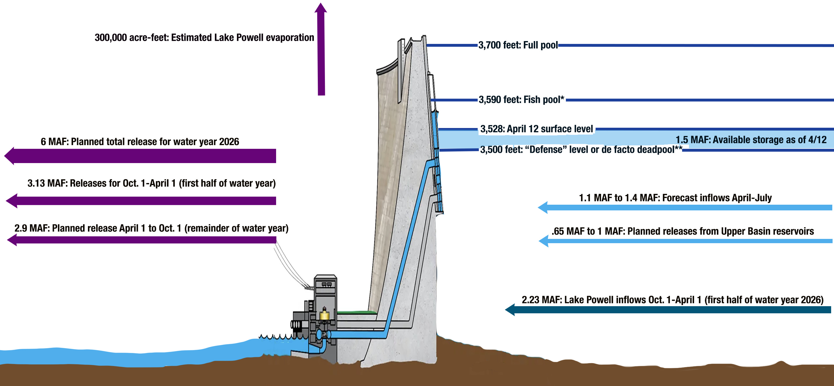
But will it be enough to avoid dipping below what I call de facto deadpool at Lake Powell? We won’t really know until later this summer, but a fairly simple calculation can help predict that future. Keep in mind that I’m no hydrologist, I’m just working with the numbers that are available to see whether potential inputs (Lake Powell inflows) are at least equal to planned outputs (Glen Canyon Dam releases).
I put together this little diagram to help visualize things. I know the text is tough to read in the email version, and especially if you’re reading this on your phone. So I’d suggest clicking on the image (or the headline of this post) and viewing it in the web version.
Simplified diagram of Glen Canyon Dam with inputs (on the right) and outputs (on the left). *Fish pool is the surface level scientists have deemed necessary for minimizing the potential of non-native bass escaping through the dam and propagating downstream, where they can compete with endangered native fish. Infographic by Land Desk using data from Bureau of Reclamation and the Colorado River Basin Forecast Center.
Here are the figures for the equation.
Inflows:
1.5 MAF: Lake Powell Storage available above 3,500 feet.
1.1 MAF to 1.4 MAF: Forecast Lake Powell inflows April-July
.65 MAF to 1 MAF: Planned releases from upper basin reservoirs.
TOTAL INFLOWS: 3.25 to 3.9 MAF
Outflows:
2.9 MAF: April 1 – Oct. 1 releases to reach 6 MAF for the water year (3.13 MAF has already been released)
.3 MAF: Rough estimate of evaporation from Lake Powell for the remainder of the water year.
TOTAL OUTFLOWS: 3.2 MAF
That gives us a whopping .05 to .7 million acre-feet to spare. That is cutting it close, folks; a hot, dry summer could drive evaporation levels up, and/or bring inflows down, shaving off the sliver of breathing room this affords. But unless the outlook dims considerably, the BoR should be able to avoid a run-of-the-river situation this year, which is good news. And, since Arizona likely will not be required to take more cuts this year, the state will probably hold off on doing a compact call and dragging the Upper Basin to court.
These measures, however, will have a variety of consequences, including:
The Upper Basin reservoirs (Flaming Gorge, Navajo, Blue Mesa) are also likely to see record low inflows this year. That, combined with up to 1 million acre-feet of additional releases to benefit Lake Powell, will draw them down considerably, affecting hydropower production, irrigation, and, especially, recreation.
Non-native smallmouth bass are abundant in Lake Powell, but since they are warmer-water fish, they tend to stay near the surface of the reservoir, meaning under normal conditions they stay well above the penstocks, or the outlets in the dam that lead to the hydropower turbines. However, as the surface drops closer to the penstock openings, so do the fish, allowing them to get flushed through the dam into the Colorado River. And because the water released from the dam is warmer (since it’s nearer to the surface), that warms the river downstream, allowing the bass to thrive and compete with the endangered native fish downstream. This is likely to be exacerbated as the surface level nears 3,500 feet.
This year’s 6 MAF release from Glen Canyon Dam will bring the ten-year aggregate flows at Lees Ferry down to about 79 million acre-feet. This potentially puts the Upper Basin in violation of Article III of the Colorado River Compact, which mandates that the Upper Basin “not cause the flow of the river at Lee Ferry to be depleted below an aggregate of 75 million acre-feet” for any 10-year period. A 1944 treaty added another 7.5 million acre-feet to this figure to cover half of Mexico’s allotment, making for a total of 82.5 MAF over ten years. Note: The interpretation of this provision is in dispute.
The diminished reservoir levels, combined with the reduced releases, will lead to lower hydropower output from the dam. That will force tribes, communities, and utilities that buy the relatively cheap power to purchase it on the open market. And it will also cut into power-sale revenues, which help fund endangered fish recovery programs.
Reduced dam releases will mean lower flows, on average, through the Grand Canyon, affecting riparian ecosystems and boating.
Reduced dam releases equate to lower flows into Lake Mead. Since the BoR apparently does not plan to cut releases from Hoover Dam, that reservoir will likely see its levels drop considerably, diminishing hydropower output and affecting recreation. My rough calculation suggests Lake Mead’s surface level will drop from the current 1,060 feet to about 1,030 feet, which would be lower eventhan in 2022. The BoR has suggested it will “defend” a level of 1,000 feet. That would almost certainly lead to Lower Basin shortages.
It’s still a long ways out, but for now the NOAA is calling for above average precipitation in the Southwest later this summer.
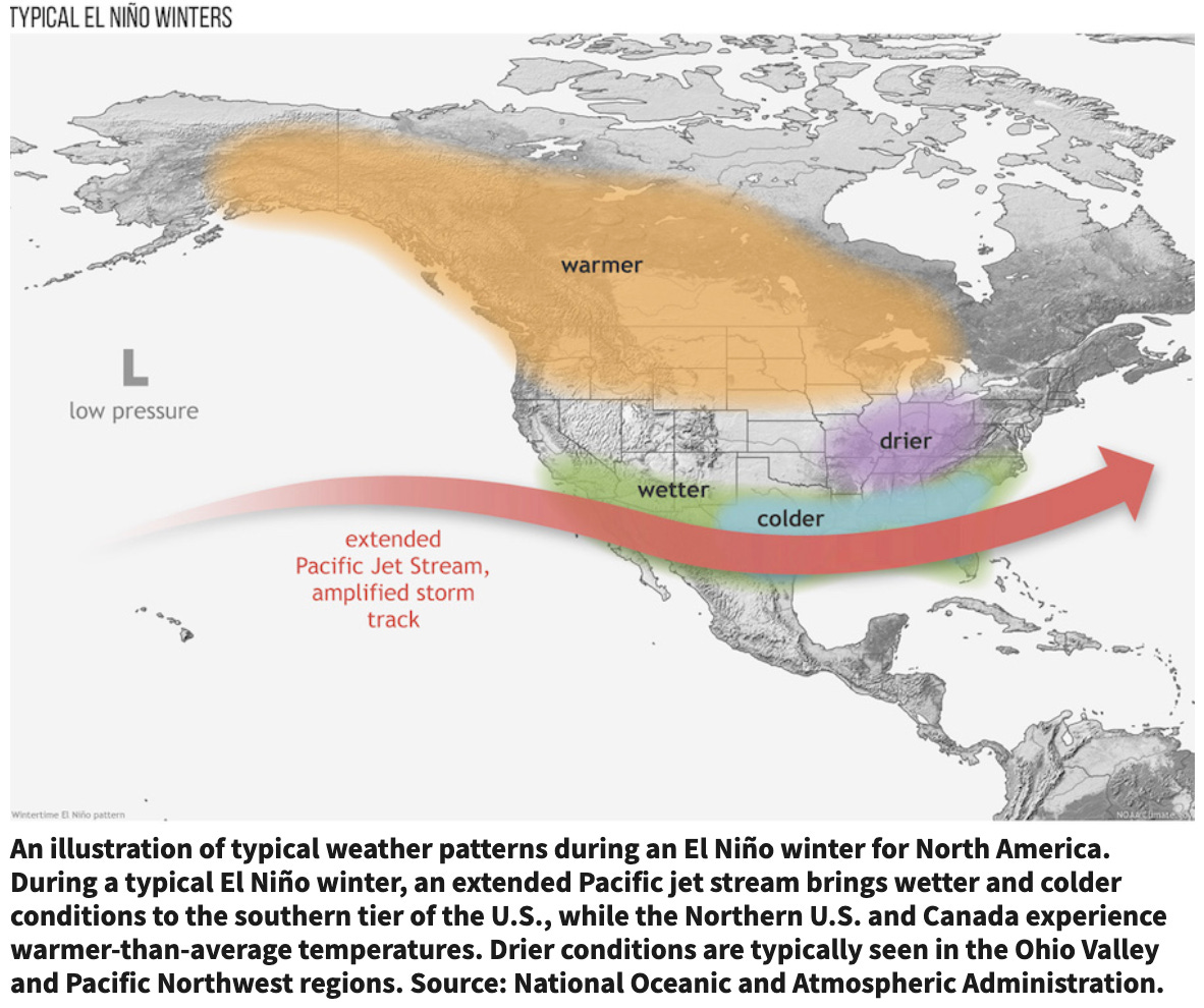
A super El Niño appears to be forming, but the effects in the Upper Colorado River Basin are especially hard to predict because it sits right in between the “warmer, drier” and the “wetter, colder” zones, meaning it could go either way. Source: NOAA.
There is potentially good news on the horizon. Conditions are ripening up for a “super” El Niño to begin forming this summer. It’s difficult to predict how that will affect the Upper Colorado River Basin, but for now, forecasts are calling for a strong monsoon in the Southwest, beginning in July. That probably would not do much to bring up Lake Powell’s levels, but it would provide relief to the many farmers who are almost certain to lose irrigation relatively early this summer and may help keep late-summer megafires at bay. And, you never know, El Niño might just bring a monster winter just when we need it most.
1 *The forecasts are for the “unregulated flow,” which means that it is an estimate of what the flow would be without upstream dams holding water back. This is not the same as “natural flow” which is a calculation of what the flow would be without upstream human consumptive use, dams, or diversions. In this case, actual inflow and unregulated inflow are almost the same.
Map of the Colorado River drainage basin, created using USGS data. By Shannon1 Creative Commons Attribution-Share Alike 4.0
The Atlas Uranium Mill near Moab as it appeared in May of 1972. Source: DOCUMERICA: The Environmental Protection Agency’s Program to Photographically Document Subjects of Environmental Concern.
The Trump administration has formally cancelled the proposed withdrawal of more than 160,000 acres in the Upper Pecos River Watershed from new mining claims and mineral leasing.
Prompted by local advocacy and New Mexico’s congressional delegation, the Biden administration began the process of protecting the watershed and surrounding mountains east of Santa Fe in 2024. But the Trump administration nipped the process in the bud shortly after taking office by cancelling scheduled public meetings. Now it has officially ended the withdrawal.
For the past several years, Comexico LLC, a subsidiary of Australia-based New World Resources, has been working its way through the permitting process to do exploratory drilling at what it calls its Tererro mining project on more than 200 active mining claims in the watershed. It has met with stiff resistance from locals and regional advocacy groups, partly because mining has a dark history in the Pecos River watershed. In 1991, a big spring runoff washed contaminated mine and mill waste from a long-defunct mine into the upper Pecos River, killing as many as 100,000 trout. That prompted a multi-year cleanup of various mining sites.
The withdrawal wouldn’t have stopped the project outright, because it doesn’t affect existing, active, valid claims. Yet it would have stopped the company from staking more claims and would make it more difficult to develop the existing ones (especially if they haven’t established validity).
I have a saying I coined while writing River of Lost Souls that goes like this: Mining is hard. Putting the earth back together again afterwards is a hell of a lot harder.That’s probably especially true when it comes to mining and milling uranium, given that along with all the other nasty byproducts of mining, it also leaves behind radioactive material. The point was recently driven home by two events:
Meanwhile, over at the cleaned up Durango uranium mill site (now a dog park), the Department of Energy’s most recent verification monitoring report finds that natural uranium flushing in the groundwater beneath the site is happening slower than expected. There’s no reason for concern at this point: Researchers are still confident that uranium concentrations will drop below the compliance goal within the allotted 100-year time period.
I mention it here because of the time-scale involved: The Atlas mill in Moab stopped operating more than 40 years ago, and the cleanup has dragged on for close to two decades. The Durango mill shut down for good in 1963; the massive, years-long, multi-million-dollar cleanup was completed in 1991. And researchers expect it to take another 65 years for the groundwater contamination to finally get back to acceptable levels.
It’s just something to keep in mind when considering new uranium mines and mills.
The back of Glen Canyon Dam circa 1964, not long after the reservoir had begun filling up. Here the water level is above dead pool, meaning water can be released via the river outlets, but it is below minimum power pool, so water cannot yet enter the penstocks to generate electricity. Bureau of Reclamation photo. Annotations: Jonathan P. Thompson
🐟 Colorado River Chronicles 💧
One of the more frustrating things about the Colorado River crisis is that the federal government, which controls the big dams and most of the extensive plumbing system on the river, has hardly given even a clue as to what it might do when Glen Canyon Dam reaches the critical minimum power pool mark as early as this summer.
Will they shut down the hydropower turbines and route all releases through the river outlets, possibly compromising the outlet tubes’ — and the dam’s — structural integrity? Will they “defend” minimum power pool by cutting back releases, thereby putting the Upper Basin in violation of the Colorado River Compact? Or will they drain Upper Basin reservoirs in an effort to maintain minimum power pool while also keeping releases at a level that will keep Lake Mead from dropping too precipitously? Maybe they’ll use the bunker-busting bombs intended for Iran to very quickly blast bypass tunnels through the canyon walls to render the dam obsolete?
The answer is still a mystery, but Interior Secretary Doug Burgum finally hinted coyly about the government’s potential approach (Interior oversees the Bureau of Reclamation, which runs most dams). The Arizona Star’s venerable environmental reporter Tony Davis reports that Burgum told a Tucson roundtable this week:
Okay, I don’t know what that means, exactly, but at least they’re planning to do something. The last statement hints at their intent to defend the minimum power pool on Glen Canyon Dam (lest they’ll lose power generation altogether). We’ll probably learn more during the Glen Canyon Monthly Operations Call in the coming week or two. So stay tuned.
As long as we’re on the subject of the federal government doing something about the Colorado River, when’s Trump going to order his people to open the giant faucet up in Canada and send water gushing down to the Southwest?
This won’t come as a surprise to many people, but it’s now official: March 2026 was the hottest March on record by a lot in the Southwest and beyond. The Upper Colorado River Basin’s average temperature for the month was 46.5° F, or more than 13° higher than the 1895-2026 median. The graph below makes it very clear that the place has been getting hotter over the past fifty years, with the only real break coming in March 2023, when snow was piling up in the mountains.
March 2026 was the hottest March since 1895 by far in the Upper Colorado River Basin. Source: NOAA.
The March scorcher followed the warmest winter and first half of the water year (Oct-March) for most of the West.
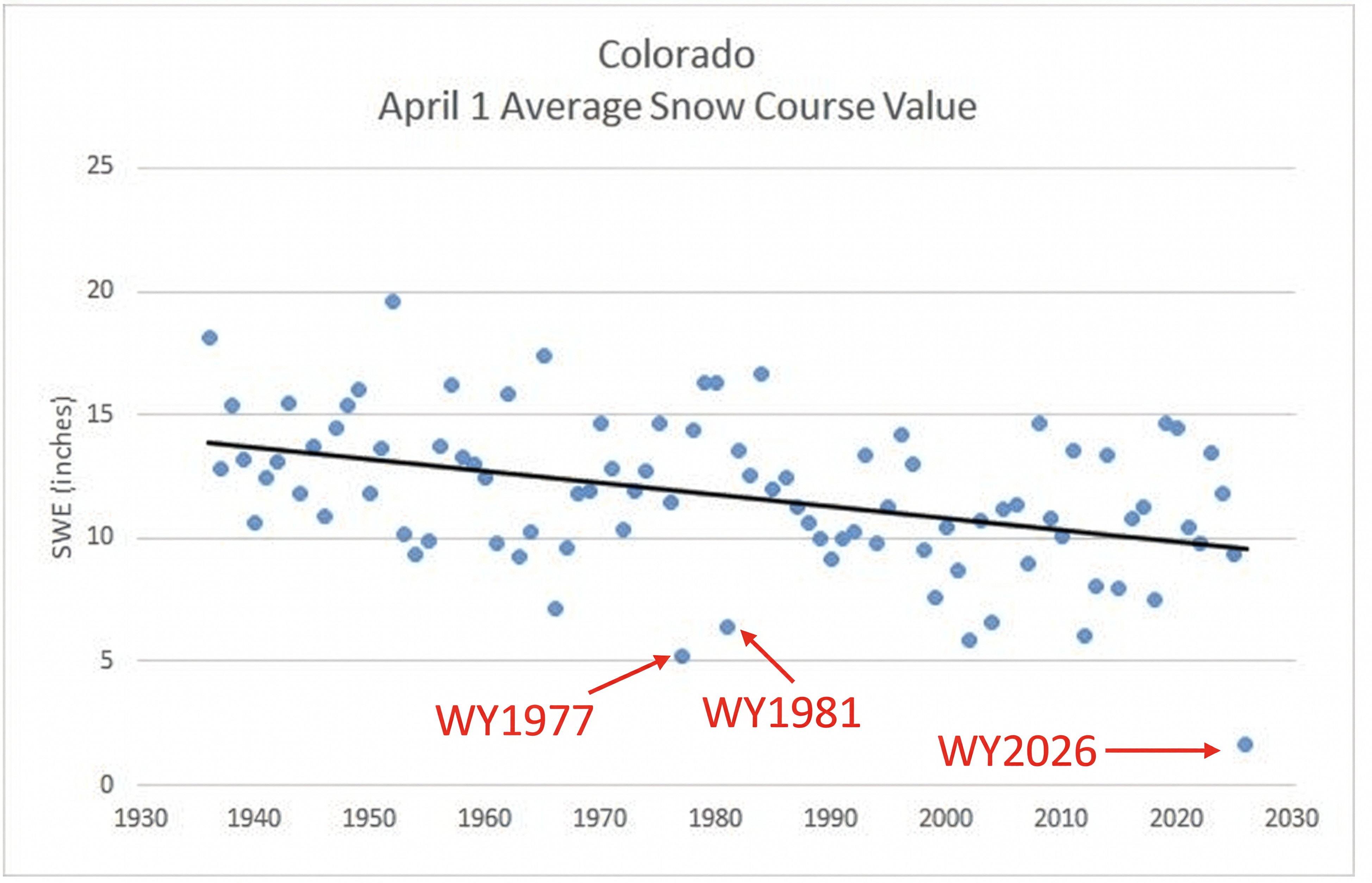
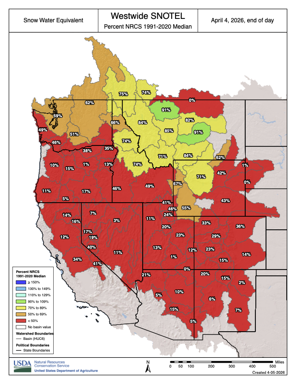
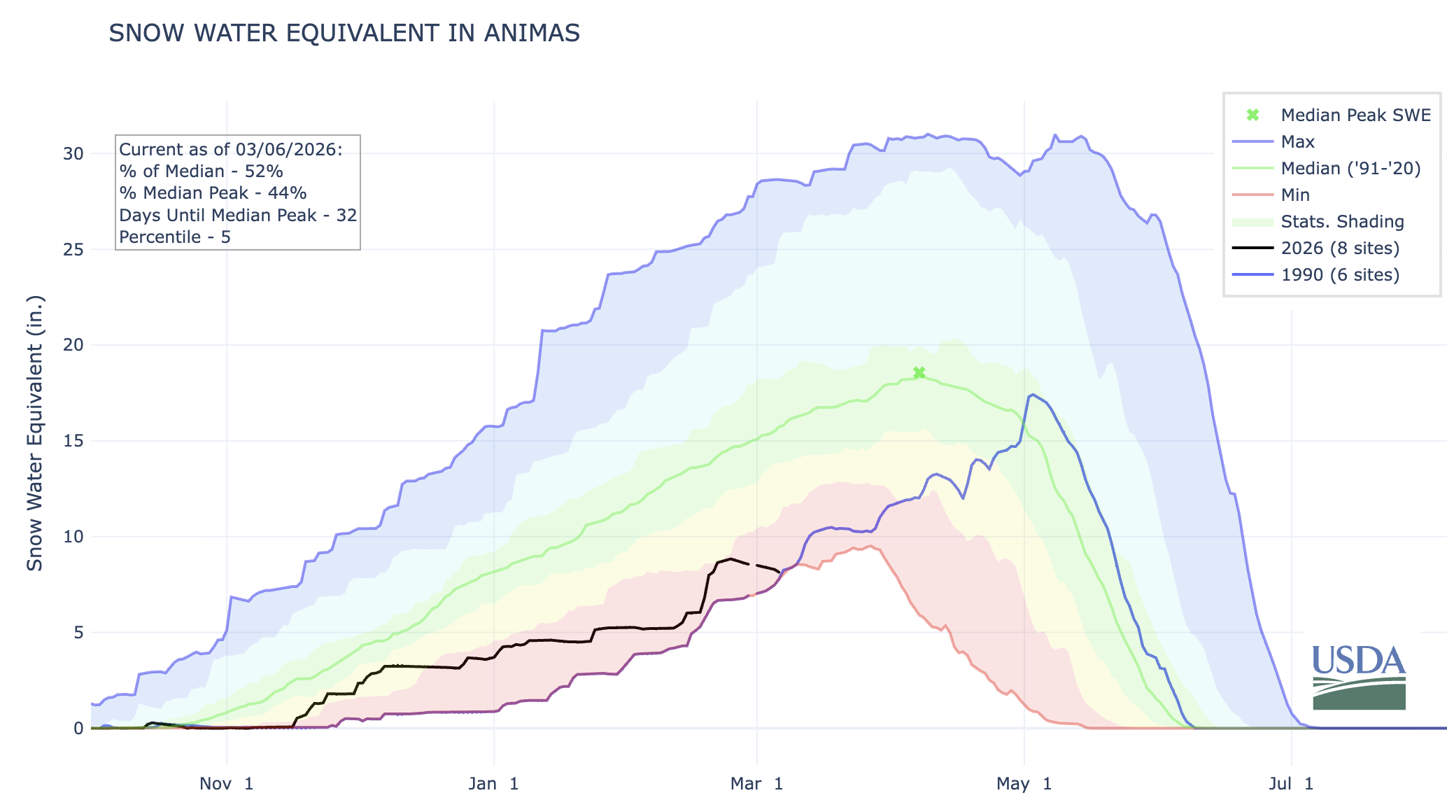
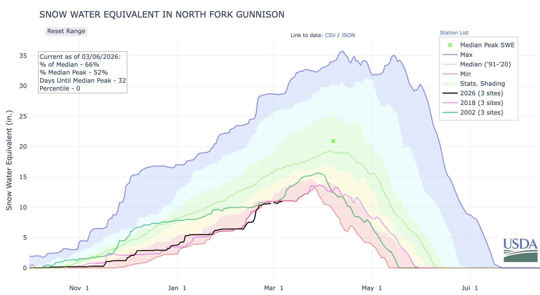
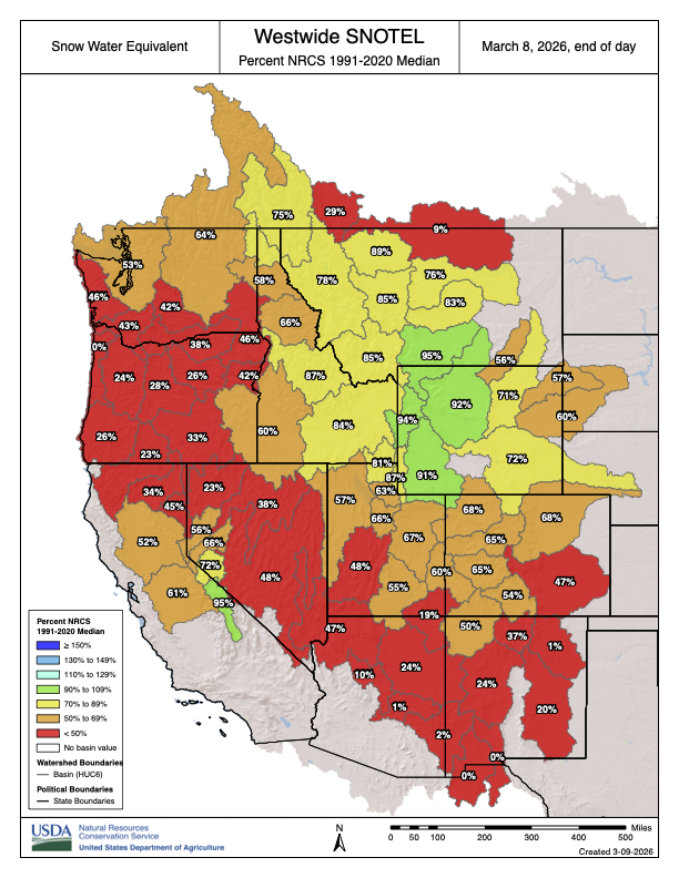
The result is clear: Even though precipitation accumulation wasn’t terribly far below normal, the snowpack was. The April 1 snowpack across Colorado was at a record low level, according to this year’s snow course, which is done by manual measurement and so goes back much farther than SNOTEL measurements.
The April 1 snowpack this year was lower than in 1977, 1981, and 2002, the worst winters of the last nine decades, at least. Source: Center for Snow and Avalanche Studies and NRCS.
Early April storms have helped keep the snow around a bit longer in the mountains, but has done little to bolster the snowpack. It’s still at historically low levels.
A team including scientists, Indigenous people and conservationists point to the ecosystem connecting Yellowstone and the Yukon as an example of a region where humans and nature are flourishing together.
Governments cannot reach their climate goals without rethinking humanity’s relationship to the Earth.
That is the overarching takeaway from a new paper published [April 9, 2026] in Frontiers in Science by a global team of scientists, conservationists and Indigenous people. The authors examined a set of climate targets from around the world, including the Paris Agreement, through the lens of a “Nature Positive” approach to climate change, in which biodiversity loss is halted and reversed by 2030 compared to a 2020 baseline.
They found that climate progress cannot happen without widespread attempts to increase biodiversity, protect intact ecosystems and reverse ecological damage from centuries of consumption.
For too long, humanity—particularly in the Global North—has viewed the environment as either a resource to mine, or a hindrance to economic growth, said Harvey Locke, the paper’s lead author and a co-founder of the Yellowstone to Yukon Conservation Initiative.
“Nature is essential to the functioning of the Earth system, which is in turn essential to people, and people are essential to the economy,” he said. “That is the hierarchy, nothing else.”
The paper characterized the present global economic order as occurring in the “sweet spot” between competing environmental, societal and economic interests, but says that trichotomy has occurred at the expense of other species and the planet. To maintain a habitable planet, humanity must nest its economy within the limits of Earth’s environment, the authors said.
One of the most severe examples of the current imbalance is climate change, Locke said.
“We’ve wildly exceeded the planetary boundary for putting CO2 into the atmosphere and we’re wildly destabilizing the Earth system through the destruction of nature,” he said. “Everyone in humanity loses—everyone—if we continue to destabilize the Earth system. And everyone wins if we work toward stabilizing it.”
As an example of how economies can grow while ecosystems are preserved and biodiversity is restored, Locke pointed to the Rockies in North America, particularly the region spanning Yellowstone to Yukon.
According to the National Park Service, the greater Yellowstone ecosystem is “one of the largest nearly intact temperate-zone ecosystems on Earth.”
“We have a wider distribution of bears and wolves and bison today than we did thirty years ago. We have more protected areas now than we did thirty years ago. And meanwhile the human population has flourished in that landscape,” Locke said, “in big measure because people value nature.”
The greater Yellowstone area’s growth has not been without its pains. As more people settle in the mountains, urban and suburban enclaves sprawl into forests, increasing fire risks. Grizzly bears and wolves, while magnates for tourists and their dollars, have also become political lightning rods, with some arguing that their rising populations are exceeding the capacity that the growing human settlements in the area will accept.
“If we don’t grow wisely, we will kill the goose that’s laying the golden egg,” Locke acknowledged.
The idea that humans are just one cog in nature’s fabulously complex and interconnected machine is an Indigenous premise, said Leroy Little Bear, one of the paper’s authors and a member of the Kainaiwa tribe that resides near the border of Canada and Montana.
If Indigenous groups across the world had more stewardship over ecosystems, species and land management decisions, it would go a long way toward restoring biodiversity and creating societies and economies that are better tailored to Earth’s environment, Little Bear said.
“We come from and operate on the basis of relationships,” he continued. “When you’re related to everything else in the environment, everything out there—the water, the rocks, the trees, the birds—are all animate. So if they’re animate then they all have the same kind of spirits as you have. How would I treat my relatives?”
But European settlers and their descendents have taken a different approach, he said. “In Western thought, we separate ourselves from nature and to a very large extent, we take the Biblical view that everything is made for the benefit of humans.”
To make their point, the authors collected an “enormous number of references to previous work,” said Cara Nelson, a professor of restoration ecology at the University of Montana who was not involved with the paper. By Daniel Case – Own work, CC BY-SA 3.0, https://commons.wikimedia.org/w/index.php?curid=63321074
“I felt they did a really great job of identifying this inherent property of life on Earth: interconnection and interdependency,” she said.
To help change human economies’ relationship to natural systems, Locke said the Yellowstone to Yukon Conservation Initiative is exploring creating natural asset companies, where the value of the organization is tied to the preservation of nature, not its destruction, so private capital can spur conservation.
“You basically think about nature like gold. It’s gonna go up in value because it’s perceived to have value,” Locke said. “And we’re not making any more of it.”
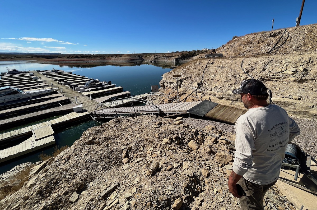
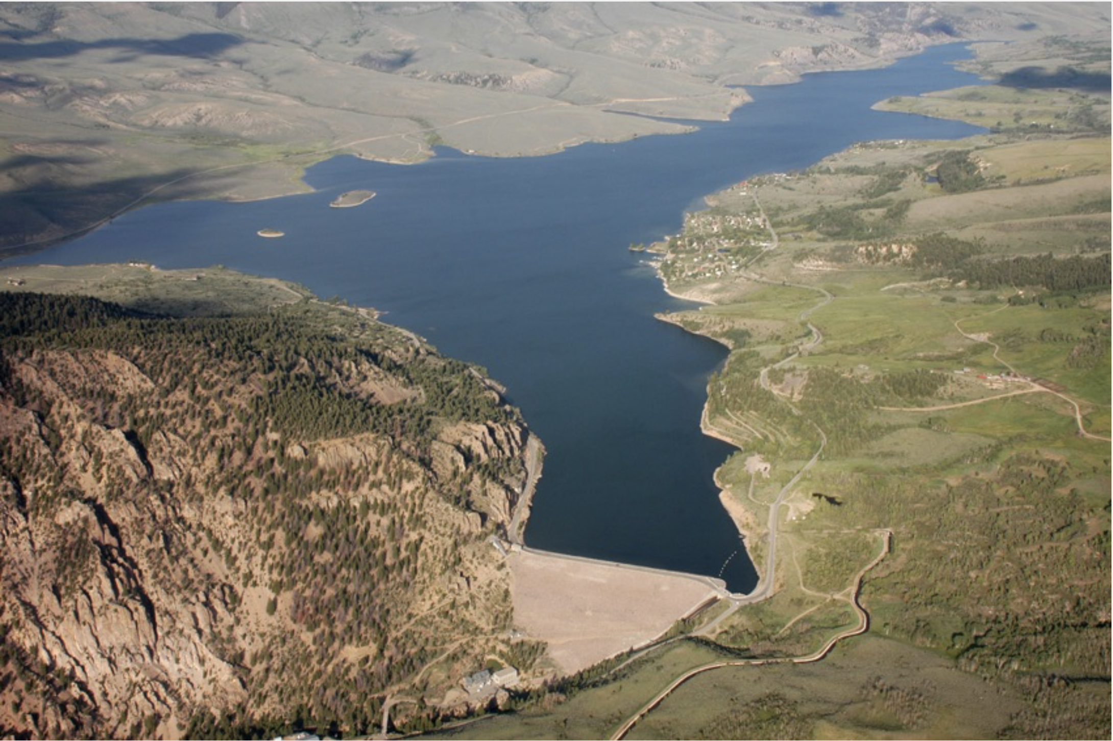
A tourist visits the lower reaches of Flaming Gorge Reservoir in Utah in September 2021. (Dustin Bleizeffer/WyoFile)
Click the link to read the article on the Wyofile website (Dustin Bleizeffer):
April 10, 2026
The outlook for the Colorado River, and Lake Powell in particular, continues to worsen due to an historically warm winter and dismal snowpack.
Projections show that Lake Powell on the Utah-Arizona border could drop low enough this year that it stops producing hydroelectric power at the Glen Canyon Dam. If it drops even lower, the dam is in danger of structural failure.
Wyoming relies on some of that hydroelectric power, according to state officials. The state will also play a major, legally obligated role in trying to help prevent such a catastrophe. Primarily, the Bureau of Reclamation will release extra water from Flaming Gorge Reservoir — potentially 1 million acre feet, which is more than a quarter of its storage capacity of about 3.8 million acre-feet.
In addition to recreation and economic impacts at Flaming Gorge on the Wyoming-Utah border — boat ramps may be rendered inoperable — Wyoming officials worry about potential mandatory water use reductions in the southwest corner of the state, as well as potential legal entanglements over a seven-state negotiation that has so far failed to resolve how stakeholders will share the pain of a declining Colorado River.
Buckboard Marina owner Tony Valdez, seen here Sept. 26, 2022, says he’s made continual adjustments to boat docks to keep up with lowering water levels at Flaming Gorge Reservoir. (Dustin Bleizeffer/WyoFile)
Adding to frustrations and fears, the water crisis is so severe and crashing so rapidly that stakeholders can’t even track — with confidence — its extent.
“Even though these projections are painting an incredibly dire picture for us, we need to be mindful that runoff might even be worse than what’s being projected,” Wyoming Senior Assistant Attorney General Chris Brown said Friday, adding that dry soil throughout the region is a wildcard in water calculations. “It’s bad. It’s incredibly bad what we’re seeing in the Upper [Colorado River] Basin right now.”
Brown joined Wyoming State Engineer Brandon Gebhart Friday at a Wyoming Colorado River Advisory Committee meeting to provide an update on the crisis (click here to see a slidedeck presented at the meeting).
“The information we’re getting is evolving just about as quickly as the hydrology is declining, so we’re trying to react to what we’re seeing in almost real time,” Brown said. “We don’t know what’s actually going to happen.”
This graphic depicts the “probable” water year for the Colorado River Basin in 2026. (Bureau of Reclamation)
An extra release from Flaming Gorge, which will begin on or before May 1, is a certainty, according to Wyoming water officials. That’s because the reservoir was specifically built to serve as a sort of water bank to ensure legally obliged deliveries to downstream states Nevada, Arizona and California. Among four storage reservoirs in the upper basin, Flaming Gorge has the most — and the most legally unrestricted – water to send downstream to Lake Powell.
“It’s the low-hanging fruit,” Brown said. “It’s the biggest, by far, and it’s got the most available water.”
But this year, even considering decreased releases from Lake Powell to help maintain Glen Canyon dam’s functionality, “anything we do as far as upstream [extra water] releases is not going to be enough,” Brown said.
Flaming Gorge Reservoir on the Utah side near the dam in September 2021. (Dustin Bleizeffer/WyoFile)
Banks of Lake Powell, Arizona in March 2026 | Page Buono
Click the link to read the article on the American Rivers website (Page Buono and Sinjin Eberle):
March 18, 2026
The situation is clear: the precipitation outlook in the Colorado River Basin is dire, the river cannot sustain the demands placed on it, and this year we’re likely to face unprecedented management decisions with potentially catastrophic consequences.
Despite decades of warnings and years of negotiations, there remains no clear blueprint for how the West can live with less water. That future is no longer hypothetical—it is already here.
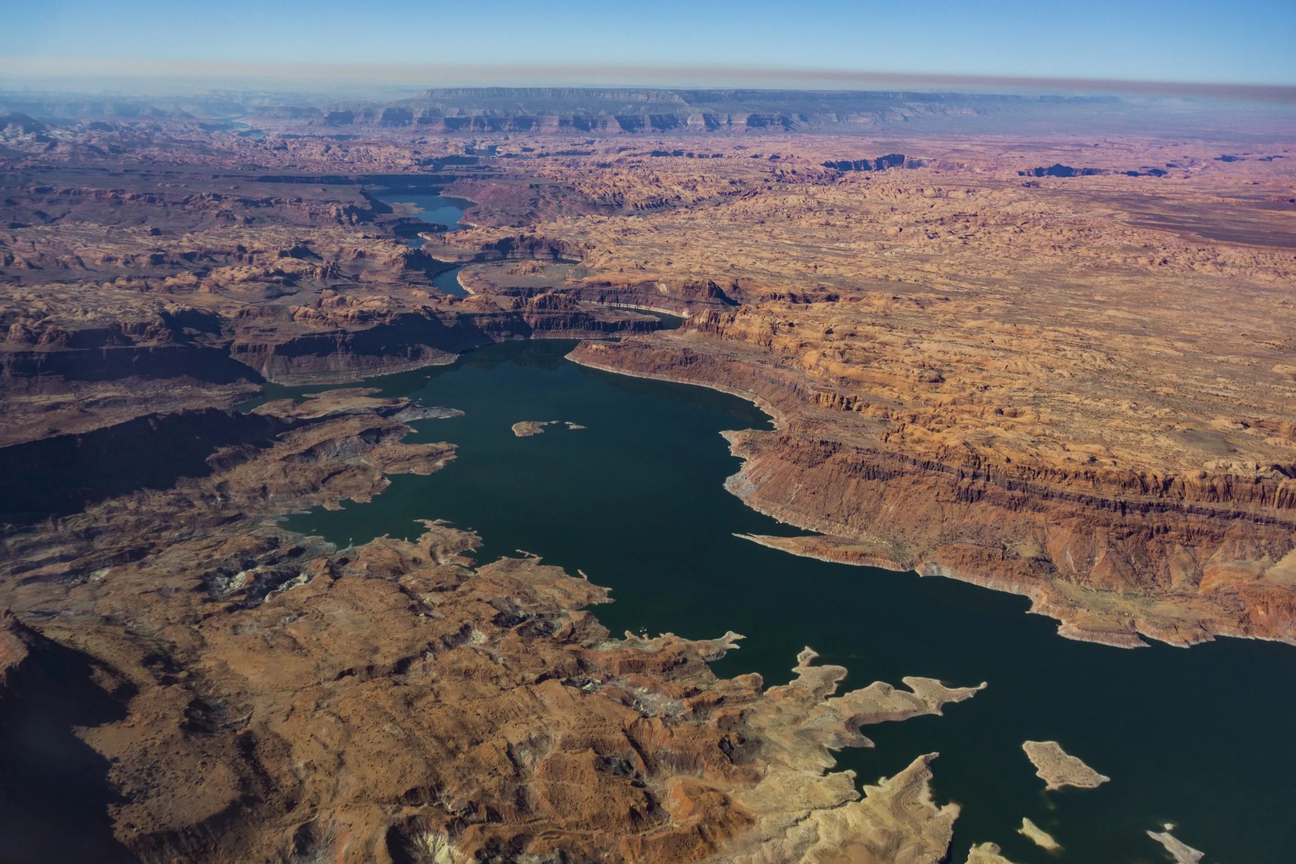
Lake Powell’s drastically low water levels are evident in the discoloration of ancient cliffs that were submerged for decades, often referred to as “the bathtub ring” in March 2026 | Page Buono
We often talk about the Colorado River and drought in ways that can feel removed, impersonal, abstract, and buried in jargon. But beneath the stories, there are real lives, livelihoods, ecosystems, and traditions that make the region what it is, and that are very much at stake.
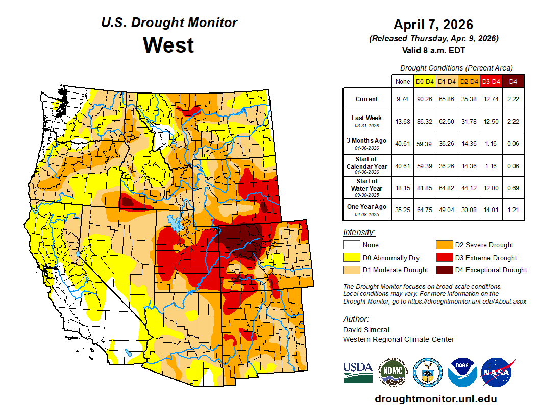
West Drought Monitor map April 7, 2026.
On March 3, for example, the US Drought Monitor released their latest report, revealing that “snow water equivalent” is less than 70% of normal across the Central Rockies, and less than 50% in the Four Corners.
But it isn’t just one fire in one year – throughout the Southwest and in California, regions are experiencing some of the largest, most catastrophic wildfires in history, and they’re occurring much more frequently.
Map of the Colorado River drainage basin, created using USGS data. By Shannon1 Creative Commons Attribution-Share Alike 4.0
Today, Governors Jared Polis (D-Colo.), Mark Gordon (R-Wyo.), Michelle Lujan Grisham (D-N.M.) and Spencer Cox (R-Utah) released a statement on the proposed draw down of Flaming Gorge and other upper basin reservoirs:
“This is an unprecedented year on the Colorado River, and likely will be one of the worst on record. A dry year like this reminds us of why it is critical that all who rely on this resource learn to live within its means and adapt our uses accordingly.
The Upper Division States of Colorado, New Mexico, Utah, and Wyoming, are actively and strictly regulating water uses. Because of such diminished runoff, existing state laws in the Upper Division States require water users to face cuts to water rights dating back to the 1800s – these cuts are mandatory, uncompensated, and will have significant impacts on water users, including Upper Basin Tribes, and local economies.
It is critical that any releases made by the federal government from Flaming Gorge and other upstream reservoirs are in compliance with existing agreements, particularly the 2019 Drought Response Operations Agreement between the Bureau of Reclamation and the Upper Division States and governing law and done for the purpose of protecting Lake Powell. We must have a clear understanding of how these proposed releases will effectively protect elevations at Lake Powell. Once the releases conclude, we expect that all water released from Flaming Gorge and other upstream reservoirs will be fully recovered.
Further, any releases must be appropriately sized. Years like this one remind us that appropriate water storage helps us survive the dry years, and that we must be prepared not only for this year but future dry years, as well as average years.
As we continue to comply with commitments to our water users and the Law of River, we recognize the impacts of water shortages and water releases from Upper Basin reservoirs on local communities – not only related to future water supply availability, but also how they affect jobs and local recreational and other economies. We recognize the need to live within the available supply and expect other communities to do so as well.”
The Colorado River flows near Hite, Utah on July 4, 2022. The river’s water supply is shrinking, and states are caught in a standoff about how to cut back on demand. Alex Hager/KUNC
Click the link to read the article on the KUNC website (Scott Franz):
April 8, 2026
This story is part of ongoing coverage of the Colorado River, produced by KUNC in Colorado and supported by the Walton Family Foundation. KUNC is solely responsible for its editorial coverage.
Last month’s record breaking heat across the Mountain West led to the worst snowpack on record in Colorado and Utah, along with a significantly downgraded forecast for the upcoming supply of Colorado River water.
Cody Moser with the federal Colorado Basin River Forecast Center said in a monthly briefing Tuesday [April 7, 2026] that just 1.4 million acre feet of Colorado River water is expected to reach Lake Powell through July. That’s less than a quarter of what’s considered normal.
It’s also much lower than the 2.3 million acre feet Moser’s office projected a month ago, before the heat wave in the West melted away an already meager supply of snowpack.
“With record low snow pack, we have well below normal water supply forecasts,“ he said. “In many cases, our April through July (water) volume forecasts rank in the lowest five on record when compared to historical observations.”
The forecast for how much water will reach Flaming Gorge Reservoir also dropped more than 20% since the last monthly projection. Flows for the Yampa River are also projected to be near the record low.
Moser added it’s likely some rivers and streams in western Colorado have already reached their peak runoff for the year.
He said the water supply forecasts could improve if wet conditions arrive, or decline even further if the West remains dry.
The worsening river forecasts arrive as the seven states that use the waterway remain at an impasse this spring over how to share and conserve the water in the future.
If states can’t reach a deal, the Interior Department is expected to identify its preferred option for how to manage Lake Powell and Lake Mead after the current operating guidelines expire this fall.
Interior Secretary Doug Burgum told Arizona radio station KTAR News this week that the worsening spring runoff conditions are going to “require everybody to dig in and take bigger cuts than they want, and we haven’t reached that spot yet.”
Map of the Colorado River drainage basin, created using USGS data. By Shannon1 Creative Commons Attribution-Share Alike 4.0
U.S. Interior Secretary Doug Burgum, center, speaks during a gathering with governors from six states in the Colorado River basin on Friday, Jan. 30, 2026. Photo credit: Lowell Whitman/Department Of Interior
Click the link to read the article on the Tuscon.com website (Tony Davis). Here’s an excerpt:
April 8, 2026
U.S. Interior Secretary Doug Burgum, pressed Monday to spell out how he’ll handle the Colorado River’s water crisis, wouldn’t get specific but said repeatedly that “nobody will be happy” with how his department will split a rapidly dwindling supply of river water among the seven states, including Arizona, that want a piece of it. Speaking at a roundtable in the Tucson area populated by a host of public lands industry leaders and University of Arizona President Suresh Garimella, Burgum pledged to hand down a decision this month on the first of two crucial, divisive issues his office is confronting regarding the river. That decision will be how much water the Interior Department’s Bureau of Reclamation will release from its upstream reservoirs in the four Upper Colorado River Basin states to head off a potential calamity in which Glen Canyon Dam, forming the boundary between the Upper and Lower Basins, would no longer receive enough water to continue generating electricity that serves customers in seven Western states.
The white bathtub ring clinging to the sandstone walls of Glen Canyon is more than a marker of a receding lake; it is a physical manifestation of a century-old accounting error. PHOTO BY BOB HEMBREE (MARCH 2019)
The white bathtub ring clinging to the sandstone walls of Glen Canyon is more than a marker of a receding lake; it is a physical manifestation of a century-old accounting error. For decades, the conventional story of the Colorado River’s decline has been framed as a tragic stroke of bad luck. The narrative, popularized in modern classics like Cadillac Desert, suggests that the framers of the 1922 Colorado River Compact simply did their best with a limited record of “eighteen years of streamflow measurement” taken during an unusually wet “binge.”
However, emerging historical research and systems analysis tell a more complicated and troubling story. In their definitive study, Science Be Dammed, authors Eric Kuhn and John Fleck argue that the crisis we face in 2026 was not an accident of nature but a predictable consequence of “selective science.” The decision-makers of 1922 were not victims of ignorance; they were sophisticated professionals who chose to ignore inconvenient data in favor of a political vision that required the river to be larger than it actually was.
Eugene Clyde LaRue measuring the flow in Nankoweap Creek, 1923. Photo credit: USGS
The Inconvenient Hydrologist
As the seven basin states gathered at Bishop’s Lodge in Santa Fe to carve up the river, they were joined by Eugene Clyde (E.C.) LaRue, a hydrologist for the U.S. Geological Survey. [Eric Kuhn responding to my X post, “Actually LaRue was never allowed to attend a Commission meeting. He asked, but Hoover said no.] LaRue presented the commissioners with a conclusion that threatened the very foundation of their negotiations. His data, which included early gauge records and historical flood markers, suggested that the river’s long-term average was approximately 15 million acre-feet (maf)
LaRue explicitly warned the commission that the period between 1905 and 1922 was a hydrological anomaly. Had the negotiators included the drier records from the late 1890s, the estimated annual flow would have dropped significantly. As Kuhn and Fleck note, the decision-makers had at their disposal a relatively thorough, almost modern picture of the river’s hydrology. They chose to ignore it because accepting LaRue’s science might have left them with a flow too low to reach the compromises necessary to develop the West.
Members of the Colorado River Commission, in Santa Fe in 1922, after signing the Colorado River Compact. From left, W. S. Norviel (Arizona), Delph E. Carpenter (Colorado), Herbert Hoover (Secretary of Commerce and Chairman of Commission), R. E. Caldwell (Utah), Clarence C. Stetson (Executive Secretary of Commission), Stephen B. Davis, Jr. (New Mexico), Frank C. Emerson (Wyoming), W. F. McClure (California), and James G. Scrugham (Nevada) CREDIT: COLORADO STATE UNIVERSITY WATER RESOURCES ARCHIVE via Aspen Journalism
Paper Water and the System Trap
By sidelining LaRue and enshrining a “paper water” figure of 16.4 million acre-feet into the Law of the River, the commissioners fell into a classic “system trap.” They created a legal stock of water rights that far exceeded the river’s physical flow. This inflated number was essential to the “reinforcing loop” of 20th-century growth. It provided the legal certainty needed to secure federal funding for massive infrastructure projects like the Hoover Dam and the Glen Canyon Dam.
This intentional overestimation created a massive “information delay.” For eighty years, the system appeared stable only because the Upper Basin states were slow to develop their shares, allowing their “unused” water to flow downstream. This masked the fundamental deficit, leading to a state of “overshoot” in which the regional economy came to depend on water that did not exist. Professor Rhett Larson describes the resulting legal framework as a system of “calling shotgun” that was excellent for settling a desert but is catastrophic for managing one in a time of scarcity.
The End of the Delay
Today, the “delay” has finally ended, and the “inconvenient science” of 1922 has become the undeniable reality of 2026. The river’s source is being further depleted by “aridification,” a process climate scientist Brad Udall describes as a “sponge above our head” that evaporates moisture before it can reach the streamflow. We are now witnessing the collision of a 100-year-old legal fiction with a 21st-century climate reality.
The current impasse between the Upper and Lower Basins is a symptom of “policy resistance,” where every actor is incentivized to protect their “paper” share even as the “wet” water disappears. As Professor Andrea Gerlak observes, if a system has 25 years to produce an agreement and fails, there is likely something fundamentally wrong with the system itself. Solving the crisis at Lake Powell will require more than engineering; it will require a paradigm shift that finally aligns our laws with the river’s actual physical limits.
The All American Canal, the largest diversion on the Colorado River, passes through Winterhaven, CA on its way to the Imperial Valley. The Colorado River is seen flowing next to it.
April 2, 2026
In the southeast corner of California, 300-foot-tall sand dunes rise from a sunbaked landscape dotted with ocotillo and creosote bushes. Summer temperatures here regularly exceed 110 degrees, and annual rainfall is comparable to that of the Sahara Desert. Despite its unforgiving terrain, more than 180,000 residents live in Imperial County, one of the country’s most productive agricultural regions and more recently a magnet for data center development and lithium extraction proposals. This has all been made possible by turn-of-the-20th century canals that carve up the region, supplying it with more than a million gallons of Colorado River water every minute.
“We’ve often called it the lifeblood of Imperial Valley,” said Robert Schettler, a spokesperson for Imperial Irrigation District, the area’s public utility, which manages the region’s over 3,000 miles of drains and canals. “If something were to happen to that river, we would all have to pack up and leave.”
Something is happening to the Colorado River. Over the past century, its average water supply has fallen by nearly a third due to prolonged drought and climate change. Experts predict that decline will continue, threatening cities, tribes and farms that depend on the river’s flow, from Wyoming, Utah, Colorado and New Mexico to Arizona, Nevada and Northern Mexico. Most of the Colorado River’s water starts as snowpack in the Rocky Mountains, but after the American West experienced the warmest winter ever recorded, snow levels are now at historic lows, prompting experts to warn that 2026 may be one of the river’s driest years yet.
That could spell disaster for Imperial County, whose harsh desert landscape of windblown sand and rugged burnt-orange mountains was transformed more than a century ago into productive, gridded farmland dotted with small cities such as Brawley, El Centro and Calexico…Imperial Valley’s agricultural industry consumes by far the largest share of water in the region, about 97% of the 3.1 million acre-feet managed by the Imperial Irrigation District every year…Those ambitious and largely successful conservation efforts have come at a cost. Much of the water used by farmers historically flowed into the nearby Salton Sea, but as farmers have reduced their water use, less runoff has reached the man-made lake, accelerating an existing environmental crisis Over the last three decades, the Salton Sea has shrunk by more than 60 square miles, exposing a dry lakebed laden with pesticides, particulate matter and heavy metals. Those contaminants are carried as dust through the air into nearby communities, contributing to a childhood asthma rate triple that of the national average. Now, farmers such as Brian Strahm, whose family has been growing crops in the area for four generations, are concerned they may have to decrease their water use further. That may prove difficult since farmers have already put in place many efficiency measures, Strahm said…Farmers say cuts could seriously harm the area’s already struggling economy. In addition to being the county with the highest percentage of Latinos in California, Imperial has among the highest unemployment rates of any county in the country, at nearly 19%. For those who do find work, the agricultural industry offers a lifeline, accounting for one out of every six jobs in the region.
Map of the Colorado River drainage basin, created using USGS data. By Shannon1 Creative Commons Attribution-Share Alike 4.0
Click the link to read the article on the Big Pivots website (Allen Best):
April 2, 2026
Utility depicts proposed large-load tariff as a way of teaming with developers to bring on innovation
Xcel Energy today filed a proposal with the Colorado Public Utilities Commission to create a large-load tariff applicable to developers of data centers that expect to need 50 megawatts of electricity or more.
Xcel’s Jack Ihle, the company’s vice president for data centers and large loads, said the company believes it can meet its legal obligation to both reduce emissions 80% by 2030 and meet the needs of data center developers.
In the last 18 months, Xcel has expressed growing worries about whether it would have the electricity it needs to meet rising demands. This worry was expressed even before its newest and large coal-burning unit, Comanche 3, went down last August. That unit is now expected to return to service in August. Xcel in March suggested it may want to delay retirement of its two coal-burning units at Hayden until 2030. They are currently scheduled to be retired in 2027 and 2028.
Ihle said the company’s resource adequacy concerns pertain mostly to the near term. Longer term, when the tariff for large-load customers would have effect, the company believes it’s in good shape owing to actions already underway. For example, the PUC authorized a rushed near-term solicitation in September 2025 that allowed the company to take advantage of tax credits for clean energy that will expire because of the One Big Beautiful Bill Act passed by Congress last July.
Data center developers could be part of the solution, said Ihle. Xcel sees the data centers as potential partners in developing next-generation energy and storage technologies.
“We may able to partner with large-load customer hyperscalers, who have the risk appetite, and to explore some of the (possibilities) we have not been able to” as a company.
Most prominent of these next-generation technologies is enhanced geothermal. Gov. Jared Polis in 2024 said he believed that by 2040 Colorado may get 4 to 8% of its electricity from geothermal. Unlike geothermal for buildings, which rely upon heat found in the ground relatively close to the surface, enhanced geothermal involves heat thousands of feet underground.
One company has been exploring whether deep oil wells near Pierce, north of Greeley, could be adapted. Another company has plans near Durango.
More definitive is work underway by Fervo Energy in central-Utah. There, near Milford, it is developing a 400- to 500-megawatt enhanced geothermal system. Two weeks ago, Fervo announced $421 million in financing for the project.
Does Colorado have the same quality geothermal resources lying underfoot? Probably not. The larger question may be whether the technology can develop rapidly enough to be of value in Colorado in the next 15 years.
Ihle also cited the 100-hour storage pilot project using iron-air technology planned at Pueblo. It is, he said, the sort of innovative technology that could be pursued with data centers as partners.
In some places, data centers have started creating their own electrical generation. The concept is called behind the meter, and it’s not necessarily new. Hospitals famously have backup resources.
Ihle said developers of hyperscale data centers — often defined as being 50 megawatts or more — have told him that they would much rather deal with a utility than develop their own resources. In Colorado, for example, building a natural gas plant to provide power for a data center will still require getting permits from the state’s Air Pollution Control Division.
In Minnesota, home base for Xcel, the utility has an agreement with Google that illustrates what it hopes will happen in Colorado.
There, Google plans a data center that will support services that include Workspace, Search, YouTube and Maps. Xcel promises to deliver 1,400 megawatts of wind, 200 megawatts of solar and 300 megawatts of long-duration (100-hour) energy storage. In addition, Google’s agreement with Xcel will yield a $50 million investment toward an Xcel program that is intended to drive reliability on the grid.
Under the agreement, Google will also pay all costs for its new service in line with its typical practices and Minnesota’s regulatory and legislative requirement.
“That is the kind of thing we want in Colorado,” said Ihle.
Xcel stressed that this proposal would not hurt other customers financially. Large-load customers would pay for the power infrastructure needed to serve them. This includes covering electric transmission, substations and interconnection upgrades as well as paying for new electric generation.
The data center developer would need to make a long-term contractual commitment, typically 15 years or more. And what if the customer exits early? Termination charges will recover remaining costs of project-specific upgrades built, avoiding stranded costs for other customers.
In the filing this afternoon, Ihle said this: “Taken together, the Company’s proposal ensures that large load customers bear the costs they impose, protects existing customers from adverse impacts, and creates a structured pathway for responsible growth.
Xcel also stresses the economic potential for data centers in generating tax revenue for schools and other public needs. Xcel says data centers can, depending upon size and location, pay $2 million to $16 million in property taxes.
At a forum in Boulder on Wednesday morning, Lon Huber, senior vice president and chief planning officer for Xcel, described Xcel’s partnership with Google in Minnesota.
“Once you get to like 70 to 80% (emissions-free electricity), it’s really hard to squeeze the last remaining bit out,” said Huber. “So we need new tech. That’s where the partnership comes in.”
Will Toor, director of the Colorado Energy Office, spoke on the same panel.
“There’s a lot of potential benefits that to the extent that we can serve strategically located data centers in places where we don’t need, for instance, significant new transmission investments, where we can make use of curtailed renewables, where we can make use of infrastructure in energy transition communities,” he said.
This depends, he added, upon getting the rate structures right, so that data centers are paying for their incremental costs but are also helping to cover the fixed costs that we have on the system.
If that can be done, he said, it can be good for all ratepayers.
Coloradans often hear that the Colorado River crisis is happening somewhere else. Headlines focus on Lake Mead, Lake Powell, and the Lower Basin, while Colorado is portrayed as a responsible headwaters state doing its part. Yet that narrative misses a deeper truth. The Colorado River crisis is not only about drought or downstream shortages. It is also about how the river is managed. In that sense, Colorado shares responsibility with every basin state.
Colorado’s water system is built on ‘prior appropriation’. The rule is simple: “first in time, first in right.” The earliest water users receive priority when supplies run low. This framework helped farmers, cities, and industries expand across the West during the nineteenth and twentieth centuries, creating stability in a region where water determines survival.
However, the system was designed for a different climate and a by-gone West. It also encouraged states and water users to claim more water than the river could supply, contributing to the overallocation of the Colorado River. Legal analyses of the Law of the River show that the basin was effectively overburdened by water claims decades before climate change began reducing flows.
Today, climate change is altering the river itself. Scientists estimate that warming temperatures have already reduced Colorado River flows by roughly 20 percent. Federal water managers warn that declines could continue as temperatures rise. In a river system that is already legally overcommitted, treating water rights as fixed privileges can deepen instability rather than prevent it.
Colorado sits at the center of this challenge. As the largest contributor of water in the Upper Basin, the state must balance many competing demands. Front Range cities continue to grow. Western Slope agriculture depends on reliable irrigation. Rivers and aquatic ecosystems are under stress. Yet much of Colorado’s water policy still assumes shortages are temporary and that legal priority alone will determine who receives water. That mindset often encourages defensive politics rather than shared problem-solving.
Conflicts between upstream and downstream states are often described as unavoidable. In reality, much of the tension stems from the priorities of management. Upper Basin states emphasize uncertainty about future river flows, while Lower Basin states focus on delivery obligations and infrastructure investments, according to recent reports on Colorado River governance. Each group is acting logically within the current system. The problem is that the system frequently rewards delay and legal conflict rather than cooperation, as researchers studying collaborative governance in the basin have found.
Colorado has an opportunity to change that pattern. One promising approach is collaborative adaptive management. This framework begins with a simple idea: uncertainty is normal in complex systems. Instead of assuming managers already know the right solution, adaptive management relies on monitoring conditions, learning from outcomes, and adjusting policies over time. With collaboration of states, tribes, farmers, cities, and environmental groups conflict can be reduced and management decisions can improve.
Some elements of this approach already exist in Colorado, including experimental reservoir operations and voluntary conservation programs. However, research on collaborative drought science planning in the Colorado River Basin shows that these efforts remain limited and politically fragile.
Equity must also be part of Colorado’s leadership. For decades, Tribal nations and many rural communities have carried the environmental costs of water development while urban growth captured much of the benefit, a pattern highlighted in research on environmental justice and Indigenous governance. Tribal nations, many of which hold some of the most senior water rights in the basin, remain underrepresented in major water decisions. Adaptive governance recognizes that whose knowledge it is that counts, matters. Incorporating Indigenous knowledge, local experience, and community-based monitoring can strengthen decisions and build trust in governance. Research shows that when affected communities help shape policies, those policies are more likely to be trusted, followed, and sustained over time.
Importantly, collaborative management does not mean abandoning Colorado water law or taking away private rights. Instead, it means updating water governance so users can share risk and adapt together as conditions change. The alternative – waiting for wetter years or relying on courts to resolve disputes – ignores both climate science and political reality. Climate projections from the Intergovernmental Panel on Climate Change indicate that the American Southwest will likely remain hotter and drier for decades. Planning for a return to twentieth-century river flows is increasingly unrealistic.
Critics argue that collaboration takes too long when the crisis is already severe. Colorado has already tried temporary agreements, emergency negotiations, and federal pressure. Those approaches have not produced lasting solutions. Short-term deals may stabilize reservoirs for a season, but they do little to address the deeper management problems driving the crisis. Without stronger cooperation, the basin risks repeating the same cycle of shortage and conflict.
Colorado has long prided itself on practical problem-solving and environmental leadership. The state now has an opportunity to apply those values to its most important river. Policymakers should strengthen collaborative water governance, ensure meaningful Tribal participation, and support conservation policies that reward flexibility rather than litigation.
Coloradans also have a role to play. Public participation in basin planning, engagement with watershed organizations, and pressure on elected officials can help shift water policy toward long-term climate adaptation rather than short-term crisis response.
The Colorado River begins in our mountains. Leadership today means recognizing that rules built for a wetter past may no longer work in a hotter future – and choosing cooperation before the river forces the decision for us.
Anderson, Patrick J., Jeanne E. Godaire, Daniel K. Jones, William J. Andrews, Alicia A. Torregrosa, Meghan T. Bell, JoAnn M. Holloway, et al. 2025. “Collaborative Drought Science Planning in the Colorado River Basin.” U.S. Geological Survey Open-File Report 2025-1041. https://doi.org/10.3133/ofr20251041.
Birnbaum, Simon. 2016. “Environmental Co-governance, Legitimacy, and the Quest for Compliance: When and Why Is Stakeholder Participation Desirable?”. Journal of Environmental Policy & Planning, 18, no. 3, 306–323.https://doi.org/10.1080/1523908X.2015.1077440
Hite, Kristen, Pervaze A. Sheikh, and Charles V. Stern. 2025. “Management of the Colorado River: Water Allocations, Drought, and the Federal Role”. Congressional Research Service Report R45546.https://www.congress.gov/crs-product/R45546.
Holling, C. S. 1978. Adaptive Environmental Assessment and Management. New York: Wiley.
Kuhn, Eric. 2024. “The Risks and Potential Impacts of a Colorado River Compact Curtailment on Colorado River In-Basin and Transmountain Water Rights Within Colorado.” Colorado Environmental Law Journal, 35.https://scholar.law.colorado.edu/celj/vol35/iss2/4.
Sullivan, Abigail, Dave D. White, and Michael Hanemann. 2019. “Designing Collaborative Governance: Insights from the Drought Contingency Planning Process for the Lower Colorado River Basin.” Environmental Science & Policy, 91: 39-49. https://doi.org/10.1016/j.envsci.2018.10.011.
David is a Colorado Certified Water Professional and environmental scientist dedicated to protecting aquatic systems through rigorous data analysis, public service, and responsible resource management. He holds a bachelors degree in Biology from Western Colorado University and will graduate soon from the University of Denver with a Masters Degree in Environmental Policy and Management.
Click the link to read the article on Ken’s Substack (Ken Neubecker):
March 27, 2026
The February 14 deadline for the seven Colorado River Basin States to come up with an agreement on future management of the river is long gone, and still no agreement in sight. The deadline for submitting comments on the Bureau of Reclamations Draft Environmental Impact Statement (DEIS) is also past. Reclamation didn’t have a “preferred alternative”, which is not normal. They were hoping the States would have an agreement so that could become the preferred alternative. So they are left with their suite of six alternatives. All six are fraught with what Reclamation calls “decision making under deep uncertainty” (DMDU, they love acronyms).
That is an understatement.
No one seems to be very happy with any single proposed alternative. Some are calling for a new DEIS, or at least a Supplemental DEIS. This would only push any deadline further down the road. Reclamation is caught between a rock and a hard place.
The only real alternatives that they can implement without full approval by the States are No Action and the Basic Coordination Alternative. Both would be disastrous. They would simply be going back to how things were done prior to the 2007 Interim Guidelines and even earlier policies, none of which reflect the needs of the Colorado River we have today.
Westwide SNOTEL basin-filled map April 4, 2026.
Adding to that is the very dry record low snowpack in the Rockies. This annual winter snowpack is the ultimate water storage reservoir for the entire basin, from Pinedale, Wyoming, to Yuma, Arizona. It is what puts water into the two great reservoirs, Lakes Powell and Mead, that the Lower Basin desert states of California, Arizona and Nevada depend on. It is the only real reservoir that the needs of the arid Upper Basin states, Colorado, Utah, New Mexico and Wyoming depend on. This year that snowpack reservoir is as low as it has ever been, even eclipsing the former record year of 2002 when all this mega-drought started. The recent heat dome setting up over the Four Corners area is melting and sublimating what little snowpack there is fast.
Lakes Powell and Mead are already at very low levels, and the 1.7 maf projected inflow from spring runoff is looking smaller every day. Reclamation predicts that the water level in Lake Powell will drop to a point where no hydropower can be generated, power pool, by as soon as late July or at least in December. That, in effect, could be dead pool, with very limited releases from the lower “river outlet” tunnels. In effect, the flows from Lake Powell will become run of the river, what comes in is what goes out. No more storage for expected water deliveries downstream except what they might risk in lowering Lake Mead even more.
Needless to say this has sparked a war of words between the Upper and Lower Basins, with the Lower Basin being particularly vitriolic. As the February 14 deadline passed, JB Hamby of California declared “The 1922 Colorado River Compact requires the Upper Basin to deliver an average of 8.25 million acre-feet (maf) annually to the Lower Basin and Mexico. That delivery obligation is fixed in law, even if the river produces less water.” Arizona has gone even further, declaring in TV ads that the water delivery is not only an obligation, but a “guarantee” for delivery.
Huh??? Fixed in law and a guarantee? The reality of the river disagrees. The requirements of the Compact are, yes, written in law. On paper. It is “paper water”, not real, or “wet” water. Colorado’s commissioner Becky Mitchell was more to the point, if less vitriolic, “We are being asked to solve a problem we didn’t create, with water we do not have.” At least someone understands the reality of the situation.
John Wesley Powell, the hero of the Colorado River was invited as the honored guest and keynote speaker at the second International Irrigation Congress, held in Los Angeles in 1893. He was held in high regard by the many boosters, speculators and people hoping to cash in with irrigated farms all across the Colorado River basin. After listening to what they were saying, Powell pocketed his prepared remarks and said,
“When all the rivers are used, when all the creeks in the ravines, when all the brooks, when all the springs are used, when all the canyon waters are taken up, when all the artesian waters are taken up, when all the wells are sunk or dug that can be dug in all this arid region, there is still not sufficient water to irrigate all this arid region.”
The delegates didn’t want to hear that. As they booed him off the stage he added,
“I tell you gentlemen that you are piling up a heritage of conflict and litigation over water rights for there is not sufficient water to supply the land.”
Powell was right, but the boosters didn’t listen. Many still aren’t listening. Agricultural dreams have faded and new dreams of housing developments and data centers are taking their place. The boosters, in both Basins, are still booing reality off the stage. Dreams continue to grow as the river continues to shrink.
I read of fears that the Upper Basin will take advantage of Lower Basin cuts by taking more themselves. Really? From where? That vast winter snowpack reservoir that is expected to “guarantee” so much water for the Lower Basin, to refill Powell and Mead, is the same shrinking reservoir that the Upper Basin depends on. Upper Basin diversions are being curtailed every year, not expanded. There isn’t enough water. The Upper Colorado River Commission’s “Amended 2016 Upper Division States Depletion Demand Schedule”, published in June 2022, was used in BOR’s modeling of Upper Basin demands, but the optimistic projections of that report have never born fruit. The report is a projection of potential future depletions from the Upper Colorado River, but they are just that, projections. And relatively modest ones at that. The report begins with a resolution of the Commission that states,
WHEREAS Depletion Demand Schedules issued by the Commission are not a prediction of future water use or depletions. The Depletion Demand Schedules are estimates that presume the continuation of the observed historically available supply and other demand drivers used for planning purposes and are useful for modeling purposes.
It is simply and estimate based on “observed historically available supply”. Observation and history have made some changes to any anticipated future depletions. The report cites 5.7 maf as the current historical use as of 2022, with potential for increased depletions up to 5.8 maf in 2020 and 6.6 maf by 2070. In reality the annual depletion has dropped to 4 maf or less. With continued aridification and dwindling snowpack Upper Basin depletions will likely stagnate, if not decline. That is just the reality.
Under Colorado law, and constitution, the right to divert water to a beneficial use “shall never be denied”. What that means, as I stated in the previous post, is that anyone can dig a ditch or throw a small pump into any stream and divert water. New applications for water rights are filed every month with the Water Courts, and their decrees will likely be granted. That is again, all on paper. The reality is they probably won’t get much if any water. When the river is flowing high in the spring it is a “free river”, meaning anyone can stick in their straw for a drink. But as soon as the first senior call is placed all that stops, and senior calls are happening earlier and earlier every year. And the local Water Commissioners, the ones who can shut down diversions, are getting busier.
The 1922 Compact has a fairly senior right on all streams and rivers in the Upper Basin. So far, the non-depletion requirement for flows averaging 75 maf over a ten year running average hasn’t been breached. Lake Powell will probably hit power pool or worse before then.
The difference between the demands, hopes, and fantasies of paper water and the hard reality of actual wet water are growing starker every winter and have been since the three giant reservoirs, Powell, Mead and the winter snowpack, have shrunk over the past 25 years. Nature doesn’t care much about paper, reports, lawyers or the dreams of boosters past and present. She always wins in the end.
And as Becky Mitchell, said, litigation won’t create any new water.
A correction/addition to my previous post about misunderstandings on the Colorado River
I need to make a correction on my previous post. The three large Upper Basin’s reservoirs, Flaming Gorge, Blue Mesa and Navajo do provide some water for Upper Basin use, especially Navajo, which provides water to the San Juan-Chama diversion to the Rio Grande basin and Albuquerque. It supplies on average 91 kaf of diverted water. It is expected that there will be no diversion this year. Navajo also provides water for Tribal use to the Navaho and Jicarilla Apachie. Downstream flows from Flaming Gorge, the largest of the three can provide smaller amounts for hay fields in Browns Park and the melons in Green River, but that’s pretty small too. Blue Mesa releases can benefit the Gunnison Tunnel diversions and Redlands downstream, but both are well senior to the Compact.
I knew better.
The main storage of the three reservoirs is still primarily as that Compact compliance savings account, and they will be called upon soon to bolster the levels of Lake Powell, where the inflow from runoff projection is dropping below 2 maf. If things keep going like this for another few weeks it will likely be lower.
Map of the Colorado River drainage basin, created using USGS data. By Shannon1 Creative Commons Attribution-Share Alike 4.0
An Xcel truck outside the Shoshone hydropower plant in Glenwood Canyon. Denver Water has enacted with water rights owner Xcel to implement a call reduction agreement, which lets the Front Range water provider divert more water for a limited time. CREDIT: BRENT GARDNER-SMITH/ASPEN JOURNALISM
Facing an abysmal snowpack and spring runoff, the state’s largest Front Range water provider has enacted an agreement that lets it take more water from the Western Slope for a limited time.
On March 18, Denver Water put the Shoshone call reduction agreement into effect with water rights owner Xcel Energy, which allows Denver Water to divert more water from the headwaters of the Colorado River in an attempt to alleviate shortages. The agreement reduces the call at the Shoshone hydroelectric plant in Glenwood Canyon by half, from 1,408 cfs to 704 cfs.
The call reduction can only be implemented when two drought conditions are met: an April to July streamflow forecast for the Colorado River measured at the Kremmling stream gauge must be at 85% or less than average and the forecasted storage for the 10 largest Denver Water reservoirs for July 1 must be at or below 80% full.
The March water supply outlook from the National Resources Conservation Service for the Colorado headwaters from Kremmling to Glenwood Springs was 56% of normal. Experts expect conditions to have worsened when the April forecast comes out next week.
This winter is shaping up to be one of the worst on record and since water supplies depend on snowmelt, municipal water providers have been quick to implement cutbacks this spring. Last week, Denver Water declared a Stage 1 Drought and will impose two-day-a-week outdoor watering restrictions this summer.
“In the wake of the worst snowpack conditions in some 50 years of records at Denver Water, we began exercising the Shoshone Relaxation Agreement with Xcel Energy starting March 18,” Denver Water’s Media Relations Coordinator Todd Hartman said in an email. “We have taken this step only one other time under the 2007 agreement with Xcel (2013) and we don’t do so lightly.”
According to the agreement, Denver Water will be able to divert additional water until May 20.
The water provider, which serves about 1.5 million people on the Front Range, gets roughly 50% of its supply from the Colorado River basin and brings it across the Continental Divide through a highly engineered system of tunnels and reservoirs that facilitate the so-called transmountain diversions.
The Shoshone water rights, which date to 1902, are some of the largest and most powerful on the mainstem of the Colorado River in the state. They can command the river’s flows all the way to its headwaters, ensuring water keeps flowing downstream on the Western Slope.
When the plant’s turbines are spinning, it can “call” for its full water right, effectively forcing upstream water users with junior rights – like Denver Water – to cut back. And because the water is returned to the river after it runs through the plant’s turbines, Shoshone benefits downstream cities, irrigators, recreators and the environment on the Western Slope.
Colorado River Basin in Colorado via the Colorado Geological Survey
Storefront, Tierra Amarilla, New Mexico, with slogans remembering the 1967 Tierra Amarilla Courthouse Raid by Reies Lopez Tijerina to protest the federal governments theft of Mexican land grants. Now a Canadian company is proposing to explore for uranium near Canjilon. Ian M. Thompson photo.
The so-called uranium mining renaissance mostly remains in the hype phase. There’s plenty of talk of acquisitions and exploratory drilling and purportedly spectacular finds, but — with a few exceptions — there’s very little action. Even existing mines that have been in “standby” mode for years, supposedly just waiting for market conditions to improve, still aren’t shipping any ore to the mill.
But that doesn’t dim the buzz any. Not only is it intensifying, but it’s spreading out geographically. Most of the drilling and speculative claim-staking is happening in the Lisbon Valley in southeastern Utah and surrounding areas, along with a handful of mining proposals in the Grants uranium belt in New Mexico. Now Gamma Resources is going a little further afield by collecting claims on U.S. Forest Service land in the Chama River watershed in northern New Mexico.
The Canadian firm’s 4,520-acre Mesa Arc Project lies about five miles south of the village of Canjilon. While this was never a uranium mining hot spot, the USGS mineral data system does include a uranium prospect here by the name of Horney Toad or Lucky Dog, though it doesn’t appear to have been a producer.
So far, the company has filed a notice of intent with the Carson National Forest proposing to drill 10 to 12 exploratory holes and construct drill pads and about 800 feet of new access road. But the forest has yet to formally launch the review process. Gamma also says it has hired SWCA Environmental Consultants to conduct an archaeological and cultural resources survey of the area.
Locals aren’t all that excited about the prospect of a uranium mine in their backyard. Source NM’s Patrick Lohmann reports that Moises Morales, a Rio Arriba County commissioner, Canjilon resident, and long-time land grant activist, is mobilizing opposition to the project.
It would behoove Gamma Resources to look into the history of the area to see what a formidable force they are up against. The Chama Valley is famous for its fierce resistance to outsiders trying to usurp their land — be it real estate developers, the federal government, or, I suppose, a mining company.
***
One company, Disa, is looking to produce uranium not by digging up ore, but by using something called high-pressure slurry ablation (HPSA) to extract the mineral from historic mine waste rock piles. Only it appears their attempts to get the novel technology off the ground is facing some hurdles.
In March, Aura Grit LLC filed an application with the BLM to use Disa’s HPSA process on the October pile, an abandoned mine located south of Gateway, Colorado, on a mesa above John Brown Canyon. But shortly after the agency began reviewing the proposal, Disa backed out, at least temporarily, and decided to make the technology’s debut at the smaller Mary Ann uranium mine waste pile in Montrose County. The plan of operations is not yet available.
The Nuclear Regulatory Commission’s environmental review of the Disa’s proposal to remediate abandoned mine dumps with HPSA describes the technology as involving …“… mobile units that use high-pressure water streams to remove source material from the mine waste, resulting in coarse material and fines concentrates. Disa expects that the coarse material would meet NRC requirements for release and would be reintegrated into the mine site soils. The fines concentrates would be transported to licensed low-level radioactive waste or uranium recovery facilities for disposal or recycling.”
Because the process is separating uranium and thorium fines from ore, it is considered a form of milling, not mining. And that’s an important distinction, because when you mill uranium ore, you leave behind mill tailings, which must be disposed of according to NRC and Environmental Protection Agency standards. Instead, the “coarse material,” as the waste is described, would be reintegrated into the mine site — even though it may contain radioactive and other harmful materials.
In its plan of operations for the October pile, Aura Grit said the process would require trucking in about 5,000 gallons of water per day (or 108,000 gallons per month) from a commercial well near Gateway.
If you’re looking to find these locations on a map, check out the Land Desk’s Mining Monitor Map, which is updated frequently.
Also, for an interactive map of all kinds of uranium prospects, mines, and mills,there’s Land Desk’s Uranium Mining in the Four Corners Country map derived from USGS data.
The BLM is looking to sell a 19 acre parcel on Las Vegas’s southern fringe to the city of Henderson for affordable housing.
🌵 Public Lands 🌲
Over the last year or so, there have been some bad faith attempts — most orchestrated by Sen. Mike Lee, R-Utah — to take public lands out of the public hands and turn them over to developers. Amid all of the brouhaha over that, it can be easy to forget that a mechanism already exists for this sort of transfer, and it’s not always a terrible thing.
The Bureau of Land Management, for example, is looking to sell about 19 acres of land on the southern fringe of the Las Vegas metro area to the city of Henderson for affordable housing. The sale would occur under the Southern Nevada Public Land Management Act, which Congress passed in 1998 to allow the feds to dispose of isolated, hard-to-manage tracts within the urban area, and to acquire private inholdings. The idea was to give Las Vegas more room to grow, while also protecting more remote, environmentally sensitive lands by transferring them into the public’s hands.
The process makes a lot of sense in southern Nevada, generally speaking, because there are so many disparate chunks of BLM land scattered throughout the city’s streetscape. While they do provide a sort of open space, they also can exacerbate “leapfrog” sprawl and essentially end up being vast vacant lots sandwiched between housing developments. And every city, including greater Las Vegas, is gripped by an affordable housing shortage.
That said, I’m curious about the choice of this particular parcel, more from an urban planning perspective than a public-land-transfer one. This is not one of those tracts surrounded by suburbia, but lies on the suburban fringe. It’s not in an existing neighborhood or even all that close to one and is beyond the reach of the bus line. It’s across the street from Combat Zone Paintball and a huge RV sales center and just up the road from Dig This Vegas, a “heavy equipment playground.”
It seems like it will not only encourage more physical sprawl, but will also amplify the disconnection and lack of community that sprawl fosters. Kids would have to walk at least two miles, across a pedestrian-unfriendly landscape, to get to the nearest school. Workers will have a long walk to the bus, or traffic-heavy driving commutes. And the only local neighborhood will be the housing complex, itself.
My take is that this sale should go forward and Henderson should build a multi-family, affordable complex here. But in the future I would hope that they’d focus on parcels that are actually within the city’s existing footprint. Because the last thing southern Nevada needs is more sprawl.
For more information and directions for commenting go here.
🗺️ Messing with Maps 🧭
Last week I did the NASA Worldview satellite snowpack comparison, this time it’s Copernicus. The big difference is that you can zoom out more with Worldview, and zoom in for higher resolution looks with Copernicus. So here I went and found imagery from the San Juan Mountains in late February of this year, which is when snowpack levels peaked in the Animas River watershed, and another one from late March, following the big fat melt out.
Ice Lake Basin (just below center) and the South Mineral Creek drainage west of Silverton (which is just off the right side of the image) on Feb. 27, 2026. This was the peak of this winter’s snowpack in the Animas River watershed, about five weeks ahead of — and less than 50% of — the normal peak.
In this view, from March 29, 2026, south facing slopes are nearly completely melted out, and even Ice Lake Basin has lost most of its snow.
📸 Parting Shot 🎞️
And for another mind-blowing look at just how little snow there is, Land Desk reader and snow-guy Andy Gleason sent in some shots from Animas Forks, at 11,185 feet in elevation. That is some thin snow for late March. Heck, it’s thin snow for late May.
There is a little bit of good news, though. First off, take a close look at the satellite images above and the photos below. Notice that the snow is pretty white, and there’s not much visible dust. Usually the spring melt reveals layer after layer of dust on the snow’s surface, that then decreases the albedo — or reflectivity — and hastens the snow melt. There appears to be less dust this year, so far, meaning maybe what’s left of the snow won’t melt quite as fast.
Oh, and also: Even though the snowpack is ultra-thin, at least it’s not gone at these high altitudes, providing a base for the snow that this week’s forecasted storm should bring. There may still be some powder skiing to be had this season after all! (Scroll down for a weather forecast).
Animas Forks, Colorado, March 30, 2026. Andy Gleason photo.
Animas Forks, Colorado, March 30, 2026. Andy Gleason photo.
🚣🏽 Predict the Peak! 🌊
Don’t forget to submit your entry for the Predict the Peak spring runoff streamflow contest! The deadline for prize eligibility is April 3, so hurry up. Also, if you already submitted an entry, but you realized that your prediction might be thrown askew by this week’s snowy forecast? You have until April 3 to resubmit. Just keep in mind that only your most recent entry for each gauge will count.
River managers need to conserve around 1.7 million acre-feet in Lake Powell to keep the reservoir from dropping below hydropower turbines this year, according to federal government projections. The Bureau of Reclamation, a federal agency that manages dams on the Colorado River, has estimated that reservoir levels could fall below required elevations for hydropower production before August as record-low snowpack turns into pitiful flows in streams and rivers.
“The situation is dire, the stakes have never been higher, and the reservoirs have never been drier,” Estevan Lopez, New Mexico’s negotiator on interstate Colorado River matters, said during a meeting of the Upper Colorado River Commission on Tuesday [March 24, 2026].
The back of Glen Canyon Dam circa 1964, not long after the reservoir had begun filling up. Here the water level is above dead pool, meaning water can be released via the river outlets, but it is below minimum power pool, so water cannot yet enter the penstocks to generate electricity. Bureau of Reclamation photo. Annotations: Jonathan P. Thompson
If water levels fall below required levels for hydropower production, dam managers will be forced to release water through bypass tubes, which are not designed for sustained, high-volume flows. With too much use, the bypasses could fail, turning the dam into a massive plug in the river and shutting off downstream flows. To keep Powell above those critical levels, federal officials can either fill it with water from upstream reservoirs, including some in Colorado, or they can reduce the water it drains from Powell and sends to the Lower Basin (California, Arizona and New Mexico). States are already expressing their views on how those operations should work. Upper Colorado River basin states, including Colorado, want the federal government to achieve the conservation requirement by reducing water releases to downstream states, at least in part. Upper Basin states say upstream reservoirs aren’t enough to save Powell without cuts to Lower Basin water deliveries. Draining the upstream reservoirs could also leave the system without backup supplies in the event of another dry year…The three primary reservoirs that could prop up Powell are Flaming Gorge in Wyoming, Navajo Reservoir in New Mexico, and Blue Mesa Reservoir near Gunnison, Colorado. Of the three, only Flaming Gorge is large enough to contribute the entire 1.7 million acre-feet on its own, and that would require draining the reservoir to halfway full. Blue Mesa and Navajo already stand at around halfway full, and the two reservoirs likely could not provide the water to save Lake Powell even if both were entirely drained.
Colorado River “Beginnings”. Photo: Brent Gardner-Smith/Aspen Journalism
American White Pelican and Double-crested Cormorant at Bill Williams Wildlife Refuge along the Colorado River, Arizona. Photo: Gary Moore/Audubon Photography Awards
Click the link to read the article on the Audubon website (Jennifer Pitt):
March 20, 2026
Audubon and partners cut through the conflict with a unique, basinwide perspective, championing the river’s health for the people and birds that rely on it.
The winter of 2025-2026 has not been kind to the Colorado River. Record-warm temperatures day after day across the mountains that feed the river have led to record-low snow levels. All indications are that spring snowmelt feeding the river will be scant.
That is a huge problem, because Colorado River reservoirs, which historically held vast water reserves, are already depleted, with Lake Powell at 25% and Lake Mead at 34% of capacity. This is bad news for people and birds relying on water from the Colorado River. The U.S. Bureau of Reclamation (Reclamation), the federal agency managing the dams, projects that Lake Powell’s water levels could fall low enough to threaten Glen Canyon Dam’s infrastructure, downstream water delivery, hydropower, and native wildlife in the Grand Canyon including the California Condor and the Western Yellow-billed Cuckoo, among others.
As this crisis plays out, Reclamation has the difficult job of re-tooling systemwide, long-term dam operations on the Colorado River (often referred to as the “Post-2026 Guidelines”). Existing rules, first set nearly two decades ago and tweaked repeatedly to keep up with the declining Colorado River (the result of a warmer and drier climate), expire at the end of this year. As anticipated under this timeline, Reclamation issued a Draft Environmental Impact Statement (Draft EIS) in late January which laid out potential alternatives for federal management and solicited comments from stakeholders. This Draft EIS embraced uncertainty as a central planning condition as they tested different approaches under a broad range of hydrologic conditions. For a long time, the expectation was that the seven U.S. states sharing the river (Arizona, California, Colorado, New Mexico, Nevada, Utah and Wyoming) would develop a consensus-based proposal for Reclamation, but that hasn’t happened and talk of litigation has increased.
Southwestern Willow flycatcher
Reclamation must now figure out next steps. The agency does have legal authorities, but those legal authorities were crafted long ago and do not necessarily spell out how to take meaningful action in this historic crisis. That threatens the water supply for more than 35 million people including the major cities of the American Southwest, Tribes, millions of acres of irrigated farms and ranches, as well as the Colorado River itself and every living thing that depends on its habitats, including hundreds of bird species like the Southwestern Willow Flycatcher, Yuma Ridgway’s Rail, and Summer Tanager.
This is a graph of snowpack above LakePowell using 104 snow measuring stations. It was 9 inches of water on March 7, now 6 inches. Other dry years shown.There is no historical analog to this — Brad Udall
Audubon submitted formal comments in response to the Draft EIS, joining conservation partners to weigh in on what comes next for Reclamation’s consideration (read our comment letter here). Dozens of comments were submitted by the Colorado River Basin states, water users, and other stakeholders making their case with Reclamation that their water uses need to be protected at the expense of others. In its comments Audubon emphasized the need to stabilize the Colorado River system from its headwaters to its delta—a unique, basinwide perspective that urges Reclamation to manage risks for people and nature rather than deferring hard decisions until emergency conditions force action. Our comment letter focused on constructive engagement noting the Draft EIS’s strengths in its analytical foundation while identifying and describing targeted refinements that would help ensure the Final EIS fully informs decision-makers about risks and real-world consequences. Specifically, Audubon calls for:
Clarity and predictability
Flexible, adaptive tools for conserving, storing, and managing water
Environmental stewardship embedded into operations
Meaningful and voluntary Tribal participation
Pathways for advancing in-basin mitigation and resilience-building opportunities
Pathways for advancingbinational cooperation with Mexico
Over the next few months, Reclamation still has an opportunity to persuade the Colorado River Basin states into consensus. Whether or not they are successful (and we hope they are), sometime this summer we expect Reclamation to issue a Final EIS that includes refinements to the Draft as well as an indication of their preferred alternative for Colorado River operations. In the meantime, it is urgent Reclamation also prepare for the water supply emergency that is unfolding in 2026.
For much of the last century, Reclamation was a leader in developing the southwestern United States by harnessing the Colorado River and delivering its water across the land. Today, Reclamation must lead in a new way, helping everyone and everything that depends on the Colorado River live with the river we have in a warmer, drier world.
At a young age, Charlotte Madin of Oahu, Hawaii, saw the impacts of climate change firsthand, including wildfires that rained ash from the sky, and destruction to the beautiful coral reefs near her home.
Madin: “Seeing that happen in real time in front of me was really scary for me.”
Four years ago, as a young teenager, Charlotte and 12 other young people sued Hawaii’s Department of Transportation. They said the agency was not doing enough to cut climate pollution and protect children’s futures.
Charlotte testified in a deposition.
Madin: “It was very intimidating. I remember being really, really nervous for the days leading up to the deposition.”
But she says her efforts were worth it.
As part of a landmark settlement, the Department of Transportation agreed to create plans to decarbonize the transportation sector by 2045.
Madin: “And it was just so incredible to hear that all of our hard work … had paid off.”
Now in 11th grade, Charlotte serves on a youth council created by the settlement to advise on transportation planning.
So she’s still speaking up for a healthy climate – and wants other young people to know they can, too.
Madin: “Utilizing the power of democracy and utilizing the legal system, you can do big things with your voice.”
Reporting credit: Sarah Kennedy / ChavoBart Digital Media
The sun rises over Lake Powell in Glen Canyon National Recreation Area, in Page, Arizona. Lake Powell, a critical Colorado River reservoir, is only at a third of its capacity as drought conditions in the Southwest worsen. CREDIT: ECOFLIGHT
Click the link to read the article on the AZMirror website (Caitlin Sievers):
March 23, 2026
Arizona is preparing for a legal battle over its rights to Colorado River water.
Following an extraordinarily dry winter along the river basin and what’s expected to be an exceptionally hot and dry spring across the West, where high temperatures in March have already blown past records, the pressure to maintain access to the state’s fair share of river water is growing.
The Colorado River is a vital source of drinking water for 40 million people in the seven basin states, Mexico and 30 Native American tribes, and provides water for farming operations and hydroelectricity.
Reaching a water usage agreement is imperative to the basin states as the river’s water supply continues to decline, as it has done for the past 25 years due to a persistent drought spurred on by climate change.
On Monday, the Arizona Governor’s Office announced that it had retained the law firm Sullivan & Cromwell to represent the state in possible litigation among the Colorado River Basin states and the federal government.
Sullivan & Cromwell is an international firm based in New York City that has represented big names like Microsoft, BP, Goldman Sachs and JPMorgan Chase. The state is using some of the $3 million it put into its Colorado River legal defense fund last year to retain the law firm.
The Governor’s Office doesn’t expect to take any legal action until June at the earliest, but wants to be prepared for the possibility, especially if the dispute ends up before the U.S. Supreme Court.
The Lower Basin states — Arizona, Nevada and California — and the Upper Basin states — Colorado, New Mexico, Utah, and Wyoming — have been negotiating an updated water usage agreement for more than two years.
But so far the states have blown past two deadlines to do so — one in November and one in February — and are quickly approaching October, when the existing usage agreement expires.
If the states can’t reach an agreement before that, the federal government will implement one of its draft plans, all of which would place an outsized burden on the Grand Canyon State.
That’s because the Central Arizona Project, a series of canals that supplies Colorado River water to the Valley and the Tucson area, is one of the newest users of the river water, making it legally one of the first to be cut.
But so far, the Upper Basin states have refused to agree to any water usage cuts of their own, while the Lower Basin states insist that every state take their fair share.
Arizona has offered to reduce its Colorado River allocation by 27%, California by 10%, and Nevada by nearly 17%.
Negotiators for Arizona also insist that the Upper Basin states be held to the original 1922 Colorado River Compact that requires them to release a 10-year rolling average of at least 75 million acre-feet of water to the Lower Basin, in addition to one-half of the annual allotment owed to Mexico, for a total of about 80.2 million acre-feet.
An acre-foot of water represents enough to cover an acre of land to a depth of one foot, or about 325,851 gallons. That’s enough to provide three homes in Arizona a year of water, on average.
So far, the Upper Basin states have held to the original release agreement. But as water levels in the two major reservoirs on the river, Lake Mead and Lake Powell, continue to decline, it’s expected that the Upper Basin states will be unable to meet that requirement as early as 2027.
When the states entered into the original Colorado River Compact in 1922, they allocated 7.5 million acre-feet of water each year to be shared by the Upper Basin states and another 7.5 million to be used among the Lower Basin states.
Since then, the states have updated their water usage guidelines several times, even though the apportionments remain the same. But Lower Basin states face mandatory cuts during times of drought and Upper Basin states do not. In 2025, for the fifth year in a row, the federal government imposed drought-based cuts, and Arizona’s amounted to a loss of 512,000 acre-feet of water for the year.
Under current allocations, Arizona has rights to 2.8 million acre feet of water per year, and has implemented 800,000 acre feet in reductions per year. In contrast, Colorado has rights to 3.8 million acre feet a year, although it uses an average of 1.9 million acre feet, annually.
The amount of water that Colorado has access to can be unpredictable because it relies mostly on melted snowpack for its water, which varies from year to year. This year’s snowpack levels are historically low.
The Lower Basin states have undertaken significant conservation efforts for Colorado River water since 2014 and have reduced their consumption from 7.4 million acre-feet in 2015 to just over 6 million in 2024.
The Upper Basin states have increased their usage in the past five years, from 3.9 million acre-feet in 2021 to 4.4 million in 2024. The federal government’s draft plans allow for the Upper Basin states to use even more water.
Gov. Katie Hobbs’s proposed budget for this year would put another $1 million toward the Colorado River Legal Defense fund, and lawmakers earlier this month gave preliminary approval to doing just that.
Even as Arizona prepares for a legal battle, the state plans to continue attempting to reach an agreement with the other river basin states, according to the Governor’s Office.
“Governor Hobbs is committed to working with the federal government and other Colorado River states to deliver a negotiated settlement that protects Arizona’s fair share of water and stabilizes the system,” spokesman for Hobbs Christian Slater said. “However, it’s critical that Arizona be prepared to defend ourselves in court if an agreement cannot be reached or the Law of the River is violated.”
Click the link to read the article on the InkStain website (John Fleck):
March 18, 2026
Some notes on the current state of the Colorado River…
I’m preparing for a panel discussion this evening in Albuquerque. I promised – three-finger promise, Scout’s honor, which still means something to me – that I wouldn’t use any swear words., either in the blog post or the panel discussion.
The state of the water
Per the latest numbers from my colleague/collaborator/friend Jack Schmidt, Lake Powell currently holds 1.57 million acre feet of water above the protect-the-infrastructure no-go line of elevation 3,500.
Storage at this point in the year is similar to 2022, when we began a hair-about-to-be-on-fire drill as Interior raced to figure out how to protect Glen Canyon Dam because of newly understood (or newly publicly understood) risks of dropping below minimum power pool and using the dam’s outlook works. That constraint still holds.
The forecast this year is a catastrophe compared to 2022: 1.75 million acre feet for the 2026 runoff season, compared to 3.8 maf in the 2022 runoff season. [ed. emphasis mine]
The result, according to the most probable forecast from Reclamation, is that absent some sort of action (see governance below) Powell will drop below 3,500 in September, and stay that way until the spring runoff in 2027.
According to the min probable forecast, which is realistic given the looming heat-pocalypse, we hit 3,500 by July and stay there forever (by which I mean as far as the current 24-month forecast runs – as the late Jim Morison wrote, the future’s uncertain and the end is always near).
The state of the governance
The state of the governance nests two separate by closely linked problems: near term actions and long term rules.
Near term actions
Protecting Glen Canyon Dam from that 3,500 no-go line requires coming up with a least 2 million acre feet of water over the next two years – to get us past that spring 2027 problem described above. There are two ways to do this. The first is to release a bunch of water from upstream, primarily Flaming Gorge Reservoir. How much? Dunno. The second is to cut releases from Glen Canyon Dam, reducing flows through the Grand Canyon and into Lake Mead. How much? Dunno, though we may find out soon.
The current rules, adopted in response to the challenges of 2022-23, allows releases from Glen Canyon Dam to drop this year to 6 million acre feet, which effectively gets 1.5 million of the needed 2 million feet from Lake Mead by reducing releases thereto. Another 500,000 in releases from upstream reservoir gets you 2 million acre feet, with room to do more if the hydrology gets even worse – which it might.
Longer term actions
The longer term stuff is where, as a student of governance, this gets really interesting for me. As a citizen of the basin, I am inclined to swear words at the dysfunction that has left us with no long term plan beyond the end of this year. But I Scout’s honor promised, so shifting to the “student of governance” schtick gives me a view from nowhereway to approach this dispassionately, without the, y’know, words that would have made Mr. Vinatieri, my Scoutmaster, disappointed in me.
Others have chronicled the failure of the seven U.S. Colorado River Basin states to come to a consensus agreement on a set of river operating rules, we need not repeat that here, other than to note that what we have here is a classic case of what has been called the tragedy of the anticommons. This is a situation where many people or entities – in this case the states of the Colorado River Basin – each have the power to block a solution that might be to the benefit of the community as a whole. In this case, each of the seven states of the Colorado River Basin have blocking power over solutions that would prevent the reservoirs from crashing.
See above: the reservoirs are crashing and we have no plan to prevent it because any proposal that might prevent it has been blocked by one or more states that object.
The reason behind this is a set of rules written beginning in the 1920s governing the river – the Colorado River Compact and a series of ad hoc additions that followed – that attempted to lay out rules for managing the river but failed to include functional processes for modifying the rules when they proved inadequate to changing the situation. We’re now stuck with a system under which each of the seven basin states has blocking power over any attempt to change the rules.
This violates one of the fundamental institutional design principles identified by the late Elinor Ostrom, who taught us so much about how we succeed or fail in overcoming the tragedy of the commons: “How will the rules … be changed over time with changes in the performance of the resource system, the strategies of participants, and external opportunities and constraints?” We have to have rules about how we rewrite the rules. We lack that.
Despite this, we have succeeded in the past, in a series of rule-writing exercises that began in the late 1990s, by depending on principled actors at the state level recognizing that they needed to balance their need to protect their own community’s water supplies against the need to solve problems at the scale of the basin as a whole.
My personal values on this question are both instrumental (things that I think are in the best interests of myself and my community) and deontological (things that I think are fundamental moral principles). The second first: I think we have ethical obligations to those upstream and downstream of us in shared river basins. This is, for me, fundamental. The second is instrumental – I think compromise is in the best interests of my community’s water supply and therefore its future, because if we end up in litigation and the system crashes, we stand to lose a lot more than if we compromise, are willing to act on our obligations to our downstream neighbors by using less ourselves.
The last two years of increasingly hostile negotiations among the states make clear that behavior that recognizes those principles is gone, replaced by interpersonal bickering and a game of chicken driving the basin toward litigation (effectively hoping to manage the basin by convincing a judge of our preferred interpretation of ambiguous rules written a century ago) and reservoir collapse.
Thar be dragons.
Map of the Colorado River drainage basin, created using USGS data. By Shannon1 Creative Commons Attribution-Share Alike 4.0
The dimensions of batteries was demonstrated during the public unveiling of a project for Holy Cross Energy near Glenwood Springs and Carbondale in late 2022. Those particularly batteries did not work out as expected and are being replaced, although two later battery projects in the Hoiy Cross service territory along Interstate 70 west of Glenwood Springs were immediately successful. Photo credit: Allen Best/Big Pivots
Click the link to read the article on the Big Pivots website (Allen Best):
March 19, 2026
Utilities are rapidly integrating energy storage places from Durango to a tiny place near the Nebraska border now best known for storing grain
Amherst lies in northeastern Colorado, about seven miles from the Nebraska border. It has a gas station, a Lutheran church, and a population of 58. Dozens of grain silos, each 110 feet tall, loom over the community. Together, they can store 2.7 million bushels, mostly wheat and corn.
In about a year, Amherst will also be storing electricity. Highline Electric, a cooperative based in nearby Holyoke, plans to install lithium-iron batteries with two megawatts of storage.
Dennis Herman, the general manager of Highline, explained that the battery storage will enable Highline to lower its peak demands for electricity, primarily in late afternoon to early evening hours. This will save money for Highline and its wholesale provider, Tri-State Generation and Transmission Association. Like most everything, electricity typically costs most when in highest demand.
Battery storage is becoming commonplace in Colorado’s energy landscape. Utilities large and small are embracing lithium-iron batteries as prices have continued to plunge.
Xcel Energy by the end of March will have 200 MW of battery storage available. The company expects to have 1,725 MW of capacity by 2028. Tri-State, Colorado’s second largest electrical generator, plans 550 MW in Colorado and another 150 in New Mexico.
Batteries represent a crucial step in the decarbonization of our energy. Fuel agnostic, they can store electricity generated by natural gas or even coal plants. Most commonly they are paired with renewable energy, particularly solar. Utilities with large-scale batteries can stock up on cheap energy to meet hours of peak demand, as in the case at Amherst.
“As we move to a much higher percentage of renewables on the grid, storage takes on a role that is more and more important,” said Will Toor, director of the Colorado Energy Office. “When you think about how we will keep the lights on in the future in a grid with high amounts of renewables, storage just gets more and more important.”
Batteries can also serve other purposes. For example, they can provide electricity in areas of the distribution grid with potential weaknesses, such as places that will lose power if a power line goes down.
Robin Lunt likens the role batteries are playing in energy to that of refrigeration in food supply chains.
“You can move lettuce from California to the Midwest if you have refrigeration. And if you don’t, you’re just betting on the weather,” said Lunt, chief commercial officer for Denver-based Guzman Energy. “Storage is a new tool that smooths out the volatility that currently exists with energy.”
Taking a national perspective, Dennis Wamsted, an analyst with the Institute for Energy Economics and Financial Analysis, sees the “blistering pace of the buildout of solar and battery storage” continuing for at least the next two years. “This allows renewables to gain more market share from coal and gas in U.S. power markets.,” he said in a new report he co-authored.
“Battery storage is about to change how the utility industry operates, and it will be for the better,” he said.
Sharp declines in prices have been crucial in spurring rapid deployment of utility-scale four-hour lithium-batteries. Bloomberg NEF, a research organization, reported that costs in 2025 fell more than 27% even as other clean energy costs rose. Taking a longer view, Energy Storage News in December reported that battery costs during the prior decade fell an average 20% annually even as installations rose 80% annually. Solar recorded parallel cost declines.
Lazard, a global assessment management firm, in 2025 found the sharp price declines were driven by technology advances, including increased cell capacity and energy density. An oversupply of battery cells resulting from lower-than-expected demand for EVs also contributed to the reduced prices.
The One Big Beautiful Bill Act signed by President Donald Trump in 2025 gutted many elements of the Inflation Reduction Act signed into law by President Joe Biden in 2023. Tax credits for battery storage were largely spared and benefit Highline and other not-for-profit electric cooperatives.
First utility scale in 2012
Batteries have stored electricity since Thomas Edison was tinkering in his New Jersey laboratories a century ago. Only in 2012, however, was the first utility-scale application battery storage project implemented in the United States. That was a pilot project in Oregon.
Colorado’s era of utility-scale battery storage began service in November 2018. Brighton-based United Power, an electric cooperative serving a broad arc along metropolitan Denver’s northern fringe, wanted to begin understanding how batteries fit into the puzzle of the energy future.
“Understanding storage is the next logical step in the progression of renewable generation,” said Jerry Marizza in 2018 when announcing the batteries. He was then United Power’s new business director. “Without the ability to store energy, renewables will have an artificial cap placed on their utilization.”
Marizza, who now lives in Arizona, remembers utilities resisting batteries as they had also once resisted solar. Many were blind-sided when prices tumbled. “They just didn’t want to learn about this stuff because they didn’t see any value in doing it,” he said.
“To me, it was a no-brainer,” said Marizza. “We didn’t do it because we wanted to become Renewables USA, although that was a benefit. We did it because it made business sense.”
United Power has rapidly deployed lithium-ion battery storage systems in its service territory north of metropolitan Denver. Photo credit: Allen Best/Big Pivots
The payback on investments has declined to six or eight years. Payback on an electrical substation – crucial to delivering electricity — is 50 years.
In some situations, the payback can be far quicker. In 2024, United added 120 megawatts. Those batteries paid for themselves almost immediately by avoiding the need to buy electricity from other sources during times of high summer temperatures. That saved the cooperative $300,000 a month. Plus, cheap solar can be used to recharge the batteries, further saving money.
United’s first experiment at the cooperative’s office along Interstate 25 between Longmont and Firestone now looks humble. The Tesla four-megawatt batteries sit behind chain link fences and within an enclosure little larger than a typical suburban two-car garage.
One measure of batteries — the one used mostly in this story — is in simple megawatts. A different measure, megawatt-hours, defines how much electric energy can be delivered from a battery over time. United’s 4 MW of storage, for example, has 16 MW-hours. The 2 MW batteries at Amherst will have 8 MW-hours (also called MWh).
Think of megawatts being the water sitting in a jug and megawatt-hours being the time it takes to empty the jug.
United’s small 4-MW experiment from 2018 was slow to be surpassed. Finally, in 2023, Holy Cross Energy began using 5 MW batteries (15 MWh) coupled with 13,500 solar panels at the Colorado Mountain College Spring Valley Campus above Carbondale. Soon after, Xcel began use of far larger battery arrays.
Tri-State is a case study in this altered thinking. Twenty years ago it saw a future consisting almost entirely of coal. By 2018 it had abandoned those ambitions but still discouraged United’s battery experiment. At that time it provided wholesale power to United. Now, Tri-State is working with 10 of its member cooperatives, including Highline, most of them in Colorado, in exploring utility-scale batteries as part of Tri-State’s demand-response program.
“The overall goal of this Tri-State program is to introduce flexibility to electric system loads, which is becoming more necessary as the generating assets being built today are not dispatchable in the traditional sense,” explained Highline’s Herman.
A striking example of the growing and valuable role of batteries can be found in California. In a December 2025 New York Times story, Ivan Penn pointed out that California officials had often asked residents in recent years to use less electricity on hot summer days to prevent power outages. Those alerts ceased after 2022, he wrote, largely because batteries have allowed California to use its abundant solar power well into evening hours.
California’s battery capacity, 14,583 MW, dwarfed Colorado’s 459 MW as of January, according to Clearview, a data-tracking company dedicated to the clean energy transition. Colorado, though, has had a far more rapid rate of growth. It had gained 102 times as much battery capacity by 2025 as compared to the 30-fold increase in California.
Texas, a politically red state, had an adoption rate that dwarfed those of bluish California and mostly blue Colorado: 4,100% since 2020. Batteries are apolitical.
A game changer
Mark Gabriel calls batteries a game changer. He is the chief executive of United Power. The electrical cooperative has nearly 120,000 members. They include data centers, oil-and-gas operators, and expansive suburban neighborhoods. United’s 6% annual growth in demand ranks highest of all Colorado electrical utilities.
How can that demand be satisfied? Wind generation remains the least expensive energy but requires transmission from mostly distant locations. That transmission is costly and typically takes a decade or more to build, Gabriel points out. Renting space on transmission lines is like driving in the toll lane of a highway.
Gas is another option, and United managed to get its natural gas plant near Keenesburg on line in July 2025 after being commissioned just 20 months earlier. The same plant might take three to five years now because of constricted supply lines.
Batteries have tightened supply chains, too, and somewhat heightened prices of late. But they can be installed within 10 months. Too, they can use existing infrastructure. In other words, no new transmission lines needed.
Substations are commonly located in areas where demand for electricity is congregated. “It’s in the distribution system that the batteries have real value,” said Gabriel.
Siting can be a challenge in areas where land is already at a premium. They do take up space, if far less than solar farms. Visually, though, they are boring, small monoliths 8 to 10 feet tall, erected in rows.
United today has 119.5 MW of battery capacity, second in Colorado only to Xcel’s existing 200 MW. Both utilities plan far more.
United Power’s first foray into battery storage was in an area little bigger than a suburban garage behind its office along Interstate 25 between Firestone and Longmont. Photo credit: Allen Best/Big Pivots
United plans 200 megawatt batteries more by 2027 in a project south of Brush called Fortress that will be coupled with 200 MW of solar. That 319.5 MW of battery storage will, if necessary, enable United to meet 40% to 50% of demand.
Xcel Energy is also rapidly expanding its battery capacity. This year it expects to complete two 200-MW battery installations, one near Brush and the second in South Park. In addition, Xcel is contracted to buy capacity from others through power purchase agreements n Adams County and Pueblo County and perhaps elsewhere.
The company is also seeking approval from state regulators to add 400 MW of battery storage adjacent to its Hayden coal plant.
Batteries are also making inroads in homes and businesses. Two electrical cooperatives, Glenwood Springs-based Holy Cross Energy and Fort Collins-based Poudre Valley Electric, have incentives for home batteries, as does Xcel Energy.
Higher prices for these small-scale applications have so far discouraged broad adoption. Multi-day outages during the last year resulting from high-wind events along the foothills west of Boulder and Denver are also spurring purchases for home use.
Microgrids are also becoming more common. At Red Feather Lake, northwest of Fort Collins, 140-kilowatt (446-kilowatt-hour) Tesla Powerpack batteries are coupled with solar and propane generation.
This microgrid is meant to provide power for fire, emergency medical services, and other critical community functions in case Red Feather Lake is cut off from the outside world, as nearly happened during the Cameron Peak Fire in 2021. As was, the fire forced evacuation of the community.
Aspen had a close call in 2018 when it came within one burning electric pole of losing power during the Lake Christine Wildfire. Now, it has a small microgrid for emergency services. So does a hospital at Cortez, among others.
In Durango, La Plata Electric was awarded a state grant for a microgrid at the Mountain Middle School. The electrical cooperative would add battery storage to couple with existing rooftop solar to allow the school to become a haven in case of extended power outages.
A setback because of setbacks
Batteries have occasionally posed problems. Batteries installed for Holy Cross Energy above Glenwood Springs in 2022 underperformed. The manufacturer, Powin, has gone bankrupt, and those batteries are now being replaced with a new Tesla utility-scale battery system. Phil Armstrong, the power manager for Holy Cross Energy, said he expects the new batteries to be in operation soon. Two more recent battery installations worked immediately and as expected.
Wildfire potential has slowed deployment of batteries in La Plata County. The county has had several major wildfires in the last 25 years. Continued drought combined with warming temperatures cause worries of worse to come.
California has had two fires caused by batteries in recent years. At the most recent, in January 2025, anywhere from 55% to 80% of the 100,000 lithium-ion batteries at the Moss Landing Vistra Energy Storage Facility burned, causing concern about air pollution in the Monterey Bay area. As of January 2026, the cause had not been determined, according to Inside Climate News.
Does La Plata County have a legitimate worry about fire? The Durango Herald, in a December editorial, pointed out that Moss Landing relied on older technology and pre-2018 fire codes.
“Battery safety has advanced quickly,” the newspaper said. It cited a National Labs report of 97% decline in battery energy storage system failure rates since 2018 “thanks to modern fire testing, safer chemistries like lithium-iron phosphate, and strict codes.”
Wamsted, of the Institute for Energy Economics and Financial Analysis, had much the same to say: The big fire at Moss Landing was a mess, clearly, but it used a construction technique no longer used across the industry,” he said. “Those batteries were not containerized, simply placed in the turbine building of the old plant. Now, everything is in a container, so if you have a fire, it stays little.”
In January, the county commissioners voted 2-1 to mandate a 200-foot setback from property lines. That leaves only one of the electrical cooperative’s 28 substations in the county eligible for battery storage without a variance.
The Herald said this approach doesn’t add safety. “It adds delay, cost, and uncertainty.”
Chris Hansen, CEO of La Plata Energy, makes a point as Robert Kenney, CEO of Xcel Energy’s Colorado operations, listens during a recent solar and storage association conference in Denver. Photo credit: Allen Best/Big Pivots
“Hansen had urged La Plata County to let hazard-mitigation analysis determine the appropriate property setbacks. “Unfortunately, they decided to use a flat number instead,” he said.
It makes our job harder. It makes it more difficult to get a battery project done in La Plata County at the places we think are best. Really, what we’re going to do is show the county that we can do it safely and reliably. We have a site where we can do that right out of the gate, where there’s enough space, and we’ll then cross the next bridge when we get there.”
La Plata Electric’s second project will be in neighboring Archuleta County, where a site has been identified as having urgent need for storage.
Adams, Arapahoe, Denver, and El Paso along with the city of Fort Collins have already adopted codes governing batteries. So have county commissioners in Pitkin County, which Hansen contends has as much fire risk at La Plata. None, he says, are restrictive.
Jeremiah Garrick, of the COSSA Institute, the educational arm of the Colorado Solar and Storage Association, reports Moffat County has also started work on regulations, as have Teller, Delta, Washington and several other counties scattered across Colorado. Logan County adopted regulations in concert with other regulations in anticipation of a hyperscale data center.
Future batteries
Lithium-ion batteries now rule but will likely be displaced in the next few years by lithium-ion phosphate, solid-state, and sodium-ion batteries.
“You’ve already seen Xcel Energy and United Power be able to get these into tighter footprints in a very safe way,” said Hansen. And that will be even easier when new technologies, solid state and sodium-ion batteries, are available in the market, because they basically have no flammability or oxidization risk at all. So you’ll be able to put them in even tighter footprints than the lithium-ion technology.”
Toor, at the Colorado Energy Office, similarly sees varieties of long-duration storage entering the picture.
Pueblo remains scheduled to be the site of deployment of a 100-hour iron-air storage collaboration between Form Energy and Xcel Energy.. A similar collaboration is alreayd underway in Minnesota.
In Pueblo, Xcel Energy, working with Form Energy, plans to deploy 100-hour iron-air storage. The project depends upon federal funding, and the Department of Energy in the Trump administration hit a pause on the project in 2025. Xcel now says it plans to have this new long-time battery storage technology operating in early 2028. Xcel and Form expect to have a project in Minnesota on line sometime in 2026.
Colorado also has several companies trying to be part of this new future.
Solid Power, a company with offices in Louisville and a factory in Thornton, is focused on solid-state batteries. “We need a new breed of battery that looks, acts, and is built like today’s lithium-ion batteries, but that comes with the benefits consumers and automakers have been seeking for decades: longer life, increased safety and lower costs,” the company states.
The company is focused on the auto market, but as Tesla’s batteries demonstrate, the technologies cross lanes from automotive to utilities.
Synthio, which has roots in the Boulder-Golden-Broomfield triangle, specializes in chemistries, including batteries.
In short, storage during the last few years has become the frontier of this big pivot in energy. What may be most remarkable is that the first batteries of any scale were not used in Colorado until little more than seven years ago.
Into the detailed weeds, if you wish:
Colorado Springs Utilities
Colorado Springs Utilities gained access to 100 MW of battery storage in 2025 and plans another 100 MW in “coming years.”
Holy Cross Energy
Holy Cross Energy has three solar-plus-storage projects at the Colorado Mountain College campus, Parachute, and Rifle. They collectively have 55 MW of storage and 24.5 of solar generation.
Platte River Power Authority
Fort Collins-based Platte River Power Authority has a battery adjacent to the Rawhide power plant. Relatively soon, working with NextEra Energy, it will have 100 MW, 4-hour (400 MWh) utility scale battery project in Weld County . Platte River is also working to add four 5-MW/20-MWh battery storage system batteries in each of its four communities: Longmont, Estes Park, Loveland, and Fort Collins.
Tri-State Generation
The portfolio approved by the Colorado Public Utilities Commission calls for 650 MW of battery storage as follows:
Montrose County, 50 MW
Moffat County, 200 MW
Kit Carson County,150 MW
Other places in eastern Colorado, 150 MW
Plus 200 MW in New Mexico.
United Power
United today has 119.5 megawatts and plans another 200 MW to be completed by December 2027.
Xcel Energy
The company’s Rocky Mountain Battery Energy Storage System has 200 MW/800MWh of storage.
Coming online by the end of 2027:
A 200 MW/800 MWh of storage near the Pawnee coal plant, near Brush.
South Park 200 MW/400MWh. Both projects are expected to come online by the end of 2027.
In addition, Xcel is contracting with several other projects through power purchase agreements. Two will come online in 2027, two in 2028. This is in addition to two already in service.
Sunlight glimmers on the Colorado River near Page, Arizona on Nov. 2, 2022. Alex Hager/KUNC
Click the link to read the article on the KUNC website (Scott Franz):
March 20, 2026
This story is part of ongoing coverage of the Colorado River, produced by KUNC in Colorado and supported by the Walton Family Foundation. KUNC is solely responsible for its editorial coverage.
Critical negotiations about the future of the Colorado River took a two week hiatus last month after the seven states in the basin missed a key Valentine’s Day deadline for striking a deal, New Mexico’s water negotiator said Thursday.
Estevan López said talks resumed March 2, and the upper and lower basin states are using a short-term pitch from Nevada as a starting point.
“Right now, we’re in discussions with the lower basin about a potential short-term agreement,” Lopez told New Mexico’s Interstate Stream Commission.
Nevada is proposing to increase water releases from upper basin reservoirs like Flaming Gorge by at least 500,000 acre feet to help prevent Lake Powell from dropping too low.
The latest forecasts predict that Powell could drop enough to stop producing hydropower by December.
In return, lower basin states would agree to cut their water use by 1.25 million acre feet “until system conditions have meaningfully improved.”
López said upper basin states had a counter proposal and talks about it were scheduled on Thursday afternoon.
“The hydrology right now is incredibly dire,” López said. “So we’re beginning for this year, for the remainder of this water year, we’re suggesting that there needs to be a release from the upper initial units, most likely Flaming Gorge, since that’s the reservoir that’s largest and has the most water. And we are anticipating that there will be a release of half a million acre feet from Flaming Gorge to prop up Lake Powell.”
Meanwhile, the Interior Department is reviewing thousands of comments it received on a range of options for how to manage the vital waterway.
The alternatives were published in January and could result in a variety of scenarios, ranging from significant water reductions in lower basin states to creating new incentives for states to conserve water.
And after the states missed two deadlines to reach an agreement, it’s becoming increasingly likely the federal government will try to piece together its own plan before the current guidelines expire in the fall.
Water negotiators are also facing a worsening water supply forecast with record low snowpack across the West.
A map shows how much water is predicted to arrive at certain locations in the Colorado River basin as of a March 1 forecast.
Cody Moser with the federal Colorado Basin River Forecast Center said last week just 2.3 million acre feet of Colorado River water is expected to reach Lake Powell through July. That’s about a third of what’s considered normal.
“You’ll notice it’s not a pretty picture here with lots of reds,” he said as he presented a color coded map of how much water is expected to reach certain locations in the river basin. “That’s 50 to 70% of normal April through July runoff. Those maroon colors are 30 to 50% and we even have some of those pinks, which indicates less than 30% normal seasonal spring runoff.”
An attorney for New Mexico’s Interstate Stream Commission said Thursday the state expects the Interior Department to identify a preferred option for managing the dwindling river by July. The current operating guidelines for Lake Powell and Lake Mead expire in the fall.
The seven U.S. states that make up the Colorado River basin are struggling to agree on how best to manage the river’s water as its supply dwindles due to climate change and a period of prolonged drought. Their negotiations, which are not open to the public, missed a Feb. 14, 2026, deadline the federal government had established, after which federal officials said they would impose their own plan.
The federal government has not yet done so, but the prospect of such an action is not good news for the nearly 40 million people who depend on the Colorado River for water, energy, agriculture and recreation, nor for the estimated US$1.4 trillion in economic activity the river supports.
But compromise on Colorado River management is possible and, in fact, was achieved to curb California’s water use in the 2000s, to negotiate an interim agreement to coordinate operations at the Lake Mead and Lake Powell reservoirs in 2007, and to enact contingency plans to manage drought in 2019. But this time around, circumstances are different.
The negotiators for the states had long-standing relationships and built trust by frequently communicating outside formal meetings and seeking to listen to and understand other states’ perspectives, even if they didn’t agree.
The states also agreed to use the bureau’s computer model for analyzing scenarios of climate change and management decisions. That meant all the negotiators were looking at the same data when delving into possible options. And the political and social environment was less polarized than today.
The current situation
In this round of negotiations, federal leadership has been lagging. The Department of the Interior has not made clear what the consequences might be for the states if they fail to agree. The U.S. Bureau of Reclamation has been without a permanent commissioner since President Donald Trump retook office in January 2025.
The states are fractured into subgroups, according to whether they are in the river’s Upper Basin – Colorado, Wyoming, Utah and New Mexico – or the Lower Basin, which includes Arizona, Nevada and California. Each basin group holds strong positions and has generally been unwilling to shift.
Each basin group is using a different set of assumptions for the bureau’s computer model to explore options. And the discussion often gets stuck on details, which prevents progress toward broader agreements.
But those relatively new challenges to Colorado River compromise are not an excuse for failure.
Interior Secretary Doug Burgum, center between flags, meets with governors and representatives of the seven Colorado River basin states in January 2026. U.S. Department of the Interior via X
A way forward?
The current negotiations have all been done behind closed doors. From talking with people involved in the negotiations, we understand the negotiators have been left to set their own agendas and meeting plans and conduct their own communications and follow-up, with no formal facilitators.
It’s reasonable to expect the negotiators to be ready to represent their states’ interests, working through an incredibly complicated landscape of hydrology, climate and management scenario modeling, water law and administration, and politics. But we believe it’s unreasonable – and unrealistic and unfair – to expect them to also be experts at designing and facilitating an effective process for sorting out their differences.
Federal officials are not necessarily the best people to run the process either. And if the agency that ultimately needs to approve any deal is the one leading the process, real or perceived biases about the states or key issues in the agreement could further complicate the discussions.
We believe that agreement between the seven states is still possible. It may be less effective to bring in a third-party facilitator at this stage in the negotiation process, though, because of the degraded trust, hardened positions and shortage of time.
A more hopeful possibility is that the bureau adopts short-term rules that would give the states another chance to negotiate a longer-term deal – ideally with an unbiased third-party facilitator for support.
A collaborative and consensus-based planning process in the Yakima River Basin in Washington state in the early 2010s is evidence that while nobody gets everything they want in a negotiated agreement, “if they can (all) get something, that’s really the basis of the plan,” as a Washington state official told The New York Times.
We are two and a half decades into the Southwest’s most severe drought of the last 1,200 years, and this winter’s snow dearth is one of the most extreme on record.
Without an April-May miracle, human-caused climate change likely will finally catch up with the Colorado River—and the 40 million people who rely on it—in the form of a full-blown crisis later this year.
“Drought” may be too hopeful a word, since it implies an eventual end. Most climate scientists refer to the phenomenon as “long-term aridification,” caused by a lack of rain and snow and warming temperatures.
The West has just experienced its warmest winter since record-keeping began in 1895. The average October-through-December temperature in some parts of the region has been more than 8° F warmer than the 20th-century mean. This is a huge anomaly.
In Gunnison County, Colorado, one of the colder places in the nation, the average minimum temperature for that four-month stretch was about 19° F. That doesn’t seem so bad until you realize that back in 1990, another dry, warm winter, the corresponding measure was 13.6° F. For the Upper Colorado River Basin, the average minimum temperature for that four-month stretch was about 26° F, the warmest on record.
The warmer temperatures tinker with the health of the watershed.
This water year, which began Oct. 1, started out with record-high precipitation in some areas, most of which fell as rain. That helped fend off severe drought conditions. But what really counts is the mountain snowpack, which serves as a giant natural reservoir that supplies at least 70% of the Colorado River’s water each year. Warm temperatures have left some areas snow-free even in parts of Wyoming, where the white stuff normally would be piled high in March.
The diminishing snow has, in turn, shrunk the Colorado River. The “natural” flow—or an estimate of how much water the river would carry without upstream diversions or human consumption—has been below 15 million acre-feet (MAF) at Lees Ferry during 20 of the last 26 years, with an average flow of 12.25 MAF during that time.
This matters, because when the Colorado River Compact of 1922 parceled out the river’s waters, the river was assumed to carry an average annual flow of at least 16.5 MAF. Demand has significantly exceeded supply for the last 26 years, forcing the drawdown of the watershed’s big savings accounts, Lake Powell and Lake Mead, to about one-third of their capacity.
Meanwhile, to comply with the Colorado River Compact of 1922—the document that serves as the Ten Commandments for the management of the river’s waters—the Upper Basin States must release, on average, at least 7.5 MAF from Glen Canyon Dam each year.
Given that the Upper Basin states need a bunch of water to keep their cities and farms from drying up, and that an additional 800,000 acre-feet evaporates or seeps into the underlying rocks at Lake Powell each year, you can see how the warming climate wreaks havoc on the math of the Colorado River.
The entire river system now teeters on the brink, and this year’s snow drought may be what pushes it over the edge.
The back of Glen Canyon Dam circa 1964, not long after the reservoir had begun filling up. Here the water level is above dead pool, meaning water can be released via the river outlets, but it is below minimum power pool, so water cannot yet enter the penstocks to generate electricity. Bureau of Reclamation photo. Annotations: Jonathan P. Thompson
The Bureau of Reclamation’s latest forecast says Lake Powell’s surface level is likely to drop below the minimum level needed for power production later this year. This so-called “deadpool” would not only mean the end of hydropower production, it would also force all of the dam’s releases to go through the river’s 8-foot-wide, steel outlet tubes, which were not made for sustained use. This could compromise the tubes and the dam itself.
It’s possible that the dam would even be shifted to a run-of-the-river operation, in which releases equal the amount of water flowing into the reservoir, minus evaporation and seepage. That would almost certainly result in water shortages downstream, at the very least for the Central Arizona Project, which serves the Phoenix metro area.
This quandary didn’t sneak up on us.
The seven Colorado River states and the federal water managers can’t agree on who should make what cuts in consumption. The feds, meanwhile, haven’t gotten around to re-engineering Glen Canyon Dam or creating a bypass around it that would enable the water to keep flowing. It’s almost as if they’ve been paralyzed by the belief that dry winters were just a minor glitch.
Now, as the spring runoff gets underway, it has become clear that nature won’t save us: We have no choice but to live within increasingly meager limits.
Jonathan Thompson is a contributor to Writers on the Range, writersontherange.org, an independent nonprofit dedicated to spurring lively conversation about the West. He is a longtime journalist and author about the West.
Lake Powell, on the Colorado River, is seen from the air in 2019. The Upper Basin states are planning how to potentially fill a dedicated pool in the nation’s second largest reservoir. CREDIT: ECOFLIGHT
With a Lake Powell conservation pool nearly guaranteed for the future of Colorado River management, the four Upper Basin states are exploring and refining the ways they could fill it.
Conservation by those states (Colorado, New Mexico, Utah and Wyoming) could be one of the keys to reaching a deal among the seven states that share the Colorado River and an important part of the framework for managing the drought-stricken river after this year. The water saved by the Upper Basin states could be stored in Lake Powell as a means of maintaining higher water levels and as an insurance policy against drastic cuts.
This type of pool isn’t yet being used in Lake Powell; it would have to be established by an agreement among the seven states. An agreement in the 2019 Drought Contingency Plan allowed for a 500,000 acre-foot Upper Basin storage pool in Lake Powell, but so far, the states have not utilized this and the agreement expires this year.
The Upper Basin and Lower Basin (California, Arizona and Nevada) have been at an impasse for more than two years about how the nation’s two largest reservoirs — Lake Powell and Lake Mead — will be managed and shortages shared in the future. The situation has never been more dire: The current guidelines for river management expire at the end of the year, while record-low snowpack is expected to push reservoir levels below critical thresholds. The seven states have blown past two deadlines to come up with a plan, and the federal government is gearing up for emergency actions to manage reservoirs.
The crux of the disagreement between the two basins has been over who should take shortages in drought years. The Lower Basin has committed to 1.5 million acre-feet of reductions annually and wants cuts beyond that to be shared by the Upper Basin. The Upper Basin says its water users already take cuts in some years because streams run dry by midsummer and any contributions they make must be voluntary.
TThe main boat ramp at Wahweap Marina was unusable due to low water levels in Lake Powell in December 2021. The U.S. Bureau of Reclamation is projecting that the reservoir will fall below critical thresholds later this year. CREDIT: HEATHER SACKETT/ASPEN JOURNALISM CREDIT: HEATHER SACKETT/ASPEN JOURNALISM
Contribution not conservation
Some Upper Basin officials have made a slight shift in the way they now talk about a pool in Lake Powell. No longer referred to as a conservation pool, it is called a “contribution” pool, reflecting the different methods — not only conservation of agricultural water — of contributing water to a Lake Powell pool.
Traditionally, the Colorado River basin states have turned to programs that pay irrigators to voluntarily leave fields dry for a season or two as the primary way to cut water use. With agriculture representing the majority of water use in the Upper Basin, it’s often the low-hanging fruit when it comes to water savings.
But at least two Upper Basin states are turning to other methods to contribute water to a Lake Powell pool.
For example, New Mexico can contribute water from Navajo Reservoir that it leases from a tribe. In Colorado, the method is less straightforward, but officials say the state is prioritizing and expanding existing programs and projects that save water.
“When you talk about things like turf removal, water-loss prevention, watershed restoration, forest-health efforts that are happening on the ground, those are benefits not only to Colorado but to the entire system,” said Becky Mitchell, Colorado’s lead negotiator in talks among the seven states that share the Colorado River. “So we’re trying to figure out: How do we acknowledge all of that work?”
Raymond Langstaff, a rancher and president of the Bookcliff Conservation District, irrigates a parcel north of Rifle. The state of Colorado explored the feasibility of a demand management program that would pay irrigators to cut back, but did not implement one. CREDIT: HEATHER SACKETT/ASPEN JOURNALISM
Utah touts pragmatic approach
Over its run in 2023 and 2024, the federally funded System Conservation Pilot Programdoled out $45 million to Upper Basin irrigators to cut their use by about 100,000 acre-feet. Utah water users received about $15 million of that in exchange for temporarily forgoing about 37,000 acre-feet of Colorado River water. The state put lessons learned with SCPP to use and is now in the second year of its own demand management pilot program, funded by $5 million from the state legislature and run by the Colorado River Authority of Utah.
The pilot program lets water users temporarily participate in a conservation program, and pays them $390 an acre-foot of water to do it. In 2025, Utah sent about 8,000 acre-feet downstream to Lake Powell under this pilot program, according to Marc Stilson, deputy director and principal engineer of the authority. There are a couple industrial water users and one municipal water user among the participants, but the majority are agricultural, he said.
“The pilot program is trying to iron out all these issues so that if we end up with some type of post-2026 commitment to do these types of voluntary conservation programs, we’re ready to do it,” Stilson said. “There is a very pragmatic approach in Utah looking at the big picture, and I think generally there is a sense that we have to adapt to changing conditions.”
Whether the program will continue after this year is unclear and could depend on whether the states reach a deal.
“We were anticipating that we’d have an agreement and that these types of programs would be part of that agreement,” Stilson said. “I think we just have to take a wait-and-see approach.”
Wyoming is also looking to traditional programs: State lawmakers are establishing a voluntary water conservation program. Wyoming state engineer and lead negotiator Brandon Gebhart did not respond to phone calls, emails or a list of questions from Aspen Journalism.
Boater on the San Juan River in May 2023. New Mexico officials say they can contribute water to a pool in Lake Powell through releasing water they lease in Navajo Reservoir. CREDIT: HEATHER SACKETT/ASPEN JOURNALISM
New Mexico seeks ‘more diverse’ ways to contribute water
The state of New Mexico plans to contribute to a Powell pool mostly through 20,000 acre-feet of Navajo Reservoir water, which it leases from the Jicarilla Apache Nation and can be released down the San Juan River. Along the way to Lake Powell, it boosts flows for endangered fish. Officials say because they can control when they release the water, it can be tracked with certainty to the reservoir.
“We all need to focus on more diverse ways of contributions, not just the classic conserved consumptive use,” said Ali Effati, Colorado River basin bureau chief for the New Mexico Interstate Stream Commission.
Water managers say that automatically turning to agricultural water isn’t always reliable because as climate change continues to rob rivers of flows, even if senior water users want to participate in these types of conservation programs, they may not have any water to spare in dry years.
“That doesn’t mean that we have shied away from those sorts of activities, but to the extent that we can do our part without having to ask our agricultural community to cut water where they already take significant cuts almost annually, that’s just a preferable perspective,” said Estevan Lopez, lead negotiator for New Mexico.
Lopez said the likelihood of seeing a future Upper Basin contribution pool in Lake Powell is nearly 100% and that New Mexico will be ready, willing and able to contribute its share of water when the time comes.
“We have our percentage easily covered, plus a significant amount more,” he said.“We have our percentage easily covered, plus a significant amount more,” he said.
TThese hay bales stand ready to be collected on a ranch outside of Carbondale in July 2024. Upper Basin states have traditionally looked to agricultural to conserve water, but some are now turning to other ways to contribute water. CREDIT: HEATHER SACKETT/ASPEN JOURNALISM
Colorado points to programs already in place
Colorado water users participated in both years of SCPP, but the state has been reluctant to take the leap into setting up its own program, despite being an early leader of the conservation conversation among the Upper Basin states.
In 2019, Colorado convened nine workgroups to explore the feasibility of a demand management program. The process included Colorado River water users from across the state and in multiple water-use sectors, who looked at how to set up a temporary, voluntary, compensated state program. But in 2022, the state water board shelved the studies without implementing a program, in favor of focusing on drought-resiliency initiatives.
Mitchell said the demand management feasibility investigation was an incredibly valuable exercise, but that there are still a number of open questions. Inaction on a demand management program doesn’t mean inaction on conservation overall, she said.
“The CWCB board voted to pause that investigation until there was clarity about whether any such program would be achievable, worthwhile and advisable and until there’s evidence that a demand management-esque program would benefit Colorado,” Mitchell said.
In 2023, Colorado lawmakers created a task force to again examine how the state could implement demand reduction and conservation programs. Water managers punted the issue again, failing to make recommendations to lawmakers on this topic, with some members saying conservation programs were “premature.”
The state still does not seem to have the policies in place to implement a large-scale, traditional conservation program in the near future. Mitchell said Colorado’s plan to contribute water to a Lake Powell pool is through the programs and projects already in place, many of which are funded through the state’s Water Plan grants.
At its March meeting, the CWCB approved more than $13 million for 38 projects across the state, according to a press release. They include things like urban turf replacement, creek and wetland restoration, outdoor water budgeting and wildfire ready action plans.
“Our strategy is to continue on with the programs that are already in existence, continue to fund conservation efforts that benefit all Coloradans as well as the entire system, continue to live within the means of the river and adapt our uses to align with available supply,” Mitchell said. “Because of all those programs already set up, we believe we have the majority of the structure in place.”
But Mitchell would not put a number on the amount of water that Colorado could contribute.
“We want to be a part of the solution when and how we are able to, but no, I’m not going to say we can do 100,000 acre-feet in a year like this,” she said.
Colorado River watchers may soon get some clarity around exactly how — and how much — Upper Basin states plan to contribute to a Lake Powell pool. On March 24, the Upper Colorado River Commission plans to consider projects to include in a “provisional accounting” memorandum of understanding (MOU) with the U.S. Bureau of Reclamation, according to UCRC Director Chuck Cullom.
Some Upper Basin projects that are not traditional agricultural conservation programs may be counted under the MOU, allowing the states to “get credit” for the water they save through unconventional means. Cullom said the UCRC and Bureau of Reclamation will also soon have an accounting report of water-saving activities undertaken in 2025.
Mitchell said Colorado is still committed to a seven-state consensus agreement and wants to avoid litigation. But acknowledgement of what the Upper Basin is already doing to cut back on water use will be important.
“The MOU is one component where we would like to see some sort of real acknowledgement of what is occurring in terms of the way that we live within the means of the river and what our strict administration is doing,” Mitchell said. “As long as we are not acknowledged in what’s happening on the ground, I think we’re going to have struggles.”
Map of the Colorado River drainage basin, created using USGS data. By Shannon1 Creative Commons Attribution-Share Alike 4.0
Henry Muñoz, a former miner and resident of Superior, Arizona, overlooks a portion of Oak Flat—part of Tonto National Forest and a sacred site for the San Carlos Apache. Credit: Wyatt Myskow/Inside Climate News
Click the link to read the article on the AZCentral website (Debra Utacia Krol). Here’s an excerpt:
March 16, 2026
Key Points
A U.S. Court of Appeals denied a request to halt a land exchange at Oak Flat, clearing the way for mining work to begin.
Resolution Copper now owns the land, which is sacred to the Apache people, and plans to begin exploratory drilling.
Opponents, including the San Carlos Apache Tribe, have appealed to the U.S. Supreme Court, citing religious freedom.
Resolution Copper told the U.S. Supreme Court it would begin exploratory drilling in the Oak Flat area on March 16 after the 9th U.S. Circuit Court of Appeals turned down a bid from a coalition of environmentalists, the San Carlos Apache Tribe and a group of Apache women to halt a contentious land exchange. The three-judge panel issued its decision late Friday, March 13. Resolution relayed documents to the high court affirming the land exchange occurred shortly after the court rendered its decision. Resolution now owns Oak Flat, a location sacred to the Apaches and other Native people. The Forest Service issued the final record of decision March 16 finalizing the land exchange.
“The national security of America depends on our ability to harness the abundant natural resources we are blessed with in this country,” said Agriculture Secretary Brooke Rollins in a statement. “The Resolution Copper project is a prime example of bureaucratic and legal chokeholds preventing our rural communities, supply chains, and defense industry from producing the minerals we need right here in America.”
The appeals court denied an injunction in three cases, blocking a legal move that could have halted progress on the handover of the 2,200-acre site and another 211 acres currently within Tonto National Forest to Resolution, the British-Australian mining company, while the lawsuits continue to make their way through the court system. Miles Coleman, one of the attorneys representing the Brown-Lopez family and other Apache women, said the firm filed an appeal with the U.S. Supreme Court over the weekend.
“The transfer and destruction of Oak Flat would be a tragic departure from our nation’s founding promise of religious freedom,” Coleman told The Arizona Republic. He said the emergency application with the Supreme Court asked to preserve the status quo and protect Oak Flat.
The ruling came more than two months after the judges heard the three cases on Jan. 8. The judges turned the three down because they said the cases were “unlikely to succeed on the merits.”
The U.S. Forest Service late last week completed the transfer of 2,422 acres of emory oak-studded and boulder strewn public land in central Arizona to Resolution Copper, a subsidiary of global mining corporations BHP Billiton and Rio Tinto. The newly privatized land includes Chíchʼil Bił Dagoteel, or Oak Flat, a 760-acre parcel that President Dwight D. Eisenhower withdrew from mineral entry in 1955. The land transfer removes one of the biggest regulatory obstacles blocking the company’s bid to mine a massive copper deposit that lies about one mile below the surface of Oak Flat.
Some conservation groups initially withheld opposition to the land swap because of the ecological value of the land Resolution was giving up, some of which lies along the San Pedro River, an important corridor for migratory birds. In 2015 Congress passed a bill, with bipartisan support, allowing the swap to proceed. But the company and its politician enablers failed to recognize the significance of Oak Flat to the San Carlos Apache and other tribes in the region—and underestimated the fierceness of their resistance.
Over the ensuing decade, completion of the land exchange has been held up by legal challenges and widespread opposition from Indigenous and environmental groups. Apache Stronghold, a non-profit devoted to protecting sacred sites, took its case up the legal ladder, calling on federal courts to halt the land exchange on the grounds that privatizing and destroying Oak Flat with mining and resulting subsidence would violate the Religious Freedom Restoration Act. Ultimately the Supreme Court refused to take up the case, and other legal challenges also were shot down by the courts.
The fight is not over, however. Shortly after the transfer was announced, a group of Apache women appealed to Supreme Court Justice Elena Kagan to intervene and block the exchange. Even if that fails, Resolution will still need to obtain numerous permits before it can proceed. The land exchange removes most of the project from USFS jurisdiction, leaving it in the hands of state regulators.
Because of the depth of the deposit, the mine would be underground rather than open pit, and would use the cave panel method. This may make it less visible initially, but the magnitude of the endeavor will ultimately have significant impacts on a large swath of public and private lands. As material is removed from underground, the surface will sink, or subside, creating a huge crater and destroying Chíchʼil Bił Dagoteel. Dewatering the mine workings will affect the region’s hydrology, diminishing or drying up springs and “groundwater dependent ecosystems.” And the tailings pile is expected to cover thousands of acres in Dripping Springs Wash, basically filling a desert waterway with a mountain of acid-generating, metal-laden waste.
Mining, ore processing, and slurrying operations would require large amounts of additional water. The company plans to acquire at least some of that from the Central Arizona Project, which is currently facing potentially significant cutbacks due to Colorado River water shortages.
Map showing the locations of the mine and associated facilities, along with the tailings depository (the teal and gray blob on the right side, which will totally fill in the Dripping Springs Wash valley. Source: USFS EIS.
Here are some data from the Environmental Impact Statement for Alternative 6, which was chosen in the record of decision:
1.8 billion metric tons: Estimated size of the copper ore deposit under Oak Flat, one of the world’s largest.
The subsidence crater at Oak Flat will eventually be about 1.8 miles across and between 800 and 1,115 feet deep.
1.37 billion tons: Estimated volume of tailings produced over the life of the mine
20 miles: Length of slurry pipeline that would carry tailings from the ore processing facility to the Dripping Springs Wash tailings depository.
4,002 acres; 490 feet: Area and height of the proposed tailings depository.
9,900 to 17,000: acres of soil and vegetation expected to be disturbed. The analysis notes: “… impacts to soil health and productivity may last centuries to millennia … ”
377: Number of National Register of Historic Places-eligible sites directly affected by the project.
The project would result in the reduction of 13,781 acres of livestock grazing leases and 2,797 animal unit months over 9 allotments, and 14 grazing-related facilities (water sources) would be lost along with infrastructure at the Slash S headquarters.
87,000 acre-feet: Estimated volume of water that would be pumped from the mine (dewatering) over the project’s life. (Some hydrologists have questioned this estimate, saying it is too low).
Dewatering would affect 18 to 20 groundwater dependent ecosystems, i.e. springs.
540,000 acre-feet: Estimated amount of water that would be pumped from the Desert Wellfield in the East Salt River valley for mining and processing operations over the life of the project.
1,400; $149 million: Estimated number of full-time workers at the peak of the project and total annual employee compensation.
On a related note, I’m looking into water use at existing Arizona mines for a future Land Desk dispatch. Stay tuned. And in the meantime, if y’all have any good, reliable sources for this sort of information, I’d appreciate you sending it along to me.
🥵 Aridification Watch 🐫
Typically I wouldn’t depress you all with any snowpack/water news until early April, when mountain snowpacks typically peak, and when we should have a fairly clear picture of what we’re facing as far as spring runoff. But the Bureau of Reclamation released their projections for Lake Powell on Friday, and the heat wave that’s bearing down on the Southwest is threatening to melt whatever snow is still remaining. Without some cooler weather combined with big snows, a lot of areas may have already seen their peak snowpack, which would mean spring runoff is beginning now.
Yikes!
First, the Lake Powell projections. Notice that the probable minimum inflow (the red line) reaches 3,500 feet in July. Dam engineers really don’t want it going below that level (3,510 feet would be safer). And even the green line, or the most probable inflow, would drop to that point in September. Keep in mind that these projections are often over-estimates, meaning we could hit that critical level even earlier — especially given this friggin’ heat wave. And yet, the general public still has no idea how the Bureau of Reclamation might handle the situation.
One thing you can probably bet on: The Bureau will try to buoy Lake Powell’s levels by drawing down the Upper Basin reservoirs that are in the Colorado River Storage Project. That would be Flaming Gorge on the Green River, Navajo Reservoir on the San Juan, and the Wayne Aspinall Unit (Blue Mesa, Crystal, and Morrow Point) on the Gunnison. This will, of course, affect recreation on those reservoirs as well as downstream irrigators.
And on to the heat wave. Here are some forecasts for the next few days.
The earliest 100°F day on record in Phoenix was on March 26. That record will fall this week, along with many others, I’m sure. I mean, extreme heat warnings in March? Come on!
Then there’s the far-less blistering, but equally concerning temperatures in the mountains. Silverton, at 9,318 feet in elevation and near the headwaters of both Colorado River and Rio Grande tributaries, is looking to have a full-on March thaw — even at night. Look at those lows for Wednesday through Friday: All above freezing. No bueno.
Oak Flat, Arizona features groves of Emory oak trees, canyons, and springs. This is sacred land for the San Carlos Apache tribe. Resolution Copper (Rio Tinto subsidiary) lobbied politicians to deliver this National Forest land to the company with the intent to build a destructive copper mine. By SinaguaWiki – Own work, CC BY-SA 4.0, https://commons.wikimedia.org/w/index.php?curid=98967960
The hard news about the Colorado River since my last post here is not good; we had a storm that dropped around two feet of snow above the 8,000-foot elevation – well, maybe the 9,000-foot elevation. But that was followed by a couple weeks of ridiculously warm weather for February and early March, with more 50-degree weather forecast into the near future, and overnight lows often in the 20s, rather than down around zero. Forecasts for the runoff this year range around a third of the ‘historic normal,’ which is an increasingly meaningless number – and dangerous too, MAGA-thinking, keeping alive the hope that eventually the Colorado River will be great again if we just wait it out, or close our eyes and wish real hard, with real violence toward realists….
The Bureau bases its ‘averages’ on the recent 30-year average going by decades – so now the ‘long-term average’ is based on 1991-2020. Back as recently as 2019, it was based on the average from 1981-2010, which was more than a million acre-feet per year higher than the current 30-year average. God help us when we’re figuring in the decade of the 2020s into a 2001-2030 average – the new average would probably make this years runoff look better than it looks by the 1991-2020 average, but there’s certainly an element of delusion in that.
The ‘soft news’ about the Colorado River recently has been a declaration of ‘personhood’ for the river by the Colorado River Indian Tribes (CRIT). This is a lovely gesture by people who have been struggling for ‘personhood’ themselves for 150 years in the river’s region, and still are not quite at the table in negotiating over the river’s future, even though they have ‘used’ the river, often in fairly ‘civilized’ ways, for many hundreds if not thousands of years more than the white masters of the river.
But it seemed naive (or maybe just cynical) for the ‘lamestream media’ to ask if this declaration of personhood was going to ‘help save the river.’ We probably need to face the fact that, until we get serious about slowing down the warming of the planet, we can do nothing by way of nomenclatter to ‘help save the river’ – and even then, the best we could do would be to maintain the river where it is now, or at least not a whole lot worse – which is what’s going to happen if every year we continue to put more new greenhouse gases into the atmosphere than we did the year before. I do not see how considering the river a ‘person’ is going to change that much.
I think we should also consider that granting ‘personhood’ to another set of living ecosystems might be kind of anthropocentric. I can barely contemplate what goes into ‘riverhood,’ for example, but watching a stream one sees a system very much engaged in interaction with its whole neighborhood – giving water to the surrounding land when the land’s water table is low, and taking on water the land can’t hold when it is wet. ‘Riverhood,’ I infer, has aspects of sharing, giving and receiving, that might have things to teach us about improving ‘personhood,’ rather than operating on the assumption that all life on the planet would love to be reduced to ‘personhood’…. Just thinking out loud, sorry.
Graphic via Holly McClelland/High Country News.
Our real question today is whether we can ‘save the river system’ – the structure for storage and distribution we have laid over the river – a question with which we need to actually spend some constructive time. And that kind of leads into the second part of my second ‘era’ in updating Fred Dellenbaugh’s 1903 Romance of the Colorado River: the ‘Era of Conquest.’ (First, remember, was the ‘Era of Exploration and Discovery.’)
World War II, where I left the story last post, is a natural break in the Era of Conquering the Colorado River. Prior to World War II, we saw the Bureau do its greatest work: overseeing the construction of Hoover Dam, Imperial Dam and the All-American Canal under the Boulder Canyon Project, as well as Parker Dam to back up water for the 250-mile Colorado River Aqueduct to the West Coast cities. It is hard not to call it a masterpiece of regional urban-industrial development. In our six or eight thousand-year history of humans trying to create ‘civilizations’ to constructively deal with exploding populations, the Boulder Canyon Act stands tall as a public work, fitting for a state struggling to become a mass-society democracy (possible?) rather than putting people to work on massive tombs for the self-proclaimed ‘God of the Sun’ or maybe ‘The Son of God.’
Advocates for private-sector industry will be quick to say it could not have been done without the private contractors, ‘the Six Companies’ and most notably Henry J. Kaiser. Critics of private-sector industry will be as quick to say that the private sector has not produced very many large-scale industrial organizers like Henry J – who demonstrated than you can do big work and also take good care of the people doing it. He did not rest on his laurels but capitalized on that regional system with his Fontana steel and aluminum plants and Liberty Shipyards up the West Coast.
Green Mountain Reservoir, on the Blue River between Kremmling and and Silverthorne, was built for Western Slope interests. Photo/Northern Colorado Water Conservancy District via The Mountain Town News.
The war effort cut off most domestic development – but the Bureau of Reclamation did complete two dams on the Colorado River during the war years. One was the Green Mountain Dam and Powerplant on the Blue River high in the river’s headwaters, part of the equally massive Colorado-Big Thompson Project. More about this in the next post.
The other was a modest diversion dam below Parker Dam on the Lower Colorado: Headgate Rock Dam – for the Colorado River Indian Tribes! With all the tribes in the Colorado Basin feeling – righteously – left out of river development, one might think the Bureau would make a bit of a big deal about the fact that their first Colorado River project completed after the Boulder Canyon Project was a diversion dam for irrigating Indian agriculture. Yet I can find none of the usual historical and statistic evidence in the Bureau websites about the Headgate Rock Dam, like they have for all of the other Colorado River projects, each getting its own website. Possibly this is because the operation of the dam was turned over to the Bureau of Indian Affairs Office after construction was finished.
It is, however, an interesting story. The tribes along the river were farming like Nile Valley Egyptians, planting in the new layer of silt laid down annually by the snowmelt floods, crops that needed little further irrigation. That worked until the federal Indian agents started moving Hopi and Navajo bands onto their reservation in the 1860s – the reservations truly were ‘concentration camps,’ forcing the move to ‘civilized’ agriculture. This had moved the Indian agents to acquire some pumps round the turn of the century, to water land beyond the riparian floodplain. But when the gates on Hoover Dam were closed in the mid-1930s, that ended the annual snowmelt floods, also ending the traditional agricultural economy.
So the Bureau plotted out a gravity-flow diversion dam and canal in 1938, and began construction. But construction did not really accelerate until 1941, when in one of America’s most shamefully hysteric events 17,000 Japanese-Americans were ‘relocated’ to the Colorado River Indian Tribes (CRIT) reservation – undeniably a concentration camp at that point, if only for the concentration of people. But that added not just a lot of hungry mouths, but a proven workforce that joined the First People in working on the Headgate Rock Diversion Dam and the canal works to carry the water.
It would be both insensitive and naive to speak of a ‘happy ending,’ but as the interred Japanese did in many of the desert places they were sent to, their concentration camp became a very livable village system; some stayed on after the war, and today there is a memorial monument and periodic celebration commemorating the positive relationship that developed between two ‘unwanted peoples’ – the uprooted Japanese and the Indians who forcibly shared their homeland. A story that, for some reason, the Bureau is not interested in telling….
Meanwhile, however, the Bureau was not lying dormant. Immediately after the war’s end, the Bureau released what amounted to a smorgasbord of opportunities, under the title The Colorado River: A Natural Menace Becomes a National Resource. This proposed 134 possible projects for the development of the entire river basin for human uses – cautioning that there was not enough water in the river to build them all, thereby intruding the good old all-American element of interstate competition. Fifty-eight of those proposed projects were for the Lower Basin states, but the other 88 were for the Upper Basin states. If the pre-war Colorado River development had all been about the Compact’s Lower Basin states, the post-war development would begin with controlling the ‘natural menace’ in the Upper Basin states and putting the water to work.
The 1946 Bureau report divided the Upper Basin into three different divisions, based on the River’s three main tributaries above the canyons: there were 33 projects for the Green River Division out of Wyoming and Colorado but flowing mostly (but not entirely) through eastern Utah; 35 projects for the ‘Grand Division’ (the Upper Colorado-Gunnison Rivers, originating in Colorado but flowing into Utah (using the older name for the Upper Colorado); and 20 projects for the San Juan Division, most of whose tributary waters flowed out of Colorado’s San Juan Mountains but the river itself flowed mostly through northern New Mexico and southern Utah.
The Little Snake River is about to join the Yampa River on Oct. 8, 2020. Photo credit: Allen Best/Big Pivots
An obvious challenge lay in the absence of any coordination between those natural divisions of the Upper Basin and the geographically-irrelevant state boundaries. Every major tributary except for the Gunnison River crossed at least one state boundary. The Little Snake River in the Yampa River Basin is the extreme example, crossing the Colorado-Wyoming border seven times.
Grand River Ditch in Rocky Mountain National Park. Photo credit: Greg Hobbs
Nonetheless, the first task for the Upper Basin, before the Bureau could go to work, was to divide the use of the waters among the states in an Upper Colorado River Basin Compact. This task was made the more difficult because the state boundaries bundled the relatively water-rich Upper Colorado River Basin with other drier river basins – the Platte, Arkansas and Rio Grande rivers in Colorado, Wyoming and New Mexico; and the Great Basin in Utah. And water law – plus fervent belief in big-project technology – accommodated the notion of moving water from one river basin to another. The Grand Ditch from high on Colorado’s West Slope to the Poudre River on the East Slope was already being dug by the turn of the century. Unlike water for either agricultural or municipal uses within a basin, nothing flows back into the basin of origin from a transmountain diversion – a total depletion.
The task of dividing the use of the Upper Basin waters was also complicated by vague writing in the Colorado River Compact – Article III(d), stating that ‘the States of the Upper Division will note (sic) cause the flow of the river at Lee Ferry to be depleted below an aggregate of 75,000,000 acre feet for any period of ten consecutive years.’ Was this a caution to the Upper Basin states to make sure their uses did not start cutting into the Lower Basin’s shares? Or was it a mandate to those states to deliver that much water even if it meant cutting their own uses – essentially turning the Compact into a ‘senior water right’ to the Lower Basin?
This was not really foreseen as an issue in 1922, with a river that early 20th-century optimism assumed would run at around 18 million acre-feet (maf) forever. But after the drought of the 1930s and the middling flows of early 40s, plus the mid-war treaty with Mexico to deliver 1.5 maf across that border every year, it was evident to the Upper Basin state negotiators, who gathered in 1946 to work on an Upper Basin Compact, that the river might not always produce the 7.5 maf the Compact promised to them. Their preferred interpretation of the Compact’s Article III(d) would obviously be the ‘cautionary’ interpretation – don’t be the cause of the river flow declining. But they also knew that California and Arizona would interpret it as a ‘mandate’ – and since Congress would have to ratify their Compact, they chose to not ‘waken the bear,’ as California’s current governor would put it.
So rather than dividing the use of the Upper River’s hoped-for allotment of 7.5 maf in four set figures, like the Lower Basin has, they chose to divide it into percentages: 51.75% for Colorado (which provides around 70% of the river’s water), 23% for Utah, 13% for Wyoming, and 11.25% for New Mexico. They also chose to calculate their usage by their depletions of a stream’s flow rather than adding up consumptive uses, as the Lower Basin does. I will not pretend to know exactly how this works – except to note that a measure of depletions by users also includes evaporation and transpiration, while the Lower Basin’s measures allows such considerations to get lost in their calculations of usage. (The Bureau calculates Lower Basin evaporation and transpiration on a separate spreadsheet from recorded uses.)
Meanwhile, however -… Don’t you just love it when a writer intrudes ‘Meanwhile, however’ into an already complicated mess? This is my secondmeanwhile in this post, so it is probably time to give you a break, with only a teaser about the next step in this growing ganglia of complexity.
While the still somewhat beloved Bureau of Reclamation, creator of Hoover Dam and the New West, was just cranking up the mill for the development of the rest of the Colorado River Basin waters, the Upper Basin states had already been working out their separate peace over the transmountain diversion issue between the wet Colorado River basins of origin with low populations, and drier basins of destination with large populations across the mountains. This is a story that goes back to the 1930s, with the ‘New Deal’ federal government putting out large amounts of funding for public projects in all the states – but with the caveat that for any state to tap into that funding, the whole state had to want the project…. Stay tuned for the next thrilling episode in The West’s Romance with Conquest.
Colorado transmountain diversions via the State Engineer’s office
Udall/Overpeck 4-panel Figure Colorado River temperature/precipitation/natural flows with trend. Lake Mead and Lake Powell storage. Updated through Water Year 2025. Note the tiny points on the annual data so that you can flyspeck the individual years. Credit: Brad Udall
Click the link to read the article on the Tucson.com website (Tony Davis). Here’s an excerpt:
March 14, 2026
The record-breaking heat in this month’s forecast is likely to help push the Colorado River Basin to the edge of “disaster,” in which drastic cuts in water use will be necessary next year, experts say. The heat is almost certain to slash river flows even more than already expected after the snowpack in key sites above Lake Powell hit record lows this winter. The upshot: Lake Powell is likely to get less than one-third the water from the river that it would in an average April to July. The unusually low flows won’t be bad enough to push the basin into immediate disaster this year. But several experts said it is virtually inevitable that major cuts in river water use will be needed next year in Arizona and other Western states — unless the winter of 2026-27 is far cooler and wetter than the current one.
“We can survive this year, no problem. What’ll be interesting to see is if this year puts enough scare into the states to begin real serious rethinking about how we manage water,” said David Wegner, a retired U.S. Bureau of Reclamation planner and congressional staffer who now sits on a National Academy of Sciences board that reviews water issues.
The Bureau of Reclamation already projected, in February, that Lake Powell is likely to fall below the level at which the turbines at adjoining Glen Canyon Dam can generate electricity — 3,490 feet — by December 2026. Given the trend toward lower snowpack, higher temperatures and less runoff of water into the river, it’s very possible if not likely, that future forecasts will show the lake falling below 3,490 feet sooner than December. But most observers, including Kuhn and Wegner expect the bureau to try to forestall that possibility in advance by releasing extra water from reservoirs upstream of Lake Powell, led by Flaming Gorge reservoir at the Utah-Wyoming border. Powell is at the Arizona-Utah border.
Click the link to read the article on the Big Pivots website (Allen Best):
March 6, 2026
Might the Colorado River runoff be as bad as 2002? March could bring snow and rain. Almost certainly it will bring warm temperatures.
What if March brings temperatures suitable for flip flops in places like Steamboat, Vail and Telluride? And what if the snow that does fall on the headwaters of the Colorado River is average or less?
Things could get much more grim in the Colorado River Basin this year, conceivably as bad as 2002. That year was memorable for the pitiful runoff, the peak barely discernible in Glenwood Canyon in April and May. Worse came in June when three fires erupted at very nearly the same time.
The Hayman Fire (2002) was the state’s largest recorded wildfire. Smoke from the massive blaze could be seen and smelled across the state. Photo credit to Nathan Bobbin, Flickr Creative Commons.
Bill Owens, who was then Colorado’s governor, toured the state by plane, visiting the Hayman fire that started near Colorado Springs, the Coal Seam Fire at Glenwood Springs, and the Missionary Ridge Fire north of Durango. “All of Colorado is on fire,” he said, a remark that some, concerned about impacts to tourism, derided as an overstatement. But within that statement was a certain truth.
This week, NOAA’s Colorado River Basin Forecast Center released its projected flows into Lake Powell. It doesn’t look pretty. Jeff Lukas, the principle at Lukas Climate Research and Consulting, assembled this graphic that shows how the projections visually compare to other years since 1991.
“Despite better snowfall in February, the most probable forecast remains bleak at 36% of average,” he said on LinkedIn. That, he added, would put runoff in the observed flows into Powell in 2012, 2013, 2018, 2021, and 2025. “In other words, a bad neighborhood,” he said.
An unusually wet and cool March through May would only get the inflow to 65% of average. On the other hand, it could go in the other direction. A warm and dry March could eviscerate the existing snowpack.
James Eklund, a water attorney and former director of the Colorado Water Conservation Board, pointed out that the long-term average has been 6.7 million acre-feet. The March forecast projected runoff of around 2.3 million ace-feet.
Colorado transmountain diversions via the State Engineer’s office
“The river cares not about our legal arguments,” he said in a LinkedIn post, a reference to the intense squabbling about how to share a river that has been rapidly diminishing in average volume in the 21st century. Even in places like Arvada, people who don’t realize that they are watering their lawns and taking their showers with water imported from a Colorado River tributary do realize the Colorado River has problems.
The runoff could conceivably be worse than 2002. There’s a big difference, though. In 2002, the reservoirs held a great deal of water. Not completely full, but within a good water year of being full. Total runoff that year was 25% of average. Most years since then have been below average, leaving water levels of Powell within striking distance of deadpool.
From his post in the Glenwood Springs area, Eric Kuhn sees March storms having potential to bump up the runoff numbers. “This is one of those years where March could make a big difference. But when I look at the outlook for three or four weeks, it looks like March will definitely be above average in temperatures, which is not good news. I think it’s too soon to tell whether we will have average or below average precipitation. But warm temperatures will not be good to the snowpack.” [ed. emphasis mine]
This year’s runoff will add tension to the already fraught situation in the Colorado River Basin. Kuhn, a former manager of the Colorado River Water Conservation District, said he wouldn’t be surprised if the Bureau of Reclamation — an agency within the Department of Interior that oversees operation of the federal dams — finds it must release one million acre-feet less than the base 7.5 million acre-feet release.
This could trigger a legal fight. The Colorado River Compact imposes a requirement upon the upper Colorado River Basin states to deliver 75 million acre-feet on a rolling 10-year average. This would take the upper-basin states below that threshold.
That provision in the compact has been debated almost since Congress approved it in 1929. But, under the most aggressive interpretation by lower-basin states, this could put the upper-basin out of compliance. As such, this could be the year that puts the basin states on long road to a U.S. Supreme Court review.
A meager runoff this year will also put the Department of Interior into an uncomfortable position of having to make decisions. Kuhn says the federal agency’s water officials have traditionally tried to mediate disputes among the seven basin states. This year the agency might have to make decisions that leave people upstream and down unhappy.
“They could sit back (in former days) and say we are not going to take a position because we don’t want to upset either side. We have to work with both sides. Those days have come to an end, unfortunately.”
Map of the Colorado River drainage basin, created using USGS data. By Shannon1 Creative Commons Attribution-Share Alike 4.0
Sen. Mike Lee and Rep. Celeste Maloy, both MAGA Republicans from Utah, have formally introduced legislation to use the Congressional Review Act to revoke the Biden-era management plan for Grand Staircase-Escalante National Monument. If successful, the move would also bar the feds from developing a new management plan that resembles the current one.
The current management plan is not draconian by any means. It was fashioned over years, with oodles of input and compromise, and is far less restrictive than the preservation-oriented alternatives It allowed for motorized vehicle use on designated routes and added almost no new restrictions for livestock grazing. Revoking it is not the same as rescinding the national monument or shrinking its boundaries, and will not open up any of the monument to new mining claims or oil and gas leases.
So it’s not clear what Lee and Maloy hope to achieve, except to strike a blow to a national monument that they don’t like and to throw oversight of 1.9 million acres of public land into disarray. Or maybe they’re just trying to build up their anti-public-land credentials to head off challenges from even more extreme candidates such as, say, Phil Lyman, who just challenged Maloy for her 3rd District congressional seat.
You still have time to let your representatives in Congress know how you feel.
Ugggg.
While well-intentioned greens are parsing BLM director nominee Steve Pearce’s words for indications he might be inclined to sell off public land, the Trump administration is orchestrating a massive de facto transfer of public lands to oil and gas companies.
I’m talking about oil and gas leasing. And no, it’s not an actual transfer of public land; the lessee does not take title to the land, nor can they block public access, but they do get the rights to drill that land and preclude other uses on it. And, once it is drilled, the land is scraped of all vegetation, covered with heavy equipment, poked with a massive drill, hydraulically fractured, and becomes an industrial-scale, methane-, hydrogen sulfide-, and VOC-oozing hydrocarbon factory for many decades to come.
On the auction block this June is a good chunk of slickrock-studded landscape northwest of Moab, between Hwy. 191 and the Green River, along with some parcels in the Lisbon Valley. All in all, the BLM proposes selling off 39 parcels covering some 71,600 acres. You have until March 30 to give your two cents. https://eplanning.blm.gov/Project-Home/?id=6fad61fa-a7f2-f011-8407-001dd80bcf93
***
Of course, sometimes the BLM holds an oil and gas auction and no one comes. That was the case with the Big Beautiful Cook Inlet Oil and Gas Lease Sale (yes, that is the official name) held March 4 in Alaska, in which more than 1 million acres of offshore leases were put on the block. There were zero bids. Zilch. Nada. Someday, maybe every oil and gas lease sale will be like that.
***
A federal judge has halted construction of the Northern Corridor Highway through the Red Cliffs National Conservation Area near St. George, Utah, while an advocates’ lawsuit proceeds.
The BLM approved the contested project earlier this year. The Utah Department of Transportation, apparently wanting to get started before a legal challenge could take hold, began erecting fencing along the project, even though their development plan hadn’t been approved. This activity would have disturbed desert tortoise habitat.
The court did not approve, blocking further work until the lawsuit is resolved.
***
In other Utah road news, Garfield County began chip-sealing the first ten miles of the Hole-in-the-Rock Road in Grand Staircase-Escalante National Monument, drawing protest and a lawsuit from environmental groups.
The county has been aching to pave the gravel road, which often becomes riddled with potholes and washboards, for years, but failed to gain BLM approval. Environmental groups have resisted, saying that improving the road could lead to more paving or widening of primitive byways in the area, and would increase the number of people and their impacts on the fragile landscape.
The county has also wielded RS-2477 — an 1866 statute — in an attempt to wrest control over the byway, which leads to the famed Colorado River crossing of the 1879 Latter Day Saint expedition to Bluff. Last July, a federal court granted Garfield County quiet title to the section of the road within the county.
Garfield County interpreted that as a green light to chip seal the road.
That triggered a lawsuit from the Southern Utah Wilderness Alliance, pointing out that because the road crosses BLM land, the county must still get the agency’s go-ahead for major improvements. It didn’t, but the BLM has done nothing to stop the action, which SUWA says violates federal environmental laws.
🥵 Aridification Watch 🐫
I was accused recently of being all “doom and gloom” when it comes to this year’s snow levels, so I set out to find some good news to report. It didn’t go so well, but I did uncover a few tiny nuggets, including:
After the February storms, the Center for Snow and Avalanche Studies reported: “This is rare, but currently we do not have any dust on the snowpack.” That’s good news because dust on the snow decreases albedo (reflectivity), leading to faster snowmelt. We need what little we have to stick around as long as possible. Buzzkill: The really big dust events tend to come in the springtime.
I tend to rely on a handful of high-elevation SNOTEL sites as indicators of how the mountain snowpack is doing. One of them is in Columbus Basin in the La Plata Mountains. Like everywhere else, the snow water equivalent there is way below normal. However, it’s still above 2002 levels for early March, so that’s kind of heartening. I guess?
Hope lies in 1990: That year, snowpack levels in the Animas River watershed were lower on March 6 than they are today. But beginning in mid-March, storms pummeled the region, resulting in a May 3, 1990, snowpack peak that was 94% of normal and bringing runoff up to decent levels. We could see a repeat of that March-April-May miracle!
And … oh. I’ve just been informed that there is no more good news.
As grim as this may be, it also offers a glimmer of hope: The snowpack could still recover like it did in 1990. Source: NRCS.
Now back to our regularly scheduled doom and gloom, bullet style.
The late February-early March heat wave across most of the West shattered thousands of daily high temperature records and dozens of monthly ones, topping off the West’s warmest winter on record. Monthly records (121 tied or broken nationwide during the last week of Feb.) include:
Dinosaur National Monument in Utah hit 68° F on 2/26;
Imperial County, California’s airport reached 97° on 2/28;
Albuquerque airport, 77° on 2/25;
Hovenweep National Monument in Utah, 70° on 2/28;
Havasu, Arizona, and Malibu Hills, California, were both 93° on 2/27;
Sampling of daily records (845 broken or tied during the last week of Feb) include:
Mancos, Colorado, hit 50° F on 2/28; the aforementioned Columbus Basin (elev. 10,784 feet) reached 48° and Mineral Creek, Colorado, hit 51° that same day;
McClure Pass, Colorado, reached 49° on 2/28;
Needles, California, and Phoenix both hit 92° on 2/28;
South Lake Tahoe airport, 60° on 2/28.
Those kinds of temperatures melt the snow, even on north faces, causing this year’s snow water equivalent graph lines to uncharacteristically dip during a time of year when they normally would be shooting upward. They also heighten risk of wildfires in the low country. On the last day of February, a blaze broke out in Chautauqua Park in Boulder, forcing some evacuations before it was contained. Another one was sparked west of Boulder on March 4.
The North Fork of the Gunnison, which feeds the ditches in and around Paonia and Hotchkiss and the orchards, vineyards, and farms there, is in trouble. This year’s snowpack so far is in the same boat as it was on this date in 2002 and 2018, two very dry years when irrigation ditches were shut off early in the growing season.
Aside from the entire Upper Colorado River watershed, I’m also especially concerned about the North Fork of the Gunnison. Snowpack levels are at a record low for this date, or about the same as they were in 2018, and Paonia Reservoir is currently utilizing just 22% of its storage capacity (note the record high temp on McClure Pass above, at the headwaters of Muddy Creek, which feeds the reservoir). This does not bode well for the many small farmers who rely on the river for irrigation. In 2018, downstream senior rights holders made a call on the river in June, forcing junior irrigators in the North Fork to lose water perilously early in the season.
This bad situation could be exacerbated if the feds were to decide to release water from Paonia Reservoir in an attempt to buoy Lake Powell water levels. While this is hypothetical, it is not beyond the realm of possibility by any means.
And, saving for some sort of April-May miracle, the Colorado River runoff will be extraordinarily scant this spring and summer, almost certainly pushing Lake Powell to critically low levels.
***
That demands a plan, and the Bureau of Reclamation came up with several alternatives last month. Most of the major players have commented on the alternatives, and it’s safe to say that almost no one is satisfied with any of them — albeit for different reasons.
One of the more universal critiques is that none of the alternatives adequately address dry and critically dry scenarios on the river, like the one that is likely to occur this summer. The draft environmental impact statement itself states, “In critically dry periods, all alternatives have unacceptable performance.” That leaves many wondering what, exactly, the Bureau of Reclamation plans to do to keep the system from collapsing over the next nine months.
There is a lot here, and it gets pretty darned deep in the wonk weeds. Still, what I’ve included is a mere sampling of some of the comments from just a few of the commenters in the hope that it will give readers a better idea of where different stakeholders stand, and how complicated and difficult this situation really is.
For those who don’t like weeds, here’s the short version: It’s a tangled mess with a bunch of moving pieces and stakeholders who are digging in their heels to ensure that their constituents get the water they need to drink, irrigate crops, run industries, or whatever. And they’re all butting up against the reality that there simply isn’t enough water in the river to go around.
Arizona is understandably displeased because they would take the greatest hit under any alternative. This is not because they are somehow inferior, but because the water rights to the Central Arizona Project, which delivers Colorado River water to Phoenix and Tucson, are junior to most other big users in the Lower Basin. “… each alternative, though broad in scope, will translate in practice specifically as drastic reductions to Arizona’s water supply.”
“We are deeply troubled that Reclamation all but abandons its increasingly critical role in ensuring the Upper Basin States fulfill their delivery obligations under the Colorado River Compact of 1922 (Compact).” This refers to the non-depletion or minimum-delivery obligation that I’ve written about before.
“The DEIS itself acknowledges that ‘widespread impacts on social and economic conditions may also be possible,’ including circumstances in which municipalities may need to pursue alternative or even hauled water sources to maintain basic services. Drastic cuts could have cascading consequences for human health and safety and destabilize the lives and livelihoods of Arizonans, tribal communities, and critical industries that rely on Colorado River supplies.”
They say the cuts will damage the state’s agriculture, manufacturing, and aerospace industries and that it will put at risk: “… the largest concentration of advanced semiconductor manufacturing investment in the country, representing roughly $200 billion in announced projects since 2020.” Semiconductor production is extremely water-intensive, with the average factory consuming up to 10 million gallons of ultra-pure water daily.
They call on any plans to “include verifiable Upper Basin conservation measures commensurate with Lower Basin conservation measures, including identifying tangible metrics that demonstrate Upper Basin water conservation.”
“We believe that Reclamation must institute bold and meaningful changes but that those changes must be implemented in a manner that is consistent with the 1922 Colorado River Compact, the 1944 binational treaty with Mexico, the 1948 Upper Basin Compact, and the other foundational elements of the Law of the River.”
“Reclamation must prioritize hydrologic reality over predictability for Lower Basin users. The Draft EIS places undue emphasis on predictability1 for water users, a goal that is unattainable under future climate conditions unless system storage is replenished and overall demands are permanently reduced to match the supply.”
“… several alternatives include Upper Basin water conservation ranging from zero to 500,000 acre-feet annually … <but> … fails to analyze the environmental or socioeconomic impacts associated with these conservation volumes.” It adds that a 200,000 acre-feet reduction in the Upper Basin would require fallowing 52,000 acres on the Western Slope.
“Lower Basin water use must be reduced by 1.5 million acre-feet at all times, regardless of the alternative. This amount represents system losses (i.e., transit losses and reservoir evaporation) and should not be classified as shortage.” This is a longstanding issue. Reservoir evaporation and other such losses are counted against the Upper Basin’s consumptive use, in part because of the non-depletion obligation. The same is not true for the Lower Basin; when they say they use 7.5 million acre-feet, that does not include evaporation or seepage or other system losses, only what they pull out of the river.
“The range of alternatives must include option(s) that perform under critically dry hydrology. Currently, none of the alternatives in the Draft EIS perform under critically dry hydrology. At least one alternative must protect critical infrastructure and respond effectively to significantly lower river flows than historically observed.” We are approaching a critically dry situation this summer, when the feds will have to decide whether and how to keep Lake Powell from dropping below minimum power pool. So far there is no plan for this.
“Hydrology must drive Post-2026 operations. Operating guidelines based upon comparative reservoir elevations which do not factor in real time hydrology have been disastrous for protecting storage in Lake Powell and thus, have failed to provide the water supply certainty for the Upper Basin intended by the Law of the River …”
“Interbasin transactions must not be allowed in the proposed action.” That is, Upper Basin users with senior rights should not be able to sell their water to Lower Basin users.
The team of Anne Castle, John Fleck, Eric Kuhn, Jack Schmidt, Katherine Tara, and Kathryn Soren, river experts and academics who aren’t representing any specific water user, state, or basin, also weighed in. Their comments, as Fleck put it in his Inkstain blog, could be summed up as: “Tell us what you’re going to do.” And, also:
The group calls on Interior to “primarily focus on the Dry and Critically Dry scenarios. … We think it important to be mindful of the underlying year-to-year hydrology of the 21st century as we look to the future. … we are struck by the fact that 50% of the individual years of the 21st century have been Dry or Critically Dry, and only 27% of the years (including 2017, 2019, 2023) have been Moderately Wet or Wet.”
“We suggest that the DEIS include a description of an alternative that performs sufficiently well during Dry scenarios and an alternative that performs sufficiently well during Critically Dry scenarios.”
“ … it is imperative that Reclamation provide a clear picture of what actions will be implemented in the near term (i.e., next year, next 3 years, next 5 years) to protect critical infrastructure, and to protect public health and safety.”
Noting that lawsuits are inevitable regardless of which alternative the feds choose, they urge them to avoid “safe” options and go with a plan with “… the broadest possible interpretation of Reclamation’s and Interior’s authority to provide a predictable and resilient Colorado River so that the system can continue to operate in a reasonable manner while the lawsuits proceed.”
Call on the feds to “… explore these areas for possible inclusion in the preferred alternative:
Reduction of deliveries in the Lower Basin in excess of 1.48 MAF when insufficient water is available for release.
Provision for releases of water from the Colorado River Storage Project initial units as necessary to protect critical elevations in Lake Powell and ensure continued Upper Basin Compact compliance.
Operation of federal projects in the Upper Basin to store or use less water during critical periods.
Continuation, expansion, and modification of Assigned Water programs (such as Intentionally Created Surplus and Mexican Water Reserve) with improvements to ensure operational neutrality and minimize adverse impact to priority water.
Establishing a conservation pool in Lake Powell for storing Upper Basin conserved water to be utilized for Compact compliance purposes. For more on conservation pools, check out the Shannon Mulane’s explainer in the Colorado Sun.
The group finds fault with the plan for not addressing “the need for enforceable reductions in the Upper Basin.” They go with the Lower Basin’s interpretation of the non-depletion/minimum-delivery obligation, saying that the Colorado River Compact does not guarantee that the Upper Basin gets half of the water in the river. Plus, they point out that the plan’s demand forecasts for the Upper Basin are unrealistically high, putting more of the burden for cuts on the Lower Basin.
The Southern Nevada Water Authority and Colorado River Commission of Nevadaare especially critical, writing:
“Since the onset of drought in 2002, <Nevada water users> have reduced their overall Colorado River water consumption by more than 40 percent even as our population grew by more than 875,000 people. And they, unlike so many others, have not ignored the reality facing the basin by making the flimsy argument that our economy cannot prosper while water consumption decreases.”
Like Arizona, they bring up the minimum-delivery/non-depletion clause of the Colorado River Compact and call on the Upper Basin to comply with it.
Interior’s “… approach to protecting the Glen Canyon Dam river outlet works by reducing releases from Lake Powell—rather than making infrastructure repairs and improvements—is shortsighted and harms Nevada and the Lower Basin States.”
The Upper Colorado River Commissionemphasizes the Lower Basin’s history of exceeding its Colorado River Compact allocation and failing to account for evaporation and other system losses. Colorado’s Upper Colorado River CommissionerBecky Mitchell submitted similar, very detailed comments that emphasized the Colorado River Compact’s equitable division of the river between the Upper Basin and Lower Basin. She points out that the Lower Basin’s interpretation of the minimum-delivery/non-depletion clause contradicts and even negates that division.
📖 Reading (and watching) Room 🧐
Must read: Teal Lehto’s and Len Necefer’s speculative fiction take on what might happen on the Colorado River, and to the people who rely on it, in 2030 if current climatic trends continue. It’s dramatic and sensational and catastrophic, but it’s also very well informed, smart, and not at all far-fetched, in my humble opinion.
A screenshot from a new Central Arizona Project video, which says if water deliveries to the canal system are cut too much it will “cripple our state, flatten our economy and weaken our national defense.” Provided by Central Arizona Project
Click the link to read the article the Tucson.com website (Tony Davis). Here’s an excerpt:
March 9, 2026
Arizona will take nearly a $3 trillion total economic hit and lose millions of jobs that would have come to the state by 2060 if Central Arizona Project deliveries are halted by the federal government, a new report from the project’s governing agency says. A CAP consultant’s report said the state’s total economic output would by 2060 be 11% to 14% lower than it otherwise would have been, under two proposed federal alternatives for managing the Colorado River. At worst, the state’s total jobs would shrink by 7.9% if the project’s supplies were eliminated, the report said. In addition, the state would see substantial declines in population and housing growth by then with massive CAP cuts, compared to what would have happened without them, said the report.
The three-county agency that runs the CAP’s canal system, stretching from Lake Havasu on the Colorado River to just south of Tucson, commissioned this report from the consulting firm WestWater Research, based in Boise, Idaho. The agency, known as the Central Arizona Water Conservation District, has managed daily operations for CAP since it was under construction in the 1970s. CAP submitted this report as part of its comments sharply criticizing the U.S. Bureau of Reclamation’s draft environmental impact statement on proposed alternatives aimed at curbing excessive water use by cities and farms in the seven-state Colorado River Basin. It comes out shortly after project officials released a video warning that such cuts would “flatten” Arizona’s economy. At the time the video came out, some outside water experts said it oversimplified and overestimated the impacts of CAP cuts, in part because the state and local governments have already stored huge amounts of CAP water underground to prepare for such emergencies. But the new report says those supplies will eventually be exhausted, forcing many cities to return to groundwater pumping, and that some shortages of groundwater supplies themselves also could begin in some regions as soon as the early 2030s.
Map of the Colorado River drainage basin, created using USGS data. By Shannon1 Creative Commons Attribution-Share Alike 4.0
A chart from the Colorado Basin River Forecast Center shows projected water supplies for the Colorado River basin compared to normal in 2026. (Provided by Colorado Basin River Forecast Center)
“Right now the hydrology that we have in front of us puts us in a very, very precarious situation,” said Gene Shawcroft, Utah’s Colorado River negotiator. Utah just wrapped up its warmest winter on record. Salt Lake City broke its previous maximum average winter temperature by 2 degrees Fahrenheit — a significant increase, according to the Colorado Basin River Forecast Center. While the state received similar precipitation compared to last year, much of that fell as rain, leading to the worst snowpack since 1981 in parts of the state. Now, the water supply outlook is “well below normal,” according to the center. The Bureau of Reclamation’s latest most probable forecast for Lake Powell shows it sinking below “power pool” — 3,490 feet — by December. At that level, water can’t make it through the turbines at Glen Canyon Dam that generate hydropower and keep the lights on across Utah and six other states. Powell could hit that dangerous low even sooner, though. The bureau’s most recent forecast was based on the Colorado Basin River Forecast Center’s February report. Since then, the center’s projection for water flows into Powell has dropped by 100,000 acre-feet. The bureau’s most probable forecast can also be optimistic. The agency’s minimum probable forecast, which shows a dry scenario that would statistically happen only 10% of the time, sometimes aligns more with reality. Last year, the April 2025 minimum probable study forecasted Lake Powell to hit 3,535 feet in elevation by the end of February 2026. The lake currently sits at 3,530 feet. The bureau’s latest minimum probable forecast shows the lake dropping below 3,490 by the end of August.
“It’s safe for us to assume that, unless Mother Nature is uncharacteristically generous, that Lake Powell elevations are going to fluctuate at elevations that we’re not comfortable with,” Wayne Pullan, Upper Colorado regional director for the bureau, said at a Glen Canyon Dam meeting last week…
To prop up Powell, the bureau will likely rely on another popular Utah reservoir: Flaming Gorge. The reservoir that straddles the border of Utah and Wyoming has the best water outlook in the basin, at 64% of normal, according to the forecast center. The Upper Green River, which flows into Flaming Gorge, is the “lone bright spot” for snow water equivalent — the amount of water snow holds…Under a 2019 plan, the bureau may form an agreement with Utah and the other states in the Upper Colorado River Basin — Colorado, New Mexico and Wyoming — to release water from Flaming Gorge and a few other reservoirs, such as Blue Mesa in Colorado, to maintain hydropower at Glen Canyon Dam. That’s what happened the last time forecasts showed Powell dropping to a dangerous low level in 2022. A record wet winter followed that dry year, though, boosting the reservoirs.
Lake Mead and the big “bathtub ring” as seen from next to Hoover Dam. Jonathan P. Thompson photo.
Click the link to read the article on the KUNC website (Scott Franz):
March 6, 2026
The sluggish Colorado River negotiations have entered a new phase: Long and fiery letter writing.
Politicians, water negotiators and environmental groups recently submitted hundreds of pages of comments on the Interior Department’s playbook for how to manage the waterway. There are currently five possible options to deal with the river in the absence of a deal between the seven states in the basin.
The alternatives were published in January and could result in a variety of scenarios, ranging from significant water reductions in lower basin states to creating new incentives for states to conserve water.
And after the states missed two deadlines for reaching an agreement themselves on how to share and conserve the water, it’s becoming increasingly likely the federal government will piece together its own plan before the current guidelines expire in August.
Public comment on the Interior Department’s menu of alternatives ended Monday. And leaders from both the upper and lower basins are blasting them.
The state is generally calling for a plan that forces states in the lower basin to cut back more of their water use in the face of drought.
Udall/Overpeck 4-panel Figure Colorado River temperature/precipitation/natural flows with trend. Lake Mead and Lake Powell storage. Updated through Water Year 2025. Note the tiny points on the annual data so that you can flyspeck the individual years. Credit: Brad Udall
“The Colorado River has changed dramatically over the last two decades, and our operating rules need to change with it,” Colorado River Commissioner Becky Mitchell said in a statement. “The current rules have not done enough to protect Lake Powell and Lake Mead, and it’s clear that a future management framework must better respond to today’s reality.”
Mitchell said the river is nearing a crisis point. She wrote that under current operating guidelines for the two reservoirs, which have been in place since 2007, Interior has been releasing water to the lower basin “based on demand, largely ignoring worsening hydrology and dropping reservoir levels.”
Downriver in Arizona, leaders are also blasting the Interior’s list of proposals, saying they would result in disproportional and severe water cuts to the lower basin states.
“Arizona’s agriculture, semiconductor and advanced manufacturing, aerospace and defense industries rely on the Colorado River,” the delegation wrote. “Reductions of the magnitude contemplated in the (feds playbook) would reverberate across rural communities and throughout the domestic food supply chain.”
The lower basin states of California, Arizona and Nevada are calling for mandatory water cuts in the upper basin states of Colorado, New Mexico, Wyoming and Utah.
Leaders in those states have countered that they already enact water conservation measures during times of drought.
A coalition of conservation groups, including The Nature Conservancy and Trout Unlimited, also weighed in on Interior’s draft proposals. They wrote that stabilizing the Colorado River in the face of drought “depends on early, proactive management; flexible and coordinated use of storage; meaningful Tribal participation; and integration of ecological integrity and mitigation into operational considerations.”
“Frameworks that delay action, rely on rigid rules, or institutionalize emergency operations consistently perform worse under the hydrologic conditions the Basin is most likely to face.
The Interior Department plans to review the public comments and identify which option it prefers to manage the reservoirs sometime this spring.
Environmental groups have warned negotiators in the seven states against taking their fight to court, saying that path could hold up conservation plans that are needed to protect places like the ecosystem of the Grand Canyon.
General Manager of the Colorado River Water Conservation District Andy Mueller speaks at the district’s annual seminar in 2018. Photo credit: Brent Gardner-Smith/Aspen Journalism
The general manager of the Colorado River District says that despite blown deadlines, a deal between states is still possible and needed to deal with the crisis regarding the river’s management. But Andy Mueller says time is running short to do so with an existing agreement due to expire later this year and drought and Lower Basin overuse of the river putting water levels in Lake Powell at perilously low levels.
“The best alternative from our perspective is still to have the seven states find an agreement that provides certainty. It’s really hard to do that in the middle of a really terrible drought. It’s a multi-decadal drought,” Mueller said…
Udall/Overpeck 4-panel Figure Colorado River temperature/precipitation/natural flows with trend. Lake Mead and Lake Powell storage. Updated through Water Year 2025. Note the tiny points on the annual data so that you can flyspeck the individual years. Credit: Brad Udall
Mueller said everyone has been good at pushing off the crises in the Colorado River. But the buffer at Powell and Mead in terms of stored water has disappeared due to the Lower Basin’s overuse and failure to account for system loss, and a changing river hydrology coming amidst warming temperatures, and as a result “we don’t have that buffer anymore, so it truly is hitting a crisis,” he said. The river has been beset by long-term drought for much of this century, reflecting what some refer to as aridification resulting from a warming climate…While Mueller remains hopeful that the states will continue to talk and keep the federal government from having to act on its own, the government needs to be prepared to move forward, he said. He said the next-worst alternative it is analyzing, which is called the basic coordination alternative but he considers to be the federal authorities’ alternative, imposes cuts first on Arizona, and specifically its Central Arizona Project as a junior water right in the Lower Basin. Mueller said that alternative also says the goal will be to deliver at least 7.5 million acre feet a year from Powell. He said that under most reasonably foreseeable hydrologies, that will put Powell’s infrastructure at risk. The water level would be in danger of falling below the intake tubes used to make power, which would leave the dam’s bypass tubes as the only way of getting water out of Powell and down into Grand Canyon. Those tubes have proven structurally problematic, subject to what is known as cavitation when a lot of water is moving through them, which has resulted in damage to them. Mueller said Reclamation has done a lot of work to try to repair them but no one he has talked to wants to rely on those tubes to get water below the dam..,Mueller said the federal alternative says that, to keep levels in Powell high enough to keep producing power and delivering water to the Lower Basin, it might have to take unspecified actions in the Upper Basin.
“Everybody in the Upper Basin, everybody in western Colorado should be very concerned about that statement because the question is, what do they mean by that?” he said.
He said that if the environmental impact statement is going to refer to contemplated actions, by law it needs to identify them and analyze their environmental and socioeconomic impacts. Because it doesn’t, the entire EIS process is legally flawed when it comes to the alternative most likely to be adopted by the federal government, and if it goes that route it could get sued not just by Arizona, which is facing the biggest cuts, but by the Upper Basin, Mueller said. He said the unspecified actions probably would start with massive releases of water from primarily Flaming Gorge Reservoir but also Blue Mesa and Navajo reservoirs.
Map of the Colorado River drainage basin, created using USGS data. By Shannon1 Creative Commons Attribution-Share Alike 4.0
Click the link to read the article on the AZCentral website (Brandon Loomis). Here’s an excerpt:
March 7, 2026
Key Points
A warm, dry winter has resulted in a disappointing snowpack across the intermountain West, affecting the Colorado River’s water supply.
Projected inflow to Lake Powell is at a near-historic low, complicating efforts to manage water shortages among states.
Arizona’s local water supplies, on the Salt and Verde rivers, are in better condition than last year, though still below average.
The federal government’s Colorado Basin River Forecast Center’s March report noted much of the drainage, especially in the mountains of Colorado and Utah, had experienced their worst snowpack since at least 1981. When meteorological winter ended on March 1, both Phoenix and Salt Lake City had broken records for maximum mean winter temperatures by 2 degrees Fahrenheit. The warmth that pervaded the West had melted much of the existing snowpack or caused it to fall as rain instead, encouraging evaporation and plant uptake and reducing the amount that will reach reservoirs this spring and summer.
“It’s not a pretty picture here,” forecast center hydrologist Cody Moser said while reviewing a color-coded watershed map emblazoned with red to indicate vast areas projected to deliver relatively little runoff.
The result, as of early March, was a projected Colorado River inflow to the critical storage pool in Lake Powell of just 2.3 million acre-feet, or 36% of the 1991-2020 average. If that projection holds up, it would be the lowest April-July boost for Lake Powell since the disastrous year of 2002 firmly entrenched this age of megadrought...This profound snow drought comes at an especially awkward time, compounding a quarter-century of regional aridification that has drained the nation’s two largest reservoirs to precarious depths. Lake Powell started March at just 24% of capacity, with much of that water functionally unavailable to flow downstream to Lake Mead and the Southwest because it’s below Glen Canyon Dam’s hydropower and bypass intakes. Lake Mead began the month at 34% of capacity. Both began this century essentially full. The lack of storage complicates the U.S. Bureau of Reclamation’s efforts to adopt new dam-operating and shortage-sharing guidelines without triggering a lawsuit from states and water users. Unless they do that by October, the current rules imposing cutbacks on Arizona and others will lapse, potentially worsening the shortage. Yet Arizona has panned the options that the agency initially studied because, officials say, they unfairly target the state for bigger losses while not enforcing the Colorado River Compact’s call for upstream states to let a minimum amount of water pass through.
Coyote Gulch’s Leaf in Byers Canyon, cut by the Colorado River, on the way to Steamboat Springs August 21, 2017.
Click the link to read the article on the Sky-Hi News website (Ali Longwell). Here’s an excerpt:
March 8, 2026
The state of Colorado, Upper Colorado River Commission, the Colorado River Water Conservation District, the Southwestern Water Conservation District and several Front Range water providers were among those that submitted comments, asking for the Bureau to finalize an agreement that legally fulfills all water rights while making bold and sustainable changes that align with the hydrologic reality of the river.
“The Colorado River has changed dramatically over the last two decades, and our operating rules need to change with it,” said Becky Mitchell, Colorado’s water commissioner and lead negotiator in the post-2026 operations, in a statement. “The current rules have not done enough to protect Lake Powell and Lake Mead, and it’s clear that a future management framework must better respond to today’s reality. Colorado’s comments provide constructive, legally grounded recommendations to bring the system into balance.”
[…]
Since the reservoirs’ current operational guidelines were set in 2007, the Colorado River Basin has experienced deepening drought conditions, declining inflows to the reservoirs and shrinking storage in Powell and Mead. As of March 1, Lake Powell and Lake Mead were 25% and 34% full, respectively. As the upper and lower basin states sought to reach a consensus on the post-2026 guidelines for the reservoirs, disagreements were rooted in where cuts needed to be made to deal with these worsening conditions. Through the deadline for consensus, the Lower Basin states offered up some cuts and pushed for basin-wide water use reductions. The Upper Basin states, however, have pushed back, claiming they already face natural water shortages driven primarily by the ups and downs of snowpack. In February, the upper division said this winter’s critically low snowpack will result in natural reductions “greater than 40% of the proven water rights” across the four states. In the draft, the Bureau recognizes that with “critically low storage in Lake Powell and Lake Mead, significant hydrologic variability and the anticipation of drier future conditions,” an agreement must strike a balance between “potentially profound impacts of water-delivery reductions” and “the need to maintain reservoir storage.”
The latest Upper Colorado River Commission and Colorado comments to the Bureau of Reclamation called on the federal agency to root the post-2026 guidelines on what the river actually supplies. In its comment, the state of Colorado said that the “failures of the current set of guidelines developed in 2007 have driven the current crisis on the Colorado River.”
“We can no longer rely on the management strategies of the past to solve the challenges of the present and future,” said Lauren Ris, director of Colorado’s Water Conservation Board.
Udall/Overpeck 4-panel Figure Colorado River temperature/precipitation/natural flows with trend. Lake Mead and Lake Powell storage. Updated through Water Year 2025. Note the tiny points on the annual data so that you can flyspeck the individual years. Credit: Brad Udall
With little progress in the Colorado River negotiations, some water experts are looking to a conservation program — featuring pools of invisible water and some accounting magic — as a possible path forward.
The seven Colorado River states, including Colorado, remain deeply divided over how to manage the nation’s largest reservoirs, lakes Mead and Powell, after the current management rules expire this fall. But other water users have put forward several innovative ideas for how to manage the water supply for 40 million people after 2026 as the basin’s two-decade drought continues.
One idea, known as a conservation pool, is generating a lot of conversation. Some water experts say it’s the wave of the future. A path toward, finally, some agreement among basin states.
Others say it’s a flawed concept that could hurt economies, especially in rural, agricultural areas.
“They hold great promise. They do incentivize conservation. They do create tremendous operational flexibility,” said Kathryn Sorensen, director of research at Arizona State University’s Kyl Center for Water Policy. “I think people want to see them go forward. They just also know that there’s some things that need to be fixed.”
Under a conservation pool program, water users in Colorado River states would cut back on water use, track the saved water, store it in Lake Powell on the Utah-Arizona border and/or Lake Mead on the Arizona-Nevada border, and use it to help create a more secure water supply in the river basin.
Colorado River officials are worried about the state of the basin. The river’s average flow has declined, and scientists have attributed 10 trillion gallons in water loss to higher temperatures and climate change. Lakes Mead and Powell, which together make up about 92% of the reservoir storage capacity for the entire basin, are each around one-third full.
A pool of conserved water in Lake Mead and Lake Powell could help maintain higher water levels in the reservoirs and defer drastic cuts, Stephen Roe Lewis, governor of the Gila River Indian Community in Arizona, said during an early February meeting.
It could help bring the two subbasins — the Upper Basin and the Lower Basin — closer together in their negotiations, he said.
“In our view, it offers really the only path forward that we can see that addresses the core challenge of risk each basin is facing, and provides a shared tool to manage uncertainty … in the years ahead,” Lewis said.
So how would it work?
There are lingering questions around who can participate in such a program, who would control the pool, how (and whether) people would be paid to conserve, and how the water would be used.
In Colorado, the conservation pool idea would likely start with a water user, say, for example, a farmer who grows hay near Kremmling on the Western Slope.
Colorado River water users, like farmers and ranchers, have legal rights to use water for specific purposes, at certain times and from certain places. The legal water-sharing system, called prior appropriation, gives older, more senior, rights priority. In dry years, these senior rights get water first, while more recent, or junior, rights holders might get cut off earlier than usual.
This system, however, doesn’t incentivize conservation, Sorensen said. But conservation pools would change that.
The Kremmling farmer might normally divert 5 acre-feet of water each summer, sending it through rotating sprinklers to saturate soils and grow crops.
One acre-foot is enough to cover an acre of cropland a foot deep, or roughly the annual water use of two to three urban households.
Colorado River Basin. Credit: USGS
When that farmer joins a conservation program, he or she might decide to cut their use down to 3 acre-feet one summer by not growing crops on certain fields.
The difference, 2 acre-feet, would be “conserved” water, but where does it go? Under the current water-sharing system, it would simply flow downstream, and any downstream farmer could use it on their fields.
This was one of the inherent problems in the Upper Basin’s recent pilot conservation program. In 2023, Colorado farmers and ranchers received almost $1 million to cut their use by about 2,000 acre-feet. In 2024, the estimated cuts totaled about 14,200 acre-feet and the cost was about $7 million.
Under a conservation pool program, Colorado farmers could rest assured that their conserved water would actually end up in Lake Powell.
The problem is that Upper Basin states don’t actually have ways to track that water — yet.
To reach Lake Powell, Colorado and its sister states would need to be able to shepherd conserved water past headgate after headgate, through different water districts and divisions — each with their own systems for managing water — and across state lines before it would reach Lake Powell.
“There are challenges for sure,” said John Berggren, regional policy manager for the healthy rivers department at Western Resource Advocates. “But you can overcome those challenges, and there’s a broader need to, which is to actually stay out of the courts and have an agreement.”
Once water reaches Powell, different groups want it to be used for different purposes. The Colorado River District, for example, says they will only support the idea if the water protects Upper Basin states from forced water cuts that could happen under water law if the basin’s supply falls to extreme lows.
“We do think a conservation program in the Upper Basin could be part of the solution and part of our future, but these programs should be designed and implemented in a thoughtful manner that minimizes and mitigates negative impacts,” said Raquel Flinker, the district’s director of interstate and regional water resources.
Berggren and other environmental groups are pushing for conservation pool water to be used to help Colorado River ecosystems in the Grand Canyon. The dam impacts sediment flow and water temperatures downstream from Lake Powell, which helps non-native fish species thrive and outcompete native fish.
The Bureau of Reclamation could take to their computers and “move” conserved water between Lake Mead and Lake Powell in the accounting books to make more of those releases, he said.
The art of invisible water
Many of the conservation pool ideas aim to keep the water “invisible” when the Bureau of Reclamation decides how much water to release from each massive reservoir.
The conserved water would physically be in a reservoir to keep the water levels from falling too low. At certain elevations, the dams can’t generate electricity or release water for millions of people across the West.
But when Reclamation officials look at the water accounting records, they would ignore the conserved water when calculating how much water to release and what kind of water shortages the basin states could face in dry years.
This approach would address one of the critical flaws in a similar program that has been happening in the Lower Basin since 2007, experts said.
That Intentionally Created Surplus program allows water users in Arizona, California and Nevada to cut their use and keep the water in Lake Mead to be used at a later date. In some cases, they can even divert water from other watersheds and import it into the reservoir, Sorensen said.
One of the biggest flaws of the Lower Basin program was that it artificially kept the physical water levels at Lake Mead higher than they would have otherwise been. Water levels have dictated Lower Basin shortages for the past 20 years, and the higher levels insulated the states from deeper water cutbacks, which delayed steps to adapt to the overstressed water supply in the basin.
The new conservation pools would try to correct this and expand the effort. Upper Basin, Lower Basin and tribal water users could also conserve water and use that water to help flows in rivers, protect infrastructure, and many other uses, Berggren said.
“That’s new. We didn’t have that ability before. That’s why it’s innovative,” he said.
The wave of the future?
The Department of the Interior in January laid out five options for managing the river. Three included some form of a conservation pool.
“Conservation pools are the way of the future for the Colorado River Basin,” Berggren said. “They allow for so much more flexibility in managing our reservoirs, managing our water. You’re able to respond to changing conditions quicker.”
Not everyone agrees. The Colorado River District said conserving up to 500,000 acre-feet of water in Colorado and other Upper Basin states, which is proposed in the federal options, would shrink agricultural land use and require water cuts in cities and towns.
“Conservation at this scale would have significant and potentially permanent adverse consequences, including economic impacts to communities,” Flinker of the Colorado River District said.
But — and this is a big caveat — the conservation pool concept cannot move forward without support from all of the basin states.
To set up a conservation pool program, states would need to launch new water-tracking systems. Someone would have to compensate the people conserving water. The way federal officials track, store and release water in the immense reservoirs would change.
And under its current legal authority, the federal government cannot move forward with conservation pools without risking expensive lawsuits that would tie up water management for years. But with a seven-state agreement, the feds could take action.
Arizona and Colorado, which often find themselves on opposite sides of Colorado River discussions, are open to the conservation pool idea.
The concept has merit, Tom Buschatzke, Arizona’s top water negotiator, said during an Arizona Reconsultation Committee meeting Feb. 2.
It is “something we should continue to pursue because I do believe that just formulaic attempts to deal with how you split up the water have been failing us so far,” he said.
Colorado and its sister states in the Upper Basin — New Mexico, Utah and Wyoming — have been consistently willing to do a conservation program that involves saving water in a pool within Lake Powell and potentially other upstream reservoirs, Becky Mitchell, Colorado’s top negotiator said.
“The particulars of the program and potential pool would depend upon the operational framework and/or other components of a seven-state consensus,” she said.
The Bureau of Land Management’s Mineral & Land Records System seems like a strange place to get trolled. But I think it just happened. I was looking through the MLRS to try to get an idea of whether insanely high gold and silver prices, and relatively strong uranium prices, had inspired companies or speculators to stake new mining claims n southwestern Colorado and southeastern Utah, when I came across something that seemed almost satirical.
Late last year, Kimmerle Mining Company staked four 20.66-acre lode claims in Garfield County, Utah, on the east slope of the Henry Mountains (just east of Mt. Pennell). The claim’s names? Trump I, Trump 2, Trump 3, and Trump 4.
The Kimmerle family, of Moab, control hundreds of mining claims across southeastern Utah. But they generally don’t mine them, except, it seems, to make a point.
The Kimmerles are the ones who staked mining claims on a mesa just east of Hideout Canyon inside Bears Ears National Monument just months just before the Obama administration withdrew the area from new mining claims. After Trump shrunk the monument to exclude the White Canyon area in 2017, and just before Biden restored the boundaries in 2021, Kimmerle Mining staked five new claims in the area and acquired additional claims from another mining company. Kimmerle Mining promptly filed for a permit to do exploration work there, but the BLM said they had to demonstrate the claims “validity,” or show that they contained “valuable minerals.” The process for doing so would cost up to $100,000.
Shortly thereafter, Kimmerle joined the state of Utah’s lawsuit seeking to eviscerate the national monument, claiming that its establishment had caused him to lose out on mining profits.
No word on whether the firm plans on drilling or mining its Trump claims, but at least we know these folks’ political leaning.
There have been a handful of other notable mining claim locations in the area in the past six months, including:
Platoro West Inc., located in Durango, staked twelve 20.66-acre lode claims southeast of Ouray, Colorado, in the Bear Creek drainage near Darley and Engineer Mountains. The company is registered under the name of William Sheriff, who was recently named executive chairman of Verdera Energy, which has interests in in-situ uranium mining in New Mexico.
CCKC Inc., of Philadelphia, located three 20-acre placer claims in Dolores County along the Dolores River upstream of Rico.
Roughead Resources of Moab (but which has also been associated with a Houston address) staked fifteen 20.66-acre lode claims in the Lisbon Valley of southeastern Utah near the Mi Vida Mine and the Lisbon Valley Copper Mine. At the same time, the company also staked dozens of claims in Beaver County, Utah.
Fermi Metals of Cocolalla, Idaho, staked twenty-three 20.66-acre claims on the southern slope of the La Sal Mountains, just north of the settlement of La Sal. This is near Energy Fuels’ La Sal Complex uranium mines.
Geobrines International, of Littleton, Colorado, staked twenty-five 20-acre placer claims in Grand County, Utah, along I-70 between Green River and Cisco. This adds to a cluster of previously filed claims in the same area. They are probably looking to do lithium extraction.
Utah Brine Corporation, of Omaha, Nebraska, staked seventy 20-acre claims southwest of the community of La Sal in the Lisbon Valley. UBC appears to be a subsidiary of Omaha Value Inc., which has partnered with an Australian critical materials firm Neometals on its Utah Brine Project, which aims to extract lithium and potash.
Antimony Canyon Sovereign Reserve Inc, a division of Australia firm American Tungsten & Antimony, staked nineteen 20.66-acre lode claims near Antimony, Utah, in Garfield County. The plan is to develop an antimony mine here.
In other mining news:
Metallic Minerals has been eyeing and drilling into a copper deposit in the La Plata Mountains of southwestern Colorado. While actual mining may be a long ways off, concerned locals are already coming together to keep an eye on the project and push back, if necessary. The La Plata Mountains and Public Lands Coalition now has about 225 members from the region, according to Dan King, the coalition’s administrator. Metallic Minerals’ proposal was just one of the catalysts for the coalition, and its mission is much broader and more regional in scope.
Gold and silver prices have shot up tremendously over the last year, probably due to the Trump-effect on the economy and the U.S. dollar, which is stuck at a ridiculously low exchange rate. Gold is now around $5,000/oz, while silver is hovering around $100/oz., compared to just $30 when Trump took office. Uranium’s doing well, too, sitting consistently in the $80/lb to $90/lb range.
Which is to say, mining companies suddenly have a lot more incentive to invest in reopening existing, idle mines or even building new ones (assuming they have faith that the high prices will endure). So far, however, it doesn’t seem to have sparked a surge in new mining activity. Even the Revenue-Virginius silver mine near Ouray, which is purportedly ready to produce ore, remains idle.
The uranium sector does appear to be emerging from its long slumber, but mostly in the form of exploratory drilling, smaller companies selling claims to bigger ones, and staking mining claims on the increasingly sparse sections of public land that aren’t already claimed. Anfield continues work on constructing its Velvet-Wood mine in the Lisbon Valley, but it’s still a ways away from production (and its Shootaring mill is still mothballed and unlicensed).
Energy Fuels is about the only firm actually producing conventional ore. According to their SEC filings, they pulled about 1.5 million pounds of uranium from the Pinyon Plain mine near the Grand Canyon and 155,000 pounds from their La Sal Complex in 2025. Their White Mesa Mill recovered 1 million pounds of uranium, which is a heck of a lot more than in the past, but still is far short of the facility’s 8-million-pound annual capacity. Despite all of this, the company still lost $86 million in 2025.
Meanwhile, the silver and gold mining corporations raked in massive profits, including:
Canadian corporation Barrick, which owns major gold mines in Nevada (Fourmile and Nevada Gold Mines) reported an attributable EBITDA of $8.16 billion last year, the “highest shareholder returns” in the company’s history.
Newmont (which jointly owns Nevada Gold Mines with Barrick) reported an adjusted EBITDA of $13.5 billion.
Kinross, owner of Bald Mountain and Round Mountain in Nevada, Fort Knox and Manh Choh in Alaska, and Kettle River-Curew Project in Washington, reported adjusted net earnings of $2.2 billion
Rio Tinto’s “profit after tax attributable to owners of Rio Tinto (net earnings)” $10 billion.
SSR Mining, which owns a big mine in Nevada, only had a net income of $362 million; but that compares to 2024’s loss of $350 million.
Speaking of commodity prices and profits: American oil and gas companies are poised to make out like bandits thanks to the Trump-Netanyahu war on Iran.
Iran produces some oil and gas. But more importantly, it borders the Strait of Hormuz and has threatened any oil and gas tankers that try to pass through it, effectively closing the passage. That could stanch the flow of oil and gas to the global market, causing prices to rise. The West Texas Intermediate, or WTI, crude oil price has shot up to about $76, the highest it’s been since before Trump took office. This will cause gasoline prices to climb, but also make drilling in the U.S. more profitable, and could spur companies to start using the stockpile of public land drilling permits they’ve amassed over the last year or so.
Liquefied natural gas tankers also are unable to get through the Strait to European markets, which will cause prices of the fuel to skyrocket. It could also force European countries to turn to U.S. LNG exporters, which could echo back to natural gas producing states like New Mexico and Wyoming (and also may increase U.S. natural gas prices if the conflict drags on).
Glen Canyon Dam Must Be Modified to Avoid Draconian Water Supply Disruptions
A guest post by Ron Rudolph
Glen Canyon Dam with the river outlets in use as part of the high-flow experimental release. The outlets are only used occasionally and are not engineered for sustained use. Usually, all of the releases go through the penstocks and the hydroelectric turbines. But that won’t be possible if the lake drops below the level known as minimum power pool. Jonathan P. Thompson photo.
Glen Canyon Dam, which impounds the Colorado River to form Lake Powell, is a single point of failure that poses an unacceptable risk to the functioning of the entire river system. Modifying the dam to allow more water to pass through or around it is an essential component of any plan for allocating the river’s dwindling supply.
The dam’s structural flaw limits the amount of water that can pass from Lake Powell downstream to Lake Mead. Lake Mead, the nation’s largest reservoir, is the primary repository of water for the Colorado River’s so-called Lower Basin states: California, Arizona, and Nevada. A paucity of water released from Lake Powell would eventually force reductions in the amount of water extracted from Lake Mead, diminish drinking water supplies for millions, harm agricultural productivity throughout the southwest, and embroil the federal government, seven states, more than two dozen Tribal Nations, Mexico, and others that share the river’s water in a cascade of costly court cases.
The back of Glen Canyon Dam circa 1964, not long after the reservoir had begun filling up. Here the water level is above dead pool, meaning water can be released via the river outlets, but it is below minimum power pool, so water cannot yet enter the penstocks to generate electricity. Bureau of Reclamation photo. Annotations: Jonathan P. Thompson
Due to Glen Canyon Dam’s physical limitations, when the elevation of Lake Powell reaches “minimum power pool” or lower, the only way to release water from the dam is through its river outlet works.1 The persistent drought in the southwest, and continued demand for the river’s reduced water supply, makes it highly likely Lake Powell will fall to minimum power pool this year. The U.S. Bureau of Reclamation estimated this month that Lake Powell could fall to minimum power pool by late July, and remain there or lower through 2027.2
The Bureau of Reclamation’s latest forecast for the Colorado River predicts Lake Powell will “most probably” drop below the critical minimum power pool level before the end of this year, jeopardizing Glen Canyon Dam’s structural integrity. In the worst-case scenario, it would do so before summer’s end. This could force the feds to operate the dam as a “run-of-the-river” operation to preserve the dam’s infrastructure and hydropower output, which would significantly diminish downstream flows and threaten Lower Basin water supplies.
In addition, the agency’s February forecast estimates that under “most probable inflow” conditions, Lake Mead would drop below elevation 1,040 in June. If conditions do not improve by the agency’s August forecast, mandatory reductions in water use would be required in Arizona, California, Nevada, and Mexico.3 If the annual amount of water let out from Lake Powell is restricted to the dam’s outlet works, it would result in less water reaching Lake Mead than any year this century, and could trigger even larger reductions in Lower Basin water consumption.4 Releasing water from reservoirs upstream from Lake Powell could forestall the reservoir reaching minimum power pool, however, that is a non-sustainable solution, that fails to address Glen Canyon Dam’s fundamental plumbing problem.
In January, the Bureau of Reclamation’s draft environmental impact statement — Post-2026 Operational Guidelines and Strategies for Lake Powell and Lake Mead —proposed several options for managing the Colorado River for the next 20 years. None of the alternatives includes remedying Glen Canyon Dam’s structural flaws.
The Bureau’s proposals have been criticized by some of the largest consumers of Colorado River water who have signaled a willingness to challenge the agency in court. For example, the Metropolitan Water District of Southern California, which serves nearly 19 million people, noted the Bureau’s proposed alternatives “would likely lead to lengthy litigation.”5 The Central Arizona Project, the second largest consumer of Colorado River water, has identified several “legal deficiencies,” including non-compliance with the Colorado River Compact, and failure to adequately disclose and analyze the environmental, economic and socioeconomic impacts.6
Depending exclusively on the river outlet works to release sufficient water through Glen Canyon Dam is bound to fail, like relying on rainfall to grow crops in Arizona or southern California. The Bureau has warned relying on the outlet works would risk water supply disruptions to those who depend on Lake Powell and Lake Mead.7 The Director of the Bureau’s Technical Service Center has advised against using the outlet works as the sole means for releasing water from the dam,8 as previous high-capacity use of them for only 72 hours caused structural damage, which required nine months to repair. Despite the remedial effort, the Bureau concluded the repairs will not prevent future damage.9 The dam’s design flaw led the Arizona Department of Water Resources to conclude the structural limitations of Glen Canyon Dam must be alleviated.10
The calculus for equitably apportioning the diminishing water in the Colorado River is extremely complicated. But one variable in the equation is as obvious as the bathtub ring surrounding Lake Powell: a new system for conveying water sustainably through or around Glen Canyon Dam must be built. Without it, risks to the Colorado River system, and the communities, agriculture and ecosystems reliant on it, will escalate, as will pressure to impose compulsory reductions in consumptive uses throughout the basin.
Ron Rudolph, a former assistant executive director of Friends of the Earth, spent 35 years in various engineering companies, including MWH Global, CH2M Hill, Jacobs Engineering, and Cardno with a career focused on infrastructure development and environmental remediation.
1 U.S.Bureau of Reclamation, Technical Decision Memorandum, Establishment of Interim Operating Guidance for Glen Canyon Dam During Low Reservoir Levels at Lake Powell, March 26, 2024, page 9
3 When Lake Mead drops below elevation 1,040, a “Level 2 Shortage Condition,” mandatory reductions in water use by Arizona, California, Nevada, and Mexico are required by the 2007 Interim Guidelines for managing Lake Powell and Lake Mead, and the 2019 Lower Basin Drought Contingency Plan
4 The Bureau’s guidance for maximum release of water from each river outlet work (ROW) at minimum power pool elevation is 3,185 cubic feet/second (cfs). The agency has determined only three ROWs would be available simultaneously. If three ROWs operate at full capacity, they would release 9,555 cfs. 1 cfs sustained for a year = 724.acre-feet/year. 9,555 x 724.45 = 6,922,000 acre-feet/year. The maximum releases are specified in USBR, Technical Decision Memorandum, Establishment of Interim Operating Guidance for Glen Canyon Dam During Low Reservoir Levels at Lake Powell, March 26, 2024, page 2. The determination that only three ROWs would be available simultaneously in based on USBR, Near-term Colorado River Operations, Final Supplemental Impact Statement, March 2024, page 2-3. The least amount of water released this century was 7 million acre-feet in 2022, based on data from U.S. Bureau of Reclamation, Colorado River Accounting and Water Use Report: Arizona, California and Nevada, 2000-2024
5 Statement of Metropolitan Water District’s General Manager, Shivaji Deshmukh, January 9, 2026
6 Patrick Dent, Assistant General Manager, Water Policy, Central Arizona Project, Report on Post-2026 Draft Environmental Impact Statement, February 5, 2026
7 U.S. Bureau of Reclamation, Near-term Colorado River Operations, Final Supplemental Impact Statement, March 2024, page 1-9, footnote 10
8 USBR, Technical Decision Memorandum, Establishment of Interim Operating Guidance for Glen Canyon Dam During Low Reservoir Levels at Lake Powell, March 26, 2024, page 9
Central Arizona Project map via Mountain Town News
Click the link to go to the Central Arizona Project website Colorado River Operations where you can find links to the relevant documents with respect to the DEIS.
On behalf of the Central Arizona Project and twenty-two Arizona Participating Entities that rely on the Colorado River, I am submitting the attached comments that express our deep concerns regarding the Draft Environmental Impact Statement (DEIS) for the Post-2026 Operational Guidelines and Strategies for Lake Powell and Lake Mead and the devastating impacts the alternatives therein would impose on Arizona.
All the alternatives proposed in the DEIS disproportionately harm Arizona and are unacceptable. Specifically, the Basic Coordination alternative proposed in the DEIS that Reclamation claims could be imposed without Arizona’s consent all but severs much of Central and Southern Arizona from Colorado River supplies that have been relied upon on for four decades, betraying the promise of sustainable water supplies that underly Arizona’s economy and potentially causing “widespread impacts on social and economic conditions. . . .”that may forcecities and townsto“haul water . . . as an alternative to support continued services.”1 Arizona will not tolerate devastation and destabilization, particularly when the DEIS allows other Basin States to increase their water use.
The waters of the Colorado River are foundational to the economy and people of Central and Southern Arizona, supporting 6 million Arizonans, many tribal communities, a thriving advanced microchip manufacturing industry, and critical mineral and agricultural production. Arizona has cultivated a flourishing desert society over the past 40 years through careful and prudent use of Colorado River water supplied by the Central Arizona Project—more than doubling the State’s population while managing at the same time to use less water. The DEIS alternatives threaten to tear apart a generation of careful water management and topple the architecture supporting Arizona’s economy which is home to the heart of the American semi-conductor manufacturing and AI infrastructure industries.
The DEIS alternatives are not just a failure of policy but also include fatal legal deficiencies, and we respectfully request that the Department of the Interior withdraw the document. The United States must implement a decision that is consistent with the Colorado River Compact of 1922 (Compact), the Law of the River, and wise water policy—the DEIS fails on all counts. The enclosed comments highlight several critical flaws in the DEIS, including but not limited to:
Inconsistency with the Compact and the Law of the River: Absent agreement by the Basin States, the operating criteria for the Colorado River must comply with the foundational authority on the Colorado River: the Compact. All subsequent statutes, regulations, contracts, and other agreements are subject to compliance with the Compact and the DEIS ignores this foundational issue by proposing alternatives that would result in a breach thereof.
Failure to Analyze Upper Basin Delivery Obligations: The DEIS fails to consider or model the impacts of Upper Basin delivery obligations due to a Compact deficiency, including required releases from Colorado River Storage Project Act Upper Initial Units and curtailment in the Upper Basin necessary to prevent a breach of the Compact. This analysis is particularly important at this time, as a breach of the Upper Basin’s Compact delivery obligations could occur within the next 12 months.
Failure to Analyze the Devastating Socioeconomic Impacts to Arizona: The DEIS fails to analyze the widespread destabilizing social and economic impacts on Arizona that would be caused by the deep cuts to Arizona’s Colorado River supplies proposed in the document and could cause Arizona’s economy to lose over $2.7 trillion.
Failure to Evaluate Reasonable Alternatives: The range of alternatives is too narrow and neglects to evaluate the reasonable and feasible Lower Basin Alternative which would equitably share cuts needed to stabilize the Colorado River System among all seven Basin States and Mexico.
Illegal Implementation of the so-called “Junior Priority” on the Central Arizona Project: Arizona never agreed and the law does not make the Central Arizona Project a junior user to the Upper Basin. The DEIS fails by proposing deep cuts to Arizona’s water supplies without Compact compliance or required reductions to the Upper Basin. Further, the “junior priority” described in the Colorado River Basin Project Act and used to distribute the DEIS cuts to the Lower Basin is a facially unconstitutional imposition on Arizona’s sovereignty and illegally attempts to make Arizona a second-class citizen among the other Lower Basin States.
For these reasons and others described in the attached comments, the current DEIS does not provide the “hard look” at environmental consequences required by law. Proceeding with this document is highly likely to lead to legal challenges and long-term environmental damage that has not been analyzed.
We welcome the opportunity to work with the Department of the Interior to ensure the revised DEIS is robust and legally durable. Arizona has been a willing partner in attempting to negotiate a consensus solution to the management challenges facing Colorado River operations and continues to stand ready to find a compromise with the Secretary, the other Basin States, and additional Colorado River stakeholders based on shared sacrifice and a recognition that everyone must reduce their uses to stabilize the system. A revised DEIS is essential to comply with NEPA and properly inform the public and decision-makers and to avoid protracted litigation.
Map of the Colorado River drainage basin, created using USGS data. By Shannon1 Creative Commons Attribution-Share Alike 4.0
Interior Department overhauls its environmental review procedures.
GAO says NOAA, which has oversight authority, should do a better job of tracking cloud seeding and other weather modification.
Senate passes a bill to allow southern Nevada’s water authority to build a water-supply pipeline beneath a national conservation area.
EPA staff decreased 7 percent in the nine months through June 2025, GAO found.
Army Corps directive aims to speed up infrastructure work, prioritize projects.
House Democrats from the D.C. region ask Congress to fund the repair of a major sewer pipe break.
And lastly, Bureau of Reclamation officials outline options for propping up a shrinking Lake Powell.
“I think it’s safe for us to assume that unless Mother Nature is uncharacteristically generous, that Lake Powell elevations are going to fluctuate at elevations that we’re not comfortable with.” – Wayne Pullan, Bureau of Reclamation Upper Colorado regional director, speaking about the possibility that Lake Powell drops low enough later this year that Glen Canyon Dam cannot generate hydropower.
7 Percent: Decrease in EPA staff between September 2024 and June 2025, according to a Government Accountability Office audit.
10: States that have weather modification programs, typically cloud seeding to induce rainfall, according to a GAO report.
News Briefs
Interior NEPA Changes The Interior Department overhauled its environmental review procedures, aligning them with recent court decisions, congressional action, and Trump administration priorities.
The final rule sets page limits (150 pages in most cases, up to 300 for actions of “extraordinary complexity”) and time limits (generally two years) on environmental impact statements.
The new rules do not require public comment on draft environmental impact statements. The only mandatory opportunity for public comment is after the department issues a notice that it intends to prepare an EIS.
Reviews already in progress, those with “applications that are sufficiently advanced,” will be held to the previous standard.
Illustration from the report, “Antique Plumbing & Leadership Postponed” from the Utah Rivers Council, Glen Canyon Institute and the Great Basin Water Network. Courtesy of Utah Rivers Council
Lake Powell Options Officials at the Bureau of Reclamation, the federal agency that manages Colorado River dams, outlined several actions they are considering in the coming months to boost water levels in a rapidly shrinking Lake Powell, which could drop to a record low later this year that would halt hydropower production from Glen Canyon Dam for the first time.
The Colorado River’s second-largest reservoir behind Lake Mead is entering one of the most difficult periods in its six-decade history. The basin is drying due to a warming climate. Powell is just a quarter full, and projected to drop lower this year. Winter has been a dud, with warm temperatures and a historically bad snowpack in the Colorado mountains that feed into the reservoir.
Reclamation officials discussed their options during a meeting last week of the Glen Canyon Dam Adaptive Management Work Group, an expert committee that advises on the dam’s ecological impacts.
A 2024 decision allows Reclamation to “consider all tools that are available” to keep Powell from dropping below 3,500 feet, an elevation that provides a little wiggle room for maintaining hydropower production. Powell today sits at 3,531 feet.
The tool from the 2024 decision is Section 6(E), which grants Reclamation the authority to restrict water releases from Powell to as low as 6 million acre-feet. The planned release this year is 7.48 million acre-feet, so the Section 6(E) authority represents a potential 20 percent reduction.
A cut of that magnitude might not be necessary because Reclamation has another tool it can use in tandem.
That option is releasing more water from Flaming Gorge and other smaller reservoirs located higher in the watershed. This is called a DROA release after its authorizing document. Pullan said this action, which states in the lower basin are advocating for, is being discussed and the volume of those releases would be determined in the spring, around April or May.
Southern Nevada Water Pipeline The Senate passed a bill that allows southern Nevada’s water provider to tunnel beneath Sloan Canyon National Conservation Area in order to build a pipeline to increase the water-supply system’s reliability. The bill now goes to the president’s desk.
Studies and Reports
‘Army Mode’ for the Army Corps Adam Telle, head of the Army Corps of Engineers, issued a collection of directives aimed at reducing paperwork and speeding up water infrastructure construction.
In one memo, Telle called for an “Army Mode” mobilization. He ordered a bottom-up approach whereby officials will select at least 20 projects nationally to prioritize. The list is due March 20.
A separate memo lists seven focus areas for infrastructure work. In descending order of importance: human life and safety, economically or strategically important infrastructure, efficient navigation and supply chains, human property, aquatic ecosystems, state-level infrastructure, and municipal infrastructure.
In yet another memo, he said that project investigations – part of the planning phase – should take no more than three years and $3 million.
Cost of Natural Hazards for the Defense Department The Defense Department lacks data to understand fully the costs of natural hazards to its installations, according to a Government Accountability Office report.
The GAO made five recommendations, including resilience planning, data collection standards, guidance, and procedures. The Defense Department agreed with all of them.
Weather Modification The GAO also looked into NOAA’s tracking of activities to induce rainfall or otherwise change the weather.
Thanks to a 1972 law, NOAA has oversight authority over weather modification and any entity that shoots silver iodide into clouds to make it rain is required to file a report with the agency. Solar geoengineering, which attempts to reduce air temperatures, is far less common but also covered under this authority.
The GAO found that NOAA’s database is incomplete, inconsistent, and unreliable. One fifth of interim and final reports had at least one error, the GAO estimates.
“Consequently, NOAA is not fully aware of the extent of weather modification activities that have occurred and are occurring within the U.S., how they are being conducted, or potential effects,” the GAO concluded.
On the Radar
How to Sue the EPA The EPA is proposing to change the process for filing citizen lawsuits, moving from mail delivery to electronic submissions.
Public comments are due March 26. Submit them via http://www.regulations.gov using docket number EPA-HQ-OGC-2024-0557.
Water Infrastructure Funding In the wake of a large-diameter sewer line rupture along the Potomac River, House Democrats from Maryland, Virginia, and the District of Columbia wrote to leaders of the House Transportation and Infrastructure Committee asking for funding for repairs.
The letter also asked for the Army Corps of Engineers to prioritize a study of a backup drinking water source for the capital region, which relies on the Potomac.
“Unlike other major metropolitan areas, the region lacks a secondary water supply, which would provide critical redundancy in the event of a future crisis.”
Federal Water Tap is a weekly digest spotting trends in U.S. government water policy. To get more water news, follow Circle of Blue on Twitter and sign up for our newsletter.
Map of the Colorado River drainage basin, created using USGS data. By Shannon1 Creative Commons Attribution-Share Alike 4.0
Last week, the Colorado River District submitted comments and specific recommendations to the Bureau of Reclamation on the recently released Post-2026 Operational Guidelines and Strategies for Lake Powell and Lake Mead Draft Environmental Impact Statement (DEIS). In its comments, the River District calls for future operational decisions that reflect hydrologic realities, address Lower Basin overuse, and move the Colorado River System beyond constant crisis management.
“A core part of our mission is safeguarding, for all Coloradans, the waters of the Colorado River to which our state is entitled under the various laws, agreements and compacts that govern the river,” said Raquel Flinker, Director of Interstate and Regional Water Resources at the Colorado River District. “Our water users have adapted to the reality of variable hydrology. We are living with a river that has 20% less water and this trend is expected to continue. It is past time that our neighbors in the Lower Basin learn how to live within the means provided by the river.”
“What is very clear in these proposals is that we still have a basic math problem,” said Colorado River District General Manager Andy Mueller. “Every year, around 1.5 million acre feet of Colorado River water disappears due to evaporation and transit loss in the Lower Basin, yet this amount is unaccounted for in the Bureau’s water deliveries. If we want to move out of crisis response mode, every proposal must begin by reducing consumptive use in the Lower Basin by this amount every single year before discussing shortages. If we had fixed the math to align with the laws of nature twenty-five years ago, we would have almost 30-million-acre feet of storage still available in the system today.”
The River District’s letter includes 13 specific recommendations organized around several key themes. First, it calls for post-2026 operations that align demand with available supply and put hydrologic reality, not predictability for the Lower Basin, at the center of decision-making. The River District urges Reclamation to evaluate alternatives that perform under critically dry hydrology, provide a fair, transparent analysis of actions and impacts, and clearly disclose Upper Basin shortage risks in the main body of the analysis.
The letter also stresses that Lower Basin use must be reduced by roughly 1.5 million acre-feet at all times, defined as system losses rather than “shortage,” and that Upper Basin conservation assumptions and scale must be re-evaluated. In addition, the River District calls for clear, durable guidelines and definitions, including fully defining and analyzing “gap water” and “additional Upper Basin actions,” and for CRSP initial unit water to remain in Lake Powell. Finally, it raises Law of the River concerns, including that inter-basin transactions must not be allowed.
The River District’s full comment letter is available here:
Reclamation formally published the DEIS on January 16, 2026, opening a 45-day public comment period. The Bureau of Reclamation must consider public feedback when developing a preferred alternative for management of the system, and the basin states will continue their negotiations alongside this process with the hope of reaching a seven-state consensus. The current guidelines expire at the end of September 2026.