Central Arizona Project map via Mountain Town News
Click the link to go to the Central Arizona Project website Colorado River Operations where you can find links to the relevant documents with respect to the DEIS.
On behalf of the Central Arizona Project and twenty-two Arizona Participating Entities that rely on the Colorado River, I am submitting the attached comments that express our deep concerns regarding the Draft Environmental Impact Statement (DEIS) for the Post-2026 Operational Guidelines and Strategies for Lake Powell and Lake Mead and the devastating impacts the alternatives therein would impose on Arizona.
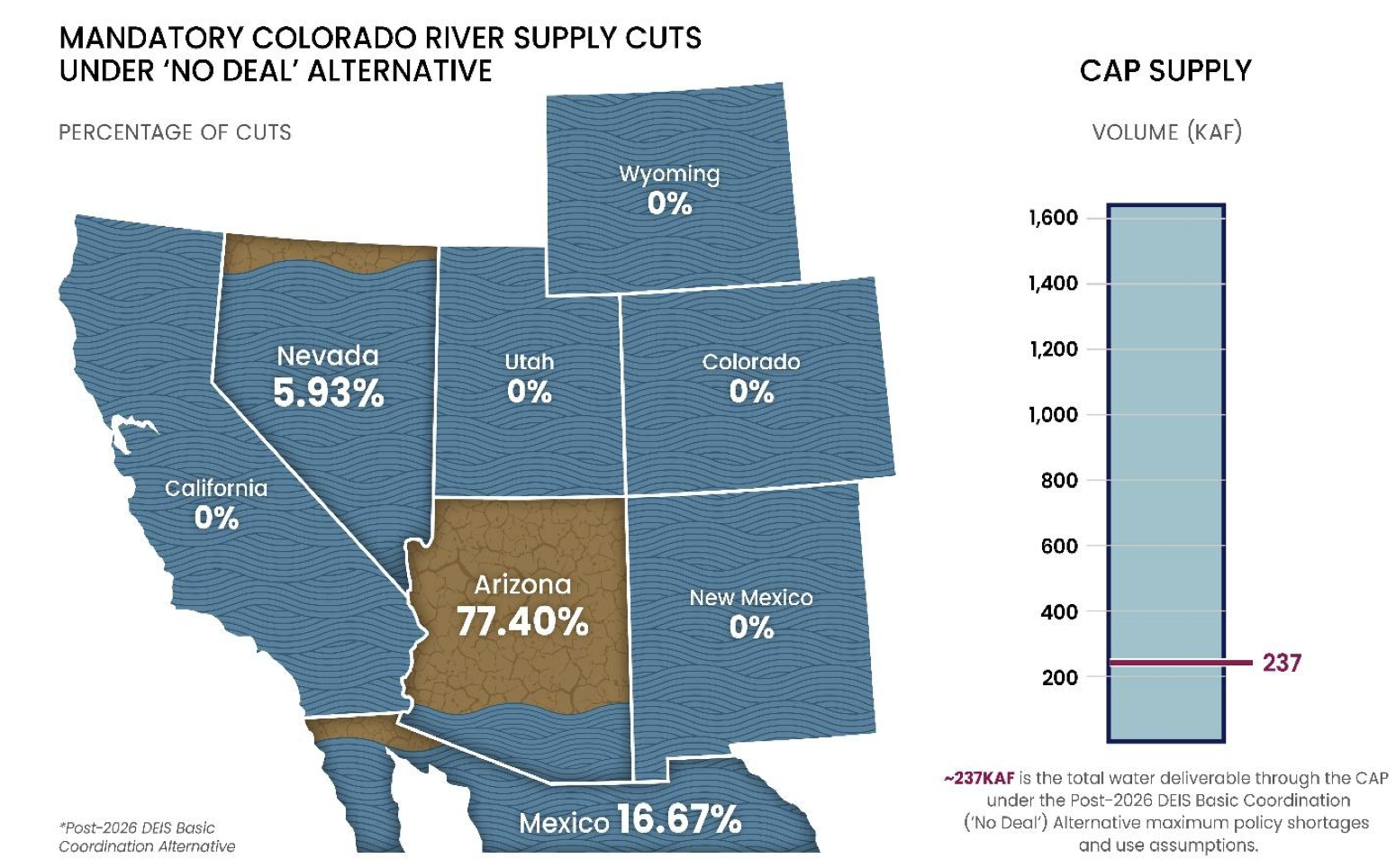
All the alternatives proposed in the DEIS disproportionately harm Arizona and are unacceptable. Specifically, the Basic Coordination alternative proposed in the DEIS that Reclamation claims could be imposed without Arizona’s consent all but severs much of Central and Southern Arizona from Colorado River supplies that have been relied upon on for four decades, betraying the promise of sustainable water supplies that underly Arizona’s economy and potentially causing “widespread impacts on social and economic conditions. . . .”that may forcecities and townsto“haul water . . . as an alternative to support continued services.”1 Arizona will not tolerate devastation and destabilization, particularly when the DEIS allows other Basin States to increase their water use.
The waters of the Colorado River are foundational to the economy and people of Central and Southern Arizona, supporting 6 million Arizonans, many tribal communities, a thriving advanced microchip manufacturing industry, and critical mineral and agricultural production. Arizona has cultivated a flourishing desert society over the past 40 years through careful and prudent use of Colorado River water supplied by the Central Arizona Project—more than doubling the State’s population while managing at the same time to use less water. The DEIS alternatives threaten to tear apart a generation of careful water management and topple the architecture supporting Arizona’s economy which is home to the heart of the American semi-conductor manufacturing and AI infrastructure industries.
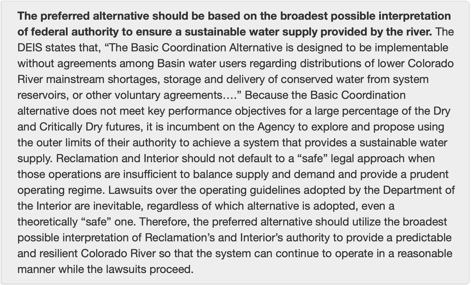
The DEIS alternatives are not just a failure of policy but also include fatal legal deficiencies, and we respectfully request that the Department of the Interior withdraw the document. The United States must implement a decision that is consistent with the Colorado River Compact of 1922 (Compact), the Law of the River, and wise water policy—the DEIS fails on all counts. The enclosed comments highlight several critical flaws in the DEIS, including but not limited to:
Inconsistency with the Compact and the Law of the River: Absent agreement by the Basin States, the operating criteria for the Colorado River must comply with the foundational authority on the Colorado River: the Compact. All subsequent statutes, regulations, contracts, and other agreements are subject to compliance with the Compact and the DEIS ignores this foundational issue by proposing alternatives that would result in a breach thereof.
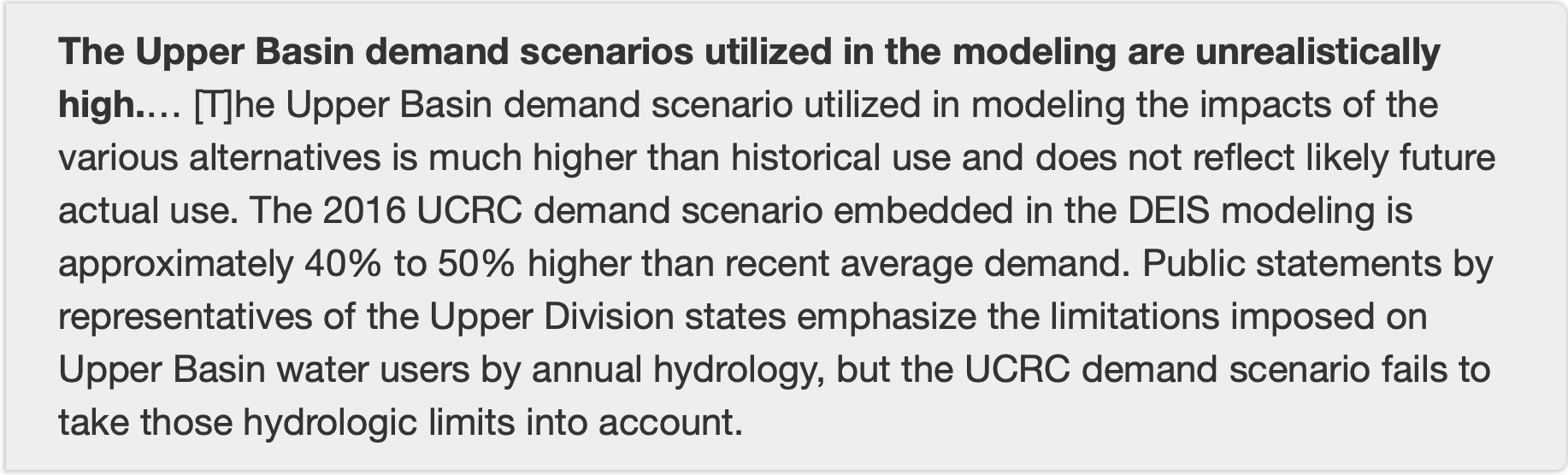
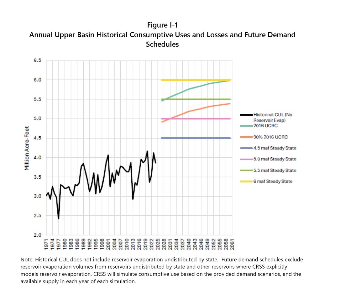
Failure to Analyze Upper Basin Delivery Obligations: The DEIS fails to consider or model the impacts of Upper Basin delivery obligations due to a Compact deficiency, including required releases from Colorado River Storage Project Act Upper Initial Units and curtailment in the Upper Basin necessary to prevent a breach of the Compact. This analysis is particularly important at this time, as a breach of the Upper Basin’s Compact delivery obligations could occur within the next 12 months.
Failure to Analyze the Devastating Socioeconomic Impacts to Arizona: The DEIS fails to analyze the widespread destabilizing social and economic impacts on Arizona that would be caused by the deep cuts to Arizona’s Colorado River supplies proposed in the document and could cause Arizona’s economy to lose over $2.7 trillion.
Failure to Evaluate Reasonable Alternatives: The range of alternatives is too narrow and neglects to evaluate the reasonable and feasible Lower Basin Alternative which would equitably share cuts needed to stabilize the Colorado River System among all seven Basin States and Mexico.
Illegal Implementation of the so-called “Junior Priority” on the Central Arizona Project: Arizona never agreed and the law does not make the Central Arizona Project a junior user to the Upper Basin. The DEIS fails by proposing deep cuts to Arizona’s water supplies without Compact compliance or required reductions to the Upper Basin. Further, the “junior priority” described in the Colorado River Basin Project Act and used to distribute the DEIS cuts to the Lower Basin is a facially unconstitutional imposition on Arizona’s sovereignty and illegally attempts to make Arizona a second-class citizen among the other Lower Basin States.
For these reasons and others described in the attached comments, the current DEIS does not provide the “hard look” at environmental consequences required by law. Proceeding with this document is highly likely to lead to legal challenges and long-term environmental damage that has not been analyzed.
We welcome the opportunity to work with the Department of the Interior to ensure the revised DEIS is robust and legally durable. Arizona has been a willing partner in attempting to negotiate a consensus solution to the management challenges facing Colorado River operations and continues to stand ready to find a compromise with the Secretary, the other Basin States, and additional Colorado River stakeholders based on shared sacrifice and a recognition that everyone must reduce their uses to stabilize the system. A revised DEIS is essential to comply with NEPA and properly inform the public and decision-makers and to avoid protracted litigation.
Map of the Colorado River drainage basin, created using USGS data. By Shannon1 Creative Commons Attribution-Share Alike 4.0
Interior Department overhauls its environmental review procedures.
GAO says NOAA, which has oversight authority, should do a better job of tracking cloud seeding and other weather modification.
Senate passes a bill to allow southern Nevada’s water authority to build a water-supply pipeline beneath a national conservation area.
EPA staff decreased 7 percent in the nine months through June 2025, GAO found.
Army Corps directive aims to speed up infrastructure work, prioritize projects.
House Democrats from the D.C. region ask Congress to fund the repair of a major sewer pipe break.
And lastly, Bureau of Reclamation officials outline options for propping up a shrinking Lake Powell.
“I think it’s safe for us to assume that unless Mother Nature is uncharacteristically generous, that Lake Powell elevations are going to fluctuate at elevations that we’re not comfortable with.” – Wayne Pullan, Bureau of Reclamation Upper Colorado regional director, speaking about the possibility that Lake Powell drops low enough later this year that Glen Canyon Dam cannot generate hydropower.
7 Percent: Decrease in EPA staff between September 2024 and June 2025, according to a Government Accountability Office audit.
10: States that have weather modification programs, typically cloud seeding to induce rainfall, according to a GAO report.
News Briefs
Interior NEPA Changes The Interior Department overhauled its environmental review procedures, aligning them with recent court decisions, congressional action, and Trump administration priorities.
The final rule sets page limits (150 pages in most cases, up to 300 for actions of “extraordinary complexity”) and time limits (generally two years) on environmental impact statements.
The new rules do not require public comment on draft environmental impact statements. The only mandatory opportunity for public comment is after the department issues a notice that it intends to prepare an EIS.
Reviews already in progress, those with “applications that are sufficiently advanced,” will be held to the previous standard.
Illustration from the report, “Antique Plumbing & Leadership Postponed” from the Utah Rivers Council, Glen Canyon Institute and the Great Basin Water Network. Courtesy of Utah Rivers Council
Lake Powell Options Officials at the Bureau of Reclamation, the federal agency that manages Colorado River dams, outlined several actions they are considering in the coming months to boost water levels in a rapidly shrinking Lake Powell, which could drop to a record low later this year that would halt hydropower production from Glen Canyon Dam for the first time.
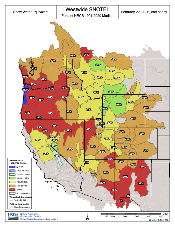
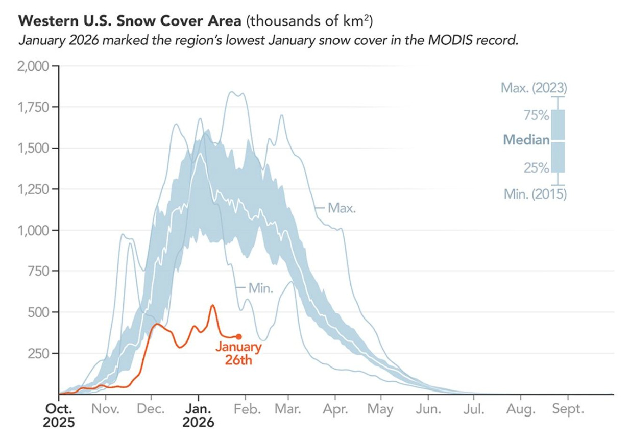
The Colorado River’s second-largest reservoir behind Lake Mead is entering one of the most difficult periods in its six-decade history. The basin is drying due to a warming climate. Powell is just a quarter full, and projected to drop lower this year. Winter has been a dud, with warm temperatures and a historically bad snowpack in the Colorado mountains that feed into the reservoir.
Reclamation officials discussed their options during a meeting last week of the Glen Canyon Dam Adaptive Management Work Group, an expert committee that advises on the dam’s ecological impacts.
A 2024 decision allows Reclamation to “consider all tools that are available” to keep Powell from dropping below 3,500 feet, an elevation that provides a little wiggle room for maintaining hydropower production. Powell today sits at 3,531 feet.
The tool from the 2024 decision is Section 6(E), which grants Reclamation the authority to restrict water releases from Powell to as low as 6 million acre-feet. The planned release this year is 7.48 million acre-feet, so the Section 6(E) authority represents a potential 20 percent reduction.
A cut of that magnitude might not be necessary because Reclamation has another tool it can use in tandem.
That option is releasing more water from Flaming Gorge and other smaller reservoirs located higher in the watershed. This is called a DROA release after its authorizing document. Pullan said this action, which states in the lower basin are advocating for, is being discussed and the volume of those releases would be determined in the spring, around April or May.
Southern Nevada Water Pipeline The Senate passed a bill that allows southern Nevada’s water provider to tunnel beneath Sloan Canyon National Conservation Area in order to build a pipeline to increase the water-supply system’s reliability. The bill now goes to the president’s desk.
Studies and Reports
‘Army Mode’ for the Army Corps Adam Telle, head of the Army Corps of Engineers, issued a collection of directives aimed at reducing paperwork and speeding up water infrastructure construction.
In one memo, Telle called for an “Army Mode” mobilization. He ordered a bottom-up approach whereby officials will select at least 20 projects nationally to prioritize. The list is due March 20.
A separate memo lists seven focus areas for infrastructure work. In descending order of importance: human life and safety, economically or strategically important infrastructure, efficient navigation and supply chains, human property, aquatic ecosystems, state-level infrastructure, and municipal infrastructure.
In yet another memo, he said that project investigations – part of the planning phase – should take no more than three years and $3 million.
Cost of Natural Hazards for the Defense Department The Defense Department lacks data to understand fully the costs of natural hazards to its installations, according to a Government Accountability Office report.
The GAO made five recommendations, including resilience planning, data collection standards, guidance, and procedures. The Defense Department agreed with all of them.
Weather Modification The GAO also looked into NOAA’s tracking of activities to induce rainfall or otherwise change the weather.
Thanks to a 1972 law, NOAA has oversight authority over weather modification and any entity that shoots silver iodide into clouds to make it rain is required to file a report with the agency. Solar geoengineering, which attempts to reduce air temperatures, is far less common but also covered under this authority.
The GAO found that NOAA’s database is incomplete, inconsistent, and unreliable. One fifth of interim and final reports had at least one error, the GAO estimates.
“Consequently, NOAA is not fully aware of the extent of weather modification activities that have occurred and are occurring within the U.S., how they are being conducted, or potential effects,” the GAO concluded.
On the Radar
How to Sue the EPA The EPA is proposing to change the process for filing citizen lawsuits, moving from mail delivery to electronic submissions.
Public comments are due March 26. Submit them via http://www.regulations.gov using docket number EPA-HQ-OGC-2024-0557.
Water Infrastructure Funding In the wake of a large-diameter sewer line rupture along the Potomac River, House Democrats from Maryland, Virginia, and the District of Columbia wrote to leaders of the House Transportation and Infrastructure Committee asking for funding for repairs.
The letter also asked for the Army Corps of Engineers to prioritize a study of a backup drinking water source for the capital region, which relies on the Potomac.
“Unlike other major metropolitan areas, the region lacks a secondary water supply, which would provide critical redundancy in the event of a future crisis.”
Federal Water Tap is a weekly digest spotting trends in U.S. government water policy. To get more water news, follow Circle of Blue on Twitter and sign up for our newsletter.
Map of the Colorado River drainage basin, created using USGS data. By Shannon1 Creative Commons Attribution-Share Alike 4.0
Last week, the Colorado River District submitted comments and specific recommendations to the Bureau of Reclamation on the recently released Post-2026 Operational Guidelines and Strategies for Lake Powell and Lake Mead Draft Environmental Impact Statement (DEIS). In its comments, the River District calls for future operational decisions that reflect hydrologic realities, address Lower Basin overuse, and move the Colorado River System beyond constant crisis management.
“A core part of our mission is safeguarding, for all Coloradans, the waters of the Colorado River to which our state is entitled under the various laws, agreements and compacts that govern the river,” said Raquel Flinker, Director of Interstate and Regional Water Resources at the Colorado River District. “Our water users have adapted to the reality of variable hydrology. We are living with a river that has 20% less water and this trend is expected to continue. It is past time that our neighbors in the Lower Basin learn how to live within the means provided by the river.”
“What is very clear in these proposals is that we still have a basic math problem,” said Colorado River District General Manager Andy Mueller. “Every year, around 1.5 million acre feet of Colorado River water disappears due to evaporation and transit loss in the Lower Basin, yet this amount is unaccounted for in the Bureau’s water deliveries. If we want to move out of crisis response mode, every proposal must begin by reducing consumptive use in the Lower Basin by this amount every single year before discussing shortages. If we had fixed the math to align with the laws of nature twenty-five years ago, we would have almost 30-million-acre feet of storage still available in the system today.”
The River District’s letter includes 13 specific recommendations organized around several key themes. First, it calls for post-2026 operations that align demand with available supply and put hydrologic reality, not predictability for the Lower Basin, at the center of decision-making. The River District urges Reclamation to evaluate alternatives that perform under critically dry hydrology, provide a fair, transparent analysis of actions and impacts, and clearly disclose Upper Basin shortage risks in the main body of the analysis.
The letter also stresses that Lower Basin use must be reduced by roughly 1.5 million acre-feet at all times, defined as system losses rather than “shortage,” and that Upper Basin conservation assumptions and scale must be re-evaluated. In addition, the River District calls for clear, durable guidelines and definitions, including fully defining and analyzing “gap water” and “additional Upper Basin actions,” and for CRSP initial unit water to remain in Lake Powell. Finally, it raises Law of the River concerns, including that inter-basin transactions must not be allowed.
The River District’s full comment letter is available here:
Reclamation formally published the DEIS on January 16, 2026, opening a 45-day public comment period. The Bureau of Reclamation must consider public feedback when developing a preferred alternative for management of the system, and the basin states will continue their negotiations alongside this process with the hope of reaching a seven-state consensus. The current guidelines expire at the end of September 2026.
Back in the late 1990s and early 2000s, when I lived in Silverton, Colorado, elevation 9,318 feet, we often experienced a “January thaw.” It was a period of a few sunny, warm days between storms that usually fell in January but could also occur in February. If you could find a south-facing deck that was protected from the wind and free of dangling, skull-piercing icicles, you could sit out in shirtsleeves, soak up some vitamin D, and maybe even get a little bit of a suntan. Then winter, below zero temperatures, and super snowy San Juaners would return, finally and grudgingly departing sometime in late May.
A pretty big swath of the Southwest is about to experience a February thaw of its own, according to National Weather Service forecasts, including in these hot spots:
Phoenix’s mercury could climb into the low- to mid-90s this weekend [February 28 – March 1, 2026], with overnight lows in the 60s.
Durango, Colorado, is expecting to hit 66° F on Sunday (with lows staying above freezing).
It will be prime bike-riding weather in Moab, where the highs could climb into the low 70s.
And even Silverton will get up into the 50s, with the overnight lows dipping only a few degrees below freezing — bad news for the snow.
Denver is under a red flag warning for fire danger today, and will see temperatures in the high 60s.
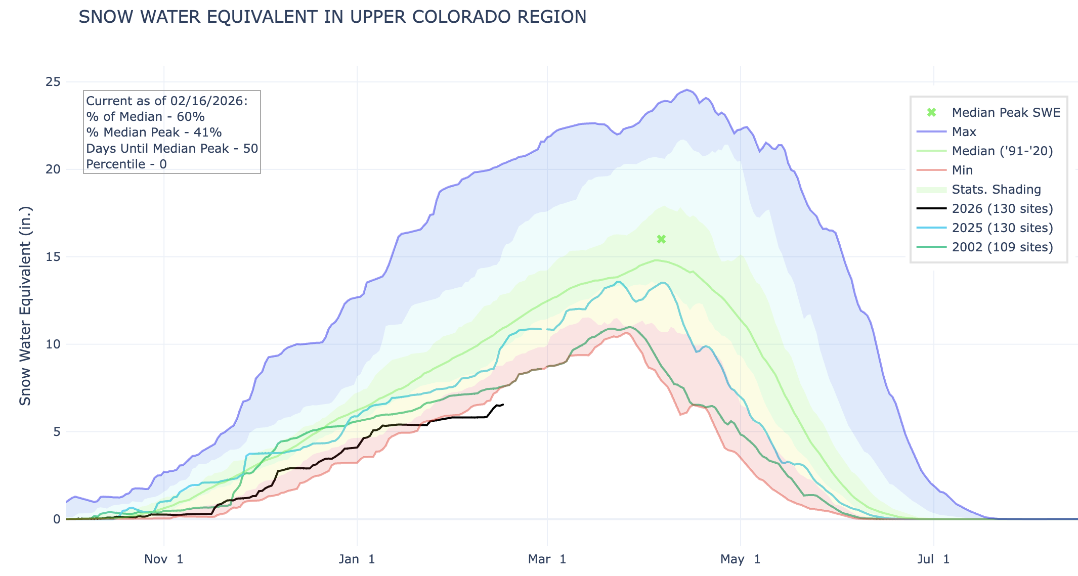
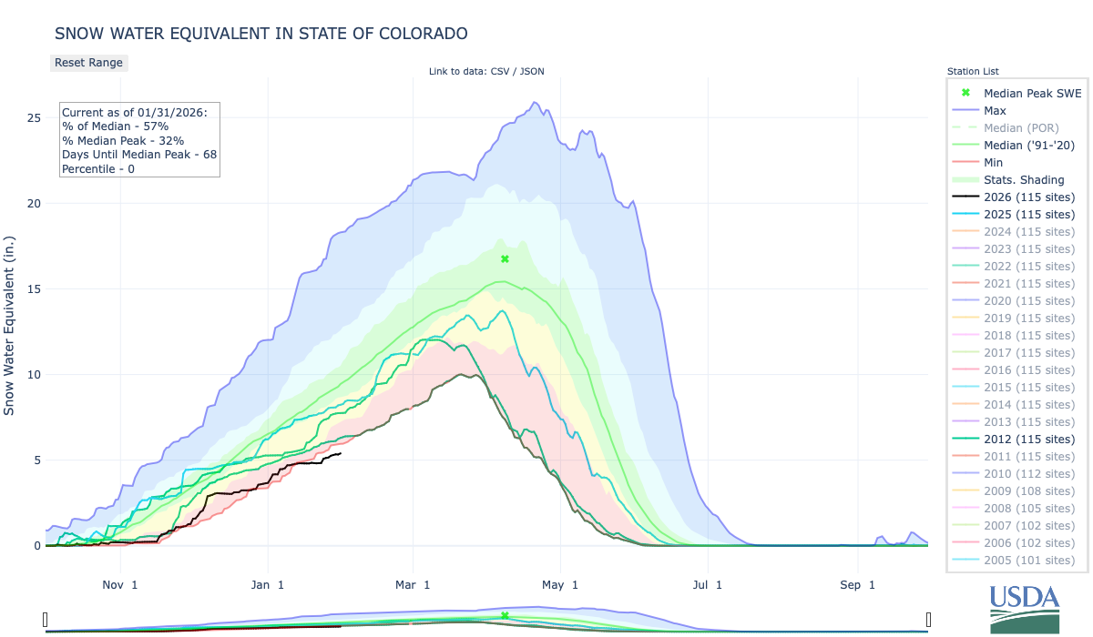
During a “normal” winter, this wouldn’t be alarming in the slightest. In fact, it would be a welcome respite from winter. Now it threatens to wipe out any indication that it even is winter by potentially erasing the snowpack gained during last week’s storms. The Upper Colorado River Basin’s snowpack is exactly at the same level as it was on this date in 2002. Ohhh boy, if those March storms don’t arrive it’s going to be a long, dry summer.
As a deal between the seven Colorado states for how to divvy up massive consumption cuts seems less and less likely, Arizona is getting a bit more aggressive.This week the Protecting Arizona’s Lifeline Coalition launched a PR campaign, complete with videos, attempting to pressure the Upper Basin states to let more water flow downstream to its Lower Basin neighbors.
Arizona is understandably worried: The Central Arizona Project’s water rights are junior to most of the other large users in the Lower Basin, meaning they would be among the first to take cuts if there were a shortage. The window for a dramatic improvement in Upper Basin snowpack is rapidly closing, thereby increasing the likelihood of a shortage later this year.
The campaign includes a series of videos with various officials making their case. There are also a few educational ones that do a nice job of explaining the Colorado River Compact, and are really worth a watch. However, I should warn you that they are coming from a Lower Basin perspective, meaning they interpret one clause of the Compact, Article III(d), significantly differently than the Upper Basin states. And yet, that’s what their entire argument relies on.
That clause states that the Upper Basin must “not cause the flow of the river at Lee Ferry to be depleted below an aggregate of 75 million acre-feet” for any 10-year period.
The Upper Basin sees this as a “non-depletion obligation,” meaning it blocks them from exceeding their 7.5 MAF/year allocation if it causes the Lee Ferry flow to fall below a 7.5 MAF/year average. The Lower Basin sees it as a “minimum delivery obligation,” meaning that the Upper Basin is obliged to send an average of 7.5 MAF past Lee Ferry no matter what, even if that means draining all of its reservoirs and drying out its fields and cities.
In a comment on Tuesday’s dispatch, reader Steve Harris suggested a story on the U.S. Customs and Border Protection fast-tracking a 200-mile segment of border wall through Big Bend National Park.
This is a super important issue. And it’s not only in Big Bend: The entire border wall is an environmental disaster, slashing through biologically diverse, beautiful country and cutting off migratory routes and movement for mountain lions, javelina, coyotes, ocelot, deer, desert bighorns, and even jaguars. Keep in mind that it’s not just a fence, it’s a giant piece of infrastructure that requires bulldozing all the vegetation and even blasting through the landscape. Besides that, we taxpayers are forking out billions of dollars for something that isn’t all that great at doing what it’s supposed to do.
For me it’s especially heartbreaking to see the wall cut through the borderlands south of Tucson, down in the Patagonia Mountains. Many years ago my dad took my brother and I along some little road through there right up against the border, which at the time was just a barbed wire fence. It was incredible country, so quiet and mostly humanity-free.
The stakes are equally as high in the Big Bend area, where both ecological and cultural treasures are at risk. Unfortunately I’ve never been to Big Bend, and it’s a little ways outside the region I normally cover, so I’m not going to try to pretend to know what’s going on there. But a lot of other smart folks have written about it and are trying to block the new stretch of wall, so I’ll share some of that here:
Border Patrol map of existing, planned, and awarded segments of wall, including the stretch through Big Bend — which consists of about 100 miles of actual physical wall plus segments of “detection technology” in the most rugged areas.
The Texas Observer has a good story on the wall plans and the way the “Big Beautiful Bill” not only allocates $46.5 billion to build the monstrosity, but also erased existing protections for some areas.
Environmental groups and environmentally-oriented media outlets are making a pretty big stink over the confirmation hearings for Steve Pearce, Trump’s pick to lead the Bureau of Land Management. There’s a good reason for this: Pearce is well known for his hostility toward the BLM and the public lands it oversees, and he has also indicated a desire to sell off public land — a stance he failed to renounce during this week’s hearings.
Pearce is a bad choice for this job. But is it worth spending a lot of resources to get him ousted? Probably not.
If the Senate does not confirm Pearce, then the administration will just find some other bozo to do the job, which in this case is basically a middle manager tasked with carrying out the agenda of Interior Secretary Doug Burgum. Burgum, in turn, is merely executing the Trump administration’s, i.e. Project 2025, policies.
Which I have to say is disappointing and sad. Before he was a cabinet member, Burgum seemed like a reasonable enough guy. Sure he has ties to oil and gas interests, but he also appeared to be a Teddy Roosevelt Republican — an old school conservative and conservationist who valued public lands. He even managed to garner the endorsement of outdoor retailer REI’s board along with that of the hook and bullet crowd.
Instead, he has prostrated himself to the extractive industries, embraced coal mining and oil and gas drilling, and shattered environmental protections for public lands left and right. His distinguishing features as a cabinet member have been his unwavering sneer-like grin and his tendency to fawn over Trump — and coal.
***
Your energy and outrage might be better spent on convincing Congress to shoot down Sen. Mike Lee’s, R-Utah, attempt to use the Congressional Review Act to revoke the Grand Staircase-Escalante National Monument management plan. If the “resolution of disapproval” passes both chambers of Congress with a simple majority vote, it would erase the plan and bar the Bureau of Land Management from issuing another plan that is “substantially the same” in the future.
Republicans in the current Congress used the CRA — which allows Congress to revoke recently implemented administrative rules — to do away with resource management plans in Alaska, Montana, and North Dakota. That’s in spite of the fact that RMPs are not considered “rules,” according to a January 2025 opinion by the Interior Department’s Solicitor. National monument management plans aren’t rules, either, but that’s not a hindrance for Lee.
This wouldn’t change the boundaries of the monument, but would likely cause management of the area to revert back to the 2020, Trump I-era plan. That plan was not only less protective than the newer one, but only applied to a much smaller area, since in 2017 Trump had significantly shrunk the national monument. Revoking the current management plan, then, would leave vast areas of the monument in a sort of management limbo.
It would also open the door to revoking other national monument management plans (e.g. Bears Ears), allowing the GOP to carry out Project 2025’s goal of shrinking or eliminating national monuments in a less visible, more underhanded manner.
Just a couple reminders from a few years ago that it does snow, and it will snow again — just maybe not this spring. Jonathan P. Thompson photos.
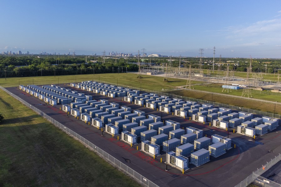
The estimated 30- to 40-acre utility-scale battery energy storage facility planned by Jupiter Power to be built in 2027 southwest of the Hayden Power Station would look similar to this facility completed in 2024 in Houston. Jupiter Power/Courtesy photo
A utility-scale battery energy storage facility was approved last week by the Colorado Public Utilities Commission with the project planned for construction southwest of the Hayden Power Station within the town limits of Hayden. Megan Castle, communications director for the Public Utilities Commission, said the 400 MW project was approved as part of 10 total bid projects accepted by the state commission. The project in Hayden will be led by Jupiter Power, a developer and operator of utility-scale battery energy storage systems with corporate offices in Austin, Houston and Chicago. The proposed energy storage facility would be located on a 72-acre site on Routt County Road 51 near the Hayden power plant and Yampa Valley Regional Airport and would connect by a new transmission line to the Mount Harris substation southeast of the main Hayden station. The stored energy would be sold to Xcel Energy through a Power Purchase Agreement, said Michelle Aguayo, senior media relations representative at Xcel.
“This project is a Power Purchase Agreement, where another company builds and maintains the project, and we purchase the power produced,” Aguayo said Tuesday.
Hayden Town Manager Mathew Mendisco said municipal leaders are excited about the forthcoming facility, and that Jupiter Power staff already has worked through the preliminary application process with the town and is expected to submit a formal application later this year. Mendisco said the town leadership is happy to have more light industrial development to continue to boost the local tax base.
“Development like this is always good,” Mendisco said. “The energy sector has been part of our economy for many years, and this fits right in. We are excited to have land near the airport developed, and we think this seems to be a good fit.”
Just when you thought the GOP’s assaults on public lands couldn’t get any worse, the Trump administration launched a new blitzkrieg on environmental protections.That includes eviscerating the National Environmental Policy Act, the federal law requiring agencies to analyze, mitigate, and avoid impacts of major federal projects and projects on public land.
Interior Secretary Doug Burgum this week announced the “rescission of more than 80% of Interior’s prior NEPA regulations.” The changes, which includes limiting public comment, are aimed at streamlining permitting across the board, much as the department did with its “emergency permitting procedures” for oil and gas, uranium, coal, and critical minerals projects on public lands.
Associate Deputy Secretary Karen Budd-Falen, who is in hot water over potential ethics violations, lauded the changes, saying in a statement: “These reforms will help unleash American energy, strengthen rural communities ,and deliver real results faster for the American people.” As long as they are fossil fuels, that is, since Interior has put a de facto blockade on solar and wind developments on public lands.
Burgum finalized the NEPA rules a few days after opening 2.1 million acres of previously protected public lands in Alaska’s Dalton Corridor to new mining claims and oil and gas drilling.
***
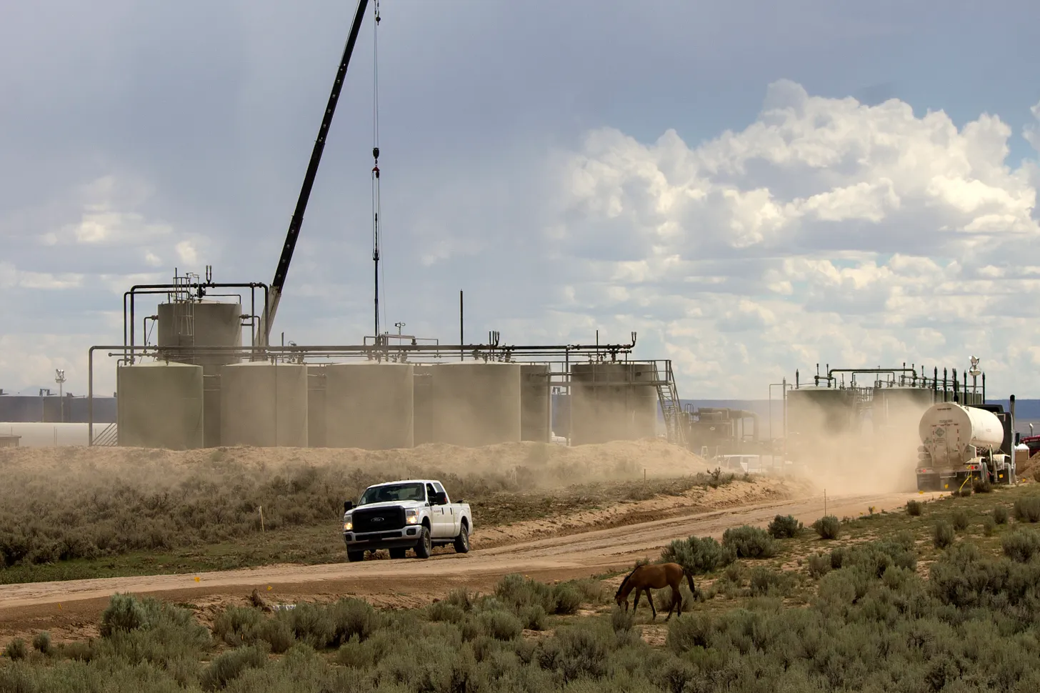
An oil and gas drilling and hydraulic fracturing operation in the Greater Chaco Region near where the BLM plans to sell more leases this August. Jonathan P. Thompson photo.
The Bureau of Land Management is, thankfully, still taking comments on proposed oil and gas leases, though it’s not clear that they will pay them any heed. You have until March 23 to give your two cents on the Farmington Field Office’s plan to auction 12 parcels covering about 16,856 acres this August. The parcels are on the checkerboard, with the biggest block of them about 20 miles east of Chaco Culture National Historical Park.
This week confirmation hearings begin for Steve Pearce, Trump’s pick to lead the BLM and oversee some 245 million acres of public land.
Pearce is a hard-right Republican, former congressman from New Mexico, and no friend of public lands or environmental protections. Pearce’s political career was infused with hostility toward the agency he has been nominated to oversee. Pearce has opposed new national monument designations, is a fan of drilling public lands, has tried to weaken or eliminate the Endangered Species Act, lied about wolves in an effort to defund the Mexican wolf recovery program, received a 4% score from the League of Conservation Voters.
A few months ago we would have considered his confirmation a slam-dunk, since at the time most Republicans were still willing to debase themselves to any degree to curry favor with Trump. But with Trump’s approval rating plummeting as he suffers from more frequent cognitive mishaps and more revelations of his involvement with Jeffrey Epstein, the Senate may not be so friendly to Pearce.
***
The News:The National Park Service “expands access,” a.k.a. limits or eliminates timed-entry reservation systems, at Arches, Yosemite, Glacier, and Rocky Mountain National Parks, sparking fears that unmanageable crowds will once again overwhelm the popular parks.
The Context: In the wake of the first wave of the COVID-19 pandemic, when Zoom boomers flooded Western communities and the masses descended on the surrounding public lands, people became increasingly concerned about the resulting crowds at national parks and at popular non-park trails and sites. Not only did the crowds risk damaging the parks’ resources, but they also potentially screwed up the visitors’ experiences.
In Arches National Park, for example, cars backed up at the entry gate for close to a mile, parking lots were crammed with vehicles and trail-jams weren’t uncommon, and on especially busy days park officials had to actually shut the gates and turn folks away — even those who may have traveled from abroad to see Delicate Arch.
To ease the pressure, the National Park Service in 2022 instituted a timed-entry reservation system during the busiest months of the year. This limited the number of people entering the park, but it also ensured the ones that made a reservation that they wouldn’t be turned away. The system led to a sharp drop in visitation during its first year, though the number of people entering the park averaged around 4,000 per day. But it has climbed every year since, including in 2025 when other Canyon Country parks saw visitation decline.
Still, some locals, presumably those of the quantity over quality variety, pushed back, saying the new system was diminishing visitation and hurting the local tourism industry. Last fall, Grand County Commissioner Brian Martinez asked the park service to revoke the timed-entry system and to build up the park’s infrastructure to enable it to maximize visitor numbers. The Trump administration’s park service apparently listened, and now timed-entry is no more.
You wanna know how old I am? I’m old enough to remember, way, way back to the days of yore, when federal officials and gateway-town chambers of commerce were wringing their hands in concern over a nationwide decline in visitation to national parks. Over a 13-year period, visitor numbers to 58 “nature-based” national parks—Arches, Yosemite, Yellowstone, …
🐓 Regulatory Capture Chronicles 🦊
Trump’s apparent disdain for clean air (and a healthy public) was manifested in recent weeks as the administration not only rolled back the EPA’s “endangerment finding,” which authorizes it to regulate greenhouse gas emissions, but also the Biden-era mercury toxic air standards.
Mercury emissions are an environmental and public health hazard. The Four Corners-area coal plants once kicked out more than four thousand pounds of mercury each year, along with thousands of pounds of selenium and copper and hundreds more pounds of lead, arsenic, and cadmium, not to mention sulfur dioxide, nitrogen oxide, and other pollutants.
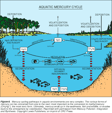
Aquatic Mercury Cycle. Graphic credit: USGS
Those emissions have decreased considerably over the years as federal regulations kicked in and as coal plants were shuttered altogether. Still, the Four Corners plant puts out about 150 pounds of mercury each year, along with varying quantities of other toxic metals. Most of these pollutants are then deposited in the surrounding water, on the land, and on homes. For years, rain and snow falling on Mesa Verde National Park have contained some of the highest levels of mercury in the nation, and elevated levels have even been found on Molas Pass, just south of Silverton. The mercury is then taken up by bacteria in lakes and rivers, which convert it to highly toxic methylmercury, which then enters the food chain. Mercury messes with fishes’ brains, and even at relatively low concentrations can impair bird and fish reproduction and health. It’s not so good for the people who live near the plant, drink the water, or eat those fish, either.
Because most existing coal plants in the West already complied with the Biden regulations, Trump’s rollback isn’t expected to have a significant effect in most cases (unless power plants dismantle existing pollution-control equipment). However, it is expected to allow the Colstrip coal plant in Montana — one of the nation’s worst polluters — to continue to operate (the operators complained that compliance with the Biden rule would have forced it out of business).
The San Juan Generating Station back when all four units were still operating, and spewing mercury and other nastiness on the area and its residents. The plant was shuttered in 2022 and has mostly been demolished. Jonathan P. Thompson photo.
🐐 Things that get my Goat 🐐
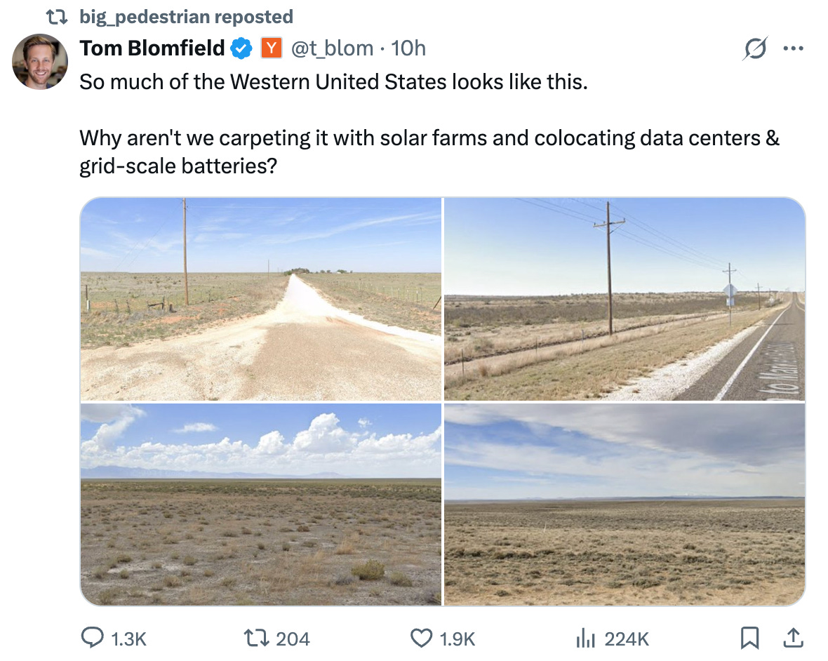
I probably shouldn’t put this here, but geez, really? Aren’t we over the whole “The West is a big empty space that we can clutter up with our myths and technology and nuclear waste” complex? I guess not. I’m sure this guy, who is clearly from somewhere that is not the Western U.S., means well. But he needs to figure out that the West’s “empty” spaces are actually full of life and beauty and, well, space, which most of us value quite highly.
Granted, the spaces shown in this guy’s pictures do look like they may have been extensively grazed, but that does not mean they are appropriate places for a bunch of damned power- and water-guzzling data centers and their associated energy facilities.
A new study has shown that it is possible, in some cases, to build large-scale solar systems without destroying the desert on which they sit.
The Gemini Solar Project in southern Nevada is one of the nation’s largest such facilities, covering about 5,000 acres of desert land. During its construction in 2022, the developers refrained from the full “blade-and-grade” site preparation that is typical, and instead worked to minimize disturbance and leave some areas of vegetation and soils completely intact.
A group of researchers from the Desert Research Institute and the U.S. Geological Survey surveyed the plant population — with a focus on the rare and sensitive threecorner milkvetch — before and two years after construction. Their hypothesis was that the facility would detrimentally affect the plant, and that the areas nearer the panels would see the biggest impacts.
What they found is that not only did the milkvetch survive, but it actually thrived “within the novel environment created at Gemini.” The plants found after construction were larger and more fecund than those found off-site. “Our results suggest that the altered environment created by panel arrays did not alter threecorner milkvetch survivorship at Gemini.”
It’s just one study focused on one solar installation and one plant. But it does suggest that, if done correctly, utility-scale solar development does not have to be a desert’s death knell.
In related, but less sunny news: Lawmakers from a handful of states have proposed bills that would make it easier for residents and businesses to install plug-in or balcony solar panels. While these panels don’t generate a ton of electricity, they are relatively inexpensive and, as the name indicates, are pretty simple to hook up. They are common in parts of Europe, especially Germany, and are gaining popularity in the U.S. since the Trump administration has killed most federal rooftop solar subsidies. The legislation is mostly aimed at allowing folks to plug these things in without a permit or go-ahead from the utility.
Last year, Utah, of all places, actually passed one of these bills. But so far this year plug-in solar legislation has died in Wyoming and in Arizona, after utilities expressed concerns. Come on! The California bill seems to still be alive.
Parting Note
I’ll be leading a couple of workshops and giving a talk at this year’s Entrada Institute “Writing from the Land” on May 14-16 in Torrey, Utah. Check it out:
State Highway 133 crosses the Crystal River several times as it flows downstream to its confluence with the Roaring Fork River in Carbondale. Some proponents of a federal Wild & Scenic designation are pushing for a quick timeline while others want a more cautious approach. CREDIT: HEATHER SACKETT/ASPEN JOURNALISM
Colorado lawmakers are asking themselves: Can they bring more data centers to the state while ensuring the power-hungry facilities don’t burden ratepayers and the environment? Dueling bills in the legislature both claim to have the answer. One would push Colorado to join the ranks of many other states that offer tax breaks to incentivize data centers — the backbone of today’s technology landscape. The other would impose more stringent regulations on the industry to protect consumers and the environment from potential harm. As the debate unfolds, some Western Slope leaders are raising concerns over what the push for data centers could mean for their communities’ most valuable resource — water…
Researchers say a large-scale data center can use up to 5 million gallons of water per day to cool down its systems. That’s enough water to serve a town of between 10,000 and 50,000 people daily, according to reporting by the Washington Post. If Colorado chooses to entice more of the thirsty facilities to set up shop, largely in metro areas, Western Slope leaders say that could mean more water being diverted from mountain communities in an era of severe drought…“We’ve struggled for a couple generations with the water of the Western Slope, which is where the water is in Colorado, moving eastward,” said Eagle County Commissioner Matt Scherr. “This is setting up even more fights with our Front Range friends than I think is necessary.”
Colorado River “Beginnings” where the snow accumulates. Photo: Brent Gardner-Smith/Aspen Journalism
Click the link to read the article on the InkStain website (John Fleck):
February 27, 2026
It is hard to know where to begin. The Department of the Interior’s Post-2026 Colorado River draft environmental impact statement, and the deep questions it raises, is an “everything including the kitchen sink” sort of process.
But at its root, the question it raises is simple: Tell us what you’re going to do.
It is easiest to quote the Draft EIS itself on the central question: “In critically dry periods, all alternatives have unacceptable performance.” Roger that. Tell us what you’re going to do.
In the short run, with a meager snowpack and no clear explanation of how federal and state managers are going to operate the reservoir system, the basin’s dams and diversions now, we have no clear picture of what will happen in 2026. Tell us what you’re going to do.
Some specifics
The ad-hoc collective that Allen Best dubbed “the Traveling Wilburys of the Colorado River” – Anne Castle, Eric Kuhn, Jack Schmidt, Kathryn Sorensen, Rin Tara, and me – took yet another stab at offering our suggestions in comments we submitted yesterday to Interior’s P26 EIS process.
I’ve been mentally largely elsewhere lately, finishing up the book and managing my health (I’m doing great! Thanks for asking!), so I mostly show up at the last minute on these things to dub my vocals, but my friends are very kind and inclusive, and they do good work. In particular, stuff like this full of both useful NEPA-speak and also substance:
As I said: Tell us what you’re going to do.
As I said: Tell us what you’re going to do.
This one’s on you, Secretary Burgum. We do offer suggestions, but if you don’t like ours, then tell us your alternative: Tell us what you’re going to do.
This one has seemed for a long time like a no-brainer to me:
Really?
This one’s on my Upper Basin leaders: Really?
Again, Secretary Burgum: Tell us what you’re going to do.
The colossal failure of the Colorado River Basin leadership is on display in this simple sentence from the draft EIS: “In critically dry periods, all alternatives have unacceptable performance.” [ed. emphasis mine]
You’ve spent the last few years telling us what you can’t do. It’s on you now: Tell us what you’re going to do.
(Lots more in the full comments, it’s a useful primer on the current state of play.)
Map of the Colorado River drainage basin, created using USGS data. By Shannon1 Creative Commons Attribution-Share Alike 4.0
Evening light hits the bluffs above the Green River at Fontenelle Reservoir in June 2021. (Ryan Dorgan/WyoFile)
Click the link to read the article on the WyoFile website (Dustin Bleizeffer):
February 18, 2026
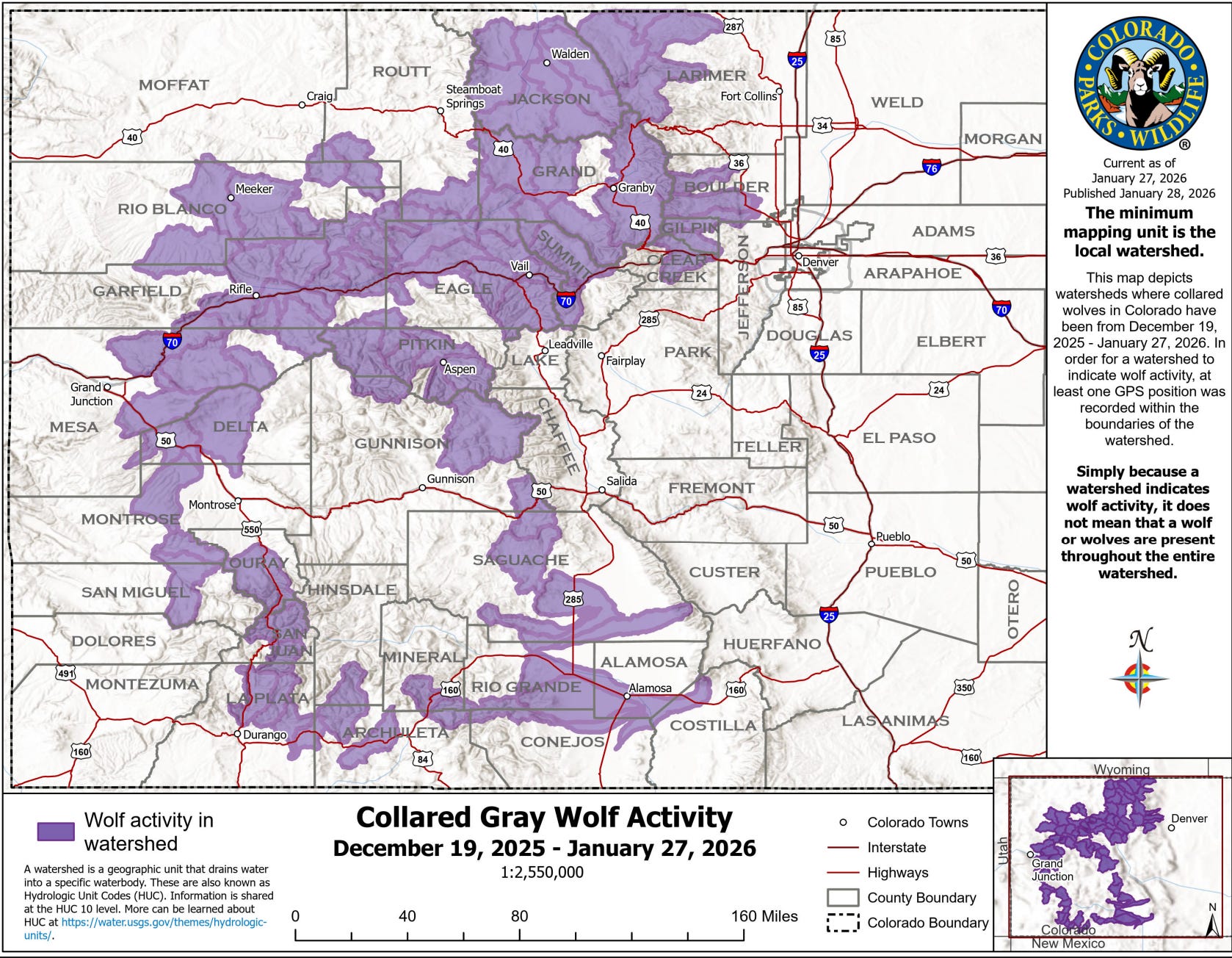
Historically bad snow and water conditions raise stakes for Colorado River basin states as feds prepare to intervene.
Wyoming water officials are desperately hoping to avoid a federal intervention into the high-stakes deadlock among Colorado River stakeholders seeking a compromise on shared water appropriation cuts.
Wyoming and the six other Colorado River basin states blew through another deadline Saturday to come to an agreement, raising the possibility that the U.S. Bureau of Reclamation will dictate a new drought response plan — a situation that could dash cooperation and spawn intense legal entanglements, observers say.
Making matters worse is an intense “snow drought” so far this winter that’s compounding a “mega drought” across much of the seven-state basin region that’s lingered for more than two decades. It’s so dry that federal water managers warn Lake Powell — for the first time in 63 years — could drop 50 feet, low enough to no longer produce hydroelectric power at the Glen Canyon dam, according to the Bureau’s latest projections.
The intense situation was a topic of discussion Tuesday as a legislative committee considered a bill — Senate File 84, “Voluntary water conservation program.” The Wyoming State Engineer’s Office hopes it will give the state some negotiating leverage and protection over the state’s share of Colorado River-bound water.
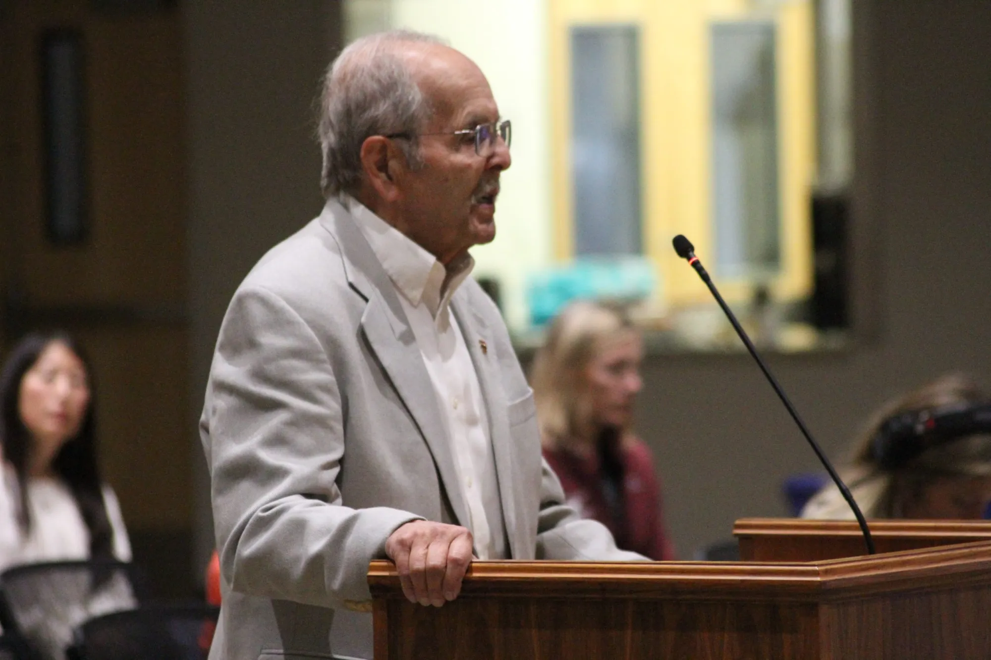
Jim Magagna, the executive vice president of the Wyoming Stock Growers Association, speaks at a September 2025 Wyoming Game and Fish Commission meeting in Lander. (Mike Koshmrl/WyoFile)
“Our governor traveled back and met with other governors in D.C. and gave a somewhat favorable report,” Wyoming Stock Growers Association Executive Vice President Jim Magagna told the Senate Agriculture, State and Public Lands and Water Resources Committee. “The day after that, the state engineer in Arizona announced that they’re willing to go to court and fight to the death to get the water they think they’re entitled to from the upper basin, [which includes Wyoming].
“I would love to be able to sit here and tell you this is totally unnecessary,” Magagna said, adding he’s in favor of the bill. “Unfortunately, the scenario we’re facing in the Colorado River today is that we do believe that the state needs to show some good faith in attempting to address some of those water issues.”
The committee also heard from representatives of Wyoming’s prolific trona and soda ash producers, who rely on water that is subject to the Colorado River Compact.
“We have 2,300 employees at risk in southwest Wyoming if we don’t find a solution,” Jody Levin told the committee, speaking on behalf of the trona industry and the Wyoming Mining Association.
Divvying up shrinking water
Water forecasts were already so dire in January that the Wyoming State Engineer’s Office warned that Colorado River water managers will likely call for a significant drawdown of Flaming Gorge Reservoir this spring. The reservoir, straddling the Wyoming-Utah border, is one of the primary backups in the upper Colorado River system to ensure operational water levels at Lake Powell.
Flaming Gorge’s function as a backup is merely one piece of a complex Drought Response Operations Agreement among Colorado River stakeholders, and it expires later this year. Renewing the DROA, along with other binding agreements that dictate appropriations throughout the river system, requires determining how to share a shrinking water resource that serves 40 million people from the Cowboy State to Mexico. Though Wyoming and other Colorado River stakeholders say they prefer their own compromise over a federal one, they have yet to strike a deal — despite years of negotiations.
The Bureau of Reclamation in January published its own draft environmental impact statement for a new plan, and last week the agency hinted that time is running out for a compromise among states.
The Blacks Fork, a tributary to the Green River, near its confluence at Flaming Gorge Reservoir in May 2018. (Ryan Dorgan/WyoFile)
“The basin’s poor hydrologic outlook highlights the necessity for collaboration as the Basin States, in collaboration with Reclamation, work on developing the next set of operating guidelines for the Colorado River system,” Acting Bureau of Reclamation Commissioner Scott Cameron said in a prepared statement Friday.
Gov. Mark Gordon, along with fellow Colorado River upper basin states’ Govs. Jared Polis, Michelle Lujan Grisham and Spencer Cox, issued a joint statement Friday ahead of the unmet deadline.
“Upper basin water users live within the means of the river by adapting our uses every year based on available supplies,” the governors said. “We continue pursuing a seven-state consensus, which would provide greater opportunity to pursue federal funding supporting conservation efforts and innovative water-saving technologies across the basin.”
The Platte River is formed in western Nebraska east of the city of North Platte, Nebraska by the confluence of the North Platte and the South Platte Rivers, which both arise from snowmelt in the eastern Rockies east of the Continental Divide. Map via Wikimedia.
Though not part of the Colorado River system, the North Platte River, stretching from south-central to eastern Wyoming, is also parched. The State Engineer’s Office issued a “priority administration” order earlier this month, requiring junior rights water holders along the river system to immediately cease diverting water. The order could remain in effect through April.
Water conservation bill
Senate File 84 cleared the Senate Agriculture Committee Tuesday [February 17, 2026] unanimously, with strong support from stakeholders beholden to the Colorado River Compact and some doubters.
It would enshrine a water conservation strategy that’s already been tested for several years in the state. It would allow ranchers and other Colorado River system users in Wyoming to voluntarily use less water without losing their appropriation rights, according to the bill.
“It helps avoid mandatory and uncompensated water use reductions, whether by court order or curtailment, to satisfy compact obligations,” State Engineer Brandon Gebhart said. “It provides a tool for Wyoming to be part of a compromise to address historic drought that has plagued the Colorado River Basin for the last 25 years.”
Kemmerer Republican Sen. Laura Pearson said she has doubts about the practical water conservation claims related to the strategy. For instance, if an irrigator foregoes flooding a field and allows their water to stay in the stream, that means less recharge for aquifers.
Welcome to the Landline, a monthly newsletter from High Country News about land, water, wildlife, climate and conservation in the Western United States. Screenshot from the High Country News website.
This is an installment of the Landline, a monthly newsletter from High Country News about land, water, wildlife, climate and conservation in the Western United States. Sign up to get it in your inbox.
When I was growing up in southwestern Colorado along the banks of a tributary to a Colorado River tributary, I was immersed not only in the quirks of water law, but also in Western water culture — the peculiar mores and customs that come from constantly looming scarcity. One oft-repeated maxim, usually used to justify building a new dam or encouraging inefficient irrigation practices, was: If we don’t use the water, it will just flow downstream to California — where it would presumably be used to water golf courses, fill LA’s swimming pools and serve other nefarious West Coast purposes.
I’m sure the idea arose partly from the animosity — and envy — the Interior West has long harbored toward its largest and wealthiest coastal neighbor. But I also think it comes from our idiosyncratic laws governing water use and the way they pit the headwaters communities against their downstream neighbors.
Whatever its origin, the sentiment endures and in fact has only grown stronger as the river and its reservoirs reach critically diminished levels, while the seven states that rely on them fail to agree on how to manage the issue going forward. Maybe the maxim needs an update. The big question today is: How much of the Colorado River’s water should be allowed to flow downstream to California, Arizona and Nevada?
How did we get here?
Western water law is based on the prior appropriation doctrine, which gives the first entity to make “beneficial use” of water the right to keep on using that amount, even if that means that upstream “junior” users’ spigots will get shut off. By the early 1900s, a rapidly growing California was enthusiastically diverting the Colorado River, with huge irrigation districts gobbling up the senior water rights. Less-populous Colorado, Wyoming and Utah were forced to watch in increasing dismay as downstream users gained control over larger and larger shares of “their” river.
Upper Basin States vs. Lower Basin circa 1925 via CSU Water Resources Archives
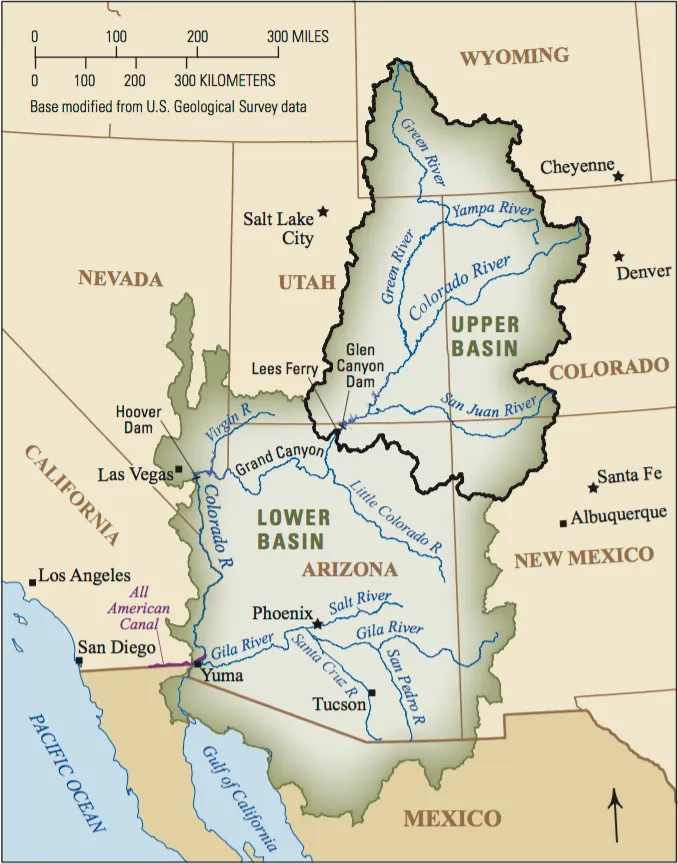
To appease these headwaters states — and to garner their support for huge dams and other water projects on the lower river — the seven Colorado River Basin states hammered out the Colorado River Compact of 1922. It divided the states into an Upper Basin (Colorado, Wyoming, Utah and New Mexico) and a Lower Basin (Arizona, California and Nevada), with the dividing line at Lees Ferry, Arizona. It aimed to share the river’s water equally between them, giving each basin the exclusive use of 7.5 million acre-feet (MAF) of water per year.
Climate change causes turbulence
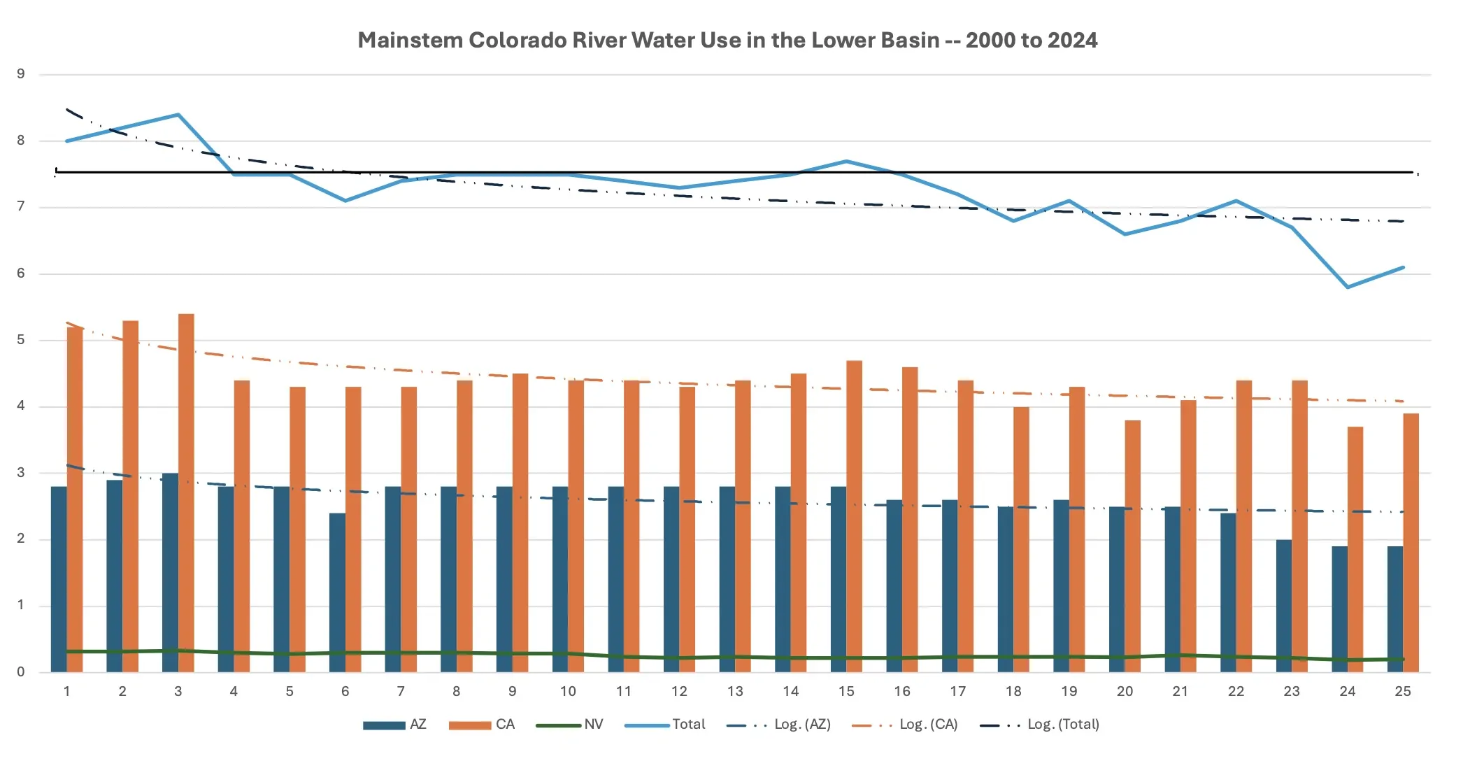
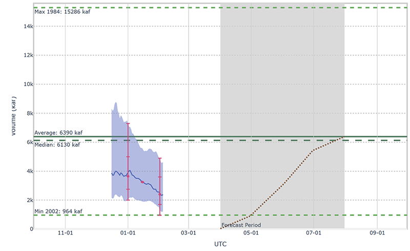
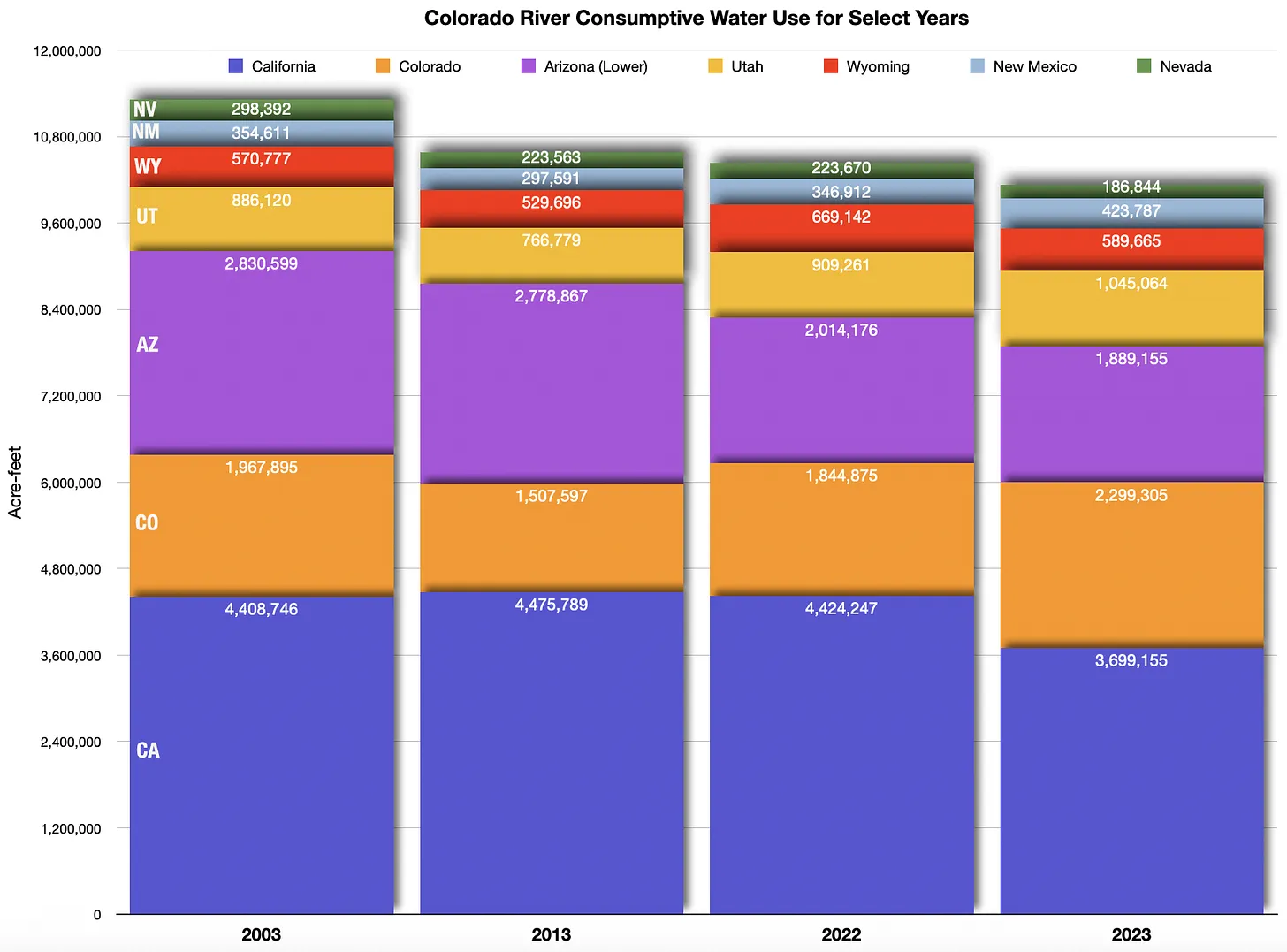
The compact was far from perfect, but the concept of dividing the water equally generally held up, even if the reality didn’t always follow suit: The Upper Basin states have always used far less than their allotted amount (around 4 MAF), while the Lower Basin for years has consumed far more than its share (as much as 11 million MAF). That wasn’t a problem as long as the river had enough water to go around. But for the last 26 years, it hasn’t.
Udall/Overpeck 4-panel Figure Colorado River temperature/precipitation/natural flows with trend. Lake Mead and Lake Powell storage. Updated through Water Year 2025. Note the tiny points on the annual data so that you can flyspeck the individual years. Credit: Brad Udall
Since around the turn of the century, warming temperatures and abnormally dry years have severely diminished the headwaters states’ snowpack, thereby shrinking the river. The annual “natural flow” at Lees Ferry, or the estimated amount of water the river would hold without any upstream diversions or human consumption, has been about 12 MAF on average since 2000, dropping below 6 MAF in 2002, or just over half of what the Lower Basin alone consumed at the time.
The meager flows simply do not jibe with the numbers in the compact. And that makes it virtually impossible for the Upper Basin to comply with the compact’s “non-depletion clause,” which dictates that the Upper Basin “will not cause the flow of the river at Lee Ferry to be depleted below an aggregate of 75,000,000 acre feet for any period of ten consecutive years.” There are different interpretations of this provision, but it appears to say the Upper Basin states has no option but to allow the water to flow down to California — even if it means they come up short themselves.
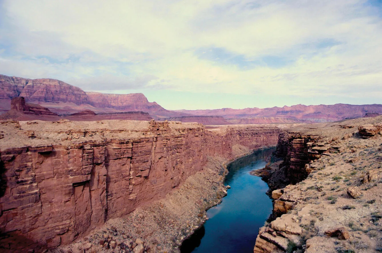
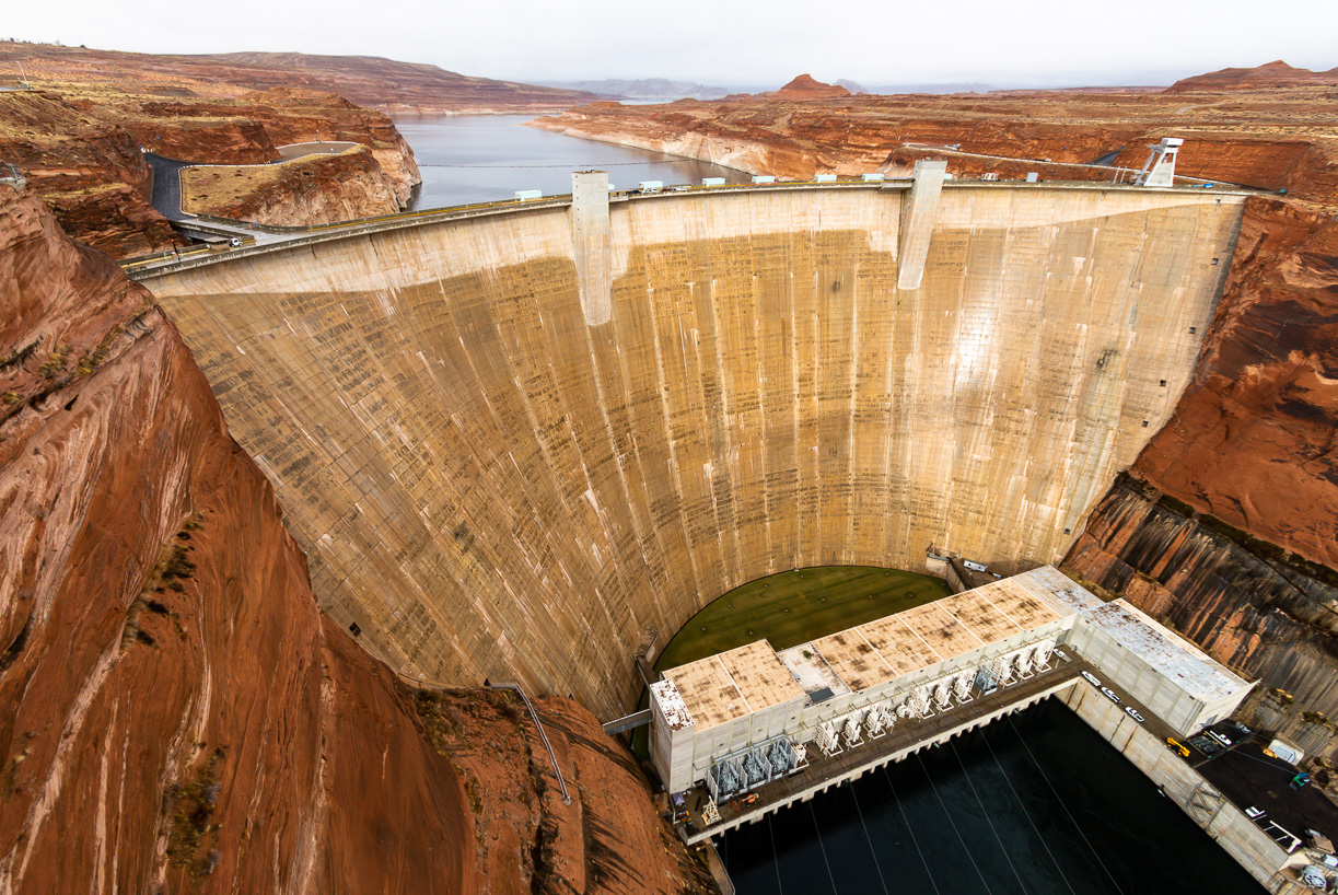
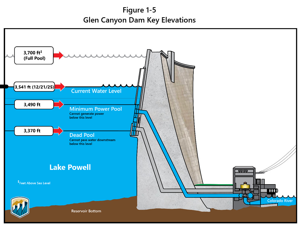
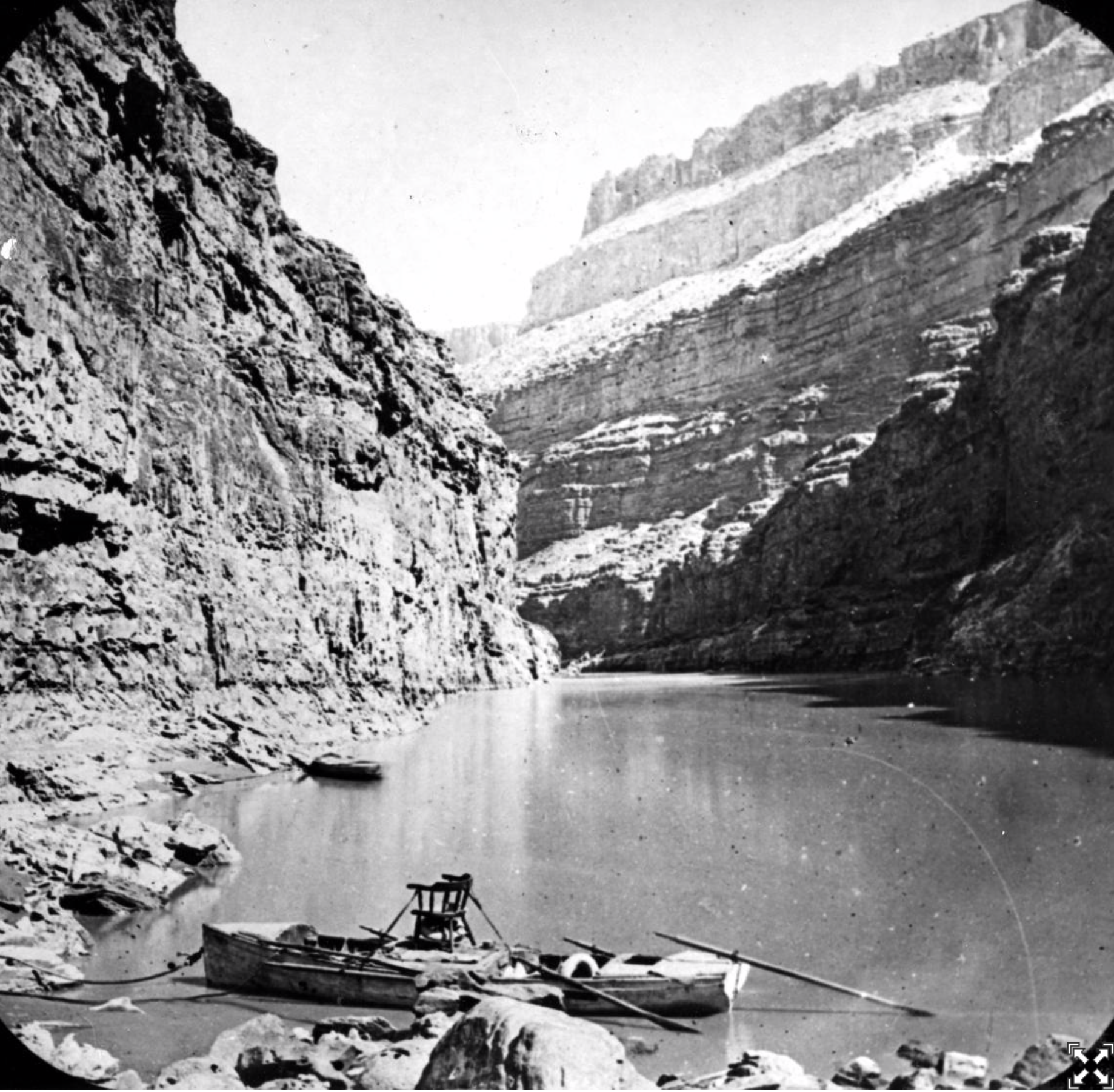
The back of Glen Canyon Dam circa 1964, not long after the reservoir had begun filling up. Here the water level is above dead pool, meaning water can be released via the river outlets, but it is below minimum power pool, so water cannot yet enter the penstocks to generate electricity. Bureau of Reclamation photo. Annotations: Jonathan P. Thompson
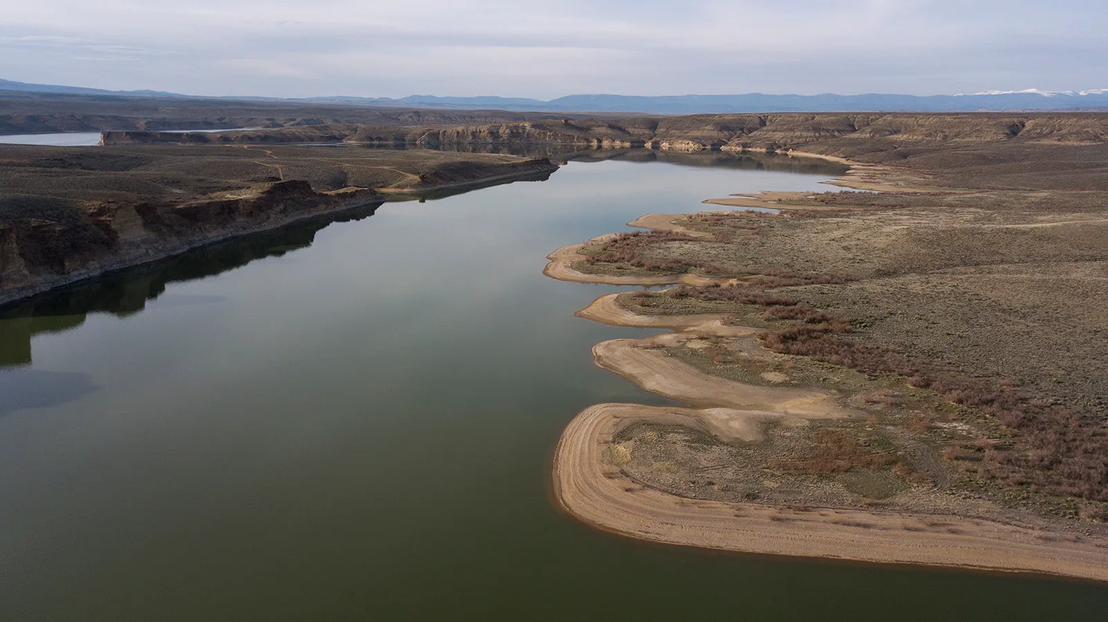
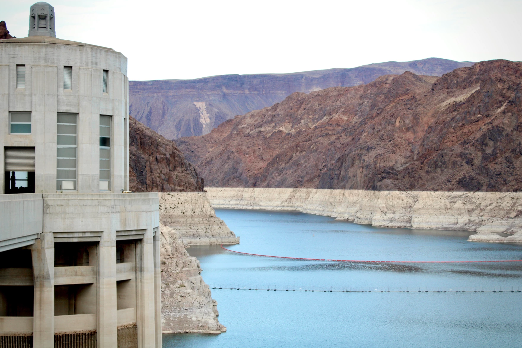
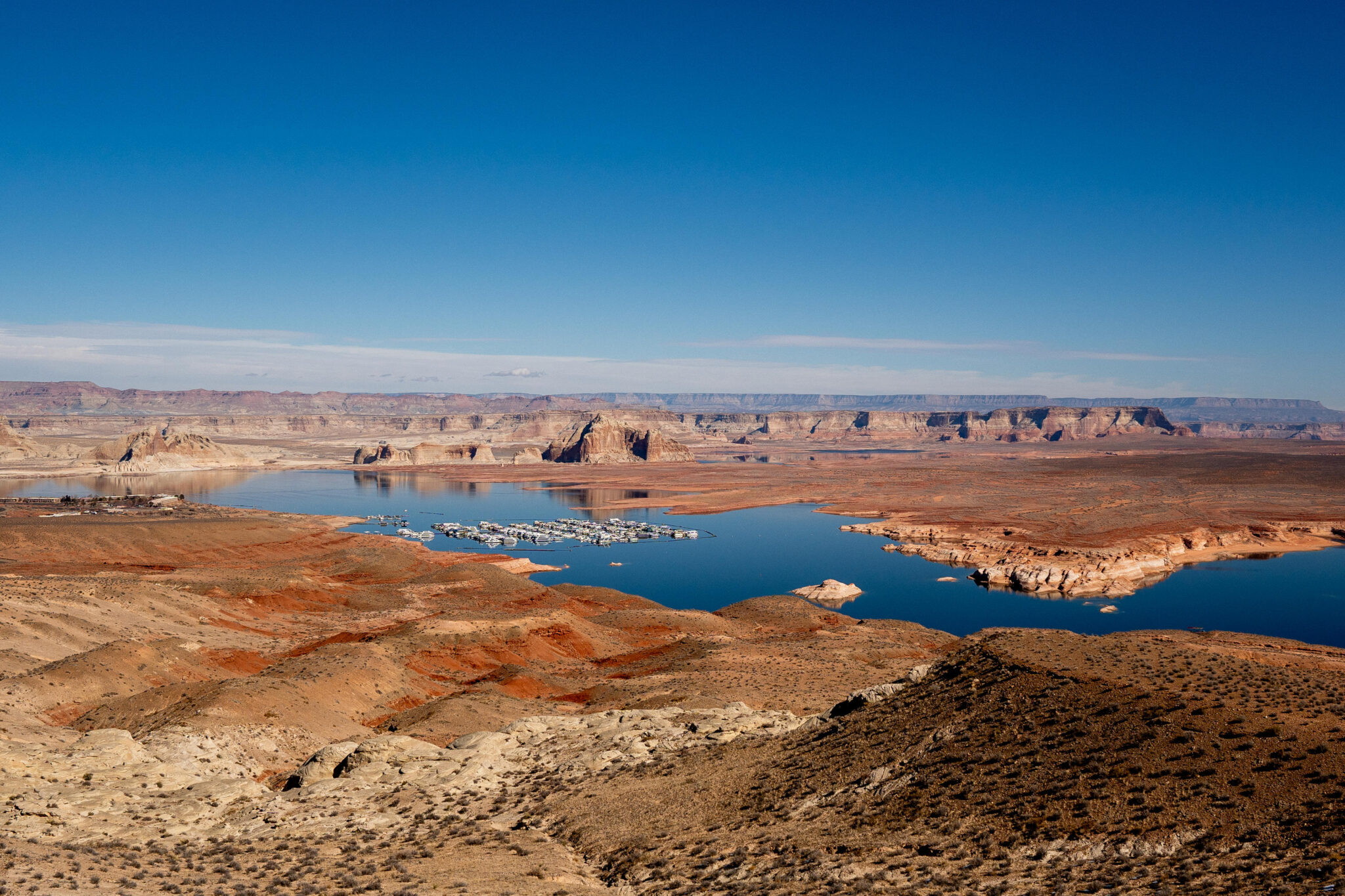
Glen Canyon Dam and Lake Powell were supposed to make things easier by acting as an Upper Basin savings account that could be drawn from during dry years. But withdrawals have greatly exceeded deposits more often than not in recent decades, leaving Lake Powell at about one-third of its full storage capacity and bringing its surface level critically close to hitting minimum power pool, the point at which water can no longer be released through the hydroelectric turbines.
When this happens — possibly as early as this fall, according to current federal forecasts — the dam will stop generating hydropower for Southwestern utilities. It will also force all releases to go through the outlets lower in the dam, which were not engineered for such sustained use. This would compromise the outlets and possibly the dam itself, and Bureau of Reclamation engineers have strongly warned against it, meaning that minimum power pool becomes the de facto deadpool.
If current climate trends continue, the only way to avoid reaching minimum power pool — aside from re-engineering the dam on a very short timeframe — is either to substantially increase flows into Lake Powell by curtailing Upper Basin water use and draining upstream reservoirs, or else significantly reduce releases from Glen Canyon Dam, forcing the Lower Basin — and the river through the Grand Canyon and its endangered native fish — to take major cuts.
On a day in late May [2022] when wildfire smoke obscured the throat of an ancient volcano called Shiprock in the distance, I visited the Ute Mountain Ute farming and ranching operation in the southwestern corner of Colorado. Photo credit: Allen Best/Big Pivots
The solution is simple; consensus is not
In 2022, the Interior Department told the seven states to broker a plan to balance demand with diminishing supplies by cutting overall consumptive use by 2 million to 4 million acre-feet per year. So far, however, the states have failed to reach consensus.
The Lower Basin states, which have maxed out their allotment and then some, have taken some cuts already and have agreed to accept more, if the Upper Basin agrees to mandatory, verifiable cuts of its own. Meanwhile, the Lower Basin wants to see some version of the non-depletion provision remain in place.
Upper Basin negotiators argue that they haven’t even come close to using all of the water they’re entitled to, and besides, they don’t use nearly as much as the Lower Basin does anyway. So why should they be forced to reduce even more? Furthermore, Upper Basin water users, especially those with junior water rights, are already struggling with drastic reductions during dry years because the region lacks large reservoirs for storing water, meaning their water use is dictated by the rivers’ flows. In 2021, for example, many southwestern Colorado farms had their ditches cut off as early as June, forcing them to sit the season out, while the Ute Mountain Ute Tribe received only about 10% of its allocation.
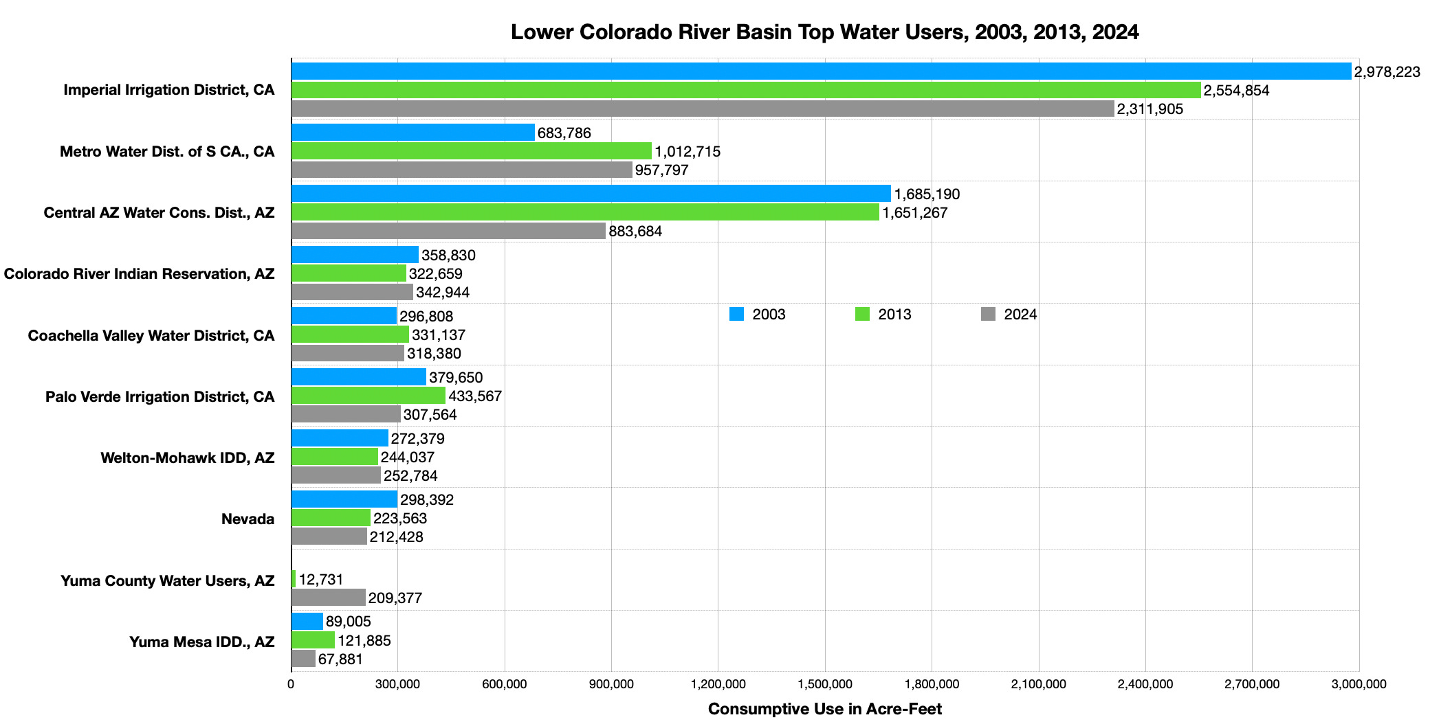
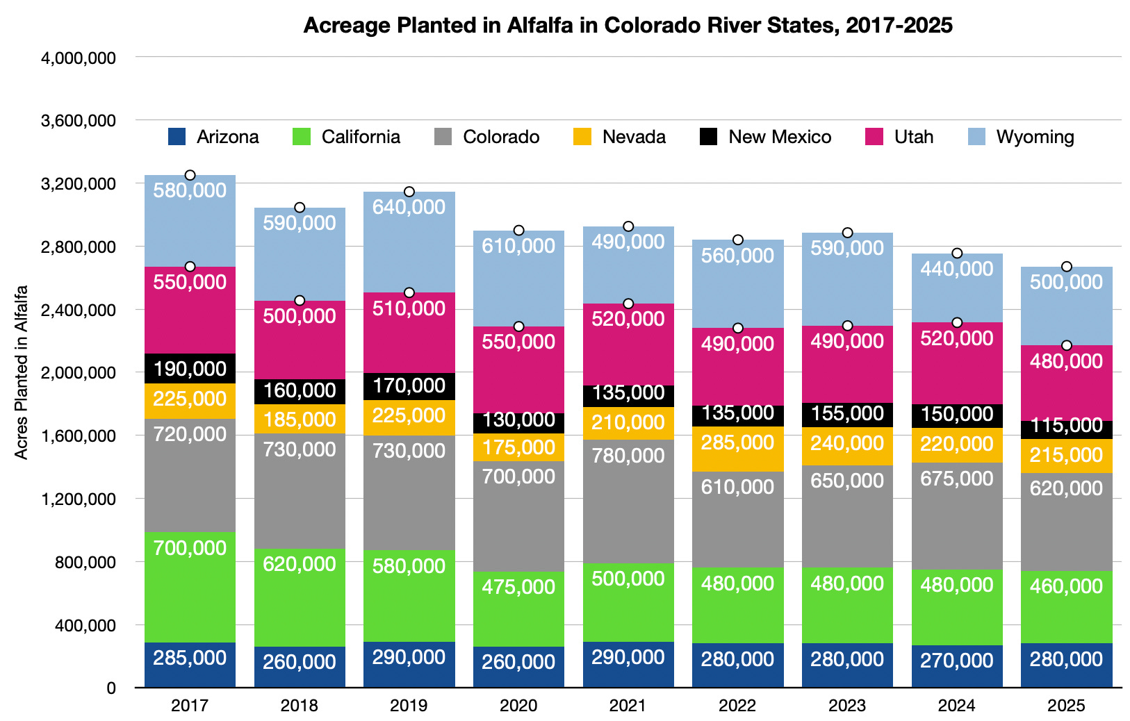
It’s also simpler logistically to reduce consumption in the Lower Basin, where huge water users are served by a handful of very large diversions, such as the Central Arizona Project canal, which carries water to Phoenix and Tucson; the All-American Canal, which serves the Imperial Irrigation District (and its gigantic alfalfa fields) — the largest single water user on the entire river — and the California Aqueduct, which serves Los Angeles and other cities, all of which are fed by Lake Mead and other reservoirs. The Upper Basin, on the other hand, pulls water from the river and its tributaries via hundreds of much smaller diversions. Achieving meaningful cuts would require shutting off thousands of irrigation ditches to thousands of small water users under uncertain authority.
The Upper Basin negotiators have suggested a “supply driven” plan that would base releases from Lake Powell on the amount of water in the river and the reservoir, thereby honoring the spirit — if not the actual figures — of the Colorado River Compact. While Lower Basin negotiators have expressed interest in the idea, the two sides have yet to agree on details, such as the percentage of flows that would be released or whether a non-depletion minimum-flow requirement would remain in place.
Deadpool doesn’t care about deals or deadlines
In the end, the river basin’s climate and hydrology are likely to decide the issue. As Lake Powell inevitably sinks this summer, the BuRec will probably drain upstream reservoirs — Flaming Gorge, Blue Mesa and Navajo — to delay its decline. But when the reservoir drops to minimum power pool, dam operators must decide whether to release water through the river outlets and hope they don’t fail, or else shift Glen Canyon Dam to a “run-of-the-river” operation, which would keep the reservoir level from falling further by making releases equal to reservoir inflows minus evaporation and seepage. The relatively scant outflows from the dam would cause Lake Mead’s levels to plummet, forcing the Lower Basin states to accept potentially calamitous cuts. The Central Arizona Project, one of the basin’s most junior rights holders, would almost certainly lose some of its water, imperiling all the cities and farms that rely on it.
If the diminished releases were to persist for several months or more, it would likely put the Upper Basin in violation of the non-depletion clause, triggering litigation from downstream users, and throwing the entire watershed back in time to the anxious and combative pre-compact days.
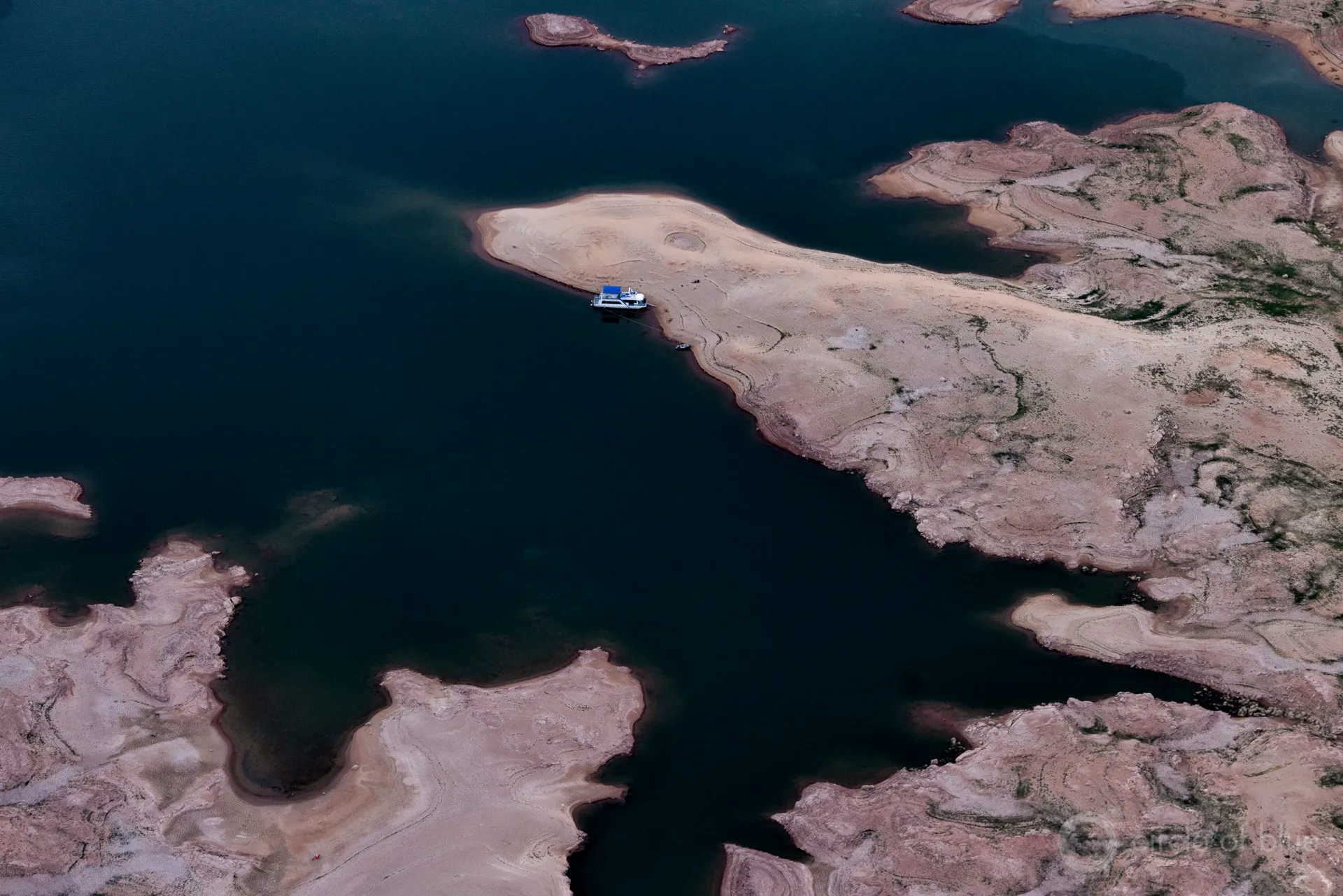
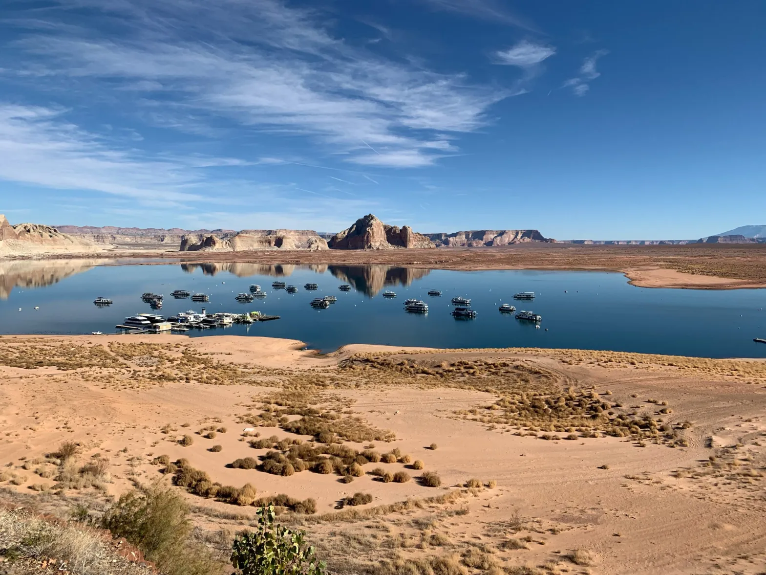
The end of a boat ramp in Antelope Canyon was high above the water of Lake Powell in May 2022, Photo/Allen Best
I used to wonder why folks worried so about Colorado’s water running downstream to California, as if letting it go were some sort of sin. I can understand not wanting to lose the water that originates in your state, but to prefer wasting it or locking it up in reservoirs to sharing it didn’t seem right. After all, every drop that Colorado sends to California and Arizona is another drop that stays in the river for that much longer, benefiting fish and the other critters and boaters that rely on its waters.
I suspect that the most egregious flaw of the Colorado River Compact wasn’t that it overestimated the amount of water in the river, but that it pitted one group of states, tribes and other water users against another, rather than creating a framework in which they could all work together for the benefit of the entire watershed. Maybe it’s time to scrap the compact altogether and, while we’re at it, do away with the whole prior appropriations doctrine on the Colorado River — starting over again from scratch, in other words.
After all, as the climate keeps getting warmer and drier, there will be less and less water to argue about. If there’s nothing left to send downstream, the Colorado River Compact will soon be worth less than the paper it’s printed on.
The Colorado River Compact, signed in 1922. Public domain
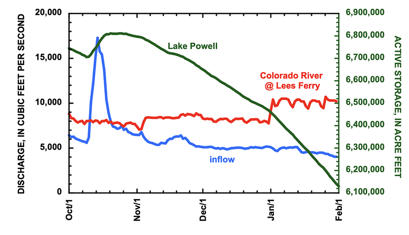
Officials at the Bureau of Reclamation, the federal agency that manages Colorado River dams, outlined several actions they are considering in the coming months to boost water levels in a rapidly shrinking Lake Powell, which could drop to a record low later this year that would halt hydropower production from Glen Canyon Dam for the first time.
The Colorado River’s second-largest reservoir behind Lake Mead is entering one of the most difficult periods in its six-decade history. The basin is drying due to a warming climate. Powell is just a quarter full, and projected to drop lower this year. Winter has been a dud, with warm temperatures and a historically bad snowpack in the Colorado mountains that feed into the reservoir.
Decisions in the next three months about how much water to release from Powell and how much to hold back will reverberate across the basin, affecting hydropower production, legal obligations, watershed ecology, threatened species, and millions of people who use its water and energy.
“Things are happening in parallel and not in sequence,” said Wayne Pullan, Reclamation’s Upper Colorado Basin regional director. “We’re going to be doing everything all at once.”
Pullan and other Reclamation officials discussed their options during a meeting Wednesday of the Glen Canyon Dam Adaptive Management Work Group, an expert committee that advises on the dam’s ecological impacts.
The back of Glen Canyon Dam circa 1964, not long after the reservoir had begun filling up. Here the water level is above dead pool, meaning water can be released via the river outlets, but it is below minimum power pool, so water cannot yet enter the penstocks to generate electricity. Bureau of Reclamation photo. Annotations: Jonathan P. Thompson
The number that federal officials are paying attention to is 3,490 feet. Below that point, Glen Canyon Dam cannot produce hydropower. Powell would be too low for water to flow through the power-generating turbines.
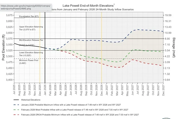
A 2024 decision allows Reclamation to “consider all tools that are available” to keep Powell from dropping below 3,500 feet, an elevation that provides a little wiggle room for maintaining hydropower production. Powell today sits at 3,531 feet.
“I think it’s safe for us to assume that unless Mother Nature is uncharacteristically generous, that Lake Powell elevations are going to fluctuate at elevations that we’re not comfortable with,” Pullan said.
The tool from the 2024 decision is Section 6(E), which grants Reclamation the authority to restrict water releases from Powell to as low as 6 million acre-feet. The planned released this year is 7.48 million acre-feet, so the Section 6(E) authority represents a potential 20 percent reduction.
A cut of that magnitude might not be necessary because Reclamation has another tool it can use in tandem.
That option is releasing more water from Flaming Gorge and other smaller reservoirs located higher in the watershed. This is called a DROA release after its authorizing document. Pullan said this action, which states in the lower basin are advocating for, is being discussed and the volume of those releases would be determined in the spring, around April or May.
“It’s important to remember that this is all in flux,” Pullan said. “This cake is being mixed and isn’t baked in any way yet.”
A previous DROA release in 2022-23 moved 463,000 acre-feet from Flaming Gorge into Lake Powell. Flaming Gorge today is 82 percent full, holding almost 3 million acre-feet.
Note the dotted red line. If says that it’s possible that power production at Glen Canyon Dam could end by August.
Reclamation’s current projections show Powell dropping below hydropower production level by December, in an average water supply scenario. If snowpack and runoff continue to run below average, then that threshold could be breached, barring interventions, in August.
Katrina Grantz, Reclamation’s deputy regional director, said that in the most probable water supply scenario the agency has the tools to be able to keep Powell above 3,500 feet over the next 12 months. But it is still analyzing how and when to deploy them.
“Reclamation is working on various scenarios of how this could play out,” Grantz said.
There are other considerations in the mix. Powell is the source of cold-water releases to help native fish. The water this year could be record warm. Powell is also the source of high-volume flows to move sediment that rebuilds Grand Canyon beaches and steadier flows that assist aquatic insects. Releases have implications for boating and recreation, too.
A shrinking Lake Powell has implications for water supply, recreation, fisheries, hydropower generation, watershed ecology, and legal requirements. Photo J. Carl Ganter/Circle of Blue
The basin’s abysmal hydrology coincides with deep political and legal uncertainty. Current reservoir management guidelines expire at the end of the year, and the seven basin states have not been able to agree on their replacement. Reclamation instead is forging its own path, aiming to finalize a decision this summer.
Reduced releases from Powell could also cause the four upper basin states – Colorado, New Mexico, Utah, and Wyoming – to violate the Colorado River Compact, which requires a certain volume of water to move downstream. This requirement and its legal ramifications are not clear and could be litigated.
It all amounts to an unsettling time for those working in the basin.
“We have to work with the resources we have,” Pullan said. “Wishing will not make things so.”
Map of the Colorado River drainage basin, created using USGS data. By Shannon1 Creative Commons Attribution-Share Alike 4.0
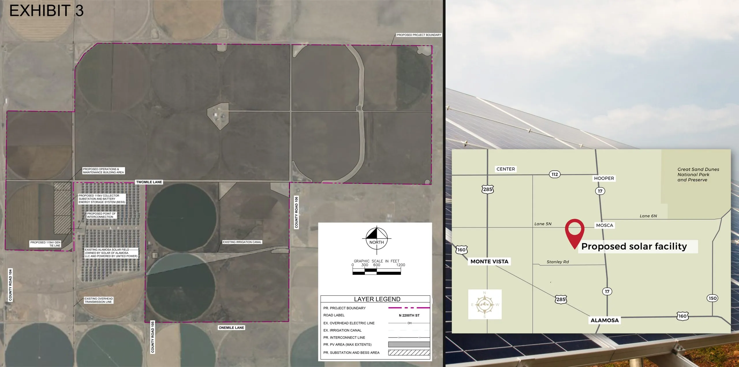
Spud Valley Energy Center’ would be built on 2,578 acres near Mosca and Hooper; it would ultimately develop 600 megawatts of solar energy and 600 megawatts of battery storage.
‘Spud Valley Energy Center’ would be the largest ever conceived for the Valley, and one of Colorado’s biggest solar projects, at a time when ag producers are being forced to reduce their footprint to save on the water
It is an agricultural corridor in Alamosa County that is drying faster and seeing more buy-and-dry deals than other parts of the San Luis Valley due to the scarcity of water from the Upper Rio Grande Basin.
On 2,578 acres of private land off State Highway 17 leading into Mosca and Hooper, a number of families are entering into contracts with NextEra Energy and its bid to ultimately develop 600 megawatts of solar energy and 600 megawatts of battery storage on the fields that once grew crops.
The solar project, dubbed the “Spud Valley Energy Center,” is the largest ever conceived for the Valley and one of Colorado’s biggest. It comes at a time when ag producers in Subdistrict 1 of the Rio Grande Water Conservation District are being forced to reduce their footprint to save on the water. Solar development then, in a Valley plentiful with sunshine, becomes an alternative for the land and a company like NextEra Energy has the means to make it happen.
“A number of the landowners we’re working with have already either retired their wells or they’re participating in CREP (Conservation Reserve Enhancement Program) to rest their lands for longterm,” said Evan Reimondo, the project manager, in an interview with Alamosa Citizen.
Spud Valley is perfectly sited when you consider the other solar development already in the corridor, the Public Service Co. substation near the project site, the water conservation subdistrict it is in, and Alamosa County’s own interests for solar development through its 1041 permit process.
A different solar development proposal — Korsail Energy’s Cornflower Solar project — had its permit application denied by the county commissioners last year after it met a headwind of resistance from locals concerned about the location of the project that was within a migratory range of sensitive wildlife areas in west Alamosa County.
Korsail was seeking to build 90 megawatts of solar and 80 megawatts of battery storage on 986 acres, but was doomed because of the location it selected. NextEra Energy’s Spud Valley doesn’t seem to carry that burden with its location, and at 600 megawatts puts the Valley on the map for solar generation to support Colorado’s goal of a state power grid built on 80 percent renewable energy by 2030.
“Colorado’s demand for electricity is going to keep growing as the population grows and technology develops and all of those things,” said Reimondo, Spud Valley’s project manager. “So we’re preparing for the future when we over-permit. By permitting for 600, it gives us that future flexibility.”
The plan is to build an initial 200 megawatts of solar and 200 megawatts of battery storage, and then stage to 600 megawatts of each from there. The transmission bottleneck — bringing power in and out of San Luis Valley — presents the biggest challenge.
“As the grid is built out, as network upgrades are completed in the future, new (transmission) lines are built, and we’ll be ready to take advantage of that,” Reimondo says.
Alamosa County is currently reviewing NextEra Energy’s 1041 permit application and eventually will hold public hearings at the county planning level and then before the county commissioners.
Reimondo says the company hopes to begin construction in 2027, with the first 200 megawatts of solar and battery storage built and tied into the neighboring Public Service Co. substation by the end of 2029.
EPA asks federal court to pause part of its regulations for PFAS in drinking water.
EPA also says it will uphold Biden-era lead pipe replacement requirements.
DOE once again orders a Michigan coal plant to continue operating.
Congress will hold hearings this week on safe drinking water, water-related legislation, and an Army Corps authorization bill.
U.S. Supreme Court will hold oral arguments this week for the Line 5 oil pipeline case.
EPA seeks comments on ways to reduce regulatory burden for hazardous substance spill response plans.
FEMA continues to be slow in approving disaster declarations in Democratic-led states.
And lastly, the White House promotes domestic phosphorus mining and glyphosate production by conferring “immunity” under the Defense Production Act.
“Consistent with these findings, I find that ensuring robust domestic elemental phosphorus mining and United States-based production of glyphosate-based herbicides is central to American economic and national security. Without immediate Federal action, the United States remains inadequately equipped and vulnerable.” – President Trump’s executive order that grants these activities (phosphorus mining and glyphosate production) immunity from “damages or penalties” for any activity related to the order. The underlying law is the Defense Production Act. Phosphorus and glyphosate are foundational elements of modern American agribusiness. They are in fertilizer and the weedkiller Roundup. But they are also primary water pollutants that contribute to harmful algal blooms or are linked to cancer and other illnesses.
EPA PFAS Lawsuit The EPA is continuing to make its case in court that the agency’s Biden-era regulation of four PFAS in drinking water should be paused while it works on a new regulation that would officially rescind them, Bloomberg Law reports.
Two of the regulated chemicals – PFOA and PFOS – have standard numerical limits. The four others – PFNA, PFHxS, PFBS, and GenX – would also be regulated as a group, using what’s known as a “hazard index.” This is the first time the agency has used such an approach for drinking water regulation.
The court in January rejected the EPA’s request to vacate the hazard index component. The agency now wants to separate the hazard index from the rest of the litigation.
Two water utility groups – the American Water Works Association and Association of Metropolitan Water Agencies – filed the lawsuit in June 2024 in the U.S. Court of Appeals for the D.C. Circuit.
In the court filing, the agency says that it has drafted a notice of rulemaking to rescind the hazard index and plans to “commence the rulemaking process imminently.”
Lead Pipe Replacement In a separate lawsuit, the EPA said it would uphold the Biden administration’s 10-year timeline for most cities to replace lead drinking water pipes, the Associated Press reports.
The lawsuit challenging the timeline was also brought by the American Water Works Association, which argued that it was not feasible.
Michigan Coal Plant Operating Order Extended The Department of Energy once again extended the life of a Michigan coal-fired power plant.
This is the fourth 90-day order to keep the J.H. Campbell Generating Plant operating. The DOE argues that closing the plant is a threat to grid reliability. It is also costing Consumers Energy, the plant owner, a lot of money – at least $80 million through last September. The company will likely recover costs through customer rate increases or surcharges.
Consumers intended to shut down the plant in May 2025.
The EPA, at the prompting of regulated facilities, is considering changing federal requirements for hazardous substance spill plans, which are authorized under the Clean Water Act to guide emergency response in case a large volume of toxic chemicals is released into waterways.
The requirements in questions were established in 2024 during the Biden administration and apply to onshore non-transportation facilities – things like chemical manufacturers, oil and gas operators, gas stations, hospitals.
The agency is seeking comment on whether it should simplify the rules for determining which facilities are required to file response plans. Public comments are due March 20 and can be submitted via www.regulations.gov using docket number EPA-HQ-OLEM-2025-1707.
Studies and Reports
Disaster Declarations and Approvals FEMA approved a disaster declaration for Louisiana, which the state requested on February 5 following a late-January storm. And it approved a declaration for a Washington, D.C. sewer line that collapsed on January 19.
The federal disaster agency, meanwhile, has rejected or has been slow to approve requests from Democratic-run states. FEMA has not acted on Washington state’s January 21 request.
Arizona and Illinois are appealing requests from last fall that were rejected. Colorado is appealing two requests from January 16 that were denied.
Chinook Salmon Decision The National Marine Fisheries Service decided against listing the Washington coast segment of Chinook salmon as endangered or threatened, saying the population faces low extinction risk.
This is the result of the agency’s 12-month review, an in-depth assessment of the threats to a species. In response to a petition from the Center for Biological Diversity, the agency had made a preliminary, 90-day decision during the Biden administration that listing the species may be necessary.
Washington coast Chinook salmon spawn north of the Columbia River and west of the Elwha River, a geography that includes the Olympic peninsula.
On the Radar
Line 5 in the U.S. Supreme Court On February 24, the nation’s high court will hear oral arguments in a case involving the controversial Line 5 oil pipeline that crosses the Straits of Mackinac between lakes Huron and Michigan.
The case centers on a jurisdictional matter: should the lawsuit seeking to shut down the 73-year-old pipeline be heard in state or federal court?
Dana Nessel, the Michigan attorney general, filed the case in state court in 2019 alleging that Enbridge’s continued operation of the pipeline violated state law.
Colorado River DEIS Comments Due The Bureau of Reclamation is accepting public comments through March 2 on its draft plan for managing the Colorado River reservoirs after current rules expire at the end of the year.
Also on February 24, a Senate Energy and Natural Resources subcommittee will discuss 18 water-related bills, including rural water supply systems, snow water forecasting, and water recycling.
There are two hearings this week on the next Water Resources Development Act, the legislation that authorizes Army Corps projects for dams, levees, ports, and ecosystem restoration.
The action starts on February 24 with a House Transportation and Infrastructure subcommittee. The head of the Army Corps will testify, as will the chief of engineers.
Then on February 25, the Senate Committee on Environment and Public Works holds its own hearing.
Federal Water Tap is a weekly digest spotting trends in U.S. government water policy. To get more water news, follow Circle of Blue on Twitter and sign up for our newsletter.
Udall/Overpeck 4-panel Figure Colorado River temperature/precipitation/natural flows with trend. Lake Mead and Lake Powell storage. Updated through Water Year 2025. Note the tiny points on the annual data so that you can flyspeck the individual years. Credit: Brad Udall
Click the link to read the article on the AZCentral website (Brandon Loomis). Here’s an excerpt:
February 23, 2026
Key Points
A coalition of cities and water providers, led by the Central Arizona Project, has launched a media campaign targeting proposed Colorado River cuts.
The campaign includes a TV ad that claims Arizona “is being unfairly targeted” by some water management alternatives outlined in a federal document.
After the seven Colorado River states failed to reach an agreement on shortage sharing, the federal government turned to its own set of proposals.
A Central Arizona Project-backed advocacy group called the Coalition for Protecting Arizona’s Lifeline has begun rolling out television ads and online videos defending the water supplier’s rights to a Colorado River that is under serious hydrological and political strain.
“Arizona is being unfairly targeted for reductions of Colorado River water that would cripple our state, flatten our economy and weaken our nation’s defense,” an ad aired by the coalition warns. It goes on to note that Arizona communities have done their part, committing more water for conservation in Lake Mead than those in other states, and that several options that the federal government is weighing for managing the river would fall hardest on the state.
One such alternative under review, CAP General Manager Brenda Burman recently said, would essentially dry up the agency’s canal from the river to Phoenix and Tucson…The alternatives Burman was referring to were never stated as the Trump administration’s preference, but rather as ideas from which the seven states that share the river water might draw from in writing an agreement for sharing in its worsening shortages. Now that the states have failed to reach such an agreement, though, the U.S. Bureau of Reclamation is faced with either enacting something like them or rapidly developing a new federal plan in time to replace river guidelines that expire this autumn…While the materials don’t directly state members’ intended method of securing water, some of the videos lean heavily on the so-called Law of the River and its guarantee of water from the four headwaters states to Arizona, California and Nevada. This theme reiterates a point that CAP and Arizona water officials have stressed over the last year or so, that if push comes to shove in a legal battle, they have the 1922 Colorado River Compact on their side.
“The Lower Basin has paper water, uses wet water, and wants the Upper Basin to deliver ghost water” — Kevin Pilgrim
Water levels were low at Lake Powell’s Wahweep Marina in November 2021. Recent worst-case projections from the U.S. Bureau of Reclamation show the reservoir declining below power pool by July. CREDIT: HEATHER SACKETT/ASPEN JOURNALISM
The Colorado River crisis is no longer part of some hypothetical future — it’s here.
Fueled by one of the worst snowpacks on record, the “most probable” February projection from the U.S. Bureau of Reclamation estimates 5 million acre-feet flowing into Lake Powell this year, which is 52% of average. A more grim estimate puts that number at just 3.5 million acre-feet, or 37% of average.
Forecasts show the nation’s second-largest reservoir could fall below the minimum level needed to make hydropower at Glen Canyon Dam as soon as July under the worst-case scenario, or by December under the “most probable” forecast. Reservoir levels are projected to fall to their lowest elevation on record in March 2027, threatening the water supply for millions in the Southwest.
But the increasingly dire projections, this winter’s historically bad snowpack and the growing gap between supply and demand haven’t yet pushed the seven states that share the river to come to an agreement on its future management.
Last week, state negotiators blew past a second federally set deadline to find a consensus plan on how to share shortages and manage Lake Powell and Lake Mead after the current guidelines expire at the end of the year. They have been stuck at an impasse for two years.
The need for a new management paradigm that adapts to a shrinking water supply has never been more urgent. So why isn’t the crisis forcing a deal?
“We’re at a moment where we really need something different that responds to our current hydrology, our current demands, and we’re not seeing a development of that kind,” said Elizabeth Koebele, a professor of political science and associate director of the graduate program of hydrologic sciences at the University of Nevada, Reno. “You’d think that all of these signals would be pointing to the fact that we really need to do something different, but we’re not.”
Anne Castle, a former federal representative to the Upper Colorado River Commission and a Colorado River expert, co-authored a paper in 2021 that said successful negotiations of new Colorado River agreements tend to be triggered by very dry conditions, and that federal directives and deadlines also play an important role. But the current stalemate amid worsening drought throws those findings into question.
“Our premise was that a crisis in terms of water supply and reservoir levels and snowpack and expected runoff can prompt creative compromise,” Castle said. “But we have all those underlying conditions, and we don’t have a compromise.”
The scale of the problem could be part of what’s making consensus difficult between the Upper Basin (Colorado, New Mexico, Utah and Wyoming) and the Lower Basin (California, Arizona and Nevada). As a junior water user on the river, the Central Arizona Project, which supplies the metro Phoenix and Tucson areas, could face the deepest cuts.
“I think if this had been a 2 million-acre-foot problem, the states probably could have solved it, but it’s potentially a 4 million-acre-foot problem,” said Kathryn Sorensen, a researcher and professor at Arizona State University’s Kyl Center for Water Policy. “There’s so little water to go around that positions have become hardened as a result. We’re not just talking about inconvenient cuts; we’re talking about severe pain to economies at this point.”
Federal involvement
Some of the normal levers that have been pulled to force action in the past — such as directives and deadlines from the federal government — don’t seem to be effective in the current situation. There have been no apparent consequences for the states missing both the Feb. 14 deadline and an initial Nov. 11 deadline set by the feds for the states to present the outline of an agreement.
The seven state negotiators and their governors were summoned to Washington, D.C., the last week of January for a meeting with Department of Interior officials. That, too, failed to result in a deal.
In a Feb. 14 news release, Interior Secretary Doug Burgum thanked the governors for their engagement and said a fair compromise with shared responsibility remains within reach.
Koebele said when the states were hashing out the 2007 guidelines, which currently govern the river and are just months from expiring, the threat of federal action was part of what spurred the states to come up with a plan.
“There’s a little bit less of this idea of a single or central federal leader in the negotiation process,” Koebele said. “And they’re also still saying, ‘Hey, states, please come up with your own option too.’ I’m not really sure how credible threats are from the federal government when we’re in this sort of context.”
Reclamation has presented five options for managing the river, but although the federal government owns and operates the infrastructure such as dams and reservoirs, it doesn’t have the authority to implement all of the actions outlined in the options. The new, innovative and collaborative actions would need an agreement among the states.
Absent that, federal officials believe the only tools at their disposal, which allocate cuts based on prior appropriation and existing water law, could see Arizona take up to 77% of total shortages, yet they “may not provide adequate protection of critical infrastructure or the system and may be viable only in the short term given current reservoir conditions,” according the bureau.
The federal management options are part of a draft environmental impact statement, which is required as part of the National Environmental Policy Act review for new guidelines. This process is moving forward on a separate, parallel track to negotiations among the states. If the states agree on a plan, it could be plugged into the EIS and become the “preferred alternative.”
“We’re sort of at a key moment for those two processes coming together,” Koebele said. “But the EIS and the state negotiations are not really intersecting in a way that we have seen them intersect in the past or that we hoped they would.”
Federal officials are accepting comments on the draft EIS until March 2.
Lake Pleasant, seen in April 2025, is a storage bucket for Colorado River water and is part of the Central Arizona Project that delivers water to the Phoenix and Tucson areas. According to one river management option from the federal government, Arizona would take the majority of shortages in dry years. CREDIT: HEATHER SACKETT/ASPEN JOURNALISM
Blame to go around
In a series of news releases on February 13, 2026Upper Basin and Lower Basin officials blamed each other for the continuing standoff.
“We’re being asked to solve a problem we didn’t create with water we don’t have,” Colorado’s representative, Becky Mitchell, said in a prepared statement. “The Upper Division’s approach is aligned with hydrologic reality, and we’re ready to move forward.”
The crux of the issue is who should take shortages in drought years. The Lower Basin has committed to 1.5 million acre-feet of reductions annually and wants cuts beyond that to be shared by the Upper Basin. The Upper Basin says their water users already take cuts in some years because streams run dry by midsummer and any contributions they make through conservation must be voluntary.
Water managers upstream of Lee’s Ferry would note that they were promised an equal amount of water as the Lower Basin was in the 1922 Colorado River Compact, although they use about 4 million acre-feet a year, while the Lower Basin — whose flows are backed up by releases from the country’s two largest reservoirs — regularly uses all of the annual 7.5 million acre-feet to which it’s entitled. The Lower Basin’s position points to its larger population and economic output, and that their water users, already subject to mandatory cutbacks, tend to be more aggressive in their conservation measures.
“It’s the fundamental disagreement that we’ve had for the past many years,” Castle said. “The Upper Basin doesn’t want to agree to any enforceable reductions in use. And that is something that the Lower Basin, and Arizona in particular, don’t feel like they can live with.”
The states appeared to be on the verge of a breakthrough last summer, when representatives from both basins indicated a willingness to consider a supply-driven approach, where reservoir releases are more directly tied to the natural flow of the river. But hashing out the details is complicated, and a plan that all parties can agree to has yet to emerge.
Note the dotted red line. If says that it’s possible that power production at Glen Canyon Dam could end by August.
A new management plan would need to be in place by the start of the new water year on Oct. 1. And if the states can’t reach an agreement by then, the federal government will impose its own management rules, doling out cutbacks that could trigger lawsuits from the states but would not go far enough to prevent the system from crashing.
Even if the states come to an eleventh-hour agreement, federal action will be needed in the immediate future to protect levels at Lake Powell and the ability to produce hydropower. The dire projections showing Powell dropping below minimum power pool assume that the feds would release 7.48 million acre-feet from Powell this year, but under a short-term agreement that also expires at the end of the year, they could reduce releases down to as little as 6 million acre-feet. The Bureau of Reclamation is also holding back about 600,000 acre-feet in Lake Powell through April, which will be released later in the year.
The last time Lake Powell was projected to drop below system-critical thresholds after the 2021 spring runoff, Reclamation conducted emergency releases from upstream reservoirs. The chance that the bureau will again release additional water from those federally controlled reservoirs — Flaming Gorge, Blue Mesa and Navajo — to boost Powell in the coming months is “about 100%,” according to Colorado River expert and author Eric Kuhn.
“Just how much is going to be up in the air, but right now, it looks like they need a million to a million-and-a-half acre-feet based on the current projections,” Kuhn said.
John Fleck, an author, writer and University of New Mexico professor, was the co-author with Castle on the 2021 paper, titled “Green Light for Adaptive Policies on the Colorado River.” He said that in previous negotiations, state representatives not only had a sense of responsibility to protect water for their own communities, but were also looking out for the health of the entire interconnected basin.
“What we have seen in the last few years is a shift to a leadership that is made up of people who are solely looking out for the interests of their own community,” Fleck said.
Experts say the Colorado River needs a new and different management plan that responds to dwindling flows, rebuilds reservoir storage and creates a resilient system in the face of climate change. The current leadership is failing to provide that, Fleck said. The solution is a shift in mindset for water managers to start playing not for the Upper Basin or Lower Basin, but for Team Colorado River Basin, he said.
“There’s a moral question involving the obligations we have to one another in shared river basins,” Fleck said. “I would not be at all happy to win the litigation and see the Central Arizona Project shut down. I would see that as a failure even though my community’s water supply might be protected.”
Map of the Colorado River drainage basin, created using USGS data. By Shannon1 Creative Commons Attribution-Share Alike 4.0
Glen Canyon downstream from Glen Canyon Dam. Photo credit: Allen Best/Big Pivots
Click the link to read the article on the Big Pivots website (Allen Best):
February 17, 2026
Sitting in the audience at the Colorado Water Congress in January, I was reminded of the days, weeks and months after 9/11. The impulse –– fueled by rage, was to punch back — at somebody, somewhere. The result, as we saw in Afghanistan after 20 years and three presidents, was far from satisfying. Osama bin Laden died, but the Taliban prevailed.
At the conference, a new state legislator from the Western Slope was full of righteous indignation about the Colorado River dispute. Colorado and other upper basin states were right, and those in the lower basin were wrong. We will prevail in court, he insisted. That would be the Supreme Court, where all disputes among states must go. And Colorado, legislators had been told, is preparing for just that possibility.
Much is at stake here. It’s not just ranches on the Western Slope but nearly all the water rights allocated since 1922. Roughly half of water for Front Range cities comes from the Colorado River headwaters and for towns on the eastern plains as far east as Fort Morgan. The mountains towns at the Colorado River headwaters, most of their water rights are post-1922. The list goes on and one.
No wonder Colorado has its fur up.
Speaking later in the morning, Jim Lochhead, a figure prominent in Colorado water affairs since the 1970s, did not disagree with Colorado’s fundamental position.
Colorado insists that Arizona and California, especially, have caused the big reservoirs, Powell and Mead, to decline. The states — together, with Nevada, they constitute the lower basin — have reduced their water use substantially since 2002 — but not in proportion to the declines caused by warming temperatures and declining snowfall. The lower-basin states created the problem of the reservoirs now at perilously low levels. They bear the heaviest burden of refilling reservoirs by simply agreeing to take less water.
Lochhead also warned of inflexibility. “The upper basin cannot bail out the lower basin,” he said. “But (negotiators) have to be given room to compromise.”
“If the negotiators are forced to focus only on protecting what each of them thinks is legally theirs on paper, they can’t work on identifying and building the tools and strategies needed to make sure we can get away from crisis management and secure our future,” he said that January morning in Aurora.
Upper-basin states say that because they are at the headwaters, they have nothing equivalent to Powell and Mead upstream to provide certainty. If it rains and snows, there is water. If not, then water users have less or none. Colorado water officials say some with water rights dating to the 1880s have already had to go without.
My kids and their friends built a small terrain park in front of their house near Sloans Lake after the March 2003 St. Patrick’s Day blizzard.
The year 2002 was seminal. Modest snowfall was followed by an early and unusually warm spring. Peak runoff was barely noticeable. In Denver, a city that gets half its water from the Colorado River headwaters, sprinklers were turned off, green grass turned brown. Aurora, also heavily dependent upon Colorado River water, was within a few months of crisis in 2003 when a miracle occurred –– three feet of snow on St. Patrick’s Day.
Downstream in Arizona and California, far from this drama in the headwaters, life continued with no fear and little change. The upstream reservoirs, Powell and Mead, had water.
We have another dry year, and the Colorado River right now is expected to deliver less than the 3.8 million acre-feet at Lee Ferry, just below Glen Canyon Dam, than it did in 2002. Flows were 17 to 18 million acre-feet in the 1920s, when the Colorado River Compact was created and adopted. The long-term average was less, 14.6 to 15.1 million acre-feet. In this century, it has dipped to 12.1 to 12.5 million acre-feet. Some expect this trend to continue amid the warming and drying now underway in the basin. Might it go below 10 in a few more decades?
The lower basin until relatively recently used 10 to 11 million acre-feet. As for the upper basin, states — Wyoming, Utah and New Mexico, in addition to Colorado —they have used 3.5 to 4.5 million acre-feet. It depends upon whether it snows.
The end of a boat ramp in Antelope Canyon was high above the water of Lake Powell in May 2022, and water levels have dropped more now. Photo/Allen Best
“Everyone knows Lake Powell is now in a dire situation,” said Lochhead in a panel after the state legislators had left. “We have gone from 86% full to I think around 25% full today. Powell is in danger of being over a million acre-feet below deadpool next year. That should scare all of us.”
Deadpool is when the water level in a dam-created reservoir drops so low that water cannot be released and used for drinking, irrigation and power. In the last several years, at least one book, Zak Podmore’s Life After Dead Pool, has been written about the Colorado River with that threshold in mind. Other books and thousands and thousands of newspaper, magazine and website postings have mentioned it.
The back of Glen Canyon Dam circa 1964, not long after the reservoir had begun filling up. Here the water level is above dead pool, meaning water can be released via the river outlets, but it is below minimum power pool, so water cannot yet enter the penstocks to generate electricity. Bureau of Reclamation photo. Annotations: Jonathan P. Thompson
Lochhead warned against hardened positions that put the Colorado River problems in front of the Supreme Court. Colorado has not fared well in water cases there the last 100-plus years.
For several decades, Lochhead was a water attorney for Holland and Hart, working from an office across from the post office in Glenwood Springs. It was a good place to raise a family of skiers, he once told this writer.
During that time on the Western Slope, Lochhead represented Colorado on Colorado River affairs in several capacities. Then, from 2010 until 2023, he was CEO of Denver Water, the state’s largest water utility. In the last few years, his life has been lower profile. But, as his remarks at the Water Congress demonstrated, he is still paying close attention.
Litigation in the Colorado River Basin, said Lochhead, is a “worst-case scenario, resulting in economic and political disruption and uncertainty no matter the outcome.” This message, he said, would be the same whether given to audiences in Arizona or Colorado.
“There are tens of millions of dollars of taxpayer dollars that will be spent on litigation over a 10- or 20-year period, and the outcomes will be uncertain. The upper basin has a lot of good arguments, and so does the lower basin.”
Colorado appeared before the Supreme Court in 1907. It claimed full use of the Arkansas River. The Supreme Court disagreed.
Delphus Carpenter. Picture courtesy Colorado State University library
In 1922, Colorado lost to Wyoming in a case involving the North Platte River. Colorado has insisted upon prerogatives because it was the source of the water. That defeat caused Colorado’s lead negotiator, Delph Carpenter, to conclude it must shelve the idea that being at the headwaters would trump the claims of downstream states on the Colorado River. Carpenter became the most important figure in crafting the Colorado River Compact of 1922.
“But of course, litigation under the compacts continued, and Colorado was ordered to pay some $34 million to Kansas in 2001 and to dry up Bonnie Reservoir and undertake the process of drying up 25,000 acres of farmland in the Republican River Basin,” Lochhead continued.
The headwaters of Whiskey Creek, between Minturn and Avon, in the Eagle River Valley, had plentiful snow in the mid-1990s. Photo/Allen Best
Lochhead described several layers of complexities.
“This isn’t litigation just between two or three states. This is litigation between four states that have a common obligation under the compact (the Upper Basin) versus three other states requiring coordination on strategy, negotiating remedies and settlement between the states,” he said.
Nor is it simple a matter of the two basins, upper and lower, in conflict. The 30 federally recognized tribes in the Colorado River Basin have their interests, and they are not all the same. They also have rights that in most cases supersede those of the states. Public interest groups can have different interests. And, if the federal government makes the decisions about future uses of the Colorado, each and all may “sue the federal government over any unilateral federal action or decision, and that litigation can take all kinds of different forms.”
“Other entities may seek to intervene in the litigation. The United States certainly would, as we have seen in Texas versus New Mexico. But when tribes seek to intervene, if the country of Mexico seeks to intervene — what happens during litigation?”
Mexico, under a 1944 compact, is to get 1.5 million acre-feet annually.
Plus, the three other upper-basin states may disagree with Colorado. Colorado uses by far the most water of the four, as a compact among them reached in 1948 specified. Alone, though, it has pushed that limit.
In other words, going to water war sounds vaguely patriotic. The reality of the courtroom may be less heart-thumping.
Boulder has very good water rights but depends somewhat on imported Colorado River water. Photo/teofilo and Wikimedia Commons
Consider what if Colorado did lose? Here’s where the story gets grim. The Front Range cities, the ski towns, even farmers in the South Platte and Arkansas valleys to the Nebraska and Kansas borders.
Lochhead described the stakes involved, the gamble of letting the black-robed justices in D.C. decide the fates of the seven base states. “Do we find ways to work together across the basin to address the crisis together?”
He asked that question more than two weeks before Valentine’s Day, the deadline set by the Bureau of Reclamation without obvious irony. Without agreement by the seven states about how to share the diminished river, it is now up to the federal government to step in. On Friday, after the states had reported still no break-through, I asked Lochhead by e-mail if his remarks from January were still appropriate. They were, he said.
“It seems as I write this, that — as for the last two years — the states remain stuck in political talking points and the federal government is not applying necessary pressure. And, in the meantime, Lake Powell is headed toward run-of-the-river operations, which precipitates crises on all kinds of different levels,” he replied. “This will lead to the federal government having to make decisions that will severely impact both upper and lower basin economies and the environment, not to mention endless, expensive and risky litigation. This all could have been avoided but here we are.”
“Wow!” said Eric Kuhn, a former general manager of the Colorado River District in Glenwood Springs, in a LinkedIn post over the weekend. “The secretary (of Interior) needs to step up and make some hard decisions!”
Sparking Kuhn’s remarks was a new Bureau of Reclamation report on Friday of probable flows in the next two years. The best of them leaves Powell in bad shape. In fact, the bureau’s “probable” flows have frequently been too optimistic. The dimmer view, called “probable minimum,” sees Powell levels dropping below the elevation needed to produce hydropower as early as August. Minimum power pool is above deadpool.
Note the dotted red line. If says that it’s possible that power production at Glen Canyon Dam could end by August.
From a Colorado perspective, lower-basin states have a sense of entitlement that defies common sense. Whether it defies the law is another matter. Kuhn told me years ago that the key provision in the 1922 compact that can be interpreted in two very different ways.
It says: “The States of the Upper Division will note cause the flow of the river at Lee Ferry to be depleted below an aggregate of 75,000,000 acre feet for any period of ten consecutive years…”
But as to that disagreement: Upper-basin states see this meaning that they have no control over the weather. They did not cause the reduced flows. Hang the weather, says the lower-basin state. The “do not cause” clause means that if only 7.5 million acre-feet is all that is in the river, it all has to flow downstream.
Typo or not, the lower-basin perspective sees this as a cut-and-dried issue. If Denver must go without transmountain diversions or taps in Winter Park or Vail must go dry, so be it. Not their problem.
JB Hamby, California’s representative on Colorado River affairs, articulated exactly that sentiment on Friday. “The 1922 Colorado River Compact requires the Upper Basin to deliver an average of 8.25 million acre-feet annually to the Lower Basin and Mexico,” he said in a statement. “That delivery obligation is fixed in law, even when the river produces less water.”
At the January forum, Amy Ostdiek, who heads the legal team for the Colorado Water Conservation Board in interstate and federal matters, laid out the basic numbers Colorado puts front and center: The 1922 compact laid out a split of roughly 7.5 million acre-feet for each, the lower and upper basins, with the upper basin required to allow another one million acre-feet to flow down river to account for evaporation and losses.
“We have to be honest about what has caused the threat that Lake Powell might not be able to make the releases that the lower-basin states believe they are entitled to. It was directly caused by their overuse of Lake Mead, which drew down Lake Powell to the point it is today,” said Ostdiek.
Again, the upper-basin states insist upon lower-basin states sharing the uncertainty of snow and rain. To rebuild the storages will mean they take less water.
“This is going to be hard for those who are not accustomed to taking less in dry years, but the benefit of reaching a state-state deal is that if we’re able to do that, it provides an opportunity or a gradual and softer landing — and more likely federal dollars for those who need that support as they adapt to this reality.”
The upper basin, though, refuses to budge on the idea that it can develop all 7.5 million acre-feet of water apportioned it by the compact — if the water is there, of course.
In their January remarks, neither Lochhead nor Ostdiek offered thoughts about on-the-ground solutions. Ostdiek pointed to programs in both the upper and lower basin with varying success. In their defense, they only had an hour.
Can the lower-basin negotiators truly misunderstand Colorado’s position? Ken Neubecker, of Glenwood Springs, formerly of environmental groups, thinks so.
“They have been accustomed, some would say addicted, to the reliable delivery of stored water for all their needs since Hoover Dam was built and began releasing stored water some 90 years ago,” he wrote in a post on Substack. “Only until very recently, even in the face of an unrelenting drought, have they had to deal with shortages. For the Upper Basin, shortage is an annual reality.”
Arizona Navy photo via California State University
Rod Proffitt, from Pagosa Springs, (and a board member for Big Pivots) points to Arizona’s history of going to courts to resolve river issues. “They even sent out the National Guard one time” (in a dispute with California),” he observed. And now Arizona, more than any other state, has its back to the wall.
Phoenix had native water, but expansive growth, among the fastest in the nation, has been enabled by imported Colorado River water since the 1990s. Photo/Allen Best
Most instructive, at least as understanding Arizona, may be George Packer’s 25,000-word piece, “What Will Become of American Civilization,” in the July/August 2024 issue of The Atlantic. During the prior year, Packer had spent several weeks or more, winter and summer, primarily in the Phoenix metropolitan region, to analyze its politics and people.
Most perplexing, he found, was the perfervid belief in population and commercial expansion that defies limitations of a climate where a simple fall onto concrete during summer can produce second-degree burns.
Colorado, of course, has its own love of economic expansion. It is dwarfed by Arizona. The latter grew 824% in population from 1950 to 2016 while Colorado grew 318%.
Water is crucial to these expansions, and Arizona has tried to disregard limits. Packer explicitly uses “water” 158 times in his report and implicitly so elsewhere. He started out with a description of the Hohokam Indians and their water infrastructure that can still be seen in Phoenix. He barely mentioned climate change but did use “heat” 32 times. He talks about water for data centers and the suburban sprawl.
“Phoenix makes you keenly aware of human artifice—its ingenuity and its fragility,” he says.
We’ve seen the ingenuity of water delivery systems in the broader Colorado River Basin, a region that extends from Colorado’s borders with Nebraska and Kansas to the Pacific Ocean. We now understand the fragility, and it makes us very, very uncomfortable.
Anything that forces change can bring out our worst, but then sometimes it can bring out our best. Can it get any worse on the Colorado River?
And also:
The five alternatives
The Bureau of Reclamation issued five alternatives in its draft environmental impact statement for how it will operate Glen Canyon Dam. The federal government, said Lochhead, can only implement two of them.
The first two, said Lochhead, are deeply flawed: No action and the second would impose shortages on Arizona and Nevada approaching 7 million acre-feet. Both alternatives would almost certainly be challenged in court. Both would quickly result in Powell reaching deadpool with compact litigation and unspecified federal actions in the upper basin to protect Powell.
The three other alternatives contain the essential elements of an agreement among the states, he said, including up to four million acre-feet of shortages in the lower base, but not by priority, and leaving pools in the two big reservoirs for conserved water by both upper and lower basins.
“Not surprising, the alternatives with the highest shortages in the two basins and the greatest flexibility perform the best again potential hydrology that illustrates the magnitude of the problem we’re in, and the actions required by both upper and lower basins to address it,” he said. For any of this to work, he added, “we need long-term funding to mitigate the impacts and build resilience in both basins.
A brief recent history:
Lochhead also sketched a brief history of agreements during recent decades on the Colorado River. His excerpted comments follow:
This slide shows the combined contents of lakes Powell and Mead for the last 25 years juxtaposed against some of the key events and agreements that have occurred during that 25-year period.
Despite the best efforts of the states, reservoir levels have continued to decline over time. The states, though, have made important agreements and have significantly reduced uses in response to changing conditions on the river. But clearly, much more needs to be done.
Starting in the early 1990s we had 10 years of negotiations that led to Federal Surplus Guidelines in 2001. You can see, at the beginning of this century, the reservoirs were virtually full, and we were arguing about surpluses.
Those guidelines also contained a deadline for California to finalize and implement the Quantification Settlement Agreement among California agencies to define priorities and implement ag-urban transfers necessary to get California’s water use from 5.3 million acre-feet a year down to 4.4 million acre-feet a year. The negotiations were driven by the direct involvement and pressure from Secretary (Bruce) Babbitt and his team at the Department Interior. That’s a theme — federal pressure being necessary to agreements of the Basin States over the last 25 years.
The California agencies had to come together and agree on how they were going to reduce their use by 800,000 acre-feet. They couldn’t reach agreement, and so Interior imposed limitations on water use in the Imperial Valley, prompting litigation that was eventually settled in 2003.
Lochhead credited Interior Secretary Gayle Norton and Bennet Raley, the assistant secretary for water, for pushing California to this agreement. Both, incidentally, were Colorado natives, Norton from Denver’s northern suburbs and Raley from southwest Colorado. Upon Raleys’ departure from the Interior in 2004, the Los Angeles Times had this to say:
“Raley may be remembered best as the folksy but firm bureaucrat who finally made good on the federal government’s long-standing threat to put California on a water diet. He did it by forcing the state to agree to stop using more than its share of the Colorado River, freeing up water for other Western states.”
Despite the arguments about surplus waters in the 1990s, some observers could see troubles ahead of a river overcommitted. Troubles arrived in a big way with the water-poor year of 2002 — a runoff that may turn out better than this year’s.
Lochhead recalled that the upper-basin states, wanting to maintain storage in Lake Powell, asked the Interior Department — the operator of the dam — to release less than 8.23 million acre-feet from the reservoir. Lower-basin states, primarily Arizona, resisted. Difficult meetings ensued, litigation was threatened, legal war chests were readied — then Norton interceded, issuing a deadline by the end of 2007 for an agreement about lower basin shortage guidelines and operational guidelines for releases of water from Powell and Mead.
The states met that deadline — unlike those of the last year — and the guidelines helped. But, said Lochhead, they have proven, over time, to be inadequate. It seemed like every year we were one foot over or under, those triggers that caused distrust and accusations between the upper and lower basins of gaming the system.
Meanwhile, the river produced less than anybody had expected. The states agreed to additional interim measures, and they, too, proved inadequate.
In 2019, the states agreed to a drought contingency plan and drought response agreement, more interim measures designed to protect the system’s major reservoirs from falling to critically low levels. The lower-basin states agreed to plan that added an extra layer of protection. The goal was to maintain a half million acre-feet of water in Lake Mead.
Declines in lower basin
Lochhead showed a chart of water use in the lower basin but with caveats. It did not include the tributaries, including the Gila River —- a conversation unto itself. Nor does it show reservoir evaporations and losses, which add up to about 1.5 million acre-feet annually, what is often called the structural deficit.
The blue line at the top showed a significant reduction in use starting in 2001, then a fairly steady use of about 7.5 million acre-feet until about 2017, when withdrawals begin to drop due to shortages.
Uneven use in upper basin
The next slide showed the variations of use by the upper-basin states. The chart shows ups and downs, which can be attributed to wetter and dryer cycles. Overall, though, water use in the upper-basin states has remained fairly constant. Those uses, he added, do not include reservoir evaporation — because those losses are explicitly included in upper-basin consumptive use.
“Part of the argument, part of the confusion, comes from these different accounting methodologies in the upper and lower basins,” he said.
The upper basin has made a couple of arguments. One is that the upper basin has the right to develop more water, up to 7.5 million acre-feet, but also that hydrology is the limiting factor. Users suffer shortages every year. I’m not sure you can have both.”
Again, hydrology is the limiting factor.
Map of the Colorado River drainage basin, created using USGS data. By Shannon1 Creative Commons Attribution-Share Alike 4.0
The rules that control releases from Lake Powell and Lake Mead are very different. Lake Powell’s releases are determined by an Annual Operating Plan that has little flexibility during the year. Lake Mead’s releases change each month in response to changing delivery requirements to Lower Basin users. The impact of these different release rules on each reservoir’s storage was illustrated this autumn and early winter when Lake Powell steadily declined and Lake Mead steadily increased. The magnitude of Powell’s decline and Mead’s increase compensated for one another, and the total combined storage in Lake Powell and Lake Mead did not change.
During the four months between October 1 and February 1, Lake Mead’s releases were reduced in response to decreasing Lower Basin demands, but Lake Powell’s releases were not similarly reduced. Lake Powell lost 615,000 af during the four-month study period, and Lake Mead gained the same amount.
On February 1, Lake Mead had 2,714,000 af more water than Lake Powell, the largest difference between the two reservoirs since April 2022.
Modest flood inflows in early October delayed drawdown of Lake Powell by six weeks. Releases during the four-month study period were the second smallest since at least 2010[1]. Releases from Lake Mead were the smallest since at least 2010. Despite the small inflows to Lake Mead, the increase in storage in Lake Mead during the study period was the largest since 2019.
The four-month delay in depletion of the combined storage in Lake Powell and Lake Mead saved between 400,000 to 900,000 af.
Forecasts for spring snowmelt inflow to Lake Powell are not encouraging and have been declining all winter, because Rocky Mountain snowpack remains meager.
[1]We compared the inflows, outflows, changes in storage, and Lower Basin consumptive uses between 2010 and 2026.
Briefly
In mid-September 2025, we noted that if the 2026 snowmelt was as little as in 2025, the total realistically accessible combined storage in Lake Mead and Lake Powell reservoirs (hereafter referred to as Powell+Mead) would likely fall to less than 4 million acre-feet (af) by early autumn 2026, less than the 21st century minimum of March 2023. At the mid-point of winter 2025-2026, where do we stand?
Despite the bad news associated with this winter’s meager Rocky Mountain snowpack and the prospect of insignificant spring inflow to Lake Powell, unusually large autumn rainfall, alongside involuntary shortages and compensated system conservation efforts, reduced the need for deliveries to Lower Basin users, resulting in a significant increase in storage in Lake Mead that matched the drawdown of Lake Powell. As a result, total combined storage In Powell+Mead did not change in October, November, December, and January[1]. This is a helpful and important outcome.
Total inflow to Lake Powell and from sources between Glen Canyon Dam and Lake Mead totaled 1.72 million af during the four-month study period (Table 1). Outflows from Lake Mead, including consumptive use by Nevada and estimated evaporation losses from Lake Powell and Lake Mead, were 1.75 million af. Because the combined storage of Powell+Mead did not change, the Inflows and the outflows, including losses must have been equal. The small discrepancy between inflows and outflows from this two-reservoir system (last two rows of Table 1) remind us of the inherent uncertainty and imprecision of some measurements. In this case, the sources of uncertainty include unmeasured inflows, unmeasured gains and losses of bank storage, and uncertainty in measurements, especially of evaporation.
Table 1. Inflows, outflows, and evaporation losses in Powell+ Mead between October 1, 2025, and February 1, 2026. Blue colors highlight terms used to calculate inflows to the Powell+Mead system. Red colors highlight terms used to calculate outflows and losses from Powell+Mead.
Even though the total amount of water in Powel+Mead did not change, Lake Powell dropped and Lake Mead rose during the study period resulting in transfer of water from Lake Powell to Lake Mead. Lake Powell lost 615,000 af during the four-month study period, and Lake Mead gained the same amount. Autumn rains modestly augmented inflows to Lake Powell, and Reclamation significantly reduced releases at Hoover Dam, such that inflows and outflows to Powell+Mead approximately balanced each other.
On February 1, Lake Mead had 2,714,000 af more water than Lake Powell, the largest difference between the two reservoirs since April 2022[2] (Fig. 1). Divergence in the amount stored in each reservoir resulted from different operating rules. Releases from Lake Powell in the Upper Basin are established in an Annual Operating Plan intended to meet the Upper Basin’s delivery obligation to the Lower Basin. This plan has little flexibility to adjust releases in response to unexpected changes in inflow. In contrast, releases from Lake Mead are adjusted to the changing delivery requirements to Lower Basin users. As demand in the Lower Basin decreased in autumn and early winter, releases from Lake Mead were significantly reduced.
Figure 1. Graph showing active storage in Lake Mead and Lake Powell since January 1, 2022.
Details
Although October flood inflows to Lake Powell were modest, this short period of augmented inflow delayed the long-term decline in storage by six weeks, an important respite for the reservoir. Inflow to Lake Powell from the Colorado River, the largest source of inflow, was only 75% of average in November, December, and January but exceeded the three-year average between October 12 and 19[3]. Inflow from the San Juan River, the second largest inflow source, exceeded the long-term daily average between October 11 and 22 and between November 15 and 24[4]. As a result, storage in Lake Powell increased by 105,000 af between October 9 and 20, the period when inflow exceeded reservoir release (Fig. 2). The rate of subsequent reservoir decline was much slower than the initial rise, and it was not until late November that Lake Powell returned to the elevation it had been just before the onset of the October floods.
Figure 2. Graph showing Lake Powell inflows and releases. Inflows were calculated as the sum of stream flow measured at USGS gages on the Colorado River above Gypsum Canyon, the Dirty Devil River above Poison Springs Wash, the Escalante River near Escalante, and the San Juan River near Bluff. Releases measured at Lees Ferry represent the sum of actual releases and ground-water seepage from Lake Powell.
The drop in Lake Powell that began in late October occurred despite Reclamation’s decision to delay release of approximately 600,000 af until summer 2026.[5] Total release from Lake Powell during the study period was 2.106 million af, the second smallest fall and early winter release since 2010 (Table 2).
Table 2. Releases from Lake Powell and inflow, change in storage, and releases from Lake Mead in October, November, December, and January.
1Colorado River at Lees Ferry 2Colorado River above Diamond Creek near Peach Springs 3Reclamation, Lower Basin Accounting Reports. Hydrodata for 2025-26.
Reclamation reduced releases from Lake Mead beginning in mid-November. In response, storage increased, because inflows exceeded releases (Fig. 3). Recovery of Lake Mead during these months was the largest since 2019 and was 5% greater than the median autumn and early winter recovery since 2010 (Table 2). Releases from Lake Mead were the smallest since at least 2010 and were 30% less than the median total release for those years. The increase in Lake Mead occurred despite the small releases from Lake Powell.
Figure 3. Graph showing Lake Mead inflows and releases since October 1, 2025. Inflows were calculated as the sum of stream flow measured at USGS gages of the Colorado River upstream from Diamond Creek, Diamond Creek, and the Virgin River downstream from Muddy Creek.
The small demand for water from Lake Mead was due to a combination of significantly reduced agricultural demand caused by abundant autumn precipitation in California’s Imperial and Coachella Valleys, the Yuma area, and elsewhere in Arizona and southeastern California as well as ongoing Lower Basin programs including involuntary shortage cuts (mostly) to Arizona, Drought Contingency Plan (DCP) contributions, and reductions in water use from compensated system conservation. Although agricultural consumptive use in Arizona and the Imperial Valley is always smallest between November and February, demand in fall 2025, especially in November, was unusually small (Table 3). Withdrawal of water by the Central Arizona Water Conservation District (CAWCD) into the Central Arizona Project (CAP) canal and consumptive use by the Imperial Irrigation District (IID) in November 2025 was less than in any previous November since at least 2010 and was 26% and 54% of the median November use[6], respectively, by those districts. Consumption in October and November by other Arizona users of mainstem Colorado River water was the second smallest since at least 1979 and CAWCD use in October was the second smallest since 1995. Only in 2024 was use less. Use by the Metropolitan Water District in January was the second smallest of the study period.
Table 3. Monthly consumptive use in parts of the Lower Basin in October, November, December, and January.
1Lowest monthly use since at least 2010 2 Second lowest monthly use since at least 2010 3Median monthly use computed for 2010-2026
A Bit of a Silver Lining
What was the significance of the four-month delay in depletion of Powell+Mead? Combined Powell+Mead storage increased between October 1 and February 1 twice since 2010, in the large runoff years of 2011 and 2019 (Table 4). In all other years, storage declined during these four months, and this year’s decrease of 200 af was the smallest decline among those 12 recent years of decline. The median drawdown of the 12 years of decline was 660,000 af and ranged between this year’s tiny drawdown and drawdown of more than 1 million af in 2012 and 2020. It is beyond the scope of this paper to estimate what the drawdown of Powell+Mead would have otherwise been, but a reasonable estimate of the water savings caused by the delayed drawdown of Powell+Mead this year is between 400,000 to 900,000 af[7]. To this small degree, the autumn rains and programs and policies to reduce Lower Basin demand allowed the Basin’s water managers to take one small step back from the edge of the cliff.
Table 4. Change in the combined storage in Lake Powell and Lake Mead between October 1 and February 1 in indicated years.
1The combined contents of Lake Powell and Lake Mead began to increase on January 13, 2016. Between October 1 and January 13, the two reservoirs lost 655,000 af.
But, the Bad News
Bad news looms in the future, especially for Lake Powell. The January 2026 24-Month Study’s most probable forecast predicts that in March 2027, storage in Lake Powell will drop to 4,382,000 af of active storage, of which only 150,000 af is realistically accessible (3 ft above reservoir elevation 3500 ft).[8] When Lake Powell is at or below elevation 3500 ft, reservoir releases are complicated by the risk of cavitation in the Glen Canyon Dam turbines and the inability to constantly use the river outlet works. Under the minimum probable inflow forecast, the predicted elevation of Lake Powell is 3476 ft in March 2027, an elevation in which no water could be released through the penstocks and no hydropower would be produced.
Even the minimum probable forecast may be overly optimistic, because the forecast for April – July unregulated inflow to Lake Powell has been progressively decreasing, because the winter’s snowpack remains meager. The Colorado River Basin Forecast Center’s official February 1 forecast is that the 50th percentile prediction (considered the most probable forecast) is 2.4 million af, significantly less than the January forecast of 3.65 million af (Fig. 4). The 90th percentile prediction (considered the minimum probable forecast) has dropped from 2.1 million af to 950,000 af. If the actual unregulated inflow were to be that of the minimum probable forecast, 2026 would replace 2002 as the lowest April to July inflow on record. Reclamation’s February 24-Month Study will be released in mid-February, and those results will certainly draw considerable attention.
Figure 4. Graph showing forecast of unregulated inflow to Lake Powell made by NOAA’s Colorado Basin River Forecast Center. The dark blue line is the median forecast. The downward trend of the forecast means that more recent forecasts are predicting smaller inflows to Lake Powell. The redlines are the official CBRFC forecasts that the USBR uses as input for the 24- Month Studies.
Unless the snowpack significantly improves between now and early April, Reclamation will have difficult choices to make. Ideally, the agency could use a combination of a large release from Flaming Gorge Reservoir coupled with an additional reduction in releases from Lake Powell to keep the elevation of Lake Powell above 3500 ft. Unless Flaming Gorge Reservoir releases are implemented using the Secretary of the Interior’s emergency authority, however, consultation and agreement with the Upper Basin states will be required. This was the strategy used in 2022, and Reclamation has indicated that even with a release of water from upstream reservoirs, there may still be a need for reductions in Lake Powell releases.[9] However, if the annual release from Lake Powell is reduced to 7 million af or less, the 10-year delivery of water from the Upper Basin to the Lower Basin will be less than what some states consider the delivery obligation of the Upper Basin (i.e., the Compact tripwire). In such a circumstance, interstate litigation might ensue.
Until basin-wide uses are reduced to meet the available supply, there are no good choices!
[1] Combined active storage in Lake Mead and Lake Powell was 14,974,197 on October 1, 2025. Combined storage on February 1, 2026, was 14,973,991af. [2] The disparity between storage in the two reservoirs has continued to increase. On February 8, Lake Mead had 2,810,000 af more water in storage than Lake Powell. [3] Average flow of the Colorado River at Gypsum Canyon near Hite was calculated between June 30, 2023, and January 31, 2026. https://waterdata.usgs.gov/monitoring-location/USGS-09328960/statistics/. [4] Average flow of the San Juan River near Bluff was calculated between October 30, 1914, and January 31, 2026. https://waterdata.usgs.gov/monitoring-location/USGS-09379500/statistics/. [5] The goal of delayed release was to protect a target elevation at Lake Powell of 3525 feet. Adjustments to Glen Canyon Dam monthly releases were adjusted to hold back 598,000 af in Lake Powell between December 2025 and April 2026 (Reclamation, January 2026 24-Month Study). https://www.usbr.gov/lc/region/g4000/24mo.pdf. [6] 2010-2025 [7] This is the interquartile range of the 12 years when Powell+Mead declined in storage. [8] For an explanation of “realistically accessible storage” see Schmidt et al., Analysis of Colorado River Basin Storage Suggests Need For Immediate Action, Sep. 11, 2025, https://www.inkstain.net/2025/09/analysis-of-colorado-river-basin-storage-suggests-need-for-immediate-action/. [9] Reclamation, 2024 SEIS ROD: Section 6(E) Monthly Meeting, Jan. 22, 2026.
Authors:
[1] Director, Center for Colorado River Studies, Utah State University, former Chief, Grand Canyon Monitoring and Research Center. [2] Retired General Manager, Colorado River Water Conservation District. [3] Getches-Wilkinson Center, University of Colorado Law School, former US Commissioner, Upper Colorado River Commission, former Assistant Secretary for Water and Science, US Dept. of the Interior. [4] Kyl Center for Water Policy, Arizona State University, former Director, Phoenix Water Services. [5] Staff Attorney, Utton Transboundary Resources Center, University of New Mexico.
You’ve seen that quote here before – and you’ll probably see it again; if this were a Wagnerian opera, that line would be a lietmotif, a recurring musical thread associated with a particular character or place or idea in the story being told musically. And who’s to say, ‘The Romance of the Colorado River,’ Frederick Dellenbaugh’s title, might make a grand opera.
But before launching into the next chapter in the ‘Romance of the Colorado River,’ there are some items of news to note. The no-news item of course continues to be the ongoing stalemate in the ongoing negotiations between the Upper and Lower Colorado River Basins. On the eve of their Valentine’s Day deadline, there is talk of new ‘interim interim guidelines,’ two to five years, for at least a nominal state presence as the Bureau of Reclamation tries to keep the lights on and some water flowing.
The bigger news is the extent to which the Colorado River Basin continues this winter to experience the reality we have created: an ongoing anthropogenic ‘heat drought’ (February temperatures in the 50s to 8,000 feet elevation this past week), coupled with a ‘dry drought’ – probably also caused by anthropogenic warming-induced changes over the Pacific Ocean. Snowpacks in the mountains from whence the river’s waters flow range from 35 to 85 percent of normal in mid-February; we may be heading for new records in low runoff.
The biggest news, but probably less noted, is a new take on the larger reality we have created globally. Late in January, the United Nations headquarters came out with a fairly astounding announcement:
“Amid chronic groundwater depletion, water overallocation, land and soil degradation, deforestation, and pollution, all compounded by global heating, a UN report today declared the dawn of an era of global water bankruptcy, inviting world leaders to facilitate honest, science-based adaptation to a new reality.” (Emphasis added)
This announcement was generally ignored, in the world’s morbid fascination over ‘what the Trumpsters are breaking today.’ But the scientists who generated this report claim that phrases like ‘water stress’ and ‘water crisis’ are too hopeful, suggesting deviations from a normalcy that we might somehow be able to get back to. Today, they say, ‘many rivers, lakes, aquifers, wetlands, and glaciers have been pushed beyond tipping points and cannot bounce back to past baselines.’ Bankruptcy.
A short list of global ‘hotspots’ included the American Southwest, where ‘the Colorado River and its reservoirs have become symbols of over-promised water,’ with no reasonable hope of ever fulfilling those promises. Nothing new there – but calling it a state of bankruptcy bumps the desperation level up a little.
Now, back to the ‘Romance of the Colorado River.’ Do remember that when we talk about ‘romancing’ here, we are not talking about a sappy love story; we are talking about people muscling up to take on a challenge that is beyond or below the mundanity of life. In the last post on this site, we looked at ‘the Colorado River and the Romance of Exploration.’ Dellenbaugh’s Romance of the Colorado River was published in 1903, and covered the adventures of everyone from the early Spanish conquistadores trying to sail up the river from its delta, to the trappers strip-mining the beavers from its upper tributaries, with a final focus on the explorations of John Wesley Powell who first sketch-mapped the unknown area between the upper river and the lower.
Dellenbaugh pulled no punches in describing his sense of the river and the challenge it represented. After noting in his introduction that ‘in every country, the great rivers have presented attractive pathways for interior exploration—gateways for settlement,’ serving as ‘friends and allies’ – he launches into his initial impressions of the Colorado River:
“By contrast, it is all the more remarkable to meet with one great river which is none of these helpful things, but which, on the contrary, is a veritable dragon, loud in its dangerous lair, defiant, fierce, opposing utility everywhere, refusing absolutely to be bridled by Commerce, perpetuating a wilderness, prohibiting mankind’s encroachments, and in its immediate tide presenting a formidable host of snarling waters whose angry roar, reverberating wildly league after league between giant rock-walls carved through the bowels of the earth, heralds the impossibility of human conquest and smothers hope.“
Opposing utility everywhere? Refusing absolutely to be bridled by Commerce? Heralding the impossibility of human conquest, smothering hope? Could he have said anything more stirring in throwing down the gauntlet to an adolescent civilization?
Dellenbaugh’s Romance does sort of follow the formula of today’s sappy romance novel, but on the grand scale of the romantic adventure: first you establish the object of the protagonist’s ‘dangerous’ love as arrogant or disturbed or otherwise undesirable or unattainable – but therefore… irresistibly attractive. Why are we drawn to such hard cases? Why wouldn’t we leave such an angry and extreme river alone, like countless generations of First Peoples had done, settling riparian along its tributaries and even the mainstream, but just living with the ‘veritable dragon’ as it was, and doing nothing to confront or challenge it? Or to bend it to their perceived needs? But we Euro-Americans are a civilization in which ‘love conquers all’ – or else. Love or its simulacra – lust for wealth, for power, for knowledge, whatever. Come not between a woman and her lust for impossible men – or a civilization and its lust for everything it doesn’t already control.
So it almost seems more destiny than coincidence that when Dellenbaugh wrapped up the ‘Romance of Exploration’ in 1903, that was also the year the U.S. Reclamation Service went to work, following the Reclamation Act of 1902, to reclaim and conserve the river.
Theodore Roosevelt and John Muir at Glacier Point. By Underwood & Underwood – This image is available from the United States Library of Congress’s Prints and Photographs division under the digital ID cph.3g04698. See Commons:Licensing for more information., Public Domain, https://commons.wikimedia.org/w/index.php?curid=3517191
We call Theodore Roosevelt ‘the father of American conservation,’ but he did not have the commonly accepted sense of conservation that we have today. Conservation to Roosevelt and his sidekick Gifford Pinchot was the full and efficient development of resources otherwise wasted. Freshwater running off to the ocean in an unmanageable spring flood was a prime example of profligate ‘waste’; they took it on through a Reclamation Service charged with working with farm communities, to develop irrigation systems to get water out of the rampant river and on to the dry land, thus conserving for human use both the land and water, each ‘useless’ until combined with the other.
The Reclamation Service was created as a division of the U.S. Geological Survey, which was still a bulwark of John Wesley Powell’s disciplined science in the otherwise freewheeling Interior Department, aka General Land Office, charged primarily with privatizing the public lands through the Homestead Act and other laws. From the start, the Reclamation Service was filled with idealistic young engineers infused with the spirit of Rooseveltian conservation – the kind of idealism that could gradually transmogrify into the unconscious arrogance of those who Know They Are Doing Good and are therefore Always Right.
Their idealism is reflected in an article written in 1918 by C.J. Blanchard of the U.S. Reclamation Service, for The Mentor, an educational publication:
“A vein of romance runs through every form of human endeavor…. In the desert romance finds its chief essentials in adventure, courage, daring and self-sacrifice. For more than half a century man has been writing a romance of compelling interest upon the face of the dusty earth. Irrigation, with Midas’ touch, has changed the desert’s frown to smiling vistas of verdure.“
In a section titled ‘The Romance of Reclamation,’ Blanchard described the reclamation engineers as men not concerned about ‘large emoluments, for government salaries are notoriuously meager’; instead, ‘as they toiled in the fastness of mountains, an abysmal canyons or far out in the voiceless desert, through the blazing heat of the Southwest or the fierce blizzards of the northern plains, this thought was uppermost, “By this work we shall make the desert bloom.”’
But the reclamation engineers quickly found working at the farm end of irrigation systems drawing water from the wildly varying flows of the Colorado River frustrating at best, impossible at worst. And they were engineers, not scientists – engineers with a brave new world of technology unfolding; fellow engineers were building the Panama Canal (1904-1914) using steam trains and steam shovels that could move more dirt in an hour than a hundred farmers with shovels could move in a day. Scientists just figure out how the world works; engineers figure out how to make it work better. (or so they hope).
So within their first half-decade the Reclamation Service engineers were drawn toward larger projects that, in effect, would ‘correct’ the inefficiency and maddening variability of the river: the Roosevelt Dam up in the Salt River canyons storing the spring flood for release to irrigators throughout the whole growing season; a concrete weir dam all the way across the lower Colorado River to keep the late summer flows up to the headgate of the Laguna Irrigation Project near Yuma; a five-mile tunnel from the Black Canyon of the Gunnison River to the water-short (or over-developed) Uncompahgre Valley – all three projects begun in 1905-6.
Gunnison Tunnel via the National Park Service
Evolving concrete technology, and the evolving internal combustion engine made them dream of even larger projects, addressing all the natural challenges posed by Dellenbaugh’s ‘veritable dragon.’ In 1907 the Reclamation Service separated from the U.S. Geological Survey and became an independent bureau in the Department of Interior. This separation was more than just a name change; they also began to work independently of John Wesley Powell’s scientific rigor practiced in the Geological Survey.
U.S. Geological Survey hydrologist Eugene Clyde La Rue takes notes (top) while in camp on Diamond Creek, a tributary to the Colorado River in Arizona, in 1923. La Rue (bottom; standing in water) measures river discharge along Havasu Creek, another tributary in Arizona, also in 1923. Click image for larger version. Credit: Both: U.S. Geological Survey
This became a background issue when the seven states of the Colorado River Basin gathered in 1922 to try to work out an equitable division of the river among themselves. Knowledge of the actual flow of the river was sketchy. Rough measures of the flow at a Yuma gauge only went back to the mid-1890s, and gave an average in the wild annual fluctuations of just under 18 million acre-feet (maf). But a Geological Survey scientist, E. C. LaRue, had studied tree rings and other evidence, and argued that the river was just in a very wet spell, that the longer-term average flow of the river was probably well under 15 maf, maybe as low as 10-12 maf (what it appears to be today). He also cautioned that extensive storage in desert reservoirs would exact a large toll in reservoir evaporation; there would be more water available for use, but the tradeoff would be less water overall.
LaRue – John Wesley Powell’s kind of scientist – offered to consult with the Compact Commission; but nobody really wanted to hear what he was known for saying, and his offer was ignored by Chairman Herbert Hoover (an engineer). But a constant advisory presence at the compact planning meetings was Reclamation Commissioner Arthur Powell Davis, another engineer and an active participant in discussion leading to the commission accepting the Bureau figures, and deciding that a ‘temporary equitable division’ of 15 maf between an upper and lower basin was a reasonably conservative division, leaving enough uncommitted water for ‘those men who may come after us, possessed of a far greater fund of information, [to] make a further division of the river.’
Current water mavens Eric Kuhn and John Fleck wrote a well-researched book,Science Be Dammed: How Ignoring Inconvenient Science Drained the Colorado River, detailing this decision to ignore solid USGS science in drafting the compact. A more mythic summary of what happened probably lies in desert poet Mary Austin’s recollection of a legend about the Hassayampa River, a Colorado River tributary; if anyone drinks its water, according to the legend, they will ‘no more see fact as naked fact, but all radiant with the color of romance.’ Whatever was in the Hassayampa’s water may have infiltrated the entire Colorado River in the 20th century.
Basically, the Bureau of Reclamation, with all the emerging technology and its vision of ‘making the desert bloom,’ was itching to take on the ‘veritable dragon.’ The ‘Romance of Exploration’ had uncovered a rampaging river whose waters were needed for American advancement; the ‘Romance of Conquest’ was the obvious next step, and science just based on the ‘naked facts’ no longer seemed to dictate the limits of the possible. We’re an empire now, and when we act, we create our own reality. That may not have been so baldly stated until 2004, but it was the driving theme of the 20th century – first in America, then globally.
President Franklin Roosevelt at dedication of Boulder (now Hoover) Dam, September 30, 1935
The Romance of Conquest began with the three 1905-6 projects, but shifted into high gear with the Boulder Canyon Project, created by Congress in 1929 following ratification of the Colorado River Compact – almost simultaneously with the onset of the Great Depression. The Project became practically the nation’s only bright light in the early 1930s, and became a template for much of Roosevelt’s ‘New Deal.’
The centerpiece of the Boulder Canyon Project was Hoover Dam, the largest dam project ever undertaken anywhere, capable of storing almost two years of the river’s flow, and as it released water on demand from the ‘desert bloomers’ downstream, it would generate enough electricity to handle most of the Southwest’s power demand at that time. But while the big dam was being built, the Bureau was also building the Imperial Weir Dam 180 miles downstream, to diverting more than three million acre-feetof water into the All-American Canal for an 80-mile trip to the Imperial Valley where crops could be grown year round. And between those two huge works, the Bureau was also overseeing construction of Parker Dam (not officially part of the Boulder Canyon Project) to pool up water for a 250-mile aqueduct a Metropolitan Water District was building to carry domestic water to California’s burgeoning south coast cities.
All of that was completed by 1941 – a massive coordinated regional development: food, water and power for cities that quickly became an industrial force in the winning of World War II. And it was all done on budget, and on time, organized by an agency created only forty years earlier to help small new farming communities build local irrigation systems.
And I’m going to pause there, at the moment of the Bureau’s triumph, and pick up the rest of the story of the Romance of Conquest in the next post here. Stay tuned.
The California Aqueduct, San Joaquin Valley, California. Sources/Usage: Public Domain.
The Bureau of Reclamation’s latest forecast for the Colorado River predicts Lake Powell will “most probably” drop below the critical minimum power pool level before the end of this year, jeopardizing Glen Canyon Dam’s structural integrity. In the worst-case scenario, it would do so before summer’s end. This could force the feds to operate the dam as a “run-of-the-river” operation to preserve the dam’s infrastructure and hydropower output, which would significantly diminish downstream flows and threaten Lower Basin water supplies.
Lake Powell could receive only half the normal amount of water from upstream rivers and streams this year, according to a recent federal study.
The U.S. Bureau of Reclamation releases a monthly study that forecasts good, bad and most likely storage conditions for the Colorado River Basin’s key reservoirs over the next two years. The February forecast expects about 52%, or about 5 million acre-feet, of the normal amount of water to flow into Lake Powell by September. The more grim outlook says Powell’s inflows could be 3.52 million acre-feet or 37% of the average from 1991 to 2020.
It’s enough to spike concerns about hydropower generation at Glen Canyon Dam — which controls releases from Powell — prompt discussions about emergency releases from upstream reservoirs and trigger federal actions to slow the pace of water out of the reservoir.
“I think they’re going to be nervous about operating the turbines,” said Eric Kuhn, former general manager for the Colorado River Water Conservation District.
In January, about 79% of the 30-year average flowed into Lake Powell — which is on the Utah-Arizona border — from upstream areas of Arizona, Colorado, New Mexico, Utah and Wyoming, according to the federal February 24-month study, released Friday.
The February projections also showed even less water flowing into Lake Powell, a decline of about 1.5 million acre-feet since January.
The Colorado River Basin, which provides water to 40 million people, has been plagued by a 25-year drought that drained its main reservoirs — the largest in the nation — to historic lows amid unyielding human demands.
And that stress is going to continue. The most probable forecast shows nothing but below-average flows in February — 71% of the 30-year average — and for April through July, when flows are likely to be 38% of the norm.
Feds take action to boost Powell
Upstream states like Colorado do not get a drop of water from Lake Powell, Kuhn said. Coloradans rely mostly on local reservoirs to help pace the spring runoff and support year-round water use.
But the reservoir’s status can impact whether upstream reservoirs, like Flaming Gorge in Wyoming and Blue Mesa in Colorado, will have to make emergency releases to elevate water levels in Lake Powell.
In response to the dry and warm winter, the federal government is trying to keep the water in the reservoir above certain critical water levels, according to the study.
At 3,490 feet in elevation, Glen Canyon Dam can no longer send Powell’s water through its penstocks and turbines to generate hydroelectric power — that would remove a cheap, renewable and reliable power source for communities across the West.
Lake Powell is projected to drop below the critical elevation by December, or as soon as August in one scenario, according to the 24-month study.
Federal officials are likely to call for emergency water releases from upstream reservoirs to keep Powell’s water level from falling to that point. They’re working to maintain a cushion by keeping Powell’s water level above 3,525 feet, or at the very least 3,500 feet in elevation, according to the study.
Lake Powell’s elevation was just over 3,532 feet as of Monday, but it’s expected to drop to 3,497 feet by Sept. 30 under the most likely forecast. (The minimum forecast puts it closer to 3,469 feet.)
Putting himself in the Bureau of Reclamation’s shoes, Kuhn would be looking upstream to fill that gap.
“Where do they plan for it?” he said. “I would be looking to get a lot of water if I’m going to keep Lake Powell above 3,500. … 3,525 may not be possible. There just may not be enough water in the system.”
Facing new lows
That is partly because the Bureau of Reclamation is required by a 2007 agreement, which expires this fall, to release certain amounts of water each year based on reservoir elevations. Replacing these rules is the focus of ongoing high-stakes — and deadlocked — negotiations among states.
Powell’s releases are expected to be 7.48 million acre-feet between Oct. 1, 2025, and Sept. 30, according to the February 24-month study.
To try to keep reservoir levels up, the Bureau of Reclamation has adjusted its normal releases since December to keep about 600,000 acre-feet of water in the reservoir. That water will eventually be released downstream as required by the 2007 rules.
Federal officials could also release less than 7.48 million acre-feet this year to keep more water in Lake Powell, according to the study. A 2024 short-term agreement allows the officials to release as little as 6 million acre-feet of water this year to avoid Lake Powell falling below 3,500 feet.
Lake Powell’s lowest release was about 2.43 million acre-feet in 1964, when the reservoir was first being filled. Since 2000, when the basin dipped into the ongoing 25-year drought, Powell’s average annual release has been 8.69 million acre-feet, according to The Sun’s analysis of water release data.
“I don’t think they’re going to release 7.48 this year. I think they have to cut the flow down to 7 (million acre-feet) or even below,” Kuhn said.
The Bureau of Reclamation’s latest forecast for the Colorado River predicts Lake Powell will “most probably” drop below the critical minimum power pool level before the end of this year, jeopardizing Glen Canyon Dam’s structural integrity. In the worst-case scenario, it would do so before summer’s end. This could force the feds to operate the dam as a “run-of-the-river” operation to preserve the dam’s infrastructure and hydropower output, which would significantly diminish downstream flows and threaten Lower Basin water supplies.
Valentines Day wasn’t so lovey-dovey on the Colorado River.
First, the Bureau of Reclamation (BoR) released a grimmer-than-ever spring runoff forecast for the Colorado River and its two big reservoirs. Then the seven Colorado River Basin states announced that they once again had failed to reach an agreement on a plan to bring demand into line with diminishing supplies by the Feb. 14 deadline. While the states have blown by other deadlines since negotiations began in 2022, this time was different in that it triggered the federal government to move forward to impose a post-2026 management plan of its own.
On paper, the states still have until the end of the water year, or Oct. 1, to come up with a deal or to implement an alternate plan. But that may be too little too late to keep Lake Powell’s surface level from dropping below minimum power pool — otherwise known as de facto dead pool — later this year. While the negotiations are over the Colorado River, or rather the water in the river, in many ways they pivot around the need to keep Lake Powell’s surface level above 3,500 feet in elevation. That can only be done by releasing less water out of Glen Canyon Dam, or increasing flows into the reservoir, or a bit of both.
The sticking point in the negotiations hinges upon whether the Upper Basin states will take mandatory and verifiable cuts in water use. The Lower Basin states have already taken cuts, and have agreed to take more, but only if the Upper Basin does the same.
The Upper Basin (aka the Headwaters states) points out that while the Lower Basin has maxed out and even exceeded its Colorado River Compact allocation of 7.5 million acre-feet per year, the Upper Basin hasn’t even come close to using all of the water it’s entitled to. Furthermore, Upper Basin water users, especially those with more junior water rights, have grappled with drastic reductions during dry years because the Upper Basin lacks large reservoirs for storing water, meaning their water use is dictated in large part by the rivers’ flows. In 2021, for example, many southwestern Colorado farms had their ditches cut off as early as June, forcing them to sit the season out.
The Lower Basin states long used their entire 7.5 MAF allocation and then some, while the Upper Basin states use only about 4 MAF per year. In recent years, Arizona and California have cut consumptive use. Source: Bureau of Reclamation.
It’s also far simpler logistically to reduce consumption in the Lower Basin, where huge water users are served by a handful of very large diversions, such as the Central Arizona Project canal (which carries water to Phoenix and Tucson), the All-American Canal (serving the Imperial Irrigation District — the largest single water user on the entire river), and the California Aqueduct (serving Los Angeles and other cities), all of which are fed by Lake Mead and other reservoirs. Dialing back those three diversions alone could achieve the necessary water use reduction. The Upper Basin, on the other hand, pulls water from the river and its tributaries via hundreds of much smaller diversions; achieving meaningful cuts would require shutting off thousands of irrigation ditches to thousands of small water users under dubious authority. (ed. emphasis mine]
Also, proposals to divert and consume more of the Colorado River’s water — such as the Lake Powell pipeline — remain on the table, albeit tenuously. If that project were to be realized, which is a big if these days, it would further drain Lake Powell and result in even less water flowing down to the Lower Basin.
The Imperial Irrigation District is the largest single water user on the Colorado River by far. Most of that water goes to irrigating agriculture, including a fair amount of alfalfa and other forage crops. Las Vegas uses about one-tenth the amount of water as the IID. Source: Bureau of Reclamation.
Environmental groups tend to side with the Lower Basin on this issue. If the Upper Basin is forced to pull less water from the river, it would leave more water for the river, riparian ecosystems along the river, and aquatic critters. The Upper Basin’s proposal to release a percentage of the river’s “natural flow” from Glen Canyon Dam would leave less water in the Colorado River through the Grand Canyon, possibly imperiling endangered fish and rafting.
Meanwhile, the states’ lack of consensus pushes Glen Canyon Dam closer to the brink of deadpool.
The BoR’s “Post-2026 Operational Guidelines and Strategies for Lake Powell and Lake Mead” offers five alternative scenarios for how to run the river. While it doesn’t give a “preferred” alternative, officials have indicated that without all of the states’ approval or congressional action, they are only authorized to go with the Basic Coordination Alternative. That would include a minimum annual release of 7.0 million acre-feet from Glen Canyon Dam, with the largest mandatory cuts being borne by Arizona. But according to the BoR’s latest 24 month projection, that release level would lead to Lake Powell’s surface level dropping below minimum power pool by the end of this year, which is a really big problem.
The back of Glen Canyon Dam circa 1964, not long after the reservoir had begun filling up. Here the water level is above dead pool, meaning water can be released via the river outlets, but it is below minimum power pool, so water cannot yet enter the penstocks to generate electricity. Bureau of Reclamation photo. Annotations: Jonathan P. Thompson
Back in 2022, as climate change continued to diminish the Colorado River’s flows and Lake Powell shrunk to alarmingly low levels, the dam’s operators were faced with the prospect of having to shut down the penstocks, or water intakes for the hydroelectric turbines, and only release water from the river outlets lower on the dam. Not only would this zero out electricity production from the dam, along with nixing up to $200 million in revenue from selling that power, it might also compromise the dam itself. “Glen Canyon Dam was not envisioned to operate solely through the outworks for an extended period of time,” wrote Tanya Trujillo, then-Interior Department assistant secretary for water and science, in 2022, “and operating at this low lake level increases risks to water delivery and potential adverse impacts to downstream resources and infrastructure. … Glen Canyon Dam facilities face unprecedented operational reliability challenges.”
In March 2024, a BoR technical decision memorandum verified and clarified those risks, and recommended that dam operators “not rely on the river outlet works as the sole means for releasing water from Glen Canyon Dam.”
The only way to do that is to keep the water level above 3,490 feet in elevation, which could mean shifting Glen Canyon Dam to a run of the river operation — where releases equal Lake Powell inflows minus evaporation and seepage — as soon as this fall. That, most likely, will lead to annual releases far below 7 million acre-feet, which will then lead to Lake Mead’s level being drawn down considerably as the Lower Basin states rely on existing storage to meet their needs, thereby threatening Lower Basin supplies. Such a scenario is clearly not sustainable, would put the Upper Basin states in violation of the Colorado River Compact1, and would almost certainly lead to litigation.
An irony here is that Glen Canyon Dam’s primary purpose is to allow the Upper Basin to store water during wet years and release it during dry years, enabling it to meet its Compact obligations. Hydropower, silt control, and recreation were secondary purposes. Now the need to preserve the dam could cause the Upper Basin to run afoul of the Compact. Aridification is rendering the dam obsolete, at least as a water storage savings account. Meanwhile, low levels are diminishing hydropower and recreation. It seems that soon, the dam’s main purpose will be to prevent Lake Mead from filling up with silt. [ed. emphasis mine]
Mother Nature, or Mother Megadrought, if you prefer, has left few options for moving forward. The states still could come to an agreement, but it’s difficult to see how, given the long-running stalemate so far. The feds could reengineer Glen Canyon Dam to allow for sustained, low-water releases. That would only be a temporary fix, however, unless climatic trends reverse themselves and the West suddenly becomes much wetter and cooler. Somehow, that doesn’t seem too likely.
🥵 Aridification Watch 🐫
Is all of this Colorado River talk a bit confusing? Do you find yourself lost in the water-wonk weeds? Yeah, me too. That’s why I put together the Land Desk’s Colorado River glossary and primer. It’s not behind the paywall yet, so even you free-riders can take a look for the next few days. It’s worth looking at even if you already received the email edition last month, because it is now updated with new terms and more graphics (it didn’t all fit in the email version). I’ll keep updating it, too, as new questions about what it all means come up. And if you’re not already, you should consider becoming a paid subscriber and break down the archive paywall, allowing you to read the whole list of analysis, commentary, and data dumps I’ve done on the Colorado River over the last five years.
1 The Upper Basin and Lower Basin generally disagree on how to interpret the Colorado River Compact’s provision dictating that the Upper Basin “not cause the flow of the river at Lee Ferry to be depleted below an aggregate of 75 million acre-feet” for any 10-year period. The Upper Basin sees it as a “non-depletion obligation,” meaning they can’t exceed their 7.5 MAF/year allocation if it causes the Lee Ferry flow to fall below a 7.5 MAF/year average. The Lower Basin believes it’s a “delivery obligation,” and that the Upper Basin must deliver 7.5 MAF/year no matter what. Which interpretation is correct determines whether run-of-the-river would violate the Compact or not.
The Colorado River Basin spans seven U.S. states and part of Mexico. Lake Powell, upstream from the Grand Canyon, and Lake Mead, near Las Vegas, are the two principal reservoirs in the Colorado River water-supply system. (Bureau of Reclamation)
The Government Highline Canal, near Grand Junction, delivers water from the Colorado River, and is managed by the Grand Valley Water Users Association. Prompted by concerns about outside investors speculating on Grand Valley water, the state convened a work group to study the issue. CREDIT: BRENT GARDNER-SMITH/ASPEN JOURNALISM
Click the link to read the article on The Denver Post website (Elise Schmelzer). Here’s an excerpt:
February 17, 2026
Negotiators from the seven states along the Colorado River blew past yet another federal deadline over the weekend without reaching a compromise on how to share its water — even as this winter’s dismal snowpack could spell immediate disaster for the river system.
Westwide SNOTEL basin-filled map February 18, 2026.
Years-long discussions about how to split the river’s shrinking water supply, which is relied upon by 40 million people, remained deadlocked as the Saturday deadline for a final deal came and went. It was a deadline set by the U.S. Department of the Interior. The seven basin states are split into two factions that have not agreed on how to divvy up cuts to water supplies in dry years. The Lower Basin states of Arizona, California and Nevada lie downstream of Lakes Powell and Mead and rely on releases from those reservoirs for water. The Upper Basin states — Colorado, Wyoming, Utah and New Mexico — are upstream of the reservoirs and primarily depend on mountain snowpack for their water supplies. Leaders from each basin pointed fingers at the other as the deadline passed. Lower Basin negotiators have repeatedly said that Upper Basin states must “share the pain” and take mandatory cuts in dry years, which have become increasingly common in recent decades. But the Upper Basin states say their water users already take cuts every year because their supplies depend on the amount of water available and are not propped up by supplies in Lakes Powell and Mead. Repeated overuse in the Lower Basin has drained the two reservoirs, they’ve argued.
“We’re being asked to solve a problem we didn’t create with water we don’t have,” Colorado’s negotiator, Becky Mitchell, said in a statement Friday. “The Upper Division’s approach is aligned with hydrologic reality and we’re ready to move forward.”
The Bureau of Reclamation’s latest forecast for the Colorado River predicts Lake Powell will “most probably” drop below the critical minimum power pool level before the end of this year, jeopardizing Glen Canyon Dam’s structural integrity. In the worst-case scenario, it would do so before summer’s end. This could force the feds to operate the dam as a “run-of-the-river” operation to preserve the dam’s infrastructure and hydropower output, which would significantly diminish downstream flows and threaten Lower Basin water supplies.
As political leaders unleashed a series of pointed statements Friday, the Bureau of Reclamation released new projections that show one of the river system’s major reservoirs could be in peril as soon as this summer. The bureau’s new projections show that, if drought conditions remain dire, Lake Powell could fall so low by the end of July that water would no longer flow through Glen Canyon Dam’s hydropower system — a level called “dead pool.” Even if snow conditions improve, the reservoir could still reach dead pool in November — a scenario the bureau dubbed its most probable outcome. The Colorado River District, an agency created by the Colorado legislature that’s based in Glenwood Springs and advocates for Western Slope water needs, said it was disappointing that Lower Basin negotiators walked away from discussions on the day the projections were released.
“With Lake Powell now quickly approaching dead pool, that decision reflects a continued disconnect from hydrologic reality and a clear refusal to confront the core problem: longstanding Lower Basin overuse,” the district said Monday in a statement.
Snowpack across the mountains that feed the Colorado River remained dismal in early February. Above Lake Powell, snowpack on Feb. 1 sat at 47% of the median recorded for that time of year between 1991 and 2020. The water year — which began Oct. 1 — has so far featured record-setting warmth and limited precipitation, according to the National Weather Service’sColorado Basin River Forecast Center. That could translate to water supplies at 38% of normal, according to the center. Current projections show inflow into Lake Powell will total a meager 2.4 million acre-feet — far less than the 7.5 million acre-feet allocated to the Lower Basin in the 1922 Colorado River Compact.
Map of the Colorado River drainage basin, created using USGS data. By Shannon1 Creative Commons Attribution-Share Alike 4.0
In the 1950s, the U.S. Bureau of Reclamation built the Blue Mesa, Morrow Point and Crystal dams west of Gunnison as part of the massive regional Colorado River Storage Project. The Bureau of Reclamation is currently in the process of replacing all four original valves at Blue Mesa Dam for the first time. (Photos/National Park Service)
For the first time since its completion in 1966, the Bureau of Reclamation is replacing all four original valves at Blue Mesa Dam, the largest of the three dams that make up the Aspinall Unit on the Gunnison River. This multi-year, $32 million federally funded project is a major milestone in ensuring the reliability and safety of one of Colorado’s most important water and power facilities.
Standing 390 feet tall, Blue Mesa Dam creates Blue Mesa Reservoir, the largest body of water in Colorado, with a capacity of nearly 941,000 acre-feet. Together with Morrow Point and Crystal dams, the Aspinall Unit provides water storage, flood control and hydropower generation. Blue Mesa’s power plant alone produces 86 megawatts of electricity, helping power homes and businesses across the region.
Crews help guide the removed ring follower gate to a flatbed truck so it can be transported to California for refurbishment. Reclamation photo
The project will replace two ring follower gate valves and two butterfly valves, critical components that control how water moves through Blue Mesa Dam.
Ring follower gates, located in the dam’s outlet works, allow water to bypass the turbines during maintenance or emergencies, ensuring uninterrupted flows to the Gunnison River.
Butterfly valves, located inside the penstocks, act as flow-control and isolation devices for water entering the turbines to generate hydropower.
Work began in January with the removal of the first ring follower gate, a massive assembly measuring 18 feet long by 7 feet wide and weighing about 14 tons. The hydraulic hoist system adds another 12 tons. Before safely removing the gate, crews first installed a blind flange, a heavy steel plate that temporarily seals the opening and holds back water.
The gate and its components are now in California for refurbishment and will return for installation in August. Later this fall, once irrigation demands ease, the blind flange will be removed and normal operations restored. After this first gate is complete, crews will move on to the second ring follower gate, followed by the two butterfly valves.
“This work is complex,” said Blue Mesa Plant Supervisor Eric Langely. “We must maintain minimum river flows downstream, avoid disruptions at Morrow Point and Crystal dams, and manage drought-related constraints—all while working inside a dam built nearly 60 years ago.”
The project is being led by a skilled team of Reclamation engineers, plant operators, and technical specialists. Their expertise ensures this upgrade will keep Blue Mesa Dam operating safely and efficiently for decades to come.
Crews weld the temporary blind flange into place inside Blue Mesa’s penstock. Courtesy photo/USBR)
Map of the Colorado River drainage basin, created using USGS data. By Shannon1 Creative Commons Attribution-Share Alike 4.0
Click the link to read the article on the AZCentral.com website (Branson Loomis). Here’s an excerpt:
February 13, 2026
Key Points
The seven Colorado River Basins states failed to reach a shortage-sharing agreement in time for a Feb. 14 deadline set by the federal government.
State officials say negotiations have yielded “almost no headway” toward a compromise over who will give up water.
The Interior Department has said it will impose its own plan, but that prospect could trigger a lengthy legal battle as states move to protect their water allocations.
The prospect of a costly and prolonged interstate lawsuit over rights to the Colorado River looms now that the states using the water are blowing past a Valentine’s Day deadline with no water-sharing deal in hand. With no agreement among the states, Interior Secretary Doug Burgum said the federal government could no longer delay action and would move forward with work on a set of alternatives outlined late last year.
“Negotiation efforts have been productive,” Burgum said in a statement Feb. 14. “We have listened to every state’s perspective and have narrowed the discussion by identifying key elements and issues necessary for an agreement. We believe that a fair compromise with shared responsibility remains within reach.”
[…]
The dispute has largely hinged on whether states in the headwaters region would agree to mandatory cuts [ed. no one has the authority to order mandatory cuts in Colorado and likely in the entire upper basin] to their overall supply in especially dry years — a commitment they have so far rejected in part because they do not use their full allocation as the more developed Southwest does…
“As I talk with people throughout Southern Nevada, I hear their frustration that years of negotiations have yielded almost no headway in finding a path through these turbulent waters. As someone who has spent countless nights and weekends away from my family trying to craft a reasonable, mutually acceptable solution only to be confronted by the same tired rhetoric and entrenched positions,” [John] Entsminger said, “I share that frustration.”
The U.S. Bureau of Reclamation has released a February 24-month study showing inflow to Lake Powell declining by 1.5 million acre-feet since January as the federal agency highlights the worsening hydrologic conditions across the Colorado River Basin.
The study of the most probable forecast for the Colorado River under current conditions was released on Friday, just as the seven compact states remained at a stalemate and failed to meet a Feb. 14 deadline for agreement on how to reduce their own usage of water to save the river.
U.S. Interior Secretary Doug Burgum announced on Saturday, Feb. 14, that the federal government is moving forward with finalizing operating guidelines for the Colorado River reservoirs by Oct. 1. His announcement adds pressure to Colorado and the other compact states to find compromise or face guidelines forced onto them by the federal government.
“While the seven Basin States have not reached full consensus on an operating framework, the Department cannot delay action,” the U.S. Bureau of Reclamation said in its announcement that the federal government was moving forward.
Colorado River Basin. Credit: USGS
The lack of agreement among the compact states and the idea of federal intervention raises the prospect of litigation that would be drawn out and ultimately end with the U.S. Supreme Court. The current Rio Grande Compact dispute between Texas and New Mexico that has taken 12 years to reach a proposed settlement, now filed with the U.S. Supreme Court, gives an indication to the slow-evolving nature of U.S. water law.
“I am disappointed that the seven Basin States could not reach a consensus agreement on the future management of the Colorado River by the U.S. Department of the Interior’s Feb. 14 deadline,” said Colorado Attorney General Phil Weiser, who added that Colorado is prepared for litigation to protect Colorado’s rights and interests.
“Colorado will continue to work with our fellow Upper Division States to provide comments on the federal government’s draft environmental impact statement, which sets forth a range of possible solutions. The Upper Division States will have to cut back their usage of water from the Colorado River — by 40 percent or more — in the face of an historic drought,” he said.
U.S. Sen. John Hickenlooper said the low snowpack this winter is adding an exclamation point to the dire conditions of the Colorado River Basin. “If we don’t address this problem together — head-on and fast — our communities, farms, and economies will suffer,” Hickenlooper said.
“The best path forward is the one we take together. Litigation won’t solve the problem of this long-term aridification. No one knows for sure how the courts could decide and the math will only get worse.”
BLM’s February 24-month study shows a loss of 1.5 million acre-feet is equivalent to approximately 50 feet in elevation in Lake Powell.
“The basin’s poor hydrologic outlook highlights the necessity for collaboration as the Basin States, in collaboration with Reclamation, work on developing the next set of operating guidelines for the Colorado River system,” said Acting BLM Commissioner Scott Cameron. “Available tools will be utilized and coordination with partners will be essential this year to manage the reservoirs and protect infrastructure.”
The water year inflow is now estimated at just 52 percent of average, and as a result, the February 24-Month Study projects, for the first time, that Lake Powell could decline (based on most probable projections) to:
3,490 ft – minimum power pool in December 2026; below this level Glen Canyon Dam’s ability to release water is reduced and it can no longer produce hydropower.
3,476 ft – in March 2027; the lowest elevation on record since filling further constraining the ability to release water from Glen Canyon Dam.
Colorado River managers estimate that around 4 million acre-feet of cuts are needed to bring the basin back into balance – an amount equal to more than a quarter of the Colorado River’s annual average flow.
“There needs to be unbelievably harsh, unprecedented cuts,” Brad Udall, a senior water and climate research scientist at the Colorado Water Center, told The Guardian media outlet.
“Mother Nature is not going to bail us out,” Udall said.
Udall/Overpeck 4-panel Figure Colorado River temperature/precipitation/natural flows with trend. Lake Mead and Lake Powell storage. Updated through Water Year 2025. Note the tiny points on the annual data so that you can flyspeck the individual years. Credit: Brad Udall
Flows in the Colorado River are down 20 percent over the last century and precipitation has shrunk by about 7 percent with rising temperatures as aridification takes hold across the southwest.
“The chickens are coming home to roost,” Udall said. “Climate models have underestimated how much warming we are going to get, and humans are not stepping up.”
Jack Schmidt, director of the Center for Colorado River Studies at Utah State University, likened the negotiations among the seven compact states to the final scene in “Thelma and Louise.” “Seven people have their hands on the steering wheel driving toward the edge of a cliff — and no one is working the brakes,” he reportedly said.
Udall/Overpeck 4-panel Figure Colorado River temperature/precipitation/natural flows with trend. Lake Mead and Lake Powell storage. Updated through Water Year 2025. Note the tiny points on the annual data so that you can flyspeck the individual years. Credit: Brad Udall
The Department of the Interior is moving forward with the Post-2026 NEPA process to finalize operating guidelines for Colorado River reservoirs by Oct. 1, 2026. While the seven Basin States have not reached full consensus on an operating framework, the Department cannot delay action. Meeting this deadline is essential to ensure certainty and stability for the Colorado River system beyond 2026.
“Negotiation efforts have been productive; we have listened to every state’s perspective and have narrowed the discussion by identifying key elements and issues necessary for an agreement. We believe that a fair compromise with shared responsibility remains within reach,” said Secretary of the Interior Doug Burgum. “I want to thank the governors of the seven Basin States for their constructive engagement and commitment to collaboration. We remain dedicated to working with them and their representatives to identify shared solutions and reduce litigation risk. Additionally, we will continue consultations with Tribal Nations and coordinate with Mexico to ensure we are prepared for Water Year 2027.”
Prolonged drought conditions over the past 25 years and the most recent forecast showing inflow to Lake Powell declining by 1.5 million acre-feet since January underscore the ongoing challenges. The inflow reduction could result in Lake Powell dropping to an extremely low level, threatening water delivery and power generation.
The Colorado River is managed and operated under compacts, federal laws, court decisions and decrees, contracts and guidelines known collectively as the “Law of the River.” This apportions the water and regulates the use and management of the river among the seven Basin States – Arizona, California, Colorado, Nevada, New Mexico, Utah, and Wyoming – and Mexico. The Colorado River Compact is the cornerstone of the “Law of the River.” The 1944 Treaty with Mexico governs the sharing of the Colorado River between the two nations.
The Colorado River is a vital resource as it provides economic stability and enhances the quality of life across the basin. The river:
provides water to approximately 40 million people for municipal use.
supports the generation of hydroelectric energy, producing more than 8 billion kilowatt-hours annually powering the needs of approximately 700,000 homes.
sustains 5.5 million acres of farmland and agricultural communities where a significant share of the fruit and vegetables consumed in the United States are grown.
serves as a vital resource for 30 Tribal Nations and two Mexican states.
supports seven National Wildlife Refuges, four National Recreation Areas, and 11 National Parks.
“Through collaboration among the Department and Reclamation, states, Tribal Nations, Mexico and other key partners, we can create more opportunities for innovation and develop stronger tools to address drought and growing water demands,” said Assistant Secretary – Water and Science Andrea Travnicek. “Working together ensures that we combine expertise and resources to build solutions that benefit everyone and secure the future of the Colorado River.”
To learn more about this initiative, please visit the Colorado River Post-2026 website.
Meadows in north Routt County, Colorado, were bare in spots on Feb. 9 after a slow start to this winter’s snowpack. Scott Franz/KUNC
Click the link to read the article on the KUNC website (Scott Franz):
February 13, 2026
This story is part of ongoing coverage of the Colorado River, produced by KUNC in Colorado and supported by the Walton Family Foundation. KUNC is solely responsible for its editorial coverage.
Jay Fetcher and other ranchers in northwest Colorado measure snowpack each winter using their barbed wire stock fences.
A healthy level is called a three wire winter, when the snow piles up past the third wire above the ground. But on Feb. 9, the region was experiencing a zero wire winter.
“We just have no snow, and I have never seen it, in my 75 years here, I have never seen this,” Fetcher said Monday as he navigated patches of mud on his ranch in the Elk River valley north of Steamboat Springs.
Jay Fetcher poses on his ranch in northwest Colorado on Feb. 9. Low snowpack is adding pressure to negotiations on how to conserve the dwindling Colorado River. Scott Franz/KUNC
Many of the hills and meadows surrounding his ranch were brown and bare. The thermostat on Fetcher’s truck read 50 degrees, and the last patch of snow was melting fast off the roof of a barn.
This year, Fetcher’s ranch is on the frontlines of record-low snowpack across the West that is adding a sense of urgency among seven states to finalize a plan for how to conserve the dwindling Colorado River.
The snow in the nearby Zirkel wilderness melts into the Elk River and irrigates Fetcher’s fields before the water eventually joins the Colorado River and flows to millions of people downstream.
But things have been changing near Fetcher’s ranch over the past decade, and it could have implications for states competing for the water supply.
Since 1951, the Fetchers have tracked how long the snow stays on their meadows by marking the date in a little red journal. The data shows the snow is melting sooner in the valley.
“In the past 10 years, the snow leaving the meadow has moved up by 12 days,” he said. “This winter is a real indication of climate change, with bare meadows in the middle of February. I mean, what date am I going to write down for (when) snow left the meadow this year? Did it ever come?”
Jay Fetcher walks through a barn door on his ranch in Routt County, Colorado. Scott Franz/KUNC
The dwindling water supply in the Colorado River basin is driving intense negotiations among the seven states over how to share it in the future. Some forecasts predict water levels at Lake Powell could get so low this year that its dam would stop producing electricity. States have until Saturday to come to an agreement and the pressure has been building.
If they don’t, they might end up fighting each other in the Supreme Court.
Downstream states, including California and Arizona, say Colorado and states in the upper basin should pitch in with mandatory water restrictions during dry years.
But leaders in the Rocky Mountains are digging in.
They say ranchers and cities are already enacting conservation plans, and more cuts should not be forced on them.
“If we don’t choose how to live within the river’s limits, the river will choose it for us, and she will not be gentle,” Becky Mitchell, Colorado’s top river negotiator, said in a speech to a water conference in January. “Operations (of the river’s reservoirs) must be supply based, not demand based, not entitlement justified, and not built on a hope that the next big year will save us.”
Negotiators in the lower basin are calling for compromise. J.B. Hamby is California’s water negotiator.
“It’s going to take everyone chipping in and making the necessary (water) reductions to balance the supply with the demand we have moving forward,” he said during a speech last month.
The Yampa River in downtown Steamboat Springs was mostly ice free on Feb. 9 as temperatures rose above 50 degrees. Scott Franz/KUNC
Sitting on a patio on his ranch in northwest Colorado, Fetcher said Monday he’s not confident the lower and upper basins will resolve their differences anytime soon.
He said he’s willing to donate some water he doesn’t use each year downstream to California, but under current regulations, he would risk losing his water rights under a ‘use it or lose it’ system.
“I know that we will be able to irrigate these meadows just fine, because of our water rights, because of where we are, because of the ranch being on the Elk River. So from a personal standpoint, I’m okay with it,” he said. “The challenging question is, what happens with the lower basin? They’re just going to have to think about how to get by with less water and not have so many golf courses out there.”
The deadline for the seven states to agree on a long-term plan for how to conserve the Colorado River is Saturday.
Westwide SNOTEL basin-filled map February 12, 2026.
A photo of Glen Canyon Dam from 2022, when the dam’s intake points were 33 feet away from minimum power pool. The top of the grate-like penstocks can be seen in this photo. Luna Anna Archey / High Country News
Floyd Dominy, the commissioner of the federal Bureau of Reclamation in the 1960s, was largely responsible for the construction of Glen Canyon Dam on the Colorado River. In 1963, when the dam was completed, he could not have foreseen the climate situation we find ourselves in today, with declining snowpack, record-high temperatures and alarmingly low water levels in Lake Powell, year after year. But he and his engineers could have, and should have, foreseen that the way they designed the dam would leave little room to maneuver should a water-supply crisis ever impact the river and its watershed.
Indeed, a state of crisis has been building on the Colorado for decades, even as the parties that claim its water argue over how to divide its rapidly diminishing flows. Lately, things have entered a new and perilous phase. Last Nov. 11 was a long-awaited deadline: Either the states involved — California, Arizona, Nevada, Utah, New Mexico, Colorado and Wyoming — would have to agree on a new management plan, or else the federal government would impose its own, something none of the parties would welcome. Meanwhile, the 30 tribes that also hold claims to the river have historically been and continue to be excluded from these negotiations.
Udall/Overpeck 4-panel Figure Colorado River temperature/precipitation/natural flows with trend. Lake Mead and Lake Powell storage. Updated through Water Year 2025. Note the tiny points on the annual data so that you can flyspeck the individual years. Credit: Brad Udall
That deadline came and went, and instead of acting, the government punted, this time to Feb. 14. Nobody was surprised: Unmet deadlines and empty ultimatums have been business as usual on the river for years. Decades of falling reservoir levels and clear warnings from scientists about global warming and drought have prompted much hand-wringing and some temporary conservation measures, but little in the way of permanent change in how water is used in the Colorado River Basin.
The downstream face of Glen Canyon Dam, which forms Lake Powell, America’s second-largest water reservoir. Water is released from the reservoir through a hydropower generation system at the base of the dam. Photo by Brian Richter
For decades, the seven Basin states have used more water than the river delivers by drawing their entitlements from surpluses banked in reservoirs during the wet 1980s and ’90s, chiefly in Lake Mead and Lake Powell. Never mind that those entitlements were based on an over-estimate of river flows in 1922, when the Colorado River Compact was established, rendering the “paper” water of the entitlements essentially a fiction, not to mention a source of continual conflict. That savings account has now been drained: Mead and Powell are each below 30% full, and the trend is steadily downward. Global warming has only accelerated the decline: So far this century, the river’s flow has fallen 20% from its long-term annual averages, and scientists forecast more of the same as the climate continues to heat up.
The back of Glen Canyon Dam circa 1964, not long after the reservoir had begun filling up. Here the water level is above dead pool, meaning water can be released via the river outlets, but it is below minimum power pool, so water cannot yet enter the penstocks to generate electricity. Bureau of Reclamation photo. Annotations: Jonathan P. Thompson
Meanwhile, the physical infrastructure that enables Colorado River water management is on the verge of its own real and potentially catastrophic crisis — and yet Reclamation has barely acknowledged this, with the exception of an oblique reference in an unposted technical memorandum from 2024. The falling reservoir levels reveal another, deeper set of problems inside Glen Canyon Dam, which holds back the Colorado and Lake Powell. The 710-foot-tall dam was designed for a Goldilocks world in which water levels would never be too high or too low, despite the well-known fact that the Colorado is by far the most variable river in North America, prone to prodigious floods and extended droughts. But the Bureau, bursting with Cold War confidence — or hubris — chose to downplay the threat. In the record-breaking El Niño winter of 1983, the Bureau almost lost the dam to overtopping, due to both its mismanagement and its design, because the dam lacks sufficient spillway capacity for big floods. Only sheets of plywood installed across its top and cooler temperatures that slowed the melting of that year’s snowpack saved Glen Canyon Dam.
The four 96-inch diameter steel pipes of the River Outlet Works. If the dam’s penstocks are closed, these pipes are the only remaining way to pass water through the dam, and are unsafe to use for extended intervals. Luna Anna Archey / High Country News
Gus Levy, Glen Canyon Dam’s plant facility manager, walks past hydropower turbines. In 2022, due to the low water level of Lake Powell, only five of the eight turbines operated on a daily basis, though all eight were kept in working order. Luna Anna Archey / High Country News
Today, the dam is threatened not by too much water but too little. In March 2023, the water level of Lake Powell dropped to within 30 feet of the minimum required for power generation, known as “minimum power pool.” At 3,490 feet above sea level, minimum power pool is 20 feet above the generators’ actual intakes, or penstocks, but the dam’s eight turbines must be shut down at minimum power pool to avoid cavitation — when air is sucked down like a whirlpool into the penstocks, forming explosive bubbles which can cause massive failure inside the dam.
Even more worrisome is what would happen next. At minimum power pool, the penstocks would have to be closed, and the only remaining way to pass water through the dam is the river outlet works, or ROWs: two intakes in the rear face of the dam leading to four 96-inch-diameter steel pipes with a combined maximum discharge capacity of 15,000 cubic feet per second. However, the ROWs, also known as bypass tubes, have a serious design flaw: They are unsafe to use for extended intervals, and start to erode when the reservoir is low.
In 2023, when the ROWs were used to conduct a high-flow release into the Grand Canyon at low-reservoir levels, there was, in fact, damaging cavitation, and the Bureau has warned that there would likely be more in the event of their extended use. In practice, safe releases downstream may only be a fraction of their claimed capacity — and if the tubes begin to experience cavitation, flows may need to be cut off entirely. Such a scenario would compromise the dam’s legal downstream delivery requirements, or, to put it bluntly, its ability to deliver enough water to the 25 million people downstream who rely on it — as well as the billions of dollars’ worth of agriculture involved. This means that Lake Powell — and with it, the entire Colorado River system — is perilously close to operational failure.
If reservoir levels drop to the ROWs’ elevation of 3,370 feet above sea level, Lake Powell would reach “dead pool,” where water would pass through the dam only when the river’s flow exceeded the amount of water lost to evaporation from the reservoir. No other intakes nor spillways exist below the ROWs. There is no “drain plug.” Yet there is more dam — 240 feet more before the bottom of the reservoir, effectively the old riverbed. This not-insignificant impoundment — about 1.7 million acre-feet of water — would be trapped, stagnant and heating in the sun, prone to algal blooms and deadly anoxia. The lake would rise and fall wildly, as much as 100 feet in a season, because of the martini-glass shape of Lake Powell’s vertical cross section.
Illustration from the report, <a href=”https://utahrivers.org/blog-post/2022/8/9/lenapost“>Antique Plumbing & Leadership Postponed</a> from the Utah Rivers Council, Glen Canyon Institute and the Great Basin Water Network. Courtesy of Utah Rivers Council
Insufficient or no flows through Glen Canyon Dam would be a disaster of unprecedented magnitude, affecting vast population centers and some of the biggest economies in the world, not to mention ecosystems that depend on the river all the way to the Gulf of California in Mexico. The Lower Basin states of California, Arizona and Nevada warned as much in a recent letter to Interior Secretary Doug Burgum, saying that Reclamation’s failure to mention the dam’s plumbing problems in its current environmental impact statement for post-2026 operations is against federal law. The letter reads: “Addressing the infrastructure limitations may be the one long-term measure that would best achieve operation and management improvements to the Glen Canyon Dam.”
To date, however, the Bureau has made no formal response.
One thing is clear: Glen Canyon Dam will need to be modified to meet its legal and operational requirements. In the process, the health of the ecosystems in Glen Canyon, above the dam, and in Grand Canyon, below it, must be considered. The best way to avoid operational failure and the economic and ecological disasters that would follow is to re-engineer the dam to allow the river to run through it or around it at river level, transporting its natural sediment load into the Grand Canyon.
Sketches by Floyd Dominy show the way he’d end the Glen Canyon Dam. From the article “Floyd Dominy built the Glen Canyon Dam, then he sketched its end on a napkin” on the Salt Lake Tribune
As it happens, Floyd Dominy himself provided us with a simple and elegant plan for how to do it. In 1997, the former commissioner sketched on a cocktail napkin how new bypass tunnels could be drilled through the soft sandstone around the dam and outfitted with waterproof valves to control the flow of water and sediment. What it prescribes is treating the patient — the Colorado River, now on life support — with open-heart surgery, a full bypass. Dominy’s napkin, which he signed and gave to my colleague Richard Ingebretsen, the founder of Glen Canyon Institute, is effectively a blueprint for a healthier future for the Colorado River and the people and ecosystems that depend on it.
But the window for action to avoid dead pool is dauntingly narrow and closing fast, especially given the time that would likely be required for the government to study, design and implement a fix. The Trump administration’s gutting of federal agency expertise and capacity adds yet more urgency to the issue. Whatever may or may not get decided on Feb. 14, the feds and the basin states need to look beyond the water wars and start building a lasting, sustainable future on the Colorado River.
U.S. Interior Secretary Doug Burgum, center, speaks during a gathering with governors from six states in the Colorado River basin on Friday, Jan. 30, 2026. Photo credit: Lowell Whitman/Department Of Interior
Click the link to read the article on the KUNC website (Scott Franz):
February 2, 2026
This story is part of ongoing coverage of the Colorado River, produced by KUNC in Colorado and supported by the Walton Family Foundation. KUNC is solely responsible for its editorial coverage.
Governors and negotiators from the seven Colorado River basin states met behind closed doors for about two hours in Washington on Friday [January 30, 2026] to talk with Interior Secretary Doug Burgum about the dwindling waterway’s future.
After they left the meeting, governors were quick to issue statements praising the gathering as ‘productive’ and ‘meaningful,’ but no deal among the states was announced by Monday afternoon.
“There is still a lot of work ahead to get to an agreement, but everyone wants an agreement, and we’ll work together to create a pathway forward,” New Mexico Governor Michelle Lujan Grisham said in a statement.
Arizona Gov. Katie Hobbs said she was “encouraged to hear Upper Basin governors express a willingness to turn water conservation programs into firm commitments of water savings.”
Upriver in Colorado, Gov. Jared Polis said in a statement he “defended our mighty Colorado River.”
Colorado Gov. Jared Polis speaks Friday, Jan. 30 at a meeting about the future of the Colorado River at the Interior Department in Washington. Photo credit: Lowell Whitman/Department Of Interior
“I always fight to defend our water, whether it’s at the Department of Interior, Congress, or the courtroom,” he said.
Utah Gov. Spencer Cox said he left the meeting “hopeful that we’ll avoid the path of litigation.”
“No one wins going down that path,” he said in a statement.
And Wyoming Gov. Mark Gordon issued perhaps the most optimistic statement of the group.
“I am wholeheartedly encouraged by our conversation and believe there is a definitive path” toward a deal, he said.
California Gov. Gavin Newsom missed the meeting, but his natural resources secretary, Wade Crowfoot, was in the room.
Crowfoot said in a statement afterward that he was “cautiously optimistic that an agreement is possible, and we’re working hard to make it happen.”
Negotiators from the lower and upper basins entered the meeting at a yearslong impasse over how water restrictions should be managed during dry years.
They now have less than two weeks until a federal Feb. 14 deadline to reach an agreement.
Pressure to reach a deal is building.
Forecasts for the water supply from the Colorado River continue to grow worse as snowpack lags far behind normal across the West.
And negotiators from the basins have said there are “sticking points” that remain in the negotiations in recent weeks that even marathon talks have failed to resolve.
“Some in the lower basin wanted some sort of guaranteed supply, irrespective of hydrologic conditions,” Becky Mitchell, Colorado’s top negotiator, told KUNC last week on the eve of the DC summit. “And I think asking people to guarantee something that cannot be guaranteed is a recipe that cannot get to success.”
California’s negotiator, J.B. Hamby, said during a recent speech that “continued back and forth between the basins haven’t really been moving the ball forward.”
He welcomed potential federal intervention to help strike a deal.
“The administrations…have this important role in sometimes knocking heads together, sometimes encouraging consensus, and having diplomatic discussions between the states to be able to move conversations forward,” he said.
Click the link to read the article on the KJZZ webdsite (Howard Fischer). Here’s an excerpt:
February 4, 2026
Gov. Katie Hobbs said Monday that unless Upper Basin states actually offer up some firm commitments to conserve water she won’t agree to any deal for Arizona to cut its own withdrawals from the Colorado River. And that would lead to either Interior Secretary Doug Burgum imposing his own solution on the seven states that draw water from the river — or the situation having to be hashed out in court. Only thing is, Burgum has so far refused to do more than bring the governors of the affect states together, as he did on Friday. And Terry Goddard, president of the Central Arizona Water Conservation District, which oversees the state’s Colorado River supply, said the options put forward by the Interior Department “are not palatable to Arizona or California,” one of the two other Lower Basin states.
“All Burgum’s done is set us up for litigation,” he told Capitol Media Services. “And I think that’s sad.”
Still, [Governor Hobbs] said she thinks it doesn’t necessarily have to wind up in court, even though Arizona already has set aside $3 million for litigation.
“While we didn’t leave with a lot of specifics — the details are to be worked out through negotiation — I think that we came away with hearing that nobody wants to end up in litigation,” Hobbs said. “We want to find a way to get to a deal.”
But Hobbs said that means recognizing that Arizona, which already has agreed to give up 27% of the water it has been getting from the Colorado River, won’t give up a drop more unless there are firm and enforceable promises that the Upper Basin states will share in the burden.
Map of the Colorado River drainage basin, created using USGS data. By Shannon1 Creative Commons Attribution-Share Alike 4.0
With another federal deadline only weeks away and record-low snowfall further drying out the watershed, states have begun talking about whether they are prepared for litigation
Time and water are running low on the Colorado River.
Amid one of the driest winters on record, representatives from seven Western states have less than two weeks to meet an already-delayed federal deadline to find a new way to share the dwindling Colorado River—one that recognizes the megadrought and overconsumption plaguing the basin.
The current guidelines for implementing drought contingencies expire later this year, but as the Feb. 14 deadline looms, basin states, particularly Arizona and Colorado, have begun discussing the prospect of settling their disputes in court, suggesting that a deal is far from guaranteed. And while a meeting last week in Washington, D.C. between the Interior Department and all seven basin states brought some hope, state negotiators have again dug in their heels.
“I’ll certainly own whatever failure attaches [to me for] not having a seven-state agreement,” said Tom Buschatzke, the director of the Arizona Department of Water Resources and the state’s lead negotiator, in a meeting among the state’s stakeholders on Monday. “The only real failure for me, when I look in that mirror, is if I give away the state of Arizona’s water supply for the next several generations. That ain’t gonna happen, and I won’t see that as failure if we can’t come to a collaborative outcome. To me, that’s successfully protecting the state of Arizona.”
Those who hoped for a repeat of the winter of 2022-2023, when heavy snowfall across the West temporarily and partially replenished critical reservoirs, easing pressure on negotiators, are out of luck. With 2026’s winter about halfway over, it would take record amounts of snowfall for the Colorado River basin to climb back to merely average snowpack levels, said Eric Kuhn, the retired general manager of the Colorado River District and an author on Colorado River issues.
“People are mobilizing for potential litigation, and the question is, is somebody gonna pull a trigger?” Kuhn asked. “Hydrology may be the driving force. It may not be human action. It may be nature that forces us into litigation.”
The Colorado River basin spans parts of Arizona, California, Colorado, New Mexico, Nevada, Utah and Wyoming, and serves over 40 million people across the seven states, 30 tribes and Mexico. It contains dozens of watersheds, all but one of which—the Green River basin in Wyoming and slivers of Colorado and Utah—have experienced below-average or well below-average precipitation since October, when the new water year begins.
A storm in mid-January, which started in the West and brought several inches of snow to eastern parts of the country, did little to alleviate the drought.
“It’s a very critical situation right now,” Kuhn said. “This is climate change at work.”
Low Water, High Pressure
Low snowpack will result in less water melting into reservoirs across the basin come spring and summer. With less water stored, the Bureau of Reclamation’s options for managing the federal infrastructure along the river, including lakes Powell and Mead, the largest reservoirs in the nation, and their respective Glen Canyon and Hoover dams, will be constrained.
Loveland Pass in Summit County on Dec. 24, 2025. The lack of snow is clearly visible on the higher peaks. Photo credit: Denver Water.
The dams provide hydroelectricity for more than a million people in the Southwest, but must hold water well above the turbines that generate power. If water levels at Lake Powell dip below “minimum power pool” for an extended period of time the agency would have to bypass the turbines, turning off the electricity they produce, and deliver water to the Lower Basin through lower outlets on Glen Canyon Dam, which could compromise the structure. At that point, the Bureau of Reclamation would have to choose between damaging the second-highest concrete-arch dam in the U.S. or reducing water releases to Arizona, California and Nevada, which would be a devastating blow to the region’s cities and economy. Some experts have predicted that could happen as soon as next summer or sooner if this winter’s dry spell continues.
Last September, Kuhn and a consortium of other hydrologists and Colorado River experts authored a report that found that if the current winter was similar to last year’s, Colorado River users would overdraw the river by 3.6 million acre-feet, and there would need to be “immediate and substantial” reductions in water use across the basin to prevent a total collapse of the system. One acre-foot is enough to supply water to two to four households.
Now, with winter looking even more dismal than initially forecast, Kuhn says the Bureau of Reclamation’s options are “further constrained, unless things get wetter in the next two months.”
One option that Kuhn found likely was a big release from Flaming Gorge near the Wyoming-Utah border, the largest federally managed dam upstream of Lake Powell. He guessed the release could be anywhere from half a million to 1 million acre-feet of water.
While today’s drought and low streamflows are a product of nearly three decades of aridification, water forecasters cannot say for sure how climate change will impact future water supplies. Under some models, precipitation remains low and consistent, but rising temperatures dry out soils across the basin, leading them to absorb more snowmelt and further reduce streamflow.
Other hotter futures could also be wetter, Kuhn said, but this would not reinvigorate the river. “We’re expecting stream flows to continue their downward trend,” he said.
And if that is the case, Mother Nature may be the deciding factor between a successful negotiation and litigation.
Hydrologically speaking, we are living through a winter where “that’s a possibility,” Kuhn said. “I think it’s gotta put a lot of pressure on the states.”
Looming Litigation
A resolution in the courts is looking increasingly likely.
During her state of the state address on Jan. 12, Arizona Gov. Katie Hobbs said the “Upper Basin states, led by Colorado, have chosen to dig in their heels instead of acknowledging reality” during negotiations.
The state, she said, had established a $1 million legal fund in anticipation of litigation, with a bipartisan bill introduced to add another $1 million to it. This will “keep putting Arizona first and fight for the water we are owed,” she said.
“As negotiations continue, I refuse to back down.”
Arizona Governor Katie Hobbs at signing ceremony November 19, 2024. Photo credit: ADWR
A week later, Colorado lawmakers asked Becky Mitchell, the state’s lead negotiator, about its prospects in litigation. “We are gonna have the best lawyer,” she said. “We will be ready.”
Earlier in the week, Colorado Attorney General Phil Weiser assured state lawmakers that he is prepared to go to court and blamed the other basin for the lack of a deal.
“The reason it’s hard to get a deal is you need two parties living in reality. And if one party is living in la la land, you’re not going to get a deal,” he said. “I’m committed to not getting a bad deal just to get a deal.”
The Upper Basin states of Colorado, New Mexico, Utah and Wyoming, and the Lower Basin states of Arizona, California and Nevada sounded far apart on a deal at the annual Colorado River Water Users Association conference in Las Vegas last December. Some negotiators advocated for a short-term agreement while others called for greater federal pressure.
Last week, negotiators from all seven basin states met in D.C. to try to break the impasse. After the meeting, governors Spencer Cox, of Utah, and Mark Gordon, of Wyoming, said in a joint statement that “all acknowledged that a mutual agreement is preferable to prolonged litigation,” and both felt encouraged by the results of the meeting.
In a separate statement, Arizona Gov. Hobbs said she was also encouraged, and that the states “reaffirmed our joint commitment to protecting the river.” Arizona has been and remains willing to continue bringing solutions, she added, “so long as every state recognizes our shared responsibility.”
Earlier this month, the federal government released a range of alternativesoutlining how it would manage the system if no deal is reached by Feb. 14. If that deadline passes without an agreement, the political and environmental situation across the basin may become as grim as the snowpack.
Arizona officials have said any of the federal government’s proposals would likely lead them to pursue litigation and that the Bureau of Reclamation’s draft Environmental Impact Statement puts all the risk of the river’s decline on the Lower Basin and does not comply with the bedrock law of the river. Under the outlined federal proposals, the vast majority of the cuts would affect Arizona, which relies heavily on the river for water but holds junior rights, often making it the first to face significant reductions. The state has already had a third of its water rights to the river cut.
“The entire weight of the river cannot fall on Arizonans, the Valley [Phoenix] and the Tucson metro areas,” said Brenda Burman, general manager of Central Arizona Project, the entity delivering Arizona’s Colorado River water, at a press conference Monday. “That’s not acceptable. We, as water managers … we will make sure that there is water flowing.”
The structural deficit refers to the consumption by Lower Basin states of more water than enters Lake Mead each year. The deficit, which includes losses from evaporation, is estimated at 1.2 million acre-feet a year. (Image: Central Arizona Project circa 2019)
The Lower Basin has volunteered to cut 1.5 million acre-feet, the amount of water lost to transpiration and evaporation in a year, and asked that the Upper Basin share in cuts after that amount. The Upper Basin, which has never used the full amount it is entitled to on paper, has proposed making only voluntary cuts to its use.
Sarah Porter, director of the Kyl Center for Water Policy at Arizona State University, said she’s felt litigation is increasingly likely since the basin states missed their initial federal deadline in the fall and their negotiations began to deteriorate.
“I believe that everybody has kind of stared it down and concluded that litigation isn’t such a horrible idea that it needs to be avoided,” she said.
As a former litigator, Porter said the threat of legal action may force both sides to develop their arguments along with facts and data supporting them, which could provide the clarity needed for a settlement. But a lawsuit would extend the uncertainty surrounding the region’s water supply, Porter said, affecting the planning of cities, tribes and farmers waiting for new guidelines.
Litigation would likely focus on one of the most crucial sections in the 1922 Colorado River Compact: Article III(d).
Under this part of the agreement, the Upper Basin “will not cause the flow of the river at Lee’s Ferry,” a point just south of Glen Canyon dam, “to be depleted below an aggregate of 75,000,000 acre-feet for any period of ten consecutive years.” Should the average flow at Lee’s Ferry fall below an average of 7.5 million acre-feet, which is a possibility given current hydrological conditions, the Lower Basin could sue the Upper Basin for failing to uphold this part of the compact.
“High-Stakes Poker”
Any lawsuit would be risky.
“That language has never been interpreted by a court,” said Anne Castle, a senior fellow at the Getches-Wilkinson Center at the University of Colorado and a former assistant secretary for Water and Science at the Interior Department. “This is high-stakes poker for both basins.”
The Lower Basin would presumably argue that Article III(d) means the Upper Basin has an obligation to deliver water, so it would have to adjust its consumption to ensure the Lower Basin receives 7.5 million acre-feet annually.
But the Upper Basin could counter that Article III(d) only prohibits it from overconsuming the river and leaving less than 7.5 million acre-feet at Lee’s Ferry, and climate change is actually responsible for the meager flows. In that case, they would bear no obligation under the compact to make cuts.
Porter said the Upper Basin’s interpretation flies in the face of history. The whole reason the compact exists was the fear California would take all of the river’s water at the time, she said, because that’s where the growth was.
“It is silly to think that California would agree to a deal with the Upper Basin that said they have no responsibility to leave water for California,” she said.
For decades, the Upper Basin cited its delivery obligation to California, Arizona and Nevada to justify building a series of dams and reservoirs above Lake Powell, Porter said.
“There’s a huge amount of evidence that the Upper Basin states … needed those reservoirs upstream because they had an obligation to deliver water to the Lower Basin,” she said.
Even if Congress originally authorized Upper Basin reservoirs to help satisfy provisions in the compact, “that doesn’t tell us what those obligations actually are,” Castle said. “Fixed number obligations don’t work with a changing climate that is causing shrinking flows.”
Not every state is eager to initiate litigation. Wyoming Senior Assistant Attorney General Chris Brown appeared before state lawmakers in January and warned of the pitfalls of letting Congress or the Supreme Court dictate what happens on the river.
Still, “as a headwater state, Wyoming has a long history of zealously defending its rights to use interstate waters, and the rights of its water users,” Brown said in an email. “The Colorado River is no different.”
Tina Shields, water manager for the Imperial Irrigation District, which is California’s biggest and most senior water rights holder, said in a statement that the state continues to work on finding a consensus agreement among all the states that depend on the Colorado River, but could not comment on the status of those negotiations.
“The Colorado River hydrology is unlikely to wait for a court decision, so any speculation about litigation is premature,” she said.
Although Arizona’s Lower Basin counterparts have not touted litigation as an option, Buschatzke said he is confident they will support the state, as compliance with Article III(d) affects them too, though less severely.
And the states may not be the only entities to sue. Under a 2004 water settlement, the Gila River Indian Community receives 653,000 acre-feet of Colorado River water a year, a significant allocation. But getting that water depends on the Central Arizona Project (CAP) not getting its water allotment cut.
Any unilateral action by the Department of the Interior to reduce that flow “would, in our view, constitute a blatant violation of the United States trust responsibility to protect our CAP water as established by Congress under the Arizona Water Settlement Act,” said Gila River Indian Community Gov. Stephen Roe Lewis at the Arizona meeting of water stakeholders.
While litigation may clear up some of the murkier language in the compact, Castle wasn’t sure that it is the best way forward for the river’s stakeholders—particularly since these kinds of disputes can take years to resolve.
“We might get answers to a few questions after years,” she said, “but we have a river to operate in the meantime.”
Map of the Colorado River drainage basin, created using USGS data. By Shannon1 Creative Commons Attribution-Share Alike 4.0
Carly Jerla speaking at the Colorado River Water User’s Association Conference December 5, 2024. Photo credit: USBR
From email from Brian McNeece:
January 27, 2026
Colorado River negotiations have bogged down, but dozens of experts at the Bureau of Reclamation (BOR) have been streaming right along. On Jan. 14, the BOR released its draft Environmental Impact Statement (EIS), which is bureaucratese for a report on options for the negotiators after the current rules expire this year.
It’s a bit complicated. The report includes a modeling of 1,200 possible future scenarios for the entire Colorado River system and runs 1,600 pages. Just the Executive Summary is 66 pages. The theme of this massive undertaking is deep uncertainty. In fact, that is the name of the modeling process: Decision Making Under Deep Uncertainty.
What’s uncertain? Well, in a word: the weather. And not just the weather, but also population growth and water use patterns. Most scientists agree that climate change includes aridification, or a general drying of the Colorado River basin, but it’s impossible to quantify reliably. Thus the 1,200 futures.
This massive report took two and a half years to compile with the help of around 150 people with expertise in everything from hydrology to chemical engineering to wildlife management to socioeconomics to anthropology to law. Browsing through it, I marveled at the depth of analysis and the advanced computational and mathematical tools brought to bear on a question, which at the end of the river, is a political one. I thought, does anyone understand all of it? But when I looked at the top of the list of preparers, I realized that yes, someone does.
And that is Carly Jerla. She’s the Senior Water Resources Program Manager for the Bureau of Reclamation. Ms. Jerla was hired by the BOR in 2005 as a graduate student at the University of Colorado’s Center for Advanced Decision Support for Water and Environmental Systems. She is trained in civil and environmental engineering and public policy. Twenty years on, she’s the boss of this effort.
I’ve watched Ms. Jerla in action at several of the recent Colorado River Water Users Association (CRWUA) conferences in Las Vegas. A petite woman, Carly has a disarmingly low, warm voice. Speaking to a crowd of 1,700 people, she talks as if she’s having an over-the-fence conversation with a neighbor. But as the overlays of data stacked up on her slides, I could sense her losing the audience. It was just too much.
We saw a draft of the current report in 2024. Since then, it has grown massively, but the same dilemma exists and can actually be summed up simply. In re-writing the rules for how the water of the river gets divvied up, they need to decide what triggers shortage conditions, how much cuts each contractor must take under those conditions, and where shortages are measured. In the past, Lake Mead and Lake Powell had separate conditions, and the reservoirs above Lake Powell were not in play. Ms. Jerla’s report emphasizes that the entire system should be considered in the rules, not just the two giant reservoirs.
There are currently five major alternatives being proposed. This first one, called the No-Action Alternative, is also the no-go alternative, since it returns us to the world prior to the 2007 guidelines for shortages. The No-Action Alternative would drain the reservoirs. So negotiators must choose one of the other four alternatives. All of them make heavy cuts, either based on prior appropriation (i.e. the Law of the River) or pro rata (i.e. proportional cuts for everyone).
Is there a Goldilocks alternative among the other four? One that splits the difference between the historical, asymmetrical Law of the River and the fairness in a pro rata plan? No, there isn’t. That’s why we’re stuck.
There’s one future scenario that is completely omitted from the alternatives. Colorado’s negotiator Becky Mitchell has repeatedly called for the Upper Basin states to get MORE water. She points out that the Colorado River Compact of 1922 allocated the Upper Basin the same amount allocated to the Lower Basin states — 7.5 million acre feet. But that’s 3 million more acre-feet than the Upper Basin has ever drawn from the system.
None of the five alternatives, and apparently not one of Carly Jerla’s 1,200 possible futures, includes that premise. So if the Upper Basin negotiators are staking their claim on the river to include more water for them, they are way off the mark. Their next best hope is to take no cuts, but that option won’t float in the Lower Basin.
Trying to make a decision under Deep Uncertainty is tough, tough work. Carly Jerla and her team have laid out the buffet for the representatives from the states along the Colorado River. Time to pick from the menu.
Map of the Colorado River drainage basin, created using USGS data. By Shannon1 Creative Commons Attribution-Share Alike 4.0
“Ken Neubecker, a long-time Colorado River observer affiliated with environmental groups, said mandatory cuts to Colorado River water use would require an amendment to Colorado’s state constitution and likely those of other upper-basin states. Colorado’s constitution has been… https://t.co/qwkPJDPF7G
Click the link to read the article on the Big Pivots website (Allen Best):
February 2, 2026
Snowpack realities must be recognized by all seven Colorado River Basin states, says Becky Mitchell, Colorado’s chief negotiator
Becky Mitchell was particularly busy during the last week of January. On Wednesday, Jan. 28, she opened the annual Colorado Water Congress conference with a 1,100-word speech (the prepared remarks are below) that reiterated Colorado’s position in the stalemated Colorado River discussions.
Lower-basin states, said Mitchell, Colorado’s chief negotiator in Colorado River affairs, must fully come to terms with the changed realities on the Colorado River. “This means releases from Lake Powell must reflect actual inflows, not political pressure,” she said. “If reductions aren’t real, reservoirs won’t recover.”
The next day, Mitchell was in Washington D.C. along with Colorado Gov. Jared Polis and the governors of five of the six other basin states. California Gov. Gavin Newsom, who cited pre-existing family commitments, was the only governor absent.
The New York Times on Saturday reported that the governors achieved “no breakthrough — and whether they made progress was unclear.” Mitchell was quoted in that story saying upper basin states “cannot and will not impose mandatory reductions on our water rights holders to send water downstream.”
In other words, as she had said Colorado water users must live with the hydrologic realities, including this one of almost no snow. Colorado does not have the giant reservoirs of Powell and Mead upstream.
Others, including Eric Kuhn, the former general manager of the Glenwood Springs-based Colorado River Water Conservation District, have urged a new model based on proportionate cutbacks, not absolute numbers. See: “Dancing With Deadpool on the Colorado River,” Big Pivots. Dec. 12, 2025.
That is how the four upper-basin states among themselves apportioned their share of the river flows in their 1948 compact. The 1922 compact used absolute numbers, i.e. 7.5 million acre-feet for each basin.
The Colorado River Compact of 1922 among the seven basin states uses some language that can be interpreted very differently about delivery obligations. That is a long, involved story — that may eventually be decided by the Supreme Court.
The Arizona Daily Star, however, reported a nuance of possible importance in statements made by Mitchell and Polis afterward. Mitchell emphasized “voluntary” conservation in the upper basin, while Polis said Colorado remained “committed to working collaboratively to find solutions that protect water for our state, while supporting the vitality of the Colorado River and everyone who depends on it.”
An Arizona source told the Daily Star’s Tony Davis that some Upper Basin governors appeared open to possible mandatory, as opposed to voluntary, conservation measures. “I think the other Upper Basin states expressed a willingness to put water on the table in a way that Colorado has not,” said the source, who asked for anonymity to protect continued participation in interstate river discussions.
But again, Colorado insists that it already has mandatory cutbacks — the ones imposed by Mother Nature. Using the prior appropriation doctrine to sort out priorities, Colorado restricts uses even in the more water-plentiful years. This year, the most “junior users” will most definitely not get water.
The black line in this chart represents snow-water equivalent in Colorado’s snowpack as of Feb. 1 relative to 1991-2020, a time frame of which about two-thirds consisted of drought and aridification. The map below shows the snow-water equivalent as of Jan. 31 by basin. More can be found at the Natural REsources Conservation Service.
Amy Ostdiek, the Colorado Water Conservation Board’s chief for interstate, federal, and water information, made that point in remarks at the Water Congress the day after Mitchell’s speech.
“These reductions in the upper basin are mandatory. They’re uncompensated. They’re the job of each state engineer’s office to go out and shut off water rights holders when that water isn’t available. And what that means in practice is that many years you have pre-compact water rights dating back to the 1800s getting shut off.”
The complications of mandatory reduction of water uses also came up in a session with state legislators at the Water Congress.
Ken Neubecker, a long-time Colorado River observer affiliated with environmental groups, said mandatory cuts to Colorado River water use would require an amendment to Colorado’s state constitution and likely those of other upper-basin states.
Colorado’s constitution has been amended repeatedly since 1876, when Colorado achieved statehood, but the provision setting forth prior appropriation has not been touched.
“I don’t think you will get an amendment that will give the state any kind of authority to enact mandatory cutbacks beyond existing administrative cutbacks,” said Neubecker. “That’s just not in the cards.”
The upper-basin states also differ fundamentally with lower-basin states in that the lower basin states have just a few giant diversions, such as the Central Arizona Project and the Imperial Valley. The headwaters states have thousands of legal diverters. That also makes application of mandatory diversions more difficult.
These facts would together make mandatory costs a legal and logistical nightmare to administer.
The states have a deadline imposed by the federal government, as operator of the dams, to agree how to share a shrinking river.
Later this year, Mother Nature may impose an even harsher deadline if current thin snowpack continues to prevail. The statewide snowpack was 58% of average as of late January when the Water Congress conference was getting underway.
One barometer, if imperfect, of the snowpack is the snowpack on Vail Mountain. On Jan. 15, the Vail Daily’s John LaConte reported that the Snotel measuring site at the ski area showed the worst snowpack reading in 44 years of measurements.
The opening of Vail’s Back Bowls also testifies to dryness of the Colorado River headwaters. As recently as 2012, a notoriously dry year, that south-facing ski terrain was not opened until Jan. 19, according to David Williams of the Vail Daily. On Jan. 26, he reported another foot of snow was necessary to open it.
In June 2023, Polis appointed Mitchellto her current position, as Colorado’s first full-time commissioner to the Upper Colorado River Commission. She had previously overseen the Colorado Water Conservation Board.
“Mitchell will now navigate the deep challenges of the Colorado River in this upgraded position, supported by an interdisciplinary team within the Department of Natural Resources and support from the Colorado Attorney General’s Office,” said the announcement.
“The next few years are going to be incredibly intense as we shift the way that the seven basin states cooperate and operate Lakes Powell and Mead,” Mitchell said in that 2023 announcement. “Climate change coupled with Lower Basin overuse have changed the dynamic on the Colorado River and we have no choice but to do things differently than we have before.”
Colorado River “Beginnings”. Photo: Brent Gardner-Smith/Aspen Journalism
Click the link to read the article on the Summit Daily website (Ali Longwell). Here’s an excerpt:
January 27, 2026
As Colorado continues to negotiate with the seven Colorado River basin states on the post-2026 operations of Lake Powell and Lake Mead, the state’s attorney general and lead negotiator are ready for a legal battle if the states continue to clash.
“If it comes to a fight, we will be ready,” said Becky Mitchell, the Colorado River commissioner, who represents the state on the Upper Colorado River Commission, at the Jan. 23 SMART Act hearing for the Colorado Department of Natural Resources, where the agency provided its annual update on priorities and programs to lawmakers.
After two years of back and forth, Colorado River basin states remain deadlocked, unable to agree on the guidelines for how Lake Powell and Lake Mead should operate beyond 2026. The operations of these two critical reservoirs have widespread implications for the approximately 40 million people, seven states, two counties and 30 tribal nations that rely on the river…In Colorado, the Colorado River and its tributaries provide water to around 60% of the state’s population.
“We developed priorities that continue to serve as my north star as we negotiate these post-2026 operational guidelines,” Mitchell said. “The most important of these priorities is to protect Colorado water users. This means that our already struggling water users and reservoirs cannot be used to solve the problem of overuse in the lower basin.”
[…]
Despite disagreements over how the reservoirs should operate in an uncertain future, reaching a consensus between the seven Colorado River basin states remains the objective for all involved, but time is ticking. The U.S. Bureau of Reclamation — which manages Lake Powell and Lake Mead — has given the states until Feb. 14 to reach an agreement before the federal agency steps in and makes the decision itself. Mitchell told lawmakers that she was still “optimistic” about reaching a consensus by the deadline, adding that she will “sit in the room with the full intent to negotiate,” as long as there are “willing parties.”
“Folks should start worrying when I’m no longer in the room,” she said. “I will, 100%, be focused on a deal until there’s not a deal to be had.”
Map of the Colorado River drainage basin, created using USGS data. By Shannon1 Creative Commons Attribution-Share Alike 4.0
If you’ve ever floated the Gunnison River in western Colorado through the Dominguez-Escalante National Conservation Area between Delta and Grand Junction, you’ve probably noticed that the land on either side of the stream alternates between public parcels and private ranch land. If the Bureau of Land Management has its way, some 4,000 acres of that private land will soon be entering the public domain, according to reporting from the Grand Junction Daily Sentinel. That’s right, the agency is putting more lovely land into the public’s hands.
The parcels were formerly operated as a ranch by Dick Miller. After he died, the Conservation Fund purchased the land from Miller’s son for an undisclosed amount in order to sell it to the BLM. The associated BLM grazing leases will reportedly be transferred back to the BLM, but it isn’t clear whether they’ll be made available for grazing again.
The BLM is also looking to put a lot of public land into oil and gas companies’ hands. The agency is seeking public input on proposals to lease 74 parcels covering 33,530 acres in New Mexico, and 271 oil and gas parcels totaling 357,358 acres in Wyoming.
The New Mexico parcels are mostly in the Permian Basin, but do include tracts in the San Juan Basin located north and northeast of Chaco Culture National Historical Park (but not within the ten-mile buffer zone, which remains in place — for now).
The Wyoming parcels are concentrated in the southern part of the state between Rawlins and Green River, the central part of the state, and the Powder River Basin.
🦫 Wildlife Watch 🦅
Wolves in the West have had a rough go of it ever since white settlers showed up in the 1800s and proceeded to slaughter them en masse. And while they’ve been able to recover somewhat in the Northern Rockies, thanks in part to endangered species protections and reintroduction efforts, the move to bring them back to Colorado and the Southwest has hit obstacles — and tragedy, including:
Another reintroduced wolf has died in Colorado, reports the Colorado Sun’s Tracy Ross, bringing the total number of wolf fatalities since the start of reintroduction to 11. The cause of death has not been determined.
Meanwhile, Colorado Parks and Wildlife has paused new wolf reintroductions because it hasn’t been able to find another state or tribal nation to provide the animals.
Utah Department of Agriculture officials killed three wolves in the northern part of the state on Jan. 9. While wolves are protected by the Endangered Species Act in most of the state, they were delisted in one small section along the Wyoming border when protections were lifted for the Northern Rockies population. Now, apparently, the state will kill any wolves that wander into that area, just because they can, and to prevent them from going into the protected zone. That’s despite the fact that the three animals had not killed or stalked any livestock. “I have not heard any of my neighbors, and we haven’t had the experience ourselves that we’ve had actual issues with our cattle and wolves,” area livestock owner Launie Evans told KSL.
And in more sad news: “Taylor,” the Mexican gray wolf that wandered out of southern New Mexico and into the Mt. Taylor region, was found dead on I-40 near Grants. Taylor first roamed onto Mt. Taylor early last year, apparently not realizing that the feds don’t allow wolves to cross I-40. Wildlife officials captured him and deported him back to the southland, but he was persistent, and simply turned around and headed north again. He was removed again in November, but couldn’t stay away from Mt. Taylor. This time, on his return journey, he was struck by a vehicle.
“Taylor’s death is a heartbreaking reminder that highways like I-40 are not just lines on a map, they are lethal barriers for wildlife,” said Claire Musser, executive director of the Grand Canyon Wolf Recovery Project, in a statement. “Abolishing I-40 as a management boundary is long overdue. If we are serious about recovery, we must allow wolves to move freely across suitable habitats and invest in wildlife crossings and landscape-scale connectivity so highways no longer function as death traps.”
And, finally, CPW’s latest map of wolf activity is out (at the top of this section), and it shows that wolves have been wandering into new parts of the state. Folks in the Silverton area might just be seeing some soon. If you think you see one, but aren’t sure if it’s a wolf or coyote, this little guide from CPW might help:
Public Citizen just released an accounting of some of the ways the Trump administration is subsidizing global mining corporations and their operations on public lands — and the ways in which executives made off like bandits as a result. It’s worth reading the whole report, but here are just a small sampling of highlights:
$8.8 million: Amount 13 mining corporations, including Rio Tinto, Resolution Copper, South32, Lithium Americas, and Ambler Metals, spent on lobbying in 2025.
$3.5 million: Amount Lithium America paid Interior Department official Karen Budd-Falen’s husband for water rights for its Thacker Pass mine in Nevada. The federal government also took a 5% stake in the company and the mine as a condition of preserving a Biden-era loan.
$400 million: Amount the U.S. Defense Department paid for a stake in Las Vegas-based MP Materials, which owns the Mountain Pass rare earths mine in California. The Pentagon also loaned the company $150 million.
The Bureau of Land Management approved the Grassy Mountain gold and silver mine on 469 acres of public land in Malheur County, Oregon. The action allows Paramount Gold Nevada to develop an underground mine, an onsite mill, and “associated storage” (which I’m taking to mean they’ll be able to dispose of toxic mill tailings on public land mining claims).
📖 Reading (and watching) Room 🧐
Here’s a great piece by Leah Sottile, who has written authoritatively on right-wing movements and more, on the plague of hypocrisy going around right now.
The Border Chronicle is indispensable reading these days and, well, always. This piece, titled Border Patrol Nation, is an important look at the violent history of the Border Patrol.
Speaking of hypocrisy: I’m sure most of you have heard Trump administration officials saying that federal ICE and/or CPB agents shot Alex Pretti because he brought a gun to a protest. The photos below were all captured at the May 2014 Recapture rally in Blanding, Utah. Quite a few of the attendees — who were on hand to protest “federal overreach” — were armed. None of them were shot. Just sayin’.
Folks exercising the right to bear arms at Recapture Canyon to protest federal overreach. Photo credit: Jonathan P. Thompson
Map of the Colorado River drainage basin, created using USGS data. By Shannon1 Creative Commons Attribution-Share Alike 4.0
Click the link to read the article on the Tucson.com website (Tony Davis). Here’s an excerpt:
January 31, 2026
Arizona Gov. Katie Hobbs and leaders of the six other Western states that rely on the Colorado River ended a Friday meeting in Washington, D.C. with no deal to end a stalemate over rights to the river’s dwindling water supply. Hobbs indicated that progress was made thanks to newfound flexibility from upstream states over their willingness to make commitments to cut some of their river water use, as the Lower Basin states, including Arizona, have already done. But Colorado officials all but directly contradicted Hobbs’ comments, saying they and Upper Colorado River Basin states were sticking to their position opposing any mandatory water use cuts on their part. The meeting was hosted by U.S. Interior Secretary Doug Burgum…
“I was encouraged to hear Upper Basin governors express a willingness to turn water conservation programs into firm commitments of water savings,” [Katie] Hobbs posted on social media after the two-hour meeting. “Arizona has been and will continue to be at the table offering solutions to the long-term protection of the river so long as every state recognizes our shared responsibility…
Mitchell said, “Colorado is committed to being part of the solution, and with our Upper Basin partners, we have offered every tool available to us. This includes making releases from our upstream reservoirs and establishing a contribution program as part of a consensus agreement. However, any contributions must be voluntary, and we have real ideas and plans to achieve the goals…”As several upper basin governors clearly stated at the meeting, we cannot and will not impose mandatory reductions on our water rights holders to send water downstream,” she wrote. “Our water users are already facing uncompensated reductions through state regulation. In many cases, these reductions impact 1880s water rights that predate the (Colorado River) Compact. Any contribution program must recognize our hydrologic realities: we simply cannot conserve water that we do not get to begin with.”
[…]
Mitchell spoke in even stronger terms earlier in the week at a public talk she gave in Aurora, a suburb of Denver. She spoke at the annual meeting of the Colorado Water Conference, a professional association that advocates for policies and laws that protect the state’s waters.
“For more than a century, we built a system on optimism and entitlement. We planned for abundance, labeled it normal, wrote it in the law, and when the water showed up, we spent it,” Mitchell told the gathering, in remarks reported by the Colorado Sun news website. “When it didn’t, we blamed the weather, climate change or each other. Anything but the simple math.”
The seven states need to tie reservoir releases more closely to the actual amount of water coming in, Mitchell said in an interview after the speech. That was a nonnegotiable for the Friday meeting, she said. Overuse by the Lower Basin is draining the system, Colorado officials say.
Udall/Overpeck 4-panel Figure Colorado River temperature/precipitation/natural flows with trend. Lake Mead and Lake Powell storage. Updated through Water Year 2025. Note the tiny points on the annual data so that you can flyspeck the individual years. Credit: Brad Udall
Welcome to the Landline, a monthly newsletter from High Country News about land, water, wildlife, climate and conservation in the Western United States. Sign up to get it in your inbox. Screenshot from the High Country News website.
The latest iteration of the Information Age appears to have arrived in full-force, manifested as AI, the digital cloud, remote work and the mass migration from the material world into cyberspace.
A couple of decades ago, when I was feeling optimistic, I envisioned this future as a Jetsons-esque world, where the noisy clang of machinery would give way to a soft electrified hum while robots and artificial intelligence performed menial and mundane tasks, freeing us to live like George Jetson, working a leisurely nine hours a week as a digital index operator at a space sprocket firm.
This new era would be a vast improvement over the worn-out Industrial Age, mainly because it would come with an energy transition. We would ditch our clanky old machinery — all the smokestacks and pollution and internal combustion engines — trading them for sleek cars that, if not flying, would at least be electric, powered by cleaner, gentler and quieter forms of energy, like wind and solar.
Data center construction at 49th & Race, Denver. Photo credit: Allen Best
But now, the future is here and AI is everywhere, whether you want it to be or not. It can’t yet wash the dishes, and even though it’s begun taking people’s jobs, it hasn’t erased the need to work for a living. It can, however, correct your spelling errors, help researchers crunch huge datasets, diagnose illnesses and even provide what passes for mental health counseling. It can also inject language you never intended into your messages without your knowledge, churn out inane emails and stilted high school essays, and casually plagiarize artists, writers and journalists.
This new age has its marvelous aspects, I suppose, but it is also disappointing — even baffling. It’s true that it has coincided with the clean(er) energy transition; coal-burning for power generation has been declining since 2007, while solar, wind and battery storage have boomed. And yet instead of allowing us to abandon the most outdated component of the Industrial Age — the production of power via fossil fuel combustion — the Information Age has helped perpetuate this dirty habit. Our most futuristic, newfangled technologies continue to rely on prehistoric energy.
Every AI query or other cyber-operation that relies on cloud computing is processed by data centers, warehouse-like buildings housing row after row of servers that churn through digital information. Each individual operation might use a fairly small amount of power, but a single data center handling millions of queries per day can guzzle as much electricity as an entire city.
And now, the buildup of energy-intensive, AI-processing hyperscale data centers threatens to outpace the energy transition, while giving fossil fuel-boosters justification for continuing to rely on dirty energy sources. To meet the burgeoning demand for power, utilities are nixing plans to shutter old coal and nuclear plants, and data center developers are even constructing new natural gas generators to power their facilities.
Each time you or I queue up an old Jetsons episode on YouTube or ask ChatGPT whether a video was real or fabricated by Grok, the request travels at roughly the speed of light to a data center. Perhaps that data center happens to be a grid-connected facility in, say, the Phoenix metro area, where hyperscale data centers are sprouting like cheatgrass. The facility’s GPUs and CPUs run off electricity funneled in from transmission lines that connect to power plants spread across the utility’s entire grid.
That means there’s a good chance that some of that power is coming from the Four Corners coal power plant in northwestern New Mexico, or from natural gas plants burning methane from the oil and gas fields in the nearby San Juan Basin.
How did all that coal and methane get there in the first place? We have to go back some 145 million years to the beginning of the Cretaceous period, when a shallow, briny sea covered much of what is now the Interior West. Over thousands of millennia, the sea advanced and retreated numerous times, laying down layers of sediment — sand, mud, clay — each time, supplemented by silt carried by huge rivers originating in adjacent mountain ranges.
An artist’s reconstruction of a ‘Sarabosaurus dahli’ swimming with ammonites and fish in southern Utah 94 million years ago. Andrey Atuchin/Bureau of Land Management
Embedded within the sediment was organic material, including plants, algae, bacteria, plankton and other microorganisms — along with much larger creatures, from Cretalamna (a megatooth shark) to the Sarabosaurus dahli, which might have resembled some combination of fish, seal and lizard. As the sediment piled up and was subjected to heat and pressure, each layer was transformed into a rock formation: the Dakota sandstone, the Mancos shale, the Mesa Verde sandstone and more. Meanwhile, the organisms decomposed in an oxygen-free environment, eventually transforming into crude oil and methane, or natural gas.
In the Late Cretaceous, before the dinosaurs went extinct 66 million years ago, the sea retreated for the final time, leaving behind vast freshwater swamps in what is now the San Juan Basin. The climate back then was downright sultry — rainy and warm and almost tropical. Trees and plants grew profusely in and around the shallow marshes, and fallen leaves and toppled trees decayed rapidly, leaving behind deep accumulations of decayed vegetal matter, or peat. Ultimately, this, too, would be transformed by pressure, heat and millions of years into thick, methane-infused coalbeds that are now part of the Fruitland formation.
Coal Mine Canyon is lined with reddish sandstones and siltstones of Mesozoic age. The Canyon is situated in a remote locale bordering the eastern edge of the Painted Desert. On the mesa above the canyon, are longitudinal sands dunes. The quality of coal in the canyon is poor and active coal mining was discontinued decades ago. Photo credit: Ted Grussing/University of Arizona
These days, huge draglines with house-sized shovels tear into the earth at the Navajo Mine, exhuming the remnants of those swamps at a rate of about 14,000 tons daily. The carboniferous rocks are then shipped a few miles north to the Four Corners power plant. In the nearby gas fields, drillers have poked tens of thousands of holes in the ground and hydraulically fractured the rock formations to get at the hydrocarbons, the physical memories of ancient sea creatures, which are then processed and piped to natural gas power plants.
The fuels are burned, releasing carbon and other pollutants that have been stored for millions of years underground, to generate enough steam to turn turbines to spark an electromagnetic field and send electrons across the desert in massive transmission lines to the Arizona grid. From there, they travel to the data center’s server banks, businesses and homes, ultimately ending up in the outlet next to your bed where you charge your phone.
Fossil fuel combustion made the Industrial Age possible and continues to drive much of society, both in and out of cyberspace. Yet when you factor in the immense amounts of time, human labor, energy and downright violence required to extract and process and transport these fuels, the whole endeavor seems increasingly bizarre. The strangeness is only magnified by the fact that this ancient form of energy powers the newfangled technology of the Information Age, especially when the same technology has given us access to an abundance of renewable, cleaner forms of power.
With the deadline to reach a water usage agreement looming, leaders from the seven Colorado River Basin states expressed cautious optimism that their “historic” meeting in Washington, D.C., will spur the compromise needed to reach a consensus.
U.S. Secretary of the Interior Doug Burgum called the meeting at the request of Arizona Gov. Katie Hobbs, after the states blew past a Nov. 11 deadline to reach an agreement. The new Feb. 14 deadline was set by the Bureau of Reclamation, which manages water in the West under the Interior Department.
Arizona stands to see the largest cuts if the states can’t reach an agreement, because its Central Arizona Project is one of the newest users of the river water, making it legally one of the first to be cut.
The Colorado River is a vital source of drinking water for 40 million people in the seven basin states, Mexico and 30 Native American tribes, and provides water for farming operations and hydroelectricity.
One of the biggest disagreements between the Lower Basin states — Arizona, Nevada and California — and Upper Basin states — Colorado, New Mexico, Utah, and Wyoming — is over which faction should have to cut back on their water use, and by how much.
“This is one of the toughest challenges facing the West, but the Department remains hopeful that, by working together, the seven basin governors can help deliver a durable path forward,” Burgum, the former governor of North Dakota, said in a statement. “Looking at this as a former governor, the responsibility each of them carries to meet the needs of their constituents cannot be understated, and we are committed to partnering with them to reach consensus.”
The meeting in the nation’s capital lasted more than two hours, Christian Slater, a spokesman for Hobbs, told the Arizona Mirror. The governors of all of the basin states attended the meeting, except for Gov. Gavin Newsom of California, who had a prior family commitment and sent California Natural Resources Secretary Wade Crowfoot in his place.
“It’s actually a pretty historic meeting, and I don’t use those words lightly,” John Entsminger, Nevada’s Colorado River negotiator, said. “I’ve been working on the river for more than 25 years, and I’ve never seen that many governors and a cabinet secretary in one room talking about the importance of the Colorado River.”
“I was encouraged to hear Upper Basin governors express a willingness to turn water conservation programs into firm commitments of water savings,” Hobbs wrote. “Arizona has been and will continue to be at the table offering solutions to the long-term protection of the river so long as every state recognizes our shared responsibility.”
Udall/Overpeck 4-panel Figure Colorado River temperature/precipitation/natural flows with trend. Lake Mead and Lake Powell storage. Updated through Water Year 2025. Note the tiny points on the annual data so that you can flyspeck the individual years. Credit: Brad Udall
Reaching a water usage agreement is vital to the basin states because the Colorado River’s water supply has been in decline for around 25 years due to a persistent drought spurred on by climate change. The decline is expected to continue into the future.
Water levels in the two major reservoirs on the river, Lake Mead and Lake Powell, have also been in decline for the last quarter century.
“One thing is certain: We’ll have less water moving forward, not more,” New Mexico Gov. Michelle Lujan Grisham said in a statement. “So, we need to figure this out. There is still a lot of work ahead to get to an agreement, but everyone wants an agreement, and we’ll work together to create a pathway forward.”
Lower Basin states want all seven states to share mandatory water cuts during dry years under the new guidelines. But the Upper Basin, which is not subject to mandatory cuts under the current guidelines, argue that they already use much less water than downstream states and should not face additional cuts during shortages.
State negotiators for both the Upper and Lower Basin have said they would prefer a seven-state agreement over alternative river management options proposed by the federal government.
Tom Buschatzke, director of the Arizona Department of Water Resources, told reporters last week that the Grand Canyon State does not like the options proposed by the federal government as they place almost the entire burden for cuts on Lower Basin states.
The Colorado River Compact dates back to 1922, when the seven states made their initial agreement, allocating 7.5 million acre-feet of water each year to be shared by the Upper Basin states and another 7.5 million to be used among the Lower Basin states.
In 2025, for the fifth year in a row, the federal government imposed water allocation cuts on the Colorado River due to the ongoing drought and Arizona’s cut amounts to a loss of 512,000 acre-feet of water for the year.
“Today’s discussion was productive and reflected the seriousness this moment requires,” Colorado Gov. Jared Polis said in a statement. “Since 2022, Colorado and the Upper Basin states have shown up to the negotiating table ready to have hard conversations. We have offered sacrifices to ensure the long-term viability of the Colorado River and we remain committed to working collaboratively to find solutions that protect water for our state, while supporting the vitality of the Colorado River and everyone who depends on it.”
Complicating matters this year is scant snowpack in the Rocky Mountains. Small snowpack means very little runoff, the source for almost all of Colorado’s water.
The Lower Basin states have undertaken significant conservation efforts for Colorado River water since 2014 and have reduced their consumption from 7.4 million acre-feet in 2015 to just over 6 million in 2024.
The Upper Basin states have increased their usage in the past five years, from 3.9 million acre-feet in 2021 to 4.4 million in 2024.
Buschatzke, who attended the meeting in D.C. on Friday alongside Hobbs, has remained insistent that it’s time for the Upper Basin states to do their part. Hobbs’ statement indicated that the states had made some progress toward that.
If the states can’t reach an agreement and are forced to take one of the federal government’s proposals, it will likely lead to litigation — something that the states agree they would prefer to avoid.
“We all have to keep working together,” Entsminger said. “We have to find a compromise, and we have to find a way that the states stay in control of this process and don’t turn it over to the courts.”
Last year, Arizona put a total of $3 million to its Colorado River legal defense fund, and Gov. Katie Hobbs’ proposed budget for this year would put another $1 million toward that fund.
Entsminger said that he thinks the meeting improved the chances of the states meeting the Feb. 14 deadline.
“Whether we have a final deal on February 14 or not, we’re still going to have to keep working,” he said. “That’s not to say I don’t think we’ll meet the deadline, but I do think we keep working until we have a deal, regardless of what day in the future that occurs.”
Jeniffer Solis of the Nevada Current contributed to this report.
Map of the Colorado River drainage basin, created using USGS data. By Shannon1 Creative Commons Attribution-Share Alike 4.0
Rebecca Mitchell, John Entsminger, Estevan Lopez, Gene Shawcroft, JB Hamby, Tom Buschatzke at the Getches-Wilkinson Center/Water and Tribes Initiative Conference June 6, 2024. Photo credit: Rebecca Mitchell
Click the link to read the remarks on the Coyote Gulch website. Thanks to Michael Elizabeth Sakas for sending them in email:
January 28, 2026
Fellow Coloradans,
First I want to thank Christine Arbogast and the Colorado Water Congress for allowing me to speak today. I will be brief as Amy Ostdiek will be on a panel tomorrow giving a bit more detail of the status of the negotiations. I will be heading to Washington DC with my fellow commissioners to have more discussions.
Let’s start with a truth that somehow still feels radical:
The Colorado River is not broken.
We are.
Udall/Overpeck 4-panel Figure Colorado River temperature/precipitation/natural flows with trend. Lake Mead and Lake Powell storage. Updated through Water Year 2025. Note the tiny points on the annual data so that you can flyspeck the individual years. Credit: Brad Udall
The river is doing exactly what rivers do when you take too much from them for too long. It is responding to reality. And right now, for many, reality is inconvenient.
For more than a century, we built a system of optimism and entitlement. We planned for abundance, labeled it “normal,” and wrote it into law. When the water showed up, we spent it. When it didn’t, we blamed the weather, climate change, or each other—anything except the simple math.
The river never signed those agreements. And it is not interested in our love story with the past.
Lake Powell and Lake Mead were supposed to protect the system. Instead, we turned them into shock absorbers for delay. We wanted them to be savings accounts, when in reality we treated them like credit cards—use now, pay later.
Well, interest has accrued and the bill has arrived. Both reservoirs are in a treacherous situation.
The Colorado River fills Glen Canyon, forming Lake Powell, the nation’s second-largest reservoir. The reservoir could drop to a new record low in 2026 if conditions remain dry in the Southwestern watershed. (Alexander Heilner/The Water Desk with aerial support from LightHawk)
Lake Powell was never meant to be drained so that hard decisions could be postponed downstream. It was designed to stabilize the system, to smooth out highs and lows; not to prop up demand that no longer matches supply. Year after year, Powell has been drawn down to protect uses elsewhere—even as inflows decline and the margin for error disappears.
Hoover Dam at low water. Jonathan P. Thompson photo.
Lake Mead tells the same story from the other end. Despite conservation programs, pilot projects, and voluntary agreements, Mead keeps dropping. Not because we lack creativity—but because we are still taking more water out of the system than the river is putting in.
Reservoirs don’t lie.They are the silent accountants of what we actuallydo, not what we say we’re doing.
Here in Colorado, when the river runs low, the impacts are immediate. We don’t have a giant reservoir upstream to hide behind. Shortages here are hydrologic. They are real. Farmers fallow fields. Municipalities restrict use. Communities adapt—not next year, not after another study or more modeling, but now. These impacts should be the indicator of the level of action that is needed across the entire Basin.
That lived experience matters—especially as we head into a post-2026 world.
Post-2026 is not just another chapter in the Law of the River, it is a reckoning.
The Interim Guidelines were written for a different river–-a river of the past. The drought contingency plans were emergency patches—not as a permanent fix but to buy time at a cost of more than a billion dollars until the next deal. We all know now those bandaids don’t fix holes in reservoirs. And the idea that we can simply extend these frameworks or merely modify them —while Powell and Mead hover near critical elevations—is not leadership. It’s hope, not based on reality or experience, but avoidance.
In the post-2026 world, operations must be supply-based. Not demand-based. Not entitlement -justified. And not built on the hope that the next big year will save us. The harm will be irreversible because the Colorado River is NOT TO BIG TO FAIL.
Map of the Colorado River drainage basin, created using USGS data. By Shannon1 Creative Commons Attribution-Share Alike 4.0
Right now, the Basin States have a chance to prevent further irreversible damage and try to avoid bankruptcy. But that will only be possible if we all work together and see the stark reality of our present circumstances with clear eyes. We must build a framework that recognizes and adapts to the math problem–supplies that regularly give us all less than our full rights and entitlements, that improves efficiencies for water intensive sectors, allows us flexibilities to help our neighbors when we can, and requires full transparency for measurement, monitoring, and accounting across the Colorado River System to build trust between us. Trust is difficult to rebuild when some don’t acknowledge or adhere to the agreements already made.
That means releases from Lake Powell must reflect actual inflows, notpolitical pressure.
It means protecting critical elevations is not optional.
And it means Lake Mead cannot continue to serve as a pressure valve for overuse.
We cannot manage scarcity with delay.
We cannot store our way out of imbalance with water that isn’t there-that may never be there.
And we cannot negotiate with the simple arithmetic, no matter how many times we tell ourselves it will be different this time.
As sparks fly in the interstate negotiations, it is important to keep these realities in mind despite the rhetoric that attempts to distract.
Colorado is often told to “come to the table,” as if we’ve been absent. But we’ve been here the entire time—bringing hydrology, realism, and a simple message: if reductions aren’t real, reservoirs won’t recover. It is telling that what some refer to as an extreme negotiating position is based solely on the simple facts of hydrology—using more than the supply will bankruptthe entire system for everyone. How does the saying go? Doing the same thing over and over again and expecting a different result is the definition of insanity.
We are not asking for special treatment. We are not asking for a pass on doing our part to help save the system from collapse. We are asking for honesty. For reductions from both basins that are measurable, enforceable, and in proportion to use—not in proportion to who can avoid the truth the longest.
Because if we don’t choose how to live within the river’s limits, the river will choose for us. And it will not be gentle.
This is not a call for conflict.
It’s a call to face the reality of this unprecedented situation and come together to manage the River with wise and mature decision-making.
Lake Powell and Lake Mead are no longer warnings. They are verdicts. They are telling us—clearly and without spin—that the era of surplus,overuse, of clever deals is over.
The question facing all of us post-2026 is simple:
Do we align the rules with the river we actually have—or keep clinging to a past that no longer exists?
So as I head East I take you with me, because I know you all are doing the real work back on the home front. This year’s current hydrology demands it. I know Coloradans will be prepared, like they always have been. Fields will be fallowed, municipalities will be preparing to manage within their resources, deals will be made to protect fish and flows. Junior priority water users know that years like this one will call for collaboration and innovation, senior priority water users will work within the law and with those that are suffering, you will help each other pay the bill from Mother Nature because you know we all rise and fall together.
You all are here doing the real and hard work, and I will take that with me.Coloradans should be proud that we are choosing reality over fantasy, science over slogans, and responsibility over delay.
That is not weakness.
That’s leadership.
Colorado River “Beginnings”. Photo: Brent Gardner-Smith/Aspen Journalism
Water policymakers from (left to right) Utah, New Mexico, Colorado and Wyoming speak on a panel at the Colorado River Water Users Association conference in Las Vegas on December 5, 2024. State leaders are deeply divided on how to share the shrinking water supply, and made little progress to bridge that divide at the annual meetings. Photo credit: Alex Hager/KUNC
Click the link to read the article on the KUNC website (Scott Franz):
January 29, 2026
This story is part of ongoing coverage of the Colorado River, produced by KUNC in Colorado and supported by the Walton Family Foundation. KUNC is solely responsible for its editorial coverage.
Governors in the Colorado River basin and their negotiators are meeting with Interior Secretary Doug Burgum in Washington on Friday to try and break a yearslong impasse among states over how to share the dwindling waterway.
On the eve of the high-stakes summit, negotiators from both the upper and lower river basins are not sounding confident they can reach an agreement before a fast-approaching Feb. 14 deadline.
“It depends on the day that you ask me,” Colorado’s negotiator, Becky Mitchell, said Tuesday when asked by KUNC News if she thinks the states are heading toward a court battle. “But I will tell you the level of commitment that we have, both within Colorado and the upper basin, is strong to try to find some way to make a deal. There’s some things that we can’t give on.”
Mitchell said negotiators are continuing to talk at least twice each week.
But leaders from the upper and lower basin states say they still have sticking points.
They continue to differ on how water cuts should be handled and how releases from Lake Powell should be managed during dry years.
“Some in the lower basin wanted some sort of guaranteed supply, irrespective of hydrologic conditions,” Mitchell said. “And I think asking people to guarantee something that cannot be guaranteed is a recipe that cannot get to success.”
The lower basin states of California, Arizona and Nevada are proposing to cut 1.5 million acre feet of their water use. They’re also asking for water restrictions to be mandatory and shared among all seven states.
Negotiators from the different basins spoke at public events on Wednesday to set the stage for the summit in Washington.
“It’s tough to say I’m looking forward to it, because that would be a lie,” Mitchell told a large crowd Wednesday at a water conference in Aurora.
Her speech was fiery at times.
Colorado River negotiator Becky Mitchell speaks to the Colorado Water Congress convention in Aurora on Jan. 28, 2026. Scott Franz/KUNC
“Operations must be supply based, not demand based, not entitlement justified, and not built on a hope that the next big year will save us,” she said. “That harm will be irreversible, because the Colorado River is not too big to fail.”
As Mitchell was addressing the water conference in a hotel ballroom, California’s water negotiator, J.B. Hamby, was talking to roughly 600 people on a webinar about his take on the state of negotiations.
He largely focused on his desire to still find a compromise among the seven states in the river basin.
“It’s better to be able to work something out across the negotiating table, to do something that makes sense and protects our users and people and agriculture in our state, and as a result of that, getting a seven-state agreement that protects those interests,” he said.
Hamby said the federal government is “leaning in” and becoming more involved in the negotiations by offering potential options.
Hamby called the feds’ ideas helpful.
“Continued back and forth between the basins haven’t really been moving the ball forward,” he said. “The administrations…have this important role in sometimes knocking heads together, sometimes encouraging consensus, and having diplomatic discussions between the states to be able to move conversations forward.”
“It’s going to take everyone chipping in and making the necessary (water) reductions to balance the supply with the demand we have moving forward,” Hamby said.
Members of the Colorado River Commission, in Santa Fe in 1922, after signing the Colorado River Compact. From left, W. S. Norviel (Arizona), Delph E. Carpenter (Colorado), Herbert Hoover (Secretary of Commerce and Chairman of Commission), R. E. Caldwell (Utah), Clarence C. Stetson (Executive Secretary of Commission), Stephen B. Davis, Jr. (New Mexico), Frank C. Emerson (Wyoming), W. F. McClure (California), and James G. Scrugham (Nevada) CREDIT: COLORADO STATE UNIVERSITY WATER RESOURCES ARCHIVE via Aspen Journalism
Udall/Overpeck 4-panel Figure Colorado River temperature/precipitation/natural flows with trend. Lake Mead and Lake Powell storage. Updated through Water Year 2025. Note the tiny points on the annual data so that you can flyspeck the individual years. Credit: Brad Udall
Click the link to read the report on the Center for Colorado River Studies website (Kathryn Sorensen1, Sarah Porter2, Anne Castle3, John Fleck4, Eric Kuhn5, JackSchmidt6, Katherine Tara7). Here’s the executive summary and recommendations:
January 2026
As Colorado River supplies and demands reach razor-thin margins, new tools to provide adaptive capacity will play a critical role in sustaining communities across the West. We must reduce our consumption of water, while finding ways to cushion the impact. One of the most innovative tools for doing this, developed over the last two decades, is “Assigned Water” – giving users the ability to store conserved water earmarked for their own future use.
Originally developed as “Intentionally Created Surplus” in the 2007 Colorado River Interim Guidelines, Assigned Water has been revised and expanded through U.S.-Mexico Treaty Minutes and as part of the 2019 Drought Contingency Plan. While conceptually simple and demonstrably valuable – a savings bank for conserved water – it is crucial to get the policy tools right as Colorado River management rules evolve.
For agencies granted access to the tool, Assigned Water provides important adaptive capacity to prepare for and manage shortfalls on a volatile river with shrinking supplies. But nearly two decades of operational experience also have exposed unintended consequences. With Assigned Water likely to play a critical role in basin management going forward – including its potential expansion to the Upper Colorado River Basin – it is important to review the strengths of the existing program, and essential lessons learned, to guide the development of river management policies after the current operating rules expire at the end of 2026.
HOW ASSIGNED WATER WORKS
Assigned Water allows some users to either conserve water that would have been used, import some categories of tributary water to the mainstem, or to fund system improvements to conserve water that would otherwise have been lost to inefficiencies. This water is then earmarked for the creating agencies’ use, sitting outside of the priority system through which the rest of the Colorado River’s water is allocated. Agencies can pay users to take out their lawns, or fallow farm fields, banking the saved water for future use. By planning ahead, water agencies secure a reliability hedge against shortages as the river shrinks.
But at a time when overall water supplies are declining, Assigned Water creates a category of “private water,” available only to specific users, while remaining water allocated to all users under the existing priority system continues to shrink.
Assigned Water created a tool to overcome the “use it or lose it” problem that left little incentive for water agencies to conserve. Its usefulness and subsequent expansion have led to the existence of 3.5 million acre feet now are stored in Lake Mead, representing the bulk of the available water currently in the reservoir.
UNINTENDED CONSEQUENCES
Delaying Shortage Actions
By keeping Lake Mead levels higher than they otherwise would have been, Assigned Water delayed formal shortage declarations in the Lower Colorado River Basin. While this was an intended benefit, it has had the practical effect of putting off water use reductions to the detriment of reservoir storage.
Subsidizing Evaporation
Although current rules apply some reductions to Assigned Water accounts, they often fail to fully account for actual evaporation. This results in a subsidy for Assigned Water holders at the expense of water available to everyone else.
Crowding Out
Assigned Water creates incentives for agencies to focus their conservation efforts primarily on programs that benefit their own users, potentially at the expense of the kind of broader efforts that will ultimately be needed to bring Colorado River Basin use into balance with physical supply. We must remember that Assigned Water does not permanently reduce the use of a quantity of water; instead it stores it for later, simply deferring that use to the future.
Inequitable Access
Assigned Water is currently available only to a select group of major Colorado River water agencies, depriving other users of the program’s benefits.
KEY RECOMMENDATIONS
Operational Neutrality
Assigned Water should not be included in the reservoir levels used to make shortage declaration and determine reservoir operations.
System Assessment
Agencies granted access to Assigned Water should pay a “system assessment” for the privilege. This mechanism would credit their earmarked storage account for a portion of the conserved water while converting the remainder to “System Water,” helping to rebuild storage and meet broad Basin needs.
Evaporation Assessment
Accounting for evaporation should use the best available science, to avoid subsidizing Assigned Water accounts at the expense of the rest of the Basin’s water users.
Expand Access
A wider range of users should be given the opportunity to participate in and benefit from Assigned Water tools.
ADDRESSING THE COLORADO RIVER BASIN’S TRAGEDY OF THE COMMONS
For more than a century of development, Colorado River governance has lived under a tension between individual communities’ desires to use more water and the collective need to balance basin-scale supply and use for the benefit of the region as a whole. Incentives favoring individual communities at the expense of the collective good have brought us to the edge of the current crisis.
Going forward, Assigned Water can provide a crucial management tool, but the policies we use to implement it must find the balance between individual benefit and collective good.
GLOSSARY OF KEY TERMS
Priority Water: Water diverted within the U.S. generally under the prior appropriation system of water allocation.
Mexican Water: Water that flows past the international border into Mexico pursuant to the 1944 U.S.-Mexico treaty
Assigned Water: Water resulting from water use reduction programs that is stored in Colorado River Basin reservoirs earmarked for the specific use of the users who created it, outside the normal priority system. Assigned water functions as a sort of private water savings account for those agencies granted the privilege of using the tools.
System Water: System Water: The collective term for all water in the reservoirs, including Priority, Mexican, and Assigned Water.
Intentionally Created Surplus: The term used for the Assigned Water initially created under the 2007 Colorado River Interim Guidelines, which became the prototype for similar programs that followed.
System Conservation: Programs that fund reductions of water use to benefit the
Colorado River Basin as a whole by creating System Water for rebuilding reservoir storage or general use under the priority system rather than being allocated to the accounts of specific users.
APPENDIX OF ALL RECOMMENDATIONS
NEUTRALITY
In any newly developed operational guidelines for Lake Powell and Lake Mead,volumes of Assigned Water created after 2026 should be invisible for purposes ofdetermining shortage conditions.
Other than for flood control releases, volumes of Assigned Water created after2026 should be invisible for purposes of determining surplus in Lake Mead.
Volumes of Assigned Water in Lake Mead and Lake Powell created after 2026should spill before all other water, a condition that also functions as a de-factolimit on total accumulation of Assigned Water.
In any newly developed operational guidelines for Lake Powell and Lake Mead,volumes of Assigned Water created after 2026 and held in Lake Mead or LakePowell should be invisible for purposes of calculating annual releases from LakePowell.
EVAPORATION
Reclamation should establish evaporation coefficients applicable to calculation ofevaporation caused by storage of Assigned Water. These evaporationcoefficients should be based on on-going monitoring and best available scienceand appropriately funded. Evaporation coefficients should be reassessed everyfive years, especially in light of a changing climate.
Future volumes of Assigned Water in any reservoir should be assessed arealistic and conservatively high annual evaporative loss based on thesecoefficients and on the amount of Assigned Water in storage.
Future deliveries of Assigned Water should be assessed transit losses whereappropriate. Transit losses should also be estimated based on best availablescience, updated by monitoring and scientific studies, and revised every fiveyears.
Future volumes of Assigned Water in any reservoir should proportionately sharethe evaporative (and transit) losses that occur due to Mexican Water deliveryobligations (other than for Mexican Assigned Water, which should bear its ownlosses) and should be assessed a realistic and conservatively high annualevaporative loss based on these coefficients and due to Mexican Water deliveryobligations. The evaporative assessment should reflect the proportionate shareof Assigned Water and Priority Water in storage.
Evaporative losses should be assessed under all conditions, including shortage.
SHORTAGES AND DELIVERIES
Deliveries of Assigned Water should be restricted if necessary to protect criticaldam infrastructure.
Alternative: The federal government should compel the sale of Assigned Waterfor immediate conversion to System Water during years in which reservoirs are atcritically low levels.
PARTICIPATION
In years in whichSystem Water storage in Lake Powell and Lake Mead isdeemed to be inadequate, any Assigned Water developed or acquired by thefederal government in those years should immediately be converted to SystemWater. Use for other purposes should be allowed only in conditions in whichSystem Water storage is adequate.
Dedication of federally-controlled Assigned Water for purposes other thanconversion to System Water should occur through a robust and transparentpublic process.
Because they are among those most exposed to involuntary shortage, CAWCDsubcontractors that rely on deliveries of Colorado River water to surface watertreatment plants should be allowed to create, own and acquire Assigned Water.
Entities without an entitlement to Colorado River water should not be allowed toown Assigned Water.
The Secretary’s approval should be required for all agreements for creation,transfer, or sale of Assigned Water.
Any Colorado River entitlement holder, with the concurrence of the Secretary,should be allowed to participate in transactions in any state to develop, own oruse Assigned Water created from projects in the U.S. (So long as adequateprotections are afforded Priority Water and there is agreement between thestates regarding accounting for Assigned Water deliveries under the Compact).
To avoid profiteering, the Assigned Water held by any given Colorado Riverentitlement-holder should be proportional to its Colorado River entitlement. Theannual accumulation and balance of Assigned Water for a single entity in anyreservoir should be limited to some (relatively small) multiple of its annualentitlement to Colorado River water.
To ameliorate concerns about permanent water transfers between states,agreements to create Assigned Water from consumptive-use reductions in onestate for delivery in another state should be structured such that there isreasonable means for entities within the state in which the reduction inconsumptive-use derives to make use of that water within the state in the future.One means to do so would be to allow agreements to create Assigned Waterfrom consumptive-use reductions in one state for delivery in another state only ifthe agreements expire after five years and do not include a provision forautomatic renewal. Existing Assigned Water storage could continue beyondexpiration.
To ameliorate controversies associated with the transfer of agricultural water formunicipal use, agreements to create Assigned Water from consumptive-usereductions in agriculture should include a requirement that the funder of theAssigned Water pay a tax assessed per acre-foot paid to the county or countiesfrom which the consumptive-use reductions derive. The tax could derive from thevalue of the agricultural economy. Waivers could apply if the Assigned Watercreation program creates a net increase in economic value in an agricultural area(e.g., crop switching or crop insurance).
ASSIGNED WATER CREATED THROUGH SYSTEM EFFICIENCIES
The federal government should fund efficiency projects for creation of SystemWater up until the amount of water that results from such projects sufficientlyameliorates the impacts of the annual, national obligation to Mexico to PriorityWater users.
Thereafter, the creation of Assigned Water via efficiency projects in theU.S. should only be allowed if a) System Water storage in Lake Powelland Lake Mead is deemed to be adequate or b) the efficiency projectbenefits System Water over Assigned Water on a ratio of 90/10 over theensuing five years.
To the extent participation is offered, participation in efficiency projects in the U.S.in exchange for Assigned Water should be awarded based on an allocationmethod determined through an open and transparent process (e.g. highestbidder) and should be subject to any limitations on participation, total AssignedWater annual accumulation and balance for that entity.
The federal government should hold the right of first refusal to purchase anyMexican Assigned Water up for sale and to fully fund any conservation projects inMexico that can become Assigned Water during years in which System Waterstores are deemed to be inadequate for the sole purpose of converting it toSystem Water.
Mexican treaty obligations increase the risk of shortage in the Lower Division andincrease the risk of a Compact call. Those in the Lower Division with lowestpriority contracts and subcontracts and those in the Upper Division most at risk ofcurtailment due to a Compact call should be given the second right of refusal upto an amount that equals projected involuntary cuts to Priority Water for eachentity over the next two years.
Thereafter, purchase of Mexican Assigned Water should be awarded to domesticentity with the highest bid and should be subject to any limitations onparticipation, total Assigned Water annual accumulation and balance for thatentity.
MEASUREMENT AND BASELINES
An audit independent of Reclamation should be conducted on the existingAssigned Water program in the Lower Division and Mexico. The goals of theaudit should be:
to examine claimed savings for accuracy,
to assemble a list of lessons learned on measurement and accountingfrom twenty years of program administration and
to assemble a list of qualifying activities for reduction of consumptive use,alongside recommended terms and conditions, that can form thefoundation of future agreements.
The audit should be made available to the public with and opportunity to reviewand comment.
Assigned Water in any reservoir should only be allowed under a program thataccurately measures Assigned Water creation, shepherding, storage anddeliveries.
Owners of Assigned Water should be assessed an annual fee to fund robustmeasurement and enforcement programs.
Assigned Water created through water savings should derive from a baseline ofhistoric consumptive use, not entitlement or filed water right claims.
FORBEARANCE/SHEPHERDING
Forbearance/shepherding should be based on qualifying activities, notparticipants. In other words, withholding of forbearance/shepherding should notbe a veto used to exclude participants that would otherwise qualify fordevelopment of Assigned Water.
The means of creating Assigned Water that meet the threshold for agreements toforbear/shepherd should be decided ahead of time. Allowing additional qualifyingactivities down the road increases flexibility but also potentially undermines trustin Assigned Water programs between participants and more importantly amongnon-participants who rely solely on the prior appropriation system.
TRANSPARENCY
Reclamation should compile a centralized, searchable, easily accessible libraryof all agreements and documents associated with Assigned Water programs.
Reclamation should develop a new Assigned Water annual report that clearlyshows ownership of the several different types of Assigned Water, the status offunding agreements and the flow of dollars, transactions involving AssignedWater, Assigned Water creation by creation category, method and partner,relevant shepherding arrangements, assessments, evaporative losses, deliveriesand ending balances and other relevant details.
Graphs and charts of reservoir elevations should clearly delineate AssignedWater by ownership and method of creation.
PROGRAM LENGTH
The ability to create or purchase Assigned Water under a given Assigned Waterprogram should expire 20 years after program initiation, a duration long enoughfor bond financing of capital projects. The ability to store Assigned Water shouldexpire no more than 5 years after expiration of the program under which it wascreated.
LOANS AND CONVERSIONS
Loans against Assigned Water balances should not be allowed where defaultdiminishes the amount of System Water in storage.
Conversion of existing Assigned Water into another form of Assigned Watergoverned by different rules should only be allowed after a robust and transparentpublic process.
Loans between Assigned Water owners for Assigned Water should be allowed infuture programs.
With proper guardrails, loans from Assigned Water owners to Priority Water usersshould be allowed, including across state lines.
With proper guardrails, loans and/or conversions from Assigned Water to thePriority Water pool should be mandatory when Priority Water stores are deemedto be seriously inadequate.
ADDRESSING THE TRAGEDY OF THE COMMONS
Future creation of Assigned Water should be assessed a percentage deductionthat becomes System Water at the time of creation to help rebuild System Waterin reservoirs.
The assessment should be determined based on a sliding scale; a 30%assessment should apply in water years in which System Water stores aredeemed to be inadequate. The assessment should then decreaseincrementally to 10% as total storage increases.
Alternative: Colorado River entitlement holders must agree to take shortagesabove and beyond shortage levels described in the 2007 Guidelines before beingallowed to create Assigned Water.
The amount of shortage should equal 30% of the proposed deposit inyears in which System Water stores are deemed to be inadequate. Theshortage should then decrease incrementally to 10% as total storageincreases.
During years in which System Water stores are deemed to be inadequate thefederal government should hold the right of first refusal to purchase any AssignedWater offered up by willing sellers for the sole purpose of converting it to SystemWater.
ASSIGNED WATER OPPORTUNITIES IN THE UPPER DIVISION
Where possible while still maintaining neutrality to Priority Water, and assumingagreement between the states on how to account for Assigned Water deliveriesbetween the Divisions under the Compact, the amount of Assigned Water storedin different reservoirs should be adjusted to optimize for hydropower,environmental and recreational benefits.
Assigned Water created in the Upper Division must be properly shepherded intothe relevant downstream reservoir and assessed appropriate transit losses.
1 Director of Research, Kyl Center for Water Policy, former Director, Phoenix Water Services
2 Director, Kyl Center for Water Policy
3 Senior Fellow, Getches-Wilkinson Center, University of Colorado Law School, former US Commissioner, Upper Colorado River Commission, former Assistant Secretary for Water and Science, US Dept. of the Interior
4 Writer in Residence, Utton Transboundary Resources Center, University of New Mexico
5 Retired General Manager, Colorado River Water Conservation District
6 Director, Center for Colorado River Studies, Utah State University, former Chief, Grand Canyon Monitoring and Research Center
7 Staff Attorney, Utton Transboundary Resources Center, University of New Mexico
Map of the Colorado River drainage basin, created using USGS data. By Shannon1 Creative Commons Attribution-Share Alike 4.0
I started the Land Desk five years ago this month to fill what I saw as a gap in coverage of public lands, energy, climate, water, economics, and communities in the Western U.S. — along with the politics around all of those issues. I certainly wasn’t planning on covering national or partisan politics.
But it so happens that my first dispatch ran four days after the infamous events of Jan. 6, 2021, which had echoes — if not direct connections — to Western land-use politics. So, less than a week after launching, I found myself, well, delving into national partisan politics.
The United States is again in turmoil, the administration is a full-on dumpster fire, and federal agents are executing people in the streets of Minneapolis — and then lying about it and slandering the victim.
To say I’m horrified, outraged, and heartbroken would be an understatement.
I’m not going to offer any analysis here — others have done a much better job than I could. But I would plea with and urge Western elected officials from both parties to stand up and do whatever you can to curb these authoritarian and reprehensible actions, even if it means shutting down the government, and to hold the administration accountable. [ed. emphasis mine]
On a brighter note, it is the Land Desk’s fifth birthday this month. Actually, it was on Jan. 10, and I totally missed it until now. I just want to take this opportunity to thank all of my readers, but especially the Founding and Sustaining Members and the other paid subscribers and “Buy Me a Coffee” supporters who keep this thing — and the Silver Bullet and now El Burro Blanco — going. I couldn’t do it without you.
☘️ Annals of Alfalfa 🍀
Yes, I’m going to talk about alfalfa. Again. Why? Because the Colorado River is on my mind, and as John Fleck, author, former journalist, and Writer in Residence at the Utton Transboundary Resources Center at the University of New Mexico School of Law, once wrote: “Golf and the Bellagio Fountain are easy targets. But if you’re not talking about alfalfa, you’re not being serious.”
That’s because alfalfa and, to a lesser degree, other livestock forage crops, are collectively the largest users of Colorado River water. So, any serious efforts to cut consumption on the river are going to involve alfalfa, in some form or another. In recent years, this has included paying farmers to fallow some of their alfalfa fields and leave the water in the ditches, canals, or the river.
But a report1published last year2 posits a less extreme solution: Keeping the alfalfa, but watering it less during the summer months in dry years — a practice known as deficit irrigation. The farmer could then sell the surplus water to other users to offset the losses resulting from lower crop yields. The authors estimate that this approach could save up to 3.4 million acre-feet of water annually across the Southwest3, or about 50% of total alfalfa water use.
In some ways, this method is analogous to something called “demand response” on electrical power grids. That’s when large power users, or a collection of smaller users, are paid to reduce electricity consumption during times of high demand to ease grid strain. So, for example, during a heat wave, when everyone’s air conditioners are running full blast, the utility or grid operator would signal a factory, say, or a data center to scale back their operations during the hottest time of the day when solar generation might be dropping off. The targeted drop in consumption has the same effect as increasing power generation would, keeping supply and demand in balance.
Alfalfa is a good crop for water-demand-response in part because it uses a lot of water in the first place, but also because putting it on a temporary water diet won’t kill it. The authors argue that this approach is preferable to fallowing fields, replacing alfalfa with other crops, or even increasing irrigation efficiency. Alfalfa is high in nutrients and digestible fiber, making it a valuable livestock feed; its deep roots facilitate nitrogen fixation; and it has high salt tolerance.
They note that drip irrigation and fertigation (a new term to me that is where liquid fertilizer is applied with irrigation water) have increased crop yields, but have also resulted in “a water savings paradox, especially greater net consumptive use (CU) due to expansion of cropped areas and reduced groundwater recharge and return flows to streams.” Fallowing, meanwhile, has its own unintended economic and environmental consequences, including increased weeds and dust mobilization, loss of green space, and loss of wildlife habitat.
In addition to saving between 16% and 50% of water used to irrigate alfalfa, the authors write, “Summer deficit irrigation could also be an attractive strategy for alfalfa growers particularly if market water prices at the peak of the growing season are high enough to offset the remaining alfalfa cutting revenues.”
It all sounds good on paper, but implementing it in the fields would be far more complicated than simply shutting off the ditches for a couple of months. And whether this approach could actually pay for itself depends on the price of alfalfa, the price of water, and on whether it’s logistically feasible to sell the saved water to someone else.
Still, deficit irrigation is certainly one useful tool for farmers and water managers to consider. Because cuts are coming to the Colorado River one way or another. And it behooves everyone to make it as painless as possible.
📈 Data Dump 📊
Here’s a few alfalfa charts for your perusing pleasure.
Alfalfa acreage has decreased in most states over the last several years. Data Source: National Agricultural Statistics Service.
Top ten Western counties for acreage planted in alfalfa. Data Source: USDA NASS.
Colorado River state alfalfa production increased steadily over the decades before peaking in the early 2000s. Then, as the megadrought/long-term aridification settled in, it started decreasing. Data Source: NASS
Hay exports, especially to China, have dropped off considerably in recent years after a steady climb. This may have to do with the Trump administration’s tariffs. Source: Foreign Agriculture Service.
California’s largest hay export market used to be China. Source: FAS
Arizona’s biggest hay export market has long been Saudi Arabia, but that has dropped off in the last year. Source: FAS.
🔋Notes from the Energy Transition 🔌
In somewhat related news: The vast and powerful Westlands Water District has voted to move forward on a plan to build up to 21 gigawatts of new solar-plus-battery energy storage capacity on fallow, water-constrained agricultural fields in the San Joaquin Valley. In choosing this path, the water district defied the growing anti-solar backlash that seems to have infected even more progressive areas. And it opened the door for farmers to continue to earn an income on land that they simply can’t farm anymore because the water is no longer there. As a Westlands representative told Canary Media, it will “give farmers another crop to grow, which is the sun.”
***
Rio Tinto/Kennecott’s Bingham Canyon copper mine in the snow. Jonathan P. Thompson photo.
Rio Tinto’s Kennecott copper mining and smelting operation near Salt Lake City is the state’s largest polluter, spewing about 193 million pounds of toxic chemicals into the air each year. That kind of puts a grimy shadow over the company’s efforts to become more sustainable — like switching from diesel to battery-electric trucks — but it is better than business as usual, I suppose. And on that note, they are bringing online a 25 megawatt solar array to help power its operations, which is notable since they have started to produce tellurium, an ingredient in photovoltaic panels.
***
I have similarly mixed feelings about this next news item: MGM Resorts just acquired more solar power, bringing their onsite and offsite solar-plus-storage facilities combined capacity to a whopping 215 megawatts, allowing the company to meet up to 100% of daytime electricity load at its Las Vegas Strip operations.
1 “Reimagining alfalfa as a flexible crop for water security in the Southwestern USA,” by Emily Waring, et al.
Reclamation has released a Draft Environmental Impact Statement (DEIS), a required step in the process to develop new operating guidelines for Colorado River operations by the end of the year when the current operating guidelines expire. It comes amid two-plus years of ongoing meetings and negotiations led by Reclamation working with the seven Colorado River Basin states, the Colorado River Basin tribes and other stakeholders.
The DEIS lays out five alternatives for how the Colorado River might be managed after 2026. These include one “no action” alternative required by law, three alternatives that would require agreements among the basin states, and one “no deal” alternative which may be imposed if there is no agreement among the states.
The DEIS places all the risk of a dwindling Colorado River on the Lower Basin, and all the alternatives proposed are harmful to Arizona.
The “no deal” alternative in particular piles virtually all the mandated cuts on the State of Arizona and Central Arizona Project. The DEIS ignores the obligations of the Upper Basin states to deliver water under the Colorado River Compact and the federal government to release water from the Colorado River Storage Project dams.
The “no deal” alternative would result in a crushing blow to Central Arizona’s water supply, including tribal water supplies. Millions of Arizona residents would be negatively affected – including those in the fifth largest city in the United States, as would several of the nation’s key industries, including manufacturing, microchips and national defense.
Our economy is integrated regionally and nationally, which means if Arizona is suffering, neighboring businesses and our national defense are too.
In contrast, the “no deal” alternative imposes no federal cuts to the Upper Basin and allows the Upper Basin to increase water use in the future.
Implementation of any of the DEIS alternatives would likely force Arizona to seek legal options. [ed. emphasis mine]
The basin states and the Bureau of Reclamation can do better than any of these alternatives with a negotiated agreement. As history has shown, the Colorado River has worked best when all basin states agree on how it is managed.
We remain committed to working with the basin states and Reclamation so long as the path is toward recognizing the shared risks and responsibilities for the river and fairly sharing reductions to protect vital infrastructure that benefits the entire Colorado River Basin.
Here’s what CAWCD’s Board members have to say about the DEIS:
“Each alternative put forward places the risk of a dwindling Colorado River on the Lower Basin – none of them are good for Arizona and certainly not for Central Arizona Project. In the Lower Basin, we’ve demonstrated that we can accept that the River has less water now and likely in the future. But we cannot bear the shortage alone. The Upper Basin shows no willingness to conserve and in fact demands more water, yet these alternatives do nothing to deny their greed. That’s not acceptable to CAP whose millions of water users and billions in industrial investments will bear the brunt of these devastating alternatives.” – Terry Goddard, CAWCD Board President
“The alternatives laid out for post-2026 Colorado River operations are potentially disastrous for millions of Arizonans – including the residents of the fifth largest city in the United States. Further, these alternatives all negatively impact several of the nation’s key industries, including manufacturing, microchips and national defense. This means harm not just to Arizona, but to the entire country.” – Alexandra Arboleda, CAWCD Board Vice President
“Arizonans have been smart water stewards, conserving water for decades in our desert environment. What’s more, we’ve worked with our Lower Basin partners to protect Lake Mead, by voluntarily conserving water beyond the mandatory reductions Arizona has taken for the past several years. We’ve done our part and it’s so disappointing to see alternatives that make Arizona bear the burden for all Colorado River users.” – Karen Cesare, CAWCD Board Secretary
“Pinal County has already shouldered the brunt of the Colorado River reductions Arizona has been taking for the past several years. And this has had a monumental negative impact on our agricultural community. We’ve already felt a great deal of pain and these alternatives would be rubbing salt in the wound and would continue to devastate Arizona.” – Stephen Miller, CAWCD Board Member, Pinal County
“CAP delivers more tribal water than any other entity in the United States. The alternatives proposed for post-2026 Colorado River operations would have a damaging effect on those deliveries, which are part of settlement agreements with the federal government. The negative effects of these alternatives impact all of CAP’s water users – cities, industries and tribes.” – Justin Manuel, CAWCD Board Member, Pima County and member of Tohono O’Odham Nation
Map of the Colorado River drainage basin, created using USGS data. By Shannon1 Creative Commons Attribution-Share Alike 4.0
The Colorado River flows through Grand County, Colo. on Oct. 23, 2023. Negotiators from seven states remain at an impasse over how to share and conserve the river’s water despite four days of recent meetings together in Utah.
Click the link to read the article on the KUNC website (Scott Franz):
January 25, 2026
This story is part of ongoing coverage of the Colorado River, produced by KUNC in Colorado and supported by the Walton Family Foundation. KUNC is solely responsible for its editorial coverage.
It’s crunch time for negotiators from seven western states trying to strike a deal before Feb. 14 on how to share the dwindling Colorado River.
But four days of talks in a Salt Lake City conference room earlier this month did not appear to have sparked a breakthrough.
“We got tired of each other,” Utah’s negotiator, Gene Shawcroft, said Tuesday at a public board meeting, days after the meeting ended. “And two of the days, we made some progress, but one day we went backwards almost as much progress as we made in two and a half days.”
The states in the lower and upper basins remain at an impasse over how cuts to water use should be handled during times of drought.
A spokesperson for Colorado Gov. Jared Polis confirmed the meeting invitation to KUNC and said in a statement that Polis “hopes to attend this meeting if it works for the other Governors.”
John Berggren, a water policy expert at Western Resource Advocates, said many of the scenarios on the table can only be taken if all the states in the basin agree to them.
“The fact that the states don’t have a seven state agreement right now means that we can’t consider some of these really good, new, innovative tools that are in some of the alternatives,” he said Tuesday. And so that’s pretty frustrating.”
What could management of the vital waterway look like after the current rules expire in August?
Berggren, who got his Ph.D. at the University of Colorado focusing on sustainable water management in the Colorado River Basin, helped KUNC’s water desk summarize the five options on the table from the feds.
He said an eventual deal might incorporate pieces from several of the alternatives.
Basic coordination
This is the only path the feds say they currently have the legal power to take if the seven states fail to reach an agreement.
Berggren said this option would likely ‘normalize’ 1.48 million acre feet of water shortages each year in the lower basin states.
“And this would just basically say every year, that’s a given,” Berggren said.
Water in Lake Mead sits low behind Hoover Dam on December 16, 2021. The nation’s largest reservoir, which has reached record-low levels in recent years, serves as the main source of water for the Las Vegas area. It is mostly filled with mountain snowmelt from Utah, Colorado, Wyoming and New Mexico. Photo credit: Alex Hager/KUNC
Upper basin states, including Colorado, would not be forced to contribute more water in dry years.
Berggren said this option “does not do enough.”
“There’s many years where the system crashes,” he said.
A crash means Lake Powell and Lake Mead reach deadpool, a scenario where they’re so critically low that hydroelectricity stops and water stops flowing through their dams.
Millions of water users in the west could see impacts.
Enhanced coordination
Berggren calls this plan ‘a little more innovative.’
Highlights include the power to use conservation pools that encourage and incentivize states and water users to find ways to save water.
That could mean the feds paying states to conserve water. Lower basin states could also put water they save in Lake Mead to stay there until they need it.
“It’s water security, because if we can save water today, we’ll put it into storage and we can withdraw it later when we need it,” Berggren said.
This option also includes contributions from the upper basin states each year that would gradually increase over time.
The Interior Department writes this option “seeks to protect critical infrastructure while benefitting key resources (such as environmental, hydropower, and recreation) through an approach to distributing storage between Lake Powell and Lake Mead that enhances the reservoirs’ abilities to support the Basin.”
No action
This plan might sound like the path with the least impact, but that’s far from the case.
This path would revert the operating procedures at Powell and Mead to what they were almost 20 years ago.
“It basically says Reclamation will shoot to release 8.23 million acre feet of water from Powell, and that’s kind of it,” Berggren said. “Not a lot of authority for lower basin shortages, not a lot of authority to modify your reservoir operations to try and prevent the worst from happening. No action very clearly crashes the system quickly, and no one wants it.”
According to the Interior Department, “there would be no new mechanisms to proactively conserve and store water in Lake Powell or Lake Mead.”
This option was legally required to be included in the feds report on operating scenarios.
Maximum flexibility
This proposal was developed by a group of seven conservation groups.
Interior said this alternative is “designed to help stabilize system storage, incentive proactive water conservation, and extend the benefits of conservation and operational flexibility to a wide range of resources.”
It’s also designed to give dam operators more flexibility to respond to the impacts of climate change.
As water levels in Lake Powell keep dropping, some say they could fall too low to pass through Glen Canyon Dam at sufficient levels. Ted Wood/The Water Desk
Berggren said this option allows water users to conserve water and store it in reservoirs.
It would also change the way water releases are handled.
A “climate response indicator” would be introduced to help decide how much water should be released from Lake Powell.
“If the last three years have been really dry or exceptionally dry, then you adjust your Lake Powell releases,” he said.
Berggren and his environmental group, Western Resource Advocates, had a hand in developing this alternative along with the six other organizations.
All seven of the organizations that crafted the river management proposal have received funding from the Walton Family Foundation, which also supports KUNC’s Colorado River coverage.
Supply driven alternative
“All this does is say that what you release from Lake Powell down to Lake Mead is based on some percentage of the preceding three years,” Berggren said. “You look at the past three years, and you take some percentage of that, and that’s what you release from Glen Canyon Dam, and that’s basically it.”
He said the plan, which incorporates ideas from the states themselves, was nicknamed “the amicable divorce of the basins.”
“Because it was basically the upper basin will do its thing with Lake Powell and its upper basin reservoirs,” he said. “And then whatever gets released, lower basin deals with that, deals with Lake Mead, deals with lower basin shortages.”
Shortages in the lower basin could be up to 2.1 million acre feet a year in this scenario, according to the Interior Department.
The Antiquities Act of 1906 was signed into law by Theodore Roosevelt, for “… the protection of objects of historic and scientific interest” through the designation of national monuments by the President and Congress. National monuments are one of the types of specially-designated areas that make up the BLM’s National Conservation Lands. Some of the earliest national monuments included Devils Tower, the Grand Canyon, and Death Valley. They were initially protected by the War Department, then later by the National Park Service. More recently, the BLM and other Federal agencies have retained stewardship responsibilities for national monuments on public lands. In fact, the BLM manages more acres of national monuments in the continental U. S. than any other agency. This includes the largest land-based national monument, the Grand Staircase-Escalante National Monument in Utah featured here. National monuments under the BLM’s stewardship have yielded numerous scientific discoveries, ranging from fossils of previously unknown dinosaurs to new theories about prehistoric cultures. They provide places to view some of America’s darkest night skies, most unique wildlife, and treasured archaeological resources. In total, twenty BLM-managed national monuments, covering over five million acres, are found throughout the western U. S. and offer endless opportunities for discovery. Photos and description by Bob Wick, BLM.
St. George, in Utah’s southwest corner, is one of the nation’s fastest growing communities. This is partly because of a nice climate, access to a major interstate, and relative closeness to Salt Lake City and Las Vegas. But it’s also because the landscape in which it sits is stunning, characterized by burnished red sandstone punctuated by dark volcanic formations and the green ribbons of the Santa Clara and Virgin Rivers, all set against the backdrop of the Pine Valley Mountains. In 2009, Congress created the Red Cliffs National Conservation Area on about 45,000 acres of BLM land just north of St. George to protect some of this landscape and its wildlife, and to offer a refuge from the burgeoning mass of humanity.
Satellite view of St. George, the southern end of the Red Cliff National Conservation Area, and the proposed highway corridor just approved by the BLM (in purple). The highway would fragment desert tortoise habitat and near-town hiking areas. Google Earth image.
But the Trump administration — and the state of Utah — have other plans. This week, the Bureau of Land Management approved Utah’s plans to build a four-lane highwaythrough the south end of the conservation area. The stated aim is to accommodate growth, reduce congestion, and speed up the car trip from one section of sprawl to another. But really it will only induce growth and more traffic, while also diminishing one of St. George’s most appealing assets.
The idea for a Northern Corridor Highway has been bantered about for a couple of decades. The proposal seemed to perish in 2016, when the BLM denied Washington County’s bid to build the road through the national conservation area. But when Donald Trump was elected president the first time, the county and the Utah Department of Transportation seized the opportunity to apply for a right of way to build a 4.5 mile, four-lane highway across a portion of the conservation area.
Red Cliff National Conservation Area. The Northern Corridor Highway would connect to the Red Hills Parkway in the mid-ground of the photo about one-third of the way in from the left. Jonathan P. Thompson photo.
In January 2021, the outgoing Trump administration’s BLM approved the right of way, even though its own analysis acknowledged that it would destroy tortoise habitat, spread invasive species, and essentially chop off the southern end of the conservation area, destroying trails and damaging the recreation experience. A large coalition of environmental groups under the banner of the Red Cliffs Conservation Coalition sued the BLM, and the agency ultimately agreed to redo the environmental analysis — finally rejecting the proposed highway at the end of 2024 and recommending an expansion of the existing Red Hills Parkway, instead.
Once Biden was out of office, however, the state and Washington County once again appealed to the feds to grant them a right-of-way, arguing that the Red Hills Parkway idea was not feasible. And since the Trump administration and Utah’s elected leaders tend to value roads and more suburban sprawl over tortoises, beauty, and the thriving desert landscape, the BLM opened the door to bulldoze more land to indulge Utah’s road fetish and to make way for yet another monument to America’s car-centric culture.
***
A couple of dispatches ago, I wrote about how curious it was that the Trump administration had yet to move to diminish or eliminate any national monuments during this second term. It may be because they are outsourcing the task to Congress.
Utah’s congressional delegation is expected to introduce federal legislation that would use the Congressional Review Act to overturn the Biden-era Grand Staircase-Escalante National Monument management plan. If the “resolution of disapproval” passes both chambers of Congress with a simple majority vote, it would erase the plan and bar the Bureau of Land Management from issuing another plan that is “substantially the same” in the future.
This wouldn’t change the boundaries of the monument, but would likely cause management of the area to revert back to the 2020, Trump I-era plan. That plan was not only less protective than the newer one, but only applied to a much smaller area, since in 2017 Trump had significantly shrunk the national monument. Revoking the current management plan, then, would leave vast areas of the monument in a sort of management limbo.
“I strongly denounce any attempt to use the Congressional Review Act to overturn the Grand Staircase-Escalante National Monument Resource Management Plan. This plan reflects years of public input, scientific research, and meaningful Tribal consultation, and dismantling it through procedural shortcuts undermines good governance, responsible land stewardship, and the protection of irreplaceable cultural landscapes,” said Autumn Gillard, Southern Paiute,Grand Staircase-Escalante Inter-Tribal Coalitionmember, in a written statement. “At this time, I urge lawmakers from both sides of the aisle to uphold the approved resource management plan from January 2025.”
Utah officials often say they dislike new national monument designations because, in their minds, protecting land and cultural resources is bad for the economy, mostly because they block new mining and drilling. A new study shows they are wrong.
Headwaters Economics analyzed economic conditions and trends in 30 national monument gateway communities, and found that national monument designations do not disrupt local economies. They also don’t give nearby communities a substantial economic boost. “Employment and population trends continue on the same trajectory after designation,” Headwaters found, “and income growth tends to improve modestly over time.”
From Headwaters Economics’ economic performance of communities near national monuments report.
The findings match up with what one would intuitively expect. National monuments are rarely designated in areas that are currently targeted for new drilling and mining, meaning they are unlikely to affect the existing extractive economies. Meanwhile, they are often established in places that are already experiencing an increase in visitation, meaning that designation wouldn’t necessarily cause a significant jump in tourism.
Take Bears Ears National Monument, for example. It was established in 2016 on federal land in San Juan County, Utah. Both the oil and gas and uranium mining industries were (and are) active in the county. But they weren’t interested in drilling new wells or opening new mines within the monument’s boundaries. Previous oil and gas wells had mostly come up dry — drillers have found much more success in the Aneth and McElmo fields east of the monument. And the Daneros uranium mine, which is been on standby status for years, is outside the boundaries, as well. In other words, monument designation had absolutely zero effect on either industry.
Meanwhile, fears that establishing a national monument in this corner of southeastern Utah would lead to its “discovery” by the masses were overblown, simply because the internet and social media had already lured folks to the area. Indeed, part of the reason people pushed for designation was to try to get a handle on increased visitation and its impacts on natural and cultural resources.
Headwaters has a nice interactive graphic on which you can check out the economic trends around the 30 national monuments. The trends, themselves, are interesting to see: They make it abundantly clear that other factors, especially COVID-19, had a much bigger effect than any national monument designation.
The Big Data Center Buildup is accelerating. Nearly every day I get news of another proposed hyperscale facility somewhere in the West. A lot of them are not planning on connecting to the power grid, which is good for other utility users, because they won’t have to pay for associated infrastructure upgrades. But in almost every case, their proposed power sources include at least some gas-fired generation. And natural gas, i.e. methane, is not clean energy by any means.
So, while the data center boom has the potential to accelerate the clean energy transition by encouraging more solar, wind, and battery storage, it is also slowing the transition by perpetuating fossil fuel burning and even prompting construction of new fossil fuel-fired facilities.
Projects that have come onto my radar recently include:
Laramie County, Wyoming’s commissioners approved Crusoe Energy Systems’ and Tallgrass’ proposed AI data center complex near Cheyenne, despite residents’ pushback over the project’s massive scale. If this thing is built as planned, it will be ginormous, with estimated capital costs of $50 billion. That would not only include the Project Jade’s five data centers and associated structures, but also a 2,700 MW gas-fired power plant — which would be among the largest of its kind in the West. The developers plan to use a closed-loop cooling system, which is less water-intensive than conventional evaporative systems but uses more energy.
About 150 miles west of there, Power Company of Wyoming, an Anschutz Corporation subsidiary, is proposing a 2,000 MW gas generating facility in Carbon County to serve growing data center-driven power demand. These are the same folks who are building the Chokecherry Sierra Madre wind project and the TransWest Express transmission line. The controversial, 732-mile TransWest Express was originally billed as a clean-energy line that would carry Wyoming wind to California. Looks like it also will be moving fossil fuel-fired power, as well.
Residents of Surprise, Arizona, a section of Phoenix’s sprawl, are getting a little surprise of their own: A proposed data center and dedicated 700 MW natural gas plant adjacent to a residential neighborhood. Residents are not too pleased, according to a story in the Arizona Republic, and are worried about the environmental and health impacts of a gas plant and the data center. The data center would run off the gas plant for the first couple years of operation before connecting with the grid. Then the plant would serve as backup for the center as well as a “peaker” plant, meaning it is fired up during peak demand.
🫣 Correction 🙀
In this week’s Colorado River glossary and primer I inadvertently shrunk the Colorado River watershed quite significantly by leaving out two zeros. It covers about 250,000 square miles, not 2,500. Duh.
Cool Opportunity
The Wright-Ingraham Institute is now taking applications for its three-week immersive fellowship for graduate students and early-career professionals in science, design, policy, the arts, and beyond. This year’s field workshop focuses is on “designing for adaptation in a time of prolonged drought,” and will be held in the San Luis Valley and Taos Plateau from July 6-27. Read more and apply here.
📸 Parting Shot 🎞️
This one popped up on my Facebook feed and I just had to purloin it. It’s downtown Grand Junction in the 1960s (I believe), not long after they refashioned the main drag to make it more people-friendly. It’s funny because a lot of folks in my hometown of Durango are freaking out about a proposal to do something kind of like this, but even less radical, to its downtown. They claim that widening sidewalks and so forth will destroy the historic integrity of the streetscape. In my mind, this photo illustrates how untrue that claim is.
The 2025 U.S. Geothermal Market Report updates and expands on the 2021 U.S. Geothermal Power Production and District Heating Market Report, also referred to as the 2021 Geothermal Market Report (Robins et al., 2021). This report was developed by the National Laboratory of the Rockies (NLR), formerly known as NREL, a national laboratory supporting the U.S. Department of Energy (DOE), and Geothermal Rising, a professional and trade association for the geothermal industry, with support from the International Ground Source Heat Pump Association (IGSHPA), a professional organization for advancing geothermal heat pump technologies. The intent of this work is to provide policymakers, developers, researchers, engineers, financiers, and other stakeholders with an update on the U.S. geothermal market.
This report discusses updates since 2020 regarding technology, cost trends, and market activities for both geothermal power production as well as geothermal heating and cooling systems. A notable difference since the 2021 Geothermal Market Report is the inclusion of geothermal heat pumps (GHPs) for both single building and district heating and cooling applications. This section provides a summary of key findings—first for geothermal power generation, then for geothermal heating and cooling systems, and finally for emerging opportunities.
Geothermal Power GenerationMarket: Key Findings, Steady Increase in Installed Capacity
Concentrated in Western States Geothermal power installed nameplate capacity as of 2024 is 3.969 gigawatts-electric (GWe) (3,969 megawatts-electric [MWe]), an 8% increase from 3.673 GWe (3,673 MWe) in 2020. This net increase comprises 246 MWe of new installed capacity, 132 MWe of capacity expansions/additions, and 82 MWe in plant retirements between 2020 and June 2024 (Figure ES-1). Correspondingly, summer and winter net capacities have also risen from 2.56 GWe and 2.96 GWe in 2019 to 2.69 GWe and 3.12 GWe in 2023, respectively. Two operators, Ormat and Calpine, continue to comprise the majority of U.S. geothermal power plant ownership and operation. Together they account for 69% of total installed capacity and 61% of all operating geothermal plants in the United States.
Figure ES-1. Geothermal nameplate capacity growth in the United States since 2021 Geothermal Market Report. Note that “new refers to nine new plants that have come online, “retired” represents six plants that are no longer operational, and “expanded” includes plants that have reported changes in their capacity.
Geothermal power plants are almost entirely concentrated in the western United States (see Figure ES-2). This geographical region consists of several Known Geothermal Resource Areas (e.g., The Geysers), with high thermal gradients, heat flow, and permeability, that have been historically explored and developed for power production. California hosts 53 of the 99 geothermal power plants1 in the country, with a total installed nameplate capacity of 2.87 GWe (2,868 MWe, 72% of the U.S. total). Nevada, with significant resource potential, is second with 32 power plants and an installed nameplate capacity of 892 MWe. Other states with geothermal power installed include Oregon and Utah with four plants each, Hawai‘i and Alaska with two plants each, and Idaho and New Mexico with a single plant each.2
Figure ES-2. Distribution and installed nameplate capacity of geothermal power plants in the United States as of June 2024. Data from EIA (2024a, 2024d). In the power plant totals for each state, a single plant is described by the installation year (Appendix B) as it can consist of one or more generating units installed over years. Some plants (e.g., Puna in Hawai‘i and McGinness Hills in Nevada) have been expanded in subsequent years after the first unit was installed. These are treated as separate plants as shown in Appendix B. This does not include planned plants that are not yet operational.
New Power Purchase Agreements and Projects Under Development Indicate Accelerated Interest by Utilities, Corporations
The rise in recent power purchase agreements (PPAs)—26 since the 2021 Geothermal Market Report, as of June 2025—is an indicator that the geothermal power sector is primed for substantial growth. In total, these represent more than 1.6 GWe (1,642 MWe) of new capacity commitments to be developed in the near term (see Figure ES-3 for a map of new developments). The California Public Utilities Commission (CPUC) released a procurement order in 2021 that contributed to the increase in PPAs (CPUC, 2021). NLR analysis in this report shows that the order has led to the signing of at least 616 MWe in PPAs between geothermal developers and load-serving entities in California as of June 2025. This order also awarded credits to imports of firm (i.e., “always on”) power from other states, resulting in PPAs signed between California purchasers and geothermal developers in Nevada and Utah.
Next-generation geothermal systems3 account for 60% of geothermal PPAs signed between 2021 and July 2025. The first of these PPAs was signed in 2022 between Fervo Energy and Google, through NV Energy, for 3.5 MWe of power produced from an enhanced geothermal system (EGS) project. As of June 2025, utilities have procured (or agreed to procure) 984 MWe of next-generation geothermal power capacity across California (439 MWe), Nevada (135 MWe), New Mexico (150 MWe), Texas (110 MWe), and an undisclosed location east of the Rocky Mountains (150 MWe) through 11 PPAs.
Overall, the number of geothermal power projects under development has increased from 54 to 64 since 2020. This is based on data gathered through industry survey respondents as of June 2024 from major geothermal developers and operators, and compares data from companies that existed in both 2020 and 2024. Ormat continues to lead in conventional commercial geothermal development, with 37 projects under development. Fervo Energy, with four developing projects, and Sage Geosystems and Eavor, with two projects each, are spearheading commercial next-generation geothermal.
Major R&D and Commercial Advancements in Next-Generation Power Technologies
DOE’s Frontier Observatory for Research in Geothermal Energy (FORGE) site near Milford, in Beaver County, Utah, has been largely successful in showing a replicable process for developing EGS reservoirs. FORGE has drilled seven wells, and has achieved notable improvements in drilling performance, including reduction in on-bottom drilling hours—110 hours for a well in 2023 compared to 310 hours for a well in 2020 (Dupriest and Noynaert, 2024).
Figure ES-3. New geothermal power project developments within PPAs signed between 2021 and July 2025, including those related to the 2021 CPUC procurement order. Data from multiple sources; see Table 3 for more information. Note that CCA stands for Community Choice Aggregator, SCE stands for Southern California Edison, and CPA stands for Clean Power Alliance.
In 2023, Fervo Energy recorded the first commercial-scale EGS drilling and reservoir development pilot in the United States adjacent to the Blue Mountain Geothermal Plant in Nevada (Norbeck and Latimer, 2023). Fervo Energy has an additional four projects in development, including a first-of-a-kind large-scale 500-MWe (100 MWe Phase 1 and 400 MWe Phase 2) commercial EGS project underway at their Cape Station site near Utah FORGE in Beaver County, Utah (Fervo Energy, 2024a).
The development of closed-loop geothermal (CLG) systems is steadily advancing. In 2022, Eavor Technologies drilled the first two-leg multilateral deep geothermal well in the U.S. in New Mexico. In that project, Eavor drilled a single vertical well with a sidetrack to a true vertical depth of 18,000 ft and rock temperature of 250°C, a first in the U.S. geothermal industry (Brown et al., 2023).
The levelized cost of energy (LCOE) for EGS is declining (Figure ES-4) and is projected to hit levels of 2024 flash hydrothermal LCOE within the next decade based on the 2024 Annual Technology Baseline (ATB) Moderate Scenario (NLR, 2024). The latest outcomes from Fervo’s drilling, stimulation, and well testing activities at its Cape Station site have bolstered this developing projection. As seen in Figure ES-4, the LCOE for conventional hydrothermal systems has been relatively flat since the 2021 Geothermal Market Report and has hovered between $63–74 per megawatt-hour (MWh) for flash-based plants and $90–110 per MWh for binary plants. However, these LCOEs are competitive with the geothermal PPA prices compiled in this report.
Investment in Next-Generation Geothermal Technologies Is Accelerating
Companies at the forefront of developing and commercializing next-generation geothermal technologies have raised more than $1.5 billion in private capital since 2021. According to recent data gathered by NLR, EGS and CLG technology companies and startups have brought in $990 million and $604 million, respectively, in capital investment between 2021 and mid-2025. Within this period, Fervo Energy and Eavor Technologies raised additional amounts—$642 million and $387 million in equity investments, respectively (Fervo Energy, 2024a, 2024b, 2024c, 2025; Eavor Technologies, 2024a). Technology advances are helping to increase attractiveness of next-generation geothermal for debt financing. Fervo has secured $331 million in debt financing through various loan facilities to finance their Cape Station project in Utah, and Eavor received $142 million in loans in 2024 (Fervo Energy, 2024b, 2025; Eavor Technologies, 2024a; 2024b).
Figure ES-4. The levelized cost of energy for geothermal power technologies from the 2021 ATB to the 2024 ATB. All costs are in 2022 dollars (the 2024 ATB base year).
Domestic Geothermal Potential Is Abundant, Including on Public Lands
Based on recent NLR analysis, the estimated average EGS resource potential is 27 terawatt-electric (TWe) to 57 TWe within 1- to 7-km depth across the continental United States (Menon et al., 2025). NLR also estimates 4.35 TWe of EGS resources are within Bureau of Land Management (BLM) and United States Forest Service (USFS) land (Martinez Smith et al., 2024). Further analysis of these results indicates a smaller amount of resource potential that is considered economically developable, including 1.1% (47.8 GWe) of EGS resources. As of June 2025, geothermal projects on public lands (managed by the BLM as part of the Federal mineral estate) total 2,600 MWe of nameplate capacity, with 756 MWe added since 2000 (EIA, 2024a; Ormat, 2024a). As of 2023, 51 geothermal power plants are in operation on BLM-managed lands (BLM, 2023b). In 2022, geothermal power plants on BLM-managed lands generated 11.1 terawatt-hours (TWh) of electricity (EIA, 2024a, 2024b, 2024c).
Figure ES-5. Private capital investments in next-generation geothermal developers between 2021 and June 2025. Sources: Fervo Energy (2024a, 2024b, 2024c, 2025), Business Wire (2024a; 2024b; 2025a), Eavor Technologies (2024a; 2024b), and Pitchbook (2025).
States Incentivize Geothermal Power Projects
As of December 2025, there were 29 U.S. states with incentive policies for geothermal power including grants, rebates, tax incentives, and other financial incentives (e.g., reduced cost and/or free application fees for permit processing). A total of 17 states and D.C. have policies that encourage geothermal electricity production, including tax credits. Furthermore, 42 states and D.C. have existing regulatory policies that include geothermal power, which include energy and efficiency standards, net metering, and/or interconnection standards.
Geothermal Heating and CoolingMarket: Key Findings
Geothermal Heat Pumps Are Reliable, Highly Efficient, and Available Across the Country The GHP market is an established energy market for residential and commercial building heating and cooling. GHPs are used across all geographical and climatic regions in the United States, according to census track data from the Energy Information Administration (EIA) (Figure ES-6) and corroborated by historical well permit data collected by NLR for single building GHP installations (Pauling, Podgorny, and Akindipe, 2025).4
GHP systems have seeen increased adoption across various sectors, including residential, commercial, and industrial applications. Residential use has been a major focus as homeowners seek energy-efficient options. Based on extrapolation of data from the Residential Energy Consumption Survey (RECS) and the Commercial Building Energy Consumption Survey (CBECS), an estimated 1.27 million residential housing units and 27,300 commercial buildings across the United States have GHP installations. In the residential sector, Florida, Tennessee, and North Carolina are estimated to have the highest number of housing units with GHPs.
Incentives Help Offer Consumers Energy Options
As of December 2025, 34 states and D.C. have incentive policies for GHPs. These include grants, rebates, tax incentives, and other financial incentives. In addition, eight states have policies that encourage GHP adoption. 23 states and D.C. have existing regulatory policies for GHPs. As of July 2025, at the federal level, homeowners were eligible for a 30% tax credit on GHPs as part of the Inflation Reduction Act (IRA) Residential Energy Credit (Section 25D of U.S. Code 2025a), however, the property must have been placed in service prior to December 31, 2025. As of July 4, 2025, an exemption to the IRS policy of limited-use property doctrine was created for geothermal systems where they may now be leased by a third-party, including to residential customers (Section 50 of U.S. Code, 2025c). The IRA also includes a base 6% tax credit for commercial building owners installing GHPs (Section 48 of U.S. Code, 2025b).
GHPs Offer Secure, Reliable Support
for U.S. Grid Infrastructure GHPs can offer up to $1 trillion in value in the form of avoided grid infrastructure build-out costs to the future U.S. grid. Oak Ridge National Laboratory estimates that GHP deployment in 68% of the total existing and new building floor space in single-family homes in the continental United States by 2050 would provide multiple benefits to the electric grid, including up to $306 billion reduction in electric power system costs and up to $606 billion savings in wholesale electricity marginal costs (Liu et al., 2023). Mass GHP deployment is estimated to have the potential to reduce required additional annual generation by 585–937 TWh and power and storage capacity by 173–410 GW. Mass GHP deployment is also expected to alleviate the need for transmission build outs by 3.3–65.3 TW-miles.
Figure ES-6. GHP installations in the United States. State-level distribution of residential housing units with GHPs estimated using EIA’s 2020 RECS data (EIA, 2023b).
Figure ES-6. GHP installations in the United States. Census division-level distribution of commercial buildings with GHPs using 2018 CBECS data (EIA, 2023a).
Thermal Energy Networks Are a Growing Market for District Heating and Cooling
Accelerating interest in energy efficiency in buildings from neighborhood to city scale has spurred the rise of Thermal Energy Networks (TENs). A geothermal TEN is a fifth- generation geothermal district heating and cooling system with decentralized GHPs connected to a shared distribution loop. States like California, Colorado, Maryland, Massachusetts, Minnesota, New York, Vermont, and Washington have enacted regulations and announced programs that specifically address the need for geothermal TENs within energy utility service territories (Varela and Magavi, 2024).
In 2024, the natural gas utility Eversource Energy commissioned a first-of-its-kind U.S. utility-owned geothermal TEN pilot in Framingham, Massachusetts. The Framingham project consists of an ambient temperature loop that connects decentralized GHPs in 36 buildings—including 24 residential and five commercial buildings—to three borehole fields (Eversource, 2025). The Framingham pilot project serves as a first example and path forward for the rapidly growing national interest by natural gas utilities and state regulatory agencies in developing TEN projects within their service territories and jurisdictions.
Geothermal Direct Use in the United States Cuts Across Multiple End Uses
Based on updated data compiled by NLR beyond the 2021 Market Report (Robins et al., 2021), there were close to 500 geothermal direct-use (GDU) installations (by end-use application) in the United States as of October 2024. Of these, GDU for heating resorts and pools accounts for the largest portion (59%) with 281 installations, followed by space heating (77), aquaculture (47), greenhouse (37), district heating (25), and other (15) applications, including dehydration, snow melting, irrigation, and gardening. With 89 installations, California has the most GDU installations in the United States.
Emerging Opportunities: Key Findings
Geothermal As Part of U.S. Energy Security and Independence
From a power generation perspective, geothermal energy can strengthen the electric grid and provide resilience against extreme weather, power outages, and cyberattacks. These benefits likely contributed to the greenlighting of geothermal energy projects within multiple U.S. Department of Defense (DoD) installations. Specifically, DoD awarded six projects between September 2023 and April 2024 to explore the potential of conventional and next-generation geothermal technologies in a total of seven installations. The DoD locations (and awardees) include Joint Base San Antonio in Texas (Eavor), Fort Wainwright in Alaska (Teverra), Mountain Home Air Force Base in Idaho (Zanskar), Fort Irwin in California (Zanskar), Naval Air Station Fallon in Nevada (Fervo), Naval Air Facility El Centro in California (GreenFire Energy), and Fort Bliss in Texas (Sage Geosystems) (Defense Innovation Unit, 2023, 2024). In August 2025, the DoD installations were expanded to include the Marine Corps Air Ground Combat Center Twenty-Nine Palms and the Sierra Army Depot, both in California (GreenFire Energy), the Naval Air Station Corpus Christi in Texas (Sage Geosystems), and the Army’s White Sands Missile Range in New Mexico (Teverra) (Defense Innovation Unit, 2025). In a separate effort, the U.S. Department of the Air Force awarded Sage Geosystems a $1.9-million grant in September 2024 for a pilot demonstration of their next-generation technology at an off-site test well in Starr County, Texas (Bela, 2024).
Among heating and cooling technologies, geothermal is a resilient and reliable option. As a resilient energy source, it is not affected by supply chain disruptions and energy price fluctuations like conventional heating fuels. As a reliable energy source, the resource capacity of geothermal for heating and cooling through GHPs is not directly affected by changes in surface weather conditions. These uniqueattributes have been found useful for various building types across the U.S., including federal buildings. Based on recent analysis, 24 separate GHP projects were awarded in federal buildings between 2001 and 2014 across the country, leading to energy and maintenance cost savings (Shonder and Walker, 2024).
Data Center Support Is a Key Opportunity Area for Geothermal Power
Data center load growth has tripled over the past decade and is projected to double or triple by 2028 (Shehabi et al., 2024). Geothermal energy has the potential to play a key role in meeting the rapidly growing power demands of artificial intelligence (AI)-driven data centers by providing firm, reliable energy as well as critical opportunities to significantly reduce peak data center cooling demands through underground thermal energy storage. Major technology companies have already turned to geothermal energy to power their operations—Meta signed a PPA in 2024 with Sage Geosystems for up to 150 MWe of geothermal power to support its U.S. data centers (Meta, 2024) and another 150 MWe PPA with XGS to support data centers in New Mexico (Business Wire, 2025b). Similarly, Google expanded its partnership with Fervo Energy and NV Energy in 2024 beyond the initial 3.5 MWe agreement, securing 115 MWe of geothermal energy to supply its Nevada data centers (Hanley, 2024).
Superhot Geothermal Could Boost Geothermal Well Output
Superhot/supercritical geothermal has the potential to deliver 5–10 times the thermal energy output per well compared to conventional geothermal systems (CATF, 2025). Estimates suggest that harnessing heat from superhot resources shallower than 10 kilometers (km)—accessible with existing drilling technology—could supply up to 50% of current global electricity demand (Kiran et al., 2024). DOE’s Geothermal Technologies Office (GTO) funded research in this area, including a project to de-risk superhot exploration and one to demonstrate superhot EGS on the western flank of Oregon’s Newberry Volcano (GTO, 2024a).
Hybrid Plants, Geological Thermal Energy Storage, and Co-Production Could Offer Additional Avenues for Flexible Generation and Grid Stability
In addition to providing flexible generation and grid stability, geothermal can be used as a balancing resource. For instance, hybrid plants integrating geothermal with solar photovoltaic or concentrating solar thermal technologies can provide baseload capacity and peaking power. Examples of this include Cyrq Energy’s Patua project, Ormat’s Tungsten Mountain project, and Ormat’s (formerly Enel’s) Stillwater project.
Another growing application of geothermal is geological thermal energy storage (GeoTES). GeoTES converts sedimentary reservoirs (e.g., depleted oil and gas reservoirs) to long-duration energy storage systems. There are not yet any active GeoTES plants in the United States, but GTO and DOE’s Solar Energy Technologies Office previously separately selected for negotiation two demonstration projects in this space. The first project aims to develop a 100-kilowatt-electric (kWe) demonstration power plant with more than 12 hours of GeoTES in depleted oil reservoirs in Kern County, California (Partida, 2024; Umbro et al., 2025), while the second will feature a GeoTES demonstration project at Kern Front Oil Field in the same county (Cariaga, 2024c).
Co-production of geothermal energy from oil and gas reservoirs is an approach that harnesses the thermal energy present in the fluids produced during oil and gas extraction. In January 2022, DOE awarded $8.4 million to four projects as part of the Wells of Opportunity initiative. These projects—led by Geothermix, ICE Thermal Harvesting, Gradient Geothermal (formerly Transitional Energy), and University of Oklahoma—aim to repurpose inactive or idle hydrocarbon wells for geothermal energy use (GTO, 2025c).
Mineral Extraction From Geothermal Brines Could Help Address U.S. Critical Materials Competitiveness
Another emerging opportunity for geothermal is mineral extraction from geothermal brines, particularly lithium. Findings from Lawrence Berkeley National Laboratory indicate the Salton Sea lithium resource is estimated to be close to 3,400 kilotons, offering the potential to create a domestic lithium industry in the United States (Dobson et al., 2023). Technological innovations in mineral extraction technologies like direct lithium extraction continue to advance. Work to continue these advances includes GTO-funded national laboratory projects for research and development on lithium extraction in Known Geothermal Resource Areas within and beyond the Salton Sea, California, and additional projects targeting the Smackover Formation and other areas of the U.S. with mineral and geothermal potential, previously funded by GTO in collaboration with DOE’s Advanced Manufacturing and Materials Office and DOE’s Office of Fossil Energy (GTO, 2024c).
Footnotes
1 Multiple geothermal power plants can be situated in a Known Geothermal Resource Area. For example, 17 of the 53 plants in California are within The Geysers Known Geothermal Resource Area.
2 A single plant is described by the installation year (Appendix B) as it can consist of one or more generating units installed over years. Some plants (e.g., Puna in Hawai‘i and McGinness Hills in Nevada) have been expanded in subsequent years after the first unit was installed. These are treated as separate plants as shown in Appendix B
3 The term “next-generation geothermal systems” refers to technologies that enable geothermal energy to be harnessed in low to ultra-low permeability formations through advanced drilling and/or stimulation techniques. This technology category currently includes enhanced geothermal systems and closed-loop geothermal systems.
The structural deficit refers to the consumption by Lower Basin states of more water than enters Lake Mead each year. The deficit, which includes losses from evaporation, is estimated at 1.2 million acre-feet a year. (Image: Central Arizona Project circa 2019)
From email from the Colorado River Water Conservation District (Andy Mueller):
January 17. 2026
The Colorado River system is on the brink of collapse, drained by decades of overuse in the lower basin states and accelerated by the impacts of climate change. While this is not the first time that we have stared down a crisis at Lake Powell, in the past, we have gotten lucky, saved by big snows and cold winters.
This year, however, it does not appear that Mother Nature is going to bail us out.
On the Western Slope, we spent our holidays staring at snowless, brown hillsides and dry, rocky riverbeds as water year 2026 began setting records — all in the wrong direction. At the Colorado River District, our job is to protect the water security of the Western Slope, regardless of the condition of the snowpack. We can’t make it snow, but we can hold decision-makers accountable for their choices, and as we near the deadline of the post-2026 river operation guideline negotiations, we can demand that they do not continue to make the same mistakes which have driven us to this crisis.
In recent months, as pressure and public scrutiny have grown around the negotiations between the seven Colorado River Basin states, it has become clear that the Lower Basin states of Arizona, California, and Nevada are looking for a scapegoat. They have begun loudly accusing the Upper Basin states of Colorado, Utah, Wyoming, and New Mexico of being inflexible and unwilling to compromise on a solution to balance the system. They believe that their political might and economic clout entitles them to continue to use more than their share and absolves them of responsibility for their part in the collapse of the system.
But that is not reality.
Over 100 years ago, the Colorado River Compact was designed with exactly this moment in mind. It was created to allow Upper and Lower Basin states to develop their water separately, to meet the needs of their unique communities on their own timeline, and to steward their resources responsibly.
In eight pages, the Compact makes it clear that the communities of suburban Phoenix are not more important than those of western Colorado.
Think about it like this: in 1922, the Upper and the Lower Basin each bought a brand-new truck. Both came with contracts and manuals explaining proper use and maintenance, limits and legal obligations.
For years, their engines hummed.
During this time, the Lower Basin chose to modify their purchase contract to upgrade. They signed on the dotted line to accept the feds as their water master when they wanted to build Hoover Dam, and Arizona agreed to take junior water rights on the system to develop the Central Arizona Project.
But as things heated up in the early 2000s, the warning lights began to come on.
The Upper Basin quickly adapted to changing conditions, slowing down, or driving carefully around uncertain terrain. Without large reservoirs upstream and guaranteed water deliveries, water managers and agricultural producers in these states had to make tough decisions every month based on how much water was actually in the river.
Udall/Overpeck 4-panel Figure Colorado River temperature/precipitation/natural flows with trend. Lake Mead and Lake Powell storage. Updated through Water Year 2025. Note the tiny points on the annual data so that you can flyspeck the individual years. Credit: Brad Udall
The Lower Basin, however, chose to ignore the warning lights on their dashboard. Despite being told by multiple mechanics that they couldn’t continue to drive full speed anymore, they kept their foot on the gas.
Regardless of worsening hydrology, they overused their allotment by as much as 2.5 million acre-feet per year by not accounting for evaporative and transit loss or their full tributary use. In addition to this, Arizona hoarded over 300,000 acre-feet annually of Colorado River water by dumping it into the ground.
Left unaddressed, the problems compounded. Now their truck is seizing up, and the driver is trying to explain to everyone onboard why their broken vehicle is someone else’s fault.
In western Colorado, we have never had the luxury of looking away from the wear and tear caused by prolonged drought. Every year, we adjust our use to meet our obligations downstream and protect the health of our communities.
The 1922 Compact is not being renegotiated, but the interim rules governing water apportionment on the river are.
Any new agreements must recognize the hydrologic reality that water is a finite and shrinking resource and be consistent with our existing legal framework. New agreements must end the fiction that growth can continue without considering hydrology and reject any deal that forces western Colorado to subsidize decades of overuse elsewhere.
After last week’s somewhat wonky dispatch on the Colorado River, a couple of readers asked about some of the terminology used. That, along with the fact that the deadline for an agreement on how to operate the river’s plumbing is fast approaching, prompted me to put together a bit of a glossary/primer on the Colorado River to give a little more context to related news, which is likely to come fast and furious over the next several weeks.
If I miss anything, or if you have other questions, please let me know and I’ll try to answer them soon. Also, I’ll be doing a host of data-driven, Colorado River-related dispatches in coming weeks to go over some of last year’s statistics on water consumption, water pricing, alfalfa production and exports, and so forth.
Colorado River Basin: A 250,000 square-mile watershed that includes southwestern Wyoming, western Colorado, southern and eastern Utah, southern Nevada, western New Mexico, Arizona, and eastern California. For administrative purposes, it has been split into the Lower Basin (CA, AZ, NV) and the Upper Basin (CO, WY, UT, NM), with the dividing line at Lees Ferry.
Law of the River: This isn’t an actual law, but rather a collection of agreements, compacts, treaties, laws, and Supreme Court decisions that serve as a framework for governing the Colorado River.
Doctrine of Prior Appropriation, aka First In Time, First in Right: This is the basis for most Western water law, which says that the first entity to put a set amount of water on a stream to beneficial use at a specific place has the highest or most senior priority of water rights. If a senior rights holder is not receiving their full appropriation due to drought or overuse, they can make a “call” on the river, forcing upstream, junior rights holders to stop diverting water from the stream or its tributaries.
Acre-foot (AF): Amount of water that would cover one acre one foot deep. 1 acre-foot = 325,851 gallons. MAF = million acre-feet.
Consumptive Use: The amount of water diverted from a stream minus the amount returned to it. For example, last year Nevada pulled about 443,000 acre-feet of water from the Colorado River, mostly via pumping plants in Lake Mead. But it returned about 244,000 acre-feet of treated wastewater to the reservoir via Las Vegas Wash, leaving it with a total consumptive use of about 198,000 acre-feet for the year. Evaporation and transpiration (or uptake by and evaporation from plants) are considered consumptive uses. Agriculture is the largest consumptive user in both the Upper and Lower basins.
Colorado River Compact: In 1922, representatives from the seven Colorado River states entered into a compact aimed at ending interstate conflict and litigation to clear the way for developing dams and diversions on the river. The compact gives each basin exclusive beneficial consumptive use of 7.5 million acre-feet of water per year, but also mandates that the Upper Basin “not cause the flow of the river at Lee Ferry to be depleted below an aggregate of 75 million acre-feet” for any 10-year period. A 1944 treaty reserved an additional 1.5 million acre-feet to Mexico, which would be covered by surplus or borne equally by the two basins.
I like to run this one again from time to time, just to remind folks how much the population of the West has grown over the last century. This is what the signers of the Colorado River Compact were dealing with as far as water users go — compared to some 40 million users now. Source: USGS.
The Upper Basin divided its 7.5 MAF by percentage: 51.75% to Colorado; 11.25%to New Mexico; 23% to Utah; 14% to Wyoming (plus an additional 50,000 acre-feet for the portion of Arizona in the Upper Basin).
The Lower Basin allotted 4.4 MAF to California; 2.8 MAF to Arizona; .3 MAF to Nevada.
20 million acre-feet: Presumed total annual natural flow of the river upon which the compact was based and which was considered “more than sufficient to water all lands now being irrigated and all lands which can be economically developed for forty years to come.”
17.3 million acre-feet: The actual annual flow recorded by the he U.S. Geological Survey during the nine years leading up to the compact’s ratification, with yearly flows ranging from 9.9 million acre-feet to 26.1 million acre-feet. That was during an unusually wet period.
14.3 million acre-feet: Median annual natural flows at Lees Ferry from 1907 to 2025.
8.5 million acre-feet: Estimated natural flow at Lees Ferry in 2025.
2 million to 4 million acre-feet: Estimated amount of consumptive use that must be reduced to bring the Colorado River supply and demand into balance.
September 21, 1923, 9:00 a.m. — Colorado River at Lees Ferry. From right bank on line with Klohr’s house and gage house. Old “Dugway” or inclined gage shows to left of gage house. Gage height 11.05′, discharge 27,000 cfs. Lens 16, time =1/25, camera supported. Photo by G.C. Stevens of the USGS. Source: 1921-1937 Surface Water Records File, Colorado R. @ Lees Ferry, Laguna Niguel Federal Records Center, Accession No. 57-78-0006, Box 2 of 2 , Location No. MB053635.
Natural Flow at Lees Ferry: This is a calculated estimate of the amount of water that would flow past Lees Ferry if there were no upstream dams, diversions, or human consumptive use. This estimate would guide the supply driven option for dividing up the river. The USBR describes the method for determining it as such:
Provisional Natural Flow at Lees Ferry = observed annual flow at Lees Ferry + average Upper Basin consumptive use for the last 5 published years +/- net change in mainstream storage +/- net change in off-mainstem storage +/- net change bank storage + mainstem reservoir evaporation.
The estimated “natural flow” at Lee Ferry. Some of the alternatives would base Lake Powell releases on recent average natural flows at Lee Ferry. If the recent past is an indicator of what’s to come, we could expect a relatively minuscule amount of water running through the Grand Canyon to the Lower Basin states. Source: Bureau of Reclamation.
Winters v. the United States: 1908 Supreme Court ruling establishing that when the federal government “reserved” land for a tribal nation, it also reserved rights to water. And the appropriation date for those water rights would be the date the reservation was established, whether or not the tribe put the water to “beneficial use” at that time. Winters did not quantify the amount of water tribes were entitled to, except that it should be “sufficient … for irrigation purposes.”
By rights, this would give the 30 tribal nations within the watershed the most senior rights to most if not all of the water in the Colorado River. Five lower Colorado River tribes currently have quantified and settled rights to about 900,000 acre-feet, while Upper Basin tribes have settled and quantified about 1.1 million acre-feet. But other tribes have yet to settle or quantify their rights, so they remain in a sort of limbo.
In many cases, the tribal nations lack the infrastructure for putting their water rights to use, meaning they end up relying on federal infrastructure — and on the respective appropriation dates for the infrastructure. An example: The Ute Mountain Ute tribe has 1868 water rights on the Dolores River in southwestern Colorado. But they actually receive their water via the Dolores Project, which only has 1968 rights — which are junior to most of the white farmers on the river. That means during very low water years, the tribe can lose most of its water.
Eugene Clyde LaRue measuring the flow in Nankoweap Creek, 1923. Photo credit: USGS
Eugene C. LaRue: One of the early 20th century’s foremost authorities on the Colorado River, who warned the Colorado Compact signatories that their negotiations were based on overestimates of the river’s supply. In 1916, he wrote: “Evidently, the flow of the Colorado River and its tributaries is not sufficient to irrigate all the irrigable lands lying within the basin.” LaRue also warned against building Hoover Dam because evaporation would further deplete water supplies and suggested banning trans-basin diversions, or exporting water from the Colorado River watershed to other parts of the seven basin states. The signatories heard LaRue but clearly didn’t heed his warning, even though he repeated it many times prior to the compact’s signing. (He eventually resigned in protest.)
Minimum Power Pool: Surface elevation of Lake Powell or Lake Mead below which hydroelectric production is no longer possible because it is lower than the dam’s penstocks. This is especially critical at Lake Powell because if water can’t be released through the penstocks and turbines, it must go through lower river outlets, which are not equipped for long-term releases and could be damaged by constant use. Also, the electricity from the dam is critical to Southwestern power grids, and sales of it raise revenue for endangered native fish recovery programs.
Deadpool: Surface elevation of Lake Powell or Lake Mead below which no water can be released from the dam. So in Lake Powell, this means the water would drop below the river outlets, which could happen if the reservoir is drawn down to the river outlet level, and then reservoir seepage and evaporation exceeds inflows (which could happen late in a hot, dry summer).
Run of the River: This is the term for when releases from a dam are equal to reservoir inflows minus evaporation and seepage at any given time. In other words, if inflows were 20,000 cfs, releases would be slightly lower, and the dam wouldn’t hold any water back (or release any storage). Glen Canyon dam operators could use this method to keep Lake Powell from dropping below minimum power pool.
Transbasin Diversion: Moving water from one watershed to another, within the same state, e.g. from the Colorado River’s headwaters to the state’s populous Front Range, or from the Navajo River (a tributary of the San Juan, which is a tributary of the Colorado) to the Chama River (a tributary of the Rio Grande).
Central Arizona Project: The 366-mile canal and pumping system that delivers Colorado River water to the Phoenix and Tucson areas. The project’s water rights have a 1968 appropriation date, making them junior to California users such as the Imperial Irrigation District. That has meant that Arizona must reduce consumption prior to California.
Imperial Irrigation District: A major agricultural area in southern California and the Colorado River’s largest single water user.
There continues to be no new information from the ongoing negotiations among the protagonists for the seven states trying to work out a new two-basin management plan for the Colorado River. The Bureau of Reclamation, however, is pressing ahead; it recently went public with its ‘Draft Environmental Impact Statement’ (DEIS) for ‘Post-2026 Operational Guidelines and Strategies for Lake Powell and Lake Mead.’
The five alternative ‘operational guidelines and strategies’ analyzed in this DEIS were announced back in the fall of 2024; the Bureau has spent the past year-plus examining their environmental impacts. I’m not going to go into their analyses right now; I’m still working on skimming, skipping, sprinting and plowing my way through enough of the 1600 pages or so of the report to feel reasonably informed on its contents.
But I will note that the first action analyzed (skipping past the mandatory ‘No Action’ alternative) is for the Bureau to go ahead and run the river system as it sees fit, without input from the seven states/two basins – not something they want to do, but would have to do since the system will not wait while the states stare at their chessboard stalemate. That action would of course precipitate lawsuits from some of the states since the Bureau would have to go ahead with some of the things that are part of non-debate behind the stalemate.
Anyone wishing to submit themselves to the torture of an EIS can find the home page and Table of Contents for the report by clicking here.
And in the meantime, I’ll go off again on what I hope might be at least a more interesting tangent, and maybe more creative – fully believing that the only way out of our ever-unfolding river mismanagement is some centrifugal push to get beyond the tight centripetal pull of the Colorado River Compact and its two-basin expedient that has become gospel.
Two posts ago here, I acknowledged a need to explain why I titled all these posts ‘Romancing the River’ – ‘romance’ being a degraded term these days for many people, most commonly referring to formulaic fiction about chaotic and improbable couple-love relationships. This is a sad degradation of a word that, in more imaginative times, referred to a much larger quality or feeling of adventure, mystery, something beyond or larger than everyday life – ‘your mission should you choose to accept it,’ as it was expressed in Mission Impossible and The Hobbit.
‘Romance’ has been used to describe our relationship with the Colorado River for more than a century. C. J. Blanchard, a spokesperson for the Bureau of Reclamation in 1918, spoke of the ‘romance of reclamation,’ observing that ‘a vein of romance runs through every form of human endeavor.’ The first book compiling the history of the Euro-American exploration of the Colorado River was titled The Romance of the Colorado River. Written by Frederick Dellenbaugh, something of an explorer himself, he first encountered the Colorado River in the company of one of the river’s greatest romantics, John Wesley Powell, on Powell’s second adventure into the canyon region of the river.
Painting by Henry C. Pitz showing John Wesley Powell and his party descending the Colorado River through the Grand Canyon, presumably during the historic 1869 expedition. (Image credit: Smithsonian Institution, Bureau of American Ethnology)
Now wait a minute, you may say: John Wesley Powell a romantic? Everyone knows he was a scientist! Well, yes, that too. A romanticscientist. Let me try to explain.
Science is a discipline, perhaps summarized in the caution: Look before you leap. Science is the discipline of looking, studying, analyzing for causes in some studies, for effects in others, basically trying to map out what is demonstrably going on in the system or structure being studied. But most scientists will acknowledge being also moved by feelings, convictions, beliefs that lie outside of or beyond the linear relationships of cause and effect explorations. The extreme example might be scientists who believe in a god or gods that oversaw the creation they are studying. More subtly, the very desire to pursue a life in science reflects a belief beyond evidence that the work is important as well as interesting. This is the ‘romance’ underlying science and those who pursue it.
The same year Dellenbaugh published his Romance, 1903, another southwestern writer, Mary Hunter Austin, came out with her Land of Little Rain, a poetic collection of her explorations in the deserts of the lower Colorado River region. In that book she offered what might be a cautionary note about ‘romancing the river.’ In an observation about a small central Arizona tributary of the Colorado River, ‘the fabled Hassayampa,’ she reports an unattributed legend: ‘If any drink [of its waters], they can no more see fact as naked fact, but all radiant with the color of romance.’
That could be construed into a kind of spectrum, the ‘naked facts’ of any situation at one end, the ‘radiant colors of romance’ dressing up the naked facts at the other end. The discipline of science is to stay as close to the ‘naked facts’ as possible. But is it a bad thing to allow feelings or beliefs to dress up the naked facts with the radiant color of romance?
Hold that question for a bit, and back to Major John Wesley Powell. Powell was a scientist by nature – meaning born a curious fellow who collected information about things that made him curious. He studied science in a couple of colleges, but never completed a degree – partially, probably, because college science was a little too tame. One of his early ‘field trips’ was a solo trip the length of the Mississippi River in a rowboat. Another was a four-month walk across the ‘Old Northwest Territory’ state of Wisconsin. Both of those trips pretty unquestionably fall more into the category of ‘romantic adventures’ than ‘scientific expeditions.’
As a son of an itinerant farmer/preacher immigrant, growing up on farms in rural New York, Ohio and Illinois, he also shared, to some extent, the romantic Jeffersonian vision of ‘another America,’ a nation of small decentralized and mostly locally-sufficient communities of farm families – now just a nostalgic fantasy-vision of nation building that still haunts the imperial urban-industrial mass society that America has become. But trips to the west had convinced Powell that the mostly arid lands of the West were largely unsuitable for the spread of that agrarian vision, without the development of an appropriate system for settlement and land management specifically for the arid lands.
He had ideas about that, things to say, but he was basically just a high-school teacher who spent his summers adventuring west; how could he get a hearing for his concerns and ideas? He needed some way to gain public attention. So he turned his destiny over to his romantic adventurer side: he would do a scientific investigation into one of the remaining blank spots on the continental map, the region beginning where the rivers draining the west slopes of the Southern Rockies disappeared into a maze of canyons, and ending where a river emerged from the canyons – a river thick with silt and sand, indicating a pretty rough passage through canyons still in the creation stage.
Wallace Stegner. Ed Marston/HCN file photo
Wallace Stegner, in his great book about Powell and the development of the arid lands, Beyond the Hundredth Meridian, credited Powell’s scientific grounding with getting him through his 1869 expedition into the canyons: ‘Though some river rats will disagree with me, I have been able to conclude only that Powell’s party in 1869 survived by the exercise of observation, caution, intelligence, skill, planning – in a word, Science.’
I’m one of those who disagree with Stegner on that point. The advance planning for the trip sank in the first set of Green River rapids, with the wreckage of one of the boats containing a large portion of both their food supply and scientific instruments. They gradually acquired some skill at negotiating rapids (and knowing when to portage instead), but they started with no skill and paid the price. Observation was limited to the stretch of river before the next bend. Dellenbaugh asked Powell, on the second trip in 1871-72, what he would have done had he come to a Niagara-scale waterfall with sheer walls, no room for portage and no way back upriver. Powell answered, ‘I don’t know.’ Scientific caution was not a factor in this trip; they leapt before looking because there was no way to look first.
Stegner to the contrary, I would argue they survived the way adventurers survive (and sometimes don’t): a kind of adaptive intelligence, for sure, figuring out how to make rotten bacon and moldy flour edible, how to fabricate replacement oars, how to deal with the unexpected quickly and decisively. But mostly, just gutting it out, keeping spirits from crashing completely with morbid humor and routines – Powell getting out the remaining instruments to take their bearing rain or shine, getting back in the boats every morning and turning their lives over to the will of the river again.
And it worked out. Ninety-one days after starting, they made national headlines when they floated half-starved into a town near the confluence with the Virgin River. And Powell, a national hero after that, procured a government job doing a ‘survey’ of the Utah territory.
Then Powell the scientist took over – but the romantic side of his nature shaped his scientific work. The unstated purpose of the western surveys by the 1870s was to map out potential resources for the fast-growing industrial empire ‘back in the states’; Powell covered those bases, but the heart of his 1879 ‘Report on the Lands of the Arid Region…’ was analysis of the potential of the arid lands for fulfilling Jefferson’s romantic agrarian vision for America. All agricultural activity, he argued, would require irrigation, and there was only enough water to irrigate many three percent of the land.
John Wesley Powell’s recommendation for political boundaries in the west by watershed
He made a strong case for replacing the Homestead Act’s one-size-fits-all 160-acre homestead allotments with two alternatives for the arid lands: 1) 80-acre allotments for intensive irrigated farming, that being as much as a pre-tractor farm family could successfully tend; or 2) ‘pasturage’ allotments on unirrigable land of 2,560 acres, four full sections, for stockgrowers, with up to 20 irrigable acres for growing some winter hay and the ubiquitous kitchen garden.He went even further than that: settlement should not be done on a willy-nilly ‘first-come-first-served basis’; instead each watershed should be developed by an organized ditch company working from a plan assuring that every member got a fair allotment of water and that the water was most efficiently distributed. And the right to use that water should be bound to the land, he said. No selling your water right to some distant city!
Powell did not just recommend this in his report; he included model bills for state and federal legislation. He was of course thoroughly ignored because everything that he suggested was contrary to the romantic mythology of the Winning of the West – Jefferson’s legendary ‘yeoman’ conquering the wilderness, the rugged American individualist going forth with rifle, ax and Bible.
Acequia La Vida via Greg Hobbs.
That American mythology from the start was always ‘all radiant with the color of romance,’ with very little attention to ‘the naked facts’ – which is the main reason why two out of three homesteads failed as settlement moved into the semi-arid High Plains and the arid interior West. ‘The naked facts’ of aridity, on the other hand, had been foundational to the communal land-grant system imported from Spain to Mexico, and it was already known to many of the native peoples already in the Americas: it takes a village and a stream to raise good crops in the arid lands. Powell observed it in the Utah Territory, where the Mormons had borrowed it from the natives and Mexicans.
Powell was philosophical about being ignored – and kept on pushing. He was ‘present at the creation’ of the United States Geological Survey (USGS) in 1879, the same year he presented his ‘Report on the Lands of the Arid Region.’ And two years later he became director of the USGS, where he tried to keep both the Agrarian Romance and ‘the naked facts’ of aridity front and center. He tried to sell the idea of doing a complete survey of the interior West to map its water resources and the adjacent areas of possible successful settlement, and he was actually a vote or two from achieving that, and actually shutting down the homesteading process until the study was done. But once some of the senators fronting for the industrialists realized what he was doing, they shut him down with a vengeance – he quickly realized that to save the USGS, he had to resign from it, and did so in 1894. Western extractive industries depended to some extent on failed homesteaders for their labor supply.
The Powell-Ingalls Special Commission meeting with Southern Paiutes. Photo credit: USGS
Powell was not out of work, however. From his pre-canyon days he had been interested in the First Peoples of the West. While most Euro-Americans saw them, at best, as raw material for conversion to Christianity and industrial labor, and at worse, as vermin to be wiped off the land, Powell saw them as people who had survived and even thrived in the region with Stone Age technology, some still semi-nomadic, some settled in agrarian communities, and therefore people from whom something might be learned. His efforts to communicate with those he encountered in his Utah survey led to the 1877 publication of a book, Introduction to Indian Languages – which led, two years later to the creation of the U.S. Bureau of Ethnology in the Smithsonian Institute with Powell as director – a position he held until his death in 1902, finally producing the first comprehensive linguistic survey of indigenous tongues, Indian Linguistic Families of America, North of Mexico(1891).
In both ethnology and the geology survey Major Powell established a high standard for government science – attention to the naked facts while still trying to carry forward what Bruce Springsteen called ‘the country we carry in our hearts’ – the ever evolving, devolving, careening, diverted, perverted, and currently severely damaged Romance of the American Dream. Next post, we’ll take a look at what happens when that standard gets out of balance.
But I want to leave you with a Colorado River image of Powell, related in Dellenbaugh’s Romance of the Colorado River: there were afternoons in that second voyage in the canyons, in the placid stretches between rapids, when the men would rope the boats together, and Major Powell would sit in his chair on the deck of the Emma Dean and read to them from the romantic adventure stories of Sir Walter Scott. Romancing the River.
A stopover during Powell’s second expedition down the Colorado River. Note Powell’s chair at top center boat. Image: USGS
The so-called “bathtub ring”, a deposit of pale minerals left behind where reservoir water levels once reached, is shown on the edge of Lake Powell near Page, Arizona on Sunday, Feb. 2, 2025. (Photo by Spenser Heaps for Utah News Dispatch)
With just weeks to decide how to share the Colorado River’s shrinking water supply, negotiators from seven states hunkered down in a Salt Lake City conference room.
Outside was busy traffic on State Street and South Temple. Inside was gridlock that eased up for a time, only to return, Utah’s chief negotiator, Gene Shawcroft said Tuesday of last week’s meetings.
The states moved forward on a deal for two-and-a-half days, then went back by almost as far as they’d come, Shawcroft said.
“I would just tell you that four days is too long. We got tired of each other,” he said.
Shawcroft reiterated Tuesday what he and his counterparts from the other Colorado River states have said in recent months: They don’t have a deal, but they do have a commitment to keep talking and meet their upcoming February deadline.
The earlier goal was to reach a 20-year deal, but Shawcroft told Utah News Dispatch the states are now working on an agreement for a shorter time frame.
“I think it’ll be fairly simple, but I think it’ll allow us to operate for the next five years,” Shawcroft said.
Map of the Colorado River drainage basin, created using USGS data. By Shannon1 Creative Commons Attribution-Share Alike 4.0
The river provides water to 40 million people across the U.S. and Mexico, contributing 27% of Utah’s water supply. It is shrinking because of drought, [ed. and aridification]overuse and hotter temperatures tied to climate change.
Time for negotiators is also drying up as a Feb. 14 deadline set by the federal government approaches. The current agreement runs through late 2026.
The four Upper Basin states — Utah, Colorado, New Mexico and Wyoming — are at odds with the Lower Basin states of Nevada, Arizona and California.
The upstream states don’t want to make mandatory cuts in dry years, saying they typically use much less than they’re allocated. The downstream states say all seven need to absorb cuts in difficult years.
Conservation groups have criticized the states for not reaching a deal yet, saying “escalating risks” — including declining storage in lakes Powell and Mead — are piling up every month they fail to agree on a plan.
Lake Powell and the Wahweap Marina are pictured near Page, Arizona on Sunday, Feb. 2, 2025. (Photo by Spenser Heaps for Utah News Dispatch)
The debate centers in part on upstream reservoirs like Flaming Gorge on the Utah-Wyoming border and whether they’ll be managed under the new plan.
“Lower Basin believes those reservoirs ought to be used at the beck and call of the lower basin to reduce their reductions,” Shawcroft said at the meeting. “Obviously, we think differently.”
Arizona Gov. Katie Hobbs, for her part, has criticized the upstream states’ “extreme negotiating posture,” saying they refuse to participate in any sharing in managing water shortages.
West Drought Monitor map January 13, 2026.
Demand for water is outpacing the river’s supply, and extended dry periods aren’t helping. At the meeting, board members viewed a map covered in yellow, orange and red, noting the entire Colorado River watershed is experiencing some level of drought.
Earlier this month, the U.S. Bureau of Reclamation, the federal agency that oversees water in the West,released five options for a framework on managing the river’s biggest reservoirs, Lake Mead in Nevada and Lake Powell on the Utah-Arizona line.
Amy Haas, executive director of the Colorado River Authority of Utah, said she and her colleagues were still reviewing the 1,600-page document but one thing is clear.
“None of the five can provide what for Utah is really the central consideration for the deal, and that is a waiver of compact litigation,” Haas said.
States can sacrifice more than just time and money in lawsuits over water use. In Texas, similar litigationgave the federal government more leverage in negotiations.
One of the Bureau of Reclamation’s plans would have Nevada, Arizona and California face potential water shortages. It could go into effect next year if the seven states don’t reach a deal.
“The river and the 40 million people who depend on it cannot wait,” Andrea Travnicek, assistant interior secretary for water and science, said in a Jan. 9 statement announcing the five alternatives. “In the face of an ongoing severe drought, inaction is not an option.”
Udall/Overpeck 4-panel Figure Colorado River temperature/precipitation/natural flows with trend. Lake Mead and Lake Powell storage. Updated through Water Year 2025. Note the tiny points on the annual data so that you can flyspeck the individual years. Credit: Brad Udall