For users in the Yampa River Basin, which lacks any reservoirs controlled by the Bureau of Reclamation, Rossi said the focus needs to be on how to exist with the water that is there, not what the [Colorado River Compact] theoretically allows…
Lindsey Marlow, executive director of Friends of the Yampa, said many strategies to help with drought issues, erosion and overall river health are outlined in the newly updated Yampa Integrated Water Management Plan. Completed in September, the update involved dozens of volunteers and stakeholder groups working together for nearly four years.
“The recommendations that came out of (the management plan) were to ensure we are managing a river in balance, so that all user groups can use it effectively while keeping it healthy and sustainable,” Marlow said…
Marlow said the plan has 20 recommendations ranging from increased education for users to adding new infrastructure to the system. Recommendations include conducting a return flow study to understand the impact of water used for agriculture, securing funding to upgrade diversion structures in Routt and Moffat counties and creating a centrally located dashboard for a variety of data concerning river health, among other recommendations. Rossi pointed to a number of initiatives the Upper Yampa district is leading in the management plan, such as exploring water diversions on Coal Creek and Morrison Creek that could add water to district-owned reservoirs and installing a network of soil moisture monitors in the basin.
“I’m not too concerned with what the Bureau of Reclamation asks us to do. I’m more concerned about how can our water users survive through drying times because they’re here to stay,” Rossi said. “When it goes dry, we just don’t have anything to use.”
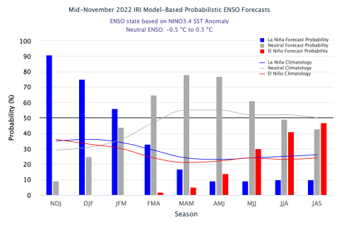
Synopsis: La Niña is expected to continue into the winter, with equal chances of La Niña and ENSO-neutral during January-March 2023. In February-April 2023, there is a 71% chance of ENSO-neutral.
Below-average sea surface temperatures (SSTs) persisted in the central and eastern Pacific Ocean during the past month. All of the latest weekly Niño index values were near -1.0ºC, except for the Niño-1+2 index which was at -0.5ºC. In November 2022, negative subsurface temperature anomalies weakened, reflecting an eastward expansion of the above-average subsurface temperatures in the western and central Pacific and contraction of the below-average temperatures across the eastern Pacific. Low-level easterly wind anomalies and upper-level westerly wind anomalies were evident across most of the equatorial Pacific throughout the month. The convection pattern continued to show suppressed convection over the western and central tropical Pacific and enhanced convection over Indonesia.
Overall, the coupled ocean-atmosphere system continued to reflect La Niña. The most recent IRI plume indicates that La Niña will persist into the Northern Hemisphere winter 2022-23. For the dynamical model averages, ENSO-neutral is favored in January-March 2023, while the statistical model average shows the transition to ENSO-neutral occurs in February-April 2023. The forecaster consensus, which also considers the North American Multi-Model Ensemble (NMME), is split on whether La Niña or ENSO-neutral will prevail during January-March 2023. Regardless, there is higher confidence that ENSO neutral will emerge by the Northern Hemisphere spring. In summary, La Niña is expected to continue into the winter, with equal chances of La Niña and ENSO-neutral during January March 2023. In February-April 2023, there is a 71% chance of ENSO-neutral.
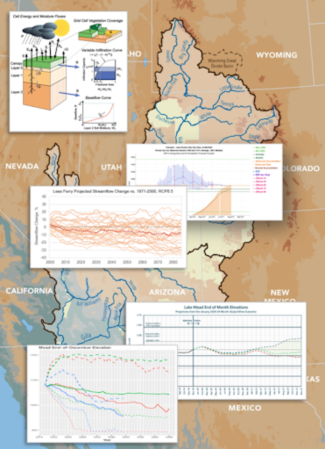
Representation of the different models and data, and their underlying science, applied to decision-making in the Colorado River Basin. (Design: J. Lukas, adapted from L. Payton; basin map by Western Water Assessment (L. Woelders); thumbnail images from University of Washington VIC group, NOAA Colorado Basin River Forecast Center, and Reclamation)
The newly launched Colorado River Science Wiki, created by SW CASC researchers, is now available for use by managers and other decision-makers, researchers, the media, and the broader public!
The Wiki is a web-based platform with many goals, including helping to inform discussions about the next Interim Guidelines on the Colorado River. The site summarizes and shares the most recent Colorado River research, increases visibility of the activities of the research community, and makes accessible important datasets and tools. Additionally, it is a space where contributions can be made by the community and ownership is shared, and where advances in science are given context so they have more value to non-specialists (e.g., agency staff, congressional staffers, 1st year grad students, journalists).
Information on the Wiki is organized into six sections: Science and Applications, Data and Tools, New Research, Water Law and Policy, Who’s Who, and About the River. Users can navigate through the sections with a menu on the left side, read summaries, and follow links to datasets, tools, and additional resources.
The Wiki was created by SW CASC co-investigator, Brad Udall (Colorado Water Center, Colorado State University), Julie Vano and Tanya Petach (Aspen Global Change Institute), and Jeff Lukas (Lukas Climate Research and Consulting), with funding from the SW CASC. It is still in the early stages of development and the creators welcome feedback from users to improve the site and advance communication of key Colorado River information to stakeholders.
Colorado River “Beginnings”. Photo: Brent Gardner-Smith/Aspen Journalism
An 8 a.m. Dec. 7 report from Wolf Creek Ski Area indicated that Wolf Creek had received 7 inches and 11 inches in the previous 48 hours, bringing the base depth to 39 inches and the season-to-date snowfall to 71 inches. The Wolf Creek summit was a 99 percent of the Dec. 7 snowpack median. The San Miguel, Dolores, Animas and San Juan river basins were 88 percent of the Dec. 7 median terms of snowpack…
River report Stream flow for the San Juan River on Dec. 7 at approximately 1 p.m. was 84.5 cubic feet per second (cfs), according to the U.S. Geological Service (USGS) National Water Dashboard. This reading is up from last week’s reading of 59.2 cfs at 1 p.m. on Nov. 30.
Colorado Snowpack basin-filled map December 10, 2022 via the NRCS.
In May of 2018, USGS Hydrologic Technician Dave Knauer found a batch of zebra mussels attached to the boat anchor in the St. Lawrence River in New York. (Credit: John Byrnes, USGS. Public domain.)
CPW staff first discovered the presence of invasive zebra mussels at Highline Lake State Park on an artificial PVC substrate in the lake during routine invasive species sampling on Sept. 14. In October, during increased testing by CPW staff additional adult zebra mussels were found in Highline Lake. Zebra mussels are an invasive species in the United States…
This is the first time a body of water has been categorized as infested with zebra mussels in the state of Colorado. The discovery is an alert for water managers, fishermen, and recreationists to be on the lookout for a striped invader and to be careful not to be a human carrier.
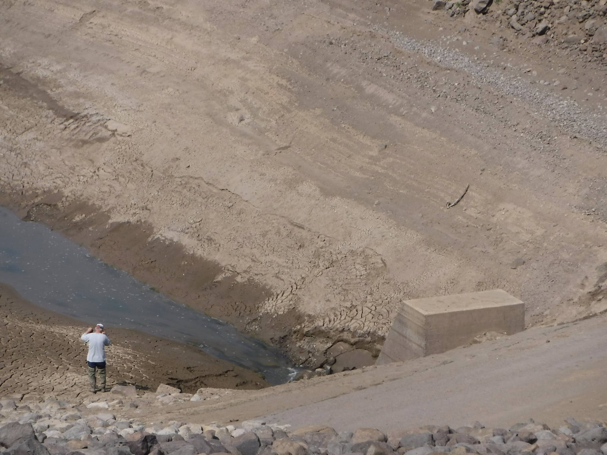
Stillwater Reservoir was drained in August 2021 for inspections to determine upgrades needed to the aging infrastructure.
Colorado Division of Water Resources/Courtesy photo
When the 75-foot dam for Stillwater Reservoir was built in 1939 by the Civilian Conservation Corps for the former Yampa Reservoirs Public Irrigation District, it was well constructed to meet engineering standards at the time. But by today’s standards, the dam’s abutments would be addressed differently, said Dana Miller, dam safety engineer with the Colorado Division of Water Resources in Steamboat Springs. As a result, the aging dam infrastructure needs expensive upgrades to bring the structure up to current safety standards, Miller said. Since it was constructed, the dam at approximately 10,300 feet elevation has experienced consistent seepage issues where the sides of the dam abut the hillsides. If not addressed, the seepage could eventually lead to a failure of the dam, Miller explained. Although the seepage has been worked on through the years with minimal results, lasting improvements could cost millions, according to the owner Bear River Reservoir Co. The reservoir water is owned by 18 agricultural shareholders and the town of Yampa, and those southern Routt County hay growers have been affected financially due to lower water storage allowances, plus years of drought.
The Stillwater Reservoir was placed on a fill restriction by the state in June 2019 and currently is limited to approximately 80% capacity, which the water storage level may reach during wetter years. The structure is classified as a high-hazard dam, which is not based on its condition but because “loss of life and significant damage is expected downstream if the dam were to fail,” Miller explained. The 129-acre reservoir, which is also known for the trailhead to popular Devil’s Causeway hike, was drained to a small dead pool in August 2021 for inspections of the upstream side of the reservoir outlet gates. The reservoir was drained again in October for work on the hydraulic operating system, said Andi Schaffner, secretary for Bear River Reservoir Co. Yampa resident Schaffner said the owners of the private, nonprofit reservoir company have contributed more than $100,000 to help with dam issues in the past 11 years, and total upgrades to the hydraulics are predicted to cost $300,000.
The downtown Denver skyline from Arvada. Photo credit: Allen Best/Big Pivots
Click the link to read the article on the 9News.com website (Cory Reppenhagen). Here’s an excerpt:
The study includes a scientific survey of 1,024 Colorado residents conducted by the Rasmussen research group. It focuses on several environmental issues, including water. Citing increased traffic, the loss of open space, and a strain on the water supply, 75% of Coloradans surveyed said urban sprawl, which is the encroachment of cities into natural space and agricultural space, is making Colorado a worse place to live.
Kolankiewicz said urban sprawl damages natural waterways, takes water away from agriculture and reduces the supply of water. Of those surveyed, 70% said water should not be diverted away from agriculture in favor of supporting further urban development. And 76% said water should be kept in streams to support wildlife.
Rebecca Mitchell, Director of the Colorado Water Conservation Board, said even with a stable or reduced population, there still may not be enough water because of a 20-plus-year mega-drought in the West.
“We don’t fight with Mother Nature; we dance with her, and we embrace her. And I think how we do that is by living within what she provides,” she said.
The Cocopah Environmental Protection Office finished planting more than 1,000 trees along a seven acre stretch of land along the Colorado River near the Arizona-California border. Cocopah EPO Director Jen Alspach. Cocopah Elder Neil White and Restoration Ecologist Fred Phillips talk about what this project means for the environment and Cocopah culture. This project is being sponsored by the Catena Foundation.
Click the link to read the article on the KJZZ webiste (Al Macias). Here’s an excerpt:
This small stretch of the river winds through part of the Cocopah Reservation near Yuma. It’s the last tribal land the river touches before it flows into Mexico. For hundreds of years, the river provided food and other resources to the Cocopah and other river tribes. In the 19th century, the river was hundreds of yards across and steamboats ran up and down the river ferrying supplies. Now the river is a few feet across.
View showing steamboat Cochan on the Colorado River near Yuma, Arizona in 1900. A photograph of the Cochan, last stern-wheel steamboat running on the Colorado River for the Colorado Steam Navigation Company between 1899 and 1909. This photo was taken in 1900. Cochan was sold to the U.S Reclamation Service in 1909. Not required by the Service, Cochan was dismantled in 1910. By Unknown author or not provided – U.S. National Archives and Records Administration, Public Domain, https://commons.wikimedia.org/w/index.php?curid=16588505
But major change began to take shape in the early 1900s, when the first dam was added. More than a century later, development and an extensive system of 15 dams has changed the river and the people who depended on it. Here on the Cocopah reservation, the landscape changed as well with invasive plant species choking out native cottonwoods, mesquites and other trees. Back in June as this, heavy equipment began ripping out seven acres of invasive plants called phragmites.
Tamarisk
Jen Alspach is the director of the Cocopah Environmental Protection Office.
“The goal of this project was to bring back those native plants and create a very special place where they can gather and you know reconnect with the river,” Alspach said.
After the seven acres were cleared, a thousand cottonwoods, willows and mesquites were planted.
This User Guide is designed to help planners, policymakers, and communities navigate this often confusing information landscape and acquire information most suitable for their needs. While focused on the U.S. Mountain West, much of the information in the User Guide is transferable to other regions too.
Please share this User Guide with your networks and others who might benefit from this free resource…
This User Guide was made possible through NOAA Sectoral Applications Research program funding. We gratefully acknowledge the tremendous work that went into the climate resources this Guide addresses, and appreciate the valuable feedback we received from so many in the research and management communities.
A reminder of the choices that global society has to make about the climate:
Delaying action on reducing emissions commits the world to live with severe consequences.
Rapid action now means a more habitable world for all.
There is no going back. Choose wisely. Credit: Ed Hawkins via via his Twitter feed
Hoover Dam’s intake towers protrude from the surface of Lake Mead near Las Vegas, where water levels have dropped to record lows amid a 22-year drought. (Source: Bureau of Reclamation)
Chorus of experts warn climate change has rendered old assumptions outdated about what the Colorado River can provide, leaving painful water cuts as the only way forward
When the Colorado River Compact was signed 100 years ago, the negotiators for seven Western states bet that the river they were dividing would have ample water to meet everyone’s needs – even those not seated around the table.
A century later, it’s clear the water they bet on is not there. More than two decades of drought, lake evaporation and overuse of water have nearly drained the river’s two anchor reservoirs, Lake Powell on the Arizona-Utah border and Lake Mead near Las Vegas. Climate change is rendering the basin drier, shrinking spring runoff that’s vital for river flows, farms, tribes and cities across the basin – and essential for refilling reservoirs.
The states that endorsed the Colorado River Compact in 1922 – and the tribes and nation of Mexico that were excluded from the table – are now straining to find, and perhaps more importantly accept, solutions on a river that may offer just half of the water that the Compact assumed would be available. And not only are solutions not coming easily, the relationships essential for compromise are getting more frayed.
With the Compact’s shortcomings and the effects of climate change and aridification becoming as clear as the bathtub ring around Lake Mead, previous assumptions of how much water the river can provide and the rules governing how it gets divvyed up must be revised to reflect the West’s new hydrology. One thing is certain among experts and Colorado River veterans: Water cuts are in the short-term and long-term forecast for major cities such as Los Angeles, Las Vegas and Phoenix, as well as farmers from Colorado’s West Slope to growers in California’s Imperial Valley near the Mexican border.
“You don’t have any other arrow in your quiver right now except to reduce use,” Pat Mulroy, former general manager of the Southern Nevada Water Authority, told a gathering of Colorado River water interests this fall. “There are no other arrows.”
Updated Colorado River 4-Panel plot thru Water Year 2022 showing reservoirs, flows, temperatures and precipitation. All trends are in the wrong direction. Since original 2017 plot, conditions have deteriorated significantly. Brad Udall via Twitter: https://twitter.com/bradudall/status/1593316262041436160
The River’s Changing Math
Predicting the amount of water the Colorado River can provide in a given year has always been a challenge. The river’s flow is famously erratic, dictated by the size of the often-fickle Rocky Mountain snowpack and other variables such as soil moisture and changes in temperature.
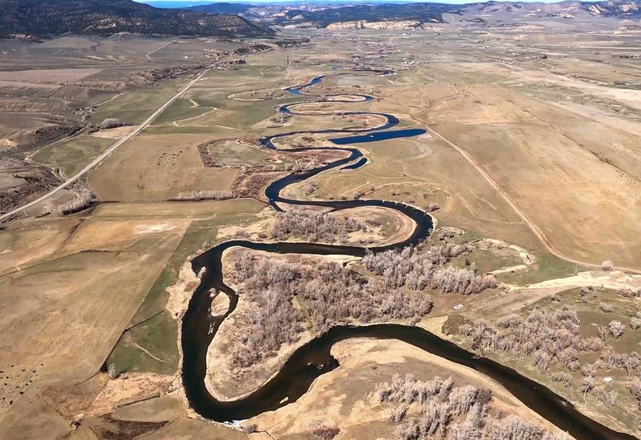
Flows in the White River (pictured above) and other Upper Basin tributaries have declined dramatically over the last 20 years, a trend experts warn will worsen as the West becomes hotter and drier. (Source: The Water Desk)
The old expectations of the Compact signers is giving way to a new reality on the river. Over the last century, the river’s flows in the Upper Basin have dropped by 20 percent. Scientists have pinned warming temperatures as the main cause of the disappearing flows and predict the trend will worsen as the Upper Basin, source of most of the river’s water, becomes even hotter and drier.
Water users have been able to counter previous dry spells by relying on the river’s main reservoirs. But after more than two decades of drought, both Lake Mead and Lake Powell are only about one-quarter full. The reservoirs’ rapid declines have forced the Bureau of Reclamation to order unprecedented water cuts to Arizona and Nevada. Mexico is taking similar cuts under binational agreements. And Reclamation has warned more severe actions are needed to prevent the collapse of the Colorado River system.
The Compact signatories, relying on data from a small but abnormally wet time period, estimated the river’s annual average natural flow in the Upper Basin to be about 18 million acre-feet. The figure, they asserted, was enough to cover 7.5 million acre-feet of water in perpetuity for the Upper Basin states of Colorado, New Mexico, Utah and Wyoming, and 7.5 million acre-feet for the Lower Basin states of Arizona, Nevada and California. They also agreed that any water committed to Mexico would be supplied equally by the two Basins. Native American tribes, who now legally hold substantial rights to the river’s water, were barely mentioned.
Brad Udall, Colorado State University climate researcher, said it’s becoming harder and harder for the river to meet the promises outlined in the Compact and the accompanying set of agreements, laws and court cases referred to as the Law of the River. He warned dozens of water managers and policy experts at a recent Water Education Foundation Symposium that climate change caused by greenhouse gas emissions is rapidly and permanently shifting precipitation trends in the Basin.
“It’s not a drought, it’s not temporary, it’s aridification,” said Udall. “Additional 1 degree Celsius or more warming by 2050, Lee Ferry flows in 9 million acre-feet are possible. Every important trend line [is] heading in the wrong direction, notably our reservoirs, but all the science trends as well.” [ed. emphasis mine]
Data from recent decades shows it’s becoming uncommon for the river to meet the benchmark used to craft the Compact. Estimated annual flows at Lee Ferry, a key dividing point between the Colorado River’s Upper and Lower Basins, have surpassed 18 million acre-feet just four times since 1991, while the river’s average flow since 2000 has been 12.3 million acre-feet.
“If we’re taking out more than comes in, it is really simple math that the reservoirs are going to continue to decline,” said Rebecca Mitchell, director of the Colorado Water Conservation Board, the state’s water management agency.
The federal government may reduce releases from Glen Canyon Dam (pictured above) in 2023 by an unprecedented 2-3 million acre-feet, a move that would trigger severe cuts in the Lower Basin. (Source: Bureau of Reclamation)
Mitchell was among nearly 200 state and regional water managers, farmers, tribal leaders and other water interests from the seven Basin states, along with key federal and Mexican officials, who attended the Foundation’s biennial Colorado River Symposium in late September to mark the Compact’s 100th anniversary and to discuss the risks and challenges ahead for the iconic Southwestern river.
Discussions were sometimes sobering and sometimes tense, underscoring the growing risks to a river depended upon for drinking water by 40 million people and for irrigation of more than 4 million farmland acres across the Basin. An undercurrent of the discussions was whether Basin interests can avoid taking their differences to court – a prime motivation behind creating the 1922 Compact. Despite the occasional sharply worded airing of differences between Upper and Lower Basin interests, there was broad acknowledgement that action is needed to keep the river system functioning.
Reclamation Commissioner Camille Calimlim Touton was among those urging water interests throughout the Basin to continue working collaboratively toward solutions and she provided a broad outline of actions that federal officials are preparing to take in 2023 – including reducing water releases from Lake Powell and Lake Mead – to keep the river from crashing.
“The actions we choose to take over the next two years,” Touton told participants, “will define the fate of the Colorado River for the next century.”
Living Within New Means
Though the Colorado River’s annual yield has shrunk in the 21st century, demand for its diminishing supply hasn’t, creating a glaring math problem for Basin water managers. In a system where every drop of water is already allocated, the specter of an 11 million acre-foot river — or worse — is forcing users to prepare for a drier future.
The Colorado River Compact divided the basin into an upper and lower half, with each having the right to develop and use 7.5 million acre-feet of river water annually. (Source: U.S. Geological Survey via The Water Education Foundation)
One agency that has been actively finding ways to stretch its river supply is Southern Nevada Water Authority, which serves more than 2 million people in the Las Vegas area. The agency has updated its modeling and long-range planning to reflect the river’s changing hydrology.
John Entsminger, the authority’s general manager, said computer models are sending a direct warning that the Lower Basin will end up with only a slice of the 7.5 million acre-feet per year outlined in the Compact. After accounting for evaporation and system losses, he said, it’s probable the Lower Basin and Mexico will have much less water to split.
“It is incumbent upon the Lower Basin to come up with a plan to live within its 7 million acre-feet release from Lake Powell probably forever going forward and hope it’s not less than that,” said Entsminger.
Like Nevada, Arizona is already feeling the pinch from the latest round of federal water cuts. So far, the two states and Mexico have shouldered most of the pain.
In 2022, Arizona is using approximately 2 million of its 2.8 million acre-feet Colorado River allocation, according to state officials The state’s agricultural industry is taking the hardest hit, including one rural county that fallowed more than 50 percent of its farmland for lack of irrigation water.
“We’re already seeing huge pain, and with an 11 million acre-feet [river] that pain’s just going to continue to grow,” said Tom Buschatzke, Arizona Department of Water Resources director.
Lees Ferry, located 15 miles downstream of Glen Canyon Dam is the dividing line between the upper and lower Colorado River basins. Photo/Allen Best
The widening gap between supply and demand is also having an impact above Lee Ferry, where inflows into Lake Powell continue to fall below historical average. Water from Powell is critical for helping the Upper Basin meet its commitment under the 1922 Compact to deliver water to the Lower Basin.
Representatives from the Upper Basin states say they have collectively cut their annual consumptive river use from 4.5 million acre-feet to approximately 3.5 million acre-feet over the last three years. Over the same period, they argue, the Lower Basin has done little to reduce its own consumptive use. Similar to Arizona, Upper Basin farmers also have been on the receiving end of water cuts.
The Ute Mountain Ute Tribe has fallowed the majority of its farmland in southwestern Colorado while in Wyoming, more than 100,000 acres of farmland were cut off from surface water for most of August because of low stream flows in the Upper Basin.
“That equates to about 100,000 acre-feet of [diverted Colorado River water] a month…that’s a third of our average irrigated use,” said Brandon Gebhart, Wyoming State Engineer.
The Upper Basin states have proposed a five-point plan built around paying farmers to reduce water consumption. Though it doesn’t require mandatory cuts for water users, proponents say the success of the plan hinges on whether the Lower Basin agrees to leave more water in Lake Mead.
“I think we need to recognize that the uses are far outweighing what Mother Nature is providing and that is primarily not in the Upper Basin,” said Mitchell with the Colorado Water Conservation Board.
California In the Spotlight
California’s use of the river has been a sore point among others in the Colorado River Basin. California, the largest user of Colorado River water, has been spared from water cuts so far due to its senior priority rights and has been using its full 4.4 million acre-feet entitlement in 2022. Groups in both the Upper and Lower Basins say the state must significantly reduce its use to prevent the river system’s collapse.
The Salton Sea (pictured above ) straddles the Imperial and Coachella valleys and has long been a sticking point in Colorado River deals. But the federal government recently committed up to $250 million for restoration efforts at the sea. (Source: Water Education Foundation)
California water agencies and state officials have pushed back on criticism that they aren’t doing enough to help buoy the shrinking reservoirs.
Peter Nelson, chairman of the Colorado River Board of California, argued California delayed the current crisis by enacting voluntary deals that pay farmers not to plant their fields, transfer water to urban users or make their systems more water efficient.
“In the Lower Basin, since the last seven years or so, we’ve stored 1.5 million acre-feet of water in Lake Mead as Intentionally Created Surplus water,” said Nelson, who farms in the Coachella Valley. “That has enabled the lake levels at Lake Mead to stay high enough to stay out of shortages and benefit other states in the Basin.”
Though the state is using its full share amid another bitterly dry year on the Colorado River, California water managers say they are not dismissing the fact that the river is overprescribed and that future cuts are needed. But they warn that the state’s farmers shouldn’t be made the scapegoat for all the Basin’s water problems.
For example, cutting off water to farmers in the Imperial Valley may help solve one crisis but simultaneously cause another, said Henry Martinez, general manager of the Imperial Irrigation District. Agriculture overwhelmingly drives Imperial County’s economy, he said, so fallowing would lead to major job losses in a region already prone to high poverty and unemployment rates.
“You can devastate the whole industry by making the wrong cutbacks at the wrong time. There has to be consideration also as to how to prop up or maintain the economy of the region, otherwise you go from a very poor area to devastating even furthermore the economy,” said Martinez.
In response to Reclamation’s call this summer for river users to voluntarily conserve 2 million to 4 million acre-feet of water in 2023 to protect Lake Mead and Lake Powell, Imperial Irrigation District and other California agencies on Oct. 5 proposed a plan that would save 400,000 acre-feet — 9 percent of California’s river allocation — each year between 2023 and 2026.
Earlier this month, the Department of the Interior approved the deal, committing $250 million from the Inflation Reduction Act to kickstart the conservation plan and support Salton Sea restoration efforts. As a result of water conservation efforts and a long-term transfer of farm water from the Imperial Valley to urban San Diego, the sea has been shrinking, exposing more lakeshore to winds that blow hazardous, lung-choking dust into the region.
California’s offer has received mixed reviews throughout the Basin: Some have applauded the proposal and called it an encouraging first step from the river’s biggest user, but others have cast it as an underwhelming opening gambit.
Wade Crowfoot, California Natural Resources Agency Secretary, said the Basin must continue negotiating and taking advantage of federal aid earmarked for Western drought relief to spur water conservation.
“As challenging and as tense as this is, I think that there’s a real opportunity and that failure is not an option,” said Crowfoot. “Everybody understands we have to figure this out and we have some resources at our disposal.”
“We can’t be caught flat-footed.”
In June, Reclamation Commissioner Touton told a U.S. Senate panel that unless an emergency conservation deal was reached by river users in 60 days, the federal government would have to take unilateral action to prevent the system’s demise.
Bruce Babbitt, former Interior secretary and Arizona governor. (Source: Water Education Foundation)
But the deadline passed without a deal and there was no immediate federal response, causing water users to wonder whether repercussions were coming. With little progress on a watershed-wide conservation plan, some Colorado River veterans contend the federal government should take a direct role in facilitating negotiations.
“I think Reclamation is going to have to get some key players in the room, probably including Mexico, and really get down to the brass tacks of leveraging and what needs to be done,” said Tom Davis, general manager of the Yuma County Water Users’ Association. “We need to save this patient’s life in the next 24-36 months.”
Touton’s demand that the Basin states cut 2 million to 4 million acre-feet caught them off guard, said Bruce Babbitt, former Interior secretary and Arizona governor. Since the announcement, Babbitt said, the states have essentially been “stumbling around” in the absence of a well-defined negotiation framework.
Babbitt likened the current situation to the one 100 years ago, when the states’ negotiations on how to split the Colorado River had also stalled before President Warren Harding tapped Herbert Hoover to guide the talks. Babbitt told the September symposium there are important lessons to be taken from the structured discussions at Bishop’s Lodge, just outside of Santa Fe, N.M., that ultimately led to the formulation of the 1922 Compact.
“What finally emerged out of that in terms of process at Bishop’s Lodge is something that I think we need to reflect on because we’re going to have to put together a workable framework,” Babbitt added.
Federal officials contend there isn’t a leadership void.
David Palumbo, Reclamation’s deputy commissioner of operations, said Reclamation is preparing a suite of actions — including reducing releases from Lake Powell in 2023 — to prevent a scenario where water can’t flow out of the system’s main dams.
“If we need to release less than 7 million acre-feet [from Glen Canyon Dam] … if that hydrology is not there, we’re going to have to do something to avoid the crash and we’re going to be prepared to do that,” said Palumbo. “We can’t be caught flat-footed.”
Water users are urgently trying to keep Lake Powell on the Utah-Arizona border from dropping to a point where Glen Canyon Dam can no longer generate electricity. (Source: Bureau of Reclamation)
With talks between the states and tribes at a standstill, Interior Secretary Deb Haaland on Oct. 28 announced the federal government is considering deviating from operating rules established in 2007 and 2019 to handle water shortages on the river.
During recent public briefings, federal officials have indicated that Lake Powell releases may be slashed by 2 to 3 million acre-feet annually to keep the reservoir from reaching a point where it could no longer generate electricity or deliver water downstream.
Meanwhile, Reclamation is now offering Lower Basin water users up to $400 per acre-foot of conserved water over the next three years, part of the $4 billion in drought relief funding secured through the Inflation Reduction Act. In addition, at least $500 million will be reserved for water conservation and efficiency projects in the Upper Basin.
Some Colorado River veterans, including Colby Pellegrino, deputy general manager of resources for the Southern Nevada Water Authority, are urging Reclamation to focus the federal drought relief on actions that will not just temporarily halt Lake Mead’s decline, but permanently change water use habits.
“We should be using that money to fundamentally change the way we do everything in this Basin to use the least amount of water possible,” she said.
Considering the scope of the damaging economic, social and ecosystem impacts that would flood the Basin if Lake Mead or Lake Powell were to reach dead pool, others argue Congress should get more involved. One idea, outlined in a policy paper presented at the Symposium by the Foundation’s 2022 Colorado River Water Leaders class, is a biennial program that would provide federal funding for programs that would reduce system demand and encourage more frequent discussions between the states, tribes and other water users in the Basin.
Congress has enacted similar regional programs in recent decades, including in the Florida Everglades, the Chesapeake Bay and the Great Lakes. A stable source of federal funding can create permanent, multi-benefit solutions, said Brenda Burman, former Reclamation commissioner who will take over as general manager of the Central Arizona Project in 2023.
“Whether it’s biennial or yearly, I think we need to be looking at a Colorado River Basin program,” she said.
Tribes Gain a Say
Unlike previous deals, the federal government and states say they are committed to figuring out how to share Colorado River water while acknowledging the sovereignty and water needs of Native American tribes.
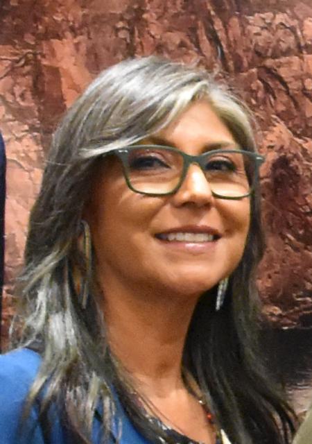
Lorelei Cloud, member of the Southern Ute Indian Tribe’s tribal council. (Source: Water Education Foundation)
Many Basin tribes, which hold legal rights to about a quarter of the river’s water, are hoping to upgrade their infrastructure and fully develop their water rights. As the tribes assert their water rights, the amount of water available to states with junior rights like Arizona or Nevada may shrink. After fighting legal battles to secure their rights to the river — 12 Basin tribes still have unresolved water rights claims — tribes aren’t eager to halt the progress they’ve made in bringing water to their communities and farms.
Lorelei Cloud, a member of the Southern Ute Indian Tribe’s tribal council, said the tribe’s unused river water simply flows by its Colorado reservation to be used by others downstream. She reiterated that unused tribal water, which gets treated as “surplus water”, is a vanishing luxury the rest of the Basin won’t soon be able to bank on.
“Tribes don’t get compensated and have never been compensated for our unused tribal water, especially the water that’s sitting in Lake Powell and Lake Mead,” said Cloud.
Decrepit water infrastructure among other issues prevents the Southern Ute from being able to use its full river allocation as it is, so Cloud added that the tribe is unlikely to cut back its water use even if the river continues to shrink.
“When tribes start to develop their water, what are you all going to do?” Cloud asked the Symposium crowd. “Because that water is ours. We’re in Colorado, so we’re going to get our water first.”
While the tribes have been historically excluded from and considered an afterthought in Colorado River negotiations, there are signs that the balance of decision-making power is shifting. Congress is providing billions of dollars in funding in the Bipartisan Infrastructure Law and the Inflation Reduction Act to help tribes across the country improve their drinking water and water delivery systems.
At the September Symposium, both federal and state officials echoed the need for tribes to be included at the bargaining table.
“Tribes across the Basin will also continue to play a vital role,” said Interior Secretary Haaland, the first Native American to serve as a cabinet secretary. “Indian tribes have water rights, and not only are they deeply affected by the drought, but they have been and will be invaluable partners in finding solutions.”
Other Challenges
Before considering any major changes to the river’s guiding principles, water managers will have to ensure that the country of Mexico is included in the process.
Mexico, already dealing with water shortages in several of its northern cities, is taking cuts to its river supply in 2022 and 2023 under binational agreements. Tensions over sharing the Colorado River have traditionally waxed and waned but the neighboring countries have been able to reach a series of water management agreements in recent decades.
Members of the International Boundary and Water Commission (IBWC), which oversees boundary and water issues between the U.S. and Mexico, said they are confident the two countries can continue communicating and building on previous partnerships.
“I feel that we’re going to go very far and be able to identify what we need to solve the issues along the U.S.-Mexico border,” said Maria-Elena Giner, the U.S. commissioner to the IBWC.
Thus far, talks regarding the river’s future have focused on limiting impacts to cities, farms and tribes. But reserving enough water to ensure the Basin’s fish and wildlife survive the drought is another thorny task water managers are wrangling with.
Environmental groups and other nongovernment organizations argue they are key river partners that can bring myriad resources and ideas to the brainstorming process.
“When the system is not sustainable, it’s not resilient and the environment loses. It’s the one that gets sacrificed first,” said Taylor Hawes, The Nature Conservancy’s Colorado River program director. “Finding solutions that do not sacrifice the environment, that do not look at the environment as a sacrificial lamb, need to be part of our collective path forward.”
Meanwhile, new rules that would require Lower Basin users to account for water lost in large reservoirs to evaporation or leaky water delivery infrastructure are in the works. Currently, Upper Basin states are charged for evaporation losses but the Lower Basin is not.
Federal officials estimate as much as 10 percent of the river’s flow evaporates annually, including more than 1 million acre-feet from the Lower Basin. The federal government has announced it may change the evaporation accounting practices by the end of 2024, meaning the Lower Basin could take a significant cut to its share.
“In these serious times, we need to take the overdue step of assessing how to account for those losses throughout the Basin. This is another tough reality that we must work together to address,” Haaland said.
As water managers attempt to navigate the river’s mounting crises, they can turn to a variety of recent success stories for inspiration.
Pat Mulroy, a senior fellow at the University of Nevada, Las Vegas’ Boyd School of Law and the former longtime general manager of the Southern Nevada Water Authority, is an advocate for extensively rethinking how the Colorado River is managed. (Image: University of Nevada, Las Vegas’ Boyd School of Law)
Cities such as Phoenix, Los Angeles and Las Vegas have shown the ability to decouple water demand from population growth. Restoration efforts at the long-neglected Salton Sea are producing positive results. An innovative water sharing deal is providing economic benefits to the Jicarilla Apache Nation as well as water security for New Mexico and increased river flows for endangered species of fish.
These beneficial programs and decisions — in a refreshing twist from a river history dominated by men — are being crafted with the input of women in high-ranking positions, creating hope on a river in dire straits.
Instead of court battles that could lead to a federal judge taking over management of the Colorado River, water users need to negotiate with open minds as they chart a path for the lifeline that means so much to so many, said Mulroy, former head of the Southern Nevada Water Authority. To cut through the paralysis that has bogged down negotiations, everyone will have to show the courage to deviate from old agreements and assumptions and prepare for cuts.
“We’re talking about a body of law and a structure we’ve lived with predicated on 17 to 18 million acre-feet,” Mulroy said, “and a reality that has 9 to 11 million acre-feet in the river – the two don’t mesh.”
Three years after it started, Denver Water’s Lead Reduction Program is getting a big boost from more than $76 million in federal funding.
The funding will help fast-track the program, replacing thousands more old, customer-owned lead service lines in the next few years than had been originally anticipated.
The state approved allocation of funds to Denver Water in October, and the Denver Board of Water Commissioners formally accepted the funds Dec. 7.
The money will be spent in 2023 through 2025 and is expected to replace up to 7,600 lead service lines, shortening the 15-year program by 1.5 years. Thanks to the new funding, between 3,000 and 5,000 additional lines will be replaced in 2023 — on top of the nearly 5,000 lines already planned for replacement next year.
Since the program started in January 2020, Denver Water has replaced more than 15,000 lead service lines. The lead lines are replaced with lead-free, copper lines at no direct cost to the customer.
The addition of $76 million in federal funding for the Lead Reduction Program will fast-track the replacement of up to 7,600 old lead service lines. Photo credit: Denver Water.
“This infusion of federal money means we will be able to replace thousands more customer-owned lead service lines at a faster pace than we had originally planned, and ultimately shorten the length of the biggest public health initiative in Denver Water’s history. This groundbreaking program is supported by all our customers across our service area,” said Jim Lochhead, Denver Water’s CEO/Manager.
“Removing these lines is the most effective way to eliminate this source of lead exposure, and we are committed to this program until every lead service line has been removed. We’re grateful for the opportunity provided by this funding.”
The water Denver Water delivers to customers is lead-free, but lead can get into the water as it passes through a customer’s internal plumbing or water service line that contains lead. The service line is the small pipe that connects to Denver Water’s pipe in the street and carries water to the customer’s home. Lead can cause serious health problems if too much enters the body, whether from drinking water or other sources.
Denver Water’s groundbreaking Lead Reduction Program aims to replace nearly 5,000 customer-owned lead service lines every year. When the program started, Denver Water estimated there were between 64,000 and 84,000 lead service lines in its service area and expected it would take 15 years to remove them all.
The addition of federal money will help Denver Water exceed its annual target in 2023 by an extra 3,000 to 5,000 lines. For every 4,500 additional lead service lines replaced using the federal funding, the overall length of the program will be one year shorter.
Replacement work will take place in parts of many neighborhoods across Denver in 2023, including Baker, Globeville, Sunnyside, Barnum West, Athmar Park and Capitol Hill.
An initial map of the 2023 replacement work areas is available at denverwater.org/Pipes. The replacement work prioritizes areas with vulnerable, at-risk populations and disproportionately impacted communities while also taking into account planned construction activities, schools and child care centers.
Lead was a commonly used material for water service lines across the U.S. through the mid-1900s and is frequently found in Denver homes built before 1951.
The replacement work is done by contractors through the Lead Reduction Program and by Denver Water crews, who replace any lead service line found during scheduled pipe replacements or during repair work on a broken water main.
In total, Denver Water was approved for $76,123,628 from the Colorado Drinking Water State Revolving Fund, which will receive money from the federal bipartisan Infrastructure Investment and Jobs Act signed into law by President Joe Biden in November 2021. The funding Denver Water received is a low-interest loan that the utility will repay, with $40 million of the loan’s principle forgiven immediately as allowed by the legislation.
The $76 million in federal funding Denver Water’s Lead Reduction Program received comes from the federal bipartisan Infrastructure Investment and Jobs Act signed by President Joe Biden signed in November 2021. Photo credit: White House.
The state will receive federal funding from the Environmental Protection Agency to address lead in drinking water every year for five years, beginning in 2022. Denver Water intends to apply for funds in the future and, if approved, will be able to accelerate the replacement program even more.
The EPA also has approved a continuation of the Lead Reduction Program, via a variance from the federal Safe Drinking Water Act, following a review of the progress made in its first three years.
“Denver Water’s approach to tackling lead in drinking water has been remarkable and an example for other communities across the country,” said EPA Regional Administrator KC Becker, in an announcement.
“Thanks to new funding from the Bipartisan Infrastructure Law the utility’s customers can expect an even faster lead service line replacement schedule delivering health protections for children and adults across the Denver area.”
Customers enrolled in the Lead Reduction Program receive water pitchers and filters to use for cooking, drinking and preparing infant formula until six months after their lead service line is replaced. Photo credit: Denver Water.
Lochhead thanked EPA and Denver Water’s community partners for working with the utility to ensure the successful implementation of the program.
“Denver Water’s first priority is sustaining our communities by protecting the health of our customers,” Lochhead said.
In addition to the installation of a new, lead-free, copper water service line at no direct cost, customers enrolled in the program also receive water pitchers and filters certified to remove lead.
Filtered water should be used for cooking, drinking and preparing infant formula until six months after the lead service line is replaced. The utility also has changed the water chemistry, raising the pH of the water it delivers, to better protect customers from the risk of lead.
This has been a huge effort involving many areas of Denver Water, and we couldn’t have done it without the support we’ve received from our customers,” said Alexis Woodrow, who manages the Lead Reduction Program for Denver Water.
“Our customers enrolled in the program allow us into their homes to replace their old lead service lines, and they are patient with all the construction work that accompanies the replacement process. We’re also excited that in a recent survey, 83% of customers said that they use the filters we provide to filter water for cooking, drinking and preparing infant formula.”
With the federal funding, the work surrounding the replacement process will touch more homes and neighborhoods in 2023.
“We’re grateful for all the support we’ve received for this program, from our customers to our community partners and our elected officials,” Woodrow said.
“We’re all working to protect our customers now and for generations to come.”
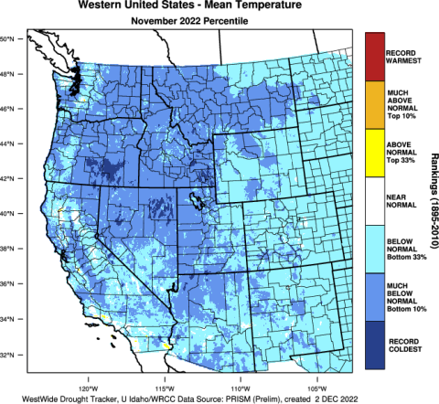
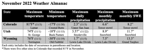
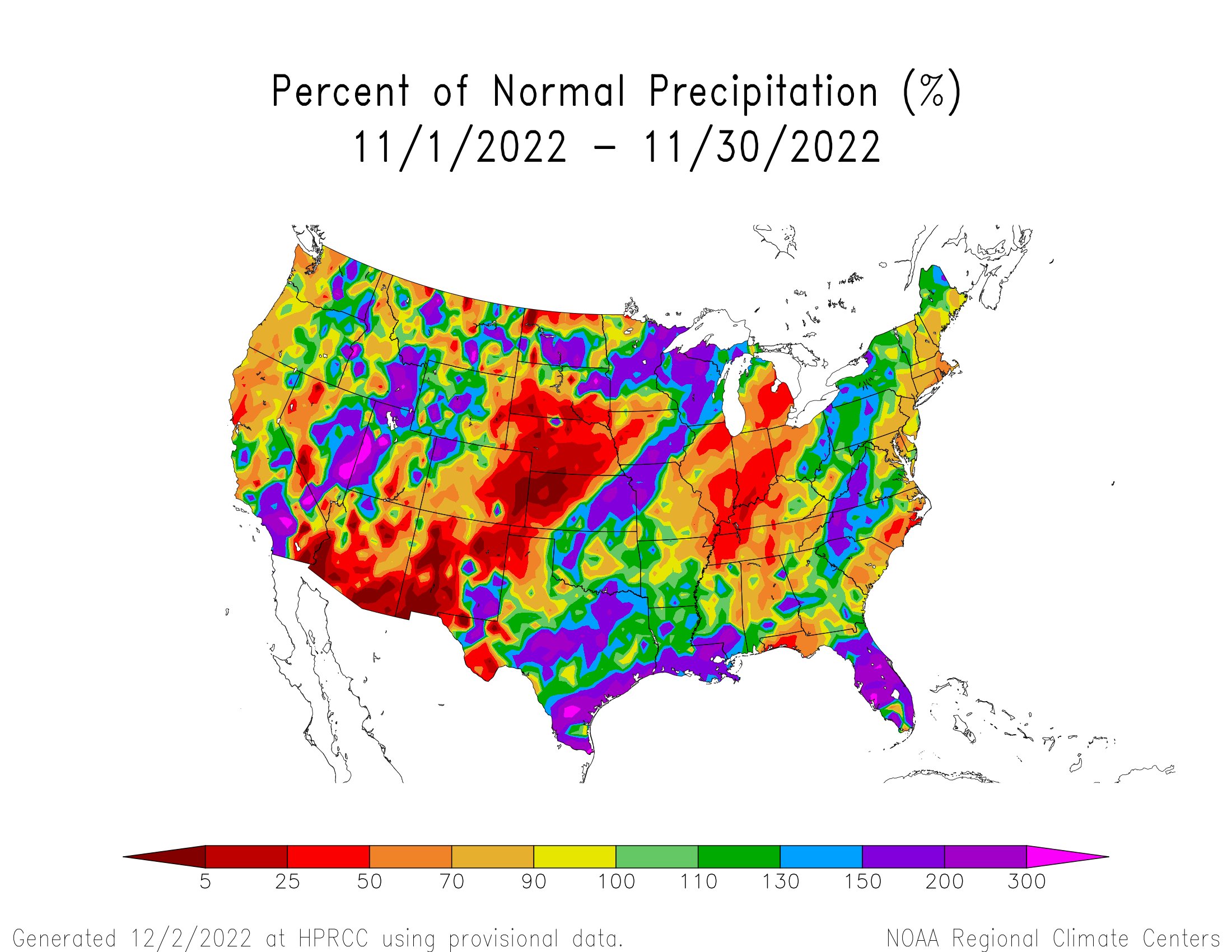
Regional precipitation was a mix of above to much-above normal conditions in northern and western Utah, western Wyoming, and northwestern Colorado, and below to much-below normal conditions in eastern Utah and Wyoming, and most of Colorado. Temperatures were below normal for the entire region. Regional snowpack is near normal for a majority of Colorado and Wyoming and is slightly above to much-above normal in Utah. Regional drought has slightly expanded, with a slight expansion in Wyoming, a slight improvement in Colorado, and a very slight improvement in Utah. La Niña conditions are expected to persist through winter, but will likely return to ENSO-neutral conditions by spring. NOAA December precipitation forecasts suggest an increased probability of above normal precipitation for most of Utah and Wyoming, while probabilities for above normal, below normal, and equal chances are split for Colorado.
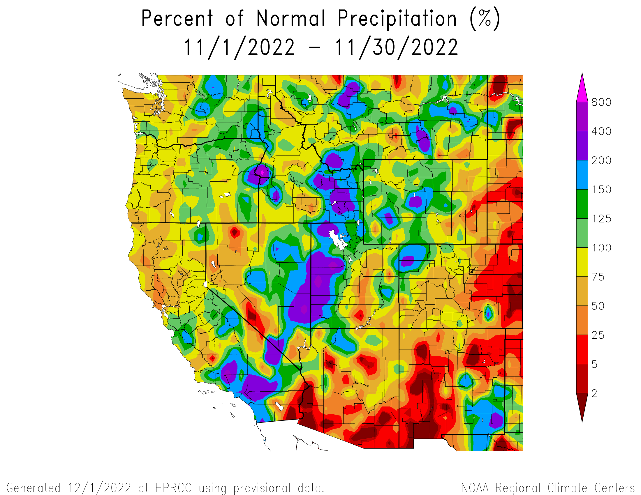
November precipitation was above normal (125-200% of average) throughout much of Utah, Wyoming, and northwestern Colorado, and much-above normal (200-800%) in western Utah. Precipitation was below normal (25-75%) in eastern Utah and eastern Wyoming, and was below normal to much-below normal (<25%) in Colorado. Record-wettest conditions were observed in Tooele and Box Elder Counties in Utah, and record-driest conditions were observed in Kit Carson, Cheyenne, Kiowa, Bent, and Prowers Counties in Colorado.
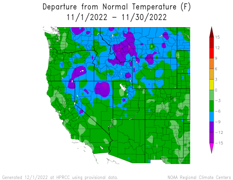
November temperatures were slightly below normal (0 to -3°F) to below normal (-3 to -9°F) for the entire region, with pockets of much-below normal temperatures (-9 to -15°F) in northwestern Wyoming and central Utah.
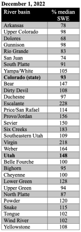
As of December 1st, snow-water equivalent (SWE) was much-above normal in northern and southwestern Utah and slightly above normal in eastern Utah. SWE was near-normal in much of northern Wyoming, above normal in parts of northern and southwestern Wyoming, and below normal in southeastern Wyoming. SWE was near-normal in northern Colorado and below normal in southern Colorado. It was the third snowiest November in Denver in the last 15 years. Most SNOTEL sites above 8,000 ft. reported 2-6” of SWE in Utah and Wyoming, and 1-4” in Colorado.
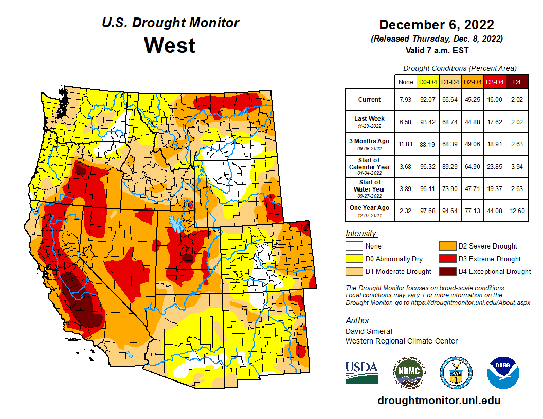
Regional drought coverage remained unchanged from October to November. Drought has been spatially consistent from October to November in our region (CO, UT, WY) with pockets of exceptional (D4) drought remaining particularly in Sanpete County in central Utah and Sedgwick and Phillips Counties in northeastern Colorado. Extreme (D3) drought has expanded to cover 6% of southeastern Wyoming and 4% of eastern Colorado. D3 drought continues to cover 50% of central Utah, although it has improved slightly. D3 drought was removed from the Green and Snake River basins in western Wyoming.
West Drought Monitor map December 6, 2022.
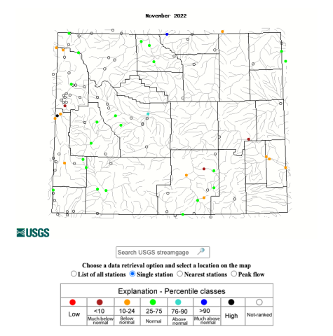
Record-low flows were observed at several locations, including the North Fork Cache La Poudre, San Juan, and White Rivers in Colorado; and the Bear, Dirty Devil, Fremont, San Rafael, and Sevier Rivers in Utah. Many sites in the region, particularly in Utah, recorded below to much-below normal November streamflows. However, there are also many sites throughout the region with normal streamflows, as well as above normal streamflows at six sites in Colorado, five in Utah, and one in Wyoming. There were a few sites that observed much-above normal streamflows, including Blue River in Colorado and Little Bighorn River in Wyoming.
A La Niña advisory remained in place during November as below average sea surface temperature (SST) anomalies persisted in the equatorial Pacific Ocean and increased in the east-central Pacific Ocean, causing temperatures that were nearly 1°C below normal. SST models predict a 76% probability of La Niña conditions continuing through winter (December-February). However, ocean temperatures are projected to warm by the end of winter and there is a 65% probability of ENSO-neutral conditions by early spring (February-April). The NOAA monthly precipitation forecast for December indicates a 40-50% chance of above normal precipitation for western Wyoming and northern Utah, and a 33-40% chance of above normal precipitation in northwestern Colorado, central Utah from west to east, and most of eastern and central Wyoming. There is an increased probability of above normal temperatures in southern Colorado and below normal temperatures in northwestern Utah and central Wyoming from west to east. There are higher probabilities of below normal temperatures in northern Wyoming. Over this winter (December-February), the NOAA seasonal precipitation forecast predicts an increased probability of above normal precipitation in northern and central Wyoming and a 33-40% chance of below normal precipitation in southeastern Utah and southern to eastern Colorado. The seasonal temperature forecast shows a 33-40% chance of above normal temperatures in southern to western Colorado and southern to central Utah during the winter. The forecast shows a 33-40% chance of below normal temperatures in northern Wyoming this winter.
Significant November weather event: Colder than average temperatures covered the entire region with monthly temperatures ranging from 0 to -15°F below normal for the western U.S. Temperatures were coldest in northwestern Wyoming, where November temperatures were up to 8 degrees below normal in Park, Bighorn, Washakie, and Hot Springs Counties. The majority of Colorado and Wyoming experienced below normal temperatures (bottom 33rd percentile) and the majority of Utah experienced much-below normal temperatures (bottom 10th percentile). In Wyoming, Moose experienced its coldest November on record, Jackson and Lamar Ranger Station experienced their second coldest November on record, and Old Faithful and Tower Junction experienced their third coldest November on record. Denver and Salt Lake City had their coldest November since 2000 with average monthly temperatures of 35.6°F and 37.2°F, respectively. Statewide, November 2022 was Colorado’s 20th coldest November since 1895; temperatures were 3.1°F below the 20th-century average.
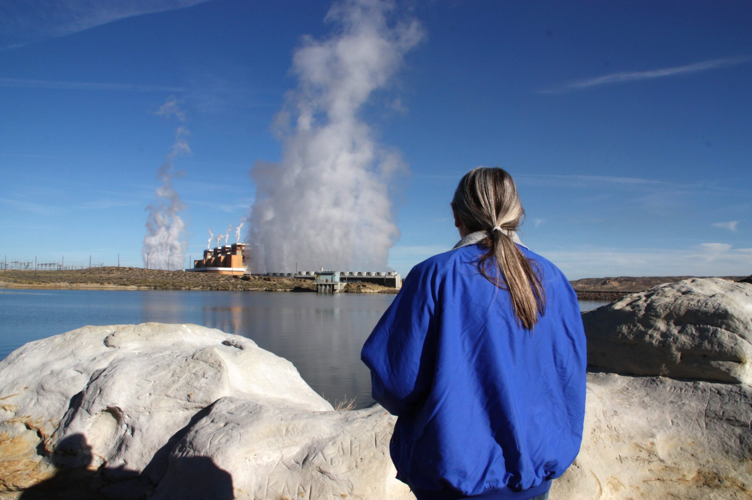
Lou Ann Varley looks out across the pond that holds water for the cooling towers at the Jim Bridger coal plant, where she worked for 37 years before retiring in 2020. Credit: Nicholas Kusnetz
In early fall, residents of this desolate corner of southwestern Wyoming opened their mailboxes to find a glossy flyer. On the front, a truck barreled down a four-lane desert highway with a solar farm on one side and what looked like rows of shipping containers on the other. On the back was an invitation.
“CarbonCapture Inc. is launching Project Bison,” it read, announcing a “direct air capture facility” set to begin operations here next year. “Join us at our town hall event to learn more.”
Few had heard about the proposal before receiving the flyer, let alone had any idea what a direct air capture facility was. So the following week, about 150 people packed into a large classroom at Western Wyoming Community College in Rock Springs to find out.
“We are a company that takes CO2 out of the air and stores it underground,” said Patricia Loria, CarbonCapture’s vice president of business development, in opening the meeting.
Loria described a plan to deploy a series of units—the shipping container-like boxes pictured on the flyer—that would filter carbon dioxide from the air and then compress the greenhouse gas for injection underground, where it would remain permanently.
As carbon dioxide levels continue to climb, scientists, entrepreneurs and governments are increasingly determining that cutting emissions is no longer enough. In addition, they say, people will need to pull the greenhouse gas out of the atmosphere, and an emerging field of carbon removal, also called carbon dioxide removal or CDR, is attempting to do just that.
There are companies like Loria’s looking to use machines and others trying to accelerate natural carbon cycles by altering the chemistry of seawater, for example, or mixing crushed minerals into agricultural soils. These efforts remain wildly speculative and have removed hardly any of the greenhouse gas so far.
Some environmental advocates warn that carbon removal will be too expensive or too difficult and is a dangerous diversion of money and attention from the more urgent task of eliminating fossil fuels. Perhaps more troubling, they say, the various approaches could carry profound environmental impacts of their own, disrupting fragile ocean ecosystems or swallowing vast swaths of agricultural fields and open lands for the energy production needed to power the operations.
Yet even as those potential impacts remain poorly understood, the Biden administration is making a multi-billion dollar bet on carbon removal. The administration’s long-term climate strategy assumes that such approaches will account for 6 to 8 percent of the nation’s greenhouse gas reductions by 2050, equal to hundreds of millions of tons per year, and it has pushed through a series of laws to subsidize the technology.
The first investments will come from the Energy Department, which is expected to open applications within weeks for $3.5 billion in federal grants to help build “direct air capture hubs” around the country, with a particular focus on fossil fuel-dependent communities like Rock Springs, where mineral extraction is by far the largest private employer. The goal is to pair climate action with job creation.
The money has prompted a rush of carbon-removal-focused companies to fossil fuel communities, from Rock Springs to West Texas to California’s San Joaquin Valley, seeding hope from supporters that a concept long relegated to pilot plants and academic literature is on the cusp of arriving as an industry.
As Loria made her pitch, Lou Ann Varley was listening intently. Varley sits on a local labor union council and spent a 37-year career working at the Jim Bridger coal plant outside town before retiring in 2020. She knows that young workers starting at the plant today won’t be able to match her longevity there, with its four units slated to close over the next 15 years, and hoped Project Bison might offer some of them a new opportunity.
Others weren’t having it. Throughout the presentation, residents listened quietly, sitting in pairs at folding tables in the classroom. Some munched on sandwiches and cookies the company had provided. Others leaned back, arms crossed. But when it came time for questions, they launched a volley of concerns about the potential risks and unknowns.
Who was going to pay for this? Would it use hazardous chemicals? What about earthquakes from the underground injections of carbon dioxide? What would happen if the company went bankrupt, and who would be liable in the event of an accident? Wyomingites are deeply protective of their open landscapes, and many wondered about the impacts of all of the renewable energy that would be required for power.
Direct air capture machines consume tremendous amounts of energy. Project Bison, according to CarbonCapture’s figures, could eventually require anywhere from 5 to 15 terawatt hours of power per year, equal to 30 percent to 90 percent of Wyoming’s current electricity consumption, depending on whether the company can increase its efficiency.
Laura Pearson, a sheep rancher who wore heavy work clothes, was sitting in the back row that night feeling deeply skeptical of the entire premise. Pearson’s family has worked the same land for generations, and she sees the wind farms and solar panels that have started covering parts of her state as a threat to its open range.
“If you don’t think those affect wildlife and livestock grazing and everything else in this state,” she told Loria from across the room, “you’re crazy.”
Loria said the company was working with wildlife scientists and officials to minimize impacts, but Pearson was unswayed.
“I love Wyoming and I don’t want to see it change,” Pearson said after the meeting ended. She said she doubted the company’s intentions, didn’t think carbon dioxide posed such a threat to the planet and didn’t like seeing out-of-state interests, whose demands for cleaner energy have sent Wyoming’s coal sector into decline and are threatening to do the same for its oil and gas, coming to peddle something new. “It’s all about the money,” she said.
A Town With a Storied Coal History
Rock Springs was built on coal. In 1850, an Army expedition found coal seams cropping out of the valley bluffs. Less than 20 years later the Union Pacific Railroad routed the nation’s first transcontinental line through here so its locomotives could refuel as they crossed the Rockies. The mines soon snaked right under the center of town, where the outlaw Butch Cassidy once worked at a butcher shop and earned his nickname.
The rail line still bisects the town, although the old station has been converted into the Coal Train Coffee Depot cafe. A large sign arcs above the tracks outside: “Home of Rock Springs Coal, Welcome.” A stone monument next to the depot lists everyone who died in the mines each year, coming by the dozen in the early 1900s, with names like Fogliatti, Mihajlovic and Papas reflecting all the countries from which men flocked to find work.
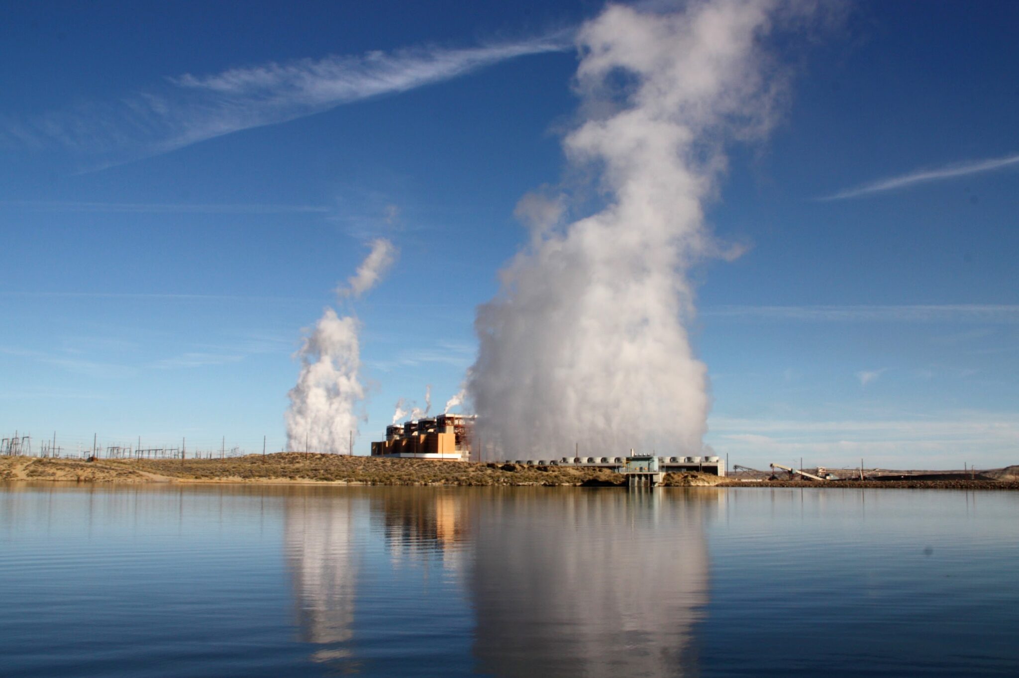
The Jim Bridger coal plant, one of the nation’s largest, has faced forced retirement and is slated for closure within 15 years. The impending loss of jobs has brought anxiety to the coal-reliant community of Rock Springs, Wyoming. Credit: Nicholas Kusnetz
Varley started at Jim Bridger, one of the country’s largest coal plants, in 1983 after getting laid off from mining trona, a mineral used in the manufacturing of glass, detergents, chemicals and other products. All but one of the eight largest private employers in Sweetwater County either mine or use the minerals and fossil fuels that underlie this part of Wyoming. As oil, gas and coal operations have shed jobs in recent years, the trona mines have absorbed many of the losses.
Varley began as a laborer, sweeping and shoveling coal or ash, before working her way up through operations and maintenance. Eventually, she helped operate the computer systems that ran the plant. “I loved the job,” she said.
Two years after retiring, Varley still refers to Bridger as “my plant.”
Until recently, her plant was facing the forced shutdown of some of its units for failing to meet federal pollution rules set by the Environmental Protection Agency. But in February, Wyoming Gov. Mark Gordon struck a deal to forestall any retirements by converting two of Bridger’s four units to burn natural gas instead. Still, all of its units are expected to close within 15 years.
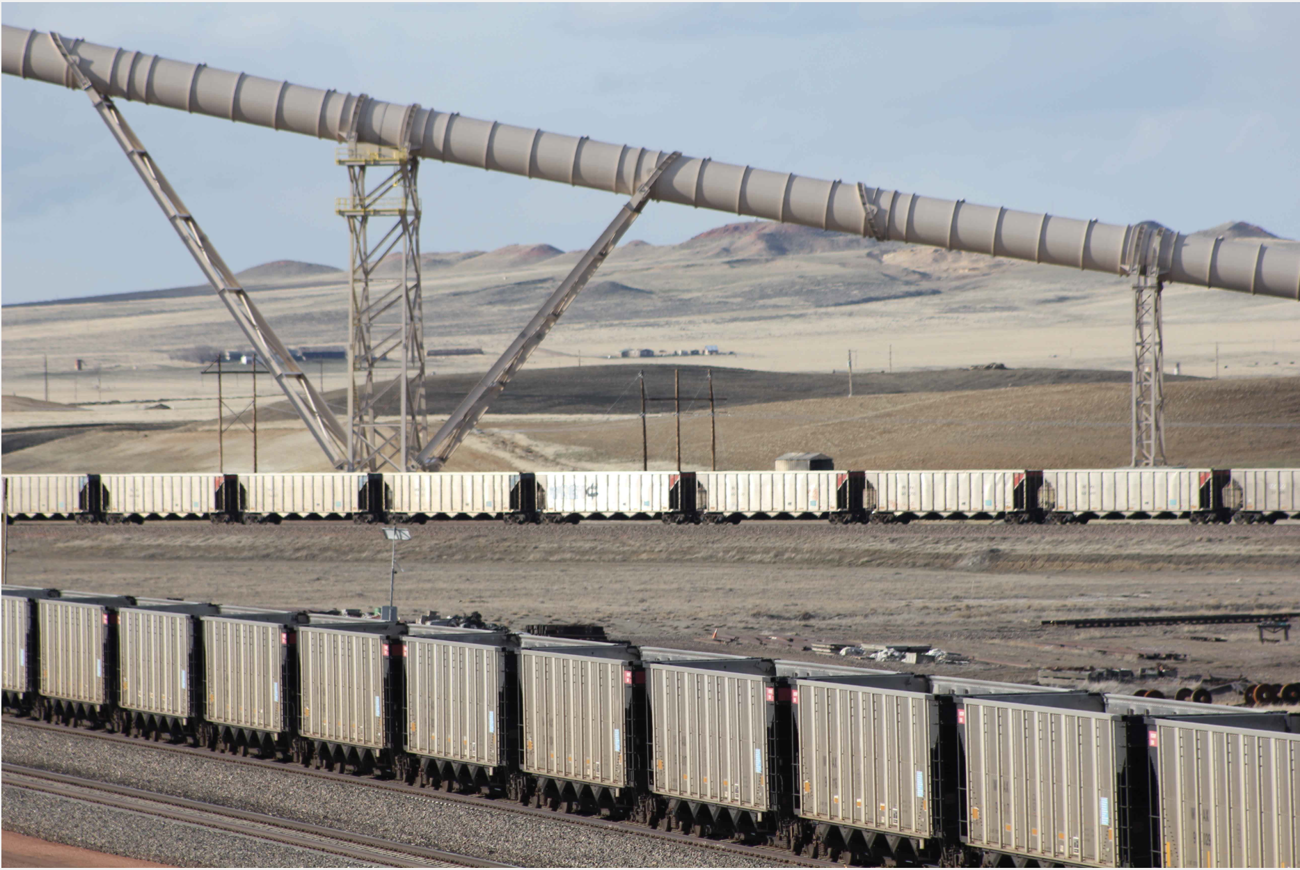
Coal trains await loading in the Powder River Basin of Wyoming. Photo/Allen Best
Wyoming produces about 40 percent of the nation’s coal, so the fuel’s plummeting share in the nation’s electricity—from half in 2005 to about 20 percent this year—has brought acute anxiety to towns like Rock Springs.
“It makes it kind of tough when you know that they’re talking towards phasing out coal,” Varley said. Many people who work at the plant, which employs more than 300, get angry about the prospect, she said. “Especially some of the younger ones, because they hired in believing like me that they would be able to retire from that facility.”
Wyoming officials have spent years trying everything to promote carbon capture technology, which removes carbon dioxide from power plant or industrial emissions, in the hope it could save coal. The state university has mapped its geology for places to store CO2. Regulators won federal approval to oversee the underground injection of carbon dioxide, one of only two states to do so, along with North Dakota. (The EPA oversees the practice everywhere else.) In 2020, Wyoming lawmakers passed a law that tried to force utilities to install carbon capture equipment at their coal plants.
These efforts have not yielded a single commercial carbon capture operation at a power plant, but they do seem to have attracted CarbonCapture Inc., to the delight of state economic development officials.
A California-based start-up, CarbonCapture said it has secured enough private investment to begin work next year on the Wyoming plant, although it still needs to receive state and local permits. Rather than attaching to a coal plant, this project would pull carbon dioxide out of ambient air by passing it through giant fans fitted with a chemical sorbent, which traps the CO2. The sorbent is then heated to release the gas for compression before being reused.
Project Bison would initially capture 10,000 metric tons of carbon dioxide per year, but the company said it plans to expand to reach a capacity of 5 million metric tons by 2030. That higher figure would be orders of magnitude above what any company has achieved so far, yet roughly equal to the emissions of one coal power plant, or less than 0.1 percent of total U.S. emissions of nearly 6 billion metric tons in 2020.
The operations would be financed by selling carbon credits to corporations seeking to offset their own emissions. The company said it has already sold credits at $800 per ton to Cloverly, a carbon-offset marketer, and to CO2.com, a new carbon offset venture of TIME, the magazine owned by the billionaire Marc Benioff.
Varley had gone into the town hall meeting feeling optimistic that the project could potentially provide high-quality jobs while also helping the environment. While she wants the coal plant to continue operating for as long as possible, she knows its days are numbered, and when it closes, it could take more than 300 jobs with it.
Southwest Wyoming is hard country to live in: Varley has spent her entire life here and said “it grows on you like a fungus.” The state has the highest suicide rate in the country, and the decline of fossil fuels, it feels to many, will only make life harder.
“People are looking for ways to maintain our ability to live here,” Varley said.
These disasters have driven many people toward desperate acts of civil disobedience, like a scientist who chained himself to the doors of a private jet terminal. They’ve also pushed many to conclude that carbon removal technologies, however unlikely their deployment, will now be necessary to avoid the worst impacts of warming.
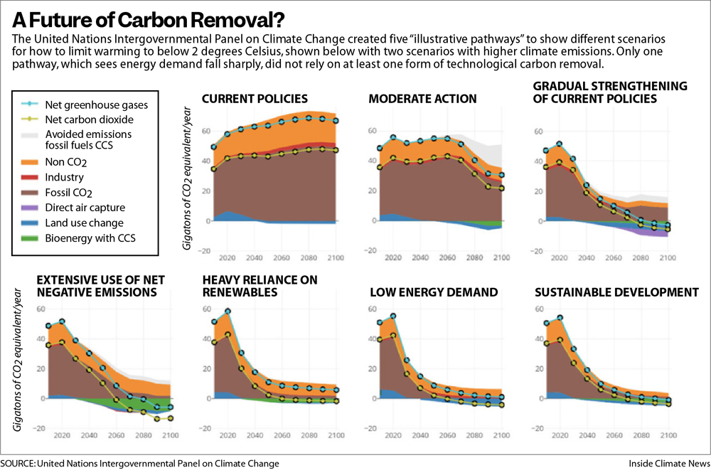
When the United Nations Intergovernmental Panel on Climate Change released its latest report this year on how to keep warming below 2 degrees Celsius, it determined that at least some degree of carbon removal was needed but that the amount could vary drastically, depending on how quickly fossil fuel consumption declined and whether nations adopt more sustainable practices.
A future of carbon removal? Credit: Inside Climate News
The only scenarios that did not include meaningful levels of carbon removal generally required global energy use to decline, which seemed unlikely, especially if there was any hope of supplying electricity to the nearly 800 million people who currently lack it.
“It’s critical to have this tool,” said Jennifer Wilcox, the principal deputy assistant secretary in the Office of Fossil Energy and Carbon Management at the Department of Energy, “and we need to have it on the order of gigatons,” or billions of tons.
The last year has brought an explosion of funding to try to make that happen. In addition to the $3.5 billion that Congress allocated to the Energy Department for direct air capture hubs, lawmakers earmarked another $1 billion for research and development this year and, as part of the Inflation Reduction Act, more than tripled the value of a federal tax credit for direct air capture.
United Airlines, Airbus, Microsoft, Alphabet, Meta, Stripe and other corporations have collectively pledged billions more. The billionaire entrepreneur Elon Musk has funded a $100 million prize for carbon removal startups. The field is also one of the fastest growing areas of climate philanthropy.
So far, however, hardly any carbon dioxide has been pulled from the atmosphere. The largest direct air capture plant in operation, opened by a company called Climeworks in Iceland, pulls in about 4,000 metric tons of CO2 per year. By contrast, the Jim Bridger plant outside Rock Springs spewed out 10.8 million metric tons of carbon dioxide in 2021 alone.
Skeptics have noted how far carbon removal is from making a dent in global emissions. Supporters, however, argue that the rates of growth the industry must achieve to make a difference, while high, are comparable to what solar energy generation has seen since the 1990s.
The rush of funding and attention has prompted a new set of questions about carbon removal technologies. The concerns of many skeptics have moved beyond whether carbon removal can possibly work, to wondering what it would look like if it somehow did.
Displacing Herds of Native Pronghorn
Pearson’s route to town takes her past Wyoming’s first utility-scale solar farm, which was built in 2018. The 700-acre site was cleared of vegetation before the panels were installed and surrounded with a chain-link fence. Now it marks a shiny, incongruous break in the high desert, though it is hardly the only disturbance around, with trona mines in each direction.
The sight of it was bad enough for Pearson and other residents, but soon after the project’s completion, residents noticed herds of pronghorn, a fleet-footed antelope-like animal indigenous to the region, tramping onto the highway. The area that the solar farm had enclosed, it turned out, had been used by resident pronghorn, and the fences shut them out. The companies behind the project sponsored a study, published last spring in a scientific journal, that determined that the animals lost nearly a square mile of high-use habitat, about 10 percent of their core range. Today, the pronghorn’s trails and droppings line the perimeter of the fence that locked the animals out of lands they once called home.
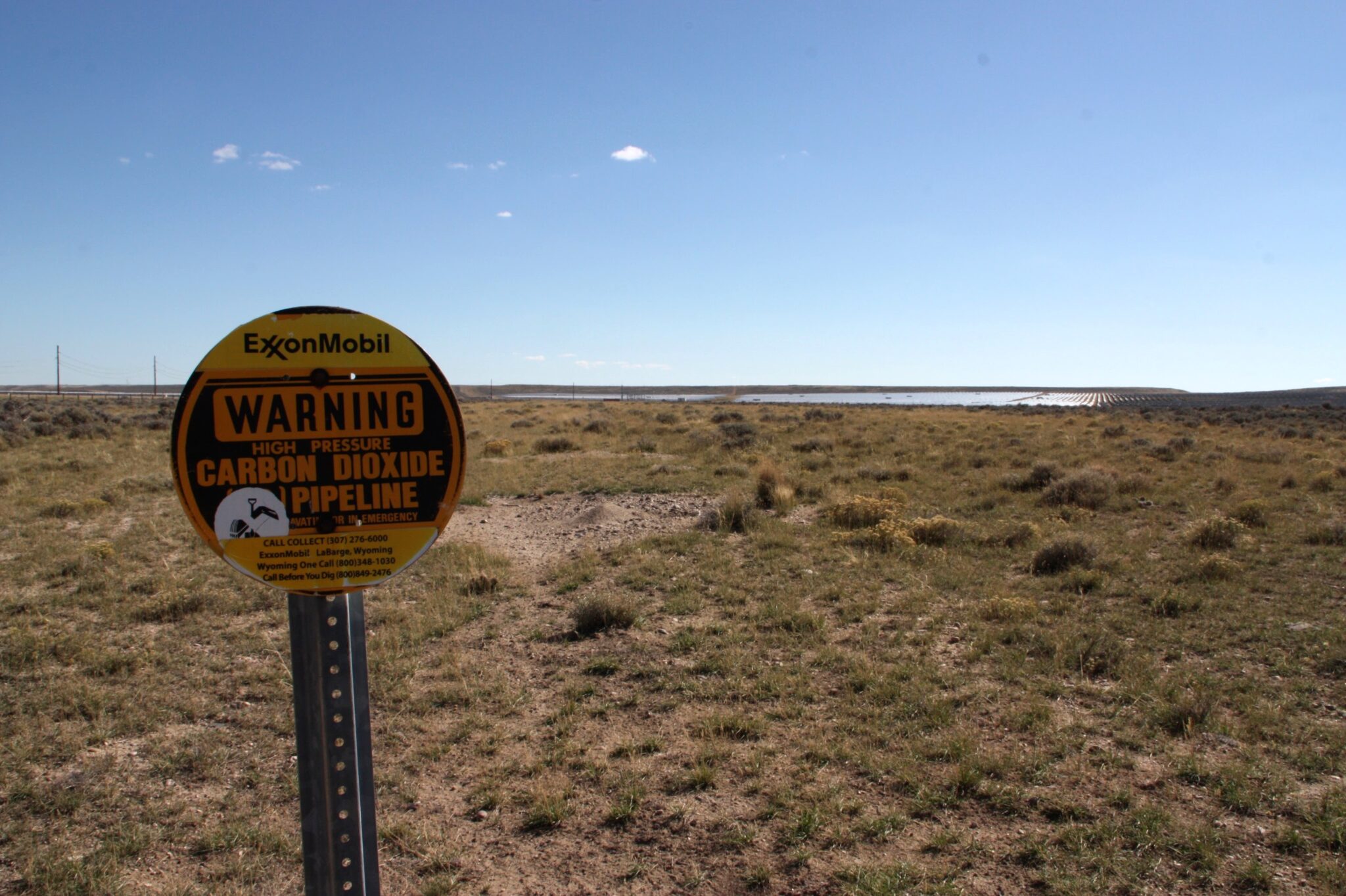
A carbon dioxide pipeline runs from an ExxonMobil gas processing plant under Wyoming’s first utility-scale solar farm. The state has tried to attract carbon capture operations to help its ailing coal industry, as well as renewable energy development. The solar farm upstate many locals after it displaced wildlife. Credit: Nicholas Kusnetz
CarbonCapture plans to build its new facility about 20 miles west of the solar farm, a rough and barren landscape of greasewood and sagebrush, and it could eventually need much more solar development to run its operations.
The company has said it will try to minimize the impacts, by choosing lands already disturbed by oil development, for example. But some will be unavoidable. State maps show that the sage grouse, a protected game bird, has core habitats surrounding the area where the plant would be built. Closer to the site, cattle roam on rangeland that is dotted with oil wells and a creek trickles south on its way to the Green River, a tributary of the Colorado.
CarbonCapture said it would initially use natural gas to power its operations while capturing the resulting carbon dioxide emissions, but aims to eventually rely on renewable energy. At full scale, that would require 1,000 acres to house the energy supply, and 100 acres more for the project itself.
The World Resources Institute, an environmental think tank, has estimated that if direct air capture technology reaches the scale envisioned by the Biden administration, about 500 million metric tons of carbon dioxide per year by mid-century, the industry would consume more than 4 percent of the nation’s current total energy supply. If all that energy were generated by wind and solar power, that could mean covering an area equal to a small state with turbines and panels.
The prospect alarms Pearson, who said her family has been offered money to allow solar panels on their land, but that they declined. “We would have been set for life, and we said no way. Because we knew what it would do to the wildlife, to our way of life, to Wyoming’s way of life.”
Adrian Corless, CarbonCapture’s chief executive, said that because the project will connect to the electric grid, the new renewable energy development could be located in other parts of the state, or even out of state.
“There’s a lot of opportunity to find the right situations for land use that are aligned with community expectations and needs,” Corless said.
Justin Loyka, energy program manager in the Wyoming office of the Nature Conservancy, said CarbonCapture asked his organization for help in reducing its impacts, and that there were opportunities to do so. But he added that as renewable energy development spreads, some impacts are inevitable.
“The vast majority of Wyoming is some of the most intact ecosystem in the lower 48,” Loyka said. “Wyoming has these wildlife migration corridors that are hundreds of miles long, and that really doesn’t exist in many other places.”
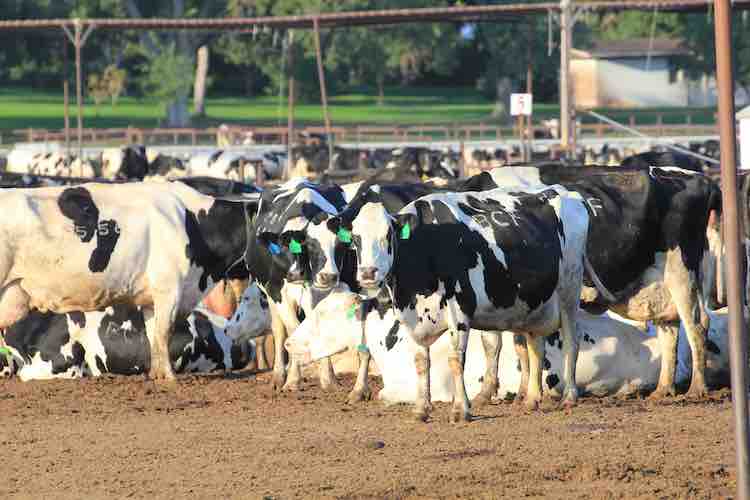
For decades, Americans mostly turned a blind eye to the industrial-scale livestock production operations that churn out cheap supplies of meat and dairy for the masses. Occasional opposition to local pollution problems and the casual animal cruelty that characterize conventional US dairy, hog, and poultry production did little to alter practices that are embedded in the rural landscape.
That may be changing. A wave of frontline resistance is now breaking across the Upper Midwest and around the country as organized campaigns aimed at regulating concentrated animal feeding operations, known as CAFOs, are being felt at every level of government, and in state and federal courts.
Opposition to large livestock operations is more intense than at any time in recent memory, say environmental advocates.
“It’s been building and building,” said Rob Michaels, an attorney for the Environmental Law and Policy Center (ELPC), a Chicago-based legal group, who is working to limit CAFO manure discharges in Ohio and Michigan. “It’s now being raised as a political issue. As a legal issue. As a legislative issue.”
On October 19, the 9th Circuit U.S. Court of Appeals issued a ruling that lends legal muscle to a five-year old petition that Food & Water Watch and 36 allies filed to compel the US Environmental Protection Agency (EPA) to update CAFO permitting regulations. The Trump and Biden administrations ignored the 2017 petition. The Court of Appeals said the plaintiff’s petition “raises issues that warrant an answer” from the agency. A Food and Water Watch attorney said the Justice Department has been in touch to schedule a negotiating meeting.
A week later, on October 26, Earthjustice, a nonprofit public interest law group, and 50 allied non-profit and citizen organizations from around the US filed a separate petition calling on the EPA to initiate new rule-making that would require the largest CAFOs, which are significant sources of water pollution, to apply for wastewater discharge permits under the Clean Water Act. The petition asserts that because every CAFO discharges polluting wastes EPA has the authority and duty to require them to operate under wastewater permits.
Calls for moratoriums on new CAFO construction also are being heard by legislatures in Iowa, Missouri, Minnesota, and Wisconsin. Counties in South Dakota and Arkansas have issued local moratoriums. The Missouri Supreme Court is set to decide, perhaps before the year ends, whether counties can regulate CAFO development through local public health ordinances.
At least five Wisconsin counties and three towns have enacted temporary moratoriums, and one county is considering imposing a local ordinance next year. Last year the Wisconsin Supreme Court affirmed the authority of the Wisconsin Department of Natural Resources (DNR) to restrict large livestock farms to protect the state’s water, a rebuke to a 2011 state law that limited the DNR’s authority to regulate CAFOs.
Dairy cattle Morgan County. Photo credit: Allen Best/The Mountain Town News
Water worries
The EPA has identified more than 21,000 large CAFOs across the country but just 6,266 of those operate with wastewater discharge permits under the Clean Water Act designed to control and restrict pollutants discharged into waterways, according to EPA figures.
“EPA is weak on regulations on CAFOs,” said Emily Miller, a Food & Water Watch attorney. “Only a fraction have permits and the permits that do exist are just simply ineffective.”
An EPA spokesman said the agency would not comment on either petition. The American Farm Bureau Federation declined to be interviewed for this article.
The National Milk Producers Federation, though, issued this statement in response to the environmentalists’ petitions. “Regulation of CAFOs require a responsible approach, which sometimes isn’t the case among environmental activists who seek to use regulations to reduce the availability of animal protein products for consumers,” said Jamie Jonker, the group’ chief science officer.”
The restiveness about CAFO operations and expansion in the American countryside is due to the same kinds of disruptions occurring in states like Wisconsin, where 340 large livestock operations have been constructed, most of them big milk and hog production facilities. They collectively house hundreds of thousands of animals.
Wisconsin CAFOS pour billions of gallons of untreated liquified manure every year, and millions of tons of solid manure on hundreds of thousands of farm acres. A study for the Wisconsin Legislature made public in October found that the number of private wells contaminated with nitrates or E.coli, the intestinal bacteria, was expanding steadily and identified the source as agricultural discharges.
CAFOs, though, are the only industrial polluting facilities not required to treat their wastes. The federal waiver for treating CAFO wastes dramatically reduces pollution control and operating costs. It is a primary reason the American livestock sector has rapidly changed from numerous small farms that manage livestock on outdoor pastures and barnyards to many fewer industrial-scale operations where animals spend their entire lives indoors.
And because CAFOs operate on efficiencies of scale, they have played an outsize role in keeping commodity prices low and contributed to the closure of small farms in America.
As CAFOs gained influence, for example, Wisconsin in November counted 6,172 dairy farms, down from 11,260 a decade earlier, according to state figures. A study by the American Farm Bureau Federation found that from 2011 to 2020 Wisconsin led the nation in farm bankruptcies.
Though the Biden administration dispatched the EPA administrator and several aides to Cleveland earlier this year to celebrate the 50-year anniversary of the Clean Water Act, the 1972 statute has not come close to achieving its “fishable and swimmable” goal for American surface waters. The problem is unregulated nutrient discharges from agriculture. In 2016, the EPA identified phosphorus and nitrogen discharges from U.S. farmland as “the single greatest challenge to our nation’s water quality.”
Harmful algal blooms caused by phosphorus discharges from CAFOs now contaminate many of America’s iconic waters, among them Chesapeake Bay, Lake Okeechobee, Lake Champlain, California’s Clear Lake, and Lake Erie. “Somewhere between 88 percent and 94 percent of the problem is caused by these CAFOs, these megafarms and their nutrient nonpoint source runoff. Everyone knows it,” said Wade Kapszukiewicz, the mayor of Toledo, Ohio, which was forced in 2014 to shut down its drinking water plant for three days because of bloom-generated toxins. Half a million residents lost their drinking water supply.
CAFO nutrient discharge is worse in the Corn Belt states: the Dakotas, Minnesota, Wisconsin, Iowa, Illinois, Missouri, Nebraska and Kansas. The EPA counted 9,332 concentrated livestock and poultry operations across the Corn Belt in 2021. It is not known how much manure they all produce each year, but it’s prodigious. For comparison the 291 CAFOs in Michigan generate 4 billion gallons of untreated raw liquid manure annually, and millions of tons of solid manure, according to the state environment department.
In Iowa, where almost 4,000 CAFOs operate, nearly every mile of streams and acre of surface water is impaired by nutrients or E.coli. Just 167 Iowa CAFOs have wastewater discharge permits, according to the E.P.A.
The Biden Administration and CAFO opponents know full well that changing the regulatory rules of the CAFO game will be a fierce struggle. Environmentalists, small farm advocates, and E.P.A. administrators under previous administrations, Democratic and Republican, have tried to cross this same ground before and been turned back in federal courts by politically powerful farm groups led by the American Farm Bureau Federation and its allies in the various state and national dairy, pork, poultry, and beef associations.
In 2003, in response to a lawsuit brought by Natural Resources Defense Council and Public Citizen, the EPA issued a new rule that obligated CAFOs to apply for discharge permit unless they could demonstrate that they had “no potential to discharge” damaging nutrients. That rule was challenged by livestock operators, who in 2005 convinced the Second Circuit Court of Appeals to strike it down.
The E.P.A. tried again with a new rule in 2008 that limited the permitting obligation to CAFOs that “propose to discharge” wastes. But in 2011, in a case brought by the National Pork Producers Council and other farm groups, the Fifth Circuit Court of Appeals struck that rule down, too. In both cases plaintiffs argued the law didn’t give the agency authority to regulate “potential” or “proposed” sources of pollution.
With their petitions and grassroots campaigns, activist legal and non-profit groups are pressing E.P.A. to try again. They assert that every CAFO operating in the United States is a source of “actual” wastewater discharges that require much more effective regulation. “The E.P.A. under its current leadership acknowledges that what we’ve asked for needs to happen,” said Amy van Saun, a senior attorney for the Center for Food Safety, which is a party to the 2017 petition. “I don’t think they have any legal way to say no.”
The Department of the Interior announced today that four Tribal water projects in Oregon and California’s Klamath River Basin will receive $5.8 million through the Bureau of Reclamation to restore aquatic ecosystems, improve the resilience of habitats, and mitigate the effects of the ongoing drought crisis. The funding is made available through Reclamation’s Native American Affairs Technical Assistance to Tribes Program.
Secretary Deb Haaland made the announcement while touring the Iron Gate Fish Hatchery with Governors Gavin Newsom and Kate Brown, Congressman Jared Huffman, representatives from the Klamath Basin Tribes and other officials and stakeholders to celebrate the imminent surrender and decommissioning of the Lower Klamath Project, a four-dam hydropower project on the Klamath River. On November 17, 2022, the Federal Energy Regulatory Commission issued an order approving the surrender and decommissioning of the Project, the culmination of nearly two decades of effort to find a path to remove the dams, open up hundreds of miles of historic salmon habitat, improve water quality, and restore the River and the fishery the Basin Tribes have relied upon since time immemorial. Dam removal activities will begin next spring, with full removal completed in 2024.
“Clean water, healthy forests and fertile land made the Klamath Basin and its surrounding watershed home to Tribal communities, productive agriculture, and abundant populations of migratory birds, suckers, salmon and other fish. But over the past 20 years, the Basin has been met with unprecedented challenges due to ongoing drought conditions and limited water supply,” said Secretary Haaland. “The projects we are funding today – combined with millions of dollars in water and habitat resilience investments from President Biden’s Bipartisan Infrastructure Law – will help restore this once abundant ecosystem for the benefit of all its inhabitants.”
“Reclamation is committed to working with Tribes in the Klamath River Basin on important water resource issues,” said Reclamation Commissioner Camille Calimlim Touton. “This funding will help facilitate collaboration with Tribes as they address the severe and continuing drought impacting their lands.”
Reclamation’s Native American Affairs Technical Assistance Program provides technical assistance to Tribes to develop, manage and protect their water and related resources. The funding announced today is provided to Tribes as a grant or cooperative agreement. The projects are:
Hoopa Valley Tribe, Karuk Tribe and Yurok Tribe, in collaboration with U.S. Geological Survey (USGS), Juvenile Salmonid Survival and Migration Rate Study: The project will receive $3.9 million to study juvenile salmon. The Yurok Tribe will estimate specific survival through time of wild and hatchery Chinook Salmon as they migrate through the Klamath Basin under various environmental conditions. The Hoopa Valley and Karuk Tribes will use acoustic tags to monitor juvenile salmonid survival and migration rates from the Scott, Salmon and Trinity rivers and locations on the middle Klamath to Klamath River estuary. The USGS will provide support to the Tribes for this research study.
Hoopa Valley Tribe, Ecological Flow Assessment on the Hoopa Valley Indian Reservation: The Hoopa Valley Tribe will receive $554,325 to complete an ecological flow assessment on the Trinity River. The project includes site selection, field data collection, stream gaging and water temperature monitoring.
Klamath Tribes, Upper Williamson River Restoration: The Klamath Tribes will receive $500,000 to assess and plan river system restoration activities on the Upper Williamson River in southern Oregon. The Tribe will assess the existing condition of approximately five miles of the river, develop plans for restoration activities, and install restoration infrastructures. This project advances goals and objectives established in both the Klamath Basin Integrated Fisheries Restoration and Monitoring Plan and the Upper Klamath Basin Watershed Action Plan.
Yurok Tribe, Oregon Gulch Project, Mainstem Trinity River: The Yurok Tribe will receive $864,533 to remove tailing piles, increase floodplain inundation, promote fluvial processes, and reduce the wood storage deficit. The project will also double rearing habitat, improve the aquatic ecosystem, create seasonal surface water connections, increase vegetation biomass and increase the number of trees along the riverbanks.
This funding supplements nearly $26 million from the Bipartisan Infrastructure Law allocated this year for Klamath Basin restoration projects, including nearly $16 million for ecosystem restoration projects in the Basin and $10 million to expand the Klamath Falls National Fish Hatchery.
As part of the Interior Department’s ongoing commitment to partnership and collaboration, senior Department leaders have held several in-person and virtual engagement sessions with Tribes, state and county officials, interagency partners, and water users to discuss near- and long-term solutions related to drought impacts in the Basin.
This U.S. Drought Monitor (USDM) week saw an active storm pattern across much of the Western U.S. as well as another round of isolated heavy rainfall across portions of the South and Southeast. Out West, several rounds of Pacific moisture streamed into the region bringing heavy rains to the lower elevations of the Pacific Coast Ranges and snowfall to the higher elevations of the Sierra Nevada, Klamath Mountains, Cascades, northern Great Basin, and the central and northern Rockies. For the multi-day storm event, the heaviest snowfall accumulations were observed in the Sierra Nevada where up to four feet was observed including at the Central Sierra Snow Lab, which reported a 7-day snowfall total of 48.8 inches. Moreover, the storms boosted basin-wide snow water equivalent (SWE) to well above normal levels in the Sierra Nevada drainage basins and basins across the Intermountain West and Pacific Northwest, according to the National Resources Conservation Service (NRCS) SNOTEL network. Along the Central California coast in the Santa Lucia Range (south of Monterey), 7-day rainfall accumulations ranged from 4 to 11+ inches—helping to reduce longer-term precipitation deficits (past 24 months) that ranged from 8 to 20+ inches after this week’s storms. In the Desert Southwest, locally heavy rainfall was observed in southern Arizona and west-central New Mexico in association with sub-tropical moisture that moved into the region on Saturday with isolated areas receiving 2 to 3+ inches of rain. The rainfall improved soil moisture levels and helped to boost precipitation totals during the past 12-month period to normal to above-normal levels across much of the southern portion of Arizona. In the Northern Plains, light snowfall (2 to 6 inches) was observed in the Dakotas and eastern Montana in addition to the passage of an Arctic front early this week, which dropped temperatures into the single digits in North Dakota. In the Midwest, a wintery mix of rain, freezing rain, and snow impacted southern Wisconsin while light-to-moderate snowfall accumulations (2 to 6 inches) were observed in Minnesota and Upper Peninsula Michigan. In the Interior Deep South, locally heavy showers (2-to-4-inch accumulations) brought some relief to drought-affected areas of northern Alabama and Georgia as well as southeastern Tennessee, and southwestern North Carolina. In the Northeast, light-to-moderate snowfall accumulations (1 to 4 inches) were observed last week with the heaviest accumulations in Upstate New York. In Maine and New Hampshire, strong winds and shower activity (1 to 2 inches) impacted the region last week causing power outages in areas of Maine. In the South and Southeast, locally heavy rainfall was observed across a west-to-east band extending from northern Mississippi to northern Georgia. The storms helped to reduce short-term precipitation deficits (past 30-60 days) in some areas and boosted streamflows and soil moisture to above-normal levels…
On this week’s map, improvements were made in northwestern Colorado and Wyoming. In Wyoming, recent storms delivered beneficial snowfall to the Teton and Wind River ranges leading to reduction in areas of Moderate Drought (D1). Moreover, the drainage basins in those ranges, the Snake Headwaters and Upper Green, were reporting SWE percentage of median levels of 129% and 114%, respectively. Additionally, areas of Moderate Drought (D1) were reduced in northwestern Colorado in response to improving conditions from recent storms and above-normal snowpack conditions including in the White-Yampa Basin (122% of median). In Kansas, continued dry conditions led to minor expansion of areas of Extreme Drought (D3) and Exceptional Drought (D4) in western Kansas. Looking at the past 9-month period in the western half of Kansas, precipitation deficits ranged from 3 to 12+ inches. For the week, average temperatures were mainly below normal, with the greatest departures (10 to 15 deg F below normal) observed in North Dakota and north-central Wyoming. In terms of precipitation, the region was generally dry, although some significant mountain snowfall was observed in western Wyoming and in the Rockies of Colorado, while lesser accumulations were reported in areas of the Dakotas…
Colorado Drought Monitor one week change map ending December 6, 2022.
Out West, back-to-back storm systems delivered significant rainfall accumulations to the lower elevations of California, Oregon, and Washington as well as heavy mountains snows to the Sierra Nevada, Klamath Mountains, and areas of the Cascades. Moreover, moderate-to-heavy snowfall accumulations were observed in the ranges of the northern Great Basin and the central and northern Rockies. The beneficial rains from the storms led to some minor improvements on the map along the Central Coast of California where rainfall totals exceeded 10 inches in isolated areas of the Santa Lucia Range. Elsewhere in California, no changes were made on the map this week. However, some targeted improvements are likely next week after a more thorough assessment of the impact of the storms in juxtaposition to the significant longer-term precipitation deficits across the state. Nonetheless, California’s snowpack is off to a positive start with the California Cooperative Snow Surveys reporting (12/6) statewide SWE at 171% of normal, with the Northern Sierra at 156%, Central Sierra 160%, and Southern Sierra 203% of normal. In the Southwest, some improvements were made on the map in drought-affected areas in southern Arizona in response to this week’s round of subtropical moisture that delivered locally heavy rains—improving soil moisture and streamflow conditions. In the Intermountain West, improvements were made on the map in areas of Extreme Drought (D3) in central and eastern Nevada as well as in Utah where conditions have improved during the past 6-month period across various indicators including soil moisture, streamflows, shallow groundwater, and precipitation. In southwest Montana, recent snowfall and overall improving conditions on various drought metrics led to removal of areas of Moderate Drought (D1) on the map. For the week, the northern half of the region experienced cooler-than-normal temperatures (2 to 20 deg F below normal) with the greatest departures observed along the northern border with Canada…
In the South, improvements to drought-related conditions were made on the map in areas of Arkansas, Mississippi, and Tennessee in response to rainfall over the past 30-day period. Elsewhere, some minor degradations occurred in South Texas and the Oklahoma Panhandle. Across the western portion of the region, generally dry conditions prevailed, while the eastern half saw rainfall accumulations ranging from 1 to 4+ inches with the highest totals logged in northeastern Mississippi and southern Tennessee. Average temperatures for the week were generally above normal (1 to 10 deg F) with the greatest anomalies observed in the Trans Pecos region of Texas and along the central Gulf Coast Region. In contrast, eastern Oklahoma, Arkansas, and Tennessee experienced average temperatures that were near to slightly below normal…
Looking Ahead
The NWS WPC 7-Day Quantitative Precipitation Forecast (QPF) calls for moderate-to-heavy precipitation accumulations (including heavy snowfall accumulations) ranging from 2 to 4+ inches (liquid) across much of the Cascades of Oregon and Washington, Klamath Mountains, Coast Ranges of Northern California, and the Sierra Nevada Range-similar to last week’s QPF for the West Coast region. In the Intermountain West, 1-to-2-inch (liquid) accumulations are expected in the Rocky Mountains of Colorado, while lesser accumulations are expected in the Wasatch Range of Utah and the ranges of central and northern Idaho. Elsewhere in the conterminous U.S., another round of heavy precipitation accumulations is expected in Arkansas, southern Missouri, northern Mississippi, and eastern portions of Kentucky and Tennessee (3-to-5+-inches liquid). In areas of the Midwest and Northeast, accumulations are expected to be generally <1-inch. The CPC 6-10-day Outlooks call for a moderate-to-high probability of above-normal temperatures for the eastern half of the conterminous U.S. with near-normal temperatures across much of the Plains states, while the Western U.S. is forecasted to be below normal. In terms of precipitation, above-normal precipitation is expected across most of the conterminous U.S. except for western Texas and areas of New Mexico.
US Drought Monitor one week change map ending December 6, 2022.
Just for grins here’s a gallery of US Drought Monitor maps for early December for the past few years.
The first sign of serious trouble for the drought-strickenAmerican Southwest could be a whirlpool. It could happen if the surface of Lake Powell, a man-made reservoir along the Colorado River that’s already a quarter of its former size, drops another 38 feet down the concrete face of the 710-footGlen Canyon Dam here. At that point, the surface would be approaching the tops of eightunderwater openings that allow river water to pass through the hydroelectric dam. The normally placid Lake Powell, the nation’s second-largest reservoir, could suddenly transform into something resembling a funnel, with water circling the openings,the dam’s operators say. If that happens,the massive turbines that generate electricity for 4.5 million people would have to shut down — after nearly 60 years of use —or risk destruction from air bubbles. The only outlet for Colorado River water from the damwould then be a set of smaller, deeper and rarely used bypass tubes with a far more limited ability to pass water downstream to the Grand Canyon and the cities and farms in Arizona, Nevada and California. Such an outcome — known as a “minimum power pool” — was once unfathomable here. Now, the federal government projects that day could come as soon as July.
The back of Glen Canyon Dam circa 1964, not long after the reservoir had begun filling up. Here the water level is above dead pool, meaning water can be released via the river outlets, but it is below minimum power pool, so water cannot yet enter the penstocks to generate electricity. Bureau of Reclamation photo.
Worse, officials warn, is the remote possibility of an even more catastrophic event. That is if the water level falls all the way to the lowest holes, so only small amounts could pass through the dam. Such a scenario — called “dead pool” — would transform Glen Canyon Dam from something that regulates an artery of national importance into a hulking concrete plug corking the Colorado River. Anxiety about such outcomes has worsened this year as a long-running drought has intensified in the Southwest. Reservoirs and groundwater supplies across the region have fallen dramatically, and states and cities have faced restrictions on water use amid dwindling supplies. The Colorado River, which serves roughly 1 in 10 Americans, is the region’s most important waterway.
On the way to such dire outcomes at Lake Powell — which federal officials have begun both planning for and working aggressively to avoid — scientists and dam operators say water temperatures in the Grand Canyon would hit a roller coaster, going frigid overnight and then heating up again, throwing the iconic ecosystem into turmoil. Lake Powell’s surface has already fallen 170 feet. Lucrative industries that attract visitors from around the world — the rainbow trout fishery above Lees Ferry, rafting trips through the Grand Canyon — would be threatened. And eventually the only water escaping to the Colorado River basin’s southern states and Mexico could be what flows into Lake Powell from the north and sloshes over the lip of the dam’s lowest holes.
Did you know that 50% of urban water is used outdoors? Most of this water is used to irrigate “non-functional” turf – meaning the only use is for aesthetics that could be achieved through other, lower water use means. One of the most impactful solutions WRA is driving helps municipalities, homeowners, and other property owners replace unnecessary, thirsty grass and lawns – also called “turf” in policy arenas – with low-water alternatives, such as native grasses and plants, trees, and shrubs.
THE BENEFITS OF REPLACING NON-FUNCTIONAL GRASS
Saves residents money. Lower water use means lower water bills and reducing the likelihood that utilities will need to invest in costly new water projects to meet demand.
Supports healthy ecosystems. Native landscaping supports local wildlife, pollinators, and the environment while better reflecting the landscapes around them. They can also reduce urban air pollution from lawn mowing and improve stormwater quality by reducing pesticide and fertilizer applications.
Uses less water and keep more water in rivers. Reducing water use at the municipal level takes pressure off our rivers and streams.
Increases water security and resilience to climate change. Improving water conservation will help communities adapt to lower water supplies.
SWAPPING TURF FOR LOW-WATER LANDSCAPING WILL PROTECT COMMUNITIES’ WATER SUPPLIES
The rivers that sustain our communities and environment – from the Colorado to the Rio Grande and the Gunnison to the Gila – are overtaxed due to climate change, multi-year drought, and decades of overuse. Additionally, as flows in the Colorado River and water levels in major Western reservoirs become further depleted – Lake Powell and Lake Mead, the largest reservoirs in the region, are at their lowest levels on record – there is a high likelihood in the coming years that the Colorado River system will collapse, generating a crisis across the West.
This means that local municipalities have a real water security problem. Water demand in communities across the region already outpaces available supply, and this only will get worse as climate change intensifies. WRA is developing and implementing innovative policies and programs that help communities live within their water means while getting rivers back into balance.
WHY NON-ESSENTIAL TURF?
While Western states are among the driest in the country, irrigated turf – think lush, green lawns – has been ubiquitous in many communities across the region, from front yards to sprawling office parks to roadway medians. Much of this grass is not used but requires a large amount of water. In fact, non-functional landscape irrigation makes up more than half of water use in the West. In Colorado, where I live, outdoor water use accounts for 38% of all municipal demand each year. Most of this outdoor water use is dedicated to landscaping and irrigated grass. With the growing impacts on the Colorado River, this is water the region cannot afford to waste.
Replacing grass and lawns is a key part of increasing community resilience to climate change, improving water security, and adapting to a present and future with less water. In other words, turning the sprinklers off will help cities keep the taps on. While many municipalities have had success conserving water through strategies such as requiring low-flow toilets and showers and more water-efficient home appliances, further conservation is needed in the urban sector.
Outdoor water conservation is particularly important because, unlike indoor water use, outdoor water is largely consumptive, meaning it evaporates or is used by the plant and cannot be reused down the line. Switching from grass to low-water plants is the next low-hanging fruit that will help municipalities stretch increasingly limited water supplies over the coming decades.
Additionally, one of the best parts about replacing thirsty grass is that anyone can play a role: An individual homeowner, a large business, a city, or an entire state. By swapping a traditional lawn with drought-proof landscaping, we can help save 50% or more in outdoor water use.
GRASS REPLACEMENT IS IN HIGH DEMAND
As more local communities seek opportunities to replace high-water use grass, WRA is designing, advocating for, and implementing policies and programs to support their efforts. In 2022, WRA helped develop legislation creating the first state-wide turf replacement program in Colorado and advocated for a similar program in Utah. These voluntary programs will ensure every property owner in the state can access financial resources to replace their lawn with drought-tolerant, sustainable alternatives. We’re also supporting municipalities, like the city of Aurora in Colorado, with crafting effective local water-saving ordinances that meet their unique needs, such as banning new golf courses or restricting lawns in new developments. This builds on WRA’s years of work helping municipalities integrate water into land use planning, ensuring that growth and development are efficient and water smart.
The region is moving in the right direction on lawns. A growing number of Western water providers are creating and advocating for programs that encourage their customers to swap underutilized grassy areas for waterwise landscaping. In Colorado, 22 utilities — including Castle Rock and Fort Collins — provide customers with rebates for replacing water-thirsty plants with low- or no-water alternatives. In Utah, more than a dozen municipalities participate in the Flip Your Strip program, which encourages residents to remove park-strip grass in their front yard and replace it with waterwise landscaping. The Southern Nevada Water Authority (SNWA), which serves Las Vegas and other areas of the state, has perhaps the most successful lawn replacement program in the country. SNWA’s cash for grass program has saved nearly 467,000 acre-feet of water, which is 167,000 acre-feet more than the amount of Colorado River water that the entire state of Nevada has the right to use each year. SNWA shows that, when implemented at large scale, grass replacement efforts can serve as vital water supply infrastructure — the same as pipes, tanks, and reservoirs.
WHAT CAN WATERWISE LANDSCAPING LOOK LIKE WHERE YOU LIVE?
WRA envisions a future where Western communities showcase beautiful native landscaping reflective of our region that provide all the benefits of grass with a fraction of the water. To be sustainable, communities will need to reflect the water and climate reality we now have, as well as the open spaces that surround them.
Replacing non-functional grass with waterwise landscaping will look different across our states and communities. In Arizona, a grassy highway median could be transformed with saguaros and beargrass. In Colorado, a front lawn could have pops of color with purple gayfeather, yellow rabbitbrush, and blue flax. In New Mexico, orange sunset hyssop and green agave could grow alongside a small, low water buffalo grass lawn in a backyard. Drought-resistant landscaping that occurs naturally in the Western region encompasses an extraordinary range and depth of plants, trees, shrubs, and other flora, from native grasses to fields of wildflowers to large shade trees, that mirror the unique ecosystems of each state.
Turf replacement. Photo credit: Western Resource Advocates
There is still, however, a role for grass in our communities. Playgrounds, parks, sports fields, and reasonably sized backyards all provide valuable benefits and should be prioritized. These types of spaces provide important community functions. Replacing all non-functional grass allows communities to better maintain turf spaces that are meant for all to enjoy. Replacing or reducing the size of lawns creates an opportunity to prioritize limited water for trees. A healthy tree canopy is vital to combat urban heat island, reduce power bills, and shade yards, which further reduces water needs for plants.
When it comes to the impacts of drought and climate change on the Colorado River, replacing lawns and non-functional grass must happen alongside other large-scale conservation efforts, such as boosting use of recycled water and enabling water from retired coal plants to flow back into rivers. Major water users throughout the basin, including agricultural producers, will also need to do their part to reduce use through a variety of temporary and permanent means.
WHAT’S NEXT FOR TURF REPLACEMENT IN THE WEST
Western communities need to do more – and faster – to improve their water security through expanding turf replacement programs and promoting waterwise landscaping. WRA is instrumental in supporting local governments by:
Pushing for additional, local lawn replacement policies and programs while increasing funding for current statewide programs in Colorado and Utah;
Partnering with municipalities to develop local ordinances, local codes, and improved land use and water planning to reduce non-functional turfgrass in new development and redevelopment;
Partnering with water utilities to develop and expand grass replacement programs;
Providing input on state water plans to make sure they include and prioritize grass replacement in urban conservation efforts;
And encouraging more waterwise training and certification opportunities for landscape and irrigation professionals.
In addition to doubling down on grass replacement programs and policies across the West, important shifts are needed to ensure success. First, programs need more dedicated funding. Lawn replacement programs, particularly at the municipal level, are incredibly popular but quickly run out of funding. States, municipalities, and water utilities need to set aside adequate funds for these programs so anyone who is interested can participate and programs can scale to maximize their impact. Water providers, city planners, and local elected officials interested in financing programs can find resources in WRA’s white paper: Financing the Future: How to Pay for Turf Replacement in Colorado.
Additionally, landscaping professionals should focus more training and industry knowledge around caring for native and low-water plants, while ensuring there is plant availability to meet growing consumer demand. Although more residents are converting their thirsty lawns to waterwise gardens, we still have a long way to go in transforming our landscapes and we need everyone involved. Increasing financial incentives, providing additional support, and offering educational resources for homeowners and other property owners will go a long way.
THE WEST NEEDS A WATERWISE FUTURE
In the face of climate change and a growing population, communities across the West must do more to make every drop of water count. Swapping underutilized and high-water-use grass is a key part of the solution with multiple benefits, from increasing water security and reducing water bills to supporting healthy, flowing rivers. States and municipalities must prioritize creating and growing lawn replacement programs in urban areas to improve their climate resilience and protect water users.
If you want to see more waterwise landscaping opportunities in your community, take action! You can contact your local elected officials, like city council members and state representatives, as well as your water utility to tell them you want more lawn replacement programs where you live. You can also help protect rivers while showing your neighbors what a waterwise garden can look like by transforming your own lawn. There are many resources to help you get started, depending on where you live, including:
With soil sampling 98% complete at the Colorado Smelter Superfund Site, the Environmental Protection Agency seeks to finish its residential cleanup by spring 2024, if not sooner.
Since 2015, the EPA has conducted outdoor soil and indoor dust samplings of lead and arsenic levels at residences near the former Colorado Smelter. When samples taken from residences show harmful levels of contaminants, the properties are then earmarked for EPA cleanup.
Due to the COVID-19 pandemic, the EPA’s progress on dust sampling has trailed behind its soil sampling efforts. The agency has sampled dust at 73% of the properties it’s targeted in Pueblo’s Bessemer, Eilers and Grove neighborhoods.
As of Oct. 28, about 44% of the 1,833 properties that have received soil sampling have required cleanup, according to the EPA, as have about 36% of the 1,361 dust-sampled properties.
While most of the West remains in some stage of drought, the situation is markedly improved over a year ago—especially in parts of the Southwest—despite the La Niña phenomenon that tends to result in a warmer, drier weather in the southern part of the region. Source: U.S. Drought Monitor.
The meteorological winter has only just begun, and the 2023 water year is a mere two months old, so it’s probably too early to be talking about snowpack and precipitation trends. But I’m going to do it anyway because things are getting kind of interesting.
As I’ve noted before, La Niña has returned for a third consecutive winter, a rare occurrence. La Niña strengthens the trade winds along the equator, pushing warm Pacific Ocean water away from South America’s west coast, which then causes cool water to upswell to the surface to replace the warmer waters. This pushes the jet stream northward, bringing drier conditions to the Southwest and moisture and cold to the Northwest.
At least that’s what usually happens.
So far, though, Western weather hasn’t always followed the rules. What else is new, right? For example:
The snowpack in the Upper Colorado River watershed is currently just above the median for this time of year, and is quite a bit healthier than on this date in 2021 and 2022—also La Niña years. If current trends continue through the winter it should buoy levels at Lake Powell, or at least keep them from declining so rapidly. Currently the reservoir’s surface is at about 3,527 feet above sea level. On the one hand, that’s 14 feet below what it was at this time last year, which is not so great. On the other hand, levels have held fairly steady since late September thanks in part to a wet fall.
As if to rub it in, Phoenix, which had a pretty healthy monsoon this summer, just experienced its wettest day in almost a year, receiving .76 inches of rain over a 24-hour period. Tucson, meanwhile, received .69 inches of rain during the first week of December, nearly five times the normal amount for the entire month.
The rains apparently hammered southwestern New Mexico, as well, as streams and rivers there swelled up to levels usually only seen during summer thunderstorms. The Blue River in Clifton, Arizona, shot up from about 20 cubic feet per second to almost 3,500 cfs in a matter of hours, setting a new high for 2022. Also:
The USGS stream gauge San Francisco River at Glenwood is currently at 3070 CFS. It peaked at 3780 CFS at 10:15am this morning. Past high flow was 280 CFS back in 1993. #nmwater#nmwxpic.twitter.com/ozWX20K7NR
Meanwhile, the Northwest is cool and wet, just as one would expect during a La Niña year. A scan of SNOTEL stations in Idaho, Wyoming, and Montana show some stations have more than twice the usual snowpack for this time of year.
Still, the winter is young, and things could change radically. Last winter started out dry in much of Colorado, for example, leading to the late December Marshall Fire near Boulder that wiped out 1,000 homes. Then some monster storms came, forcing everyone to reassess. Then the dryness returned. This year, forecasters are expecting La Niña to mellow or disappear by early spring, so maybe things will return to normal. Whatever that means.
Snowpack at Indy Pass has increased by 45% since last week
Snowpack in the Roaring Fork basin reached 120.5% of average for Dec. 4 with 4.7 inches of snow-water equivalent, according to NOAA.
SNOTEL sites that monitor snowfall throughout the winter measured the snowpack at Independence Pass at 93.6% of average on Dec. 4, with a “snow water equivalent” (SWE) of 4.21 inches, up from 2.91 inches on Nov. 27. Last year on Dec. 4, the SNOTEL station up the pass (located at elevation 10,600 feet) recorded an SWE of 3.19 inches, or 70.9% of average.
The monitoring station at McClure Pass located at elevation 9,500 feet recorded a SWE of 4.29 inches on Dec. 4, or 130% of average. That’s up from a SWE of 3.5 inches on Nov. 27. Last year, on Dec. 4, the station also measured a snowpack holding 0.39 inches of water.
On the northeast side of the Roaring Fork Basin, snowpack at Ivanhoe, which sits at an elevation of 10,400 feet, reached 4.8 inches on Dec. 4, or 126.1% of average.
Snowpack at Schofield Pass reached 8.31 inches on Dec. 4, which represents 109.3% of average. Schofield Pass sits at an elevation of 10,700 feet between Marble and Crested Butte.
Snow water equivalent — the metric used to track snowpack — is the amount of water contained within the snowpack, which will become our future water supply running in local rivers and streams…
Most streams keep running close to the average
The Roaring Fork River below Maroon Creek flowed at 95 cfs on Dec. 4, or 93.3% of average, according to the USGS gauge. That’s down from Nov. 27, when the river was flowing at 101 cfs, or 103.1% of average.
At Stillwater, located upstream of Aspen, the Fork on Dec. 4 ran at 15.2 cfs or 52.4% of average, down from 15.4 cfs but up from 51.3% of average on Nov. 27.
The upper Fork’s flow is impacted by the Independence Pass transbasin diversion system that sends Roaring Fork headwaters to Front Range cities. Water flowing through the tunnel under the Continental Divide between Grizzly Reservoir on Lincoln Creek and the South Fork of Lake Creek measured 12.2 cfs on Dec. 4.
The Roaring Fork at Emma, below the confluence with the dam-controlled Fryingpan, saw on Dec. 4 streamflow of 263 cfs, or about 96% of average. That’s down from 270 cfs, but up from 94.4% of average, on Nov. 27.
Meanwhile, the Crystal River above Avalanche Creek, which is not impacted by dams or transbasin diversions, flowed at 65 cfs, or 110.7% of average, on Dec. 4. Last week, the river ran at 66 cfs, or 104.6% of average.
Letter puts kibosh on Westminster’s efforts to bring boating back
Northglenn Mayor Meredith Leighty sent a letter, signed by the eight other council members, declining Westminster’s request to meet regarding bringing boating back to Standley Lake.
“Northglenn’s water in Standley Lake is irreplaceable, valued at more than $209 million dollars. There is no level of risk that our community is willing to accept when it comes to protecting our drinking water supply,” the letter reads.
That means unless Northglenn changes their minds, Westminster will have to wait until 2030 to renegotiate the Intergovernmental Agreement. According to Thornton Spokesperson Todd Barnes, the agreement needs all three cities to agree to amend it. The move comes after Westminster held a study session on Nov. 21 discussing the possibility of reallowing boating on the lake. At the meeting, Mayor Pro Tem David DeMott, City Councilor Rich Seymour and City Councilor Lindsey Emmons said they wanted to make sure all councilors — for Northglenn and Thornton — understand the entire issue. DeMott emphasized that the decision comes down to risk and the threshold each council is comfortable accepting. Seymour said it’s a complicated subject and takes a long time to understand. In response to the letter, DeMott said he was disappointed.
In many semi-arid, snow-fed river systems, climate change is shifting the timing and quantity of streamflow; at the same time, changing water use priorities are introducing additional demands on water supplies. These dynamics challenge water security across the globe. Water markets – economic instruments used to reallocate water via voluntary trade – may be used to adapt to these changes, though their implementation remains limited. To understand how water markets may enhance water security in the western United States, we assess diverse actors’ perceptions of water allocation institutions broadly, as well as their preferences for different water market designs, in the empirical context of the Walker River Basin. This 4,200-square mile watershed, located on the California-Nevada border, exemplifies many key regional water management challenges. Through an analysis of 30 in-depth interviews, we find that actors across sectors desire changes to traditional water allocation institutions, preferably at the local level, and view markets as an acceptable tool for reallocation. Despite identified legal and social challenges, markets that facilitate temporary water trading are generally preferred. While limited to the context of a single basin, these findings provide lessons for designing water markets to enhance water security in basins regionally and beyond.
Click the link to read the article on the NOAA website:
Climate research has revealed dramatic increases in temperatures since the late 19th century, but our analysis is limited by how long temperatures have been consistently sampled around the world, providing data that lasts for only a negligible fraction of the Earth’s lifespan. How can researchers compare modern temperatures to past centuries and millennia?
The answer is paleoclimate research. By using various proxies, scientists can infer climate information from thousands or even millions of years ago. Tree rings and ice cores contain physical or chemical evidence that can be reliably traced to certain time periods. For instance, scientists can observe the width of annual tree rings in temperature-sensitive (as opposed to moisture-sensitive) trees or the relative concentrations of oxygen isotopes in ice cores (at high latitudes, precipitation in colder conditions has a lower O-18/O-16 ratio as compared to warmer conditions).
Paleoclimate data allows us to better understand current trends in the context of centuries of climate variability.
Temperature and Carbon Dioxide Change
When broadly viewing the paleoclimate record, one clear trend emerges: when the concentration of carbon dioxide in the atmosphere increases, temperature increases along with it—and vice versa. These values may rise and fall over 100,000 year periods, but they do so at similar rates. This trend is consistent with the role of greenhouse gases in climate change.
Temperature change (light blue) and carbon dioxide change (dark blue) measured from the EPICA Dome C ice core in Antarctica. (Jouzel et al. 2007; Luthi et al. 2008).
Carbon dioxide is coupled to temperature in other ways. For instance, warmer temperatures release more carbon from soils and permafrost, warmer oceans absorb less carbon from the atmosphere, and warmer periods prevent the fertilization of marine phytoplankton that can take up excess carbon dioxide.
Paleoclimate data also reveals that climate change is about more than temperature. During times with lowest temperatures, snow lines were lower, continents were drier, and tropical monsoons were weaker. While some of these changes may be independent, some could be tied to changing levels of carbon dioxide. Understanding what changes may occur in the future and to what extent remains a topic of vigorous research.
Paleoclimatic Data for the Last 2,000 Years
Since the 1970s, paleoclimatologists have developed methods for reconstructing temperatures over the last 2,000 years based on a broad range of proxy data types. While some differences between these records may be due to their using diverse statistical methods, they show similar patterns of temperature variability over the last 2,000 years.
These paleoclimate reconstructions reveal three important conclusions:
Temperatures have increased over the last 50 years at an unprecedented rate.
Warmer than average temperatures are more widespread across the Northern Hemisphere since the mid-20th century than in any previous time.
Prior to 1850 CE, there was a millennial-scale cooling trend including a multi-century period with relatively cooler temperatures beginning in the 15th century.
Climate Model Simulations of the Last 1,000 Years
Paleoclimate records indicate that natural climate variations are a result of “forcings,” factors that drive the climate system to change. These forcings include solar and volcanic activity. Some theorize that these forcings are behind global warming, rather than human-caused greenhouse gas emissions. We can test this using another tool: the climate model.
Climate models are computer programs that use physical laws to determine how climate has changed in the past and may change in the future. Models range from simple ones tracking only the most essential processes to complex ones which incorporate additional important interactions between the atmosphere, ocean, sea ice, and land surface. Through modeling studies, researchers have examined the contribution of greenhouse gas concentrations to global warming.
These climate model simulations have revealed that:
Solar and volcanic activities have been responsible for some variations in Northern Hemisphere temperature over the past 1,000 years.
Neither solar nor volcanic forcing can explain the dramatic warming of the 20th century. Natural changes in these forcings would actually have resulted in a small cooling since 1960 under a normal emissions pathway.
Only by adding the human-caused increase in greenhouse gas concentrations are the models able to explain the unprecedented warmth we are experiencing.
Paleoclimate Data Before 2,000 Years Ago
Studying data from well beyond 2,000 years ago, paleoclimatologists have discovered several periods of unusually high warmth. The Mid-Holocene Warm Period, observed about 6,000 years ago, was generally warmer than today during summer in the Northern Hemisphere.
This natural warming was caused by slow changes in the Earth’s orbit, which caused shifts in the amount of solar radiation reaching each latitudinal band of the planet. Changes in the Earth’s orbit also caused warming in the Penultimate Interglacial Period about 125,000 years ago. Based on proxy evidence, the global mean annual surface temperature appeared to be higher than pre-industrial by about 1° to 2°C, but this warming was not uniform across the globe. However, this slowly varying climate forcing mechanism cannot be responsible for warming over the last 100 years.
The Early Eocene Period, about 54 to 48 million years ago, stands out as distinctly warmer than today, particularly at high latitudes. The global surface temperature was 9° to 14°C higher than today, and carbon dioxide levels were very high, between 1,000 to 2,000 parts per million (levels in 2021 were 414.27 parts per million). Scientists think that increased volcanic activity was an important cause of these high levels of carbon dioxide. Model simulations support the hypothesis that carbon dioxide concentrations maintained high temperatures in the early Eocene.
The Crystal River runs low outside of Carbondale on September 1, 2020. With average temperatures warming in summer months by as much as 3.5 degrees since the 1950s in Garfield County, streamflows are trending down as peak runoff comes earlier and more water is sucked up by evaporation and dry soils, stressing available water supplies in late summer and fall. Photo credit: Dan Bayer/Aspen Journalism
A study of a water replacement plan on the Crystal River is looking at nature-based solutions, but experts say some type of storage will also probably need to be built to solve shortages in dry years.
Wendy Ryan, an engineer with Colorado River Engineering who is heading up an analysis of a basin-wide backup water-supply plan, gave a progress update at the Colorado Basin Roundtable meeting this week. The study was funded largely by a state grant and undertaken by the Colorado River Water Conservation District and the West Divide Conservancy District.
“We have a couple landowners near Marble we are working with to see if we can put storage supplies on their properties,” Ryan said in response to a question asking her what solutions she had found. “We don’t have any shovel-ready projects. We did a lot of work upfront, and now it’s simply trying to find what we can build.”
During the hot, dry summer of 2018, the Ella Ditch, which pulls water from the Crystal River and irrigates hayfields south of Carbondale, placed a call for the first time. That means the Ella Ditch wasn’t getting the full amount to which it is entitled and upstream junior water users had to stop taking water so that the Ella could get its full amount.
The Ella Ditch has water rights that date to 1902, and any water rights younger than that — including those held by the town of Carbondale, the Marble Water Company and several residential subdivisions along the Crystal River — were technically supposed to be shut off under a strict administration of the river by the state Division of Water Resources. Under Colorado’s system of water law known as prior appropriation, those with the oldest water rights have first use of the river.
Most junior water rights holders have what’s known as an augmentation plan, which allows them to continue using water during a call by releasing water from a backup source, such as a nearby reservoir. The problem on the Crystal is that several of these residential subdivisions don’t have an augmentation plan.
Engineers from Division 5 of the Colorado Division of Water Resources have said that if water users work together to find solutions and come up with an augmentation plan, they won’t shut off indoor residential water use if the call happens again. Outdoor watering could still be shut off.
The first phase of the study, which River District representatives presented to Pitkin County commissioners in June 2021, was a demand quantification, which put numbers on the amount of water needed at different times of year.
Engineers found 90 structures — many of them wells for in-house water use — that take water from the river system and which would need to be included in the augmentation plan. These structures deliver water to 197 homes; 80 service connections in Marble; about 23 irrigated acres; Beaver Lake and Orlosky Reservoir in Marble; 16,925 square-feet of commercial space; and livestock.
In order for these water users to keep taking water during a downstream call by an irrigator, they would have to replace about 113 acre-feet in the Crystal River per year. (An acre-foot is the amount of water needed to cover an acre of land to a depth of 1 foot and can typically meet the annual needs of one or two families.) The amount of extra flow that would need to be added to the river is small — just .58 cubic feet per second during July, the peak replacement month.
The Ella Ditch, in the Crystal River Valley, placed a call for the first time ever during the drought-stricken summer of 2018. That meant the Town of Carbondale had to borrow water from the East Mesa Ditch under an emergency water supply plan. Photo credit: Brent Gardner-Smith/Aspen Journalism
Wild & Scenic jeopardized?
Ryan and staff from the River District have said they are not considering storage on the mainstem of the Crystal River, which could jeopardize a federal Wild & Scenic designation, a long-sought-after goal of Pitkin County, local environmental groups and some residents. A Wild & Scenic standing would mean no dams or out-of-basin diversions.
“We were never going to consider any mainstem storage on the Crystal River,” Ryan said. “We don’t want to do anything to jeopardize that potential designation on the Crystal, and what we are looking at shouldn’t.”
But Pitkin County Commissioner Kelly McNicholas Kury said it’s hard to see how upstream storage and a Wild & Scenic designation won’t conflict.
“It troubles me to hear the engineers say it’s hard to envision a solution that doesn’t involve storage,” she said. “So that’s just a red flag. It’s always been a red flag for Pitkin County.”
McNicholas Kury and two other roundtable members voted in 2019 against funding the study unless storage was off the table.
The Crystal River at the fish hatchery just south of Carbondale was running at about 10 cubic feet per second on Oct. 13, 2020, much lower than the state’s instream flow standard of 60 cfs. Rivers in the Roaring Fork watershed have seen below-average streamflows in water year 2020, which ended Oct. 1, despite a slightly above-average snowpack. Dry soil conditions threaten to bring a similar scenario in water year 2021. Photo credit: Heather Sackett/Aspen Journalism
Nature-based solutions
A parallel study, undertaken by the River District and environmental-and-recreation advocacy group American Rivers, is looking at nature-based solutions. The idea is that by keeping water on the landscape higher in the basin, it could recharge aquifers and boost river flows in late summer.
“We have been analyzing whether the reconnection of floodplains can assist with aquifer recharge and natural water storage while also improving the resilience of watersheds and potentially contributing to later-season flows,” said Fay Hartman, American Rivers conservation director for the Southwest region.
According to Zane Kessler, the River District’s director of government relations, there are four potential areas for nature-based projects: the Coal Basin area; Avalanche Creek upstream of its confluence with the Crystal; the Janeway area, downstream of the confluence of Avalanche Creek and the Crystal; and the confluence of Thompson Creek and the Crystal. But none of the sites are perfect, Kessler said.
“The River District and American Rivers are partners in this effort investigating whether turning back the clock on past alterations that have degraded the Crystal River can help recapture some of the climate resilience we have lost,” he said. “Improving the storage in floodplains and wetlands I think we see as an innovative and lower-impact approach to meeting late-season water needs than dams or storage in the headwaters.”
Findings and recommendations from the nature-based solutions analysis are expected by the end of the month. But Ryan said some kind of storage is still needed because nature-based solutions will still not be enough to meet the supply-demand gap in dry years, according to her analysis.
“It might meet a portion of our demands, but it’s not going to meet all our demands,” she said.
Twenty-two sanitary pads, panty liners and incontinence pads have detectable levels of fluorine, an indicator of the group of chemicals known as PFAS, according to a new report from Mamavation.
Partnering with EHN.org, the environmental wellness blog and community had 46 pads products tested by a U.S.-Environmental-Protection-Agency-certified lab and found levels of fluorine ranging from 11 parts per million, or ppm, to 154 ppm in 22 of the brands, including 13 advertised as “organic,” “natural,” “non-toxic,” “sustainable” or using “no harmful chemicals.”
Fluorine is a strong indicator of “forever chemicals”— which have been linked to everything from cancer to birth defects to lower vaccine effectiveness.
EHN.org partially funded the testing and Pete Myers, chief scientist of Environmental Health Sciences, which publishes Environmental Health News, reviewed the findings. The report comes just a month after Mamavation found PFAS evidence in popular tampon brands. A past investigation also looked at PFAS indicators in period underwear and found 11 of 17 tested pairs had detectable levels of fluorine.
But it’s not just feminine care products — earlier this year an EHN.org investigation on PFAS found the chemicals in foods, sports clothes, makeup and other products.
While the health impacts of PFAS exposure via skin contact are still somewhat unclear, Linda S. Birnbaum, scientist emeritus and former director of the National Institute of Environmental Health Sciences and National Toxicology Program, told Mamavation “Dermal exposure to PFAS from your menstrual products can be a big problem. Because vaginal skin is so vascular, we can anticipate the internal exposure could be a bit worse. This is a category of products that should NOT have any detectable fluorine.”
Why is fluorine in sanitary products?
It’s not clear how fluorine ends up in sanitary products. However, it’s possibly from trying to achieve moisture-wicking fabric, as PFAS are stain- and water-resistant. Or the contamination could be unintended via lubricants used in production, or manufacturers omitting data on — or simply not knowing — the raw materials.
The testing is part of an ongoing effort by Mamavation and EHN.org to identify PFAS in common consumer products. Follow our PFAS testing project with Mamavationat the series landing page.
San Luis garden. Photo credit: The Alamosa Citizen
Click the link to read the article on the Rocky Mountain PBS website (Sonia Gutierrez, Julio Sandoval). Here’s an excerpt:
The Colorado Department of Agriculture is aiming to address the disadvantages people like [Roberto] Meza face with a pilot lending program. Meza specializes in micro-greens. He says banks didn’t know much about the economics or profitability of said market, so they were denied loans.
“It was really, really hard for us to gain funding as first-time entrepreneurs who had very little collateral and very little business experience,” explained Meza.
To address this need, the Colorado Department of Agriculture launched their first-ever revolving loan program. Colorado’s Commissioner of Agriculture, Kate Greenberg, said the program is a $30 million fund that came out of the state’s recovery efforts. “So, over the last two years Colorado has been successful in getting $96 million for Colorado agriculture. This is a part of that package,” she said. Greenberg said the intention is for the program to live on well beyond this initial loan fund. “As we lend money and get dollars paid back through those loans, we’ll be able to initiate more loans in the future.” This program is meant to be financially inclusive. It targets people in agriculture who have historically been left out of conventional lending…
This loan can be used for conservation efforts, equipment investments and processors. “We also have terms around re-payment schedules,” explained Greenberg. “Knowing that the cashflow bottlenecks within agriculture can make it very difficult to have monthly payments. Because often times during harvest is when you’ll get your cash.”
Greenberg also said the program was perfect for families who want to continue the traditions of farming.
A solar farm off CO 17 in Alamosa County. Photo by Owen Woods via The Alamosa Citizen
Click the link to read the article on the Alamosa Citizen website (Chris Lopez):
WHEN you drive across the expansive high mountain desert that is the San Luis Valley, you see acreage once irrigated through groundwater pumping wells now lying fallow. It’s a sight particularly evident in the central and western end of the Valley through Alamosa, Rio Grande and Saguache Counties, where the unconfined aquifer of the Upper Rio Grande Basin struggles from depletion due to overpumping of groundwater and decades of drought.
It’s one reality of the changing landscape that is on the minds of county officials and state leaders who represent the Valley and are trying to address ways the six-county region can at least partially replace some of its lost agricultural economy.
Another reality on the minds of local leaders is the fact that the San Luis Valley remains vulnerable to natural disasters and large-scale emergencies because there is no redundant power source to keep the Valley moving.
The vulnerabilities were demonstrated most recently both during the Spring Creek Fire in 2018 and the Boulder County fire of last December. In both situations the Valley lost critical power transmission and had no redundant system for backup power generation.
These realities are pushing local leaders to step before the Colorado Public Utilities Commission (CPUC) this month to say the San Luis Valley is interested in joining efforts of utility companies and the state to generate more renewable energy.
The clock to get involved is running, with the CPUC setting a Dec. 30 deadline to hear from interested parties on renewable energy and transmission development. Alamosa County, for one, is planning to step forward and raise its hand to let the Colorado Public Utilities Commission know that it has an interest in renewable solar generation and transmission development in the San Luis Valley.
“If we miss this and don’t act now, we will no longer be in the discussion and that’s actually what’s happened in the past,” said Alamosa County Commissioner Lori Laske.
“My concern is the redundancy and the safety of our Valley,” Laske said. “Second is with a larger (transmission) line to export our solar because right now we are maxed out with what we have.”
State Sen. Cleave Simpson and the local office of U.S. Sen. Michael Bennet have been convening local leaders this fall to work through initial conversations and to understand the opportunity the CPUC has created through what is known in the bureaucracy as a miscellaneous docket proceeding.
“The PUC is saying there’s value in evaluating the potential for solar generation and transmission in the Valley,” Simpson said.
The business case to be made is that from a solar perspective, the San Luis Valley produces 10 percent more power per solar panel than anywhere else in the state due to its base elevation of 7,500 feet and more days of sun than the Front Range and anywhere else in Colorado.
That’s according to Mike Krueger, president and CEO of the Colorado Solar and Storage Association, a nonprofit that is working with Valley leaders to get in front of the Colorado Public Utilities Commission.
“The Valley is the single best place in the state to produce those electrons,” Krueger said.
“If you had the ability to export the generation from the Valley, you’d see I would suggest thousands of acres across the six counties that would be able to support solar down there. Literally the only thing stopping people is you can’t get the power out.”
A solar farm off CO 17 in Alamosa County. The San Luis Valley produces 10 percent more power per solar panel than anywhere else in the state due to its base elevation of 7,500 feet and more days of sun than the Front Range and anywhere else in Colorado. Photo by Owen Woods via The Alamosa Citizen
KRUEGER figures landowners could command lease payments anywhere from $500 to $1,000 per acre for solar development. Simpson said at that price, there would be a market in the Valley to generate more solar power.
In the Valley there is plenty of nonproductive ag land as a result of groundwater wells being permanently shut down in recent years, and more on the way.
Valley irrigators are expecting to tap into $30 million set aside through the state Groundwater Compliance Fund that could retire another 10,000 to 20,000 acres of irrigated farm land. It’s the need to permanently retire groundwater wells and continue to reduce the amount of crops produced in the San Luis Valley that has Simpson and others searching for alternatives.
“This community should come together and say to the PUC ‘This is a huge resource, we want this resource to be developed, you decide where it should go. Where’s the most benefit to the state of Colorado and the (power) system?’” Simpson said.
It’s a consensus that he and the local staff to Sen. Bennet have been working to build. Alamosa County is expected to formally get involved and take the Valley’s case to the CPUC.
“The cards are all lined up to go ‘Colorado has this expectation of being carbon-free, so does Tri-State, so does Xcel, and you have this resource here, we just don’t have any place to go with it,” Simpson said. “I think this is a window of opportunity that isn’t going to be here forever.”
Once you generate and store the solar, and you’ve established a redundant system of power for the San Luis Valley itself, it’s then transmitting the renewable solar energy for Xcel and Tri-State to use that makes the proposition tricky and challenging.
That’s a battle for down the road. For now it’s signaling to the Colorado Public Utilities Commission that the San Luis Valley wants to be involved in generating renewable energy and new transmission routes out of the Valley.
Krueger calls it YIMBY: A move to say “Yes In My Back Yard.”
San Luis Valley. Photo credit: The Alamosa Citizen
The orange plume flows through the Animas across the Colorado/New Mexico state line the afternoon of Aug. 7, 2015. (Photo by Melissa May, San Juan Soil and Conservation District)
New Mexico officials received 17 proposals totaling more than $28 million for the $10 million in Gold King Mine spill settlement money between the state and the U.S. Environmental Protection Agency that has been set aside for restoration projects. The deadline for submitting proposals for the settlement money was Oct. 28, a date that was extended from its original deadline of Sept. 30 by the New Mexico Office of the Natural Resources Trustee, the state agency that is coordinating the process. Maggie Hart Stebbins, the New Mexico natural resources trustee, said her agency has begun the process of vetting the proposals and will be analyzing them to determine if additional information is needed from any of the entities seeking the funding…
The $10 million is part of a $32 million settlement the state reached with the EPA earlier this year to compensate New Mexico for damages related to the August 2015 incident, during which millions of gallons of toxic waste were released from the abandoned Gold King Mine near Silverton, Colorado, eventually winding up in the Animas and San Juan rivers. A total of $18.1 million from that settlement was designated for response costs, while $3.5 million was set aside for water quality and cleanup activities through Clean Water Act and Superfund grants. The remaining $10 million has been earmarked for restoration of injured natural resources, much of which state officials said would be used to fund outdoor recreation opportunities in northwest New Mexico…
The list of proposals includes several projects submitted by government entities in San Juan County, as well as those associated with the Navajo Nation and the state of New Mexico. San Juan County submitted three proposals, while the City of Aztec submitted two, and the cities of Bloomfield and Farmington submitted one each. New Mexico State Parks led the way with four proposals, while the New Mexico Tourism Department submitted one.
New Mexico Lakes, Rivers and Water Resources via Geology.com.
Click the link to read the article on the InkStain website (John Fleck):
The Bureau of Reclamation folks haven’t posted the slides yet from last week’s Supplemental Environmental Impact Statement briefings. In the meantime, some of us in the Colorado River nerd world have been passing around our screenshotted copies like some sort of precious mimeographed ’60s ‘zine.
It was a remarkable affair.
Buried in the tables and graphs was a sobering message: If we are to take climate change seriously, we need to be prepared for the possibility of:
driving Lake Mead to “dead pool” in order to protect the structural integrity of Glen Canyon Dam
driving Lake Powell below the critical power pool threshold, where Reclamation is forced to use Glen Canyon Dam’s dicey outlet works, in order to protect Lake Mead from reaching dead pool
releases from Lake Mead of as low as 3.8 million acre feet in a single near future year – a ~5 million acre foot reduction from current levels
Lake Powell releases dropping below the 10 year-by-75 million acre foot benchmark set by the Colorado River Compact. Not merely the 10×82.5 maf number that includes the Upper Basin’s share of the U.S. Mexican treaty obligation. Below 10x75maf.
To be clear, Reclamation is not projecting those numbers. Rather, this is the no-holds-barred reality check being offered by Reclamation’s technical team of a plausible scenario for which we need to be prepared.
Given the context in which these numbers are being offered – new operating rules under a revised version of the 2007 Interim Guidelines – it seems clear where this is headed.
REFILLING
First and foremost, if we have a wet year this year, we need to hold water back now. I can imagine, for example, a new rule that constrains releases from Glen Canyon Dam indexed to inflows – perhaps “don’t release any more water from Glen this year than last year’s unregulated inflow”. If my hypothetical rule takes evaporation into account, that would mean something around a 6maf Powell release in 2023.
Just hypothetically.
One of the flaws we can now clearly see in the ’07 guidelines is that they were keyed to reservoir elevations rather than the actual flow of the river, in a way that allowed us to drain Mead and Powell. We have a chance for a tweak to save us from the worst of that over the next few years. [ed. emphasis mine]
LOWER BASIN USE
Cutting Powell’s releases, as we must do, quickly crashes Lake Mead, pushing it well down into the ’07 guidelines shortage tiers. But the model runs presented by reclamation show those current shortage tiers won’t be enough.
So a new set of rules, to get us through the next few years, has to offer up much deeper Lower Basin cuts than the current rules in the ’07 guidelines and Drought Contingency Plan. It also seems clear, after staring at Reclamation’s slides from last week’s briefing, that we need the cuts to kick in sooner, at higher Mead levels, if we are to be prepared for the possibilities contemplated in the briefing. I’m intrigued by a “double DCP” notion that’s been kicking around the basin community, because it’s based on ratios for shortages among the Lower Basin states that have already been negotiated.
My back-of-the-envelope look at those numbers suggests to me that Double DCP at higher Mead elevations might be going a little harsh on Arizona and easy on California. Dunno. Thinking about equities, “present perfected rights”, Tribal water, environmental flows, and my friends in the Lower Basin gives me a headache.
But I’ve got plenty of aspirin and 16 days until Interior’s deadline for comments, so perhaps I’ll make it.
Audubon California has received $500,000 from General Motors to help support its work on the fast-dwindling Salton Sea. Audubon will use the funds toward the design of public recreational facilities at its 900-acre Bombay Beach wetland restoration site; to conduct research into the lake’s biofilm, or bacterial species; to assess its overall ecosystem health; and to engage local communities on the future of the huge water body…
“The Salton Sea is an enormous resource to California, to the western United States, and the entire Western Hemisphere,” said Frank Ruiz, director of Audubon California’s Salton Sea Program. “That means more than just lithium extraction: The sea should provide recreational opportunities and badly needed access to the outdoors for residents of park-poor surrounding communities, as well as continue its role as a stopover of hemispheric importance to millions of migrating birds. We’re grateful to GM for this grant and its commitment to helping halt the sea’s decline.”
In a news release about the GM funding, Audubon California said the grant will help fund planning for infrastructure at Bombay Beach that will provide habitat for birds and threatened Desert Pupfish, control wind-blown dust off of drying, exposed lakebed, and provide educational features for visitors. The award also will help fund Audubon’s Salton Sea science staff, working with local environmental youth leaders, to take water and soil samples, survey bird populations and conduct other research, including the hiring of a local graduate student to investigate food availability for migratory shorebirds. In addition, Audubon will conduct outreach to and engage with local residents on issues pertaining to the sea.
The Colorado River has long been regarded as the “lifeline of the Southwest.” It supplies water to 40 million people in seven states, 29 Native American tribes and parts of Mexico. Farmers use it to irrigate nearly 5.5 million acres of agricultural land.
One hundred years ago this month, the signing of the Colorado River Compact laid the foundation for how water from the river is used today. But the signers of the 1922 agreement had no way of knowing what the future would bring. Decades of overuse because of faulty science and population growth—along with climate change—have all reduced the river’s flow and the water levels in the nation’s largest reservoirs, Lake Mead and Lake Powell. Now, the basin is facing a crisis.
“The conditions that we’re experiencing now are far worse than anyone anticipated them to ever be,” Crystal Tulley-Cordova, principal hydrologist at the Navajo Nation Department of Water Resources, tells Smithsonian magazine.
So, how did the situation evolve into what it is today? And what comes next for the basin? Here are five things you should know about the 1922 agreement for its 100th anniversary.
Where is the Colorado River?
The 1,450-mile-long river begins in the Rocky Mountains of Colorado. It passes through Lake Powell, the Grand Canyon and Lake Mead before ending in Mexico’s Sonoran Desert. Altogether, its drainage basin spans about 246,000 square miles, representing 8 percent of the land in the continental United States.
While the river historically stretched all the way to the Gulf of California, damming and overuse have prevented the water from regularly flowing into the gulf since the 1960s.
Colorado River Allocations: Credit: The Congressional Research Service
What is the Colorado River Compact?
In the early 1920s, states in the Colorado River Basin grew concerned about their shares of water in the river. California was growing rapidly, and some feared it would establish priority access to the water.
Delph Carpenter, an attorney in Colorado, proposed that the states should come together to negotiate river water allocation. The states took 11 months to reach an agreement: the Colorado River Compact. It divided states in the watershed into an Upper Basin and a Lower Basin, which would each receive 7.5 million acre-feet of water per year. From there, the basins were left to figure out how to split up the water among themselves.
In the decades following the compact, subsequent court cases, treaties and agreements hammered out exactly how the water would be distributed. Together, these are called the “Law of the River.”
From the 2018 Tribal Water Study, this graphic shows the location of the 29 federally-recognized tribes in the Colorado River Basin. Map credit: USBR
Who was involved, and who was not?
The compact was signed by delegates from seven states—Arizona, California, Colorado, Nevada, New Mexico, Utah and Wyoming—as well as a representative from the federal government, Secretary of Commerce Herbert Hoover. It was the first time so many states had come together to make an agreement—a momentous occasion in U.S. history.
But while Native Americans had been using water in the river for millennia and had legal rights to it, per a 1908 Supreme Court case, they were left out of the agreement, as was Mexico.
All states ratified the compact except for Arizona. Its then-governor said the compact put Arizona at a disadvantage, because it would be forced to compete directly with California for water. Arizona later joined the agreement in the early 1940s, and the two states still face bitterdisputes over water today.
A March 31, 1922 photo of the Colorado River Commission. Standing left to right: Delph E. Carpenter (Colorado), James G. Scrugham (Nevada), R. E. Caldwell (Utah), Frank C. Emerson (Wyoming), Stephen B. Davis, Jr. (New Mexico), W. F. McClure (California) and W. S. Norviel (Arizona). Seated: Gov. Emmet D. Boyle (Nevada), Gov. Oliver H. Shoup (Colorado), Herbert Hoover (federal representative and chair) and Gov. Merritt C. Mecham (New Mexico). The governors were not members of the Commission. Photo: Colorado State University Library
One century later, what has changed?
While the Law of the River still governs water use, conditions have shifted drastically in the 100 years since the compact was signed. Hoover predicted the basin’s population, which was about 457,000 in 1915, would quadruple. Today, the river serves 40 million people—more than 20 times his prediction.
And states are now using more water than is sustainable. The 1922 negotiations allocated water use based on data from an unusually wet period in history, Brad Udall, a senior water and climate research scientist at the Colorado Water Institute at Colorado State University, tells Smithsonian magazine. Now, with reduced water in the river and its reservoirs, these allocations are outdated. The signers likely knew their agreement would create a long-term problem, some experts say, but they ignored the research and forged ahead anyway.
Updated Colorado River 4-Panel plot thru Water Year 2022 showing reservoirs, flows, temperatures and precipitation. All trends are in the wrong direction. Since original 2017 plot, conditions have deteriorated significantly. Brad Udall via Twitter: https://twitter.com/bradudall/status/1593316262041436160
“Uses are somewhere on the order of about 15 million acre-feet. The historical flow since 2000 is around 12 million acre-feet,” Udall says. “We’ve got a 3 million acre-foot imbalance.”
Meanwhile, climate change is reducing the mountain snowpack that feeds the river, and it’s also causing more evaporation. Warmer, drier conditions have thrown the entire basin into a 23-year-long drought that is ongoing. But Udall and other scientists argue the word “aridification” is a more accurate term, since the conditions are unlikely to change.
“Since 2000, the basin has been in a state of profound imbalance,” Udall says. “As a result, the Colorado River reservoirs, the nation’s two largest reservoirs, have declined by roughly 70 percent.”
The water shortage has forced the federalgovernment to take drastic action—it has ordered cuts to water usage and reduced downstream releases from the Glen Canyon and Hoover dams, which form Lake Powell and Lake Mead, respectively. But even these measures haven’t been enough.
Native American tribes, which were excluded from the original 20th-century negotiations, have inherent rights to the diminishing water supply—a combined total of about 20 percent of the river’s historical flow. But many tribes are still fighting for these rights to be recognized.
“While people are conserving, we’re trying to develop our water,” Tulley-Cordova says. “A large population of our nation still don’t have running water.”
Jack Schmidt, director of the Center for Colorado River Studies at Utah State University, tells Smithsonian magazine the situation is dire. One more extremely dry winter—on par with the record-breaking dry conditions that occurred in 2002—will either drain Lake Powell or force the government to take unprecedented emergency action, he says.
“We’re in abject crisis right now,” Schmidt says. “We’re on the edge of that cliff. We’re about to fall off.”
What’s next for the basin?
The basin faces an immediate crisis of dry conditions this winter. But it also faces the long-term crisis of overuse, says Schmidt.
“We must, as a nation, reduce our long-term use rates to be consistent with the supply,” he says. “That’s just basic checkbook accounting.”
In 2026, several current agreements regarding water usage will expire, forcing new compromises to be made about water allocation. So far, though, no one has decided what those new rules will look like.
“I don’t know where we’re going. I don’t know that anybody would tell you where we’re going. But if we don’t make decisions fast, nature’s going to make them for us,” Udall says. “The real threat here is that we empty these two reservoirs and then become reliant on an annual allocation that nature provides, instead of an annual allocation that we humans decide what’s best for us.”
But Udall says one reason to remain optimistic is that relationships between states and entities in the basin are good. And moving forward, Tulley-Cordova says that continuing to forge these relationships will be key.
“It’s not to say that we all agree on the way things should be done,” she says. “But the best [strategy for] talking about a complicated subject is not assuming what the other person’s priorities, needs, and challenges and opportunities are.”
Still, scientists say action must be taken—and soon. With Lake Mead and Lake Powell at historic lows and the states failing to cut back their water use, it’s only a matter of time before nature forces the states to make uncomfortable decisions.
“It’s going to be a wild ride. That much, I can tell you,” Udall says. “We’re in a deep hole here.”
Uranium and vanadium radioactive warning sign. Photo credit: Jonathan P Thompson
Click the link to read the article on the PropPublica website Mark Olalde, Mollie Simon and Alex Mierjeski, video by Gerardo del Valle, Liz Moughon and Mauricio Rodríguez Pons
ProPublica is a Pulitzer Prize-winning investigative newsroom. Sign up for The Big Story newsletter to receive stories like this one in your inbox.
In America’s rush to build the nuclear arsenal that won the Cold War, safety was sacrificed for speed.
Uranium mills that helped fuel the weapons also dumped radioactive and toxic waste into rivers like the Cheyenne in South Dakota and the Animas in Colorado. Thousands of sheep turned blue and died after foraging on land tainted by processing sites in North Dakota. And cancer wards across the West swelled with sick uranium workers.
The U.S. government bankrolled the industry, and mining companies rushed to profit, building more than 50 mills and processing sites to refine uranium ore.
But the government didn’t have a plan for the toxic byproducts of this nuclear assembly line. Some of the more than 250 million tons of toxic and radioactive detritus, known as tailings, scattered into nearby communities, some spilled into streams and some leaked into aquifers.
Congress finally created the agency that now oversees uranium mill waste cleanup in 1974 and enacted the law governing that process in 1978, but the industry would soon collapse due to falling uranium prices and rising safety concerns. Most mills closed by the mid-1980s.
When cleanup began, federal regulators first focused on the most immediate public health threat, radiation exposure. Agencies or companies completely covered waste at most mills to halt leaks of the carcinogenic gas radon and moved some waste by truck and train to impoundments specially designed to encapsulate it.
But the government has fallen down in addressing another lingering threat from the industry’s byproducts: widespread water pollution.
Creating a balance of water that’s taken from aquifers and water that replenishes aquifers is an important aspect of making sure water will be available when it’s needed.
Image from “Getting down to facts: A Visual Guide to Water in the Pinal Active Management Area,” courtesy of Ashley Hullinger and the University of Arizona Water Resources Research Center
Regulators haven’t made a full accounting of whether they properly addressed groundwater contamination. So, for the first time, ProPublica cataloged cleanup efforts at the country’s 48 uranium mills, seven related processing sites and numerous tailings piles.
At least 84% of the sites have polluted groundwater. And nearly 75% still have either no liner or only a partial liner between mill waste and the ground, leaving them susceptible to leaking pollution into groundwater. In the arid West, where most of the sites are located, climate change is drying up surface water, making underground reserves increasingly important.
ProPublica’s review of thousands of pages of government and corporate documents, accompanied by interviews with 100 people, also found that cleanup has been hampered by infighting among regulatory agencies and the frequency with which regulators grant exemptions to their own water quality standards.
The result: a long history of water pollution and sickness.
Reports by government agencies found high concentrations of cancer near a mill in Utah and elevated cancer risks from mill waste in New Mexico that can persist until cleanup is complete. Residents near those sites and others have seen so many cases of cancer and thyroid disease that they believe the mills and waste piles are to blame, although epidemiological studies to prove such a link have rarely been done.
“The government didn’t pay attention up front and make sure it was done right. They just said, ‘Go get uranium,’” said Bill Dixon, who spent decades cleaning up uranium and nuclear sites with the state of Oregon and in the private sector.
Tom Hanrahan grew up near uranium mills in Colorado and New Mexico and watched three of his three brothers contract cancer. He believes his siblings were “casualties” of the war effort.
“Somebody knew that this was a ticking atomic bomb,” Hanrahan said. “But, in military terms, this was the cost of fighting a war.”
A Flawed System
When a uranium mill shuts down, here is what’s supposed to happen: The company demolishes the buildings, decontaminates the surrounding soil and water, and encases the waste to stop it from leaking cancer-causing pollution. The company then asks the Nuclear Regulatory Commission, the lead agency monitoring America’s radioactive infrastructure, to approve the handoff of the property and its associated liability to the Department of Energy’s Office of Legacy Management for monitoring and maintenance.
ProPublica’s analysis found that half of the country’s former mills haven’t made it through this process and even many that did have never fully addressed pollution concerns. This is despite the federal government spending billions of dollars on cleanup, in addition to the several hundred million dollars that have been spent by companies.
Often, companies or agencies tasked with cleanup are unable to meet water quality standards, so they request exemptions to bypass them. The NRC or state agencies almost always approve these requests, allowing contaminants like uranium and selenium to be left in the groundwater. When ingested in high quantities, those elements can cause cancer and damage the nervous system, respectively.
Bill Dam, who spent decades regulating and researching uranium mill cleanup with the NRC, at the DOE and in the private sector, said water pollution won’t be controlled until all the waste and contaminated material is moved. “The federal government’s taken a Band-Aid approach to groundwater contamination,” he said.
White Mesa Mill. Photo credit: Energy Fuels
The pollution has disproportionately harmed Indian Country.
Six of the mills were built on reservations, and another eight mills are within 5 miles of one, some polluting aquifers used by tribes. And the country’s last conventional uranium mill still in operation — the White Mesa Mill in Utah — sits adjacent to a Ute Mountain Ute community.
So many uranium mines, mills and waste piles pockmark the Navajo Nation that the Environmental Protection Agency created a comic book superhero, Gamma Goat, to warn Diné children away from the sites.
NRC staff acknowledged that the process of cleaning up America’s uranium mills can be slow but said that the agency prioritizes thoroughness over speed, that each site’s groundwater conditions are complex and unique, and that cleanup exemptions are granted only after gathering input from regulators and the public.
“The NRC’s actions provide reasonable assurance of adequate protection of public health and safety and the environment,” David McIntyre, an NRC spokesperson, said in a statement to ProPublica.
“Cleanup Standards Might Suddenly Change”
For all the government’s success in demolishing mills and isolating waste aboveground, regulators failed to protect groundwater.
Between 1958 and 1962, a mill near Gunnison, Colorado, churned through 540,000 tons of ore. The process, one step in concentrating the ore into weapons-grade uranium, leaked uranium and manganese into groundwater, and in 1990, regulators found that residents had been drawing that contaminated water from 22 wells.
The DOE moved the waste and connected residents to clean water. But pollution lingered in the aquifer beneath the growing town where some residents still get their water from private wells. The DOE finally devised a plan in 2000, which the NRC later approved, settling on a strategy called “natural flushing,” essentially waiting for groundwater to dilute the contamination until it reached safe levels.
In 2015, the agency acknowledged that the plan had failed. Sediments absorb and release uranium, so waiting for contamination to be diluted doesn’t solve the problem, said Dam, the former NRC and DOE regulator.
In Wyoming, state regulators wrote to the NRC in 2006 to lambast the agency’s “inadequate” analysis of natural flushing compared to other cleanup options. “Unfortunately, the citizens of Wyoming may likely have to deal with both the consequences and the indirect costs of the NRC’s decisions for generations to come,” the state’s letter said.
ProPublica identified mills in six states — including eight former mill sites in Colorado — where regulators greenlit the strategy as part of a cleanup plan.
When neither water treatment nor nature solves the problem, federal and state regulators can simply relax their water quality standards, allowing harmful levels of pollutants to be left in aquifers.
County officials made a small area near the Gunnison mill off-limits to new wells, and the DOE suggested changing water quality standards to allow uranium concentrations as much as 475 times what naturally occurred in the area. It wouldn’t endanger human health, the agency said, because people wouldn’t come into contact with the water.
ProPublica found that regulators granted groundwater cleanup exemptions at 18 of the 28 sites where cleanup has been deemed complete and liability has been handed over to the DOE’s Office of Legacy Management. Across all former uranium mills, the NRC or state agencies granted at least 34 requests for water quality exemptions while denying as few as three.
“They’re cutting standards, so we’re getting weak cleanup that future generations may not find acceptable,” said Paul Robinson, who spent four decades researching the cleanup of the uranium industry with the Southwest Research and Information Center, an Albuquerque-based nonprofit. “These great mining companies of the world, they got away cheap.”
NRC staffers examine studies that are submitted by companies’ consultants and other agencies to show how cleanup plans will adequately address water contamination. Some companies change their approach in response to feedback from regulators, and the public can view parts of the process in open meetings. Still, the data and groundwater modeling that underpin these requests for water cleanup exemptions are often wrong.
One reason: When mining companies built the mills, they rarely sampled groundwater to determine how much contamination occurred naturally, leaving it open to debate how clean groundwater should be when the companies leave, according to Roberta Hoy, a former uranium program specialist with the Wyoming Department of Environmental Quality. She said federal regulators also haven’t done enough to understand certain contaminants at uranium mills.
In one recent case, the NRC fined a mining company $14,500 for incomplete and inaccurate groundwater modeling data. Companies use such data to prove that pollution won’t spread in the future. Freeport-McMoRan, the corporation that owns the fined mining company, did not respond to a request for comment.
At a 2013 conference co-hosted by the NRC and a mining trade group, a presentation from two consultants compared groundwater modeling to a sorcerer peering at a crystal ball.
ProPublica identified at least seven sites where regulators granted cleanup exemptions based on incorrect groundwater modeling. At these sites, uranium, lead, nitrates, radium and other substances were found at levels higher than models had predicted and regulators had allowed.
McIntyre, the NRC spokesperson, said that groundwater models “inherently include uncertainty,” and the government typically requires sites to be monitored. “The NRC requires conservatism in the review process and groundwater monitoring to verify a model’s accuracy,” he said.
Water quality standards impose specific limits on the allowable concentration of contaminants — for example, the number of micrograms of uranium per liter of water. But ProPublica found that the NRC granted exemptions in at least five states that were so vague they didn’t even include numbers and were instead labeled as “narrative.” The agency justified this by saying the groundwater was not near towns or was naturally unfit for human consumption.
Lincoln Park/Cotter Mill superfund site
This system worries residents of Cañon City, Colorado. Emily Tracy, who serves on the City Council, has lived a few miles from the area’s now-demolished uranium mill since the late 1970s and remembers floods and winds carrying mill waste into neighborhoods from the 15.3-million-ton pile, which is now partially covered.
Uranium and other contaminants had for decades tainted private wells that some residents used for drinking water and agriculture, according to the Department of Health and Human Services. The company that operated the mill, Cotter Corp., finally connected residents to clean water by the early 1990s and completed cleanup work such as decontaminating soil after the EPA got involved. But the site remains without a final cleanup plan — which the company that now owns the site is drafting — and the state has eased water quality standards for molybdenum, a metal that uranium mining and milling releases into the environment.
“We have great concerns about what it might look like or whether cleanup standards might suddenly change before our eyes,” Tracy said.
Jim Harrington, managing director of the site’s current owner, Colorado Legacy Land, said that a final cleanup strategy has not been selected and that any proposal would need to be approved by both the EPA and the state.
Layers of Regulation
It typically takes 35 years from the day a mill shuts down until the NRC approves or estimates it will approve cleanup as being complete, ProPublica found. Two former mills aren’t expected to finish this process until 2047.
Chad Smith, a DOE spokesperson, said mills that were previously transferred to the government have polluted groundwater more than expected, so regulators are more cautious now.
The involvement of so many regulators can also slow cleanup.
Five sites were so contaminated that the EPA stepped in via its Superfund program, which aims to clean up the most polluted places in the country.
At the Homestake mill in New Mexico, where cleanup is jointly overseen by the NRC and the EPA, Larry Camper, a now-retired NRC division director, acknowledged in a 2011 meeting “that having multiple regulators for the site is not good government” and had complicated the cleanup, according to meeting minutes.
Homestake Mining Company of California did not comment on Camper’s view of the process.
Only one site where the EPA is involved in cleanup has been successfully handed off to the DOE, and even there, uranium may still persist above regulatory limits in groundwater and surface water, according to the agency. An EPA spokesperson said the agency has requested additional safety studies at that site.
“A lot of people make money in the bureaucratic system just pontificating over these things,” said William Turner, a geologist who at different times has worked for mining companies, for the U.S. Geological Survey and as the New Mexico Natural Resources Trustee.
If the waste is on tribal land, it adds another layer of government.
The federal government and the Navajo Nation have long argued over the source of some groundwater contamination at the former Navajo Mill built by Kerr-McGee Corp. in Shiprock, New Mexico, with the tribe pointing to the mill as the key source. Smith of the DOE said the department is guided by water monitoring results “to minimize opportunities for disagreement.”
Tronox, which acquired parts of Kerr-McGee, did not respond to requests for comment.
San Juan River Basin. Graphic credit Wikipedia.
All the while, 2.5 million tons of waste sit adjacent to the San Juan River in the town of 8,000 people. Monitoring wells situated between the unlined waste pile and the river have shown nitrate levels as high as 80 times the limit set by regulators to protect human health, uranium levels 30 times the limit and selenium levels 20 times the limit.
“I can’t seem to get the federal agencies to acknowledge the positions of the Navajo Nation,” said Dariel Yazzie, who formerly managed the Navajo Nation Environmental Protection Agency’s Superfund Program.
At some sites, overlapping jurisdictions mean even less cleanup gets done.
Such was the case near Griffin, North Dakota, where six cows and 2,500 sheep died in 1973; their bodies emitted a blue glow in the morning light. The animals lay near kilns that once served as rudimentary uranium mills operated by Kerr-McGee. To isolate the element, piles of uranium-laden coal at the kilns were “covered with old tires, doused in diesel fuel, ignited, and left to smolder for a couple of months,” according to the North Dakota Geological Survey.
The flock is believed to have been poisoned by land contaminated with high levels of molybdenum. The danger extended beyond livestock. In a 1989 draft environmental assessment, the DOE found that “fatal cancer from exposure to residual radioactive materials” from the Griffin kilns and another site less than a mile from a town of 1,000 people called Belfield was eight times as high as it would have been if the sites had been decontaminated.
But after agreeing to work with the federal government, North Dakota did an about-face. State officials balked at a requirement to pay 10% of the cleanup cost — the federal government would cover the rest — and in 1995 asked that the sites no longer be regulated under the federal law. The DOE had already issued a report that said doing nothing “would not be consistent” with the law, but the department approved the state’s request and walked away, saying it could only clean a site if the state paid its share.
“North Dakota determined there was minimal risk to public health at that time and disturbing the grounds further would create a potential for increased public health risk,” said David Stradinger, manager of the Radiation Control Program in the North Dakota Department of Environmental Quality. Contaminated equipment was removed, and the state is reevaluating one of the sites, he said.
“A Problem for the Better Part of 50 Years”
While the process for cleaning up former mills is lengthy and laid out in regulations, regulators and corporations have made questionable and contradictory decisions in their handling of toxic waste and tainted water.
More than 40 million people rely on drinking water from the Colorado River, but the NRC and DOE allowed companies to leak contamination from mill waste directly into the river, arguing that the waterway quickly dilutes it.
Federal regulators relocated tailings at two former mills that processed uranium and vanadium, another heavy metal, on the banks of the Colorado River in Rifle, Colorado, because radiation levels there were deemed too high. Yet they left some waste at one former processing site in a shallow aquifer connected to the river and granted an exemption that allowed cleanup to end and uranium to continue leaking into the waterway.
For a former mill built by the Anaconda Copper Company in Bluewater, New Mexico, the NRC approved the company’s request to hand the site off to the DOE in 1997. About a decade later, the state raised concerns about uranium that had spread several miles in an aquifer that provides drinking water for more than 15,000 people.
The contamination hasn’t reached the wells used by nearby communities, and Smith, the DOE spokesperson, said the department has no plans to treat the uranium in the aquifer. It’s too late for much more cleanup, since the DOE’s Office of Legacy Management’s mission is to monitor and maintain decommissioned sites, not clean them. Flawed cleanup efforts caused problems at several former mills after they were handed off to the agency, according to a 2020 Government Accountability Office report.
“Uranium has been overplayed as a boom,” said Travis Stills, an environmental attorney in Colorado who has sued over the cleanup of old uranium infrastructure. “The boom was a firecracker, and it left a problem for the better part of 50 years now.”
“No Way in Hell We’re Going to Leave This Stuff Here”
Mining companies can’t remove every atom of uranium from groundwater, experts said, but they can do a better job of decommissioning uranium mills. With the federal government yet to take control of half the country’s former mills, regulators still have time to compel some companies to do more cleanup.
Between 1958 and 1961, the Lakeview Mining Company generated 736,000 tons of tailings at a uranium mill in southern Oregon. Like at most sites, uranium and other pollution leaked into an aquifer.
“There’s no way in hell we’re going to leave this stuff here,” Dixon, the nuclear cleanup specialist, remembered thinking. He represented the state of Oregon at the former mill, which was one of the first sites to relocate its waste to a specially engineered disposal cell.
A local advisory committee at the Lakeview site allowed residents and local politicians to offer input to federal regulators. By the end of the process, the government had paid to connect residents to a clean drinking water system and the waste was moved away from the town, where it was contained by a 2-foot-thick clay liner and covered with 3 feet of rocks, soil and vegetation. Local labor got priority for cleanup contracts, and a 170-acre solar farm now stands on the former mill site.
But relocation isn’t required. At some sites, companies and regulators saw a big price tag and either moved residents away or merely left the waste where it was.
“I recognize Lakeview is easy and it’s a drop in the bucket compared to New Mexico,” Dixon said, referring to the nation’s largest waste piles. “But it’s just so sad to see that this hasn’t been taken care of.”
We solicited feedback on our findings from 10 experts who worked or work at the NRC, the Environmental Protection Agency, the Wyoming Department of Environmental Quality, the Southwest Research and Information Center, the University of New Mexico and elsewhere. Additionally, we interviewed dozens of current and former regulators, residents of communities adjacent to mills, representatives of tribes, academics, politicians and activists to better understand the positive and negative impacts of the uranium industry and the bureaucracy that oversees uranium mill cleanup.
We also traveled to observe mill sites in New Mexico, Utah and Colorado.
After additional funds were approved by Pueblo City Council on Monday night, a total of $3 million in American Rescue Plan Act funds will be allocated to a 6,200-foot sanitary sewer line on Pueblo’s west side…Funded by ARPA and the Pueblo Wastewater Department, the project will cost an estimated $6.8 million, according to the city of Pueblo.
“We have been in the process of designing that sewer line,” Pueblo Mayor Nick Gradisar said. “There are a couple of arroyos. Some of that sewer line is going to be 13 to 30 feet deep. It turns out to be much more expensive.”
The multi-million dollar project is expected to benefit several developments, including Southern Colorado Clinic, the Pueblo YMCA, the Wildhorse Annexation, the proposed WL Annexation and the incoming Pueblo County detention center.
“This really is a major trunk line that will collect waste from a number of areas,” said Andrew Hayes, the city’s director of public works. “As the rest of the West Side develops in the vicinity of Southern Colorado Clinic, the YMCA— those areas will also feed into this very same line.”
Upper Colorado River basin study area. Graphic credit: USGS
Click the link to read the article on the USGS website (Fred D. Tillman, Natalie K. Day, Matthew P. Miller, Olivia L. Miller, Christine Rumsey, Daniel Wise, Patrick Cullen Longley, and Morgan C. McDonnell). Here’s the abstract:
The Colorado River is a critical water resource in the southwestern United States, supplying drinking water for 40 million people in the region and water for irrigation of 2.2 million hectares of land. Extended drought in the Upper Colorado River Basin (UCOL) and the prospect of a warmer climate in the future pose water availability challenges for those charged with managing the river. Limited water availability in the future also may negatively affect aquatic ecosystems and wildlife that depend upon them. Water availability components of special importance in the UCOL include streamflow, salinity in groundwater and surface water, groundwater levels and storage, and the role of snow in the UCOL water cycle. This manuscript provides a review of current “state of the science” for these UCOL water availability components with a focus on identifying gaps in data, modeling, and trends in the basin. Trends provide context for evaluations of current conditions and motivation for further investigation and modeling, models allow for investigation of processes and projections of future water availability, and data support both efforts. Information summarized in this manuscript will be valuable in planning integrated assessments of water availability in the UCOL.
Observed temperature Water year 2022 was the sixth warmest and 35th driest on record going back to 1896. At a national scale, Colorado was part of a southern and central plains drought over the Water Year 2022. The South Platte basin was much drier than normal, while parts of the state west of the continental divide experienced wetter conditions. 2022 was a “warm dry” year as compared to historical average temperatures and precipitation data. However, this temperature data was heavily impacted by a very mild early season period from October through November 2021. As in recent years, February 2022 was the coldest month of the year.
Observed precipitation and drought conditions Precipitation for the 2022 water year started dry, then was impacted by about 15 days of strong moisture in late 2021. April was dry and also recorded as the windiest month on record. The state had a wet July and monsoonal moisture in the central and southern parts of the state was very impactful on overall precipitation trends. In the October/November timeframe the state experienced wetter conditions in the Northwestern/Western parts of the state, while it has remained very dry on eastern plains. The 30-Day Standardized precipitation Indices (SPI) shows dry conditions over the last month, but the longer term 24-month SPI indicates wetter than normal conditions throughout the central part of the state. Abnormally dry and moderate drought remains across much of the west slope. The Drought Monitor reflects few or no changes because changes move slowly this time of year, however drought doesn’t stop. Precipitation has been very low in Baca, Bent, and Prowers counties. Overall, the country is suffering from extensive drought, and Colorado is no exception.
Credit: Colorado Climate Center
Observed streamflows Going into Water Year 2023 Colorado has some of the best antecedent soil moisture in years. This is good news but not the only variable that matters. Vegetative health shows decent conditions west of the divide, but on the eastern side of the divide conditions are a lot drier than normal. Precipitation is near normal at 95% of median WYD precipitation.
Westwide SNOTEL basin-filled map December 4, 2022 via the NRCS.
Snowpack and reservoir storage Statewide snowpack is at 118% above median for this time of year, but that number is skewed a bit by higher than average low elevation snowpack for this time of year. Snowpack on the western slope is generally above average, while the eastern slope is generally below average. All basins are above average except South Platte and Laramie. Statewide reservoir storage is at 77% of normal. Releases from Blue Mesa are driving low reservoir storage in Gunnison Basin. There is a human element to low storage in Gunnison and Southwest basins due to water being sent downstream.
Seasonal outlook La Niña looks likely to continue through early winter and possibly beyond. On average, the Northern Rockies are wetter during La Niña and with colder temperatures that can result in good snowpack conditions . Drier conditions may impact the southern part of the state.
Illustration of how a denitrifying bioreactor fits in with drainage water management. Credit: NRCS
Click the link to read the article on the NRCS website (Kari Cohen):
Walk to the edge of certain crop fields in Iowa and look down. You might not notice anything unusual, but just beneath the surface hordes of woodchip-dwelling microorganisms are busy removing excess nitrates from water before it leaves the field. By filtering nitrates, this organic gauntlet safeguards local streams and, eventually, the Gulf of Mexico.
Hungry microorganisms and woodchips are the key components of denitrifying bioreactors, a conservation practice that USDA’s Natural Resources Conservation Service (NRCS) made eligible for financial assistance last year with the publication of a Denitrifying Bioreactor conservation practice standard. Progressive farmers in the Midwest have been experimenting with bioreactors for about a decade, and NRCS has piloted the practice in a handful of states including Iowa, Minnesota and Illinois.
“We’re really excited about the potential to spread this technology across the Mississippi River Basin,” said Dr. Wayne Honeycutt, deputy chief for science and technology at NRCS. “When paired with nutrient management, cover crops and no-till practices, denitrifying bioreactors are a fantastic line of defense for subsurface nitrates.”
Water control structures (in the large white circles) route water running through tile lines into the denitrifying bioreactor, which lies underground at the edge of a field. Image by John Peterson via the NRCS
A bioreactor is basically a buried trench filled with a carbon source – usually wood chips – installed at the edge of a field. Tile drains from the field carry excess water from the plant root zone, and divert a portion of the drainage water into the bioreactor. Microorganisms on the wood chips consume the nitrates in the water and expel it as nitrogen gas. Performance varies based on size, location, and a variety of other factors, but the average bioreactor can be expected to remove 35-50 percent of nitrates from the water flowing through it. Bioreactors have no adverse effects on crop production and do not restrict drainage.
In 2011, the Iowa Soybean Association was awarded a Conservation Innovation Grant from NRCS to increase farmer awareness and accelerate implementation of denitrifying bioreactors. Project leaders monitored and analyzed the performance of new and existing bioreactors, and explored ways to limit buildup of harmful contaminants in the woodchip pile.
“One thing we learned is that it’s important not to build bioreactors too large,” said Keegan Kult, environmental projects manager with the Iowa Soybeans Association. “If they’re too large, it becomes hard to control the flow of water through the bioreactor.”
The project also provided outreach and training to NRCS field staff and drainage contractors to build confidence and familiarity with the new practice. Kult said that the Iowa Soybean Association has been involved in the installation of 22 bioreactors in Iowa, and estimates that there are probably another 10-15 beyond that.
Installation costs of a bioreactor vary, but the average model costs $8,000-$12,000. NRCS, through the new conservation practice standard, may provide partial financial assistance for the cost of implementation. Nabbing Nitrates Before Water Leaves the Farm: Bioreactors, a short video by the Missouri & Mississippi Divide Resource Conservation and Development with support from NRCS, provides a nice overview of a bioreactor from start to finish.
NRCS promotes coordinated conservation practices that help producers avoid loss, and control and trap nutrients and sediment at the edge of farm fields. Denitrifying bioreactors hold great promise as a nutrient trap, reducing the flow of excess nitrates into local bodies of water, a significant water quality concern throughout the Mississippi River Basin.
Due to their potential for capturing nitrates, bioreactors are gaining popularity. Bioreactors are still a relatively new technology, however, and continued research and testing will lead to further refinement and performance improvement in the future.
Installation of a denitrifying bioreactor. Nitrates beware. Photograph by Jason Johnson, NRCS Iowa.
In Kansas, the Dakotas, Nevada and New Mexico, some places received less than 5% the normal amount of rain for the month, while others saw more than 200%.
Subsidized water cultivated the West, but this required becoming increasingly profligate with the region’s scarcest resource
The West uses too much water. For such a simple problem, the obvious solution — use less — lies frustratingly out of reach.
That inability to change may seem hard to understand, but the root of the problem becomes clearer if we consider the role of the West in the historical development of the United States:
The purpose of our system of “free water” — heavily subsidized water for irrigation — was to provide opportunities to settlers.
The frontier has served an important function in the Euro-American imagination since before there was a United States. For historians of the American West like me, the significance of the frontier has been at the center of our field for more than a century. Thomas Jefferson made the most notable case for westward expansion, prescribing it to relieve the social and political pressures that were building up as eastern populations grew and fought over limited resources. By the mid-1800s policymakers believed his ideal of yeoman homesteaders and their patchwork of farms was the Manifest Destiny of the United States’ exceptional democracy.
But that ideal never made it all the way across the continent. It ran into a problem right around the 100th meridian, west of which there wasn’t enough rainfall for agriculture.
Agriculture would require irrigation. A lot of it.
Hayfield message to President Obama 2011 via Protect the Flows
To solve this problem, the United States formed the Reclamation Service (the precursor to the Bureau of Reclamation) just over a decade after the frontier closed in 1890. While the federal government wasn’t quite powerful or rich enough, at the time, to construct many major irrigation projects, the Service provided a signal of the nation’s commitment to investing in the West as a site for settlement. It was too important a project to leave to private irrigation companies and too much work for individual homesteaders. As historian Donald Pisani put it in his book Water and American Government, “Federal reclamation was the last stage of Manifest Destiny.”
With the New Deal, the Bureau of Reclamation came into its own: Hoover Dam, completed in 1935 as the world’s largest dam, served as a symbol for the country’s ability to conquer nature.
Progressives championed desert reclamation at the turn of the century, but the federal government’s willingness to build infrastructure and give water away on extravagantly lenient terms was just as appealing for conservatives after World War II. Even Barry Goldwater, while courting the libertarians of the nascent New Right, advocated for the federally funded Central Arizona Project in his home state so that farmers could grow cotton in the Sonoran Desert.
That’s the defining contradiction of life in the West: “Government,” in Western parlance, was and is the stuff of restrictions, even when it’s the government that underwrites ever-popular sprawl.
While some made fortunes off this deluge of government spending, the enrichment of a few landowners was not the policy objective. Rather, the purpose of all the free water was to retain the West as a “safety valve,” a place of refuge for those who wanted to avoid the taxes and regulations of the East. But to accommodate growth without limits as the population boomed, the region would need to heighten the contradictions and become increasingly profligate with its scarcest resource.
Agriculture was once the means for permanent settlement of the arid West, and it continues to drive water consumption today. Around 80% of Colorado River water goes toward agriculture. About half of that is directed toward alfalfa hay that feeds cattle, an extremely inefficient way to provide calories for humans.
AZ must reduce water usage by 21% — and smaller cuts are needed in NV and Mexico — to avoid a “catastrophic collapse” of the Colorado River, the U.S. govt says.
The area is facing its worst drought in 1,200 years — now ongoing for 23 years — largely due to the climate crisis. pic.twitter.com/2n8gUy1eKV
Agricultural water rights are some of the oldest in the West, and water law here revolves around seniority. Yet even if there were a ready legal pathway to divert water away from alfalfa fields, the fact remains that the apparatus for western water delivery was simply not built with a regulatory lever. The underlying imperative to grow without limits would inevitably lead back to a state of crisis.
Consider St. George, Utah. The fastest growing metropolitan area in the country consumes almost no agricultural water, yet its lawns and golf courses quickly suck up its scarce water supply. The city, a popular destination for retirees, is expected to double in population by 2050. Officials now find themselves struggling to find sources of water for the surge in residents. What is quickly becoming a crisis for humans is also creating additional pressure on other species such as the endangered woundfin and Virgin River chub.
Pine Valley Mountains with St. George, Utah in the foreground. By Óðinn – Own work This image was created with Hugin., CC BY-SA 2.5 ca
The system’s deference to ideology over pragmatism is clear when it comes to the Basin’s 30 Native American Tribes. Collectively, they control about 20% of the water rights in the Colorado River system, yet many of those rights consist of “paper water.” They’re unrealized due to a lack of infrastructure. Building the necessary water projects for the Tribes would not only cost money but also push the system past the point of collapse. The very viability of the free water system depends on a de facto denial of the water rights of Indigenous nations, just as broken treaties facilitated the “free land” policy of the 19th century.
Free water was destined to run out eventually. Facing this problem in the West will be difficult, considering that politics and culture have worked in tandem for so long to keep “government” out of government-subsidized water. It’s unclear whether the system can be retrofitted with an off switch and whether the necessary governments can work together to do so before the Colorado River system crashes.
So how do we move forward? Ending the current subsidies seems the most commonsense solution — as well as the most unlikely to gain political traction.
Another possible solution: commodities trading. The classic solution for an imbalance of supply and demand is to introduce markets. Yet applying this approach to western water faces logistical challenges and can do little about longstanding problems of equity.
Still, the problem is big enough that all interventions may be necessary. Perhaps these first two ideas can be implemented. And perhaps we can think bigger.
One way forward is for the government to recognize the inherent worth of natural waterways, rejecting the premise that all fresh water must be consumed. Giving legal rights to ecosystems is the goal of the rights of nature movement, which has had some success across the world and even in the U.S. West. The organization Save the Colorado helped the communities of Ridgway, Nederland, and Grand Lake in Colorado pass resolutions recognizing the intrinsic rights of their watersheds. I’m part of an organization, Save Our Great Salt Lake, that’s exploring a similar strategy.
Wherever the future leads, the aridification of the American West will have consequences not just for those living here, but for the entire country.
It’s conceivable that westerners will adapt more readily to a drier climate than the rest of the nation will adapt to the loss of a region that functions as a safety valve. At any rate, we’re approaching the end of an era in which water was taken for granted. Just as human beings physically depend on water, our policies and conversations need to align with the water cycle.
Two of the biggest current topics in water resources management drew nearly 400 people to the Embassy Suites on Nov. 15.
The Northern Water Fall Symposium offered in-depth panel discussions exploring the ongoing challenges facing users of Colorado River water and the challenges of developing housing with appropriate water-conserving landscaping.
With an overall theme of the event highlighting the physical and sociological adaptations that may be required of Northern Colorado residents into the future, the Symposium brought together water users from across many municipalities, agricultural interests and industries to hear from top experts in their respective fields.
In addition to the in-depth discussions, the Symposium offered the opportunity to meet the new director of the Colorado Water Center – John Tracy, hear about the regional outlook from the state’s climatologist, forest health initiatives and local water projects.
Planning for the Spring Water Users Meeting has already begun, and more information will be released soon.
Colorado’s ski-and-snowboard industry fights to mitigate the consequences of climate change while boosting the state’s economy.
It’s the first rule of skiing and riding: You need snow.
And when Mother Nature is stingy in providing the white stuff, Colorado’s ski-and-snowboard industry ramps up its efforts to lend her an icy helping hand.
Arapahoe Basin opened Oct. 23 this year, with several other resorts following suit a few days later. Winter Park had the earliest opening day in its 83-year history despite the fact that it has seen less natural snowfall this year than last.
It’s all thanks to the resorts’ extensive snowmaking operations, where water and pressurized air are used to create artificial snow. Recent advances in snowmaking technology, coupled with some major investments in state-of-the-art equipment, often send ski-and-snowboard season off to a flying start before Halloween.
That’s great for Colorado’s outdoor industry, which generated $11.6 billion in economic activity in 2021, said Lincoln Davie, Ph.D., associate professor of Outdoor Recreation in Metropolitan State University of Denver’s School of Hospitality. Snow activities alone generated $1.3 billion in Colorado, which ranked first in the nation.
“The ski industry remains our most robust outdoor market,” Davie said, “and there’s an expectation that adventure tourism will bring in more than $1 trillion globally by 2030. So yes, you could say getting a steady supply of snow is pretty critical.”
But maintaining that steady supply to sustain a crucial sector of the state’s economy is also a balancing act. Snowmaking at Colorado ski resorts annually diverts around 1.5 billion gallons of water and uses a lot of energy, all while the state endures a crippling 23-year drought and an accelerating climate crisis.
“It’s a difficult situation, certainly” said Tom Bellinger, Ph.D., an affiliate professor of Environmental Science at MSU Denver. “Although it does help that winter recreation occurs during the ‘recharge season’ of the water year, when there’s generally less demand for irrigation, plants and crops.”
But the situation remains fragile, he warned. A string of dry winters could easily lead to a sparse mountain snow covering, resulting in a limited water supply to fill the state’s reservoirs.
“That would be a double whammy for tourism,” Bellinger said. “If you had not enough mountain snow when resorts needed it most — plus a lack of available snowmaking water — you’d likely be looking at shorter snow seasons.”
‘Stretchy’ season
There’s good reason why the ski industry is investing so heavily in man-made snow. Snowpack in the U.S. West fell by nearly 20% during the last century, according to an analysis by the Environmental Protection Agency. And as natural snow progressively arrives later and melts earlier, snowmaking has provided a means to artificially “stretch” the skiing season — in both directions.
Besides enabling record early starts this year, man-made snow has been lengthening the ski season in recent years. That’s why snowmaking is critical to the industry’s bottom line and the 46,000 year-round jobs that depend on it, Davie said.
“Without reliable snow all season long, all those other highly profitable elements of the resort experience — guest ski passes, lodging, food and drink, even parking — simply would not happen,” he said.
Snowmaking first started to gain traction around 50 years ago and has become almost ubiquitous. The National Ski Areas Association estimates that around 87% of the country’s ski resorts use snowmaking equipment.
Still, you can’t say they’ve been napping through the climate crisis. In recent years, the multibillion-dollar industry has invested heavily to make snowmaking technology more energy-efficient and environmentally conscious.
Numerous resorts have replaced their manual snow guns with fully automatic models. Fitted with onboard weather systems, these complex machines “read” forecasts and switch on only when the temperature is suitably cold and crisp. The result: more snow with less water.
Crucially, resort operators have also gotten better at utilizing another valuable resource: experience. Davie argues that decades of trial and error have made ski specialists more strategically savvy about what does and doesn’t work, and better at managing risks.
“These days, resorts know precisely where to position snow guns to maximize cover, and they carefully scrutinize weather forecasts,” he said. “It’s a finely honed operation.”
Sustainable skiing
While the 1.5 billion gallons of water used annually in Colorado snowmaking sounds like a giant number, it’s a tiny amount — a thimbleful of water in a great lake — compared with the vast reserves (85% of Colorado’s total water allowance) set aside each year for agricultural use.
And most of this man-made snow, around 80%, eventually melts and returns to the watershed during the spring.
“Last season, Winter Park took around 72 million gallons from the Vasquez Canal for its snowmaking operations,” Bellinger said. “But most of that water, excepting 20% lost to evaporation, returned right back to the canal during the melt season.”
In other words, the ski resorts are largely “borrowing” the water rather than outright taking it.
Colorado’s ski industry is also fighting to mitigate its impacts and implement progressive environmental strategies.
“The outdoor industry has really led the way in demonstrating that business can’t be relevant without a deep integration of sustainability principles,” Davie said.
As an example, he pointed to Vail Resorts, a massive company that employs thousands but nonetheless is on track to achieve a zero net operating footprint by 2030. Other ski areas have also set similar goals through aggressive sustainability plans.
“That’s the kind of progress I’d like to see across the board,” Davie said. “If more industries could follow Vail’s example and commit to such ambitious environmental targets, it might give us a fighting chance.”
WildEarth Guardians has filed a lawsuit seeking to hold federal agencies accountable for the continued decline of imperiled species in the Middle Rio Grande, including the endangered Rio Grande silvery minnow.
The lawsuit filed today in the federal District of New Mexico, alleges that the Bureau of Reclamation and the U.S. Fish and Wildlife Service are in violation of the Endangered Species Act and seeks a court order compelling the federal agencies to reassess the effects of water management activities on threatened and endangered species along the Rio Grande. If successful, Guardians’ lawsuit would require federal agencies to develop enforceable measures to ensure that dams and diversions in the Middle Rio Grande do not jeopardize the survival or recovery of imperiled species.
The Rio Grande is a critical artery of life through the desert of the American southwest. But a century of dams, diversions, and modifications have decimated this living river and driven numerous native species to extinction and others to the brink. Critical wildlife habitat in and along the Rio Grande has been impaired, threatening bird species such as the southwestern willow flycatcher and the yellow-billed cuckoo. And nearly 30 years after the silvery minnow was listed as endangered in 1994, this once-abundant fish remains perilously close to extinction. While federal, state, and local agencies have been working to protect and recover silvery minnow populations for decades, critically-low population levels show that new solutions are desperately needed.
“Fish need water. With the Rio Grande running dry through Albuquerque during the summer of 2022—for the first time in decades—it comes as little surprise that silvery minnow populations remain in crisis,” said Daniel Timmons, Wild Rivers Program Director for WildEarth Guardians. “It is time to move beyond band-aid solutions for the Middle Rio Grande and think holistically about how to save a living river and all the native species that call the river home.”
“With the climate crisis and aridification contributing to long-term changes in Rio Grande flows, federal water managers must recognize that the status quo is a recipe for extinction,” said Timmons. “Time is running out—not just for the silvery minnow, but for a living Rio Grande. If future generations of New Mexicans are to enjoy a living, flowing Rio Grande, a verdant bosque, and abundant fish and wildlife, we must come together and figure out new, sustainable solutions to meeting human needs for water for cities and farms, while protecting our environment.”
Click the link to read the release on the Reclamation website (Becki Bryant and Michelle Helms):
The Bureau of Reclamation has begun monthly operational adjustments with reduced releases from Glen Canyon Dam under the Drought Response Operations Agreement. The adjusted releases are designed to help protect critical elevations at Lake Powell until the spring runoff materializes.
The monthly adjustments will hold back 523,000 acre-feet of water in Lake Powell from December 2022 through April 2023 when inflow to the reservoir is low. The same amount of water (523,000 acre-feet) will then be added to releases to Lake Mead between June and September after the spring runoff occurs.
Consistent with the DROA and the dam’s Long-term Experimental and Management Plan Record of Decision, only the monthly volumes are being adjusted. The annual release volume of 7.0 million acre-feet for water year 2023 (October 1, 2022, through September 30, 2023) will remain the same as described in the Colorado River Interim Guidelines for Lower Basin Shortages and Coordinated Operations for Lake Powell and Lake Mead (referred to as the 2007 Interim Guidelines).
These monthly adjustments will boost Lake Powell’s elevation by nearly 10 feet by April 2023. Latest projections show the reservoir dropping below the 3,525 feet target elevation as early as this month. The target elevation is a buffer that allows for response actions to prevent Lake Powell from dropping below elevation of 3,490 feet, the lowest elevation that Glen Canyon Dam can still release water through its eight penstocks and generate hydropower.
The modified release pattern for Glen Canyon Dam is as follows:
Modified release plan for Glen Canyon Dam December 2, 2022 via Reclamation
“Under the Drought Response Operations Agreement, making these monthly operational adjustments at Glen Canyon Dam is an integral part of ongoing actions to protect critical elevations at Lake Powell,” said Reclamation’s Upper Colorado Basin Regional Director Wayne Pullan.
Reclamation and the DROA parties have amended Attachment B – Operational Adjustments at Glen Canyon Dam to reflect the decision to modify monthly releases from the dam. Work continues to develop a Drought Response Operations Plan for the 2023 DROA year (May 1, 2023 – April 30, 2024), which could include additional water releases to Lake Powell from the upstream Colorado River Storage Project initial units of Flaming Gorge, Blue Mesa and Navajo reservoirs.
Reclamation continues to closely monitor the basin’s hydrology and will release updated projections later this month with the December 24 Month Study. Those projections, scheduled to be released Dec. 15, will include the modified monthly releases from Glen Canyon Dam.
“We’ll continue to work with our basin partners in the future in the same collaborative spirit we have demonstrated in the past,” said Reclamation’s Lower Colorado Basin Regional Director Jaci Gould.
Reclamation is working with its partners in the Colorado River Basin to meet the need for long-term adaptation for drought and a changing climate. The Bipartisan Infrastructure Law and the Inflation Reduction Act provide the resources to back up Reclamation’s commitment to work in a consensus manner to protect the Colorado River system.
A new turf replacement program, set to roll out in Colorado in 2023, will pay to convert some of the grass in urban areas and residential yards into more water-efficient landscaping. This is the first time the State of Colorado has dedicated funds expressly to turf replacement. It’s an important step to increase water conservation and get it closer to where it needs to be, said state officials and conservation leaders at a confab earlier this month. But this version of cash for grass will be just one of many tools — and maybe not the most influential one — that will transform landscaping in the state in response to climate change and reduced water availability.
As climate change, drought, and crisis on the Colorado River intensify, outdoor water use and nonessential turf become increasingly important targets for water conservation. Today, 40% of Colorado’s municipal and industrial water use goes toward outdoor irrigation.
“Water conservation is critical. We’re talking about how we can build the landscapes of tomorrow, today,” said Russ Sands section chief of water supply planning for the Colorado Water Conservation Board (CWCB) in kicking off the Colorado Landscape Summit on November 9. More than 150 people attended, either online or in person, this first-ever landscape summit hosted by the CWCB at Metro State University in Denver. “Outdoor turf removal is a really critical part of this discussion.”
The outdoor water-saving conversation has been gaining momentum in Colorado. The state legislature passed House Bill 1151 in June 2022, requiring the CWCB to develop a turf replacement program that will provide incentives for replacing nonessential irrigated turf with more water-wise landscaping. According to the bill, examples of nonessential turf include medians, land adjacent to open spaces, stormwater detention basins, commercial or industrial properties, portions of residential lawns, and more. The new law also came with an allocation of $2 million to finance the program.
Now the agency is working to set up that grant program, with details expected this spring and applications set to open sometime after July 2023. Local governments, special districts, nonprofits, and tribal nations will be eligible to apply, and individuals interested in receiving funds may be able to work with those entities to access the money.
But the program’s $2 million in initial funds won’t stretch far or transform the state’s turf on its own, said Peter Mayer with Water Demand Management, or WaterDM, an engineering consulting firm.
“The amount of money being spent in Colorado is ultimately nothing compared with what’s being spent in a single year in southern Nevada or southern California,” Mayer said.
After subtracting staffing and administration costs, some $1.5 million will remain for incentives to transform landscapes. That money is expected to be distributed in two cycles of $750,000 over two years, with the majority funneled into existing local turf replacement programs. For the program to continue beyond 2025, Colorado will have to find additional funding. However, though not specifically set aside for turf replacement, the CWCB’s Water Plan Grants and Water Supply Reserve Fund Grants may also be used to fund turf replacement work.
In August 2022, some public water providers and cities who rely on water supplies from the Colorado River Basin, including Aurora Water, Denver Water and Pueblo Water, signed a Memorandum of Understanding committing to reduce per capita water use. On November 15, additional water providers and agencies signed on, bringing the total to more than 30 entities across the West. The MOU says each of the water providers will introduce a program to reduce the amount of “non-functional turf grass by 30% through replacement with drought- and climate-resilient landscaping, while maintaining vital urban landscapes and tree canopies that benefit our communities, wildlife and the environment.” Details about how this will be accomplished have not yet been released.
Colorado is hoping to maintain those same qualities with its turf replacement program, said Sands.
But there’s still a lot to learn about how much savings Colorado can expect from turf replacement, what level of incentives are necessary to encourage participation, and what other potential costs and benefits there may be.
The state is trying to learn from neighbors with large-scale programs. The Southern Nevada Water Authority, which provides water to Las Vegas and surrounding cities, has been collecting data on its turf replacement program for almost 25 years, providing a helpful resource for Colorado officials.
Since the late 1990s, the authority has converted about 4,600 acres of turf, saving 467,000 acre-feet of water, at a cost of around $285 million. The average landscape conversion through the authority’s program resulted in a 19% to 21% reduction in water use. Among other findings, participation in the authority’s program correlates with the scale of the incentives – when cash incentives increase, participation increases.
Colorado should expect about one-third of the water savings that Nevada has seen, said Doug Jeavons, managing director with BBC Research, a firm that served as the CWCB’s water economy specialist in working on the 2019 Technical Update to the Colorado Water Plan. That is because of cooler temperatures and the fact that we don’t water turf year-round here, which means a lower starting point for outdoor water use and therefore less potential savings from turf replacement.
“Lower [water] savings basically means less favorable economics for a property that wants to participate in this program,” Jeavons said. In other words, it will take a property in Colorado more time to see the cost savings that result from reduced water bills due to their landscape conversion than it does in Nevada.
Economics aren’t the only reason to convert a property’s turf to water-wise landscaping. A 2018 Alliance for Water Efficiency study on landscape transformation found that most customers aren’t happy with their landscaping and 69% of all respondents have already considered taking out their lawns, said Mayer, who led the study.
“There’s just not enough [state] money to buy [out] all the landscapes [to transform them from grass to water-wise vegetation] so we have to do the work ourselves toward changing the market and shifting the culture,” Mayer said. “We have to create a new Colorado landscape ethos of less water use, minimizing outdoor water use.”
According to Mayer, incentives aren’t the only way to encourage that change. Codes, ordinances, regulations, land use planning and zoning, water bills, and ultimately education and culture change all play a role, he said. But while making those changes, it’s important to minimize any unintended negative impacts, maintain the tree canopy, minimize the heat island effect, and transform landscapes in an equitable way.
To date, 22 turf replacement programs exist across Colorado, and many other utilities have water conservation programs that target outdoor irrigation.
Colorado Springs Utilities offers a turf replacement rebate and works to incentivize customers to update their landscaping, shifting to plants that can thrive on 12 inches of irrigation per year or less, said Julia Gallucci, the water conservation supervisor for the utility. The city is also focusing on retrofitting parks and public areas where people can see examples of different types of water-wise landscaping.
Colorado’s West Slope communities are also looking to reduce outdoor water use, but face different challenges.
Some residents in the Roaring Fork Valley, for instance, use untreated water for outdoor irrigation that is not metered through the utility, complicating conservation efforts. “We have raw water supplies so it’s difficult to put in outdoor water restrictions because a neighbor might be pulling water from a ditch, so there’s confusion,” said April Long manager of the Ruedi Water and Power Authority. “I think we still need to do some work on changing expectations.”
Meanwhile, the City of Aurora, which offers a grass replacement incentive, upped the ante. In August 2022, the city passed an ordinance that restricts turf in new developments. The city no longer allows “non-functional,” cool weather turf to be installed at new development projects, redevelopment, or at new golf courses. The installation of turf is also banned from medians, curbsides and residential front yards.
“The key is to not put turf in in the first place,” said Tim York, water conservation supervisor for the City of Aurora. In developing its ordinance, Aurora engaged developers and community members. “You want them to get involved because it’s the right thing to do, not because we told them to do it.”
Caitlin Coleman is a contributor to Fresh Water News and is editor of Water Education Colorado’s Headwaters Magazine. She can be reached at caitlin@wateredco.org.
Borne of Water illustrates the journey of water, from mountain snow to flowing rivers. Inspired by a historical Hopi event, the film shows how climate change is impacting water and rivers today. Reduced snowpack and shrinking flows impact all who live along the river. Tiyo, a Hopi boy, grows curious about where the water goes once it passes through his village on the Colorado River. To quench his curiosity, he traverses the Colorado River in hopes of saving his village from drought. Through Tiyo’s journey and lessons about what changes and what remains, we find deeper meaning in how water connects us to past, present, and future.
The New River, a contaminated waterway that flows north from Mexico, spills into the Salton Sea in southwestern California’s Imperial Valley. (Image: U.S. Bureau of Reclamation)
Southern California’s powerful Imperial Irrigation District voted late Tuesday [November 22, 2022] 3-2 to ink an agreement with federal and state officials that could yield as much as $250 million for Salton Sea restoration projects in exchange for not using another 250,000 acre-feet of Colorado River water. An acre-foot is enough to supply about two households. The vote came despite livid objections from Imperial County farmers and environmental groups, who questioned why such a major agreement was being voted on just 24 hours after it was made public, and four days before two newly elected board members are slated to be sworn in to the five-member panel, replacing outgoing president Jim Hanks and outgoing director Norma Galindo, two of the three backers of the agreement on Tuesday…
“Most of us heard about this four-way deal for the first time through the news media Monday afternoon …. The omission of public input borders on a violation of human rights when dealing with something essential to living like water,” said Jose Flores, research and advocacy specialist at Comite Civico del Valle, a nonprofit community advocacy group, who denounced it as a “half-baked deal.”
[…]
But director JB Hamby, agreeing with a majority of the board and the district’s general manager and water director said, “there is no down side” to the agreement with the U.S. Department of Interior, the California Natural Resources Agency and the Coachella Valley Water District because while it does not bind the district to cuts, it guarantees critical federal support if cuts are implemented. The agreement also would release IID from liability for wind-borne pesticides and other toxics contained in exposed lake bed, and loss of habitat for endangered birds and other species. Instead the state of California would absorb that risk. In exchange, IID agreed to guarantee state contractors long-sought access to its lands to construct restoration projects, and to provide up to 100,000 acre-feet from New River supply, not Colorado River supply. Outgoing president Hanks said the agreement guarantees up-front for the first time in decades of cuts that federal and state officials will pay for impacts to the Salton Sea from reduced Colorado River supply. The sea is dependent on runoff from Colorado River water provided to farms along its shores for its continued existence. Since 2003, a series of agreements have diverted large amounts from the farms and the lake to urban areas.