#Drought Update for the Intermountain West (December 16, 2022): Winter #snowpack is off to a great start. More is needed to improve long-term drought conditions — NOAA/NIDIS

Click the link to read the update on the NIDIS website. Click through for the outlooks and state-based impacts and conditions. Here’s an excerpt:

Key Points

  • Most of the Intermountain West experienced a cool and wet November. 
  • Exceptional (D4) drought has dropped to less than 0.5% of the region, persisting in central Utah and far northeastern Colorado. 
  • The area in severe (D2) to exceptional (D4) drought is at its lowest in two years.
  • NOAA’s seasonal outlook for January–March 2023 shows a warmer and drier-than-normal season ahead for the Southwest.

Current Drought Conditions and Outlook

U.S. Drought Monitor Conditions

  • Exceptional (D4) drought persists in central Utah and northeastern Colorado. 
  • 8% of the region is experiencing Extreme (D3) drought or worse, the lowest amount since August 2020.
  • Extreme (D3) drought conditions have been in place in this region since May 2020.
  • Moderate (D1) or worse drought has been in the region since August 2009.

November Temperatures and Precipitation

  • November was another cooler-than-normal month for the Intermountain West.
    • Statewide November monthly temperature rankings:
      • Arizona: 15th coolest November and coolest since 2000
      • Colorado: 29th coolest November and coolest since 2000
      • New Mexico: 29th coolest November and coolest since 2000
      • Utah: 14th coolest November and coolest since 2000
      • Wyoming: 19th coolest November and coolest since 2003
  • Precipitation in November was generally average to below average across the Intermountain West, with the exception of the Great Basin and Wasatch regions of western and northern Utah.

Departure from Normal Temperature

Departure from normal temperature (ºF) from November 1–30, 2022. Source: High Plains Regional Climate Center.

Departure from Normal Precipitation

Departure from normal precipitation (inches) from November 1–30, 2022. Source: High Plains Regional Climate Center.

Snowpack

  • Winter precipitation is essential for ameliorating drought in the Intermountain West. Winter snowpack acts as a natural reservoir that adds water to western rivers and streams during the spring melt. 
  • As of December 15, the Upper Colorado River Basin had an average of 114% of normal snow water equivalent for this time of year. The lower Colorado River basin was at 118% of normal.
  • Snowpack in New Mexico and eastern Arizona is below average for this point in the season; the snow water equivalent for the Rio Grande Basin is at only 69% of the 1991–2020 median. 
  • It’s too early in the season to anticipate the final snowpack for the year. For the Upper Colorado River Basin, the snowpack usually peaks around April 8 (118 days from the writing of this report).

Snow Water Equivalent Percent of Median: Intermountain West

Snow Telemetry (SNOTEL) snow water equivalent (SWE) values for watersheds in the Intermountain West as a percentage of the USDA Natural Resources Conservation Service (NRCS) 1991–2020 median. Valid December 15, 2022.

Snow Water Equivalent in the Upper Colorado

Snow water equivalent (inches) in the Upper Colorado Region, showing the historical range of statistical shading breaks at 10th, 30th, 50th, 70th, and 90th percentiles, the median (green line), and the current water year (black line). Source: USDA Natural Resources Conservation Service.

Dealing with #methane escaping from Coal Basin’s shuttered mines sparks debate: A community meeting revealed tension over the project’s global #climate benefits and local environmental impacts — @AspenJournalism #ActOnClimate #KeepItInTheGround

The biggest hurdle proponents of the Coal Basin methane project might face may not be the layers of bureaucracy they will have to navigate, but convincing Redstone residents that doing something is better than doing nothing. CREDIT: WILL SARDINSKY/ASPEN JOURNALISM

Click the link to read the article on the Aspen Journalism website (Sarah Tory):

On a dark evening in early October, about 20 people gathered in a dimly lit room on the bottom floor of the Redstone Church. Many of the chairs were empty, but a smattering of locals from around the small, tightknit hamlet of Redstone had come to learn more about a project that could transform Coal Basin, a mountain valley just west of town. 

For more than a century, invisible clouds of methane gas have been leaking out of several former coal mines that once operated in the basin. Although methane occurs naturally in coal deposits, ripping a hole in the mountain in the form of a coal mine releases the methane much faster. A potent greenhouse gas, methane is 25 times more powerful than carbon dioxide at trapping heat in the atmosphere over a 100-year time period. (Over a 20-year period, methane is 84 times more powerful.) 

Standing in front of the audience, Chris Caskey, a Paonia-based scientist and architect of a proposal to deal with the methane leaks, pulled up a picture of one of the mine portals on a projector screen. The image was taken with an infrared camera, which made visible the methane billowing out from around the concrete header on the mine portal. 

“These mines are doing $12 million of damage a year on society,” said Caskey, referring to the social cost of methane, a calculation that seeks to put a dollar figure on the total damages to society as a whole by emitting 1 ton of methane into the atmosphere. This includes, for instance, contributing to climate change, damaging public health and reducing the yield of agricultural ecosystems. 

Not everyone was convinced. For many locals, the methane leaking out of the mine was less problematic than the potential changes to what they consider a treasured backyard wilderness, encompassing 6,000 mountainous acres of aspen groves, waterfalls and a new mountain-bike trail system. 

The meeting was supposed to inform locals about the project — and ultimately win their support — but it also offered a window into a much deeper debate in the fight against climate change: How can the global benefits of a project that would reduce heat-trapping emissions be reconciled with the impacts the project would inevitably have on the local environment? For Caskey and the other proponents of the Coal Basin methane project, their biggest hurdle might not be the layers of bureaucracy they will have to navigate, but convincing Redstone residents that doing something is better than doing nothing. 

Redstone residents Chuck Downey and Gentrye Houghton on Coal Basin Road on Dec. 8, 2022. The scenic valley just west of Redstone, once home to industrial coal mining, is a favorite local recreation destination. Both have expressed concern about the impact of a potential project to capture methane leaking form the shuttered mines. CREDIT: WILL SARDINSKY/ASPEN JOURNALISM

Identify and authorize

The Coal Basin mines are among thousands of shuttered coal mines across the country currently leaking methane long after they have closed. So far, Caskey has identified 12 major leaks in Coal Basin, but there are probably more, which he hopes to find with a drone or by helicopter. Using a portable methane sensor, Caskey has measured methane from two of those leaks (the only two that are easy to measure) at a combined rate of 100 to 200 tons per year. Extrapolating that number using Environmental Protection Agency data, he believes the Coal Basin mines are, in total, emitting roughly 10,000 tons, or the equivalent of 248,040 tons of carbon dioxide, which is roughly half of Pitkin County’s total annual greenhouse gas emissions. 

That situation is untenable to Caskey, a self-described “climate guy” who learned about the problem a few years ago and began thinking of solutions. Backed by almost $900,000 in funding from private companies such as Atlantic Aviation, nonprofits such as Community Office for Resource Efficiency (CORE) and Pitkin County, Caskey hopes he can find a way to deal with the methane leaks. He has proposed capturing the methane and either using it or destroying it, depending on which option proves most viable. The purpose of the meeting was to outline the next steps in the process to identify a project and get it authorized — and hopefully, gain more support from the Redstone community, which appears skeptical based on the sentiment expressed at the October meeting and in subsequent interviews. 

Early this month, Caskey submitted clarifications for his proposal to the U.S. Forest Service asking for permission to run a “flow test” this spring or summer at the mines in Coal Basin. The test would deliver more precise information about the methane and other gases coming out of the mines, revealing the exact quantity and quality of the methane — and the best option for dealing with it. If the test reveals that the gas contains a minimum of 18% methane, the most viable project would be destroying the methane through flaring, or burning, it. If the test shows the emissions have more than 30% methane, then it would be possible to capture the methane and convert it to electricity — a much costlier and more environmentally invasive project, involving pumping stations and building a pipe (either above ground or below) to bring the gas down. 

Doing nothing is also an option, Caskey said, but, given the urgency of the climate crisis, it was not one he favored. 

Chris Caskey stands for a portrait during a hike to shuttered mines in Coal Basin, near Redstone, Colo., in September 2021. Caskey is leading an effort to investigate potential strategies to capture methane leaking from the shuttered mines. CREDIT: LUNA ANNA ARCHEY/ASPEN JOURNALISM

Reading the room

As the meeting progressed, tensions in the room rose as Caskey described what the flow test would entail. The test requires having to haul up a large, heavy measuring device to the mine portals in Coal Basin. To do that, they would have to reopen the old road, building culverts over the stream crossings so that a truck could get through. 

A woman in the audience asked, “Any other way to do this without dragging equipment up there?” 

“Will this project kill our dwindling elk herd?” asked Gentrye Houghton, a Redstoneresident.

Caskey assured her that a project to deal with the methane would not kill the elk herd. Still, his affirmations that any project proposal would first undergo environmental impact studies under the National Environmental Policy Act seemed not to have much sway. 

“That’s not what the residents want to see up there,” a man said. Another person asked how many diesel generators a methane electrification project would require.

Caskey tried to acknowledge the sentiments diplomatically: “I’m hearing that people have noise concerns,” he said.

Redstone residents Chuck Downey and Gentrye Houghton, pictured here on Dec. 8, 2022, are skeptical that the methane leaking from shuttered mines in Coal Basin, just west of town, is a big enough problem to justify the impacts of a potential project to capture the potent greenhouse gas. CREDIT: WILL SARDINSKY/ASPEN JOURNALISM

Cost versus benefit

A month after the meeting, I met with Houghton at the Redstone General Store. Thirty-seven years old with short pink hair, Houghton is publisher and editor-in-chief of the Crystal Valley Echo, a local paper, and works as a massage therapist on the side. She moved to Redstone almost 10 years ago, after an internship with Rock and Ice, a now-defunct Carbondale magazine. In 2018, she bought a house — formerly the town laundromat and, at 430 square feet, “literally the smallest home in Redstone,” she said. Coal Basin is where Houghton taught herself to backcountry ski — on a hillside she later found out was not a natural slope but, rather, a mound of old coal tailings. These days, she estimates that she is up in the basin at least once a day to recreate, depending on the season. 

Houghton first heard about Caskey’s methane project proposal while scrolling through the minutes from a Pitkin County commissioners meeting. The commissioners had allocated $200,000 to the project, which Houghton said helps illuminate some of her and other Redstone residents’ broader frustrations about the project. “The big sentiment is: Is this big money bulldozing us over?” she said. “Is this just a pet project for billionaires who don’t have to look at it in their backyard?”

Many residents, she said, remember Coal Basin’s reclamation process, a $4 million restoration effort that lasted until 2002 to clean up the environmental disaster left over from the mining operations. They fear that a methane project could undo those decades of progress. Houghton pushed back at the notion that Redstone residents were prioritizing their own interests over addressing climate change. The 10,000 tons produced annually by the Coal Basin mines are just a small fraction of the 570 million tons of methane emissions that occur globally. According to Houghton, many locals are unconvinced that the environmental impacts of the project are worth the benefits.

Chuck Downey, 84, another longtime Redstone resident, echoed those feelings. Growing up in the Fryingpan Valley, he saw how the Ruedi Dam construction in the 1960s forever changed the valley. Afterward, he vowed to fight if another project that would negatively affect his local ecosystem ever arose. Of particular concern to Downey was the electricity-generation option. Initially, Caskey had hoped that the flow-test results would support his idea to convert the methane leaking from the coal mines into electricity. However, based on the lessons learned from the nearby methane-to-electricity power plant at a mine in Somerset (one of only two such facilities in the country), Caskey said he now questions whether electricity generation from the Coal Basin methane will be viable. Downey would be more amenable to Caskey’s other proposal — flaring the methane — but he said he would still not endorse the plan, believing that the amount of methane leaking from the mines is too small to warrant the impacts to national forest land. “The way I see it,” he said, “what’s being proposed is indeed a really good idea, but it’s in the wrong place.” 

Coal Creek flows into the Crystal River in Redstone. CREDIT: WILL SARDINSKY/ASPEN JOURNALISM

Local responsibility 

Caskey isn’t surprised that locals are wary of the project. “I run a for-profit company. Anytime one shows up in your town, you should be suspicious,” he said. Overall, he added, the reception to his proposal has been overwhelmingly positive, but the closer you get physically to where the  project would occur, the more concerns there are. 

At the meeting, proponents expressed how Coal Basin’s mining history and already-disturbed status make it an ideal location for a methane project. “It’s not a pristine mountain area,” a man said. “It’s not even fully restored.”

A lady in a puffy pink jacket objected to his assessment, saying that she hikes in Coal Basin regularly. “I know what I’m talking about,” she said tartly. 

For Caskey, the local impacts aren’t the only questions relevant to the methane project. Wealthy Coloradans have benefited from resource exploitation, he said. “The more pertinent question is: ‘What responsibility do we have to clean up the mess related to that exploitation given that it hurts other people?’”

Another proponent reminded the room that Coal Basin’s minerals are owned by the Bureau of Land Management, which manages resources for all Americans, not just the few who live in Redstone. “What if this project could contribute to good?” the person added. “It could be a model for the rest of the world — opportunity for Redstone to rally around in a time when so much is wrong.”

“We need more studies,” said a man in a blue fleece.

“Oh, there will definitely be more studies,” said Caskey, flipping the projector to the next slide.

Sarah Tory is a freelance journalist based in Carbondale. This story appeared in the The Aspen Times and Glenwood Springs Post-Independent.

Editor’s note: Aspen Journalism is supported by the Catena Foundation, which is affiliated with the owner of the parcel home to the mountain-bike trail network referenced in the story. We are also supported by Pitkin County’s Healthy Community Fund. Aspen Journalism is solely responsible for its editorial coverage.

Map of the Eagle River drainage basin in Colorado, USA. Made using USGS data. By Shannon1 – Own work, CC BY-SA 4.0, https://commons.wikimedia.org/w/index.php?curid=69310517

Romancing the River: Quo vadimus? — Sibley’s Rivers #ColoradoRiver #COriver #aridification #CRWUA2022

Belleview Mountain East River Headwaters. Photo credit: Ray Schoch via Sibley’s Rivers

Click the link to read the article on the Sibley’s Rivers website (George Sibley):

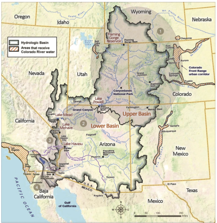
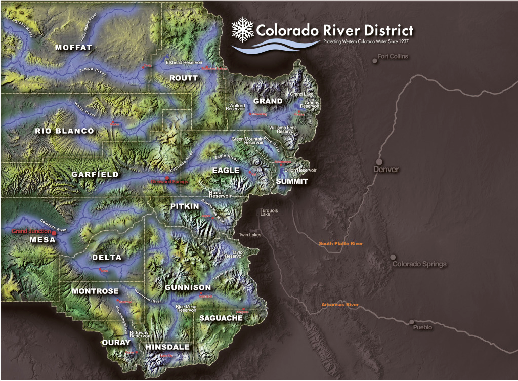
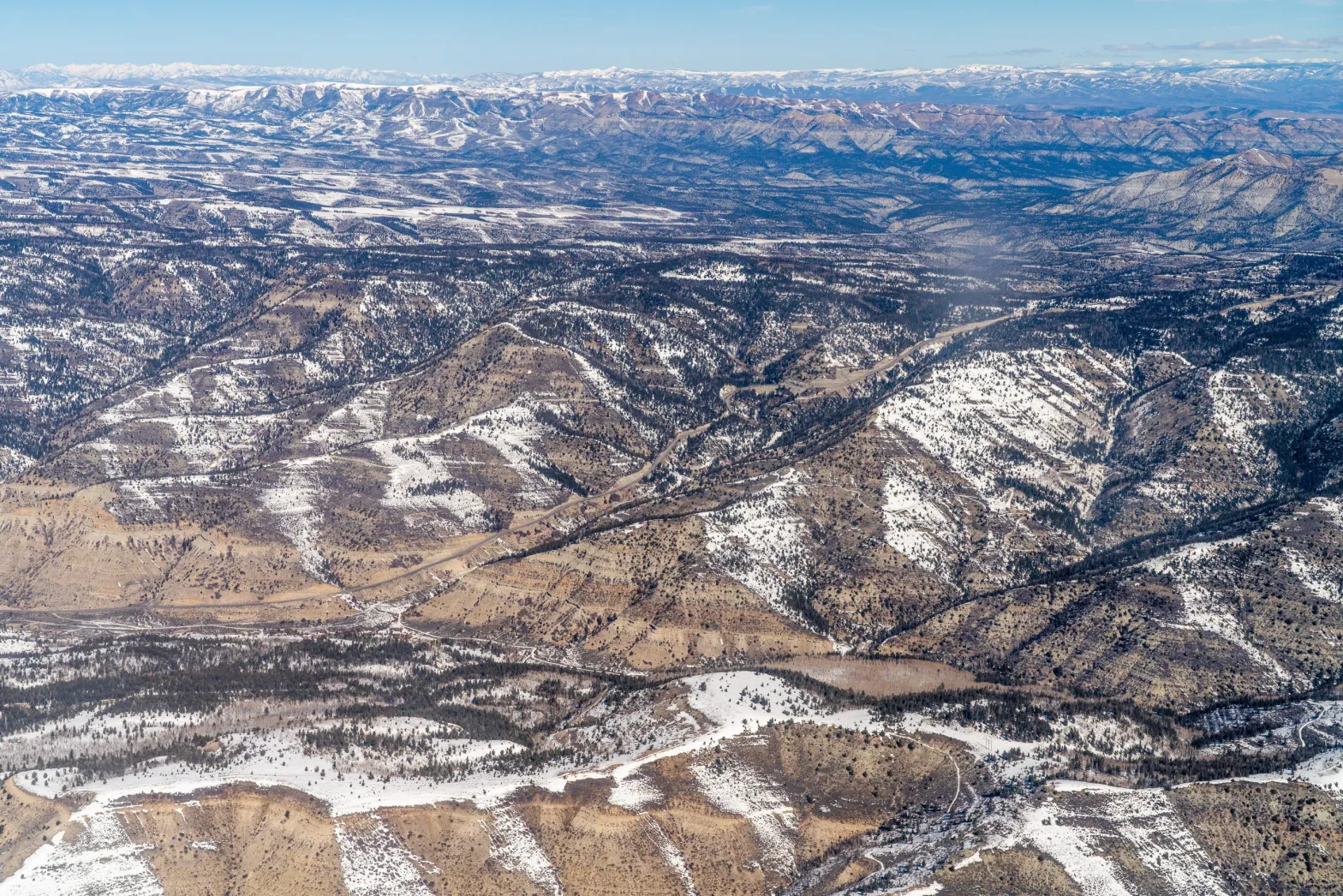
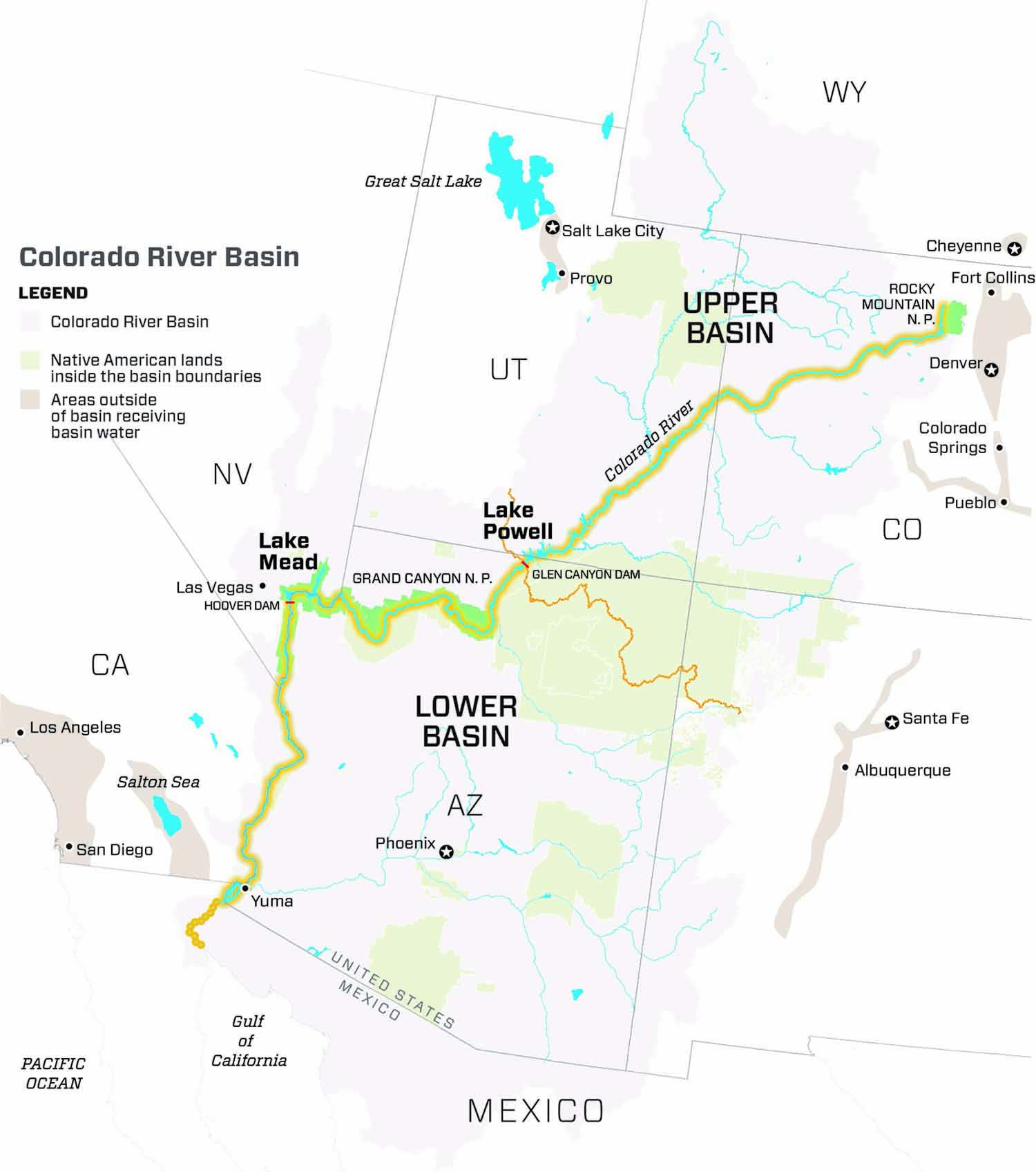
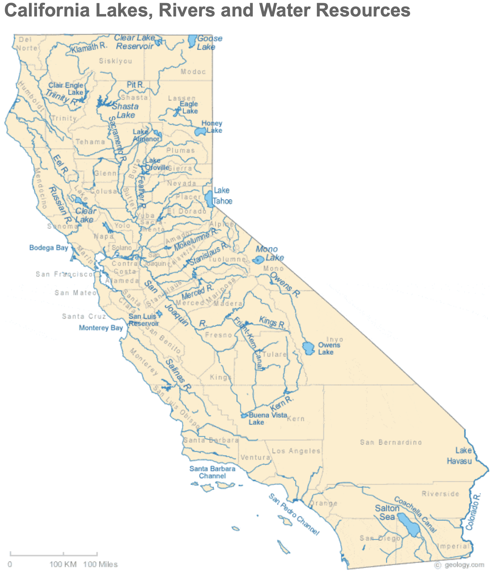
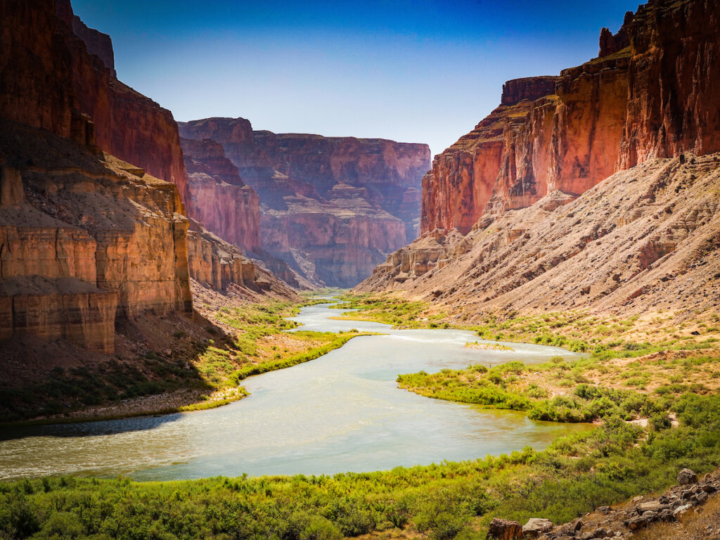
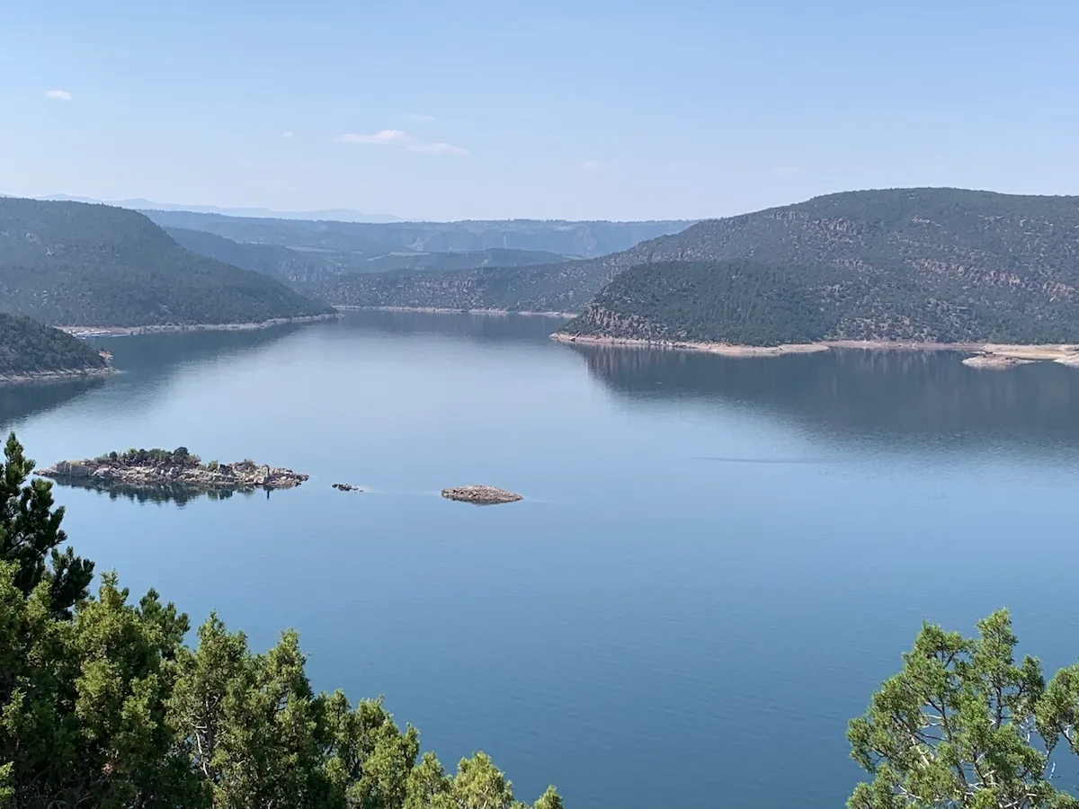
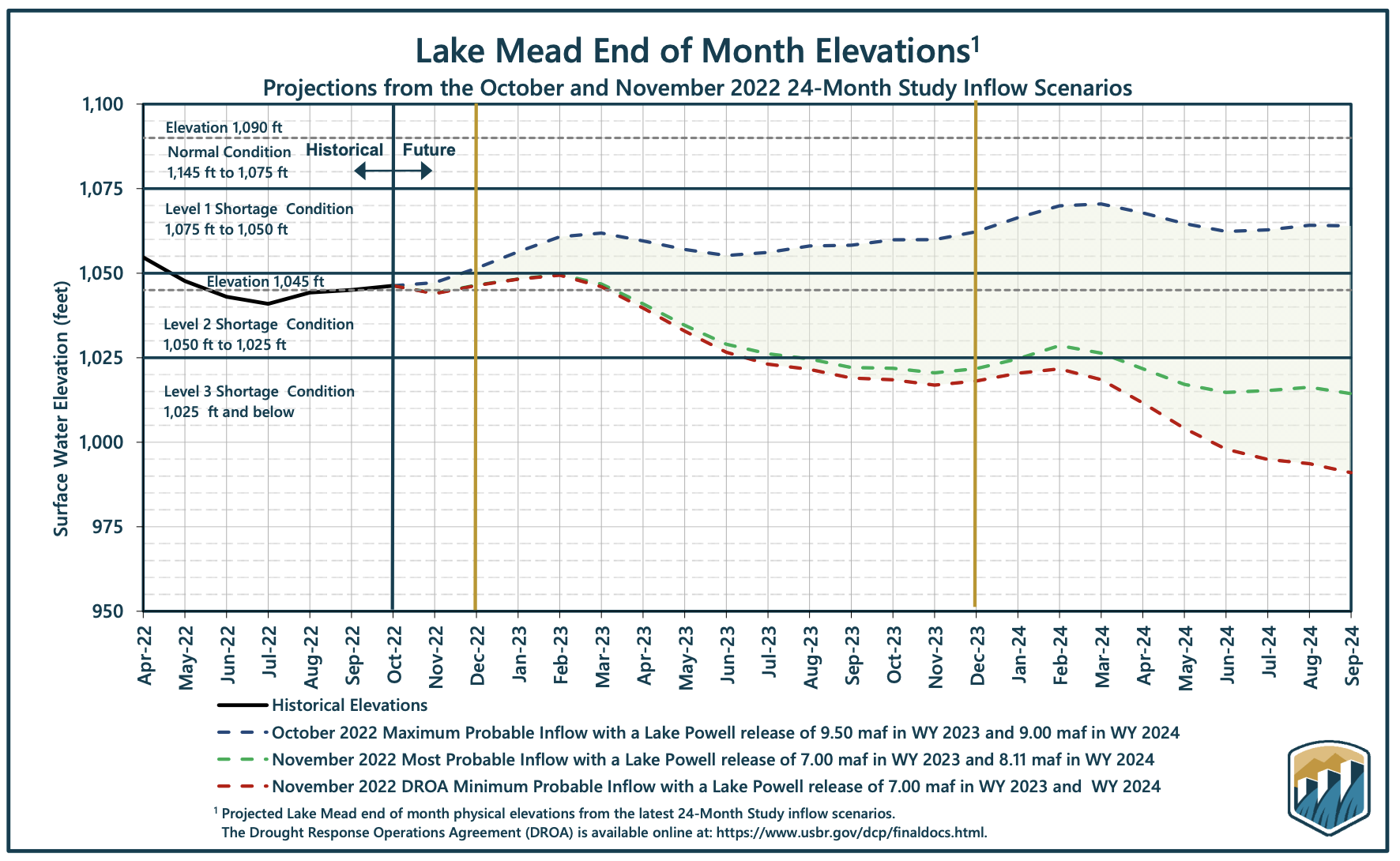
Enough gallivanting around the Mississippi Basin and its rivers; back to the troubled and troublesome Colorado River, currently experiencing its worst dry spell since around 800 CE. The Colorado Rivers, I should maybe say, since for all practical (human) purposes the river is now managed in a quasi-de jure way as two river basins under the Colorado River Compact and subsequent ‘Law of the River’ actions: an Upper Colorado River and a Lower Colorado River.

Previously here, I’ve been exploring the Colorado River Compact at its centennial, in what is certainly the worst year in its century. Here are some things I came up with in that exploration, that I don’t think are getting enough attention in our efforts to search our own souls and the soul of the river in the desert as we try to figure out where we are going from here:

1. The Colorado River Compact is not the ‘foundation of the Law of the River.’ The foundation of the Law of the River is the appropriation doctrine: the body of law that bases the right to use the water of the river and its basin (groundwater too, now) primarily on the seniority of use. First come, first served, for any economically beneficial use for as long as the use continues. Appropriations law is basically a powerful growth engine.

The Colorado River Compact, and all the subsequent laws, treaties, acts of Congress, and other consensual agreements involving the river thus become efforts to deal with the consequences of applying a powerful growth engine to an erratic and relatively modest river  – and they fall short to the extent that they too cautiously circle around (or just ignore) the problem of a body of law encouraging unlimited demand on a limited resource.  

2. The Compact could not do what its creators set out to do, so they settled for an expedient resolution to facilitate development of the River.  The Compact was created because Euro-Americans wanted to control a rambunctious river whose erratic flows made it hard to use for civilized pursuits. But the growth logic of the foundational Law of the River (the appropriation doctrine) made six of the seven Colorado River states fear the pace of development of the seventh state, California, if the river were controlled; California could conceivably lay claim to most of the river’s water before the other states really got settled. 

The six states thus wanted an ‘overlay’ to the unconstrained law of appropriation that would assure each state of enough water to meet their own future needs at their own pace. Unfortunately, they did not have – could not have had in the 1920s – enough solid information of what their reasonable future needs were. So they settled for an expedient resolution; they divided the river into two basins, above and below the uninhabited canyon region; each basin was given a little less than half the estimated flow of the river to develop, with the upper river basin committed to deliver a fixed amount of water to the lower river basin (75 million acre-feet over any ten-year period).

Eugene Clyde LaRue measuring the flow in Nankoweap Creek, 1923. Photo credit: USGS

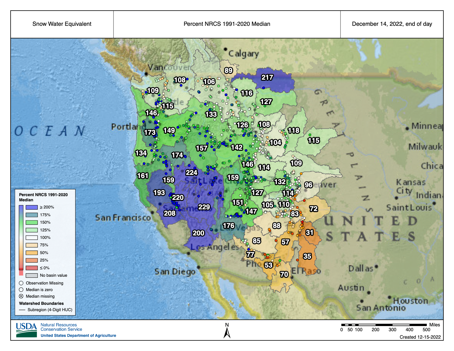
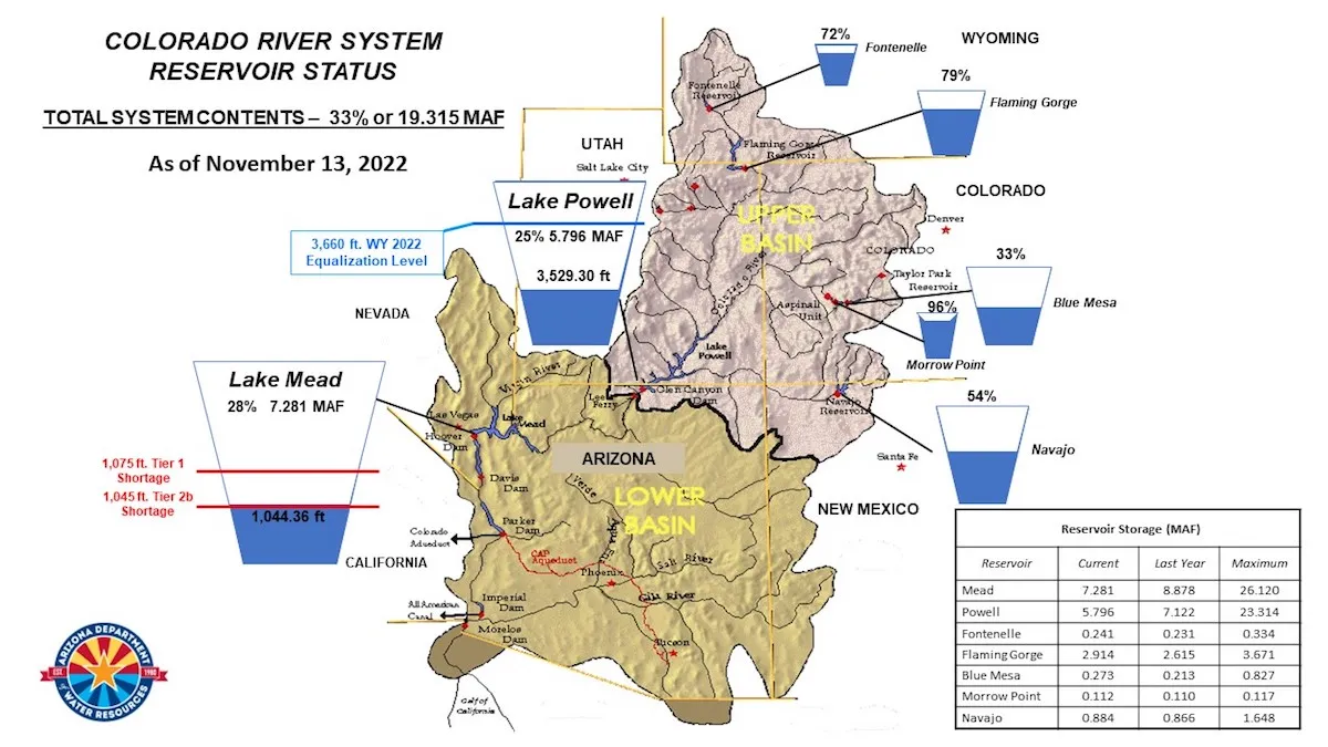
3. Mistakes were made. Much has been made of the fact that the Compact commissioners selected an estimated flow of 15 million acre-feet of water to divide between the two basins, well above what has been proven to be a more realistic estimate of an average annual river flow of 13 million acre-feet by E.C. LaRue and some other Geological Survey scientists. It was, however, well below the optimistic 16.8 million acre-feet estimate by the Bureau of Reclamation. 

It was also an ebulliently optimistic time in America – the advent of the Anthropocene, when we thought we were on the verge of freedom from the stodgy limitations of nature. The commissioners acknowledged that they did not have enough information to accurately divide the waters of the river seven ways, and were content to leave that task ‘to the hands of those men who may come after us, possessed of a far greater fund of information.’ We now know that they should have listened to the USGS scientists, but it is easier and kind of superior to tsk-tsk as ex post facto Monday morning quarterbacks, than it is to acknowledge and understand – maybe even regret the loss of – the spirit of the times when the mistake was made.

The Compact commissioners have also been faulted for ‘leaving the Indians out of the Compact.’ That is not entirely accurate; what they said was that ‘Nothing in this compact shall be construed as affecting the obligations of the United States of America to Indian tribes.’ But what was the obligation of the United States to the Indian tribes?

On the one hand, in 1908 the U.S. Supreme Court had decided, in a case involving an Indian reservation in Montana, that when the federal government reserved public lands for any specific purpose, such as an Indian reservation, that it also implicitly reserved enough water to carry out that purpose. In the case of an Indian reservation, this meant enough water to teach the Indians to be farmers rather than hunter-foragers – meaning irrigation water, in the West.

But on the other hand, when the Compact was created in the early 1920s, the federal government was aggressively pursuing the ‘soft genocide’ of forced assimilation. Between 1900 and 1925, the number of Indian youth essentially kidnapped into ‘Indian Boarding Schools’ swelled from around 20,000 to more than 65,000. The official policy was ‘kill the Indian to save the man.’ The Compact commissioners were all white professionals receiving mixed messages from the government, and might be expected to think, even hope (river gods forgive them), that any Indian water claims might fade away if government policy succeeded – which it didn’t, no thanks to federal Indian policies before or since. And a reserved water obligation for the reservations remains an untransacted and pending commitment.

So yes, the Compact kicked some cans down the road, that it’s now time to pick up and deal with. But no one seems to be saying anything about a much larger and more consequential Compact mistake…

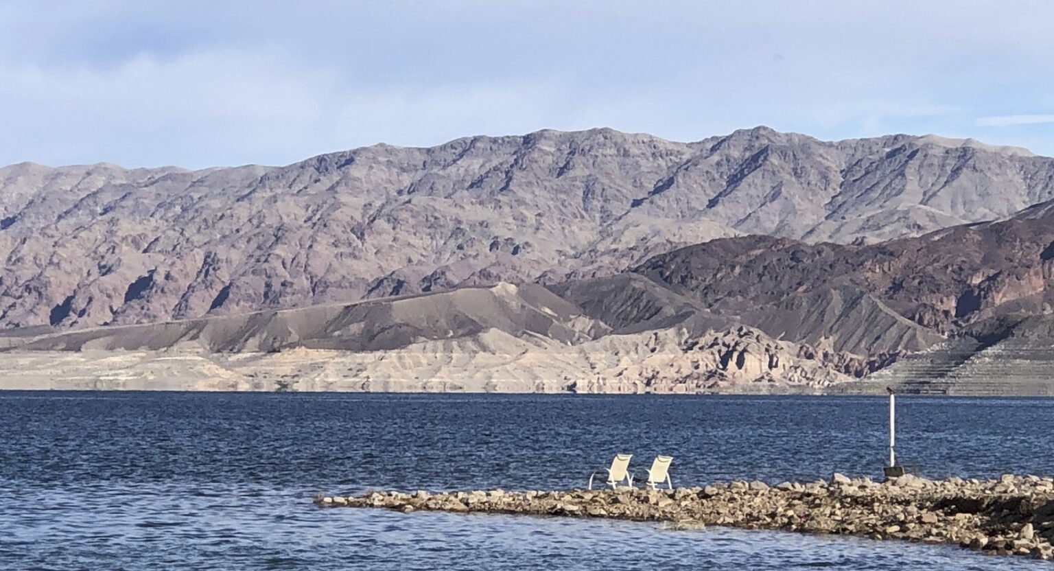
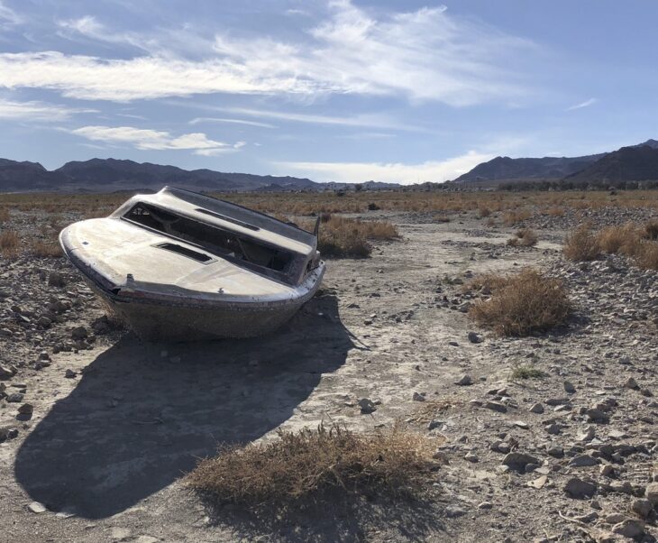
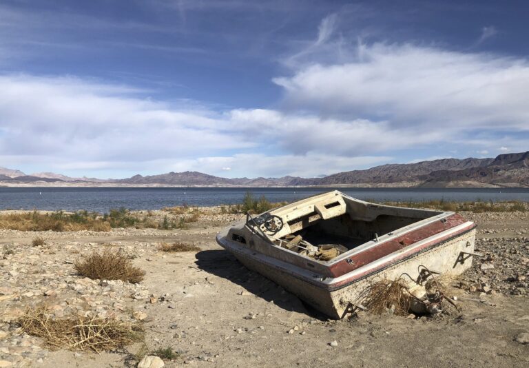
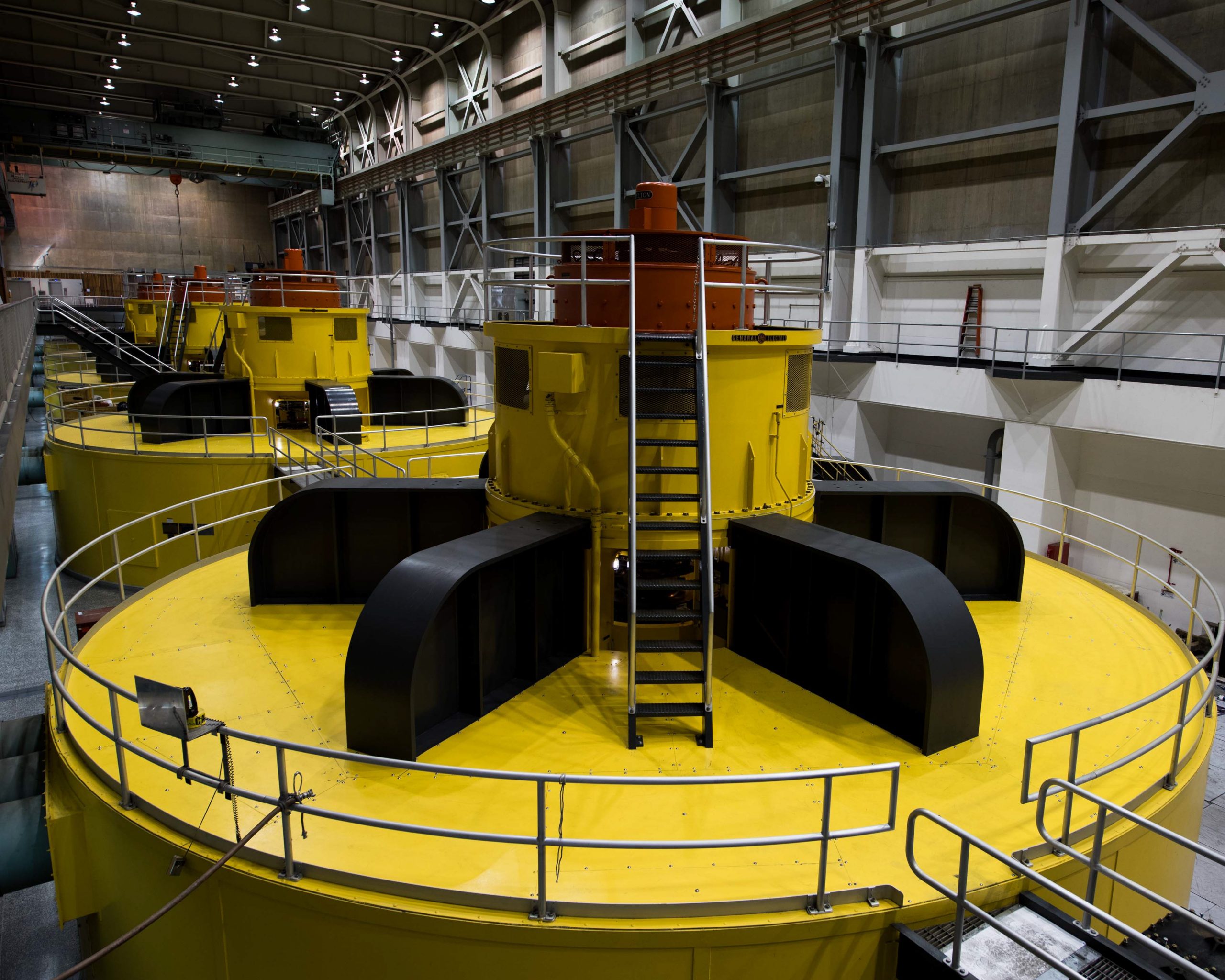
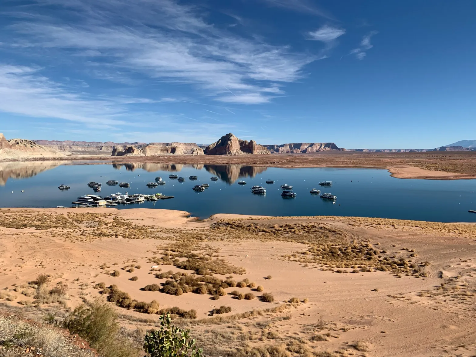
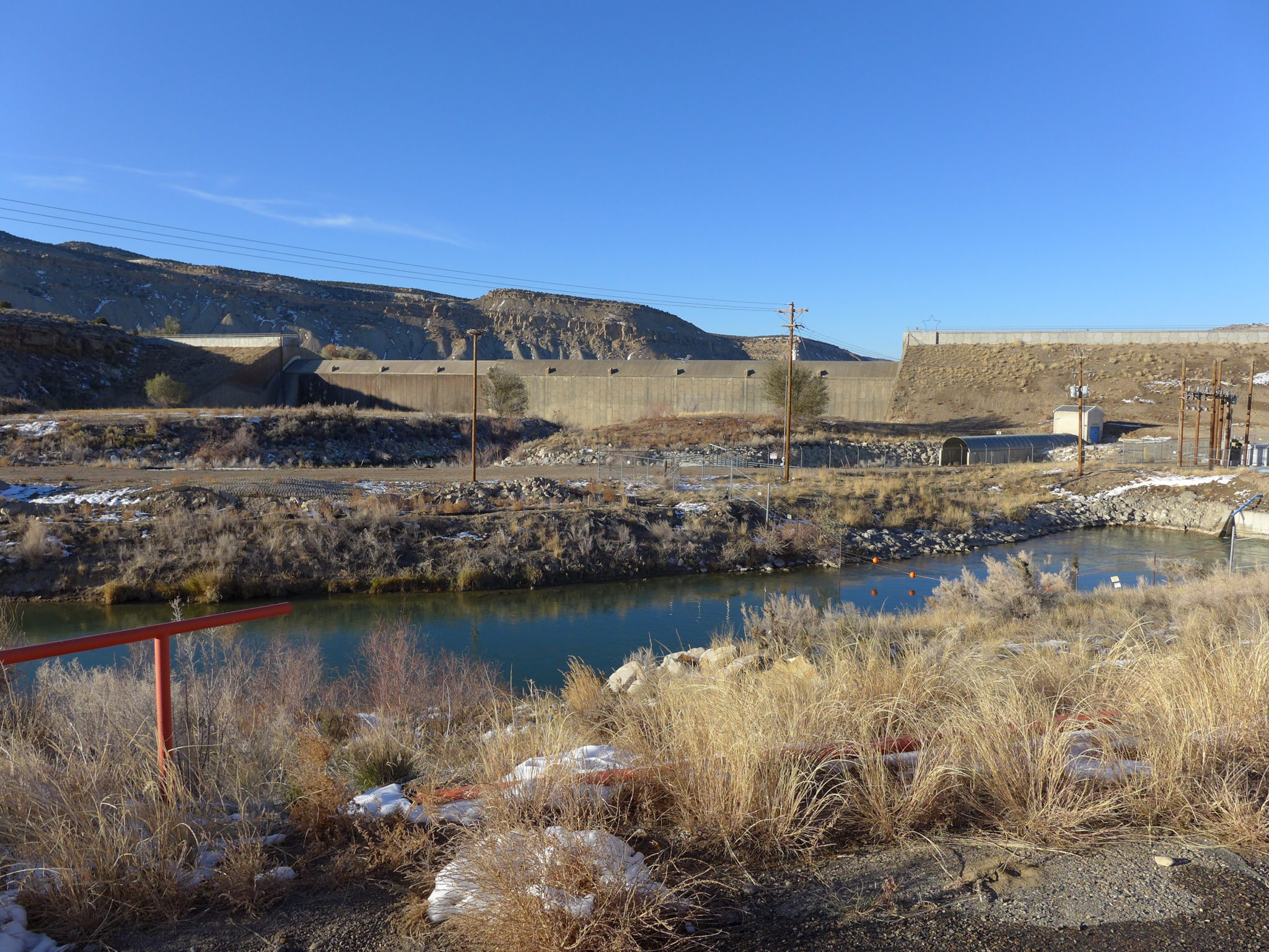
4. Dividing a desert river basin into two river basins is not a good idea. It worked – sort of (Arizona didn’t accept it) – as a temporary fix to break the logjam of not knowing enough to make an equitable seven-way division of the waters. What made the two-basin Compact work at all, sort of, was the fact that, until the construction of Glen Canyon Dam, the river itself, flowing unconstrained past Lees Ferry, kept the water supply (nearly all from the Upper River Basin) united with the growing water demand (mostly in the Lower River Basin). 

But once the big dam near Lees Ferry was in place, the supply-demand distribution became a management problem that gradually succumbed to bad power politics. The Bueau gave the Lower River Basin its Compact allocation and more, regardless of growing water supply problems upriver, and the Upper River Basin developed a large supply of justifiable but unproductive resentment. The Compact, which confused ‘equitable’ with ‘equal’ in its division between two basins, is broken by the dam that turns it into two rivers, one supplying the other in ways both unequal and inequitable. It’s not the ‘structural deficit’ per se, but the refusal to address it, that breaks the Compact.

So – what can we do?How do we muddle forward from where we are now? No one is asking me, but of course I have some thoughts….

First and foremost, we should reunite the two river basins into one squabbling river basin (with transbasin extensions). Drop the expedient Compact solution of two river basins – a mistake perpetrated by subsequent ‘Law of the River’ measures, and finally fatal when the Colorado River Storage Project Act enabled building a wall – literally – between the two river basins. 

This reunion would have to start with a consensual seven-state agreement – a new compact, if you will, to execute the task deemed impossible in 1922: a seven-state division of the river’s use. After a century of development, this has been achieved, de facto, and equitably enough. The lower river basin states get the consumptive use of almost twice as much water as the upper river basin, but they spread it over far more people and quite a bit more (and more productive) ag land. 

This will not be easy, of course – but nothing ever is in the Colorado River region. California and Arizona have gotten so used to using ‘undeveloped upper river basin water’ that they’ve forgotten that that ‘surplus’ hasn’t existed for decades. They think the ‘structural deficit’ is an act of God about which nothing can be done, rather than just the consequence of their growing on borrowed water, a loan now being called in. But the hardest part for the lower river basin will come when the firm numbers for present use apportionments by state all have to be converted into percentages of the diminishing whole river – which the upper river basin states have already been doing, living closer to the vagaries of a desert river. The upper river states will no longer have to fear a call from the lower basin states, so long as they stay within their apportioned percentage of what’s there.

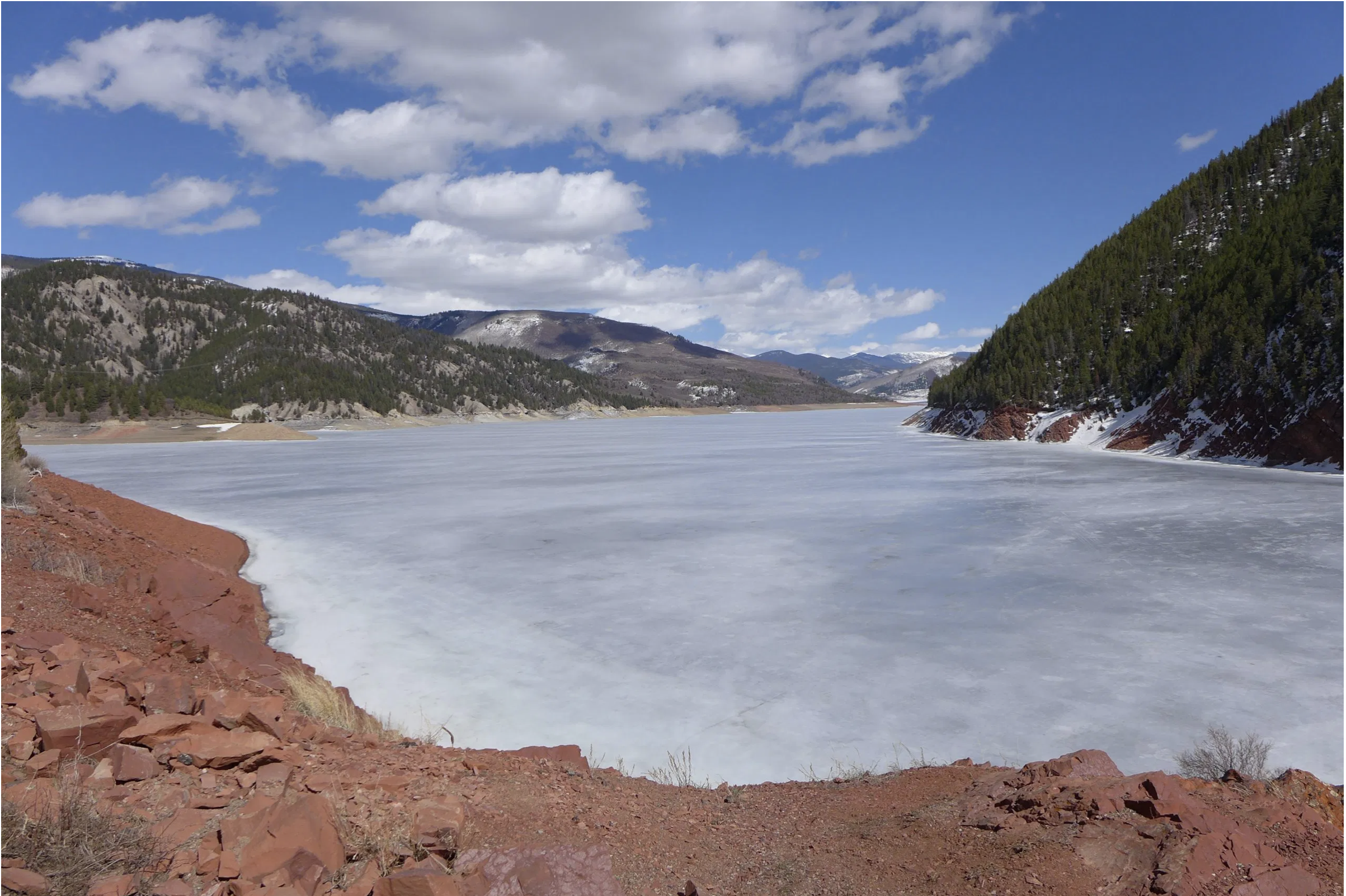
The real reunion of the basins into one river might begin when those in the lower river basin acknowledge that the water supply for the river’s desert lands comes mostly from snowfall in mountains in the river’s headwaters. This suggests that the downriver users of a desert river should accept some responsibility for the maintenance and improvement of the river’s mountain headwaters, their water supply. And those in the upper river basin would need to acknowledge the need for that help, especially if it is financial.

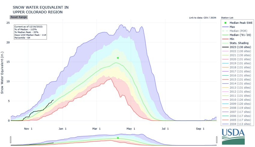
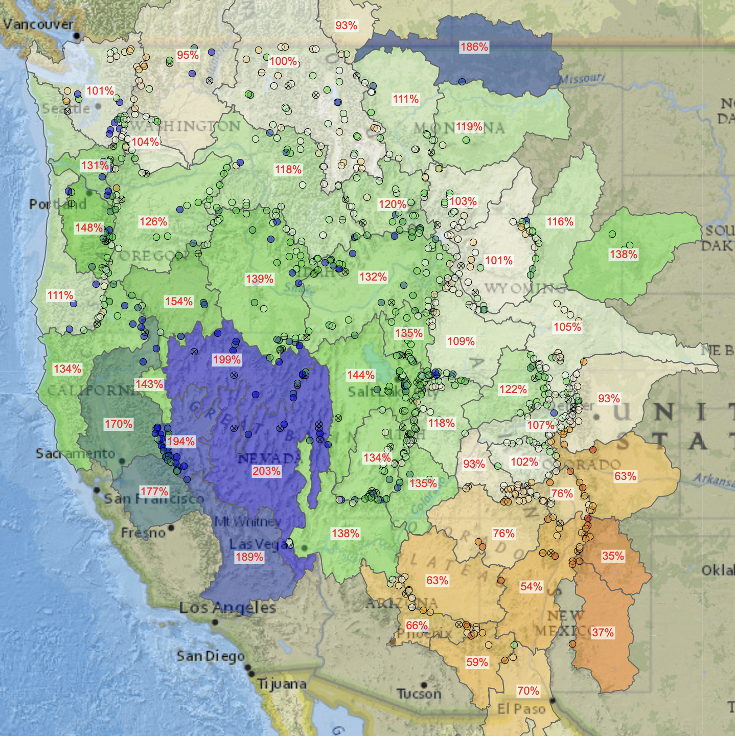
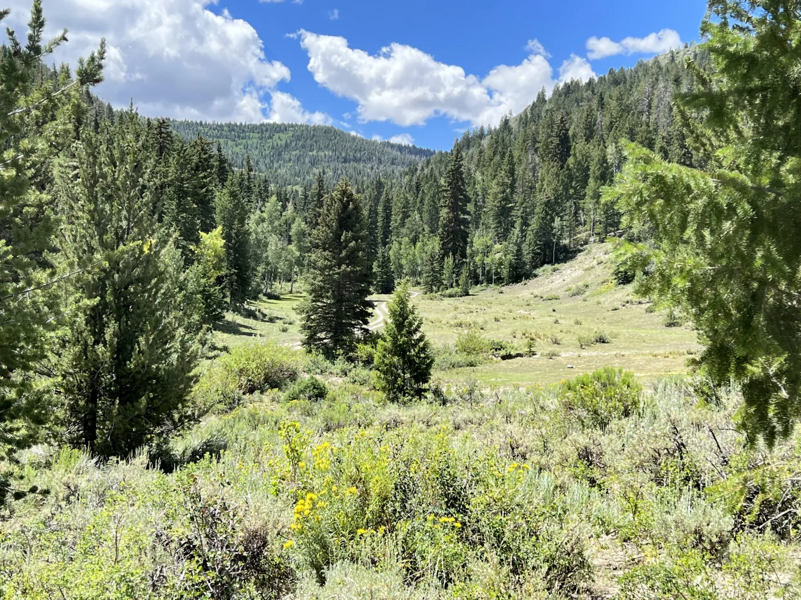
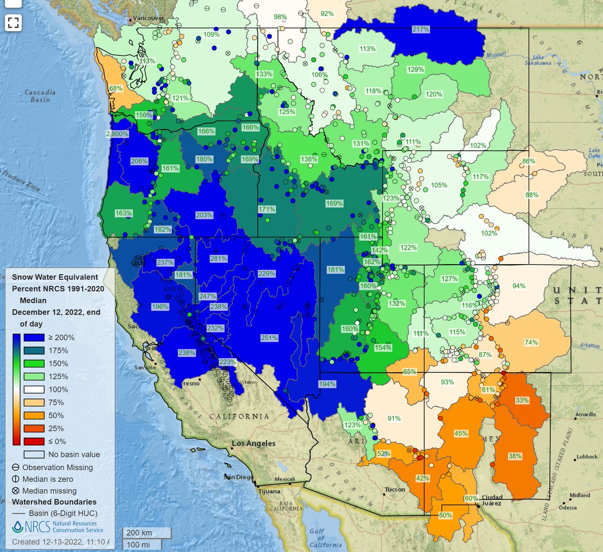
‘Maintenance and improvement’ of the water supply? Can we ‘improve’ the water yield from a river’s headwaters? An undigested fact about the mountain headwaters of the Colorado River Basin is the scientists’ consensual estimate that somewhere around 90 percent of the precipitation that falls over the river basin does not make it into the river. It either returns fairly quickly to the heavens as water vapor, or soaks into the ground to be transpired by trees, grasses and other plants back into the atmosphere. Scientists estimate that as much as a third of the precipitation that falls is lost through sublimation in the high headwaters: snow and ice being vaporized by sun and wind without even turning into water first. 

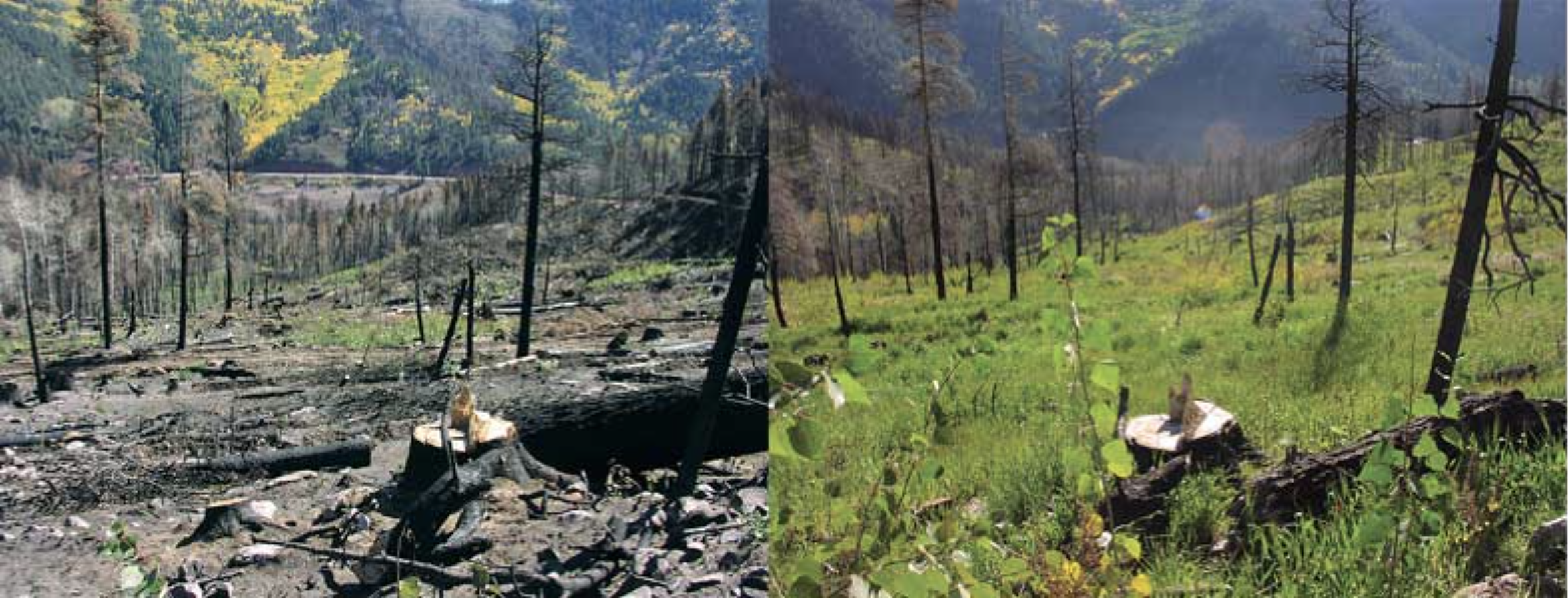
Some quantity close to another third of the precipitation is transpired through the forests that form a broad band around the headwaters reaches of the river. Contrary to Forest Service founder Gifford Pinchot, the forests are not ‘father’ to the rivers that work their way through the forests; the forests are just some of the first major ecosystems that depend on the river’s water for their life. We love and need the forests, and they do provide shade and shelter for the snow that makes it through the trees to the ground – but they also drink a lot of water (more as the ambient temperatures increase), and not always for their own betterment; the density and age of forests we have protected from cleansing fires result in the consumption of a lot of water by big old forest trees not really getting enough to be healthy.

Those forests are almost entirely managed by the U. S. Forest Service, management that must include the long-term health and well-being of the forest itself rather than just short-term commodity production. But are there ways to manage a healthy forest that maximizes the Forest Service’s 1897 organic act charge ‘to secure favorable conditions of water flows,’ as well as (or instead of) the charge ‘to furnish a continuous supply of timber’?We don’t really know, because the Forest Service has not paid as much attention to optimal water management as it has to optimal timber management. We do know, however – for one example – that timber managers favor denser stands to produce tall trees with less branchiness, but that density increases the amount of snow intercepted by trees, which increases snow loss through sublimation. 

To even learn how to maximize water yield from the headwaters’ rocks, ice and forests will require experimentation, trying things out, and it will require creative scientists and lots of boots on the ground that the perpetually under-funded Forest Service cannot afford. If, however, all forty million users of the Colorado River’s water thought of themselves as part of the whole river’s watershed, top to bottom, they might be willing to pony up a pittance for the health and vitality of the headwaters that produces their water. This is already happening to a modest extent; some of the big dogs in the Lower River Basin – the Metropolitan Water District, the Southern Nevada Water Authority, the Central Arizona Project – are contributing funding to a cloud-seeding project in the river’s headwaters, to increase snowfall from selected storms. That is a beginning.

And the next steps? Well, at some point, we have to descend into the cellar foundation of the Law of the River, and figure out how to adapt the frontier instincts of the appropriations doctrine to a civilization of 40 million. As Tom Buschatzke, Arizona’s Director of Water Resources said, just last week at the meeting of the Colorado River Water Users convention: ‘The single biggest roadblock to solving the problem of stabilizing the river is the priority system.’ 

There will be more on this imagined reuniting of the two rivers and their basins. Stay tuned.

Updated Colorado River 4-Panel plot thru Water Year 2022 showing reservoirs, flows, temperatures and precipitation. All trends are in the wrong direction. Since original 2017 plot, conditions have deteriorated significantly. Brad Udall via Twitter: https://twitter.com/bradudall/status/1593316262041436160

Congratulations to Northern Water — The Buzz @FloydCiruli #NISP #PoudreRiver #SouthPlatteRiver

Click the link to read the post on The Buzz website (Floyd Ciruli):

The NISP project in the North Front Range has just received its critical permit from the U.S. Army Corps of Engineers in compliance with the National Environmental Policy Act. The project, which will cost $2 billion and take years to complete, will provide water to a host of cities and agricultural water districts in Larimer, Weld, Morgan, and Boulder counties.

The review by Colorado and federal environmental agencies took 20 years and added millions in additional cost to the project in scientific study and mitigation, including sending more water down the Poudre River through Fort Collins to maintain flows above what currently exist. It also adds major recreational opportunities and flatwater fishing.

Ciruli Associates provided public relations and public opinion research to the project managers to assist in the regulatory compliance.

After years of opposition and delay, some adversaries now threaten lawsuits, their success after these long environmental reviews has been limited. Most recently, they filed lawsuits to stop the Windy Gap project on the western slope and Gross Reservoir in Boulder County and failed in both.

Fortunately, the region’s water leadership maintained a steady and determined commitment to achieving the project’s approval.

The Chimney Hollow Reservoir Project hosted a groundbreaking event on Aug. 6, 2021. Photo credit: Northern Water

READ MORE: https://www.northernwater.org/Home/NewsArticle/3d7f713d-6df9-4549-bb87-37629b707b66

Biden-Harris Administration Announces Historic Investment in Partnerships for 70 #Climate-Smart Commodities and Rural Projects — USDA

In areas that experience low-severity burns, fire events can serve to eliminate vegetative competition, rejuvenate its growth and improve watershed conditions. But, in landscapes subjected to high or even moderate burn severity, the post-fire threats to public safety and natural resources can be extreme. Photo credit: Colorado State Forest Service

Click the link to read the release on the USDA website:

USDA to Triple Commitment with Initial $2.8 Billion Investment Piloting New Revenue Streams for America’s Climate-Smart Farmers, Ranchers and Forest Landowners, with Additional Projects to Come

Agriculture Secretary Tom Vilsack announced today that the Biden-Harris Administration through the U.S. Department of Agriculture is investing up to $2.8 billion in 70 selected projects under the first pool of the Partnerships for Climate-Smart Commodities funding opportunity, with projects from the second funding pool to be announced later this year. Ultimately, USDA’s anticipated investment will triple to more than $3 billion in pilots that will create market opportunities for American commodities produced using climate-smart production practices. These initial projects will expand markets for climate-smart commodities, leverage the greenhouse gas benefits of climate-smart commodity production and provide direct, meaningful benefits to production agriculture, including for small and underserved producers. Applicants submitted more than 450 project proposals in this first funding pool, and the strength of the projects identified led USDA to increase its investment in this opportunity from the initial $1 billion Vilsack announced earlier this year.

“There is strong and growing interest in the private sector and among consumers for food that is grown in a climate-friendly way,” said Vilsack. “Through today’s announcement of initial selections for the Partnerships for Climate-Smart Commodities, USDA is delivering on our promise to build and expand these market opportunities for American agriculture and be global leaders in climate-smart agricultural production. This effort will increase the competitive advantage of U.S. agriculture both domestically and internationally, build wealth that stays in rural communities and support a diverse range of producers and operation types.”

Earlier this year, Vilsack announced that USDA had allocated $1 billion for the program, divided into two funding pools. Because of the unprecedented demand and interest in the program, and potential for meaningful opportunities to benefit producers through the proposals, the Biden-Harris administration increased the total funding allocation to more than $3 billion, with projects from the second funding pool to be announced later this year. Vilsack made the announcement from the campus of Penn State University, which is the lead partner on one of the selected pilot projects to implement climate-smart practices, quantify and track the greenhouse gas benefits and develop markets for the resulting climate-smart commodities.

Funding for Partnerships for Climate-Smart Commodities will be delivered through USDA’s Commodity Credit Corporation in two pools. Projects announced today are from the first funding pool, which included proposals seeking funds ranging from $5 million to $100 million. USDA received over 450 proposals from more than 350 entities for this funding pool, including nonprofit organizations; for-profits and government entities; farmer cooperatives; conservation, energy and environmental groups; state, tribal and local governments; universities (including minority serving institutions); small businesses; and large corporations. Applications covered every state in the nation as well as tribal lands, D.C. and Puerto Rico. The tentative selections announced today reflect this broad set of applicants and geographic scope, and the proposals include plans to match on average over 50% of the federal investment with nonfederal funds.

USDA will work with the applicants for the 70 identified projects to finalize the scope and funding levels in the coming months. A complete list of projects identified for this first round of funding is available at usda.gov/climate-smart-commodities. These include:

  • Climate-Smart Agriculture Innovative Finance Initiative: This project, which will cover more than 30 states, will use innovative finance mechanisms to accelerate climate-smart practice uptake by farmers, leveraging private sector demand to strengthen markets for climate-smart commodities. A broad array of partners will provide technical assistance and additional financial incentives to a diverse array of producers across a broad range of commodities, tying climate-smart practice to commodity purchases and creating a scalable model for private sector investment. Lead partner: Field to Market
  • Scaling Methane Emissions Reductions and Soil Carbon Sequestration: Through this project, Dairy Farmers of America (DFA) climate-smart pilots will directly connect the on-farm greenhouse gas reductions with the low-carbon dairy market opportunity. DFA will use its cooperative business model to ensure that the collective financial benefits are captured at the farm, creating a compelling opportunity to establish a powerful self-sustaining circular economy model benefiting U.S. agriculture, including underserved producers. Lead partner: Dairy Farmers of America, Inc.
  • The Soil Inventory Project Partnership for Impact and Demand: This project will build climate-smart markets, streamline field data collection and combine sample results with modeling to make impact quantifications accurate and locally specific but also scalable. Targeted farms produce value-added and direct-to-consumer specialty crops as well as the 19 most common row crops in the United States. Lead partner: The Meridian Institute
  • The Grass is Greener on the Other Side: Developing Climate-Smart Beef and Bison Commodities: This project will create market opportunities for beef and bison producers who utilize climate-smart agriculture grazing and land management practices. The project will guide and educate producers on climate-smart practices most suited for their operations, manage large-scale climate-smart data that will be used by producers to improve decision-making, and directly impact market demand for climate-smart beef/bison commodity markets. Lead university: South Dakota State University
  • Traceable Reforestation for America’s Carbon and Timber: This project builds climate-smart markets for timber and forest products and addresses the need to expand and recover the nation’s forest estate to balance the demand for wood products with the increasing need for forests to serve as carbon reservoirs. The project will deploy funding, planning, and implementation of reforestation and afforestation activities in lands deforested by wildfire in the Western U.S. and degraded agricultural lands in the Southern U.S. Every acre planted and the volume of forest products generated will have a quantified and verified climate benefit in metric tons of carbon dioxide equivalents (CO2e). Lead partner: Oregon Climate Trust

Spanning up to five years, these 70 projects will:

  • Provide technical and financial assistance to producers to implement climate-smart production practices on a voluntary basis on working lands;
  • Pilot innovative and cost-effective methods for quantification, monitoring, reporting and verification of greenhouse gas benefits; and
  • Develop markets and promote the resulting climate-smart commodities.

The projects announced today will deliver significant impacts for producers and communities nationwide. USDA anticipates that these projects will result in:

  • Hundreds of expanded markets and revenue streams for producers and commodities across agriculture ranging from traditional corn to specialty crops.
  • More than 50,000 farms reached, encompassing more than 20-25 million acres of working land engaged in climate-smart production practices such as cover crops, no-till and nutrient management.
  • More than 50 million metric tons of carbon dioxide equivalent sequestered over the lives of the projects. This is equivalent to removing more than 10 million gasoline-powered passenger vehicles from the road for one year.
  • More than 50 universities, including multiple minority-serving institutions, engaged and helping advance projects, especially with outreach and monitoring, measurement, reporting and verification.
  • Proposals for the 70 selected projects include plans to match on average over 50% of the federal investment with nonfederal funds.

Projects were selected based on a range of criteria, with emphasis placed on greenhouse gas and/or carbon sequestration benefits and equity. The Notice of Funding Opportunity included a complete set of project proposal requirements and evaluation criteria.

USDA is currently evaluating project proposals from the second Partnerships for Climate-Smart Commodities funding pool, which includes funding requests from $250,000 to $4,999,999. Projects from this second funding pool will emphasize the enrollment of small and/or underserved producers, and/or monitoring, reporting and verification activities developed at minority-serving institutions. USDA expects to announce these selections later this Fall.

More Information

Partnerships for Climate-Smart Commodities is part of USDA’s broader strategy to position agriculture and forestry as leaders in climate change mitigation through voluntary, incentive-based, market-driven approaches. Visit usda.gov/climate-smart-commodities to learn more about this effort, and usda.gov/climate-solutions for climate-related updates, resources and tools across the Department.

Under the Biden-Harris administration, USDA is engaged in a whole-of-government effort to combat the climate crisis and conserve and protect our Nation’s lands, biodiversity and natural resources including our soil, air and water. Through conservation practices and partnerships, USDA aims to enhance economic growth and create new streams of income for farmers, ranchers, producers and private foresters. Successfully meeting these challenges will require USDA and our agencies to pursue a coordinated approach alongside USDA stakeholders, including State, local and Tribal governments.

USDA touches the lives of all Americans each day in so many positive ways. In the Biden-Harris administration, USDA is transforming America’s food system with a greater focus on more resilient local and regional food production, fairer markets for all producers, ensuring access to safe, healthy and nutritious food in all communities, building new markets and streams of income for farmers and producers using climate smart food and forestry practices, making historic investments in infrastructure and clean energy capabilities in rural America, and committing to equity across the Department by removing systemic barriers and building a workforce more representative of America. To learn more, visit www.usda.gov.

Red Wave Crashes into Trump, Abortion, and Democracy – Becomes Ripple — The Buzz

Click the link to read the post on The Buzz website (Floyd Ciruli):

The Red Wave which the history of midterms and many 2022 polls predicted became barely a ripple. What happened?

As the National Political Dashboard for November 8 displays, President Biden’s approval was deep in negative territory (-12%), the generic test was tilted toward Republicans (2.5%), inflation was at 8 percent and the markets down, all elements of a bad referendum election for the president’s party.

But the election shifted from a referendum to a choice between the Democrats and a Republican party that appeared extreme to critical groups of independent voters, millennials and Gen Z especially women.

From the June Dobbs abortion decision through the summer January 6 House hearings on the threat to democracy to former President Donald Trump’s high profile interventions in Republican primaries in favor of several controversial candidates the spotlight focused on the Republican party’s vulnerabilities. Also a sudden burst of legislative accomplishment, especially the Inflation Reduction Act provided Biden and Democrats a platform to run on.

Democrats gained a seat in the Senate, lost the House by only 9 seats, and have two more governors. An exceptionally successful midterm for Joe Biden’s party.

Las Vegas water boss urges states to take action to keep lakes from crashing — The Las Vegas Review-Journal #ColoradoRiver #COriver #aridification #CRWUA2022

John Entsminger at the Colorado River Water Users Association Annual Conference December 15, 2021.

Click the link to read the article on The Las Vegas Review Journal website (Colton Lochhead). Here’s an excerpt:

Southern Nevada’s water boss is calling on other Colorado River basin states to “do the math and face reality” as they work toward finding a way to stabilize the dwindling river that supplies water to 40 million people in the Southwest. Speaking during a panel at the annual Colorado River Water Users Association in Las Vegas on Thursday, Southern Nevada Water Authority General Manager John Entsminger said California and Arizona are going to have to shoulder the brunt of the unprecedented cuts the federal government says are needed next year in order to keep the Lake Mead and Lake Powell from crashing to points that would put hydropower and water delivery operations at risk — a possibility that is far closer than previously thought….

Since 2000, California and Arizona have accounted for nearly 70 percent of the overall water consumed annually along the Colorado River, with the majority of that water going toward agriculture irrigation.

“I’m a big believer in the law, I’m a big believer in food security. But I’m an even bigger believer in math,” Entsminger said. “When you’re cutting 4 million acre feet out of 12, and three-quarters of the use are downstream of Hoover Dam, that’s where the cuts are going to come.”

Without any plan from the states in place, the federal government has started to move forward with a plan to augment prior drought contingency plans, and one of the options it is exploring is unilaterally mandating cuts to states’ water uses in order to protect critical water elevations at the Colorado River’s two major reservoirs. Forecasting from the Bureau of Reclamation that assumes continued dry conditions across the basin show that Lake Powell could fall far enough to jeopardize hydropower production by as early as next summer, while Lake Mead could hit that same point by spring of 2025. A recent analysis by the Southern Nevada Water Authority showed that roughly 1.5 million acre feet is lost along the Colorado River system each year to evaporation and in transit as water flows downstream, losses that at this point are mostly unaccounted for in the allocation of water rights among among the seven states and Mexico that pull from the river.

Tom Buschatzke, director of the Arizona Department of Water Resources, said that water lost to evaporation and other system losses do need to be accounted for moving forward, but said the “single biggest” roadblock to stabilizing the river is the priority system itself, where the oldest water rights are first in line.

Upper #ColoradoRiver basin moves closer to #water #conservation program: Colorado River District will play role in vetting projects — @AspenJournalism #COriver #aridification #CRWUA2022

Fountains shoot water from the Colorado River into the air outside of Caesar’s Palace in Las Vegas Friday. The resort hosts the annual Colorado River Water Users Association conference. CREDIT: HEATHER SACKETT/ASPEN JOURNALISM

Click the link to read the article on the Aspen Journalism website (Heather Sackett):

Upper Colorado River basin officials seemed to inch closer to implementing a demand management program, the heart of which involves paying agricultural water users to use less, at the Colorado River Water Users Association conference this week.  

At the annual gathering of water managers and experts in Las Vegas — which sold out for the first time ever with over 1,300 attendees — the Upper Colorado River Commission (UCRC) released more details of a rebooted “system conservation pilot program” (SCPP). It originally ran from 2015 to 2018 and paid water users to use less Colorado River water. 

The restarted program comes with $125 million of federal funding from the Inflation Reduction Act, with the goal of reducing Colorado River use and mitigating the impacts of long-term drought and depleted reservoirs. 

A request for proposals released Wednesday set a price of $150 per acre foot of conservation. But applicants could be paid more if they can justify a higher price for their conservation project. The UCRC expects to award contracts in March to begin conserving water during the 2023 irrigation season.

The UCRC has also been studying the feasibility of a demand management program, which would also pay water users on a temporary and voluntary basis to use less water. 

Discussion of the two water conservation programs comes at a moment when the nation’s two biggest reservoirs, lakes Powell and Mead, are at historically low levels. Their combined storage is at just 26% of capacity, according to numbers provided Thursday by Bureau of Reclamation officials. 

The annual gathering has traditionally included finger-pointing among different water use sectors, but federal appointee and chair of the UCRC Anne Castle cast the real villain as climate change in her opening remarks at Wednesday’s board meeting. 

“The real enemy here is not the other basin, it’s not another state, it’s not alfalfa, it’s not golf courses,” she said. “The common cause we have to address is climate-change-induced lower flows and that’s what we have to work on together.”

This field is irrigated with water from the Roaring Fork River, under a senior water right. The upper Colorado River Basin seems to be inching closer to implementing a demand management program, the heart of which is paying agricultural water users to cut back. CREDIT: BRENT GARDNER-SMITH/ASPEN JOURNALISM

SCPP versus demand management

Conceptually, the SCPP and demand management are the same: paying water users — mostly agricultural water users who are the biggest water users in the basin by far — to cut back. 

The major difference between the two is that water saved from a demand management program would be legally set aside in a 500,000-acre-foot pool in Lake Powell to protect the upper basin against a compact call. A compact call could occur if the upper basin states (Colorado, Wyoming, Utah and New Mexico) can’t deliver the 7.5 million acre-feet of water per year to the lower basin states (Arizona, California and Nevada) as required by the 1922 Colorado River Compact. 

As climate change continues to rob the Colorado River basin of streamflows, the threat of a compact call becomes increasingly likely. The framework for a demand management program was set out in the 2019 Drought Contingency Plan.

Any water conserved through the SCPP would simply flow downstream, becoming “system” water to be picked up by water users in the lower basin. 

“If we are going to do it, I would much rather see it done in a demand management program where we can save the water, bank the water in our storage account in Blue Mesa, Lake Powell, Navajo and Flaming Gorge,” said Colorado River Water Conservation District General Manager Andy Mueller. “It’s much more in our interest in western Colorado that we keep that water to protect our interests and obligations under the compact.”

Officials said on Thursday that the SCPP program could eventually be rolled into a demand management program. 

“We believe (the SCPP) can easily be transitioned into demand management as we learn about that,” Gene Shawcroft, general manager of the Central Utah Water Conservancy District and commissioner to the UCRC, said in a Thursday CRWUA conference panel. “There are steps being taken to move toward (demand management), one of which is the SCPP.”

The state of Colorado conducted an in-depth study of demand management feasibility, convening nine workgroups to investigate different aspects of a potential program like impacts to the environment and agriculture and how to monitor and verify water savings. Earlier this year the CWCB placed it on the back burner to focus on a “drought resiliency toolkit” while officials waited for the report from the UCRC’s interstate demand management feasibility investigation, which was released Wednesday. 

A summary of the 63-page report says that next steps will include a committee drafting a program concept to present at the June 2023 UCRC regular meeting. Commissioners could consider approval of a demand management program at this June meeting. 

“I think if a demand management program is approved, then we will definitely use the lessons learned from the pilot program,” said Becky Mitchell, executive director of the Colorado Water Conservation Board and commissioner to the UCRC. “The difference from this pilot program versus the last one is the funding. We’ve never had this kind of funding before.”

The original SCPP saved about 47,000 acre-feet of water in the upper basin at a cost of about $8.6 million over the four years.

Colorado Water Conservation Board Executive Director and commissioner to the Upper Colorado River Commission Becky Mitchell, center, speaks on a panel with representatives of each of the seven basin states at the annual Colorado River Water Users Association conference in Las Vegas Thursday. The UCRC released additional details of a water conservation program this week. CREDIT: HEATHER SACKETT/ASPEN JOURNALISM

River District involvement

The Glenwood Springs-based Colorado River Water Conservation District, which covers 15 counties on the Western Slope, will play a key role in approval of projects enrolled in the renewed SCPP. Both the CWCB and River District will have to sign off on projects within the district’s boundaries. Durango-based Southwestern Water Conservation District will also be involved in the approval of projects in its district, according to general manager Steve Wolff. 

River District General Manager Andy Mueller has long said that a demand management program could pose risks to Western Slope communities and should have sideboards to mitigate any negative impacts. Mueller said he did not yet know what exactly the River District project approval process would look like.

Along with the state of Colorado, the River District has been a leader in looking into a demand management program. The district developed its own conceptual framework for a program and was one of several entities that commissioned a study on the potential secondary economic impacts of a program. It showed a small number of jobs would be lost if some water users were paid to fallow fields. 

Upper basin officials say they will scrutinize project proposals for evidence of those trying to unfairly profit from the sale of water. Third-party agents will be a red flag, UCRC Executive Director Chuck Cullom said.

“One of the clues to speculation is compensation to a third party to help you,” Cullom said. “The other thing is the compensation relative to the activity. So if you have a corn operation and you’re asking $1,000 an acre-foot, that seems like that’s out of sync with a reasonable return on your typical corn crop.” 

But preventing speculation may be easier said than done. The state of Colorado convened a workgroup to explore how to do that, but the group did not come up with any recommendations because members couldn’t reach consensus. State lawmakers also gave up on an effort to enact anti-speculation legislation after it was met with resistance from agricultural water users. An amendment to the draft legislation floated by the River District also failed to gain traction.  

Upper basin officials have consistently pushed back on questions of how much water can be saved through conservation programs, saying there are too many uncertainties to offer a number or make guarantees. Mitchell said she would rather under-promise and over-deliver.

“It’s hard to predict what we can do next year, because the predictions have consistently failed,” Mitchell said. “We have planned on a river that is not there so for us to make a commitment… is not a gamble I would take.”

Aspen Journalism covers water and rivers in collaboration with The Aspen Times. This story ran in the Dec. 17 edition of The Aspen Times, the Vail Daily, the Dec. 19 edition of Steamboat Pilot & Today, the Craig Press and the Glenwood Springs Post-Independent.

#Groundwater #conservation easement: A new way to manage #RioGrande — @AlamosaCitizen

The sun rises over Ron Bowman’s ranch in Mosca. Photo by Andrew Parnes for The Citizen.

Click the link to read the article on the Alamosa Citizen website (Chris Lopez):

WHEN you’re working on an enormous issue like water – in this case how to recover the Upper Rio Grande Basin and the two aquifers of the San Luis Valley – you have to stretch your mind to find new approaches.

The idea that groundwater pumped to irrigate crops could be restricted through a conservation easement is one of those moments when something that’s never been tried bubbles to the top and provides a new way to look at an urgent problem.

On Nov. 8, Valley farmer Ron Bowman signed the first-ever groundwater conservation easement to restrict the use of groundwater on his nearly 1,900-acre ranch in Mosca. The commitment also set a timeline for Subdistrict 4 of the Rio Grande Water Conservation District to purchase the ranch for $2.6 million, a deal it will be looking to close in 2023 with a loan from the Colorado Water Conservation Board.

The subdistrict’s acquisition of the entire ranch not only saves groundwater from being pumped, but importantly helps Subdistrict 4 achieve its sustainability requirements for the confined aquifer as well as offset stream depletions to nearby San Luis Creek from groundwater pumping that occurs in Subdistricts 4 and 5.

“How the law is written and works, we’ll hold those water rights and they’ll still be water rights but we won’t pump them ever again,” said Chris Ivers, program manager for Subdistrict 4 and one of the architects of the deal. “That protects those water rights from being abandoned and somebody else coming in and saying ‘Because these water rights have been abandoned, I can pump water over here.’ So we’re holding their place in line but saying, you can’t pump this water, this is our water to pump.”

Bowman’s groundwater pumping has accounted for about 10 percent of that being pumped by irrigators across Subdistrict 4. The farm has been operating with 12 center-pivot irrigation circles, growing mostly forage crops including some alfalfa.

“If by discontinuing irrigation on my farm, it means that my neighbors may be able to keep their multigenerational farms in their families, then it feels like the right thing to do,” Bowman said. He and his wife, Gail, purchased the property about five years ago.

The reduction in groundwater pumping and the fact the water is being placed in a conservation easement so it’s never pumped again creates a new way for the Rio Grande Water Conservation District and the state agencies and nonprofit land trusts it partners with to address depletion in the aquifers.

“The nice thing about a groundwater conservation easement is each one can be tailored to that property,” explains Sarah Parmar, director of conservation at Colorado Open Lands.

Parmar has been instrumental in helping create a framework for the groundwater conservation easement that Bowman entered into. She credits Cleave Simpson, the general manager of the Rio Grande Water Conservation District and state senator representing the Valley’s six counties, with the initial brainstorm.

From there it was getting other smart water people in the room, like Heather Dutton, manager of the San Luis Valley Water Conservancy District; local farmers Sheldon Rockey and Nathan Coombs; and state division engineer Craig Cotten to lend their expertise to determine if groundwater could be placed in a conservation easement.

The concept also went through a rigorous exercise with water attorneys to determine the legality of such a move, and Colorado Open Lands and the Rio Grande Headwaters Land Trust in Del Norte lent support to the project. There was also the matter of figuring out how to appraise the land given the new construct of groundwater being placed in an easement as part of a sale.

Over 20 years ago conservation easement work began to grow in the San Luis Valley largely with the establishment of the Rio Grande Headwaters Land Trust, which was formed primarily out of concern for the surface water provided by the Rio Grande and its tributaries,” Colorado Opens Lands noted. “Now through this new application of a conservation easement on the Valley’s groundwater resources, the land trust community in the Valley is reinforcing its commitment to supporting the community in protecting its most precious resource: water.”

More common in the Valley are announcements of land conservation easements, where a portion of agricultural land is placed in an easement to prevent future development and preserve the land as a natural habitat.

Now water managers like Simpson have figured out that groundwater can also be placed in a conservation easement, which creates a new way for farmers to think about their operations as they continue to reduce the amount of water they use to farm to meet the state’s groundwater pumping rules.

“We are used to keeping water rights in irrigation through conservation easements, so it feels wrong to intentionally dry a farm, but by drying this particular farm, we are ensuring that the other farms in the subdistrict are sustainable and we ensure that this groundwater stays in the aquifer and out of the hands of anyone who might want to try to move it outside of the basin,” said Parmar.

Other approaches to a groundwater conservation easement may be different, she said. Instead of a farmer putting all the groundwater in a conservation easement as Bowman did, maybe only a portion of it is conserved through an easement and the rest continues to be used for crop production.

“Our hope is to work with landowners across subdistricts to avoid the state stepping in to shut off wells,” said Parmar. “I am continually amazed by the willingness of farmers and ranchers to step up to the challenge and grateful to work with irrigators like Ron Bowman, who want to be part of the solution.”

#Snowpack news December 18, 2022

Colorado snowpack basin-filled map December 18, 2022 via the NRCS.
Westwide snowpack basin-filled interactive map via the NRCS.

Upper #SanJuanRiver #snowpack and streamflow report — The #PagosaSprings Sun #ColoradoRiver #COriver #aridification

Click the link to read the article on the Pagosa Springs Sun website (Josh Pike). Here’s an excerpt:

A Dec. 14 snow report from Wolf Creek Ski Area indicated that Wolf Creek had received 13 inches of snow in the previous 48 hours, bringing the midway base depth to 50 inches and the year-to-date snowfall total to 91 inches. According to the U.S. Department of Agriculture (USDA) National Wa- ter and Climate Center’s snowpack report, the Wolf Creek summit, at 11,000 feet of elevation, had 10.2 inches of snow water equivalent as of 11 a.m. on Tuesday, Dec. 14. The Wolf Creek summit is at 100 percent of the Dec. 14 snowpack median. The San Miguel, Dolores, Animas and San Juan river basins were at 98 percent of the Dec. 14 median in terms of snowpack…

River and water report

Stream flow for the San Juan River on Dec. 14 at approximately 10 a.m. was 60.4 cubic feet per second (cfs), according to the U.S. Geological Service (USGS) National Water Dashboard. This reading is down from last week’s reading of 81.9 cfs at 10 a.m. on Dec. 7.

#Cop15: historic deal struck to halt biodiversity loss by 2030: Agreement on ’30 by 30’ target forced through by Chinese president, ignoring objections from African states — The Guardian #ActOnClimate

he Cop15 agreement in Montreal is the culmination of more than four years of negotiations. Photograph: Julian Haber/Courtesy of Environment and Climate Change Canada

Click the link to read the key points from COP15 from The Guardian website (Patrick Greenfield and Phoebe Weston). Here’s an excerpt:

Main points of the historic agreement signed in Montreal to halt the destruction of Earth’s ecosystems

The Kunming-Montreal pact is a series of agreements that range from scientific cooperation to human-wildlife conflict. Here are the main points at a glance in the once-in-a-decade deal to halt the destruction of Earth’s ecosystems.

Agreement to conserve 30% of Earth by the end of the decade

Inspired by the Harvard biologist EO Wilson’s vision of protecting half the planet for the long-term survival of humanity, the most high-profile target at Cop15 has inspired and divided in equal measure. The final wording commits governments to conserving nearly a third of Earth for nature by 2030 while respecting indigenous and traditional territories in the expansion of new protected areas…

Indigenous rights at the heart of conservation

Indigenous peoples are mentioned 18 times in this decade’s targets to halt and reverse biodiversity, something to which activists are pointing as a historic victory. Several scientific studies have shown that Indigenous peoples are the best stewards of nature, representing 5% of humanity but protecting 80% of Earth’s biodiversity…

Reform of environmentally harmful subsidies

Definitely in the category of boring-but-important, the world spends at least $1.8tn (£1.3tn) every year on government subsidies driving the annihilation of wildlife and a rise in global heating, according to a study earlier this year…

Nature disclosures for businesses

Although the language was watered down in the final text, target 15 of the deal requires governments to ensure that large and transnational companies disclose “their risks, dependencies and impacts on biodiversity”…

A way forward on digital biopiracy

Ahead of Cop15, digital sequence information (DSI) was the controversial hot potato – and something few really understood. DSI refers to digitised genetic information that we get from nature, which is used frequently to produce new drugs, vaccines and food products. These digital forms of biodiversity come from rainforests, peatlands, coral reefs and other rich ecosystems, but they are hard to trace back to their origin country, with many in the developing world now expecting payment for the use of their resources.

Click the link to read the article on The Guardian website (Patrick Greenfield and Phoebe Weston). Here’s an excerpt:

Governments appear to have signed a once-in-a-decade deal to halt the destruction of Earth’s ecosystems, but the agreement seems to have been forced through by the Chinese president, ignoring the objections of some African states…In an extraordinary plenary that began on Sunday evening and lasted for more than seven hours, countries wrangled over the final agreement. Finally, at about 3.30am local time on Monday, news broke that an agreement had been struck. The Democratic Republic of the Congo’s negotiator appeared to block the final deal presented by China, telling the plenary that he could not support the agreement in its current form because it did not create a new fund for biodiversity, separate to the existing UN fund, the global environment facility (GEF). China, Brazil, Indonesia, India and Mexico are the largest recipients of GEF funding, and some African states wanted more money for conservation as part of the final deal. However, moments later, China’s environment minister and the Cop15 president, Huang Runqiu, signalled that the agreement was finished and agreed, and the plenary burst into applause…

Amid plummeting insect numbers, acidifying oceans filled with plastic waste, and the rampant overconsumption of the planet’s resources as humanity’s population grows wealthier and soars past 8 billion, the agreement, if implemented, could signal major changes to farming, business supply chains and the role of Indigenous communities in conservation. The deal was negotiated over two weeks and includes targets to protect 30% of the planet for nature by the end of the decade, reform $500bn (£410bn) of environmentally damaging subsidies, and restore 30% of the planet’s degraded terrestrial, inland water, coastal and marine ecosystems. Governments also agreed urgent actions to halt human-caused extinctions of species known to be under threat and to promote their recovery. The deal follows scientific warnings that humans are causing the start of Earth’s sixth mass extinction event, the largest loss of life since the time of the dinosaurs. Canada’s Steven Guilbeault, a former environmental campaigner turned minister, said the Kunming-Montreal pact was a “bold step forward to protect nature”.

The #PagosaSprings Sanitation General Improvement District approves 2023 budget — The Pagosa Springs Sun

Pagosa Springs. Photo credit: Colorado.com

Click the link to read the article on the Pagosa Springs Sun website (Josh Pike). Here’s an excerpt:

At Dec. 6 meetings, the Pagosa Springs Town Council and Pagosa Springs Sanitation General Improvement District (PSSGID) held public hearings and approved the town and sanitation district budgets for 2023…

PSSGID budget

At the later PSSGID meeting, the town council, acting as the PSSGID board, was briefed by Phillips on the 2023 budget. Phillips explained that the total resources for the district in 2023, including $817,089 in carryover funds and $1,254,454 in revenue, are budgeted as $2,071,543. She added that the district antici- pates spending $1,397,564 in 2023, thus spending into reserves by $143,110…

She indicated that the district is also planning to begin design and engineering on additional headworks equipment, including an automated bar screen, as well as work on rebuilding outdated lift stations near Apache Street and the Visitor Center. She noted that the budget would likely not contain enough money to accomplish the lift station rebuilding projects and that additional funds would need to be found.

Phillips also indicated that the 2023 revenues assume that the dis- trict board approves an increase in the monthly service fees to $53.50, as suggested by a 2018 rate study, as well as an increase in the tap fee to $4,995 per equivalent unit. She added that the budget assumes that the district will receive 15 new taps and customers in 2023, although she stated that the district likely would surpass this number due to development occurring in the area. Phillips also noted that the budget includes funding for phased replacement of collection lines and money to pay the Pagosa Area Water and Sanitation District (PAWSD) for treat-ment of waste pumped to its plant.

#ColoradoRiver #water crisis urgent, officials say, as #LakeMead drops — The Las Vegas Review-Journal #COriver #aridification #CRWUA2022

Hoover Dam’s intake towers protrude from the surface of Lake Mead near Las Vegas, where water levels have dropped to record lows amid a 22-year drought. (Source: Bureau of Reclamation)

Click the link to read the article on The Las Vegas Review-Journal website (Colton Lochhead). Here’s an excerpt:

Bureau of Reclamation Commissioner Camille Touton in June tasked the seven Colorado River basin states to develop a plan to cut water use from the river by as much as 4 million acre-feet starting next year, or about 30 percent of the river’s recent annual flows, in order to prevent that future. One deadline came and went in August with no deal in place. States have continued to work toward finding some form of consensus in recent months, but nothing concrete has emerged…

In an interview Friday, Touton admitted that it is “very much an expedited timeline,” but said she has full confidence that something will be developed between the seven states over the next five to six weeks.

“It is what the river and the communities need and demand for this moment,” she said…

In October, the bureau kicked off the process of modifying the current drought guidelines for the Colorado, and will look at any proposals submitted by the states while also working to develop a plan that would allow the federal government to take unilateral action and mandate cuts if need be. Another deadline of sorts comes Tuesday, the last day for states to submit proposals for how to modify those drought guidelines, but states would have until the end of January to continue working toward coming to an agreement.

This map shows the Colorado River Basin and surrounding areas that use Colorado River Water, with four regions delineated, based on the degree to which flow is regulated and the channel physically manipulated. The dividing line for the upper and lower basin is Lee Ferry near Glen Canyon Dam. CREDIT: CENTER FOR COLORADO RIVER STUDIES

‘Everything all at once, yesterday:’ Takeaways from a #ColoradoRiver gathering — The #Nevada Independent #COriver #aridification #CRWUA2022 #ActOnClimate

Bath tub ring seen at Lake Mead Marina on Wednesday , Aug. 17, 2022. (Jeff Scheid/Nevada Independent)

First off here’s the link to the Colorado River Water Users Association Twitter Fest.

Click the link to read the article on Nevada’s only statewide nonprofit newsroom The Nevada Independent (Daniel Rothberg):

“Everything all at once, yesterday.” That’s how a federal water manager described dealing with the Colorado River at a conference of water users in Las Vegas this week. The river faces a crisis fueled by overuse and amplified by climate change — and as Wayne Pullan, the upper Colorado River regional director for the U.S. Bureau of Reclamation stated, officials are taking an all-hands approach.

“We joke within the region that we’re going to change our slogan” to the Latin phrase for “everything all at once, yesterday,” Pullan said during a meeting Wednesday.

The conference comes on the precipice of action as federal water managers with the bureau continue to push Colorado River users to cut back and put forward a set of consensus-based policies to start stabilizing the river’s quickly declining storage reservoirs in a matter of months. 

At stake is water used by about 40 million Americans in seven Western states, from Wyoming to California, 30 Native American tribes and Mexico. Lake Mead, the country’s largest reservoir, is  28 percent full. Lake Powell, upstream, is 24 percent full. The low reservoirs give states that tap into the river little room to negotiate, and there are few options left other than significant cuts. 

Earlier this year, the federal government, which operates infrastructure across the watershed, called on the seven states to cut massive amounts of water to stabilize Lake Mead and Lake Powell. In addition, the federal government is seeking comments from the states, tribal nations and the public about new operational policies for managing the reservoirs in the coming years. 

Those comments are due Dec. 20. But the states will have another month — until the end of January — to negotiate a consensus-based solution that federal officials said they will weigh before taking unilateral action. In the absence of a consensus set of policies, David Palumbo, the bureau’s deputy commissioner, said the agency is also preparing a federal alternative. 

He emphasized the effects of climate change reducing the amount of water running off into the river from snowpack, urging water users to think of new tools to address long-term aridification.

“We can’t rely on what we’ve done in the past to be adequate for the future,” he said.

In an interview, John Entsminger, the general manager of the Southern Nevada Water Authority and the state’s negotiator, said Colorado River states, which have had side meetings this week, are “still fairly far away from coming to consensus, but we’re closer than we were on Monday.”

The Las Vegas metro area, which gets about 90 percent of its water from the Colorado River, has prepared for low-water levels at Lake Mead for decades, implementing aggressive urban conservation measures, recycling and an intake to get water from the bottom of Lake Mead. 

When asked if Nevada could be facing further cutbacks, Entsminger said past efforts should be considered but he added that the state is “certainly willing to be part of the solution.” What such a solution looks like, even if a framework for cuts is agreed upon, remains an open question.

The monumental task of what comes next: Governance of the Colorado River is diffuse, with power and water distributed differently among states, Native American tribes, irrigation districts and cities. For nearly two decades, the states have worked to cut back on their water use. Over that time, in a series of incremental deals, water users agreed to cut about 1.3 million acre-feet (one acre-foot of water is about enough water to fill a football field to a depth of one foot). 

Now the states need to cut about two to four million acre-feet — and they are being asked to do so in a matter of months, not decades. Much of those cuts will fall on water users downstream of Lake Mead. Of the states drawing on Lake Mead, Arizona and California account for the bulk of that use. The two states are wrestling with how to divide cuts among each other and among water users in each state, given a century of legal agreements about how to share shortages.

Still, they are starting to make some progress toward cuts. The three states that draw on Lake Mead submitted 32 proposals to receive federal compensation for conserving water, according to Rebecca Mitchell, the director of the Colorado Water Conservation Board. But it’s likely that more painful cuts are going to be made, and some users will have to make hard choices. And states above Lake Mead, including Colorado, are also looking at compensated conservation. 

“We have to accept the situation that we are in and we need to reduce demands,” she said. “All of us — every sector, every state, every water user… We have to accept that we cannot cling to our entitlements or allocations. If they are not there, none of that matters. It does not matter.”

People fish on the Colorado River as seen from Willow Beach in Arizona on Thursday, July 7, 2022. (Daniel Clark/The Nevada Independent)

Hydrology is dictating the agenda: For years, a motivator for the states to cut water use was the threat and uncertainty of federal intervention. That is still on the table. But in many ways, the physical hydrology of Lake Mead and Lake Powell are also dictating the timeline for action. With another winter of low runoff — the amount of water moving from snowpack into the river — both reservoirs soon risk falling to trigger elevations that would threaten water and power supplies.

In other words, if the reservoirs continue to drop, the cuts will be physical realities. 

Updated Colorado River 4-Panel plot thru Water Year 2022 showing reservoirs, flows, temperatures and precipitation. All trends are in the wrong direction. Since original 2017 plot, conditions have deteriorated significantly. Brad Udall via Twitter: https://twitter.com/bradudall/status/1593316262041436160

“Hydrology will dictate more than policy,” said Chuck Cullom, director of the Upper Colorado River Commission, urging water users to take real action that results in lowering demands. 

“And the alternative to inaction is brutal and entirely obvious,” he added. 

But after years of discussing the issue, the time to act is running out. 

“It took us five years to negotiate a five-year [drought plan],” Entsminger said during a panel Thursday. “And we don’t have five months to come up with an operation plan for 2023 and 2024. So it’s past time. I can look at all six microphones up here and dozens of people across this room, and I can give your well-worn talking points. It’s time to set it aside and get real.”

This is a climate change story: Even without climate change, the Colorado River would likely be facing a shortage. It has long been known that the Colorado River is overallocated — there are more rights to water on paper than there is actual water in the river, at least in many years. 

But climate change has undoubtedly amplified the problem. 

At a meeting on Wednesday, Anne Castle, the U.S. Commissioner at the Upper Colorado River Commission, said the “real enemy” is not another state or economic sector. It is climate change.  [ed. emphasis mine]

Over the last two decades, far less water has entered the river, further worsening the imbalance between water supply and demand. Even in years with near average precipitation, the Colorado River has seen below average runoff, attributed in part to dry conditions and poor soil moisture. 

Like with so many issues related to climate change, addressing the problem is forcing officials to grapple with injustices and inequalities embedded in the systems governing the Colorado River. The founding documents for the river’s governance largely ignore the rights of Native American tribes and the ecosystems that sustain wildlife and plants throughout the Colorado River Basin.

In looking at the climate-caused crisis on the Colorado River and a world with less water to go around, water officials are beginning to grapple with some of these longstanding injustices. 

Native American tribes hold the rights to roughly 20 percent of the Colorado River, but they have been excluded from past decisions about water use. That has started to change. On Thursday, top federal water officials held meetings with tribal leaders from across the Colorado River.

“We all have our own individual issues when it comes to water,” said Timothy Williams, chairman of the Fort Mojave Indian Tribe, whose reservation extends to Arizona, Nevada and California. 

“I think it’s coming to a head. At some point, there’s decisions that are going to be made,” he said on Thursday. “We just want to make sure that we’re part of the decision-making process.” 

Colorado River “Beginnings”. Photo: Brent Gardner-Smith/Aspen Journalism

Disaster scenarios raise the stakes for #ColoradoRiver negotiations: At #CRWUA2022 conference in Las Vegas, #water managers debate how to make historic cuts — The Washington Post #COriver #aridification

The downstream face of Glen Canyon Dam, which forms Lake Powell, America’s second-largest water reservoir. Water is released from the reservoir through a hydropower generation system at the base of the dam. The Glen Canyon Dam sits above Lake Powell and the Colorado River in Page, Ariz. Federal officials have projected that, as soon as July, water levels in the lake could fall to the point where the hydroelectric plant inside the dam could no longer produce power. Photo by Brian Richter

First off here’s the link to the Colorado River Water Users Association 2022 Conference Twitter Fest.

Click the link to read the article on The Washington Post website (Joshua Partlow). Here’s an excerpt:

Many state water officials fear they are already running out of time.

Ted Cooke, general manager of the Central Arizona Project, which delivers Colorado River water to central Arizona, said that “there’s a real possibility of an effective dead pool” within the next two years. That means water levels could fall so far that the Glen Canyon and Hoover dams — which created the reservoirs at Lake Powell and Lake Mead — would become an obstacle to delivering water to cities and farms in Arizona, California and Mexico.

“We may not be able to get water past either of the two dams in the major reservoirs for certain parts of the year,” Cooke said. “This is on our doorstep.”

The looming crisis has energized this annual gathering of water bureaucrats, the occasional cowboy hat visible among the standing-room-only crowd inside Caesars Palace. It’s the first time the conference has sold out, organizers said, and the specter of mass shortages looms as state water managers, tribes and the federal government meet to hash out how to cut usage on an unprecedented scale…

The states of the Upper Colorado River Basin — Colorado, New Mexico, Utah and Wyoming — say it is difficult to specify how much they can cut because they are less dependent on allocations from reservoirs and more on variable flows of the river. The lower basin states — California, Arizona and Nevada — also consume far more water.

“In the Upper Basin, we can say we’ll take 80 percent, and Mother Nature gives us 30,” said Gene Shawcroft, chair of the Colorado River Authority of Utah. “Those are some of the challenges we’re wrestling with.”

Upper Colorado River basins. (The border of Wyoming and Colorado is mislabeled.) (U.S. BOR)

Federal officials say urgent action needed to protect shrinking #ColoradoRiver reservoirs — The Los Angeles Times #COriver #aridification #CRWUA2022

Water users are urgently trying to keep Lake Powell on the Utah-Arizona border from dropping to a point where Glen Canyon Dam can no longer generate electricity. (Source: Bureau of Reclamation)

First off here’s the link to the Colorado River Water Users Association 2022 Conference Twitter Fest.

Click the link to read the article on The Los Angeles Times website (Ian James). Here’s an excerpt:

Speaking at a conference in Las Vegas, federal officials told water managers from the seven states that rely on the river that they will weigh immediate options next year to protect water levels in depleted reservoirs, and that the region must be prepared for the river to permanently yield less water because of climate change.

“The hotter, drier conditions that we face today are not temporary. Climate change is here today and has made it likely that we will continue to see conditions like this, if not worse, in the future,” said Reclamation Commissioner Camille Calimlim Touton.

“The basin is seeing its worst drought in 1,200 years, and there is no relief in sight. And perhaps this is what it will be in the future,” Touton said.

Lake Mead and Lake Powell, the nation’s two largest reservoirs, are now nearly three-fourths empty, and water levels are set to continue dropping. The latest government estimates show there is a risk that Lake Mead could reach “dead pool” levels in 2025, at which point the river would no longer flow past Hoover Dam, cutting off water for California, Arizona and Mexico. That grim scenario has given urgency to the search for solutions, as officials from states, water agencies, tribes and the federal government consider options for water cutbacks on a scale never seen before.

Updated Colorado River 4-Panel plot thru Water Year 2022 showing reservoirs, flows, temperatures and precipitation. All trends are in the wrong direction. Since original 2017 plot, conditions have deteriorated significantly. Brad Udall via Twitter: https://twitter.com/bradudall/status/1593316262041436160

At #CRWUA2022, inklings of a #ColoradoRiver compromise: “Managing based on inflow” — InkStain @jfleck #COriver #aridification

Ringside seats to the decline of Lake Mead. Credit: InkStain

Click the link to read the article on the InkStain website (John Fleck):

I came away from a week in Las Vegas more hopeful about a deal to prevent a Colorado River crash than I have felt since the ominous day last March when Lake Powell dropped below elevation 3,525.

The annual meeting of the Colorado Water Users Association is a bit like the shadow puppets of Java – projections onto a public stage of things hinted at but largely unseen behind.

On display in public this year, in the formal CRWUA panels, was a frank discussion of the river’s problems that I found unprecedented.

Behind, in the realm of the puppeteers, was even more frank talk about the shape of a deal that would be needed to halt the reservoirs’ declines. It’s still a longshot, with a narrow path to success and a very tight deadline – whatever “consensus plan” the seven Colorado River Basin states come up with has to be delivered to the Department of Interior by the end of January.

But going into CRWUA, I could see no path. Now one is dimly visible.

MANAGING BASED ON INFLOW, RATHER THAN RESERVOIR LEVELS

A Kuhnian paradigm shift? Photo credit: John Fleck/InkStain

At the heart of the art of the possible here is shift in the discussion of a management framework, from the well-worn path of management by reservoir levels (if Powell “x” and Mead “y”, do “z”) to a system based on inflows. If less water flows in, you have to take less water out.

Phrased that way, it sounds so obvious, but it’s a major shift from the way the system was built and has been managed for a century. The reservoirs were built to store surplus when it’s wet to be used when it’s dry. I try not to use the phrase “paradigm shift” loosely, and it’s not entirely clear that it applies here. But the change that we’re seeing bears a lot of the hallmarks of the historian and philosopher of science Thomas Kuhn’s original formulation of the concept – the accumulation of enough anomalies that you can no longer stick to the old way of thinking.

I point here, by way of metaphor, to the accumulating shipwrecks emerging from the shores of Lake Mead.

What the hydrologists call the “mass balance problem” makes this inevitable. In the long run, you can’t take more water out of a reservoir than flows in. But the realization earlier this year that Reclamation’s engineers are uncomfortable using Glen Canyon Dam’s lower elevation outlet works has place the mass balance barrier squarely within the range of the next few years’ planning. If you believe them (and, importantly, the Department of Interior seems to), then there’s no way around shifting pretty quickly to a management regime in which the water you release from Lake Powell has to match up each year with the amount that flows in.

SO WHAT CHANGES IN RIVER MANAGEMENT WHEN YOU SHIFT TO AN INFLOW-OUTFLOW REGIME?

As soon as you adopt a policy that says that releases from Lake Powell are essentially limited to what flows into the reservoir – which is the practical equivalent of “protecting elevation 3,490” or whatever line the river management community chooses above that to offer a safety buffer – 3,525 used to be the number people talked about, but we blew right through that last March – you trip two significant management triggers:

  • you face the very real prospect of Colorado River flows past Lee Ferry dropping below the 10-year standard set by the compact, triggering either a compromise or a very ugly legal fight
  • you face the very real prospect of deep cuts for water users in the Lower Basin, because you pretty quickly turn Lake Mead into an inflow-outflow system too – and/or very ugly legal fights

I could have written all of that before CRWUA began. In fact, I did.

But going into CRWUA I believed the only way to tackle those problems was with a federal intervention. Now there seems a hope of a collaborative solution – of which I’m a big fan.

RELAXING THE LEE FERRY CONSTRAINT

There were encouraging signs this week that compromise might be possible on the first point, that the Lower Basin might agree to look the other way at a Lee Ferry shortfall, if the Upper Basin states are willing to get past their “it’s a Lower Basin overuse problem” mantra of recent years and kick in some reductions of their own. My read on the situation is that it won’t take a lot of water – folks in the Lower Basin get the fact that it’s primarily their problem. But I’m not in the negotiating room. This will almost certainly be harder than my usual naively optimistic expectation, right?

September 21, 1923, 9:00 a.m. — Colorado River at Lees Ferry. From right bank on line with Klohr’s house and gage house. Old “Dugway” or inclined gage shows to left of gage house. Gage height 11.05′, discharge 27,000 cfs. Lens 16, time =1/25, camera supported. Photo by G.C. Stevens of the USGS. Source: 1921-1937 Surface Water Records File, Colorado R. @ Lees Ferry, Laguna Niguel Federal Records Center, Accession No. 57-78-0006, Box 2 of 2 , Location No. MB053635.

CUTTING LOWER BASIN USE

Regardless of how the Lee Ferry thing plays out, the hydrologic reality is that there will have to be deep Lower Basin cuts – far deeper than anything contemplated to date. The fact that extreme scenarios are being discussed among the states, rather than having state officials step aside and make the federal government impose them (or, in reality, as newly named Upper Colorado River Commission member Anne Castle reminded us, having climate change impose them) was encouraging to see in the shadows of the CRWUA puppets visible to us outsiders.

That’s incredibly important to the Lee Ferry point, because if the Lower Basin can get together and take on the herculean task of coming up with a formula to agree to the necessary cuts rather than having them be imposed, the Upper Basin is more likely to be willing to contribute without their longstanding worry that anything they kick in will just be sucked up and used in the Lower Basin.

In other words, legitimate action by the Lower Basin states makes Upper Basin action more possible.

My twinkly collaboration fanboy smile should not mislead you into thinking this will be painless – there will be a lot less water for cities and agriculture, and it would be a legal and moral failing if Tribal sovereigns are not brought into this discussion. All of those things make this really hard.

WHAT HAPPENS NEXT

All of this – an implicit relaxation of the Lee Ferry constraint, voluntary deep cuts in the Lower Basin, and an Upper Basin commitment to contribute some water – seemed to me beyond reach before we gathered at CRWUA. But behind the scenes there was serious, good faith attention to all of them, without the people making the proposals getting laughed out of the room. As Southern Nevada’s John Entsminger told the Nevada Independent’s Daniel Rothberg, the basin states are “still fairly far away from coming to consensus, but we’re closer than we were on Monday.”

Responses to Interior’s request for comments on its crisis-management-in-real-time planning effort are due Tuesday. It will be interesting to see if any of the Basin States offer up a formal first pass at a plan. And Reclamation has asked the states to provide a consensus scheme by the end of January.

Heading into CRWUA, I believed no such consensus was possible. I’ve updated my priors.

This is the first time the #Kansas Water Authority has voted to save what’s left of the #OgallalaAquifer — High Plains Public Radio

The High Plains Aquifer provides 30 percent of the water used in the nation’s irrigated agriculture. The aquifer runs under South Dakota, Wyoming, Nebraska, Colorado, Kansas, Oklahoma, New Mexico and Texas.

Click the link to read the article on the High Plains Public Radio website (David Condos), Here’s an excerpt:

For the first time, the state board voted Wednesday to say that Kansas shouldn’t pump the Ogallala aquifer dry to support crop irrigation. The underground water source has seen dramatic declines in recent decades.

The board that advises the Kansas governor and Legislature on water policy now says the state needs to dramatically cut farming irrigation to stop draining the Ogallala aquifer. The vote by the Kansas Water Authority on Wednesday signals a call for a major shift in state policy. For the first time, a state entity has stated that Kansas should move away from gradually depleting the aquifer and act to halt the decline of the vital underground reservoir. Kansas Water Office director Connie Owen called the vote a historic step in changing how the state manages the aquifer, which has lost more than one-third of its water in recent decades.

“It is enormous,” Owen said, “because there has yet to be any state entity that has publicly acknowledged the problem … and made a statement that we can no longer behave as we have been.”

The water authority will now send this official recommendation to the governor and Legislature in its annual report.

Ogallala Aquifer. Credit: Big Pivots

Local and state-wide groups join forces to boost winter flow in the #FryingpanRiver — #Colorado Water Trust #RoaringForkRiver #ColoradoRiver #COriver #aridification #CRWUA2022

Ruedi Reservoir, near the headwaters of the Fryingpan River, was still frozen in early April 2021. CREDIT: HEATHER SACKETT/ASPEN JOURNALISM

From email from the Colorado Water Trust (Kate Ryan, Rick Lofaro, Brendon Langenhuizen, and Rob Viehl):

Colorado Water Trust and Roaring Fork Conservancy have teamed up with the Colorado River Water Conservation District (Colorado River District) and the Colorado Water Conservation Board to purchase and release water from Ruedi Reservoir to mitigate the impacts of anchor ice on the Fryingpan River. On Friday, December 16, the first release of water from Ruedi Reservoir will begin. The project aims to release 1.26 billion gallons of water (or 3,866 acre-feet) between December 16, 2022, and March 1, 2023, to the Fryingpan River, maintaining flows around 65 cubic-feet-per-second (cfs) in order to diminish ice buildup.

Anchor ice is a natural occurrence, but can have serious consequences on the hydrology of the river and the health of the ecosystem within. When there are low flows in the river during the cold winter months, large amounts of anchor ice can form on the bottom of the river, negatively impacting fish and macroinvertebrate function and diversity. Maintaining minimum winter flows between 60 to 70 cfs increases ecological resilience in the river through mitigating the formation of the anchor ice, and improving recovery from previous anchor ice impacts.

The partners will monitor the flow levels in the Fryingpan River, water temperature, air temperature, and anchor ice presence, from December through March. Anchor ice survey results will be compared to previous two years to continue to observe trends and build a long- term data set. “Roaring Fork Conservancy’s unique anchor ice monitoring program will allow us to objectively document anchor ice over time. This allows us to continue to promote management of Ruedi Reservoir with local benefits in mind” says Rick Lofaro, Executive Director of Roaring Fork Conservancy.


GOCO awards $34K for wetland, river restoration in Upper #GunnisonRiver Basin — The Gunnison Country Times #ColoradoRiver #COriver #aridification

A beaver dam on the Gunnison River. Photo: Brent Gardner-Smith/Aspen Journalism

Click the link to read the article on The Gunnison Country Times website. Here’s an excerpt:

This month, the Great Outdoors Colorado (GOCO) board awarded a $34,700 grant to the Upper Gunnison River Water Conservancy District to address the urgent need to adapting the basin to ongoing drought conditions. This grant is part of GOCO’s Conservation Service Corps program. GOCO partners with Colorado Youth Corps Association (CYCA) to employ conservation crews across the state on outdoor recreation and stewardship projects. The youth corps represents a statewide coalition that train youth, young adults and veterans to complete land and water conservation work and gain professional skills.  This funding will support the Upper Gunnison through a partnership with Western Colorado Conservation Corps crews for four weeks of stewardship work. Crews will construct beaver dam analogs — man-made structures designed to mimic the form and function of natural beaver dams — and implement other low-tech processes to speed channel recovery and support wetland and river vegetation.  This project is part of the greater Upper Gunnison Basin Wet Meadow and Riparian Restoration Project, which has conducted restoration work in the area for the past decade. 

#ColoradoRiver District to Play Key Role in #Conservation Program #COriver #aridification #CRWUA2022

Colorado River District land area.

Click the link to read the release on the Colorado River District website:

At this morning’s [December 14, 2022] Upper Colorado River Commission (UCRC) meeting held in concert with the Colorado River Water User’s Association (CRWUA) Conference, the Commission formally released a Request for Proposal re-initiating a System Conservation Pilot Program (SCPP) beginning spring 2023. The Program aims to reduce consumptive use through temporary, voluntary, and compensated measures across the Upper Division States and allocates up to $125 million for the re-initiation with the potential to increase in scale. This action implements the first element of the UCRC’s 5-Point Plan released in July 2022.

Colorado River District General Manager Andy Mueller responded that a program of this scale and speed poses as much risk and opportunity as a Demand Management program, therefore it is critical how the program is implemented.

“It is vital to the health of our communities and our agricultural industry that the River District have a decision-making role in this program, consistent with past implementation of a previously-authorized System Conservation Pilot Program, and we want to thank Commissioner Mitchell for her commitment to recognize the River District’s role in that effort,” Mueller said.

Commissioner Mitchell provided a written commitment stating that “in the event the source of the water and the place of beneficial use of a prospective applicant’s SCPP project is located within the boundaries of the District, enrollment in the SCPP will be subject to approval of the application by both the Colorado Water Conservation Board (CWCB) and the District.”

In Commissioner Mitchell’s own release today, she stated, “We must continue to live within the means of what the river provides year to year and we ask others to do the same. This is the only way the system will continue as we know it into the future.”

These Imperial Valley Farmers Want to Pay More for Their #ColoradoRiver #Water — The Voice of San Diego #COriver #aridification #CRWUA2022

Southern California water agencies have agreed on a deal to cut back on the amount of water they use for the Colorado River, some of which is used to grow crops in the Imperial Valley. Ted Wood/The Water Desk

Click the link to read the artilcle on The Voice of San Diego website (MacKenzie Elmer):

Alex Jack says he’s not charged enough for the water he uses at his Imperial Valley farm. Because the Colorado River water shared by him and his neighboring farmers who make up the vast agricultural economy in the middle of the desert is so cheap, he says, farmers have little incentive to conserve.

Jack, though, spends a lot of money to save water through a huge system of irrigation hoses that push water to the root of his Little Gem lettuce plants, drop by drop. The cost to run his 3,200-acre ranch is astronomical for the area, reaching upwards of $1 million a week during the busy season to power and pay for what functions like his own water district, circulating used water back to the top of his fields and storing excess in a private reservoir.

“Everything I do is to be a better farmer,” Jack, 64, said. “If I happen to conserve water in the process, that’s great. But they’re subsidizing the people that aren’t conserving water … It’s like politicians giving away free ice cream to everybody, then everyone is happy.”

The “they” Jack refers to is the Imperial Irrigation District, a public water and power utility that manages miles of canals delivering Colorado River water to farmers and residents of the valley.

Colorado River water was virtually free in the early 20th Century when pioneers dug the valley’s first canals that would later transform this desert landscape into a $2 billion agricultural industry. Imperial Valley farmers now pay about $20 an acre foot to transport Colorado River water to their fields, a price unchanged since 2011. An acre foot is enough water to fill an acre of land, one foot deep or how much an average California home uses both indoors and outdoors.

Farmers next door in San Diego County pay between $799 and $1,109 per acre foot. Even the Coachella Valley Water District, just north of Imperial Valley, charges farmers about $37 per acre foot, nearly twice what the Imperial Irrigation District charges its farmers.

Because water is so cheap, Imperial Irrigation District doesn’t make enough selling it to cover expenses on water revenues alone. Instead of charging farmers the full cost of water transportation to the valley, the district reinforces its budget by selling conserved water to San Diego, among a few other regions, at higher prices.

In the late 1990s, San Diego decided to diversify its water sources after a drought caused cutbacks from its only supplier, the Los Angeles Metropolitan Water District.  San Diego made a deal to pay for water conservation on Imperial Valley farms in exchange for some of their Colorado River water. In the water policy world, that deal is known as the QSA or “quantification settlement agreement,” and it’s one of the largest transfers of water from agriculture to an urban area in U.S. history. 

As a custom farm management company, we seek to provide the best farm services to you. We have many in-house services that belong to Bloom to Box Crop Care, Inc. (BTB) and we are always evolving and to keep up with the latest farm integrations to be the most efficient, productive, and cost-effective for our clients.

But IID doesn’t spend most of that money on conservation. It uses a large portion of those San Diego dollars to pay for employees that manage water deliveries and maintain canals and operate on good financial footing.

“Without the QSA, the growers would either have a very small water department and not the best service or they would have a rate increase by now,” said Tina Shields, water department manager at the Imperial Irrigation District. 

Shields thinks increasing the water rate is a good idea but it puts the board elected to run the Imperial Irrigation District in a tough spot. The board is set to gain two new directors this year.

A member of that board, JB Hamby, who was elected in 2020 said he’s been floating the rate increase idea with farmers recently. The 26-year-old director acknowledged the issue has been mired by controversy in the past as farmers and the board worked through disagreements over water conservation largely sparked by the San Diego deal. 

“We’re in a new era with a new set of (board members) and realities we’re experiencing,” Hamby said. “Let’s take a fresh look at what we’re doing and set rates according to what it actually takes to deliver the water here.” 

Director JB Hamby represents Division 2 on the IID Board of Directors, which includes southeast El Centro, Heber, Holtville, and Seeley. He also serves on the Colorado River Board of California as the representative for IID and as the Chairman of the Coachella Valley Energy Commission. Photo credit: Imperial Irrigation District

The valley can’t ask San Diego for any more money. The price of the QSA is locked in until 2045

Jack’s argument is simple: If farmers paid the true cost of water delivery, that could generate millions for farm conservation, and could free up more drought-stretched Colorado River water for others in the basin. 

The true cost of water delivery varies depending on who you ask. Most agree, including director Hamby, the price hovers around $40 an acre foot – double what farmers pay now.

Jack is first to say his opinion is probably an unpopular one. But another key farming leader in the valley agrees. 

Mark McBroom, 63, farms citrus and Medjool date groves on the valley’s northwestern corner flanked by sandy, arid federal land. He chairs the Agricultural Water Advisory Committee, a group of over a dozen water users appointed by elected Imperial Irrigation District board members. McBroom said he’s been pushing a higher water price for years. 

“You have a lot of farmers on the fence because they don’t use the (conservation) program that much,” McBroom said. “And they enjoy the $20 price for farming their hay and their grass and things like this. They’re not a big proponent of this.” 

One of those on-the-fence farmers is Trevor Tagg, 36, of West-Gro Farms, which grows dehydrated onions and forage crops, like alfalfa and Bermuda grass and sunflower.

“Everything is incredibly expensive right now in these forage commodities that I live and die by,” Tagg said. “Right now, the market for those crops is very high. But if they fall apart, and if we stick ourselves with more than double our water rate, we might solve the Lake Mead problem but you won’t see shit for forage commodities. I’m fearful of that.”

Hoover Dam’s intake towers protrude from the surface of Lake Mead near Las Vegas, where water levels have dropped to record lows amid a 22-year drought. (Source: Bureau of Reclamation)

Shrinking Colorado River Resources Squeeze Farms, Cities

Lake Mead is the Colorado River’s largest reservoir located behind Hoover Dam just outside of Las Vegas. The water level there signals the health of the rest of the river, which powers a massive agricultural industry and provides drinking water for millions of people living in seven states and two countries. 

The West is experiencing such severe climate change-driven drought, the water level at Lake Mead dropped lower than ever before this year. To refill the reservoir, the federal government is coaxing states to reduce water demand by fallowing farms and flipping lawns into desert landscape. If states can’t agree, and water levels keep dropping, the federal government can set mandatory cuts following “the law of the river.”

That law is really a set of agreements and contracts made over a hundred years ago when expansionists first settled the West. They dictate a pecking order as to who loses river water depending on availability at Lake Mead. Imperial Irrigation District is virtually last in line to be cut by force. 

Arizona, Nevada and Mexico are first in line and already face mandatory water cuts next year. California, under those century-old agreements, is in the clear for now. But political pressure from states that aren’t is mounting, so some of California’s biggest water users – including Imperial Irrigation District – tentatively agreed to voluntarily conserve 400,000-acre feet in 2023. California’s full share is 4.4 million-acre feet. Imperial Valley has a right to 3.1 million of that..

While that 400,000-acre feet savings seems a drop in the bucket, farmers in Imperial Valley, whose legal rights to water remain ironclad, will have to come up with over half of that. It ruffled feathers.  

On Nov. 17, the Imperial County Farm Bureau sent a letter to the U.S. Bureau of Reclamation, the federal body that determines what happens along the Colorado River, restating their commitment to conserve an additional 250,000-acre feet. The bureau scolded the feds for failing to push other Colorado River basin states into a deeper state of mandatory drought conservation. That harsher scenario would force a canal serving Arizona cities like Phoenix to take an even larger hit and require other areas of California to take a cut for the first time. 

Conserving more water in Imperial Valley “will however come at a great expense to our farmers, the IID and disadvantaged community whose main source of income comes from agriculture,” the letter reads.

The Bureau of Reclamation, in hopes of securing voluntary commitments to use less water, offered in August to pay farmers up to $400 per acre foot of water conserved. That’s not enough, the bureau wrote, to meaningfully impact the water levels at Lake Mead.

It is, however, more than Imperial Irrigation District pays them from San Diego dollars. Payments to add equipment like sprinklers, drip irrigation and other accouterments that help efficiently water crops average about $217 per acre foot of water saved. That reimbursement rate has dropped from $285 per acre foot in 2013 when the farm conservation program really kicked off.

Ranchers like Larry Cox, whose family farmed Imperial Valley since the 1950s, has long held Imperial Irrigation District’s payments weren’t enough to cover ever-skyrocketing labor and diesel costs. Cox said valley farmers mistrust their utility. He supports raising the price of water to reflect the cost of delivery but wants certainty that extra money would be spent on the land itself.

“Imperial Irrigation District needs to be held accountable for doing a good job of delivering that water,” Cox said. 

Farmers Fear Fed’s Biggest Stick

A looming threat lingers over Imperial Valley that, if the drought worsens and states relying on the Colorado River can’t agree to save lots of water, the federal government might force farmers to fallow their ground, in other words, stop planting and, therefore, irrigating. That threat has a name: the 417 proceeding.

Farmers met the deal to give San Diego a portion of Imperial Valley’s water back in 2003 with fierce resistance at the start. So much so that the federal government leaned on the 417 proceeding, which served as a notice the government could cut how much water Imperial Valley farmers ordered that year from the Colorado River, if the valley didn’t come to terms with San Diego.

The 417 dictates water use should be both “reasonable and beneficial,” a broad definition in Western water law. It’s a box to check for all Colorado River water users each year, but during times of scarcity – like right now – water users are waiting to see whether the federal government might decide certain uses are unreasonable, like watering lawns or flooding crops with water, the traditional irrigation method in Imperial Valley.

“As water has become tighter and tighter the meaning of 417 is pretty clear,” Jack, the farmer, said. “You can’t just go out there and waste water. Using pump backs or drip irrigation puts you in that category of reasonable and beneficial, and therefore, no one should be able to take away your water.”

In other words, he views voluntary conservation as preemptive protection against the heavy hand of the federal government.

During a June meeting, fears of a 417 process resurfaced. Imperial Valley farmer Ronnie Leimgruber criticized the Imperial Irrigation District for poor management of the farming conservation program backed by San Diego dollars. Over the last two years, Leimgruber said, he spent $2.5 million on water conservation projects on his land but the utility still hasn’t reimbursed him. 

“The only way we can improve our chances on a 417 is with water conservation projects on farms,” Leimgruber said. “The only way we can do that is if the district improves the way we do on-farm conservation. We need a way to insulate ourselves from the 417.” 

Hamby said the utility’s had limited staff resources to focus on changes to the program made by previous leadership. He hopes the new board could use years’ worth of data from the program to make payments more predictable. 

In the meantime, water agencies across the West are waiting to hear what the federal government might say about their water orders for 2024. 

“It’s important we understand we’re being scrutinized and doing our part protecting our resources and maximizing beneficial use,” Hamby, the water district board director said.

What’s happening in the clouds to make Steamboat’s Champagne Powder? — Steamboat Pilot & Today

Photo via Snowflakes Bentley (Wilson A. Bentley)

Click the link to read the article on the Steamboat Pilot & Today website (Dylan Anderson). Here’s an excerpt:

But what actually happened up in the clouds to drop this snow that many claim to be so special? Gannet Hallar, director of Storm Peak Laboratory at the top of Mount Werner and a professor with the University of Utah, said it starts with the snowflakes.

“If you have the perfect snowflake, which we tend to call a stellar dendrite, it has a lot of air and not so much water in its formation,” Hallar explained. “What allows for those types of snowflakes to form is both the temperature and the amount of water in the air as the snowflake forms within the cloud itself.” Snow often starts as dust, which then forms ice. As the ice builds outward, its shape is based on the amount of water and the temperature. Hallar said warmer temperatures allow for higher water content, while colder temperatures often bring lighter, drier snow.,,

This graphic created by Kenneth G. Libbrecht, a professor at the California Institute of Technology, shows the relationship between moisture and temperature when snowflakes are formed. Kenneth G. Libbrecht/California Institute of Technology

Local meteorologist Mike Weissbluth said this relationship can be seen by looking at data from Storm Peak Lab from this week. At about 6 p.m. Monday, Dec. 12, as the storm front moved in, the temperature started dropping…Weissbluth said those low temperatures, combined with the right amount of moisture, put Steamboat in the center of the dendritic growth zone, which allowed the flakes to quickly pile up a fresh blanket of low density snow. The snow’s density is lower because the bigger the dendrites, the looser the snow packs and the more air is mixed in. While snow elsewhere can have a 15% water content, the powder in Steamboat tends to be closer to 7%, Hallar said. Another key factor in Steamboat’s snow is the geographic location, right next to a large wall that is the Park Mountains. Hallar said this process of wringing moisture out of the clouds as they rise is called orographic lift, and puts Steamboat in prime powder position.

The Jicarilla Apache Nation, #NewMexico Interstate Stream Commission and The Nature Conservancy Enter Next Phase in Historic #Water Supply Agreement: Water expected to be released into the #SanJuanRiver in 2023 #ColoradoRiver #COriver #aridification #CRWUA2022

Map credit: USBR

From email from the Nature Conservancy (Lindsay Schlageter and Maggie Fitzgerald):

Today [December 14, 2022] the Jicarilla Apache Nation (Nation), New Mexico Interstate Stream Commission (NMISC) and The Nature Conservancy (TNC) announced the next phase in their Water Supply Agreement (agreement) that was reached earlier this year.  With final federal and state approvals secured, the NMISC has placed an order for all 20,000-acre feet of water and the Nation has approved and reserved the water to be released from Navajo Reservoir to the San Juan River in 2023. 

In January 2022, the partners signed a first-of-its-kind agreement that allows the NMISC to lease up to 20,000-acre feet of water per year (for 10 years) from the Nation to benefit threatened and endangered fish and increase water security for New Mexico. As the western US faces its driest period in 1,200 years, this agreement demonstrates how Tribal Nations and state governments can work on a sovereign-to-sovereign basis–with support from conservation organizations–to find collaborative solutions that benefit multiple interests and users of the San Juan and Colorado rivers.

“The Jicarilla Apache Nation looks forward to the implementation phase of this project and hopes that this transaction can serve as a model across the Basin for collaboration with conservation organizations, negotiation of arms-length sovereign-to-sovereign agreements, and development of creative solutions that serve multiple interests,” said Jicarilla Apache Nation President Edward Velarde.

The partners are exploring multiple options about when and how the water will be released in 2023. The decision on timing will be made by the lease agreement parties with input from scientists to determine the best outcome for endangered fish species. Scientists are working on a plan to monitor how the habitat for endangered fish reacts to the release and will use the information garnered to help make decisions for future releases. 

“The NMISC is pleased that we are able to support this important project through New Mexico’s Strategic Water Reserve,” said NMISC Director Rolf Schmidt-Petersen. “We want to be sure we’ve carefully thought through the logistics of the first water release and seize the opportunity to measure benefits to the razorback sucker and Colorado pikeminnow.”

This project will use the Nation’s water temporarily placed in the State of New Mexico’s Strategic Water Reserve for the two purposes of the Strategic Water Reserve:  1) to assist the State in complying with interstate stream compacts and court decrees, and 2) to assist the State and water users in water management efforts to benefit threatened or endangered species.

“The Colorado River is in an unprecedented crisis,” said Celene Hawkins, Colorado River tribal partnerships program director for The Nature Conservancy. “Communities must proactively work together, focusing on water conservation and management. This project is a step toward those goals, and we are thrilled to be a part of this great partnership.”

Uinta Basin Railway opposition unites Colorado towns, Utah backcountry residents: Railroad through a roadless area subject to recent legal challenge, community protest — @AspenJournalism #ActOnClimate #KeepItInTheGround #GreenRiver #ColoradoRiver #COriver 

Darrell Fordham points toward a tunnel entrance for the proposed Uinta Basin Railway that would run near a mountain retreat property he owns in Argyle Canyon, Utah. U.S. Highway 191 is on the left in the photo. CREDIT: AMY HADDEN MARSH/ASPEN JOURNALISM

Click the link to read the article on the Aspen Journalism website (Amy Hadden Marsh):

Darrell Fordham is heartbroken. It took years for the resident of Lehi, Utah, to purchase 20 acres above Utah’s Argyle Canyon and build a cabin for family retreats. “I’ve sunk about $150,000 into that property,” he told Aspen Journalism. “We bought it back in 2006 just as a place to raise our kids. Get ’em out of the city, get ’em unplugged and off the cellphones.” 

The cabin is at about 6,000 feet at the edge of the Ashley National Forest on the West Tavaputs Plateau, surrounded by aspens and conifers in a small, tightknit, off-the-grid community known as Argyle Canyon Estates. “Being off-grid and about 3 1/2 miles off the pavement, the quiet is the whole appeal of that property,“ said Fordham. But that quiet is in jeopardy due to the proposed Uinta Basin Railway (UBR). 

The UBR is not yet under construction but received necessary approvals from the Federal Surface Transportation Board (FSTB) in December 2021 and the U.S. Forest Service in July 2022. The 88-mile-long railroad would connect the fracked-oil fields in northeast Utah’s Uinta Basin to the national rail network. The crude would then be transported in heated tanker cars through Colorado on its way to Gulf Coast refineries. 

Fordham began organizing his neighbors against the UBR in 2019 when it looked like two potential alignments — the Indian Canyon route and the Wells Draw route — would run through local properties and uncomfortably close to his community. As the Argyle Wilderness Preservation Alliance, the community wrote letters against the UBR in July 2020, shortly after the Seven County Infrastructure Coalition (SCIC), a quasi-governmental board created in 2014, applied for approval from the FTSB. Fordham said the group hired a lawyer that year and filed lawsuits in Utah district court but to no avail. 

In 2014-15, 26 potential UBR routes were identified in Utah Department of Transportation feasibility studies, but none passed the initial screening process. Five years later, the SCIC added the Indian Canyon, Wells Draw and Craig routes as alternatives. The Craig and Wells Draw routes were eventually scrapped. The Indian Canyon route morphed into the preferred 88-mile Whitmore Park route, named for a large valley south of the Tavaputs Plateau. 

According to maps provided by Fordham, the Whitmore Park route would still pass 2,550 feet from his property line. He said it feels as if his concerns have fallen upon deaf ears. “I think it’s communities like ours that are impacted by things like this because we’re just common people,” he said. “We don’t have hundreds of thousands of dollars to fight the government and the big oil companies, so they know they can just run it right over the top of us and there’s really nothing we can do about it.” 

Overview of Argyle Canyon area that would be impacted by the proposed Uinta Basin Railway. CREDIT: PHOTO COURTESY OF ECOFLIGHT

FSTB legal appeals in the works

In February, environmental groups and Eagle County filed separate appeals in response to the FSTB’s decision last December to approve the UBR. (The two cases have since been consolidated.) At issue are the approval decision and the U.S. Fish and Wildlife Service’s September 2021 biological assessment, upon which the FSTB relied to make its decision.

Most Uinta Basin oil is trucked to refineries in Salt Lake City, but production is capped at 80,000 to 90,000 barrels per day due to air pollution restrictions on the Wasatch Front. By connecting the Uinta Basin fracked-oil fields to the national rail line at Kyune, Utah, the UBR promises to quadruple production by bringing Uinta Basin crude — which must be heated for transportation purposes so that it doesn’t solidify — to the global market.

But increased oil production means increased air pollution in the Uinta Basin. Ted Zukoski, CBD attorney, told Aspen Journalism that air pollution in the basin is already listed as marginal. “This means it’s on the edge of becoming a nonattainment area because of wind inversions that trap pollution from drilling in the basin and lead to very unhealthy air quality.” 

A 2013 study by state and federal agencies revealed federal ground-level ozone standards violations in the basin due to oil and gas production. In 2016, the state of Utah recommended nonattainment designations for National Ambient Air Quality Standards in five Utah counties, including Duchesne and Uintah, both in the Uinta Basin. A lag in oil and natural gas production lowered methane levels from 2015 to 2020. But methane leaks in production infrastructure effectively canceled out those gains. As of October, the Uinta Basin remains in nonattainment status.

Zukoski said the FSTB ignored the air pollution impacts and the downstream impacts of greenhouse gases released from consumers burning gasoline refined from Uinta Basin crude. “It could lead to as much as 53 million tons of additional CO2 going into the atmosphere,” he said. “The Forest Service knows how bad climate change is, so it’s hypocritical for this agency to support this project.”

Eagle County argues that the FSTB failed to look at the cumulative impacts of increased rail traffic on the Union Pacific line, which passes through the county, and possible impacts should Colorado’s Tennessee Pass railway be reactivated. County officials added that the scope of the FSTB’s environmental analysis was too narrow, focusing only on the 88 miles of the UBR in Utah. 

A man holds a picket sign that reads “Stop the Uinta Oil Train Wreck” in Glenwood Springs on Saturday, Dec. 10. CREDIT: RAY K. ERKU/GLENWOOD SPRINGS POST INDEPENDENT

Colorado officials join the legal fray 

In late October, the city of Glenwood Springs and the towns of Minturn, Avon, Red Cliff and Vail filed an amicus brief in support of Eagle County and the FSTB appeal. Karl Hanlon is an attorney with Karp, Neu, Hanlon, a Colorado firm that works with the cities of Glenwood Springs, Minturn and Red Cliff. 

“What’s being proposed is 18 miles a day of train cars on the main [Union Pacific] line going through the city of Glenwood Springs and passing alongside the Colorado River through Garfield, Eagle and Grand counties,” he told Aspen Journalism. “The risks are tremendous with regard to the potential for an accident, the socio-economic impacts and the environment.”

Hanlon added that the FSTB did not consider whether running up to 185,000 heated tanker cars full of waxy crude alongside Interstate 70 is a good idea, particularly through Glenwood Canyon. The 2020 Grizzly Creek Fire shut down I-70 through the canyon for two weeks. Rockslides and mudslides from heavy rains the following summer closed the canyon again, resulting in lengthy detours for commercial trucks and other traffic, and decimating the Glenwood Springs economy at the height of tourist season.

“One major incident in Glenwood Canyon ends the livelihood of Glenwood Springs,” said Hanlon. “Not only is it a huge environmental disaster that is almost impossible to clean up, it will be the death knell for the community.” 

He said the FSTB’s decision ignored Coloradans. “Frankly, the board just kind of thumbed their nose at all these communities,” he said. “FSTB focused on the 88 miles of new line in Utah and did their entire analysis there.” 

Routt, Boulder, Chaffee, Lake and Pitkin counties, near the Union Pacific line, also signed on to the amicus brief. Routt County Manager Jay Harrington told Aspen Journalism that U.S. Highway 40 is the main northern traffic detour when I-70 is closed. “A rail accident does not have to occur close to Routt County to cause problems,” he said. “Every time I-70 [in the Glenwood Canyon ] is closed, traffic is rerouted right through here.” 

The amicus brief references climate change impacts, wildfire risks from heated train cars, and the domino effect of an oil spill on downstream Colorado River users. Hanlon said the FSTB should start over and revisit the indirect impacts, including communities outside Colorado. “That waxy crude has to go a long way to get to a refinery,” he said. “There are communities all across the [country] going down towards the Gulf Coast that are facing similar impacts from this.”   

Dirt track to the right leads to a borehole site for a tunnel under the Ashley National Forest roadless area, part of the Uinta Basin Railway proposal which U.S. Forest Service officials approved in July. CREDIT: AMY HADDEN MARSH/ASPEN JOURNALISM

USFS: A railroad is not a road

The Forest Service greenlighted a 12-mile stretch of the Whitmore Park route in July that would cut through an inventoried roadless area (IRA) in the Ashley National Forest. Prior to the approval, CBD and other conservation groups sent a letter to national Forest Service Chief Randy Moore, urging him to reject the Ashley National Forest’s application. But Moore refused, stating in a November 2021 response letter, “By definition, a railway does not constitute a road under the Roadless Rule.” 

Then, in July, Ashley National Forest Supervisor Susan Eickhoff approved that 12-mile portion of the UBR. Two months later, CBD, Living Rivers, Sierra Club and Utah Physicians for a Healthy Environment filed suit. Zukoski said the argument is more than whether a railroad is a road; it’s also about the UBR’s effect on the general intent and purpose of a roadless area. “We raised many issues, including a failure of the Forest Service to consider the impact on roadless values,” he said.

The 2001 Roadless Rule established wilderness attributes and values to define an IRA, such as remoteness, quiet and solitude within the natural world. But, Zukowski said, roadless areas offer more than solace for humans. “The Forest Service understood that these areas had a particular and special value because of their protection of storehouses of biodiversity,” he said. 

This map, included in U.S. Forest Service documents evaluating the Uinta Basin Railway proposal, shows the 88-mile length of the route. Tunnels are shown in yellow. CREDIT: COURTESY IMAGE

The UBR track, with a right-of-way between 100 and 200 feet wide, would run mostly parallel to U.S. Highway 191, cutting through private property and agricultural fields in Indian Canyon before slicing through the Ashley National Forest. The railroad’s footprint would alter an estimated 167 acres within the IRA, with an additional 235 acres affected in the construction process but planned for reclamation. Three tunnels on Forest Service land, including two spiral tunnels and a portion of a 3-mile-long straight tunnel, would have a total length of 2.6 miles.

In a January interview for ChannelV6.com, a local broadcaster in northeast Utah, Kyle Robe, deputy project manager for Rio Grand Pacific, discussed the spiral tunnels planned for Indian Canyon and the 3-mile-long straight tunnel. “[We will] drill holes into the face of the rock and high-pressure grout those holes,” he said. Then come massive machines called “roadheaders.” “They’ve got a big arm and big rotors on the end with teeth on them [that] chip away at that rock,” said Robe. “We’ll get about 25 feet a day on each end of rock that we’ll tear out of the mountain.” Robe did not respond to interview requests from Aspen Journalism. A spokesperson for the Seven County Infrastructure Coalition also declined to comment, citing pending litigation. 

Track construction also means carving out miles of cuts, siding track and embankment fill, and placing culverts and other infrastructure, including five bridges. Temporary work areas, including camps to house workers, could be up to 1,000 feet wide. Once completed, up to 10 trains per day would rumble through the IRA, each hauling up to 100 tanker cars of crude.    

Darrell Fordham stands near a tunnel entrance for the proposed Uinta Basin Railway, which would pass near his family’s mountain retreat in Argyle Canyon, Utah. CREDIT: AMY HADDEN MARSH/ASPEN JOURNALISM

CBD attorney Wendy Park pointed to a bigger, overarching issue. Under [President Joe] Biden’s 2021 executive order, combating climate change is something that all federal agencies should be doing everything in their power to address,” she told Aspen Journalism. In his 2021 letter to CBD, Moore cherry-picked components of the executive order to support the touted economic benefits of the project, stating that the UBR would support Biden’s policy to build a sustainable economy. But Biden’s order states that the United States will develop a finance plan to promote “the flow of capital toward climate-aligned investments and away from high-carbon investments.” 

Eickhoff, of the Ashley National Forest, also amended the 1986 Ashley National Forest Land Resource Management Plan (LRMP) to allow for the UBR corridor through the IRA. The LRMP calls for maintaining the area’s scenic values. But Eickhoff’s amendment exempts the UBR right of way. 

The SCIC must meet conditions of the Forest Service approval, including federal and LRMP mitigation measures, before track construction can begin. But despite approving the UBR last summer, the Forest Service has yet to issue the actual permit. 

The agency could still change course, which is what activists in Utah, Colorado and points east are hoping for. Protests last week in Boulder, Denver, Salt Lake City and Glenwood Springs called on U.S. Secretary of Agriculture Tom Vilsack to revoke the permit. “It’s worthwhile to continue to put pressure on the Biden administration and Secretary Vilsack because this project is a carbon bomb,” said CBD campaigner Deeda Seed. “This is a poster child for the harm from climate change.”

This story ran in the Glenwood Springs Post Independent on Dec. 13.

NRCS #Snowpack basin-filled map December 14, 2022 #CRWUA2022

NRCS basin-filled snowpack map December 14, 2022 via the NRCS.

Commissioner Rebecca Mitchell Commends Upper #ColoradoRiver Commission Progress on Upper Colorado River Plans — Colorado Water Conservation Board #COriver #aridification #CRWUA2022

Water users are urgently trying to keep Lake Powell on the Utah-Arizona border from dropping to a point where Glen Canyon Dam can no longer generate electricity. (Source: Bureau of Reclamation)

From email from the CWCB (Chris Arend):

The Upper Colorado River Commission (UCRC) announcedsignificant progress in implementing its Five-Point Plan at its meeting on December 14, 2022, at the Colorado River Water Users Association Meeting in Las Vegas, Nevada. 

Colorado Commissioner Becky Mitchell emphasized that the most impactful thing that can be done to manage the Colorado River System is to reduce uses in dry years. Colorado achieves this through strict administration of water rights based on hydrology—in 2021, administration impacted water use on over 203,000 acres within the Colorado River Basin in Colorado. Collectively, preliminary data from the UCRC shows that the Upper Division States used 25% less water in 2021 than in 2020 due to constraints on the physical and legal availability of water. “We must continue to live within the means of what the river provides year to year and we ask others to do the same. This is the only way the system will continue as we know it into the future,” said Commissioner Mitchell. 

At its meeting, the UCRC released a pre-solicitation for request for proposals for participation in the System Conservation Pilot Program, a large-scale program involving temporary, voluntary, and compensated reductions in consumptive use across the Upper Division States. Conserved system water could help mitigate the impacts of drought in the Upper Basin.

The UCRC also announced progress on the interstate Demand Management feasibility investigation and released a summary report of the study detailing key findings of the interstate investigation. This report will help inform next steps in Colorado’s Demand Management investigation, which will continue into 2023. More information on Demand Management is available at the CWCB website.

The Upper Division States will also consider additional releases from upstream reservoirs pursuant to the Drought Response Operations Agreement, in addition to the 661,000 acre-feet previously committed. The Commissioners emphasized the need to maintain the benefits of this water in Lake Powell.

Confab: Feds say #ColoradoRiver flows will continue to plummet, threatening releases from #LakePowell — @WaterEdCO #COriver #aridification #CRWUA2022

U.S. Bureau of Reclamation Commissioner Camille Touton (left) alongside members of the Upper Colorado River Commission at the 2022 Colorado River Water Users Association Conference on December 14, 2022 in Las Vegas, Nevada. Photo by Jerd Smith

Click the link to read the article on the Water Education Colorado website (Jerd Smith):

As the Colorado River crisis deepens, a new federal analysis of flows into Lake Powell shows that they will continue to plummet through 2025, before beginning to recover.

James Prairie, a hydrologic engineer for the U.S. Bureau of Reclamation, said flows are likely to be just 24% of average this year, making it unlikely under various planning scenarios that Powell will have enough water for the Upper Basin states of Colorado, New Mexico, Utah and Wyoming to meet their legal commitment to deliver a minimum of 7 million acre-feet of water to the Lower Basin. That amount is already reduced from the historical delivery obligation due to low flows on the river.

The news comes as more than 1,300 of the river’s most powerful water users gather this week in Las Vegas for the Colorado River Water Users Association Conference, the largest annual confab on the river.

This year it has sold out for the first time in its history, according to Crystal Thompson, communications manager at the Central Arizona Project, a major user of Colorado River water and a conference organizer.

In the water world, stream and reservoir measurements are based on what’s known as the water year, which begins Oct. 1. Prairie said Upper Basin flows in water year 2023 are expected to be just 24% of average. In 2024 they are likely to improve, reaching 58% of average, before rising to 61% of average in 2025.

But because Lake Powell is so low — it’s just 23% full with roughly 5.5 million acre-feet of water stored right now — it won’t be able to recover enough water to keep those releases going, Prairie said. And that means that users across the seven-state Colorado River Basin will see more dramatic cutbacks in their water supplies to try to protect remaining supplies in both Lake Powell and Lake Mead, farther downstream.

The basin, mired in a drought believed to be the worst in 1,200 years, is divided into two regions. The Upper Basin includes Colorado, New Mexico, Utah and Wyoming, while the Lower Basin covers Arizona, California and Nevada.

Colorado River Basin. Credit: Chas Chamberlin

During a meeting of the Upper Colorado River Commission held Wednesday during the confab, hundreds packed a conference room to hear the reports. The commission works to ensure the Upper Basin states receive their allocation of Colorado River Water and that they meet their obligations to send water to the Lower Basin.

“We all know that we are gathering here today in a time of unprecedented crisis in the basin,” said Anne Castle, a Colorado water attorney who President Biden appointed to serve as federal chair of the commission in September 2022.

“We all know we have a huge imbalance between supply and demand and we also know we don’t have much time to correct it,” Castle said.

Last summer U.S. Bureau of Reclamation Commissioner Camille Touton ordered the states to figure out how to reduce water use by 2 million to 4 million acre-feet, but no agreements have been reached, leaving the possibility that the federal government will decide how to make the cuts.

Touton urged water users to continue working together to find a solution to the crisis.

As lakes Powell and Mead have dwindled, all seven states have had to get by with less water and federal forecasts indicate that is likely to be the case for several more years.

In Colorado, major cutbacks have already occurred.

Becky Mitchell, director of the Colorado Water Conservation Board who also represents Colorado on the Upper Colorado River Commission, said the state has already had to temporarily dry up thousands of acres of irrigated farmland because of the crisis.

Mitchell said the state used 25% less Colorado River water in 2021 than it did in 2020 because of the drought.

Critical negotiations among the states are underway to reach a consensus on how to slash water use enough to keep Lake Powell full enough to continue producing power.

“The gap is big enough that no one basin, no one state, no one sector of the economy can solve it alone,” Castle said.

“The real enemy here is not another basin, or another state or alfalfa or golf courses. It is climate-change-induced lower flows. It’s not an enemy that we can defeat. It is one that we have to learn to live with,” she said.

Jerd Smith is editor of Fresh Water News. She can be reached at 720-398-6474, via email at jerd@wateredco.org or @jerd_smith.

Updated Colorado River 4-Panel plot thru Water Year 2022 showing reservoirs, flows, temperatures and precipitation. All trends are in the wrong direction. Since original 2017 plot, conditions have deteriorated significantly. Brad Udall via Twitter: https://twitter.com/bradudall/status/1593316262041436160

#Drought emergency declared for all Southern #California — The Los Angeles Times #ColoradoRiver #COriver #aridification #CRWUA2022

California Rivers via Geology.com

Click the link to read the article on The Los Angeles Times website (Hayley Smith and Ian James). Here’s an excerpt:

As California faces the prospect of a fourth consecutive dry year, officials with the Metropolitan Water District of Southern California have declared a regional drought emergency and called on water agencies to immediately reduce their use of all imported supplies. The decision from the MWD’s board came about eight months after officials declared a similar emergency for 7 million people who are dependent on supplies from the State Water Project, a vast network of reservoirs, canals and dams that convey water from Northern California. Residents reliant on California’s other major supply — the Colorado River — had not been included in that emergency declaration.

“Conditions on the Colorado River are growing increasingly dire,” MWD Chairwoman Gloria Gray said in a statement. “We simply cannot continue turning to that source to make up the difference in our limited state supplies. In addition, three years of California drought are drawing down our local storage.”

Officials said the call for conservation in Colorado River-dependent areas could become mandatory if drought conditions persist in the coming months, which some experts say is likely. By April, the MWD will consider allocating supplies to all of its 26 member agencies, requiring them to either cut their use of imported water or face steep additional fees…MWD member agencies, which include the Los Angeles Department of Water and Power, the Municipal Water District of Orange County and the Inland Empire Utilities Agency, will implement voluntary and mandatory conservation measures at the local level based on their particular circumstances, officials said. Those with local supplies or other alternative options may be able to rely on them in the interim.

#NISP won federal permit to proceed. Here’s what it means for the $2 billion #water project — The #FortCollins Coloradoan #PoudreRiver #SouthPlatteRiver #CRWUA2022

Northern Integrated Supply Project (NISP) map July 27, 2016 via Northern Water.

Click the link to read the article on the Fort Collins Coloradoan website (Sady Swanson). Here’s an excerpt:

The planned $2 billion Northern Integrated Supply Project received a federal Clean Water Act Section 404 Record of Decision from the U.S. Army Corps of Engineers on Friday, Northern Water Conservancy District — the group leading the project — announced in a news release, calling this “a major milestone” for the project.This is the final large-scale permit needed for the project to move forward, Northern Water spokesperson Jeff Stahla told the Coloradoan.

“This action is the culmination of nearly 20 years of study, project design and refinement to develop water resources well into the 21st century,” Northern Water General Manager Brad Wind said in the news release. “This Project will also allow participating communities to serve their customers without targeting water now used on the region’s farms.”

NISP will divert water from the Poudre and South Platte rivers to store in two new reservoirs — Glade Reservoir north of Fort Collins and the smaller Galeton Reservoir east of Ault — to supply water for 15 growing North Front Range communities and water suppliers, including the Fort Collins-Loveland Water District and others in Weld and Boulder counties.,.Northern Water is still in the design phase for NISP, and Stahla said construction could begin in late 2024 or early 2025 and should be operational four years after that, based on the timeline for the Chimney Hollow Reservoir.

Another #Colorado county considers “300-year rule” for water supply as population booms: Arapahoe County launches 18-month study to assess #water supply and future development — The #Denver Post #CRWUA2022

Photo credit: Arapahoe County

Click the link to read the article on The Denver Post website (John Aguilar). Here’s an excerpt:

Arapahoe County may triple the amount of water developers will be made to bring to any new subdivision they build, as a historic drought continues to grip the region and demographers project the county’s population to surge to more than 800,000 by 2050. The stricter limit, which would increase the required groundwater allocation for new development from the state minimum of 100 years to 300 years — known among water managers as the “300-year rule” — will be considered as part of an 18-month, $500,000 water study Arapahoe County is launching this month. Any new regulations or directives from the county’s study, the first of its kind in 20 years, would apply only to unincorporated parts of the county…

The county would join several others in Colorado, like Adams, Elbert and El Paso, that have adopted the 300-year rule as demand on metro area aquifers has shot up over the decades. The population in the Greeley/Boulder/Denver metropolitan statistical area, under which the Denver Basin water table lies, has leaped from less than 2 million in 1985 to nearly 3.6 million last year. It could jump to 4.4 million people by mid-century, according to state demography data. And much of that new development is headed to the eastern periphery of metro Denver, just beyond the E-470 beltway. Sixteen of the top 20 best-selling residential developments in the metro area are in Adams, Arapahoe and Douglas counties, which accounted for 76% of all metro area lots under development, according to 2021 data from real estate analytics firm Zonda. But just how much growth is constrained by stricter water supply requirements in Arapahoe County, with a population of 655,000, is not clear. According to state demography numbers, the county’s projected population will increase to just over 800,000 over the next 28 years, which would translate to an additional demand of 21,200 to 53,300 acre-feet of water a year.

Water stored in Colorado’s Denver Basin aquifers, which extend from Greeley to Colorado Springs, and from Golden to the Eastern Plains near Limon, does not naturally recharge from rain and snow and is therefore carefully regulated. Courtesy U.S. Geological Survey.

The latest seasonal outlooks (through March 31, 2022) are hot off the presses from the #Climate Prediction Center #CRWUA2022

#Drought news (December 15, 2022: A few small changes (one improvement and one degradation) were made in S.E. #Colorado and adjacent N.E. #NewMexico #CRWUA2022

Click on a thumbnail graphic to view a gallery of drought data from the US Drought Monitor website.

Click the link to go to the US Drought Monitor website. Here’s an excerpt:

This Week’s Drought Summary

While much of the contiguous U.S. is still experiencing drought or abnormal dryness, several storm systems dropped large amounts of precipitation over the past week in the form of rain or snow, especially in California and from eastern Oklahoma through Tennessee. Since some of this precipitation fell near the Tuesday morning data cutoff, more analysis of the early week precipitation will be performed next week, when more data is available to analyze changes to ongoing drought conditions. In parts of the Great Lakes, Southeast, and northwest Kansas that missed out on recent precipitation, drought or abnormal dryness developed or worsened…

High Plains

Heavier rains accumulated Monday night into early Tuesday in parts of southeast Kansas, leading to some improvements in the drought situation there as precipitation deficits lessened. Dry weather continued in parts of northwest Kansas, where soil moisture deficits and long-term precipitation deficits continued to worsen. A few small changes (one improvement and one degradation) were made in southeast Colorado and adjacent northeast New Mexico, where surface conditions changed in tandem with recent precipitation or lack thereof. Elsewhere, conditions did not change much across the region. Snow and rain that fell Monday night and Tuesday morning from northeast Colorado into Nebraska and southern South Dakota will be analyzed further next week for possible improvements to ongoing drought. Temperature anomalies for the week varied from north to south across the region, with below-normal temperatures occurring in most of North Dakota, while near- or slightly above-normal temperatures were more common in Colorado and Kansas…

Colorado Drought Monitor one week change map ending December 15, 2022.

West

Widespread improvements to ongoing drought occurred across parts of the West region this week, due to copious amounts of rain or snow. Hefty rainfall amounts in some of the coastal mountain ranges of California caused high streamflow, which lessened precipitation deficits and led to localized improvements. Widespread improvements occurred in parts of the central Sierra Nevada range, where heavy snow fell and added to a healthy early-season snowpack. Recent rain and snow also improved conditions in parts of Arizona, Nevada, Utah, Idaho, southwest Montana, and near the Columbia River along the Arizona/Washington border. Despite recent precipitation, a small part of southwest Oregon saw abnormal dryness develop where precipitation and soil moisture deficits mounted. Temperatures across the West region were generally near or a bit below normal, with the exceptions of New Mexico and eastern Montana, which had above- and below-normal temperatures, respectively…

South

In northern parts of the region, from central and eastern Oklahoma eastward through Tennessee, widespread moderate to heavy rain fell, leading to widespread improvements to ongoing drought and abnormal dryness. In central Oklahoma and north Texas, given that some of this rain fell near the data cutoff, more changes may be made next week as more data becomes available. Wetter recent weather led to improvements in surface conditions and precipitation deficits in central and west-central Texas, leading to some improvements in ongoing drought there. Due to recent heavy rainfall, severe drought areas in southwest Arkansas and near the Louisiana/Mississippi border were removed. A few localized spots in the eastern half of Texas saw conditions worsen after missing out on recent rains. Most of the region saw above-normal temperatures this week, with large portions of central and eastern Texas, Louisiana, and Mississippi seeing readings at least 15 degrees above normal…

Looking Ahead

According to forecasts from the National Weather Service (NWS) Weather Prediction Center, as the weekend progresses into early next week, most areas east of the Rocky Mountains may expect near- or slightly below-normal temperatures. Meanwhile, a much-colder-than-normal airmass should build into the northern Great Plains. Widespread precipitation is forecast for the Great Lakes region through Monday evening, and from the southern Appalachians into the Northeast.

From December 20-28, the NWS Climate Prediction Center outlooks suggest that this cold airmass will spill into parts of the central and eastern U.S., where high confidence forecasts of below-normal temperatures exist. In parts of California and Nevada, forecasts lean toward above-normal temperatures during this period, especially from December 22-28. Precipitation forecasts lean toward above-normal precipitation for the Northern Rockies, Pacific Northwest, Northern Great Plains, and Northeast from December 20-28. Drier-than-normal weather is favored in the Desert Southwest, Southern Great Plains, and the Ohio and Tennessee River valleys. For Alaska, above-normal precipitation is favored in the southern part of the state, while below-normal precipitation is favored in the northern part of the state. The temperature forecasts vary more between the 6-10 and 8-14 day periods, but generally, below-normal temperatures are more likely in eastern Alaska, while the Aleutian Islands are more likely to see warmer-than-normal temperatures.

US Drought Monitor one week change map ending December 15, 2022.

The #snowpack is ample for many parts of the West, but some areas, like #NewMexico and parts of #Arizona and #Colorado, could use more — @DroughtDenise #CRWUA2022

How would you feel if the #GrandCanyon ran dry? — American Rivers #ColoradoRiver #COriver #aridification #CRWUA2022

The Grand Canyon | Photo by Sinjin Eberle

Click the link to read the article on the American Rivers website (Sinjin Eberle):

The situation on the Colorado River continues to get worse. For months, there has been abundant news about falling lake levels (Lake Powell is below 25% full, and Lake Mead is hovering below 30% full) and while some areas of the west had a terrific monsoon, other areas were left high and dry. Now consider a forecasted La Nina winter (could be the third in a row,) which generally features a warmer and dryer season and reduced snowpack throughout the West, including the Rockies; the confluence of a grim water year is staring at us in the face.

The back of Glen Canyon Dam circa 1964, not long after the reservoir had begun filling up. Here the water level is above dead pool, meaning water can be released via the river outlets, but it is below minimum power pool, so water cannot yet enter the penstocks to generate electricity. Bureau of Reclamation photo.

Without being overly melodramatic, the reality is that unless some serious decisions are made, and fast, we could be facing the difficult reality of very little to no water being able to pass through Glen Canyon Dam, in essence creating a Grand Canyon without the guarantee of a flowing Colorado River. For anyone who has been on the river, whether on a raft trip or hiking to Phantom Ranch or trout fishing at Lee’s Ferry, this is a frightening vision. But what would someone who simply peers over the edge of the Canyon at the South Rim, enjoying the expanse and color and light of the distant rocks and buttes – does it matter to them that the small, silver ribbon in the distance is actually dry, rather than wet? Does it matter to people that the very thing that helped create, and certainly supports the web of life, culture, and connection of one of the grandest landscapes in the world, could be reduced to a mere trickle if we don’t take action – and soon? Are we ok with that scenario?

Could a rig like this even make it through the Canyon at severely reduced flows? | Photo by Sinjin Eberle

Let’s review what all this means in a practical sense. You may know that the Bureau of Reclamation, the Federal government agency that oversees/manages many of these big reservoirs and the Colorado River system overall, publishes a set of forecasts periodically to try to “project” what lake levels might be – usually up to two years into the future. These are called “24-month studies” and they take scores of different scenarios into account to forecast where the lake levels might be given varying amounts of runoff, soil moisture, snowpack, different temperature possibilities, and how much water is being used in different places across the entire basin. This all feeds into planning how much water needs to be stored, or how much can be released and when, for Lake Powell, Grand Canyon, and Lake Mead, among other federal facilities within the system. These predictions impact millions of people across the Southwest, and across the country when we start to consider that the vast majority of vegetables grown for our winter food supply rely on Colorado River water.

On average, about 8 million acre-feet of water (just one acre-foot is a football field of water, one foot deep, or just over 326,000 gallons) flows from Lake Powell to Grand Canyon in a normal year. But what happens if that number is drastically reduced, or water can’t safely flow through the dam at all? What happens then? Already this year, nearly a million-acre feet has both been sent downstream (from storage in Wyoming’s Flaming Gorge Reservoir) and held back in Lake Powell to slow the fall of the lake. Right now, there is only about 7 million acre-feet flowing into the Canyon in 2022. But levels are still declining, and we are getting closer to the point where Glen Canyon Dam cannot generate electricity, and potentially even worse, where water really can’t safely flow through the dam at all. What if those flows ultimately consisted of about 10% of what flows today – and all from seepage and springs dotting the length of the canyon itself?

Now back to the most recent 24-month study, where Reclamation projects through what they call the “minimum, most, and maximum probable” hydrology projections.  For the first time in the history of these projections, the minimum probable projection indicates that Lake Powell could decline to a level where no electricity can be generated (below elevation 3,490ft) by as early as December of 2023. But that says nothing about the efficiency of that power, since the lower the lake gets, the weaker the power generation capability is.

What would this view look like if the Colorado River became Colorado Creek? | Nankoweep Straight on the Grand Canyon | Photo by Sinjin Eberle

Below that, water would need to be released through tubes that have never been tested for sustained use. Limited space exists where water can still flow through the dam, supplying water to Grand Canyon and Lake Mead, but not generating any power.  Overall, this space is only 120 feet, then the lake would be at “dead pool” (at elevation 3,370 ft.) which is in essence exactly how it sounds – a pool of water not flowing through the dam at all.)

So how much more water needs to be held back in order to keep Lake Powell on life support? John Fleck, Eric Kuhn, and Jack Schmidt contemplate that very question as they set forth the rationale for doing keeping Lake Powell functional in an article they authored last week. We know that the Federal government has emphatically said that they will protect “critical infrastructure” which means Glen Canyon Dam and both the hydropower and water supply systems that depend upon it. We also know that there are many rules that dictate how this whole system is managed. The Colorado River community is comprised of 7 states, as well as the Republic of Mexico and the Department of Interior, along with stakeholders that include municipalities, irrigators, hydropower customers, recreationalists, and environmentalists.  Each hold varying interests in different parts of the Basin, but all must find a way to participate as a whole within the Basin that sustains us all.  Critical to considering the Basin going forward also requires recognition of the 30 Federally recognized Tribal nations which have long been left out of the decision-making process around the river. Their rights and role as it relates to the river can no longer be overlooked.  Their opportunities to participate are gaining and they should be even more deeply included in decisions going forward. In short, nobody can go it alone, and everyone needs water security and predictability to plan for the future.

Fleck, Kuhn, and Schmidt argue that now might be the time for Reclamation to impose a restricted flow through the dam of only 5.5MAF – ~ 30% less than “normal” flows and still another 13% less water than is flowing into Grand Canyon today. And last week, the Bureau of Reclamation proposed “Moving forward with administrative actions needed to authorize a reduction of Glen Canyon Dam releases below seven million acre-feet per year, if needed, to protect critical infrastructure at Glen Canyon Dam.” This proposal would attempt to keep at least some water flowing through the hydropower turbines (and further lower the levels at Lake Mead) but would keep electricity flowing in both. But what impact would this have on the Grand Canyon ecosystem, including the four species of native fish, the coldwater fishery above Lee’s Ferry, and the amazing diversity of plant, animal, and bird life throughout the Canyon? What would happen to the vibrant and sought-after rafting industry, which between both private and commercial trips, ferry’s more than 26,000 people per year through one of the most amazing, humbling, and majestic landscapes on earth? And maybe most importantly, where does this leave the cultural and spiritual considerations that water flowing through the Canyon has for the various Tribal communities that consider the Colorado River and Grand Canyon sacred places – essential to their way of life?

Grand Canyon cliffs at sunrise | Photo by Sinjin Eberle

Can everyone come together with a solution to at least hold the river and the two reservoirs it feeds to a level that would at least triage the situation? If not, what then? While hypothetical, we need to recognize that a nearly dry or severely depleted Grand Canyon in a few short years is more plausible than ever. For anyone who has ever done a river trip leaving at Lee’s Ferry, you know that the Paria River comes in just a mile or so below the put-in, but that is a highly unpredictable river – often either pretty small or nearly dry much of the year, or a raging torrent during the monsoon season. The next “reliable” water coming into the Canyon is at the Little Colorado River, 75 miles from the dam – and 75 miles is a long way when there is so much riding on the health and sustainability of this ecosystem. Some water from seepage around the dam does occur, but with lowering lake levels, does that seepage get reduced as well? So many unknowns are staring us all in the face.

Confluence of the Little Colorado River and the Colorado River. Climate change is affecting western streams by diminishing snowpack and accelerating evaporation. The Colorado River’s flows and reservoirs are being impacted by climate change, and environmental groups are concerned about the status of the native fish in the river. Photo credit: DMY at Hebrew Wikipedia [Public domain]

The upshot is that this is a scary time in the Colorado River system, with many options to consider – rules and laws, and treaties to follow (or change) and lots of people depending on getting it right. And increasingly important in all this, is that getting it right means getting it right together – the possibility of litigation or other legal action would define the worst-case scenario, as any opportunity for compromise and collaboration and finding solutions together instantly stops the minute the first lawsuit is filed.

Updated Colorado River 4-Panel plot thru Water Year 2022 showing reservoirs, flows, temperatures and precipitation. All trends are in the wrong direction. Since original 2017 plot, conditions have deteriorated significantly. Brad Udall via Twitter: https://twitter.com/bradudall/status/1593316262041436160

The 22-year drought and its associated aridification of soils and plants, the exposure of more than 40 million people to water shortage, the whole country being impacted by the potential of reduced food production, and in the middle of all this, one of the seven wonders of the world and the ecosystem, and people, who are deeply connected to this place. Where do we go from here?

December 2022 #LaNiña update: the #ENSO Blog investigates, part 1 — NOAA #CRWUA2022

Click the link to read the article on the ENSO blog website (Emily Becker):

As our regular readers will be very aware, La Niña has been rolling along in the tropical Pacific for many months, and our third La Niña winter in a row is under way. La Niña is the cool phase of the El Niño-Southern Oscillation (“ENSO” for short) climate pattern. The current forecast is for La Niña to continue into the winter, with 50-50 chances for La Niña and neutral in the January–March average.

Conditions in the tropical Pacific ocean-atmosphere system have been consistent with La Niña for long enough that, in November, one of our frequent readers commented—accurately—that they might as well have just re-read the October post! However, while La Niña seems stuck in a rut right now, the last thing we want is to give the impression that ENSO is boring! So this month, I’ll do a quick recap of current conditions before looking into a question I’ve been curious about for a while now: how does ENSO affect daily temperatures during winter?

Current events

The sea surface temperature in the tropical Pacific is still well within La Niña territory, at about 0.9 °C cooler than the long-term average in November, according to ERSSTv5, our favorite sea surface temperature dataset. This anomaly—the difference from the long-term average—has been gradually warming up over the past few months, since reaching -1.1 °C in September.

Three-year history of sea surface temperatures in the Niño-3.4 region of the tropical Pacific for the 8 existing double-dip La Niña events (gray lines) and the current event (purple line). Of all the previous 7 events, 2 went on to La Niña in their third year (below the blue dashed line), 2 went on to be at or near El Niño levels (above the red dashed line) and three were neutral. Graph by Emily Becker based on monthly Niño-3.4 index data from CPC using ERSSTv5.

The atmosphere also continues to reflect La Niña’s amped-up Walker circulation, with more rain than average over Indonesia, drier-than-average conditions over the central Pacific, and stronger winds, both near-surface and high in the atmosphere, all observed during November. The near-surface winds—the east-to-west trade winds—fluctuated a bit, slowing a little in mid-November. Since these winds cause upwelling, their slow-down may have contributed to the slight weakening in the sea surface temperature anomaly.

What’s next?

Forecasters are very confident that La Niña will continue in the short term, followed by a transition to neutral conditions. The exact timing of the transition is not clear, with equal chances of both La Niña and neutral for the January–March average. Confidence that La Niña will have exited by the February–April period, however, is fairly high, with a 71% chance of neutral. This forecast indicates that we can expect La Niña to influence our winter climate conditions this year. Check out the September post for a round-up of La Niña’s typical effects on winter temperature, rain and snow, and other weather and climate.

During La Niña, the Pacific jet stream often meanders high into the North Pacific. Southern and interior Alaska and the Pacific Northwest tend to be cooler and wetter than average, and the southern tier of U.S. states—from California to the Carolinas—tends to be warmer and drier than average. Farther north, the Ohio and Upper Mississippi River Valleys may be wetter than usual. Climate.gov image.

Speaking of La Niña impacts…

When we talk about the expected La Niña influence on seasonal temperature, we almost always talk about how the seasonal average is shifted during ENSO events. For example, during La Niña, winter in the northern U.S. tends to be cooler than average. The seasonal average temperature is very important, with implications for the amount of energy used for heating, and so on. Also, looking at seasonal averages means that we are filtering out short-term fluctuations and can be more confident that the shifts in climate are truly linked to ENSO.

However, you and I generally experience weather from a day-to-day perspective. We’ll notice big shifts in temperature from one day to the next, or unusually warm or cold days. To get an idea of how ENSO affects daily temperatures, I’ll start by looking at the range of daily average temperature within each winter. How much does the temperature normally vary from day to day? Then we can ask, for example, do La Niña winters have a wider range of daily temperatures in some locations than average? Narrower? No change? This is just a starting place, but we have to start somewhere!

The footnote has details about the calculations and data I used for the maps I show below. Also, I’m far from the first person to look at ENSO’s impact on daily characteristics of temperature, of course, and the footnote includes some information on earlier studies.

Free range

The standard deviation is a common statistic to understand the spread of a set of numbers. For example, if most of your daily winter temperatures occur in the range of 40–50 °F, the standard deviation will be smaller than if most of your daily temperatures are in the range of 35–55 °F, even though the average temperature may be the same at both locations. This statistic is widely employed in weather and climate science, and it’s what I use here.

The average variability of daily temperatures within winter. Yellow regions show where the range of daily temperatures in winter is greatest, while blue shows regions with the narrowest range. The range is assessed using the standard deviation of daily mean temperature averaged over all winters (December–February), 1950–2019. Daily temperature data source is Berkeley Earth. Map by climate.gov based on analysis by Emily Becker.

First, let’s see what the typical range of daily winter temperature is across North America. The central regions of the continent have the greatest variability on average, while the Pacific coast has a relatively narrow range of daily winter temperatures, modulated by the nearby ocean. The very moist climate of the tropics features the least daily variability.

The difference in the range of daily temperatures in La Niña winters compared to the long-term average (1950–2019). Purple indicates where the variability of daily temperature is greater in La Niña winters than average. Temperature data from Berkeley Earth. Map by climate.gov based on analysis by Emily Becker.

El Niño’s effect on the range of daily temperatures in winter is generally opposite to La Niña’s, with mostly decreased variability when compared to average, especially across the western half of North America.

Overall, I think this is an interesting result: La Niña makes daily temperatures in winter more variable in most places, and El Niño makes them less variable. But it presents an incomplete picture, of course. These maps show the average changes during El Niño and La Niña—to understand how consistent this effect is, we could illustrate each winter separately like in Nat’s post last month that shows every winter’s precipitation and temperature patterns. What does a wider range of daily average temperature really mean? Why are we seeing these patterns? Would we expect to see the same patterns in the daily high or daily low temperature? These and other questions will have to wait for future posts…

Footnote

Details on the analysis:

  • ENSO criteria: Any year with the December–February Oceanic Niño Index (ONI) greater than 0.5 °C was included in the “El Niño” sample, and any year with ONI less than -0.5 °C was included in La Niña. Not including ONI equal to 0.5 °C or -0.5 °C means I excluded the very weakest events, as well as borderline not-quite-ENSO years.
  • The El Niño maps show the standard deviation averaged over the resulting 20 El Niño winters divided by the overall average winter standard deviation. The La Niña maps show the average during the 18 La Niña winters divided by the overall winter average.
  • Daily temperature data: I used Berkeley Earth daily average temperature dataset. It’s also available here.
  • Years included: 1950–2019. Berkeley Earth is available through near-present, but the data I downloaded ended in 2019. I’ll update with 2020–2022, but don’t expect the overall results to change.
  • Programming language: I used Python. Jupyter notebook available upon request.
  • Earlier studies: The most cited paper on this topic is Smith and Sardeshmukh 2000. My results mostly reproduced theirs, with the expected differences because we used different temperature data, they looked at 1959 to 1998, and we even had different criteria for defining ENSO events. Also, there’s a recent study, Yang et al. 2022 (Nat is a co-author) that my results agree with. I’m going to discuss that paper a little more next month… stay tuned!

#Wyoming #Water managers: Lower #FlamingGorge levels the ‘new norm,’ for now: Lower inflow and extra releases at Flaming Gorge portend diminished water levels for years to come as the Bureau of Reclamation relies on the reservoir for hydropower backup — WyoFile #GreenRiver #ColoradoRiver #COriver #aridification #CRWUA2022

Flaming Gorge Reservoir on the Utah side near the dam in September 2021. (Dustin Bleizeffer/WyoFile)

Click the link to read the article on the WyoFile website (Dustin Bleizeffer):

Lower water levels at Flaming Gorge Reservoir, which have left several boat ramps and docks high and dry, are likely the “new normal” for years to come, according to federal officials.

The Bureau of Reclamation’s most recent water-balancing adjustment under the Colorado River drought contingency plan, announced this month, maintains current plans at Flaming Gorge Reservoir on the Wyoming-Utah border. Those plans entail releasing an extra 500,000 acre-feet of water through April as per actions implemented in May. However, Flaming Gorge — along with two other major Upper Colorado River Basin reservoirs, Blue Mesa in Colorado and Navajo in New Mexico — remains a primary backup water source and may likely be tapped for more water, according BOR officials. 

This graphic indicates Colorado River reservoir levels as of November 2022. (Arizona Department of Water Resources)

The BOR, meanwhile, will reduce releases from the Glen Canyon Dam at Lake Powell by 523,000 acre-feet of water from December through April, then allow that same volume to flow downstream to Lake Mead during the summer months. Future adjustments will likely include siphoning more water from Flaming Gorge, according to BOR officials.

Ongoing incremental adjustments are intended to sustain hydropower generation at the Glen Canyon and Hoover dams as a 22-year drought  — exacerbated by human-caused climate change — continues to push the Colorado River Basin into a water scarcity crisis.  

Taken all together, that means the bathtub rings of exposed shoreline at Flaming Gorge represent what is likely a “new normal” for the reservoir, Drought Response Operations program manager for the Upper Colorado Basin Region Dale Hamilton told WyoFile.

“We will continue to work with our Basin partners to consider additional releases implemented under the Upper Basin [drought contingency plan] from the upstream Colorado River Storage Project initial units, which includes Flaming Gorge,” Hamilton said.

Much depends on winter precipitation and spring runoff, Hamilton added, so any decision regarding further actions at Flaming Gorge is likely months away. “Those actions are still being discussed,” he said.

New normal

After decades of relatively steady water levels at Flaming Gorge, the reservoir is undergoing unprecedented changes as water managers release extra water in an attempt to to help balance water levels among major downstream storage reservoirs along the Colorado River.

The BOR released an extra 125,000 acre-feet of water from the reservoir in 2021 as part of the Colorado River drought contingency plan, dropping the surface level by about 5 feet. The current “extra” release of 500,000 acre-feet of water, combined with lower-than-average natural infill (just 57% of average from April through July) diminished the reservoir to 72% capacity in November, according to the BOR.

Recon Angling owner Shane Dubois (left) and Buckboard Marina owner Tony Valdez observe water levels at Flaming Gorge Reservoir Sept. 26, 2022. (Dustin Bleizeffer/WyoFile)

The reservoir has dropped by about 9 feet this year, exposing vast areas of lakebed at the upper reaches and water-ring patterns on canyon walls in some areas. 

Recon Angling fishing guide Shane DuBois tried his luck ice-fishing Monday in 7 feet of water where, normally, the water depth should be nearly 40 feet, he said.

“A lot of [fishermen] have been fishing different spots for burbot,” DuBois told WyoFile. “I think [lower water levels are] going to start messing up everything, especially with all the sediment that’s pushed up on the rocks where [fish] usually spawn. It’s not going to be conducive for successful spawning for, really, any fish.”

Recreational access is becoming increasingly difficult, as water recedes from boat ramps. The ramp at the Anvil boat launch area on the west side of the reservoir in Wyoming was closed recently, DuBois said, while the Buckboard Marina in Wyoming continues to try to keep boat docks in the water.

“We’re not naive,” DuBois said. “Even if we have a big-snow year, they’re probably just gonna take all that water right back out.”

Wyoming rivers map via Geology.com

If elevation 3,490 is #LakePowell’s new “dead pool” — InkStain @jfleck #ColoradoRiver #COriver #aridification #LakeMead #CRWUA2022

Lake Mead shipwreck. Photo credit: John Fleck

Click the link to read the post on the InkStain website (John Fleck):

The Park Service has cut a raggedy new dirt road (“4×4 recommended”) north of Hemenway Harbor along Lake Mead’s receding shoreline so you can still get in to go fishing and do the beach thing.

Mead was at elevation 1,043 and change as I rode it on my bike yesterday afternoon, with lunch and time on my hands to ponder the stakes. You could see the uppermost Las Vegas water pipe, exposed to the winter air, and the stranded intake from the World War II-era Basic Magnesium factory.

I passed three Lake Mead shipwrecks, the media icons of the great collapse, ruin porn of the Colorado River. I was happy, I guess, to finally bag the pictures for myself. I guess?

It was my annual pre-Colorado River Water Users Association Lake Mead visit – a bike ride along the reservoir, a trip to Hoover Dam, some quiet time in Boulder City before heading into the madhouse of Las Vegas and CRWUA and a Colorado River in crisis.

MANAGING IN CRISIS MODE

The challenge right now is a very practical one. We’ve no longer time the sort of vague generalizations I got when I turned to ChatGPT for help – “Implementing stricter water usage regulations and reducing water waste can help bring the supply and demand of the Colorado River into balance.” Great. Thanks. How we gonna do that?

The Colorado River brain trust has to write new rules, and it has to write them now, in a very specific way, with little time or room for error.

I have long had a dodge when reporters or my students or whoever asked me what I think we should do: It doesn’t matter what I think we should do, I would tell them. What matters, I would say, is what emerges from the seven states and the federal government, and increasingly the Tribes and others who who now, rightly, find themselves at the negotiating table(s).

Unfortunately, what has emerged from that process is shipwrecks emerging from Lake Mead.

So I’ve dropped the shield and begun thinking about how I would rewrite the rules, if anyone asked me. Come to think of it, the Federal Government has asked me, along with all the rest of you, via this Federal Register notice. You’ve got a week left before your assignment is due.

Basically, we need to do two things.

First, we need to rewrite the rules governing releases from Glen Canyon Dam to protect Lake Powell from reaching critically low levels that, by forcing the use of the dam’s lower outlet works, might threaten the structural integrity of the dam. We do this by setting a maximum release from Powell based on the current year inflow.

Second, we need rules to cut far more deeply into Lower Basin water use, like right now – far deeper than the rules we’ve got now. They’re just not sufficient. We have to include evaporation and system losses as part of each Lower Basin state’s allocation.

SAVING GLEN CANYON DAM

Section 6, Interim Guidelines. Credit: John Fleck

Section 6C and 6D of the 2007 Interim Guidelines is the critical first step.

This is where the current rules lay out how much water is to be released each year from Glen Canyon Dam. Note the quaintly anachronistic “Lake Powell Active Storage” column on the right, with “dead pool” – zero active storage – at elevation 3,370.

If Reclamation decides it doesn’t trust the dam’s outlet works, which sit down there, then suddenly “active storage” doesn’t start until elevation 3,490, the level of the power plant intakes.

For now at least, 3,490 is the new dead pool.

That would mean that at elevation 3,525, rather than having 5.93 million acre feet of “active storage” – the amount of water above “dead pool” – we’ve really got less than 2 million acre feet of really actually usable, releasable water in Powell. The whole notion of “balancing” active storage in Mead and Powell, so central to the ’07 Guidelines, now has to look completely different.

When you get close to dead pool, you’ve got a “run of the river” system, which means that the only water that leaves a reservoir is the amount that comes in. Given that we’re apparently redefining that for Powell on the fly, the new versions of 6C and 6D somehow have to restrict releases from Powell to not much more than comes in. Basically starting now, and for the foreseeable future, until we can begin to refill Powell or drill some new tubes at the bottom that we trust.

A simple approach to the new rule here might be rewrite the release rules when you’re in the “Mid-Elevation Release Tier” (below 3,575) and the “Lower Elevation Release Tier” (below 3,525) to cap releases to inflow minus evaporation. That would set a sort ratchet that would prevent a further decline in Lake Powell below its current dangerously low levels.

You could start the year by capping Powell releases at the 24-month study’s “minimum probable” unregulated Powell inflow level, with the option of raising the release an April review based on the “most probable” unregulated inflow. Minus evaporation. You’d have to subtract evaporation from that.

Other than that, the 6C and 6D rules could stay the same.

SAVING LAKE MEAD

As the modeling presented by Reclamation in its webinars two weeks ago shows, if you operate Powell the way I describe under low flow scenarios, you can crash Mead in a hurry. We need rules that are ready for that.

the Lower Basin “structural deficit”, reified. Photo credit: John Fleck

Taking evaporation and system losses off the top before we begin handing out water is a start. The “structural deficit” is real, it’s a result of not taking evaporation and system losses into account, and it’s written in shipwrecks emerging from the depths of Lake Mead.

Right now evaporation and system losses are in the ballpark of 1 million acre feet per year, but to be on the safe side, let’s set them at the 1.2 million acre foot per year level in the classic Reclamation “structural deficit” Powerpoint slide.

So the cuts in section 2D of the Interim Guidelines would have to be rewritten, with Arizona, Nevada, and California taking a proportional share of system losses right off the top.

You can do this some really complicated ways, based on the distance downstream of each user’s intake – so Imperial and Yuma would take a bigger system losses hit, and Las Vegas (pulling straight out of Lake Mead) would only suffer evaporative loss.

That seems like a recipe for scientized litigation, so my proposal is simple: Everyone shares this equally (sorry, Nevada friends).

That would leave us with a base allocation that looks something like this:

The cuts in the big ’07 Guidelines/DCP allocation tables would then be deducted from these numbers. So under this scenario, if we drop into the Mead elevation 1,040-1,045 tier, the total allocations would be:

Notably, this gets us to the 2 million acre of cuts Reclamation Commissioner Camille Touton said we need in her testimony to Congress last summer.

UPPER BASIN

This obviously doesn’t touch the Upper Basin. The process Interior is using for this round of crisis management – a straight up revision to the ’07 Guidelines – doesn’t seem to offer a clear path to force the Upper Basin to come up with contributions of their own. For now, I’m OK with that. Since the ’07 Guidelines were signed, the Upper Basin has delivered more than 10 million acre feet of water above the required 8.25 million acre foot annual requirement. Despite that, the Lake Mead shipwrecks are emerging from the shallows. The key  here is clearly to get Lower Basin overuse under control.

But I don’t think in the longer term the Upper Basin is off the hook. Reclamation’s modeling clearly shows a risk of the Upper Basin slipping below its 82.5×10 obligation if we have a few more bad years. We need a plan to deal with that. And it’s also a matter of fairness, in my view. We all have to contribute.

My scheme for Upper Basin contributions involves the next wet year – figuring out how to forego some of the Upper Basin storage we’ve got and get that water into Lake Powell instead. Suggestions for how to write that rule are welcomed – bonus if anyone can figure out how to fit that into the rewrite of the ’07 Guidelines currently underway.

COLLABORATION

I still believe in the power of the collaborative governance framework we’ve developed in the Colorado River Basin. As Assistant Secretary of Interior Tanya Trujillo told me when I was moderating her appearance at last summer’s Getches-Wilkinson Center conference, we’d be in a lot worse shape without it.

For what it’s worth, ChatGPT agrees: “Collaboration and cooperation among states and water users is crucial in finding solutions to the supply-demand imbalance on the Colorado River.”

Colorado River “Beginnings”. Photo: Brent Gardner-Smith/Aspen Journalism

The ‘power of aridity’ is bringing a #ColoradoRiver dam to its knees — KUNC #COriver #aridification #CRWUA2022 #GlenCanyonDam

These turbines at Lake Powell’s Glen Canyon Dam are at risk of becoming inoperable should levels at Powell fall below what’s known as minimum power pool due to declining flows in the Colorado River. Photo courtesy U.S. Bureau of Reclamation.

Click the link to read the article on the KUNC website (Alex Hager). Here’s an excerpt:

The dam’s innards are a time capsule of 1960s engineering. Bolts as thick as a forearm hold together the hulking metal casing for hydroelectric generators. Here, the Colorado River surges through turbines, producing power for about 5 million people across seven states. Now, the Colorado River is on the decline, and the dam faces threats that could soon render it useless after decades as a symbol of American engineering achievement. In a room that evokes the inside of a submarine, Bob Martin opened a heavy door to reveal one of those turbines. A gleaming silver cylinder whirred along inside.

“This is all original,” he said. “This is like pulling your grandpa’s 1964 Cadillac out of the garage and it’s in the same condition it was in 1964. That’s the world class maintenance that we’ve done – generations have done – at Glen Canyon.”

[…]

The back of Glen Canyon Dam circa 1964, not long after the reservoir had begun filling up. Here the water level is above dead pool, meaning water can be released via the river outlets, but it is below minimum power pool, so water cannot yet enter the penstocks to generate electricity. Bureau of Reclamation photo.

Below the hydropower intake is the pipe which allows water to pass from Lake Powell to the river on the other side. Water levels could conceivably drop below that, too. At that point, the only pass-through would be a set of four rarely-used backup tubes near the bottom of the concrete. Those tubes, known as the “river outlet works,” were originally meant to be a failsafe pr to pass water in high flow years, and aren’t wide enough to carry the legally required amount of water from one side to the other. A century-old agreement mandates that the Upper Basin states of Colorado, Wyoming, Utah and New Mexico must deliver a specific amount of water downstream to the Lower Basin states of California, Arizona and Nevada each year. The bulk of that water starts as high-mountain snow in the Rockies. Because winter snowpack varies widely year to year, the Upper Basin states resolved to add some insurance in the form of Lake Powell. Since the 1960s, it has served as a way to bank excess during wet years, and ensure enough would flow to the Lower Basin during dry years.

#ColoradoRiver users set to meet, but #water deal seems a ways off — The Las Vegas Review-Journal #COriver #aridification #CRWUA2022

Hoover Dam’s intake towers protrude from the surface of Lake Mead near Las Vegas, where water levels have dropped to record lows amid a 22-year drought. (Source: Bureau of Reclamation)

Click the link to read the article on the Las Vegas Review-Journal website (Colton Lochhead). Here’s an excerpt:

Nearly six months have passed since Bureau of Reclamation Commissioner Camille Touton first asked the Western states to come up with a plan to cut back on water use from the river next year by as much as 30 percent, but a cohesive proposal from the seven states that pull from the Colorado that supplies water to some 40 million people has yet to emerge. Things have only gotten worse along the river since Touton’s request, and that decline shows no signs of slowing down…

“The risks we saw then have only further materialized given the projected and plausible hydrology,” Touton said during a Dec. 2 meeting to discuss the options the federal government is looking at in lieu of a deal between the states…

Only piecemeal proposals have been made public thus far, including a proposal from California water agencies to conserve up to 400,000 acre-feet of water annually, or about 9 percent of the state’s annual allocation from the river, in exchange for the federal government making a commitment to contribute to Salton Sea stabilization efforts. The Southern Nevada Water Authority and nearly 30 other municipalities have signed a memorandum of understanding committing to drastically reducing the amount of thirsty decorative turf that lines their respective cities, an idea that took root in the Las Vegas Valley last year.

Interior Department Leaders to Highlight Actions to Protect the #ColoradoRiver System at Colorado River Water Users Association Conference #CRWUA2022 #COriver #aridification

From email from the U.S. Department of Interior:

Senior leaders from the Department of the Interior will join the 2022 Colorado River Water Users Association Annual Conference this week to highlight the urgent actions being taken to improve and protect the long-term sustainability of the Colorado River System and the worsening drought crisis that continues to impact communities across the West. The Department is focused on the need for continued collaboration and partnerships across the Upper and Lower Basin States, with Tribes, and with the country of Mexico.

The Inflation Reduction Act includes $4 billion in funding specifically for water management and conservation efforts in the Colorado River Basin and other areas experiencing similar levels of drought. The Department has announced new drought mitigation fundingopportunities for both the Upper and Lower Basins, as well as funding for the Salton Sea. To address the serious operational realities facing the System, the Bureau of Reclamation has initiated an expedited, supplemental process to evaluate potential revisions to the current interim operating guidelines for the operation of Glen Canyon and Hoover Dams in 2023 and 2024 in order to address the likelihood of continued low-runoff conditions across the Basin.

WHO:

  • Tommy Beaudreau, Deputy Secretary
  • Tanya Trujillo, Assistant Secretary for Water and Science
  • Camille Calimlim Touton, Commissioner, Bureau of Reclamation

WHEN: Wednesday, December 14, 2022 – Friday, December 16, 2022. Keynote remarks will be delivered on Friday at 8:30am PT.

WHERE: Las Vegas, Nev.

RSVP: Credentialed members of the media interested in attending the event can RSVP to Crystal Thompson at cthompson@cap-az.com.

Research Article: Indigenous fire management and cross-scale fire-climate relationships in the Southwest United States from 1500 to 1900 CE — Science Advances #ActOnClimate #CRWUA2022

Click the link to access the article on the Science Advances website (CHRISTOPHER I. ROOS, Et. al). Here’s the abstract:

Prior research suggests that Indigenous fire management buffers climate influences on wildfires, but it is unclear whether these benefits accrue across geographic scales. We use a network of 4824 fire-scarred trees in Southwest United States dry forests to analyze up to 400 years of fire-climate relationships at local, landscape, and regional scales for traditional territories of three different Indigenous cultures. Comparison of fire-year and prior climate conditions for periods of intensive cultural use and less-intensive use indicates that Indigenous fire management weakened fire-climate relationships at local and landscape scales. This effect did not scale up across the entire region because land use was spatially and temporally heterogeneous at that scale. Restoring or emulating Indigenous fire practices could buffer climate impacts at local scales but would need to be repeatedly implemented at broad scales for broader regional benefits.

Fig. 1. Maps of the distribution of dry pine forests across western North America and the Southwest United States with regional fire-climate analyses. The distribution of dry pine and mixed conifer forests across western North America and the Southwest are indicated in (A) and (B). The location of tree-ring sites (dots; i.e., the local scale sites) and cultural areas (orange outlines; i.e., cultural landscapes) are indicated in (B). Superposed epoch analysis plots at the regional-scale for Palmer Drought Severity Index (PDSI) (C) (77), winter precipitation (D) (78), summer precipitation (E) (78), El Niño Southern Oscillation (ENSO) (F) (79), and temperature (G) (80) indicate the “canonical pattern” of prior wet and fire-year dry (and warm) conditions using the combined regional dataset for the entire record (1500-1900 CE). Solid line indicates significance at the p < 0.05 level, dotted line at the p < 0.01 level. Red/orange bars indicate dry/warm years. Blue bars indicate wet/cool years. Dark red/blue indicate years significant at the p < 0.05 level. Orange and light blue bars are not statistically significant. Photo of ponderosa pine (Pinus ponderosa) forest in the Chuska Mountains by C. Guiterman.

Upper #ColoradoRiver officials release details of water savings program: Rebooted System Conservation Pilot Program RFPs open Dec. 14 — @AspenJournalism #COriver #aridification #CRWUA2022

Lake Powell at Wahweap Marina as seen in December 2021. The Upper Colorado River Commission’s 5-Point Plan is aimed at protecting Colorado Storage Project infrastructure like Lake Powell, where low water levels are threatening hydropower production. CREDIT: HEATHER SACKETT/ASPEN JOURNALISM

Click the link to read the article on the Aspen Journalism website (Heather Sackett):

Upper Colorado River basin officials have released details of a conservation program that would pay water users to reduce their use of Colorado River water, with the goal of implementing it as soon as this summer.

In July the Upper Colorado River Commission released its 5-Point Plan, designed to protect critical elevations at the nation’s two largest reservoirs, Lake Powell and Lake Mead. The first action listed in that plan was to restart the System Conservation Pilot Program, which ran from 2015 to 2018 and paid water users to cut back.

The SCPP reboot comes with $125 million of federal funding through 2026, but no target for an amount of water to be saved through the temporary and voluntary program. The money comes from the $4 billion in Inflation Reduction Act funding for Colorado River projects.

The goal would be to reduce Colorado River use and mitigate the impacts of long-term drought and depleted storage, not to guarantee a certain amount of water makes it to any particular reservoir, said UCRC Executive Director Chuck Cullom.

“Anyone who is proposing or providing any sort of estimate about what this program might yield is engaging in wild speculation given the water stress that all the Colorado River water users are suffering in the upper basin,” Cullom said. “Even though we have a significant financial resource available it’s unclear to me how many people will be able to subscribe to the program.”

The SCPP is open to Colorado River water users in the four upper basin states — Colorado, Wyoming, Utah and New Mexico — who can demonstrate they have a project that can reduce their water use. That could include farmers, ranchers, cities, tribes, irrigation districts or industrial users.

The UCRC will unveil a request for proposals at its meeting at the annual Colorado River Water Users Association conference in Las Vegas on Dec. 14. Proposals will be reviewed by the UCRC and upper basin states, and the commission plans to award contracts in March to begin conserving water during the 2023 irrigation season. The UCRC posted a template for a program implementation agreement to its website on Friday.

It’s not yet clear how much the program would pay per acre-foot; Cullom said that information would be in the RFP. An acre-foot is the amount of water needed to cover an acre of land to a depth of one foot. One acre-foot can supply one to two families per year.

The UCRC will set a minimum price, but applicants can propose a higher rate if they believe they should be compensated more, Cullom said. Officials will also be on the lookout for those hoping to unfairly profit from the program, which has been a longtime concern of these types of water savings programs.

“If you propose more, we are going to scrutinize,” Cullom said. “We don’t intend to overpay for the resource and we will look very carefully at proposals that are clearly speculative.”

The 5-Point Plan is the upper basin’s response to a call from U.S. Bureau of Reclamation Commissioner Camille Touton in June for 2 to 4 million acre-feet of conservation. Climate change and a two-decade mega-drought continue to rob the Colorado River and its tributaries of streamflows. Reservoirs Powell and Mead are at historically low levels, threatening the dams’ ability to produce hydroelectric power. As of this week, Lake Powell was only about 24% full.

Upper basin water managers have been quick to point out that water use is much higher in the lower basin — California, Arizona and Nevada — and therefore, that’s where the majority of water savings should come from.

“We are not at fault for the situation the river is in, but we can be part of the solution,” said Colorado commissioner to the UCRC Rebecca Mitchell. “We have tried to move as expeditiously as possible.”

This irrigated field in the Grand Valley is made green with Colorado River water. Upper Colorado River basin officials are restarting a program that could pay irrigators to conserve water.CREDIT: BRENT GARDNER-SMITH/ASPEN JOURNALISM

Program concerns

General Manager of the Durango-based Southwestern Water Conservation District Steve Wolf said he had concerns about the program. He said he has been talking with state officials about having more local oversight of projects that apply to participate in the SCPP. Ideally, his districts and others like it, such as the Glenwood Springs-based Colorado River Water Conservation District, would get to veto projects or at least review and comment on them, he said.

“We are hoping to get a few more protections for West Slope water users wrapped into the program before it actually is activated,” Wolf said. “I am fully supportive of an individual being able to do what they want with their water rights but from where I sit, I need to make sure that action does not impact other water users, so I want some sort of oversight rule.”

One of the largest water users in western Colorado, the Grand Valley Water Users Association, participated in the original SCPP. The valley has also been the site of many of the recent speculation concerns by Colorado lawmakers and others.

The renewed SCPP is different from an upper basin demand management program, something the UCRC is studying and to which the state of Colorado devoted more than two years and nine workgroups as part of its feasibility investigation. The 2019 Drought Contingency Plan created the framework for a demand management program: a 500,000 acre-foot pool in Lake Powell in which the upper basin states could store water saved as part of a voluntary, temporary and compensated program that pays water users to cut back with the aim of meeting water delivery obligations to the lower basin.

The results of the UCRC’s study on demand management is on the agenda for its Dec. 14 meeting.

Cullom said a measure of success for the reinstated SCPP is not how much water is conserved. The original program saved about 47,000 acre-feet of water at a cost of about $8.6 million over the four years.

“My measure of success is that we have an open, transparent process,” he said. “I would like to see broad participation in terms of sectors — agriculture, municipal, industrial, tribal — and that at the end the participants are satisfied with how the program went. The volumes (of water) are going to sort themselves out.”

Aspen Journalism covers water and rivers in collaboration with The Aspen Times.

How dry has 2022 been (Jan-Nov)? Second driest for #California and 4th driest for #Nebraska — @DroughtDenise

By percentiles, parts of California, Nebraska, Kansas, Nevada, Colorado, Wyoming, Utah, Iowa and Texas have recorded their driest year on record.

#WhiteRiver call ‘significant’ for #water users — @AspenJournalism #GreenRiver #ColoradoRiver #COriver #aridification #CRWUA2022

Taylor Draw Dam on the White River in northwest Colorado forms Kenney Reservoir. The dam has a hydropower facility tied to a 1966 water right for 620 cfs. Photo credit: Heather Sackett/Aspen Journalism

Click the link to read the article on the Aspen Journalism website (Heather Sackett):

A water conservancy district has put a call on the White River, an action that has the potential to alter the system for other water users.

On Dec. 1, the Rangely-based Rio Blanco Water Conservancy District placed a call for its water right of 620 cubic feet per second at the Taylor Draw Dam hydroelectric plant, which the district owns and operates. It is only the second-ever call on the White River. A call occurs when a water rights holder isn’t getting the full amount of water to which they are entitled and upstream water users are shut off or “curtailed” so that the downstream user can get their full amount.

“I think maybe it’s a little strong to say it’s going to be life-changing, but it’s going to be significant, especially if we start seeing a call year-round,” said Colorado Division of Water Resources Division 6 Engineer Erin Light. “I think it could really change the regime that everyone in that basin is accustomed to. I think there’s not much question that the basin would become overappropriated.”

DWR designated the nearby Yampa River basin as overappropriated earlier this year, which means that there’s more water on paper than real water in the system at certain times of year and new well users will have to get a water-replacement plan, known as an augmentation plan.

Under Colorado water law, older water rights get first use of the river. In this case, water users junior to the district’s 1966 water right are being shut off. This time of year, that mostly means some industrial users and those who pull water from the river to water their livestock but who don’t have a water right for that specific use, Light said.

Under Colorado water law, watering livestock from ditches during irrigation season is included under an irrigation water right. But in the winter, when fields are not being irrigated, ranchers need a separate decree specifically for livestock watering if they want to continue using their ditches to water the animals.

The Rangely-based Rio Blanco Water Conservancy District has placed a call on the White River for its 620-cfs water right at the hydropower plant. Division of Water Resources staff have shut off water to some upstream users who water their livestock with ditches in the winter. CREDIT: HEATHER SACKETT/ASPEN JOURNALISM

Reduced hydropower revenues

According to a news release from the district, the ongoing drought has significantly reduced seasonal inflows into Kenney Reservoir, which has reduced power production at the dam. According to the district, electricity production has been reduced by 35%, which has reduced the district’s revenues.

District General Manager Alden Vanden Brink said in an email that the district’s full water right was not being met several months out of the year and that the call will remain on until the full water right or capacity of the turbine is met. The district also has a 1982 water right for 125 cfs.

The news release said the district is sensitive to the hardships that the call may have on other water users and is working to create a White River augmentation plan, with a backup water supply for junior users.

Light said her office has curtailed about 10 ditches and two industrial water users since the call came Dec. 1, but assuming the call will be on whenever the river flows at less than 620 cfs, there will be more water rights and water usage curtailed in the summer and fall. During the irrigation season, there will be about 500 ditches and pumps that water commissioners will have to visit to see how much water they are using and whether they are using it legally, she said.

The U.S. Geological Survey stream gauge on the White River above Rangely is currently ice-affected and not giving a reading, but Light said she is certain that the 620-cfs water right at the dam is still not being met, even with curtailing upstream junior users. The river is probably running at about 300 cfs going into Kenney Reservoir, she said. Stream gauge data over the last half dozen years show that outside of seasonal peak flows, the White River near Rangely normally runs below 620 cfs.

Ducks swim on Kenney Reservoir, which sits near Rangely, in late October 2020. Kenney Reservoir, five miles east of Rangely, in October 2020. The Rio Blanco Water Conservancy District owns and operates the reservoir.. Photo credit: Heather Sackett/Aspen Journalism

Wake-up call

The White River flows from the Flat Tops west through Meeker and Rangely to its confluence with the Green River in Utah. This sparsely populated basin has seen little regulatory oversight from the state, and water users could generally take as much water as they needed. But that is changing. For the past few years, Division 6 staffers have been pushing water users to install measuring devices on their ditches and canals.

“In Division 6, our basin that has the most number of structures by far without measuring devices is the White River,” Light said. “Unfortunately, probably at the onset of this call in the summer, we will be shutting people off without measuring devices.”

Will Myers is an engineer and rancher on the Williams Fork, a tributary of the Yampa River, and he also serves as the agriculture representative on the Yampa/White/Green Basin Roundtable. Getting a water court decree for stock watering is the best way for agricultural producers to protect their practices, he said, especially in an area not used to strict administration by state officials because there has historically been enough water to go around.

“Any time you have something like this happen, it’s kind of a wake-up call for those in the ag community,” Myers said. “Just because you’ve always done something doesn’t mean you’re not susceptible to an actual legit administrative call.”

Ongoing drought and the impacts of a warming climate are at least partially fueling a trend in never-before-seen calls in parts of western Colorado. In 2018, the Yampa River saw its first-ever call, and the Crystal River saw its first-ever senior irrigation call.

“If that’s indeed true — that we are going to continue to see a drying climate — we are going to continue to see senior water rights not being met,” Light said. “I think that’s become clearly evident in the last four years.”

Aspen Journalism covers water and rivers in collaboration with The Aspen Times.

White River Basin. By Shannon1 – Own work, CC BY-SA 4.0, https://commons.wikimedia.org/w/index.php?curid=69281367

Assessing the U.S. #Climate in November 2022 — NOAA #ActOnClimate #CRWUA2022

Click the link to read the article on the NOAA website:

Key Points:

  • The average temperature of the contiguous U.S. in November 2022 was 41.0°F, which is 0.7°F below average, ranking in the middle third of the record. Generally, temperatures were above average from the Midwest to the Northeast and Southeast, and below average from the Plains to the West Coast.
  • November precipitation for the contiguous U.S. was 2.40 inches, 0.17 inch above average, ranking in the middle third of the historical record.  Precipitation was above average from the Great Lakes to the southern Plains, from the Gulf Coast to the Northeast and across portions of the Great Basin, northern Rockies and northern Plains. Precipitation was below average across southern Michigan to the Ohio Valley and in the central Plains.
  • Parts of the Pacific Northwest had their coldest November in nearly four decades. Washington State observed its coldest November since 1985. Oregon saw its coldest November since 1994 and Idaho had its coldest November since 2000.
  • Hurricane Nicole became the first hurricane in nearly 40 years to make landfall in the United States in November. 
  • According to the November 29 U.S. Drought Monitor report, about 57.5% of the contiguous United States was in drought. Severe to exceptional drought was widespread from the Great Basin to the Pacific Coast, across much of the Great Plains to Mississippi Valley, and in parts of Hawaii, with moderate to severe drought in parts of the Southeast and Northeast.

Other Highlights:

Temperature 

For the month of November,  Maine ranked fifth warmest on record while Florida ranked seventh warmest, with five additional states experiencing a top-10 warmest November on record. Conversely, temperatures were below average to record coldest across much of the West. Idaho ranked fourth coldest, Washington ranked sixth and Oregon ranked seventh, while two additional states each had their top-10 coldest November on record.

The meteorological autumn (September-November) average temperature for the Lower 48 was 54.7°F, 1.2°F above average, ranking in the warmest third of the record. Temperatures were above average from the West Coast to the Great Lakes and into the Northeast as well as along portions of the East Coast. Temperatures were near- or below-normal in parts of the Southwest, the southern Plains, and from the southern and central Mississippi Valley to the Ohio Valley and Southeast. Maine ranked fourth warmest while five additional states ranked among their warmest 10 autumn seasons on record. 

For the January-November period, the average contiguous U.S. temperature was 55.2°F, 1.5°F above average, ranking 17th warmest in the 128-year record. Temperatures  were above average from the West Coast to the Gulf Coast and from the Gulf to New England.  California  and Florida each ranked fifth warmest while Massachusetts and Rhode Island each had their sixth warmest January-November period on record. Five other states ranked among their warmest 10 year-to-date periods on record. Temperatures were near average from the northern Plains and Upper Midwest to the Tennessee Valley.

The Alaska statewide November temperature was 16.3°F, 4.6°F above the long-term average. This ranked in the warmest third of the 98-year period of record for the state.  Temperatures were above average across much of northern Alaska, the Yukon Delta, the Aleutians and parts of the eastern Interior. South central Alaska and areas along the Gulf of Alaska to the Panhandle experienced near-average conditions, while the southern Panhandle experienced below-average temperatures for the month.

The Alaska autumn temperature was 29.2°F, 3.3°F above the long-term average, ranking 18th warmest on record for the state. Temperatures were above average across most of the state with the central Interior region near average for the season.

The Alaska January-November temperature was 30.7°F, 2.7°F above the long-term average, ranking 15th warmest on record for the state.  Above-average temperatures were observed across the vast majority of the state for this 11-month period.

Precipitation 

November precipitation was near- to above-average over much of the contiguous U.S. Precipitation was below average in parts of the Southwest, central Plains, Ohio Valley and Great Lakes. No state experienced a top-10 wettest or driest November.

The U.S. autumn precipitation total was 5.92 inches, 0.96 inch below average, ranking in the driest third portion of the September-November record.  Precipitation  was above average across parts of the Rockies, Southwest and East Coast. Precipitation during September-November was below average along the West Coast and from the northern and central Plains to the Great Lakes and Ohio River Valley. Nebraska ranked fifth driest while four additional states experienced a top-10 driest autumn season on record.

The January-November precipitation total for the contiguous U.S. was 25.61 inches, 1.98 inches below average, ranking in the driest third of the historical record. Precipitation was above average across portions of the Northeast, Great Lakes, Ohio Valley, southern Mississippi Valley, and in parts of the Rockies and Northwest. Precipitation was below average across much of the West, central and southern Plains and parts of the East Coast during the January-November period. California ranked second-driest on record while Nebraska ranked fourth driest and Nevada ranked 11th driest for this 11-month period.

Monthly precipitation averaged across the state of Alaska was 3.37 inches, 0.02 inches below average, ranking in the middle third of the 98-year record. Conditions were wetter than average across the North Slope, central Interior, West Coast and in portions of the Aleutians while much of eastern Alaska and northern parts of the Panhandle experienced near-average conditions. Southern areas of the Panhandle had below-average precipitation for the month. 

For the autumn season, precipitation ranked 12th wettest across Alaska with wetter-than-average conditions observed across most of the state. Parts of the central Interior, Aleutians and southern Panhandle experienced near average precipitation for this period.

The January-November precipitation ranked second-wettest on record for Alaska, with above-average to record high precipitation observed across much of the state. The central and northeast Interior regions were near-average while much of the Aleutians experienced below-average precipitation for this period.

Other Notable Events

November had several notable storms that brought severe thunderstorms and tornadoes to portions of the United States:

  • On November 4-5, a tornado outbreak occurred across portions of Texas, Oklahoma, Louisiana and Arkansas. A total of 31 tornadoes were confirmed by the National Weather Service, including two EF-4 tornadoes, which brought significant damage to the region including mass power outages.
  • On November 29-30, severe storms and tornadoes swept through parts of the South, downing trees, damaging homes in parts of Alabama and Mississippi. The National Weather Service confirmed 11 tornadoes during this outbreak including two EF-3 tornadoes.

On November 10, Hurricane Nicole made landfall along Florida’s eastern shore, flooding the coast and knocking out power to thousands. Nicole was the first hurricane to hit the United States in November in nearly 40 years.

On November 7-10, a winter storm brought heavy snow and strong winds across much of the West. Parts of Washington, California, Montana and North Dakota reported between one to three feet of snow.

A historic snowstorm slammed western and northern New York on November 16-20 with more than six feet of snow reported in some areas, closing roads, triggering driving bans and canceling flights. The city of Buffalo set a record for daily snowfall, with 21.5 inches on Saturday, November 19. The previous record was 7.6 inches. The State Climate Extremes Committee is investigating whether or not a new New York state 24-hour snowfall record has been set.

Drought

According to the November 29 U.S. Drought Monitor report,about 57.5% of the contiguous U.S. was in drought, down about 5.3% from the beginning of November. Drought conditions expanded or intensified across portions of the Southeast, Great Lakes, Upper Midwest and central Plains. Drought contracted or was eliminated across portions of the Northwest, northern and southern Plains, Mississippi Valley and parts of the Northeast and Hawaii.

According to the One-Month Outlook issued on December 1 from the National Interagency Fire Center, the contiguous U.S. and Alaska are expected to be near normal while the islands of Hawaii have above normal significant wildland fire potential during December.

West Drought Monitor map December 6, 2022.

Some #water users could get paid to conserve as Upper #ColoradoRiver Basin program gets planned reboot — KUNC #COriver #aridification #CRWUA2022

Upper Colorado River basins. (The border of Wyoming and Colorado is mislabeled.) (U.S. BOR)

Click the link to read the article on the KUNC website (Alex Hager). Here’s an excerpt:

As climate change continues to shrink the Colorado River’s largest reservoirs, a group of four states that use its water are set to lay out plans to reboot a conservation program. The Upper Colorado River Commission – comprised of Colorado, Utah, Wyoming and New Mexico – plans to announce details of an extended “System Conservation Pilot Program” through which water users could be paid to cut back on their use. The soon-to-be-launched program aims to use a pool of $125 million from the Inflation Reduction Act for payouts to “mitigate the impacts of long-term drought and depleted storage,” according to presentation slides obtained by KUNC…The new program is an extension of a previous effort. An earlier pilot program ran from 2015 through 2018. Designed to serve as a proof of concept, the UCRC distributed more than $8.5 million as a part of that program and conserved an estimated 47,207 acre-feet of water…

The 2023 program would allocate considerably more money than the prior iteration if the UCRC gets approval from Congress to extend the program. The proposed Colorado River Conservation Act authorizes the program to continue until 2026. The Bureau of Reclamation would also need to sign off on the use of $125 million in federal funds. The money will come out of $4 billion from the Inflation Reduction Act that was set aside for Colorado River projects.

Chuck Cullom, executive director of the Upper Colorado River Commission, said his agency is still sorting out how much money it will offer water users on a per-acre-foot basis in exchange for cuts, and does not have a target for a total amount of conservation. The Upper Colorado River Commission is slated to release its first request for proposals on December 14, with a deadline in February. Then each participating state, and the UCRC will be able to review each water-saving proposal, setting higher payout values on a case-by-case basis. Cullom said the intent of such a review is to discourage profiteering, a nagging concern of programs that pay water users to cut back.

Studies of the 2015 pilot program found that lingering uncertainties still surround programs that pay farmers for temporarily fallowing their fields to conserve water. Questions about pricing, soil health, monitoring and ensuring that conserved water reaches the beleaguered Colorado River reservoirs remain unanswered…Cullom said the Upper Colorado River Commission expects to make a formal announcement about 2023 system conservation plans in Las Vegas. The commission will hold a meeting during the Colorado River Water Users Association annual conference, a yearly meeting of policymakers, scientists and water users that has been under increasing scrutiny as the region’s supply-demand imbalance teeters towards crisis levels.

Northern Integrated Supply Project Achieves Major Milestone from Federal Agency — @Northern_Water #PoudreRiver #SouthPlatteRiver #NISP

A computer rendering shows Glade Reservoir and its forebay northwest of Fort Collins. Credit: Northern Water

From email from Northern Water (Jeff Stahla):

The U.S. Army Corps of Engineers has issued a federal Clean Water Act Section 404 Record of Decision for the Northern Integrated Supply Project. This is a major milestone for NISP, as it reflects the lead federal regulatory agency’s review and approval of the Project.

The Corps’ approval was based on a lengthy and rigorous scientific analysis under the National Environmental Policy Act and a host of other environmental laws, including the federal Endangered Species Act, National Historic Preservation Act, State Water Quality compliance certification, and State Fish and Wildlife Mitigation Plan requirements.

The Corps has concluded that the Project’s 40,000 acre-foot yield will meet a substantial amount of the 15 Northern Front Range participants’ future water need and that NISP is the least environmentally impactful means of satisfying that need. The Corps considered a range of other potential alternative approaches, including the adverse impacts to the region if no federal action was taken.

“This action is the culmination of nearly 20 years of study, project design and refinement to develop water resources well into the 21st century,” said Northern Water General Manager Brad Wind. “This Project will also allow participating communities to serve their customers without targeting water now used on the region’s farms.”

Through the federal permitting process, the Project was refined to further avoid and minimize environmental impacts and provide mitigation and enhancements to river-related resources. NISP’s operations will send more water down the Poudre River and through downtown Fort Collins in most months of the year, providing additional flows through the city in late summer, fall and winter than currently exist. NISP will also offer significant new flatwater recreation opportunities to everyone.

NISP includes Glade Reservoir, Galeton Reservoir, and associated project infrastructure to deliver high-quality water to more than 250,000 Northeastern Colorado residents.

Participants in the Project include the Town of Erie, Town of Windsor, City of Fort Morgan, Town of Frederick, City of Evans, City of Fort Lupton, Town of Eaton, Town of Severance, City of Lafayette, Town of Firestone, and City of Dacono, as well as the Fort Collins-Loveland Water District, Left Hand Water District, Central Weld County Water District, and the Morgan County Quality Water District.

Learn more about NISP at www.NISPwater.org.

Northern Integrated Supply Project (NISP) map July 27, 2016 via Northern Water.

#RoaringForkRiver Basin #snowpack up 38% since last week — @AspenJournalism #ColoradoRiver #COriver #aridification #CRWUA2022

Click the link to read the article on the Aspen Journalism website (Laurine Lassalle):

Snowpack in the Roaring Fork basin reached 120.5% of average for Dec. 4 with 4.7 inches of snow-water equivalent, according to NOAA.

SNOTEL sites that monitor snowfall throughout the winter measured the snowpack at Independence Pass at 93.6% of average on Dec. 4, with a “snow water equivalent” (SWE) of 4.21 inches, up from 2.91 inches on Nov. 27. Last year on Dec. 4, the SNOTEL station up the pass (located at elevation 10,600 feet) recorded an SWE of 3.19 inches, or 70.9% of average.

The monitoring station at McClure Pass located at elevation 9,500 feet recorded a SWE of 4.29 inches on Dec. 4, or 130% of average. That’s up from a SWE of 3.5 inches on Nov. 27. Last year, on Dec. 4, the station also measured a snowpack holding 0.39 inches of water.

On the northeast side of the Roaring Fork Basin, snowpack at Ivanhoe, which sits at an elevation of 10,400 feet, reached 4.8 inches on Dec. 4, or 126.1% of average.

Snowpack at Schofield Pass reached 8.31 inches on Dec. 4, which represents 109.3% of average. Schofield Pass sits at an elevation of 10,700 feet between Marble and Crested Butte.

Snow water equivalent — the metric used to track snowpack — is the amount of water contained within the snowpack, which will become our future water supply running in local rivers and streams.

Most streams keep running close to the average

The Roaring Fork River below Maroon Creek flowed at 95 cfs on Dec. 4, or 93.3% of average, according to the USGS gauge. That’s down from Nov. 27, when the river was flowing at 101 cfs, or 103.1% of average.

At Stillwater, located upstream of Aspen, the Fork on Dec. 4 ran at 15.2 cfs or 52.4% of average, down from 15.4 cfs but up from 51.3% of average on Nov. 27.

The upper Fork’s flow is impacted by the Independence Pass transbasin diversion system that sends Roaring Fork headwaters to Front Range cities. Water flowing through the tunnel under the Continental Divide between Grizzly Reservoir on Lincoln Creek and the South Fork of Lake Creek measured 12.2 cfs on Dec. 4.

The Roaring Fork at Emma, below the confluence with the dam-controlled Fryingpan, saw on Dec. 4 streamflow of 263 cfs, or about 96% of average. That’s down from 270 cfs, but up from 94.4% of average, on Nov. 27.

Meanwhile, the Crystal River above Avalanche Creek, which is not impacted by dams or transbasin diversions, flowed at 65 cfs, or 110.7% of average, on Dec. 4. Last week, the river ran at 66 cfs, or 104.6% of average.