#Snowpack news: Water officials cautiously optimistic about #drought — The Westminster Window

Westwide SNOTEL basin-filled map March 10, 2017 via the NRCS.

From The Westminster Window (Scott Taylor):

“The big snow events in the metro area honestly do not help us,” said Emily Hunt, Thornton’s water resources manager. “We’d really much rather see the snow up in the mountains. But if we can keep cold weather down here through March, with the trees barely starting to come out in April and people not turning on their irrigation systems until May, that’s ideal for us. Ideally, we don’t want people to have to water their lawns and trees until after Mother’s Day.”

The latest reports for Colorado’s Front Range put snowpack depth at between 120 and 160 percent of annual averages, according to the National Resources Conservation Service.

It’s one of the several measurements local water officials monitor all year long as they prepare for the summer.

“It’s great when the snowpack tracks its normal route, or it’s above-normal route like this year,” Hunt said. “But the other measure is the snow water equivalent, and that really tells us how much water is actually in the snowpack. For us, that usually maxes out about 15 inches.”

NRCS measures show the Snow Water Equivalent along the Front Range at between 13 and 17 inches.

“If we get to 15 inches or higher, then we feel like we are having a normal year,” Hunt said.

Those show that the Denver metro area should avoid drought conditions and water restrictions for another summer…

Hunt said the weather down here can have just as much impact. People use more water when it gets warm. She’d prefer that waits until the local reservoirs have started filling up.

Westminster, Thornton, Northglenn and the Farmer’s Reservoir and Irrigation Company all rely on Standley Lake as one of their main water supplies, but each city has a number of other reservoirs and canals that feed municipal water treatment plants.

@denverpost: Jeffco Open Space plans to repair, reopen historic Welch Ditch

A portion of the Welch Ditch in Clear Creek Canyon. Photo credit Jefferson County Open Space via The Denver Post.

From The Denver Post (Josie Klemier):

The unique trail is one of a few projects planned at the mouth of Clear Creek Canyon

Jefferson County Open Space will be hosting a community meeting in January looking at a handful of projects planned for the mouth of Clear Creek Canyon.

Among them are development of the Welch Ditch Trail, a unique project reviving a trail atop an irrigation ditch first built in the 1870s to divert water from Clear Creek to around 4,000 acres of farmland in Jefferson County.

In a presentation created for the meeting, Jefferson County Open Space calls it “one of the most remarkable engineering achievements in Jefferson County.” The Golden Historic Preservation Board listed it as one of the most endangered sites in the area in 2003 and 2006.

Parts of the ditch are wooden flumes handbuilt in the 1930s and are elevated above the creek, particularly where it begins near Tunnel One in Clear Creek Canyon, offering a unique overhead view, said Nancy York, a planning supervisor for Jefferson County Open Space.

“It is an absolutely magical experience,” York said.

The ditch, in Jeffco Open Space’s Clear Creek Canyon Park, used to be open to hikers but much of it was closed in 2013 due to hazardous conditions.

York said it is an exciting project for its history — Open Space hopes to work with local historians to install educational signs along the way — but it is also an opportunity for a hiker-only trail alongside the Peaks to Plains Trail being built through the canyon.

York said Open Space is exploring the possibility of a suspension bridge connecting the ditch to the Peaks to Plains trail via a suspension bridge near the popular Twilight Zone and canal Zone climbing areas.

The community meeting, scheduled for 6-8 p.m. Jan. 18 at the Golden Community Center, 1470 10th St., Golden, will also provide updates on the ongoing work on the Peaks to Plains Trail, which received grants from Great Outdoors Colorado and the Colorado Department of Transportation, according to a Jeffco Open Space release.

CDPHE: Water Quality Information Bulletin

Click here to read the bulletin. There will be an informational briefing concerning Clear Creek at the December 12, 2016 meeting.

Clear Creek, Standley Lake watersheds including the Standley Lake Canal Zone via the Clear Creek Watershed Foundation.

Clear Creek: New water treatment under construction on the North Fork

Photo from Paul Winkle (CPW) slide show at the South Platte Forum October 26, 2016.

From 9News.com (Next with Kyle Clark):

There’s another orange, rusty flow of water coming from our Colorado mountains, this one on the North Fork of Clear Creek near Black Hawk.

A viewer sent Next a question about this, asking what was going on.

We found out that environmentalists know about it, and have known for a few years.

It happens when rocks, which have been buried for years in Colorado’s mines, reach ground water. These rocks have likely never been exposed to oxygen because of that. Once rocks touch groundwater, iron is oxidized and acid is formed. The oxidized iron turns the water orange, but the acid is the concern. Acid dissolves necessary metals in the water, and can kill off wildlife in a stream.

The substance dilutes once reaching the main stem of Clear Creek, but there is not currently wildlife living in that fork.

The water treatment plant being built will take care of all that by treating the water with lyme, which will neutralize the acid in the water. The plant opens in January.

The good news is we won’t have a repeat of the Animas River incident from 2015.

“The two point sources that are contributing to this right now have been open and they are just openly leaking into the stream continuously, and so there’s not that build up like we saw with the Animas River,” said Elizabeth Traudt, from the Colorado School of Mines. “Instead, since these have been continuously leaking, that’s why this stretch of the stream has been continuously orange and continuously contaminated.”

That’s right. The water has been orange for a while.

Arvada: Rate increase in the cards?

arvadareservoir
Arvada Reservoir via the City of Arvada.

From The Wheat Ridge Transcript (Shanna Fortier):

Owners of a typical single family home in Arvada will likely have to pay $1.41 more a month — or $16.90 additional a year — for water and sewer services fees in 2017.

The average single-family home is considered to be 3.2 people and a yard. And the average single family drinking water bill in Arvada runs about $481 annually and $291 annually for sewage.

Jim Sullivan, director of utilities for Arvada, said the average single-family account in Arvada uses 120,000 gallons of water each year for domestic and irrigation purposes and generates 60,000 gallons of sewage. Single-family accounts form the largest customer group in Arvada, using about 60 percent of the water.

Arvada City Council heard the proposed rate increases at the Sept. 26 workshop and will discuss the proposals during council meetings on Oct. 3 and Oct. 17, also the date of a public hearing. The rates have been raised every year over the past decade.

When taken separately, the proposed increases amount to 2 percent for water and 3 percent for wastewater. A 1.45 percent increase for water tap fees is also proposed. Stormwater and sewer tap fees are not projected to increase, city officials said.

The increases are needed because of rising vendor prices, new equipment and materials, and employee salary raises, Sullivan said.

Sullivan added that over the next 10 years, water operation costs will likely slowly increase as the city prepares to contribute payment for the Denver Water Gross Reservoir expansion project.

Sources of water

Arvada has two sources of water. The first is a 1965 contract with Denver Water. The second source is the city’s Clear Creek water right holdings.

But “these two sources will not be sufficient to meet the residents’ needs at buildout of the city,” Sullivan said. “The city has entered into an agreement with Denver Water to financially participate in the Gross Reservoir expansion in exchange for additional water supplies. This project should increase Arvada’s water supplies sufficiently to meet the city’s needs at buildout.”

Gross Reservoir, named for Denver Water former Chief Engineer Dwight D. Gross, was completed in 1954. It serves as a combination storage and regulating facility for water that flows under the Continental Divide through the Moffat Tunnel and supplies water to Denver Water’s North System.

The reservoir was originally designed with the intention of future expansion to provide necessary storage.

With demand expected to increase in coming years, expanding Gross Reservoir will increase sustainability to the water supply as part of Denver Water’s multi-pronged approach that includes conservation, reuse water and developing additional supply to meet customers’ future needs.

“We think we have enough money in the fund to avoid issuing debt for this project,” Sullivan told city council.

The proposed 2017 water fund budget is $29 million, with 75 percent going toward water system operations, 8 percent for debt services and 17 percent for capital improvements. The Gross Reservoir project is the majority of the capital improvements area.

The city’s current debt service is $2.2 million, paid mostly from tap fees, Sullivan said. He added that in 2020 the water bonds issued in January 2001 will be paid off.

The projected increase in the operations budget for water is $656,000 or 3 percent. However, the bond repayment in 2020 will reduce operating costs by $445,000 annually. Because of this, city staff is proposing to increase water rates by 2 percent rather than 3 percent in 2017, smoothing out future rate changes.

The proposed 2 percent rate increases the water fee part of the bill by $8.52 annually or 71 cents per month. The 3 percent increase for wastewater amounts to $8.40 annually or 70 cents per month.

It is expected that by 2023, the 20-year program to rehabilitate the sanitary sewer system in the city will end and the $2 million needed annually will drop to $500,000 for major repairs and maintenance.

The water tap fee increase of 1.45 percent applies to new construction and would increase by $275, bringing the total cost of a single family water tap to $19,275.

Denver Water is seeking approvals from the U.S. Army Corps of Engineers, the U.S. Fish and Wildlife Service, and the state of Colorado to expand Gross Reservoir, which is southwest of Boulder. The 77,000 acre-foot expansion would help forestall shortages in Denver Water’s water system and offer flood and drought protection, according to Denver Water.

Clear Creek Watershed Festival recap

From The Clear Creek Courant (Corinne Westeman):

Saturday’s eighth annual Clear Creek Watershed Festival was a fun and educational experience for children and their parents. More than 20 local businesses, government agencies and nonprofits put together booths and stations for families to visit. For each station visited, the attendee would have her “passport” stamped. A full passport book earned a prize.

The event was started as a way to celebrate and educate the community, specifically children, on the importance of the watershed and how best to keep it clean…

Organizers Chris Crouse and Dave Holm said the festival is a way to teach attendees about watershed use and cleanliness factors, including wildlife/urban balance, high altitude, land-use impacts. The Clear Creek watershed not only supplies water for several communities, they said, it also supplies several breweries and Water World in Federal Heights.

This year, Crouse and Holm said, they tried to promote the event at schools as much as possible, as an opportunity to stimulate learning outside the classroom. And, overall, they anticipated about 500 people to visit the festival throughout the day…

Cannon said the festival is a great way to “get people exposed to what’s going on” in terms of water cleanliness. Cannon displayed various types of bugs from Clear Creek. He said the presence of certain bugs is “used as an indicator of healthy water,” and that it’s important to keep Clear Creek clean and safe.

“Anything that keeps kids connected to the environment is a good, healthy thing,” he said.

Denver Water digs into Vasquez Canal Project — The Sky-Hi Daily News

The south portal of the Vasquez Tunnel is shown in this 1957 photo. Via Denver Water.

From the Sky-Hi Daily News (Lance Maggart):

The Vasquez Canal Project is a multi-year multi-million dollar project that continues efforts by Denver Water to improve existing water diversion infrastructure. Work on the Vasquez Canal Project focuses on removing sections of the existing Vasquez Canal and replacing removed sections with a 114-inch diameter concrete reinforced pipe.

Work on the project has occurred in previous year with Denver Water replacing between 5,000 and 6,000 feet of the Vasquez Canal over the past two decades. Officials from Denver Water say they plan to replace about 2,000 feet of the Vasquez Canal in 2016, leaving roughly 15,000 feet to be replaced in the future.

Officials from Denver Water did not provide an overall projected cost on the project pointing out that, “funding allocation for this project is reassessed annually”. In previous year the project averaged around $750,000 per year in costs. Future projected cost estimates on the Vasquez Canal Project total between two to three million dollars annually.

Monies used for the project come directly from Denver Water which is funding operation, as it does all operational and capital projects, through water rate fees, bond sales, cash reserves, hydropower sales and system development charges for new services.

Work on the Vasquez Canal Project consists primarily of excavation and earth moving to facilitate the canal upgrade. “Crews will demolish the old concrete liner and covers, excavate the area and install the new 114-inch pipe, piece by piece,” stated Denver Water Communication Specialist Jimmy Luthye. Luthye explained Denver Water plans to, “work aggressively to complete this project in the next few years in an effort to replace aging infrastructure and improve the safety and strength of the entire water system.”

Ames Construction is the contractor of record for the project. For the past 20 years though, as previous sections of the Vasquez Canal have been replaced, employees of Denver Water performed the upgrade work. According to Denver Water this is the first year work on the project has been contracted out.

The Arapaho National Forest prepared an environmental assessment of the Vasquez Canal Project. All construction work on the project is being conducted entirely on National Forest System Lands. According to Denver Water that environmental assessment determined, “there would be no significant environmental impacts.” Officials from Denver Water went on to state, “They approved the project along with required best management practices, design criteria and monitoring designed to protect the area during construction.”

The Vasquez Canal is part of Denver Water’s historic water diversion network that brings mountain runoff to the Front Range and Denver Metro area. The original canal was completed in the late 1930s. According to Denver Water, information on the original construction of the canal is fairly limited but officials from the municipal water supplier stated, “we suspect that some of it (Vasquez Canal) was originally dug by hand because the canal had to be cut into the side of a steep mountain… making it difficult for machines to access.”

In the late 1950s Denver Water covered the originally open Vasquez Canal, effectively creating a tunnel. A drought during the early 1950s prompted the action, which was intended to mitigate evaporation as water traveled through the diversion system.

Water utilized by the Denver Water’s diversion system follows a zigzagging path of infrastructure as it descends from snowmelt in the high Rockies to homes along the Front Range.

Diversion structures in the Upper Williams Fork River send water through the Gumlick Tunnel, formerly known as the Jones Pass Tunnel, where the water passes under the Continental Divide. From there water travels through the Vasquez Tunnel, which brings the water back through to the other side of the Continental Divide, where it enters into Grand County and Vasquez Creek. The water is then diverted through the Moffat Tunnel back under the Continental Divide for a final time and into South Boulder Creek, feeding into Gross Reservoir, a major water storage reservoir for Denver Water.

Colorado transmountain diversions via the University of Colorado

#Runoff #Snowpack news: Clear Creek closed to tubing, South Platte pretty much melted-out

Clear Creek at Golden gage April 1 through June 12, 2016.

From KWGN (Drew Engelbart):

Park Rangers were enforcing and informing visitors of the tubing and swimming restriction along Clear Creek on Saturday.

Jefferson County Sheriff’s Office announced the restriction on Thursday, citing dangerous conditions because of high water.

These temporary restrictions apply to Clear Creek in unincorporated Jefferson County, as well as those portions of Clear Creek within the City of Golden, including Vanover Park.

Colorado’s Own Channel 2 spotted two people with tubes ready to hop in the water were stopped short by onlookers who informed them tubing was restricted.

Water activities prohibited by the order include all single-chambered air inflated devices such as belly boats, inner tubes, and single chambered rafts, as well as “body-surfers” and swimming.

Kayaks, paddle boards, whitewater canoes and multi-chambered professionally guided rafts and river boards are exempt, but are encouraged to observe extreme caution due to the safety concerns surrounding swift moving water and floating debris.

Arkansas River at Moffat Street Pueblo April 1 through June 12, 2016.

From The Pueblo Chieftain:

Authorities said the water of the Arkansas River where the rescue happened [ed. 3 young people rescued from the Arkansas River Tuesday, June 7] was flowing fairly fast. Earlier in the day, it was measured at 4,300 cubic feet per second — fast but not unusual during the annual spring runoff.

Roaring Fork River at Glenwood Springs gage April 1 through June 12, 2016.

From The Aspen Times (Erica Robbie):

Rapids on the Roaring Fork River are expected to peak this weekend, said Aspen Fire Department Chief Rick Balentine, citing information from the Colorado Basin River Forecast Center.

Balentine said the currents are “dangerously high” now and cautioned those on the water to wear some form of safety flotation device.

According to the Centers for Disease Control and Prevention, 88 percent of people who drown in boating accidents are not wearing a life vest, Balentine said.

He cited another Centers for Disease Control and Prevention stat noting alcohol is a factor in 70 percent of water-recreation accidents.

“These are pretty stark facts,” Balentine said. “If you see somebody about to do something stupid, say something…

On Thursday, the river flow hit around 1,640 cubic feet per second, Ingram said.

River officials often draw a parallel between one cubic feet per second and one basketball — meaning 1,640 cubic feet per second is the equivalent to about 1,640 basketballs rushing down a river at once.

Ingram expects the Slaughterhouse area, one of the faster, more thrilling sections of the river, to reach between 1,800 and 2,200 cfs this weekend.

Cache la Poudre at Canyon Mouth water year 2016 through June 12, 2016.

From The Fort Collins Coloradoan (Jacy Marmaduke):

The National Weather Service in Denver extended a flood advisory for the Poudre in Larimer County and Weld County. The river isn’t projected to reach flood stage through early next week, but residents can expect minor flooding of low-lying areas along the river, according to the advisory.

South Platte River Basin snowpack sat at 194 percent of its historical average on Friday morning and was even higher earlier this week thanks to remnants from spring snows. That’s significant for the Poudre, which is fed by mountain snowpack in addition to water from the Colorado-Big Thompson project.

As temperatures soar into the 90s this weekend, snowmelt will push the river to 6.7 feet at the canyon mouth by Sunday morning, the advisory said. Flood stage is 7.5 feet, and the river stood at 6.2 feet Friday morning.

At 6 feet, water covers the bike path and trail along the river in and near Fort Collins.

southplatteriverbasinhighlo06112016

From The Greeley Tribune (Katarina Velazquez):

Colorado has twice as much snowpack than normal for this time of year, according to the latest snowpack report from the U.S. Department of Agriculture.

The cool, wet weather in May contributed to the exceptional water supply Colorado appears to have heading into the summer. According to the report, as of June 6, the state was at 201 percent of the average for snowpack, compared to last year’s 95 percent.

“This should be a good year waterwise for cities and for farmers; that’s the bottom line,” said Brian Werner of the Northern Colorado Water Conservancy District.

The fact that snow is still visible in the mountains at this time of year means the runoff should last longer than it usually does, which in turn means less water will be pulled from reservoir storage later in the year, he said.

And the snowpack is especially good in the northern Colorado area. The majority of remaining snowpack in Colorado exists in the northern mountains, especially in watersheds such as the South Platte and Upper Colorado, which are above 10,000 feet.

As of June 6, both river basins that feed into northern Colorado — the Upper Colorado River Basin and the South Platte River Basin — were above 200 percent of the median snowpack.

As for reservoir storage, the state is currently at 108 percent of average, according to the June 1 update from the Natural Resources Conservation Service. This is exactly where the state was last year, as well.

The Upper Colorado River Basin is at 110 percent of average for reservoir storage and the South Platte River Basin is at 112 percent of the average.

Werner said the Colorado-Big Thompson project is 20 percent above normal, which is promising at this point in the year. The Colorado-Big Thompson project is a series of reservoirs, pipelines, diversions and ditches that provides water to municipalities, farmers and other water users throughout northeastern Colorado.

Werner said going into summer, farmers and cities should be in good shape if nothing drastic occurs within the upcoming months.

“We shouldn’t have any major water worries this year,” he said.

#Runoff news: Rafting outfitters are hopeful for a good whitewater season

Clear Creek watershed map via the Clear Creek Watershed Foundation

From CBS Denver:

Colorado rafting companies excited about the summer season and they’re hoping for big crowds.

Nearly 100,000 people rafted just a stretch Clear Creek last year, but there are some safety precautions rafters need to take before they think about heading out.

“We expect to have a great year this year,” Clear Creek Rafting Company Manager Dale Drake told CBS4’s Matt Kroschel.

Dozens of commercial companies raft the waters in Clear Creek, and many more tackle other sections across Colorado.

Rafting hits high-water mark in Clear Creek — The Clear Creek Courant

From The Clear Creek Courant: (Gabrielle Porter):

The number of people taking commercial rafting trips on Clear Creek this year was likely higher than 2014, which would make 2015 the third straight year of improvement for the industry, according to the Colorado Rafting Association.

The association saw more than 72,000 commercial customers in Clear Creek in 2014. The association hasn’t finished compiling figures for 2015 year, said executive director David Costlow, but “my guess is this year it will exceed that,” he said.

“That’s big business for Clear Creek County,” Costlow said.

According to the organization’s 2014 report:

• 60,644 people took commercial rafting trips on Clear Creek in 2011.

• 35,422 took Clear Creek trips in 2012.

• 61,172 took Clear Creek trips in 2013.

• 72,224 took Clear Creek trips in 2014.

[…]

Idaho Springs-based company Raft Masters had 6,036 visitors in 2015 — up about 7 percent from last year, said owner Dennis Wied. The company has been running trips in Clear Creek for about 10 years.

“Rafting on Clear Creek is becoming really popular,” Wied said. “Initially our Clear Creek operations made up 25 percent of our total operations between Clear Creek and the Arkansas River. Now it’s more like 40 percent.”

Wied said the county’s proximity to Denver has helped boost its image, especially for people wanting to make day trips…

Costlow said other areas have higher fees than Clear Creek. He pointed to the Arkansas River, which is called the most rafted river in the world.

“The fees there are such that a lot of (rafting companies), although they still run there, they’ve transferred a lot of their business to Clear Creek …,” Costlow said. “That’s why Clear Creek County gets the increase in revenue.”

Clear Creek rafting via MyColoradoLife.com

CPW is restoring Greenbacks to Herman Gulch in Clear Creek County

Herman Gulch via TheDenverChannel.com

From CBS Denver (Matt Kroschel):

Colorado Parks and Wildlife set up a camp with more than 20 people working around the clock along the banks of the Herman Gultch in Clear Creek County. They are working to kill all the fish that live in the waterway currently, and then restock that waterway with the greenback cutthroat trout, Colorado’s state fish.

Presumed to be extinct by 1937, several wild populations of what were thought to be greenback cutthroat trout were discovered in the South Platte and Arkansas river basins starting in the late 1950s. According to the CPW, those discoveries launched an aggressive conservation campaign that replicated those populations across the landscape so that they could be down-listed from endangered to threatened under the Endangered Species Act.

Momentum for preserving the native jewels continued to build, and in 1996 the greenback was designated as Colorado’s state fish. Efforts to establish new populations were proceeding along a track that suggested the recovery plan benchmarks might soon be met, and the subspecies could be delisted entirely.

Currently, biologists estimate there are less than 5,000 wild greenback cutthroat in the state, but once this project is complete, they hope to double or triple that number.

“We choose this creek in particular because once we clear out the invasive fish species that live in these waters it will be impossible they will be able to get back into the creek to compete with the greenback cutthroat once we stock them here,” Ken Kehmeier, senior aquatic biologist, South Platte River basin, Colorado Parks and Wildlife, said.

Biologists are using a substance called rotenone to kill the fish that currently call the creek home. They add the liquid upstream of a temporary water treatment and testing center at the bottom of the stream. Once the substance does its job they then dilute and consternate the deadly substance. The process turns the water a purple color for a few hundred yards downstream of the treatment center, but water samples taken downstream from that location show the water quality is back to safe levels as it enters Clear Creek.

Right now, biologists are raising thousands of greenback cutthroats in fish hatcheries in Lake and Chaffee counties.

Cutthroat trout historic range via Western Trout

West Clear Creek cleanup: “But who can make instream flow part of the deal?” — David Holm

Clear Creek watershed map via the Clear Creek Watershed Foundation

From The Denver Post (Bruce Finley):

After years of delay, state and federal agencies this month confirmed they will clean the water by building a $15 million treatment plant — a project that had the goal of restoring fish habitat. The plant is a key step in a federal Superfund cleanup that has dragged on for 32 years. But fish are still out of luck.

Local town leaders want to divert the cleaned water for people, frustrating the agencies and those who want fish to return to the creek. It’s a case of how Colorado’s population growth and development boom are intensifying competition for water.

“It isn’t ideal,” said David Holm, director of the Clear Creek Watershed Foundation. “Would it be better if we had a deal to ensure ample in-stream flow in North Clear Creek? Yes. But who can make in-stream flow be part of the deal?”

The mining towns-turned-gambling meccas Black Hawk and Central City have asserted that, under Colorado’s water appropriation system, they can use senior water rights that they own to tap the cleaned creek. Black Hawk plans to build thousands more hotel rooms, hiking and biking trails, a reservoir and, possibly, a golf course — all requiring more water.

More Clear Creek Watershed coverage here.

A look at the state of the whitewater business along the Arkansas River

raftingarkriver

From The Pueblo Chieftain (Tracy Harmon):

A nearly 7 percent increase in Arkansas River rafting business last summer bodes well for a further rebound in the industry, yet some fear the river is slowly losing its share of the market. The Arkansas River reported 191,307 boaters last summer, up 6.6 percent from 2013, according to a report issued this week by the Colorado River Outfitters Association.

While the Arkansas River remains the most rafted river in the state by a large margin, it has lost about 3 percent of its market share to other rivers, according to the rafters group.

Clear Creek watershed map via the Clear Creek Watershed Foundation

One river showing big gains is Clear Creek west of Denver. Clear Creek reported 72,224 rafters last summer, up from 61,172 in 2013 and 35,422 in 2012.

“Clear Creek has been drawing substantially because of its convenience to Denver,” said the outfitter association’s Joe Greiner of Wilderness Aware Rafting in Buena Vista. “They are taking more (of the) people who used to come to the Arkansas River from Denver.”

The main staging area for Clear Creek rafting is Idaho Springs on Interstate 70.

Greiner said rafting on the Arkansas remains “well off its peak” of just over 252,000 customers in 2001. That peak was followed by an all-time low of 139,178 boaters during the drought year of 2002.

It was a plunge that the local industry hasn’t fully rebounded from. In 2007, the river came close with 239,887 boaters. Then came the Great Recession and a string of summers marred by drought and wildfires.

Rafting is big business.

The $23.7 million in direct 2014 expenditures on Arkansas River rafting multiplies to an overall economic impact of $60.7 million when spending for items like lodging, gas and food is factored into the equation.

Greiner credits strong water flows and the absence of major wildfires as big contributors to the increased business last summer. Last summer’s river-related deaths totaled 11 — three of which were attributed to commercial rafting accidents — but were not seen as scaring away business.

“The public is more educated and not reacting to headlines like they used to. People are taking responsibility for which section of the river they choose based on their physical limitations, river conditions and experience,” Greiner said.

If the Arkansas River is to get back to its past peak season of 250,000 customers, Greiner thinks the Browns Canyon national monument status designation would do the trick. The canyon, located between Salida and Buena Vista, is being considered for the federal status. [ed. President Obama signed the executive order designating Browns Canyon as a nation monument on February 19, 2015.]

“It would put a star on the map and people would plan their trip around that. If they find out the best way to see the national monument is by raft I think it would improve the status of the river,” Greiner said.

Friends of Browns Canyon have lobbied in Washington, D.C. and gotten positive feedback.

“There is a good chance of it,” Greiner said.

Another positive sign for this year’s rafting season is the snowpack.

“It is in pretty good shape although it has been warm and we’ve lost some (snow), if you look at the three critical gauges, they are all above average,” Greiner said.

Browns Canyon via BrownsCanyon.org

Clear Creek: A river runs though it — The Clear Creek Courant

Clear Creek watershed map via the Clear Creek Watershed Foundation

Here’s part II of the series on Clear Creek from the Clear Creek Courant (Ian Neligh). Here’s an excerpt:

Editor’s note: This is the second installment of a three-part series examining the past, present and future of Clear Creek.

Through the mountains and down to the plains, Clear Creek has rushed along its jagged banks long before civilization ever found it and the gold hidden within. Its discovery led to industry, economy and community. The tie binding the stream to the people living along its banks will not be broken easily.

A commitment

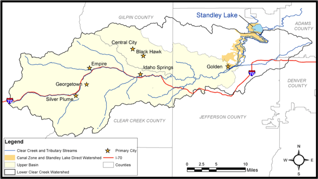
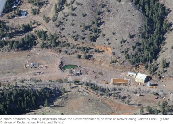
Several thousand mines are estimated to crisscross the county. Lasting repercussions of the mining industry led to more than 100 efforts to clean up the stream and mitigate the mining pollution in the last decade.

According to David Holm, the Clear Creek Watershed Foundation’s executive director, stream mitigation is a “forever commitment.”

“Once you’re going down that road, you’ve really made a forever commitment for maintenance,” Holm said. “So mine drainage is like that. It is a forever problem.”

Mine waste removal and restoration of stream banks are projects that, once completed, are ultimately removed from the Clear Creek remediation radar screen, Holm said.

Clear Creek always had a “metal footprint” because of the natural mineralization in the mineral belt, which the stream cuts across, Holm said.

“So there’s no question that there would have been iron, manganese, aluminum in elevated levels, and probably a little bit of a diminished pH,” Holm said. “The tremendous increase in exposure to the weather and elements of the mineral zone, brought about by mining, definitely has increased that footprint, and we will never eliminate that additional increased footprint.”

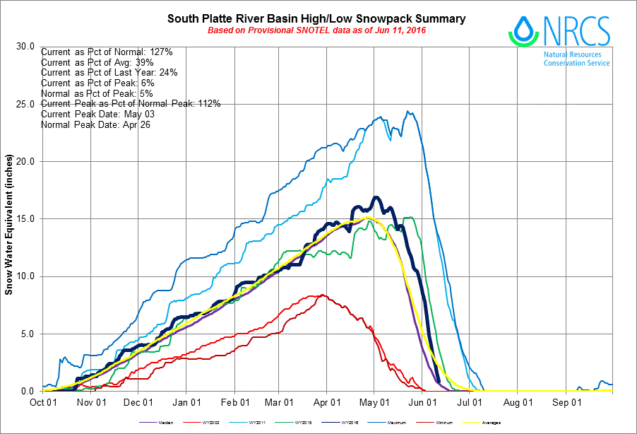
However, the stream is cleaner today than in recent memory, thanks to efforts by the Watershed Foundation, the U.S. Forest Service, and the Division of Reclamation, Mining and Safety.

A new industry

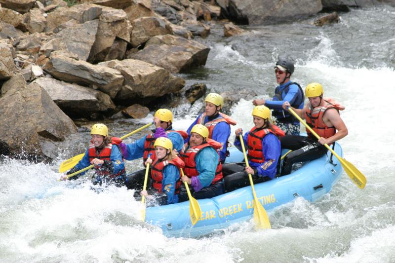
The mining industry, once so reliant on the stream, has dwindled to nearly nothing. In its place, a recreational industry has grown by leaps and bounds.

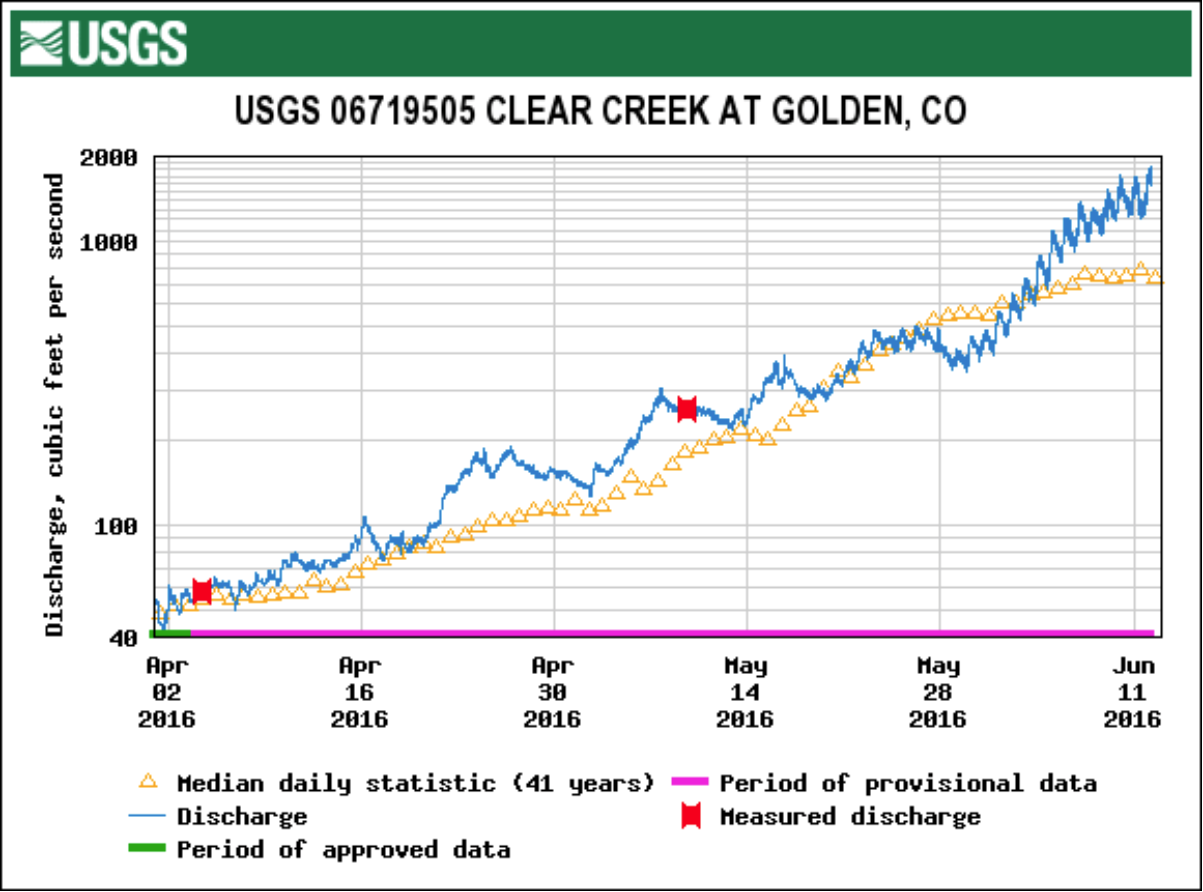
Since 1991, rafting companies using Clear Creek have experienced more than a 7,000 percent increase in customers. This increase comes at an ideal time, when the county is looking to transition to a recreation-based economy, with Clear Creek considered the area’s crown jewel.
The increase in visitors to the county had nearly a $19 million economic impact in 2013, according to the Colorado River Outfitters Association.

Association executive director David Costlow said the meteoric rise in recreation over the years is in large part due to the stream’s close proximity to Denver and to the relatively relaxed regulations for outfitters launching in Clear Creek.

Costlow said a lot of companies based on other rivers, such as the Arkansas, now bring customers to Clear Creek.

Last year, 61,000 “user days” were reported on the stream. A user day is how the rafting industry tracks customers and equates to one customer spending time on the river during one day. In 1991, the Colorado River Outfitters Association noted, Clear Creek had just 800 user days. Today the area has 15 rafting outfitters, with several owning locations in the area and putting in additional features such as zip-lines.

“You can see the growth on Clear Creek pretty rapidly. It was just 30,000 (user days) not too long ago, and now it is around 60,000,” Costlow said. “It’s a fun river, a lot of rapids per mile.”

‘Mining recreation opportunities’

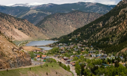
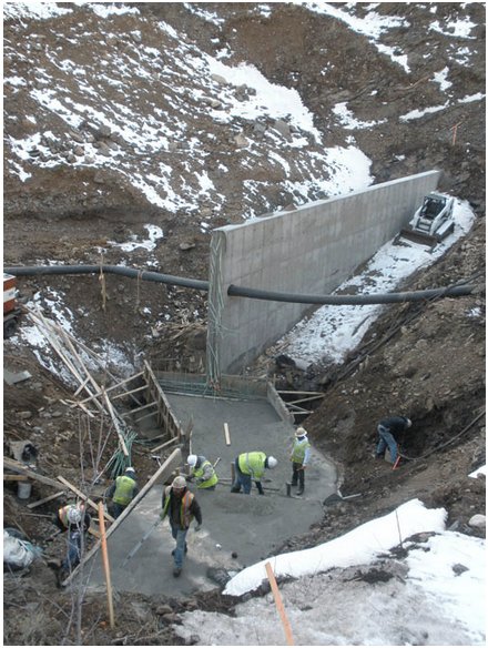
County officials see the stream as a large piece in the area’s economic puzzle. In 2010, Clear Creek Open Space, with the help of funding from a Federal Highway Administration grant, created the Lawson Whitewater Park. The park includes boulders that create specialty chutes and waves for kayakers and other boaters along the 450-foot stretch of Clear Creek just upstream from Mile Hi Rafting. The park also has parking and a changing station with environmentally friendly toilets.

County Commissioner Tim Mauck said Clear Creek saw little to no rafting 15 years ago, and now it is the second busiest river in Colorado. The county is working on a Greenway Project, which it hopes one day will create an uninterrupted recreational space following the stream from one end of the county to the other.

Earlier this year, officials met for a groundbreaking ceremony for a $13.9 million project that will link Clear Creek and Jefferson counties with a 10-foot-wide concrete trail for 6 miles, improve stream access, and link the Oxbow parcel with Mayhem Gulch.

“Looking for recreational opportunities is really something we need to position ourselves to take advantage of,” Mauck said. “The stream is the lifeblood in so many ways, not just physically to the necessities of life, but we’re drawn to it in ways that just make obvious sense.”

Mauck said Clear Creek offers a diversity of recreational opportunities such as rafting, kayaking, angling and gold panning, and the county needs to continue to transform itself and take advantage of the creek, but now in a different way.

“It’s (now about) mining the recreation opportunities,” Mauck said.

More Clear Creek watershed coverage here.

Georgetown: Meter replacement project nearly complete

Georgetown Colorado
Georgetown Colorado

From the Clear Creek Courant (Beth Potter):

Georgetown is about to complete its water-meter replacement program, and rather than asking homeowners to foot the $550 installation bill, the town took out a loan and got a grant to cover the cost. The town is replacing 660 meters because they were not accurately recording how much water homeowners were using. The town board discussed the issue for two years, trying to determine the best way to foot the cost.

The town received a $170,000 grant in 2013 from the state Department of Local Affairs and has taken out a loan for $211,000 from the Colorado Water Conservation Board to pay the rest of the cost. The loan is for 30 years at 4.1 percent interest, according to town administrator Tom Hale.

Residents will repay the debt through increases to their water bills, though Hale is unsure how much the increase will be. The $211,000 loan is part of a larger amount the town has borrowed to pay for renovations to the Georgetown Lake dam. He expects water rates to reflect the entire loan repayment in 2016.

Georgetown mayor Craig Abrahamson said having residents pay for the new water meters through small increases in their water bills would be “an easier pill to swallow” for most people.

The town hired a company from Utah to replace the meters, which will allow a meter reader to drive down the street to collect meter data.

The primary purpose of replacing the meters, Abrahamson said, is to improve their accuracy and help the town better assess how much water residents actually use.
More than 87 percent of Georgetown’s 597 water users needed new meters. The radio-read meters cost $400, and installation costs $150. The remaining 75 were installed within the last couple of years and don’t need to be replaced.
Based on readings from the new meters, the town may determine whether it can lower water rates.

More infrastructure coverage here.

Conservation front and center in Broomfield

broomfield

From the Enterprise Broomfield News:

Broomfield offers two water conservation programs to help residents save water and money. Residents and businesses could qualify for an irrigation audit and/or rebates if they receive treated water from Broomfield.

Free irrigation audits are provided by Slow the Flow Colorado, a nonprofit program of the Center for Resource Conservation. To schedule an irrigation audit, call 303-999-3820 ext. 217 or go to conservationcenter.org/.

Water rebates help offset the cost to replace inefficient toilets and irrigation components. More information on rebates, including qualifying models and residential rebate instructions, go to broomfield.org/index.aspx?NID=1098.

More information on water conservation, including lawn watering guidelines, can be found at broomfield.org/index.aspx?NID=439.

More conservation coverage here.

Westminster piloting native grasses to replace Kentucky bluegrass in some parks

kentuckybluegrassvsfescueviamowersource

From The Denver Post (Austin Briggs):

The new grass coming up on the west side of Kensington Park isn’t replacing a die-off — it’s replacing grass that was killed off.

Parks officials this year used an herbicide to kill the Kentucky bluegrass that had been there prior to planting native seeds — including fescue, rye and Canadian bluegrass.

The new ground cover will conserve water and save the city money, said Jessica Stauffer, the community outreach coordinator for the city’s Parks, Recreation and Library department.

“We went $200,000 over budget last year in watering costs for our parks,” Stauffer said. “The native grass being seeded stays greener longer and means fewer taxpayer dollars used for maintenance.”

In addition to Kensington, England and Oakhurst Park II are also being re-seeded in select spots totaling 8.4 acres away from playgrounds and high-traffic areas.

The new blend, which will grow between eight to 10 inches tall, won’t need to be mowed because it will follow a natural cycle of dormancy and growth, said parks supervisor Jerry Magnetti.

“We’ll do a second seeding this fall,” Magnetti said. “It’s a low-grow, low-maintenance seed mix that will fill in and look beautiful, especially in the fall and cooler months.”

While it’ll take another year or two for the grasses to establish, the goal is to see how this experiment works and perhaps apply it to a citywide program amid a long-term drought and rising water costs.

In 2005 the Department of Parks, Recreation and Libraries used 216 million gallons of water at a cost of $863,675 and in 2012 this grew to 319 million gallons and $1,362,975.

An acre of established native grass with trees and shrub beds costs about $500 a year to maintain, compared to $2,100 for Kentucky bluegrass.

More conservation coverage here.

Clear Creek Courant series [Part 1] about the past, present and future of Clear Creek

Graphic via the Clear Creek Watershed Foundation

Check out Ian Neligh’s retrospective about Clear Creek and the heydays of mining and logging (The Clear Creek Courant). Click through and read the whole thing. Here’s an excerpt:

Editor’s note:This is the first installment of a three-part series examining the past, present and future of Clear Creek…

Gold

There’s a monument in Idaho Springs hidden away in the parking lot of the former middle school. The giant boulder pays tribute to George Jackson, an adventurer and fortune hunter, who discovered gold in Clear Creek 155 years ago.

According to Don Allan, vice president of the Idaho Springs Historical Society, Jackson’s curiosity to follow the creek west into the mountains with only a couple of dogs by his side led to the country’s second largest gold rush.

Like a row of dominoes, Jackson’s discovery led to an onslaught of pioneers and ultimately in 1876 to the formation of a state.

“(Jackson) decided to go over and take a look down at the crick, and his curiosity brought him here to the confluence of Chicago Creek and Clear Creek,” Allan said. “When I talk with people about our community and how we got here, it was because of one man’s very good curiosity and a piece of gold.”

Jackson discovered gold in January, and by June, more than 400 people had settled in the area.

Natural hot springs drew more people into the area. Allan said in the Idaho Springs museum’s photography collection, there’s a photo of more than 50 employees standing in front of the hot springs.

“Once the stream was panned out, they panned all the gold out of the crick. Then they had to dig and make mining mills,” Allan said. “And this crick was integral to the milling of all the gold and silver in this area.”

The creek was used to support the mining industry such as the Mixel Dam in Idaho Springs, which was formed to help power mining mills and to create electricity. In 1864, silver was discovered to be the main mining mineral in Georgetown, and by 1877, the railroad reached Idaho Springs.

According to “A History of Clear Creek County,” the area at one point had 48 different towns with names such as Red Elephant, Freeland and Hill City. It is estimated that several thousand mines crisscrossed the mountains around Clear Creek as people sought their fortunes first along its banks and then in its mountains.

Those unlucky in gold sometimes found their way into the county’s second largest industry: logging. Early photos of the surrounding hillsides show them stripped of trees. But in time, the mining and logging industry waned, the frenzy slowed and the towns disappeared until there were only four municipalities left: Idaho Springs, Georgetown, Empire and Silver Plume. By World War II, the county’s mining industry has come almost to a complete halt.

But the stream once called Cannonball Creek, Vasquez Fork and lastly Clear Creek remained.

More Clear Creek watershed coverage here.

Colorado Foundation for Water Education’s “Urban Waters Bike Tour” recap


It was a grand time the other day cycling along the South Platte and hearing about current projects, operations, hopes and plans.

The tour was from the Confluence of Clear Creek and the South Platte River to Confluence Park where Cherry Creek joins the river.

Along the way we heard about Clear Creek, water quality in the South Platte Basin, infrastructure investments, and education programs.

A recurring theme was the effort to reach out to a younger generation through the school system.

Darren Mollendor explained that the program he honchos attempts to get the students to connect to their neighborhood parks. This includes an understanding of pollution, pollution abatement, and habitat improvement. He invited us all to go camping at Cherry Creek Reservoir when students from the upper and lower Cherry Creek watershed get together later this summer.

Michael Bouchard (Denver Parks and Recreation) detailed planned improvements along the river through Denver. Most of the new facilities will also have an education focus, including native flora at some locations.

Metro Wastewater is one of the largest clean water utilities in the nation, according to Steve Rogowski. The Metro District is directing a huge investment to comply with tougher treatment standards.

At the Burlington Ditch diversion Gray Samenfink explained operations under the ditch. The ditch is a supply for Barr Lake, other reservoirs, and direct irrigators. Several municipalities also take water off the ditch. The new diversion and flood control structure replaced the old dam at the location.

Caitlin Coleman (Colorado Foundation for Water Education) was tasked with keeping the tour on track. That was no easy task. When you get young and older, students, water resources folks, educators, conservationists, scientists, attorneys, engineers, and ditch riders together there’s going to be a lot of stuff to talk about.

Click here to go to the CFWE website. Become a member while you are there. That way you’ll know about these cool events in advance so you won’t miss the fun.

More Colorado Foundation for Water Education coverage here.

Clear Creek: Colorado’s hardest working river?

Graphic via the Clear Creek Watershed Foundation

From All Wet: The Colorado Water Blog (Allen Best):

Dave Holm called Clear Creek “perhaps the hardest working river in Colorado,” and to back up that statement he noted that it provides water for 400,000 people and has the second most numbers of rafters in Colorado.

As for fish? Well, not so good. “It’s a rough and tough stream, and it’s tough on fish,” he said at a March 20 presentation before the Colorado Renewable Energy Society. “They really get beat up.”

Holm directs the Clear Creek Watershed Foundation, which was set up in 1990. He explained that after just a handful of people at the first meeting, 100 people were affiliated with the group by 1994.

The foundation seeks to clean up and improve Clear Creek, no small task. It was the site of Colorado’s first industrial-scale mining, first placer operations and then tunneling. This occurred at Central City, on the north fork of the creek, and also at Idaho Springs. Other mining towns in the drainage include Black Hawk, Georgetown, and Silver Plume…

The foundation has done 80 projects altogether, but the creek still has major troubles. Interstate 70 probably has the “biggest physical impact.” The creek has been channelized to make roof for the four-way highway, creating what amounts to a “rip-rap gulley.”

Holm also described how the doctrine of prior appropriation benefits the creek. “Colorado’s—rococo comes to mind—legal framework for administering water rights,” he said. But that first-in-right means that most of the water in Clear Creek gets left there until far downstream, where it issues from the foothills into the piedmont of the Front Range.

More Clear Creek watershed coverage here.

Restoration: North Empire Creek acid mine drainage mitigation

Graphic via the Clear Creek Watershed Foundation

From the Clear Creek Courant (Ian Neligh):

The Clear Creek Watershed Foundation will spend $536,000 to remove the waste and re-vegetate the area between April and August. David Holm, the foundation’s executive director, hopes the mitigation will begin to make the water less acidic, eventually allowing plants to grow along the creek’s banks and fish to live in its waters.

However, he doesn’t want to mislead people into thinking the creek will be perfect when the work is complete.

“So how will it look afterward?” Holm asked. “We hope the stream corridor is going to look pretty good. There’s not going to be mine waste in it. It is going to look like a natural stream, and it is going to have vegetation on both sides as far out as we can get it.”

Empire Mayor Wendy Koch lauded the effort, saying the stream does not currently support life of any kind.

Koch said an Empire resident once questioned why he could never find deer, elk or any wildlife in that area.

“Well, that’s why,” Koch said of the stream and its acidity level. “(The project) will support our various wildlife, everything from bears to birds and anything in between.”

The project will be paid for by Miller Coors, which gave $394,000; the watershed district; the Colorado Division of Reclamation Mining and Safety; and in-kind donations from the county, the Environmental Protection Agency, U.S. Forest Service and Trout Unlimited.

Holm said the stream has a pH of 3, compared to a neutral pH of 7.
“When you get down to pH 3, you’re into 10,000 times more acidic than what you’re really going for,” Holm said. “So acidity is a real problem in North Empire Creek. There are very high elevations of copper and zinc. Both of those are very toxic to aquatic life.”

Holm said the stream also has toxic levels of iron, aluminum and manganese…

Holm said the area has an interesting history, being one of the earliest mining sites in the state.

“Initially, they did hydraulic mining in this area, which involves high-pressure hoses that are used, essentially, to wash the unconsolidated soil and subsoil … which in this area had disseminated gold deposits,” Holm said. “But it is a brute-force, ugly kind of mining that results in the hill slopes really not having a growth medium when it is said and done.”

More water pollution coverage here.

Georgetown: DOLA grant will help rate payers pay costs of replacement meters

Hidr%C3%B4metro.JPG/250px-Hidr%C3%B4metro.jpg

From the Clear Creek Courant (Ian Neligh):

Georgetown mayor Craig Abrahamson signed an agreement on July 9 to accept a $170,000 grant from the Department of Local Affairs to help subsidize the cost of its water meter replacement program. “It a pretty big project, and obviously we’re very pleased and grateful to the department of Local Affairs for their continued support in modernizing our infrastructure,” Abrahamson said.

The grant provider still has to sign its portion of the agreement before it is made official. Installation will get underway sometime in 2014. Approximately 600 meters need to be replaced at a cost of $550 each. The grant will pay for roughly half of the price. The town has to fund the additional $230,000 of the project’s cost. The town board will decide in the coming weeks how much of the town’s matching funds will come from the municipality, or if homeowners will need to pay a portion of the cost for equipment and installation.

More infrastructure coverage here.

CDPHE and Cotter Corp agree on a plan to end the Schwartzwalder Mine’s pollution of Ralston Creek with uranium — pumping and treating groundwater

schwartzwalderminedivisionofreclamationminingandsafety.jpg

The two parties have agreed on the geology and now believe they can pump enough water to lower the levels of water in the main shaft 150 feet below the Ralston Creek alluvium. The same approach being used at California Gulch; the perpetual pumping and treating of groundwater. Proof that the energy costs for uranium extraction sometimes never end. Here’s a report from Bruce Finley writing for The Denver Post. Here’s an excerpt:

The latest test data show that highly toxic water in the Schwartzwalder mine’s main shaft seeps underground into Ralston Creek, which flows to Ralston Reservoir.

A settlement deal requires Cotter to pump and treat millions of gallons of water and lower the level to 150 feet below the top of that 2,000-foot-deep shaft. This is intended to prevent uranium — in concentrations up to 1,000 times the health standard — from contaminating water supplies.

Cotter also must provide $3.5 million in financial assurance money to ensure cleanup of the mine west of Denver is done and pay a civil penalty of $55,000. Another $39,000 in penalties is to be waived.

The deal, approved by state regulators, ends Cotter’s lawsuits challenging state orders to clean up the mine and the creek. A state judge ruled in favor of regulators and Cotter appealed the decision.

More nuclear coverage here and here.

Ceratium and gomphosphaeria are blooming in Arvada Reservoir

arvadareservoir.jpg

From the Arvada Press (Sara Van Cleve):

Because of the extreme heat this summer, several kinds of algae, specifically ceratium and gomphosphaeria, have sprouted in Arvada Reservoir. “It’s the extended period of it that’s causing it to grow,” said Wendy Forbes, communications manager for the city of Arvada. “There is not enough fluctuation in temperatures.”

As the algae dies, it releases into the water a harmless chemical that causes the change in smell and taste, Forbes said. Though some residents have tasted and smelled the algae’s effects in their water, Forbes said, it is completely harmless.

“Arvada Water is adding carbons to the system to help with some of that,” she said. “It should stop once the algae is gone.” It takes about four days for water to pass through the purification system completely, so it takes about that long to collect enough data to see if the extra carbon is helping.

More water treatment coverage here.

Clear Creek Watershed Festival September 15

clearcreekwatershedmap.jpg

Click here to go to the Clear Creek Watershed Foundation website for all the skinny on the celebration. Here’s an excerpt:

Join us for our fourth annual family-oriented event to learn about the Clear Creek Watershed. Lots of fun & entry is FREE!

• fishing • gold panning • face painting • food • live music

• 30 environmental education PASSPORT STATIONS with engaging activities

More Clear Creek watershed coverage here and here.

CDPHE: Cotter Corp diverted Ralston Creek past its Schwartzwalder Mine to minimize discharge of uranium into creek

schwartwalderpipelinecotterralstoncreek.jpg

From TheDenverChannel.com (Thomas Hendrick):

The Colorado health department had ordered Cotter to divert water from the creek away from the Schwartzwalder Mine so that pollutants wouldn’t get into the creek water. Ralston Creek flows into a Denver Water reservoir that provides drinking water.

The health department’s water quality control division says Cotter completed a pipeline Tuesday to divert up to 8 cubic feet per second of creek flows past the mine.

More nuclear coverage here and here.

Cotter plans to route Ralston Creek through a temporary pipeline around the Schwartzwalder Mine

schwartzwalderminelocationmap.jpg

From The Denver Post (Bruce Finley):

Nobody wants Cotter Corp.’s re-routing of Ralston Creek to be permanent. Federal biologists say the pine-studded creek corridor through a picturesque canyon is habitat for the endangered Preble’s Jumping Mouse

Cotter work crews on Monday were completing a 21-foot-deep concrete-and-steel structure designed to channel all surface and shallow groundwater through an 18-inch-diameter black plastic pipeline running 4,000 feet around the Schwartzwalder Mine, once the nation’s largest underground uranium mine. As a condition of its 10-year federal permit, Cotter must irrigate the creek corridor to ensure that trees and wildlife survive. “This is a temporary bypass that will allow us to do the permanent fix,” Cotter vice president John Hamrick said. “We really are trying to do the right thing here.”[…]

Cotter also has agreed to use excavators and seven sump pumps to remove uranium from contaminated groundwater near the mine’s 2,000-foot-deep shaft, where uranium levels top 24,000 ppb. The sump pumping and subsequent treatment of contaminated groundwater over the past 18 months has removed about 1 ton of uranium that otherwise could have flowed into metro drinking water. That uranium sits in a guarded facility here until it can be trucked to a radioactive-waste dump…

State mining inspectors say uranium-laced water inside the mine shaft “is finding other ways out of the mine pool” and into groundwater and the creek beyond the mine. “The only way to fix that,” [Loretta Pineda, director of Colorado’s Division of Reclamation, Mining and Safety] said, “is to draw down the mine pool and treat it.”

Cotter favors a different approach. While Hamrick acknowledged there may be some underground pathways between the mine shaft and Ralston Creek, he and Cotter health physicist Randy Whicker on Monday said pumping toxic water out of the mine makes no sense.
Such a project would require construction of a large plastic-lined waste pond, with the cost likely to exceed $10 million, and perpetual pumping of groundwater that would continue to fill up the mine shaft and turn toxic through contact with exposed minerals.

Better, Cotter contends, would be to keep the super-toxic water inside the mine shaft and treat it in there. Mixing molasses and alcohol into uranium-laced water would cause bacteria already present inside the mine shaft to multiply, Hamrick and Whicker said. These bacteria would bond with uranium particles, separating uranium from water so that it could settle deep underground.

More nuclear coverage here. More Schwartzwalder Mine coverage here.

Clear Creek County scores $75,000 for greenway design

clearcreekwatershedmap.jpg

From the Clear Creek Courant (Ian Neligh):

The county was…awarded $75,000 to create design documents for the Clear Creek Greenway project connecting Jefferson County to the Twin Tunnels area through Clear Creek Canyon. The plan will also allow for easier access to the Oxbow Parcel and western Clear Creek County.

The greenway, envisioned to run along Clear Creek from the Jefferson County border to the Continental Divide, is intended to link communities with a string of open spaces, trails and parks. The project is not expected to be finished for another 10 years.

The Colorado Department of Transportation has partnered with the county on the project near the Twin Tunnels as part of CDOT’s effort to expand the area.

CDOT officials are planning to add a third eastbound lane on Interstate 70 between Idaho Springs at mile post 241 to the base of Floyd Hill at mile post 244, where the highway already opens to three lanes.

The $60 million project would likely begin construction in April 2013, with completion later that fall.

Meanwhile, according to County Commissioner Tim Mauck, as part of the first phase, CDOT will construct a greenway trail from the old game check behind the Twin Tunnels to just shy of the Hidden Valley Interchange.

As part of the second phase, CDOT will complete the trail from the game check station to the Idaho Springs Baseball Fields, although CDOT has not identified project funding and a timeline.

In addition, Clear Creek County Open Space was formally asked by GOCO to submit an application for a $4 million grant to further construct the greenway trail from the county line to as far as the funding would stretch.

“I project this GOCO grant to bring significant greenway improvements to Clear Creek County in the near future,” Mauck said. “Ultimately it will leverage further resources and willpower to complete the Clear Creek Greenway Trail through our community, providing our citizens and businesses with a tremendous recreational facility to utilize.”

Broomfield water history

broomfield.jpg

From the Broomfield Enterprise (Joe Rubino):

The Turnpike Land Co. launched development on Broomfield Heights, a precursor to incorporated Broomfield, in 1955 along the north side of the recently built Denver-Boulder Turnpike, completed in 1952. The city’s water originally came from a pair of lakes on the family farm land of Adolph Zang, ditch water rights and three large wells, according to local historian Silvia Pettem’s 2001 book, “Broomfield: Changes Through Time.”

By May 1955, work had begun on a water main from nearby Great Western Reservoir, which was fed by Clear Creek through the Church Ditch. It would be Broomfield’s main source of water for its first decade as a city.

In 1970, as Broomfield’s population grew to more than 7,000, the city, under the leadership of a then recently hired City Manger George Di Ciero, used federal funding to purchase an 11-million-gallon-per-day allotment from Denver Water. According to Pettem’s book, a Daily Camera article that ran in 1970 referred to the purchase as “all the water (Broomfield) will ever need.”

That proved short-lived, as it was just three years later that radioactive contamination was first found in Great Western Reservoir. The terrifying revelation that the nearby Rocky Flats Nuclear Weapons Plant had leaked contaminants into city drinking water sent many locals running out to buy bottled water, Pettem wrote.

After a 1989 FBI raid on Rocky Flats, Broomfield spearheaded regional efforts to protect area water supplies and eliminate Great Western Reservoir as a primary water source. In 1989, Di Ciero dispatched crews to dig a diversion ditch to prevent water from Rocky Flats from getting into the reservoir. Those efforts were joined by surrounding downstream cities, such as Westminster and Thornton.

“That was a monumental effort and Broomfield, I would have to say, took the lead on it,” Joyce Hunt, Thornton assistant city manager, said of the diversion ditch and ensuing battle to curb pollution form Rocky Flats.

After that, with the support of Colorado Rep. David Skaggs and $52 million from Rocky Flats manager, the U.S. Department of Energy, Broomfield sold some of its water rights and bought an allotment of Windy Gap water from Boulder. After the construction of a pipeline from Windy Gap storage spot Carter Lake and a new water treatment facility near West 144th Avenue and Lowell Boulevard, Broomfield at last had a clean, safe water supply.

“The new water supply was key to securing water for our future,” [Kirk Oglesby, Broomfield’s code enforcement manager and unofficial town history resource] said.

While Broomfield is always looking for ways to firm up its water supply, the drought that struck Colorado in the mid-2000s demonstrated the city was prepared to handle shortages, Oglesby said. While neighbors Lafayette and Louisville were forced to stop lawn watering in the city limits or fall back on Boulder for support during the drought, Broomfield’s supplies held firm, Oglesby said, and the city “didn’t experience much difficulty at all.”

More South Platte River basin coverage here.

Cotter Corp hopes to sell uranium that is being collected from groundwater sump pumps at the Schwartzwalder Mine

schwartzwalderminelocationmap.jpg

From The Denver Post (Bruce Finley):

The uranium west of Denver “is not as concentrated as yellowcake” but “is considered source material for licensing purposes,” Cotter vice president John Hamrick said, estimating the value at around $50 a pound. Cotter would like to sell the uranium, Hamrick said. He said the uranium poses little risk. For anybody trying to obtain uranium illegally, “there would be easier low- hanging fruit than us,” he said.

The uranium was collected from tainted groundwater by 10 sump pumps Cotter installed along Ralston Creek, below the mine. The uranium and other captured contaminants are removed before water is pumped into the creek, which flows into a Denver drinking-water-supply reservoir for 1.3 million metro residents.

In an Oct. 11 letter to the Colorado Department of Natural Resources, Cotter officials said 1,440 pounds of uranium had been removed as of Sept. 16 and was stored at the mine. They also disclosed “elevated concentrations of uranium in alluvial groundwater near the Old Emergency Discharge Pond” near the mine.

State mining regulators ordered Cotter to pump out and treat contaminated water in the mine shaft. Cotter challenged the state orders, and Denver District Court Judge Robert Hyatt recently ruled in favor of the state. Cotter officials now contend they can clean Ralston Creek simply by relying on their newly expanded pumping system. “Cotter has utilized intensive monitoring efforts and data evaluations to aggressively develop and implement measures to expand capture/treatment of alluvial groundwater in order to improve water quality in Ralston Creek as soon as possible,” the company’s letter said. The sump system has been effective, “significantly increasing capture and generally reducing levels in the creek.”

The system relies on an ion-exchange process using resin beads that the uranium gloms onto to remove it from water. Cotter switches out the loaded resin beads and uses the tanks the resin arrives in to store extracted uranium.

More nuclear coverage here and here

Clear Creek watershed: Cotter Corp promises to clean up discharges from the Schwartzwalder mine

schwartzwalderminelocationmap.jpg

From The Denver Post (Bruce Finley):

“Whatever the courts tell us to do, we will do,” Cotter president Amory Quinn said in a telephone interview from San Diego. “We will follow the letter of the law. If they demand we pump and treat, I guess we will pump and treat.” He did not commit to a timetable for that cleanup, though a creek-diversion pipe around the mine should be done by Jan. 31…

“We look forward to seeing Cotter’s plans and financial warranties for complying with the board orders,” Division of Reclamation Mining and Safety director Loretta Pineda said. Denver District Court Judge Robert Hyatt recently ruled in favor of state mining regulators in one of two lawsuits Cotter filed challenging orders to clean up the Schwartzwalder mine. That decision clears the way for removal of contaminated mine water and the posting of sufficient bond money to protect Ralston Creek, which flows into a Denver drinking-water-supply reservoir.

A decision is expected soon on Cotter’s second lawsuit, which challenges Colorado’s ability to enforce orders. Colorado Department of Natural Resources officials say this decision will help define what the state can do when companies defy legally valid orders.

On Wednesday, Quinn pointed out that Cotter has installed a sump system along Ralston Creek, below the mine. This apparently has reduced the concentrations of uranium entering the creek. Data provided by state officials shows readings ranging from 713 parts per billion in February to 39 in June. In July, the most recent reading available, the level had increased to 89 parts per billion. The state limit is 30 parts per billion. “We’re making that standard periodically,” Quinn said. But low flows in the creek during dry months, he said, result in uranium concentrations that are higher.

More nuclear coverage here and here.

Clear Creek Watershed Festival included education about the history of the watershed

clearcreekwatershedmap.jpg

Dr. Ellen Wohl’s book Virtual Rivers: Lessons from the Mountain Rivers of the Colorado Front Range looks at Front Range Creeks currently and tries to reconstruct the past, before the influences of humankind, primarily logging, mining and water diversions. At the recent Clear Creek Watershed Festival history was front and center as well. Here’s a report from Ian Neligh writing for the Clear Creek Courant. From the article:

The festival was hosted by the Clear Creek Watershed Foundation, which dedicates itself to improving the ecological, recreational and economic conditions in the Clear Creek Watershed. The festival educates by offering fun activities as educators look at pieces of the watershed, thereby teaching visitors about the watershed in its entirety…

“This is part of Colorado’s tradition. This is part of our culture. Colorado would not be Colorado, Idaho Springs would not be here, Denver would not be there (if gold hadn’t been found),” Long said.

Down several educational booths, Deb Zack with the Department of Natural Resources Division of Reclamation, Mining and Safety talked with people about the side effects of mining. “We’re here to support the local efforts to educate the public about the hazards of abandoned mines and trying to get the word out about what we do,” Zack said. She and others in her department look for grant money to mitigate abandoned mines on people’s property and to close them off as a free service. “Honestly I work in this area, reclaiming abandoned mines, so I’m interested in meeting a lot of the people who are my neighbors — and people out here know their land better than I ever could,” Zack said.

More Clear Creek watershed coverage here.

Loretta Pineda, director of Colorado’s Division of Mining Reclamation and Safety on Cotter Corp and the Schwartzwalder Mine: ‘I want to get this remediated. If Cotter wants to continue to fight this in court, that’s up to them’

schwartzwalderminelocationmap.jpg

From The Denver Post (Bruce Finley):

“I want to get this remediated. If Cotter wants to continue to fight this in court, that’s up to them,” said Loretta Pineda, director of Colorado’s Division of Mining Reclamation and Safety. “We’re rapidly losing another construction season. … Cotter could at least be doing work on a diversion.”[…]

Cotter last year filed a lawsuit accusing regulators of abusing their discretion with orders to clean up Schwartzwalder. But Friday, a Denver District Court judge ruled that Colorado’s Mined Land Reclamation Board was correct to order the de-watering of the 2,000-foot mine shaft and impose penalties. Earlier in the week, state health officials ordered Cotter to divert creek water around the mine and find the source of the contamination.

Buoyed by the Friday ruling, state regulators met with state Attorney General John Suthers’ staff Monday about their possible next steps…

In 2007, a state mining inspector detected the water contamination. About two years ago, the state officials began raising concerns, and last year they started pressing for a cleanup. Cotter has argued that toxic groundwater filling its 2,000-foot-deep mine shaft is not connected to Ralston Creek.

The health department order last week would require Cotter to install a concrete wall and to funnel water into a pipe that would carry Ralston Creek around the mine and then, below the mine, back toward Ralston Reservoir. It’s a temporary solution until a pump-and-treat operation is set up…

…state law requires companies to post sufficient bond money to guarantee that cleanup work will be done without falling to taxpayers. But the bond posted for Schwartzwalder is not enough to cover costs of pumping and treating uranium-laced water from the mine, state mining inspector Tony Waldron said. State officials said they’ll press now for a larger bond as well as de-watering of the mine.

More nuclear coverage here and here.

Denver District Judge Robert Hyatt rules in favor of Colorado Mined Land Reclamation Board with regard to the Schwartzwalder Mine

schwartzwalderminedivisionofreclamationminingandsafety.jpg

From The Denver Post:

The decision by Denver District Judge Robert Hyatt cited “an ample evidentiary basis” for the Colorado Mined Land Reclamation Board’s findings…State inspectors several years ago discovered the problem: that uranium in the mine shaft reached up to 1,000 times the state standard, with contaminants rising to the rim of the shaft. It wasn’t until April 2010 that mining regulators ordered Cotter to remove the contamination by draining the mine. On Tuesday, state health officials ordered Cotter to divert creek water away the mine and find the source of the contamination.

More nuclear coverage here and here.

Energy policy — nuclear: Cotter ordered to build bypass pipeline at its Schwartzwalder Mine

schwartzwalderminelocationmap.jpg

Here’s the release from the Colorado Department of Public Health and Environment (Mark Salley):

On Tuesday, the Water Quality Control Division at the Colorado Department of Public Health and Environment amended its June 1, 2010 notice of violation/cease and desist order, and required Cotter Corporation to build a bypass pipeline at its Schwartzwalder Mine in Jefferson County to minimize the discharge of uranium-laden water into Ralston Creek.

Schwartzwalder Mine is an underground uranium mine near Golden that opened in about 1953 and was acquired by Cotter in 1966. Cotter operated the mine from 1966 until 2000 when mining operations ceased.

The Water Quality Control Division learned in 2010 that discharge from the mine property contained elevated levels of uranium that exceed surface water standards under the Colorado Water Quality Control Act.

Cotter completed the majority of the corrective actions required by the June order, but discharges of uranium and other mine-related pollutants to groundwater and surface water from the facility have continued.

Water sampling at the site from June 2010 through July 2011 show concentrations of uranium in the groundwater and surface water that continue to cause or contribute to an exceedance of the 30 micrograms per liter stream standard.

The amended order dated Sept. 27 requires Cotter to submit a plan to the department no later than Oct. 7 for the design and construction of the temporary structure (i.e., pipeline) that will divert Ralston Creek steam flows past the Schwartzwalder facility. Construction is to be substantially completed by Jan. 31, 2012.

The amendment to the June 1 order further requires Cotter to evaluate and enhance its groundwater capture and treatment system and to submit a plan and time schedule for the
aggressive removal or containment of all groundwater and surface water pollutant sources at the mine.

Steve Gunderson, director of the state’s Water Quality Control Division, said the department has continued to work closely with the Division of Reclamation Mining and Safety at the Colorado Department of Natural Resources to regulate the Schwartzwalder facility.

Gunderson said, “While Cotter implemented the majority of the corrective actions required in our June order, pollutants are continuing to reach the creek. This step is necessary to help protect groundwater and surface water.

“As the agency that regulates drinking water for the state, we also continue to work with public drinking water systems that rely on waters from Ralston Creek,” said Gunderson. “Those three providers (Denver Water, City of Arvada, and North Table Mountain Water and Sanitation District) continue to serve drinking water to their customers that meets safe drinking water standards. Although drainage from Schwartzwalder has continued to reach the surface waters of Ralston Creek, the drinking water from those systems remains safe for consumption as a result of downstream attenuation at Ralston Reservoir and Blunn Reservoir, and treatment techniques utilized by the public water systems.”

More coverage from Karen Crummy writing for The Denver Post. From the article:

Cotter Corp., which owns the defunct Schwartzwalder Mine in Jefferson County, has until Oct. 7 to submit a design- and-construction plan for a bypass pipeline. That pipeline is to be “substantially completed” by Jan. 31. Additionally, Cotter is required to submit a plan and time schedule for the “aggressive removal or containment of all groundwater and surface water pollutant sources” at the mine…

On Wednesday, the state said the company had “completed the majority of corrective actions” but added the pipeline requirement after it became clear pollutants were still reaching the creek…

Cotter has had numerous problems with the state over the years. Most recently, the company filed a lawsuit against the Colorado Mined Lands Reclamation Board, accusing it of abusing its discretion when it ordered Cotter to pump out and treat the uranium-tainted water in its mine.

More nuclear coverage here and here.

Idaho Springs: Clear Creek Watershed Festival September 17

clearcreekwatershedmap.jpg

From email from the Clear Creek Watershed Foundation (Christine Crouse):

Join us at the 3rd annual CLEAR CREEK WATERSHED FESTIVAL on Saturday, September 17, 10am – 3pm, creekside at Courtney-Ryley-Cooper Park in Idaho Springs.

Learn what a watershed is; what makes the Clear Creek Watershed so unique; and how we impact the watersheds we live, work, and play in.

Participants receive a WATERSHED PASSPORT and reusable tote bag to collect give-aways from 33 environmental education PASSPORT STATIONS. Learn about water and mineral resources, water quality, sustainable development/living, alternative energy and transportation, mining history, mine remediation, ecotourism, wildlife/habitat, and more.

Upon completion of the passport circuit, watershed explorers are rewarded with a cool color-changing water bottle, BBQ lunch, and ice cream. The festival is free of charge, but participants have to earn their passport stamps, prizes, and food coupons by engaging in the activities. There will be fly-tying and fishing, live music, goldpanning, facepainting, snow making, a model wind turbine, and much more!

The festival offers an out-of-the-classroom learning opportunity and the information lends itself to interesting family and class discussions/lessons on watersheds, natural resources, water science, and sustainable living.

More Clear Creek watershed coverage here.

Restoration: Trout Unlimited’s West Denver Chapter to tackle stream reach in Clear Creek near Mayhem Gulch

clearcreekwatershed.jpg

From The Denver Post (Daniel Smith):

The Canyon Reach project, with multiple funding sources, will begin near Jefferson County Open Space Park’s Mayhem Gulch, then continue upstream to near the paved turnout just below the junction of Colorado 119 and U.S. 6.

The project, which will require heavy construction equipment, should help correct some of the problems. Some of the natural rocks in the creek will be moved to create “better winter habitat, deeper holes and feeding lanes and just places for fish to survive the winter,” he said. Edwards said 15 elements will be used, including cross vanes, U-shaped large rock structures that create turbulence that constricts stream flow and deepens the channel to create spawning beds and wintering pools. A J-hook structure in stream beds also will create deep habitat in curves and protect banks from erosion. A toe-wood structure, a newer concept, uses tree trunks, layered with willows and blankets of organic material, that will help streamside riparian growth in the rocky stream. The project’s $264,000 price tag will be covered by a $168,700 grant from the Colorado Division of Wildlife’s Fishing is Fun program, $60,000 from the Jefferson County Conservation Trust Fund, and $20,000 from the Water Conservation Board.

More Clear Creek watershed coverage here.

Energy policy — nuclear: Colorado and Cotter, Corp don’t agree on cleanup at the Schwartzwalder Mine in the Ralston Creek watershed

A picture named uranium.jpg

From The Denver Post (Bruce Finley):

Cotter has filed a lawsuit challenging the state order…

State mining regulators “continue to coordinate closely with CDPHE in reviewing and monitoring on-site activities, as well as ensuring environmental protections are in place to protect drinking water supplies,” Pineda said. “Cotter has submitted a proposal to install a bypass that would divert ground and surface water around the mine, and the company is continuing to provide DRMS with information needed to fully review this proposal.”

A picture named cottercontamination.jpg

Meanwhile, Cotter has received permission to use an impoundment pond that the state of Colorado claims leaks, according to a report from Bruce Finley writing for The Denver Post. Here’s an excerpt:

The tailings impoundment at Cotter is about 157 acres and includes two retention areas. One is closed and contains about 2 million cubic yards of material. The second area is open and receiving materials related to the mill demolition, including the 90,000 gallons of sludge. It contains about 2 million cubic yards of material and is about half full, according to the health department. Cotter’s vice president for milling operations, John Hamrick, said the sludge is about 95 percent kerosene, used to process uranium. Before the sludge is moved to the impoundment, it will be mixed with another material. “It’s like kitty litter,” Hamrick said Monday. “It becomes a solid.”

Eventually, new sludge and solvents dumped into the leaky impoundment will be neutralized, health department spokeswoman Jeannine Natterman said. “More contamination is not going into that (Cañon City) area.” Hamrick said Cotter disputes the health department’s assessment of the impoundment. “We disagree with the state, that the impoundments are leaking,” he said…

Toxic plumes have been detected moving underground toward Cañon City and the Arkansas River. Most recently, officials disclosed that the cancer-causing chemical trichloroethylene has been detected in groundwater at concentrations up to 360 times federal health limits.
“It has been confirmed that no trichlroethylene has gotten into Lincoln Park (neighborhood in Cañon City),” Natterman said. Cotter officials “are still poking holes, taking samples” to characterize that plume, she said. “Cotter is responsible for all the sampling and analysis. All data have to be quality-controlled by us.”

More Schwartzwalder mine coverage here. More nuclear coverage here and here.

Georgetown residents toast newly reconditioned water and wastewater facilities, with tap water of course

A picture named watertreatment.jpg

From The Clear Creek Courant (Ian Neligh):

Of the $9.1 million, $3.3 million went to the water treatment facility for improvements, which included filtration upgrades, rehabilitation of the existing storage tank and a new 400,000-gallon storage tank.

The town’s wastewater facility received a $5.8 million upgrade, with major improvements to the treatment process. Of that money, the town will have to pay back, interest free, $3.8 million over the next 20 years.

More Clear Creek watershed coverage here.

Central City: Water meters going in for residences, water rates to go up

A picture named wirelessmeterreadingexplained.jpg

From the Weekly Register Call/Gilpin County News (Lynn Volkens):

Following public hearings, with no one from the public speaking either for or against, the Council approved Ordinance 10-15 and 10-16. The first ordinance amends Chapter 13 of the Municipal Code to require all residential units to install water meters and all commercial units to replace water meters. Commercial meters in use now have been found to be inaccurate. The City is purchasing all of the meters at an approximate cost of $281,000. Meter installation will begin in January. Residents will be billed for half of the cost of their meters (approximately $100) by adding about $2 to the monthly billings over a four year time period. Billings will go to the monthly format beginning in January 2011. The City will pick up the other half of the residential meter cost and pay for installation. Commercial water users must pay the full cost of meter replacement and installation and will also have their payments spread out via their water bills over a four year period. Once water use is being metered, the City will be able to accurately track water usage and bill accordingly. Leaks and other problems will also be identified more easily. Residents will be responsible for maintaining the meters in good working order and should contact the City for a list of contractors who can make repairs when needed. The meters are warranted for ten years.

The second ordinance (10-16) adopts water rates and fees. The 2011 water rates reflect an increase of 20% for all water users and may increase by that much each year for the next five years. Once the data from the meters is sufficient to determine actual usage, the City may find it does not need to increase the rates that much. A tiered system will also be developed at a later date so that those who use more than the base allowance of water will have steeper payments. For 2011, the residential base-rate will be $135.50 (Senior rate, $108) per quarter (but will be billed monthly). The current quarterly rate is $112.50. The commercial base-rate for 2011 will go from the current $180 to $216. The rate increases are designed to generate approximately $59,247 in annual revenue with the result of making the Water Fund self-sufficient in five years.

Each residential or commercial unit is to have its own tap, water line and meter-i.e. there is no sharing of this equipment, although there is some provision in the code for integrated units. If the City finds multiple users, the situation will be corrected and, once the water mains are laid in the street in front of those properties, the “new” water users will have to pay for their own tap, water line and meter. Water users are responsible for repairs and maintenance of the water line from the curb or property line to the structure being served.

The City plans to send brochures to water users and hold meetings so that citizens can learn more about the meters and rates. Those meetings are tentatively scheduled for the last two Wednesdays of January and the first Wednesday in February.

More infrastructure coverage here.

Central City: Water rates going up

A picture named fountainpavementdrawing.jpg

From the Weekly Register Call/Gilpin County News (Lynn Volkens):

Per approved Ordinance 10-15, the City will require water meters on all water-using units within the City. The requirement does not endanger any of the City’s water rights, City Manager Alan Lanning told the Council, and the intent is to be able to pay for the water system that currently serves 457 water users in the City. There will be numerous meetings and other community outreach efforts to inform citizens of details. The City expects to pay $220,000 to purchase, up front, all residential meters needed. Installation is included in that amount. For commercial replacement meters and installation, the City will pay, also up front, $61,000. The cost to purchase and install each residential meter is $200. Property owners must pay half that cost, payable at $25 per quarter over the next year. That cost could be offset by paying less for their water, once the exact amount of use is determined by metering. A public hearing has been scheduled for this ordinance on December 21, 2010.

That same date will be the public hearing for Ordinance 10-16 which adopts water rates and fees for water services. The ordinance proposes an across-the-board 20% increase in all water rates. For residents, that means the 2011 quarterly rate will be $135.50 (up from $112.50). Senior citizen owner-occupants will see their rate go from $90 to $108 (achieving the reduced rate by showing proof of age 65 or over, and filing an application for it with the City Clerk). The increased rate for commercial users is $216 with additional charges for quantities that exceed 45,000 gallons per quarter. Hauled water will go up from $45 to $54 per thousand gallons. Adjustments will be made for seasonal water users, such as the Opera House Association. The rates are calculated to recover some of the cost of operating the water system and are estimated to generate $59,247 in additional revenue for the Water Fund. In 2012, the meter data will be reviewed and a tiered rate system developed.

More infrastructure coverage here.

Energy policy — nuclear: Colorado fines Cotter for violation of August cleanup order

A picture named uranium.jpg

From The Denver Post:

The board also imposed the $55,000 in penalties contained in the August order and added an additional penalty of $39,000 for Cotter’s failure to take any action since then.

More Schwartzwalder Mine coverage here. More nuclear coverage here and here.

Energy policy — nuclear: Schwartzwalder mine cleanup update

A picture named uranium.jpg

From The Denver Post (Bruce Finley):

Cotter’s attorneys conceded that Cotter has not taken a step toward complying with an existing state order to pump out and treat toxic water filling the Schwartzwalder mine. That mine sits upstream from Denver Water’s Ralston Reservoir, which supplies drinking water to 1.3 million metro-area residents…

“We are entitled to know what compliance would look like,” Cotter attorney Nea Brown said before the state Mined Land Reclamation Board. Board members then read aloud a prior order requiring Cotter to pump water from the mine to a level at least 500 feet below the opening of the mine. There was an Aug. 31 deadline. “I’m just a farmer from down east, but I can read that,” said board chairman Ira Paulin, who represents the mining industry at state hearings. “It says you have got to implement it.”

Brown argued that the required corrective actions are broad and unclear and that Cotter would need time to move in equipment and have a place to put the water it removes…

Board members will continue their hearing today, when they will decide whether to impose additional fines of up to $1,000 a day for 78 days, issue new violations and a “cease and desist order” that essentially repeats state demands. Cotter separately has taken its case to Denver District Court, filing a lawsuit against the state. It asks that a judge block state efforts to order the cleanup and impose fines and accuses the state mined lands board members of abusing their discretion.

More Schwartzwalder mine coverage here. More nuclear coverage here and here.

Energy policy — nuclear: Cotter Corp sues the state over cleanup order at the Schwartzwalder mine

A picture named uranium.jpg

From The Denver Post (Bruce Finley):

The lawsuit, recently filed in Denver District Court, accuses Colorado’s Mined Lands Reclamation Board of abusing its discretion when it ordered Cotter to pump out and treat uranium-tainted water that inspections have shown to be rising toward the rim of Cotter’s defunct Schwartzwalder mine…

At issue is whether state regulators had enough evidence to order the cleanup and impose fines. Cotter is seeking a judge’s order to reverse both of those actions…

The lawsuit is the latest step in a standoff between Cotter and the state. Regulators have moved to increase a $55,000 fine against Cotter for failing to comply with cleanup orders. Since April, they’ve repeatedly ordered Cotter, a subsidiary of San Diego-based General Atomics, to pump and treat toxic water filling the mine along Ralston Creek. The creek, which flows into Denver Water’s Ralston Reservoir, contains uranium at levels far exceeding health standards for drinking water. Cotter in July began pumping contaminated water from surface alluvial ponds along the creek. But the most- contaminated water in the 2,000-foot- deep mine shaft is untouched. Cotter contends the water in the mine shaft is not connected to groundwater. State mining regulators argue that water in the mine is connected to groundwater and the creek.

More nuclear coverage here and here. More Schwartzwalder mine coverage here.

Energy policy — nuclear: Cotter, Corp’s cleanup plans at the Schwartzwalder mine fall short according to state regulators

A picture named uranium.jpg

From The Denver Post (Bruce Finley):

“Pumping just from the alluvium will not be sufficient to mitigate the uranium-contamination problem,” said Loretta Pineda, Colorado director of mining, reclamation and safety. “(State regulators) have ordered Cotter to pump and treat from both the alluvium and the mine pool.”

State officials recently fined Cotter $55,000, then suspended all but $2,500 on the condition that Cotter initiate a cleanup by Aug. 31. That could include any action, such as positioning the right equipment at the mine. State regulators, Pineda said, “believe the mine pool poses a significant risk to surface water (and are) vigorously pursuing the enforcement action. . . . The state fully intends to hold Cotter accountable for permit violations.”

Of greatest concern is Ralston Creek, which flows into Denver Water’s Ralston Reservoir and contains uranium levels exceeding health standards. Cotter “strongly disagrees” with state regulators, according to a June letter sent to the Colorado attorney general from Cotter attorney Charlotte Neitzel. “Although Cotter believes it has not violated the statutes and regulations,” the letter said, the company “recognizes the importance of taking action for the situation at Ralston Creek.”[…]

Cotter contends that the highly toxic groundwater filling the shaft, where uranium levels far exceed health standards, does not reach Ralston Creek.

“(Denver Water) supports the state’s order for Cotter to treat the groundwater in the mine,” spokeswoman Stacy Chesney said. “We’re very concerned with maintaining the quality of our source waters and hope Cotter complies.” Tests along Ralston Creek indicate uranium concentrations as high as 310 parts per billion, above the 30 ppb standard for drinking water, Chesney said. “Our treated water is meeting drinking-water standards, and our current treatment process is able to handle uranium at these levels. However, that could change in the future,” she said. “Installing a new system would be costly.”

More nuclear coverage here and here. More Schwartzwalder Mine coverage here.

Energy policy — nuclear: Cotter Corp starts Schwartzwalder mine cleanup

A picture named uranium

From The Denver Post:

The owner of a defunct uranium mine leaking pollution along a creek that flows into a Denver Water reservoir has launched a cleanup as ordered, state officials confirmed Thursday. Cotter Corp. installed a system that can pump and treat up to 50 gallons per minute of contaminated water from inside its Schwartzenwalder Mine, west of Denver in Jefferson County.

More Schwartzwalder mine coverage here.

Energy policy — nuclear: Schwartzwalder uranium tainted water cleanup to start in July

A picture named uranium

From The Denver Post (Bruce Finley):

Operators of a defunct uranium mine accused by the state of contaminating groundwater and a nearby creek have agreed to begin a cleanup by the end of July. “We intend to comply to the best of our ability,” Cotter Corp. vice president John Hamrick said. Cotter will pump and treat tainted water from inside its Schwartzwalder mine in Jefferson County, then seek a state permit before releasing treated water back into Ralston Creek, Hamrick said…

Cotter was responding to a cease-and-desist order issued June 1 by the Colorado Department of Public Health and Environment. Fines as high as $10,000 per day could be imposed. Cotter officials and state regulators have been negotiating.

Colorado Department of Natural Resources mining regulators sent Cotter a separate notice saying they have reason to believe Cotter has failed to comply with permit requirements designed to protect the environment.

State regulators have pressed to get the company to pump and treat the toxic water in the mine. “We’re in the process of establishing that system,” Hamrick said. State officials “have given us until July 31. We expect to have it by that date or before,” he said…

Residents of Denver, Arvada and the North Table Mountain Water and Sanitation District depend on the reservoir for drinking water. Municipal-water providers say their filtration systems remove uranium but aren’t designed specifically for this. Denver Water and others have been urging a swift cleanup.

More Schwartzwalder mine coverage here.

Energy policy — nuclear: The Colorado Department of Public Health and Environment orders Cotter to stop flows from Schwartzwalder

A picture named uranium

From the Associated Press:

The state health department is taking action because Cotter Corp. has been discharging pollution without a permit and uranium levels in the water are significantly exceeding the safety standard, Steve Gunderson, director of the state water quality control division, said Thursday. The agency sent the notice earlier this month. The Colorado Division of Reclamation, Mining and Safety has sent a separate notice to Cotter saying it believes the company is violation of several state laws. Cotter could face fines of up to $10,000 if found in violation. The Denver-based company didn’t immediately return a call seeking comment. Hearings are scheduled July 14 and 15 to consider whether Cotter should face penalties.

Uranium was detected in raw water going to the west-Denver suburb of Arvada, Gunderson said. The city’s water treatment plants can filter out the uranium, but disposing of the contamination could become a problem.

More nuclear coverage here and here.

Lawson welcomes their shiny new whitewater park

A picture named kayaker

From the Clear Creek Courant (Ian Neligh):

The park celebrated its grand opening May 22. It includes boulders that create specialty chutes and waves for kayakers and other boaters along the 450-foot stretch of Clear Creek just upstream from Mile Hi Rafting. The park also has improved parking and a changing station with environmentally friendly toilets. Eighty percent of the funding for the $400,000 whitewater park comes from a Federal Highway Administration grant through the Colorado Department of Transportation. The rest is split between the county Open Space Commission and Clear Creek County…

The project was overseen by Recreation Engineering and Planning of Boulder, which did designs at similar whitewater parks in Golden, Steamboat Springs and Buena Vista. Groundbreaking for the park was held last August, and work was finished in the creek by mid-autumn to protect the fisheries. Helseth said the creek was moved to one side behind a cofferdam to allow work to be done on the park. “They put those boulders exactly where they wanted them to make the perfect waves for kayaks, and then they actually grouted them into place,” Helseth said. “So now they won’t shift and move anymore, and they’ve really been laid out according to what they have identified as the optimal spacing for kayakers.”

More Whitewater coverage here.

Energy policy — nuclear: Colorado orders Cotter to start treating the water at the Schwartzwalder mine

A picture named uranium.jpg

From the Associated Press via The Durango Herald:

The Colorado Division of Reclamation Mining and Safety said Thursday it doesn’t believe the plan would prevent uranium from contaminating Ralston Reservoir, which supplies some of the Denver area’s drinking water. Loretta Pineda, the agency’s director said Cotter has been directed to resume treating the water and submit a new plan within two weeks.

From The Denver Post:

The state Division of Reclamation Mining and Safety rejected the protection plan Cotter submitted last month and instructed the Denver-based company to submit a water-treatment plan within two weeks, the agency said in a news release…Cotter had proposed a man-made wetland and a chemical filter to capture uranium leaking from the mine.

More nuclear coverage here and here.