Regarding the Wolf Creek Reservoir on-going project, the district is still working to get an approval from the Army Corps of Engineers on their purpose and need statement to justify the project. Despite data from NRCS showing a drop of roughly 1/3 in water usage by area irrigators over the past 5 years, they have received funding to assess area water users need and or desire for additional water. The District will pursue a Recreation Survey as well.
The recently released Yampa River Scorecard Project grade of C-plus for the upper segment of the Yampa River shows a need for some improvements for overall river health in the stretch between Stillwater and Stagecoach reservoirs. Jenny Frithsen, environmental program manager at Friends of the Yampa, oversees the long-term river health monitoring and evaluation project. Frithsen said a major reason for the lower score is because that river segment is heavily utilized by agricultural water users but has less water coming in from smaller tributaries compared with downstream sections of the river.
“The first and foremost contributor to river health is water in the river, and the Upper Yampa and the Bear River are arguably the hardest-working and most heavily administered sections of river in the Yampa River system,” Frithsen said. “It probably is no surprise that the flow regime has lower scores for our ecological river health assessment. It is an altered flow regime.”
Frithsen presented a high-level overview of the 2024 river study segment during a South Routt Water Users meeting Monday evening at Soroco High School. The study looks at 45 indicators and nine characteristics of river health to determine and issue a score for combined flow and sediment regime, water quality, habitat and riverscape floodplain connectivity, riparian condition, river form, structural complexity and biotic community. On the positive side, the study team found the Upper Yampa stretch rated good in water quality, structural complexity, beaver activity, channel morphology and invasive weeds. The healthy beaver activity, especially on U.S. Forest Service land, showcases the natural engineering work of the large rodents to help mitigate the impacts of human water use and infrastructure. The beavers’ work maintains minimum flows in late summer and fall and provides a refuge for fish during low flows.
Click the link to read the article on the Summit Daily website (Kyle McCabe). Here’s an excerpt:
May 9, 2025
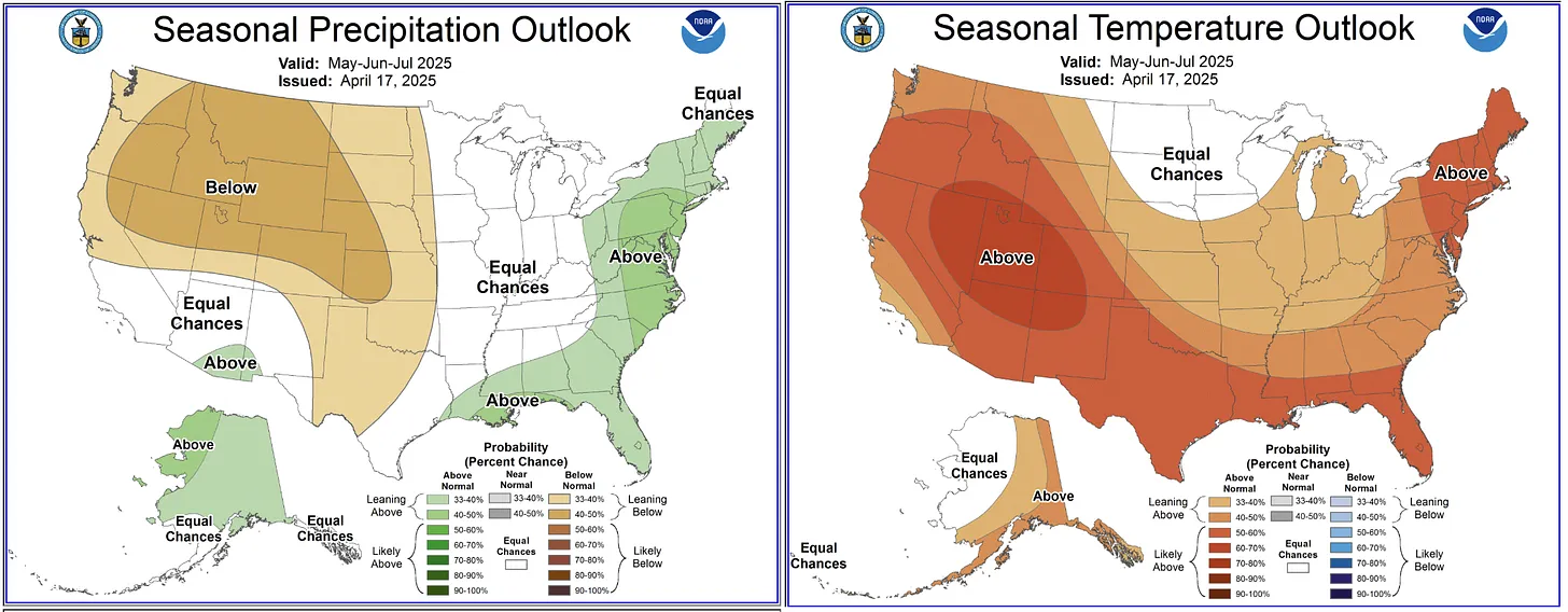
Snowpack in the Blue River Basin, which encompasses all of Summit County, stood at 90% of the 30-year median as of Friday. The figure shows that Summit is in a good position compared to the state as a whole, which sat at 58% of the median. Aldis Strautins, a service hydrologist with the National Weather Service in Boulder, said that 90% of the median is “within normal ranges.” He added that some lower elevation areas of Summit County, like the 9,350 foot-elevation snow telemetry monitoring site at Summit Ranch, have already melted out or gotten close.
“Some of the higher sites, like your Copper Mountain and Fremont Pass, those are still doing fairly well,” Strautins said. “Still have quite a bit of snowpack up there, which would make sense for this time of year.”
The Dillon Reservoir currently sits at 84% of its capacity, according to the Denver Water website.
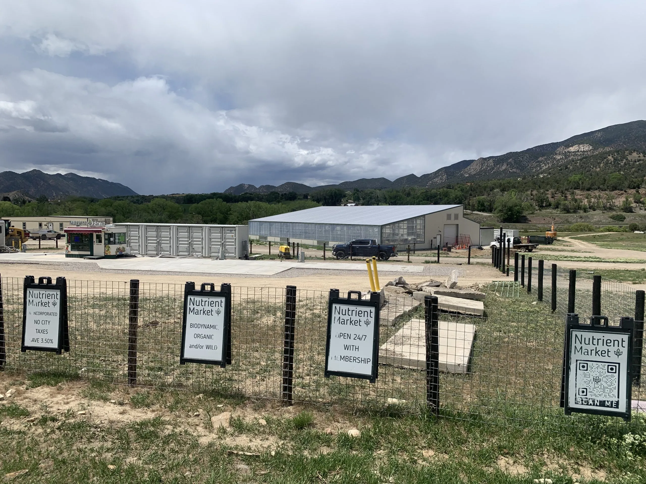
The Nutrient Farm store and greenhouse are located on Garfield County Road 335. Garfield County is considering a PUD application from Nutrient Farm to expand its operations into a restaurant, housing, lodging facilities, a music/entertainment area, campground, a health and wellness retreat, and other agricultural tourism-related operations. Credit: Heather Sackett/Aspen Journalism
The source of water — and whether there’s enough to go around — is at the heart of concerns about a proposed agritourism development for some local residents and Garfield County officials.
Nutrient Farm, an organic farm and ranch on the south side of the Colorado River between Glenwood Springs and New Castle, is seeking approval from Garfield County for a new planned unit development (PUD), which would include a restaurant, housing, lodging facilities, a music/entertainment area, campground, a health and wellness retreat, and other industrial and agricultural tourism-related operations on its 1,140 acres. Nutrient Farm would need water for its planned expansion of outdoor agricultural production including a “u-pick” orchard, nursery trees, pasture grass, hay, corn, vegetables, lawns and landscaping.
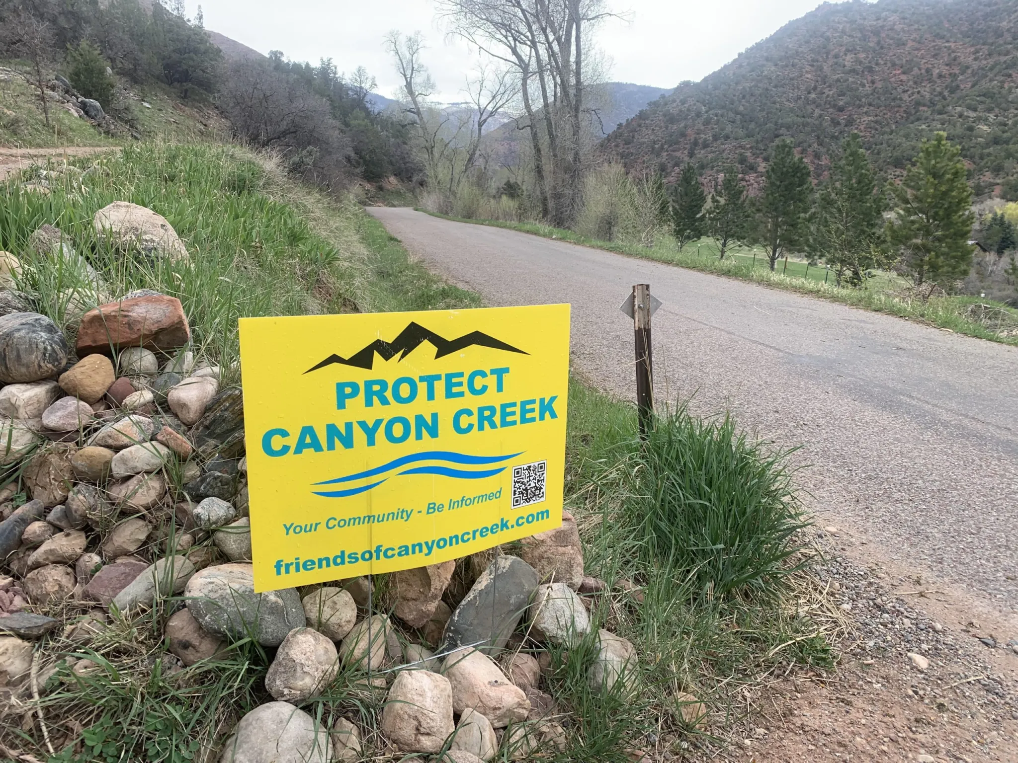
At the confluence of Canyon Creek and the Colorado River. Photo credit: Friends of Canyon Creek
Nutrient Farm is proposing that the main water supply would come from Canyon Creek, a tributary on the north side of the Colorado River. It would be taken out of the creek 1.5 miles upstream from its confluence with the Colorado River and conveyed across the river and Interstate 70 via the Vulcan Ditch.
According to Colorado Division of Water Resources records, the Nutrient Farm property has not used water from Canyon Creek or the Vulcan Ditch in more than two decades.
Water supply studies found that there may not be enough water in Canyon Creek for the Vulcan Ditch to take the full amount to which it is entitled during the late irrigation season in dry years, raising questions about the adequacy of the Canyon Creek water supply and the project’s impacts on the creek.
Concerned residents who live on Canyon Creek have formed Friends of Canyon Creek, a group dedicated to maintaining the ecological health of the stream. Six nearby property owners have hired a lawyer to oppose three water court cases related to Nutrient Farm’s water rights.
Sonia Linman lives along the creek and is an outspoken member of Friends of Canyon Creek. She is one of several residents who own property on the creek and don’t want to see the Vulcan Ditch reopened. Linman and others say the draw on the creek that Nutrient Farm is proposing could devastate wetlands, would harm the ecological values of properties that are protected by conservation easements between some landowners and the Aspen Valley Land Trust, and put the wildfire-prone valley at risk if the source of water to fight the frequent blazes is diminished.
“For me, I’d be losing a family member,” Linman said of the creek. “For most of us who believe nature is in an especially tenuous place right now, it would be reflective of a death of hope. We must do what’s right to protect something that is clearly, legally, morally, ethically deserving of that protection.”
Nutrient Farm’s proposal has been contentious, with the overwhelming majority of public comment and letters expressing concern about the project. Many took issue with impacts that the water use could have on Canyon Creek. After being continued twice — in January and March — the PUD application is scheduled to be revisited by the Garfield County Planning Commission on May 28.
AVLT has 12 conservation easements across eight properties in Canyon Creek, with the common goal to preserve and protect the ecological health of the creek and its habitat.
“Not only would [proposed water diversions] have a devastating impact on the ecology of Canyon Creek itself, it would also have extreme, irreversible and likely impermissible
impacts to the conservation values protected by AVLT’s conservation easements,” the letter reads.
But under Colorado water law, drawing a creek down to a trickle is not illegal, as long as the water is being put to beneficial use. And the state has no problem with someone using their water right — especially one that dates to before the 1922 Colorado River Compact — to the fullest extent possible.
Under Colorado’s arcane, century-old system of management, water usually belongs not to those who need it most, nor to the stream itself, but to the legacies of the European American settlers who got there first. Water is treated as both a natural resource that belongs to the public and a potentially valuable private property right. For some observers, Nutrient Farm’s plan highlights the system’s inherent imbalance and demonstrates how few options there are for protecting the health of streams in a warming and drying climate.
Canyon Creek water supply
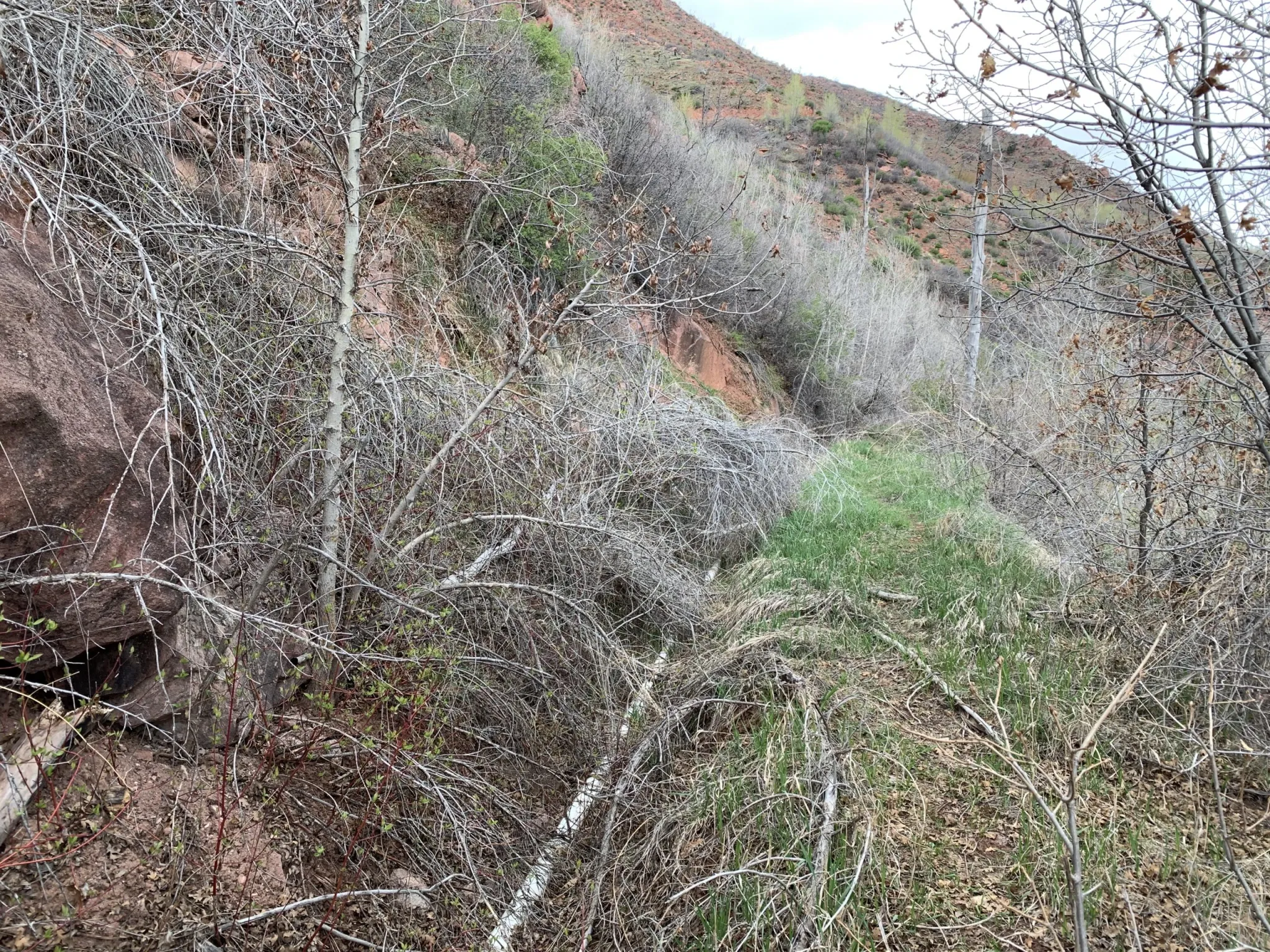
The Vulcan Ditch snakes across the hillside on the west side of Canyon Creek, roughly parallel to County Road 137. It is filled with downed trees, boulders, marmot holes, and an overgrown tangle of bushes and weeds. Nutrient Farm plans to reconstruct and realign the ditch, and install a 24-inch pipe, work that would require at least a 15-foot-wide — in some places, a 30-feet-wide — construction corridor, according to its PUD application. Water would have to be conveyed south across I-70 and the Colorado River to get to the Nutrient Farm property.
Dave Temple is the only other current water user on the ditch, which he maintains just enough in certain places to get his .13 cubic feet per second of water through a narrow, plastic pipe running along the bottom of the ditch to his property, located north of I-70 and the river. He walks parts of the Vulcan Ditch every other day during irrigation season.
“The ditch is a disaster,” Temple said. “I’ve always done it by myself, and it’s always taken me at least two weeks to get everything cleaned up enough to where I could turn the water in. … It’s in bad shape and even though [Nutrient Farm is] going to put it in pipes, it’s still going to devastate the whole hillside here.”
Nutrient Farm holds two water rights on Canyon Creek: a larger right, from 1908, and a smaller right, from 1952. According to a water supply adequacy report from Glenwood Springs-based engineering firm SGM, in dry years in the late irrigation season (August through October), the available streamflow may be limited to the senior 1908 water right.
A revised version of the SGM report, from this past March, clarified that although Nutrient Farm has the legal right to divert its full Vulcan Ditch right of 8.93 cfs, it will not — and cannot — divert continuously, year-round. The amount of water allowed to be used by crops (known as consumptive use) is capped at 393 acre-feet per year, which limits how much can be taken from the stream. At its maximum diversion rate of 8.93 cfs, Nutrient Farm would be able to divert only 34 days a year.
The report says the legal and physical water supply from Canyon Creek is sufficient.
“Whether diverting at higher rate for fewer hours, or diverting at a lower continuous rate, the proposed diversions are limited and are well within the supply available from Canyon Creek even in a dry year,” the report reads.
At the request of Canyon Creek property owners, Wright Water Engineers reviewed the original report from 2020 and submitted a memo to Garfield County. The Wright engineers agreed that there would be limited water available in Canyon Creek at the Vulcan Ditch headgate during the late irrigation season of dry years. Further, they concluded when using 1977, the driest year on record in the Colorado River Basin, as a benchmark, that the streamflow available at the Vulcan Ditch headgate would be below the property’s average demand at that time.
“Therefore, the Canyon Creek physical and legal supply is not sufficient to provide for Nutrient Farm’s demands during the late irrigation season in dry years,” the memo reads.
During late summer and early fall is when many streams in Colorado experience dry-ups as natural seasonal streamflows dwindle but irrigation continues. Many streams in Colorado are overappropriated, meaning there are more water rights on paper than there is water in rivers, depending on the season, and it’s not uncommon for irrigators to experience shortages during these times.
Nutrient Farm is owned by Andy Bruno, who bought the property in 2018. He did not answer a list of specific questions sent by Aspen Journalism, but he provided a statement about the project’s intended use of Canyon Creek.
“There is a long-standing adjudicated right for the entire Nutrient Farm water supply,” Bruno wrote in an email. “There is more than ample water available in the Canyon Creek to address all needs and Nutrient Farm remains subject to Division of Water Resources oversight. Nutrient Farm owns senior water rights, has a water management plan and will use this resource responsibly.”
Canyon Creek resident Dave Temple at the headgate of the Vulcan Ditch on Canyon Creek. Besides Nutrient Farm, Temple is the only other water user on the ditch, with a .13 cfs water right. Credit: Heather Sackett/Aspen Journalism
Water for fish
In a comment letter to the Garfield County Planning Commission, leaders of the Colorado chapter of Trout Unlimited said that if Nutrient Farm’s water right — in full or in part — was diverted during fall and winter low-flow periods, it could be devastating to spawning fish.
In 2021, Trout Unlimited completed a $250,000 project to upgrade the culvert system that conveys Canyon Creek under I-70 to improve access for spawning fish from the Colorado River. Trout Unlimited representatives said Nutrient Farm should permanently use water from the Colorado River, and that Canyon Creek should be protected from additional diversions.
“TU is primarily concerned about the detrimental impacts of additional diversion from Canyon Creek on brown trout spawning and subsequent egg incubation and fry emergence,” the letter reads. “In a drier, hotter climate, aquatic systems like Canyon Creek should be given special consideration.”
But historically, the health of aquatic ecosystems have been given very little consideration in the laws that govern water use in Colorado. And the section of lower Canyon Creek where the Vulcan Ditch headgate is located lacks one of the only protections available to rivers in Colorado: a minimum instream-flow water right.
These rights are held by the Colorado Water Conservation Board and are designed to preserve the natural environment to a reasonable degree. They date to the 1970s or later, and under the Western water management system of prior appropriation, where the oldest rights get first use of the creek, they aren’t always effective at keeping water in streams because they are so much younger than many big irrigation rights.
An upper reach of Canyon Creek between the confluence with Johnson Creek and the headgate of the Baxter Ditch has a series of minimum instream-flow water rights, but lower Canyon Creek lacks this protection.
Several other ditches besides the Vulcan Ditch take water from Canyon Creek, including the Williams Canal, the Mings-Chenoweth, Wolverton and Johnson ditches.
DWR does not have a problem with a water user taking so much water that it dries up the creek as long as they are not taking more than legally allowed or increasing their overall consumptive use to more than what is allowed in their water court decrees.
“That’s called tough luck,” said Aaron Clay, a retired water attorney, water court referee and expert who teaches community courses about the basics of water law across the Western Slope. “That’s the way the law works and DWR has no control over that. … Unfortunately, the prior appropriation system does not recognize environmental concerns on creeks.”
The Vulcan Ditch, which takes water from Canyon Creek, is overgrown and hasn’t been used in more than two decades. Nutrient Farm plans to pipe the ditch and begin using it for a farm and agritourism business. Credit: Heather Sackett/Aspen Journalism
Vulcan Ditch history
According to Nutrient Farm’s project narrative, “the Vulcan Ditch has historically provided irrigation water to the property from Canyon Creek and will continue to do so.” Nutrient Farm plans to use the Canyon Creek water for potable indoor use, irrigating crops, livestock, landscaping, grass fields, open space and recreational ponds.
But although the Vulcan Ditch may have brought water to what is now the Nutrient Farm property decades ago, state diversion records indicate that hasn’t happened in the past 24 years. The year 2000 was the last year that the ditch took a large quantity of water, about 1,500 acre-feet. Records are spotty for the next decade with either a very small amount of water diverted or no diversions at all, until 2010, when diversions resumed, but at a much lower level than in the 20th century. These numbers reflect the diversions of the only other water user on the ditch: Temple, who uses a small pipe to get water from the headgate to his property downstream.
Under Colorado water law, water rights holders must use the water if they want to keep their legal right to it. If they don’t, the water right could be abandoned. Abandonment is the legal term for one of Colorado’s best-known water adages: Use it or lose it. Abandonment means that the right to use the water is canceled. The principle came about to discourage hoarding of water rights that weren’t being used and to make sure that someone who used water long ago — but then stopped — couldn’t suddenly begin diverting water again and disrupt the flows of a river that more current water users have come to depend on.
“We’re afraid that this kind of precedent is dangerous,” Linman said. “When water has not been used and a ditch has not been maintained, to have the power to reopen a clearly abandoned structure puts residents at risk across the entire West.”
The reason that Nutrient Farm’s water rights on the Vulcan Ditch haven’t been formally abandoned, despite the ditch itself not being used in more than two decades, is because the farm has been taking water from the Colorado River using what’s known as an alternate point of diversion.
But those records are spotty. Diversion records indicate that a small amount of water was taken from the Colorado River to the Nutrient Farm property using a pump in five years between 2006 and 2023. Assistant Division Engineer for Division 5 Caleb Foy said his office must evaluate how to best use its resources in pursuing abandonment cases, which are subject to a determination of the court. For a water right to be abandoned, the water user must intend to abandon it in addition to not having used it in the previous 10 years.
“The water court has typically applied a relatively low standard for users to show they did not intend to abandon their rights,” Foy said in an email. “As such, within Division 5, partial abandonment of rights diverted at structures with a record indicating some water use were generally not a priority… .”
There may be another reason the Vulcan Ditch and associated water rights have not ended up on the state abandonment list: For the past 25 years, the state of Colorado has also given an extra layer of protection to pre-Colorado River Compact water rights. The state engineer’s office has had a policy of keeping them off the abandonment list for the past two cycles.
Nutrient Farm, an organic farm between New Castle and Glenwood Springs, is planning to use water from Canyon Creek for its proposed expansion of outdoor agricultural operations. It would involve reopening the Vulcan Ditch, which hasn’t been used in almost 25 years. Credit: Heather Sackett/Aspen Journalism
Data gaps
Garfield County planning staff has also expressed its concerns with Nutrient Farm’s water plan, which they outlined in two recommended conditions of approval. The county land-use code requires that applications for land-use change permits have an adequate, reliable, physical, long-term and legal water supply. To ensure this, the county wants Nutrient Farm to use water from the Colorado River instead of Canyon Creek and to complete an additional water supply plan analysis, which includes an assessment of impacts on stream flows in Canyon Creek.
However, counties typically don’t have jurisdiction over water rights issues in Colorado. Normally, that is the responsibility of departments of state government such as the water courts, DWR and the CWCB.
In a written response to the county, Nutrient Farm attorney Danny Teodoru said both these conditions are far outside the proper scope of zoning review in Colorado.
“Nutrient Farm, and frankly any water owner in the state of Colorado or the American West, can in no way agree to tie their legal use of legally decreed water rights to a discretionary zoning review,” Teodoru wrote. “Such a notion is absolutely untenable and again flies in the face of long-established Colorado law on incredibly valuable water rights.”
He added that Nutrient Farm would participate in a collaborative stream study if other Canyon Creek water rights holders do.
A stream management plan for Canyon Creek would go a long way to fill what Kate Collins, executive director of the Middle Colorado Watershed Council, called an area with a lot of data gaps. Canyon Creek was not included in the 2021 Middle Colorado Integrated Water Management Plan and was left out of the 2024 Wildfire Ready Action Plan. In addition to having no minimum instream flow for the lower portion of the creek, stream gauge data has been spotty over the years, without a long, consistent record.
“We believe finding out more science and data to make good decisions is always a good idea when it comes to the watershed,” Collins said.
Signs have popped up in yards and along roads around New Castle and Glenwood Springs supporting Friends of Canyon Creek, a group dedicated to protecting the watershed. Nutrient Farm wants to resume using a ditch for its planned development that hasn’t been used in more than two decades. Credit: Heather Sackett/Aspen Journalism
Few options for protecting streams
The issue of who can use water on Canyon Creek gets at a central tension of Western water law: Is water a public resource or a private property right? The answer is both. There are other options for leaving water in streams during environmentally critical times of year, including nondiversion agreements or water leasing programs. But there’s no way to force it to happen without the willing participation of water users.
“It has to be a negotiated deal because it’s a property right and the property right says: ‘I have the right to dry up the stream,’” Clay said. “If the dispute is beyond the headgate, it’s no longer a water rights issue — it’s a private property issue. Those disputes are between private property owners, not DWR.”
The Friends of Canyon Creek have few options to protect their local stream. Linman said her group shouldn’t be responsible for funding an assessment of impacts when they want to leave the creek the way it is. Within the limited confines of the system, the water court process — which seeks to minimize harm to other water users — is the best opportunity to have a say in how Nutrient Farm uses water. Three cases related to Nutrient Farm’s water rights are still pending. However, none of the cases directly affects the project’s right to use water from the Vulcan Ditch.
“Our intention is to protect the creek and make sure that a new draw wouldn’t be pulled from an already threatened watershed that is significantly responsible for fire mitigation, ecological stability and community well-being,” Linman said.
Linman, Temple and others are frustrated by what they say is a lack of communication between them and Bruno and his representatives. Temple said he learned of Nutrient Farm’s plan to reopen and pipe the ditch when he talked with an employee of SGM who was surveying the Vulcan Ditch.
“I have not had any communication,” Temple said. “They have never ever come over here to talk to me. They should understand you can’t just be secretive; you have to communicate with your neighbors.”
Residents worry they will soon live next to a diminished stream, harming their quality of life and ability to fight wildfires. They are also concerned that the construction needed to clear the ditch of debris, repair the ditch and pipe the ditch will damage their property. They said they would be more likely to support Nutrient Farm’s development plan if it used water from the Colorado River, a much bigger water source than Canyon Creek and better able to handle the diversion.
According to SGM’s report, Canyon Creek should be the preferred source for Nutrient Farm’s water supply because it’s better quality than the notoriously silty Colorado. Last year, Nutrient Farm filed water court applications to renew water rights from 1983 that would allow the farm to take an additional 2 cfs from the Colorado River and for a 2,000 acre-foot reservoir in which to store this water.
Basalt attorney and JVAM partner Ryan Jarvis represents six property owners who are opposers in the three water court cases that Nutrient Farm filed last year related to its water use.
“Besides a decreed instream-flow water right, I don’t know of any other way, per se, to protect the flows in the creek for environmental concerns,” Jarvis said.
But residents are holding out hope that there is another potential way forward. They say Nutrient Farm could choose to be a good neighbor.
“There is an easy and achievable solution,” Jarvis said. “Take your water from the Colorado River and don’t unnecessarily harm Canyon Creek and its community. My clients are still here and willing to have conversations and find solutions.”
Six of the seven state representatives who will shape the next chapter of Colorado River rules speak on a panel at the University of Colorado, Boulder on Jun. 6, 2024. The same group is opting not to speak at this year’s conference. Alex Hager/KUNC
Click the link to read the article on the KUNC website (Alex Hager):
May 11, 2025
This story is part of ongoing coverage of the Colorado River, produced by KUNC in Colorado and supported by the Walton Family Foundation. KUNC is solely responsible for its editorial coverage.
As tense negotiations about the future of the Colorado River are stuck at a standstill, the people in charge are retreating further into the shadows.
A group of negotiators – one from each of the seven states that use Colorado River water – will not be speaking at a major water law conference in June. Those representatives have appeared together on a panel at the conference for the last few years, and rarely appear together in public otherwise.
“The unwillingness to answer the public’s questions suggests that negotiations aren’t going well,” said John Fleck, who teaches water policy at the University of New Mexico. “I think it misses an important obligation in democratic governance of a river that serves 40 million people.”
The event, the Getches-Wilkinson Conference at the University of Colorado, Boulder, is typically one of two times each year that the negotiators appear together in public. In recent iterations of the same conference, they all spoke on one panel. Occasionally, a state representative has fallen ill or sent a deputy in their stead.
They seemed starkly divided at the other annual appearance, too. In December, they opted to split into two separate panels at the Colorado River Water Users Association conference in Las Vegas.
Water policymakers from (left to right) Utah, New Mexico, Colorado and Wyoming speak on a panel at the Colorado River Water Users Association conference in Las Vegas on December 5, 2024. The two rival factions of states chose to appear on two separate panels then, and have opted to avoid speaking entirely in June. Alex Hager/KUNC
People with knowledge of the situation confirmed to KUNC that state leaders told conference organizers they did not want to speak publicly. There is currently no seven-state panel on the published conference agenda.
JB Hamby, California’s top water negotiator, said he would attend the conference but not speak, and he was “100%” sure the other top officials wouldn’t be speaking. Representatives from Arizona, Colorado and New Mexico confirmed their states’ Colorado River negotiators would not be speaking.
Unlike many government processes, Colorado River policymakers work in a space that does not involve a mandate for public access. Their meetings are often held behind closed doors, are not listed publicly and do not yield minutes or records that can be viewed by the public.
“You need to listen to and have spaces to discuss with the people who are going to be impacted by your decisions,” Fleck said. “That’s not happening now, and that’s really disturbing.”
Those water policymakers are stuck in a standoff about how to use less water from the shrinking Colorado River. Negotiators seem to agree with the broad concept that the farms, businesses and 40 million people of the Colorado River basin need to cut back on water use as the river gets smaller due to climate change. They don’t, however, agree on who should cut back.
Talks so far have largely stayed divided along a decades-old fault line. On one side is the Upper Basin – which consists of Colorado, Utah, Wyoming and New Mexico. The other side, the Lower Basin, is made up of California, Arizona and Nevada.
The Lower Basin has volunteered relatively modest cuts in proposals for how to manage the river after the current rules expire in 2026. The Upper Basin has not volunteered any cuts, insisting that its states are already forced to use less water due to climate change and a longstanding legal requirement to send a fixed amount of water to those Lower Basin states.
“I am fully focused on the negotiations for post-2026 operations of Lake Powell and Lake Mead,” Becky Mitchell, Colorado’s top negotiator, wrote in an email to KUNC. “As the Getches-Wilkinson conference drew nearer, it was unclear where we would be in that process, and I wanted to be cognizant of the sensitivity of the work. Time is of the essence, and these critical negotiations have my full attention at this time.”
The states have dug their heels in on those positions for months now, and their willingness to talk about the status of their closed-door attempts to break the deadlock has only gone down over time.
Reporters’ requests to state water authorities that once yielded interviews with top policymakers are now often met with written statements that tend to be short on detail.
Glen Canyon Dam holds back the waters of Lake Powell near Page, Arizona on Sunday, Feb. 2, 2025. Lake Powell, has approached dangerously low levels in recent years as policymakers have struggled to come up with a long-term management plan for the water it stores. Photo credit: Spenser Heaps/Utah News Dispatch
“I have a lot of respect for the people who are doing these negotiations,” Fleck said. “They’re trying to solve really hard problems, and I respect the idea that they need some space to do that, but not showing up in public at all is granting them more space than I’m willing to grant them.”
Joanna Allhands, an opinion writer at the Arizona Republic who has written about the Colorado River’s “bankruptcy of leadership,” said more transparency from water policymakers “would be smart as a matter of self preservation.”
“Whatever the decision is made,” she said, “Whatever alternative gets chosen, if people feel like they’ve been left out, guess where we’re headed? We’re going to the Supreme Court.”
Colorado River negotiators have said that they want to avoid taking this issue to the Supreme Court, but have made little recent progress to steer talks away from that outcome.
Colorado River “Beginnings”. Photo: Brent Gardner-Smith/Aspen Journalism
This year’s predicted spring runoff into Lake Powell has decreased yet again as the impacts of a dry winter begin to show. Hydrologists at the Colorado Basin River Forecast Center said Wednesday that the amount of water flowing into Lake Powell between April and July this year is expected to be 55% of average. “Average,” in forecasting, refers to the average runoff between 1991 and 2020. That prediction follows a decline in forecasted flows since the start of winter…In terms of actual water, 55% of the average runoff translates to about 3.5 million acre-feet of water making it into Lake Powell…That’s lower than the runoff in 2022, which was a little over 3.7 million acre-feet, but better than 2021’s 1.85 million acre-feet. Spring runoff in 2023 and 2024 were well above what is forecasted this year. The snowpack above Lake Powell, which is the second-largest reservoir in the U.S., has already begun to melt. At the start of April, the snowpack was 89% of the 1991-2020 median. As of May 1, it has shrunk to 71% of the median.
Homestake Creek is a tributary of the Eagle River. CREDIT: BRENT GARDNER-SMITH/ASPEN JOURNALISM
Click the link to read the article on the Vail Daily website (Zoe Goldstein). Here’s an excerpt:
May 8, 2025
Every year brings different water conditions in Eagle County. With climate change, the promise of full rivers in the summer may become even less certain. To prepare for future drought years, the Eagle River Water and Sanitation District and Upper Eagle Regional Water Authority have a new water shortage response plan.
“The goal of this plan is to provide water security, to ensure that we can provide our core services,” said Justin Hildreth, the district’s water resources engineer, when presenting the plan to the district board for approval on April 10. Among the core services included in the list are safe drinking water and water for structure fire suppression…According to the plan, “a water shortage occurs when the (district/authority) lacks the physical or legal water supplies needed” to provide their services and maintain required streamflow levels. This can happen when there are extended calls from older water rights, (like the Shoshone water rights on the Colorado River), when stream flows are low for long periods and when local reservoirs (Eagle Park Reservoir and the Black Lakes) have low supply. The district and authority boards approved the plan during their April 10 meetings after learning about the plan during Feb. 27 work sessions…
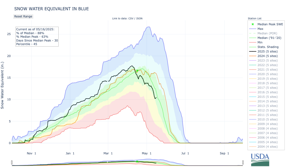
One of the best early predictors of a drought scenario is if the snow water equivalent measure has not reached an average of 15 inches across the Vail, Fremont Pass and Copper SNOTEL stations by April 1. “That directly relates to Eagle Park Reservoir, that relates to the flows in Gore Creek and the flows in the Eagle River,” Hildreth said. This year, the average was just shy of 16 inches across the three stations on April 1.
Click the link to read the article on the Aspen Times website (Robert Tann). Here’s an excerpt:
Perched above the Dillon Reservoir on the side of a mountain road in Summit County, Gov. Jared Polis on Thursday signed into law three bills aimed at bolstering the state’s water infrastructure. The measures come amid the backdrop of chronic drought and increased water demand in the West which have made finding a path towards water sustainability more urgent. Speaking amid on-and-off snow flurries and bouts of sunshine, Polis said the bills signed on Thursday will help “build a sustainable, livable future” by “securing our water for the state of Colorado.”
State voters’ decision to approve a tax on sports betting in 2019 has provided a critical funding source for water projects, delivering as much as $30 million a year for infrastructure and conservation efforts. House Bill 1311 takes that a step further by eliminating a tax exemption for revenue generated from free sports bets…
A view of the popular Pumphouse campground, boat put-in and the upper Colorado River. Photo credit: Brent Gardner-Smith/Aspen Journalism
Finding solutions to funding woes
While taxes on sports betting have helped shore up state spending on water projects, its other key funding stream risks running dry…Under Senate Bill 40, the state will commission a nine-member task force within the Department of Natural Resources to study the future of severance tax revenue and come up with solutions to better fund the state’s water needs. The task force will be required to submit a final report to the legislature in July 2026, with lawmakers hoping to turn those ideas into policy.
Grays and Torreys, Dillon Reservoir May 2017. Photo credit Greg Hobbs.
Map of the Colorado River drainage basin, created using USGS data. By Shannon1 Creative Commons Attribution-Share Alike 4.0
Click the link to read the article on the AZCentral.com website (Branson Loomis). Here’s an excerpt:
May 13, 2025
Key Points
Arizona has “real skin in the game” as negotiations continue over shares of a smaller Colorado River, Gov. Katie Hobbs said. Now she wants other states to step up.
The seven Colorado River states are trying to reach a shortage-sharing agreement this year, but are also looking to the new Trump administration to see if there are alternatives.
Arizona officials say other parts of the state, such as Yuma, may have to take cuts. Tribes say they expect the state to honor settlements.
Arizona is doing its part and taking its hits to conserve the Colorado River, Gov. Katie Hobbs said, and it’s time for upstream states to do the same. The governor assembled a roundtable of water users and officials on May 13 to present what she called a unified front among the state’s interests in defending Arizona’s share of the Colorado River as time runs short for reaching a deal with other states that use the water. So far, states upstream from Arizona have not offered cutbacks beyond the limits that a paltry snowpack naturally extracts from their farmers.
“It’s been more than a little frustrating,” Hobbs said. “We’ve come to the table with real solutions, with real proposals. We have real skin in the game,” she said, including billions of dollars in water infrastructure upgrades and in conservation agreements that keep water in the river’s reservoirs. “The upper states need to be willing to take their share as well.”
[…]
So far, the Rocky Mountain states known collectively as the Upper Basin have declined to specify new cuts they might take, because they say they already suffer the consequences of a reduced snowpack that shortchanges their farmers every year. The federal government has paid some Lower Basin farmers and others to cut back on their demands from Lake Mead’s storage bank, and the four Upper Basin states of Colorado, New Mexico, Utah and Wyoming argue that their year-in, year-out hardship is unrewarded and largely invisible to water users in the Southwest.
Udall/Overpeck 4-panel Figure Colorado River temperature/precipitation/natural flows with trend. Lake Mead and Lake Powell storage. Updated through Water Year 2024. Credit: Brad Udall
Following a day of testimony on May 6, Denver Water has been asked by U.S. District Court Judge Christine Arguello to provide the court with the utility’s final summary highlighting its position following the witness testimony and exhibits. There isn’t a specific timetable set for this yet.
The focus of the hearing was for the judge to determine if construction can safely stop while Denver Water moves forward on an additional permitting review as the court ruled on April 3. Here is Denver Water’s statement on the risk presented by delaying construction:
Denver Water has already started the appeal process with the 10th Circuit Court of Appeals. As part of this, the project has been allowed to continue (under a temporary stay) while legal proceedings are underway.
Roller-compacted concrete will be placed on top of the existing dam to raise it to a new height of 471 feet. A total of 118 new steps will make up the new dam. Image credit: Denver Water.
The Palisades Fire, photographed here from Palisades Drive, ignited Jan. 7, 2025, in the Santa Monica Mountains of Los Angeles County. It spread rapidly because of hurricane-force Santa Ana winds, burning for 24 days, consuming more than 23,000 acres and destroying 6,837 structures. Photo credit: Ariam23, Wikimedia Commons, CC BY 4.0
One of the initial concerns during the series of tragic Los Angeles wildfires that burned in January 2025 was whether fire hydrants were ready to combat the inferno that left so much destruction in its wake.
To be clear, and as Denver7 highlighted in January, public water systems are designed to help firefighters battle urban fires.
For instance, Denver Water’s system includes built-in redundancies to ensure it can meet water demand, and the utility continually invests in the system to keep it that way.
Denver Water’s distribution system includes 31 treated water storage tanks across the metro area (many of which have been upgraded in recent years), more than 3,000 miles of pipe and 22,000 fire hydrants, along with dedicated mechanics who focus on maintaining those hydrants and keeping them in top condition.
During a fire in the Denver Water service area, its operators can analyze and adjust the operation of the distribution system so that firefighters have the water pressure they need to fight the blaze. The utility also will send experts to the scene to help maintain pressure.
The system of hydrants is not designed, however, to provide sufficient flows for a long enough period to effectively battle long-lasting, wind-driven, large-scale wildfires. Hydrants are pressurized and are crucial to fighting structure fires, but they can only do so much. And when many hydrants are in use in the same area at the same time, water pressure is going to weaken.
While Denver Water can store millions of gallons of drinking water in dozens of large water storage tanks around town to accommodate increases in demand, there are limits — like being able to provide enough water to fight a wildfire.
Fortunately, much of Denver Water’s service area is in a different environment compared to Los Angeles. But that doesn’t mean the area is immune, as there are portions that blend wildland environments with urban communities.
In fact, just last summer a string of wildfires ignited during the same week in the foothills along the Front Range. The fires required aggressive coordination from fire departments up and down the corridor, alongside state and federal agencies, to extinguish, with a focus on wildland firefighting. Wildland fire responders cleared fire lines and fought the fires from the air.
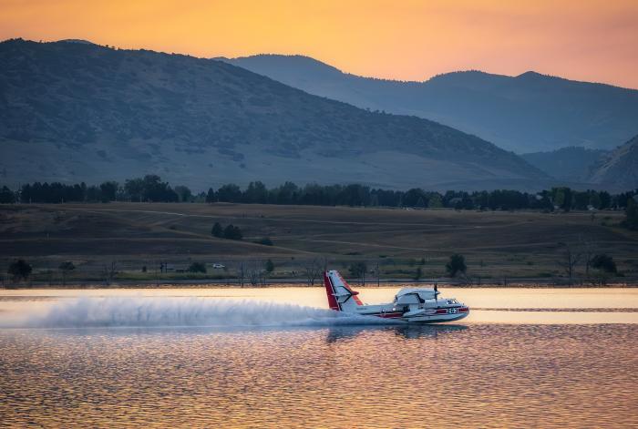
A plane pulls in water from Chatfield Reservoir to help fight the Quarry Fire, a wildfire that ignited in summer 2024 in Jefferson County, Colorado. The fire required a multi-jurisdictional effort to extinguish. Photo credit: Colorado Parks and Wildlife.
Urban fire hydrants were not the focus.
Ultimately, when a fire like the tragic blazes in Los Angeles occurs, it is always going to require a coordinated, multijurisdictional effort, often across city, state and even international lines.
So, what can be done?
Colorado Public Radio in January spoke with Colorado State Forest Service wildfire mitigation program specialist Chad Julian, who discussed the importance of focusing on the right topics when analyzing any fire.
“If we focus on increasing budgets, more water storage, more fire trucks, it’s not going to change the outcome of the next event. It would take the engagement of homeowners to really work on the resistance to ignition and hardening those buildings, the vegetation and the yards,” he said.
“Ninety-five percent of it was likely still caused by land use patterns, how we build, how we interact with the ecosystem, whether we adapt to it or not. And unfortunately, that’s not the focus at the moment,” he said.
But this was the focus in Colorado after the devastating Marshall Fire of 2021, leading to new legislation:
In Louisville, an ordinance took effect in December 2024 requiring implementation of wildfire-resistant measures in buildings. (Boulder is considering something similar.)
Many new construction sites in Denver include 5-foot vegetation barriers around new structures in their landscape planning.
The Wildfire Resilient Homes Grant Program, created by Colorado’s state legislature, encourages homeowners to make their properties more resistant to wildfire.
Julian says these are the types of changes that can make a real difference.
Denver Water has long focused on investing in the resiliency of its watersheds and system, and plans to invest about $1.8 billion over the next 10 years.
When customers pay their water bill, the money goes to building a reliable system, which includes regular infrastructure inspection and maintenance programs to ensure pipes, hydrants and storage tanks are ready to protect communities during urban fires.
Water bills also fund watershed resiliency projects that protect the lands and facilities that collect and store Denver’s drinking water.
The From Forests to Faucets partnership alone has committed more than $96 million to reduce wildfire risk in critical areas, from 2010 through planned work into 2027. Half of that money has come from Denver Water. The risk of wildfire in Denver Water’s watersheds remains the greatest risk to Denver’s water supply, making this investment crucial to the resilience of the system.
A Ponsse tree harvester works to thin a 40-acre section of forest in Breckenridge in August 2020, as part of the From Forests to Faucets partnership. Photo credit: Denver Water.
Denver Water’s 10-year investment plan also includes expanding Gross Reservoir in western Boulder County, which will improve water supplies on the north side of the metro area and make the system more balanced and resilient in the face of increasing impacts from climate change, drought and wildfire.
This improvement on the north side of the metro area will prove pivotal should wildfire inhibit resources that deliver water on the south side of the region, via the South Platte River, where wildfires have struck consistently over the past 20 years.
These are just a few examples of investments and partnerships already underway, but challenges lie ahead.
As Salazar noted in his column published in The Denver Post (which can also be found on Denver Water’s TAP news site), climate change continues to impact the environment and, as the wildland-urban interface continues to merge, even more investment and collaboration will be crucial.
Aerial view of Lake Estes and Olympus Dam looking west. Photo credit Northern Water.
From email from Northern Water (Jeff Stahla):
May 9, 2025
The Northern Water Board of Directors allocated 23,000 acre-feet of Regional Pool Program (RPP) water during its May 8, 2025, Board meeting. RPP water is available for lease by eligible Northern Colorado water users, with sealed bids due 2 p.m. May 22, 2025. Bid prices per-acre-foot must be greater than or equal to $33.80, a floor price the Board selected based on the 2025 agricultural assessment rate. Late bids will not be considered.
The allocation will be available to bidders from two subpools of 11,500 acre-feet each; one that delivers water from Horsetooth Reservoir, and a second that delivers to water users south of Horsetooth Reservoir, including the Big Thompson River, St Vrain Creek and Boulder Creek.
The following forms are required to submit a bid:
Pre-Approval Form – To confirm eligibility, interested bidders must email or mail the Pre-Approval Form to Northern Water. A new Pre-Approval Form is required each year.
Carrier Consent Form – If the RPP water will be delivered by a carrier, such as a ditch or reservoir company, bidders and their carriers must complete the Carrier Consent Form or provide a signed agreement stating that the carrier will deliver the RPP water to the bidder. This form must also be emailed or mailed to Northern Water.
Bid Form – Sealed bids will be accepted at Northern Water’s headquarters through a “self-serve” process. Bidders will sign in at a kiosk in the Building A lobby at Northern Water, 220 Water Ave., Berthoud, and print a bid label for their sealed bid envelope. The label will identify the bidder name, date and time stamp, and bid number. Bidders are then asked to secure the label to the bid envelope and place it in the drop box. Sealed bids may also be mailed to Northern Water, but bids must be received before the deadline.
Sealed bids are due by 2 p.m. Thursday, May 22, at Northern Water’s headquarters, 220 Water Ave., Berthoud, CO 80513. As described above, sealed bids can be mailed or hand delivered; email and fax bid forms will not be accepted. RPP leases within each subpool will be awarded based on highest bids per acre-foot. Sealed bids will be opened at 2:10 p.m. Thursday, May 22, in the Grand Lake Conference Room of Building A at Northern Water.
Questions regarding the Regional Pool Program and bid submittal can be emailed to regionalpool@northernwater.org or by calling Sarah Smith at 970-622-2295 or Water Scheduling at 970-292-2500.
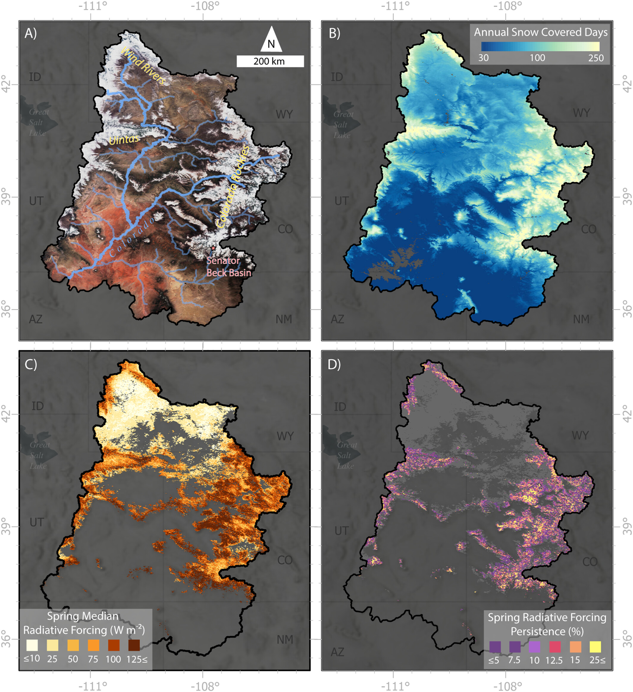
A new study finds that airborne dust deposited on snow in the Upper Colorado River Basin speeds up spring snowmelt. Regular readers of the Land Desk won’t be surprised by this conclusion, as there are regular mentions here regarding the effects of dust-on-snow in the San Juan Mountains. This study, however, is the first to quantify the effects across the entire Colorado River Basin.
When dust, lifted up from the lowlands by spring winds, falls on mountain snow, it decreases the snow’s albedo — the measure of a surface’s reflectivity — causing the snow to melt faster. That adds another variable into the water forecasting mix, since about 85% of the Colorado’s flow comes from snowmelt.
Dust events have been occurring for thousands of years on the Colorado Plateau and in the San Juan Mountains, but picked up significantly following the white settler-colonist influx of the mid-1800s, and peaking in the first few decades of the twentieth century, when volumes of dust were five times higher than they were prior to colonization.
The lowest dust-on-snow impacts occurred in the northern Uinta in Utah and the Wind River Range in Wyoming, while higher and more persistent effects were seen in the central and southern Rockies.
Dust impacts tend to be largest in the lower alpine elevations (8,000 – 10,000 feet).
The researchers observed greater dust effects in the first part of the observation period (2001 to 2014) and lesser after that, “producing a slight but statistically significant decreasing trend over the record.” And the patterns don’t necessarily align with drought intensity, “indicating that there is not a straightforward relationship between aridity and dust.”
The reason for the decreasing trend aren’t clear, but researchers hypothesize that it relates to a combination of increasing surface roughness (vegetation) and decreasing wind speeds related to climate variability.
The good news for the San Juans is that dust events have been relatively mild this spring, according to the Center for Snow and Avalanche Studies’ April 29 report, which has helped keep the meagre snowpack around a while longer. At least for now: A storm is forecast to move into the San Juans this weekend and early next week, likely bringing both dust and snow to the high country, which could throw off some of our Predict the Peak guesses, for sure.
***
Fire season has arrived in the Southwest. It feels early, but then, who the hell knows anymore? Maybe last year’s fire season is simply continuing on. The Stronghold Fire has scorched a little over 2,000 acres in the east edge of the Dragoon Mountains in southern Arizona, forcing evacuations in the rural sprawl. As of May 1, it was 62% contained and fire activity had ebbed. And the Otero Fire burned through 494 acres of the Rio Grande Bosque adjacent to Socorro, New Mexico.
The outlook is for a hot, dry, maybe smoky summer for a good swath of the West:
🏠 Random Real Estate Room 🤑
I stumbled upon an unexpected headline in the Las Vegas Review-Journal today: “Inventory flooding Las Vegas Valley’s home market with no buyers in sight: Zillow.” Say what? For I don’t know how long, we’ve been hearing that Las Vegas was suffering a severe housing shortage — i.e. demand was far outstripping supply — and that the only solution was to sacrifice surrounding public lands to housing developers.
Yet now Zillow is saying there are too many houses for sale? And what’s also interesting is that home prices continue to rise alongside inventory. That’s right: There are more homes available for sale, and yet the median sales price continues to increase, showing that the laws of supply and demand don’t always apply to housing (and showing that the push to bulldoze federal land for affordable housing is a sham).
I checked out Zillow for myself and found about 1,600 homes listed for less than $300,000 for sale in the greater Las Vegas area. I decided to look around the region a bit, too, and it actually seems like there are more sub-$300k homes/condos available now than during my previous scans over the past four years. Oh, and I found this tiny home in the sprawling metropolis of Ticaboo, Utah. A little overpriced, but the location? Heck yeah!
🤯 Trump Ticker 😱
Sigh. That guy is still president, and continues to do his darnedest to wreck everything that makes America great. Wes Siler’s Newsletter is reporting that the National Park Service plans to fire another 1,500 employees in coming days, bringing total Park Service staffing losses through resignations, firings, and layoffs to 5,000 under Trump. Meanwhile, year-to-date visitation at Zion National Park is at near-record levels. The combination of more visitors and fewer staff could get messy.
And all Interior Department employees (which includes the Park Service, BLM, and so forth), have been ordered to submit their resumes — i.e. reapply for their existing jobs — in preparation for significant job cuts and an expected complete overhaul of the department and its agencies.
Firing thousands of people from what seemed like secure jobs will not be good for the economy, which is already struggling mightily due to Trump’s policies. And on that note, if you’re interested in tariffs and how they might affect things, I’d urge you to read this smart take from Aaron Smith at his Ag Data News:
📈 Data Dump 📊
WildEarth Guardians just released their first quarter “Oil & Gas Waste Watch” report tallying up industry and regulatory failures in New Mexico. Findings include:
307/330 The number of oil and gas facility incidents/spills reported during the first three months of the year in New Mexico.
78,858 barrels Volume of liquid, including 22,927 barrels of wastewater in addition to crude oil, condensates, and other materials, spilled in those incidents. Some of the material was recovered.
118 Number of spills involving crude oil or condensates.
292/36 Number of spills in the Permian Basin/San Juan Basin, respectively.
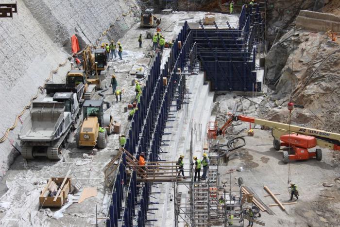
Denver Water is helping ensure its future water security with the Gross Reservoir Expansion Project. When the project is complete, it will nearly triple the Boulder County reservoir’s capacity to 119,000 acre-feet. CREDIT: HEATHER SACKETT/ASPEN JOURNALISM
Adam engineer who designed a major expansion of Gross Reservoir Dam in Boulder County told a federal judge Tuesday that the raising of the dam, facing a potential halt due to an April federal court ruling, needs to proceed to protect public safety.
Mike Rogers, the civil engineer who designed the $531 million expansion of the dam, said bad weather could create flood conditions that would lead to a catastrophic failure similar to what occurred with the Oroville Dam failure in California in 2017.
But Stephen Rigbey, a Canadian dam safety expert testifying for Save The Colorado, said any issues with putting the construction project on hold, even in its partially-complete state, could be addressed, and that the risk of a catastrophic failure was “negligible.”
Workers from Denver Water and contractor Kiewit Barnard stand in front of Gross Dam in May 2024 to mark the start of the dam raise process. Photo credit: Denver Water.
Rogers’ and Rigbey’s testimony Tuesday came during a federal hearing in Denver, after which U.S. District Court Judge Christine Arguello will determine whether to allow construction to move forward on the Denver Water project or whether the construction will be paused until new federal reviews she has ordered are completed and legal questions are answered.
But at the end of Tuesday’s hearing, Arguello said the parties to the case had not provided enough information for her to make a decision and ordered them to submit more data later this month.
The massive construction project has raised fierce opposition in Boulder County and prompted several legal challenges from Save The Colorado, a group that advocates on behalf of rivers. Though its early lawsuits failed, in 2022 the river defenders won an appeal that put the legal battle back in play. Despite months of settlement talks, no agreement was reached.
Boulder County Commissioner Ashley Stolzmann was unmoved by Rogers’ testimony, saying she hopes the judge halts the work to prevent further environmental damage in Boulder County and to protect the Fraser River, a tributary to the Upper Colorado River. The Fraser has served as the source of water for Gross Reservoir since the 1950s, when it was built.
“It’s incredibly disappointing that Denver has chosen to move forward,” Stolzmann said. “With climate change, it really is a time for different entities to work together to repair the climate. I want to see Denver seek alternative solutions.”
Denver Water first moved to raise Gross Dam more than 20 years ago when the water provider began designing the expansion and seeking the necessary federal and state permits. Denver Water has said raising the dam and expanding the reservoir is necessary to ensure it has enough water throughout its delivery system and to help with future water supplies as climate change continues to reduce streamflows.
The Gross Reservoir Expansion Project involves raising the height of the existing dam by 131 feet. The dam will be built out and will have “steps” made of roller-compacted concrete to reach the new height. Image credit: Denver Water
After years of engineering, environmental studies and federal and state analyses, Denver received a permit from the U.S. Army Corps of Engineers and construction began in 2022. It has involved taking apart a portion of the original dam and raising its height by 131 feet to nearly triple the reservoir’s storage capacity to 119,000 acre-feet from 42,000 acre-feet.
The case took center stage again April 3, when Judge Arguello put a temporary halt to construction of the higher dam, at Save The Colorado’s request.
In that high-profile ruling, Arguello said, in part, that the Army Corps should have considered whether ongoing climate change and drought would leave the Colorado River and Western Slope waterways too depleted to safely allow transfer of Denver Water’s rights into a larger Gross Reservoir for Front Range water users.
At the same time, she ordered a permanent injunction prohibiting enlargement of the reservoir, including tree removal and water diversion, and impacts to wildlife.
Almost immediately, Denver Water filed for temporary relief from the order, saying, in part, that it would be unsafe to stop work as the incomplete concrete walls towered above Gross Reservoir.
Arguello granted that request, too, allowing Denver to continue work on the dam considered necessary for safety.
Denver Water has also filed an appeal with the U.S. 10th Circuit Court of appeals, seeking to permanently protect its right to continue building the dam. The appeals court is expected to wait for the lower court to rule, before considering Denver Water’s request.
Udall/Overpeck 4-panel Figure Colorado River temperature/precipitation/natural flows with trend. Lake Mead and Lake Powell storage. Updated through Water Year 2024. Credit: Brad Udall
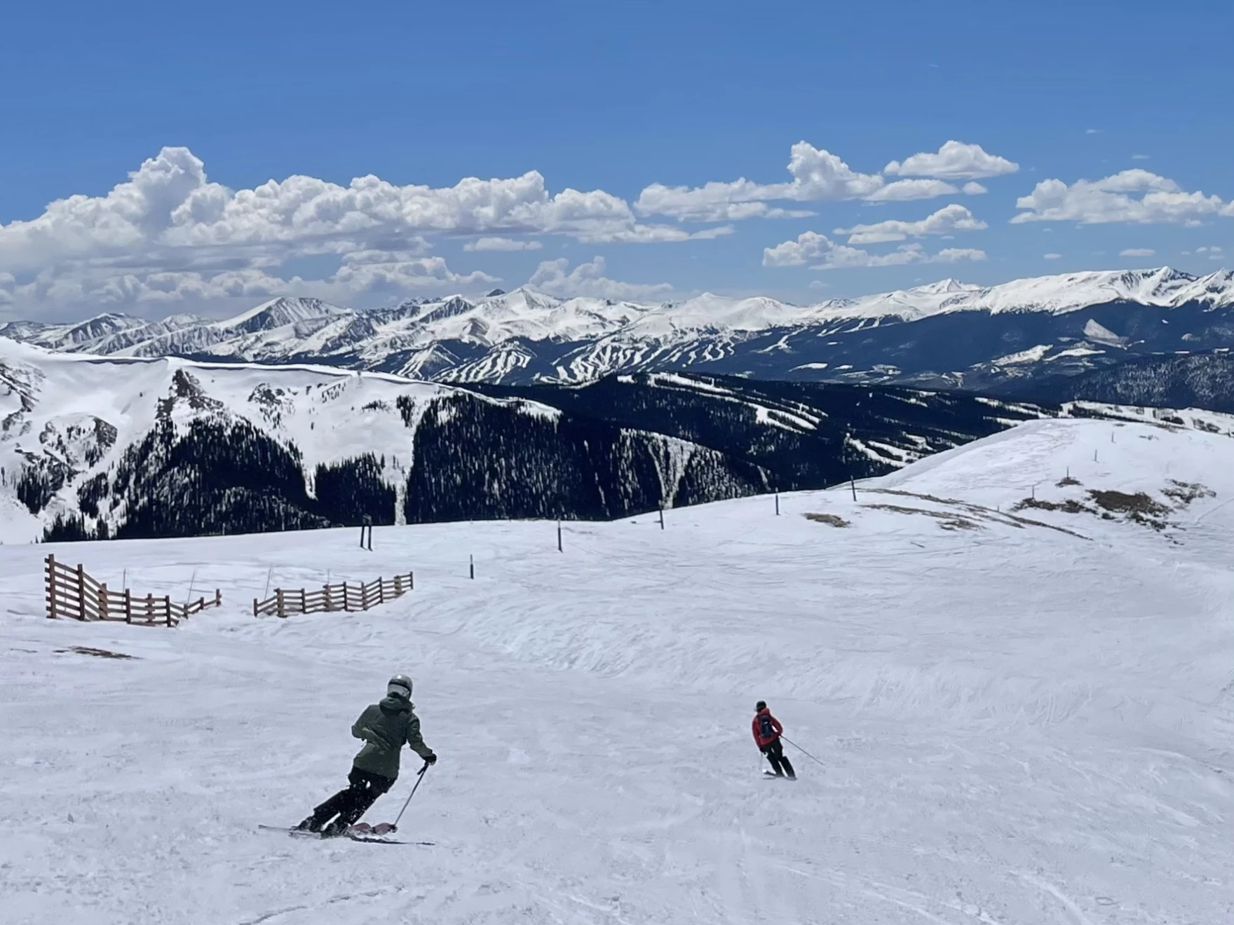
Skiers descend Arapahoe Basin Ski Area in Colorado on May 4, 2025. Snowpack across the mountains that supply the Colorado River is far below normal for this time of year. Forecasts call for 55% of average runoff into Lake Powell, the nation’s second-largest reservoir. Alex Hager/KUNC
Click the link to read the article on the KUNC website (Alex Hager):
May 8, 2025
This story is part of ongoing coverage of the Colorado River, produced by KUNC and supported by the Walton Family Foundation. KUNC is solely responsible for its editorial coverage.
If you took a look at a map of Rocky Mountain snow right now you would see a lot of red.
The mountains that feed the Colorado River with snowmelt are strikingly dry, with many ranges holding less than 50% of their average snow for this time of year. The low totals could spell trouble for the nation’s largest reservoirs, but those dry conditions don’t seem to be ringing alarm bells for Colorado River policymakers.
Inflows to Lake Powell, the nation’s second largest reservoir, are expected to be 55% of average this year, according to federal data released this week. If forecasts hold true, 2025 would see the third-lowest amount of water added to Lake Powell in the past decade.
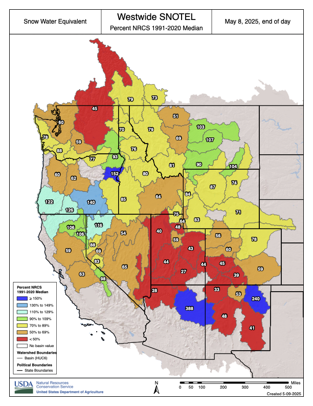
Westwide SNOTEL basin-filled map May 8, 2025 via the NRCS.
“It’s looking like a pretty poor water supply and spring runoff season,” said Cody Moser, a hydrologist with the Colorado River Basin Forecast Center.
If Lake Powell drops too low, the reservoir would lose the ability to generate hydropower for about five million people across seven states. Much lower, and it could lose the ability to pass enough water downstream, where tens of millions of people depend on it.
Eric Balken, who watches Lake Powell closely as director of the nonprofit Glen Canyon Institute, said this year’s snow data is concerning, but it isn’t driving the same level of concern from policymakers and media outlets that emerged in previous dry years.
Balken said that may be happening for two reasons.
First, it’s because negative outcomes might not be felt immediately. Lake Powell is unlikely to drop low enough to lose hydropower capabilities this summer, but the dry spring is making that more likely to happen in 2026.
Second, it’s because water managers simply have bigger fish to fry.
The federal offices that manage Western water are in disarray amid layoffs and restructuring since Donald Trump returned to the White House. The Bureau of Reclamation, the top federal agency for Colorado River dams and reservoirs, is without a permanent commissioner.
All the while, state and federal policymakers are spending most of their time and attention on drawing up new water-sharing rules. The current rules expire in 2026. Talks between states have reached a standstill, and negotiators say they’re working toward a compromise.
“That chaos within the agencies, the broader negotiations happening on the Colorado River, all of these other factors, I think, are sort of drowning out the severity of the drought situation right now,” said Balken.
Glen Canyon Dam creates water storage on the Colorado River in Lake Powell. Low water levels in Lake Powell could jeopardize the dam’s ability to produce hydropower or pass water downstream. Credit: U.S. Bureau of Reclamation
This year got off to a strong start for mountain snow, but took a dip during a dry spell that lasted from December through February. Snowmelt from Colorado accounts for about two-thirds of the water in Lake Powell. A portion of Western Colorado saw less than 15% of normal precipitation from December through April.
Scientists say these low snow years are the result of climate change, which is causing less snow to fall, and more of it to be soaked up by dry, thirsty soil before it has a chance to reach rivers and reservoirs. That has left the Colorado River in a dry trend going back more than two decades.
Balken said the climate reality is here to stay, and should spur the region’s leaders to rein in demand accordingly.
“Just because we’ve gotten used to it doesn’t mean that it’s not a problem,” he said. “We have to stay laser focused on what’s happening on the Colorado River, because there are some very big problems that need to be addressed.”
Layers of snowpack melted rapidly in Colorado in April, which could lead to less water supply in the summer and higher wildfire potential, according to data from the National Integrated Drought Information System. The federal data, released on May 1, indicate that “substantial and rapid” snowmelt occurred throughout broad swaths of Colorado between April 10-17. Several weather stations maintained by the U.S. Department of Agriculture logged record snowmelt during that week, compared to the same period in prior years. Snow disappeared up to 4 weeks early in parts of Colorado compared to previous years, federal data show…How quickly snow melts, and when it happens, can impact water availability during hot summer months and affect how likely wildfires are to occur in a region. An area that’s seen rapid snowmelt in early spring could have dried-out vegetation by summer, a potential fuel for blazes…
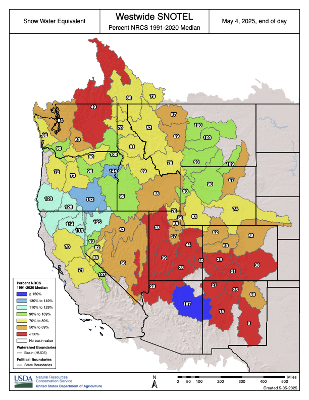
Westwide SNOTEL basin-filled map May 8, 2025 via the NRCS.
Spring heat waves in early April rapidly melted snow across Colorado’s Rocky Mountains, leading to large drops in the state’s median “snow water equivalent,” compared to past levels. Snow water equivalent (SWE) measures how much liquid water is stored in the snow, which will eventually melt and flow into the soil and bodies of water…
The federal data also show that water supply forecasts for the Upper Colorado River Basin – an area that stretches four states including Colorado – declined compared to rosier projections from early April.
The area around Yuma, Ariz., and California’s Imperial Valley provide roughly 95% of the vegetables available at grocery stores in the United States during winter months. February 2017 photo/Allen Best
From the sprawling alfalfa fields of the Imperial Valley to the lush, water-guzzling grass of cities like Phoenix, the definition of what the feds consider “beneficial use” along the Colorado River needs an update, according to a coalition of nonprofits. In a legal petition filed Tuesday, the Natural Resources Defense Council and a group of river advocates urged the federal Bureau of Reclamation to use its power to better dictate how water can be used in the Lower Basin states of Nevada, California and Arizona. Its authors acknowledge that’s a bold request…As states remain deadlocked on which ones should take cuts in how much water they can use, the agency emphasized in a statement its commitment to “long-term operational agreement for the river after 2026…The petition hinges on Part 417 of federal regulations — a section of code that gives the Bureau of Reclamation the authority over water deliveries to the Lower Basin states, with an obligation to ensure that water use is reasonable. Some worry that if the Bureau of Reclamation took the actions outlined in the petition, it could open the door to even more legal challenges from states and water users, kicking progress on conservation even further down the line when time is a luxury that water managers no longer have…
Gold’s petition specifically calls out the inefficiency of the agricultural sector, where more than half of the river’s water is used every year — far more than city use. The petition says exporting water-intensive crops is “akin to exporting water itself.” California’s Imperial Valley, where farming is a multibillion-dollar industry, receives more water than Los Angeles, Phoenix and Las Vegas combined to grow crops like alfalfa, carrots and lettuce. Gold hopes the feds will use better discretion in choosing which contractors are able to divert water from the river, prioritizing conservation. Some practices, like using flood agriculture to cover fields in water, are not practical, especially on days that break 100 degrees, he said.
Yampa River May 3, 2025. Yampa River on Saturday evening was flowing strongly through Steamboat Springs, but the snowpack in the the Yampa-White drainage area of northwest Colorado was still less than two-thirds of average. Photo credit: Allen Best
Click the link to read the article on the Big Pivots website (Allen Best):
May 6, 2025
Colorado’s southern mountains had another miserable snowpack. This is not good for the Colorado or Rio Grande rivers. It fits in with a theme.
Louis Meyer awoke on Monday morning at his farm about 10 miles north of Durango to see Engineer and Red mountains wearing fresh blankets of snow. The two mountains had been scantily clad for much of the winter.
The spring snow was welcome news, he said, but unlikely to change the story of southwest Colorado. Runoff will be abysmal.
A resident of southwest Colorado for about eight years, Meyer has conferred with others with deeper local knowledge. Right now, it appears that those farmers and ranchers who might normally expect to get three or four cuttings of hay will get no more than two. And in La Plata County, they will be lucky to get one cutting of hay.
Snow contributing water to the Animas, San Juan and other rivers of southwestern Colorado have only 28% of median of snow-water equivalent, according to maps released on Monday by the Natural Resources Conservation Service, a federal agency.
East of Wolf Creek Pass, in the upper Rio Grande drainage, numbers were worse yet, 21% of median. Last week, before the fresh snow, they had been even less.
Water managers in the San Luis Valley warned in a May 1 posting on Facebook that they expect early runoff, low rivers flows, and a short boating season. Heather Dutton, manager of the San Luis Valley Water Conservancy District, said there had been high hopes several times of 16- to 18-inch snow dumps, even 36 inches. “It just never materialized for us.”
Snowpack in Colorado’s southern mountains always has been uneven. Some years are better, other years worse. But a trend has emerged of earlier springs and less moisture in the San Juan Mountains and Sangre de Cristo Range of Colorado, and this year’s snowpack and weather fits in with it.
Russ Schumacher, the Colorado state climatologist, and associates at the Colorado Climate Center have analyzed data from the Snotel stations in Colorado going back to at least 1979. Their studies have focused on the volumes of peak snow-water equivalent in the snow and the dates of those readings.
Snotel stands for SNOwpack TELemetry, an automated system.
“In Colorado’s northern mountains, trends over the last 45 years are fairly modest overall, with some mixed signals,” he wrote in in an April 14 posting at Colorado Climate Center.
Many stations in the San Juans and Sangre de Cristo mountains showed levels below the 10th percentile of records, he said.
“But in the southern mountains, the data make a very clear statement: snowpack is declining, and the peak is happening earlier. At many of the stations in the San Juan and Sangre de Cristo mountains, the peak snow-water-equivalent has declined by 3% to 5% per decade, and the peak has shifted two to four weeks earlier.”
The 1980s were unusually wet, which makes the recent declines look even worse. Contributing to the declines have been dust-on-snow events and the rising temperatures.
During the 21st century, Colorado has had just one year of below-average annual temperatures when compared to the 1971-2000 average, according to a study commissioned by the state government. Seven of the top 10 hottest years on record have occurred since 2010.
Colorado’s northern mountains looked somewhat below average as of early April. But unseasonably warm temperatures caused the snowpack to sag as the month went on.
“It was clear by early April that it was going to be a bad year in southern Colorado,” Schumacher wrote to Big Pivots in an e -mail on April 29. “But with very little snow and a lot of sunshine in the last couple weeks, snowpack in the northern mountains has started declining early as well.”
The Natural Resources Conservation Service Snotel readings on Monday morning showed improvement after an overnight snowfall but remained far below average.
Snow was notably absent in Colorado’s southern mountains this winter. It started out OK, then got warm and dry. By late January, the odds were for a very poor runoff.
A Snotel station near Wolf Creek Pass had the second lowest peak snow-water equivalent since the station was established in 1979. The lowest reading was in 2002. This was even less than in 2018, a year plagued by wildfires in southern Colorado.
At his farm along the Animas River, Meyer first noticed a problem in February. The well that taps water for domestic purposes went dry. The water table had dropped 35 feet. He persuaded others on the ditch to begin diverting water from the Animas River through the ditch. This caused the groundwater level to rise. It worked, although he was out of water for a week to 10 days.
Meyer is relatively new to southwest Colorado but not to Colorado water issues. An engineer by training, he operated a Glenwood Springs-based water consulting business for 35 years before he retired. He then bought ranch property in southwest Colorado near the community of Mancos. After a drought in 2021, he resolved to get a property with better access to water.
The property north of Durango is where the San Juan Mountains begin to pinch the Animas River Valley. The farm he and his children tend has plentiful orchards: peaches, apples, and pears. They also grow cherries and plums along with raspberries, strawberries and blackberries.
Family members also like to raft, but on Sunday found too little water to do so.
At his office in Cortez, Ken Curtis, director of the Dolores Water Conservancy District, has been monitoring the snowpack numbers. In late April they suggested a runoff of 30% of average. Because his district owns more senior water rights, the farmers of alfalfa, pinto beans and other crops in his district will probably do better than that might suggest.
“It’s been a weird year,” he said. “We are definitely going to have a shortage.”
The good news he reported was the relative absence of dust-on-snow, a phenomenon that warms the snow more rapidly and causes faster melting.
This was the eighth or ninth year out of the last 15 that the runoff from the winter snowpack has been on the low side.
Cortez lies amid the remains of the Ancestral Pueblo, known colloquially as the Anasazi. Because of a multi-decade drought about 1200, they abandoned their cliff dwellings and took up homes along the Rio Grande to the east.
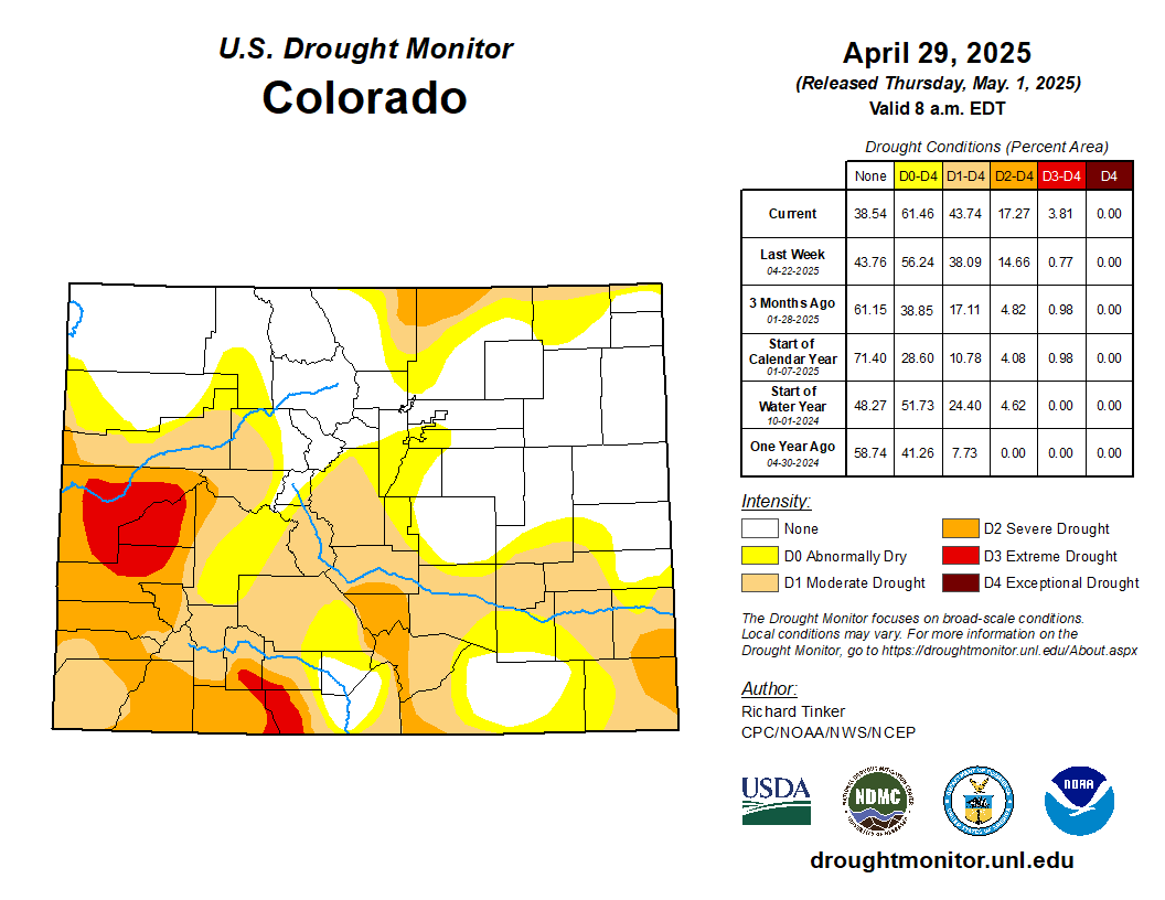
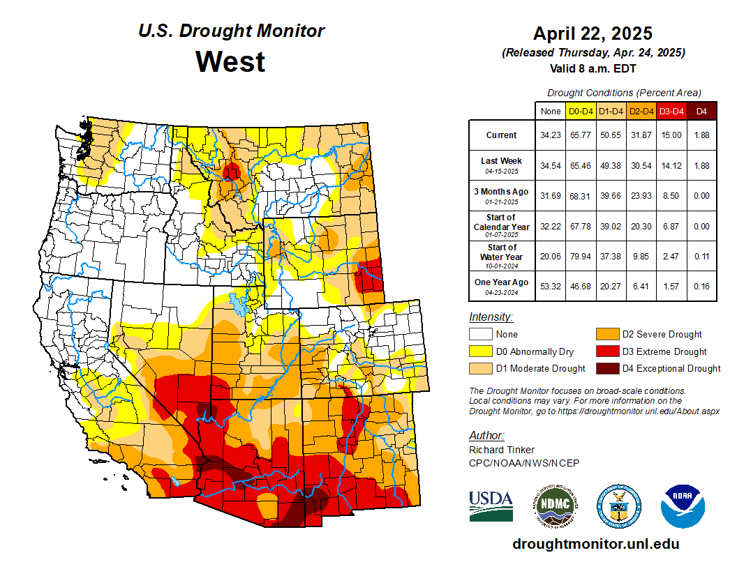
West Drought Monitor map April 29, 2025.
At least part of this drought is something different, the result of rising temperatures created by accumulating greenhouse gases. The process is called aridification, and scientists since about 2017 have conducted studies that convincingly demonstrate that it is responsible for roughly half of declined flows. Drought may go away, but human-caused aridification will not any time soon.
The Colorado River during the last 25 years has yielded significantly less water than the 20th century average — and even less than delegates from the seven basin states assumed when they drew up the Colorado River Compact in 1922.
The states, divided into the upper and lower basins, have been trying to come to grips with the new realities of the 21st century for most of the century. Results have been uneven.
First California and then Arizona gulped waters from the river with giant diversion projects. Colorado but especially other basin states were slower to put straws into the river and they have also been smaller straws.
Who should cut back given the clear evidence for need? At his farm near Durango, Meyer thinks that Colorado must recognize it needs to cut back somewhat in line with what Arizona and California have agreed to do.
Runoff into Lake Powell during March 2as 61% of average. The reservoir is 31.4% full, far better than in 2022, when capacity dipped to below 23% of capacity. Runoff in the last couple of years has been at least okay. This year’s runoff will be a stern reminder that new agreements must be hammered out.
On April 25, water journalist and author John Fleck and four collaborators – including Anne Castle and Eric Kuhn of Colorado – issued a short paper that outlined what they said are the seven essential pillars for post-2026 management of the Colorado River. The first calls for enforceable reductions in water use in both the Upper and Lower Basin.
The compact assumed far more water than occurred in the 20th century, but that faulty assumption was tolerable until the 1990s, when the Central Arizona Project withdrawals began. Then came the drought and aridification of the 21st century. The river that delivered 14.5 million acre-feet (unlike the 20 million acre-feet that was assumed) was in trouble.
Colorado, to a small extent, but Wyoming and Utah especially, had not been using the amount of water that was assumed by the compacts. California and Arizona had been – and then some.
In recent years, California and Arizona have cut back their use of the Colorado River dramatically. The argument made by Castle and Kuhn as well as the others is that there must be shared pain in reduced wager use. That runs counter to the official stance of Colorado and other basin states that it’s a lower-basin problem.
“Shared pain is also critical to inducing the various states not to litigate over the interpretation of the 1922 Compact,” they wrote. “Shared does not mean equal, either in amount, triggers or duration,” they added.
They also say that reductions in water use cannot be predicated on federal compensation, as was important in enabling Arizona and California to reduce their flows during the last few years.
Kuhn was the long-time general manager of the Colorado River Water Conservation District in Glenwood Springs, and Castle, an attorney who specialized in water, was undersecretary for Water and Science in the Interior Department during the Obama administration. She is now with the Getches-Wilkinson Center at the University of Colorado Law School.
Udall/Overpeck 4-panel Figure Colorado River temperature/precipitation/natural flows with trend. Lake Mead and Lake Powell storage. Updated through Water Year 2024. Credit: Brad Udall
From email from the Upper Gunnison River Water Conservancy District (Sue Uerling):
Please see the attached notice for the May Upper Gunnison River Water Conservancy District and Lake San Cristobal Water Activity Enterprise Meetings in Lake City, Colorado on Tuesday, May 20th, 2025 with lunch beginning at noon. If you would like to join the meeting via Zoom, please use the following link to pre-register for the meeting:
Aerial images of the Gunnison Basin revealed that much of the rolling lowlands had already melted out by the end of March. With warmer-than-usual temperatures lingering most of April, the high country is also on track for a speedy melt, triggering the potential for a short water supply this summer. Snowfall was sporadic across much of the valley and Colorado this winter.
Westwide SNOTEL basin-filled map May 4, 2025 via the NRCS.
According to the Natural Resources Conservation Service, on April 30 snowpack statewide is 57% of normal, with the southwestern portion of the state faring far worse than its northern neighbors. These are the lowest snowpack levels for this time of year since the 2014-15 water year. Marked on the map in hues of red and orange — signaling a drought is in place — the snowpack this week in the Gunnison Basin sat at 47% of normal, the Upper Rio Grande at 23% and the San Miguel-Dolores-Animas-San Juan at 28%. There is little moisture in the current forecast, and the NOAA Climate Prediction Center outlook continues to show a warm and dry spring.. Winter 2024-25 started off with momentum with a huge early-season storm around Thanksgiving. Headed into the spring runoff season, near- to above-normal soil moisture conditions were also present in the Gunnison Basin, Cody Moser said during a water supply update on April 24. Moser is a senior hydrologist with the Colorado Basin River Forecast Center. Positive soil moisture conditions impact the water supply outlook as these areas can expect increased runoff. But over the last four months, the valley dried out, Moser said. Precipitation levels October through March across the Gunnison Basin were 88% of the 30-year average (this spans from 1991-2020, some of the driest years on record). December was by far the worst, at 48% of average. The arrival of spring brought no relief. The dry trend continued in April and brought record-high temperatures. The heat resulted in an early melt, draining some of the high-altitude areas that usually hang onto snow much later in the season.
According to the 10-day forecast the melt is expected to pick up this week. Water supply projections across the Gunnison River Basin are below normal, ranging from between 50-80% of average. At Blue Mesa Reservoir, projections show an inflow of just under 500,000 acre-feet of water as the snow melts. This runoff year falls into the “moderately dry” category, similar to 2020 and 2022. Blue Mesa is currently 61% full, and is expected to fill to 80%.
Overview maps of the Upper Colorado Basin (UCRB), outlined in black. (a) The major UCRB waterways overlaid on satellite imagery from April 2022 visualizing typical extent of springtime snow cover. Over the MODIS record, (b) annual snow covered days visualizing extent and duration of snow cover, (c) spring RFdust, and (d) persistence of RFdust (% of time above 50 Wm−2).
Click the link to read the letter on the AGU website (Patrick Naple, S. McKenzie Skiles, Otto I. Lang, Karl Rittger, Sebastien J. P. Lenard, Annie Burgess, Thomas H. Painter). Here’s an excerpt:
Abstract
In the mountainous headwaters of the Colorado River episodic dust deposition from adjacent arid and disturbed landscapes darkens snow and accelerates snowmelt, impacting basin hydrology. Patterns and impacts across the heterogenous landscape cannot be inferred from current in situ observations. To fill this gap daily remotely sensed retrievals of radiative forcing and contribution to melt were analyzed over the MODIS period of record (2001–2023) to quantify spatiotemporal impacts of snow darkening. Each season radiative forcing magnitudes were lowest in early spring and intensified as snowmelt progressed, with interannual variability in timing and magnitude of peak impact. Over the full record, radiative forcing was elevated in the first decade relative to the last decade. Snowmelt was accelerated in all years and impacts were most intense in the central to southern headwaters. The spatiotemporal patterns motivate further study to understand controls on variability and related perturbations to snow water resources.
Key Points
Spatiotemporal patterns in dust on snow radiative forcing and melt contribution assessed over the MODIS period of record
Dust darkens snow every year and impacts were generally higher in the first half of the record
The dust on snow radiative impacts accelerate snowmelt every spring with relevant melt contribution even in lower magnitude years
Plain Language Summary
Seasonal melt from mountain snowpacks dominates water resource availability in the Upper Colorado River Basin (UCRB). The mountainous Colorado River headwaters are adjacent to arid regions that regularly emit dust that darkens the snow. Darker snow melts earlier and faster due to the snowpack absorbing more of the sun’s energy. This study uses 23 years of daily remotely sensed images to observe patterns in dust on snow impacts during the melt season across the UCRB. Results showed that impacts were greatest in the central-southern Rocky Mountains at mid-alpine elevations. Over time, snow darkening and accelerated melt were generally higher in the first half of the record with a slight declining trend across the full record. However, dust contributed to accelerating melt every spring over the record. Results suggest the need for further study to understand what controls dust on snow variability and magnitude of impact from year to year.
Dusk falls on Lake Powell near Bullfrog Marina on July 15, 2024. A new letter from water policy experts gives negotiators some recommendations on how to sustainably manage the Colorado River in the future. Alex Hager/KUNC
Click the link to read the article on the KUNC website (Alex Hager):
May 3, 2025
This story is part of ongoing coverage of the Colorado River, produced by KUNC in Colorado and supported by the Walton Family Foundation. KUNC is solely responsible for its editorial coverage.
The seven states that use the Colorado River are deadlocked about how to share it in the future. The current rules for dividing its shrinking supplies expire in 2026. State leaders are under pressure to propose a new sharing agreement urgently, so they can finish environmental paperwork before that deadline.
Right now, they don’t appear close to an agreement, so a group of prominent Colorado River experts co-signed a letter outlining seven things they want to see in the next set of rules.
The letter gives a clear, concise list of recommendations for ways to keep taps flowing while protecting tribes and the environment. Whether the states will listen is another matter entirely.
‘Shared pain’
The letter, written by a group of academics and retired policymakers, makes no bones about it: states need to find a collective solution to their collective problem. And some of them might not be happy.
State leaders have been reluctant to volunteer cutbacks, and have largely stayed divided along a decades-old fault line. On one side, the Upper Basin – which consists of Colorado, Utah, Wyoming and New Mexico. The other side, the Lower Basin, is made up of California, Arizona and Nevada.
The recent letter is interesting in part because it’s co-authored by people from both sides of the Colorado River debate. Eric Kuhn led an agency that defends Western Colorado’s water. Kathryn Sorensen led Phoenix’s water department.
The letter was also written by Anne Castle, who has worked in federal water policy positions, and Jack Schmidt, a water researcher at Utah State University. Co-authors John Fleck and Katherine Tara research water policy at the University of New Mexico.
The authors write that states need to engage in some level of “shared pain,” meaning cutbacks to the amount of water that flows to farms, homes, and businesses.
“‘Shared’,” the letter writes, “Does not mean equal, either in amount, triggers, or duration.”
Water from the Colorado River flows through the East Highline Canal on its way to farms in the Imperial Valley on June 20, 2023. The Colorado River’s single largest user has taken federal money through incentive programs to cut back on water use. Alex Hager/KUNC
The Lower Basin states have already proposed relatively modest cutbacks, and the Upper Basin seems to be digging in its heels on the idea that they should not have to give up any water at all.
This letter pushes back on that stance.
“There’s lots of wonderful legal arguments about why it shouldn’t be me that needs to use less water,” Anne Castle, one of the letter’s authors, told KUNC. “But in order to have a viable and politically viable agreement, everybody has to do a share.”
Other recommendations
In addition to calling for states to put their heads together, the authors also warned against leaning too hard on federal checks as a way to conserve water. Money from the federal government has been a key part of avoiding catastrophe on the Colorado River in recent years. Hundreds of millions of dollars have gone to big water users, often farmers, as an incentive to use less water.
Those funds have come under threat during President Donald Trump’s second term. The letter says new rules for the Colorado River “cannot assume that federal taxpayers will reimburse Western water users over the long term to forgo the use of water that does not exist.”
The letter goes on to advocate for groups that can sometimes be an afterthought in Western water policy. It essentially re-ups an earlier call from a group of tribes in the Colorado River basin, which are asking for a bigger seat at the table after more than a century of exclusion. It also pushes for new rules to be more flexible, which would make it easier to protect river ecosystems. That mirrors similar comments from a group of nonprofits.
The shortest and final recommendation in the letter says that any new Colorado River rules have to make sure there’s enough water to keep people safe and healthy.
“There must be absolute protection of domestic water deliveries for public health and safety,” it reads.
In short, it’s asking to make sure that a worst-case-scenario doesn’t see drinking water reserves go dry, while agriculture and other industries keep their faucets flowing.
“I don’t think that would happen,” Castle said. “I think the market would intervene and take care of this situation.”
The reaction
KUNC reached out to top water negotiators in Arizona and Colorado for this story. Their answers fell in line with oft-repeated talking points from each basin.
A spokesman for the Arizona Department of Water Resources wrote that its director, Tom Buschatzke, “agreed with the authors that ‘every state and sector of the economy must contribute to the solution to this imbalance.’”
Water policymakers from (left to right) Utah, New Mexico, Colorado and Wyoming speak on a panel at the Colorado River Water Users Association conference in Las Vegas on December 5, 2024. The Upper Basin states have been reluctant to volunteer cutbacks ahead of the next set of river-sharing rules. Alex Hager/KUNC
Colorado’s top water official, Becky Mitchell, wrote that the recommendations overlooked climate change’s impact on Upper Basin water supplies, and that states already take “mandatory and uncompensated” cuts.
“Colorado water users do not enjoy a guaranteed delivery of the full amount of their water rights each year,” she wrote.
Jennifer Gimbel, Colorado’s former top water official, did not contribute to the letter and also took issue with the suggestion that both basins could afford to make cutbacks.
“Are the authors of the paper thinking that federal law should be enacted to override state law?” Gimbel wrote to KUNC in an email. “Are they thinking that users in the Upper Basin, who they say should not rely on federal compensation, should just give up their livelihoods voluntarily or be compensated by the state legislatures? I don’t know because they don’t say.”
Udall/Overpeck 4-panel Figure Colorado River temperature/precipitation/natural flows with trend. Lake Mead and Lake Powell storage. Updated through Water Year 2024. Credit: Brad Udall
Click the link to read the article on the InkStain website (John Fleck):
April 25, 2025
A group* of my Colorado River collaborators has put together what we hope can be a useful set of foundational principles as the basin states and federal leadership search for a path toward a negotiated agreement for post-2026 Colorado River management. They’re based on a number of key premises:
The Colorado River Compact will remain the foundation of the river’s management, but we have to find a way past the deep disagreement between Upper and Lower basin states on what the Compact actually says.
Colorado River Basin tribes must be essential partners in crafting the next set of guidelines, including through compensation for foregone water use.
Shared pain is essential. The path toward a sustainable river system requires everyone to contribute to the solution to the problem of the river we all share.
The “Bonita Peak Mining District” superfund site. Map via the Environmental Protection Agency
Click the link to read the article on The Durango Herald website (Reuben M. Schafir) Here’s an excerpt:
April 29, 2025
The Bureau of Land Management is restoring up to 11 cubic feet per second of water previously diverted to the Uncompahgre River Basin back to the headwaters of the Animas River north of Silverton. That’s a win for fish, other aquatic wildlife and mining remediation, said Trout Unlimited’s Mining Coordinator Ty Churchwell, because the water will dilute heavy metals to less toxic concentrations. Both the national organization of Trout Unlimited and the local Five Rivers chapter provided financial assistance with the acquisition. The 11-cubic-foot diversion is about 10% of the river’s total current flows in Silverton before the confluence with Cement Creek…
The previous owner held the rights to divert the water through the Mineral Point Ditch – before it entered Burrows Creek – over into the Uncompahgre Basin for agricultural use. This resulted in a 100% depletion of that water from the Animas River…The BLM paid $297,000 – fair market value – to buy the water right from a willing seller, agency spokeswoman Katie Palubicki said in an email to The Durango Herald, using funding from the Land and Water Conservation Fund and the agency’s Abandoned Mine Lands program to acquire the right.
Click the link to read the article on the KVNF website (Brody Wilson):
April 29, 2025
The Colorado River is the lifeblood of the American Southwest. Forty million people depend on it — not just here in Colorado, but in cities like Phoenix, Las Vegas, and Los Angeles.
Here on the Western Slope, we don’t always feel directly connected to the Colorado River. After all, we live in the Gunnison Basin — a different watershed, right?
Not quite. The Gunnison River contributes about 17% of the Colorado River’s total annual flow. So any decision made about the Colorado River’s future directly affects us — how much water we can use, when, and for what purpose. For decades, the river has been in a slow-moving crisis. Climate change, explosive population growth, and overallocation have pushed the system to the brink. In 2022, the river’s two main reservoirs — Lake Powell and Lake Mead — reached such low levels that hydropower turbines at Glen Canyon Dam were nearly shut down and dam operators were near “dead-pool” where water would no longer be able to pass through the dam. But today, nearly three years later, the system isn’t bouncing back. Andy Mueller, General Manager of the Colorado River District, has a blunt message: the Colorado River is carrying less water than it used to, and if we don’t change course, the future of agriculture, recreation, and the our way of life across the Western Slope could be at risk.
“The average temperature in March has gone up 4.2 degrees Fahrenheit,” Mueller told the crowd in Ridgway. “And for every 1 degree of warming, streamflow drops by 3 to 5 percent. We’re looking at a 20% decline right here in the Uncompahgre Valley over the last 125 years.”
These trends are part of a long-term warming and drying pattern. Less snow is falling, and what does fall melts earlier. That means less water reaches our rivers — and more of it is lost to evaporation or absorbed by plants growing in longer, hotter seasons.
In 1922, Federal and State representatives met for the Colorado River Compact Commission in Santa Fe, New Mexico. Among the attendees were Arthur P. Davis, Director of Reclamation Service, and Herbert Hoover, who at the time, was the Secretary of Commerce. Photo taken November 24, 1922. USBR photo.
To understand what’s happening now, you have to go back to 1922. That’s when the seven states in the Colorado River Basin signed a compact to divide the river’s water. Colorado, New Mexico, Utah, and Wyoming became the “Upper Basin.” California, Arizona, and Nevada formed the “Lower Basin.” Each side was promised 7.5 million acre-feet of water per year. But there was a problem: the river wasn’t carrying that much water — and certainly doesn’t now. For decades, this over-allocation was masked by big reservoirs like Lake Powell and Lake Mead. But as the drought continues, those buffers have disappeared. In 2007, the states and federal government adopted a temporary fix: interim guidelines to manage the system during dry years. Those guidelines are set to expire in 2026. New rules must be negotiated now — and the clock is ticking.
“There’s a lot of confusion out there,” Mueller said. “People talk about renegotiating the Compact — but that’s not what’s happening. The Compact isn’t being touched. What’s being negotiated are the guidelines for how Powell and Mead are operated — especially in times of shortage.”
Click the link to read the paper on the InkStain.net website (Kathryn Sorensen, Sarah Porter, Eric Kuhn, and Cynthia Campbell). Here’s an excerpt:
April 18, 2025
Conserving water now in reservoir savings banks, as a hedge against future risks associated with drought and declining flows, has emerged as one of the central tools for managing the Colorado River. The Lower Basin “Intentionally Created Surplus” program, created in the 2007 Interim Guidelines, has shown the idea’s promise and given the basin nearly two decades to learn the strengths and weaknesses of the approach. With tweaks to allow similar efforts in the Upper Basin and other modifications based on what we have learned about the current ICS approach, such “Floating Pools” are one of the key tools being considered as negotiators try to thread the needle of a seven-state agreement for post-2026 Colorado River management. Done properly, they have the potential to finesse the states’ disagreement over the terms of the 1922 Colorado River Compact in a way that could avoid potentially disruptive litigation. But getting the details right will be crucial to the development of an enduring bargain that can help the basin avoid the risk of interstate litigation.
Context
Negotiations over post-2026 operating rules for Lakes Powell and Mead are a proxy battle over whether the 1922 Compact acts as a limitation on yet-to-be used water in the Upper Division States or as a cut to existing water uses in the Lower Division States. Much of the conflict focuses on Article III(d) of the Colorado Compact, which states, “The states of the Upper Division will not cause the flow of the river at Lee Ferry to be depleted below an aggregate of 75,000,000 acre-feet for any period of ten consecutive years. . .”
The Upper Division States have a fundamentally different interpretation of their Compact obligations at Lee Ferry than the Lower Division States. Clearly, the best-case scenario for the Lower Division States, especially in Central Arizona, is a court decision that confirms the Upper Division States have a compact obligation to not deplete the flow of the river below 75 million acre-feet every ten years plus ½ of the annual delivery to Mexico under the 1944 Treaty, approximately 82 million acre-feet every ten years. This outcome would mostly stabilize the water supply available to the Lower Division States and likely limit consumptive uses in the Upper Division States to about the same or a little less water than they are currently using, approximately 4 million acre-feet per year. If the high court rules instead that the Upper Division States have a non-depletion obligation, and that consumptive uses in the Upper Division States are not the “cause” of inadequate flows needed to deliver 8.23 million acre-feet to the Lower Division States and Mexico, the result in a declining river system is a cut, potentially even to zero, for water delivered via the Central Arizona Project (CAP) into the Sun Corridor from Phoenix to Tucson and potential cuts to water-right holders in Western Arizona, Southern California and Nevada who are next on the chopping block.
Distilled to its core, here is the question before us: in a declining river system and in the absence of an agreement among the Divisions, does the operation of Article III(d) of the Compact result in a limitation on future new uses in the Upper Division States or an elimination to existing ones in the Lower Division States?
Map of the Colorado River drainage basin, created using USGS data. By Shannon1 Creative Commons Attribution-Share Alike 4.0
Udall/Overpeck 4-panel Figure Colorado River temperature/precipitation/natural flows with trend. Lake Mead and Lake Powell storage. Updated through Water Year 2024. Credit: Brad Udall
It’s easy to take for granted the accounting innovations in the Colorado River governance regime’s 2007 guidelines, which have governed river management and the upstream-downstream relationships between the upper and lower basins. “Intentionally Created Surplus” (ICS) is now part of the lexicon, and the idea behind it shows enough promise that it’s at the heart of the current negotiations over the post-’07 guidelines management of the river.
But we need to be careful about the lessons that we learn, and the details of how we implement the successor to ICS. How should the successor to ICS related to action levels for reservoir management? How do we ensure that water in ICS-like accounting pools is really conserved water, part of a sincere effort to reduce basin consumptive use?
Those questions are at the heart of the argument in Floating Pools & Grand Bargains, a new white paper by Kathryn Sorensen from Arizona State University and a group of colleagues, including Eric Kuhn:
As Save the Colorado and Denver Water prepare to face off in a federal courtroom Tuesday, water officials across the state are watching the Gross Dam expansion case closely for its environmental impact and its affect on water projects across the West.
Kirk Klancke, a long-time Grand County environmentalist and president of the Colorado River Headwaters Chapter of Trout Unlimited, said a decision that shuts down the $531 million water project, could also shut down 12 years of work on the Fraser River and its tributaries.
Denver Water is one of 18 partners who signed the Colorado River Cooperative Agreement in 2013, ushering in a new era of cooperation between the utility and West Slope stakeholders, all with the vested interest in protecting watersheds in the Colorado River Basin. As part of that agreement, a process called “Learning by Doing” was created, which has helped the utility stay better connected on river conditions in Grand County. The partnership is a collection of East and West Slope water stakeholders who help identify and find solutions to water issues in Grand County. “Denver Water has been part of Grand County for over 100 years, and we understand the impact our diversions have on the rivers and streams,” said Rachel Badger, environmental planning manager at Denver Water. “Our goal is to manage our water resources as efficiently as possible and be good stewards of the water — and Learning By Doing helps us do that.”
Here’s why: Denver Water owns much of the Fraser with water rights dating back more than 100 years. And it is that water that has historically been piped through the Moffat Tunnel near Rollinsville to fill the existing Gross Reservoir. The new water for the expanded reservoir will come largely from that river as well.
After what’s known as the 2013 Colorado River Cooperative Agreement was signed, Denver Water agreed to conduct extensive restoration work on the river in exchange for being able to raise Gross Dam and bring more water from the Fraser River over to the Front Range.
Klancke said the heavily diverted, scenic waterway would suffer if the deal falls apart. “To dissolve that partnership will be the death of the Fraser River,” he said.
Under the terms of the Colorado River Cooperative Agreement, the work on the Fraser River can only be finalized if the Gross Dam expansion proceeds.
On the upside though, Klancke said, if a new environmental settlement were reached, it could mean more money and more work to restore South Boulder Creek on the other side of the Continental Divide. The creek carries that Fraser River water from the reservoir to Denver Water’s northern storage system.
“I would love to see Denver put a whole bunch of money into South Boulder Creek,” Klancke said.
Gary Wockner, the head of Save The Colorado, disputes the notion that the case could harm environmental work already underway in Grand County.
“We are not causing environmental damage,” he said. “If Denver Water chooses to stop, that’s their choice. That’s on their shoulders. Not ours.”
For its part, Denver says it hopes to continue the Grand County work, but that the terms of the Fraser River agreement are all based on the successful completion of the Gross Dam expansion.
The agency also says it has already set aside $30 million to help offset any environmental harm caused by the massive construction project, including providing 5,000 acre-feet of water to improve streamflows along a 17-mile stretch of South Boulder Creek. An acre-foot of water equals nearly 326,000 gallons, enough water to serve two to four urban households for one year.
Roller-compacted concrete will be placed on top of the existing dam to raise it to a new height of 471 feet. A total of 118 new steps will make up the new dam. Image credit: Denver Water.
Denver Water first moved to raise Gross Dam more than 20 years ago when it began designing the expansion and seeking the necessary federal and state permits.
After years of engineering, studies and federal and state analyses, construction began in 2022. It has involved taking apart a portion of the original dam, built in the 1950s, and raising its height by 131 feet to nearly triple the reservoir’s storage capacity to 119,000 acre-feet from 42,000 acre-feet.
Save The Colorado has launched several unsuccessful challenges to the project, but in 2022 it won an appeal that put the legal battle back in play. Despite months of settlement talks, no agreement was reached.
Then the case took center stage again April 3, when Senior U.S. District Court Judge Christine Arguello put a temporary halt to construction of the higher dam, at Save The Colorado’s request.
Almost immediately, Denver Water filed for temporary relief from the order, saying, in part, that it would be unsafe to stop work as the incomplete concrete walls towered above Gross Reservoir.
Arguello granted that request, too, allowing Denver to continue working on the dam.
Gross Dam case spurred $100 million settlement in a different lawsuit
What happens next is anyone’s guess. Jennifer Gimbel, a water policy scholar at Colorado State University who also serves on Northern Water’s board of directors, said the case has already had an impact on a $2 billion water project to deliver water to residents of fast-growing northern Colorado. The Northern Integrated Supply Project, as it is known, also faced a legal challenge from Save The Colorado, and ultimately the water agency opted to settle the case for $100 million. The cash will help restore the Cache la Poudre River with new diversion agreements and improved streamflows, among other benefits.
Gimbel said the Gross Reservoir case was a key factor in that settlement. “Because of Denver’s troubles with Save the Colorado, Northern Water decided to resolve their lawsuit because they were worried about their own permit getting stale and because as you delay construction costs increase.”
The Gross Dam case is also noteworthy because it has stopped a major construction project already underway and may significantly change it. Judge Arguello has ordered the U.S. Corps of Engineers, the major permitting agency, to redo its original permitting work.
Denver Water General Manager Alan Salazar has said his agency would take the case to the U.S. Supreme Court, if they lose in the lower courts.
As both sides prepare for Tuesday’s hearing, the 10th Circuit Court of Appeals panel has said it will wait to see what information emerges from the Tuesday hearing before it rules on Denver Water’s appeal before the 10th Circuit, according to Denver Water General Counsel Jessica Brody. That action seeks to permanently protect what Denver believes is its right to raise Gross Dam.
Denver Water has also raised national security concerns in the case because Save The Colorado has asked and been granted the right to review construction documents on the dam project, documents that would normally be kept from public view.
In response, the judge has told participants to expect the court to be closed periodically during the hearing to address those security concerns.
The town of De Beque is seeking Congressionally directed spending to help it secure a secondary water source, as it currently relies solely on the Colorado River to supply water to the community. De Beque Town Treasurer Katherine Boozell said the town is looking at drilling a well near the town’s Water Treatment Plant. According to Boozell, the well could cost in excess of $400,000 to drill.
“At present, the Town of De Beque relies solely on the Colorado River as its drinking water source,” Boozell wrote in an email. “This dependence leaves the community vulnerable during periods of high turbidity, which occur frequently due to mudslides from wildfire burn scars upstream or sediment disruption caused by storms. When turbidity levels spike, we are forced to shut down intake to our treatment plant because the water is too muddy to process.”
The town does have a tank where it can store treated water, but that is a temporary solution, she said. When the tank is dry, the town is unable to provide treated water until the river’s water conditions improve. This poses a public health risk, she said, making a secondary water source an urgent need…According to a fact sheet about the proposal, a new well would not only improve reliance for the town’s water but also improve the water quality as well.
The Shoshone hydro plant in Glenwood Canyon, captured here in June 2018, uses water diverted from the Colorado River to make power, and it controls a key water right on the Western Slope. Photo credit: Brent Gardner-Smith/Aspen Journalism
James Heath, division engineer for the Colorado River Basin for the Colorado Division of Water Resources, says [Avi] Stopper most likely witnessed a roughly two-mile stretch where up to 1,400 cubic feet per second of water takes the scenic route through Xcel Energy’s Shoshone Hydro Electric Generating Plant. If that diversion is happening during high-water months like May, passersby would probably miss it entirely. But in the dead of winter, when river flows can be below 1,000 CFS, the difference can be seen by drivers heading east.
“At certain times of the year, the power plant can divert every single drop of water that’s in the Colorado River and other times a year the stream flow is significant and it’s hardly noticeable what the power plant’s actually diverting off the stream system,” Heath said.
The water rights are considered “nonconsumptive,” which means there’s no water lost in the process. That’s also why the river disappeared and reappeared a short time later on Avi’s drive. Water leaves the river at a diversion dam near the Hanging Lake Tunnel and then reenters the river at the Shoshone plant. Heath said it’s about a 2-mile stretch and there’s little entering the stream during that period.
“There’s a little bit of gate leakage there at the diversion dam. There are a couple small minor tributaries that come in between the diversion dam and the returns from the powerhouse, but it’s a small trickle at times during the year,” Heath said.
View of Shoshone Hydroelectric Plant construction in Glenwood Canyon (Garfield County) Colorado; shows the Colorado River, the dam, sheds, a footbridge, and the workmen’s camp. Creator: McClure, Louis Charles, 1867-1957. Credit: Denver Public Library Digital Collections
The town of New Castle has agreed to contribute $100,000 to the Western Slope’s efforts to buy the historic Shoshone hydroelectric power plant water rights, while the towns of Parachute and De Beque also have agreed to kick in smaller amounts…Parachute will be contributing $25,000 and De Beque, $5,000. The De Beque Plateau Valley Soil Conservation District also is kicking in $5,000…Combined, more than 30 Western Slope local governments, water entities and regional partners have committed over $17 million toward the $99 million purchase. The river district and state of Colorado also have committed $20 million apiece, and the federal Bureau of Reclamation committed $40 million in the final days of the Biden administration. That funding has been frozen by the Trump administration but the river district remains hopeful of eventually receiving it.
The fickle “children of the Pacific Ocean,” El Niño and La Niña, have again dealt the Gunnison River Basin a bad hand. A weak La Niña winter sent the storm-bearing jet streams over the northwestern United States and southern Canada, leaving the Southwest, and southern half of Colorado, relatively dry for 2025, according to Bob Hurford, Colorado’s Division 4 (Gunnison Basin) Engineer. Hurford visited Gunnison on April 17 for an annual “State of the River” program, along with Andy Mueller, general manager of the Colorado River Water Conservation District, known as the “River District,” the program’s sponsor. Sonja Chavez, manager of the Upper Gunnison River Water Conservancy District, and Jesse Kruthaupt, Gunnison agent for Trout Unlimited’s Colorado Restoration Program spoke on the state of the Upper Gunnison River.
Hurford led with a discussion of what is unfolding locally in water year 2025 (Oct. 1, 2024 through Sept. 30, 2025). The Upper Gunnison Basin’s April 1 snowpack (usually at or near the maximum depth for the winter) contains only 59% of the 30-year average water content. It is projected at this point to yield through July about 540,000 acre-feet of runoff or less for the river — probably not enough to fill Blue Mesa Reservoir after downstream water rights are filled. An acre-foot of water is the amount it would take to cover the playing area of a football field to the depth of one foot. As the changing climate warms the planet, March is becoming the “new April.” This year’s snowpack peaked in mid-March. With the big melt usually beginning sooner nowadays, spring-like weather is causing trees and other plants to also begin “drinking” sooner…Increasing evaporation and plant transpiration also come with the changing climate. According to Mueller, for every additional degree Fahrenheit in the ambient temperatures, another 3-5% of water on the surface and in plants disappears as water vapor. These are changes to be anticipated for as long as we continue to warm the planet’s climate. Hurford concluded his presentation with a chart indicating that the decade beginning with 2020 is on track at this point to be the driest decade on record, including the droughts of the 1930s and 2000s.
For the past three months and change, the Trump administration, in a series of executive orders, has been working to dismantle the administrative state, or the framework of agencies, rules, and regulations designed to protect the nation and its citizens. For the most part, however, the Interior Department — the sprawling agency that oversees much of the nation’s public lands — has been relatively (and suspiciously) quiet, refraining from big actions beyond merely repeating some of Trump’s orders.
That has rapidly changed in recent days as Interior Secretary Doug Burgum — or perhaps Tyler Hassan, the DOGE minion Elon Musk appointed to reorganize Interior — set off a figurative bomb that could demolish protections for public lands.
The most alarming move, so far, is the department’s implementation of “emergency permitting procedures” for oil and gas, uranium, coal, biofuels, and critical mineral projects on federal lands. Under this order, the department will compress the entire environmental review for these projects down to 28 days or less — even for a full environmental impact statement.
“By reducing a multi-year permitting process down to just 28 days,” Burgum said in a press release, “the Department will lead with urgency, resolve, and a clear focus on strengthening the nation’s energy independence.”
If you’ve ever skimmed through an EIS, you know how insane this concept is.
The Bureau of Land Management will be packing the entire process mandated by the National Environmental Policy Act, Endangered Species Act, National Historic Preservation Act, and other rules and regulations into an impossibly short timeframe.
By impossibly short, I mean that it is virtually impossible to comply with these laws and requirements — which include tribal consultation, archaeological surveys and mitigation, environmental and endangered species reviews, socioeconomic impact analyses, and public comment periods — in four weeks or less. So by radically compressing the timeline, Burgum is essentially telling his staff to skirt the requirements, i.e. violate the law.
Burgum uses President Trump’s claim that the U.S. is experiencing an “energy emergency,” to justify the destructive rubber-stamping, and says fast-tracking project approvals is necessary to address that emergency.
I’ve said it many times, but I will say it again: There is no energy emergency. The U.S. is pumping more crude oil than ever before from the Permian Basin and other fields, it is the largest petroleum producer in the world, it is a net exporter of petroleum products, and liquefied natural gas exports are at an all-time high. The U.S. market is glutted with natural gas and the coal supply has been outpacing demand for nearly two decades. Lithium — for electric vehicle batteries and grid-scale energy storage — is so plentiful that prices have plummeted nearly 90% since 2022. Uranium shortage? Nope.
One could certainly argue that the power grid in the West is outdated, its operation balkanized, and that it is not up to the challenges posed by growing data center electricity demand. But aside from geothermal and hydropower (solar, wind, and transmission projects are not included), none of the categories of projects on the fast-track list would do anything to fix the grid. Even if they were, it would not justify truncating environmental reviews so severely — or at all.
Environmental reviews can take a maddeningly long time, especially for big projects. But the way to speed things up is not to throw the laws and protections in the the trash bin. That will only lead to lawsuits, which likely will delay the projects even more. The only way to truly streamline permitting, while still safeguarding human health and the environment, is to beef up staffing, resources, and expertise. And that’s exactly the opposite of what Trump and Musk and Burgum are doing.
Pages from the Interior Department’s 2026-2030 Strategic Plan Draft Framework acquired and published by Public Domain. Note that one objective is to “release federal holdings” for housing. And that in the top one they want to “reduce the costs for grazing” on public land (can it go any lower?), while in the bottom one they want to “increase revenues from grazing … .” Uh … okay?
But wait. It gets worse.
We might take some comfort in the fact that national monuments are off-limits to the extractive industries and Trump’s energy dominance agenda, right? Maybe not for long.
Earlier this week, the folks at Public Domain acquired a copy of the Interior Department’s 2026-2030 Strategic Plan Draft Framework. The plan aims to, among other things: “restore American prosperity,” “assess and right-size monuments,” and “return heritage lands and sites to the states.”
The Washington Post, however, is reporting that Burgum is not necessarily waiting until next year to “right-size,” or shrink, national monuments. From the Post:
If they go through with the shrinkage of any or all of these national monuments, it would open up additional lands to oil and gas leasing and new mining claims, which would then be subject to the fast-tracked permitting.
Baaj Nwaavjo I’tah Kukveni-Ancestral Footprints of the Grand Canyon is especially rich in high-grade uranium deposits, and the White Canyon area in Bears Ears might also be targeted for uranium if the monument were shrunk. Grand Staircase-Escalante includes a large coal deposit on the Kaipairowitz Plateau, but it’s exceedingly unlikely that anyone would be interested in mining it given the faulty economics of coal.
One thing you can be sure of is that none of this will go unchallenged. The tribal nations that proposed the designation of Bears Ears and other national monuments will sue to keep them intact, and advocacy groups and land and water protectors will support them and take the administration to court over its flouting of environmental laws.
A look across Glen Canyon National Recreation Area and into Bears Ears National Monument from the Little Rockies. Jonathan P. Thompson photo.
🌵 Public Lands 🌲
For many people, the mention of Glen Canyon National Recreation Area evokes images of Lake Powell and all that entails: boats plying the blue-sky-reflecting waters and the sandstone cliffs and formations that rise up from the murky depths. That makes sense, given that the national park unit was established because the reservoir was there in 1972.
Yet the reservoir makes up just 13% of the 1.25 million-acre recreation area. The remaining 87% contains some of the more remote and spectacular country in the lower 48, shares borders with a half-dozen other national parks and monuments, and makes up the core of the Moab to Mojave Conservation Corridor.
So, the manner in which the area is managed matters — a lot. And for five decades after the recreation area’s establishment, off-road vehicle travel went virtually unmanaged, allowing for a destructive free-for-all along shorelines and in remote parts of the recreation area. In 2018, the Park Service released a plan that more or less codified the pre-plan anarchy. Environmentalists sued and forced the Park Service back to the drawing board.
This January the Park Service finally issued an amended rule celebrated by conservationists for adding protections to some of GCNRA’s more sensitive areas from motorized vehicle travel (this does not affect boating, by the way). It bars OHV-riding yahoos from roaring around the lake’s shore unheeded, and restricts motorized travel in the Orange Cliffs area on the north end of the recreation area adjacent to the Maze in Canyonlands.
The off-road vehicle lobby, however, was unhappy with the added restrictions, and they took their victim-complex grievances to the Utah congressional delegation, all of whom appear to have a fetish for fossil-fueled combustion-engines. Now the plan and the recreation area are being put in jeopardy by — you guessed it — those same Utah politicians. Sens. John Curtis and Mike Lee, along with Rep. Celeste Maloy, are asking Congress to revoke the rule under the Congressional Review Act and to prohibit the Park Service from implementing similar protections in the future.
🗺️ Messing with Maps 🧭
The National Parks Conservation Association created a nifty map showing active mining claims and mines near national parks and national monuments. It gives a good sense of how vulnerable some areas might be to new mining claims and projects if the Trump administration goes ahead with shrinking the aforementioned national monuments. You can look at the interactive version here.
One note of caution: An active mining claim ≠ a valid mining claim. An active claim simply means it has been located and filed, and that the claimant has paid their annual maintenance fee. The validity of a claim, on the other hand, depends on the discovery of a valuable mineral deposit there, which must be demonstrated. Rights to mine are only attached to valid claims.
Parting Poem
Here’s another one from Richard Shelton’s Selected Poems, 1969-1981.
The agreements propping up Lake Mead and Lake Powell expire in 2026, and negotiations for new agreements have stalled.
The Trump administration’s lack of clear direction and delay in appointing a Reclamation commissioner are exacerbating the crisis.
Arizona will face significant water cuts, potentially deeper than any previous shortages. It needs time to process them.
Many of us have seen this train wreck coming for years, the slow buildup of chronic overuse, coupled with a river that no longer produces as much water as it used to, that is draining Lake Mead and Lake Powell, the nation’s two largest water savings accounts. And if things don’t change soon, 40 million people who rely on this river are about to suddenly realize that decisionmakers squandered every dollar spent on buying time to fix this fundamental problem…The mismatch between supply and demand began emerging around 2000, and by 2007, the feds had created the first set of shortage guidelines, hoping those mandatory cuts would be enough to stave off crisis. But we now know that they weren’t nearly enough to reduce the drag on the lakes. Deeper cuts were made. Billions of dollars were set aside to pay people to temporarily not use water. And we’ve stabilized Lake Mead and Lake Powell, for now.
But those rules and agreements expire at the end of 2026…The Trump administration hasn’t said anything about those alternatives. And after dropping an executive order to nix a longstanding review process, it’s unclear how the feds will evaluate or collect public input, presuming that said alternatives are still on the table…It’s telling that while state negotiators continue to meet (and make no real progress), no one from the Bureau of Reclamation — the federal agency tasked with operating Lake Mead and Lake Powell — has attended those negotiation sessions since the Trump administration took office. In fact, Reclamation still doesn’t even have a commissioner. The administration has been dragging its feet on getting the leadership in place to finally break this logjam…Now is not the time to be hands-off. The Trump administration must prioritize naming a Reclamation director who can offer firm, clear and fair direction — and who isn’t afraid to bust a few heads if state negotiators refuse to budge.
Colorado River “Beginnings”. Photo: Brent Gardner-Smith/Aspen Journalism
Lake Powell at Wahweap Marina as seen in December 2021. Dwindling streamflows and falling reservoir levels have made it more likely that what some experts call a Colorado River Compact “tripwire” will be hit in 2027. Credit: Heather Sackett/Aspen Journalism
When Colorado convened a working group on water speculation, its members shared stories of times in which they’d seen or thought they might have seen investment water speculation occurring — when water rights are purchased with a primary purpose of profiting from the future sale or lease of that water as demand drives up its price. On the list was the notion that buyers with no real interest in agriculture would buy agricultural land and water rights with the primary intention of enrolling in a program that pays water rights holders not to use that water.
The concern, essentially, was that programs that compensate farmers for fallowing fields like the Upper Colorado River Basin’s System Conservation Pilot Program, and nonprofits that fundraise to keep water in streams weren’t sufficiently guarded against abuse, particularly when it comes to an increasingly constrained Colorado River system.
“The impacts of drought and the risks that drought causes in the Colorado River Basin, just by way of example, attract money to the concept that money can be made from taking water out of production — conservation,” says Peter Fleming, general counsel for the Colorado River District.
“Where do you draw the line in that?” Fleming asks. “Which one is a good, socially recognized benefit that the state as a whole should support versus which one is bad because it encourages speculation in water resources, and it makes things more difficult for others, and it has adverse secondary impacts in the local economies when you take water out of production?”
A few guardrails exist to make real conservation efforts — those that serve the common good — clear. But questions remain on whether those protections can really stop investment water speculation before speculation occurs.
Little Cimarron Ranch, where a first-of-its-kind agreement allows water rights to go to irrigation in the spring and summer, and to instream flows to support river health in the summer and fall. Photo courtesy of Mirr Ranch Group
Streamflows for the Public Good
In 1973, Colorado lawmakers legally recognized instream flows, in which water is allocated to the river to maintain flows and habitat as a “beneficial use” in parallel with industries, cities and agriculture. That 1973 legislation tried to prevent speculators from prospectively appropriating instream flows and locking up the state’s water by taking measures like limiting who can operate instream flows to a single state agency, the Colorado Water Conservation Board.
“There is government oversight for specifically this reason — to prevent speculation,” says Josh Boissevain, staff attorney with the Colorado Water Trust, a nonprofit that works to secure water for streams. “Instream flow is a decreed use, so using that water for instream flow is not speculation at all, even though it’s left in the river.”
When water rights owners work with the water trust to use their water to restore flows, it takes a lot of paperwork and a close look at the web of other users affected. The process can be tedious and time-consuming, and the profits marginal.
“Nobody is doing that for the money,” Boissevain says. “They do it because they care.”
Some loopholes have been closed. For example, a 1994 change to Colorado’s water law prevents conditional water rights holders, who hold onto water rights for unbuilt projects or potential future uses, from transferring those rights to instream flows. That law blocks speculators from selling conditional water rights to the CWCB for a profit.
Shoshone Hydroelectric Plant back in the days before I-70 via Aspen Journalism
Having a perfected water right — one that is fully established and has been put to beneficial use — converted to instream flows is fine, Fleming says. The Colorado River District participates in those programs and is working to buy a water right currently used to generate 15 megawatts at Xcel Energy’s aging Shoshone hydroelectric power plant. The River District aims to convert that hydropower right to an instream flow right to ensure that this water continues to flow from the headwaters down through boating hotspots in Glenwood Canyon, regardless of the 115-year-old power plant’s future.
But Fleming, who worked on a 2021 report that reviewed Colorado’s legal sideboards on speculation, remains concerned that the lines are not clearly enough drawn between those recognizable benefits to the state and local economies, and the place where speculators could start counting on those efforts and “conserving” to make a profit. At a certain scale, the effects of taking water off farm fields could ripple out beyond bare fields to farm supply stores and gas stations, as well as the local job market in rural communities.
Perhaps the most frightening possibility that could result from profiteering is that water rights bought and steered from use in Colorado will somehow be sold to thirsty fields or towns in Arizona or Nevada. But even if both buyer and seller are willing, specific language in interstate compacts and existing law complicates the likelihood of selling water from one state to a buyer in a different state.
Meanwhile, conservation groups are also concerned about speculators cornering them out of the increasingly expensive water rights market, Boissevain says. To adapt to the current water market, the Colorado Water Trust is exploring a new acquisition model with Qualified Ventures, a consulting company based in Washington, D.C. Through this new approach, the water trust would buy land with water rights through financing from lenders. A conservation easement would protect the land as agricultural, and the tax rebate from that status would partially repay the loan. The water trust would reassess how to profitably farm that land while sharing the water rights between agriculture and environmental flows. Then the land could be sold, potentially at a reduced price, perhaps to a first-generation farmer.
“It’s another way to keep ag in production and keep water on the land,” Boissevain says. “It’s another step up in the competition against people that might try and buy [irrigated farms] for speculation or maybe even development.”
Confluence of the Cimmaron and Gunnison rivers. Photo: Brent Gardner-Smith/Aspen Journalism
The results might resemble a project on the Little Cimmaron River near Gunnison, where the Colorado Water Trust purchased 5.8 cubic feet per second of flow in the McKinley Ditch to return water to a river that was nearly dry in late summer months. The water trust partnered with a land trust to buy the water rights and land, put a conservation easement on the land, then sell the land and water rights to a private landowner. In a first-of-its-kind agreement, the water rights can go to irrigation in the spring and summer, and to the CWCB for instream flow in the late summer and fall when the river needs it most. In a very dry year, all of the water can be left in the stream protected, and in a wet year, all of it can be diverted for agriculture.
This map shows the 15-mile reach of the Colorado River near Grand Junction, home to four species of endangered fish. Map credit: CWCB
Environmental groups contend that for the environment to thrive, the entire river system needs this kind of adaptability, particularly as Colorado River Basin states renegotiate operations for Lake Powell and Lake Mead ahead of the current guidelines’ expiration in 2026.
“We want to see better, more realistic management of the Colorado River that accounts for climate change and … drastic shifts in hydrology,” says Matt Rice, Southwest regional director with American Rivers. “It’s all about creating, from our perspective, more flexibility in the system to avoid emergency action after emergency action because we’re collectively afraid to make hard decisions when we need to.”
With an eye on the prospect of a compact call or other crisis, WaterCard, a Colorado-based company, aims to leverage private market dynamics to promote water conservation in the Colorado River system. It also provides an avenue for companies and individuals to offset their water footprint.
It works like this: A person can buy a WaterCard, which gives them conservation credits linked to a quantifiable amount of water conserved on a Colorado farm or ranch. It’s like an offset. The WaterCard buyer also receives an NFT digital token as proof of purchase.
In the field, WaterCard funds are used to compensate farmers and ranchers who sign up for the program and voluntarily reduce water usage by fallowing fields for a season, decreasing irrigation, or transitioning to drought-resistant crops.
To demonstrate the concept, WaterCard founder James Eklund, who is also a working water attorney and rancher, is fallowing 66 acres of grass-alfalfa hay at his family ranch in western Colorado’s Plateau Valley. Introducing a market-based mechanism for water conservation in a headwaters state does not equate to speculation, Eklund says, because buyers are only purchasing credits tied to conserved water, not the underlying water rights themselves.
“This approach aligns fully with the anti-speculation doctrine, which I strongly support. That doctrine prohibits buying a water right, leaving it unused, and flipping it for profit — that’s speculation,” he says.
WaterCard’s model is designed to work within the Upper Colorado River Commission’s System Conservation Pilot Program (SCPP) and, Eklund hopes, eventually within a demand management framework. SCPP was designed to explore solutions to low flows in the Upper Colorado River Basin by granting funding to irrigators who voluntarily apply to conserve water for the season. If a demand management program is developed, conserved water could serve as a “savings account” in Lake Powell, helping Colorado meet future obligations to send water to downstream states under the Colorado River Compact.
By piggybacking off of the SCPP, WaterCard benefits from the SCPP’s efforts to verify conservation efforts. Therefore, producers enrolled in WaterCard must also have a project enrolled in the SCPP. WaterCard will simply boost the amount of funding those irrigators receive for conservation efforts, making SCPP participation more appealing. As of early 2025, however, it’s unclear whether the SCPP will continue. Eklund argues that this model allows private entities and individuals to play a meaningful role in preventing water crises, one $3.50 WaterCard — representing 500 gallons of water saved — at a time.
Farmers and ranchers who participate can diversify revenue sources while continuing to farm and ranch. Eklund contends that current SCPP payments are insufficient and rejects the notion that fair compensation would cause agricultural producers to abandon their livelihoods.
“That idea is insulting,” he says. However, if farmers and ranchers can derive a higher dollar value for conserved water through a market-based system, he says, that’s not speculation, that’s “market-based capitalism.”
Independent journalist Elizabeth Miller has written about environmental issues around the American West for publications including The Washington Post, Scientific American, Outside, Backpacker and The Drake.
Map of the Colorado River drainage basin, created using USGS data. By Shannon1 Creative Commons Attribution-Share Alike 4.0
Workers from Denver Water and contractor Kiewit Barnard stand in front of Gross Dam in May 2024 to mark the start of the dam raise process. Photo credit: Denver Water.
A federal judge on Tuesday ordered Denver Water to share information with the environmental groups who successfully challenged a reservoir expansion project in Boulder County, as both sides prepare for a hearing to determine how much additional construction is necessary to stabilize the structure…Days later, Arguello allowed for necessary construction to temporarily resume, and the U.S. Court of Appeals for the 10th Circuit has since extended that window while it reviews Arguello’s order. However, last Wednesday, the groups that challenged the project’s legality asked Arguello to intervene on another issue related to the upcoming hearing about how much stabilizing work is warranted…In response to the groups’ questions about risk management plans, spillway capacity and failure modes — plus a request for project documents — Denver Water told the petitioners that disclosure “poses Dam security risks.”
“The fact remains that Denver Water is the only party that currently has available to it extensive documentation that bears directly on the specific safety issues that this Court ordered all parties to address at the hearing,” the environmental groups added in their court filing.
The Shoshone hydro plant in Glenwood Canyon. The River District has made a deal with Xcel Energy to buy the water rights associated with the plant to keep water flowing on the Western Slope. Credit: Heather Sackett/Aspen Journalism
Pitkin County on Wednesday joined 29 other Western Slope counties, cities and towns, irrigation districts and water providers in financially backing a plan to buy a critical Colorado River water right.
Pitkin County commissioners unanimously approved a resolution supporting the Shoshone Permanency Project and pledging $1 million toward the campaign to keep the water rights associated with the Shoshone hydropower plant in Glenwood Canyon on the Western Slope. Pitkin County’s Healthy Rivers Board recommended the $1 million contribution from its fund at its regular meeting April 17.
The Colorado River Water Conservation District plans to purchase the water rights from Xcel Energy for nearly $100 million. The water rights are some of the biggest and oldest non-consumptive water rights on the mainstem of the Colorado River, and ensure water keeps flowing west to the benefit of downstream cities, farms, recreation and the environment.
“From our perspective we view this as an opportunity to really create and enhance a partnership that should be incredibly functional in the future,” River District General Manager Andy Mueller told commissioners on Wednesday. “We’re committed to working with you to keep the upper Roaring Fork healthy and figuring out creating solutions to bring water into the watershed at the right times of year.”
About 40% of the headwaters of the Roaring Fork River is diverted across the Continental Divide for use in the Arkansas River basin. It’s long been Pitkin County’s goal to mitigate the effects this has on the health of the Roaring Fork.
In exchange for support of the Shoshone project, Pitkin County will be able to use some water from Grizzly Reservoir, owned by the city of Aspen and the River District, to boost flows in the upper Roaring Fork River.
“One of the most productive things to come out of this, in addition to the benefits you’ve already discussed with the Shoshone project itself … is going to be that the River District has agreed that Pitkin County can now have a voice in working with Aspen and the River District on that Grizzly water,” said Jennifer DiLalla, an attorney with Moses, Wittemyer, Harrison and Woodruff. DiLalla is the county’s outside counsel who works on water issues. “That is one of the only sources of water available upstream of you. It’s not going to be there all that often, but when it is, it’s a really great benefit for the upper Fork.”
The $1 million pledge may help the county and the River District repair their rocky relationship after years of being at odds over certain water issues. Pitkin County didn’t initially support the Shoshone campaign because of the complex interaction of the water rights with another big set of downstream irrigation water rights in the Grand Valley known as the Cameo call.
“We’ve come a long way because it used to be not too long ago that we were just going to oppose this, period,” said Pitkin County Commissioner and River District representative Francie Jacober. “I would say that we are on the road to a new era of cooperation with the River District.”
Pitkin County’s concern was that with Shoshone under new ownership — and the proposed addition of an instream flow use for the water along with hydropower — the call for the water through Glenwood Canyon might delay or reduce the need for the Cameo call. Aspenites like to see the Cameo call come on because it forces the Twin Lakes diversion to shut off, which means more water flowing down the Roaring Fork, typically during a time of year in late summer and early fall when streamflows are running low and river health is suffering.
North Star Nature Preserve on the Roaring Fork River just upstream of Aspen experienced high water in June of 2023. Pitkin County is supporting the River District’s campaign to buy the Shoshone water rights in exchange for help boosting flows in the upper Roaring Fork. Credit: Heather Sackett/Aspen Journalism
Some of the mistrust between the two local governments can be traced to water rights owned by the River District that would have kept alive huge reservoirs on the Crystal River near Redstone. The district eventually abandoned those rights, but not without first being challenged in water court by Pitkin County. Pitkin County also opposed the widely supported River District 2020 tax increase — ballot measure 7a — which funds water projects across the district’s 15-county area.
To secure the Shoshone water rights — which comprise a 1902 right for 1,250 cubic feet per second and another from 1929 for 158 cfs — the River District must add an instream flow use to the water rights in addition to their current use for hydropower. That requires working with the Colorado Water Conservation Board, which is the only entity in the state allowed to hold instream flow rights which preserve the environment, as well as getting a new water court decree to allow the change in use.
Despite the support and $1 million pledge, Pitkin County still may oppose the change case in water court. The county hired Golden-based engineering firm Martin and Wood Water Consultants to do an analysis of the Shoshone and Cameo call interaction to see if the Roaring Fork could be harmed. According to Tara Meininger, an engineer with Martin and Wood, there could potentially be an annual impact of 26 acre-feet on average to the upper Roaring Fork.
But a final report is still not complete, said Pitkin County Attorney Richard Neiley, which is why the county reserved the right to oppose the River District in water court.
“It’s an important goal to make sure that change does not result in injury to the Roaring Fork forever,” Neiley said. “We haven’t given anything away with respect to being able to argue or oppose the change case on that basis.”
With Pitkin County’s $1 million contribution, the River District has now raised $57 million from local and regional partners. In addition, the project was awarded $40 million in the final days of the Biden administration, but that funding has since been frozen, though River District officials are hopeful that the federal funding will still be realized.
The River District plans to present an agreement on the instream flow water rights to the Colorado Water Conservation Board at its regular meeting in May.
“We’re about to enter into a process with the Colorado Water Conservation Board where your support will be essential to a successful experience there and then on into water court,” Mueller told commissioners. “So we just want to say thank you very much.”
Colorado transmountain diversions via the State Engineer’s office
GLENWOOD SPRINGS, Colo. — The effort to permanently protect the Shoshone Hydroelectric Power Plant’s water rights gained additional momentum this week as Pitkin County committed $1 million toward the Colorado River District’s $99 million purchase agreement with Xcel Energy. This contribution is bolstered by additional funding from middle Colorado River communities, including the Town of New Castle ($100,000), Town of Parachute ($25,000), Town of De Beque ($5,000), and the De Beque Plateau Valley Soil Conservation District ($5,000), which are committed to safeguarding flows vital to the region’s economy and way of life. Reliable flows in the Colorado River are essential to the health and future of these interconnected communities. By supporting Shoshone, they join a broader coalition of Western Slope entities committed to long-term water security for the region.
“The Shoshone water rights are essential to the health of our rivers, ecosystems, and communities across the Western Slope,” said Francie Jacober, Pitkin County Commissioner and Colorado River District Board Member. “This isn’t just a smart investment, it’s a legacy decision. Pitkin County proudly stands with our neighbors to protect this lifeline for future generations.”
“The Town of New Castle recognizes the critical importance of protecting Colorado River water rights on the Western Slope and proudly supports the long-term preservation of non-consumptive flows,” said New Castle Town Administrator David Reynolds. “These rights are vital to a strong recreational economy, improved water quality, sustainable agriculture, and consistent stream flows in the upper Colorado River Wild and Scenic Management areas. New Castle fully supports the work of the Colorado River District and the Shoshone Water Rights Preservation Coalition to safeguard the river’s health and sustainability.”
The Shoshone Water Rights Preservation Project, led by the Colorado River District, now includes 30 local governments, water entities, and regional partners across the Western Slope. Together, they have committed over $17 million toward the $99 million purchase price. Along with the $20 million pledged by the State of Colorado through the CWCB Projects Bill (HB24-1435) and $20 million from the River District’s Community Funding Partnership, more than $57 million has been committed to date.
“From headwaters counties like Pitkin to towns along the Colorado River, the West Slope is demonstrating what true collaboration looks like,” said Andy Mueller, General Manager of the Colorado River District. “The momentum behind Shoshone Permanency reflects a powerful and unified vision where agricultural producers, recreation economies, and rural communities stand shoulder to shoulder to protect the water resource that sustains us all. This is a once-in-a-generation opportunity, and our region is rising to meet it.”
The Shoshone hydroelectric plant, located in Glenwood Canyon, holds nonconsumptive senior water rights that date back to 1902. These rights are essential for supporting flows in the Colorado River, benefiting agriculture, recreation, rural economies, and water users across the West Slope.
In December 2023, the Colorado River District entered a purchase and sale agreement with Xcel Energy to acquire and permanently protect the water rights, with plans to negotiate an instream flow agreement with the Colorado Water Conservation Board. This agreement would safeguard the flows into the future, regardless of the operational status of the Shoshone plant itself.
In January 2025, the Bureau of Reclamation awarded $40 million in federal funding through a program authorized by the Inflation Reduction Act. The River District continues to work with the Bureau of Reclamation and remains optimistic that the project’s broad support and clear public benefit will secure the federal dollars needed to complete this once-in-a-generation investment.
Learn more about the Shoshone Water Rights Preservation Project & Coalition at KeepShoshoneFlowing.org.
Researchers at the University of Utah recently published a first-of-its-kind study that measures the impact dust has on melting snow in the Colorado River basin.
Dust has long been credited to accelerating snowmelt in the Intermountain West. Blowing from arid regions and settling in the mountains, the dust darkens the snow, lowering its albedo — essentially, darker snow doesn’t reflect the sunlight as well, leading to more heat absorption and speeding up the melting process.
It’s particularly prevalent in the Colorado River basin, with large mountain ranges like the San Juans, La Sals and Maroon Bells pushed up against dry expanses of desert. As drought continues to impact the region, dust events have worsened, depleting the snowpack at faster rates and complicating an already precarious situation for the Colorado River and the 40 million people who get their drinking water from it.
And while previous papers have recorded the impact dust has on snowmelt, University of Utah researchers are the first to study an area as large as the Colorado River headwaters, which spans multiple states. According to the university, there are no snowmelt models — streamflow forecasts in mountain basins essential for areas that rely on snowpack for water — that take dust into account.
“The degree of darkening caused by dust has been related to water forecasting errors. The water comes earlier than expected, and this can have real world impacts — for example if the ground is still frozen it’s too early for farmers to use. A reservoir manager can store early snowmelt, but they need the information to plan for that,” said McKenzie Skiles, associate professor at the university’s School of Environment, Society and Sustainability. “If we can start to build dust into the snowmelt forecast models, it will make water management decision-making more informed.”
Stiles is a co-lead author of the study, which was published in the scientific journal Geophysical Research Letters in March.
Stiles and other researchers analyzed 23 years of satellite images, from 2021 to 2023, to observe snow darkened by dust in the spring months. They found that dust accelerated snowmelt in the Colorado River Basin every spring, even during less-dusty years.
During runoff season, typically between April and May, the snowpack melts about 10 to 15 millimeters each day. According to the study, dust deposition can accelerate snowmelt by 1 millimeter per hour during peak sunlight — during a “high-dust” year, that can factor out to about 10 extra millimeters each day.
“It’s not just how much dust gets deposited over a season, but also the timing of dust deposition that matters,” said Patrick Naple, doctoral candidate of geography at the University of Utah and lead author of the study. “Dust is very effective at speeding up melt because it’s most frequently deposited in the spring when days are getting longer and the sun more intense. Even an extra millimeter per hour can make the snowpack disappear several weeks earlier than without dust deposition.”
One of the most comprehensive analyses of dust and snowmelt yet, the university says this research could improve water forecasting and allocation for communities that rely on the Colorado River.
The western boundary of Senator Beck Basin is pictured May 12, 2009, after a dust event. That year was an exceptionally dusty one, with 12 dust events. The basin has experienced five dust events so far this year. CREDIT: COURTESY PHOTO BY THE CENTER FOR SNOW AND AVALANCHE STUDIES
The Lisbon Valley copper mine in southeastern Utah is looking to expand, and now the Trump administration has moved to expedite its permits. Jonathan P. Thompson photo.
A little while back I wrote about Trump’s executive order aimed at making it easier to mine on federal lands. Now it’s becoming a little clearer how that might play out on the ground. The U.S. Permitting Council last week released a list of the first wave of mining projects the administration plans to fast track through the permitting process.
The projects include a few that the Land Desk has covered or mentioned in the past, such as:
The announcement promised there are “many more projects on the way” to the expedited list, though it does not elaborate on what fast-tracking might look like, exactly. The council says it will publish permitting timetables for the projects by May 2. Stay tuned to the Land Desk for updates.
😀 Good News Corner 😎
Prizes, folks. There are prizes for the winners of the Land Desk’s Predict the (spring) Peak Super Contest! Why super? Because it’s not just for one stream, but for five. And that means there could be five winners, and each gets to choose one of these prizes from our merch selection.
Is that enticing, or what? But there is a bit of a catch: Only paid Land Desk subscribers will be eligible to enter the contest, meaning only they can win the prizes. But don’t fear: Sign up now and get 20% off the regular annual subscription price, and get the privilege of entering the Predict the Peak contest.
The idea is to accurately predict the spring runoff peak streamflow (in cubic feet per second) and the date of the peak for any or all of these five stream gages:
So an entry for the Animas might look like this: Animas River, May 17, 2,950 cubic-feet per-second. The winning entry would be the closest streamflow reading to the actual peak, with the date being a tie-breaker if needed. So if someone gets the cfs right, but the date wrong, they would beat out someone with the right date but wrong flow.
Entries will only be eligible if they are entered into the comment section below this post. Don’t email me your entries! They won’t count! (If you are a paid subscriber but are having problems commenting, let me know at landdesk@substack.com). And they must be entered before Friday, May 16, to be eligible. Winners will be determined after spring runoff has peaked on all of the rivers, which will likely be in late June or early July (or perhaps earlier if spring remains warm).
I’ve prepared the following graphs to help you out. They show this year’s April 22 snowpack level, along with the snowpack curve and peak flows and dates for 2021 and 2023. Good luck!
Streamflow readings are for the Animas River gage in Durango. Source: NRCS, USGS.
Streamflow readings are for the North Fork gage in Lazear. Source: NRCS, USGS.
Streamflow readings are for the Rio Grande gage at Otowi Bridge. Source: NRCS, USGS.
Streamflow readings are for the San Miguel River gage at Uravan. Source: NRCS, USGS.
Streamflow readings are for the Colorado River gage at the Utah-Colorado state line. Source: NRCS, USGS.
Streamflow readings are for the Colorado River gage at the Utah-Colorado state line. Source: NRCS, USGS.
With Utah facing a drier year, Gov. Spencer Cox issued an executive order declaring a state of emergency in 17 counties due to drought conditions.
The counties covered by the order include southern and rural areas of Washington, Iron, San Juan, Kane, Juab, Emery, Grand, Beaver, Garfield, Piute, Millard, Tooele, Uintah, Carbon, Sevier, Sanpete and Wayne counties.
West Drought Monitor map April 22, 2205.
The governor’s executive order comes after the Drought Response Committee recently recommended he act due to drought conditions.
“We’ve been monitoring drought conditions closely, and unfortunately, our streamflow forecasts are low, particularly in southern Utah,” Cox said in a prepared statement. “I urge all Utahns to be extremely mindful of their water use and find every possible way to conserve. Water conservation is critical for Utah’s future.”
Cox’s emergency declaration also comes after he told reporters last week he was working on issuing one due to worsening drought conditions in southern Utah, which has seen a weak snowpack this winter.
Though the governor said last week it’s been a “pretty normal year for most of the state,” there are some areas that are worse off than others.
Currently, severe drought covers 42% of the state, and 4% is in extreme drought, according to the state’s website.
This year, Utah’s snowpack peaked at 14.3 inches on March 23, which is equal to the state’s typical annual peak, according to state officials. However, southwestern Utah’s snowpack was only about 44% of normal. Plus, winter temperatures were 2 degrees Fahrenheit higher than normal.
The state’s reservoir storage levels are at 84% of capacity, “which will help the state weather drought,” the governor’s office said in a news release. “However, drought is unpredictable, and taking proactive measures to prepare is critical.”
“The state partners closely with federal agencies to share critical water supply and drought updates,” Joel Ferry, executive director for the Utah Department of Natural Resources, said in a statement. “Proactive planning is essential. We ask all Utahns across all sectors to use less water to help stretch the water supply.”
It’s been almost exactly three years since the governor declared a drought declaration. The last time he did so was April 22, 2022, when 65% of the state was in extreme drought, and more than 99% of the state was experiencing at least severe drought conditions.
As part of his order, Cox urged Utahns to watch their water use, both inside and outside their homes.
Wait to water your lawn until temperatures are in the mid-70s for several consecutive days, and check the Weekly Lawn Watering Guide for other tips on how to optimize water use.
Fix leaks.
Run full loads for dishwashers and washing machines.
Turn off the faucet while brushing your teeth, shaving, soaping up, doing dishes or rinsing vegetables.
Shorten your shower time by at least one minute.
Participate in water-saving programs like water-smart landscaping, toilet replacement, and smart sprinkler controllers.
Vallecito Reservoir expected to fill, but low snowpack means short irrigation season
[Ken Curtis] expects users will receive no more than 50% of their allocated water and could get as little as 25%. Ken Beck, superintendent of the Pine River Irrigation District, which manages Vallecito Reservoir, said he’s optimistic the reservoir will fill to its 123,500-acre-foot capacity. He needs another 31,000 acre-feet of water to get there. Beck thinks he’ll get it – but probably not much more…Snowpack water supply in the northern part of the state is at or above 30-year median levels, but those numbers decline the farther south one goes. The Upper San Juan Basin, which contains Vallecito and Navajo Lake, has 67% of the median snow-water equivalent for this time of year. The Animas basin sits at 76%; the basin containing the Mancos and La Plata rivers is at 65%; and the Dolores basin, which feeds McPhee Reservoir, is at 72%…Water accumulation in the San Miguel-Dolores-Animas-San Juan subbasin, which spans much of the southwest corner of the state, typically peaks around April 2. This year, however, it appeared to peak more than a week early, on March 23. Snow-water equivalent dipped at the end of March but perked up with early April storms.
The dam raise process begins at the bottom of the dam using roller-compacted concrete to build the new steps that will go up the face of the dam. Photo credit: Denver Water.
Denver Water vowed this week to take the high-stakes battle over a partially built dam in Boulder County to the U.S. Supreme Court if necessary to defend what it sees as its well-established right to continue construction and deliver water to its 1.5 million metro-area customers.
“It would be irresponsible not to do that,” Denver Water’s General Manager Alan Salazar said in an interview Tuesday as a tense month of legal maneuvering continued.
Senior U.S. District Court Judge Christine Arguello on April 3 put a halt to construction of the $531 million Gross Reservoir Dam raise nearly four months after Denver Water and the river-defending nonprofit Save the Colorado failed to negotiate a settlement that would add new environmental protections to the project. When settlement talks stalled, Save the Colorado asked for and was granted an injunction.
Almost immediately, Denver Water filed for temporary relief from the injunction, saying, in part, that it would be unsafe to stop work as the incomplete concrete walls towered above Gross Reservoir in western Boulder County.
Arguello granted that request, too.
Now the water agency, the largest utility in the Intermountain West, has filed an emergency request with the federal appeals court, seeking to permanently protect its right to continue construction as the legal battle continues.
A decision could come as early as this week as a 10th Circuit Court of Appeals panel considers Denver Water’s emergency request, according to environmental advocate Gary Wockner. Wockner leads Save The Colorado, a group that has financed and led litigation against Denver Water and many other agencies seeking new dams or river diversions. Wockner said he is ready to continue the fight as well.
“We are prepared to defend the district court’s decision,” Wockner said, referring to the construction halt.
Alan Salazar, who became Denver Water CEO/Manager in August 2023 Photo credit: Denver Water
The high-profile dispute erupted in Denver just weeks after Northern Water agreed to a $100 million settlement with Save The Colorado and its sister group, Save The Poudre, to allow construction of the Northern Integrated Supply Project, or NISP, to proceed.
The money will be used to help restore the Cache la Poudre River, including moving diversion points and crafting new agreements with diverters that will ultimately leave more water in the river. Northern Water, which operates the federally owned Colorado-Big Thompson Project for the U.S. Bureau of Reclamation, is overseeing the permitting and construction of NISP.
But two years of talks and negotiations between Save The Colorado and Denver Water failed to yield a similar environmental settlement over the Gross Reservoir Dam expansion project. It was after the talks failed that Federal District Court Judge Arguello agreed to halt construction on the dam.
Whether a new environmental deal will be forthcoming now isn’t clear. Both sides declined to comment on whether settlement talks had resumed.
Salazar also declined to discuss whether a deal similar to the $100 million NISP settlement would emerge over the Gross Reservoir lawsuit.
“I don’t want to get into the cost of a settlement,” Salazar said. “But the impact on ratepayers would be significant.”
Case sets the stage for future water projects in Colorado
Across the state, water officials are closely watching the case play out.
For fast-growing Parker Water and Sanitation, the preliminary injunction to stop construction, though temporary, is worrisome.
Its general manager, Ron Redd, said he wasn’t sure how his small district, which is planning a major new water project in northeastern Colorado, would cope with a similar injunction or a U.S. Supreme Court battle.
“In everything permitting-wise you need consistency in how you move projects forward,” Redd said. “To have that disrupted causes concern. Is this going to be the new normal going forward? That bothers me.”
Denver Water first moved to raise Gross Dam more than 20 years ago when it began designing the expansion and seeking the federal and state permits required by most water projects.
After years of engineering, studies and federal and state analyses, construction began in 2022. It has involved taking part of the original dam, built in the 1950s, and raising its height by 131 feet to nearly triple the reservoir’s storage capacity to 119,000 acre-feet from 42,000 acre-feet. An acre-foot of water equals 326,000 gallons, enough to serve up to four urban households each year.
The giant utility has said it needs the additional storage to secure future water supplies as climate change threatens stream flows in its water system, a key part of which lies in the Fraser River, a tributary to the Upper Colorado River in Grand County. The expansion was also necessary to strengthen its ability to distribute water from the northern end of its system, especially if problems emerged elsewhere in the southern part of its distribution area, as occurred during the 2002 drought.
And the judge agreed climate change is a factor but she said it’s not clear the water would ever even materialize as flows shrink. She overturned Denver Water’s permits because she said the Army Corps had not factored in Colorado River flow losses from climate change, and whether Denver would ever actually see the water it plans to store in an expanded Gross. Arguello also ruled the Army Corps had not spent enough time analyzing alternatives to the Gross Reservoir expansion.
Wockner said forcing Denver Water and the U.S. Army Corps of Engineers to re-analyze water projections under new climate change scenarios, as his group has asked, is critical to helping protect the broader Colorado River and stopping destructive dam projects.
Whether the questions the case raises about permitting and environmental protections ultimately make their way to the U.S. Supreme Court isn’t clear yet.
But James Eklund, a water attorney and former director of the Colorado Water Conservation Board, the state’s lead agency on water planning and funding, said Denver Water has the expertise and financial muscle to take it there.
“They have really sharp people over there,” he said. “I would say they are not only willing, they would have the facts to present a case they believe would be successful.”
The Gross Reservoir Expansion Project involves raising the height of the existing dam by 131 feet. The dam will be built out and will have “steps” made of roller-compacted concrete to reach the new height. Image credit: Denver Water
On a picture perfect, late-March bluebird day in the Colorado mountains, Rob Krueger and Jay Joslyn gear up for a unique job at Denver Water — venturing into the wilderness to measure snowpack.
Boots? Check. Gloves? Check. Hats? Check. Jackets? Check. Very special metal tube and a scale? Check, check. All of it is loaded into their winter travel vehicle, a snowcat.
Denver Water owns a snowcat that is used to access facilities and remote locations during the winter months in Grand County. Photo credit: Denver Water.
“We’re heading up to Vasquez Creek to one of our snow courses,” Krueger says as he fires up the Tucker 2000XL and starts rolling. “It’s around 10 miles up to our destination, and it takes about 30-40 minutes in the snowcat.”
The journey starts at Denver Water’s Grand County office just west of Fraser and heads into the Arapaho National Forest.
“The snowcat is kind of like a truck with tank-like tracks on it,” Krueger said. “We use it throughout the winter to reach our remote buildings and dams and to get to our snow courses.”
The journey would be impossible in a regular car or truck. But the snowcat, designed to tackle this type of terrain, easily powers over the snow.
“We’re a 24/7 operation so we need a vehicle like this in the winter,” he said. “Whether it’s snowing, sleeting, raining or we have 60-mile-per-hour winds and it’s negative 6 degrees out, we still have to get around. So that’s what makes the snowcat such an important piece of equipment for us.”
Rob Krueger drives the snowcat through a snow-covered road near Winter Park. Photo credit: Denver Water.
Krueger drives the snowcat through the trees on a snow-covered U.S. Forest Service road and into Denver Water’s collection system.
The collection system is the area where Denver Water captures melting snow during the spring runoff. The water then flows through creeks, canals, tunnels and reservoirs to treatment facilities on the Front Range where it’s cleaned for delivery to 1.5 million people in metro Denver.
After reaching their destination, Krueger and Joslyn get ready for their task of measuring the snowpack.
Snowshoes are strapped on and equipment, including a snow measuring tube, is assembled for the trek across Vasquez Creek to reach a “snow course.”
“A snow course is basically a preset path where we take samples to measure the snowpack,” Joslyn said. “We do these same courses four times over the winter.”
The courses are set up across Colorado’s mountains and managed by the U.S. Department of Agriculture’s National Resources Conservation Service, also known as the NRCS, to monitor snowpack. The data from these courses are used by cities, farmers, ranchers, water utilities and recreationists to help predict the amount of water that will flow down the mountains during the spring runoff.
Joslyn and Krueger snowshoe across Vasquez Creek to reach the snow course. Photo credit: Denver Water.
Denver Water partners with the NRCS to do snow courses in Grand, Park and Summit counties where the utility collects its water.
In Grand County, there are five locations where Denver Water samples snow.
The Vasquez snow course starts a few feet from the creek and is surrounded by a canopy of spruce and fir trees. On this trip, the snow on the course ranged from 4 to 5 feet deep.
Joslyn stabs the snow with the measuring tube to collect a snow sample. Photo credit: Denver Water.
Joslyn carries the measuring tube [Federal Snow Sampler], then stabs it into the snow and checks the reading. He calls out “53,” which is the depth of the snow in inches. Then he takes a closer look at the slots on the tube and calls out a second number; this one is the length of the snow core captured inside.
Next up, Joslyn uses a handheld scale to weigh the tube with the snow inside. “42,” he calls out. This time referring to the weight in ounces.
Krueger records this number, then subtracts the weight of the empty tube from the total, which gives the water content in inches of the snow core sample. They also calculate the density of the snow.
Joslyn weighs the tube with the snow inside. The process is used to determine the water content and density of the snowpack. Photo credit: Denver Water.
The pair does the same process 10 times at 25-foot intervals on the course. On this trip, the snowpack was in good shape, coming in at 118% of normal for the end of March 2025.
“Denver Water has a long history in this valley, and we’ve been doing snow courses in Grand County dating back to 1939,” Krueger said. “With decades worth of data, we can get a really good idea of how much water we’ll see during the spring runoff.”
The data is sent to Denver Water’s planning department and the NRCS. Planners combine the snow course information with data from SNOTEL sites and high-tech flights over the mountains to predict how much water will flow into the utility’s reservoirs where water is stored for customers.
“The information from the snow courses is critical to our planning, as it gives us boots-on-the-ground information about the snowpack,” said Nathan Elder, water supply manager at Denver Water. “Our crews in the mountains often have to brave a lot of harsh weather to get the data we need, so we’re thankful for their hard work.”
Working for Denver Water in Grand County involves a variety of jobs that change throughout the seasons, with the snow courses being one of the most unique.
“The snow courses are interesting and of course being out in the snow and driving the snowcat is pretty fun,” Krueger said. “Our work feels valuable to Denver Water as a whole to understand what kind of water resource we have to send to the city.”
U.S. Sen. John Hickenlooper, D-Colo. stopped in Glenwood Springs on the bank of the Colorado River on April 15 for a roundtable with Western Slope water users. Many who spoke were promised federal funding for projects to address environmental and drought issues, which has now been frozen by the Trump administration. Credit: Heather Sackett/Aspen Journalism
During a tour of the Western Slope last week, U.S. Sen. John Hickenlooper, D-Colo., said he was frustrated with the pace of negotiations that could determine how the Colorado River is shared in the future and that the Upper Basin states may be pushing back too hard.
A deal should have been reached last summer, he said.
“Colorado should have a right to keep the water that we have been using the way we’ve been using it, and I don’t think we should compromise that,” Hickenlooper said. “But there are a lot of things we could do to give a little to be part of the solution to the Lower Basin and get to a collaborative solution. Again, I’m frustrated by our lack of progress.”
The remarks came during a Q&A with reporters April 15 after a roundtable in Glenwood Springs with Western Slope water managers, many of whom spoke about their projects that were promised funding through the Inflation Reduction Act, which was earmarked for environmental and drought issues. That funding has since been frozen by the Trump administration.
Hickenlooper added that Colorado River management decisions should not be coming from Washington and that the only path forward is an agreement among the seven states that comprise the two basins. Hickenlooper has supported conservation efforts in the Upper Basin (Colorado, New Mexico, Utah and Wyoming), including the System Conservation Pilot Program, which paid water users to cut back in 2023 and 2024.
The seven states that use water from the Colorado River – Arizona, California and Nevada comprise the Lower Basin – have just over a month left to agree on how the nation’s two largest reservoirs would be operated and cuts shared in the future before the federal government may decide for them.
“It’s our understanding from Reclamation that they are going to start the impacts analysis in early June, so they are seeking a consensus alternative by the end of May,” said Chuck Cullom, executive director of the Upper Colorado River Commission.
The current guidelines for the management of the Colorado River expire at the end of 2026, and new ones need to be in place by that August, when reservoir operations for the next water year are set. That means the clock is ticking on the National Environmental Policy Act (NEPA) process that will develop and adopt new guidelines. Without an agreement between the basins, the U.S. Bureau of Reclamation will move forward with its own management plan.
“[Reclamation] is targeting a record of decision in the summer of 2026 so that it is implementable on Oct. 1, 2026, when the next new water year starts,” Cullom said.
From left, J.B. Hamby, chair of the Colorado River Board of California, Tom Buschatzke, Arizona Department of Water Resources; Becky Mitchell, Colorado representative to the Upper Colorado River Commission. From left, Colorado River negotiator for California JB Hamby, Arizona’s Tom Buschatzke and Colorado’s Becky Mitchell. Water managers from all seven Colorado River Basin states have just over a month left to reach a consensus on how the river will be shared in the future.Credit: Tom Yulsman/The Water Desk
Although water managers say coming to an agreement that all seven states can live with is better than the federal government imposing its own rules, the Upper Basin and the Lower Basin remain divided. Talks ground to a halt at the end of last year, but they have since resumed, according to Colorado officials.
Lead negotiator for Colorado Becky Mitchell said in a written statement that Colorado is focused on working with the basin states towards a consensus approach for the post-2026 operations of Lake Powell and Lake Mead that would fit within Reclamation’s timeline for the NEPA process.
“The basin states share common goals: we want to avoid litigation, and we want a sustainable solution for reservoir operations,” Mitchell said. “In light of these goals, I see the basin states working towards sustainable, supply-driven operations of Lakes Powell and Mead that are resilient across a range of hydrologic conditions experienced in the basin.”
In March 2024, each basin submitted competing proposals to federal officials. In January, the bureau released an alternatives analysis, which outlined five potential paths forward. It did not include either basin’s proposal as an option and instead looked at a “basin hybrid” option, with elements from each basin’s proposal.
A major sticking point that has not yet been resolved is that Lower Basin water managers say the Upper Basin states must share cuts under the driest conditions. Upper Basin officials maintain they already suffer annual shortages of about 1.3 million acre-feet because they are squeezed by climate change and shouldn’t have to share additional cuts because their states have never used the entire 7.5 million-acre-foot apportionment given to them by the Colorado River Compact. Upper Basin officials, however, have offered to voluntarily conserve up to 200,000 acre-feet of water a year.
“A lot of the difference in the two proposals is that the Lower Basin seems much more comfortable running the system at a lower volume of water in the reservoirs, and we view that as leading to crisis management,” Andy Mueller, general manager of the Glenwood Springs-based Colorado River Water Conservation District, said at the district’s regular board meeting April 15. “So if you keep the system in a constant state of crisis, then it’s one emergency after another, which should feel familiar to anybody who’s been following the Colorado River for the last 20 years, because that’s what has been happening.”
This 2023 diagram shows the tubes through which Lake Powell’s fish can pass through to the section of the Colorado River that flows through the Grand Canyon. Credit: USGS and Reclamation 2023
Of the five potential options in the bureau’s analysis, the “federal authorities” alternative may be the most likely way forward if a consensus between the two basins is not reached. That alternative includes up to 3.5 million acre-feet of cuts in the Lower Basin, no Upper Basin conservation and a focus on upstream reservoir releases to keep Lake Powell full enough to make hydropower at Glen Canyon Dam.
“We have to remember that creating your own solution for the consensus is always better than allowing somebody else to create it for you, so we are hopeful that will happen,” Mueller said.
Adding to the urgency of finding agreement on future river operations is a rapidly diminishing snowpack and spring-runoff forecast that could once again drive reservoirs to crisis levels. Hot and dry conditions have pushed snowpack across the Upper Basin down to 74% of average — a 27% loss in the past two weeks. Conditions may be beginning to resemble 2021 and 2022, when Lake Powell fell to its lowest point ever, threatening the ability to make hydropower and triggering emergency upstream reservoir releases and calls from federal officials for 2 million to 4 million acre-feet in conservation from the states.
“It’s the opposite of good,” Cullom said of this year’s runoff forecast. “Now through the first week of May, either we’ll get some replenishment or the snowpack will collapse. My money’s on collapsing, unfortunately, similar to 2021.”
Map of the Colorado River drainage basin, created using USGS data. By Shannon1 Creative Commons Attribution-Share Alike 4.0
A technician with North American Weather Consultants works on a cloud seeding generator in Ogden, Utah on March 20, 2025. Utah has the nation’s largest program, and nearby states are watching to see how it adds to the water supply. Photo credit: Alex Hager/KUNC
Click the link to read the article on the KUNC website (Alex Hager):
April 21, 2025
This story is part of ongoing coverage of the Colorado River, produced by KUNC in Colorado and supported by the Walton Family Foundation. KUNC is solely responsible for its editorial coverage.
Humans have the technology to literally make snow fall from the clouds. In the drought-stricken Southwest, where the Colorado River needs every drop of water it can get, there are calls to use it more.
Utah, home to the nation’s largest cloud seeding program, is at the crossroads of the technology’s past and future. The state has become a proving ground for cloud seeding in the West, with water managers, private sector investors, and conspiracy theorists keeping a close eye on their progress. Advocates say the technology works, and now they need to figure out exactly how much.
For a practice that has launched millions of dollars in funding, countless snowflakes and a string of death threats, the technology itself is strikingly uncomplicated.
On an overcast day in the foothills near Ogden, Utah, Jared Smith crunched through a thin layer of spring snow toward a white trailer about the size of a dumpster. Inside, he explained, is a solar-charged battery, a tank of the non-toxic chemical compound silver iodide, a tank of propane, and a few valves and switches that control their flow.
“Most complicated things are just a lot of simple things put together,” Smith said.
He works for North American Weather Consultants. The company is based in the Salt Lake City area and operates about 200 of these setups across Utah.
With one click of a button, the machine whooshes to life. A small orange flame flickers from the tip of a shiny pipe atop the trailer as tiny particles of silver iodide, invisible to the naked eye, drift off into the sky.
That’s pretty much it.
From here, those particles drift into passing clouds and cause ice crystals to form. That process, Smith says, is like those videos of people who put bottles of water in the freezer. When they pull them out, the water is below freezing but still liquid. With a quick whack against a hard surface, it quickly turns to ice.
Clouds hang low behind Salt Lake City’s skyline on March 20, 2025. Boosting snow is pivotal for Utah’s water supply, 90% of which starts as snow in the state’s mountains.
Alex Hager/KUNC
Cloud seeding takes below-freezing water inside a cloud and gives it a silver iodide particle to grip onto, at which point it hardens, turns into a snowflake, and falls to the ground.
One thing cloud seeding does not do, Smith said, is create snow out of thin air. It only works when there are already water-laden clouds in the sky.
“If we could create the weather,” Smith said. “I’d probably be retired, owning an island in the Bahamas.”
Cloud-seeding graphic via Science Matters
Tweaking the tech
While the concept of cloud seeding can sound like the stuff of a distant sci-fi future, the technology has been in use since the 1950s. And since then, it has gone largely unchanged.
In Utah, though, North American Weather Consultants and its parent company are tweaking the way the machines are used, and hoping to blaze a new trail towards more efficient and precise cloud seeding. They’re doing that in two ways.
For years, if you wanted to turn on one of those silver-iodide-spouting machines, you had to do it in person. That’s not always an easy task, since they’re often placed where they’ll be the most effective – in remote mountain ranges buried under deep snow.
Now, they can be turned on from a phone, anywhere in the world.
Instead of asking a person to drive, trudge, or snowmobile to a faraway generator – often hours before a storm starts in the wee hours of the morning – they can be turned on from a technician’s home on the other side of the state at exactly the right moment. That means less propane and silver iodide are wasted and the machines can spend more of the winter fully operational.
“You’re able to operate in the middle of the night, turn it on for an hour, turn it off without bothering anybody,” Smith said.
Silver iodide particles emerge from the top of a cloud seeding generator in Ogden, Utah on March 20, 2025. The particles cause ice crystals to form in passing clouds and can increase Utah’s snowpack by more than 10% some years. Alex Hager/KUNC
So far, North American Weather Consultants has switched about 100 of its roughly 200 generators to remote operation, and plans to upgrade the remainder over the next few years.
The company is also testing a new way of getting silver iodide particles into clouds with drones. While they’re still awaiting permits to use them fully, the company plans to take those particles straight to the source by flying drones that can disperse the compound straight into the clouds.
Measuring the impact
Utah’s cloud seeding program is being closely watched by others around the region. Its efforts cover more ground than any other state in the nation, and it has one of the strongest bases of state funding.
For that reason, other water-short states in the Western U.S. are keeping an eye on how much return on investment Utah is getting from a $5 million annual cloud seeding budget and those efficiency-boosting tech upgrades.
Jonathan Jennings, who runs the cloud seeding program at the Utah Department of Natural Resources, said between the new tech, the funding, and backing from the state’s legislature, “Utah is climbing its way to one of the best programs in the world.”
“It’s a lot of pressure,” he said, “Because I do realize that our neighboring states are watching how we spend our money and what comes out of it.”
What has come out of it, so far, is an amount of snow that would raise the eyebrows of most water managers in states gripped by drought and steady demand. Utah says it is able to boost its snowpack by 6-12% each year through cloud seeding. For states that depend on the Colorado River, about 85% of which begins as mountain snow, that is significant.
Jonathan Jennings browses his collection of decades-old books about cloud seeding in his Salt Lake City office on March 20, 2025. The technology has looked largely the same since the 1950s. Alex Hager/KUNC
“If you’re able to continue to live in the state of Utah without any worry about water,” Jennings said, “That’s part of the cloud seeding program helping.”
Beyond cloud seeding’s ability to create water, it’s generating buzz because of its ability to do so cheaply.
As policymakers try to rein in the Colorado River’s supply-demand imbalance, they’re considering myriad ways to add more water or cut back on use. Water conservation is often the most cost-effective way to do that, and the reason that governments have spent hundreds of millions on programs that pay farmers to use less.
When it comes to adding to the supply, cloud seeding is less expensive than other trendy water technologies like desalination and wastewater recycling. A 2018 study of Utah’s program found that cloud seeding could create an acre-foot of water for less than $3. The Colorado River basin’s largest desalination plant, by comparison, produces the same amount of water for more than $3,000.
“If we have a really good return on investment,” Jennings said, “Other states can look at that and say, ‘Wow, we’re under-funding our cloud seeding program, we need to do this.’”
Investment from out of state
The Colorado River supplies about 40 million people from Wyoming to Mexico. Its water flows to kitchen faucets in cities like Denver, Phoenix, Salt Lake City and their growing suburbs. It supplies a multibillion-dollar agricultural economy that puts produce on supermarket shelves across the nation. But the river is in the grips of a climate change-fueled megadrought going back longer than two decades, and its supplies are dwindling.
Any technology that can add more water to that stretched-thin system is going to turn heads. It’s the reason that the main water distributor in and around Los Angeles is pouring billions into a system to turn sewage directly into drinking water.
It’s also the reason that relatively faraway water agencies are investing in Utah’s cloud seeding program in hopes it could help them — both in the future and today.
The Colorado River’s Lower Basin states of California, Arizona, and Nevada send about $1.5 million each year to Utah, Wyoming and Colorado for cloud seeding work, one-third of which goes to Utah.
The Southern Nevada Water Authority, the main supplier for Las Vegas and its suburbs, sent $800,000 to Utah’s cloud seeding program to purchase equipment. Southern Nevada gets about 90% of its supply from Lake Mead, the nation’s largest reservoir, which is primarily filled with melted snow from Utah, Wyoming, Colorado, and New Mexico.
Hoover Dam with Lake Mead in the background December 3, 2024.
The Las Vegas area is a poster child for water conservation. It has spent big money on efficiency programs, making its financial involvement in Utah’s cloud seeding work look like a valuable stamp of approval.
Colby Pellegrino, the Southern Nevada Water Authority’s deputy general manager of resources, said cloud seeding is unlikely to end the Western water crisis alone.
“I think it’s one arrow in the quiver, one piece of the silver buckshot,” she said. “But it’s not going to be the thing that saves us all. We’ve seen enough studies to believe that the costs are low and the benefit we get is enough that it’s worthwhile for us to do.”
At the same time, the private sector is starting to see the value in cloud seeding too. A California-based startup called Rainmaker recently acquired North American Weather Consultants. Augustus Doricko, the company’s founder, pointed to a 2017 study called SNOWIE that helped prove cloud seeding’s efficacy, and said the industry has been ripe for expansion since then.
“I think someone just had to do it,” he said. “I think that this technology has been perceived wrongfully as third wheel crack quackery for decades, and even in the last eight years since SNOWIE, the research community has been spectacular in driving the ball down the field on innovation.”
Doricko said remote-operated cloud seeding generators have brought down cloud seeding’s logistical complexity by an order of magnitude, and represent a “huge, huge step in the right direction.”
Conspiracy theories and death threats
For all of the positive energy around cloud seeding and its future, a small group of detractors is making life difficult for the technology’s biggest proponents. And this year, it got personal.
Some conspiracy theorists associate cloud seeding with the idea of “chemtrails.” It’s a theory that the government is spraying mysterious substances into the air in order to, among other things, control the minds of the people living below. The theory started percolating through internet forums in the 1990s, often concerned with the harmless streaks of water-based vapor and exhaust left behind by large airplanes.
The theory extends to cloud seeding programs and still has ardent believers in 2025. Just ask Jonathan Jennings.
Earlier this year, his personal social media was “completely overrun by fanatics.” They harassed him, publicized his home address and even sent death threats.
“They took it a step too far,” Jennings said.
The attacks also extended to other employees of the Utah Department of Natural Resources, including some who had nothing to do with the state’s cloud seeding program.
Skiers descend Alta Ski Area in Utah on January 12, 2023. Some ski areas see promise in the state’s cloud seeding program as a means of creating more reliable snow on the slopes. Alex Hager/KUNC
The harassment left Jennings frustrated not only because of the personal attacks, but because he has been working on cloud seeding for decades and knows the technology and silver iodide are safe.
“I live here,” he said, “My family lives here. All of my friends live here. If we were truly doing something nefarious, I’d be the first to stop that.”
Jennings does not seem deterred by the attacks, and quoted longtime cloud seeding operator Don Griffith in expressing his commitment to staying the course.
“Once you get silver iodide in your blood, it’s hard to get it out,” Jennings said. “This is a lifelong passion now.”
‘Let’s put some real science and money behind this’
Utah’s cloud seeding program and the state government’s willingness to fund it, is the envy of its neighbors. In Colorado, where the cloud seeding program operates on a substantially smaller annual budget, the state’s cloud seeding officials are looking to expand.
“There’s always advancements to make,” said Andrew Rickert, who manages Colorado’s weather modification programs. “I wish we had more funding to throw behind this.”
Rickert said he sees promise in drone programs like the one Utah is piloting. They could make a significant difference in Colorado, where more than two-thirds of the Colorado River starts as snow.
“Let’s put some real science and money behind this and show people that we can increase our water in a safe and efficient manner,” he said.
In the meantime, Utah is pressing forward.
“Everybody not only has eyes on Utah,” Jennings said, “But they support what we’re doing in hopes that we are widely successful to the point where their states are going to be forced to fund cloud seeding even more than they are.”
Colorado River officials are debating six options for how to manage the overstressed river after 2026 with the goal of reaching a seven-state agreement by May. Under this year’s ultra dry water conditions, all of the proposed plans would call for mandatory cuts in the three Lower Basin states with reductions ranging from 1.3 million to 3.2 million acre-feet. The basin’s legal share of the river is 7.5 million acre-feet, although estimates say its actual use is higher.
Under most of the different management options, Colorado and its sister states in the Upper Basin would be asked to voluntarily conserve up to 500,000 acre-feet of water. One acre-foot roughly equals the annual water use of two to three households.
In Arizona, the state that would be hardest-hit, cities, farms and tribes are already making alternative plans, Tom Buschatzke, Arizona’s Colorado River negotiator, said.
“The impacts are going to be meaningful,” Buschatzke, who is also director of the Arizona Department of Water Resources, said. “They are going to have some pain attached to them.”
It’s been a tough water year for parts of Colorado and the Colorado River Basin. In Colorado, the snowpack on the Western Slope — where the Colorado River starts — ended up with a below average peak this winter.
Across the basin, more than 20 major reservoirs and tributaries can expect a lower-than-usual water supply between April and July, according to the Colorado Basin River Forecast Center.
Lake Powell, one of the immense reservoirs that provides storage for millions of water users in the basin, will likely receive less than 70% of its normal inflows from the Upper Basin region of Colorado, New Mexico, Wyoming and Utah.
It’s the kind of water year that starts to worry officials about late-summer irrigation supplies and wildfire risks, according to fire officials, irrigators and water providers.
With this year’s conditions, Colorado River states would be conserving or cutting back on their water use under any of the six plans dominating current planning discussions: two competing proposals from basin states — one from the Upper Basin and one from the Lower Basin — and four options from the federal government.
The fifth federal option, called the “no action” alternative, is theoretical and a required part of the federal planning process. It would not sustainably manage the river, officials say.
The final management plan won’t be decided until later this year or early in 2026.
Colorado snowpack basin-filled map April 20, 2025 via the NRCS.
How would the Upper Basin manage the river?
If the Upper Basin’s proposal were being used to manage the river basin, the Lower Basin states would be reducing their use by 1.5 million acre-feet this year.
The proposal calculates cuts by taking a snapshot every Oct. 1 of the water level at Lake Powell and the amount of water stored in Lake Powell and Lake Mead. This year, Powell’s surface was 3,577 feet above sea level and the combined storage in both reservoirs was 17.8 million acre-feet on Oct. 1, about 36% of their combined capacity, according to Colorado’s Colorado River team.
Colorado and the other Upper Basin states would take more voluntary action, like conserving water or releasing water from reservoirs further upstream if needed.
Sticking to voluntary conservation would be a win for the Upper Basin, where officials have said they should not be required to cut their use because their water supply is already unpredictable and limited by each year’s precipitation.
The Upper Basin, located upstream of the basin’s biggest reservoirs, lakes Mead and Powell, relies on smaller reservoirs to try to pace the flow of water from year to year. The Lower Basin depends on the vast storage in lakes Powell and Mead to pace its water supply, which offers more predictability over a longer time span.
What would cuts look like under the Lower Basin’s plan?
Arizona, California, Nevada and Mexico would also cut their use by a total of 1.5 million acre-feet this year if their own proposal were to manage the river basin.
Arizona would cut its use by 760,000 acre-feet; California, by 440,000; and Nevada, 50,000. Lower Basin officials estimated Mexico would have to cut its use by 250,000 acre-feet, but those reductions are being decided in separate negotiations between Mexico and the U.S.
The Upper Basin would not be required to cut its use at all this year under the Lower Basin proposal, Buschatzke said. (If the basin’s water supply was even worse, the Upper Basin would be required to share in the water cuts instead of voluntarily conserving.)
In Arizona, one water project, the Central Arizona Project, would take the brunt of the hit, Buschatzke said.
Central Arizona Project map via Mountain Town News
The 336-mile water delivery system serves cities, like Phoenix and Tucson, and several tribes, including one of the project’s largest users, the Gila River Indian Community.
Other cities and farms along the Colorado River, like Bullhead City, Lake Havasu City, Kingman and the Cibola Valley Irrigation District, could also take a hit. That’s dependent on how Arizona decides to distribute cuts inside the state, Buschatzke said.
“We will be able to continue to live sustainably within the CAP service area, but it’s going to cost more money,” he said.
It will mean that creative things, like treating wastewater so it can be used to drink, will have to be developed and deployed, which also means significant infrastructure costs of hundreds of millions of dollars, Buschatzke said.
The state will face tough decisions about how to use water, like choosing between restoring ecosystems along rivers or diverting that water to support other uses.
“We’ve been talking about these things for many, many years, but it’s coming to the fore now where some policy decisions are going to have to be made,” Buschatzke said.
What would water cuts look like under the federal plans?
The Lower Basin states are ready to face 1.5 million acre-feet in cuts, but some of the federal plans would call for cuts up to 3.2 million acre-feet in a year like 2025, according to an analysis by the Upper Colorado River Commission.
The commission used a federal study of reservoir levels and projected inflows from February to gauge the minimum, maximum and probable water cuts in the Lower Basin. The Lower Basin’s outlook hasn’t changed much since February, Chuck Cullom, the commission’s executive director, said in early April.
Under water sharing agreements, California can use 4.4 million acre-feet of Colorado River water; Arizona, 2.8 million acre-feet; and Nevada 300,000 acre-feet.
For Colorado and other Upper Basin states, cuts will not be mandatory under the federal plans. Instead, the states would commit to other actions, like voluntary conservation.
There’s not enough detail at this point in the negotiations to say exactly how much the Upper Basin would try to conserve based on this winter’s water conditions, Cullom said.
Under a former water conservation pilot project — the System Conservation Pilot Program — the Upper Basin has been able to cut its use by a maximum of 37,800 acre-feet. That was in 2023, a very wet year with a much higher snowpack across the Western Slope than in 2025.
“What we’ve observed is that there’s greater participation in voluntary programs when there’s more water in the system. So that’s what the modeling reflects,” Cullom said. “The commitment is that we would develop conservation programs. They’re voluntary, so they would be targets to achieve, not requirements.”
Udall/Overpeck 4-panel Figure Colorado River temperature/precipitation/natural flows with trend. Lake Mead and Lake Powell storage. Updated through Water Year 2024. Credit: Brad Udall
The USGS helps Department of the Interior partners explore possible management decisions to prevent invasive fish from spreading into the Grand Canyon.
Sources/Usage: Public Domain. View Media Details Learn about how USGS scientists work with the U.S. Fish and Wildlife Service and Bureau of Reclamation to protect Grand Canyon ecosystems from invasive smallmouth bass. From modeling fish population growth to forecasting the effects of future dam operations, the USGS’s unbiased, high-quality science helps on-the-ground managers rise to new challenges brought on by climate change. (Click to view the video)
Part 1: The River
The Colorado River is not a naturally flowing river, not anymore. With Glen Canyon Dam upstream and Hoover Dam downstream, the Colorado River in Grand Canyon is one of the most highly regulated water systems in the world. Its flow generates hydroelectricity, irrigates crops and provides water to nearly 40 million people across seven U.S. states, 30 Tribal Nations and two Mexican states.
Graphic via Holly McClelland/High Country News.
Managing the Colorado River Basin is complicated. Federal, state and Tribal agencies balance the needs of many user groups, from anglers to farmers to city municipalities. They also care for the river as an ecosystem, home to rare fish and the foundation of Grand Canyon, one of the Nation’s natural treasures. In an era of heat waves and drought, when there is less water than ever to go around, managers increasingly need high-quality science to respond to emerging challenges.
The USGS provides critical science to resource managers in the Colorado River and Grand Canyon. Our stream gages monitor water quality and flows, our researchers track fish populations and our modelers forecast how resources may respond to future conditions. We help managers anticipate new threats and consider potential outcomes of management decisions.
And on a scorching day in June 2022, the summer Lake Powell reached its lowest water level in five decades, we sprang into action when one of our predictions became suddenly real.
Did you hear what they caught in Lees Ferry?
For the first time, National Park Service staff caught baby smallmouth bass in the lower Colorado River, south of the Glen Canyon Dam holding back Lake Powell. While this voracious, predatory fish had previously been caught in very low numbers in the relatively pristine Grand Canyon ecosystem, such captures had been rare, and they had never been observed reproducing.
The finding raised fresh concerns about the future of native fish of the Grand Canyon.
Part 2: The Fish
Smallmouth bass were originally stocked in Lake Powell as a valued catch for anglers and have since established healthy populations throughout the lake. But with low lake levels in recent years, smallmouth bass can be sucked through the dam and spat into the Colorado River. Worse, extended drought means river temperatures are warmer than usual, creating especially hospitable conditions for the warm-water fish to proliferate.
To slow the spread, Eppehimer and USGS research statistician Charles Yackulic worked with academic, state and federal cooperators to develop models predicting when and where the fish might invade, based on projected temperatures and Lake Powell water levels. These models help the National Park Service prioritize locations for smallmouth bass monitoring and eradication.
Adding extra urgency: Smallmouth bass threaten to erase years of conservation gains for the threatened and endangered species of Grand Canyon. Most of the fish in the park today are native species, a hard-fought accomplishment in an era of constant non-native species invasions. And the humpback chub was recently downlisted from “endangered” to “threatened” after successful conservation efforts from park staff.
But smallmouth bass are a particularly lethal threat. Laboratory predation trials by the USGS and U.S. Fish and Wildlife Service (USFWS) show that smallmouth bass eat native fish at all life stages, from small babies to grown adults.
“Most of the sport fish species have big mouths and big teeth and they like to eat native fish,” says David Ward, fish biologist and assistant project leader for USFWS Conservation Office in Flagstaff, AZ. “When you get all those species preying on the chubs at all different life stages, they just don’t get a break.”
Part 3: The Dam
If managers want to prevent smallmouth bass from becoming a permanent addition to Grand Canyon, they need to act fast. Once a species becomes established, it becomes virtually impossible to eradicate completely.
Smallmouth bass management is a high priority for the Glen Canyon Dam Adaptive Management Program (GCDAMP) and the Adaptive Management Work Group (AMWG), a Federal Advisory Committee in the Colorado River Basin. Led by the Bureau of Reclamation (BOR), this group brings together twenty-five stakeholder and rightsholder groups representing different interests, including states, Tribal Nations, economic sectors, non-profit environmental organizations and hobby groups. Together, they provide recommendations to the U.S. Secretary of the Interior for how to manage flows from Glen Canyon Dam.
The USGS’s Grand Canyon Monitoring and Research Group (GCMRC) is a fixture of these quarterly meetings, tasked with providing science to help members understand environmental change happening on the landscape and how different management alternatives may perform under future conditions.
A major discussion point for the advisory committee is how water should flow out of the dam – how often water should be released, how much water at a time, which part of the dam it should be released from, etc. These questions are important, impacting everything from hydroelectricity production to downstream rafting conditions.
Eppehimer, Yackulic and other USGS researchers created models to predict how changes to Glen Canyon Dam flows may affect different systems, including energy production, river hydrology and sandbar formation. Of particular interest: they explored how pumping cold water from the dam’s deep bypass jet tubes could impact smallmouth bass viability below the dam. They identified ideal water temperatures for bass to grow and reproduce and modeled how cooling river temperatures using dam flows could impact overall population growth.
Using one of the USGS-modeled alternatives, the Bureau of Reclamation has begun modifying Glen Canyon Dam flows to try to prevent smallmouth bass spawning. When river temperatures reach 60°F (15.5°C) in the Colorado River at the confluence with the Little Colorado River tributary (76 miles downstream from the dam), the BOR releases deeper, cooler flows from Glen Canyon Dam to create less favorable conditions for smallmouth bass growth and reproduction. They began these releases on July 9, 2024, and are now working with the USGS and other DOI agencies to actively monitor the effects on river conditions and smallmouth bass populations.
This work was funded by USGS’s Southwest Climate Adaptation Science Center (Southwest CASC), Ecosystems Mission Area, Water Mission Area, and the U.S. Bureau of Reclamation. The project embodies the USGS’s actionable science model, which prioritizes applied research designed to meet on-the-ground needs.
“It is an excellent example of partnership-based science,” says Sarah LeRoy, Research Coordinator with the Southwest CASC. “From the very beginning, managers asked a question about what’s going to happen to fish, native and invasive, in the Colorado River Basin, and the scientists answered their questions in a way that helps them better care for the river in the future.”
Endangered bonytail chub were released into a Colorado River lagoon south of Laughlin, Nev., in spring of 2024 as part of the MSCP. (Source: Bureau of Reclamation)
WESTERN WATER IN-DEPTH: As the 50-year Multi-Species Conservation Program hits the 20-year mark this month, new questions about how to keep it strong hang over its future
Before the construction of Hoover Dam on the lower Colorado River, as well as a slew of smaller sisters downstream, the stretch downriver served as a biological oasis in the middle of the unrelenting Mojave and Sonoran deserts. The marshes and backwaters along the river’s edge provided sheltered areas for fish to spawn and rear their young, and mesquite and cottonwood-willow forests provided important habitat for numerous species of birds and other animals. But when Lake Mead began filling behind Hoover Dam in 1935, it drastically reduced the amount of water flowing downstream, radically altering the habitat there.
In the decades that followed, the river flow captured by Hoover Dam became a critical source of water for farms and cities across Southern California, Nevada and Arizona – transforming deserts into some of the nation’s most productive farmland and creating some of the most populous cities such as Los Angeles, Phoenix and Las Vegas. Today, more than 27 million people in the three states rely on water from the Colorado River—roughly two-thirds of the total population that the river serves. Yet even as that dependence on the river grew, a collision between human and environmental needs was brewing.
Historically, the Colorado River was home to more than 30 mostly endemic native fish species. In 1967, a native fish called the pikeminnow and another called the humpback chub were classified as endangered under federal law. They were the first of what are known as the four “big river” fish species to be added to the endangered species list. Thirteen years later, in 1980, came the bonytail chub. Then, in 1991, came the fourth – the razorback sucker. (An endemic bird called the Yuma clapper rail had also been classified as endangered in 1967.)
For municipal and agricultural water managers who depended on the Colorado, the growing list of endangered species was a wakeup call. It spurred a decade-long effort to craft a multi-party agreement that allowed water agencies to continue delivering water to their users while staying ahead of the mounting endangered species issues. That effort has largely proven successful, but as the program now crosses the 20-year mark, new questions are arising about how to keep it strong for the next three decades in the face of grinding drought, contentious negotiations over the river’s future, and new uncertainties about the federal government’s role in its continued implementation.
A New Approach on Habitat
In November 1994, the federal Bureau of Reclamation, which operates the big Colorado River dams and makes water deliveries, agreed to work together with state and local agencies to mitigate the effects of water and power operations on threatened and endangered species. The effort didn’t come a moment too soon: Four months later, another species — a bird called the southwestern willow flycatcher — was also declared endangered.
“When the big-river fishes were listed, it was a kick in the pants for folks along the river to put together something broad enough to anticipate most of what’s going to happen in the next 50 years,” said Jessica Neuwerth, the executive director of the Colorado River Board of California, which represents the state’s agricultural and urban users of the river’s water. “Then the southwestern willow flycatcher kicked it into overdrive.”
As it happened, a new approach had recently appeared on the horizon that focused on restoring and protecting habitat not just for individual endangered species, but for a broad range of them existing in a particular region. Long-term, large-scale “multispecies habitat conservation plans” were taking shape in a variety of places, including California’s San Diego County, southwestern Riverside County and the Coachella Valley.
The four so-called big river fish, from top: razorback sucker, Colorado pikeminnow, bonytail chub and humpback chub. (Source: U.S. Fish and Wildlife Service)
The new approach was championed by Bruce Babbitt, the former governor of Arizona who, at the time, was Interior secretary under Bill Clinton. “Babbitt was a big advocate for this style of landscape-level species and habitat management,” said Chris Harris, who preceded Neuwerth at California’s Colorado River Board and was involved in the early discussions. “And he really urged all of us to keep our noses to the grindstone and put something together that could work.”
The effort to create a broad habitat conservation program for the Lower Colorado dragged on for a decade. But it quickly became clear that all the participants would be better off if they tackled the endangered species issue together. Finally, in April 2005, the federal government and non-federal participants signed an agreement that officially launched the Lower Colorado River Multi-Species Conservation Program. Under it, the Bureau of Reclamation, irrigation districts and municipal water agencies committed to a 50-year, $626 million inflation-adjusted program, splitting the cost evenly between the federal government and state parties.
The Lower Colorado River MSCP “is unique in a lot of ways — partly because it is a federal and non-federal program, where we really haven’t even tried necessarily to disentangle whose impact is whose,” said Neuwerth. “There’s so much overlap between what the feds do and what the state or local agencies do that we really are bound together. We’ve blended both the non-federal and federal compliance into one package, and it’s more efficient than everybody going off and doing their own thing.”
Managed by the Bureau of Reclamation, the program pledged to create 512 acres of marsh and 360 acres of backwaters — habitat for Colorado River native fish — as well as 1,320 acres of mesquite woodland and 5,940 acres of cottonwood-willow forest along the river for the imperiled birds. In addition, the program would pay for rearing and stocking more than 660,000 razorback suckers and 620,000 bonytail; fund ongoing maintenance of the newly created habitat; and carry out monitoring and research to adaptively manage restoration efforts based on an
Intended to last over the long term, the MSCP was also designed to be flexible. “That’s always been the goal,” said Neuwerth, “to be proactive and make sure that we have this umbrella that’s going to protect us for a pretty wide range of future conditions.”
Seth Shanahan, Colorado River Program Manager for the Southern Nevada Water Authority. (Source: Water Education Foundation)
The program was not designed to recover endangered species populations. But it was, at its root, an insurance program to protect Lower Basin water users and the federal government against potential violations of the Endangered Species Act, or ESA, as they continued their primary mission of delivering water to cities and farms.
“We couldn’t do what we do on a day-to-day basis without this program,” said Seth Shanahan, the Colorado River Program Manager for the Southern Nevada Water Authority (SNWA), which supplies water to the Las Vegas metropolitan area. He noted that water agencies are dependent on the Bureau of Reclamation’s ability to store water in Lake Mead and deliver it downstream, as well as to develop plans for when to take shortages and how to share water among themselves to lessen the impacts of drought. “All of that is enabled by the MSCP.”
Helping Species Survive and Thrive
In contrast to an endangered-species recovery program, the MSCP isn’t explicitly intended to increase endangered species populations to the point that they can be taken off the endangered species list, or their protection status at least downgraded.
“MSCP is a habitat creation program,” said Vineetha Kartha, Colorado River programs manager for the Central Arizona Project (CAP), which transports river water to Phoenix, Tucson, farms and tribes. “We are creating habitat so that species thrive and can still survive under these changed circumstances.”
Twenty years in, the program has already created roughly 75 percent of the habitat it initially pledged to take on.
“We’re trying to do the best we can with what is available,” said SNWA’s Shanahan. “Restoring the functionality of habitat for species is the important part, not necessarily (restoring) it to what was there 500 years ago.”
Workers plant seedlings of cottonwoods, willows and mesquite trees at an MSCP habitat restoration project south of Blythe, California. (Source: Bureau of Reclamation)
MSCP’s adaptive management, or adjust-as-you-go, approach has helped it adapt to changing conditions and a constantly improving understanding of how to meet the needs of individual species. “Folks early on realized they didn’t know everything. So they gave us an opportunity to modify the course as we learn more information, and that’s really useful,” Shanahan said. “We need to have some space to try different things and see what works.”
One important part of the program focuses on stocking hatchery-raised razorback suckers and bonytail into their native habitat below Hoover Dam. But because the natural system has been so drastically altered, ensuring their survival hasn’t been easy.
“It’s a tough hand of cards for native fish in this part of the world,” said Neuwerth, an environmental scientist by training. “We have dams, we have diversions, we have introduced fish, and there’s really no way of turning that clock back. We’re doing the best we can with the system as it is, and we’re trying out new stuff all the time. Anything that can give our fish an edge, we’ve looked at it.”
Giving native fish — which are raised in hatcheries as far away as eastern New Mexico — that edge has gone as far as running “fish survival camps” to teach them the kind of street smarts they need to survive in the modern-day river. At one point, fisheries biologists even used Botox injections to paralyze the jaws of non-native fish and then released them, along with a dose of predator-alarm pheromones, into ponds filled with razorback suckers and bonytail chub to teach them how to recognize and avoid predators.
Outside-the-box experimentation like that has been just one of the ways the MSCP has been able to adapt to changing realities on the river.
Humpback chub swim in the waters of the Lower Colorado River. (Source: Bureau of Reclamation)
“We always knew that what we were doing was not going to be the be-all, end-all, for the full 50-year term,” Harris said. To accommodate unanticipated events such as the discovery of new protected species within the MSCP project area, the program’s creators adopted what he called a “plug and play” approach.
In 2015, biologists discovered the presence of the threatened Northern Mexican gartersnake upstream of Lake Havasu, a key reservoir for Southern California and Arizona, possibly drawn in by habitat improvements made under the MSCP.
“That wasn’t on our list (in 2005) but then became threatened, and it was found within our program area,” said SNWA’s Shanahan. “So we also had to go back and consult on the impacts to that species. But there were mechanisms in the permits that allowed us to do that pretty efficiently.”
‘A String of Pearls’
The heart of the MSCP is its commitment to create conservation areas that provide the marshes, backwaters and riverside forest on which endangered species depend. One of the MSCP conservation areas lies on tribal land of the Fort Yuma Quechan Indian Tribe.
“The tribe had a strong interest in pursuing a project that would reconnect the tribal people and the larger community back to the river,” said Brian Golding, Sr., the Quechan tribe’s economic development director. As dams, levees and irrigation projects were developed, “the river was forgotten. Anything on the river side of the levees essentially became overgrown and invaded by invasive species and became a no-man’s land.”
Lower Colorado River Multi-Species Conservation Program
Since 2005, the Lower Colorado River Multi-Species Conservation Program has grown to include 18 habitat conservation areas along the river. The map below highlights the six stretches of the river with MSCP-managed habitat.
In 2004 the tribe, in partnership with the Yuma Crossing National Heritage Area, the city of Yuma and the Arizona Game and Fish Department, began restoring wetlands on the tribe’s reservation along the Colorado River, creating a mosaic of marshes and stands of mesquite, cottonwood and willow that benefit an array of endangered species. In 2013, the tribe finalized an agreement with the MSCP to include the 380-acre Yuma East Wetlands within the program in exchange for operation and maintenance funding over 50 years.
That has helped the tribe develop its own ability to restore and maintain natural habitat along the river. Today, six members of the tribe work on habitat restoration and maintenance, along with a tribe member-owned contracting company, and Golding said the tribe is in talks with the MSCP program to restore another 30 to 40 acres of wetlands along the river.
The Yuma East Wetlands are just one piece of the bigger network of conservation areas, which has grown to 18 sites between Hoover Dam and the Mexican border.
When the MSCP first started, “I think people thought this was just a Band-Aid and duct tape approach,” said Harris. “Now, these conservation areas are really a string of pearls, and they’re all sort of connected together. Every few miles, there’s a huge patch of native riparian marsh and aquatic habitat that’s being managed by the program so the species can travel up and down the riverine corridor – whether they’re birds or fish or terrestrial species – and have these areas of safe haven.”
Although the MSCP is a stand-alone program, it’s ecologically linked with an ambitious restoration effort taking place across the border in Mexico. There, a coalition of non-governmental organizations including National Audubon Society, Restauremos el Colorado, the Sonoran Institute and Pronatura have been working to restore portions of the Colorado River Delta. “Many of the ideas and techniques that have been developed and utilized in the MSCP have now been applied in the Mexican restoration program,” Harris said, “so there’s been a lot of carryover and cross pollination from work done under the MSCP down to the environmental program in Mexico.”
The Hart Mine Marsh was initially created by historic flood flows from the Colorado River, but as the river system changed, including from water operations, the marsh deteriorated. Reconstruction of the marsh is among the habitat projects undertaken through the MSCP. (Source: Bureau of Reclamation)
Ecologically, both those efforts also tie together with the ongoing initiative to restore habitat at the Salton Sea, Harris said. “If you can link those three areas,” he said, “you’ve got a pretty good mosaic now from Lake Mead downstream all the way to the Gulf of California.”
Julia Morton, Audubon’s Colorado River program manager, said MSCP’s comprehensive approach and its rigorous scientific monitoring program can help improve conditions not just for the species it’s specifically designed to protect, but for the entire ecosystem along the lower reaches of the river. “That’s a huge improvement over ‘one-off’ mitigation projects,” she said.
In late April, the MSCP’s steering committee will vote on a request by Audubon to join the committee — a move that would only strengthen the synergy between the U.S and Mexican restoration efforts. “The frameworks and the driving forces of each program are pretty different,” said Morton, “but at the end of the day, these programs are both creating quality habitat.”
The Catch-22 of Historic Drought
Those efforts seem to be yielding positive results. In 2021, for instance, the humpback chub was “down listed” from endangered to threatened. But along the way, the MSCP has been forced to contend with a number of unanticipated challenges – especially drought.
“A lot of thought was put into MSCP,” said CAP’s Kartha. But when the program was designed, “we didn’t understand how bad the hydrologies could tank.”
Vineetha Kartha, Colorado River programs manager for the Central Arizona Project. (Source: Central Arizona Project)
When the MSCP was officially launched in 2005, the Colorado River Basin was already five years into a major drought, which has only gotten worse in the years since. The drought is now dragging into its 25th year, and studies suggest that it could be the worst drought on the river in the past 1,200 years.
“Hydrology has been our biggest surprise so far,” said Kartha. “And basically, we have had to move with the times.”
In 2019, the seven Colorado River states and the federal government agreed to a pair of “drought contingency plans” to save water and store it in lakes Mead and Powell, the river’s two largest reservoirs. In 2024, the Lower Basin states agreed to a follow-on plan to conserve an additional 3 million acre-feet over three years and store that in Lake Mead. Those actions helped the states prop up their water supply, but that also meant somewhere around 1.7 million acre-feet less water was released from Hoover Dam per year.
Those efforts to weather the drought have revealed a Catch-22. For decades, water use contributed to the decline in the river’s native species. Now, though, using less water potentially harms the environment, because as that conserved water is stored in Lake Mead, less water flows down the lower Colorado River, potentially amplifying damage to habitat.
“We are in this strange paradox where folks doing the right thing for the system and leaving water behind (in Lake Mead) could potentially have an impact on the river channel,” Neuwerth said. “So we’re balancing those two things and trying to avoid getting caught in a situation where we’re penalized for saving water.”
The 2019 and 2024 drought-protection strategies forced the Bureau of Reclamation to initiate two rounds of “reconsultation,” a process under which the U.S. Fish and Wildlife Service reviews any new federal actions that may harm endangered species or their habitat. In response, the Fish and Wildlife Service issued a pair of biological opinions that required the MSCP to create another 180 acres of marsh and backwater habitat to offset the potential loss of habitat caused by the reduced flows.
Uncertain Future Federal Role
Questions about water availability, funding and regulatory oversight may only sharpen in the future. The change in presidential administration earlier this year has already raised uncertainty about the federal government’s role going forward.
In March, the Bureau of Reclamation declined comment for this story “due to our on-going mission requirements, the increased workload to accommodate the new administration’s priorities and awaiting the appointment of the new Reclamation Commissioner and their direction.” The U.S. Fish and Wildlife Service also declined comment, using nearly identical language.
The lowland leopard frog, one of the species covered by the MSCP. (Source: Bureau of Reclamation)
It’s indisputable that the federal government has played a critical role in the success of the MSCP — and its role in assuring reliable water supplies for some 27 million people in the river’s Lower Basin states.
“When (the non-federal participants) were originally talking about putting together the program, they were considering whether to hire a third party to do the work. But instead, we have Reclamation as the implementing agency, and their workers are the ones that build the habitats and maintain them,” said Neuwerth. “That’s really helped us keep the cost down. And I think it just makes a lot of sense to have one of the parties to the MSCP responsible for the actual on-the-ground work.”
The Trump administration has already signaled its intent to rescind at least parts of both the Endangered Species Act (ESA) and the National Environmental Policy Act (NEPA). On April 16, it proposed a rule that would strip federal protections for habitat needed by threatened and endangered species to survive. Fully repealing the ESA and NEPA would take an act of Congress, but if that were to happen it would gut the primary drivers behind the creation of the MSCP.
Yet even if federal environmental and endangered species-protection laws were gutted, California’s Endangered Species and Environmental Quality acts (known as CESA and CEQA) — which are even more stringent than their federal equivalents — would almost certainly remain in place.
Under California law, “the California permittees have made certain commitments. If there was no more ESA and there was no more MSCP, those commitments would still exist,” said Neuwerth. “It’s tough to know exactly how it would all shake out, but I think CESA and CEQA provide a backstop in California that wouldn’t go away if the MSCP did.”
The Southwestern willow flycatcher, listed as an endangered species by the U.S. Fish and Wildlife Service. (Source: USFWS)
While Arizona and Nevada aren’t subject to similar state requirements, they may not be willing to step away from the program, either. Water agencies would face tremendous uncertainty in their long-term planning with a federal abandonment of the ESA and NEPA and the drawn-out legal challenges sure to follow — to say nothing of the fact that the MSCP, as originally agreed to by the participants, would still have a quarter-century left to run after the end of the current presidential administration.
“With the agreements we have in place, I don’t know that it would be all that easy for any administration to reel that back,” Harris said. “This program works, and it works well. It gives the feds what they need to be able to optimize their management flexibility for the entire Colorado River system — and particularly from Glen Canyon Dam downstream. And from a federal perspective, I think that’s got to be hugely important.”
“Having that environmental regulatory compliance package in place,” he added, “gives all the stakeholders — whether it’s the agricultural water users, the municipal water users or the federal agencies operating the system — a pretty significant measure of reliability and certainty for future operations.”
Regardless of what happens on the regulatory front, the MSCP’s participants are already contemplating potential big changes in how the Colorado River will be managed over roughly the next two decades. The current set of guidelines governing Colorado River operations expires next year, so states and the federal government are scrambling to agree on a new set of post-2026 operating guidelines.
That negotiation has proven particularly contentious and nearly broke down last year, so it’s far from clear what the final guidelines might look like — but they are nearly certain to include at least an additional 1 million acre-foot per year reduction in river flows below Hoover Dam. Regardless of what the exact numbers are, the MSCP’s steering committee is already anticipating the need to initiate a third, much more significant round of reconsultation with the U.S. Fish and Wildlife Service.
Sunrise at the Laguna Division Conservation Area near Yuma, Arizona, where Reclamation has worked on riparian and marsh restoration as part of the Lower Colorado River MSCP. (Source: Bureau of Reclamation)
The 2022 and 2024 biological opinions gave MSCP participants “a pretty wide band of coverage” through 2028, but “that’s sort of a short-term patch,” said Neuwerth.
“We’d like to make sure that the umbrella going forward is big enough to cover us through 2055, so that requires a little bit of crystal-ball reading of what could be coming down the line,” she said. “We’re also struggling with the effects of climate change reducing the amount of water that’s available, and what does it look like for a recovery program to navigate through that?”
Despite the uncertainty over the program’s future, Neuwerth said the MSCP has already proven its worth. “We’ve seen over the past 20 years that we’re all pulling in the same direction.”
Now, at a time when tensions over future operations on the Colorado River are exceptionally high, MSCP “has provided us a lot of certainty, and it’s allowed us breathing room to do things like (water conservation and drought management) without having to scramble to put together compliance every time something new is happening on the river,” she said. “That’s really helped provide stability on the Lower Colorado River, and it’s one less thing to fight over if we’re making changes.”
Matt Jenkins. Photo credit: Water Education Foundation