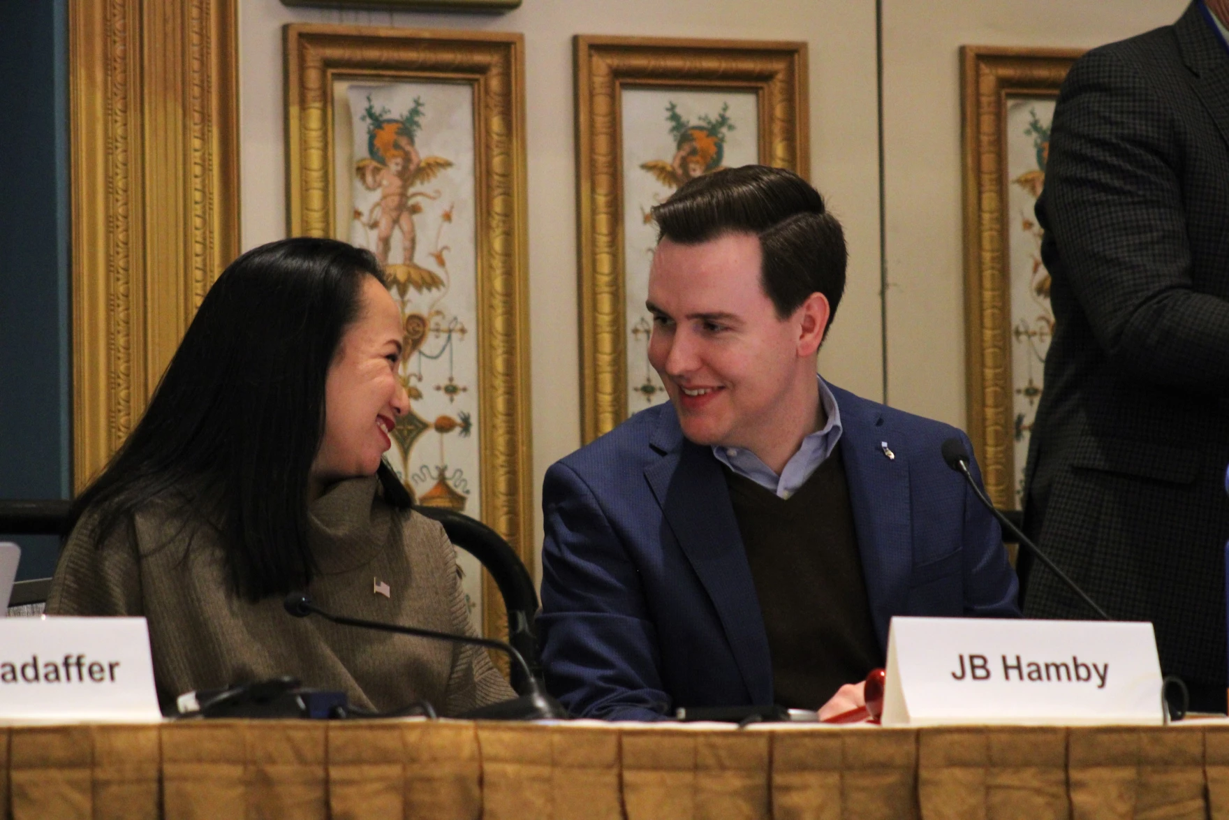
Bureau of Reclamation commissioner Camille Calimlim Touton (left) smiles at JB Hamby of the Imperial Irrigation District at a conference in Las Vegas on December 4, 2024. The federal government has sent hundreds of millions of dollars to the Southern California farming district to incentivize farmers to use less water. Photo credit: Alex Hager/KUNC
Click the link to read the article on the KUNC website (Alex Hager):
December 14, 2024
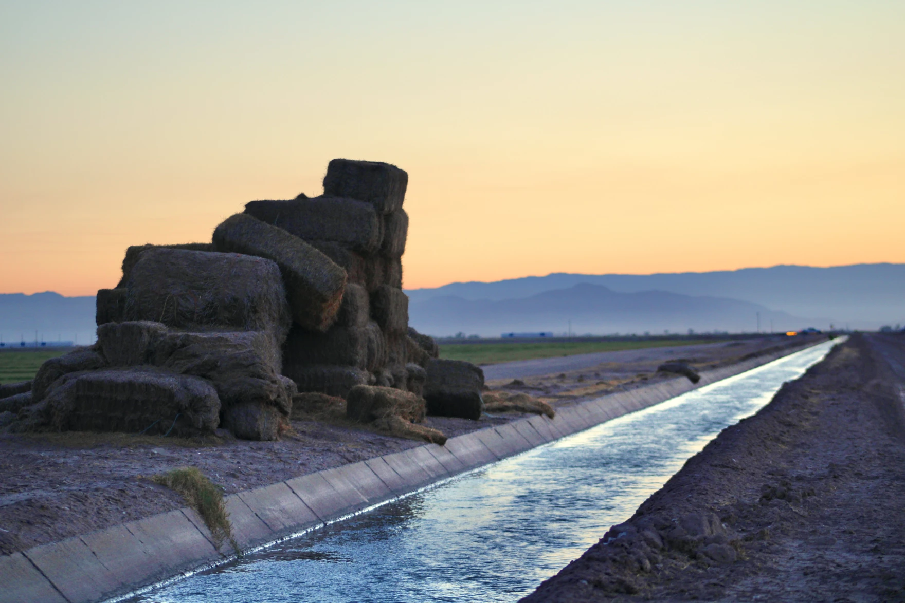
Where the farm fields meet the desert in Southern California’s Imperial Valley, farmer John Hawk looks out over a sea of green.
“It really is an emerald gem that we have,” he said. “With the water, we can do miracles.”
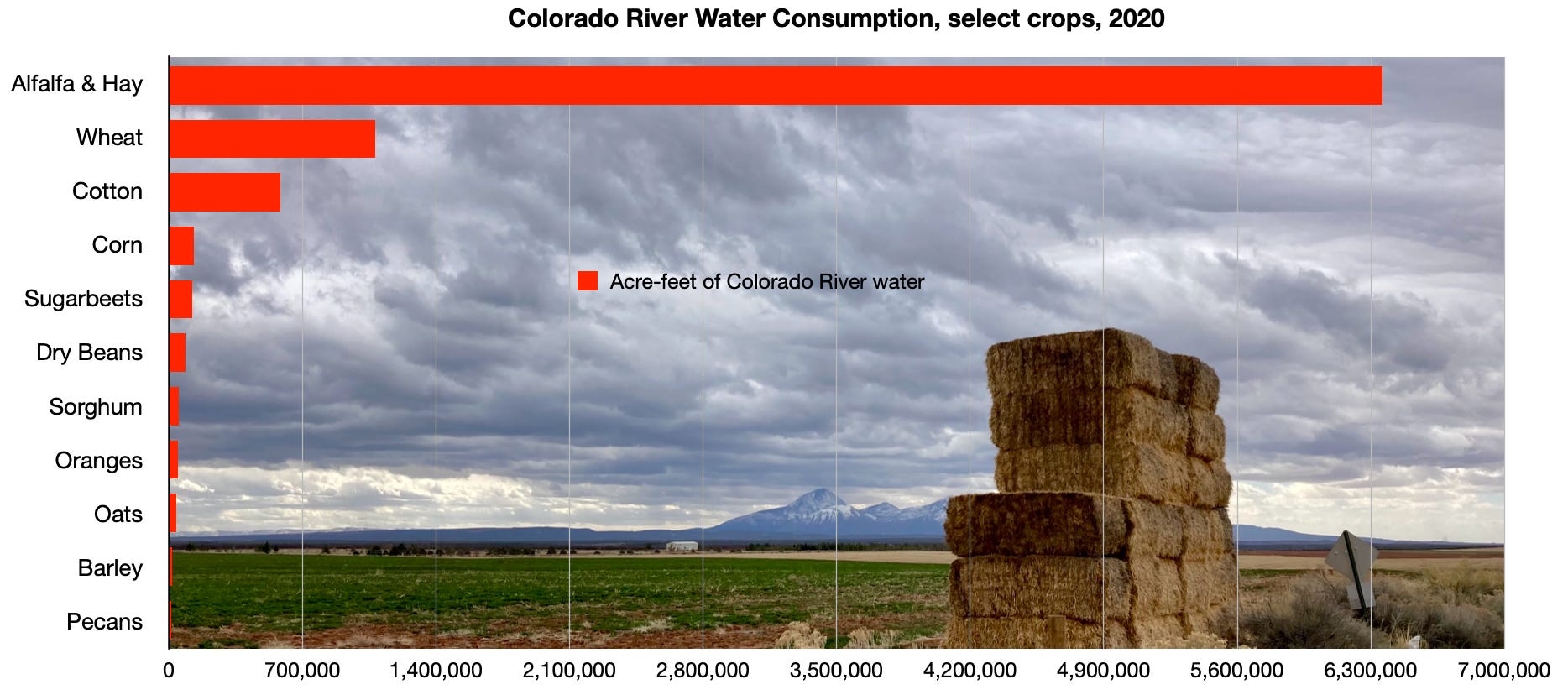
The Imperial Irrigation District uses more water from the Colorado River than any other single entity – farm district, city, or otherwise – from Wyoming to Mexico. As climate change shrinks the river’s supplies, its biggest users are facing increasing pressure to cut back on their demand.
“Do we need to conserve? Absolutely,” Hawk told KUNC in 2023. “We need to conserve, but we need to be paid for the conservation.”
Last year, the federal government took Imperial’s farmers up on that suggestion. Over the course of three years, it agreed to send more than $500 million to the district to use less water and leave it in Lake Mead, the nation’s largest reservoir. That money comes from the Biden Administration’s Inflation Reduction Act.
Water leaders in the West and Washington D.C. alike have lauded the effort as a pivotal way to boost the reservoir, which has dropped to all-time low levels in recent years. Similar spending has saved water on farms and tribal land across the region. It has also made city utilities more efficient. But now, on the cusp of Donald Trump’s return to the White House, those who use the river’s water are worried that funding could disappear.
“All these programs cost money,” said Gina Dockstader, a fourth-generation farmer who sits on the Imperial Irrigation District board of directors. “All this investment, all this infrastructure costs money, and without these additional funds, these farmers can’t afford to put it in by themselves.”
John Hawk, a farmer in California’s Imperial Valley, walks across an irrigation canal on June 20, 2023. “We need to conserve, but we need to be paid for the conservation,” he said. Photo credit: Alex Hager/KUNC
The federal government needs to keep water in Lake Mead and the nation’s second-largest reservoir, Lake Powell. Without conservation, water levels could drop low enough to cause the shutoff of massive hydropower generators. Even lower water levels could make it impossible to send water from big reservoirs to the Colorado River on the other side of the dams that hold them back.
When the Biden Administration set aside $4 billion of the Inflation Reduction Act for Colorado River work, it lifted some weight off the shoulders of anxious water managers, who could use it to incentivize water conservation and stave off catastrophe at those reservoirs.
Those measures also bought time for negotiators working on new, long-term rules for sharing the river’s water. Nevada’s top water negotiator, John Entsminger, called the federal spending a “once-in-a-generation windfall.”
On the campaign trail, then-candidate Donald Trump said he would claw back unspent funds from the Inflation Reduction Act. That could jeopardize the expensive programs that have brought a wave of temporary peace and certainty for the Colorado River basin.
“It would be really disappointing if that went away,” said Hannah Holm with the conservation group American Rivers. “People are pretty pessimistic.”
American Rivers receives funding from the Walton Family Foundation, which also supports KUNC’s Colorado River coverage.
Holm said the need for water conservation, and funding to make it possible, will only get more important in the future. Climate change is expected to keep shrinking the amount of water in the river and necessitate more cutbacks to the region’s water use.
“If that funding doesn’t materialize,” she said, “We just won’t be as able to adapt as well to the conditions we already have, let alone the conditions that are coming our way.”
The Biden Administration’s infrastructure funding reached a wide variety of water-related projects. Holm cited forest restoration work that helps decrease the likelihood of forest fires, which can add dirt, ash, and harmful debris to rivers that supply drinking water.
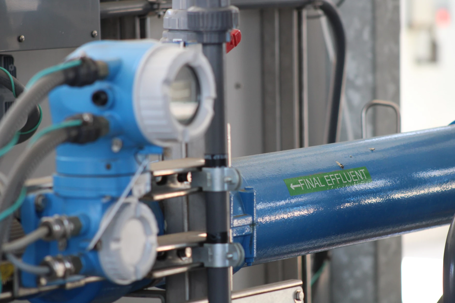
A pipe carries treated wastewater out of a water recycling demonstration facility in Carson, California on May 26, 2022. Cities are modernizing their water treatment systems to make them more efficient, often with the help of federal funding. Alex Hager: KUNC
City facilities that treat water for drinking were also on the long list of entities that received federal funding under the Biden Administration.
In the Los Angeles area, for example, the Metropolitan Water District of Southern California is spending massive amounts of money on equipment that will help steel its network against future water shortages. That agency is spending more than $3 billion on a water recycling facility, where it will safely turn sewage back into drinking water instead of cleaning it to a lower standard and releasing it into the ocean.
“In the long run, it’s going to be vital for us,” said Deven Upadhyay, Metropolitan’s interim general manager. “In the short run, it looks to be pretty expensive compared to the other resources we have. So the federal dollars really do help.”
Meanwhile, as farms and cities tighten the screws on their water use, the negotiators shaping the big-picture future of the Colorado River are stuck at an impasse. The seven states that use its water are split into two camps, divided by deep ideological differences about who should cut back on their water use going forward.
State water officials are projecting optimism that Trump’s second term will not shake up their talks, citing a historical precedent of stability within federal water agencies that is mostly unaffected by turnover in the White House.
Holm said the future they are negotiating, though, will look different if there is less federal money to ease the pain of water reductions.
“In order to be able to make less water do more,” she said, “We need to be able to manage it a lot more precisely. That takes investment in science, in infrastructure, in monitoring, in figuring out different ways of moving water around. And none of that happens by itself.”
This story is part of ongoing coverage of the Colorado River, produced by KUNC in Colorado and supported by the Walton Family Foundation. KUNC is solely responsible for its editorial coverage.
Map of the Colorado River drainage basin, created using USGS data. By Shannon1 Creative Commons Attribution-Share Alike 4.0
One of the hopeful notes coming out of the recent Colorado River discussions is the way the operation of Glen Canyon Dam in a more flexible way, to accommodate a broader range of values, is back on the table. The USBR alternatives released ahead of this week’s Colorado River Water Users Association, while requiring some tea leaf divination because of their brevity, seem to leave the door open for this discussion.
Jack Schmidt and I have a new white paper offering some assistance, based on our understanding of the legal and regulatory structure around Grand Canyon National Park and Glen Canyon National Recreation Area. The idea behind what we’re arguing isn’t to wag a regulatory finger and say, “The law requires us to do X.” Rather, we’re saying, “The law enables us to do X,” where for “X” we argue for the consideration of a wider range of social, cultural, and environmental values as we make decisions about how to divide the water up between Lake Mead and Lake Powell.
Call it a meeting of the minds – Willem A. Schreüder, the CU computer scientist behind the groundwater modeling of the Upper Rio Grande Basin, and a group of San Luis Valley irrigators who are racing against time to reduce groundwater pumping in what state water engineers call “one of the most productive irrigated farming areas in the state.”
Schreüder spent more than an hour at a Dec. 4 meeting with farmers who form the governing board of Subdistrict 1 of the Rio Grande Water Conservation District. They wanted to know if the subdistrict’s upcoming Fourth Plan of Water Management, which calls for irrigators to limit their groundwater pumping to the amount of surface water that naturally flows in, is going to work.
It’s called one-for-one pumping, and while the plan has been approved by the Subdistrict 1 board, the Rio Grande Water Conservation District board and the state engineer, it still needs sign off from the state water court, which likely won’t happen until 2026.
While all the Valley’s farmers face pressure to reduce groundwater pumping in the face of a changing climate, it’s the crop producers in Subdistrict 1 who are on the clock and under state orders to recover groundwater levels of the unconfined aquifer and maintain a sustainable irrigation water supply by 2031.
It’s Schreüder’s mathematics’ modeling that clues in the Colorado Division of Water Resources to the response the river system and aquifers are having through a steady reduction of groundwater pumping over the past two decades.
Schreüder’s expert witness testimony explaining the Rio Grande Decision Support System (RGDSS) model has been the subject of state water court proceedings and undoubtedly will be again in upcoming cases.
His session with Subdistrict 1 managers yielded a few insights, notably:
The recharge of streams should occur as close to the point of where the groundwater pumping occurred, a problem that has particularly come to light around Saguache Creek and the groundwater pumping that occurs in that area of the Valley.
As much as the RGDSS model can be useful in showing the response of the river to less groundwater pumping, there is always an imbalance even if irrigators are perfectly recharging the same amount as they’ve pumped out.
What follows is a partial, edited transcript of the conversation to get at some of the more pertinent questions. Jake Burris, president of the Subdistrict 1 board of managers, opened the discussion:
Burris: The first question I would throw at you is, the anchor of the amended plan, should we be successful, is that we would only pump imported water as it’s brought in. Live within our means, sort of speak. If that is the case, is it unreasonable to assume that we would not be generating any new depletions at that point?
Schreüder: New depletions anywhere, or a particular stream?
Burris: Anywhere, any stream.
Schreüder: So the short answer is ‘No’ in the sense that yes, we probably still will have the depletions, and what it comes down to is that the one-for-one plan essentially is one that deals with an average. So we’re looking at a districtwide or subdistrict-wide average balance, whereas when we talk about stream depletions, we’re talking about time, place, amount. And so it’s very easy to construct a hypothetical situation where if you look at where the pumping occurs and where the recharge occurs, that those recharges in pumping are not exactly coincident and as a result, the distance between where you recharge and where you are pumping basically directs depletions to a particular direction. And so what could very likely occur is that on one stream you actually have an accretion and on another stream you have depletion. So on average you tend to be sort of in balance with the surface network, but the people on the stream that is depleted, are not going to be happy. . .So unless the way that the one-for-one works is that the recharge occurs in exactly the place where the pumping occurs, you likely will have depletions to some streams.”
Burris: So it’s not just simply an issue from an administrative standpoint of us utilizing our recharge on an average. That’s irrelevant. It is a logistics and timing problem, regardless?
Schreüder: There’s both a temporal and spatial component to that. Think about for example, the depletions to the Rio Grande and I’m making up numbers here, but just to make the argument easier, let’s say 50 percent of your depletions occur in year one and then 30 percent in year two and 10 percent in years three and four. So it’s front-loaded as far as when the depletions occur, and you’re working on a five-year average and let’s say for those first five years, or first four of the five years, let’s say there’s negative 25,000 acre-feet of pumping to managed recharge. . .and then in the last year, year five, we basically have a 100,000 acre-feet of pumping in excess of recharge. So because half of that occurs in year one, and the offsets from two years and three years and four years and five years ago are lesser amounts, even though on the five-year average you are in balance, you could have a situation that on the Rio Grande in that first year after the big pumping you do not have an impact. So it’s both the temporal scale at which things happen, as well as the spatial scale. It’s also a reflection of where did that recharge occur and where did the pumping occur. If you average it out, they don’t fall right on top of each other.
Burris: The way the model then is I guess essentially looking at it for lack of a better way, but from a temporal and spatial standpoint, Sub 1’s aquifer itself is irrelevant. It’s not looking at it from a form of recharging an aquifer as a whole and recharging for all the wells as a conglomerate. It’s looking at the individual wells and the areas around each well?
Schreüder: As far as the model is concerned, yes.
Burris: I think that’s our big disconnect, or at least I should speak for myself there. The way Sub 1’s structured is with the way the aquifer system is and the way we treat the wells and recharges, it’s in totality. It’s as a conglomerate, and so you can’t take that perspective in any way to the model?
Schreüder: That’sright? And so there’s actually three parts to this. The first is as far as Subdistrict 1’s one-for-one is concerned, to a large part that’s going to address sustainability because what you put in and what you take out balances, that should be sustainable. So that’s the one part. The other part then, of course, is the groundwater modeling, which tries to figure out just exactly where the spring depletions occur. And then the third part to that is well, we need to calculate these response functions and the response function needs to capture the essential behavior of the model so that we have a simpler way of actually applying the inputs and predict what the depletions are. The problem that we are going to face in the future is that so far the response function approach has actually worked pretty well because what we found is that if you simply look at what the imbalance between pumping and recharge is in the ’90s and early 2000s, it did a pretty good job of predicting where the stream depletions would be if all you do is to calculate the net consumptive use and you run it through that function, and then you get the stream depletion prediction. But what if we go one-for-one and the next CU (consumptive use) is zero a lot of time, how are we going to figure out a response function that we can then use to predict what the stream depletion is?
Burris: It is a possibility to reconsider conceptually how the model is I guess, the framework of the model? Or are we pretty much stuck with how the system is now, if that makes sense?
Schreüder: I think we are fairly confident in the framework of the model because it is able to reproduce what has happened historically pretty well. The question that we’re struggling with is ‘How do we ask the what-if question?’ Had there not been wells or had the wells only operated in a way where the pumping matched the recharge, what would the stream depletions have been? And that’s a little bit more tricky question that we need to answer now. In the past, because there was always an imbalance between pumping and recharge, it sort of worked out. But if we are actually finding that we are leaving the response function zeros a lot, and if the model does all of the superimposition of individual wells in terms of one answer, and then we average things and we run that sort of the response function, we don’t come up with that same answer, that’s the problem, right? That’s the definition of non-linear. Linear means if you have a function that translates an input to an output, all you have to do is average the inputs and the function will give you the same average on the outputs. Whereas in the non-linear system, if you run the individual items through the function and you then average the results, you don’t get the same answer. And that’s what we are struggling with. Will we be able to properly linearize that?
Burris: I’ll throw one more question at you and then I’ll let somebody else talk. What is the difference in impacts specifically, I’ll say, to Saguache Creek as far as the model sees them between unconfined wells and confined wells? Is the classification different in the model? Is the impact different, or are those treated the same sort of like we treat them the same in Sub 1?
Schreüder: They’re different in the sense that, because in the confined aquifer you typically have lower storage co-efficients, the columns of depression that accumulate for those tend to spread out wider and faster than they do in the unconfined aquifer. And so since the model basically just stacks all of those on top of each other and then calculates the total, it takes into consideration the fact that confined and unconfined wells behave differently. But as far as, can you tell me exactly how confined wells are, what the total is from confined wells and what’s the total from the unconfined wells? I’ve not tried to make that separation. We always just consider it in total because again, this is a non-linear system. So how you evaluate individual wells versus all of the wells in the subdistrict as a whole, if you add up all the individual wells, it doesn’t add up to the total for the subdistrict as a whole. So it’s a little difficult to make that clear distinction between the two.
Credit: Rio Grande Water Conservation District
The seventh iteration of the RGDSS model is being finalized by Schreüder, which led to this exchange with another of the Subdistrict 1 managers. The conversation also then delved into the new Southern Colorado Water Conservancy District.
Sub1 Board: When will we have, ‘This is the final seven version?’ Do we need to take action soon or can we wait a month or two for you to finalize it?
Schreüder: So I am hoping, we have a meeting on Dec. 17, I think is the date, and I’m hoping to finalize the model for that, or at least get people’s agreement that this is good enough that we should be moving on to the application of the model. So now we start asking the model questions, and it’ll probably be several months if not a year before we go from OK, we now have a model’ translating that into, do we ask the right question for each zone and then what are the response functions that are coming out of that? So it’s probably going to be at least a year before we have the answer that will apply for the next five or 10 years.
Sub 1 board member, on the Sustainable Water Augmentation Group known as SWAG: SWAG forming their own subdistrict and I guess trying to do it alone, how would you see that changing those fields and their new conservation district now outside of our subdistrict. Would that impact this data set?
Schreüder: Well, I guess to the extent that they do their own thing, they give us more site-specific information, we’ll try to incorporate that into the model. The difficult thing that we need to figure out is, ‘How do we deal with it separate from the rest of Sub 1?’ And that’s not going to be easy.
Sub 1 board member: Just clipping those wells out of our dataset, you’re saying it’s not just as straightforward as, ‘Hey, these ones are closer to Saguache and they’re no longer in the map.’ Does that help the math?
Schreüder: Well, and I mean that’s part of the problem, right, is it’s sort of obvious that yeah, those guys are probably having a bigger impact on Saguache Creek than the rest, but how do we actually run the model in such a way that we can actually quantify that? And that’s one of the problems that you have an nonlinear system, is if you start breaking it up into lots of little parts, the answer doesn’t sum up to the total and that becomes problematic in terms of how do you figure out what the total impact on the stream is and how to distribute that back to individual people? And it’s something that we’ve worked very hard to avoid, but they’re sort of forcing our hand and I don’t know exactly what the answers can be.
Sub 1 board member: You mentioned the substantial decrease in pumping over the last 10, 15 years in Subdistrict 1. Is there a scenario where if that were to continue or if wells were continuing to be retired in Sub 1, that that cone of depression would no longer reach Saguache Creek or we would no longer have applications in any scenario?
Schreüder: It’s that balance, right, between where the recharge occurs and where the pumping is. So if we basically do one-for-one and we can put the recharge exactly where we’ve pumped, then there should be no net cone of depression. And so that’s the problem, right? There’s always an imbalance, and so even if you are perfectly recharging the same amount as you are pumping, it’s always going to push the cone of depression in one direction.
Jake Burris: I once again will reiterate how appreciative I, and we are, that you’re willing to make the trip down here and talk to us. It was hugely helpful, at least for me, just the general perspective o,f it’s drastically different how we treat Sub 1 and administer it versus how the model sees it, I guess is how I’ll put it. But we do appreciate you taking the time.
Schreüder: Well, and again, let me just reiterate. The sustainability requirement, there’s the model’s predictions of impact, and then the response functions themselves, and the way that the response functions work right now, by definition, if you had no net CU (consumptive use), there would be no depletion. But that’s the existing response functions, and that’s one of the things that we need to figure out at the end of phase seven is, OK that particular model of response function is probably not going to work again. So what are we going to do to fix that?
NASA satellite images show water decline in Lake Mead from 2000, at left, to 2022, the largest reservoir in the United States. Credit: Colorado State University
Click the link to read the article on the InkStain website (John Fleck):
My colleagues with the Colorado River Research Group have a new policy brief out today taking another whack at the question of “assigned water” – water kinda sorta conserved, but left in storage so water agencies can pull it out again at some future date. Think “Intentionally Created Surplus” (ICS). At this point, nearly 40 percent of the water in Lake Mead is tagged as some agency’s private storage account, rather than being available for general system use.
This is the issue Arizona State’s Kathryn Sorensen (one of my CRRG colleagues) has been raising, and that Kathryn (with help from Sarah Porter and I) wrote about in October. The new CRRG paper argues that, as we move toward expanding the assigned water programs available to basin water users, we need to be mindful of the risks.
Map of the Colorado River drainage basin, created using USGS data. By Shannon1 Creative Commons Attribution-Share Alike 4.0
Drawdown of the Colorado River’s reservoirs now slightly exceeds the amount of gain that occurred during the 2024 snowmelt season. For the next four months until snowmelt begins again, the basin’s reservoirs will be drawing from the excess accumulated in 2023, demonstrating the immense challenge in balancing water consumption with supply.
In Detail…
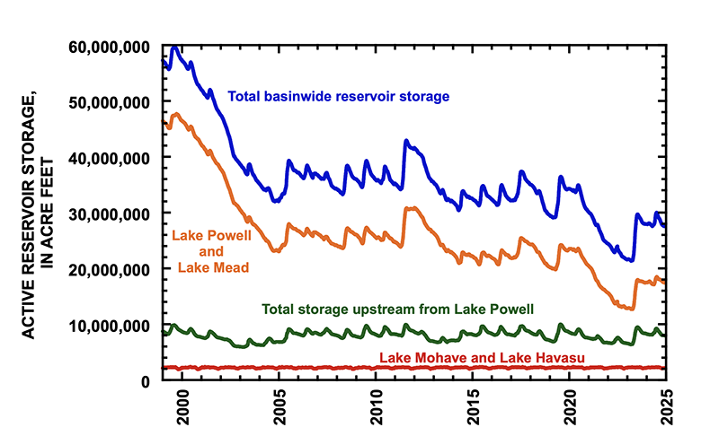
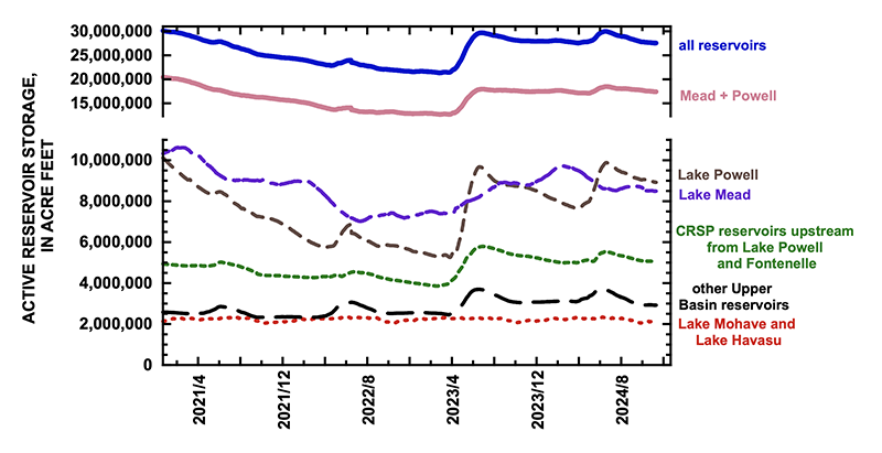
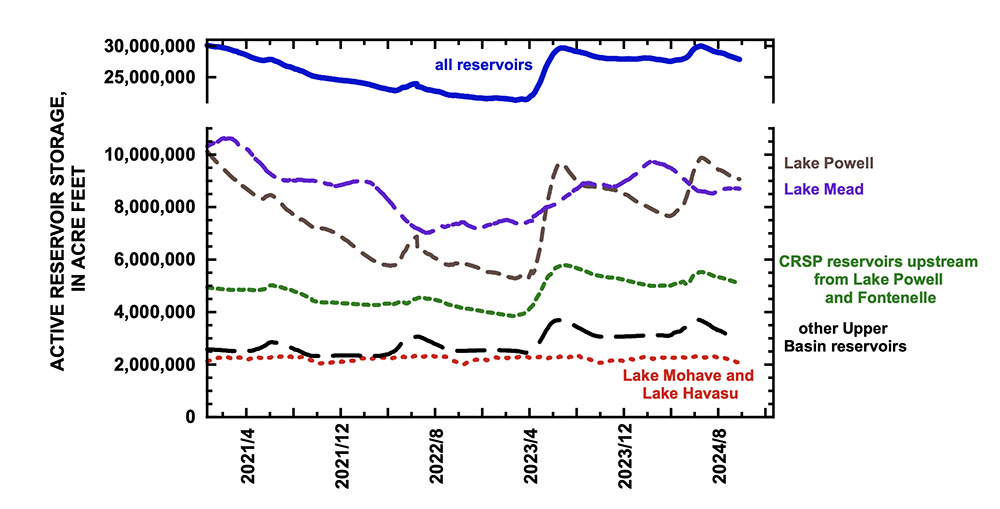
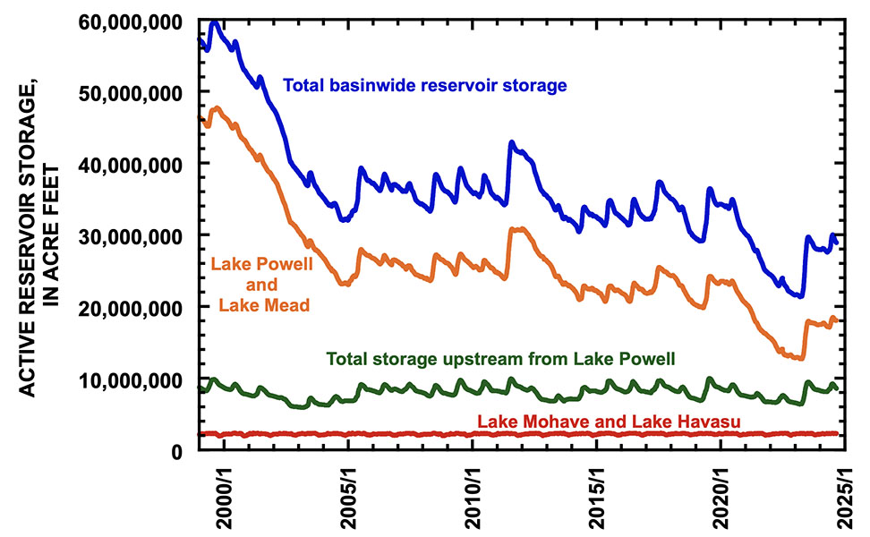
On 30 November 2024, total basin reservoir storage was 27.5 million af (acre feet)1, approximately two years’ supply at today’s rate of consumptive use and loss (Fig. 1). That amount is 43% of the maximum system contents of July 19832 and is the same amount as at the beginning of July 2021 when the basin’s water managers were beginning to get worried. Conditions are not quite as bleak as in summer 2021, because that year’s snowmelt season had already passed. Now, we can hope that the 2025 snowmelt season might be a good one. Nevertheless, reservoir storage is the bank account from which we draw to maintain the economy of the American Southwest and parts of northwestern Mexico. It would be preferable for there to be more water in that account.
Figure 1. Graph showing total storage in 46 reservoirs (blue line) in the Colorado River basin since 1 January 1999. Also shown are the total contents of Lake Mead and Lake Powell (orange line), total contents of Lake Mohave and Lake Havasu (red line), and 42 reservoirs upstream from Lake Powell (green line) which includes reservoirs managed by the federal and state governments, municipalities, and water districts. Credit: Jack Schmidt/Center for Colorado River Studies.
Approximately 63% of current total reservoir storage is in Lake Mead and Lake Powell. Presently, there is approximately 400,000 af more water in Lake Powell than in Lake Mead, but the contents of Lake Powell are slowly being depleted. The contents of Lake Mead held fairly constant during the past month. The contents of Lake Powell decreased by approximately 4300 af/day during November, but the contents of Lake Mead decreased by only 800 af/day (Fig. 2). Upstream from Lake Powell, Colorado River Storage Project (CRSP) initial unit reservoirs, as well as Fontenelle Reservoir, decreased by only 600 af/day in November, and other Upper Basin reservoirs lost even less (400 af/day).
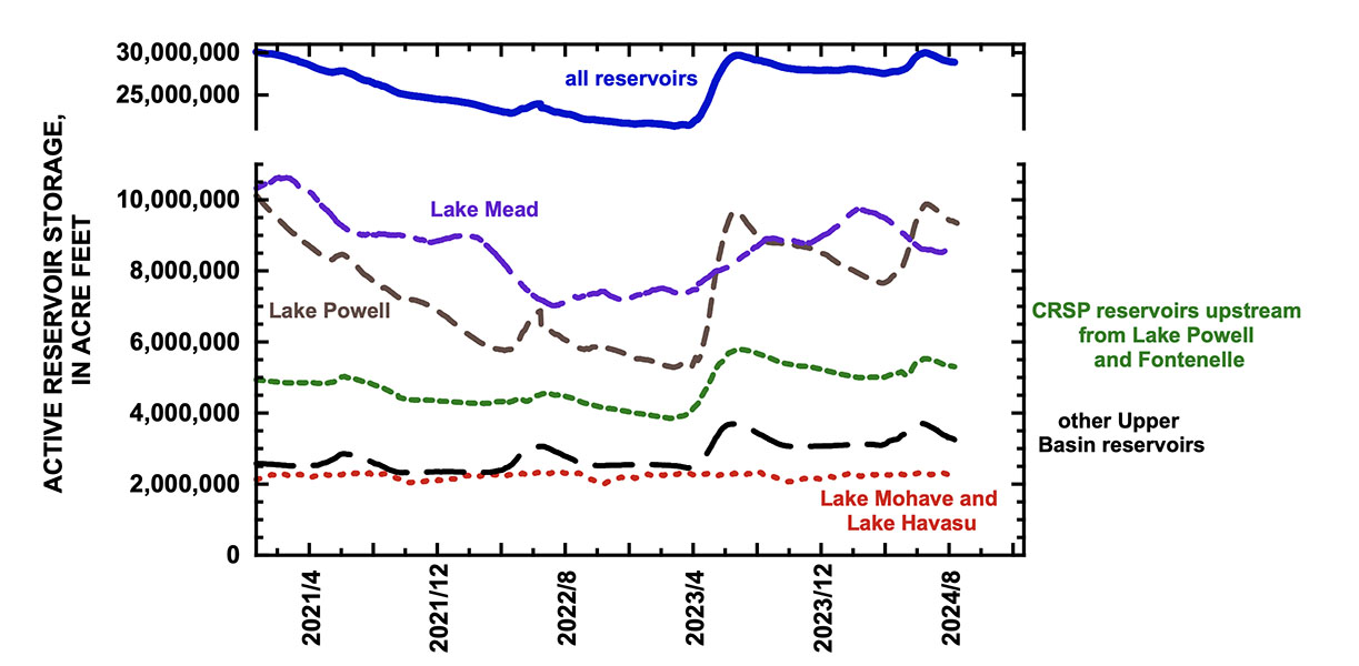
Figure 2. Graph showing total basin reservoir storage (blue line), and storage in different parts of the Colorado River watershed between 1 January 2021 and 30 November 2024. Credit: Jack Schmidt/Center for Colorado River Studies
Basin reservoir storage must be increased to improve the security of our water supply. We need to increase the balance in our “bank account,” and the only way to do that is to spend less than the amount of our actual water “income.” Most of our income arrives during the snowmelt season of late spring and early summer. Mid- and late-summer, fall, winter, and early spring is the period when we spend the snowmelt-season income, although summer rains and groundwater inflow offset some of our uses.
Occasionally, we have an unusually snowy winter, and the basin’s reservoirs significantly refill. 2023 was one of those years. Reclamation estimates that the natural flow of the Upper Basin3 was 17.4 million af in 2023, the third largest of the 21st century (after 2011 and 2019), and total basin storage increased by 8.38 million af, only exceeded by the increase in storage in 20114. 2024 was a moderately snowy winter.
2024 was a different story, however. The NRCS estimated that the peak snow water content in 2024 was 14% greater than the 30-year average, but dry soils and other effects of a warming climate limited natural flows to between 11.9 and 12.1 million af, which is less than the average for the 21st century5. In 2024, the basin’s reservoirs increased in storage by 2.45 million af. The drawdown of the basin’s reservoirs as of 30 November was 2.46 million af, slightly more than the gain from snowmelt (Fig. 3). The contents of Lake Mead and Lake Powell increased by 1.39 million af in 2024, and the drawdown in those two reservoirs has been 1.07 million af this year. During the next four months, the basin will begin drawing from storage that accumulated in 2023.
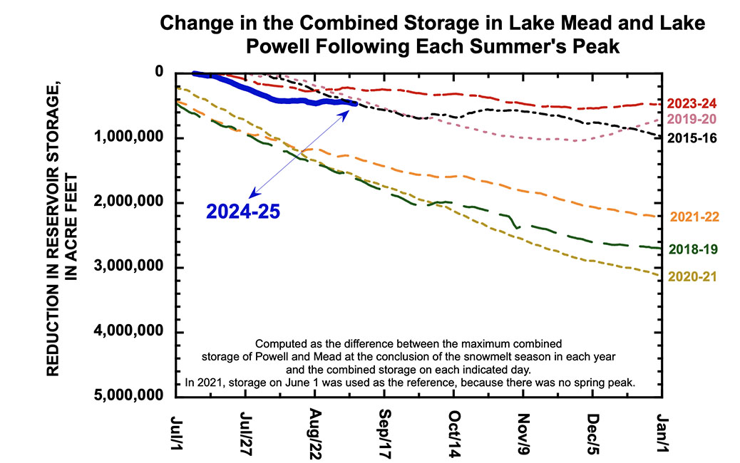
Figure 3. Graph showing reservoir storage between 1 January 2023 and 30 November 2024, highlighting the amount of reservoir recovery during the past two snowmelt seasons and the amount of intervening reservoir drawdown. The drawdown of the basin’s reservoirs since July 2024 slightly exceeds the recovery that occurred due to snowmelt in 2024. Credit: Jack Schmidt/Center for Colorado River Studies
Drawdown of the basin’s reservoirs has been much greater in 2024 than in 2023. The amount of drawdown between early summer and today is slightly more than the median drawdown for the past 15 years6 and is 43% greater than the drawdown at this time last year (Table 1). The drawdown of Lake Mead and Lake Powell in 2024 is slightly less than the median for the past 15 years7 but is 98% greater than it was at this time last year.
The total reservoir drawdown between early summer and 30 November is now 14% greater than in all of last year, and drawdown in Mead and Powell also exceeds the total drawdown in those reservoirs last year (Table 2). We did well last year, but not so well this year. Credit: Jack Schmidt/Center for Colorado River Studies
Credit: Jack Schmidt/Center for Colorado River Studies
There are many details ignored in this overview. Reservoir drawdown in the Upper Basin is not only determined by consumptive use, but also by reservoir operating rules that require winter drawdown and by requirements to provide environmental flows. Water use in southern California is significantly affected by water supply available from northern California, the Owens River, and locally. Nevertheless, every drop of water released from upstream is used, lost, or stored in a downstream reservoir, and total basin storage is the only available supply to make up the shortfall between annual precipitation and annual use.
Conservation in the Lower Basin and in Mexico is reducing drawdown in Lake Mead, and the storage contents of Lake Mead are likely to increase during the next few months as water is delivered from upstream. Drawdown of the total contents of Lake Mead and Lake Powell is still 0.32 million af less than what accumulated there from the 2024 inflow season and a 2024 deficit might not occur is Lower Basin water use is drastically reduced or if Upper Basin reservoirs are emptied.
Efforts to date to reduce water consumption in the basin have been significant, and required a significant investment by the federal government. Despite those efforts, we have four months ahead of us before snowmelt in 2025 begins, and we are likely to begin deficit spending unless radical changes in use are immediately implemented. The challenge faced by the federal government, Mexico, the seven basin states, every tribe, and every water user is immense and is not solely restricted to negotiating the post-2026 agreements. We remain in a water crisis today, and the time to greatly reduce water consumption is right now in the present moment. [ed. emphasis mine]
[2] There was 63.6 million af of storage in the basin on 15 July 1983. Some of this storage exceeded the generally accepted capacity of some reservoirs, notably Lake Powell.
[3] at Lees Ferry
[4] Basin reservoir storage increased by 8.78 million af in 2011.
[5] Natural flows for calendar year and water year 2024 were 12.1 and 11.9 million af, respectively, based on Reclamation’s 12 September 2024 estimate. The average natural flow at Lees Ferry between 2000 and 2024 was 12.4 million af/yr, based on Reclamation’s estimates.
[6] The median drawdown between the summer peak and 30 November during the past 15 years was 2.26 million af for the 46 reservoirs of the watershed.
[7] The median drawdown between the summer peak and 30 November during the past 15 years was 1.16 million af for the total contents of Lake Mead and Lake Powell.
[8] Includes drawdown of Lake Mohave and Lake Havasu.
Western states that rely on the Colorado River are in a heated deadlock over how to manage the troubled river, and are doubling down on their own regional plans, despite growing pressure from the federal government to reach a compromise.
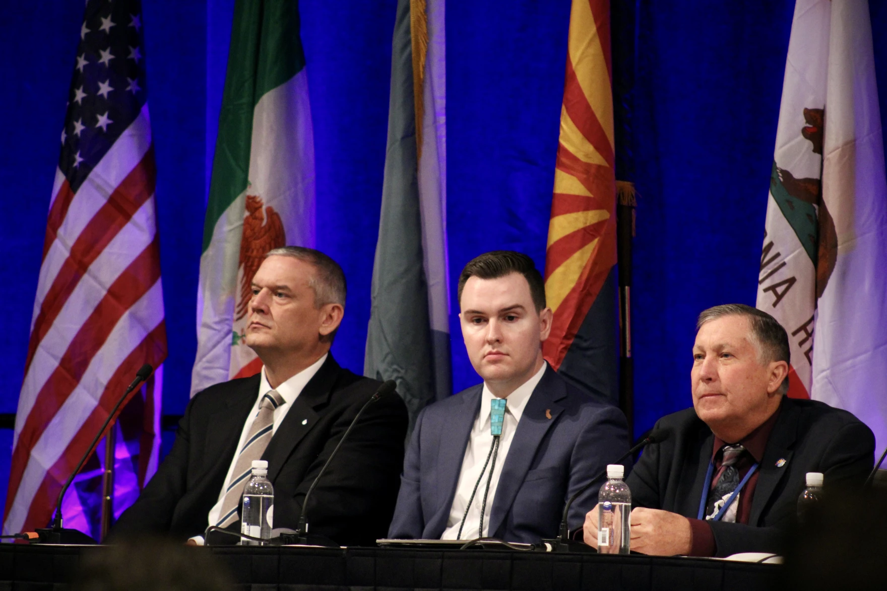
Top water officials for the seven Colorado River Basin states — Arizona, California, Nevada, Colorado, New Mexico, Utah, and Wyoming — gathered for the Colorado River Water Users Association conference at the Paris Hotel and Casino in Las Vegas Thursday.
But for the first time in years, representatives from Lower Basin states — Nevada, Arizona, and California — and Upper Basin states — Colorado, New Mexico, Utah, and Wyoming — did not appear on a panel together or meet during the conference to negotiate the future of the Colorado River.
“It’s been customary that we get together beforehand,” said Colorado River Commissioner for Colorado, Becky Mitchell, during a news conference. “Unfortunately, we weren’t able to do that. I don’t think that means that we will never be able to do that again. It just means this time we weren’t.”
Map of the Colorado River drainage basin, created using USGS data. By Shannon1 Creative Commons Attribution-Share Alike 4.0
Nine months ago, the two basins submitted competing water management plans to the federal government after state negotiators could not reach a consensus on how to share the river’s dwindling water supply.
Since then, the basin states have not moved any closer to negotiating a compromise on how to equitably share and cut Colorado River water use once current management rules expire in 2026, leaving states up a creek without a paddle.
One of the biggest sticking points between the two basins is whether or not Upper Basin states should absorb mandatory water cuts during dry years, despite using significantly less than their 7.5 million acre-feet Colorado River allocation year-after-year.
Historically, Lower Basin states have used nearly all their 7.5 million acre-feet Colorado River allocation under the 1922 Colorado River Compact, compared to the 4.5 million acres-feet used by the Upper Basin states.
Lower Basin states argued all seven states should share water cuts during dry years under the new post-2026 guidelines. If they don’t, downstream states warned they could face water cuts they can’t feasibly absorb.
Those tensions were reflected Thursday when Lower Basin water managers told a ballroom full of water managers, researchers, agricultural producers and others from across the drought-stricken river that if their Upper Basin counterparts did not sign onto the Lower Basin plan and accept cuts, they would be at greater risk of triggering a “compact call,” which could force cuts on the Upper Basin.
Upper Basin states argue they don’t have the legal authority to significantly reduce flows to water users on their own under the 1922 Colorado River Compact, unlike Lower Basin states.
“They might have that authority if we make a compact call. So perhaps we’ll make that compact call, then they’ll have the authority to cut flows,” said Tom Buschatzke, Arizona’s top Colorado River negotiator. “Maybe that’s an easy path compared to going to their water users with some voluntary program or their legislatures to get authorities to do the things we have to do in the Lower Basin.”
In September, Buschatzke asked Arizona Gov. Katie Hobbs to set aside $1 million for litigation in the event states can’t reach a compromise and Arizona needs to take the issue to court.
“I have to do my due diligence for all potential outcomes,” said Buchatzke about his request.
Negotiators in both the Lower and Upper Basin states all acknowledged they have three options to decide how states will share the river’s waning water supply going forward: litigation, legislation or negotiation.
“When we put forward our Lower Basin alternative, we were looking to offer a compromise,” said JB Hamby, Colorado River Commissioner for California. “We want a seven state agreement. We don’t want to have to go litigate stuff and force these really difficult outcomes in the Upper Basin.”
Mitchell, the Colorado River Commissioner for Colorado, was critical of how the Lower Basin states have approached negotiations with the Upper Basin.
“I think going in, not willing to change your deal at all, is probably the first problem. You cannot say there’s a compromise, if we have to accept a deal in its entirety,” Mitchell said, adding that Upper Basin states are open to adjustments to their plan.
To spur a compromise, the federal government released an initial outline detailing four different river management options last month, including a hybrid management option that blends components from both basin state plans.
Representatives for both camps said they would need to see more details before throwing their weight behind any of the federal management proposals.
“They did provide a bit of additional information today as to some of the elements, but still not enough,” said Estevan Lopez, New Mexico’s representative on Colorado River matters, during a news conference Thursday.
Representatives for the U.S. Bureau of Reclamation said the agency intends to publish a more detailed analysis of the federal proposals by the end of the year. Maximum cuts could range from 2.1 million acre-feet to 4 million acre-feet, which could be divided based on who has the oldest rights, or distributed proportionally across all seven states.
Despite the lack of comradery among the Lower and Upper Basin states at the annual conference, both camps expressed optimism they could reach a compromise, eventually.
“I want everybody from the upper basin to hear from Nevada: We believe compromise is possible. We think it’s the first, second and third best option. But we need a dance partner, so let’s get back to the table and make this happen,” said John Entsminger, Nevada’s representative on river issues and general manager of the Southern Nevada Water Authority.
Mitchell said it was clear to her from panel presentations during the conference that all seven states want to reach a consensus plan on how to manage the future of the Colorado River.
“I think there’s still a possibility. I’m still hopeful. And I think if we want a seven state consensus, we’re going to have to have seven leaders come to the table,” Mitchell continued.
Brandon Gebhart, Wyoming’s state engineer and Colorado River negotiator, said he believes the seven Colorado River Basin states can come up with a better management plan than one imposed by the federal government, although “it won’t happen next week.”
Udall/Overpeck 4-panel Figure Colorado River temperature/precipitation/natural flows with trend. Lake Mead and Lake Powell storage. Updated through Water Year 2024. Credit: Brad Udall
“We really need to understand that the enemy we’re battling right now is not the Upper Basin, it’s not the Lower Basin. It’s hydrology,” Gebhart said.
Nevada Current is part of States Newsroom, a nonprofit news network supported by grants and a coalition of donors as a 501c(3) public charity. Nevada Current maintains editorial independence. Contact Editor Hugh Jackson for questions: info@nevadacurrent.com. Follow Nevada Current on Facebook and X.
Water policymakers from (left to right) Utah, New Mexico, Colorado and Wyoming speak on a panel at the Colorado River Water Users Association conference in Las Vegas on December 5, 2024. State leaders are deeply divided on how to share the shrinking water supply, and made little progress to bridge that divide at the annual meetings. Photo credit: Alex Hager/KUNC
Click the link to read the article on the KUNC website (Alex Hager):
December 6, 2024
This story is part of ongoing coverage of the Colorado River, produced by KUNC in Colorado and supported by the Walton Family Foundation. KUNC is solely responsible for its editorial coverage.
States that use the Colorado River have spent the better part of 2024 deadlocked about how to share its shrinking water supplies, and annual water meetings in Las Vegas laid bare how far those states are from an agreement.
The seven states can’t agree on who should feel the pain of water cutbacks during dry times. The river is getting smaller due to climate change, and states need to come up with new rules to share its water.
Colorado, Utah, Wyoming and New Mexico make up the Upper Basin. California, Arizona and Nevada represent the Lower Basin. The current rules for sharing water expire in 2026, and each group has submitted a separate proposal for new guidelines after that point.
In Las Vegas, the Colorado River Water Users Association annual conference provided a rare peek behind the curtain of talks between those states. Surrounded by the golden wallpaper and shimmering chandeliers of the Paris Hotel, policymakers showed little progress towards an agreement but brought plenty of bluster.
In recent years, negotiators from all seven states have appeared on one panel together. This year, amid their public disagreement, they appeared on stage at separate times.
State leaders made subtle and not-so-subtle jabs at their counterparts, alleging an unwillingness to use less water. Between those jabs, though, they preached the value of collaboration.
“We have this conference so that we can try to pull together, not pull apart,” said Gene Shawcroft, Utah’s top Colorado River official.
Some of Shawcroft’s downstream neighbors also urged togetherness.
“I’m not looking for a fight,” said John Entsminger, Nevada’s delegate. “We need a dance partner, so let’s get back to the table and make this happen.”
Others were less gentle with their choice of words.
“All of the rhetoric, the saber-rattling and other distractions going on right now are [bullshit]” said Brandon Gebhardt, Wyoming’s top water negotiator. “It needs to stop.”
Despite all the calls for collaboration, state leaders didn’t use the Las Vegas conference to hold closed-door policy talks like they have in past years. Tom Buschatzke, Arizona’s water director, said the states don’t even have another meeting on the books.
“We are willing to meet with them,” he said. “We want that meeting to be something of substance.”
People mingle in the hallway of the Colorado River Water Users Association conference at the Paris Hotel in Las Vegas on December 5, 2024. The event brought together more than 1,500 water experts from across the Southwest. Photo credit: Alex Hager/KUNC
Looming large in the background of this week’s water talks is the unpredictability of the next presidential administration. Those water leaders said they do not expect Donald Trump’s return to the White House will shake up the Colorado River negotiation process, but some water users and onlookers say the next administration could impact the future of the river in other ways.
The past few years have seen an influx of federal spending that Nevada’s Entsminger called a “once-in-a-generation windfall.”
Michael Bennet, Colorado Senator; Bill Long, Southeastern Colorado Water Conservancy District; Camille Calimlim Touton, Reclamation Commissioner; Rebecca Mitchell, Director Colorado Water Conservation Board stand with pipe for the construction of the Arkansas Valley Conduit. Photo credit: Reclamation
Some presentations at the conference felt like a bittersweet sendoff for the administration and its willingness to spend. Water leaders from around the West eulogized the work of Camille Calimlim Touton, the outgoing head of the Bureau of Reclamation, the federal agency that operates Western reservoirs.
Money from the Inflation Reduction Act has been spread far and wide across the cities, farms and native tribes that use the river’s water. While some of it has been spent on physical infrastructure, like fixing old pipes and upgrading water treatment facilities, large portions of funding have been used to conserve water, particularly in the river’s Lower Basin.
Farm districts, tribes and cities have taken federal cash in exchange for using less water and leaving it in Lake Mead, the nation’s largest reservoir.
“All these programs cost money, all this investment, all this infrastructure, costs money,” said Gina Dockstader, who sits on the board of directors for the Imperial Irrigation District in California. “Without these additional funds, these farmers can’t afford to put it in by themselves.”
While the exact details of President-elect Trump’s plans for federal spending are still coming together, he’s provided some indications that they will look different from the Biden administration’s.
Udall/Overpeck 4-panel Figure Colorado River temperature/precipitation/natural flows with trend. Lake Mead and Lake Powell storage. Updated through Water Year 2024. Credit: Brad Udall
Climate scientists are projecting a drier future for the Colorado River. Hannah Holm, a policy expert with the conservation group American Rivers, said the kind of water conservation programs that have been made possible by federal funding will only get more important.
“If that funding doesn’t materialize,” she said. “We just won’t be able to adapt as well to the conditions we already have, let alone the conditions that are coming our way.”
American Rivers receives funding from the Walton Family Foundation, which also supports KUNC’s Colorado River coverage.
The clock will keep ticking for states to find some common ground on the next set of rules. A snowy winter could help buy them a little bit more time and space for negotiations by raising reservoir levels with runoff in the spring, but even record-breaking snow totals would make a relatively small dent in the long-term supply-demand imbalance along the Colorado River.
Colorado River “Beginnings”. Photo: Brent Gardner-Smith/Aspen Journalism
Attendees of the Colorado River Water Users Association watch negotiators Estevan Lopez of New Mexico and Becky Mitchell of Colorado speak on a panel Thursday at the Paris Hotel and Casino. The Upper and Lower basin states are at an impasse about how cuts will be shared and reservoirs operated after 2026. CREDIT: LUKE RUNYON/THE WATER DESK
At the largest annual gathering of the basin’s water managers on Thursday, speakers invoked Dr. Strangelove, the Hunger Games and Alice in Wonderland to convey the dire, darkly dystopian and illusory state of the negotiations for how the Colorado River will be shared in the future.
The seven representatives from the Upper Basin states (Colorado, New Mexico, Utah and Wyoming) and the Lower Basin states (California, Arizona and Nevada) are deadlocked in disagreement and for the first time in recent years did not appear on stage together at the Colorado River Water Users Association Conference at the Paris Hotel and Casino in Las Vegas. This year, representatives from the two basins had their own separate panels, underscoring their failure thus far to reach a consensus on how to share shortages and operate the nation’s two largest reservoirs, Lake Powell and Lake Mead, after 2026.
Each took the opportunity to double down and reiterate their differing positions laid out in competing proposals submitted to the U.S. Bureau of Reclamation in March. Lower Basin water managers say all seven states that use the Colorado River must share cuts under the driest conditions, while Upper Basin officials maintain they already take cuts in dry years because they are squeezed by climate change and shouldn’t have to share additional cuts because their states have never used the entire 7.5-million-acre-foot apportionment given to them by the Colorado River Compact.
“In the Upper Basin, it’s the Hunger Games,” said Colorado’s top negotiator Becky Mitchell. “We are hungry all the time. There is never enough.”
The two basins have not moved any closer to a consensus during their nine-month-long standoff. Mitchell said she had expected the seven state representatives to have their customary meeting before the conference started.
“I’ve been here since Monday thinking that we would be meeting all day Tuesday and that did not occur,” Mitchell told the Colorado delegation at a breakfast Thursday morning. “I am hopeful that we can still come together again to talk and work towards a mutually agreeable solution.”
Credit: USBR
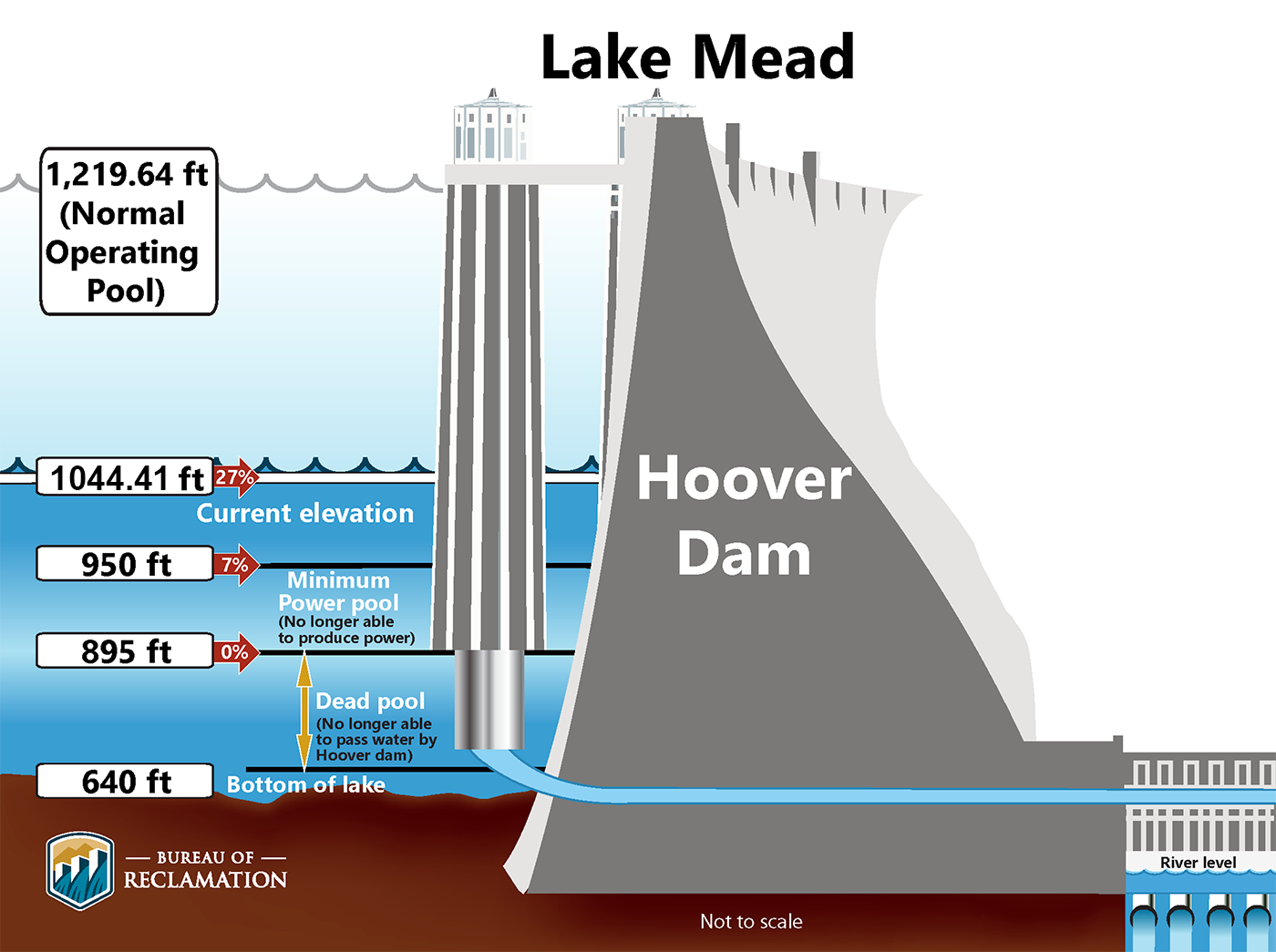
The current river management guidelines were developed in response to drought conditions in the first years of the 20th century and set shortage tiers based on reservoir levels that spell out which states in the Lower Basin will take cuts as levels fall. But these guidelines did not go far enough to protect reservoir levels from drought and climate change, and in 2022 Lake Powell flirted with falling below a critical elevation to make hydropower.
Lake Mead key elevations. Credit: USBR
Perhaps to spur the basin states toward a solution, in November, Reclamation released an outline of five potential paths forward, including a “No Action” alternative, which is unlikely to be chosen. None of the management options adopted either the Upper or Lower basin proposals, but instead include a “basin hybrid” that is a mash up of elements from both.
Proposed coordinated reservoir operations for Lake Powell and Lake Mead from Carly Jerla at the Colorado River Water Users Association Conference December 5, 2024.
Carly Jerla, a senior program manager with Reclamation gave an overview of each of the options Thursday and said the agency intends to publish a report with more detail on the alternatives by the end of the year. Maximum cuts could range from 2.1 million acre-feet to 4 million acre-feet and could be shared based strictly on priority of who has the oldest rights or distributed proportionally across all seven states.
Upper Basin officials said in a prepared statement that they cannot speak directly to Reclamation’s potential alternatives and need more information before they can analyze them.
“The Upper Division States continue to stand firmly behind the concepts embodied in the Upper Division States’ Alternative, which performs best according to Reclamation’s own modeling and directly meets the purpose and need of the federal action,” the statement reads.
The negotiators from the Lower Colorado River Basin states speak on a panel Thursday at the Colorado River Water Users Association Conference in Las Vegas. From left, panel moderator Jennifer Gimbel, John Entsminger of Nevada, Tom Buschatzke of Arizona and JB Hamby of California. CREDIT: LUKE RUNYON/THE WATER DESK
Reclamation officially kicked off the post-2026 guidelines development process in June 2023 with a Notice of Intent. The current guidelines expire at the end of 2026 and new ones must be in place by August of that year, meaning water managers have just over a year and a half to complete the National Environmental Review Act process for implementing new management rules.
“We have a year and a half left to identify a preferred alternative, put out a draft EIS, put out a final EIS, develop the implementation and adopt a record of decision,” Jerla said. “So we need to be moving as a basin a lot faster in the second half than we did in our first half.”
On their panel, Lower Basin representatives gave an overview of their proposed alternative, plus their water conservation tallies over the past two decades, some of which was forced by the shortage agreements under the current guidelines.
“We’re asking the Upper Basin to come with us to help further protect the river, but only in those really hot, dry (years),” said Tom Buschatzke, Arizona’s top negotiator.
At this year’s conference, there was talk about the longtime elephant in the room, something Colorado River water managers have previously said they want to avoid at all costs: litigation over the Colorado River Compact. Upper Basin water managers believe that as long as they don’t use more than the 7.5 million acre-feet allocated to them, they will not be in violation of the compact. But Lower Basin officials believe that regardless of the Upper Basin’s use, the upstream states could be subject to a compact call if they don’t deliver 7.5 million acre-feet a year.
As river flows continue to decline due to climate change, the basin states could be inching closer to a compact call, which could force cuts on the Upper Basin.
Buschatzke addressed his September request of Arizona Gov. Katie Hobbs to set aside $1 million for litigation in case of a compact call.
“Compact compliance is out there, it is a potential issue,” Buschatzke said. “I have to do my due diligence for all potential outcomes.”
But the principals remained committed to finding agreement among the seven states. Top Nevada negotiator John Entsminger said he wants the Upper Basin states to know he’s not looking for a fight.
“I want everybody from the Upper Basin to hear from Nevada: We believe compromise is possible,” he said. “We think it’s the first, second and third best option. But we need a dance partner. So let’s get back to the table and make this happen.”
Map of the Colorado River drainage basin, created using USGS data. By Shannon1 Creative Commons Attribution-Share Alike 4.0
At the second day of the Colorado River Water Users Association conference, the Bureau of Reclamation provided more details about its five proposed paths forward for post-2026 river operating guidelines. And both the Upper and Lower Basin states spoke openly about their frustrations in separate panels about talks that haven’t yielded compromises needed to sustain the system that provides water to more than 40 million people, including Las Vegas residents. Rather than considering the competing proposals set forth by the Lower and Upper basins this year, the bureau put together a “Basin Hybrid” plan that regulators feel is the beginning of a compromise. Some have suggested that the disagreement could result in a costly Supreme Court case against the federal government…
The fate of the Colorado River is something that would directly affect Southern Nevada, a region of the state that sources 90 percent of its water from Lake Mead. Scientists say the river has faced unprecedented shortages in the 2020s, with less water available for use than ever because of climate change and historic overuse. Thus, the need for sweeping changes to 2007 operating guidelines that will no longer apply in 2026.
The structural deficit refers to the consumption by Lower Basin states of more water than enters Lake Mead each year. The deficit, which includes losses from evaporation, is estimated at 1.2 million acre-feet a year. (Image: Central Arizona Project circa 2019)
Depending on how conversations proceed, the Lower Basin states of Nevada, California and Arizona could continue to bear the brunt of mandatory cuts to their allocations from the river. The Lower Basin has proposed basin-wide cuts should a shortage exceed 1.5 million acre-feet, the amount of water known as the “structural deficit” that the river loses to evaporation and transport…The Upper Basin states of Colorado, New Mexico, Utah and Wyoming have argued that declining snowpack and a lack of reservoir storage already set them back 1.2 million acre-feet. Northern states have floated putting more dams and reservoirs on the river that could, in total, store the equivalent of Nevada’s allotment from the river.
“We really need to understand that the enemy we’re battling right now is not the Upper Basin; it’s not the Lower Basin. It’s hydrology,” said Brandon Gebhart, Wyoming’s state engineer and Colorado River negotiator. “All of the rhetoric and other distractions going on right now are [bullshit]. It needs to stop.”
Carly Jerla’s summary slide at the Colorado Water User’s Association Conference December 5, 2024.
Most who work on the Colorado River concur: A courtroom is the last place decisions about water should be made. But as total agreement between the Upper and Lower Basin seems more like a pipe dream with each passing month, a court battle has become a possibility while U.S. states, Native American tribes and Mexico chart a path forward as operating guidelines for the river expire in 2026. It would be an expensive, decadeslong legal fight against the Bureau of Reclamation’s decision that would likely make its way to the Supreme Court. At the annual Colorado River Water Users Association conference in Las Vegas on Wednesday, a panel of legal experts who have worked on interstate water cases spoke about the challenges such a case might bring. The bottom line: Engineers are far better equipped to solve water issues than judges, and all efforts should be made to keep post-2026 Colorado River negotiations out of the courtroom.
“The court has a limited understanding of technical water cases,” said Jeff Kightlinger, ex-general manager of the Metropolitan Water District of Southern California. “It has a very limited ability to draft nuanced, long-term solutions.”
[…]
“New plot using the nClimGrid data, which is a better source than PRISM for long-term trends. Of course, the combined reservoir contents increase from last year, but the increase is less than 2011 and looks puny compared to the ‘hole’ in the reservoirs. The blue Loess lines subtly change. Last year those lines ended pointing downwards. This year they end flat-ish. 2023 temps were still above the 20th century average, although close. Another interesting aspect is that the 20C Mean and 21C Mean lines on the individual plots really don’t change much. Finally, the 2023 Natural Flows are almost exactly equal to 2019. (17.678 maf vs 17.672 maf). For all the hoopla about how this was record-setting year, the fact is that this year was significantly less than 2011 (20.159 maf) and no different than 2019” — Brad Udall
The breakdown of talks between the Upper and Lower Basin states has centered on whether the Upper Basin states should be required to take cuts to their allocations from the river as climate change reduces water availability…Arizona’s [Tom Buschatzke], however, has publicly signaled that the state is eyeing $1 million in state funds to retain a lawyer if it becomes necessary. But that doesn’t mean leaders are satisfied with that option.
“I do not want litigation. There is uncertainty with litigation,” Arizona Department of Water Resources Director Tom Buschatzke said at a meeting earlier this year. “We see that in other basins, with judges running rivers. It’s not good for anybody.”
View of Shoshone Hydroelectric Plant construction in Glenwood Canyon (Garfield County) Colorado; shows the Colorado River, the dam, sheds, a footbridge, and the workmen’s camp. Creator: McClure, Louis Charles, 1867-1957. Credit: Denver Public Library Digital Collections
Click the link to read the article on the Steamboat Pilot & Today website (Ali Longwell). Here’s an excerpt:
November 29, 2024
Last week, the governmental entity created to represent Western Slope water users submitted its 600-page application for $40 million from the Inflation Reduction Act, which allocated $4 billion toward drought mitigation efforts. The application falls under the Bureau of Reclamation’s Upper Colorado River Basin Environmental Drought Mitigation funding opportunity, also known as the Bucket 2E funding. The $40 million would go a long way toward the $98.5 million needed for the Colorado River District to purchase the water rights from Xcel Energy. So far, the district has raised around $56.9 million from the state legislature, its board and the various Western Slope municipalities and utilities it serves.
While the district’s request for federal dollars has received support from the majority of Colorado’s federal congressional delegation, the Inflation Reduction Act is likely to be targeted by Trump as he takes office in January. While the president-elect is unlikely to repeal the Inflation Reduction Act completely, he has promised to rescind any unspent funds under the act. The bureau is expected to award the Bucket 2E grants in the spring…Regardless of this uncertainty, Amy Moyer, the Colorado River District’s director of strategic partnerships, said the district “remains steadfast in its commitment to securing the Shoshone water rights and protecting the long-term health of the Colorado River.”
Breaking news! The Lower Colorado River Basin is threatening the Upper Basin with a ‘Compact Call’ if it does not agree to share some major cuts in river use! Well, actually the news broke a week ago – and now there’s more news: just as I was wrapping this analysis of the ‘Call’ up yesterday, the Bureau put out for our consideration five options for river management up to and beyond the 2026 termination of the ‘Interim Guidelines.’
So we’ll interrupt our out-of-the-box exploration for management options for living with a desert river in an intelligent universe, and try to figure out what’s going on back in the surreal world of the ‘Compact box’ – looking at the ‘Call’ situation here, then get into the five management options in a couple weeks after the dust has settled.
The Lower Colorado River Basin has attempted to break the stalemate between the two Compact-designated Colorado River Basins, by telling the Upper Basin that, if they do not agree to share some major cuts when the river situation grows desperate again, then in that desperate time they will issue a ‘Compact call’ on the Upper Basin to deliver the whole 7.5 million acre-feet (maf) on average they claim the Compact obligates the Upper Basin to deliver regardless of the water situation upriver.
There has been no formal Upper Basin Commission response to that threat, but Colorado’s Commissioner, and director of the Colorado Water Conservation Board, Becky Mitchell, essentially called the bluff, and put the blame for Lower Basin problems back on the Lower Basin. The Upper Basin has argued that, if the situation becomes so desperate that the Lower Basin’ share cannot be delivered without draining Powell Reservoir, then the Upper Basin users will already be experiencing extreme shortages levied by nature.
This Hobson’s choice from the Lower Basin hinges on Article III(d) of the Colorado River Compact, which says, ‘The States of the Upper Division will not cause the flow of the river at Lee Ferry to be depleted below an aggregate of 75,000,000 acre-feet for any period of ten consecutive years.’ Does this mean, as Lower Basin states will argue, that the Upper Basin has a ‘delivery obligation’ of 75 maf over any ten-year period, regardless what is happening weatherwise in the Upper Basin? Or does it mean, as Upper Basin states are likely to argue, should argue, that if the flow to the Lower Basin were to fall below that 75 maf over a ten-year period due to circumstances other than human uses in the Upper Basin states (drought, dead pool in Powell Reservoir due to excessive releases, the atmosphere’s growing ‘evaporative demand,’ et cetera), causing ‘the flow to be depleted’ below the 75 maf minimum, then responsibility for the depletion does not fall on the water users in the Upper Basin, but on changing natural processes beyond human control. The Upper Basin could, maybe should, argue that this condition in the Compact is simply a reminder to Upper Basin users, to be careful in using their 7.5 maf half of the river (cue bitter laughter), to not infringe on the Lower Basin’s 7.5 maf half of the river.
And so far as the Compact goes, that reminder is all there is. Nowhere in the Compact is there any provision for a ‘Compact call,’ or any other procedure when or if the flow at Lee Ferry (the ‘Mason-Dixon line’ between the two Basins) were to fall below that 75 maf over ten years. A ‘call,’ the reader might remember, is an unneighborly procedure in the appropriations doctrine that remains the foundation of water law in all seven Colorado River Basin states: if downstream water users with senior rights are not able to get all of their appropriated water, they can place a ‘call’ on upstream users with junior rights, who have a legal obligation to let enough water go past their headgates to fill the seniors’ rights.
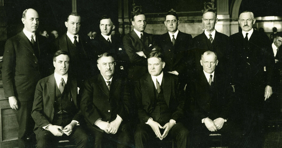
Members of the Colorado River Commission, in Santa Fe in 1922, after signing the Colorado River Compact. From left, W. S. Norviel (Arizona), Delph E. Carpenter (Colorado), Herbert Hoover (Secretary of Commerce and Chairman of Commission), R. E. Caldwell (Utah), Clarence C. Stetson (Executive Secretary of Commission), Stephen B. Davis, Jr. (New Mexico), Frank C. Emerson (Wyoming), W. F. McClure (California), and James G. Scrugham (Nevada) CREDIT: COLORADO STATE UNIVERSITY WATER RESOURCES ARCHIVE via Aspen Journalism
A seven-way division of the use of the river, however, proved to be nearly impossible. Each commissioner had come with the charge to protect their own state’s glorious future, to develop their vast acreage of potentially irrigable land, their mineral resources, et cetera. No factual studies existed to support the glorious visions. And when the water requirements for those visions were all added up, they would have required a river half again larger than even the overly optimistic flow numbers provided by the Bureau of Reclamation.
The Bureau hovered around the Compact meetings, eager to ‘make concrete’ the final purpose stated in that Compact preamble: ‘to secure the expeditious agricultural and industrial development of the Colorado River Basin, the storage of its waters, and the protection of life and property from floods.’ The Bureau wanted to build big dams on the Colorado River, and ‘expeditious agricultural and industrial development’ was the rational cloak the Bureau and the commissioners could throw on over the romantic urge to just take on the conquest of Fred Dellenbaugh’s ‘veritable dragon’ of a river.
Herbert Hoover, U.S. Secretary of Commerce and chair of the Compact Commission, and an engineer by training and romantic inclination, also wanted to build big dams. And when the commissioners grew frustrated at their failure to resolve an equitable seven-way split of the use of the river after several days of looking at magical numbers, he worked hard to keep them from just dropping the whole idea, reminding them that Congress would not approve funding for Colorado River projects until the seven states all felt satisfied that a share of the river would be there for them when they were ready to grow like California.
Still, he was unable to pull them together for a serious working meeting until November, nearly the end of the year they had given themselves to create their interstate compact. He was able to lure them with an idea he and Delph Carpenter, Colorado’s commissioner, had cooked up over the summer: instead of the currently impossible seven-way division based on vague visions, they would work out a two-way division, dividing the river into two Basins, the four tributary states mostly above the river’s canyon region as an Upper Basin, and the three states mostly below the canyons as a Lower Basin, and each Basin could have the use of half the river, to divide further among each Basin’s states at their leisure.
Holed up at the posh Bishops’ Lodge just north of Santa Fe, with 28 formal meetings in 11 days and who knows how many off-the-record breakfast and bar caucuses and drafting sessions, they came up with a Compact that no one loved, but six of the seven thought they could live with, to satisfy Congress that they were all on the same page.
The seventh state was Arizona. Arizona’s commissioner, W.S. Norviel saw from the start that this two-basin idea caged the thousand-pound gorilla, California, to the satisfaction of the four Upper States, but left his state in the cage with the gorilla. He signed off on the Compact – possibly so Hoover would let them go home – but his state legislature refused to ratify the Compact. And all the other six states only ratified it after months of persuasion that it was as good as they were going to get.
The Colorado River near Black Canyon before Hoover Dam. Photo via InkStain.
Congress, on the other hand, was sufficiently infected with the romance of conquest to be willing to ratify the Compact with only six of the seven states on board. The next step was the Boulder Canyon Project Act in 1928, clearing the way for the construction, begun under President Hoover, of Hoover Dam, Parker Dam, the Imperial Weir Dam and the All-American Canal – a massive project that was about the only thing happening in America in the Great Depression, and which was adopted by the Roosevelt administration as the model for the Public Works Program and several other New Deal programs to put America back to work on big visions.
But at the base of all that is the rushed and rickety Colorado River Compact, the ricketiness of which was acknowledged by most of the commissioners – and by Hoover himself, who in one of the later November compact meetings, summarized the emerging compact as ‘a temporary equitable division, reserving a certain portion of the flow of the river to the hands of those men who may come after us, possessed of a far greater fund of information; that they can make a further division of the river at such a time, and in the meantime we shall take such means at this moment to protect the rights of either basin as will assure the continued development of the river.’ (Italics added) If the legal and political infrastructure isn’t quite in place – never mind: go ahead and build the physical structure anyway.
We have the whole chain of laws, subsequent compacts, court decisions, interim guidelines and other fixes that have tried to shore up the Compact – the Law of the River – but nothing that really addresses the matter of the 7.5 maf promise to both basins that the river cannot support – and that the Lower Basin now seems to be considering, on the basis of that Article III(d) obfuscation, as an appropriated right that the gives them a kind of seniority over the Upper Basin.
Isn’t that what this ‘Compact Call’ threat is? Hasn’t the Lower Basin essentially tried to graft the Compact onto the appropriations doctrine in order to threaten the Upper Basin with a ‘Compact call,’ despite the expressed intent of the Compact to create an equitable division that would preclude post-Compact appropriation calls between states?
I’ll leave it there, hoping that someone with a greater fund of information can explain this to me. Watch the ‘Comments’ section here.
And then we’ll dig into the Bureau’s recommendations in a week or two. And forget, for the time being, trying to think outside the Compact box; it demands our attention, love it or not.
Colorado River “Beginnings”. Photo: Brent Gardner-Smith/Aspen Journalism
“New plot using the nClimGrid data, which is a better source than PRISM for long-term trends. Of course, the combined reservoir contents increase from last year, but the increase is less than 2011 and looks puny compared to the ‘hole’ in the reservoirs. The blue Loess lines subtly change. Last year those lines ended pointing downwards. This year they end flat-ish. 2023 temps were still above the 20th century average, although close. Another interesting aspect is that the 20C Mean and 21C Mean lines on the individual plots really don’t change much. Finally, the 2023 Natural Flows are almost exactly equal to 2019. (17.678 maf vs 17.672 maf). For all the hoopla about how this was record-setting year, the fact is that this year was significantly less than 2011 (20.159 maf) and no different than 2019” — Brad Udall
Click the link to read the article on the Associated Press website (Tom Howarth). Here’s an excerpt:
As the American Southwest grapples with a historic water crisis, some advocacy groups, such as the Glen Canyon Institute (GCI), propose drastic measures like draining Lake Powell to address the diminishing flow of the Colorado River. However, Arizona’s top water official, Tom Buschatzke, has warned that this approach could exacerbate the problem rather than resolve it. Buschatzke, the director of the Arizona Department of Water Resources, outlined the risks of removing Lake Powell from the equation in the broader water management system. His argument underscores the importance of maintaining the reservoir as a buffer against the volatility of the Colorado River’s flow.
“Bigger reductions in the flow of the river that might attend to climate change are something that is being looked at,” Buschatzke told Newsweek. “But if you take Lake Powell out of the equation, the yield of the system is going to go down.”
[…]
“There will be wet years in which you won’t have storage to save the water,” he said. “So the overall yield over a longer-term average has to go down without Lake Powell. That means you have less usable water, and that might not be the outcome you’re trying to achieve.”
The proposal to drain Lake Powell also highlights a broader philosophical divide in water management: incremental fixes versus transformative changes. According to Buschatzke, large-scale reforms, while potentially impactful, are fraught with challenges…Groups like the GCI disagree with Buschatzke, arguing that bypassing Glen Canyon and adopting a “Fill Mead First” policy could not only help manage water in the system more effectively but also recreate the landscape lost when Glen Canyon Dam was first constructed in the 1960s. As the levels of the lake have receded in recent years, plants and animals have reclaimed in the shores in what’s been dubbed an “ecological rebirth.”
The All American Canal, the largest diversion on the Colorado River, passes through Winterhaven, CA on its way to the Imperial Valley. The Colorado River is seen flowing next to it.
The Biden administration on Wednesday released four alternatives to address the drought-stricken Colorado River’s water shortages, giving seven states, 30 tribes and the 40 million people who rely on the river a taste of how the vital waterway will be managed in the coming decades.
But the announcement offers little in the way of hard details, with a draft environmental impact statement analyzing the impacts of the Department of Interior’s proposed alternatives pushed back to next year. The states, meanwhile, remain divided over the path forward to deal with shortages on the river. Over the past year, the seven Colorado River Basin states—Arizona, California, Colorado, Nevada, New Mexico, Utah and Wyoming—along with tribes and the federal governments have been in negotiations over the “Post-2026 Operations” for the river that will dictate how to deal with water shortages. The river’s current drought guidelines, drafted in 2007, will expire at the end of 2026.
“We continue to support and encourage all partners as they work toward another consensus agreement that will both protect the long-term stability of the Colorado River Basin and meet the needs of all communities,” said Laura Daniel-Davis, the acting deputy secretary of the Department of Interior. “The alternatives we have put forth today establish a robust and fair framework for a Basin-wide agreement. As this process moves forward, the Biden-Harris administration has laid the foundation to ensure that these future guidelines and strategies can withstand any uncertainty ahead, and ultimately provide greater stability to the 40 million water users and the public throughout the Colorado River Basin.”
The river that enabled the Southwest’s rapid growth and vital agricultural production has seen its flows diminished roughly 20 percent over the past two decades by a megadrought. Climate change and years of overuse of the river’s resources have led the system’s massive reservoirs—lakes Mead and Powell—to fall to just a third of their capacities. That prompted steep cuts in allocations of the river’s water to Arizona, California and Nevada, and tense negotiations over its future. Further declines at the reservoirs could cause their respective dams to reach minimum power pool, where they can no longer generate electricity, or dead pool, when the water drops too low to flow through the concrete dams’ plumbing.
The Colorado River Basin is regulatorily split in two. The Upper Basin consists of Colorado, Wyoming, Utah and New Mexico. The Lower Basin is composed of Arizona, California and Nevada, which historically has used more of the river. Under the 1922 Colorado River Compact, which divided up the river’s resources and is the bedrock document for how it is governed, the Upper Basin is required to allow the Lower Basin states’ allocation of water to flow downstream before it can use its half of the river. If the Upper Basin fails to send the required amount of water, its own allocation could be cut.
Earlier this year, each basin submitted its own proposals for how it would manage the river’s water post-2026, but there was little agreement between their plans. The Upper Basin argued that, since it does not have large reservoirs and its users already have to make cuts anytime there is drought, it should be able to send less water downstream and the Lower Basin should bear responsibility for cutbacks. Under the Lower Basin’s proposal, all users would be forced to take cuts based on the total amount of water held in eight reservoirs across the entire system. Meanwhile, tribes have submitted their own proposals and comments, as have environmental groups.
The two basins remain deeply split, and though both sides are committed to coming to an agreement, it’s possible that the question of how Colorado River water will be divided and distributed between the basins will have to be settled in court, KUNC reported earlier this week. The Upper Basin representatives also maintain it has the right to take more water out of the river, given it does not use its full share, something that’s drawn the ire of its lower basin counterparts, environmental groups and water attorneys.
The Interior Department will analyze the four options presented Wednesday in an environmental assessment, with a final decision planned for 2026 on how to advance the process the Biden administration began and that President-elect Donald Trump’s administration will have to take over. One alternative is the federal government’s plan to “achieve robust protection of critical infrastructure,” like Hoover and Glen Canyon dams and the large amounts of hydropower they produce, along the river. Another combines that plan with comments from tribes and others. A third follows a proposal submitted by environmental groups, while the fourth combines the proposals of the states and tribes.
“Big picture: There’s still a lot of conflict about how Lake Powell will be managed,” said Kyle Roerink, the executive director of the Great Basin Water Network. A key difference between the alternatives is how water would be released from Lake Powell, the massive reservoir in the middle of the river system. He said the Upper Basin’s proposal would use it as a “piggy bank” to store water for them while the Lower Basin, which has priority rights to the water, wants to see it used to deliver what it is owed by the upstream states.
The states themselves say it will take time to fully analyze the proposals put forth by the Bureau of Reclamation, which oversees the river’s management, but neither side seems excited about the options, though they’ve admitted the need to continue working together.
“There are some really positive elements to these alternatives, but at the same time I am disappointed that Reclamation chose to create alternatives, rather than to model the Lower Basin states’ alternative in its entirety,” said Tom Buschatzke, the director of the Arizona Department of Water Resources, in a statement. “The Lower Basin’s alternative didn’t start at one extreme or the other, and it showed unequivocally that the Lower Basin was willing to take the first tranche of cuts.”
In a statement, Colorado River Commissioner Becky Mitchell said that “Colorado continues to stand firmly behind the Upper Division States’ Alternative, which performs best according to Reclamation’s own modeling and directly meets the purpose and need of this federal action.
“The Upper Division States Alternative is supply-driven and is designed to help rebuild storage at our nation’s two largest reservoirs,” she said. “The Alternative protects Lake Powell’s continued ability to release water downstream into the future to continue to meet our obligations and protect our significant rights and interests in the Colorado River.”
Roerink likened the Biden administration’s efforts to bring water users together as “herding cats” and said that Wednesday’s decision may help bring them back to the table to find a solution. But the divide between the two basins remains wide. “Change is scary,” he said.
This article originally appeared on Inside Climate News (hyperlink to the original story), a nonprofit, non-partisan news organization that covers climate, energy and the environment. Sign up for their newsletter here.
Audubon’s Jennifer Pitt testifies before Congress on Colorado River habitats. Photo: Caitlin Wall/Audubon
Click the link to read the release on the Audubon website (Jennifer Pitt):
November 20, 2024
The following is the oral testimony of Jennifer Pitt, Audubon’s Colorado River Program Director before a House Natural Resources Subcommittee on Water, Wildlife and Fisheries:
Chair Bentz, Ranking Member Huffman, and members of the Subcommittee, thank you for holding this hearing on proposed legislation addressing water management in the western United States. My name is Jennifer Pitt and I serve as the Colorado River Program Director for the National Audubon Society, with over 25 years of experience working on water issues in the Colorado River Basin. National Audubon Society is a leading national nonprofit organization representing more than 1.4 million members and supporters. Since 1905, we have been dedicated to the conservation of birds and the places they need, today and tomorrow, throughout the Americas using science, advocacy, education, and on-the-ground conservation. Audubon advocates for solutions in the Colorado River Basin that ensure adequate water supply for people and the environment.
Audubon supports H.R. 9515, the Lower Colorado River Multi-Species Conservation Program Amendment Act of 2024. The Program constructs habitats along the Colorado River below Hoover Dam, and that habitat is essential not only for the 27 species the program targets, but also for many of the 400 species of birds that rely on the Lower Colorado River, including Yellow-billed Cuckoos, Sandhill Cranes, and Yuma Ridgway’s Rails. Today, because the Program spending does not keep pace with the collection of funds from non-federal partners, about $70 million is held in non-interest-bearing accounts. If these funds were held in an interest-bearing account, the Program would have about $2 million in additional funds per year, and be more able to maintain program implementation in the face of increasing costs.
Audubon appreciates the inclusion of H.R. 9969 in this hearing. This bill directs Reclamation and the Western Area Power Administration, in consultation with the Glen Canyon Dam Adaptive Management Work Group, to enter into a memorandum of understanding to explore and address potential impacts of management and experimental actions to help control invasive fish passage in the face of drought and declining water levels. Rapidly changing conditions on the Colorado River warrant the experimental approach of adaptive management, with the Work Group bringing together varied interests to a consensus on how to protect downstream resources and strike a balance on river operations. Results of this collaboration include improved sediment flows that help maintain sandy beaches used by plants and animals that dwell in the floodplain, as well as by people traveling the canyon by boat.
The context for these bills is the current crisis on the Colorado River. Climate change continues to ravage the Colorado River Basin, which is now in its 25th year of drought. The forecast for this winter is for above-normal temperatures and below-normal snowpack, which could impact Colorado River water supply. With a 2026 deadline looming for the expiration of existing federal guidelines for operation of federal Colorado River infrastructure – with implications for water supply reliability for people and the river itself – human nature is creating unacceptable risks. Colorado River water managers are preparing for conflict to protect their share of an increasingly scarce water supply, rather than focusing on holistic solutions.
Earlier this year, Audubon joined with conservation partners in submitting to Reclamation our Cooperative Conservation Alternative for consideration in the post-2026 NEPA process for developing Colorado River Operating Guidelines. Cooperative Conservation is designed to improve water supply reliability, reduce the risk of catastrophic shortages to farmers and cities, create new flexible tools that can protect infrastructure, incentivize water conservation, help Tribes realize greater benefits from their water rights, and improve river health. We urge Reclamation and all Colorado River Basin parties to consider our approach as they proceed through the NEPA process.
From a bird’s eye view, the whole system matters. That needs to hold true for water users who must figure out how to share the Colorado River. The old adage applies: united we stand, divided we fall. The Colorado River community – in particular Upper Basin and Lower Basin interests – must stop thinking parochially and start thinking about how we survive drier times together.
I would like to thank Congress for funding water conservation programs, such as WaterSMART and the Cooperative Watershed Management Program, and the crucial funding in the Bipartisan Infrastructure Law and the Inflation Reduction Act, both of which include funding to improve the resilience of the Colorado River Basin. With this funding, and states working together, we have avoided a crisis, but we are still just one bad winter away from catastrophic shortages. To be effective, this funding needs to get out of federal coffers and into the hands of water users and water managers, to incentivize water conservation and efficiency, to improve the health of the forests and headwater streams that are the river’s source, and to stabilize the river itself – the natural infrastructure that supplies water to more than 40 million people. Congress will need to help in the future with additional funding to support continued resilience investments in the Colorado River Basin as warming continues.
Thank you very much for the opportunity to testify and I would be happy to answer your questions.
Water runs down a spillway at the Shoshone hydro plant in Glenwood Canyon. Rockfalls, fires and mudslides in recent years have caused frequent shutdowns of plant operations. Credit: Heather Sackett/Aspen Journalism
A $99 million plan to buy and permanently preserve some of the oldest water rights in Colorado is inching closer to securing all of its funding. But President-elect Donald Trump’s promise to gut climate spending could throw a wrench in the deal, despite its bipartisan support. The Colorado River District, which advocates on behalf of Western Slope water users, submitted a funding application today to the U.S. Bureau of Reclamation under a program for drought mitigation. The district is seeking $40 million from the federal agency to help purchase water rights from Xcel Energy, the state’s largest utility…
Since the agreement, around 25 Western Slope water providers, the river district and the state of Colorado have committed $56 million to purchase the water rights. The state’s water conservation board, much of Colorado’s congressional delegation, and a bipartisan group of state lawmakers support the plan. To make up the remaining funds, the river district is banking on money from the Inflation Reduction Act, the nation’s largest climate law, which was signed by Biden in 2022. Bureau of Reclamation records show the agency has $450 million remaining under the law to dole out to state, local and tribal governments in the upper Colorado River Basin for projects that offset the effects of drought and climate change…
That stream of federal funding for the Shoshone water deal has not yet been committed and could be in jeopardy, according to Martin Lockman, a law fellow at the Sabin Center for Climate Change Law. President-elect Trump said he would rescind any remaining funds from the inflation law when he returns to office. Project 2025, a conservative policy blueprint influential among the president-elect’s advisors, has called for repealing elements of the law.
Alamosa is continuing to piece together its Rio Grande recreation puzzle. With support from the city of Alamosa to pull back the levee to make way for a beach, the Alamosa Riverfront Project is taking a different shape. Support from the city will aid in helping bring the project to completion.
During a city council meeting earlier in November, councilors recognized that the project aids in the city’s “Activating the Rio Grande Corridor,” a top priority for the Parks and Recreation Department.
As the river’s oxbow loops lazily trickle ever southward to the Gulf of Mexico, deciphering how to ensure people can access the river, how the river can maintain its natural biodiversity, and how to prevent thousands from losing their homes in a “100-year” flood make it a daunting and sharp puzzle.
Proposed changes to levee location and riverfront access Credit: JUB Engineering
The Alamosa Riverfront Project is looking to expand recreation access and improve river restoration from the State Avenue Bridge, upstream of Alamosa’s Cole Park, to the West Side Ditch, downstream of Cole Park. It’s a multi-million dollar project that, so far, has received overwhelming support from the community, according to project planners and members of the community who showed up at a series of summer community meetings.
You may be able to take the town from the river, but the river will continue to flow through town.
The project is looking to connect people back to the Rio Grande, not through adrenaline-pumping white water, but instead by leveraging its natural geographic limitations.
Brian Puccerella, San Luis Valley Great Outdoor’s outdoor recreation manager, has been involved in this project since about 2016. That’s when the conversation about expanding access to paddlers, maybe adding a play wave, and just expanding recreation generally started making the rounds.
The conversation was about “what was possible in our stretch of river in town,” Puccerella said. “We didn’t know the answer to that.”
An engineering study was funded in 2017 to look at what was possible.
“The conclusion,” he laughed, “was not much. It’s pretty flat and we don’t have a lot of flow. That doesn’t mean there isn’t going to be recreational improvement.”
The study equates Alamosa’s stretch of low-flowing river, less than one mile per foot downhill through town, to a “skinny lake.”
Puccerella explained that Alamosa’s portion of the river doesn’t have the flows or drops to ever get whitewater, even in a good year. A lot of the water that flows from the mountains into the river is diverted to different systems throughout the San Luis Valley. By the time the river reaches Alamosa, its flows are quite slow.
What we do have, he said, is flatwater.
That’s not a negative, though. “It creates opportunity for family-friendly recreation.”
Construction is still a ways out. Alamosans can expect construction to begin sometime around fall 2026. A lot of money still needs to be raised, and a lot can happen between now and then. What planners won’t have to worry about is the Army Corps of Engineers’ levee recertification.
Credit: The Alamosa Riverfront Project
BEACHFRONT PROPERTY
When construction is finished, the western levee, the side of the river adjacent to Cole Park, will be pulled back and a highly accessible riverfront beach will be added. Right now there’s a fairly steep, unfriendly drop to the water. In the future, there will be easy access for everyone.
The Rio Grande Headwaters Restoration Project is heading up the funding and providing the support to engineers throughout the project’s timeframe. During the summer, the group held two community feedback meetings to both inform and learn. From those meetings, project planners were able to adjust the plans.
Final plans will be revealed to the public in early 2025. These preliminary renderings can give us a hint, however.
“We’re doing this because this is what the community wanted,” said Cassandra McCuen, program manager for the Rio Grande Headwaters Restoration Project. She called the project “amazing and transformative.”
McCuen and Puccerella joined Outdoor Citizen podcast host Marty Jones to talk more about the project and provide updates. You can listen to that episode here, or wherever you get your podcasts.
From those community meetings, project planners were able to incorporate community feedback. Two of the most important pieces of feedback for engineers and designers: ensuring as much of the project is ADA accessible as possible, and making sure the river and beachfront are safe.
Access from Cole Park will be a priority, as it will serve as a kind of hub. The project calls for a few more boat ramps, adding to the two Alamosa currently has. These boat ramps won’t be for motorboats, but personal watercraft such as paddle boards, tubes, kayaks, and canoes.
Increasing recreational potential increases recreational safety. Currently, Puccerella and McCuen said, floating south of Cole Park isn’t advised. The West Side Ditch Diversion and the railroad bridge are a bit of a snag of willows, rusty metal, and splintered wood.
Rio Grande at location of Alamosa Riverfront Project. Photo credit: Owen Woods
INSIDE THE LEVEE
“Inside the levee it’s more complicated,” McCuen said.
When it comes to changing the levee or potentially changing how water flows through town, you answer to the Army Corps of Engineers.
The Corps is responsible for ensuring that levees don’t fail during a proverbial “hundred-year flood.” Alamosa has a history of regular and devastating flooding. The levee system protects Alamosa proper and East Alamosa. Without a certified levee system, property owners are required to pay for flood insurance.
The recertification process is still many years out. The riverfront project is just a few years out. McCuen said the city has been an amazing partner in supporting the project.
With that in mind, project planners were able to meet with the Army Corps of Engineers and provide them with a full rundown of the project, plus the support of the city of Alamosa, and their proposal to pull the levee back.
McCuen said it was a real point of concern, because the project planners were unsure of how the Corps would react to the project’s proposal of pulling the levee back and the inner-levee restoration work.
McCuen said they were finally able to meet with the Army Corps in August. During that meeting, the Corps told the project planners they would be willing to work with them, “as long as you do not impact the flows through Alamosa negatively.”
Pulling the levee back to make way for a beach won’t impact flows in a noticeable way.
“Our project has worked seamlessly with the work that’s gone into levee recertification,” she said.
Fish species thought to be present at Cole Park, based on CPW fish surveys. Credit: The Alamosa Riverfront Project
FISH PASSAGE
People are not only getting an upgrade, but so are the wildlife. This project is unique and special to Alamosa through both its recreation and restoration efforts. McCuen said the attempt is to improve the natural condition of the Rio Grande through town alongside increasing its recreational value. From the planning phase onward, restoration has been at the forefront of the project.
In-town restoration work can be complicated due to the levee recertification, but also due to the geographical limitations Puccerella mentioned. The river is extremely confined, McCuen explained.
Part of that confinement is because the Rio Grande is a very developed river. For example, diverting the Rio Grande’s flow before it reaches Alamosa creates that low flow prime for paddling and floating, but it also makes the water warm.
Warm water is bad for the Rio Grande’s fish. “Super-duper low flows make the area hot,” McCuen said. So one of the major aspects of the restoration portion is creating a safe, cool fish passage.
“We want fish to be able to flow upstream and downstream.”
The fish passage would simply be deeper channels that fish would use as aquatic highways. Also needed are fish refuges, or backwater habitats that exist along the river to serve as places where native fish can take refuge from non-native carp and pike.
Restoring the Rio Grande will take time and effort, but connecting the people back to the river is a start.
“We really wanted to create a project that spoke to the culture of Alamosa, spoke to the community, is something the community wanted, and I think we’re gonna get there because people took time out of their day to be involved in all this,” McCuen said.
We can all agree that we literally can’t survive without water. The real controversy arises from how we should manage this precious resource.
Ultimately, it comes down to working together. That’s why the theme of the 2024 Water in the West Symposium was “Building Bridges: Collaborative Water Action.” The Nov. 14 event at the Colorado State University Spur campus in Denver brought together more than 150 stakeholders representing everything from the state and federal government to academia and tribal nations.
“We often overlook acres of common ground to focus on less significant differences,” CSU Chancellor Tony Frank said in his opening remarks. “I think with water and in conversations like this one … offer us a path toward unity.”
And during a day filled with panels discussing diverse topics, ranging from agriculture to state water planning and finance, one common theme rang through: progress through collaboration isn’t always easy, but it is possible.
Here are some of the key takeaways.
Teams should create spaces for listening and dissent
Keynote speaker Michaela Kerrissey, an assistant professor of management at the T.H. Chan School of Public Health, focuses much of her research on helping teams solve difficult problems.
“Part of it is about not getting stuck in the problem but figuring out what the solution is,” Kerrissey said.
Finding solutions to problems is a good common goal, and having this sense of purpose is a good anchor to a strong team, Kerrissey said. Another key? Creating a space where everyone feels empowered to speak up – including those who might disagree with the overall consensus.
“The idea behind this is that likely in all of our organizations and all of our teams, great ideas get left behind because the culture doesn’t come with a space to come forward, be heard, and be taken seriously,” she said.
Kerrissey was the first speaker of the day. Martin Carcasson, the founder and director of the CSU Center for Public Deliberation, was the last, and he too focused his remarks on how allowing for disagreement can ultimately lead to better results.
“For divergent thinking, we need to get beyond the usual suspects and status quo and hear all the voices,” he said.
That’s easier said than done. And in an at-times polarized world, his hope is that we create more spaces that allow this to happen.
“We have so many organizations that are designed to divide us, we need organizations that are designed to bring us together,” Carcasson said.
Solving grand problems requires empathy
Meagan Schipanski, an associate professor in the Department of Soil and Crop Sciences at CSU, said science is really good at defining problems. Solving them requires more of a human touch.
“As a biophysical scientist, I’ve become increasingly convinced that we need to lead with the humans, the stories, the contexts in all these situations,” she said.
Center pivot sprinklers in the Arikaree River basin to irrigate corn. Each sprinkler is supplied by deep wells drilled into the High Plains (Ogallala) aquifer.
She pointed to her efforts to engage with stakeholders working to preserve the Ogallala Aquifer, and the varying motivations and struggles of everyone involved.
Sunset September 10, 2024 in the San Luis Valley. Photo credit: Alamosa Citizen
Heather Dutton, the district manager for the San Luis Valley Water Conservation District, shared similar lessons from her efforts engaging with farmers and ranchers.
“We realized the environmental community and farmers have a lot in common – we rely on the river as one of the key economic drivers of our region, we rely on it for happiness,” she said. “The thread of realizing we all have so much in common has enabled us to have robust and collaborative projects to think about all the different uses and benefits.”
South of Hesperus August 2019 Sleeping Ute Mountain in the distance. Photo credit: Allen Best/The Mountain Town News
Manuel Heart, the chairman of the Ute Mountain Ute tribe in southwestern Colorado, also shared the importance of getting to know the people involved in different sides of a problem.
“I’m hoping to bring education to each of you, education about who we are as a native people, as a Ute Mountain tribe, and to have the respect to be able to speak freely and bring the challenges we face, and also gain trust and partnership,” he said. “You have to feel those feelings of not just one ethnic group, but other ethnic groups.
“You need that empathy to feel what is going on.”
Building strong relationships requires trust and a common goal
Nobody will be able to solve the water crisis alone. That’s why the Water in the West Symposium featured panelists representing everything from state-level water conservation groups to NGOs to private companies.
All of them shared stories about how they’ve worked together to solve problems in their region, and a common thread from all of these successes? Trust.
Autumn view of the wetlands and cottonwood groves in the Yampa River basin at Carpenter Ranch, located west of Steamboat Springs, Colorado. Photo courtesy of The Nature Conservancy
“I think that uncertainty leads to misinformation, and all the sudden it’s us against them, and you have disagreements between downstream water users versus upstream ones, and everything in between,” said John Ford, the water projects manager for agriculture at the Nature Conservancy Arizona. “When you can get people together and be really clear, you can mitigate some of the risk and distrust. That’s when collaborations happen.”
Russ Sands, the section chief for water supply planning at the Colorado Water Conservation Board, said it’s clear that something needs to be done – it’s just a matter of rallying people around that common goal.
West Fork Fire June 20, 2013 photo the Pike Hot Shots Wildfire Today
“We know water has a massive impact on the hazards in this state … the cycle of drought, more things catching on fire … it has devastating consequences, and that really stacks up on our impact and need for action,” he said. “We need to move to a place where we’re talking and need to take care of each other and work together.”
Jocelyn Hittle at CSU Spur Water in the West November 2024. Photo credit: CSU Spur
There’s a lot of room for hope
Working together isn’t always easy, but it is possible – and that lesson applies to so much more than water.
“We really liked the idea of bringing people together to talk about collaboration, to showcase what’s happening on the ground,” said Jocelyn Hittle, the associate vice president for CSU Spur. “Deliberation is what makes our American democracy experiment very strong, and very alive, and very dynamic.”
Carcasson, who speaks to groups across Northern Colorado about how to have collaborative conversations, said he was encouraged by hearing panels throughout the day and realizing that there was already a strong dialogue surrounding Water in the West.
Updated November 20, 2024 to include video of the lecture.
Ms. Mulroy’s lecture yesterday evening focused on increasing water supply in the Lower Basin (after setting the stage with the reality of a declining Colorado River due to climate change). One solution she offered was a pipeline from northwest Mexico to the Imperial Valley. The water would be used to replenish the Salton Sea and then be desalted for irrigation to lessen the diversion of water from the Colorado River in the Imperial Valley. The Imperial Irrigation District holds the largest water rights on the river and is an important source of food for the U.S. so her solution is an attempt to keep them in production and also cutting Lower Basin diversions.
She acknowledges the costs involved and the problem of disposing of the brine but is convinced that conservation, while very important, cannot solve the crisis of a declining supply in the basin. She has observed desalination in the Middle East where it is piped across the landscape to meet demands. This is the solution that Cape Town has embraced since nearly hitting “Day Zero” a few years ago during a particularly long and deep drought.
Augmentation of the Lower Basin water supply would benefit the entire basin, she maintains, taking pressure off the Upper Basin which already shoulders the burden of reduced water supplies during drought years.
Desalination plant, Aruba, December 2004.
The 2024 Norm Evans Lecture was hosted by the Colorado Water Center at CSU Spur and featured distinguished speaker Pat Mulroy. Mulroy, former general manager of the Southern Nevada Water Authority and negotiator for the state of Nevada on the Colorado River, discussed the challenges and opportunities for the Colorado River Community at the intersection of law and climate change.
“Not a great year,” is how Colorado Division of Water Resources Division 3 Engineer Craig Cotten summed up the flows on Rio Grande and Conejos River systems this water year which ended Nov. 1.
The Rio Grande had an estimated annual flow of 485,000 acre-feet or 78 percent of the long-term average, while the Conejos River had 238,000 acre-feet or 79 percent of the long-term average, according to figures Cotten presented this week to Rio Grande Basin Roundtable members.
Under the Rio Grande Compact with New Mexico and Texas, Colorado will be obligated to deliver an estimated 122,500 acre-feet from the Rio Grande and 67,800 acre-feet from Conejos River downstream into New Mexico and its storage at Elephant Butte Reservoir.
“We are delivering all the water we have in the system to the state line,” Cotten said, noting that with the water year now ended there is 100 percent curtailment on the Rio Grande and Conejos River systems.
Platoro Reservoir. Photo credit: Rio de la Vista
Getting into the fine details of the Rio Grande Compact, Cotten said Colorado is not storing any water from this year at Platoro Reservoir in Conejos County due to Article 7 of the compact. Platoro Reservoir is a post-compact storage reservoir which Colorado can’t utilize this year because storage of a usable water supply at Elephant Butte and Caballo Reservoir in New Mexico has potentially dropped below 400,000 acre-feet.
“Article 7 of the Compact is in effect and that restricts our ability to store in post-compact reservoirs. So we are not currently storing additional water in Platoro Reservoir,” he said.
The irrigation or water season in the Valley typically runs from April 1 to Nov. 1 and is primarily reliant on snow runoffs in the springtime from the surrounding San Juan and Sangre de Cristo ranges. The runoffs feed into the creeks and streams that come together to form the Rio Grande.
A lack of consistency in snowfalls over the past two decades and the warming of the southern end of Colorado compared to the state’s northern frontiers has San Luis Valley irrigators constantly working to figure out how to farm and ranch in a climate of aridification.
“The forecast is for the northern areas to get more snow than the southern areas,” Cotten said in looking at the outlook for 2024-25 winter.
Native America in the Colorado River Basin. Credit: USBR
Click the link to read the article on the InkStain.net website (Eric Kuhn, Rin Tara, and John Fleck):
November 5, 2024
The pending Northeastern Arizona Indian Water Rights Settlement Agreement settles Navajo Nation, Hopi Tribe, and San Juan Southern Paiute Tribe claims to the Upper Colorado River Basin in Arizona. To do so, Arizona’s 50,000 AF entitlement of Upper Colorado River Basin water will be allocated.
Although Arizona’s testimony during the ratification of the 1948 Upper Colorado River Basin Compact indicated that Arizona’s cut would be used for tribes, Arizona fashioned the deal to benefit the Central Arizona Project. Charles A. Carson, Arizona’s Upper Basin Compact Commissioner, originally requested 136,200 AF/yr for Arizona in the negotiation but ultimately accepted 50,000 AF/yr in the interest of sweetening the deal for the rest of the states to sign on to stream depletion theory as the means for measuring system use. Stream depletion theory, under Arizona’s interpretation of the 1922 Colorado River Compact allowed Arizona to consume two million acre-feet per year on the Gila River system, while only being charged for one million acre-feet of compact apportionment.
This theory, in combination with the Upper Basin relationships strengthened by Carson’s choice to accept only 50,000 AF/yr, is what Carson envisioned would be used to convince Congress Arizona had a sufficient legal water supply for the Central Arizona Project. The CAP project was approved in 1968 and completed in the 1990s, though tribal water in Arizona’s northeast corner was not quantified. Even after CAP was built, a portion of the power generated at Navajo Generating Station, which consumed a significant portion of that 50,000 AF/yr apportion, powered the pumps that transported CAP water from Lake Havasu to central Arizona.
Eight decades after Arizona acknowledged that the 50,000 AF of Upper Colorado River Basin water was destined for tribes, Congress is on the cusp of approving the settlement that would resolve some water rights for Navajo Nation, Hopi Tribe, and San Juan Southern Paiute Tribe. This settlement is critical and long overdue, especially considering Arizona’s acknowledgement of tribal entitlement in the 1940s.
The “backstory” behind Arizona’s 50,000 acre-feet of Upper Basin water.
At the recent Water Education Foundation Colorado River meeting in Santa Fe, we heard an update on the status of Congressional approval of the water rights settlement among Arizona the Navajo, San Juan Southern Paiute and Hopi nations. Among other things, the settlement divides up the use of the 50,000 acre-feet of water apportioned to Arizona by the 1948 Upper Colorado River Basin compact. How Arizona ended up with 50,000 acre-feet of Upper Basin water is a fascinating story. At first blush, it may seem somewhat arbitrary, but the reality is that it was based on a well-conceived and executed strategy by Arizona’s negotiators At the time, the deal was cut, Arizona’s negotiator made clear that the only likely users of the water would be Native American communities in northeast Arizona. The deal was not designed for their benefit, but rather for the ultimate benefit of Arizona’s quest to build the Central Arizona Project.
While Arizona’s motives may have focused entirely on cutting an interstate deal to enable construction of the CAP, the state’s leadership were frank in acknowledging that the only people who might put Arizona’s Upper Basin allotment to use where Native Americans.
“There is not much possibility of using water on that land except … on the Navajo Reservation,” Arizona’s Charles A. Carson told members of Congress during the 1949 Upper Basin Compact hearings.
Colorado River Allocations: Credit: The Congressional Research Service
The 1922 Colorado River Compact divides the basin into two sub-basins: the Upper Basin and the Lower Basin. The dividing point is Lee Ferry, located in Northern Arizona, a mile downstream of the confluence of the Colorado and Paria Rivers. Lands that drain into the Colorado River above Lee Ferry are in the Upper Basin, including about 7,000 square miles of lands in northeastern Arizona. Today all but a small portion of these lands are located on the Navajo reservation. Likewise, both Utah and New Mexico have lands that drain into the river below Lee Ferry. The Upper Gila River in New Mexico and Kanab Creek and the Virgin River in Utah are Lower Basin streams.
Although Arizona has lands in the Upper Basin, it is not a State of the Upper Division, a critically important distinction under the 1922 Compact. As a state with Upper Basin lands, Arizona in entitled to use some portion of the beneficial consumptive use apportioned to the Upper Basin under Article III(a) of the 1922 Compact, but since it is not a State of the Upper Division, it does not share in the joint obligations of the Upper Division States to provide certain flows at Lee Ferry under Articles III(c) and III(d). This is a nuance the negotiators of the 1948 Upper Basin Compact understood from the get-go (UCRBCC Official Record, 1st meeting, pages 25-26).
Arizona’s Upper Basin Compact Commissioner was Charles A. Carson. He was the state’s special counsel for Colorado River matters. Carson, an accomplished lawyer and skilled negotiator, began representing Arizona in the mid-1930s. By the 1940s, Arizona’s top water priority was obtaining Congressional approval of the Central Arizona Project (CAP). Carson negotiated the 1944 contract between Arizona and the United States for 2.8 million acre-feet of Hoover Dam water. He orchestrated his state legislature’s ratification of the Colorado River Compact a few weeks later. In 1945 he chaired the legal sub-committee of the Six-State Committee that successfully lobbied for Senate ratification of the 1944 Water Treaty with Mexico. During this time, he became a close associate and friend of Colorado’s Clifford Stone and Royce Tipton. Stone was Colorado’s Upper Basin Compact Commissioner, its first Executive Director of the Colorado Water Conservation Board, and the long-time chair of the Committee of Fourteen that advised the U.S. State Department on the treaty negotiation with Mexico. Tipton was a consulting engineer that worked for Colorado on four major interstate compacts. He was an engineering consultant to the State Department during the negotiations of the 1944 Treaty. With Stone’s blessing, Carson hired Tipton to help with Arizona’s efforts to advance the Congressional approval of the CAP.
Carson’s appointment as Arizona’s Upper Basin Compact Commissioner was likely welcomed by the negotiating teams from the other states. He was designated as Chair of the Commission’s Legal Committee, which would ultimately make numerous recommendations to the Commission on the language and structure of the Upper Basin Compact. Among the many important recommendations the legal committee made were the decisions to include the water requirements of the Upper Basin’s tribes within the apportionments made to each individual state (rejecting an option by New Mexico to consider the tribal needs as a “sixth state”) and the language of Article IV which prescribes how the UCRC will determine the timing and amount and distribute among each Upper Division State a curtailment (aka – “compact call”), if necessary to be in compliance with 1922 Compact.
Upper Colorado River Basin map via the Upper Colorado River Commission.
Carson first spelled out what Arizona wanted from an Upper Basin Compact during the second meeting of the Upper Basin Compact Commission in September 1946, almost two full years before the other four (?) states put their cards on the table during the marathon seventh meeting in July 1948. Carson suggested Arizona be apportioned “all of the waters (on its Upper Basin lands) precipitated thereto, and in addition thereto, 1000 acre-feet from the Paria River” (Official Record, 2nd meeting, page 4). When the other states were finally ready to negotiate the allocations (Colorado had insisted that the Commission not address this core issue until the Engineering Committee had completed its report), Carson reiterated his request–Arizona wanted the right to use all the water that fell on its lands as precipitation plus an additional thousand acre-feet from the Paria River. Now that the Engineering Committee had completed its report, this number was now quantified–136,200 acre-feet (Official Record, 7th Meeting, page 69). According to the Engineering Committee, these 136,200 acre-feet represented 0.87% of the natural (virgin) flow at Lee Ferry (Official Record, 7th Meeting, page 22). This number may seem very high based on our recent experience, but it was the number the Commission had in front of it and in the 1940s the estimated natural flow of the river at Lee Ferry was about 16 million acre-feet per year.
The problem facing the Commission was that collectively the states had requested a total of 117% of the available water. Since Arizona had requested a fixed amount, the problem was with the four Upper Division States, but that did not prevent the other states from suggesting that Arizona consider taking less. Wyoming’s legal advisor Bill Wehrli asked Carson if Arizona would accept an apportionment of 49,200 acre-feet. Carson responded, “I am willing to do that in order to try to help make a compact.” Interestingly, Wehrli responded, “we would be willing to be a little more generous and give you one percent” (7th meeting, page 109). The 49,200 acre-feet referenced by Wehrli was taken from the 1947 comprehensive basin report prepared by the Bureau of Reclamation. The report included very little detailed backup information. Although no tribal members were consulted or invited to the negotiations, the Office of Indian Affairs (now the BIA) provided some input to the Commission on tribal needs. It suggested that present and future depletions from tribal use on Arizona’s Upper Basin lands would total about 25,000 acre-feet per year but cautioned that this estimate was preliminary (Official Record, 5th Meeting, pages 49-51).
When the dust settled, Carson accepted a fixed 50,000 acre-feet per year, only 37% of Arizona’s contribution to the flow of the river at Lee Ferry. The only other state that accepted an apportionment smaller than its contribution was Colorado. It produces 70% of the river’s flow at Lee Ferry but accepted a 51.75% apportionment (~72% of its contribution). In contrast, New Mexico which contributes only 1.6% of the river’s flow, got an apportionment of 11.25%. What made Arizona happy was the package deal that accompanied the agreement on the state apportionments. The three other Upper Division States accepted a proposal by Colorado and Arizona that apportionments be measured by the stream depletion theory. Under the stream depletion theory, the Upper Basin’s compact apportionment is measured as the net impact of man-made depletions on the natural flow of the Colorado River at Lee Ferry. The agreement on the stream depletion theory was made a part of Article VI of the Upper Basin Compact. Article VI is applicable to the Upper Basin only, but Upper Basin officials, including Stone and Tipton, would later testify before Congressional committees that it was their opinion that the Lower Basin’s 1922 Compact apportionment was supposed to be measured as the net impact of the Lower Basin’s man-made depletions on the natural flow of the Colorado River at the international boundary with Mexico.
Why was adoption of the stream depletion theory an important victory for Arizona? Simply put, under Arizona’s interpretation of the 1922 Compact at the time, using the stream depletion theory, Arizona’s could consume two million acre-feet per year on the Gila River system, but only be charged for one million acre-feet of compact apportionment. In its natural state, the Gila River loses an average of one million acre-feet per year as it flows from the Phoenix area to its confluence with the Colorado River at Yuma. Under the stream depletion theory, the net impact of consuming two million acre-feet per year of Gila system on the natural flow of the Colorado River was only a million acre-feet. If Arizona was going to be limited under the 1922 Compact to the use of about 3.8 million acre-feet (2.8 million under its Boulder Canyon Project Act allocation plus all one million acre-feet of III(b) water (less a small amount set aside for Utah and New Mexico), using the stream depletion theory freed up a million acre-feet that the CAP could pump from Lake Havasu to Central Arizona.
California, of course, had a different theory on how 1922 Compact apportionments were supposed to be measured. It advocated for the “diversions minus return flows” theory. Under this theory, all two million acre-feet of Arizona’s Gila River use would be charged to Arizona as compact apportionment. Under this method, the water available for the CAP would be a million acre-feet less, likely making the project economically unfeasible. For more details on the different theories and why Colorado believed the stream depletion theory benefited the Upper Basin, see Science Be Dammed chapter 12.
During the negotiations of the Upper Basin Compact, Wyoming had initially opposed using the stream depletion theory. Speaking for its delegation, Wehrli questioned the basic legal assumption that the 1922 Compact apportioned depletions, noting that California’s legal argument had merit. He concluded that stream depletion theory benefited the Lower Basin more than the Upper Basin and he stated, “Wyoming is desirous of staying completely out of the controversy between Arizona and California, Lower Basin States” (Official Record, 7th Meeting, pages 58-60). To reach a final compact agreement, Wyoming ultimately accepted the stream depletion theory, but unlike Colorado, it never championed it in Congressional testimony or court filings. Note, with perfect hindsight, Wehrli was mostly right, but also note that the question of how to measure apportionments under the 1922 Compact has never been resolved.
What Carson accomplished by accepting a small apportionment was to strengthen the close working relationship between his state and the four States of the Upper Division. It’s apparent that Carson believed that this relationship would help Arizona in its battle with California over the Congressional authorization of the CAP. In his compact report to the Governor, Carson writes that his engineers and the Indian Service believed that Arizona would never use more than about 30,000 acre-feet per year on its Upper Basin lands and therefore Arizona received 50,000 acre-feet as a measure of safety. He makes no mention of any input or consultation with the Navajo Nation, nor does he refer to the 49,200 acre-feet estimate made by the Bureau of Reclamation. Concerning Article VI and the stream depletion theory he writes, “[t]his of course is in complete accord with Arizona’s construction of the Colorado River Compact, and it is believed will be helpful to Arizona in opposing California’s arguments on the Gila River.” Carson concluded his report with “I believe it to be fair, just, and equitable to all of the States, and particularly valuable to Arizona in that it supports Arizona’s position in opposition to the arguments made by certain California interests” (Carson’s report is included in the record of the 1949 Congressional Hearings on the Upper Basin Compact, pages 128-139).
After a minor kerfuffle with California’s Congressional delegation which was settled by report language making it clear that by approving the Upper Basin Compact, Congress was not committing the United States to any interpretation of the 1922 Compact, it was approved by Congress and became effective on April 6, 1949.
The Central Arizona Project canal cuts through Phoenix. Photo credit: Ted Wood/The Water Desk
Was the Carson strategy to minimize its claims for Upper Basin water and enlist the Upper Division States as close allies in Arizona’s quest to build the CAP successful? The short answer is yes, the result was that the CAP was authorized in 1968 and has been fully operational for about three decades. The path that Arizona used to get there, however, differed from the one that he envisioned. Carson who died in 1951, believed that Arizona would use the stream depletion theory to convince Congress, or if that failed, the Supreme Court, that Arizona had a sufficient legal water supply under the 1922 Compact to build and operate the CAP. Indeed, in 1952 when Arizona filed suit against California, one of its claims for relief was that it asked the Supreme Court to find that the stream depletion theory was the proper method of measuring apportionments under the 1922 Compact.
In one of the first major turning points in the case, in 1954 California filed a joinder motion to bring the Upper Basin States into the case arguing that the compact issues that Arizona wanted the court to interpret such as how apportionments are measured, how the surplus is measured for Mexican Treaty purposes, and how mainstem reservoir evaporation is handled were basin wide issues that impacted all seven states. From today’s perspective, California’s logic seems obvious, but that was not the case in the 1950s. In a coordinated response, Arizona and the Upper Divisions States convinced Special Master George Haight that the case involved Lower Basin matters only. While the Upper Division States had independent reasons to stay out of the case, they were concerned that their participation in the case would delay Congressional approval of the Colorado River Storage Project, clearly had they decided that they needed to be in the case, the Special Master would most likely have let them in. Note, New Mexico and Utah were parties to the case as to their Lower Basin interests only.
Ultimately, Haight’s successor, Simon Rifkind determined that the 1922 Compact did not need to be interpreted to decide the case. Thus, the disputed compact issues raised by Arizona in 1952 remain unresolved. In 1963 the Supreme Court agreed, ruling that the 1928 Boulder Canyon Project Act allocated 2.8 million acre-feet per year of mainstem water to Arizona, but subject to water availability under the 1922 Compact. This gave Arizona sufficient water to gain Congressional approval of the CAP. Had Arizona not followed Carson’s advice and chosen a more adversarial approach to dealing with the Upper Basin States, it is unclear if the CAP would exist today.
Arizona’s 50,000 acre-feet apportionment was also used to support the CAP because a portion of the power generated by the Navajo Generating Station was used to power the pumps used by the CAP to move water from Lake Havasu to central Arizona. At its peak the coal-fired plant consumed over 28,000 acre-feet per year. The plant was shut down in 2019. Today, the average use of Arizona’s Upper Basin apportionment is about 11,000 acre-feet per year (U.S. Bureau of Reclamation, Upper Colorado River Basin Consumptive Uses and Losses Spreadsheet, 20240624 version. Note the consumptive use numbers on this spreadsheet are not necessarily the same as Arizona’s use under Article VI of the Upper Basin Compact).
Now nearly eight decades after the water needs of the Native Americans living in Arizona’s Upper Basin lands were subordinated to its interests in the authorization and construction of the CAP, Arizona, the Navajo Nation, the Hopi Tribe, the San Juan Southern Paiutes, the United States and others have reached a water rights settlement. The settlement divides Arizona’s 50,000 acre-feet of Upper Basin water into three ways: 44,700 acre-feet per year for the Navajo Nation, 2,300 acre-feet per year for the Hopi Tribe, and 3,000 acre-feet per year for the City of Page. Note, the settlement goes beyond just allocating Arizona’s Upper Basin water, it also addresses the Lower Basin Colorado River, groundwater, and the Little Colorado River (a Lower Basin stream).
We thus have finally reached the point where the water Carson told Congress was intended for use by Native Americans might actually be theirs to use.
At the Santa Fe meeting, there was general support and enthusiasm for Congressional approval (and funding) of the settlement. Tom Buschatzke, Director of AWDR missed the meeting because he was in Washington advocating support of legislation authorizing the settlement. The Salt River Project, IID, and CAP all support the settlement.
The settlement of tribal rights has always raised difficult issues for both basins. The rights of Navajo, Hopi, and Southern San Juan Paiute people to use the Colorado River for both consumptive and cultural purposes predate statehood of all four Upper Division States. Their rights are “pre-compact” rights and thus, under Article VIII, are not impaired by the 1922 Compact. The use of water by tribal sovereigns has never fit well into the state-centric water use rules established by the Euro-American settlers. When the Navajo Nation, a sovereign entity, signed its1868 Treaty with the United States, it was one community. Today, it is crisscrossed with boundary lines. It has land and water in three Upper Division States, in both the Upper and Lower Colorado River Basins, and in the Rio Grande as well.
Whatever the detailed issues are, it is now time to get past them and move the Basin toward unanimous support for approval and implementation of this important settlement.
Hunter Thompson put the term ‘fear and loathing’ into our cultural dialogue in the early 1970s: first in 1971 with ‘Fear and Loathing in Las Vegas,’ then with ‘Fear and Loathing on the Campaign Trail’ in 1973, a long rambling essay into America’s political character based on his coverage for Rolling Stone of the 1972 election of Richard Nixon over George McGovern.
‘Fear and loathing’ is a pretty accurate description of the campaign that Donald Trump ran: fear of a tidal wave of immigrants, mostly criminals; fear of a tidal wave of crime; fear of Promethian women unbound; fear of – well, fear of the future in general, along with a massive denial of things that most Americans apparently don’t want to think about, as discussed in my last post. That those tidal waves of fear were devoid of any factual reality, and the denials chin-deep in ignored factual realities – all that was immaterial; fear and anger work their dark magic best in darkness.
As for ‘loathing’: he and his minions worked hard, with considerable success, to make the gullible loath liberals, progressives, enviros, believers in the rule of law, people wanting to make their own decisions about their own bodies, anyone who still harbors the vision that we can save the planet from ourselves and that life can be made decent for everyone. He and his minions have said, will continue saying, things about people like me that are vicious fictions – I am the evil spawn of the devil just because I’d like to see more equity in our society, and have a commitment to the now-receding hope that we can pass a still-livable planet on to the next generations?
And he won with that campaign. The vote by a majority of my fellow Americans indicate that the Untied States (sic) is no longer going to even be trying to be Thompson’s ‘monument to all the best instincts of the human race this country might have been.’ Not now, anyways. Might we hope that we will recover our more positive vision after four more years with Trump and his dark xenophobic vision? There’s really nothing but hope, but like the guy in the lifeboat said, ‘Pull for the horizon, boys. It’s better than nothing.’
So – back to the river: ‘Let us gather by the river, the beautiful, the beautiful river….’
This map shows the Colorado River Basin and surrounding areas that use Colorado River Water, with four regions delineated, based on the degree to which flow is regulated and the channel physically manipulated. The dividing line for the upper and lower basin is Lee Ferry near Glen Canyon Dam. CREDIT: CENTER FOR COLORADO RIVER STUDIES
What were we doing when so rudely interrupted by the election? We were taking advantage of these ‘interim months’ in the Colorado River Basin to engage in a little thinking ‘outside the box’ about the Colorado River, while the seven basin states remain stalemated in the ‘Colorado River Compact Box.’ The Compact’s division into Upper and Lower Basins has devolved at this point to a situation that can legitimately be compared to the 1860 division of states into North and South with a downward spiral toward conflict and chaos. Only in the rich imagination of Paolo Bacigalupi does it descend to open uncivil warfare physically in the Colorado River region (read his worst-case book, The Water Knife, if you haven’t already). But the biggest action step recently in the stalemate was when Arizona’s state director of Water Resources, Tom Buschatzke, asked his governor and legislature to ‘set aside’ a million dollars in the event that going to court becomes unavoidable.
So in our ongoing ‘romance’ with the river, we could either hover and dither over that stalemate, like the rest of the media, trapped in the ‘Compact Box’ – or just take advantage of the ominous quiet to heist ourselves up on the edge of the box, to look over and out at possible alternative futures.
We’ve been exploring the anomaly of a river in a desert – a river created through natural atmospheric processes in a mountainous region of sufficient elevation to force precipitation onto land steep enough so that a large portion of the water created runs off its slopes rather than sinking in – a water-producing region. Whose produced water then runs off into desert lands, where the water produced in the highlands is gradually consumed by the same natural processes – evaporation, transpiration from riparian vegetation, and replenishment of low groundwater tables, and also by human cultures that learn how to use the river to grow things – mainly food crops and cities. The river is not significantly replenished for those losses by precipitation in the arid deserts, so it gradually diminishes, disappears on its way to sea level. The sun giveth the river, and the sun taketh the river away. The vaporized river water rides the wind, usually eastward in search of another condensing factor in the environment, to again become liquid precipitating on the increasingly thirsty earth as we relentlessly drive the planet’s temperature upward.
For cultures trying to live in desert lands with a heavy dependence on a river in the desert, there are two kind of obvious fundamental principles for using the river’s water: 1) first, collaborate on an equitable and efficient division of the use of the river’s water among all its desert consumers, and make that use contingent on the application of best practices in avoiding waste. And 2) take care of the water-producing region in order to maintain or achieve its optimal flows into the deserts. I’ll say that again: it is the responsibility of all the desert water users to take care of the water-producing region for their water, as well as being careful with the water that reaches their desert. Another principle the Colorado River Compact not only ignored, but made worse with the assumption that management of the Headwaters for the river would be up to high-desert users in the Upper Basin, and none of the Lower Basin’s business.
Despite the current disputatious stalemate between the seven states trying to share the river and their division into two camps of north states and south states (with the state boundaries themselves making no geographic or hydrological sense) – there are actually things going on internally within the states, mostly led by the huge metropolitan ‘city states,’ that work toward that first principle of collaboration on the best use of the river and its water. There are water-sharing agreements between desert cities and desert farmers; there are expensive efforts by the cities to maximize efficiency in the use of their current shares of the river, as well as the usual striving for larger shares. Considering that the division of the use of the waters is still bound by the foundational ‘first come first served’ appropriation doctrine, it is all the more remarkable that cooperation and efforts toward maximal and equitable efficiency are beginning to break out here and there, transcending strict appropriation law enforcement.
There is not, however, much conscious and coordinated attention among river users in the desert region for the water-producing region of the river in the desert – the 15 percent of the Basin lands (largely uninhabited) that produces 90 percent of their water. That’s what we’ve been trying to explore in some recent posts – beginning with the river’s ‘mystery’: the fact that of the estimated 170 million acre-feet (maf) of precipitation that falls over the Basin, roughly half of it in the water-producing region, only around 10 percent of that actually shows up in the river.
In a previous post we looked at some of the reasons why so much of the river’s water disappears from the river’s water-producing region – all attributable to sun and wind: sublimation (direct conversion of water from solid to vapor) diminishing the snowpack throughout the whole winter; evaporation as the snowpack melts and forms streams exposed to the desert sun; and transpiration through trees and other vegetation of groundwater that sinks into their root zone. Together these processes consume around three-fourths, at least two-thirds, of the water that falls on the Headwaters.
That is a Sibley guesstimate, by the way. We haven’t devised really accurate measures for any of these naatural processes (although there is currently serious scientific work toward better measures). The Western Water Assessment study I’ve been citing is somewhat stuck in the Compact Box, breaking most of its analysis down into Upper and Lower Basin data, which does not work for the ‘water-producing and water-consuming’ model, since most of the Upper Basin is part of the water-consuming desert region (ten inches or less annual precipitation). The WWA estimates the ‘runoff efficiency’ for the whole Upper Basin at 16 percent – an estimated 14.8 maf at the Lee Ferry version of the Mason-Dixon Line from an estimated 92 maf of precipitation – meaning that for every 6 acre-feet of precipitation, only one acre-foot makes it into the river for surface water users. (The WWA estimates Lower Basin runoff efficiency at three percent – one acre-foot dribbling into the river for every 33 acre-feet of precipitation – in areas with way less than 10 inches of annual precipitation.
While we’re talking numbers, the 14.8 maf at Lee Ferry is not an actual measure of water flowing past the division point, but an estimate of what the flow there would have been if there were no human water consumers upstream. There are of course hundreds of farmers and ranchers upstream as well as some substantial cities and lots of towns in the three major tributaries of the Colorado River mainstem: the Green, the Colorado-Gunnison confluence, and the San Juan. Towns and cities can estimate their consumption fairly accurately (especially the half a million acre-feet that go through tunnels to the Front Range metropolis. But more than 80 percent of Upper Basin consumptive use is agriculture, and the largest portion of that is hay production in mountain valleys not easily adapted to modern large scale irrigation technology (even if the small ranches could afford it). Flood irrigation is the default process; and how much water gets used in that makes the ag consumption figures a really rough guesstimate.
September 21, 1923, 9:00 a.m. — Colorado River at Lees Ferry. From right bank on line with Klohr’s house and gage house. Old “Dugway” or inclined gage shows to left of gage house. Gage height 11.05′, discharge 27,000 cfs. Lens 16, time =1/25, camera supported. Photo by G.C. Stevens of the USGS. Source: 1921-1937 Surface Water Records File, Colorado R. @ Lees Ferry, Laguna Niguel Federal Records Center, Accession No. 57-78-0006, Box 2 of 2 , Location No. MB053635.
While we’re talking numbers, the 14.8 maf at Lee Ferry is not an actual measure of water flowing past the division point, but an estimate of what the flow there would have been if there were no human water consumers upstream. There are of course hundreds of farmers and ranchers upstream as well as some substantial cities and lots of towns in the three major tributaries of the Colorado River mainstem: the Green, the Colorado-Gunnison confluence, and the San Juan. Towns and cities can estimate their consumption fairly accurately (especially the half a million acre-feet that go through tunnels to the Front Range metropolis. But more than 80 percent of Upper Basin consumptive use is agriculture, and the largest portion of that is hay production in mountain valleys not easily adapted to modern large scale irrigation technology (even if the small ranches could afford it). Flood irrigation is the default process; and how much water gets used in that makes the ag consumption figures a really rough guesstimate.
The question for the water-consuming region then – aware as we ought to be, that we are losing in our changing climate 5-6 percent of our river’s water for every one degree F increase in average temperature – is whether there might be better management strategies for the Headwaters that would improve that ratio even just a little, to help compensate for coming losses…. And don’t be thinking that maybe what we need is less management, not more (more wilderness!). If we are going to keep adding more people to this planet, we are going to need better management everywhere – maybe not more, definitely not less, but certainly better.
Colorado River “Beginnings”. Photo: Brent Gardner-Smith/Aspen Journalism
We can say, with some confidence, that about the only part of the Headwaters where we have significant management options is the broad band of forests and grasslands ringing the Southern Rockies above the 8,000-foot elevation where most of the river region’s precipitation falls. These forests and grasslands occupy most of the water-producing region below the alpine tundra where the sun and wind rule uncontested, and above where the high deserts begin below the 8,000-foot elevation. Those forests – the subalpine spruce-fir forest and the montane pine forest (splashes of aspen everywhere in both) – are almost all public lands, designated National Forests, managed by the U.S. Forest Service.
The 1897 ‘Organic Act’ that turned existing ‘Forest Reserves’ into National Forests, and created the Forest Service to ‘improve and protect’ them, gave a broad overview of the National Forest mission:
‘No public forest reservation shall be established, except to improve and protect the forest within the reservation, or for the purpose of securing favorable conditions of water flows, and to furnish a continuous supply of timber for the use and necessities of citizens of the United States.’
The use of the conjunctions ‘or’ and ‘and’ there indicate that this law might have been written by a lawyer trying to hedge something by writing like a lawyer. Does the ‘or’ indicate a choice had to be made between the two ‘use’ clauses and ‘improving and protecting’ the reserved forest? And why the negative-sounding start: ‘No public forest reservation shall be established, except…’?
We need to remember that 1897 was Very Early Anthropocene (1850s-1950s): we were simultaneously trying to do two things. On the one hand, we were developing increasingly effective and efficient fossil-fueled methods for vacuuming up the resources of the continent and turning them into production infrastructure and consumer goods. The assault on the forests for timber to turn to lumber to feed the insatiable call for more houses got seriously industrialized with steam-powered sawmills and railroads to haul the forest products quickly in great volume.
But on the other hand, we were becoming ‘woke’ to the consequences of these resource-mining activities. The 19th century equivalent to Rachel Carson’s Silent Spring in 1962 was Man and Nature, published in 1864 by the early conservationist George Perkins Marsh. Marsh laid out in plain language the consequences of timber-mining and grass-mining, as well as the more conventional mining of other valued resources. Clogging and gullying of the rivers and streams were the worst consequences of these practices, choked with soil and debris washed off the denuded slopes – which also diminished the ability of the forests and grasslands to grow again. The farmable floodplains were devastated by larger and more violent spring floods.
It’s easy but not very accurate to say the one hand did not know what the other hand knew; but anyone dependent on the rivers for water knew the unpaid cost of all their houses and barns. It was, however, knowledge for them like the knowledge of the climate crisis is for us today: knowledge to be acknowledged only through the five-step process of accepting what we don’t want to accept: denial, anger, negotiation, depression and finally, acceptance.
This probably explains the negative beginning the Forest Service mission statement – ‘No public forest reservation shall be established’ – except when we think we have to. Goddam right! This the people’s land, not the government’s! Ours to put to beneficial use! But – yeah. We’ve got to do something about the mess running of the mountains into the rivers…. But can’t it wait till we’ve converted a little more of it into wealth?
Well, that’s a good place to stop for now. Denial and anger have a long history in American exceptionalism.
Next time – a closer look at the forests and water production.
The city of Durango’s approach to stormwater management is largely reactionary: When storm drains become clogged, crews reshuffle their priorities to clean the drains. Infrastructure around the city is failing, and after heavy rains, debris is often swept across streets, parking lots and into riverways. The Public Works Department is in desperate need of dedicated staff to implement a proper preventive maintenance program, Bob Lowry, interim Public Works director, said. Besides two street sweeper operators in its streets division, Public Works lacks any staff dedicated to preventive maintenance to stormwater infrastructure, he said. And it lacks a dedicated funding source for managing its stormwater system. He said the system consists of nearly 55 miles of pipe and 2,392 storm drainage inlets in curbs and gutters, in addition to natural drainage channels.
Residents have expressed concerns about sediment unloading into the Animas River after heavy rain and snow melt, which threatens ecology and wildlife, and flood-prone zones and failing stormwater infrastructure around town imperiling private and public property.
Last week, Lowry pitched City Council the idea of establishing a stakeholder committee tasked with identifying a suitable long-term funding source. Councilors will consider a resolution establishing such a group at their next meeting in November. In a presentation with photos of problem areas around town, he highlighted pipes clogged by debris, flood zones and erosion…
A dedicated stormwater maintenance fund would facilitate a crew of four additional staff and a supervisor, street sweeping, inspecting pipes and infrastructure with camera feeds, and inlet and pipe cleaning operations, he said…And, he hopes such a committee and the Durango Financial Advisory Board would conclude stormwater management fees that would be charged through residents’ and businesses’ utility accounts are the best funding option.
The sun sets on Lake Powell near Bullfrog Marina in Utah on July 15, 2024. The Colorado River’s reservoirs have shrunk to record lows in recent years, and negotiators are tasked with decreasing demand on the shrinking river. Those negotiators say an upcoming Trump presidency is likely to alter the course of current talks. Photo credit: Alex Hager/KUNC
Click the link to read the article on the KUNC website (Alex Hager):
November 7, 2024
The people who will determine the future of the Colorado River said they do not anticipate major changes to their negotiation process as a result of former president Donald Trump’s return to the White House.
Multiple officials from states that use the Colorado River pointed to historical precedent and said that similar negotiations in the past were largely unaffected by turnover in presidential administrations. Historically, state leaders have written the particulars of river management rules, and the federal Bureau of Reclamation implements the states’ ideas.
“I think if you’re using history as your guide, the election probably doesn’t mean a whole lot,” said John Entsminger, Nevada’s top water negotiator. “We have seen both Democratic and Republican administrations over the last two and a half decades have pretty consistent Colorado River policy.”
The Colorado River is used by 40 million people from Wyoming to Mexico. Climate change is shrinking its supplies, and policymakers are trying to agree on ways to rein in demand. They are under pressure to come up with a new set of rules for sharing its water by 2026 when the current guidelines expire.
Those policymakers – a group of seven appointed officials from each of the states that use the Colorado River – are split into two factions. Those two groups released competing proposals for how to manage the river after 2026, and they do not appear close to an agreement.
Brenda Burman, who was appointed by then-President Donald Trump to run the Bureau of Reclamation, speaks at a conference in Las Vegas in December 2019. Western water leaders say previous administration changes have done little to alter the course of Colorado River negotiations. Photo credit: Luke Runyon/KUNC
The Biden Administration had urged those states to coalesce around one proposal before the presidential election to help ensure it could go through the necessary paperwork and be implemented smoothly, but state leaders failed to do that.
On the campaign trail, Trump suggested major shakeups to the federal government, suggesting that he would gut or dissolve some federal agencies entirely. Entsminger said he does not think those efforts will extend to the federal agencies that help manage water in the West.
“I expect there to be a Department of the Interior,” he said. “I expect there to be a Bureau of Reclamation because someone has to actually operate the dams on the Colorado River.”
However, the Trump Administration may not be in a hurry to appoint new heads of those agencies. Entsminger pointed to past administrations that have prioritized other agencies, and Interior Department leaders haven’t been appointed until eight or nine months after inauguration day.
“The basin states can’t afford to sit around and wait to hear who that’s going to be,” Entsminger said. “It’s incumbent upon the basin states to keep working towards a solution in the interim, until we know who the new administration’s representatives are going to be.”
“New plot using the nClimGrid data, which is a better source than PRISM for long-term trends. Of course, the combined reservoir contents increase from last year, but the increase is less than 2011 and looks puny compared to the ‘hole’ in the reservoirs. The blue Loess lines subtly change. Last year those lines ended pointing downwards. This year they end flat-ish. 2023 temps were still above the 20th century average, although close. Another interesting aspect is that the 20C Mean and 21C Mean lines on the individual plots really don’t change much. Finally, the 2023 Natural Flows are almost exactly equal to 2019. (17.678 maf vs 17.672 maf). For all the hoopla about how this was record-setting year, the fact is that this year was significantly less than 2011 (20.159 maf) and no different than 2019” — Brad Udall
Scientists and policymakers broadly agree that climate change is driving the two-decade megadrought that is shrinking the Colorado River, but Trump has denied that climate change even exists. His administration appears poised to expand fossil fuel extraction, which would accelerate climate change. Western water leaders don’t expect those attitudes to get in the way of finding ways to rein in water demand.
“I don’t think that the debate over climate change is going to change the view of the federal administration about the need to deal with a smaller river, or how we’re going to get there,” said Tom Buschatzke, Arizona’s top water negotiator. “I just don’t see it happening.”
Even if Colorado River management at the federal level is stable, discord between the states could make things tricky. Currently, the Upper Basin states of Colorado, Utah, Wyoming and New Mexico are in disagreement with their Lower Basin neighbors – California, Arizona and Nevada. The two camps have a rivalry going back more than a century, and it still divides them today.
John Entsminger (left), JB Hamby, and Tom Buschatzke sit on a panel at the Colorado River Water Users Association annual meeting in Las Vegas on Dec. 14, 2023. The three men are top negotiators for the Colorado River’s lower basin states of Nevada, California and Arizona. They say they will press forward with river management talks even as the presidential administration changes. Photo credit: Alex Hager/KUNC
Elizabeth Koebele, who researches water policy at the University of Nevada, Reno, said that creates a risky level of instability.
“I worry that when our house isn’t in order inside the [Colorado River] basin,” she said, “Then these bigger, national level, ‘big-P Political’ changes are more likely to impact policy making, or more likely to add more stress to policy making.”
Koebele said federal leaders have often helped spur action and agreement among states by giving them “ultimatums” and deadlines to submit water management plans. The federal water officials appointed by Trump, she said, will face a tall order if they want to do that this time around.
“The stakes are probably higher than ever,” Koebele said, “And the Upper Basin and Lower Basin are facing major conflicts about who’s responsible for doing something about this. So I’m maybe not as optimistic as the state [negotiators] are.”
State water negotiators in both basins said they plan to keep pressing forward, and seemed optimistic about agreement, even amid shifting politics at the national level.
“We’re committed to coming up with a solution,” said Gene Shawcroft, Utah’s top negotiator. “This is a seven state solution, not an administration solution, if you will. And so there’s no waffling in our commitment to come up with a solution.”
Shawcroft said he believes any plan agreed upon by all seven states would be accepted by a future Trump administration.
This story is part of ongoing coverage of the Colorado River, produced by KUNC and supported by the Walton Family Foundation. KUNC is solely responsible for its editorial coverage.
Aerial image of entrenched meanders of the San Juan River within Goosenecks State Park. Located in San Juan County, southeastern Utah (U.S.). Credits Constructed from county topographic map DRG mosaic for San Juan County from USDA/NRCS – National Cartography & Geospatial Center using Global Mapper 12.0 and Adobe Illustrator. Latitude 33° 31′ 49.52″ N., Longitude 111° 37′ 48.02″ W. USDA/FSA, Public domain, via Wikimedia Commons
From email from Reclamation (Western Colorado Area Office):
Reclamation will be fulfilling a request to release the second block of the Jicarilla Apache Nation (JAN) subcontracted water that has been leased to the New Mexico Interstate Stream Commission (NMISC) and The Nature Conservancy (TNC) for calendar year 2024.
The subcontracted water released from the Navajo Unit will augment the current release of 350 cfs as requested by the NMISC and TNC. The table below shows the release schedule. Any changes to this schedule will be sent out in subsequent notices. The total volume of JAN subcontracted water for this release is 10,000 acre-feet over our current release.
Following this operation, the release will return to 350 cfs, or whatever is required to maintain the target baseflow through the endangered fish critical habitat reach of the San Juan River (Farmington to Lake Powell). The San Juan River Basin Recovery Implementation Program recommends a target base flow of between 500 cfs and 1,000 cfs through the critical habitat area. The target base flow is calculated as the weekly average of gaged flows throughout the critical habitat area from Farmington to Lake Powell.
This scheduled release change is subject to changes in river flows and weather conditions. If you have any questions, please contact Susan Behery (sbehery@usbr.gov or 970-385-6560), or visit Reclamation’s Navajo Dam website at https://www.usbr.gov/uc/water/crsp/cs/nvd.html
The twin turbines of Xcel Energy’s Shoshone hydroelectric power plant in Glenwood Canyon can generate 15 megawatts. The plant was down for about a year and a half, according to the Colorado Division of Water Resources. Credit: Heather Sackett/Aspen Journalism
The Shoshone Hydropower Plant in Glenwood Canyon was not operating for nearly all of 2023 and more than half of 2024, adding urgency to a campaign seeking to secure the plant’s water rights for the Western Slope.
According to records from the Colorado Division of Water Resources, the Shoshone Hydropower Plant was not operating from Feb. 28, 2023 until Aug. 8, 2024. According to Michelle Aguayo, a spokesperson from Xcel Energy, the company that owns the plant, there was a rockfall which forced an outage as well as maintenance which impacted operations during that time period.
The Grizzly Creek Fire burning along the Colorado River on August 14, 2020. By White River National ForestU.S. Forest Service – Public Domain
In 2024 the plant has been down for 221 days; in 2023 for 307 days; in 2022 for 91 days and in 2021 for 143 days. Water Resources Division 5 Engineer James Heath said he began tracking Shoshone outages in 2021 when they began to happen more frequently, starting with the post-Grizzly Creek fire mudslides in Glenwood Canyon.
“It was all these extended outages and just being able to have some sort of record of what was going on,” Heath said. “I kept getting questions from the parties on how many days we were operating ShOP and what the priorities were on those different days.”
The recent extended outages of the plant increase the urgency of the effort by the Colorado River Water Conservation District to acquire Shoshone’s water rights, which are some of the oldest and most powerful non-consumptive rights on the main stem of the Colorado River. If the plant were to shut down permanently, it would threaten the Western Slope’s water supply. The water rights could be at risk of being abandoned or acquired by a Front Range entity.
At a tour of the Shoshone plant in October, hosted by the Water for Colorado Coalition, River District Director of Strategic Partnerships Amy Moyer explained why the Shoshone water rights are important for improving water security and climate resilience on the Western Slope.
“As we’re sitting here in the iconic Glenwood Canyon. … It is a beautiful place, but we have an active highway, a railroad, a hydro power plant, all nestled in this tiny canyon that has experienced its fair share of natural hazards and risks over the years,” Moyer said. “When we’re looking at the level of risk, that is why we are looking for permanent protections for these water rights, and why we have a willing partner in Xcel Energy realizing that they had an incredible asset that was meaningful to Colorado’s Western Slope and the Colorado River itself.”
Water runs down a spillway at the Shoshone hydro plant in Glenwood Canyon. Rockfalls, fires and mudslides in recent years have caused frequent shutdowns of plant operations. Credit: Heather Sackett/Aspen Journalism
According to the terms of ShOP, when it is on during the summer, the plant can call 1,250 cfs. In the wintertime, that number falls to 900 cfs. The agreement is in place for 40 years (with 32 remaining), a relatively short period in water planning, after which it could be renegotiated. And ShOP doesn’t have the stronger, more permanent backing of a water court decree.
“ShOP came about as a band aid to kind of maintain the river flow and the river regime when the plant was out,” said Brendon Langenhuizen, River District director of technical advocacy. “ShOP wasn’t meant to be for year after year after year of the plant being down.”
The Shoshone hydro plant in Glenwood Canyon. The River District has made a deal with Xcel Energy to buy the water rights associated with the plant to keep water flowing on the Western Slope. Credit: Heather Sackett/Aspen Journalism
The River District’s campaign to acquire the Shoshone water rights has been gaining momentum over the last year, with about $55 million in committed funding so far from entities across the Western Slope, the River District and the state of Colorado. The River District plans to apply for $40 million in funding from the U.S. Bureau Reclamation’s B2E funding. This money from the Inflation Reduction Act is earmarked for environmental drought mitigation.
The River District’s plan is to add an instream flow use to the water rights in addition to their current use for hydropower. That requires working with the Colorado Water Conservation Board, which is the only entity in the state allowed to hold instream flow rights which preserve the environment, as well as getting a new water court decree to allow the change in use.
That way, when the Shoshone plant is offline, the instream flow right would be activated to continue pulling water downstream, making ShOP obsolete and solidifying a critical water right for the Western Slope.
Xcel would lease the water right for hydropower from the River District for as long as the plant is in operation.
“New plot using the nClimGrid data, which is a better source than PRISM for long-term trends. Of course, the combined reservoir contents increase from last year, but the increase is less than 2011 and looks puny compared to the ‘hole’ in the reservoirs. The blue Loess lines subtly change. Last year those lines ended pointing downwards. This year they end flat-ish. 2023 temps were still above the 20th century average, although close. Another interesting aspect is that the 20C Mean and 21C Mean lines on the individual plots really don’t change much. Finally, the 2023 Natural Flows are almost exactly equal to 2019. (17.678 maf vs 17.672 maf). For all the hoopla about how this was record-setting year, the fact is that this year was significantly less than 2011 (20.159 maf) and no different than 2019” — Brad Udall
“Colorado’s Western Slope is truly at an epicenter of increased temperatures and decreased streamflows that are exacerbating temperature issues, creating water quality issues,” Moyer said. “So it’s imperative that we look for these legacy level, permanent solutions to build resiliency in our basin.”
Beaver Lake and the Crystal River in Marble seen from the air. Three subcommittees are continuing to work on exploring protections for the river. Credit: EcoFlight
Three subcommittees exploring ways to protect the Crystal River met in Marble on Monday to share their status and findings after six months of work.
The Crystal River Collaborative Steering Committee split into three subcommittees in March, each focused on evaluating a different method of river protection: a peaking instream flow; an intergovernmental agreement; and a federal Wild & Scenic designation.
Some Crystal Valley residents, along with Pitkin County, have pushed for a Wild & Scenic designation for years as the best way to prevent future dams and diversions. Others, wary of any federal involvement, have balked at the idea, instead proposing different types of protections. But nearly everyone involved agrees that some type of protection is necessary to ensure that one of Colorado’s last free-flowing rivers stays that way.
A peaking instream-flow water right could protect about 25,000 acre-feet of river flows during peak runoff so that that water could not be claimed by a new transbasin diversion or dam project. Committee member Andrew Steininger said the group has hired environmental consultant Brad Johnson to study the issue and write a report on the feasibility of a peaking instream-flow water right on the Crystal. The water right is designed to protect special riparian ecosystems, including plants that need annual floodwaters to survive, and it’s not clear how it would be adapted to the Crystal.
“We are anxiously awaiting Brad’s work, and I think that will really help inform what an avenue might look like,” Steininger said.
Gunnison County Commissioner Liz Smith gave an update on the intergovernmental agreement committee, or IGA. An IGA would include representatives from Gunnison County, Pitkin County, Marble, Colorado River Water Conservation District and West Divide Water Conservancy District. The IGA would have two main goals: Signatories would agree to not support any new reservoir or impoundment of water on the main stem of the Crystal and would agree to oppose in water court any water rights application that would remove water from the Crystal River basin.
Steering committee members agreed that Smith will work on a draft IGA with the local governments, which will be reviewed by the steering committee before the governments sign it.
The view looking upstream on the Crystal River below Avalanche Creek. Pitkin County and others wants to designate this section of the Crystal as Wild & Scenic. CREDIT: CURTIS WACKERLE/ASPEN JOURNALISM
Wild & Scenic
Members of the subcommittee dedicated to exploring a Wild & Scenic designation said the process is a lot more complicated than they initially thought it would be. The group provided 13 pages of information with many links to additional resources. Every white paper that the group reads and every expert that they talk to generates new questions, said committee member Hattie Johnson.
“One takeaway from this process is that we don’t have a draft to share, we don’t have a formal recommendation,” said committee member Lea Linse. “There is a lot more to this act than a lot of us starting this process realized.”
The U.S. Forest Service first determined in the 1980s that the Crystal River was eligible for designation under the Wild & Scenic Rivers Act, which seeks to preserve rivers with outstandingly remarkable scenic, recreational, geologic, fish and wildlife, historic and cultural values in a free-flowing condition. There are three categories under a designation: wild, which are sections that are inaccessible by trail, with shorelines that are primitive; scenic, with shorelines that are largely undeveloped, but are accessible by roads in some places; and recreational, which are readily accessible by road or railroad and have development along the shoreline.
The Crystal could include all three types of designation: wild in the upper reaches of the river’s wilderness headwaters, scenic in the middle stretches and recreational from the town of Marble to the Sweet Jessup canal headgate.
Each river with a Wild & Scenic designation has unique legislation written for it that can be customized to address local stakeholders’ values and concerns.
The teeth of the designation comes from an outright prohibition on federal funding or licensing of any new Federal Energy Regulatory Commission-permitted dam, on the mainstem of the river or its tributaries. A designation would also require review of federally assisted water resource projects.
According to section 7 of the Wild & Scenic Rivers Act, a project requires review when it meets both of the following criteria: it is proposed in the bed or banks of a designated river and it is proposed by a federal agency or it requires some type of federal assistance such as a permit, license, grant or loan. Projects on the bed or banks of a tributary of a designated river stretch also trigger a review when they are proposed by a federal agency or if they require some type of federal assistance such as a permit, license, grant or loan; and are likely to affect a designated river.
Subcommittee members said better understanding how that would play out in the Crystal River basin will require more work.
“The process where the broad and easy questions to answer have been covered, and now we are starting to get into tricky territory where additional facilitated conversations would be important to this group,” said committee member and Pitkin County Commissioner Kelly McNicholas-Kury. “Section 7 is always the sticking point. It’s always the area of the law where the negotiation and the learning and the clear understanding needs to be very intentional.”
Crystal River Valley resident and Wild & Scenic proponent Bill Argeros speaks at a steering committee meeting Monday at the Marble firehouse. Argeros said it’s time for the subcommittee to start drafting a proposal for legislation. Credit: HEATHER SACKETT/Aspen Journalism
There was some disagreement among the group about how fast they should move forward with a draft proposal for Wild & Scenic legislation. Crystal Valley resident Bill Argeros, who favors Wild & Scenic, said the committee’s task was very clear. The group’s charter says they are charged with creating a draft Wild & Scenic legislative proposal and map that protects the community-held values on the Crystal River, while addressing local concerns.
“Draft a proposal — that’s what we need to do, and I think that’s what everybody here is waiting for,” he said. “We need to work on that really hard and as quickly as we can.”
But others cautioned that pushing too fast would be a mistake and that there’s still a lot to learn. Carbondale rancher Bill Fales is familiar with these sometimes-messy community processes; he helped advocate to protect public land from new oil and gas leases in the Thompson Divide. Earlier this year, the Biden administration announced the 20-year withdrawal of nearly 222,000 acres from oil and gas development. The effort eventually paid off, but it took decades of work by ranchers and environmentalists.
“Look at Thompson Divide,” Fales said. “Eight months is premature. Don’t expect to do something this consequential in one year.”
All three subcommittees will continue working, and another meeting of the larger steering committee is scheduled for April.
On October 14th, the Poudre Flows Project, a collaboration of Colorado Water Trust, the Colorado Water Conservation Board, Cache la Poudre Water Users Association, the cities of Fort Collins, Greeley, and Thornton, Northern Colorado Water Conservancy District, and Colorado Parks and Wildlife, began increasing flows in the Cache la Poudre River. During the week of October 14, Thornton added flows between the mouth of the Poudre River and the confluence with the South Platte.
The Poudre Flows Project aims to reconnect the Cache la Poudre River past numerous frequent dry-up locations between the mouth of the Poudre Canyon and the confluence with the South Platte River while still allowing water rights owners to use their water. Under a temporary plan approved by the State, water provided by the cities of Thornton and/or Greeley can be used in a trial run of the innovative Poudre Flows Project. As conditions allow, the temporary plan allows water provided by Thornton to be used to increase flows by up to 20 cubic feet per second (“cfs”) for up to two weeks this fall and again in the spring. As conditions allow, the plan will also allow water provided by Greeley to be used to increase flows between 3-5 cfs between the months of April to October.
“The Poudre Flows project has brought a cross section of water users and river advocates together to add and protect flows on the Poudre River,” said Emily Hunt, Deputy Utilities Director for the City of Thornton. “Thornton is proud to contribute the first deliveries of water in a trial run of this project and is excited to continue its work with the Colorado Water Trust and the Poudre Flows partners to achieve significant environmental benefits for the Poudre River.”
Fly fishing on the Poudre River west of Fort Collins. Photo credit: Colorado Water Trust
The Poudre Flows Project implements a new mechanism known as a Streamflow Augmentation Plan that was approved by the Colorado legislature to help restore depleted river flows. Generally, an augmentation plan is a tool used by water users to increase flexibility and maximize utilization of water supplies on a stream while still protecting other water users. While augmentation plans are typically used to replace water diverted from the river to meet water use needs, the Poudre Flows Project uses this same tool to meet environmental needs by releasing water to the river and protecting it from diversion by others as it flows downstream.
“The Colorado Water Conservation Board is proud to be a part of this critical effort to protect flows on the Cache La Poudre River,” said Lauren Ris, CWCB Director. “Through our agency’s Instream Flow Program, we are able to ensure that the river maintains its vital flows, supporting both the environment and the communities that depend on it. This collaboration highlights the importance of innovative solutions to protect Colorado’s water for generations to come.”
Historically, environmentalists and recreationalists have been at odds with water users who take water out of the river. The Poudre Flows Project is bringing together those who have previously been in conflict, including municipalities, water conservancy districts, state agencies and agricultural producers. This group will strategically leverage water rights to preserve and improve river flows in times of low flow. The Poudre Flows Project has a pending water court case; but in the meantime, Greeley and Thornton have obtained temporary approvals in October from the Colorado Division of Water Resources, via substitute water supply plans, to use their water rights in the Streamflow Augmentation Plan for one year. This is the first Streamflow Augmentation Plan in the state and could be a model for streamflow improvement in other river basins.
Playing in the Poudre River at the Fort Collins whitewater park. Photo credit: Colorado Water Trust
“Greeley is excited to see the Poudre Flows project going live after many years of regional collaboration, enabling legislation, and investment in this innovative water administration strategy,” said Sean Chambers, Director of Water Utilities for the City of Greeley. “The project will physically enhance the Cache la Poudre river, its aquatic habitat, and the administration of water rights, and Greeley appreciates the Colorado Water Trust’s leadership and project management.”
THE POUDRE FLOWS STORY: For more than a decade, the water community of the Poudre River Basin has been working on an innovative plan to reconnect one of the hardest working rivers in Colorado, the Cache la Poudre River. Since the Colorado gold rush in the mid-1800s, people have diverted water from the Cache la Poudre River for beneficial uses that have helped northeastern Colorado grow into the agricultural and industrial powerhouse it is today.
While the Poudre River flows are high during the spring runoff, there are times throughout the year when the river dries out entirely in places below some water-diversion structures. To combat dry conditions and improve river health, local communities have worked hard over the past decade with the goal of improving and bringing vitality to the Cache la Poudre River. The Poudre Flows Project is a perfect example of those efforts.
The Poudre River during a dry-up period. Photo credit: Colorado Water Trust
Colorado Water Trust, a statewide nonprofit organization with a mission to restore water to Colorado’s rivers, has been one small part of this process. Over a decade ago, Colorado Water Trust had an unorthodox, pioneering idea to reconnect the Poudre River, and the water community of the Poudre River Basin said, “Let’s get it done.” A broad collaboration of water providers, cities, state government, nonprofits, and a collective of farmers have worked tirelessly to make this novel idea a reality and rewater the Poudre River. Finally, this year, the Poudre Flows Project will be put into action through the generous contributions of water by the cities of Greeley and Thornton. This is the first step toward reconnecting the Poudre River both now and for future generations.
”The Poudre Flows Project is such a great example of collaboration and innovative thinking when it comes to water, and it shows a recognition of how important our streams are to us as Coloradans,” said Kate Ryan, Executive Director of Colorado Water Trust. “You have all different types of water users on the Poudre River coming together to take responsibility for the health and vitality of this river and to find ways to protect it for future generations. The success of this project could serve as a blueprint across the state for communities of water users to protect their own rivers and streams in the face of a changing climate.”
Colorado’s water landscape is very complex and the legal structure for this project is innovative. The Poudre Flows Project will provide water right owners a flexible opportunity to add their water to the plan on a temporary or permanent basis. This groundbreaking project has the potential to be replicated in other basins throughout Colorado. Lastly, one of the unique aspects of this project is that it doesn’t change the Poudre River from being the hardest-working river in Colorado. Instead, the Poudre Flows Project provides an avenue for optimal management of river water, to protect people’s livelihoods AND the river itself. The Poudre Flows Project proves that if we work together, we can maintain all that we love about Colorado, from the beauty and thrills of a flowing river to the local food and beer that river water helps provide, and the flourishing neighborhoods that depend on the river’s water in their homes.
“Partnerships are the key ingredient to the success of the Poudre Flows Project,” said Katie Donahue, Director of the City of Fort Collins Natural Areas Department. “Together we are launching a new chapter of river resiliency for our community.”
FUNDERS FOR THIS PROJECT INCLUDE: • Xcel Energy Foundation • City of Fort Collins • City of Greeley • City of Thornton • Northern Water • Gates Family Foundation • Eggleston Family Fund of the Community Foundation of Northern Colorado • New Belgium Brewing Company • Odell Brewing Company • Alan Panebaker Memorial Endowment of the Yampa Valley Community Foundation • Telluray Foundation • Colorado Water Conservation Board
Cache la Poudre River drop structure. Photo credit: Northern Water
Cache la Poudre River. Photo credit: Allen BestFort Collins community members kayak and sit on the shore of the Poudre River during the grand opening of the Poudre River Whitewater Park off of North College and Vine Drive Oct. 12. (Alyssa Uhl | The Collegian)Poudre River whitewater park. Photo credit: Rocky Mountain CollegianFort Collins community members kayak and sit on the shore of the Poudre River during the grand opening of the Poudre River Whitewater Park off of North College and Vine Drive Oct. 12. (Alyssa Uhl | The Collegian)Construction begins on Cache la Poudre River for fish ladder near Watson Lake. Photo credit: Jason Clay/Colorado Parks and WildlifeCache la Poudre tributaries cutthroat stocking event August 2020. Photo credit: Jason Clay via Colorado Parks and WildlifeCache la Poudre River May 2018. Photo credit: Greg Hobbs Ralph Parshall squats next to the flume he designed at the Bellevue Hydrology Lab using water from the Cache la Poudre River. 1946. Photo Credit: Water Resource Archive, Colorado State University, via Legacy Water News.Cache la Poudre River from South Trail via Wikimedia Foundation.Grand River Ditch gaging station. Photo credit Greg Hobbs.Cache la Poudre River
On Wednesday and Thursday, October 30 and 31, diversions to the Gunnison Tunnel will be ramped down for the season. Releases from the Aspinall Unit will be adjusted in coordination with the ramp down schedule for Gunnison Tunnel diversions in order to keep Gunnison River flows near the current level of 370 cfs. There could be fluctuations in the river throughout these days until the Gunnison Tunnel is completely shut down.
On Wednesday, October 30, releases from the Aspinall Unit and Gunnison Tunnel diversions will be reduced by 300 cfs. On Thursday, October 31, releases from the Aspinall Unit and Gunnison Tunnel diversions will be reduced by 650 cfs and Tunnel diversions will be ended until next year.
Flows in the lower Gunnison River are currently above the baseflow target of 1050 cfs. River flows are expected to stay above the baseflow target for the foreseeable future.
Pursuant to the Aspinall Unit Operations Record of Decision (ROD), the baseflow target in the lower Gunnison River, as measured at the Whitewater gage, is 1050 cfs for October through December.
Currently, diversions into the Gunnison Tunnel are around 980 cfs and flows in the Gunnison River through the Black Canyon are around 370 cfs. After the shutdown of the Gunnison Tunnel, flows in the Gunnison River through the Black Canyon will still be near 370 cfs. Current flow information is obtained from provisional data that may undergo revision subsequent to review.
This scheduled release change is subject to changes in river flows and weather conditions. For questions or concerns regarding these operations contact Erik Knight at (970) 248-0629 or e-mail at eknight@usbr.gov
Lake Powell has been about a quarter-full. The snowpack looks strong now, but it’s anybody’s guess whether there will be enough runoff come April and May to substantially augment the reservoir. May 2022 photo/Allen Best
Click the link to read the article on the Big Pivots website (Allen Best):
October 24, 2024
Colorado River Basin states have scaled back their demands on the river. But agreement about solutions proportionate to the challenge remains distant as the 2025 deadline nears.
The story so far: Andy Mueller, the manager of the Colorado River District, the lead water policy body for 15 counties on the Western Slope of Colorado, used his organization’s annual seminar this year to call for the state to begin planning for potential curtailments of diversions. The river has delivered far less water in the 21st century than was assumed by delegates of the seven basin states when they drew up the Colorado River Compact in 1922. Might higher flows resume? Very unlikely, given what we know about climate change. See Part Iof the series and Part II.
“Having a state plan for compact curtailment has been on the table for what seems like forever, likely 2005 to 2007,” said Ken Neubecker. Now semi-retired, he has been carefully watching Colorado River affairs for several decades and has represented several organizations at different times.
Why hasn’t Colorado moved forward with this planning? When I called him to glean his insights, Neubecker shared that he believes it’s because such planning encounters a legal and political minefield.
“It’s not as simple as pre-1922 rights are protected and post-1922 rights are going to be subject to curtailment based on the existing prior appropriation system.”
Denver Water’s Moffat Tunnel diversion from the Fraser River to Boulder Creek. Most of water diverted to Colorado’s Front Range cities from Western Slope rivers and creeks have legal rights junior to the Colorado River compact. Photo/Allen Best
Front Range municipal water providers and many of Colorado’s agriculture diversions are post-1922 compact. And so are some agricultural rights on the Western Slope.
“I think everybody thinks that well, we’re on the slow-moving train and the cliff is getting closer but it’s not close enough – and there are other things that we can do to slow the train down.”
Taylor Hawes, Colorado River Program director for the Nature Conservancy via Water Education Colorado.
Taylor Hawes, who has been monitoring Colorado River affairs for 27 years, now on behalf of The Nature Conservancy, suspects that Colorado doesn’t want to show its legal hand or even admit the potential need to curtail water use in Colorado. She contends that planning will ultimately provide far more value.
“The first rule you learn in working with water is that users want certainty. Planning is something we do in every aspect of our lives, and planning is typically considered smart. It need not be scary,” she told Big Pivots. “We have all learned to plan for the worst and hope for the best.”
Colorado can start by creating a task force or some other extension of the state engineer’s office to begin exploring the mechanisms and pathways that will deliver the certainty.
“We don’t have to have all the answers now,” Hawes said. “And just because you start the process for exploring the mechanism to administer compact compliance rules doesn’t mean you implement them. It will give people an understanding of what to expect, how the state is thinking about it.”
Rio Grande near Monte Vista. Meeting Colorado’s commitments that are specified in the compact governing the Rio Grande requires constant juggling of diversions. Photo/Allen Best
Compacts have forced Colorado to curtail diversions in three other river basins: the Arkansas, Republican and Rio Grande. The Rio Grande offers a graphic example of curtailment of water use as necessary to meet compact obligations on a week-by-week basis.
The Republican River case is a more drawn-out process with a longer timeline and a 2030 deadline. In both places, farmers are being paid to remove their land from irrigation. The Colorado General Assembly this year awarded $30 million each to the two basins to bolster funding for compensation.
A study commissioned by the Nature Conservancy that involved interviews with water managers and others in those river basins had this takeaway message: “the longer (that) actions are delayed to address compact compliance, the less ability local water users have to tailor compliance-related measures to local conditions and needs and reduce their adverse impacts.”
In the Arkansas Basin, Colorado had to pay $30 million and water available to irrigators was reduced by one third.
“That’s the first lesson in how not to do compact compliance: do not wait to be sued because (then you lose) the flexibility to do stuff the right way,” said one unidentified water manager along the Arkansas River.
Neubecker points to another basin, the South Platte. Even in 1967, Colorado legislation recognized a connection between water drawn from wells along the river and flows within the river. The 2002 drought forced the issue, causing Hal Simpson, then the state engineer, to curtail well pumping, creating much anguish.
Ken Neubecker via LinkedIn
Creating a curtailment plan won’t be easy, Neubecker warns. “It could easily take 10 years. ’Look how long it took to create the Colorado Water Plan. It took a couple years and then we had an update five years later. And that was easy compared to this.”
All available evidence suggests the Colorado River Basin states are nowhere near agreement.
In August, Tom Wilmoth provided a perspective from Arizona in a guest opinion published by The Hill under the title of “Time is running out to solve the Colorado River crisis.” As an attorney he has worked for both the Arizona water agency and the Bureau of Reclamation before helping form a law firm in 2008.
“It has taken 24 years for the problem to crystalize, but less than 24 months remain to develop a solution,” he wrote. “Yet there appears to be little urgency in today’s discussion among the Colorado River Basin’s key players.”
Wilmoth said ”Deferring hard conversations today increases the risk of litigation later.” He, like all others, sees a reasonable chance it would end up before the Supreme Court – with the risk of the justices appointing a special master to adjudicate the conflict. “Its recent tendency has been to appoint individuals lacking in subject matter expertise, a troubling prospect given the complex issues at play.”
The area around Yuma, Ariz., and California’s Imperial Valley provide roughly 95% of the vegetables available at grocery stores in the United States during winter months. February 2017 photo/Allen Best
Monitoring the conversations from Southwest Colorado, Rod Proffitt sees Mueller trying to prepare people in the River District for the challenges ahead.
“I think he has tried to scare people. He is trying to get them prepared to make some sacrifices, and limiting growth is a sacrifice.”
A semi-retired water attorney, Proffitt is also a director of Big Pivots, a 501-c-3 non-profit.
Make no mistake, says Proffitt, more cuts in use must be made – and they need to be shared, both in the lower basin and in the upper basin. What those cuts need to be, he isn’t sure. Nor do they necessarily need to be the same.
For example, he can imagine cuts that are triggered by lowering reservoir levels. At a certain point, lower basins must reduce their use by X amount and upper basin states by Y amount.
The federal government has mostly offered carrots to the states to reduce consumption, a recognition of the river’s average 12.4 million acre-feet flows, far short of the flows assumed by the compact. It also has sticks, particularly regarding lower-basin use, but has mostly avoided using its authority. Instead, the lower-basin has reduced use voluntarily, if aided by the federal subsidies.
The Inflation Reduction Act and the Bipartisan Infrastructure Act, have yielded a river of money for projects in the West that broadly seek to improve resiliency in the face of drought and climate change. The seeds have been planted in many places. For example, a recent round of funding produced up to $233 million for the Gila River Indian Community in Arizona for water conservation efforts.
The federal government has also offered incentives to reduce consumption in the upper basin. The System Conservation Pilot Program ran from 2015 to 2018. The 2024 program was funded with $30 million through the Inflation Reduction Act and had hopes for conserving about 66,400 acre-feet.
The federal government, through the Bureau of Reclamation, has clear authority to declared water shortages in the lower basin. It has warned that three million acre-feet less water must be used. The lower-basin argues that the upper basin should share in some of this burden.
Grand Junction has a maze of irrigation canals but the municipal water utility gets water from a creek that flows from the Grand Mesa. Some diversions in Colordo are pre-compact, but many others occurred after 1922. This is a scene from Grand Junction. Photo/Allen Best
Should the federal government get out the stick?
“Nobody wants to apply vinegar this close to the November election,” said James Eklund when we talked in late September about the stalemate on the river.
Eklund has had a long association with the Colorado River. His own family homesteaded on the Western Slope near Colbran in the 1880s and the ranch is still in the family. He lives in Denver, though, and was an assistant attorney in the state attorney general’s office in 2009, when I wrote my first story. He later directed the Colorado Water Conservation Board, the lead agency for state policy.
For the last few years Eklund has been on his own, more or less, a water attorney now working for Sherman and Howard, a leading Denver firm, while trying to represent clients with diverse agriculture water rights.
“Litigation is a failure,” he said when I asked him about Mueller’s remarks in Grand Junction. He contends the upper basin must come to the table with more ideas about how to solve the structural imbalance between supplies and demands than it has so far. And this, he said, will involves some pain.
Creating compact curtailment will involve rule-making, though, and that will take time and effort. Echoing Denver Water’s position, he says it will divert Colorado from the more important and immediate work of helping negotiate solutions.
Eklund suspects an ulterior motive of the River District: to get the state to play its cards on what curtailment could look like so that it can begin jockeying for position.
On the other hand, he believes cutbacks should be premised on two bedrock principles: voluntary and compensated. But Eklund also says that if the situation becomes desperate enough, water will continue to find its way to cities. “The Front Range is not going to bend its knee to alfalfa plants. It’s not going to do it.”
And then, Colorado’s Constitution allows municipalities to take water. It requires compensation.
The Bureau of Reclamation has said the same thing in the lower basin. Las Vegas and other cities will not be allowed to dry up.
The Bureau of Reclamation has said that Las Vegas and other cities will not be cut off from water in the Colordo River. . Photo/Allen Best
But what if compact curtailment means making the hard decision about who doesn’t get water and does not get compensated – people like the farmers near Fort Morgan who, in 2002, had to cease pumping water?
Neubecker characterizes the position of Colorado as one of conflict avoidance. Look at where it got Neville Chamberlain, the British prime minster, in his negotiations with Hitler.
What Colorado must do is prepare for the worst-case scenario. “It’s a doomsday plan,” Neubecker says of compact curtailment. “Make the plan, involve all the people who are going to be effected by the plan, and put it on the shelf – but not too far back on the shelf, just in case you need it”
For now, water levels in the two big reservoirs are holding more or less steady.
Another winter like 2002 could trigger renewed clanging of alarm bells.
John Fleck at Morelos Dam, at start of pulse flow, used 4/4/14 as my new twitter avatar
In New Mexico, Fleck, the author, who also monitors Colorado River matters at his Inkstain blog, rejects the metaphor of the Titanic or the idea that conflict is inevitable. In 2002, California was still using 5.1 million acre-feet from the Colorado River, both for agriculture and to supply the metropolitan areas of Southern California. This was well above the state’s apportionment of 4.4 million acre-feet. “The rhetoric was that it will be a disaster to California’s economy” to return to the allocated flows.
California eventually did cut back and it has done just fine. “Everybody would prefer not to do the adaptation, but they have done it just fine. We see that over and over again in community responses to drought in the Western United States,” he said.
Lake Powell currently has filled to 40% of capacity, a marked improvement from February 2023, when the reservoir had fallen to 22% of capacity. Mead is at 36% of capacity. The situation is not as tense as it was two years ago. That could change in the blink of another hot, dry runoff like that in 2002.
Figure 2. Graph showing reservoir storage between 1 January 2023 and 15 October 2024, highlighting the amount of reservoir recovery during each snowmelt season and the amount of reservoir drawdown during intervening periods. Credit: Jack Schmidt/Center for Colorado River Studies
Roaring Fork River September 2022. Photo credit: Allen Best
Click the link to read the article on the Big Pivots website (Allen Best):
October 22, 2024
Our story so far: Andy Mueller used the Colroado River District seminar this year to call for Colorado to begin planning for potential curtailment of the Colorado River. The state engineer, who is legally responsible for such planning, it it occurs, pushed back, saying first things first. For Part I, go here.
Andy Mueller, general manager of the Colorado River District, has used the district’s annual seminar in Grand Junction in years past to warn of a worsening situation in the Colorado River Basin. Two years ago, for example, he warned that flows were already well below the 20th century averages. Might those flows of 13.5 to 14 million acre feet further decline to 9.5 million acre-feet in decades ahead?
Even relatively healthy snowfalls don’t necessarily produce robust volumes of runoff. For example, snow during the winter of 2023-24 was good but runoff just 84% of average.
“A new different” is how Dave Kanzer, the River District’s director for science and interstate matters, described the runoff numbers. [ed. emphasis mine]
“We are just kind of treading water, and where we are next year could be similar to where we are this year — unless something changes,” he added during the district’s seminar in Grand Junction. “There’s a lot of uncertainty.”
Warming temperatures most likely will produce continued declines in river flows. That was a key takeaway of the presentation by Russ Schumacher, the state climatologist. He’s a careful scientist, clear to differentiate what is known from that which is not. Much of what he said was not particularly new. Some of the conclusions he offered were little changed from those of a decade ago – but with one key difference. Another decade of data has been compiled to support those conclusions.
Seven of Colorado’s nine warmest years have occurred since 2012. The rise can be seen most clearly in summer and fall records. This past summer was part of that trend. It was the sixth hottest summer in Colorado’s recorded history going back to the late 1800s.
Some places were hotter than others, though. In Grand Junction, gages at Walker Airfield recorded the hottest June-August period ever, an average of more than 80 degrees. That’s the average temperature 24/7, day and night.
Precipitation? No clear trend has emerged. Levels vary greatly from year to year.
Graphic credit: Russ Schumacher/Colorado Climate Center
Integration of temperature and precipitation records tell a more complex and concerning story. Rising temperatures have produced earlier runoff. The warmth also exacerbates evapotranspiration, which is also called evaporative demand. The warmer it is, the more surface air draws water from the plants and dries out the soils.
The most powerful way of explaining all this was in two sequences of slides, one of which is reproduced here.
“The timing shift, even if the peak doesn’t change all that much – the timing is quite important,” said Schumacher. Colorado River flows at Dotsero, near Glenwood Canyon, have already declined 25% during late summer.
Schumacher and other scientists describe predictions with various degrees of confidence. There is, he said, high confidence of a future warming atmosphere that to an even greater degree reduces runoff no matter how much snow falls in winter. We can be sure of temperatures rising between one and four degrees F by mid-century, he said.
Unless Colorado gets far more snow and rain, the ColoradoRiver will decline further. [ed. emphasis mine]
Future warming depends upon how rapidly greenhouse gas emissions rise globally. In mid-October, they were at 418 parts per million high on the slopes of Hawaii’s Mauna Loa. They were 315 when the first measurements were taken there in 1958 and roughly 280 at the start of the industrial era.
Graphic credit: Russ Schumacher/Colorado Climate Center
And that returns us to the Colorado River Compact, the foundation for deciding who gets what and where in the basin — and who doesn’t.
In 1922, when the Colorado River Compact was drawn up at a lodge near Santa Fe, the Colorado River had been producing uncommonly robust flows. In their 2019 book, “Science Be Dammed,” Fleck and Eric Kuhn, the former general manager of the River District, explained that ample evidence even in 1922 existed of drier times just decades before. Later evidence documented lesser flows in the centuries and millennia before.
Not only were flows in the Colorado River during the 20th century much less than was assumed by the compact, the document failed altogether to acknowledge water rights for Ute, Navajo and 28 other Native America tribes in the basin who were to get water as would be necessary to sustain agricultural ways of life. Just how much had not been determined, although it’s now estimated at 20% of the river’s total flow. Some claims still have not been adjudicated.
Mueller called it a “flawed document” produced by a “flawed process” that had “faulty hydrological assumptions” and did not include “major groups of people who reside in and own water rights in this basin.”
A March 31, 1922 photo of the Colorado River Commission. Standing left to right: Delph E. Carpenter (Colorado), James G. Scrugham (Nevada), R. E. Caldwell (Utah), Frank C. Emerson (Wyoming), Stephen B. Davis, Jr. (New Mexico), W. F. McClure (California) and W. S. Norviel (Arizona). Seated: Gov. Emmet D. Boyle (Nevada), Gov. Oliver H. Shoup (Colorado), Herbert Hoover (federal representative and chair) and Gov. Merritt C. Mecham (New Mexico). The governors were not members of the Commission. Photo: Colorado State University Library
For its time, though, the compact was a grand bargain. Colorado’s Delph Carpenter was a key negotiator. He had realized that if diversions from the Colorado River were determined by the doctrine of prior appropriation, the bedrock for water law in Colorado and most other states, the upper-basin states would lose out because they would develop the Colorado River more slowly. Instead, the compact created an equitable apportionment, essentially a 50-50 split of the water between upper and lower-basin states.
It was the foundation for what is now called the Law of the River, by which is meant the many laws, court decrees and agreements concerning both surpluses and droughts.
Dams were built, diversion structures constructed – including, because of a law of Congress in 1968, the Central Arizona Project (which also resulted in dams on the Animas and Dolores rivers in Western Colorado). That 1968 legislation, the Colorado River Basin Project Act, recognized that the river would be short by as much as two million acre-feet, said Mueller.
And then the agreements of the 21st century have tried to acknowledge lesser flows. But they have also deferred the really hard questions. The harder questions, as Mueller suggested, may yet provoke the states to get out their legal swords.
Central to the dispute is how much water should the upper basin states be releasing from Lake Powell? This is the key clause in the compact: “The States of the Upper Division will not cause the flow of the river at Lee Ferry to be depleted below an aggregate of 75,000,000 acre-feet for any period of ten consecutive years …”
Lee Ferry, located in Arizona but a few miles downstream from Glen Canyon Dam, is the formal dividing point between the upper-basin states and lower-basin states in the Colorado River. It is also the put-in location for boaters rafting or kayaking the Grand Canyon. Photo/Allen Best
Flows from Colorado and other upper-division states have been about 86 million acre-feet over the last 10 years.
Lower-basin states say no, that’s not enough. They argue that the upper basin states need to accept cuts, too.
For now, there is no dispute that the upper basin states are meeting that obligation. But what if a string of years like those of 2002-2004 return? And what if the case ends up before the Supreme Court and that court ultimately rules against the upper basin?
This sets up the potential – Mueller characterized it as a certainty – for conflict, a court case that will have to go before the U.S. Supreme Court.
“I don’t believe we’re violating the compact today, and I don’t think we’re going to be violating the compact necessarily if the river drops, if our delivery below Glen Canyon drops,” he said. “What I can tell you is we’re going to have litigation.”
In May 2022, a couple paused at once had been the bottom of the boat put-in ramp in Antelope Canyon to lok down on the receding waters of Lake Powell. The reservoir at that point was 22% full. Photo/Allen Best
Colorado, Mueller asserted, must put together rules for how it will handle shortages if the state must curtail it diversions in order to allow water to flow downstream. He called it a painful process but warned that the “future is not far away.”
The River District position is that the burden within Colorado cannot fall entirely on the Western Slope and its ag users. Programs designed to reduce compensation have been focused solely on the Western Slope and agriculture, says Lindsay DeFrates, deputy director of public relations.
“If we are looking to reduce water long term, we can’t put it on the backs of West Slope users,” she says. “It has to be a shared burden.”
Journalists insist that it’s Western Slope. People in the water community invariably say “West Slope.”
Next: Colorado River Basin states have scaled back their demands on the river. But But agreement about solutions proportionate to the challenge remain distant as deadline near.
Colorado transmountain diversions via the State Engineer’s office
Unfortunately, water use between now and next April is on track to exceed the inflows of the snowmelt season, resulting in a net loss of reservoir storage. The persistent decrease in runoff is severely challenging the quest to rebuild reservoir storage.
Summary
Reservoir storage in the Colorado River basin is now approximately equal to two year’s average annual consumptive use. In the three months since reservoir storage peaked in July 2024, drawdown of those reservoirs lost more than 80% of the increase accomplished by the 2024 snowmelt inflow season, which had increased basin reservoir storage by only 2.5 million acre feet despite the Upper Basin snowpack having peaked at a snow water equivalent that was 13.5% greater than the long-term average1. If this rate-of-use continues for the next six months, there will be a net loss in basin reservoir storage. Water supply reliability and security for Colorado River water users can only be accomplished if we replenish the amount of water stored in reservoirs and not further deplete the declining supply.
Details
On 15 October 2024, total contents of the reservoirs of the Colorado River Basin upstream from the Gila River were 27.8 million af (acre feet). This amount of reservoir storage would support two years of consumptive use of the Colorado River2, assuming that basin consumptive uses remain approximately 13 million af/yr, the average between 2021 and 2023. Reservoir storage today is comparable to conditions in mid-June 2021 (Fig. 1) when there was increasing concern among the basin’s water managers about the security and reliability of water supplies provided by the Colorado River. Today, we should be just as concerned as we were in 2021.
Figure 1. Graph showing total basin reservoir storage (blue line), and storage in different parts of the Colorado River watershed between 1 January 2021 and 15 October 2024. CRSP reservoirs are those authorized by the Colorado River Storage Project Act. Credit: Jack Schmidt/Center for Colorado River Studies
The only way to increase the security and reliability of the water supply is to increase reservoir storage, and we are not doing a very good job of achieving that goal. There is no doubt that the large reservoir inflows of 2023 benefitted the basin water supply, allowing us to take a step back from the edge of the cliff of crisis. Basin reservoirs in mid-March 2023 were the lowest they had been (21.3 million af) since late May 1965, when the Colorado River Storage Project’s reservoirs were just beginning to fill and other reservoirs had yet to be built. Snowmelt runoff in 2023 recovered 8.4 million af of reservoir storage, nearly a 40% increase from the March 2023 low point (Fig. 2)
Figure 2. Graph showing reservoir storage between 1 January 2023 and 15 October 2024, highlighting the amount of reservoir recovery during each snowmelt season and the amount of reservoir drawdown during intervening periods. Credit: Jack Schmidt/Center for Colorado River Studies
However, little additional progress in reservoir recovery was made in 2024. We were encouraged that reservoir drawdown during the nine months immediately following the 2023 inflow season was remarkably small, only 2.15 million af and only 26% of the preceding gain in storage. However, snowmelt inflow only resulted in 2.5 million af of gain in reservoir storage in 2024 (Fig. 2).
In contrast to last year, basin uses and losses are much greater this year. In the first three months following the 2024 inflow season that ended in mid-July, reservoir drawdown has been 2.14 million af, more than 80% of the gain of the preceding inflow season (Table 1). Slightly more than half of the drawdown during the last three months has been from the 42 reservoirs upstream from Lake Powell. Those releases supported the needs of mid- and late summer irrigated agriculture, were exported out of the basin, or flowed into Lake Powell. It is likely that the drawdown from these reservoirs will decrease during winter. Slightly more than 30% of the drawdown has been from the combined contents of Lake Mead and Lake Powell. Recent agreements to decrease diversions in the Lower Basin hopefully will reduce drawdown from Mead-Powell combined storage during the next six months. The continued drawdown from Mead-Powell storage will be a robust test of the effectiveness of recent drought management measures.
Table 1. Reservoir drawdown during the first three months following the 2024 snowmelt compared to the total drawdown during the nine months following the 2023 snowmelt season. Credit: Jack Schmidt/Center for Colorado River Studies
Basin water use between now and April 2025 is on track to exceed the inflows of the 2024 snowmelt season, resulting in a net loss of reservoir storage since the bounty of 2023. The persistent decrease in runoff in the 21st century is severely challenging the quest to rebuild reservoir storage. We desperately need to accomplish that goal to avoid another water supply crisis such as occurred between 2020 and 2022.
The only way to replenish the amount of water stored in reservoirs is to decrease reservoir drawdown to match or exceed each year’s gains that occur during the inflow season. For the next six months, that is our goal.
Workers from Denver Water and contractor Kiewit Barnard stand in front of Gross Dam in May to mark the start of the dam raise process. Photo credit: Denver Water.
Click the link to read the article on the InkStain website (John Fleck):
October 18, 2024
A federal judge this week criticized the federal government for failing to consider the risk of a Colorado River Compact call in its environmental review of the planning for Denver Water’s expansion of Gross Reservoir in Boulder County.
Wrangling over the risk of a compact call – which the judge said could force water use reductions in the Upper Basin if the Upper Basin states fail to deliver enough water past Lee Ferry to the Lower Basin – has been a key point in current negotiations between the two basins over future Colorado River operations.
The ruling, in a lawsuit against Gross Reservoir expansion by Save the Colorado River and others, allows construction to proceed, but criticizes the project’s planners for not considering the fact that the risk of a compact call means there might not be enough water to fill it. (Here’s Elise Schmelzer’s article about the decision.)
In the decision, federal judge Christine Arguello noted that the Army Corps of Engineers environmental review of the project “rests on the assumption that there will be no compact call…. However, considering the American West’s last few decades of severe aridity, such an assumption warrants considerable scrutiny.”
Here’s the full language from Arguello’s ruling. I’ve bolded the key bits:
Colorado River headwaters-marker. Photo credit: Allen Best/Big Pivots
Click the link to read the article on the Big Pivots website (Allen Best):
October 20, 2024
Andy Mueller, the general manager of the Colorado River District, delivered a strong message at the organization’s annual seminar in September. It was time, he declared, for Colorado to plan for potential curtailment of Colorado River diversions as necessary to comply with the compact governing the river among the seven basin states.
Colorado transmountain diversions via the State Engineer’s office
Compact curtailment, sometimes described as a compact call, means that those with water rights junior to or filed since the Colorado River Compact of 1922 would be vulnerable to having no water. That could potentially include most of Colorado’s Front Range cities, which get roughly half of their water from the Colorado River and its tributaries. It could also include some towns and cities on the Western Slope and even some farmers and ranchers on the Western Slope as well as some ag users reliant upon transmountain diversions.
The precise trigger for such a call, reduced flows to lower-basin states, is open to argument. An ambiguous clause in the compact could be hotly debated, and likely will be, if river flows continue to decline. Mueller spoke of legal saber rattling by lower basin states.
This is not entirely a new subject. Colorado has been talking about the potential for compact curtailment for about 20 years but has not pursued it. The state government disputes the immediate need. What almost everyone can agree upon, however, is that it will be foolish to assume that the near-average or better river flows of the last two years will prevail.
Reservoir levels in the basin have been sagging for most of the 21st century. Most dramatic was the runoff in 2002 when the river yielded only 3.8 million acre-feet. Delegates of the seven basin states who had gathered near Santa Fe in 1922 to apportion the river assumed average flows of at least five times that much.
“New plot using the nClimGrid data, which is a better source than PRISM for long-term trends. Of course, the combined reservoir contents increase from last year, but the increase is less than 2011 and looks puny compared to the ‘hole’ in the reservoirs. The blue Loess lines subtly change. Last year those lines ended pointing downwards. This year they end flat-ish. 2023 temps were still above the 20th century average, although close. Another interesting aspect is that the 20C Mean and 21C Mean lines on the individual plots really don’t change much. Finally, the 2023 Natural Flows are almost exactly equal to 2019. (17.678 maf vs 17.672 maf). For all the hoopla about how this was record-setting year, the fact is that this year was significantly less than 2011 (20.159 maf) and no different than 2019” — Brad Udall
Flows in 2003 and 2004 were only marginally better. Slowly, there was acceptance of extended drought unknown in the 20th century. In 2017, a study by Brad Udall and Jonathon Overpeck identified warming temperatures as just as important as drought in explaining the declines. They called it aridification.
By May 2022, the situation looked grim at Powell, the reservoir that the upper basin uses to fulfill its commitment to lower basin states as specified by the compact to the lower-basin states. Water levels had receded so much that tracks laid into the canyon wall to construct Glen Canyon Dam emerged. They had been underwater since the reservoir began filling in the mid-1960s.
It might have worsened. Modeling evaluated the risk of Powell having too little water to generate electricity by the next year. Some talked about potential for the reservoir to have too little water to pass any downstream, what is called dead storage.
Snow fell in prodigious quantities in the winter of 2022-2023 in Steamboat Springs and some other locations along the headwaters of the Colorado River and its tributaries, temporarily averting crisis on the Colorado River. Photo/Allen Best
Instead of further decline, snow fell in prodigious quantities during the next winter of 2022-2023 across parts of Colorado, which is responsible for 55% of total flows in the river, as well as in Wyoming and other upstream locations. Stock fences were entirely buried in some places of the Yampa Valley.
The runoff that resulted was the third-best in the Colorado River in the 21st century. Five more consecutive runoffs of the same magnitude would fill Powell and all the other reservoirs in the Colorado River Basin, according to Utah State University’s Jack Schmidt.
What if, instead of epochal snows in the Rockies, pitiful runoffs parallel to those of 2002 to 2004 return?
“Let’s hope for the best and plan for the worst,” Mueller said at the seminar in Grand Junction held by the River District. The Glenwood Springs-based district — its official title is the Colorado River Water Conservation District — was created in 1938 to represent the interests of 15 of the 20 counties on the Colorado River drainage.
Several people who heard Mueller’s remarks applauded them. Colorado, they say, should not wait until the very last minute before devising a strategy. Curtailing water use will be a very difficult and lengthy process. Better to get on it now.
But there is also another level to the discussion, one of moral and ethical questions, according to one long-time Colorado Rive observer
“How do we, as a community of two nations, seven states and Mexico, and 30 sovereigns (Native American tribes) — how do we come together to recognize that this is a shared resource, and climate change is changing the resource. We need to understand how to collaboratively share the resource in a way that will be necessary to live in a climate-altered world,” says John Fleck, an Albuquerque-based author of several books, including “Water is for Fighting Over: And Other Myths about Water in the West.”
Colorado and other upper basin states, he observes, are saying it’s not their problem because they have met their commitments.
”That is morally wrong to me,” he said in an interview. As a practical matter, it’s also “seems really dumb” because in the political and legal system the upper basin states are unlikely to win that argument in a drier 21st century. “That just ain’t gonna work.”
The Colorado River Compact of 1922 apportions waters between the upper and lower basins. Lee Ferry, just a few miles below Glen Canyon, along the Utah-Arizona border, divides the two. Water from the river is also exported outside the basin to agricultureal areas of eastern Colorado and cities of the Front Range as well as southern California, Albuquerque and other places. Map credit: AGU
The 1922 compact apportioned 7.5 million acre-feet for the upper basin states – Colorado as well as New Mexico, Utah and Wyoming — and 7.5 million acre-feet for the three lower basin states of Arizona, California and Nevada. The compact assumed deliveries to Mexico would be required by a future compact, and they also realized significant evaporation. Altogether, they assumed more than 20 million acre-feet flows in the river. That has rarely happened.
The debated clause is called the “non-depletion obligation.” It says the upper basin states must allow river flows of 75 million acre-feet over a rolling 10-year average at Lee Ferry. Lee Ferry is in Arizona, just below Glen Canyon and a few miles above the Grand Canyon.
Colorado’s position is two-fold. It argues that the lower basin overuse remains the primary problem coupled with climate change. And Colorado and its siblings in the upper basin didn’t create either.
“We take the position that we are not the cause of trending lower flows over the past 20 years,” said Jason Ullman, the state water engineer in a statement from the Colorado Department of Water Resources in response to a query by Big Pivots. “Climate change and aridification impact snowpack and soil moisture, which in turn reduce flows into the Colorado.”
Colorado and other upper-basin states altogether use between 3.5 and 4.5 million acre-feet annually compared to roughly 10 million acre-feet by the lower-basin states.
Denver Water, which provides water for the city and many of its suburbs, warns that compact curtailment planning might distract Colorado from negotiations with other states. Photo/Allen Best
“This is why Colorado believes that the responsibility to bring the river back into balance primarily lies with the lower basin and the need to bring uses within their compact apportionment with a plan to use less during times of shortage,” Ullman said.
Mueller, in his remarks at Grand Junction, didn’t disagree with that stance. But he insisted that Colorado needs to prepare a backup plan if the state must releases more water downstream, forcing the curtailment of its diversions.
“I think the best thing our state can do is, while continuing to make a very good case that we’re not the cause of this and that climate change is causing it, we need to be prepared in the event it occurs,” said Mueller
River District directors had recently asked Ullmann to “please get moving with compact curtailment rules,” he said.
The state needs to come up with the “right funds, have the right personnel, and get moving with our compact curtailment rules,” said Mueller.
This, he added, should not be seen as a sign of weakness by Colorado in the interstate negotiations, but rather as a sign “that we’re smart, that we’re helping our water users and our communities plan for the future.”
Colorado and other basin states are in the midst of negotiating new guidelines that govern operation of the two big reservoirs, Mead and Powell. The first set of guidelines were adopted by the states and the Bureau of Reclamation in 2007.
The regulations were abetted by the drought contingency plan, which brought cuts in water use to the lower basin and new water management tools to the upper basin.
The 2007 guidelines expire at the end of 2026. The states must come up with a new agreement that recognizes the shifted realities by the end of 2025.
Lake Powell was at 22% of capacity in May 2022 when this photograph was taken, revealing a ledge near the dam that had been used to construct Glen Canyon Dam. Photo/Allen Best
Lake Powell was at 22% of capacity in May 2022 a few weeks prior, a track used in that construction emerged from the receding waters, the first time it had been above water since Powell filled in the 1960s. Photo/Allen Best
State government does not absolutely reject the need for compact compliance rules, but the statement attributed to Ullman cites these negotiations.
“It would be imprudent to undertake any rule-making for compact compliance without knowing the terms of any seven-state consensus regarding operating guidelines that includes releases from Powell. Therefore, it is the position of the state engineer that undertaking compact compliance rule-making now would be premature.”
That sounds like no. But there’s more.
The state engineer has the exclusive authority to make and enforce regulations that enable Colorado to meet its compact commitments.
“Colorado recognizes that the first critical step in being able to administer to the compact, if necessary, is the ability to accurately measure diversions,” said Ullman in the written statement. “The state engineer is pursuing measurement rules for diversions to establish accuracy standards and better define where measurement is necessary. The goals of this effort include increasing the consistency of water right measurement so that Colorado sends only what is required to maintain compact compliance and not more.”
How much Colorado might have to curtail would depend upon findings of the Upper Colorado River Commission, which is governed by a 1948 compact.
The state engineer has adopted rules for one of the four water divisions on the Western Slope, and work is progressing in a second district. The engineer plans to also adopt measurement rules in the other two districts.
What do the big Front Range diverters with post-compact water rights have to say?
Denver Water falls in line behind the state position. It has major diversions from the Colorado River tributaries in Grand and Summit counties.
“We recognize interest from some in rules for compact administration, but it’s very important that this effort be undertaken at the right time, with thoughtful collaboration among water interests statewide. We know that the State Engineer laid out a potential process a few years ago, with the first step being a focus on measurement rules. If and when it becomes necessary to take further action, we trust the State Engineer to so do. In the meantime, we think it’s critical that states, including Colorado, should keep their focus on the post-2026 guidelines being negotiated now, and not be distracted during a process of the greatest importance to Colorado’s future.”
Northern Water, operator of the Colorado Big-Thompson diversions from the Colorado River headwaters in Grand County, says it will defer to the state. “Northern Water looks to the State of Colorado as the leader on matters related to interstate water agreements,” said public information officer Jeff Stahla.
The Upper Yampa Water Conservancy has launched a new website gathering historic, current and forecasted watershed data from the Yampa River Basin last week. The new website, the Yampa River Dashboard, provides a centralized location to access watershed data as a way to assist local water managers and the public with timely information related to recreation, water quality standards, flood irrigation and reservoir management.
“The new Yampa River Dashboard is an essential tool for the City in our ongoing efforts to monitor, protect and enhance the health of the Yampa River,” said Julie Baxter, water resources manager for the City of Steamboat Springs, in a statement. “The dashboard is also a valuable resource for community members, offering updated information on river conditions.”
The conservancy is encouraging both water professionals and the public to utilize the new tool. Whether looking for recreational opportunities, timing flood irrigation, managing reservoir releases, or looking for water quality standards, users can find the data needed to make more informed decisions about the Yampa River.
The outflow at the bottom of Navajo Dam in New Mexico. Photo: Brent Gardner-Smith/Aspen Journalism
From email from Reclamation’s Western Colorado Area Office:
With forecast sufficient flows in the critical habitat reach, the Bureau of Reclamation has scheduled a decrease in the release from Navajo Dam from 550 cubic feet per second (cfs) to 450 cfs for Tuesday, October 22nd, at 7:00 AM. Reclamation is still currently utilizing the 4×4 for the release point due to a maintenance project. This project will continue throughout October and November.
Releases are made for the authorized purposes of the Navajo Unit, and to attempt to maintain a target base flow through the endangered fish critical habitat reach of the San Juan River (Farmington to Lake Powell). The San Juan River Basin Recovery Implementation Program recommends a target base flow of between 500 cfs and 1,000 cfs through the critical habitat area. The target base flow is calculated as the weekly average of gaged flows throughout the critical habitat area from Farmington to Lake Powell.
The $33 million Colorado River Connectivity Channel diverts the river around the Windy Gap Dam to improve river health, fish passage and habitat in the upper headwaters of the Colorado River. (Northern Water, Contributed)
With the snip of a ribbon Tuesday, Colorado water managers officially opened a new waterway in Grand County that reconnects a stretch of the Colorado River for the first time in four decades to help fish and aquatic life.
The milelong waterway, called the Colorado River Connectivity Channel, skirts around Windy Gap Reservoir, where a dam has broken the natural flow of the river since 1985. The $33 million project’s goal is to return a stretch of the river to its former health, a river where aquatic life thrived and fish could migrate and spawn. But getting to the dedication ceremony Tuesday took years of negotiations that turned enemies into collaborators and can serve as a model for future water projects, officials say.
“It speaks to the new reality of working on water projects, which is that it doesn’t have to be an us-versus-them situation,” Northern Water spokesperson Jeff Stahla said. “People can get together and identify things that can help not only the water supply, but also help the environment.”
Windy Gap Reservoir and the new channel are just off U.S. 40 near Granby, a few miles southwest of popular recreation areas around Lake Granby and Grand Lake.
The reservoir was designed to deliver an average of 48,000 acre-feet of water per year from Grand County through numerous reservoirs, ditches, canals and pipelines to faucets in homes and sprinklers on farms across northeastern Colorado. One acre-foot roughly equals the annual water use of two to three households.
But soon after construction finished in 1985, locals and fly fishermen started noticing problems — starting with the bugs.
Drivers used to cleaning insects out of their radiators suddenly had one less chore as certain types of mayflies, stoneflies and caddisflies disappeared. In 2011, state biologists calculated a 38% loss in diversity between the early 1980s and 2011.
The dam blocked fish passage, and the reservoir became a breeding ground for whirling disease, a deadly condition for local trout caused by a microscopic parasite.
Windy Gap Reservoir before construction started for the Colorado River Connectivity Channel. The dam, built in 1985, blocked the Colorado River and inhibited a healthy fishery. The new channel around the reservoir will improve the health of the Upper Colorado River. (Northern Water, Contributed)
It choked seasonal high flows. Without the flows to flush the sediment from between small rocks, the habitat for a fundamental food source, small organisms called macroinvertebrates, diminished. The sculpin, a small fish that often serves as an indicator of river health, disappeared entirely.
Macro Invertebrates via Little Pend Oreille Wildlife Refuge Water Quality Research
“The ecosystem started crashing,” said Kirk Klancke, a longtime conservationist in the area. “It didn’t die out completely, but it certainly started crashing. We lost all the sensitive, most important macroinvertebrates.”
The fishery’s gold medal status was threatened, and losing that would have been a blow to the local economy, he said.
The reservoir also couldn’t reliably serve its main purpose: catching water and pumping it 6 miles to Lake Granby to eventually reach the Front Range. When the lake is filled to the brim in wet years, it can’t store Windy Gap’s water, leaving northeastern communities in the lurch, according to Northern Water.
Restoring a river channel in the Upper Colorado Basin. Graphic credit: Northern Water
The new channel is the fix.
To create the channel, the Northern Colorado Water Conservancy District started work in 2022, draining Windy Gap Reservoir and cutting its size in half. The result is a smaller reservoir and a floodplain through which the channel flows.
Crews built a new diversion headgate — the main focus of the dedication this week — that manages how much water enters the reservoir from the channel. They removed a small, upstream dam crossing the Fraser River that blocked fish passage.
After vegetation is established, the channel will open to fishing and recreation, likely around 2027.
Water has been flowing through the channel for about a year, and officials are already seeing benefits: Colorado Parks and Wildlife said Tuesday that the sculpin has been detected in that stretch for the first time in 20 years.
“Seeing the project come to fruition, and then getting the bonus of having wildlife biologists tell you, ‘Yep, we’re already seeing signs of biological healing,’ was just mind blowing,” said Tony Kay, former president of Trout Unlimited who has been working on connecting the river for 26 years.
It was emotional. Not everyone who started this process was able to see it through to the end, like Bud Isaacs, a downstream landowner who was one of the first to raise the alarm and who passed away in 2022, Kay said.
“We never actually thought that this would happen,” he said.
The channel is also one facet of a sweeping, multimillion-dollar plan to fix multiple problems in one go.
Through the Windy Gap Firming Project, growing Front Range communities will have more reliable water storage in the form of Chimney Hollow Reservoir, which is under construction near Loveland and will work in tandem with Windy Gap to provide water supplies.
The effort to build the connectivity channel has seemed slow moving at times, but officials, environmentalists and urban areas are celebrating it as an example of hard-won collaboration.
“It was a gamble to partner with Front Range water diverters. There were a lot of people who told us you can’t do deals with the devil. You’re going to end up really regretting it,” Klancke said. “The connectivity channel has proved we went down the right road.”
It’s also just one step in addressing chronic low-flow issues along the upper Colorado River caused by drought and massive water diversions to Colorado’s Front Range, Klancke said.
In five years time, Kay hopes to see a healed river through the new channel and farther downstream. He’ll be saying “thank you” every time he drives past that stretch of the river.
Snow is a cornerstone of the American West’s water supply, but just how important is it to the region’s streams, rivers and reservoirs?
In the popular press and academic papers, the sizable share of runoff that originates as snowmelt is often cited as a reason why the West’s snowpack is so crucial to both cities and farms, not to mention the region’s wildlife and very way of life.
But when a team of researchers set out to study the question, they found a wide range of estimates cited in 27 scientific papers. They concluded that “a detailed study of the contribution of snow to the runoff over the western U.S. has not been conducted.”
To clarify the connection between the snowpack and streamflow—and project how climate change is altering the relationship—the scientists used computer simulations and hydrological modeling in a 2017 paper in Geophysical Research Letters to estimate snow’s significance for runoff across the West. Here’s what they found:
53% of total runoff in the West originated as snowmelt, even though only 37% of the precipitation fell as snow.
In mountainous parts of the region, snowmelt was responsible for 70% of runoff. Specifically, it was 74% for the Rockies, 73% for the Sierra Nevada and 78% for the Cascades (see graphic below).
A quarter of the West’s land area, primarily in the high country, produced 90% of total runoff on average.
Climate change will reduce the snowpack’s contribution to runoff, according to the study, as warmer temperatures make it more likely that precipitation will fall as raindrops, rather than snowflakes, leaving downstream water users vulnerable.
“The snowpack is more efficient at producing runoff and streamflow than liquid precipitation,” said co-author Jennifer Adam, a Professor of Civil and Environmental Engineering at Washington State University. “When it’s cold, you have less evaporative demand.”
How much runoff is derived from snowmelt?
Chart: Mitch Tobin/The Water DeskSource: Li, D., et al. (2017). How much runoff originates as snow in the western United States, and how will that change in the future? Geophysical Research Letters, 44(12), 6163–6172. Created with Datawrapper
Climate change threatens snowpack
A diminished snowpack and less snowmelt in rivers “would likely exacerbate the dry-season water scarcity in the future,” according to the study. “In addition, the earlier snowmelt will strain storage capacity of the hydrologic infrastructure and further reduce the water availability in the prolonged dry season.”
Future runoff in the West will be affected by many other factors, including land-use changes, water policies and water efficiency trends. But the researchers caution that “due to the profound reliance on snow as water resources, future declines in snow accumulations in the West will pose a first-order threat directly on the regional water supply, especially in the late summer and fall” when water demand peaks.
Looking ahead, the study used two climate change scenarios—known as Representative Concentration Pathway (RCP) 4.5 and 8.5—to project how the snowpack’s contribution to streamflow will respond to warming temperatures and altered precipitation.
As I noted in a previous post, RCP 8.5’s business-as-usual projections for the carbon output of the global economy now appear too pessimistic, so the more moderate emissions scenario in RCP 4.5 may be more plausible.
Using RCP 4.5, the study projects that by 2100, the fraction of runoff coming from the snowpack will decline from 53% to 39.5%. For streams and rivers draining the region’s major mountain ranges, the figure will drop from 71% to 57%.
The declines are even greater when using the higher-emissions RCP 8.5 scenario: snow-derived runoff in the West falls to 30.4%, and in mountainous areas, it’s down to 45%.
In other words, with enough warming and time, the West’s snowpack will no longer be responsible for the majority of runoff in the region. The change in character and timing of runoff will pose serious challenges, not only for humans who have built elaborate water infrastructure based on snowmelt but also for other species that have come to depend on snow-dominant systems.
Snowmelt-derived runoff projected to fall due to warming
Notes: Moderate Emissions scenario is RCP 4.5 and High Emissions scenario is RCP 8.5
Chart: Mitch Tobin/The Water DeskSource: Li, D., et al. (2017). How much runoff originates as snow in the western United States, and how will that change in the future? Geophysical Research Letters, 44(12), 6163–6172. Created with DataWrapper
Snowmelt’s contribution to reservoirs
The 2017 study also examined the snowpack’s importance to each of the region’s largest 21 reservoirs, which collectively have more capacity than the 2,300+ other reservoirs in the West combined.
Overall, snowmelt accounts for 67% of storage in these reservoirs. For the largest three in the West—Mead, Powell, and Fort Peck—the figure is 70%. In the map below, the circles are sized according to each reservoir’s storage capacity and shaded by the percentage derived from snowpack (click on circles for more data).
Map: Mitch Tobin/The Water DeskSource: Li, D., et al. (2017). How much runoff originates as snow in the western United States, and how will that change in the future? Geophysical Research Letters, 44(12), 6163–6172. Created with DataWrapper
Reservoirs are collection points for runoff, so to understand why some are more or less dependent on snowmelt, the researchers looked at the watersheds upstream. The map below shows that dependence on snowmelt varies greatly across the vast and topographically diverse region, with the bluest shading representing areas most dependent on snowmelt and the yellow shading showing places least reliant on snow.
Source: Li, D. et al. (2017).
What explains the geographic pattern?
“Winter temperature and then also the fraction of annual precipitation that falls in the winter are the two key pieces,” Adam said.
In some parts of the region, it’s cold enough at high elevations for it to snow and most of the yearly precipitation falls in winter. But at lower elevations and in other parts of the West, there’s more precipitation outside of winter, and even during the colder months rain may fall instead of snow.
Aerial view of the San Juan Mountains snowpack, Electra Lake and the Animas River, north of Durango, Colorado, on May 26, 2024. Photo by Mitch Tobin, The Water Desk, with aerial support from LightHawk.
Warming reshapes river flows
Climate change will not only alter the snowpack’s contribution to runoff but also profoundly change the timing of those streamflows and the fundamental character of many waterways.
Adam noted that another study, published in 2010 in Climatic Change, classified tributaries into three categories—rain-dominant, transient rain-snow, and snowmelt-dominant—based on their precipitation patterns. The graphics below show that each of these regimes lead to very different hydrographs, which are visualizations of streamflow over time that essentially tell the story of a river’s discharge through the seasons.
Graph “a” shows a rain-dominant system, represented by the Chehalis River, east of Aberdeen, Washington and near the Pacific Coast. This hydrograph peaks early in the winter because rainfall quickly runs to the river. Graph “b” shows the transient rain-snow system, in this case represented by the Yakima River in south-central Washington, where the streamflow exhibits two peaks: a smaller one due to winter rains and a much larger one due to the spring snowmelt from higher elevations. Finally, graph “c” shows a snowmelt-dominant system, in this case the Columbia River at The Dalles, Oregon, where the streamflow remains low throughout the winter but then ramps up in spring and peaks in summer due to the high-country snow melting out.
Source: Elsner M., et al. (2010).
These three hydrographs depict very different rivers in terms of the timing and magnitude of their flows. The hydrographs also lead water agencies to pursue varying management strategies to ensure that customers get enough water, while individual species and entire ecosystems have evolved through the ages to cope with the streamflow regimes. In the 21st century, however, warming temperatures will reshape these curves by making these systems more dependent on rain than snow.
“In those places that are snowmelt dominant historically, you’re going to see a lot of vulnerability to warming temperatures,” Adam said, adding that junior water rights holders are most at risk. “More of our modeling is looking at the water rights and trying to understand where the water restriction is going to be felt.”
Ecologists have long warned that reduced streamflows pose a dire threat to cold-water fisheries, such as trout. Adam said a shift from snowmelt to rain could compound the problem. “One of the problems with the loss of snowpack is that snowmelt cools down the system,” she said. “It’s not just about water volume, but it’s also about cooling the rivers.”
Looking ahead, climate models are crystal clear in projecting warmer temperatures, but the story for precipitation is clouded by uncertainty, making it especially hard to predict runoff at lower elevations.
“We don’t really know what’s going to happen to the rain dominant systems: Are they going to get wetter? Are they going to get drier? We just don’t know,” Adam said. “At least we know with confidence that the snowmelt-dominant systems are going to become more and more stressed.”
Aerial view of the Blue River, a popular trout fishery near Silverthorne, Colorado, on December 22, 2019. Photo by Mitch Tobin, The Water Desk.
The Water Desk’s mission is to increase the volume, depth and power of journalism connected to Western water issues. We’re an editorially independent initiative of the Center for Environmental Journalism at the University of Colorado Boulder.
The importance of the Colorado River cannot be overstated for the American West. The river and its tributaries serve more than 40 million people by providing drinking and municipal water. The water from the river basin irrigates more than 5 million acres of land, which produces around 15% of the nation’s crops. The dams in the basin generate 4,200 megawatts of hydro-power. Overall, the river system sustains over 16 million jobs, contributes $1.4 trillion per year to the economy, and supports terrestrial and aquatic ecosystems (USBR, 2012.)
West Drought Monitor map October 8, 2024.
However, the current drought that has lingered for decades now poses a significant threat to everything that depends on the mighty Colorado River. The river basin lies in the region which is infamous for its natural variability. Over the course of history, the region has had cycles of dry and wet periods, which may also make the present drought look like a natural phenomenon alone. However, a study conducted in 2021 showed that around 19% of the current drought conditions can be attributed to human-induced climate change. Not only that, but the conditions are worse than they have been in at least 1200 years.
Since 90% of the streamflow in the Colorado River originates in the upper part of the basin,several studies over the years have focused on watershed modeling in that region many studies have investigated historical flows, while others have included baseflow – the steady release of groundwater that seeps into a stream or river. Some have gone further to use historical streamflow and baseflow to predict future conditions in the river basin using various climate models. However, almost all studies have either used pre-development scenarios – conditions when there was little to no water infrastructure such as dams, canals, levees, etc., management, and regulations – or have used oversimplified models that ignore the complexities of groundwater movement, storage, and interactions with the surface water.
The Colorado River Basin is one of the most highly regulated and over-allocated river systems in the world. As a result, basing studies on pre-development scenarios seems to be of little practical importance in this day of rapidly changing climate. Moreover, the importance of groundwater and its interactions with surface water cannot be ignored, as more than half of the streamflow in the basin is contributed by baseflow.
Colorado transmountain diversions via the State Engineer’s office
The river basin also has trans-basin or trans-mountain diversions. These diversions bring water from the western slope of the Rocky Mountains, which are in the Colorado River Basin, to the eastern slope of the Rockies outside of the basin. These diversions have also been ignored in previous models.
Map credit: AGU
Therefore, my team, which includes my Ph.D. advisor at CSU, Associate Professor Ryan Bailey, and two scientists from the Agricultural Research Service, is working to address this knowledge gap by incorporating key hydrological processes that were overlooked in previous research studies. We are using a physically based and spatially distributed model to build and quantify historical streamflows and groundwater levels in the Upper Colorado River Basin for the post-development scenario. A physically based model simulates how water moves through the environment, using real-world processes, instead of relying on statistical patterns. A spatially distributed model, on the other hand, takes into account differences in the landscape and natural features across different areas. In our model, we have included reservoirs, canals, irrigation schedules, floodplains, trans-basin diversions, and tile drainage – an agricultural drainage system that removes excess subsurface water from irrigated fields. The model also simulates groundwater fluxes such as groundwater recharge, canal seepage, tile drainage flow, saturation excess flow, lake and reservoir seepage and evaporation, and groundwater-floodplain exchanges, which can be used to identify spatio-temporal patterns in the river basin.
Once we simulate the historical hydrology and fluxes, we plan to run what-if scenarios, hypothetical situations to help us analyze different options, for several water management, land use change, and climate change scenarios. This will allow us to come up with best management practices to address water issues and manage water resources more effectively and efficiently.
Historic photo of the Lee’s Ferry gage on the Colorado River. Photo credit: USGS
In the final phase of the study, we use what-if scenarios to assess the political and socio-economic aspects of the model. This includes, crop budgets, agricultural productivity in monetary terms, possibility and probability of Denver getting shut out from trans-mountain diversions in case of a drought, economic implications of sustainable groundwater use, the amount of water flowing at Lee’s Ferry in Arizona – the dividing point of the upper and lower basins, and so on.
The findings of this study can influence how water managers, government agencies, farmers, and other stakeholders approach water use and management for higher revenues and sustainability. Ecologists can gain insights into future streamflows and their potential impacts on aquatic ecosystems. Additionally, it will provide the scientific community with a solid foundation and valuable catalyst for future research. In the long run, these findings can help shape water policy, advancing the goal of achieving integrated regional water management.
M. Raffae
The fate of the Colorado River Basin does not only depend on the climate and its variability, but also on the policies we create that define how we store, move, use, and manage our water. To come up with policies that help us sustain the economy, environment, and society, it is imperative that we conduct a comprehensive hydrological modeling study for the post-development scenario that shows us both our best- and worst-case scenarios for the future to better prepare for it. This study is an ambitious attempt to do so.
About the author: M. Raffae is a Ph.D. student in the Department of Civil and Environmental Engineering at Colorado State University (CSU) funded by the Fulbright Foreign Student scholarship program. He is also a fellow in the NSF Research Traineeship (NRT) Program InTERFEWS at CSU.
Animas River. Photo credit: The Southern Ute Indian Tribe
From email from John Berrgren:
August 15, 2024
The foundation of the laws, treaties, acts and policies that govern the Colorado River is the Colorado River Compact of 1922. Over the past 100 hundred years, dozens of additional agreements and decisions have been layered on top, providing for the management framework we know today.
As we look to the future, and as individuals who represent Tribal and environmental interests in the Colorado River Basin, we believe it is time to return to — and reimagine — one of the primary stated purposes of the 1922 Compact: to provide for the equitable use of water.
For me, Lorelei, it’s personal. Rooted in the Southern Ute Indian Tribe and raised on the Reservation in southwestern Colorado, my life has been deeply intertwined with water.
We lived in one of the first adobe houses on the Reservation and did not have running water. We relied in part on groundwater, but the well often dried up. So, we hauled water once a week and my grandmother boiled ditch water for drinking water as needed.
Water was a scarce resource, and we often had to choose between using water for drinking, taking showers or flushing the toilet. This scarcity is still a reality for many Native Americans today across the country.
I grew up knowing that water is a living, sacred being. Our Ute (Nuuchiu) culture centers around water, and we offer prayers for and with it. Water is the heart of our ceremonies. We were taught early on to take and use only what is needed. Above all else, we must care for the spirit of the water.
From the 2018 Tribal Water Study, this graphic shows the location of the 29 federally-recognized tribes in the Colorado River Basin. Map credit: USBR
When I was first elected to the Southern Ute Tribal Council in 2015, I was asked to participate in the Ten Tribes Partnership, or TTP, which is a coalition of the 10 Tribes along the Colorado River focused on securing and using tribal water. After one year, I was asked to chair TTP.
I drew on my personal and spiritual connection to water and started learning about the complex legal and technical issues related to managing water in the American West. I was stunned to learn that Tribes have historically delegated to have little to no role in managing Western water, and that tribal needs and interests are often marginalized.
In recent years, I have had the opportunity to work alongside many people from diverse walks of life to begin addressing these inequities: lack of inclusion in decision-making; lack of access to clean water; and lack of capacity to manage, develop and use water.
I became a founding member of the Water and Tribes Initiative, or WTI, for the Colorado River Basin; was the first Native American appointed to the Colorado Water Conservation Board and the Colorado Chapter of The Nature Conservancy; co-founded the Indigenous Women’s Leadership Network, a program of WTI; and helped forge an historic agreement among the six tribes in the Upper Basin the Colorado River and the states of Wyoming, Colorado, Utah, and New Mexico to allow Tribes to be more meaningfully involved in collaborative problem-solving (but not decision-making per se).
Like Tribes, environmental interests have mostly taken a backseat to the use of the Colorado River for municipal and agricultural purposes. Most adjustments to address cultural and ecological values have been treated as subservient to the allocative laws that largely service municipal and agricultural interests.
Returning to the primary purpose of the 1922 Compact, we believe that providing for the equitable use of water includes substantive and procedural elements. There’s a huge difference between how the Colorado River is managed for multiple values (substance) and how people who care about such issues determine what ought to happen (process).
We are offering a process improvement. We believe it’s time to establish an ongoing, whole-basin roundtable that would embrace the entire transboundary watershed, address the major water issues facing the basin, and, importantly, provide an equitable process to engage all four sets of sovereigns (United States, Mexico, seven basin states and 30 Tribal nations), water users and stakeholders.
The late University of Colorado law professor David Getches, an astute observer of Colorado River law, noted in 1997 that “the awkwardness and the intractability of most of the Colorado River’s problems reflect the absence of a venue to deal comprehensively with Colorado River basin issues.” He called for “the establishment of a new entity that recognizes and integrates the interests and people who are most affected by the outcome of decisions on major Colorado River issues.”
Many other scholars and professionals have supported a whole-basin approach to complement, not duplicate, other forums for engagement and problem-solving in the basin. Establishing a whole-basin forum is also consistent with international best practices, as most transboundary river basins throughout the world have some type of river basin commission.
A whole-basin forum would be a safe place to have difficult conversations, to exchange information, build trust and relationships, and to develop collaborative solutions. It should rely on the best available information, including Indigenous knowledge.
Addressing the historic inequities built into the fabric of governing the Colorado River requires innovative substantive tools as well as procedural reforms focused on engagement and problem-solving. We look forward to working with all of you to shape a more equitable, more sustainable future for the Colorado River.
Vice Chairman Lorelei Cloud lives on the Southern Ute Indian Reservation and is the first Native American appointed to the Colorado Water Conservation Board and the Colorado Chapter of The Nature Conservancy.
John Berggren lives in Boulder and is the Regional Policy Manager, Healthy Rivers for Western Resource Advocates.
Last year in this space, we asked “Whatever happened to the September swoon?” as we noted the fact that Septembers — once the month for a gentle, luscious cooldown as we eased into autumn — have become August 2.0.
Story update for 2024: September was hot. Again. Breaking-records hot for Denver, in fact.
Chris Bianchi, a meteorologist at 9News, included this list of hottest Septembers in recent years in a tweet on X.
National Weather Service data shows September’s average temperature (across both the daytime and nighttime) for Denver was 70 degrees. That beats the old record of 69.4 degrees set back in 2015, not even 10 years ago.
Experts suggest the rising average temperatures are a key indicator for climate change in Colorado, as the trend seems to have solidified. Four of the last six Septembers have been the four hottest on record.
These hot Septembers are creating ripples for the environment and for water managers.
“The hot September trend is concerning. It means less natural streamflow in the rivers that provide Denver Water’s supply as more water is lost to evaporation and taken up by thirstier plants,” said Nathan Elder, Denver Water’s manager of supply.
That’s also affecting Denver Water’s collection system. Natural streamflow in September has fallen below the system’s long-term average every year since 2014.
Hot Septembers also mean Denver Water customers are using more water on their landscaping during the month. Since 2017, customers’ outdoor usage during September has been roughly 20% higher compared to September usage between 2000 and 2016.
So, what do we do about it? It’s another reason we make water conservation and efficiency a high priority for the 1.5 million people we serve.
Oct. 1 marked the end of summer watering rules, so first and foremost it’s time to dial back on the watering and let your lawn and plants prepare for winter dormancy.
Denver Water’s annual summer watering rules ended Oct. 1, meaning it’s time to dial it back on the watering to allow your lawn and landscapes to ease into winter dormancy. Photo credit: Denver Water.
Better yet, start to think about long-term landscape changes that would reduce your need for higher summer watering. Purchasing a Garden In A Box kit through Resource Central is one great avenue to explore.
Small steps are a perfect way to start, too. There’s no need to tear out all your grass or make giant changes all at once. Taking it slow and learning as you go works too.
Bouncing along the bottom. Credit: John Fleck/InkStain
Click the link to read the article on the InkStain website (John Fleck):
October 4, 2024
Sept. 30 marks the end of the “water year,” an accounting milestone that gives us an opportunity to take stock.
The change in total water storage year-over-year is one way to do this, to help understand if we took more water out of the reservoirs than the climate put in. The graph above is actually based on Sept. 20 year-over-year (the Reclamation data updates lag a bit), but it’s enough to give us a feel for two things.
First, we’ve seen no real reversal of the long term pattern – a huge reduction in storage in the early 21st century, and then basically dragged the bottom of the reservoirs ever since.
Second, on a shorter one- or two-year time scale, total storage is down ~350,000 acre feet at the end of water year 2024 compared to the end of 2023. Over a two-year time scale, we basically burned through the bonus water from a wet 2023 and are back where we were at the end of 2022.
Rio Grande flow this year at Otowi in north-central New Mexico has been 63 percent of the period of record mean, going back to the late 1800s.
New Mexico Lakes, Rivers and Water Resources via Geology.com.
A complex system of pipes, tunnels and canals carries water around the Western U.S., like this one in Colorado’s Fraser Valley. However, policy experts say a cross-country pipeline wouldn’t make sense for political, financial and engineering reasons. Ted Wood/The Water Desk
Click the link to read the article on the KUNC website (Alex Hager):
September 30, 2024
This story is part of a series on water myths and misconceptions in the West, produced by KUNC, The Colorado Sun, Aspen Journalism, Fresh Water News and The Water Desk at the University of Colorado Boulder. KUNC’s coverage of the Colorado River is supported by the Walton Family Foundation.
The Colorado River is a lifeline for about 40 million people across the Southwest. It supplies major cities like Los Angeles, Phoenix, and Denver and a multibillion-dollar agriculture industry that puts food on tables across the nation. But it doesn’t have enough water to meet current demands.
Policymakers are struggling to rein in demand on the river, which has been shrinking at the hands of climate change. The region needs to fix that gap between supply and demand, and there’s no obvious way to do it quickly.
But one tantalizingly simple solution keeps coming up. The West doesn’t have enough water, but the East has it in abundance. So, why don’t we just fix the Colorado River crisis by piping in water from the East?
This proposed pipeline divert water from the Atchafalaya River in Louisiana through Louisiana, Texas, New Mexico, Arizona and up to the Glen Canyon Dam. Credit: Don Siefkes
The answer is complicated, but experts say it boils down to this: It doesn’t make sense to build a giant East-to-West water pipeline anytime soon for three reasons — politics, engineering, and money.
Political headwinds
If the West’s leaders wanted to take some water from the East, who would they even ask? Right now, there’s no national water agency that could oversee that kind of deal.
“I would argue that there aren’t many entities with the authority across the country to do this,” said Beaux Jones, president and CEO of The Water Institute in New Orleans. “I don’t know that the regulatory framework currently exists.”
Water is often managed using a messy patchwork of different government agencies and laws. The Colorado River is managed through a fragile web of agreements between cities, states, farm districts, native tribes and the federal government. Even though they’re all pulling from the same water supply, there’s no central Colorado River government agency.
A similarly complex system applies to many watersheds in the East. Even if a single city or state in the Western U.S. seriously wanted to build a pipeline from the East, it’s not even clear who they’d meet with to ask for water from a different area. And there’s no single federal agency that could sign off on such a deal and make sure it doesn’t harm people or the environment.
Colorado Water Conservation Board Executive Director and commissioner to the Upper Colorado River Commission Becky Mitchell, center, speaks on a panel with representatives of each of the seven basin states at the annual Colorado River Water Users Association conference in Las Vegas Thursday, December 15, 2022. The UCRC released additional details of a water conservation program this week.
CREDIT: HEATHER SACKETT/ASPEN JOURNALISM
Any serious effort to pull new water in from the East to the Southwest would likely touch some part of the Mississippi River basin. It’s a sprawling network of smaller rivers that covers 31 different states, from Montana to Pennsylvania.
It’s a busy river with a lot of uses. And while its shortages aren’t as severe as dry times in the West, the Mississippi River basin goes through its own droughts. So even if, someday, the governments of the East and West set up a formal way to negotiate a water transfer, the cities, farms, boaters and wildlife advocates to the east might not be willing to share.
“The very nature of there being sufficient availability of water in the Mississippi River Basin to, in a large scale way, export that water,” Jones said. “I think there are many people on the ground within the Mississippi River basin that would fundamentally disagree with that.”
Engineering limits
There are countless examples of large pipelines and canals moving liquids around the U.S. at this very moment. The longest existing today is the Colonial Pipeline, which carries gasoline from Houston to northern New Jersey through 5,500 miles of pipe.
So if we have the engineering capacity to do that, could we build similar infrastructure for water? In theory, yes. But it would have to be much larger than existing pipes for oil and gas.
“It takes so much more water to supply a city than it takes gasoline,” said John Fleck, a water policy professor at the University of New Mexico. “So the size of the pipe or the canal has to be a lot bigger, has to be much wider, has to cover a lot more ground.”
Because that pipeline or canal would be so big, it is more likely to ruffle some feathers along the way. Fleck suggested that landowners in its path, including local governments, could push back on a giant new piece of infrastructure running through their properties and mire any pipeline project in regulatory red tape.
Phoenix, Los Angeles, Denver and Salt Lake City wouldn’t look like they do today without giant water-moving systems, like this pipe that is part of the Central Arizona Project. Experts say all of the feasible water pipelines have already been built, and a system to carry water in from the East is too difficult to be worth building. Photo credit: Central Arizona Project
All that said, a pipeline is still physically possible. There is perhaps no better argument for an East-West water transfer than the fact that the Western U.S. is already crisscrossed by multiple huge pipes and canals that carry water across long distances.
The West as we know it today wouldn’t exist without that kind of infrastructure. Much of Colorado’s population only has water due to a series of underground tunnels that bring water across the Rocky Mountains. Phoenix and Tucson have been able to welcome new residents in the middle of the desert with the help of a 336-mile canal that carries water from the Colorado River. Los Angeles, Albuquerque and Salt Lake City would not be the cities they are today without similarly ambitious water delivery systems built decades ago.
The existence of those water-moving projects isn’t proof that we should build a new, even bigger water pipeline from the East, Fleck said. In fact, he pointed to those systems as proof that we shouldn’t.
“All the feasible ones have largely been done, and the ones that are left are the ones that weren’t done because they just turned out not to be feasible,” he said.
Money problems
Even in a world where the West’s leaders could find a willing water seller, get the right permits and put shovels in dirt, experts say an East-to-West water pipeline would simply be too expensive.
Any solution to the Colorado River crisis will require massive amounts of public spending. The federal government alone has thrown billions of dollars at the problem in just the past few years. But water economists and other policy experts say a cross-country pipeline isn’t the most efficient use of taxpayer dollars.
Stacks of hay bales sit beside an irrigation canal in California’s Imperial Valley on June 20, 2023. Experts say there are more cost-effective ways to fix the Colorado River crisis than building a cross-country canal, like paying farmers to pause growing thirsty crops such as alfalfa. Alex Hager/KUNC
Kathleen Ferris, former director of the Arizona Department of Water resources, pointed to two ongoing efforts that might be a more cost-effective way to help correct the region’s supply-demand imbalance. One involves paying farmers to pause growing on their fields, freeing up water to bolster the region’s beleaguered reservoirs. Another uses expensive, high-tech filtration systems to turn wastewater directly back into drinking water.
“Sometimes I feel like people don’t want to do the heavy lifting,” said Ferris, who is now a water policy researcher at Arizona State University. “Instead, they want to just find the next water supply and be done with it and have somebody else pay for it.”
Ultimately, she said, those kinds of programs already have momentum and cost less money than an East-to-West water pipeline.
“Why don’t we do the things that we know are possible and that are within our jurisdiction first,” Ferris said, “Before we go looking for some kind of a grand proposal that we don’t have any reason to believe at the moment could succeed.”
Pipe dreams becoming reality
Piping in water from outside of the Colorado River basin, for all of its challenges, is a tempting enough idea that the federal government has given it a serious look.
In 2012, a Bureau of Reclamation report analyzed ways to bring new water into the Colorado River Basin, including importing piped water from adjacent states.
The study concluded that strategy was not worth the money and effort.
“It just isn’t the time yet,” said Terry Fulp, a retired Reclamation official who helped write the study. “We felt that there were other things we could be doing in the basin, particularly in the Lower Basin, that would relieve the pressure.”
This map from the Bureau of Reclamation’s 2012 “Colorado River Basin Water Supply and Demand Study” shows places where water could theoretically be imported. One of the report’s authors said now “isn’t the time” to pipe water in from the East. Credit: U.S. Bureau of Reclamation
Fulp said the study was a worthwhile endeavor, and that the idea of importing water from the East might make sense down the road. The scale of the challenge posed by the Colorado River crisis, he said, will take some big thinking, “on the order of the thinking when we built the Hoover Dam.”
“It’s one of those possible solutions that should always stay, if not forefront on the table, somewhere on the table, so that you don’t lose sight of it,” Fulp said.
Despite the fact that many Colorado River experts have cast doubt on the feasibility of a cross-country water pipeline, even some sitting state officials say it deserves more research. Chuck Podolak, director of the Water Infrastructure Finance Authority of Arizona said the idea deserves “serious attention.”
“We understand that every option is hard, every option is expensive, every option has political hurdles, every option is a daunting engineering task,” he said. “Right now, we’re in a let’s-look-at-everything mode with eyes wide open.”
Arizona and other states around the region, with their eyes on continued growth, are already looking at ways to stretch out the water they already have using technology. Terry Fulp said those efforts may need to expend past the spendy and ambitious engineering projects that are already helping facilitate that growth.
“It’ll be the time someday, if we want the Southwest to continue to grow the way it’s been growing,” he said. “There’s only so much water in the basin.”
A powerful sprinkler capable of pumping more than 2,500 gallons of water per minute irrigates a farm field in the San Luis Valley June 6, 2019. Credit: Jerd Smith via Water Education Colorado
You’ve heard the news: Farmers and ranchers use roughly 80% of the water in Colorado and much of the American West.
So doesn’t it make sense that if growers and producers could just cut a bit of that, say 10%, we could wipe out all our water shortages? We probably couldn’t water our lawns with wild abandon, but still, wouldn’t that simple move let everyone relax on these high-stress water issues?
Not exactly. To do so would require drying up thousands of acres of productive irrigated lands, causing major disruptions to rural farm economies and the agriculture industry, while wiping out vast swaths of open space and habitat that rely on the industry’s sprawling, intricate irrigation ditches, experts said.
Take a look at the numbers in Colorado. The state produces more than 13.5 million acre-feet of water every year, but only about 40% of that stays here, according to the Colorado Water Plan. The rest flows downhill to satisfy the needs of other states across the country.
Of the 5.34 million acre-feet that is used here at home, 4.84 million is used by ranchers and farmers to grow cows, lamb, pigs, corn, peaches, onions, alfalfa and a rich list of other items that produce the food we eat here in Colorado, the U.S. and internationally.
All told, the agriculture industry is one of the largest in the state, and includes 36,000 farms employing 195,000 people, according to the Colorado Department of Agriculture, and generates $47 billion annually in economic activity.
But here is the hard part. Thanks to crumbling infrastructure, chronic drought and climate-driven reductions in streamflows, the industry is already facing annual water shortages of hundreds of thousands of acre-feet. That number could soar as stream flows continue to shrink and populations continue to grow, according to the water plan.
An acre-foot equals enough water to serve two to four urban households, or a half acre of corn.
“Already, statewide there are irrigated crop producers who don’t receive water in some years,” said Daniel Mooney, a Colorado State University agricultural economist.
“If we had to cut another 10%, those people who are already at the margins would be impacted. I would say we can’t afford to do that.”
Out in the fields, just as cities are trying to cut water use inside and out, ranchers and growers are trying to cut back as well because they don’t have as much as they once did.
That too is challenging, according to Greg Peterson, executive director of the Colorado Agricultural Water Alliance.
These hay bales stand ready to be collected on a ranch outside of Carbondale. Upper Colorado River Basin officials are working on a memorandum of understanding with the U.S. Bureau of Reclamation so water saved as part of conservation programs can be tracked and stored in Lake Powell. Credit: Heather Sackett/Aspen Journalism
Despite years of work, the transition from farming and ranching in water-rich Colorado, to water-short Colorado is still evolving.
Peterson cites one crop experiment, where a new type of grass, or forage, was grown to replace alfalfa, a water guzzler.
Twenty farmers in the pilot program switched crops, saving an acre-foot of water per acre of land. Initially, they got $200 a ton for the new grass crop. Today, that same crop is selling for $90 a ton.
“We flooded the market,” Peterson said. “So now we need to look at hiring a marketer to find new markets. Changing what they grow might be the easiest thing to do.”
Finding funding to create new lines of production and new markets is also needed, Peterson said.
In the quest to help farmers stretch existing water supplies, the state and the federal government have spent millions of dollars helping pay for lining irrigation ditches and piping water underground, among other things. But that doesn’t create new water.
Delta County farmer Paul Kehmeier stands atop a diversion structure that was built as part of a project to improve irrigation infrastructure completed between 2014 and 2019. Kehmeier served as manager for the ditch-improvement project, which was 90% funded by the Bureau of Reclamation and serves 10 Delta County farms with water diverted from Surface Creek, a tributary of the Gunnison River. Lining and piping ditches, the primary methods used to prevent salt and selenium from leaching into the water supply, are critical to the protection of endangered fish in the Gunnison and Colorado river basins. Photo credit: Natalie Keltner-McNeil/Aspen Journalism
Colorado has lost roughly 32% of irrigated lands since 1997, according to the National Agricultural Statistics Service. New state policies designed to make it easier and more lucrative to share water between agricultural producers and cities through long-term, temporary leases, rather than having the water permanently removed, have done little to slow the loss of irrigated agriculture, according to Jim Yahn, manager of the North Sterling Irrigation Company in the northeastern corner of the state.
Such deals often require a trip to Colorado’s special water courts, where the legal right to use the water must be changed from agricultural to industrial or municipal use.
“We can recoup money from leasing,” Yahn said. “But it’s whether you want to take the step. It’s scary because when you go into water court, you never know how a judge might rule.”
Yahn was referring to the amount of water associated with water rights. If growers haven’t tracked their water use annually and lack adequate records, a judge could determine that there is less water associated with that water right than originally believed.
Perry Cabot, a Grand Junction-based agricultural research scientist, has been studying farm water use for decades, testing new ways to help growers stretch water supplies and examining leasing programs that pay growers well and slake the thirst of city dwellers and industry.
Leasing water almost always means drying up land, even if only on a temporary basis. Alfalfa, Cabot said, is one of the few crops that tolerates fallowing well, but it has to be done carefully.
“It is not unrealistic to expect a 10% reduction in use (in a growing season). But that means less hay,” he said.
Milkweed, sweet peas, and a plethora of other flora billow from Farmer’s Ditch in the North Fork Valley of western Colorado. Jonathan P. Thompson photo.
But then what do cows eat in the winter, Cabot asked. “They are not going to go to Florida. So then do you sell them and buy them back next year (when you have the water to grow hay again). No.”
Agriculture experts say the simplest and most destructive way to cut agricultural water use enough to make up for looming shortages would be to continue drying up large swaths of farm and ranch lands that are already struggling.
“Is it possible? Yes.” irrigator Jim Yahn said. “But is that more important than growing food and supporting local economies? And it’s not just food. What about the open spaces and habitat that our irrigation systems create?”
Sept. 20, at a Grand Junction water conference sponsored by the Colorado River District, Bob Sakata was handing out T-shirts that say “Without the farmer you would be hungry, naked and sober.” Sakata is agricultural water policy adviser to the Colorado Department of Agriculture.
He’s been thinking about ways to keep farmers whole even as water supplies shrink, including paying farmers for the benefits their open spaces and lush habitats provide all Coloradans.
And he warned against taking the cost of agricultural water cuts lightly. “We’ve lost 1 million irrigated acres in this state,” he said. “That is scary.”
More by Jerd Smith. Jerd Smith is editor of Fresh Water News. She can be reached at 720-398-6474, via email at jerd@wateredco.org or @jerd_smith.
In the last two posts here (one of which you got twice, my apology), I’ve been trying to ‘revision’ the Colorado River as the classic desert river that it is. All rivers are composed of runoff – water from precipitation that did not soak into the ground, collecting in streams that ‘run off’ to the next lower watershed. Humid-region rivers receive new water from unused precipitation all the way along their course to the sea, but a river in the arid lands obtains nearly all of its water as runoff from a highland area high enough to force water vapor to condense into precipitation. The resulting runoff from that precipitation then flows down into the arid lands where it receives very little additional moisture and thus starts to diminish through natural processes on its way to the sea – evaporation under the desert sun, riparian vegetation use, absorption into low desert water tables. When the deserts are large enough, and the rivers’ highland water supplies erratic enough, some desert rivers disappear entirely, seasonally if not year round, before they get to the ocean.
As a desert river, the Colorado River divides naturally into a water-producing region in mountains mostly above ~8,000 feet elevation (only about 15 percent of the basin area, mostly in the Southern Rockies), and a much larger water-consuming region of arid lands, both orographic ‘rain-shadow’ deserts and hot subtropical deserts. Because the majority of its surface water comes from snowmelt, the pre-20th-century Colorado River regularly sent an early summer flood of water down into the Gulf of California, but later in the water year, snowpack gone, it probably did not always make it all the way through its jungly delta to the sea. Today, with 35-40 million water users in the Colorado River’s water-consuming region as well as those natural processes, the highly controlled river only makes it (almost) to the ocean in an occasional planned release.
In the last post we began exploring the river’s Headwaters – its water-producing region. To refresh your memory, here’s is the set of maps that, in effect, show the river’s water producing region – the blue areas on the map on the left, which show the average quantities of water (snow water equivalent) held in the peak snowpack, usually late March or early April:
It’s important to note that the water-producing and water-consuming regions of the Colorado River region are not congruent with the Colorado River Compact’s Upper and Lower Basins (above and below the line dividing the area outlined in black). The water-consuming region consists of nearly all of the Lower Basin and most of the Upper Basin – and includes all the trans-basin consumptions via long canals and tunnels).
The river’s actual water-producing region (blue areas inside the black line) is barely a fourth of the Upper Basin and some Lower Basin uplands that produce water for the Gila, Virgin and Little Colorado Rivers. That region is our focus today.
I will begin by suggesting that the 35-40 million of us in the water-consuming region of the Colorado River Basin (plus extensions) should have an investment of at least interest and concern, if not (yet) a fiscal investment, in our river’s water-producing region.
Whoa! What’s that? In addition to doing everything we can to conserve and extend the water we use in our deserts – we arid-land river users have to be involved – maybe eventually financially – with the river’s water-producing Headwaters as well? Why shouldn’t the people that live there take care of that?
One obvious reason is the fact that comparatively very few people live in the Headwaters above 8,000 feet. Nearly all of it is public land, National Forests managed for the ‘multiple uses’ of all the people. But the larger reason for water users in the consumption region to be investing at least attention and political interest in the Headwaters is the fact that we – the 40 million of us consumptive users – are the people with the greatest direct interest in what happens in the mountains. We depend on those Headwaters for 90 percent of our water supply, and our concern ought to be apparent: we want as much water as possible making its way out of water-producing region into the region of consumption, especially as our river’s flow diminishes by the decade.
Because the border between the water-producing region and the water-consuming region is a natural rather than political boundary, it is not really a line at all (like the 8,000-foot contour), but more of a blurry edge zone, an ecotone with varying levels of both water production and consumption in it. In Gunnison where I live, for example, at 7,700 feet elevation, we receive on average just a little over 10 inches of precipitation annually – the upper edge of an arid region that continues down through the Colorado River Basin to the river’s end in the subtropical deserts. But 30 miles up the valley from Gunnison, the town of Crested Butte at 9,000 feet gets around 24 inches a year on average, a water-consuming community up in the water-producing region – and all of the valley floodplains between the two towns that are not yet subdivisions are in irrigated hay fields. This is the ecotone, the edge zone in which the net balance between water production and water consumption gradually shifts, over a mere 30 miles, from mostly production to mostly consumption, as precipitation diminishes to desert levels.
Mining and resort towns above 8,000 feet are, however, pretty minor consumers of precipitation-produced water, compared to consumption by natural forces at work in the area. In the last post we explored some of those natural forces in addressing a mystery posed by the Western Water Assessment’s report on the ‘State of Colorado River Science’: ~170 million acre-feet of precipitation fall on the Colorado River Basin every year on average, but only ~10 percent of that becomes the river’s water supply. What happens to the other 90 percent?
The perpetrators of this loss turn out to be the sun that originally ‘distills’ the freshwater from the salty ocean and the prevailing winds that carry it across a thousand miles of mountain and desert to condense it into a snowpack in the high Rockies. The sun and wind give, and the sun and wind take away – starting immediately after the giving.
The precipitation forced from water vapor in the air by our mountains is barely on the ground before the sun and wind are trying to return it again to vapor. Throughout the main water accumulation period, the winter, sublimation – the conversion of ‘solid water’ directly to water vapor by sun and wind – is eating away at the exposed snowpack every sunny or windy day, even at temperatures well below freezing.
Then once the mountains warm up enough for the snow to melt, the sun and wind evaporate what they can of the water that runs off on the surface, especially where it is pooled up or spread out on the streams’ floodplains. The snowmelt water that sinks into the ground goes into the root zone of all the vegetation on the land – grasses, shrubs, brush and trees – where it is sucked up by the thirsty plants, with most of that being transpired back into the atmosphere as water vapor to cool and humidify the working environment of the plants.
Sublimation, evaporation, transpiration – exactly how much water each of these activities of sun and wind convert back to water vapor is difficult to measure, but the end result is that less than a quarter of the water that falls on the mountains stays in the liquid state as runoff creating the streams that become the river flowing into the desert regions where 35-40 million of us depend on it, and less than five percent of what falls on the water-consuming desert regions augments the river there. The sun and wind give, and take away.
The question arises: are there not some ways in which we might retain or recover some of that lost water? That question may begin to sound like another charge for planet engineering – crystals in the stratosphere to reflect heat away from the planet, et cetera. I am not so ambitious as that.
But we know that the Colorado River has lost as much as 20 percent of its water over the past several decades from a combination of climate warming and drought, and even if the drought ends, we will lose morein the decades to come from the warming of the climate already made inevitable from our ongoing reluctance to do much about it. Scientists estimate that for every Fahrenheit degree of average temperature increase, we will lose 5-7 percent of our surface waters from heat- sublimation, evaporation and transpiration. So is there anything we can do – affordably, and undestructively – down here where the water is, to mitigate that loss, if only partially?
Obviously, the sun and wind rule unchallenged in the highest Headwaters, the treeless alpine tundra. But as one moves down into the treeline – another ecotone with the subalpine spruce-fir forest gradually becoming the dominant ecology over the miniature plants and windbeaten krumholz trees of the tundra. The forest shades the snow that makes it down to the snowpack from the sun, and shelters it from the wind. But the forest also catches a lot of snow on its branches, and that snow is prey to the sublimating sun and wind.
The shading trees also slow how fast the ground snowpack melts; in the deep forest, patches of dirty snow can last into the early fall. A slower melt means a higher ratio of water sinking into the ground over water running off to the 35-40 million of us waiting for it downriver. But the trees of the forest exact a high price for their protective efforts; the water sinking in is sipped up by the roots of all the forest vegetation, and the trees are heavy drinkers, transpiring most of what they drink.
Nearly all of the forests that run a wide belt through the Colorado River Headwaters region – the subalpine spruce-fir forests and the montane pine forests – are, as mentioned earlier, public lands designated National Forests, set aside to protect them.from the Early Anthropocene Age of Plunder. A huge number of them were designated by President Theodore Roosevelt, considered the Father of American Conservation, with forester Gifford Pinchot riding shotgun. Pinchot probably had a hand in crafting the 1897 Organic Act that created the National Forest concept out of scattered federal ‘Forest Reserves’ set aside under earlier legislation, but with no management or legally impowered managers explicit.
The Organic Act was fairly explicit in defining the purpose for creating National Forests:
Recognizing that just setting the land aside with no process for ‘improving and protecting the forest’ was, in the still pretty wild West, equivalent to hanging a sign on the reserve saying ‘Get it while you can, boys, because someday you might be banned,’ the Organic Act also provided for ‘such service as will insure the objects of such reservations’ – which ‘service’ became, under Roosevelt and Pinchot, the U.S. Forest Service.
Note that there are two fairly specific charges in the quotation from the Organic Act: ‘securing favorable conditions of water flows,’ and ‘furnishing a continuous supply of timber.’ Given the circumstances of a nation continually growing and building, with the American dream being a home of one’s own, it goes without saying which of those two tasks the evolving Forest Service has been mandated to prioritize. For much of their history, the Forest Service has been expected to fund themselves with a surplus to the U.S. Treasury through timber sales – always harvesting of course in ways that ‘improve and protect the forest’ (possible, but increasingly improbable when demand grows extreme and supply trudges along at nature’s unhurriable rate).
The charge to secure favorable conditions of water flows, however, has been given much less attention. Pinchot said that ‘the relationship between the forests and the rivers is like the relationship between fathers and sons: no forests, no rivers.’ That is clearly not the case; the forests are not the creators of rivers, they are instead just the first major user of the rivers’ waters; they protect the snowpack and slow the melt for their own needs. Pinchot was right in perceiving a relationship between forests and rivers, but had it backward: ‘No water, no forests’ is more accurate.
One might think, then, that in the Headwaters of the most stressed and overused river in the West, if not the world, the managers of the Headwaters forests might be expending serious effort to make sure that they are securing the most favorable flows possible from their forests.
What I am having trouble discerning is whether the Forest Service is paying any attention at all to any responsibility for a water supply that 35-40 million people are depending on. In my ‘home forest,’ for example, the Gunnison National Forest – now bundled together for management efficiency with two other National Forests as the ‘Grand Mesa Uncompahgre Gunnison National Forests (GMUG): the first draft of a GMUG Forest Management Plan being drafted over the past 2-3 years did not even mention the Colorado River Basin by name as a larger system they are part of, and hugely important to. Response letters from ecofreaks like me (I assume others also wrote them about this) got a paragraph about that larger picture into the final draft – but nowhere in the plan itself did I find explicit discussion of the larger mission that implied and of specific management strategies for making sure that the plan was fulfilling that organic charge of securing favorable – one might say ‘optimal’ – conditions of water flows.
Well – that launches into an exploration of National Forest management policies and activities that I am still trying to muddle through, but that can wait till next month. I’ve gone on long enough here for now, in this effort to peer over the edge of the box we’re all supposed to be trying to think outside of – the ‘Compact Box’ that all the water buffalo are still stalemated over, as we all try to envision river management after the expiration of the Interim Guidelines from 2007. Stay tuned.
This new SNOTEL site near the headwaters of Castle Creek measures snowpack, temperature, soil moisture and other weather data. The city of Aspen will use the data to better understand its water supply. Credit: Heather Sackett/Aspen Journalism
Water managers at the city of Aspen have a new tool to help them better understand and plan for the city’s water supply.
Last week, after four years of planning and permitting, crews from the National Resources Conservation Service installed a new snow telemetry (SNOTEL) site in the headwaters of Castle Creek. Named Castle Peak, the new SNOTEL site is one of the highest in the state at 11,500 feet.
The SNOTEL network is a collection of over 900 automated remote sensing sites in high-elevation, mountainous watersheds across the West. The stations collect data about snowpack depth and water content, air temperature, wind, solar radiation, humidity, precipitation and soil moisture.
This publicly available data provides a real-time snapshot of conditions in Colorado’s high country. It can help avalanche forecast centers know how much new snow is in the backcountry after a storm; soil moisture data can help wildland firefighters know when forests are dangerously dry.
Perhaps most importantly, SNOTEL data helps scientists understand climate change impacts to water supply and predict how much water will be available come spring.
“In the western United States, about 80% of the annual water used in many basins comes from mountain snow,” said Brian Domonkos, NRCS Colorado snow survey supervisor. “That means it’s a resource we can monitor and get an idea of how much water we have in the snowpack and anticipate how much will be melting in the spring for use throughout the summer.”
The city of Aspen staff requested the site just below treeline off of Pearl Pass Road because the city gets the majority of its water from Castle Creek. NRCS agreed it would be a good spot to enhance their network of SNOTEL sites. Aspen paid the $45,000 cost of setting up the site, while NRCS will be responsible for maintaining it going forward.
“Most folks are pretty psyched that we have another piece of data and something that will be more representative of the basin than what we’ve had in the past,” said Steve Hunter, utilities resource manager with the city of Aspen.
Castle Creek flows downstream from the bridge on Midnight Mine Road, just above the city of Aspen’s diversion. Aspen is hoping to get a stream gauge on this stretch of river to better understand its water supply. Credit: Heather Sackett/Aspen Journalism
Site fills a data gap
Aspen water managers previously have used SNOTEL sites on Independence Pass, Schofield Pass, North Lost Trail, Upper Taylor in the Gunnison River basin and sites in the Fryingpan River basin to estimate how much water was in the Castle Creek drainage.
“There was really this big hole, a missing gap in this area,” Hunter said.
In many cases, SNOTEL data can help officials manage their reservoirs, releasing more water to make room for a big spring runoff or holding more back in years with a sparse snowpack. Aspen does not have a big storage bucket; the Leonard Thomas Reservoir it uses to store municipal water only holds about 10 acre-feet. Hunter said Aspen will use the SNOTEL data to make decisions about water conservation and when to enact outdoor watering restrictions.
“It gives us a way to quickly adapt, depending on what we’re seeing up there as far as snowpack,” he said. “I think that’s going to be super helpful.”
Aspen received several letters of support for the project when it was applying for a grant from the U.S. Bureau of Reclamation in 2020, including from Pitkin County, Colorado Water Conservation Board, Roaring Fork Conservancy and Aspen Global Change Institute. While the grant wasn’t funded, it demonstrated strong support for the new SNOTEL site.
“Since all data from these proposed stations will be public, these monitoring sites would benefit both the city of Aspen and other mountain towns and municipalities seeking to better understand potential climate change impacts on water supplies,” reads the letter from AGCI.
The Castle Peak SNOTEL is just one piece of Aspen’s effort to better understand its water supply availability. It’s 2020 Municipal Drought Mitigation and Response Plan says the city would benefit from a stream gauge on Castle Creek above its diversion point to improve monitoring and make drought declaration decisions. The city is still working on the Castle Creek stream gauge.
Along with other governments across the state, Aspen has also funded Airborne Snow Observatories, a company that measures snowpack from the air using LiDAR, a laser technology that can sense snowpack depth across a wide area. Aspen contributed $50,000 to ASO flights in the Roaring Fork watershed this year.
Real-time data from the new SNOTEL site can be found on the NRCS website. The site does not yet have “percent of normal” values since this is its first year of operation.
Cracked mud – memories of Lake Mead’s low stand. Art and photo by L. Heineman.
Click the link to read the article on the InkStain website (John Fleck):
September 29, 2024
Two years ago, when the level of Lake Mead was hovering near elevation 1,040, my artist wife Lissa Heineman and I drove out over UNM’s fall break to see it for ourselves.
Out beyond the old Boulder Harbor, we walked a half mile across mud flats to get to the water. I could look out across the water to see the elbow of the old Southern Nevada Water Authority intake, above the water line. I was gut-punched by the visceral reality.
Lake Mead in the 1,040s, October 2022. Photo credit: John Fleck/InkStain
On the walk back to the car, Lissa carefully picked up some pieces of cracked mud. Her art has always been wrapped up in the conceptual properties of her materials. So she carefully packed up the cracked mud in a box and took it home. It’s been sitting in her studio ever since, and last month she tried firing some of it atop some small ceramic plates in her kiln.
It worked, and she gave me the results to give to my Lower Basin/Lake Mead friends. The texture of the mud, with ripples across the sandy and muddy reservoir bottom, captures a moment in history I hope we never repeat.
So last week, with the Colorado River brain trust in Santa Fe for the Water Education Foundation’s always-fascinating Colorado River symposium, I drove up to see folks and stuck a couple of Lissa’s pieces in my backpack.
I shared them with a message: That was scary. Let’s not go back there again. Please don’t fuck this up.
I’ve got a lot going on – revisions to the new book, teaching my fall semester graduate-level water resources class, nervously eyeing the levels in Lake Powell and Lake Mead, and the gridlock in Colorado River negotiations. So when my brain suggested listening to Rubber Soul Friday night, I was resistant. But we’ve been together for a long time, and I trust my brain’s judgment. So Rubber Soul it was.
What a great album.
This post is lengthy and rambly, so for those who are annoyed by my discursive side trips and just here for the Colorado River stuff, I’ve added anchors to the key material:
Eugene Clyde LaRue measuring the flow in Nankoweap Creek, 1923. Photo credit: USGS
Rubber Soul and my fascination with innovation
When Eric Kuhn and I set out to write Science Be Dammed, the project arose in part out of a mutual fascination with E.C. LaRue, the early 20th century hydrologist who first tried to map out the supply of water, and possible uses of it, across the entire Colorado River Basin. The thing that first drew me to LaRue, long before I knew Eric, was the fundamental innovation of what LaRue and the others working at the time on similar projects were doing. No one had ever tried to envision managing a continental-sized river at the full basin scale.
Rubber Soul
In an entirely different context and framework, it’s a theme Bob Berrens and I take up in our new book Ribbons of Green, about the making of a city.
The first time I remember thinking hard about this was when Lissa, my sister Lisa, and I saw the Hermitage exhibition at the Los Angeles County Museum of Art in 1986. It was a magnificent sweep of early modern painting that had been collected by rich Russians before the revolution. I remember rounding a corner and being gobsmacked by a big Picasso canvas, Three Women, one of the first few cubist paintings that he and George Braque had been making in Paris in 1907-08. Lissa, who understood the history, took me back through the rest of the exhibit to see the roots – the impressionists breaking one way, Matisse another, and Cezanne sweeping them all away with the beginnings of the deconstruction of the picture plane that led to Braque and Picasso.
My own father had been deeply influence by the reverberations of that work, and I had always seen it in Dad’s work, but it wasn’t until Lissa held my hand and walked me through the history that I began thinking about pathways. How does this happen? Once I saw, read, and learned about it once, I became hungry for examples. My intellectual life is now littered with them. I have long since soured on Picasso himself (what an asshole!), but the genre of intellectual journey continues to fascinate.
The most interesting books I’ve read in recent years all document this – Patti Smith’s Just Kids, about the birth of punk and her invention of Patti Smith; Amartya Sen’s memoir Home in the World; Henry Threadgill’s Easily Slip Into Another World (I still can’t grasp the music, but his story of innovation is a joy); Stanley Crouch’s biography of early Charlie Parker, Kansas City Lightning. In each case (three memoirs, one not), the innovation is rooted in a deep understanding of the past and foundations, and then the ability to see, out of that, something entirely new. And all four books are ripping good reads.
I love playing this game with the Beatles, because thanks to streaming services it is possible to dive in and listen to them learning on the fly, to watch the way the bar band Beatles learned how audiences responded to the old things and began envisioning something new.
This is metaphor.
The path to elevation 1,040
As we near the Sept. 30 end of the water year, Lake Mead is at elevation 1,064 feet above sea level, twenty feet above where it was when Lissa picked up the cracked mud two years ago.
In 2021-22, it took one year to drop from the 1,060s to the 1,040s. Could this happen again?
The short answer is probably not in a single year, because of a couple of things that have changed since then. But in two years? Yup. Lissa and I could have a chance to collect more 1,040s cracked mud.
The first thing that has changed since 2022 is the release from Lake Powell. In 2022 the Basin was in the midst of its hair-on-fire crisis management because of fears of Powell dropping dangerously low, so the Powell release that year was just 7 million acre feet. This year, it’s 7.48 million acre feet. So more water coming into Mead.
Things are also better on the outflow side. In 2022, the three Lower Basin States used 6.66 million acre feet. This year, the latest forecast number is 6.09 million acre feet.
Between the higher inflows and lower use, the latest midpoint forecast has Mead ending next year at 1,059 feet above sea level, with Reclamation’s most pessimistic model runs (the “minimum probable”) at ~1,054. But the min probable clearly shows risk out at the edge of what our headlights can illuminate right now, of dropping back into the 1,040s again by the summer of 2026.
The game of chicken on the Colorado River
The “game of chicken” is a game theory classic. It involves a conflict which, in the classic storytelling version, involves two drivers headed toward one another on a collision course. We’ll call them “U” and “L”. Each has the option to swerve or stay on course. The best outcome for each driver is for the other to swerve and lose face (water), while the driver who stays the course demonstrates dominance (keeps its water). But if neither swerves, we end up with a catastrophic collision. In the game theory matrix, it looks like this, with the payoffs for each:
Driver U Swerves
Driver U Stays
Driver L Swerves
(0,0)
(-1,1)
Driver L Stays
(1,-1)
(-10,-10)
I’m obviously talking about the Upper Basin and the Lower Basin here, which are at impasse over the Lower Basin’s proposal to cut deeply up to a point (1.5-ish million acre feet total) and, if any deeper cuts are needed, to share them among the two basins.
The Upper Basin’s counter is basically “no.” If deeper cuts are needed, the Lower Basin should make them.
The payoff matrix, though, is a lot more complicated than my toy example above. First, both sides can gamble on good hydrology, which could avert the crash. So even if the impasse remains, the collision is not a sure thing. (In this regard, it’ll be interesting to see how the players’ strategies shift if we have a really bad winter.)
The second is the nature of the collision itself. No one knows quite what it will look like.
In the classic chicken game, both drivers know about the crash that happens if neither swerves. But part of the risk calculation we all have to live with right now is the uncertainty about what happens if the Upper and Lower Basin states can’t come to an agreement. We also have a situation where the nature of the game is changing over time.
Walking down a Santa Fe sidewalk Wednesday evening after dinner, one of my Colorado River friends observed that both sides seem to think that, if the collision comes, they have a winning legal argument.
If you think that, your understanding of what happens in the bottom right quadrant of the matrix, the crash scenario, is very different.
The Upper Basin seems to have convinced itself, at least based on public pronouncements, that it has a winning legal argument in terms of its obligation, or lack thereof, to send water downstream past Lee Ferry. This seems dangerous to me given my understanding of the history and the law, but it doesn’t matter what I think. The Upper Basin seems happy to keep hammering down the road.
Once deliveries past Lee Ferry drop below one of the “tripwire” triggers (82.5maf / ten years or 75/10), the Lower Basin states have nothing to lose by suing. And when that happens, my community’s water supply is at risk if my basin’s lawyers aren’t right.
Crash!
A few years back Kaveh Madhani and Bora Ristic wrote a paper working out the details of a game theory example that seems to fit what we’re currently seeing in the Lower Basin’s proposal to “own” the 1.5 million acre feet of structure deficit, and to try to negotiate some sort of sharing arrangement if the cuts need to go deeper. This would appear to be what Ristic and Madhani describe as “strategic loss.”
Which seems to model what the Lower Basin has done.
I would prefer to live in the upper left quadrant of the chicken game matrix, where both sides compromise. My values: mindful shared reductions across the basin can leave us all with healthy, thriving communities. I wrote a whole book about this path. But one of my smart friends pointed out something that is a reasonable hypothesis: The model I laid out in that book, written a decade ago, was sufficient on a river that shrinks some, but seems to be failing on a river that has shrunk a lot.
Risti? and Madhani seem to be suggesting a game theoretic path that could get us back on track.
“New plot using the nClimGrid data, which is a better source than PRISM for long-term trends. Of course, the combined reservoir contents increase from last year, but the increase is less than 2011 and looks puny compared to the ‘hole’ in the reservoirs. The blue Loess lines subtly change. Last year those lines ended pointing downwards. This year they end flat-ish. 2023 temps were still above the 20th century average, although close. Another interesting aspect is that the 20C Mean and 21C Mean lines on the individual plots really don’t change much. Finally, the 2023 Natural Flows are almost exactly equal to 2019. (17.678 maf vs 17.672 maf). For all the hoopla about how this was record-setting year, the fact is that this year was significantly less than 2011 (20.159 maf) and no different than 2019” — Brad Udall
Silly me. Silly, silly me. And that goes for all of those federal and state officials who have been wringing their hands and gnashing their teeth over the West’s water situation, trying to find some way to keep the region from drying up as the Colorado River shrinks. When all along, the answer was staring us all right in the face: We just had to turn on the big faucet. You know, the big one up there somewhere that collects all the water from the snowcaps that climate change is melting. I think?
Former President Donald Trump unveiled this solution in an address in California. Seriously. You can watch it yourself on this YouTube clip Jeff Tiedrich put up on his newsletter:
And just in case the link doesn’t work or something, here’s the transcript (with punctuation added by me where it seemed to fit):
I had to watch the clip several times, and search around for the context, to make sure I wasn’t missing a lead-in or punchline to the joke. I wasn’t. He was serious.
As much as my snarky side would like to draw this whole thing out for humor’s sake, none of us have time for that. So I’m going to end the suspense: There is no faucet. There is no pipeline, canal, or other infrastructure in place that could move that water southward. And all that gibberish about the Department of Commerce, Gov. Newsom, and 30 gallons per day is nonsense. Maybe Trump believes in the Giant Faucet. Or maybe he just thinks the people listening to him are dumb enough to believe it and vote for him so that he can get someone to go up there and turn the big-as-a-wall faucet and turn California’s brittle forests into lush oases.
There are those who will get mad because I’m being too partisan by beating up on Trump. Believe me, if a Democrat said something this silly I’d be even more scathing in my response. Others will say I should just laugh it off; you can’t take anything the guy says seriously. Which is true. And yet, if Trump is elected, he or someone he appoints will be in charge of big water-related decisions. What are they going to tell him when he orders them to turn on the Giant Faucet?
As I Googled around on this one, it was interesting to see the lengths to which various water experts — especially those friendly ones from Canada — went to explain what Trump might have been talking about. Sure, there’s no faucet, but there have been proposals to ship water from the Columbia River southward — proposals that will never come to pass, because they would cost trillions of dollars and would involve a war with Canada. That’s probably what he was talking about. (It was called the North American Water and Power Alliance. Michelle Nijhuis wrote a fascinating history of the scheme in now-defunct Buzzfeed, which is preserved on the Wayback Machine).
I doubt it. More likely, he was just pulling a random assemblage of concepts out of his a&%. Maybe it’s best to just laugh it off as the ravings of a lunatic in cognitive decline, like all the talk of sharks and batteries and Hannibal Lecter. Thing is, even if it is crazy, it does come from — and reinforce — a common misconception that we can build our way out of the water crisis. It is the tragic Myth of More: If we just add a few more dams, diversions, and canals; if we just shoot some more silver iodide into the clouds; if we could just find some great big person to turn that Giant Faucet, everything will be fine.
Desalination is one of those infrastructure ideas that has long-been held up as an easy solution to the West’s water problems, but which has never caught on because of the crazy expense, energy-intensity, and the environmental impact of sucking water out of the ocean and disposing of the leftover brine. But Hannah Ritchie, at her Sustainability by the Numbers Substack, gives the technology another look. She finds that the technology has evolved, bringing energy use and operating costs down. A U.S. household would use less energy to desalinate all of its water than it does to heat the same water or to heat or cool the home. And it would end up costing the average American household about $154 per year. Not nothing, but not terrible, either.
If all irrigation of alfalfa and hay was stopped, it would put more than 6 million acre-feet of water back into the Colorado River system. But it would also wreak havoc — and conflict with the law and values. Credit: Jonathan P. Thompson/The Land Desk
So can we solve the Colorado River shortage by desalinating seawater? Probably not. In theory, municipalities near the coasts could get most of their water from desalination. They could even pump and pipe that water further inland (which requires energy, and therefore increases cost). But relying on desalination for agricultural irrigation would be prohibitively expensive due to the huge volumes of water needed for crops. And, as you’ve read here before, agriculture takes up the lion’s share of the Colorado River.
***
📈 Data Dump 📊
I’ve had a lot of charts on here showing how many drilling permits the Biden administration has issued vs. other administrations. It’s more than some, less than some. But perhaps more important over the long-term is how much new land is leased to oil and gas companies. And by that measure, Biden is way ahead — or behind — of everyone else, depending on your point of view. He’s leased out a record-low amount of land. The totals aren’t yet in for fiscal year 2024 (which ends at the end of this month), but I’m fairly sure they’ll look more or less the same as 2022 and 2023.
The decrease in reservoir storage following the 2024 inflow season has been thankfully modest, but not as favorable as it was at this time last year. Perseverance reducing consumptive uses and losses is needed for reliability and security in the water supply and to regain reservoir storage.
Between mid-April and early July 2024, reservoir storage in the Colorado River basin increased by 2.45 million acre feet (af). Now we are in the nine-month period of progressive decline as reservoir storage supports consumptive uses and losses throughout the basin until the 2025 spring snowmelt season begins. As of 1 September 2024 basin reservoir storage was 28.9 million af, and the combined storage in Lake Mead and Lake Powell was 18.0 million af. Those amounts are similar to conditions from spring 2021 when media outlets began reporting on the emergence of a water crisis. That crisis continues.
It is useful to monitor changes in basin reservoir storage because it is the “bank account” from which we can make withdrawals during dry years. Basin water managers have little control over each year’s watershed runoff, but they have a continuing ability to reduce water consumption.
Basin water managers have a long way to go to replenish reservoir storage to amounts that ensure a secure and reliable water supply. Today’s water in the basin’s reservoirs is slightly more than a two-year supply, based on the average rate of water consumption and losses[1] in the basin. It remains in a precarious state should a string of very dry years occur, as was the case between 2002 and 2004 and between 2020 and 2022.
Although the ultimate cause of the ongoing crisis in water supply is a declining watershed runoff associated with a warming climate, the proximate cause is the inability to reduce consumptive uses to match the declining supply[2]. John Fleck summarized recent progress in reducing Lower Basin water use[3]— that is the kind of progress needed throughout the basin.
Where We Stand Today
Figure 1 is a reminder that present reservoir storage remains low in relation to conditions throughout the 21st century. Today, 62% of total basin storage is in Lake Mead and Lake Powell, 30% of storage is in reservoirs upstream from Lake Powell, and 8% of storage is in Lake Mohave and Lake Havasu. Storage in reservoirs upstream from Lake Powell increases during each year’s snowmelt season, and subsequently decreases to sustain consumptive uses. Storage in Lake Mohave and Lake Havasu change little. The big changes in the basin are mostly due to changes in storage in Lake Mead and Lake Powell.
Figure 1. Graph showing reservoir storage in the Colorado River basin between 1 January 1999 and 31 August 2024.
The water supply in Lake Mead and Lake Powell, as well as Lake Mohave and Lake Havasu, supports water use in the Lower Basin and in Mexico. Lake Powell is downstream from virtually all Upper Basin water use. Essentially, Lake Powell and Lake Mead are one reservoir, separated into two parts by the Grand Canyon. Nevertheless, Lake Mead and Lake Powell are operated differently, as is evident in Figure 2. In spring and early summer, snowmelt runoff is captured in Lake Powell, and storage increases there even though storage at the same time decreases in Lake Mead in some years. Once the snowmelt season ends, water is transferred to Lake Mead, and Lake Powell storage slowly declines. Figure 2 demonstrates that changes in water storage in Lake Mead occur over longer cycles than do the annual cycles of storage change that occur in Lake Powell. Because of the different operating rules of the two reservoirs, basin water storage conditions are better reflected by the combined storage contents of the two reservoirs rather than conditions in either Lake Mead or Lake Powell.
Figure 2. Graph showing reservoir storage in different parts of the Colorado River basin since 1 January 2021.Note that water storage in Lake Powell increased greatly during the 2023 inflow season, declined thereafter until the beginning of the 2024 inflow season, increased again in spring 2024, and is now declining.
Despite the modest inflow season of 2024 when unregulated inflow to Lake Powell was only 83% of average, reservoir storage increased by 300,000 af, because losses from the basin’s reservoirs between mid-July 2023 and early April 2024 were less than the gains in storage that occurred in spring 2024[4]. The total decrease in storage between mid-July 2023 and early April 2024 was the smallest in the past decade and was primarily due to reduced consumptive uses in the Lower Basin.
One way to keep track of the loss in reservoir storage due to consumptive uses and losses is to monitor changes in storage that occur after the early summer peak occurs, as is depicted in Figure 3. For example, the dark blue line in Figure 3 was computed by subtracting the total basin reservoir storage on each day from the peak value of 30.0 million af that occurred on 6 July 2024. On 31 August 2024, total basin storage of 28.8 million af was 1.12 million af less than the early July peak. This amount of loss is midway in the range of reservoir loss that has occurred during the past decade. Reservoir storage declined little following inflow in 2017 (2017-2018); 2019 (2019-2020); and 2023 (2023-2024). Storage declined by large amounts following inflow in 2018 (2018-2019); 2020 (2020-2021); and 2021 (2021-2022). These data demonstrate that the current rate of decrease in reservoir storage has been “average” for the last decade but is much greater than the remarkably small rate of loss last year.
Figure 3. Graph showing the decrease in total basin reservoir storage in 2024 (2024-2025) following the early summer peak, compared with the decrease in some other years of the past decade. Loss in reservoir storage was greatest following the 2020 inflow season (2020-2021) and least following the 2023 inflow season (2023-2024). This year’s loss is midway between those extremes.
The rate of decrease in the combined contents of Lake Mead and Lake Powell since early July 2024 has been comparable to the loss in other years of small decline, as is evident in Figure 4. It is especially encouraging that storage in Mead and Powell greatly slowed since mid-August.
Figure 4. Graph showing the decrease in the combined contents of Lake Mead and Lake Powell following peak storage of 18.5 million af that occurred on 8 July 2024, compared with the decrease in some other years of the past decade. Loss in reservoir storage was greatest following the 2020 inflow season (2020-2021) and least following the 2023 inflow season (2023-2024). This year’s loss is similar to years when the loss in combined storage was relatively small.
[1] Basin consumptive uses and losses averaged 13.0 million af/yr for 2021-2023, based on the latest published reports of the Bureau of Reclamation.
[2] Schmidt, J. C., Yackulic, C. B., and Kuhn, E. 2023. The Colorado River water crisis: its origin and the future. WIREs Water 2023;e1672.
[3] Fleck, J. 2024. Imperial Irrigation District’s water use on track for a record low, as is U.S. Lower Basin use. Inkstain, 9 September 2024, https://www.inkstain.net/.
[4] The gain is reservoir storage during the 2024 inflow season was 2.45 million af, and preceding decreases in storage between mid-July 2023 and mid-April 2024 were only 2.15 million af. Thus, inflows in 2024 added 300,000 af to total basin reservoir storage (Schmidt, 2024. The 2024 runoff season comes to an end- how did we do? Center for Colorado River Studies, 17 July 2024, https://qcnr.usu.edu/coloradoriver/).
From email from Reclamation (Western Colorado Area Office):
With forecast sufficient flows in the critical habitat reach, the Bureau of Reclamation has scheduled a decrease in the release from Navajo Dam from 700 cubic feet per second (cfs) to 600 cfs for Friday, September 27th, at 4:00 AM.
Next week, on October 1st at 7:30 AM, Reclamation will begin a maintenance project that will necessitate a switch to the 4×4 for the release point. The release may fluctuate slightly during the switch, and the water downstream of the dam may be silty for a day or two following this release point change. The maintenance project will continue throughout October and November.
Releases are made for the authorized purposes of the Navajo Unit, and to attempt to maintain a target base flow through the endangered fish critical habitat reach of the San Juan River (Farmington to Lake Powell). The San Juan River Basin Recovery Implementation Program recommends a target base flow of between 500 cfs and 1,000 cfs through the critical habitat area. The target base flow is calculated as the weekly average of gaged flows throughout the critical habitat area from Farmington to Lake Powell.
This scheduled release change is subject to changes in river flows and weather conditions. If you have any questions, please reply to this message, call 970-385-6560, or visit Reclamation’s Navajo Dam website at https://www.usbr.gov/uc/water/crsp/cs/nvd.html.