With #Colorado ‘at war’ with small businesses, agriculture, and oil and gas, #WeldCounty group seeks secession to #Wyoming — USA Today

Screen shot from the https://www.weldcountywy.com website January 2021.

From USA Today (Steve Kiggins):

Weld County Wyoming, a political committee registered last year by Christopher “Todd” Richards, wants to place a measure on the November 2021 ballot that, if passed, would instruct county commissioners to engage and explore annexation with Wyoming.

“We’re not really moving,” Richards said during a November meeting at a local church that was recorded and posted on a website built to promote the proposed measure. “We’re moving a line.”

At the meeting, Richards said he got the idea for Weld County Wyoming after reading a Denver Post opinion article, admitting he considered the idea the “funniest thing I’ve ever heard.” Still, Richards later created a Facebook page to gauge interest that has since garnered nearly 5,000 likes.

“This has never been done before, so we’re not here to tell you this can be done,” Geoffery Broughton, a local pastor, said at the meeting. “We’re telling you this is a hard thing that we think is worth trying to do.”

A pair of rural Oregon counties are one election cycle ahead of Weld County Wyoming. In November, Jefferson and Union counties approved ballot measures to push lawmakers to consider relocating to Idaho, a state they believe is more representative of their political views.

Two other counties rejected the same measure proposed by a group led by Mike McCarter called Move Oregon’s Border. What’s next? McCarter hopes to push similar ballot measures in 11 other counties as soon as this year, with a vision of ultimately taking 22 of Oregon’s 36 counties to a new “Greater Idaho.”

It won’t be easy: The reallocation of any county would require votes by the state legislatures in Oregon and Idaho as well as the U.S. Congress.

The Weld County Wyoming movement faces similar long odds, with Richards stressing at the meeting that the process would be “long” and “daunting.”

If Weld County joined Wyoming, Vermont would suddenly become the country’s most sparsely populated state, with Wyoming’s population increasing by nearly 60%. The Colorado county east of Fort Collins has a population of about 324,000.

Wyoming, with about 579,000 residents, has long celebrated its standing as the country’s least populated state since the 1990 U.S. Census. One Cowboy State radio station even pulled together a “10 Reasons NOT to Move to Wyoming” list that includes too much fresh air and not enough traffic.

Why is Wyoming a better fit for Weld County? At the meeting, Broughton said it was because Colorado was “at war with three major economic drivers for Weld County: small businesses, agriculture, and oil and gas.”

A similar idea proposed in 2013 that aimed to form a new state with several northern Colorado counties failed, though it passed in five of 11 counties where it appeared on the ballot.

“There are a lot of consideration(s) for Weld County voters if they want to secede to Wyoming: income tax, personal property tax, corporate state income tax, retirement income tax, gas tax, severance taxes on oil and gas, and water rights to name a few,” Jennifer Carroll, the mayor of Erie, said in a statement. “If Weld County residents approve the ballot question, the Colorado legislature has to approve it, the Wyoming legislature has to approve it, and it’s possible both Colorado voters and Congress will need to approve it as well.”

Tommy Butler, a member of the Greeley City Council, offered a blunter assessment to KDVR-TV.

“I absolutely love living in Colorado,” Butler told the TV station. “For those that don’t love living here, there are certainly less ridiculous ways of moving to Wyoming.”

Are there rivers beyond the #Colorado? — The Mountain Town News #RioGrande #ArkansasRiver #SouthPlatteRiver #ColoradoRiver #COriver #aridification

Cache la Poudre River. Photo credit: Allen Best

From The Mountain Town News (Allen Best):

Jeff Lukas co-wrote a Colorado River book. It deserves attention, he says, but it’s not the only river of the West!

Jeff Lukas calls the Colorado the “charismatic megafauna of Western rivers.” This riverine equivalent of grizzly bears, bald eagles, and humpback whales gets lots of attention, including national attention.

Some of that attention is deserved. It has the nation’s two largest reservoirs, among the nation’s tallest dams, and many of the most jaw-dropping canyons and eye-riveting national parks in the country. It also has 40 million to 50 million people in Colorado and six other southwestern states, plus Mexico, who depend upon its water, and a history of tensions that have at times verged on the political equivalent of fist-fights.

Jeff Lukas via the Western Water Assessment.

Just the same, Lukas admits to some crankiness about all the attention lavished on the Colorado River—including his own. It is not the only river in the West. Other rivers, including those in the state of Colorado, have problems and attributes, too. They should, he says, get more time on stage. These other rivers, too, do an awful lot of heavy lifting.

Lukas recently became a water consultant after 11 years at the CU Boulder-based Western Water Assessment, a program that works with water decision-makers across Colorado, Utah, and Wyoming, along with other research institutions. Before that he was a dendrochronologist, an analyst of the rings found in the bores extracted from trees to understand past growth and hence weather and climates. He calls himself a geographer at heart.

If he has never rafted the Colorado River’s great canyons, Lukas knows the river basin very well. After all, he was the co-lead author on a recently-released 500-page synthesis report—essentially, a book—called “Colorado River Basin Climate and Hydrology: State of the Science.” Brad Udall, a former colleague of Lukas’s at Western Water Assessment, called it the “most comprehensive scientific report ever produced about the Southwest’s iconic river.” [Click here to read the Coyote Gulch post about the report.]

Even before climate change began to intrude into the hydrology of the river, as Udall and other climate scientists have now documented, the Colorado River was tasked to be all that everybody wanted it to be. It’s unlike the Mississippi, dumping vast amounts of water into the Gulf of Mexico. The Colorado is a much smaller river and, since the 1990s, has almost never delivered water to the Sea of Cortez, an arm of the Pacific Ocean. That is part of the river’s drama.

Other river basins have drama, too. The rivers may not be as long. Their canyons may not be quite as absorbing. The challenges, though, aren’t all that different.

The Colorado River Basin “doesn’t have as many unique challenges as we’ve been led to believe,” says Lukas. “It gets too much attention. It leads to a biased view of Western water issues, at least from a national perspective. Most other rivers do not get examined in the same way, either by researchers or the media.”

The Platte River plods through downtown Denver, a small workhorse with a big load. Top photo, the ice-fringed Poudre River during early winter. Photos/Allen Best

A case in point is the river book shelf. Every year a new book seems to come out about the Colorado River. The South Platte River? Not so much. There’s Ellen Wohl’s body of work, including “Virtual Rivers” and “Wide Rivers Crossed,” Tershia d’Elgin’s memoir about her father, “The Man Who Thought He Owned Water,” and “Confluence: The story of Greeley Water,” one of several books by former Colorado Supreme Court Justice Greg Hobbs. The shelf is short for books about these other rivers.

A woman jogs along the South Platte River underneath highways and railroad tracks near downtown Denver. Photo credit: Allen Best

The South Platte is in many ways Colorado’s most important river. It arises along the Continental Divide in Colorado, near the town of Fairplay, traveling south before circling around for descent through the foothills to the Great Plains. If you’ve flown from Phoenix to Denver, you have hewed to some of this route as the plane glides down toward landing. Continuing north before veering eastward at Greeley, the river is augmented by the Poudre and the Big Thompson, along with Clear Creek, the St. Vrain, and Boulder Creek.

The South Platte River Basin is shaded in yellow. Source: Tom Cech, One World One Water Center, Metropolitan State University of Denver.

In its journey the South Platte and these tributaries provide water for 4 million of Colorado’s 5.8 million residents and some of its most productive farms. As recently as 2015, some 86% of the water in the South Platte gets used by agriculture – sometimes time and again. By some estimates, water from the Platte gets used seven times before the river meekly enters Nebraska, thoroughly tired.

Like the Colorado River, the Platte has problems aplenty. The Colorado has been tamed, but so has the South Platte. The Colorado becomes nothing—literally—shortly after it enters Mexico. The South Platte becomes basically nothing during its journey through Denver.

Dylan Wilson on the banks of the Rio Grande near Las Cruces, N.M. Photo credit: Allen Best

Context always matters. “You know the saying that all politics is local,” says Lukas. “All vulnerability is local.”

Even within this one basin, the challenges differ. Consider the consequences of the 2002 drought. Aurora, the strapping suburb on Denver’s eastern side, came uncomfortably close to draining its reservoirs. In response, the city tightened up conservation measures but also created a major water-reuse project called Prairie Waters. It reclaims water released after treatment at the Metropolitan Wastewater Treatment Plant after it has flowed for about 20 miles in the river’s banks and adjoining aquifers. Near Fort Lupton, the water gets drawn from an aquifer for pumping 34 miles back to Aurora Reservoir.

Denver Water, a much bigger provider, rode out that drought more easily. There were pinches, which it is still trying to address via both conservation but also expansion of Gross Reservoir. But the point is that context matters—and, oh by the way, it’s not just the Colorado River struggling to meet all the demands imposed on it.

This is from the Jan. 28, 2021, issue of Big Pivots, an e-magazine tracking the energy transition in Colorado and beyond. Subscribe at http://bigpivots.com

Making his case even more granular, Lukas points to the needs and vulnerabilities in just one city, Boulder.

“People who live in Gunbarrel (a community jutting out from the city’s northeast corner) have a different vulnerability relative to their water supply than do people in the central part of Boulder, because they are served by a different set of raw water sources, treatment plants, and pipelines.”

Like the Colorado River, the Platte is a contentious river among the states through which it passes. Actually, there has been contention in nearly every river originating in Colorado.

Rio Grande and Pecos River basins. Map credit: By Kmusser – Own work, Elevation data from SRTM, drainage basin from GTOPO [1], U.S. stream from the National Atlas [2], all other features from Vector Map., CC BY-SA 3.0, https://commons.wikimedia.org/w/index.php?curid=11218868

Consider the Rio Grande, which arises in the San Juan Mountains and flows through the San Luis Valley on its way into New Mexico and eventually the Gulf of Mexico. New Mexico believes that the river never delivers enough water. From south of that border, flows are carefully monitored.

The Arkansas River slithers across the prairie near the remains of Bents New Fort, in southeastern Colorado. Photo credit: Allen Best

The Arkansas River Basin has also provoked expensive courtroom showdowns with Kansas. Colorado and Kansas don’t even pronounce the name of the river the same, East of Holly, where the river enters the Sunflower State, it becomes the ar-Kansas River. In the Centennial State, it’s universally the Ar-kan-saw River.

Sure, the Arkansas and the South Platte both benefit from imported water from the Colorado River Basin. In the case of the Platte, a little more than 33% of the annual flows comes from the various tunnels and ditches that extract water from the Colorado River headwaters. But just because these rivers get help from the Colorado River does not diminish their own unique challenges.

Arkansas River Basin via The Encyclopedia of Earth

Again, there’s the question of how can the co-author of a 500-page report about the Colorado River say that this same river gets too much attention, at least compared to other rivers. Lukas acknowledges he sounds like the pot calling the kettle black.

It is, he says, a matter of balance.

“It would be valuable to have this same sort of science synthesis done for other basins as well,” he said.

#Drought news: One class improvement in a few small areas of western #Colorado

Click on a thumbnail graphic to view a gallery of drought data from the US Drought Monitor.

Click here to go the US Drought Monitor website. Here’s an excerpt:

This Week’s Drought Summary

The heaviest precipitation this week fell on a swath across southwestern Kentucky and immediately adjacent locales (3.0 to 4.5 inches), and the higher elevations of Arizona (3.5 to locally over 6 inches). Moderate to heavy amounts of 1.5 to locally 4.0 inches pelted the rest of Kentucky, southern Missouri, northeastern Arkansas, just north of the central Gulf Coast, and patchy areas across southern Virginia and the interior Southeast. Similar amounts dotted southern California and the higher elevations of the southern Sierra Nevada and the Four Corners region, especially across Arizona. Light to moderate precipitation extended across the remainder of the interior Southeast, from central Texas northward through the upper Midwest, across some lower elevations of the Four Corners region, in parts of the southern Great Basin, through most of the Sierra Nevada, and along much of the immediate West Coast. Much of the precipitation fell as heavy snow late in the period from Kansas and Nebraska to the lower Great Lakes. Amounts topped one foot at scattered spots across southwestern Iowa and southeastern Nebraska, with Omaha, NE reporting just under a foot. Small areas of moderate precipitation were observed in some areas to the lee of Lakes Erie and Ontario, but otherwise, the driest areas this week – reporting little or no precipitation – stretched along the northern tier of states from the Cascades through New England, most of the Intermountain West, the High Plains, southern Texas, Florida, the southern Atlantic Coast, the northern Ohio Valley, and the middle Atlantic States. No large, broad-scale changes were appropriate as a result, but numerous smaller-scale adjustments were introduced…

High Plains

Moderate precipitation and/or heavy snow hit eastern Nebraska and Kansas, and isolated but heavy precipitation fell on some of the higher elevations of Colorado. Other areas received light amounts at best. Decent snowpack and recent heavy precipitation in the highest mountains led to some improvement in the protracted D2-D4 in a few ranges in north-central and south-central Colorado. Areas farther north experienced another dry week, resulting primarily in a fairly broad expansion of severe drought into northeastern Wyoming and the western Dakotas…

West

Persistent above-normal precipitation led to improvements across the southern tier of the region as well as the southern Oregon coast. At the same time, continued deficient precipitation led to significant expansion and/or deterioration of D3 and D4 conditions near the Nevada/California border, and D0 to D2 conditions across Montana and adjacent Wyoming. Notably, the protracted D4 conditions in central Arizona finally eased slightly as the higher elevations report above-normal precipitation and a favorably enhanced snowpack. Smaller areas of improvement due to recent increased precipitation were brought into north-central New Mexico, southwestern Arizona, and southeastern California…

South
Moderate to heavy precipitation fell on swaths of Tennessee and the lower Mississippi Valley, bringing improvements to some of those regions. But the precipitation was not widespread, and some parts of this area that missed the heavier precipitation saw an increase in dryness and drought. Farther east, heavier precipitation was more sparsely distributed through Oklahoma, northeastern Texas, and central Texas, with the remainder of Texas recording only light amounts. Besides adjustments to short-term cry areas in response to the rainfall pattern, moderate drought persisted in southwestern Tennessee, and expanded into larger sections of northwestern Mississippi and south-central Louisiana. In addition, an area of severe drought was assessed in an area centered near Tallahatchie County, MS where 90-day rainfall totals were 8 to 10 inches below normal and 6-month totals were 10 to 12 inches below normal. In the expanded area of moderate drought in southern Louisiana, 6-month rainfall totals were as much as 15 inches below normal, but shorter-term deficits are less remarkable…

Looking Ahead

Over the next 5 days (January 28 – February 1, 2021) the heaviest precipitation is expected along the immediate West Coast, southern Cascades, and Sierra Nevada. These areas are expecting 3 to locally 7 inches of precipitation. Meanwhile, 1 to 3 inches are expected in the central and northern Cascades and the higher elevations from northeastern Oregon to northwestern Wyoming. Up to 2 inches may fall on north-central Utah, the higher elevations of Arizona, and part of Nevada. Farther east, the western half of the Plains should be dry, and only light precipitation is forecast across the northern Great Lakes, lower Mississippi Valley, Gulf Coast, Florida, and upper New England. Moderate to locally heavy precipitation should fall on a swath from much of the Mississippi Valley eastward through the southern half of the Appalachians, middle Atlantic region, and upper Southeast. The eastern half of North Carolina should pick up 1 to 2 inches. In the portions of the Plains expecting very little if any precipitation, daytime temperatures should average at least 3 degrees F above normal, with a swath from the Texas Panhandle to eastern Montana averaging 6 to 12 degrees F warmer than normal. In contrast, most of the Pacific and Atlantic Coasts and the Southwest should average at least 3 degrees F below normal. Daytime high temperatures will average at least 6 degrees F below normal in central Arizona, northern California, the upper Northeast, and lower New England.

The ensuing 5 days (February 2 – 6, 2021) bring enhanced chances of surplus precipitation in a broad area from the Rockies to the East Coast, excluding much of Texas and Florida. Odds favor above-normal precipitation throughout Alaska as well. Meanwhile, deficient precipitation is more likely across the Florida Panhandle, the southern one-third of Texas, northern California, and the Pacific Northwest. Warmer than normal weather is favored east of the Mississippi Valley and north of Florida, with the highest probabilities covering New England. Milder than usual conditions are also expected in the southern half of Alaska. Meanwhile, the odds favor subnormal temperatures from the High Plains to the West Coast, especially across California and most of Nevada, Utah, and Arizona.

US Drought Monitor one week change map ending January 26, 2021.

From The Clear Creek Courant (Deb Hurley Brobst):

The first six months of 2021 are predicted to be dryer than normal, and the Evergreen Metropolitan District is reminding residents that it isn’t too soon to conserve water.

All foothills residents, whether in a water district or on private wells, should be concerned about drought, and EMD General Manager Dave Lighthart is already expecting to impose water restrictions in the district as soon as April.

“The stream-flow forecast that came out in January is showing critical issues throughout the state but most importantly in the Bear Creek and the Mount Evans watersheds,” Lighthart said. “We want people to be aware that we are extremely dry. The long-range forecasts for the (foothills) are that temperatures will likely be higher than normal with an equal chance of lower-than-normal precipitation.”

According to the Natural Resources Conservation Service, as of Jan. 1, Colorado’s year-to-date mountain snowpack was 83% of normal and precipitation was 70% of normal. Last year, the snowpack was 119% and precipitation was 92% of normal.

The 2020 water year, which ended on Sept. 30, 2020, finished on a record dry note, according to the conservation service. The combined precipitation in August and September 2020 totaled the lowest in the 36 years the service has kept records. Then October precipitation across Colorado was 47% of average.

Last summer, EMD instituted Level 2 drought restrictions and was concerned it would need to move to Level 3 — the strictest level — until a couple of rainstorms in July increased water flows in Clear Creek.

EMD’s Level 1 requests voluntary reductions in water usage; Level 2 requires mandatory cutbacks in both residential and commercial outside watering; Level 3 requires no outside water uses and assesses fines for violations.

Lighthart said EMD generally waits until April to begin water restrictions, hoping that the typical spring snowstorms will positively impact snowpack, but “the long-range forecasts are not being very positive in that regard.”

#Snowpack news: Below average snowpack could impact #MesaCounty — KJCT8 #ColoradoRiver #COriver #aridification

Upper Colorado River Basin High/Low graph January 26, 2021 via the NRCS.

From KJCT8 (Stacy Rasmussen):

UTE Water and the Bureau of Land Management said that the lack of runoff from the snowpack could impact our community. Not only does it limit our supply of water but could also lead to increased fire risk.

According to UTE Water, last year was the fourth worst drought in Colorado’s history…

Ute Water is urging people to conserve water. “Right now, what we want from our customers is make voluntary cutbacks. Do what they can to conserve the water that they have right now,” said Andrea Lopez, External Affairs Manager, UTE Water.

Westwide SNOTEL basin-filled map January 27, 2021 via the NRCS.

#Colorado’s ornery, independent #water guardians finally agree on one thing: #WallStreet can look elsewhere — The #ColoradoSun #ColoradoRiver #COriver #aridification

Water from the Colorado River flows through the Grand Valley Irrigation Company’s canal near Palisade, shown in a file photo. Photo credit: Brent Gardner-Smith/Aspen Journalism

From The Colorado Sun (Jason Blevins):

The calls came in shortly after the story in The New York Times announced Wall Street was on the prowl for “billions in the Colorado’s water.”

“Can you help us? How do we get started?” wondered the New York financiers, pals of Andy Mueller, the manager of the Colorado River Water Conservation District.

“My response was really that if you want to invest in Colorado, you might want to look at something other than water,” Mueller said. “There is nothing to see here.”

The national story raised hackles across Colorado. It defined agriculture as a “wrong” use of Colorado River water and detailed a growing swarm of investors eager to inject Wall Street’s strategies into the West’s century-old water laws. The idea of private investment in public water has galvanized the state’s factious water guardians…

Population growth and persistent drought exacerbated by climate change are stressing the Colorado River, which supports 40 million people in seven states and Mexico and irrigates some 5.5 million acres of crop land. Now, the increasingly parched communities along the 1,450-mile river can add an additional threat: speculation.

It’s rare to see Front Range water managers like Denver Water and Northern Water joining counterparts on the Western Slope. Heck, neighbors on the Western Slope don’t often agree over agricultural, municipal, recreation and tourism-based uses of water. But everyone involved in the perpetual tug-of-war over Colorado water is ready to fight Wall Street investors eyeing “billions” in the state’s most precious resource.

“We have different interests and we have different things we use water for on the Western Slope,” Martha Whitmore, the Ouray County board member on the Colorado River Water Conservation District Board, said during the board’s quarterly meeting last week. “but the one thing we are really unified on … is we don’t want this to be a New York hedge fund’s new thing.”

Water law requires beneficial use

Colorado has some of the toughest laws to prevent profiteering on water in the West, anchored in a nearly 160-year-old state water law that requires users to put their rights to beneficial use. That definition has expanded from irrigation and home taps to include snowmaking, protecting wildlife and even kayaking in a whitewater park. Beneficial use does not include making money.

Even with the state’s strict law preventing a gold rush on water, an 18-member Anti-Speculation Law Work Group created by Colorado lawmakers last year is studying how to give the law preventing water profiteering even more teeth.

A view of the popular Pumphouse campground, boat put-in and the upper Colorado River. Photo credit: Brent Gardner-Smith/Aspen Journalism

Jim Lochhead, the head of Denver Water, agrees with water managers around the state that institutionalized private investment in water “is inherently a problem for the entire state of Colorado.”

[…]

The Law of the River could be upended by Wall Street investors buying up and fallowing farmland for water rights, or even worse, buying agricultural water and holding it unused until it makes them rich, like some kind of water-logged bitcoin bros. (Which, by the way, is illegal under Colorado law that doesn’t really allow the sale of actual water as much as the right to use water for beneficial use.)

But, in a way, that buy-and-dry scenario is already part of Colorado’s water landscape. Cities like Aurora and Pueblo often buy water rights to support growth. And more of that is coming. The Colorado River Drought Contingency Plan — part of a historic water management agreement inked in 2019 by federal officials and leaders in seven states — aims to cut water use, by, in part, paying farmers and ranchers and other water users to temporarily suspend their water rights.

Details on the controversial “demand management” element of the drought contingency plan are still being hammered out. But the prospect of water speculation has led to calls for all types of safeguards of public water in a demand-management market.

There is a big difference between investors who likely would be moving water from farms to cities willing to pay big and water districts trying to temporarily secure water rights to bolster supplies, said Taylor Hawes, who directs The Nature Conservancy’s Colorado River Program.

Demand management is about conserving water and “creating water security, which is a public good,” said Hawes, who earlier this month published a letter in Western Slope Colorado newspapers along with the the national Family Farm Alliance and Trout Unlimited urging partnerships among often-contentious Colorado River users “to find durable solutions that make economic sense for water users and rural communities, as well as cities.”

“Demand management should be more of a guided market not a free market,” Hawes said in an interview. “It needs to have sideboards and restrictions, and one of those restrictions needs to be that it is serving the public good, to make sure we have water security for the future and that we can adapt to the changing climate.”

[…]

Mueller, with the Colorado River District, led a spirited discussion last week with his board, detailing specific issues with the increasing call for private investment in water. He warned that eroding trust in government institutions could sway more people toward a revamp of Colorado laws that would increase the role of market forces.

“The demand-management market needs to focus on rules and regulations and structures that protect our communities and if it can’t be done, the program should go away,” Mueller said.

Mueller, who has many issues with the New York Times article, says the article may “help make our case” as a launching point to rally not just water managers, but state residents, around the need to protect water.

Private, profit-driven investment in Colorado River water might not respect agricultural roots of communities that exist because of the river. But the eye of Wall Street might help champion the case for drought management and it’s share-the-pain plan to spread potential cuts. Mueller said the threat of speculators moving into Colorado’s water market could help convince residents about the need for big, climate-adapting changes in how water is conserved and protected in the state…

Most of the angst over Wall Street is coming from a group called Water Asset Management, a New York investment firm that has spent more than $16 million over the past few years buying more than 2,000 acres of farmland in the Grand Valley. The company is the largest landowner in the influential Grand Valley Water Users Association, which operates the 55-mile Government Highline Canal and 150 miles of irrigation pipe and ditches that water more than 23,000 acres of farmland.

It’s safe to say that Water Asset Management has succeeded where all others have failed: The fund has found a way to get Front Range and Western Slope water users in quick and easy agreement.

And advising the investment firm is James Eklund, the former director of the state’s top water protector, the Colorado Water Conservation Board. Eklund spent years as the state’s representative on the Upper Colorado River Commission, helping to draw up the drought contingency plan that, among many things, creates a pool of water for Upper Basin states inside Lake Powell that serves as the upper state’s own bank within the larger bank.

Eklund bristles at the notion that the WAM group is angling to take over that bank of Upper Basin water in Lake Powell.

“You can’t do that now and you could not do that before the Drought Contingency Plan and you can’t do it in the future. Because the Law of the River forbids it,” he said. “If we allow private accounts in Lake Powell, we will undo the benefits of the bargain of the 1922 compact.”

Water Asset Management buys farms, pays for upgrades that increase the efficiency of water used in irrigating crops and then leases the property back to the farmer, Eklund said.

The firm’s investment fund “develops and markets the water assets while our farming operators manage the farming operations of the properties, mitigating agriculture risk,” reads the firm’s website details of its Water Property Investor Fund.

The group is not trying to flip water. If it was, it would have already sold the water rights it has, Eklund said. The group wants to invest in agriculture in the Western United States, he said…

Across Colorado, water managers agree with at least of one of Eklund’s ideas: It is time to work together. But not necessarily with his group. A host of water managers across the state have been meeting, amiably, to discuss how best they can form a united front to stop Wall Street speculation on public water.

“The coming together of all these different interests is a recognition that the challenges we face on the Colorado River are already complex enough. So, so complex,” said Hawes with the Nature Conservancy. “The last thing we need is Wall Street getting in the middle of this as we try to work out the solutions which are going to be really really difficult to do.”

@potus signs order that includes lease moratorium for oil and gas development on federal lands, #water — The #KiowaCounty Press #ActOnClimate #KeepItInTheGround

Oil and gas development on the Roan via Airphotona

From The Center Square (Derek Draplin) via The Kiowa County Press:

President Joe Biden on Wednesday signed an executive order halting new leases for oil and natural gas development on federal land, a move criticized by the industry and some state governors.

“We’re going to review and reset the oil and gas leasing program,” Biden said Wednesday at the White House.

Biden said his administration is going to “properly manage lands and waterways in ways that allow us to protect, preserve them and the full value that they provide for us for future generations,” adding that his administration won’t ban fracking.

The administration cites greenhouse gas emissions and “irresponsible leasing” that negatively affects communities as the reason for the order, which won’t affect existing oil and gas development on federal land and doesn’t apply to tribal land.

The lease moratorium, which also applies to offshore leases, expands a secretarial order signed last week suspending new land leases and drilling permits for 60 days unless approved by Department of Interior (DOI) leadership. It’s also part of broader executive actions Biden took on Wednesday.

The executive actions establish an Office of Domestic Climate Policy in the White House along with a National Climate Task Force. Biden is also directing DOI to establish a plan that will conserve 30% of the country’s land and water by 2030…

Other states, like Colorado, welcomed Biden’s climate actions and pledge to work with his administration.

“We will also work closely with the Biden administration as they begin a program-wide review of energy development policy on public lands to ensure that it works for Colorado,” Gov. Jared Polis said in a statement. “And as long as the review is completed expeditiously we don’t expect an economic impact in the short-term with current market factors and the many existing unused leases and permits.”

Environmental advocacy groups praised the moratorium along with the administration’s broader efforts on fighting climate change.

“Hitting pause on oil and gas leasing is a crucial first step toward reforming a rigged and broken system that for too long has put oil and gas lobbyists ahead of the American people,” said Jesse Prentice-Dunn, policy director for the Denver, Colo.-based Center for Western Priorities.

The Sierra Club said the lease moratorium “will improve the health of our communities, our climate and our wild places.”

“We look forward to working with the Biden administration to secure lasting solutions that address the climate impacts of coal, oil and gas leasing and put in place long-overdue protections for communities, taxpayers, and the climate,” said Athan Manuel, the Sierra Club’s director of Public Lands Protection.

Great Expectations: Deconstructing the Process Pathways Underlying #Beaver-Related #Restoration

Three beaver-related restoration methods via BioScience online.

Click here to read the article (Caroline S Nash, Gordon E Grant, Susan Charnley, jason B Dunham, Hannah Gosnell, Mark B Hausner, David S Pilliod, Jimmy D Taylor). Here’s the abstract:

Beaver-related restoration is a process-based strategy that seeks to address wide-ranging ecological objectives by reestablishing dam building in degraded stream systems. Although the beaver-related restoration has broad appeal, especially in water-limited systems, its effectiveness is not yet well documented. In this article, we present a process-expectation framework that links beaver-related restoration tactics to commonly expected outcomes by identifying the set of process pathways that must occur to achieve those expected outcomes. We explore the contingency implicit within this framework using social and biophysical data from project and research sites. This analysis reveals that outcomes are often predicated on complex process pathways over which humans have limited control. Consequently, expectations often shift through the course of projects, suggesting that a more useful paradigm for evaluating process-based restoration would be to identify relevant processes and to rigorously document how projects do or do not proceed along expected process pathways using both quantitative and qualitative data.

14 Denver-area cities to coordinate #drought response — @WaterEdCO

From Water Education Colorado (Jerd Smith):

Disclaimer: I work for the City of Thornton and I am quoted in this article.

As drought conditions intensify across Colorado, at least 14 cities in the Denver metro area say they will join forces to warn residents of looming water shortages and the need to cut back use this spring.

Denver Water’s Jason Finehout said a metro drought coordination effort would help ensure a consistent message on reducing water use in what is shaping up to be another alarmingly dry year.

“Right now 14 cities have signed up, but I expect that number to grow,” Finehout said.

Finehout said Denver Water would likely not decide until March whether to impose tough watering restrictions, but other participating communities, such as Thornton, are likely to move ahead.

Thornton’s John Orr said the city planned to implement restrictions sooner rather than later in order to prepare for what is likely to be a water-short year.

“Our team recommends that we treat this as a start to a multi-year drought,” Orr said. “We’re trying to be cautious.”

Orr’s comments came at the Jan. 21 meeting of the state Drought and Water Availability Task Force.

Last year was the state’s second-driest calendar year on record, according to the Colorado Climate Center, leaving soils ultra dry. That is worrisome to weather trackers and water utilities, because the soil is likely to absorb much of the water coming out of this year’s snowpack.

Right now snowpack statewide is at 78 percent of normal, according to the Natural Resources Conservation Service, and stored water supplies are also below average. Last year reservoirs stood at 107 percent of average at this time, but are now at just 82 percent of average.

“2020 was a doozy of a year,” said Peter Goble, climate specialist at the Colorado Climate Center. “And we just continue to fall farther and farther behind,”

In November the state announced it would activate a statewide emergency municipal drought response plan for only the second time in its history, citing the deteriorating water forecasts. The agricultural portion of the plan had already been activated over the summer.

Colorado Drought Monitor January 19, 2021.

Colorado has experienced four severe droughts since 2000, but the trend has intensified with the drought of 2018 barely lifting before 2020 brought searing temperatures and dry weather again.

Few expect this year to be any different. “My personal demeanor has gone from cautious to concerned,” said Swithin Dick with the Centennial Water and Sanitation District, which serves Highlands Ranch and which is a member of the new drought group. The district’s water reservoirs stand at 55 percent of capacity, a benchmark that is 25 percent lower than normal for this time of year, he said.

Denver Water will partner with Aurora Water to lead the coordinated drought communications response effort, Finehout said, with the first meeting tentatively scheduled for early February.

Jerd Smith is editor of Fresh Water News. She can be reached at 720-398-6474, via email at jerd@wateredco.org or @jerd_smith.

#Snowpack news (January 27, 2021): Upper #ColoradoRiver Basin gets a bump from this week’s snowfall #COriver

Click on a thumbnail graphic to view a gallery of snowpack data from the NRCS.

For context, here’s the Westwide SNOTEL basin-filled map for January 27, 2021 from the NRCS.

Westwide SNOTEL basin-filled map January 27, 2021 via the NRCS.

A look at the Lone Cone Ditch and Reservoir Company — The Telluride Daily Planet

From The Telluride Daily Planet (Candy A. Meehan):

In 1888, local farmers and ranchers got together to start a formal ditch company. For this, there would have to be an official survey. The original survey map that was made in July through August of 1888 was measured by hand with 100-foot links of chain. Once completed, the Lone Cone Ditch Company was formed on Wright’s Mesa for irrigation purposes on July 30, 1889.

Shortly after that, on Oct. 29, 1889, the State of Colorado awarded its certificate of incorporation. The original eight owners of the Lone Cone Ditch Company were Roger Williams, Charles Hotchkiss, Charles Traux, Jeremiah Foster, R.A. Peers, J.W. Winkleman, L.W. White and J.W. Fraser.

Approximately 12 to 13 years later, land was donated for a reservoir. The company took the opportunity to grow, and the Lone Cone Ditch Company then became the Lone Cone Ditch and Reservoir Company on June 21, 1902. The reservoir was excavated using a Fresno machine pulled by horses. The reservoir floor was compacted after excavation by running a sheep herd back and forth through it. It was built to hold 1,800-acre feet of water…

Every year, the size of the water shares depends on Mother Nature. Snowmelt, rain, wind and heat all contribute to the factors of water dispersed to each shareholder annually. Lone Cone Ditch does not have a ditch rider. Given that there are approximately 14 miles of upper ditch and 32 miles of lower ditch, water shares are taken on an honor system with divider boxes made and placed by each shareholder. This ditch system is not an “on call” system. It is “all on” or “all off.”

According to Colorado SNOTEL Snowpack Update report for Jan. 24, the Lone Cone is at 6.1 inches of water and 64 percent of it median. These numbers are low and could be an indicator of what our water circumstances could be for the upcoming irrigation season. Conservation practices can become highly effective habits.

The Lone Cone Ditch and Reservoir Company is currently working on the mechanics of the dam structure that is in need of maintenance and repairs. Their engineer is diligently completing his assessment and report. The existing water outlet has held strong and true for many, many years. But, like with all things, it is in need of replacement. At that time, regular maintenance will be performed to ensure that it is functioning to capacity. Once the assessment is complete, grant funding will be the next step.

One of the most profound statements I have ever heard before was from a Wright’s Mesa farmer and rancher: “Gold runs clear.”

Will #California finally fulfill its promise to fix the #SaltonSea? — @HighCountryNews #ColoradoRiver #COriver #aridification

Map of the Salton Sea drainage area. By Shannon – Background and river course data from http://www2.demis.nl/mapserver/mapper.asp and some topography from http://seamless.usgs.gov/website/seamless/viewer.htm, CC BY-SA 4.0, https://commons.wikimedia.org/w/index.php?curid=9707481

From The High Country News [December 21, 2020] (Mark Olalde):

Decades have passed and millions of dollars spent, yet little has been done to restore the lake. California officials say it’s all been leading up to this moment.

This story is a collaboration between High Country News and The Desert Sun, part of the USA Today Network.

Red flags flutter outside the schools in Salton City, California, when the air quality is dangerous. Dust billows across the desert, blanketing playgrounds and baseball diamonds, the swirling grit canceling recess and forcing students indoors. Visibility is so poor you can’t see down the block. Those days worry Miriam Juarez the most.

Juarez, a mother of three and active volunteer at the schools, often received calls to pick up her 7-year-old son, Lihan, when sudden nosebleeds soiled his outfits. But she couldn’t leave her job, harvesting vegetables in the fields that form square oases in the Coachella Valley. So she began packing fresh clothes for him every day, before COVID-19 halted in-person learning. “It’s OK. Just go to the office,” she’d say. “The ladies will help you change.”

The doctor’s diagnosis was unclear: Perhaps Lihan had allergies. Then, Juarez’s 17-year-old daughter began suffering headaches and respiratory issues. Finally, Juarez got a runny nose and sore throat that lasted for days when the dust blew.

Juarez blames California’s largest lake, the Salton Sea. Only a few miles east of the family’s neatly kept house, it’s a cobalt-blue patch on Southern California’s Colorado Desert, a roughly 325-square-mile oblong oddity that’s twice as salty as the ocean.

It’s also toxic — a looming environmental and public health disaster. The Salton Sea’s shoreline is receding, exposing a dusty lakebed known as the “playa.” This sandy substance holds a century’s worth of agricultural runoff, including DDT, ammonia, possibly carcinogenic herbicides like trifluralin and other chemicals. Its windborne dust travels across Southern California and into Arizona, but nearby communities — many of them populated by Latino farmworkers — bear the heaviest burden.

The problem isn’t new. Yet California, though largely responsible for fixing it, has barely touched the more than 25 square miles of exposed playa. It’s been almost two decades since an agreement was signed in 2003, committing the Imperial Irrigation District, the Colorado River’s largest user, to conserve water that once flowed from farms into the lake and send it to other districts. Knowing the lake would recede, the state committed to mitigating the health and environmental impacts. The state and federal governments have spent about $70 million so far, largely on salaries and studies. Meanwhile, the high-water mark has fallen nearly 10 feet, and salinity continues to rise.

The politicians admit they’re years behind schedule, but they’re adamant that the course has been corrected, the money is being put to good use and the future is bright. Currently, 16 state employees are planning projects to tamp down dust or rebuild wetlands, and that will grow to 26 once new positions approved in the latest budget are filled. They’ve also nearly finished permitting projects that will cover 30,000 acres, a little more than a third of the area that could eventually be exposed.

Assembly Member Eduardo Garcia, D-Coachella, who represents the region surrounding the lake, is optimistic. “I believe 2021 will be a new story of the state of California living up to its responsibility and liability in terms of investing in what it signed up for at the Salton Sea,” he said.

Still, the state must overcome funding issues, disagreements with the feds, permitting bottlenecks and decades of inertia.

FOR YEARS, the government stood still.

Over tens of thousands of years, as it meandered across the West, the Colorado River occasionally filled the Salton Sea. The lake’s most recent iteration formed between 1905 and 1907, when an engineering disaster diverted the river into the basin. It has since been fed largely by agricultural runoff from the Imperial and Coachella valleys. It soon became clear that salinity levels would continue increasing. Since then, millions more people have begun relying on the Colorado River, even as climate change threatens the waterway. In response to competing demands, the 2003 agreement diverted water from the Imperial Valley. That meant that the lake’s level was guaranteed to drop. So, in 2007, the state released a sweeping proposal with an $8.9 billion price tag — unfortunately, just as the Great Recession took hold. “Folks got sticker-shocked and did not really pursue a full rehabilitation-restoration approach,” Garcia said.

Still, the agreement included 15 years of inflows to temporarily control salinity while the state decided on a plan. By late 2020, the California Natural Resources Agency had completed one dust-suppression project covering a mere 112 acres; the goal for the end of that year was 3,800 acres. “For a very long time, the enormity of the challenge at the sea was frankly overwhelming, and there was very little action at the state level until 2014 or 2015,” said Wade Crowfoot, secretary of the Natural Resources Agency, the lead department tasked with restoring the sea.

That one completed site, the Bruchard Road Dust Suppression Project, looks like someone tried to farm the surface of the moon. Tractors dug long, straight furrows through the white, sandy playa to catch the windblown dust. But more expensive wetland habitat restoration is needed; the lake has long been an important feeding ground along the Pacific Flyway, a migratory bird route on the Western Seaboard.

In order to “fix” the sea, government agencies, led by the state, will need to flood, plough or plant tens of thousands of acres to control dust and rebuild habitat. They’re racing against the clock. An estimated 131 square miles of playa will be dry and exposed to the air by the time the lake reaches a degree of equilibrium — meaning the inflow from three small waterways and agricultural runoff will maintain a smaller lake — in 2047.

For a shallow body of water, the Salton Sea holds a large amount of sunk costs. Years of studies, salaries and office supplies have been purchased, but few shovels have been put to work.

But Arturo Delgado, an assistant secretary with the Natural Resources Agency and the state’s Salton Sea czar, pointed out that a portion of the more than $355 million set aside for the lake — 99% of it from bonds — needed to be spent sorting out permits and access to a complex checkerboard of state, tribal, federal and private land. “The bulk of the funding that has been appropriated to date for the Salton Sea program has not been spent,” he said.

As of late November, state agencies had used about $53 million, most of it going to ledger entries, including “studies and planning activities,” “staffing and other design costs” and “annual surveys to monitor bird and fish populations.” Glaring zeros marked the “expended” column next to several construction budgets.

Years of indecisiveness mixed with land-access and permitting issues have bogged down the process; the state’s own efforts to clean up the ecological disaster got stuck in the compliance process. “Frankly, the permitting is probably more expensive right now than the actual projects,” said Tina Shields, water department manager at the Imperial Irrigation District, which, separate from the state, completed about 2,000 acres of dust suppression on its own land around the lake.

The state is appropriating some funds, but the federal government has been slow to pitch in. The U.S. Department of Agriculture kicked in about $8 million for dust-suppression projects, and over the past five years, the Bureau of Reclamation spent about $11 million on water-quality monitoring, wetlands projects along polluted rivers that empty into the lake, and studies on the feasibility of using salty water for dust mitigation.

When the Natural Resources Agency is finally ready for large-scale builds, the budget could get in the way. Individual construction sites are expensive, with one roughly 4,000-acre project set to break ground in 2021 costing an estimated $200 million. Another 160-acre design will cost $20 million. Cleanup along the New River, one of three small waterways flowing into the lake, comes with a $28 million bill.

And while California regularly calls on bonds to fund large projects, that money can’t be used for operations and maintenance. Crowfoot acknowledged that the state lacks a mechanism to fund long-term monitoring and upkeep. At the beginning of 2020, Gov. Gavin Newsom promised an additional $220 million, but that was predicated on a bond. When the pandemic hit, that idea and a parallel measure Garcia introduced in the Legislature both died, although Garcia said he’ll reintroduce his bill in 2021.

For now, the state lacks a better funding plan. “We don’t have the reserves that we had prior to COVID-19,” Garcia said. “That money has been invested in our emergency response.”

IF THE SALTON SEA RESTORATION were to reinvigorate the Pacific Flyway, it would likely begin at the wetlands around Red Hill Bay on the lake’s southeastern corner, where various agencies are constructing new habitat. An October visit found it far from inspiring. A flat patch of dirt covered several hundred dry acres, dotted with a few dead trees. A sign, complete with typos, showed a hopeful rendering of a functioning wetland and promised: “Estimated construction in 2016.”

Rep. Raul Ruiz, D-Calif., introduced the federal Salton Sea Public Health and Environmental Protection Act in November to streamline permitting and unlock additional federal dollars. He acknowledged the delays, but called the Red Hill Bay Restoration Project “proof of concept that we can get a shovel-to-ground project started,” adding, “My number-one goal was to break ground on a project to rip that inertia to pieces and to start building momentum.”

The son of farmworkers, Ruiz grew up just miles from the lake. He returned home to practice medicine after studying at Harvard, and he still wears gym shoes with his suits, as if he’s about to run into the emergency room. Ruiz, who was struck by the high rates of respiratory illnesses in the area, compares the lake to a patient “in need of triage.”

A 2019 study conducted by researchers from the University of Southern California’s medical school and a local nonprofit called Comite Civico del Valle estimated that nearly one in four elementary school children in northern Imperial County, the area nearest to the Salton Sea’s exposed and emissive playa, suffered from asthma, about three times the national average. “Exposing this population to more and more poor air quality — in particular, particulate matter small enough to penetrate the lung-blood barrier that also carries toxins like arsenic, selenium and pesticides — would be devastating to the public’s health,” Ruiz said.

Ruiz said that divergent visions had stalled progress, while egos got in the way. Since entering Congress in 2013, he has tried to rally local lawmakers and called on the federal government to take a more active role. Juarez, in Salton City, welcomes the efforts but believes that if this problem affected a wealthier, whiter area like Palm Springs, it would’ve been addressed already. It’s a sentiment her elected representatives share. So, she asked, “Why is nothing getting done?”

In 2020, the Imperial County Air Pollution Control District slapped the state and feds with notices of violation for failing to complete dust-control projects. The Imperial Irrigation District wants the state to act, too, citing the 2003 water transfer agreement. California politicians argue the federal government needs to step up because the Bureau of Reclamation owns much of the land underneath the lake. The feds insist they occupy a supporting role, and agency heads from Reclamation and the U.S. Fish and Wildlife Service refused to attend a September congressional hearing to discuss the government’s role in cleaning up the lake.

The people in Salton City and other towns around the retreating lake are still waiting. For Juarez, who began working in the fields when she was just 15, the clock is ticking on the American dream her family built in the California desert. It’s difficult to find hope in stepwise permit approvals while dust fights through cracks in her home. She takes her children to the doctor every six months and worries about Lihan. “I’m nervous, and I’m scared to see my son like that,” Juarez said.

She doesn’t want to move away but is finally considering it. “I don’t want to stay here and see my kids sick,” she said.

Mark Olalde is an environment reporter for The Desert Sun. He is based in Palm Springs, California.

Mette Lampcov is a freelance documentary photographer from Denmark, and is currently based in the greater Los Angeles area.

Pueblo #drought conditions aided slightly by recent snow — The #Pueblo Chieftain

Colorado Drought Monitor January 19, 2021.

From The Pueblo Chieftain (Heather Willard):

“We need snow and a lot of snow,” warned Tony Anderson, service hydrologist for the National Weather Service in Pueblo. Anderson has been studying the drought levels in Southern Colorado for years and said that this is the worst he has seen, possibly ever…

The dry weather spells bad news for the continuing drought.

“What (the climatic indicators) are telling us right now is we have a very good chance of being warm and dry through April and May,” Anderson said. “Now, that’s not to say they are going to be warm and dry, it’s just that the probabilities are good. This is one of those times where I really hope I’m wrong.”

Anderson noted Pueblo County is typically one of the drier areas in the state, tempering the severity of the current drought situation…

The other part of the equation is that Pueblo has received more precipitation than other parts of the state this year, which is unusual. Typically, Pueblo receives less precipitation throughout the year than the mountainous regions, but recent months have been wet in relation to other areas of the state.

Anderson tracks the area’s precipitation amounts, as well as temperatures, vegetation growth and rivers for drought data. This same data is what the U.S. Drought Monitor, a national organization that focuses on broad-scale conditions, uses to publish a weekly drought map…

The city’s reserves are in good shape for the upcoming year, noted Alan Ward, Pueblo Department of Water Works Water Resources Division Manager, but as a precautionary measure short-term water lease agreements have been put on hold. The agreements are typically used for agricultural purposes.

“We have about 30,000 acre feet of water in storage, which should be plenty to meet full demand,” Ward said. “As always, we advise our residents to use water wisely.”

#SanLuisValley ranchers see dividends in #water for fish. Are they on to something? — @WaterEdCO #RioGrande

Nathan Coombs, left, and Kevin Terry at the Manassa gate on the Conejos River. Credit: Susan Moran

From Water Education Colorado (Susan Moran):

Nathan Coombs, a burly alfalfa farmer in the San Luis Valley, never imagined he would trust an environmentalist, much less partner with one to improve habitat for fish in the region’s rivers and streams. As manager of the Conejos Water Conservancy District, Coombs cares first and foremost about supporting the livelihoods of agricultural water users in the upper Rio Grande Basin. As such, he had figured that more water for fish meant less water for farmers and ranchers.

And that was unthinkable.

But things took a surprising turn about seven years ago when Coombs met Kevin Terry, a fish biologist at Trout Unlimited. Terry, who manages the organization’s efforts in the Rio Grande Basin, approached Coombs with what seemed like an outlandish idea, if only because it had never been suggested before, at least not here: shift the timing of some water deliveries from storage reservoirs to provide enough water for trout to survive the winter, while still meeting the requirements of the Rio Grande Compact. Even a small boost in streamflows can be enough to significantly help trout and other fish hang on until the late-spring snowmelt naturally improves their ability to reproduce.

For decades reservoirs in the basin have only released water for agricultural, the basin’s primary water users, during the April-through-October irrigation season. As a result, many streams and ditches run dry or slow to a trickle in the winter.

What kept Coombs, whose district operates the Platoro Reservoir on the Conejos River, from rejecting Terry as just another antagonizing environmentalist or silver-spoon fly-fisherman, as he might have previously, was that Terry didn’t pontificate or try to persuade. Rather, he asked Coombs and other board members and residents what they needed to support their farms and ranches.

Re-timing releases

Terry then suggested a way to help them: Pay irrigators to re-time reservoir releases, providing them with cash, while giving native and wild fish a leg up.

Over the course of many discussions with Terry and heated debates among district board members, Coombs became convinced that this did not need to be a zero-sum proposition. About two years later, in 2015, he joined Terry in creating the Rio Grande Winter Flow Program. That same year the district board voted unanimously to change a longstanding rule to allow for the re-timing of water released from reservoirs.

The program works like this: Trout Unlimited pays participating water users to shift the release of a portion of their water allocation from the growing season to the winter months. Those landowners then pay a fraction of what they receive from TU to their local water conservancy district to release that amount of water from their storage reservoir, and they can keep the difference.

Dennis Moeller, for instance, owns a 2,000-acre ranch near the town of Antonito that stretches to the Conejos River in the southern San Luis Valley. Some 80 head of cattle roam the ranch in the winter, and another 400 graze on public land in the mountains. Now, the Conejos district releases a portion of Moeller’s allocated water from Platoro Reservoir into his ditch through the winter. Not only does this help the trout upstream of Moeller’s ranch, but he no longer needs to truck in winter water for his cattle. Trout Unlimited pays him $10 per acre-foot. Moeller pays the Conejos district $4.50 per acre-foot and pockets the $5.50 difference. For a total of about 84 acre-feet, he netted $462. Hardly a 401(k) plan, but it’s easy money. He said he still comes out net positive even if he needs to buy extra water to irrigate his meadow grass and alfalfa hay during the growing season.

And the collaboration is paying off across the valley.

“I promise you, I was considered the most anti-environmentalist in the room a few years ago,” said Coombs. “And the attitude of the board in the beginning was ‘no and hell no.’ But we realized that the [winter flow] program could benefit operators in the district, and that fish were a footnote. And we came to recognize that it also helps fisheries and tourism broadly in the region. The genius of this [program] is getting enough people in the room who understand what the common goal is, and enough trust.”

A voluntary approach

Five storage reservoirs in the basin participate in the program: Platoro, Continental, Terrace, Beaver Creek and Rio Grande. They operate on the Conejos, Rio Grande and Alamosa rivers.

For the voluntary program with an annual budget of about $80,000, Trout Unlimited does not set firm goals, but Terry noted that any additional water in the winter helps fish and their habitat. “The more the better, but we consider the program a success if we get any additional acre-feet of water for instream flows,” he said.

Last year was Colorado’s second-driest year on record, making precious little water available for additional instream flows.

The situation is also made more complicated by the Rio Grande Compact. Under this agreement, formalized in 1938, water users in the valley must make sure that certain amounts of water are delivered across the state border en route to New Mexico and Texas every year.

And the winter flow program, which works cooperatively with the water users, is able to work within the constraints of the compact.

Although Terry said Trout Unlimited’s goal to raise streamflows in the basin is not specific, the Conejos district set a goal of adding at least three cubic feet per second (cfs) per day, a 43 percent increase from its minimum required release of 7 cfs, in the non-irrigation season, amounting to roughly 900 acre-feet total to the program.

Last winter the Conejos far exceeded its goal—releasing an additional 4,345 acre-feet during the winter months. Overall, the winter flow program generated more than 5,000 acre-feet, according to Terry. And although it was not the most productive year, it was a pleasant surprise.

“The message is that we made a small portion of the [Rio Grande] Compact water do more work while it was still in Colorado, by re-timing some of it so that Colorado’s streams benefitted and we still paid the bill,” Terry said.

Estevan Vigil is an aquatic biologist with Colorado Parks and Wildlife who has been researching fish populations and their habitat in the Conejos and Rio Grande rivers. He said the program has helped to restore and improve some trout and insect habitat, although low flows in the last two years especially have made it difficult to survey fish populations. Going forward, he said, climate change and drought will pose major slow-moving threats.

“Doing things like the winter flow program, where we’re keeping flows higher in rivers as often as we can, allows us to try to mitigate the impacts of those changes,” Vigil said.

Changing mindsets

Anecdotal evidence from fly-fishing outfitters suggests that the winter flows have helped bring more wild brown and other trout into local rivers and streams. Randy Keys, owner of Riffle Water LLC in Antonito, said the program has helped restore certain areas for fishing, drawing more anglers to the area. “It has made a huge difference,” he said. “For example, before the program the area right below the Platoro [Reservoir] was nothing but meadow water, with not a lot of holding places for trout. Now it’s great for fishing.”

As water in this region, and more broadly in the West, becomes increasingly scarce, the winter flow program may become one of many examples of how different water interests with seemingly competing priorities are reassessing their historic perspectives in order to figure out how to squeeze more out of every drop, for everyone.

“It’s one of those things where we’re just changing people’s mindsets,” said Craig Cotten, Division 3 engineer at the Division of Water Resources, which has been working with Trout Unlimited to administer water under the winter flow program. “We don’t have to do everything exactly like we did in the past. We can adjust it a bit to get multiple benefits.”

Susan Moran is a freelance journalist based in Boulder, Colo. She can be reached at susankmoran@gmail.com or @susan_moran.

This article was supported by a grant from The Water Desk, an independent journalism initiative based at the University of Colorado Boulder’s Center for Environmental Journalism.

#Colorado West Land Trust announces conservation of 1,200 acre ranch — The #GrandJunction Daily Sentinel

Meek Ranch. Photo credit: Shaffer Real Estate

From the Colorado West Land Trust via The Grand Junction Daily Sentinel:

Meek Ranch, which covers more than 1,200 acres along the West Elk Scenic and Historic Byway, has been conserved by the Colorado West Land Trust, it announced Monday.

The ranch is located on the western slope of the West Elk mountain range and includes pasture land for cattle, as well as mountain shrublands and woodland and more than two miles of riparian habitat.

This conservation will ensure the large open spaces, ranchland and habitat will never be developed in the future.

Owners Roy and Sandy McLaughlin purchased the property in 2014 and graze livestock on it, which is how it has been managed for more than a century. The McLaughlins have worked to improve the land.

“The Meek family started ranching this land in 1915,” Sandy McLaughlin said in a statement. “To continue their legacy, we try to enhance the unique natural qualities that exist here—things like fertilizing fields and reopening old ditches to channel spring water to dry areas of land.”

The ranch is surrounded by privately owned open space and National Forest land that connects to Black Canyon of the Gunnison National Park to the southwest.

Funding for the project was provided by Great Outdoors Colorado (GOCO) and Colorado Parks and Wildlife.

“We are grateful to the McLaughlin family and our friends at Colorado West Land Trust for ensuring the permanent protection of a property that so immensely benefits Colorado’s wildlife and people,” GOCO Executive Director Chris Castilian said in a statement.

The Meek Ranch property and surrounding area provides forage, cover, breeding grounds and migration corridors for a diversity of wildlife, including big game species.

This project is part of Colorado West Land Trust’s work to conserve the natural and agricultural land in the area of the West Elk Scenic and Historic Byway.

To date it has protected nearly 9,500 acres of ranch land in that area.

“We greatly appreciate the efforts of landowners like the McLaughlins, who choose to conserve their properties so future generations can have places to farm and ranch long term,” Colorado West Land Trust Director of Conservation Ilana Moir said in a statement. “It has been a pleasure working with Sandy and Roy, and we look forward to our continued connection with them as they ranch and care for their property.”

First #ColoradoRiver District project spending from tax to tackle #GrandCounty project — The #GrandJunction Daily Sentinel

Restoring a river channel in the Upper Colorado Basin

From The Grand Junction Daily Sentinel (Dennis Webb):

The Colorado River District will spend the first $1 million in partner project funds made possible from a recent tax approval to help pay for a Grand County effort to address environmental impacts from a reservoir.

The district board last week approved the contribution to a $23.5 million project for a channel to reconnect the Colorado River where the Windy Gap Reservoir blocks its flow.

The decision means nearly a quarter of the annual amount that the tax approval will generate for such projects will be spent in just one of the 15 counties in the river district. But district General Manager Andy Mueller believes it’s a good place to start. And a district policy newly approved by the board aims to ensure that over the long run, funding is allocated fairly and broadly around the district…

In November, voters, including in Mesa County, approved roughly doubling the district’s property tax rate to 0.5 mills. The measure is expected to boost its revenues by nearly $5 million in the first year. Some of the annual revenues from the new tax will help the district address operating budget needs, but most of it — about $4.2 million this year — is to go toward partnering on projects addressing agriculture, infrastructure, healthy rivers, watershed health and water quality, and conservation and efficiency.

Under the board’s new policy to implement the program, it is seeking over time to spread funds among those categories and among counties and river basins in the district, while also considering factors such as the relative populations of counties and basins, and the district’s strategic goals.

The district also plans to use funds to help lobby for contributions of funds from other sources, rather than paying for projects by itself…

Mueller told the board the Windy Gap project is the kind of funding partnership he had in mind, in that “it really brings together all of these folks to fix something.”

Among those who already have committed to the project are the federal Natural Resources Conservation Service (about $5.67 million), the Northern Colorado Water Conservation District and related entities ($5 million), the Colorado Water Conservation Board (more than $3.2 million) and Grand County ($1 million).

With the river district commitment, the project remains more than $6.3 million short of full funding, but Mueller plans to use the district’s commitment to push for further funding from a variety of sources, including by pressuring the Northern Colorado Water to chip in more…

The bypass project partly involves reconfiguring the reservoir through construction of a redesigned dam, and building a roughly mile-long natural channel around the reservoir to reconnect the river upstream and downstream of it.

The project is expected to improve Gold Medal trout habitat and improve water quality for downstream irrigators…

Steve Acquafresca, Mesa County’s representative on the river district board, told fellow board members that the project is necessary…

He said it provides a lesson to the current generation of the water community about the need to “really pay attention to what you’re doing” to avoid unintended consequences…

As for other projects that the new river district tax revenue could someday fund, the district more locally has pointed to possibilities such as helping rehabilitate the Grand Valley Roller Dam in Mesa County, and working to maintain for the long term Colorado River flows secured by the senior water right associated with the aging Shoshone hydropower plant in Glenwood Canyon.

Outflow from the dam across the Colorado River that forms Windy Gap Reservoir. Taken during a field trip the reservoir in September, 2017.

From The Montrose Daily Press (Katharhynn Heidelberg):

“This one was right up there, one of those the district thought was really qualified to be the initial (recipient),” said Catlin, of Montrose, who also represents State House District 58 in the Colorado Legislature. “Hopefully, it gets started right away, but all the communities will be able to apply for funding for projects across the district.”

Montrose and the 14 other counties that make up the Colorado River District voted in November to increase the district’s mill levy to 0.5. The same ballot measure eliminated spending and revenue caps under the Taxpayer Bill of Rights, but not the tax-rate cap, and allows the district to keep and spend state and local grant funds.

The mill levy increase was projected to generate about $5 million in 2021, with the bulk going to partnerships for priority water projects.

Applications may be made for the awarding of partnership funds, which are to be direct to priority projects; the money can also serve to leverage other funds from state, federal or private sources.

“The projects supported by the Partnership Project Funding Program will protect and sustain West Slope water for all of us who rely on it,” River District General Manager Andy Mueller said, in a provide statement announcing the Windy Gap funding.

“In launching this program and funding our first project, we’re fulfilling our promise to the voters who make our work possible. This and future projects will help build a brighter water future for Western Colorado.”

Under the Partnership Project Funding framework, the river district has created a line item in its general fund budget, identifying the moneys available for such funding.

Staff analyze requests for funding and forward those that match up with several criteria to the board for further consideration. Under those criteria, the proposed project must fit with the mission of the district and language of the 2020 ballot measure.

Risk analysis is part of consideration and applicants need buy-in from their respective local governments. Mostly, the river district will offer partial financial support, although some projects may also receive technical, legal or administrative advocacy.

District funds are not intended to be the sole funding source for any project.

Projects may involve improvements related to agriculture, infrastructure, healthy rivers, watershed health/water quality, conservation and efficiency. The framework calls for geographic equity in awarding the funds.

#Colorado sports betting is popular enough to quickly benefit state #water projects after all — The Colorado Sun

Colorado Water Plan website screen shot November 1, 2013

From The Colorado Sun (Jesse Paul):

Sports betting got off to a hot start, meaning enough tax revenue has already been collected to start benefiting Colorado’s Water Plan projects…

Colorado had already collected more than $3.4 million in sports betting tax revenue through the end of December, more than enough to cover the roughly $2 million in startup costs that had to be paid off before wagering dollars could start being directed to the water plan projects, including increasing storage capacity.

Sports betting began in Colorado in May, after voters passed Proposition DD in November 2019. More than $1 billion has been wagered so far…

Proposition DD was pitched to voters as a way to direct money to the state’s water plan, which could have a price tag as large as $40 billion. But in December 2019, Polis’ Department of Revenue warned state lawmakers that it would possibly take until the 2021-22 fiscal year before enough tax revenue came in for the water plan to benefit.

The sports betting tax revenue is still far lower than the Colorado General Assembly’s fiscal analysts projected. But the upshot is that there’s already plenty of sports betting tax dollars — which are generated by a 10% tax on casinos’ net proceeds — to turn on the water-plan-funding spigot…

Gamblers have placed more than $1.1 billion in wagers since sports betting began in Colorado last year.

American football saw the most bets in December, with $88.1 million in wagers placed with retail and online operators, followed by basketball at $42.8 million. Coloradans continue to show interest in betting on table tennis, with $10.9 million in bets coming in for the sport last month.

From The Colorado Springs Gazette (Wayne Heilman):

Betting on professional football and basketball, and college basketball added up to more than half of the $284.6 million total in December. Last month’s total was up 23.1% from November but the amount sportsbooks kept after paying winners fell by 36.7% to $5.67 million, in large part because sportsbooks gave away nearly $11 million in free bets on promotions.

“Hitting the $1 billion mark is a milestone event for the department, leading us to believe that the trust and competition in the industry are leading bettors from the black market to the regulated market,” said Dan Hartman, director of the Colorado Division of Gaming, which regulates sports bettering and casinos. The $1.19 billion in bets last year generated $3.4 million in tax revenue for the state. Sportsbooks pay a 10% tax on profits, which funds Colorado water projects.

After pro football, and pro and college basketball, college football and table tennis were the two next-most-popular sports with bettors, attracting $14.1 million and nearly $11 million in wagers, respectively. Parlays and combination bets accounted for $46.4 million in wagers and other sports combined to total another $45.9 million. More than 98% of all bets were placed online or with mobile applications, and nearly 94% of all amounts wagered were paid to winning bettors.

#Colorado waters test free of invasive mussels; Aquatic Nuisance Species Management Plan approved — @COParksWildlife #BlueRiver #ColoradoRiver #COriver

Here’s the release from Colorado Parks & Wildlife (Bridget Kochel):

Colorado has mandatory boating inspection regulations in place to help monitor that mussels do not cross state lines.

After three consecutive years of negative testing, Colorado Parks and Wildlife (CPW) has removed Green Mountain Reservoir in Summit County from the positive waters list for quagga mussels, a prohibited aquatic nuisance species (ANS). As Green Mountain Reservoir was the only body of water in Colorado suspected of having a population of quagga mussels, this de-listing makes Colorado a completely negative state for both zebra and quagga mussels.

In August 2017, Green Mountain Reservoir, which is owned and operated by the Bureau of Reclamation and whose developed public recreation sites are managed by the White River National Forest, tested positive for the presence of quagga mussel larvae (veligers). No adult mussels were ever found in Green Mountain Reservoir nor have they ever been found in a Colorado water body. Regional standards require three years of subsequent negative testing in order to re-classify the water from Suspect to Negative.

“After three years of negative testing, we are confident that Green Mountain Reservoir is free of invasive mussels and does not pose a risk to other aquatic resources,” said CPW’s Invasive Species Program Manager Robert Walters. “Colorado is the only state to de-list all mussel positive waters. This is a testament to the fact that our mandatory watercraft inspection and decontamination procedures do work to protect Colorado’s waters from invasive species.”

While Colorado is once again completely free of invasive mussels, the threat of zebra or quagga mussels entering Colorado from another infested state is still quite real. Boaters using infested waters must take extra care not to transport mussels across state lines and to comply with Colorado’s mandatory inspection regulations.

“Our staff want to express our gratitude to the boaters who help keep Colorado’s waters safe from harmful invasive species. By participating in Cleaning, Draining, and Drying your watercraft and gear between each and every use, we can continue to prevent the spread of invasive species,” said Walters.

State of Colorado Aquatic Nuisance Species Management Plan Approved

On December 10, 2020, the national Aquatic Nuisance Species Task Force approved the State of Colorado Aquatic Nuisance Species (ANS) Management Plan to protect Colorado waterways from invasive species.

The management plan was originally conceptualized in 2006 and has been collaboratively developed by CPW staff, the Colorado ANS Task Force and by ANS experts and stakeholders across the state.

“The approval of this plan is a significant milestone in ANS program history because it sets a clear path forward on how we can prevent and manage aquatic nuisance species in Colorado,” said Reid DeWalt, CPW’s assistant director for aquatic, terrestrial and natural resources. “Invasive species have the potential to cause significant irreversible environmental impacts. The ANS management plan includes a coordinated prevention plan to keep Colorado’s waters free of ANS and a rapid response strategy that is designed to quickly contain new populations that may establish. This aims to minimize negative impacts on human safety, our wildlife populations and our native ecosystems.”

In an effort to balance outdoor recreation with mindful conservation, Colorado Parks and Wildlife requires boaters to purchase an ANS Stamp when registering a boat in Colorado to help protect state waters. ​The stamp ​provides approximately half of the funding needed to run the ANS Program operations annually, which includes watercraft inspection and decontamination services, monitoring of state waters and management of existing populations.

To learn more about CPW’s ANS Program and Aquatic Research Projects, visit https://cpw.state.co.us/aboutus/Pages/ISP-ANS.aspx and https://cpw.state.co.us/learn/Pages/Aquatic-Research-Projects.aspx.

“Right now inflows across the basin are well below average. In fact we are setting records for what is in the stream today” (Dave Kanzer) — The #Colorado Sun #ColoradoRiver #COriver #aridification

Gunnison River Basin snowpack January 25, 2021 via the NRCS Colorado Snow Survey.

From The Colorado Sun (Jason Blevins):

The Bureau of Reclamation’s dire projections for Colorado River Basin reservoirs for the first time triggers drought contingency planning across seven basin states.

The dry 2020 and the lack of snow this season has water managers in seven states preparing for the first time for cutbacks outlined in drought contingency plans drafted two years ago.

A sobering forecast released this week by the Bureau of Reclamation shows the federally owned Lake Mead and Lake Powell — the nation’s two largest reservoirs and critical storage for Colorado River water and its 40 million users — dipping near-record-low levels. If those levels continue dropping as expected, long-negotiated agreements reached by the seven Colorado River Basin states in 2019 will go into effect, with water deliveries curtailed to prevent the federal government from stepping in and making hard water cuts.

The Bureau of Reclamation’s quarterly report was dire, showing Lake Powell at 42% of capacity and downriver’s Lake Mead at 40% capacity. And there’s not much water coming.

“Right now inflows across the basin are well below average. In fact we are setting records for what is in the stream today,” said Dave Kanzer, deputy chief engineer with the Colorado River Water Conservation District, presenting the bureau’s latest forecasts to the district’s board last week.

The bureau’s January report showed the impacts of a warming, drying climate peaking last year. The period from April to December was among the driest stretches ever recorded in the Southwest, with current conditions mirroring 2002, 2012, 2013 and 2018, four of the five driest years recorded in the Colorado River Basin. The bureau forecasts three scenarios for the next 24 months. Those three projections detail a most probable result, a best-case scenario and a worst-case situation.

Snowpack conditions right now in the mountains that feed the Colorado River and eventually fill Lake Powell are perilously close to the worst-case scenario. The bureau report shows the 2021 inflow into Lake Powell most likely will land around 53% of normal, but could end up as bad as 33% of normal.

The bureau expects the Utah reservoir will finish 2021 at 35% of capacity. If things get worse and follow that worst-case projection, the water level at Lake Powell could drop below a critical level — 3,525 feet above sea level — in early 2022 and that would threaten the ability of Glen Canyon Dam to generate electricity…

The “bathtub ring” at Lake Powell evidences lower flows coming into the reservoir. According to preliminary data from the Bureau of Reclamation, the total inflow into Lake Powell for the 2020 water year was about 6 million acre-feet, just 55% of average. Photo credit: Brent Gardner-Smith/Aspen Journalism

If the reservoir falls below that 3,525-foot elevation level, the Glen Canyon Dam will be unable to deliver hydro-electricity to more than 3 million customers and the federal government could lose as much as $150 million a year in revenue from selling that electricity. Any projection that the reservoir is headed toward that critical threshold gets water managers in all seven basin states ready for drought-response operations that spread the pain of water cuts across every region of the Colorado River Basin.

Jim Lochhead has helmed Denver Water for half of this prolonged drought. He’s seen good years like 2011 — really the last decent year for water in Colorado — and bad years, like 2013…

But with the lack of snow this season and snowpack in all but one of the state’s seven major river basins below median levels, Lochhead said he is “certainly very concerned about the supply outlook.”

[…]

Kanzer, in his report to the Colorado River district board last week, said soil conditions are very dry across Western Colorado. So the state can’t blizzard itself out of this drought hole.

“Even if we did get a good spring we would not get much benefit because all of the moisture would go into the soil and not run off,” Kanzer said.

Snowpack news (January 24, 2021): Snow dances are in order

San Juan River Basin snowpack January 24, 2021 via the NRCS.

From The Pagosa Springs Sun (Clayton Chaney):

The Pagosa Springs area received over 10 inches of snow…[January 19, 2021], bringing some much-needed additional snowpack to the area…

According to the U.S. Depart- ment of Agriculture National Water and Climate Center’s snowpack report, the Wolf Creek Summit, at 11,000 feet of elevation, had 16.4 inches of snow water equivalent as of noon on Jan. 20.

That amount is 87 percent of the Jan. 20 median for the site.

The San Miguel, Dolores, Animas and San Juan River basins were at 67 percent of the Jan. 20 median in terms of snowpack…

River Report

According to the U.S. Geological Survey, the San Juan River was flow- ing at a rate of 44.4 cfs in Pagosa Springs as of 1 p.m. on Wednesday, Jan. 20.

Based on 85 years of water records, the average flow rate for this date is 57 cfs.

The highest recorded rate for this date was in 2005 at 116 cfs. The lowest recored rate was 30 cfs, recorded in 1961.

Roaring Fork River snowpack January 24, 2021 via the NRCS.

From The Aspen Times (Scott Condon):

Aspen Mountain and Snowmass racked up decent snowfall amounts in November and December but Mother Nature closed the spigot in January. Snowmass recorded only 5 inches of snowfall in January through Tuesday while Aspen Mountain managed only 3 inches, according to Aspen Skiing Co.

From Nov. 1 through Jan. 19, Snowmass received 99 inches of snow while Aspen Mountain scored 83 inches, according to Jeff Hanle, Skico vice president of communications…

By his calculations, Snowmass was at 89% of average for November and December. It’s falling further behind average during the dry January…

The dry conditions aren’t isolated to Aspen and Snowmass. Breckenridge Ski Resort finally topped 100 inches for the season last weekend. In the 2019-20 ski season, it topped the century mark for snow in mid-December, according to the Summit Daily News.

An automated snow telemetry site on Vail Mountain shows the snowpack there is just 69% of average in snow water equivalent — the amount of water in the snow, according to the Vail Daily.

The snowpack at the headwaters of the Roaring Fork River east of Aspen is at 76% of normal, according to the Natural Resources Conservation Service…

The statewide cumulative snowpack was just 83% of median as of Jan. 1 and only 70% of last year’s snowpack on the same date.

Barefoot Dance In The Snow New York, New York March 8, 1916. Girls of the Marion Morgan School of Dance in Los Angeles perform barefoot in the snow in Central Park. Underwood Archives by Underwood Archives

The Pagosa Area Water and Sanitation District approves rate increase — The #PagosaSpring Sun

San Juan River from Wolf Creek Pass

From The Pagosa Springs Sun (Chris Mannara):

Changes were approved to water rates by the Pagosa Area Water and Sanitation District (PAWSD) at a regular board meeting on Jan. 14.

Back in September of 2018, the PAWSD board approved changes to its rates for water service customers that would take place in 2021, ac- cording to a public notice.

These changes, according to the notice, will increase the minimum monthly service charge per equiva- lent unit (EU) and will also increase the volume rate charges by 6 percent annually through 2023. They will equate to a 33.74 percent cumulative increase over a five-year period.

For 2021, the monthly service charge per EU will increase from $26.40 to $27.98, the release notes.

For those who use between 2,001 to 8,000 gallons, the rate per 1,000 gallons will increase from $4.74 to $5.02, according to the release.

Additionally, from 8,001 to 20,000 gallons, the rate per 1,000 gallons will increase from $9.48 to $10.05. For over 20,001 gallons usage, per 1,000 gallons, the charge will increase from $11.90 to $12.61.

The water fill station charge per 1,000 gallons will also increase from $10.25 to $10.84, the release notes.

Water availability of service and the wastewater availability of service charges will remain the same at $14.30 and $12.50, respectively, the notice reads.

The release also notes that the capital investment fees for both water and wastewater will increase by 3 percent per year.

Wastewater charges

PAWSD will also be implementing increases to wastewater charges in 2024 and will end in 2027, according to the release.

The changes will include a 2.5 percent annual rate increase, which amounts to a 10.38 percent cumu- lative increase over the four-year period, the release notes.

#Drought news (January 23, 2021): Half of U.S. is in trouble as drought conditions persist, experts say — The #FortMorgan Times

US Drought Monitor January 19, 2021.

From The Sterling Journal-Advocate (Jeff Rice):

Drought conditions in Colorado and across the western United States aren’t expected to improve much, if any, in the coming year, prompting state and federal agencies to launch new efforts to help agricultural producers survive the growing drought problem.

Retta Brugger, Colorado State University range extension specialist, and Julie Elliott, a USDA rangeland management specialist, issued a bulletin earlier this week warning ranchers that they may want to lower their stocking on rangeland. The scientists cited a matrix of data called a “decision tree” that shows climate conditions are poised to continue the drought at least through the spring…

Colorado Drought Monitor January 19, 2021.

On Thursday morning the U.S. Drought Monitor showed serious to severe conditions are to persist across Colorado for the foreseeable future. In map after map and graph after graph, climatologists and forecasters show lower levels of precipitation, inadequate snowpack and rising temperatures. The Drought Monitor is produced through a partnership among the National Drought Mitigation Center at the University of Nebraska‐Lincoln, the United States Department of Agriculture, and the National Oceanic and Atmospheric Administration.

High Plains Drought Monitor January 19, 2021.

In the Midwest and High Plains sectors, which includes eastern Colorado up to the Foothills, little or no precipitation fell this week, outside parts of eastern North Dakota. Almost the entire region was unchanged compared to last week keeping most areas intact. Exceptions were found in eastern North Dakota, where light precipitation was sufficient to reduce the extent of drought conditions. Farther west, small areas of deterioration were noted in north-central Wyoming and the west-central Dakotas.

According to Brad Rippey, USDA meteorologist, around 46 percwent of the U.S. is experiencing moderate drought or worse. The seasonal drought outlook calls for continued dry conditions for nearly the entire western half of the U.S…

Meanwhile, state and federal officials are offering guidance, especially to agricultural producers, on how to survive the drought. In Colorado farmers and ranchers throughout the state can call or text (970) 988-0043 or email droughtadvisors@colostate.edu to be connected to resources and a team to help address short and long-term drought conditions.

Colorado State University will offer a two-hour “Planning for Drought” presentation in early February.

Scheduled for 5 to 7 p.m. on Feb. 2, the program will include presentations from legal, technical and planning professionals as well as grower-led drought preparation discussions and networking.

To participate, RSVP to droughtadvisors@coloradostate.edu.

The program is in partnership with CSU Extension, Agricultural Experiment stations, Rocky Mountain Farmers Union, Colorado Ag Water Alliance and the Colorado Water Conservation Board.

Upper #ColoradoRiver #Drought Plan Triggered For First Time — KUNC #COriver #aridification

Colorado River “Beginnings”. Photo: Brent Gardner-Smith/Aspen Journalism

From KUNC (Luke Runyon):

Increasingly bleak forecasts for the Colorado River have for the first time put into action elements of the 2019 upper basin drought contingency plan.

The 24-month study released in January by the Bureau of Reclamation, which projects two years of operations at the river’s biggest reservoirs, showed Lake Powell possibly dipping below an elevation of 3,525 feet above sea level in 2022. That elevation was designated as a critical threshold in the agreement to preserve the ability to produce hydropower at Glen Canyon Dam.

In a letter to water officials in Colorado, Utah, New Mexico and Wyoming, the Bureau of Reclamation’s Wayne Pullan and Jacklynn Gould said the “minimum probable” forecast triggers “enhanced monitoring and coordination,” and instructed states to identify point persons to take part in monthly planning calls. Those meetings have yet to be scheduled.

“It’s really about giving people an advanced warning,” said Eric Kuhn, former general manager of the Colorado River District, and one of the architects of the 2019 plan.

The forecast in question is called the “minimum probable” forecast, one of the more pessimistic possible futures on the river that supplies water to 40 million people across seven U.S. states and two in Mexico. But the model makes clear it’s plausible that Lake Powell could see rapid declines within the next two years, Kuhn said, and water managers need to consider all possible scenarios and plan for them.

“We need a cushion, and time to react,” Kuhn said. “So the 3,525 (elevation) was put in as a way to give everyone time to think about what’s happening.”

If federal models show the reservoir’s elevation declining past that threshold under the “most probable” forecast, smaller reservoirs upstream in the four Upper Basin states could release water to prop up Lake Powell. The models don’t show that scenario as the likeliest to occur yet…

Current Colorado Basin RFC drought monitor January 19, 2021.

As exceptional drought conditions expanded to more than 65% of the watershed’s total land area in 2020, operational forecasts for the Colorado River have worsened dramatically. Between Oct. and Nov. 2020, Bureau of Reclamation models projected a possible one million acre-foot drop in Lake Powell’s water storage due to lagging snowpack totals and record-setting soil moisture deficits.

“That was the first glimmer we could be looking at this way earlier than we expected,” said Amy Haas, executive director of the Upper Colorado River Commission.

The drought contingency plans place much of the authority to direct the response in the Department of Interior Secretary. While Rep. Deb Haaland of New Mexico has been nominated for the post, the position is currently vacant. So too is the position of Bureau of Reclamation commissioner, which means much of the drought response coordination is happening at the regional director level, something the drought contingency plans allowed for, Haas said.

#Snowpack news (January 22, 2021): Ullr you are falling behind

Click on a thumbnail graphic to view a gallery of snowpack data from the NRCS.

From Colorado Public Radio (Michael Elizabeth Sakas):

Colorado is about halfway through its season for snowpack accumulation, and the numbers don’t look great.

According to data from the Natural Resources Conservation Service, the statewide snowpack is at about 73 percent of normal.

“That’s the fourth lowest snowpack that we’ve measured for this date in the past 36 years,” said Brian Domonkos, the supervisor of the NRCS Colorado Snow Survey.

Domonkos said that vigilance means keeping an eye on streamflow forecasts and “being prepared that we could have below-average streamflow runoff and water supply conditions.”

Colorado continues to be in a bad drought, according to the U.S. Drought Monitor. Nearly three-quarters of the state is experiencing extreme conditions, the second-highest level.

One bright spot, Domonkos said, is that the snowpack in the Upper Rio Grande River basin is doing relatively well at 92 percent of normal…

On the other hand, the Upper Colorado River basin is one area that’s falling well short of average, with its snowpack at 68 percent of normal…

There’s still a chance that things can turn around this season. But he said the current outlooks show that’s unlikely.

Westwide SNOTEL basin-filled map January 22, 2021 via the NRCS.

From CBS Denver (Chris Spears):

Colorado is facing a very uncertain spring and summer when it comes to water thanks to a widespread drought that developed last year. According to NOAA’s National Center for Environmental Information 2020 was the second driest year on record in the state since 1895. The driest year in Colorado’s recorded weather history was 2002…

Many times we’ll see a few dry months where drought develops, but it is often in just a portion of the state, or it will be followed by a wet period that either resolves things or at least keeps the drought from getting worse. But in recent history we find ourselves getting into longer periods of dryness where drought becomes widespread and reaches extreme to exceptional levels. The years 2002, 2012 and 2013 come to mind, in addition to other shorter bouts of widespread drought in years such as 2006, 2018 and 2019…

It hasn’t been this dry in Colorado since the record drought year of 2002, which was abruptly ended when a historic blizzard slammed the region in March 2003. The storm was one of the worst since state weather records started in 1872.

My kids and their friends built a small terrain park in front of their house near Sloans Lake after the March 2003 St. Patrick’s Day blizzard.

The multi-day storm dropped up to 3 feet of snow around metro Denver with more than 7 feet in the adjacent foothills. Strong northerly winds produced drifts in Denver up to 6 feet tall. Widespread damage was reported to trees, roofs and powerlines because the snow was so heavy and wet…

It’s hard to know what this year will bring but it is clear we need something to change with the current weather pattern to ensure we do not fall into a more dire situation when it comes to water storage and supply. In the short term the outlook isn’t the best since the planet is currently in a La Niña weather pattern, which is an abnormal cooling of the sea surface waters in the eastern part of the Pacific Ocean along the equator.

From The Denver Post (Ben Reppert):

Aside from the Sangre de Cristo Mountains cashing in on a beneficial storm track in southern Colorado, the rest of the state has been far below normal.

This has driven the statewide snowpack to its slowest start since 2018. It is also getting uncomfortably close to the minimum set in 2002.

Much of central and western Colorado has seen less than 25% of the typical month-to-date precipitation. In many mountain areas, this equates to several feet of snow that have been missing this month, and a snowpack that has largely flatlined.

Statewide snowpack currently sits around 73% of the long-term average. The current value is also getting inflated by the Upper Rio Grande river basin. This area roughly bound by an Alamosa-Salida-Silverton triangle is running close to normal when it comes to snowpack. Most of the other regions across the state are now less than 70% of normal…

Peak snowpack typically gets reached during the first week of April. By mid-April, the spring melt tends to ramp up quickly.

Given the current numbers, Colorado needs at least 133% of average snowfall for the rest of the season to reach a normal early April peak.

In the Denver area, this snow-starved January is not as much of a rarity. January is one of the driest months of the year for the Interstate 25 corridor and the Plains. A widespread snow event early in the month was enough to keep January precipitation more respectable in eastern Colorado, when compared to normal.

Concern For #Colorado Reservoir Water Levels As #Drought Conditions Persist — CBS #Denver

From CBS Denver (Jamie Leary):

There are many ways to gauge the severity of a drought. This winter in Colorado, all you have to do is look around.

“The stream flows across the state have been really, really, really down throughout the whole fall season, so that is an indicator,” said Karl Wetlaufer.

Wetlaufer is a rafter, so he pays attention to stream flow. It’s also part of his job as a Hydrologist with the Natural Resources Conservation Service Snow Survey Program.

Karl Wetlaufer (NRCS), explaining the use of a Federal Snow Sampler, SnowEx, February 17, 2017.

Wetlaufer met CBS4 near Clear Creek in Golden on Thursday, to talk about the data collected over the last several months.

“We really are seeing it in the data. It really was as dry as everyone is saying,” he continued. “Our May precipitation in the mountains since May 15th, about half of our sites in the state had the second lowest or lowest on record, going back about 40 years.”

This type of data can be collected in several ways, but for Wetlaufer, one of the methods is through the SNOTEL Network.

“Which stands for snowpack telemetry, and those sites have been across the west for a little over 40 years now, in varying lengths,” said Wetlaufer. “We also have a network of manual stations called snow courses, and those actually go back to the mid 1930s so we use those for snowpack, precipitation, mountain temperatures. They also monitor soil moisture conditions, which is a really big challenge this year.”

SNOTEL Site via the Natural Resources Conservation Service

The challenge with the dry soil is just how dry it is. Not only for wildfire conditions but when it comes to spring runoff as well.

“We’re going into winter with such a severe drought, we’re anticipating once that snow starts to melt, those dry soils are going to soak up a lot of the water.”

Water soaked up by dry soil, can’t fill reservoirs, and while it doesn’t mean towns will run out of water, it’s not farfetched…

Overall, Denver Water says its reservoirs remain around 78 percent full, with the average for this date being 82 percent – slightly below typical.

Todd Hartman with Denver Water says Lake Dillon for instance, is lower than normal primarily because of the need to pull more water from the reservoir during the hot and dry fall, when demand was unusually high.

Hartman referenced the state drought monitor, which is covered in red. He says despite the current conditions, there was still time to make a dent in the deficit.

Colorado Drought Monitor January 19, 2021.

Forever Chemicals Are Widespread in U.S. Drinking Water — Scientific America #PFAS

From Scientific American (Annie Sneed):

Experts hope that with the incoming Biden administration, the federal government will finally regulate a class of chemicals known as PFASs

Many Americans fill up a glass of water from their faucet without worrying whether it might be dangerous. But the crisis of lead-tainted water in Flint, Mich., showed that safe, potable tap water is not a given in this country. Now a study from the Environmental Working Group (EWG), a nonprofit advocacy organization, reveals a widespread problem: the drinking water of a majority of Americans likely contains “forever chemicals.” These compounds may take hundreds, or even thousands, of years to break down in the environment. They can also persist in the human body, potentially causing health problems

A handful of states have set about trying to address these contaminants, which are scientifically known as perfluoroalkyl and polyfluoroalkyl substances (PFASs). But no federal limits have been set on the concentration of the chemicals in water, as they have for other pollutants such as benzene, uranium and arsenic. With a new presidential administration coming into office this week, experts say the federal government finally needs to remedy that oversight. “The PFAS pollution crisis is a public health emergency,” wrote Scott Faber, EWG’s senior vice president for government affairs, in a recent public statement.

Of the more than 9,000 known PFAS compounds, 600 are currently used in the U.S. in countless products, including firefighting foam, cookware, cosmetics, carpet treatments and even dental floss. Scientists call PFASs “forever chemicals” because their chemistry keeps them from breaking down under typical environmental conditions. “One of the unique features of PFAS compounds is the carbon-fluorine bond,” explains David Andrews, a senior scientist at EWG. “That bond is incredibly strong.” Ultimately this means that if PFASs enter the environment, they build up. These chemicals can linger on geologic time scales, explains Chris Higgins, a civil and environmental engineer at the Colorado School of Mines…

Because of their widespread use, release and disposal over the decades, PFASs show up virtually everywhere: in soil, surface water, the atmosphere, the deep ocean—and even the human body. The U.S. Centers for Disease Control and Prevention’s Web site says that the agency has found PFASs in the blood of nearly everyone it has tested for them, “indicating widespread exposure to these PFAS in the U.S. population.” Scientists have found links between a number of the chemicals and many health concerns—including kidney and testicular cancer, thyroid disease, liver damage, developmental toxicity, ulcerative colitis, high cholesterol, pregnancy-induced preeclampsia and hypertension, and immune dysfunction.

Concerned about PFASs’ persistence and potential harm, Andrews and his EWG colleague Olga Naidenko set out to assess Americans’ exposure to the chemicals via their drinking water. PFASs can get into this water in a variety of ways. For example, industrial sites might release the compounds into the water or air. Or they can leach from disposal sites. They can also percolate into groundwater from the firefighting foams used at airports and military bases. Andrews and Naidenko say there is a need for research into drinking-water levels because the federal government does not require testing water for PFASs. This leaves a gap in scientists’ understanding of overall exposure. Andrews and Naidenko focused their analysis on two types of these chemicals—perfluorooctanoic acid (PFOA) and perfluorooctanesulfonic acid (PFOS)—because those compounds had the most available data. The two researchers pulled that information together from various sources, including state agencies, the federal government and the EWG’s own measurements.

The scientists estimated that more than 200 million people—the majority of Americans—have tap water contaminated with a mixture of PFOA and PFOS at concentrations of one part per trillion (ppt) or higher. Andrews and Naidenko say previous research shows that levels higher than one ppt can increase the risk of conditions such as testicular cancer, delayed mammary gland development, liver tumors, high cholesterol and effects on children’s immune response to vaccinations. “It’s a calculation of what would be a safe exposure level,” Andrews says. Even when the researchers shifted their analysis to a higher level of 10 ppt, they still found some 18 million to 80 million Americans to be exposed. Representatives of the chemical industry have disagreed with such concerns. “We believe there is no scientific basis for maximum contaminant levels lower than 70 ppt,” the American Chemistry Council said in statement to Scientific American…

Technologies to remove PFASs from drinking water exist on both household and municipal levels. Granular activated carbon filters and reverse osmosis are two options, but they are costly and high-maintenance—and the burden falls on taxpayers. “PFASs are produced by companies, for which they receive a profit,” DeWitt says. “And then residents end up paying to clean up the pollution.” On top of that, PFAS that is removed from drinking water may simply end up elsewhere, such as in a landfill or river.

Some states have instituted or proposed limits on PFASs in drinking water, but experts say federal action is needed to tackle such a widespread problem. President Joe Biden’s administration may finally address that need. His campaign’s environmental justice plan specifically called out forever chemicals. And the plan said that the president will “tackle PFAS pollution by designating PFAS as a hazardous substance, setting enforceable limits for PFAS in the Safe Drinking Water Act, prioritizing substitutes through procurement, and accelerating toxicity studies and research on PFAS.” The new administration could carry out all of these goals unilaterally through executive action, without Congress’s cooperation. Some experts appear optimistic about this prospect. “I’m hopeful that the incoming administration will reempower the EPA so that it can actually create regulations to protect public health,” DeWitt says. “That is the agency’s charge—that is its mission.”

More Coyote Gulch posts about PFASs here.

#ColoradoRiver restoration project crawls forward as some environmental groups call for radical change — @AspenJournalism #COriver #aridification

The dam that forms Windy Gap Reservoir on the Colorado River, just below its confluence with the Fraser River in Grand County. The River District board approved $1 million toward a project to build a connectivity channel aimed at improving deteriorated conditions caused by the dam and reservoir. Photo credit: Brent Gardner-Smith/Aspen Journalism

From Aspen Journalism (Lindsay Fendt):

The Colorado River Water Conservation District at a board meeting [January 19, 2021] voted to give $1 million of their taxpayer-raised funds to help construct the Colorado River Connectivity Channel, which will improve deteriorated conditions at the headwaters of the Colorado River.

“When I look at this, it has benefits that are assisting our communities in the damage caused by transmountain diversions,” River District General Manager Andy Mueller said during the meeting.

The district’s vote is the first step in a final push to fund and build the long-awaited channel, which has been in the works since the early 2000s. The connectivity channel is the first project to which River District board members have allocated money as part of the organization’s new Project Partnership Funding Program.

Restoring a river channel in the Upper Colorado Basin

If built, the channel would mitigate much of the damage to the Colorado and Fraser rivers that has been caused by the Windy Gap reservoir in Grand County. While the channel itself has broad support, its fate is tangled in that of a more controversial project that will draw additional water from the Colorado River system.

The Berthoud-based Northern Colorado Water Conservancy District constructed the original Windy Gap Project in the 1980s to divert water from the Colorado River to customers across the Continental Divide.

“It’s an unchanneled reservoir, meaning that it’s just plopped right in the middle of the Colorado River,” said Mely Whiting, the legal counsel for Trout Unlimited. “It basically blocks the river all the way across, and that has serious consequences.”

The project cut off the river’s flow and led to large stretches of river that went dry. It caused sediment buildup and a documented decline in biodiversity below the reservoir, including a 38% loss of its aquatic insect species and declines in fish populations.

The connectivity channel, which is designed to undo some of this damage, would reconnect the Upper Colorado and Fraser rivers to the main stem of the Colorado by routing the river around the dam of the Windy Gap Reservoir, creating a path for fish, water and sediment to flow down the river.

Since the release of its original conceptual design in the early 2000s, the connectivity channel has seen its estimated costs grow from about $10 million to $23.5 million. The River District money would help close the remaining $7 million funding gap — but not completely. According to Mueller, the River District voted to give the money in hopes that it would entice other groups to do the same.

The project has been lauded as a rare example of collaboration in the world of water management. It carries support from an unusual coalition of environmental groups, local government and water-management groups on both sides of the Continental Divide. The River District is just one of 10 of the project’s financial backers, which include Northern Water, Grand County and the Natural Resources Conservation Service.

But the channel’s construction does come at a cost. Much of the funding for the project depends on the construction of the Windy Gap Firming Project — an expansion of the Windy Gap Project that would result in the construction of a 90,000-acre-foot reservoir in Larimer County.

To date, the Windy Gap’s junior water right has meant that the project’s managers have not been able to divert water in dry years and have not had a place to store water for their customers during wet years. The reservoir would give the project’s customers a consistent supply — or “firm yield,” as it’s called — of 30,000 acre-feet annually.

Drawing additional water from the beleaguered Colorado River was controversial, so to win support for their plan, Northern Water signed on with a battery of agreements with environmental groups and Western Slope municipalities and water managers.

Included in these agreements was $5 million for the connectivity channel, a guarantee to maintain a minimum streamflow below the dam, construction of water storage for Western Slope communities and a promise to open negotiations over other water rights that impact the Western Slope.

This graphic from Northern Water shows the lay out of the Windy Gap Firming Project. The River District has voted to spend $1 million on the Colorado River Connectivity Channel, an aspect of the project meant to mitigate impacts from the dam and reservoir.

Environmental mitigation

For many groups that traditionally oppose moving water from the Western Slope to the Front Range, the benefits from the project were enough to win them over. Additional supporters and sponsors of the project include Trout Unlimited and the Grand Board of County Commissioners.

“We have to look at this in a realistic light,” Mueller said of the compromise. “This won’t fix the original sin of placing the Windy Gap Reservoir right in the middle of the Colorado River channel, but it does mitigate it.”

Trout Unlimited has used the funds from Northern Water as leverage for attracting other funding and grants for the connectivity channel and other projects to improve the habitat quality on the river. These include plans to protect the river from some of the effects of climate change by narrowing parts of the river channel to lower stream temperatures and adding fire protection.

“Everything that we’re doing is to make the river more resilient,” Whiting said. “It’s not going to be what it would be naturally in terms of size and volume and flows, but it will function naturally and it will function as good habitat in spite of all those limitations.”

But while many have heralded the Windy Gap Firming Project as the beginning of a new era of cooperation in water management, not everyone agrees that mitigating environmental damage to the river is enough.

“We are past the point where we can do work around the margins,” said Jen Pelz, the Wild Rivers Program Director for the environmental group WildEarth Guardians. “There is a climate crisis, there’s a water crisis. These things are real, and they are not going away by us mitigating them around the edges.”

WildEarth Guardians is one of six environmental groups, including the Sierra Club and Save the Colorado, that filed a lawsuit against the Windy Gap Firming Project. The 2017 suit against the U.S. Bureau of Reclamation and U.S. Army Corps of Engineers alleged that the agencies violated the National Environmental Protection Act and the Clean Water Act by approving the permits for the Windy Gap Firming Project. Northern Water was not a defendant in the case.

In the lawsuit, the environmental groups argued that the agencies did not consider conserving water instead of building a diversion project as an alternative for providing water to Front Range communities.

The call for conservation came as a surprise to Northern Water, which used the state’s water-demand projections to justify the need for their project. Those projections already assume that municipalities will adopt a certain level of conservation measures.

“We’ve been pretty confident with our project that we addressed all the issues in our environmental work that they had questions about,” said Jeff Drager, Northern Water’s director of engineering. “And part of the reason they take so long is because the federal agencies are nervous about getting sued like this, and they want to make sure they check all their boxes and get things done.”

A federal judge dismissed the lawsuit in December. In his ruling, the judge did not analyze water conservation as an alternative. Instead, he noted that the agencies followed the procedural laid out in the law and that he was required to give deference to the agencies’ decisions.

While the plaintiffs weigh whether to appeal the case, Northern Water and the other supporters of the Windy Gap Firming Project have begun taking small steps toward constructing their projects. Barring another legal challenge, they will begin construction on the project’s reservoir as soon as this summer and on the connectivity channel in the fall.

For now, the supporters of the firming project are excited about what they see as a paradigm shift in water management: a move toward cooperation over competition for water resources. Those against the project also are hoping for an eventual shift, but their idea of what that looks like is something more dramatic.

“This just highlights for me that federal environmental laws aren’t really working anymore. When you have deference to the agency, it’s hard for someone else to come in and say that here are other ways that this can be done,” Pelz said. “I think one of the things that needs to happen, which is a radical thing, is that we need to actually live within the river means.”

Aspen Journalism covers water and rivers in collaboration with Swift Communications newspapers. Its water desk is supported by Sam Walton via the Catena Foundation. AJ was supported by the Walton Family Foundation from 2016 to 2018, and the foundation has also supported Trout Unlimited. This story ran in the Jan. 20 editions of The Aspen Times and The Vail Daily.

The latest seasonal outlooks (through April 30, 2021) are hot off the presses from the Climate Prediction Center

#Drought news: No change in depiction for #Colorado

Click on a thumbnail graphic to view a gallery of drought data from the US Drought Monitor.

Click here to go to the US Drought Monitor website. Here’s an excerpt:

This Week’s Drought Summary

In contrast to the prior week, most of the country had a relatively dry week, with the significant exception of the Pacific Northwest and northern Intermountain West. Amounts over 1.5 inches were common, with parts of the Cascades and the coastline recording 4 to as much as 8 inches of precipitation. Elsewhere, most of New England had moderate precipitation, with over 1.5 inches falling on southern Maine and adjacent New Hampshire. Areas from the upper Midwest eastward through the Great Lakes Region and lower Northeast recorded 0.25 to locally 1.0 inch, but the entire remainder of the nation received little or none. But given the time of year, the dry week did not lead to widespread deterioration. Most areas did not change, and significant improvement was limited to the Pacific Northwest…

High Plains

Similar to conditions in other regions, little or no precipitation was observed this week, outside parts of eastern North Dakota. Almost the entire region was unchanged compared to last week keeping most areas intact. Exceptions were found in eastern North Dakota, where light precipitation was sufficient to reduce the extent of D2 conditions. Farther west, small areas of deterioration were noted in north-central Wyoming (to D1) and the west-central Dakotas (deteriorating to D1-D2)…

West

In stark contrast to areas farther east and south, heavy precipitation was dropped on parts of the Pacific Northwest and the northern Intermountain West. Much of the Idaho Panhandle and adjacent parts of Montana reported heavy precipitation, with the highest elevations measuring up to 4 inches. Farther west, heavy precipitation also soaked the Cascades, and the Pacific Coast from Washington southward to northwestern California. Most of these areas – including lower elevations between the Cascades and the coastal areas – recorded at least 1.5 inches of precipitation while parts of the higher elevations were covered by 4 to locally 8 inches of precipitation. Patches of improvement were introduced as a result, with D3 removed entirely from central Washington, and spotty reductions in the D0 to D3 coverage across Oregon and northwesternmost California. With large sections of the central and southern parts of the West Region already in D3 to D4, not much more deterioration can be introduced, but a few small areas deteriorated enough to be reflected on the map, specifically north-central Utah (to D2), interior northeastern Utah (to D4), and southeasternmost New Mexico along the Mexican border (to D4)…

South

Little or no precipitation fell region-wide, leading to a few areas of deterioration in southern and western Texas. D2 to D4 conditions have become entrenched. Meanwhile, the dry weather led to the introduction of abnormal dryness through much of Tennessee and large sections of Mississippi. Smaller areas developed in Arkansas and Louisiana. Since mid-October 2020, between 4 and 8 inches less precipitation than normal in a swath from northeastern Louisiana through northwestern Mississippi and western Tennessee…

Looking Ahead

The most significant weather for the next 5 days (January 21-26, 2021) will be widespread heavy precipitation across the Southeast. Between 1.5 and 4.0 inches are forecast from eastern Texas through southern Alabama and northern Georgia. Light to moderate amounts should dampen the rest of the Southeast. Farther west, from the central and southern Rockies to the California Coast, significant precipitation will fall on the higher elevations. Most of the mountains are expecting 1 to 3 inches. The rest of the Southwest and the Pacific Northwest are expecting 0.5 to 2.5 inches. Elsewhere, light to moderate precipitation of up to 0.5 inch is forecast for the upper Midwest, and little none is expected over the Northeast, High Plains, and the remainder of the Midwest and Great Pains.

The 6-10 day CPC extended range outlook (January 27-31, 2021) favors surplus precipitation from the Rockies to the West Coast, most of the Midwest, and part of the interior Southeast. Much of Alaska is also expecting above-normal precipitation. Meanwhile, the odds favor subnormal precipitation across Florida, in the Northeast and Ohio Valley, southern Plains, and eastern Montana. Meanwhile, cooler than normal weather is anticipated in the Northeast, the middle Atlantic States, and a broad area from the Rockies to the West Coast. In contrast, enhanced chances for above-normal temperatures cover roughly the southeastern quarter of the country.

US Drought Monitor one week change map ending January 19, 2021.

Tanya Trujillo named Principal Deputy Assistant Secretary – Water and Science #ColoradoRiver #COriver #aridification

Created by Imgur user Fejetlenfej , a geographer and GIS analyst with a ‘lifelong passion for beautiful maps,’ it highlights the massive expanse of river basins across the country – in particular, those which feed the Mississippi River, in pink.

Here’s the release from the Department of Interior:

The Department of the Interior today announced key members of agency leadership who will advance the Biden-Harris administration’s agenda to build back better and address the four intersecting challenges of our time: COVID-19, economic recovery, racial equity, and climate change.

“With today’s announcement, President Biden is delivering on his commitment to build teams that exude talent and experience, and look like America,” said Jennifer Van der Heide, incoming Chief of Staff. “We look forward to working with the dedicated civil servants at the Department to fulfill Interior’s missions, advance President Biden’s vision to honor our nation-to-nation relationship with Tribes and uphold the trust and treaty responsibilities to them, address the climate and nature crises, and build a clean energy future that creates good-paying jobs and powers our nation. We are ready to get to work on behalf of the American people.”

Interior’s team reflects the Biden-Harris commitment to diversity, with more than 80% of First Day appointees identifying as people of color, women, or LGBTQ. Additional members of the Biden-Harris appointee team will be named in the days and weeks to come.

The incoming leadership team possesses a broad range of expertise and perspectives — representing decades of experience in federal, state, and tribal governments; academia; and non-profit and advocacy organizations. As part of the Biden-Harris administration’s commitment to the highest ethical standards, all appointees received an initial ethics training today following their swearing-in.

The leadership team is listed here in alphabetical order along with their new role:

  • Robert Anderson, Principal Deputy Solicitor
  • Travis Annatoyn, Deputy Solicitor for Energy and Mineral Resources
  • Ann Marie Bledsoe Downes, Deputy Solicitor for Indian Affairs
  • Tyler Cherry, Press Secretary
  • Laura Daniel Davis, Principal Deputy Assistant Secretary – Land and Minerals Management
  • Shannon Estenoz, Principal Deputy Assistant Secretary – Fish and Wildlife and Parks
  • Morgan Gray, Deputy Director of Congressional Affairs – Senate
  • Ruchi Jain, Deputy Solicitor for General Law
  • Kate Kelly, Deputy Chief of Staff – Policy
  • Marissa Knodel, Advisor, Bureau of Ocean Energy Management
  • Shantha Ready Alonso, Director for Intergovernmental and External Affairs
  • Paniz Rezaeerod, Deputy Director of Congressional Affairs – House
  • Melissa Schwartz, Communications Director
  • Janea Scott, Counselor to the Secretary
  • Rachael Taylor, Principal Deputy Assistant Secretary – Policy, Management and Budget
  • Maggie Thompson, White House Liaison
  • Maria (Camille) Touton, Deputy Commissioner, Bureau of Reclamation
  • Tanya Trujillo, Principal Deputy Assistant Secretary – Water and Science
  • Jennifer Van der Heide, Chief of Staff
  • Andrew Wallace, Director of Congressional Affairs
  • Martha Williams, Principal Deputy Director, Fish and Wildlife Service
  • Biographies of the new team are listed below:

    Robert Anderson, Principal Deputy Solicitor
    Bob Anderson is a law professor with extensive experience in American Indian law, public land, and water law. He is an enrolled member of the Bois Forte Band of the Minnesota Chippewa Tribe. He taught at the University of Washington School of Law and directed its Native American Law Center for the past twenty years. For over a decade he has been an annual visiting professor at Harvard Law School. He served as the Associate Solicitor for Indian Affairs and Counselor to the Secretary under Interior Secretary Bruce Babbitt. He began his career as a staff attorney for the Native American Rights Fund.

    Travis Annatoyn, Deputy Solicitor for Energy and Mineral Resources
    Travis Annatoyn joins the Department of the Interior from Democracy Forward Foundation, where he represented national and regional conservation organizations in novel challenges to the Trump administration’s environmental agenda. He began his litigation career as a trial attorney at the Department of Justice’s Environment and Natural Resources Division, and holds a B.A. from the University of Michigan and a J.D. from Columbia University.

    Ann Marie Bledsoe Downes, Deputy Solicitor for Indian Affairs
    Ann Marie Bledsoe Downes most recently served as the Executive Vice President of Community Impact and Engagement at Ho-Chunk, Inc. She previously served as the Deputy Assistant Secretary for Policy and Economic Development for Indian Affairs at the U.S. Department of the Interior and as Interim Director of the Bureau of Indian Education. She was also Executive Director of the Indian Legal Program (ILP) at ASU. She received a B.A. from Wayne State College and a J.D. from Arizona State University Sandra Day O’Connor College of Law. She is an enrolled member of the Winnebago Tribe of Nebraska.

    Tyler Cherry, Press Secretary
    Tyler Cherry most recently served as Director of Rapid Response for the Biden-Harris Arizona coordinated campaign. Before joining the campaign, Tyler was Director of Public Affairs at the political consulting firm SKDK, where he crafted and executed strategic communications plans for dozens of political, advocacy, corporate, and legal clients. He also previously worked at Media Matters for America as a campaigns associate and researcher. Tyler is a Los Angeles native and graduated from UCLA with a political science degree. He lives in Washington, D.C. with his partner and two exuberant cats.

    Laura Daniel Davis, Principal Deputy Assistant Secretary – Land and Mineral
    Management

    Laura Daniel Davis has more than two decades of experience in the public and non-profit sectors. She served as Chief of Staff to Interior Secretaries Sally Jewell and Ken Salazar in the Obama administration. She was most recently the Chief of Policy and Advocacy for the National Wildlife Federation.

    Shannon Estenoz, Principal Deputy Assistant Secretary – Fish and Wildlife and Parks
    Shannon Estenoz most recently was the Chief Operating Officer of The Everglades Foundation. Previously, Shannon served as Interior’s Director of Everglades Restoration Initiatives and Executive Director of the South Florida Ecosystem Restoration Task Force. Shannon’s twenty four-year career in conservation includes roles with the World Wildlife Fund and the National Parks Conservation Association, and appointments by three Florida Governors including to the Governing Board of the South Florida Water Management District. Shannon is a fifth generation native of Key West, Florida, and holds degrees in International Affairs and Civil Engineering from Florida State University.

    Morgan Gray, Deputy Director of Congressional Affairs – Senate
    Morgan Gray has nearly two decades of experience in the Senate and House of Representatives working on climate, energy and environmental policy. Prior to joining the Department, he served as Legislative Director for Senator Edward J. Markey, where he oversaw the Senator’s policy agenda. Morgan previously served as Senator Markey’s Senior Policy Advisor, directing his climate and energy policy, and before that as a senior staffer on the House Natural Resources Committee and on the staff of the House Select Committee on Energy Independence and Global Warming. Morgan graduated from Pomona College and is originally from Lincoln, Massachusetts.

    Ruchi Jain, Deputy Solicitor for General Law
    Before joining Interior, Ruchi Jain was the Pro Bono Counsel for the Washington, D.C. office of Kirkland & Ellis LLP. Previously, Ruchi served as Special Assistant to President Obama, where she worked with other senior White House officials on federal agency management, Executive Branch nominations, and personnel matters. She held several other roles in the Obama-Biden White House and the Department of Justice. She began her career in private law practice. Ruchi has a J.D. from Georgetown University Law Center and a B.A. from Rice University.

    Kate Kelly, Deputy Chief of Staff – Policy
    Kate Kelly most recently was the Public Lands Director at the Center for American Progress. During the Obama administration, Kate served as senior advisor to then-Secretary of the Interior Sally Jewell and also served as communications director on behalf of Secretary Jewell and former Secretary of the Interior Ken Salazar. Prior to joining the Interior Department, Kate worked in the U.S. Senate. Kate received her bachelor’s degree from Washington University in St. Louis and hails from Colorado.

    Marissa Knodel, Advisor, Bureau of Ocean Energy Management
    Marissa Knodel is a passionate advocate for climate and environmental justice through a just and equitable transition to a clean energy-based society, and resilient adaptation to a changing climate. As Legislative Counsel with Earthjustice, her area of expertise included federal onshore, offshore, and Arctic oil and gas leasing and regulations. Prior to joining Earthjustice, Marissa managed a campaign at Friends of the Earth to stop new fossil fuel development on federal lands and waters. Marissa holds a dual J.D. and Master of Environmental Management degree from Vermont Law School and the Yale School of the Environment.

    Shantha Ready-Alonso, Director for Intergovernmental and External Affairs
    Shantha Ready-Alonso served as Executive Director of Creation Justice Ministries, Community Mobilization Manager for NETWORK Catholic Social Justice Lobby, and Director of the National Council of Churches Poverty Initiative. Shantha is listed among the 2018 “Grist 50 Fixers” and is the recipient of the 2020 National Council of Churches USA J. Irwin Miller Excellence in Ecumenical Leadership award. Shantha holds a Master of Social Work from Washington University in St. Louis and a Master of Pastoral Studies from Eden Theological Seminary. She did her undergraduate studies at the University of Notre Dame.

    Paniz Rezaeerod, Deputy Director of Congressional Affairs – House
    Paniz Rezaeerod previously served on the staff of Rep. Joe Cunningham (SC-01), where she was responsible for legislation to ban offshore drilling, protect irreplaceable natural resources, and secure full and permanent funding of the Land and Water Conservation Fund through the Great American Outdoors Act. Prior to Rep. Cunningham’s office, Paniz worked for the House Financial Services Committee and for CoBank. A first-generation American born in Iran and raised in South Carolina, Paniz is a graduate of Sewanee: The University of the South.

    Melissa Schwartz, Communications Director
    Melissa Schwartz is a strategic communicator and adjunct professor with two decades of experience in government, the private sector, and at nonprofit organizations. She most recently served as Senior Advisor to Dr. Jill Biden. As Chief Operating Officer at The Bromwich Group for nine years, projects included coordinating communications strategy to protect the Arctic National Wildlife Refuge, raise awareness of the rape kit backlog and gender-based violence, defend national monuments and the ocean, and facilitate a just transition for coal communities. Melissa is a former senior spokesperson for the U.S. Departments of Justice and Interior, and Senator Barbara Mikulski.

    Janea Scott, Counselor to the Secretary
    Janea A. Scott was most recently a Commissioner and Vice Chair of the California Energy Commission. Janea also served as the Vice Chair of the Western Interconnection Regional Advisory Body and is a member of the Western Interstate Energy Board and the Department of Energy’s Hydrogen and Fuel Cell Technical Advisory Committee. Janea previously worked at Interior as the Deputy Counselor for Renewable Energy and at Environmental Defense Fund as a senior attorney. She earned her J.D. from the University of Colorado Boulder Law School and her master’s of science and bachelor’s of science in earth systems from Stanford University.

    Rachael Taylor, Principal Deputy Assistant Secretary – Policy, Management, and Budget
    Rachael Taylor most recently served on the U.S. Senate Committee on Appropriations for nearly 16 years. In her role as Democratic clerk of the Subcommittee on the Interior, Environment, and Related Agencies, she negotiated a $38 billion annual appropriations bill and oversaw the budgets of Federal environmental, Tribal and cultural agencies. Rachael has also served in several other legislative and executive branch roles during her career, including in the Office of Vice President Al Gore. A West Virginia native, she received a B.A. from the University of North Carolina at Chapel Hill and a Master in Public Administration from American University.

    Maggie Thompson, White House Liaison
    Maggie Thompson was most recently the North Carolina State Advisor and Chief of Staff for the Biden campaign and currently serves on the campaign’s Education Unity Task Force. Maggie was also the State Director for Elizabeth Warren’s presidential campaign. She is the former Executive Director of Generation Progress, the youth engagement arm of the Center for American Progress. Maggie also worked in the Obama administration at the White House Council on Environmental Quality and in the office of the Director at U.S. Citizenship and Immigration Services. She graduated with a degree in economics and classical archaeology from Macalester College.

    Maria (Camille) Touton, Deputy Commissioner, Bureau of Reclamation
    Camille Calimlim Touton returns to Interior after serving as Professional Staff for the U.S. House Committee on Transportation and Infrastructure. She was the staff lead on the resiliency provisions enacted as part of the Water Resources Development Act of 2020. Camille’s congressional experience also includes serving as Professional Staff for Interior’s authorization committees: the Senate Energy and Natural Resources Committee and the House Natural Resources Committee. Camille also served as Interior’s Deputy Assistant Secretary for Water and Science under the Obama administration. Camille holds a BS in Engineering (Civil), BA in Communication Studies, and a Master of Public Policy.

    Tanya Trujillo, Principal Deputy Assistant Secretary – Water and Science
    Tanya Trujillo is a water lawyer with more than 20 years of experience working on complex natural resources management issues and interstate and transboundary water agreements. She most recently worked as a project director with the Colorado River Sustainability Campaign. Before then, she served as the Executive Director of the Colorado River Board of California. She has served as Senior Counsel to the U.S. Senate Energy and Natural Resources Committee and as Counselor to the Assistant Secretary for Water and Science at Interior. A native New Mexican, Tanya attended Stanford University and the University of Iowa College of Law.

    Jennifer Van der Heide, Chief of Staff
    Jennifer Van der Heide has over 25 years of federal, state and local experience in legislative, legal and electoral sectors. She most recently served as Chief of Staff for Congresswoman Deb Haaland, and had been Chief of Staff and Political Director for Rep. Mike Honda. Jennifer previously served as the Washington Director and on-reservation Tribal Attorney for the Hoopa Valley Tribe; Tribal Attorney for California Indian Legal Services; and in private litigation practice in CA. She has a B.A. in International Relations from Tufts University, and a J.D. from UC Hastings College of the Law in San Francisco, with a focus on public interest law.

    Andrew (Drew) Wallace, Director of Congressional Affairs
    A native of Houston, Texas, Drew Wallace has worked in senior policy roles in both houses of Congress. Over the last twelve years, he has served in the office of former Senator Tom Udall (D-N.M.), finishing as Chief of Staff. Drew has a record of significant contributions to bipartisan legislative successes across a range of issues, in particular energy, the environment, and conservation. He received a B.A. in Political Science from Kenyon College in Ohio and a J.D. from George Mason University School of Law in Virginia. Drew lives in Arlington, Va. with his wife and two sons.

    Martha Williams, Principal Deputy Director, Fish and Wildlife Service
    Martha has spent her career fostering a love of the outdoors. Growing up on a farm, she gained an appreciation for place and all that comprises it. This passion led her to the wild places of the West where she focused on public lands and wildlife – first as attorney for the Montana Department of Fish, Wildlife & Parks, then as Deputy Solicitor Parks and Wildlife at the Department of the Interior, as a professor at the Blewett School of Law at the University of Montana, and most recently returning to the Montana Department of Fish, Wildlife and Parks as its Director.

    Congratulations Vice President Kamala Harris and President Joe Biden

    Kamala Harris and Joe Biden November, 2020. Photo credit: JoeBiden.com

    From The New York Times (Megan Specia, Michael Crowley and Katie Glueck):

    On Wednesday, 232 years after John Adams became the nation’s first vice president, Kamala Harris became the first woman — and the first woman of color — sworn into the office. The history-making moment is a milestone for Americans who have fought tirelessly for generations to see faces that resemble their own in the government’s executive branch.

    But Ms. Harris’s role in the new administration will be much more than a symbolic one.

    With the Senate now split evenly between Democrats and Republicans, Ms. Harris may find herself casting the decisive vote in many crucial moments, as the vice president wields tiebreaking power. Ambitious legislation on the coronavirus, the economy, climate change and other policy matters will be high on President Biden’s agenda, and her vote may prove critical. One of her first official acts in her new role will be to swear in three new Democratic senators.

    Many expect Mr. Biden will also rely on her prosecutorial chops and her personal energy as a crucial member of the administration. And given speculation that Mr. Biden, who is 78, may not seek a second term, Ms. Harris is sure to face intense scrutiny over her own political future.

    But for many, it’s the voice she will offer to women and people of color that was being reflected on as she took office.

    “That’s so important, to have a Black woman, a South Asian woman’s perspective, on the big issues that this administration has to tackle,” said Representative Barbara Lee, Democrat of California and a longtime ally of Ms. Harris’s. “She’ll bring a justice lens, a racial justice lens, racial equity, to everything and every policy and every decision that’s going to be made.”

    Across the country, women are wearing pearls on Wednesday to mark the occasion, a nod to the signature pearls that Ms. Harris has worn throughout major milestones in her life, and is likely to wear again when she is sworn in for her history-making turn as the first female vice president. Justice Sonia Sotomayor, who as the first woman of color to serve on the Supreme Court has broken barriers of her own, administered the oath.

    Hillary Clinton, the only woman ever to receive a major party’s presidential nomination, highlighted the barrier-breaking nature of Ms. Harris’s achievement in a tweet on Wednesday.

    “It delights me to think that what feels historical and amazing to us today — a woman sworn in to the vice presidency — will seem normal, obvious, “of course” to Kamala’s grand-nieces as they grow up,” she wrote, posting a photo of Ms. Harris with the two little girls. “And they will be right.”

    With the inauguration of Ms. Harris as vice president, her husband, Douglas Emhoff, 56, had two firsts of his own: the first “second gentleman” and the first Jewish spouse of a president or vice president. The details of what Mr. Emhoff, an entertainment lawyer, might do with the platform are unclear, but he has discussed focusing on “access to justice.”

    #Colorado Ag Alliance February 2, 2021: Planning for #Drought

    From email from the Colorado Ag Alliance:

    Drought Advisors

    Farmers and ranchers throughout the state can call/text (970) 988-0043 or email droughtadvisors@colostate.edu to be connected to resources and a team to work with you to address short and long-term drought conditions.

    #EastTroublesomeFire could cause water-quality impacts for years — @AspenJournalism #ColoradoRiver #COriver #aridification

    Drivers between Granby and Walden will encounter many scenes of hillsides where only snags remain from the 193,000-acre East Troublesome Fire in October. Water managers say the worst impacts of the fire may be felt with summer rains. Photo credit: Aspen Journalism

    From Aspen Journalism (Allen Best):

    For some ranchers in Troublesome Valley, the worst impacts of the wildfire that began near there in October might not arrive until summer — or even summers beyond.

    Experts say the greatest danger of sedimentation from the East Troublesome Fire will occur during and after a hard rain, especially of an inch or more. That is when the severe soil damage from the fire will cause sediment to wash into the east fork of Troublesome Creek and into a diversion ditch used to irrigate 10,000 acres of hay.

    “It’s a real concern for us,” said Kent Whitmer, one of seven ranch owners who get water from the ditch owned by the East Troublesome Mutual Irrigation Co.

    Whitmer said he most fears sediment filling the ditch so badly that it overflows.

    “That would be disastrous,” he said.

    Agricultural and municipal water users will see broad, lingering effects of the 193,812-acre fire.

    The East Troublesome Fire, which had been burning east of Colorado Highway 125, exploded on the afternoon of Oct. 21, driven by 70 mph winds. In all, the fire grew 100,000 acres in 24 hours, eventually becoming the second-largest wildfire in the state’s recorded history. The fire was formally designated as contained Nov. 30, although small plumes of smoke could be seen in the golf course area as recently as Christmas Day. All but about 5,000 acres of the fire burned in Grand County.

    Denver Water may offer lessons useful to water managers, who will be dealing with impacts from the East Troublesome Fire for years, perhaps decades. Denver Water has struggled with sediment and debris clogging its two major reservoirs in the foothills southwest of Denver. The fires that caused problems for those reservoirs — Buffalo Creek in 1996 and Hayman in 2002 — fried soils, removing their ability to absorb moisture. Sediment has been washed up to 11 miles into Strontia Springs and Cheesman reservoirs, pushed by water during summer cloudbursts.

    Denver Water has spent $28 million in reservoir dredging, facilities repair and landscape-restoration projects. It discovered that debris and sediment can travel downstream to cause problems in critical water infrastructure. At Strontia Springs, Denver Water dredged for sediment as recently as five years ago but may need to do so again this year.

    “Dredging is very costly,” Denver Water watershed scientist Christina Burri said during the recent post-fire water impacts webinar. Retrieving sediment and debris can be challenging, and then there’s the issue of what to do with the debris. “Do you pile it? Do you burn it? Where can you take it?” Burri said.

    The East Troublesome Fire might produce fewer problems. A fire assessment called burned-area emergency response was conducted by U.S. Forest Service land managers and shows mostly low to moderate soil burn severity, suggesting lesser impacts to water quality.

    But water managers still expect significant challenges come spring, when melting snow produces debris and sediment that can clog bridges, culverts and reservoirs.

    This house north of Windy Gap Reservoir was among the 589 private structures burned in the East Troublesome Creek Fire. Water managers worry soil damage by the fire will cause sediment to clog irrigation ditches and municipal water infrastructure alike. Photo credit: Aspen Journalism

    Assessing the damage

    The fire came through in October “so quickly that it didn’t have a chance to do long-term scarring of the soil,” said Jeff Stahla, public information officer for the Northern Colorado Water Conservancy District. “However, this is still a sobering assessment because it really lays out the challenge we have going forward.”

    Northern Water operates the Colorado-Big Thompson diversion project, which employs Willow Creek, Granby and Shadow Mountain reservoirs as well as Grand Lake to deliver water to more than a million people and 615,000 irrigated acres along the northern Front Range and in northeastern Colorado.

    The district estimates the fire burned as much as 94% of the Willow Creek watershed, 90% of the area drained by Stillwater Creek, 29% of the Colorado River drainage above Shadow Mountain Reservoir and 42% of the North Inlet watershed. A more detailed assessment will be needed in the spring after snow has melted, Strahla said.

    “It’s not as bad as Hayman, but that doesn’t mean it’s not bad,” Stahla said, referring to the 138,000-acre fire in 2002 that was the largest forest fire in Colorado’s recorded history until last year. In size, Hayman was eclipsed by the three Colorado fires in 2020: East Troublesome, Cameron Peak and Pine Gulch.

    In assessing the damages caused by the East Troublesome Fire, resource specialists estimated 5% of the soil suffered high severity, 48% of it moderate severity and 37% of it low severity burns. Within the fire perimeter, 10% of the land was unburned.

    The mapping for the 22,668 acres of the East Troublesome Fire within Rocky Mountain National Park has not yet been released.

    Soil in severely burned areas has lost its structure, as the fire burned the forest litter and duff, weakening the roots of trees and other material that hold soil together.

    Areas of severe damage include the basin drained by the east fork of Troublesome Creek, where the fire was first reported Oct. 14. There, the fire hunkered down, moving slowly but burning most everything. Other notable severe burn areas are near Willow Creek Pass, between Granby and Walden, and a gulch immediately north of Windy Gap Reservoir. Some areas near Grand Lake burned with surprising severity.

    Erosion in high or moderate soil burn areas depends on the specific characteristics, such as the slope and soil texture, of each area, according to the burn report.

    Little that was live remained standing in this area along Colorado Highway 25, north of Windy Gap Reservoir, after the East Troublesome Fire. Agricultural and municipal water users will see broad, lingering effects of the fire. Photo credit: Aspen Journalism

    Watching the water

    Impacts to drinking water in Grand County will vary. Well owners generally should have no problems with the debris.

    “These folks will want to make sure that wellheads and components are not damaged, to test for coliform bacteria before drinking the water post-fire and to treat it if necessary,” said Katherine Morris, water-quality specialist for Grand County. “If a well is located in an area known to be down-gradient from an area where homes burned, it may be prudent to ensure that your water treatment is adequate.”

    At Grand Lake, the town draws water from 80-foot wells.

    “We have not seen anything yet,” said Dave Johnson, the water superintendent for Grand Lake. He said he doesn’t expect problems but that the water will continue to be monitored, as it has been.

    But Grand Lake’s microhydro plant could have problems. Located on Tonohutu Creek, the small plant constantly generates 5 kilowatts of electricity used in treating the town’s domestic water.

    “We can only filter out so much debris before we have to close the intake,” Johnson said.

    In that case, the water treatment plant will be operated solely by electricity from Mountain Parks Electric.

    Hot Sulphur Springs, which draws water from wells that tap the river aquifer, will be the only town in Grand County with municipal water supplies directly impacted by the fire. Kremmling also can tap the Colorado River, but it does so only in emergencies.

    Hot Sulphur Springs Mayor Bob McVay said his town expects challenges when the snow melts this spring, producing ash-laden water and debris. The town already has set out to take precautions, but it’s not yet clear what will be required.

    Upgrading of the filters in the town’s water treatment plant, a project that began a year ago, probably will be completed in January, providing duplicate filtering systems. But that might not be enough. Secondary wells in the groundwater along the river remain an option.

    In Troublesome Valley, Whitmer hopes to consult the expertise of the Natural Resources Conservation Service about how to mitigate effects of the fire on the irrigation ditch. He also wonders whether beaver dams in the East Fork will trap at least some sediment.

    For Northern Water, this was just one of several fires affecting its operations in 2020. It was impacted by fires on both sides of the Continental Divide, including the Cameron Peak Fire, the state’s largest wildfire, which affected the Poudre River and other creeks and drainages.

    Stahla said managers attempt to prepare for wildfire and other contingencies, but they did not prepare for such a severe wildfire season.

    “If you had come to us with a scenario that there is wildfire burning above Grand Lake, above Estes Park and throughout the Poudre River Basin, we probably would have pushed back, thinking that’s a little too over the top,” he said.

    Aspen Journalism covers water and rivers in collaboration with Swift Communications newspapers. Our water desk is funded in part by the Catena Foundation. This story ran in the Jan. 16 edition of the Summit Daily News and the Jan. 15 edition of Sky-Hi News.

    The Ongoing Collapse of the World’s Aquifers: “Geology is geology…We can’t do anything about that” (Michelle Sneed) — Wired

    Types of ground subsidence. Graphic credit: By Mpetty1 – Own work, CC BY-SA 3.0, https://commons.wikimedia.org/w/index.php?curid=14698311

    From Wired (Matt Simon):

    When humans over-exploit underground water supplies, the ground collapses like a huge empty water bottle. It’s called subsidence, and it could affect 1.6 billion people by 2040.

    AS CALIFORNIA’S ECONOMY skyrocketed during the 20th century, its land headed in the opposite direction. A booming agricultural industry in the state’s San Joaquin Valley, combined with punishing droughts, led to the over-extraction of water from aquifers. Like huge, empty water bottles, the aquifers crumpled, a phenomenon geologists call subsidence. By 1970, the land had sunk as much as 28 feet in the valley, with less-than-ideal consequences for the humans and infrastructure above the aquifers.

    San Joaquin Valley Subsidence. Photo credit: USGS

    The San Joaquin Valley was geologically primed for collapse, but its plight is not unique. All over the world—from the Netherlands to Indonesia to Mexico City—geology is conspiring with climate change to sink the ground under humanity’s feet. More punishing droughts mean the increased draining of aquifers, and rising seas make sinking land all the more vulnerable to flooding. According to a recent study published in the journal Science, in the next two decades, 1.6 billion people could be affected by subsidence, with potential loses in the trillions of dollars.

    “Subsidence has been neglected in a lot of ways because it is slow moving. You don’t recognize it until you start seeing damage,” says Michelle Sneed, a land subsidence specialist at the U.S. Geological Survey and coauthor on the paper. “The land sinking itself is not a problem. But if you’re on the coast, it’s a big problem. If you have infrastructure that crosses long areas, it’s a big problem. If you have deep wells, they’re collapsing because of subsidence. That’s a problem.”

    For subsidence to become a problem, you need two things: The right kind of land, and an over-exploited aquifer. Aquifers hold water in between bits of sand, gravel, or clay. When the amount of clay in an aquifer is particularly high, the grains arrange themselves like plates thrown haphazardly in a sink—they’ve basically got random orientations, and the water fills in the spaces between the grains. But if you start extracting water from an aquifer, those spaces collapse and the grains draw closer together. “Those plates rearrange themselves into more like a stack of dinner plates that you put in your cupboard,” says Sneed. “It takes a lot less space, obviously, to stack the plates that way. And so that’s the compaction of the aquifer system that then results in land subsidence at the surface.”

    But wouldn’t pumping more water back into the aquifer force the clay plates back to their random, spacey orientations? Unfortunately, no. “It’ll press those grains apart a little bit—you’ll get a little bit of expansion in the aquifer system represented as uplift on the land surface. But it’s a tiny amount,” says Sneed. We’re talking maybe three quarters of an inch of movement. “They’re still stacked like the plates in your cupboard,” she continues.

    So at this point you’ve got a double-barreled problem: The land has sunk and it won’t reinflate, and the aquifers won’t hold as much water as they once did, because they’ve compressed. “And that’s an important point,” says Sneed. “As places around the world, including California, are starting to use aquifer systems as managed reservoirs, the compaction of them prior to now has reduced their ability to store water.”

    […]

    But scientists haven’t modeled global risks of subsidence—until now. To build their model, Sneed and her colleagues scoured the existing literature on land subsidence in 200 locations worldwide. They considered those geological factors (high clay content), as well as topology, as subsidence is more likely to happen on flat land. They factored in population and economic growth, data on water use, and climate variables.

    The researchers found that, planet-wide, subsidence could threaten 4.6 million square miles of land in the next two decades. While that’s just 8 percent of Earth’s land, humanity tends to build big cities in coastal areas, which are prone to subsidence. So they estimate that, in the end, 1.6 billion people could be affected. The modeling further found that worldwide, subsidence exposes assets totaling a gross domestic product of $8.19 trillion, or 12 percent of global GDP.

    True, gradual subsidence isn’t as destructive as a sudden earthquake or volcanic eruption. “But it will cause these indirect effects or impacts that, in the long term, can produce either damages to structures or infrastructure, or increase floodable areas in these river basins or coastal areas,” says geoscientist Gerardo Herrera-García of the Geological and Mining Institute of Spain, lead author on the paper.

    Subsidence is uniquely sensitive to climate change—at least indirectly. On a warmer planet, droughts are longer and more intense. “This is very important,” says Herrera-García. “Because no matter the amount of annual rainfall you have, the most important issue is that you have a prolonged drought period.” Dry reservoirs will lead cities to pump even more water out of their aquifers, and once you collapse the structure of an aquifer by neatly stacking those plates of clay grains, there’s no going back. For the 1.6 billion people potentially affected by subsidence—and that’s just by the year 2040—the consequences could be dire, leading to both water shortages and the flooding of low-lying land…

    At the end of the day, subsiding cities are up against unstoppable physical forces. “Geology is geology,” says Sneed. “We can’t do anything about that.”

    Save the Poudre, No Pipe Dream and Save Rural NoCo are suing the Larimer County Board of Commissioners to contest the board’s approval of the 1041 permit for the #NISP — The #FortCollins Coloradoan

    Northern Integrated Supply Project (NISP) map July 27, 2016 via Northern Water.

    From The Fort Collins Coloradoan (Jacy Marmaduke):

    The lawsuit, filed in Larimer County District Court, contends that former commissioners Steve Johnson and Tom Donnelly were biased in favor of the project and shouldn’t have voted on the 1041 permit. The suit also argues that commissioners’ 2-1 approval of the permit in September violated criteria of Larimer County’s land use code…

    The lawsuit argues that Johnson and Donnelly demonstrated bias in several ways, citing a photo of Donnelly speaking at a “Farmers for NISP” event and an online news release from NISP proponent Northern Water reading “Larimer County Commissioners support NISP.”

    The complaint also references August 2019 text messages from Donnelly to Northern Water spokesperson Jeff Stahla that read, according to the lawsuit: “You guys are getting ready to blow this deal …” and “Northern has no idea what is in store for them if they let this slide into the next boards (sic) term.”

    Stahla told the Coloradoan that Donnelly “reached out to me … when we were in the middle of the (intergovernmental agreement) process.” The county and Northern Water had been drafting an intergovernmental agreement to cover the siting of Glade Reservoir and associated pipelines before they pivoted to the 1041 permitting process.

    “… at that point, we were having open discussions with commissioners regarding this project, so we had not yet moved into” the 1041 part of the project, Stahla said on Tuesday…

    Stahla, the Northern Water spokesperson, said the NISP 1041 permit application was robust and addressed all the county’s criteria…

    He also noted that the Colorado Water Quality Control Commission in December rejected Save the Poudre’s appeal of the state water quality certification. That certification addresses NISP’s anticipated impacts on Poudre River water quality and includes 30 conditions.

    He added that it wouldn’t be appropriate for the new class of commissioners to reconsider NISP’s 1041 permit.

    “If you file a permit application and county staff recommends approval, the county planning commission recommends approval, and then you get approved by the county commissioners — well then, how far down the road can you have all of those votes changed at a long future date?” Stahla said. “We felt that we met the criteria, and the commissioners, acting in their role properly, approved the application for a 1041 permit, and so we feel we have our permit.”

    […]

    Karen Wagner of lawsuit co-plaintiff No Pipe Dream told the Coloradoan that the group had hoped the commissioners would apply their 1041 criteria as thoroughly as they did in their ruling on the proposed Thornton pipeline permit — which commissioners rejected after heavy opposition from No Pipe Dream…

    While the county 1041 permit is an integral milestone for the project, the U.S. Army Corps of Engineers has yet to issue a final record of decision on NISP. That decision is expected in the first quarter of 2021 after years of delays, Stahla said. The Army Corps’ decision could also be contested in court.

    Say hello to the new Drought.gov website #drought

    Click here to go to the website.

    From the website:

    NOAA’s National Integrated Drought Information System (NIDIS) has launched the redesigned U.S. Drought Portal (http://www.drought.gov) to better serve stakeholders, decision makers, the media, and the public.

    The new website features updated content and new interactive architecture designed to provide actionable, shareable information and easy-to-understand graphics describing current drought conditions and forecasts by city, county, state, zip code, and at watershed to global scales. The Drought Portal also aggregates and presents drought impact data for economic sectors such as agriculture, energy, water utilities, and recreation using interactive maps and data that don’t exist anywhere else.

    “The new state of the art U.S. Drought Portal provides numerous decision support resources to enable communities and economies across the United States in efforts to strengthen their resilience to drought,” said Veva Deheza, Executive Director of NIDIS. “Whether you are looking for current drought conditions in your county or needing to make water management decisions during a drought, the new U.S. Drought Portal is designed to be a one-stop shop for data, decision-support products, resources and information on drought.”

    Need to find the latest drought status? Head over to the Data and Maps section, where you can get the latest drought conditions, impacts, and outlooks and as well as drought-related maps for temperature and precipitation, wildfire updates, and soil moisture conditions, and more.

    The Portal also has the following four major new features:

  • Drought conditions down to the city and county level where you can see current conditions, key indicators of drought, outlooks and forecasts, and historical drought conditions.
  • Historical data and maps, including U.S. Drought Monitor data going back 20 years, standardized precipitation index (SPI) data going back 125 years, and paleoclimate data (e.g., from tree-ring analysis) going back 2,000 years.
  • By Sector section, which shows drought impacts on different economic sectors, such as agriculture, energy, water utilities, and tourism and recreation.
  • Research and Learn section where you can “go back to the basics” on drought with definitions, overviews of different types of drought such as flash drought and snow drought, and learn about initiatives like the National Coordinated Soil Moisture Monitoring Network.
  • Watch this demonstration video to learn more about the new Drought.gov.

    Provide your feedback on how the new Drought.gov is serving you, how you use drought-related information in decision making, and/or what other resources you would like to see available by taking this survey.

    For technical or other questions about the new http://Drought.gov website, please email drought.portal@noaa.gov.

    The latest E-Newsletter is hot off the presses from the Hutchins Water Center

    Click here to read the newsletter. Here’s an excerpt:

    There are a lot of warm colors on the maps on the Colorado Basin River Forecasting Center’s Upper Colorado Situational Awareness page, indicating lower to much lower than average moisture conditions. The Center’s forecasted inflow into Lake Powell, as of January 1, is 53% of average. Closer to home, monitoring sites on Grand Mesa are showing a water content in the snowpack of 43% (Mesa Lakes) to 54% (Park Reservoir) of the median for this time of year.

    Upper Colorado, Great, Virgin River Basins: Jan 2021 April-July forecast volumes as a percent of 1981-2010 average (50% exceedance probability forecast).

    Vail-area #snowpack is lagging behind averages — The Vail Daily #ColoradoRiver #COriver #aridification

    From The Vail Daily (Scott Miller):

    The latest data from snow measurement sites on Vail Mountain, Copper Mountain — the nearest measurement site to Vail Pass — and Fremont Pass — the closest site to the headwaters of the Eagle River — shows snowpack is far below the 30-year averages.

    The Vail Mountain site is at just 69% of the average “snow water equivalent” snowpack. Copper Mountain Mountain and Fremont Pass are better, but not by much.

    Upper Colorado River River Basin High/Low graph January 14, 2021 via the NRCS.

    Johnson noted that the snowpack at this point in the season was worse in 2012, 2013 and 2018. But, she added, this year so far makes four significant low-snow years since 2010. There have been several other drought years since 2000.

    “This comes back to the aridification of Colorado and the Colorado River Basin,” Johnson said.

    What that means is that the district — which serves the upper valley west to Edwards — has to continue to work to change customers’ behavior. That means being more efficient about outdoor watering and ultimately using less water for that purpose.

    “We’re always reminding folks of where we live,” Johnson said, adding that this part of Colorado always has been a semi-arid zone…

    “We need water in local streams, to take care of the community and to take care of those streams,” Johnson said. “The water in the streams is so important… we know already it’s going to be tough.”

    Westwide SNOTEL basin-filled map January 19, 2021 via the NRCS.

    No Pipe Dream, Save Rural NoCo Corp. and Save the Poudre challenge Larimer County’s #NISP decision in court — The Loveland Reporter-Herald

    U.S. Highway 287 runs through the future site of Glade Reservoir. The Larimer county Board of County Commissioners approved the 1041 Land Use Permit for NISP in September, 2020. Photo credit: Northern Water

    From The Loveland Reporter-Herald (Pamela Johnson):

    No Pipe Dream, Save Rural NoCo Corp. and Save the Poudre filed a lawsuit in 8th Judicial District Court last week against the county commissioners, naming former commissioners Tom Donnelly and Steve Johnson specifically, as well as the NISP Water Activity Enterprise.

    The lawsuit asks the judge to reverse the decision to grant a 1041 permit for the project, throw it out or send it back to the Larimer County Board of Commissioners for a new hearing.

    It targets Johnson and Donnelly, the two yes votes in a split decision, saying that both Republican commissioners, who have since left office, should not have voted on the permit because of a “decade-long” record of advocacy and support for the proposed reservoir project.

    And the suit also offers 44 examples of why the organizations believe the permit exceeded the county’s jurisdiction or abused its discretion, ranging from decisions around streamflow to pipeline routes to the number of alternatives considered.

    The suit claims that the commissioners did not adequately look at the overall picture of how the project would affect residents, the environment, wildlife and the Cache la Poudre River…

    Jeff Stahla, spokesman for Northern Water, pointed out that county staff members and the nonpartisan appointed Larimer County Planning Commission recommended approval of the permit based on the county’s regulations and the specific criteria that county officials were required to consider.

    “We’re confident that the strength of the entire permitting process, local, state and federal, will prevail,” said Stahla…

    “Basically the lawsuit is total crap,” Johnson responded in a text message. “Tom (Donnelly) and I were no more biased in favor of the project than John (Kefalas) was biased against the project. But as we said in the hearing, we put aside all of our opinions of the project and commented completely and exclusively on the criteria in the land use code.

    “I am confident the county will have no problem defending the propriety of our actions,” he said.

    Stahla pointed out that Save the Poudre also appealed the state water quality certification that was granted for the project, and the Colorado Water Quality Control Division rejected that challenge.

    He added, “We look at this as another attempt to delay an important project for the long-term water supply in Northern Colorado.”

    Meet the gun-toting ‘Tenacious Unicorns’ in rural #Colorado — @HighCountryNews

    Photos by Allen Tian, The Colorado Independent, and courtesy of Dark Skies Inc of the Wet Mountain Valley.

    From The High Country News (Eric Siegel) [January 14, 2021, be sure to click through for the photos]:

    A year ago, transgender rancher Penny Logue found the dome. Fed up with a hostile landlord in the city and fearful for their safety amid record-high deaths in the transgender community nationwide, Logue and her business partner, Bonnie Nelson, sought refuge in the rural, open rangelands.

    The geodesic dome perched on sprawling acreage in the remote Wet Mountain Valley on the eastern flank of the Sangre de Cristo Mountain Range, near the rural ranching hamlet of Westcliffe, Colorado. They were intrigued. “Domes are funky and cool and a bit against the status quo — and they help the planet,” Logue told me. So they bought it.

    “They are weird but useful,” she said, “which is the essence of queer.”

    If the dome caught their attention, the dramatic Wet Mountain Valley convinced them to stay. “We fell in love,” said Logue. “You emerge out of the mountains into the valley and the Sangre de Cristo range just breaks in front of you.” She and Nelson were unexpectedly taken with Westcliffe too — its quaint storefronts and theater, the wide sidewalks, signs for “Shakespeare in the Park.”

    They bought the dome, and by March, with the pandemic raging and a divisive presidential election roiling, relocated to the valley and created the Tenacious Unicorn Ranch, a community of gun-loving, transgender, anti-fascist alpaca ranchers. While they already knew the financial, physical, and emotional challenges of operating a successful ranch, they had no idea that the Wet Mountain Valley had become a cauldron of right-wing conservatism — home to militias, vigilantes, Three Percenters — anathema to the ranch’s gender-inclusive, anti-racist, ecological politics.

    Penny Logue reclines on a pile of hay as she coaxes the friendliest members of the ranch’s alpaca herd closer to her. Photo credit: Luna Anna Archey/High Country News

    But rather than retreat, the unique LGBTQ+ community, around a dozen strong, asserted its right to exist. They armed up and began speaking out, quickly developing a local reputation that galvanized other local rural progressives. In the process, they’ve showed how queer communities can flourish. “We belong here,” Logue told me this past November. “Queers are reclaiming country spaces.”

    CUSTER COUNTY, COLORADO, where the newly formed Tenacious Unicorn Ranch is located, is named after George Armstrong Custer. It was founded in March 1877 — nine months after Custer’s defeat at The Battle of Little Bighorn — and its overwhelmingly white, rural and conservative population hovers at around 5,000. While Colorado as a whole has shifted left in recent years, Custer County has tacked right: In every presidential election since 2008, when John McCain carried the county by 63%, the percentage of Republican votes has steadily increased; Trump won with nearly 70% in 2020.

    But the county defies easy categorization. Locals describe Westcliffe, the county seat, as politically “purple.” The town is a mecca of sorts, a gateway to thousands of acres of protected wilderness, and its pristine dark skies attract photographers and stargazers from around the world. (It is a certified International Dark Sky Community, one of only a handful worldwide.) A number of countercultural communities have found a foothold there over the years—from Mission: Wolf, an off-the-grid wolf sanctuary founded in the 1980s, to the Mountain Publishing Company, the conservative media organization that publishes the weekly Sangre de Cristo Sentinel (“The Voice of Conservative Colorado!”). The Sentinel’s articles and columns — one called “Patriot Alert!” — editorialize on gun culture, patriotism and the history of “the Old West.”

    When I visited the ranch around Thanksgiving, the late-afternoon light was reverberant, volleying off the Wet Mountains and Sangre de Cristos, casting a luminous glow across the landscape. J, a Texan who moved to the ranch in June — after losing her job and housing in the pandemic — waved to me from a long stairwell outside the dome’s entrance. Dressed in all-black denim, she was masked and distanced in a black cowboy hat and stylish black boots, armed with her favorite firearm, a Ruger-57. Ten enthusiastic dogs — five Great Pyrenees and Australian shepherd puppies, all named after Star Trek characters (Worf, Seven of Nine, Geordi, Lore and Data) — howled, tails wagging like windshield wipers. Nearly a hundred hissing alpaca trundled across the pasture.

    The ranch exists at a philosophical intersection that is immediately evident inside the dome, where a wall displays prized firearms — Bonnie’s sniper, a Springfield AR-15, two 12-gauge shotguns and a 22-rifle — and flags for The Iron Front, the anti-Nazi symbol used by 1930s paramilitary groups, which now symbolizes anti-fascism and intersectional Pride. Pride flags with colorful stripes — pink, rose, yellow, green, pewter, black, white — bedeck the wall, celebrating asexuality, agender identity, lesbianism and nonbinary gender identities.

    Since Logue founded the ranch in 2018, its frontier libertarian ethos has attracted social justice activists and gun-rights advocates, all seeking sanctuary. “We’re a haven. We offer work, we offer shelter, we offer peace,” says Logue, gesturing toward the expansive open space surrounding us. “There are a lot of people who visit for upwards of a week and just enjoy their time away from society,” Nelson added.

    “And cry,” Logue said. “When that ranch gate shuts behind you, the cis world stays out there.”

    On that November afternoon at the barn, Justine — a 21-year-old who moved to the ranch in July — filled water basins for the alpaca and sheep and fed the ducks and chickens. “I started the watering because it was needed, but then I realized I was doing it because it got me out of bed,” she said. “As long as the alpaca are healthy and fed, we can keep growing and help more people.”

    Logue and her cohort seek to challenge the patriotic myths — about Manifest Destiny, liberty and freedom — that their Wet Mountain Valley neighbors double-down on in The Sentinel. “The American frontier or ‘the American West’ wasn’t conquered with rugged individualism,” she said. “It was conquered by communities sticking together. … Nobody did that by themselves.” Their social mission — akin to that of mutual-aid networks and similar to anti-fascist groups like The Redneck Revolt as well as leftist pro-gun groups like the John Brown Gun Club or the Socialist Rifle Association — stems from their political commitments. “It isn’t through harsh words and violence that you defeat fascism,” Logue told me. “It’s through building community, but only if you can stay alive long enough to do it. That means you have to be armed — because fascists are armed, always.”

    This is something they’ve learned firsthand. “There are militias in the Wet Mountain Valley,” Logue said. “They’ve showed up armed and threatening.” That spurred the ranchers to arm up. “Moving here demanded gun ownership,” she continued. The ranchers watched from their front porch with a high-powered scope and sniper rifle — the Springfield AR-15 on the living room wall — staking out visitors loitering at the end of their driveway. The visits ceased. It’s rumored locally that militias unofficially “patrol” their surroundings to establish dominance. “In order to be treated as a human, you have to show you can defend yourself more than they can hurt you,” Logue said. “Then you can reach equality.”

    But achieving that has been elusive. This past summer, with COVID-19 cases rising, residents disagreed about local officials’ handling of the pandemic. The town’s political conflicts erupted on July Fourth, when armed demonstrators — led by The Custer Citizens for Liberty, a right-wing patriot group that The Sentinel frequently endorsed — paraded through downtown Westcliffe, protesting the Custer County Board of Health’s decision to cancel the annual Independence Day Parade. The ranchers had planned to avoid the protest downtown but got caught in the crowds during morning errands. “We saw them flying the Three Percenter flags front and center and everybody was armed. It was a fascist parade,” Logue told me. “So, we came back and started antifa accounts on Instagram. We called them out on being Nazis by tweeting about them, then on Facebook.”

    What happened next surprised them. “There was a real upsurge from the leftist community in the Valley,” said Logue. The outcry created an unexpected opening, as they unknowingly tapped into long-simmering sentiments. Meanwhile, they found another niche: Many residents began employing them in local handiwork and physical labor. The ranchers also provide recycling services at the county landfill. That has exponentially increased their visibility: “It’s really hard for people to paint you as ‘weird’ or whatever, if you’re just helping people,” Logue said.

    If the political headwinds they faced seem daunting, they’ve also made them adapt. “We’re queer. We get second-guessed all the time,” Logue said. “We’re always having to innovate and think ahead.” When they couldn’t get certain Department of Agriculture livestock loans, for example — alpacas are technically classified as pets — they acquired a few sheep. “There’s something inherently queer about how many alpaca we have. People don’t know what to do with us,” said Kathryn, one of Logue’s partners, who goes by her first name only. “Sure, we’ll bring out some sheep, I guess that makes us ‘normal’ or whatever, but that’s the closest we’ll get to assimilation.”

    This underscores a larger point: Exceeding established categories, and reinventing something better in their wake, is a hallmark of “Camp culture” — what critic Susan Sontag famously described in her 1964 essay “Notes on ‘Camp’” as the “love of the exaggerated, the ‘off’ … the spirit of extravagance.” The perceived surplus or frivolity is the point. Hence the large number of alpaca (nearly 200, as of January): It’s a sensibility, a vision — a distinctly ecological one. “We deliberately chose alpaca because their poop is particularly good for establishing deep soil,” Logue said. “We do natural farming and ranching, so we don’t rob the land of its inherent goodness. We make it better.” The Tenacious Unicorns and their brand of Camp culture are leading the way, seeding a blueprint, reinventing what rural America can be.

    “What we lose by thinking of rural America as a white stronghold. …” Logue drifted off. “You know, there’s plenty of space in those communities for queer voices.”

    Eric Siegel is an editorial intern for High Country News. Email him at eric.siegel@hcn.org.

    A “forever” drought takes shape in the West — Axios.com

    West Drought Monitor January 5, 2021 showing Extreme to Exceptional Drought covering an extensive area of the Colorado River and Great Basins.

    From Axios (Jennifer A. Kingson):

    The Southwest U.S. is mired in an ever-worsening drought, one that has left deer starving in Hawaii, turned parts of the Rio Grande into a wading pool, and set a record in Colorado for the most days of “exceptional drought.”

    Why it matters: These conditions may be the new normal rather than an exception, water experts say, as climate change runs its course. And worsening drought will intensify political and legal battles over water — with dire consequences for poor communities.

    Where it stands: The U.S. Drought Monitor — the nation’s official tally — shows Utah, Arizona, Colorado and New Mexico mired in “exceptional drought.” This type of drought is only supposed to happen every 50 years, but it’s now a regular occurrence.

  • Even if rain and snow arrive this January, February and March, parched soil and vegetation will slurp it up, leaving less for riverbeds.
  • An ongoing “snow drought” is delivering fewer flakes, which means there’ll be less snowpack to melt into Western watersheds this spring.
  • Officials are bracing for what could be an unusually devastating wildfire season — the second in a row — and farmers are scrambling to ensure they can irrigate their crops.
  • “The word ‘drought’ can be a little misleading if we use it to imply we’re here temporarily,” John Fleck, director of the University of New Mexico’s Water Resources Program, tells Axios. “We’ve been here ‘temporarily’ for 20 years now, with a preponderance of dry years and only a few wet years sprinkled in.”

    How it works: Conditions were dry heading into last summer, when the annual Southwest monsoon — which runs from June to September — was supposed to bring much-needed rains.

  • But the 2020 monsoon failed to materialize — some called it a “non-soon.”
  • And fall and early winter have seen less-than-average precipitation.
  • La Niña conditions — which suppress rainfall — strengthened in October and are expected to continue.
  • […]

    “Even when the rains return, the temperatures are not going to go back to what they used to be,” Daniel Swain, a U.C.L.A. climate scientist, tells Axios. “The overall scarcity problem, especially in the West, is not going away.”

  • That will lead to ever-larger battles among states and localities over water rights and access, which have been a hallmark of Western politics for centuries.
  • It will also mean that low-income communities like Porterville, Calif. — which famously ran out of running water in 2014 — will suffer disproportionately.
  • This scientist destroyed #climatechange deniers in a single viral post — indy100 #ActOnClimate

    From indy100 (Alex Barrett):

    Our burning of fossil fuels, among other factors, is slowly warming the planet to dangerous levels.

    An often cited figure is that 97.1 per cent of scientific studies support the view that climate change is real, and caused by humans.

    A 2015 study however, looked at the 2.9 per cent of studies that deny climate change is man made, and found a series of worrying flaws.

    Atmospheric scientist Katharine Hayhoe wrote a damning Facebook post about said study:

    Hayhoe wrote particularly critically of those who imply that dissenting voices are suppressed – arguing that they’re not, they’re simply contradicted with evidence.

    Wise Use Echoes: The rhetoric and ideology of today’s right-wing extremism mirrors that of a lesser-known anti-public lands movement of the 1990s — The Land Desk

    Photo credit: The Land Desk

    From The Land Desk (Jonathan Thompson):

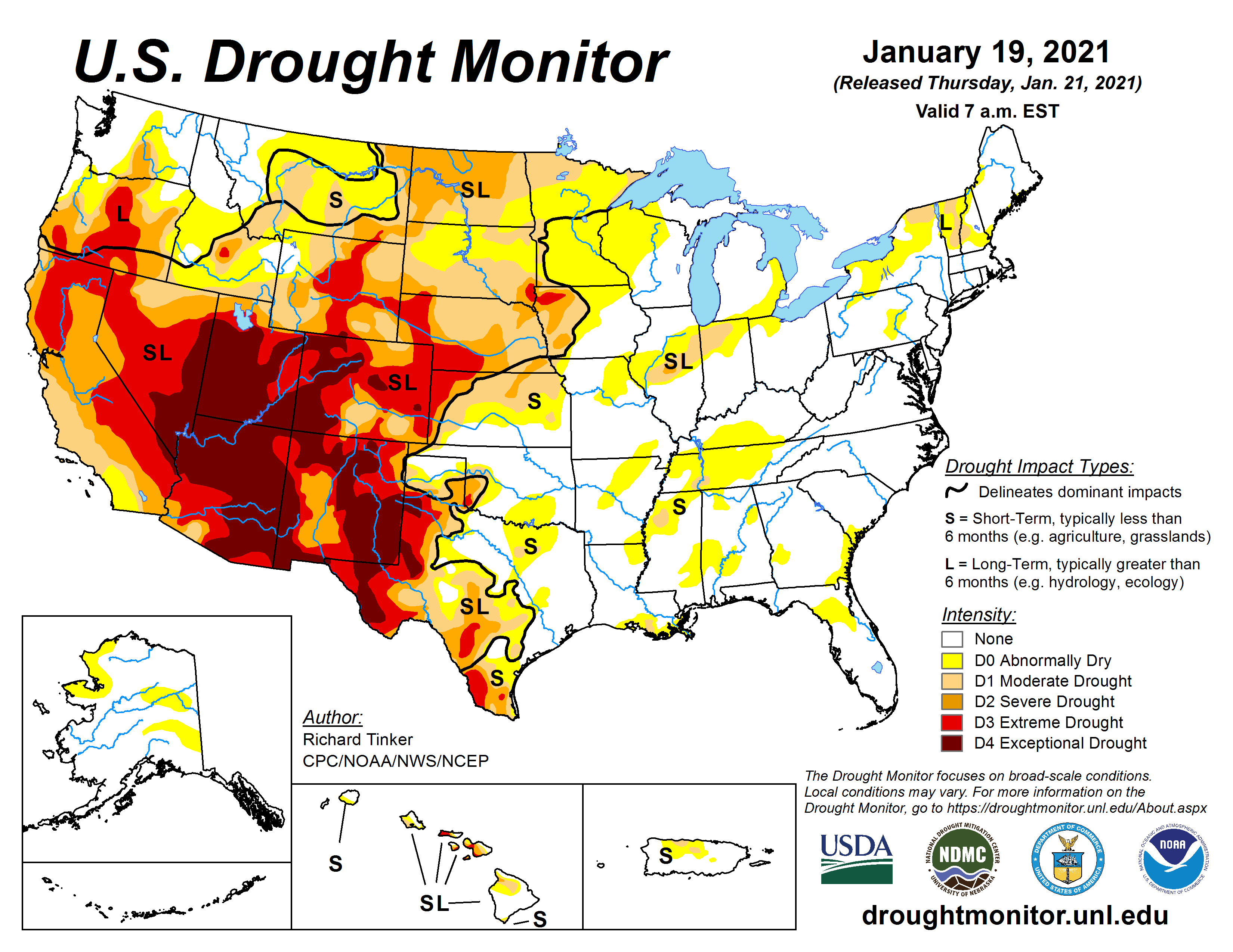
    Like millions of people from around the globe, I watched the images of coup-pawns invading the U.S. Capitol on Jan. 6 with shock, rage, and sadness. But, like many others, I wasn’t surprised. After all, almost exactly five years earlier we had been transfixed and alarmed by another violent attack on an American institution, the occupation of the Malheur National Wildlife Refuge in Oregon by Sagebrush Insurgents. The Center for Western Priorities, an environmental group, aptly called Malheur a “dress rehearsal for what we saw at the Capitol.”

    Malheur, meanwhile, was the culmination of what my colleagues and I at High Country News coined the Sagebrush Insurgency, a more violent remake of the seventies-era Sagebrush Rebellion, a movement focused on transferring public lands to state and private hands, that rose up largely in reaction to tightening environmental regulations on public lands.

    Subscribe Now

    So it makes sense that observers are now tracing the roots of the Capitol attack to Malheur and then back to the Sagebrush Rebellion. But to find the true antecedent to the recent insurgency, which was initially sparked by the election of Barack Obama to the presidency, one needn’t go back so far. In the late 1980s, another anti-environmental regulation movement known as Wise Use arose from the Sagebrush Rebellion’s ashes. Wise Use would turn out to be more radical, insidious, and ultimately more influential than its more glamorously named predecessor. And today’s right-wing extremist movements reverberate with echoes from Wise Use and its concurrent cousins the Patriot and Militia movements.

    In the late 1980s, as President Ronald Reagan finished his second term and the Cold War neared its end, a right-wing, nationalist furor fulminated in the Heartland. Billboards sprouted along rural roadsides warning of black United Nations helicopters imposing a New World Order on the nation. And in Reno, Nevada, timber lobbyist and co-founder of the Center for Defense of Free Enterprise, Ron Arnold, held the inaugural Wise Use conference featuring sponsors such as Exxon, the National Rifle Association, Boise Cascade Corporation, the Mountain States Legal Foundation, and several cattlemen’s and motorized-recreation organizations.

    While the Sagebrush Rebellion had been a direct reaction to the tightening of regulations on public lands and the relatively green ethos of President Jimmy Carter, Wise Use had no clear catalyst. Reagan, after all, had opened up the lands to exploitation once again, and his vice-president, not exactly a liberal, took over from him. Instead, it appears that the movement was sparked by a myriad of causes, one of which was Reaganism, although they would never admit to it. Reagan’s mission was to dismantle the framework created by the New Deal, a framework that protected workers’ rights, staved off extreme wealth-inequality with progressive taxation, and built up a strong middle-class. Reagan took the shame out of unbridled greed and let corporations run rampant with the promise that all that wealth would trickle down to the working classes. It did not, and the very farmers, miners, ranchers, and roughnecks who had sought salvation in Reagan’s laissez faire public lands policies instead were dealt damnation from his free-marketeer ways.

    During Reagan’s two terms: Carter-era subsidies for oil shale production ended, triggering a deep recession in the Interior West. The oil boom spurred by energy crises busted, ending—for the time being—Denver’s Dynasty period. Metal mining went global, depressing prices in the U.S. and forcing the closure of numerous Western mines. The uranium mining industry in the West was diminished by Three Mile Island’s then Chernobyl’s impact on the nuclear power industry, followed by the end of the arms race. And the Farm Crisis ravaged agricultural communities everywhere. The middle class was hollowed out while a guy named Donald Trump became a celebrity simply by flaunting his wealth. Reagan’s policies aren’t responsible for all of this, but they did weaken the safety nets that should have caught these people when they were in trouble. Instead, the nets failed, and widespread economic malaise among the working class oozed across the land, spurring resentment that the Wise Use, Patriot, and Militia leaders seized upon to fuel their cause.

    Colorado Governor Richard Lamm once called the Sagebrush Rebellion a “murky fusion of idealism and greed” and a “movement of confusion and hysteria.” Wise Use had the fusion of idealism and greed part down, but it was anything but confused, and was more focused, more radical, more sinister, and ultimately more influential than its predecessor. Like Sagebrush Rebels, Wise Users were looking to get out from the yoke of environmental regulations on public lands. But the adherents of the latter campaign also saw themselves as soldiers in a culture war, and their credo carried more than a whiff of evangelical Christianity. The federal government and environmentalists weren’t just a threat to their profits and occupations, but to their “heritage” and “civilization.” Arnold summed up his crusade’s Western civilization-centric ideology in a 1993 speech:

    I see environmentalism as the destroyer of the economy, as the destroyer of material well being—as the destroyer of industrial civilization—as the destroyer of individual liberties and civil rights. For those reasons, I fight against environmentalism as a matter of principle, as a matter of ethics, as a matter of survival. The same reasons for which I see environmentalists fighting against industrial civilization.

    Wise Use put a nifty little twist on the land-transfer ethos of the Sagebrush Rebels: Instead of focusing on transferring public lands into private hands, they would extend private property rights—for livestock operators, corporations, and counties—to the public lands. It was a brilliant idea, really, because it essentially privatized public land without the need for politically untenable land transfers. One of the leading practitioners of this notion was Karen Budd-Falen, a Wyoming-based attorney and alumna of both the Mountain States Legal Foundation and James Watt’s Interior Department, who argued that public land grazing leases bestowed private property rights on the lessee.

    Budd-Falen was instrumental in crafting a slew of ordinances and a land-use plan for Catron County, New Mexico, declaring county authority over federally managed lands and, specifically, grazing allotments. The ordinances were “… about the legal authority of county governments and the legal rights of local citizens as regards the use of federal and state lands.” They were intended to preserve the “customs and culture” of the rural West—by which they apparently meant only the predominantly white, conservative, Euro-American settler-colonial culture and customs, with a big dose of corporate influence thrown into the mix. And the Catron County commissioners were ready to turn to violence and even civil war to stop, in the words of the ordinance, “federal and state agents {who} threaten the life, liberty, and happiness of the people of Catron County … and present danger to the land and livelihood of every man, woman, and child.” The Utah-based National Federal Lands Conference, launched in the late 1980s by Sagebrush Rebel and military-surplus-peddler Bert Smith, boiler-plated the ordinances and tried to sell them to other counties around the rural West.

    Rising up alongside Wise Use was the Patriot/Militia movement. Whereas Wise Use was worried about the BLM coming after “their” lands, the Patriots were more concerned about the IRS or the ATF or the United Nations coming for their money and their guns (in black helicopters, of course). While the details of their crusades may have differed, the two movements shared followers, philosophies, and ideological roots.

    One of those shared beliefs was the creed of county supremacy over the states and feds and that the county sheriff is the ultimate law enforcement authority. A prominent teacher of this philosophy was W. Cleon Skousen, an extreme right-wing author, Mormon theologian, and founder of the National Center for Constitutional Studies, née the Freeman Institute, known for its best-selling pocket-size versions of the U.S. Constitution. Skousen’s influence—indeed, his exact words—can be found in the Catron County ordinances, and Skousen and Bert Smith were contemporaries and collaborators. Skousen was also friends and ideological twins with Ezra Taft Benson, the president of the Church of Jesus Christ of Latter-day Saints who played a leading role in steering the Church from its collectivist roots onto a right-wing course.

    Skousen, a former FBI agent and Salt Lake City police chief, gave talks to Rotary Clubs and other groups and taught classes to police officers. One of his students was a man named Richard Mack. Mack grew up in southern Arizona in a conservative Mormon family, graduated from Brigham Young University, then joined the Provo, Utah, police force in the 1980s. While he was a police officer, Mack attended one of Skousen’s classes in which he melded constitutional law with Mormon doctrine. Mack became a Skousen-convert and soon went back to Arizona to practice his new creed and where he was elected sheriff of Graham County in 1988 and was re-elected in 1992.

    The 1992 standoff at Ruby Ridge in Idaho, followed by Bill Clinton’s election to the presidency and his appointments of Janet Reno as Attorney General and Bruce Babbitt as Interior Secretary, was akin to throwing gasoline on the Patriot-Wise Use fire. The reactionary conflagration was further inflamed by the 1993 Waco fiasco and the passage of the Brady Handgun Violence Prevention Act, requiring people purchasing firearms to get background checks. Among other things, the Act charged local law enforcement with conducting the checks until a federal system was set up. That provided an opening into which then-sheriff Mack could step and propel himself into the glow of the inferno that was whipping across America.

    When the Brady Bill was passed, Mack, with backing from the National Rifle Association, joined up with other county sheriffs to sue the federal government over the background-check provision, and ultimately won a 5-4 ruling by the Supreme Court. Mack’s willingness to stand up to the federal government made him an instant folk hero among the anti-government factions (though he lost re-election in 1996) and he was soon headlining Patriot gatherings, railing at Clinton and his attorney general, Janet Reno, and he co-wrote a book with Randy Weaver, the man at the center of the Ruby Ridge shootout.

    Meanwhile, prominent Wise Use leaders took pains to distance themselves from the Patriot movement’s more violent elements, while at the same time espousing identical ideologies. The National Federal Lands Conference’s Federal Land Update, edited for a time by Wayne Hage, the rancher who became famous for doing battle with the federal government, regularly ran rants against the New World Order and gun control legislation. In 1994 the Update ran a long article touting the “need for the Militia in America.” That same year, Helen Chenoweth—a staunch Republican, Sagebrush Rebel (she held “endangered salmon bakes” to piss off the greens), and an early Wise User—was elected to represent Idaho in Congress. Chenoweth, who would go on to marry Hage, claimed that U.S. Fish and Wildlife officers were utilizing black helicopters to enforce the Endangered Species Act and that white, Anglo-Saxon males were the real endangered species. Even after a militia-follower named Timothy McVeigh blew up a federal building in Oklahoma City, killing 167 people, Chenoweth told a newspaper reporter that she would not condemn militias and that “public policies may be pushing people too far,” and therefore were partially responsible for the bloodshed.

    After George W. Bush was elected president he assembled an Interior Department staff that resembled the attendance roster for a petroleum association or Wise Use conference. It was led by Gale Norton, a disciple of James Watt’s and alumna of the Mountain States Legal Foundation, the litigating arm of the Sagebrush Rebels and then the Wise Users. Also on staff were J. Steven Griles, a lobbyist for energy companies; Rejane Burton, the former vice-president of an oil and gas exploration company; and David Bernhardt, a lobbyist for the extractive industry.

    Naturally, that played out on the public lands. During Norton’s years in Interior, the BLM issued drilling permits at a record pace. Norton favored drilling in the Arctic National Wildlife Refuge, voided critical habitat on millions of acres, increased the number of snowmobiles in Yellowstone, and so on. Meanwhile, the Interior Department and its assorted agencies fell into a veritable orgy of ethical lapses, federal coffers were deprived of oil and gas royalties, fragile species denied protection, and industry was given yet more power to wreck public land in the name of greed.

    Give a Gift Subscription

    With so many Wise Users in the government, the reactionary movement had nothing to push back against, and therefore lost a lot of steam. The same went for the Patriot movement. Mack’s pulpit dissolved as well and he became a used car salesman. But the movements were not dead, they were simply dormant, awaiting a new force against which to react and awaken them from their slumber. And that force arrived in the form of the 2008 election of President Barack Obama.

    “What if the elitists in power also used their paid political hacks to manipulate the voting process? We do know that ANY electronic voting machine can be rigged to make sure that only the elitist chosen candidates will win. That’s when it’s time for an alert and vigilant militia to be on guard. Don’t those in power, the elitists, realize that if they continue in their ways there could be some dire consequences?”

    That may sound like a rant from some Proud Boy’s Parler post, or—if it had more grammatical errors—President Donald Trump’s Twitter feed, in the days leading up to the 2020 election. In fact, these words were published in a 1994 article in the Federal Land Update, the Wise Use movement’s rag. The stolen-election trope that Trump and his followers have been spewing for months is just one of many current-day echoes of the Wise Use era. They are reverberating everywhere, whether it’s among the Tea Party or the Oath Keepers or the III-percenters or the Sagebrush Insurgency. Some examples:

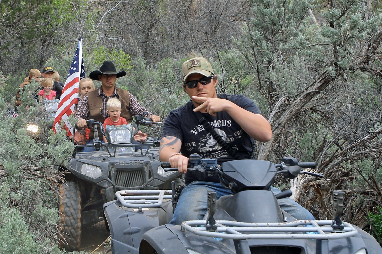
    W. Cleon Skousen: Skousen died in 2006, but his legacy lives on. Following Obama’s election, right-wing commentator Glenn Beck began touting Skousen’s 1981 tome, The Five Thousand Year Leap. A re-issued version sold hundreds of thousands of copies and came to be known as the Tea Party’s “bible.” Meanwhile, the Bundys are often seen carrying the pocket-sized constitutions published by Skousen’s NCCS in, well, their pockets. At the 2014 ATV-protest down Recapture Canyon in southeast Utah, led by Neo-Sagebrush Rebel and Wise User Phil Lyman, Ryan Bundy himself handed me one of these booklets, peppered with Scripture. Also at the event were a number of self-proclaimed militia-men.

    “Sheriff” Richard Mack: Skousen-acolyte Mack was so distraught by Obama’s election that he wrote a book. The County Sheriff: America’s Last Hope, published in 2009, argues that the sheriff is the ultimate law enforcement authority and thus the “last line of defense” shielding individual liberties from out-of-control federal bureaucrats. Mack then launched the Constitutional Sheriffs and Police Officers Association. The organization’s 2012 conference attendance roster included Bert Smith, the Wise Use leader. Smith, who became wealthy from his giant military surplus business in Ogden, Utah, had provided seed money for the CSPOA and for the American Lands Council, created that year by Utah State Rep. Ken Ivory to push for transferring public lands to the states, counties, and private entities. Also speaking was Tom DeWeese, president of the American Policy Center, known for spreading fears that the United Nations, under Agenda 21, is taking over the world via bike paths and public transit, and Joe Arpaio, the notorious sheriff of Maricopa County, Arizona, whom Mack praised for launching an investigation into the validity of Obama’s birth certificate. Ivory gave a rousing speech at the September gathering about the “revolution of ideologies” in which he and the sheriffs were engaged. Mack would go on to lend support to Cliven Bundy during the Bunkerville standoff in 2014 and was a part of the 2016 protest against the prosecution of Wise Use rancher Dwight Hammond, a protest that would culminate in the Malheur takeover.

    Bert Smith: Until his death in 2016, Smith remained active in the new iterations of the Sagebrush Rebellion/Wise Use. After the Bunkerville fiasco, Smith penned a piece on the Bundy Ranch blog in which he called Cliven Bundy a “hero of the range livestock operator on public land,” who had “a sacred God-given right of unalienable rights, private property rights” to graze his cows on the American public’s land.

    Karen Budd-Falen: Falen emerged from Wise Use as a leading private property rights attorney, often fighting against the federal government, and gained new prominence in the latest Sagebrush Insurgency. She once represented Cliven Bundy. In 2011, she told a gathering of county sheriffs in Northern California that “the foundation for every single right in this country, our freedom of speech, our freedom to vote, our freedom to petition, is all based on the right of ownership of private property.” Trump appointed her to be deputy Interior solicitor for wildlife and parks, an obscure but powerful position, in 2018.

    William Perry Pendley: Pendley worked under Sagebrush Rebel James Watt in Reagan’s Interior Department then became president of Mountain States Legal Foundation—the legal arm of Wise Use—just as the Wise Use movement was getting going. He stayed with the organization until just months before he went to work for the Trump administration. In 2019 he was named acting director of the BLM; in 2020 a judge found that he had been serving unlawfully.

    Rep. Helen Chenoweth-Hage: Chenoweth-Hage died in 2006, but her firebrand, gun-loving, lib-hating, militia-sympathizing, conspiracy-theory-flinging spirit lives on in the likes of former Alaska Governor Sarah Palin and Rep. Lauren Boebert, who was recently elected to represent Colorado’s third congressional district. Boebert, who tweeted incendiary messages as the Capitol was being invaded, seems to be emerging as the leader of what I call the #ObnoxiousCaucus, which also includes Westerners such as Republican Rep. Paul Gosar, from Arizona.

    Fake Victimhood: Both Wise Use and the current right-wing movements have portrayed themselves and their culture, customs, and heritage, as the victims of persecution and even genocide by the “elitists,” the environmentalists, cancel culture, liberals, the deep state, black helicopters, Hugo Chavez, and rigged voting machines. By falsely portraying themselves as the little guys getting beaten up by bullies—despite the fact that they are almost invariably members of the dominant power structure and backed by corporations and wealthy benefactors—they can justify responding with violence.

    Now the question is whether these echoes will be amplified in reaction to a Biden-Harris administration, or whether widespread anger and alarm in response to the Capitol invasion will silence them. Will a Biden administration rollback of Trump’s environmental rollbacks and restoration of Bears Ears and Grand Staircase-Escalante National Monuments spark a new backlash? Or will the reactionaries finally learn that these protections aren’t an existential threat to their “way of life?”

    It’s worth noting that Western politicians who have adhered to the Wise Use/Sagebrush Rebel philosophies in the past are now emerging as some of the few Republicans willing to stand up to Trump, including: Sen. Mitt Romney, of Utah, Sen. Lisa Murkowski, of Alaska, and Rep. Liz Cheney, of Wyoming.

    It’s not a lot, and it may be too little too late, but it does provide a small glimmer of hope.

    #Snowpack levels decrease across #Colorado (January 17, 2021) — The #PagosaSprings Sun

    San Miguel, Dolores, Animas, and San Juan River Basin High/Low graph January 14, 2021 via the NRCS.

    From The Pagosa Springs Sun (Simone Mounsamy):

    All basins in the state continue to decrease in snowpack totals, according to the Natural Resources Conservation Service.

    The San Miguel, Dolores, Animas and San Juan River basins sit at 68 percent of median this week, compared to 72 percent of median last week.

    A 5.94 percent decrease was reported for the Wolf Creek summit, with totals going from 101 percent of median to 95 percent of median this week.

    A reported 15.9 inches of snow water equivalent was posted at Wolf Creek Summit as of 10 a.m. on Wednesday.

    The Upper Rio Grande Basin has a snowpack total of 95 percent of median this week. Last week it was 102 percent of median.

    At the Arkansas River Basin, totals were 100 percent of median last week and are 93 percent of median this week.

    At the Yampa and White River basins, snowpack totals went from 82 percent of median this time last week to 72 percent of median this week.

    The Laramie and North Platte River basins were 82 percent of median last week, whereas they are 71 percent of median this week.

    The South Platte River Basin’s snowpack total is 77 percent of median this week. Last week, it was 82 percent of median.

    Snowpack totals at the Upper Colorado River Basin were 76 percent of median this time last week. This week they are 70 percent of median.

    The Gunnison River Basin was 73 percent of median last week. This week, it is 67 percent of median…

    River report
    As of Wednesday, the San Juan River had a reported flow of 37.9 cfs, which falls below the 57 cfs average for Jan. 13, according to the U.S. Geological Survey.

    The highest reported flow total for Jan. 13, based on 85 water years of record, came in 1987, when the San Juan had a reported flow of 114 cfs. The lowest flow total came in 1946, when the San Juan River had a flow of 26 cfs.

    Westwide SNOTEL basinf-filled map January 17, 2021 via the NRCS

    The Pagosa Area Water and Sanitation District adopts budget, certifies mill levies — The Pagosa Sun

    Pagosa Hot Springs

    From The Pagosa Springs Sun (Simone Mounsamy):

    The board began by voting to certify its mill levies. A mill levy of 11.778 was certified for District 1 that will lead to $1,514,389 in revenue. For District 2, the board voted to certify a levy of 5.098 mills that will produce $565,839 in revenue.

    PAWSD Director of Business Services Aaron Burns gave a summary of changes made since the draft budget was presented.

    PAWSD had $1,111,059 in total revenue for its general fund for 2019, had $1,094,782 in total 2020 revenue, and proposed $1,143,197 for 2021 total revenue.

    As far as expenditures, in 2019 PAWSD had $1,088,605 in total expenditures, $1,115,160 in 2020, and $1,243,667 for the 2021 proposed budget.

    Its beginning balance for 2020 was $983,500 and the end-of-year balance was $963,122.

    The budget projects that the end-of-year balance for 2021 will be $862,652.

    In terms of its water enterprise funds, PAWSD planned to spend $1,246,368 in 2020 on total water treatment and actually spent $1,201,778. The budget projects that in 2021 it will spend $1,212,748.

    For total water distribution, PAWSD planned to spend $1,354,525 for 2020. It actually spent $946,928 in 2020 and plans to spend $1,178,166 in 2021.

    The total water enterprise expenditures were expected to be $5,725,406 for 2020 and by the end of the year were actually $5,033,192.

    The water enterprise budgetary fund balance for the beginning of 2020 was $6,285,577 and the budgetary fund balance for the end of 2020 was $7,497,054.

    In regard to its wastewater enterprise fund, PAWSD budgeted for $918,856 in total wastewater collection in 2020, but ended up receiving $694,034 by the end of 2020. It projects to make $839,393 in wastewater collection for 2021.

    It budgeted $802,080 in total wastewater treatment for 2020, but actually spent $763,109 for the year. In 2021, PAWSD expects to spend $953,140 in this area.

    Total wastewater enterprise expenditures for 2020 were expected to be $2,636,374, but ended up being $2,324,183. It projects that expenditures for the waste- water enterprise in 2021 will be $2,874,099.

    The budgetary fund balance for PAWSD’s wastewater enterprise at the beginning of 2020 was $3,110,691 and by the end of 2020 it was $3,461,858.

    Rio Blanco secures water right for dam-and-reservoir project — @AspenJournlism #WhiteRiver #GreenRiver #ColoradoRiver #COriver #aridification

    One option for the White River storage project would be an off-channel dam and reservoir at this location. Water would have to be pumped from the White River into the reservoir site. Photo credit: Heather Sackett/Aspen Journalism

    From Aspen Journalism (Heather Sackett):

    Six years after the application was filed, a judge has granted a water conservancy district in northwest Colorado a water right for a new dam-and-reservoir project that top state engineers had opposed.

    Rio Blanco Water Conservancy District now has a 66,720 acre-foot conditional water right to build a dam and reservoir between Rangely and Meeker, known as the White River storage project or the Wolf Creek project. The conservancy district is proposing an off-channel reservoir with a dam 110 feet tall and 3,800 feet long, with water that will be pumped from the White River.

    But the decree, while granting Rangely-based Rio Blanco the amount of storage it was seeking, doesn’t allow the district all the water uses that it initially wanted. The decree grants Rio Blanco a water right for municipal use for the town of Rangely; augmentation within its boundaries; mitigation of environmental impacts; hydroelectric power; and in-reservoir use for recreation, piscatorial and wildlife habitat. The conservancy district will not be able to use the water for irrigation, endangered fish or augmentation in the event of a compact call.

    For more than five years, state engineers had argued that the project was speculative and that Rio Blanco couldn’t prove a need for the water. Engineers had asked the court to dismiss Rio Blanco’s entire application in what’s known as a motion for summary judgment. Division 6 Water Judge Michael O’Hara III agreed in part with state engineers and dismissed some of Rio Blanco’s requested water uses in an order filed Dec. 23. That left the fate of just three water uses to be determined at trial: Colorado River Compact augmentation, endangered fish and hydroelectric power.

    After seeing his order, the parties asked O’Hara if they could postpone the trial, which was scheduled for Jan. 4, while they hammered out a settlement agreement. The final decree and a stipulation, filed Thursday night, cancel and replace O’Hara’s Dec. 23 order and let the parties avoid a trial.

    “When you come to agreements, you are much more likely to live with those than having the judge force you to do things you didn’t really want to do,” O’Hara told the parties in a Dec. 31 conference call.

    Both sides said they are happy with the terms of the decree. Conservancy district Manager Alden Vanden Brink said that after six years of working out issues, the decree brought a sense of elation and a sigh of relief to the community of Rangely. The district is very pleased with the final result, he said.

    “Folks kept holding their breath,” Vanden Brink said. “And now we’ve got a step forward for drought resiliency.”

    This map shows the potential locations of the proposed White River storage project, also known as the Wolf Creek project, on the White River between Rangely and Meeker. Rio Blanco Water Conservancy District on Jan. 7 secured a conditional water storage right for 66,720 acre-feet. Credit: Colorado Division of Water Resources via Heather Sackett/Aspen Journalism

    Settlement and stipulation

    The main issue for state engineers, who were the sole remaining opposer in this case, was whether Rio Blanco could prove it needed the water. According to Colorado water law, new conditional water rights cannot be granted without a specific plan and intent to put the water to beneficial use. State engineers maintained that the conservancy district had not proven that water rights it already owned wouldn’t meet its demands.

    But Rio Blanco said its existing water rights in their current locations were insufficient and that it needed a new reservoir on Wolf Creek to meet current and future needs. And district officials said they were wary of seeking to transfer these rights and uses to a new reservoir because that requires a water-court process whose outcome is not guaranteed; therefore they needed the new conditional storage right. Even if a water court approved the changes, Rio Blanco still said there was not enough storage in the White River basin to meet demands during a drought or for future uses.

    State engineers and Rio Blanco disagreed about how much, if any, water Rio Blanco needed for Rangely, irrigation, endangered fish and other uses. Rio Blanco agreed to give up two of the three water uses left to be determined at trial: Colorado River Compact augmentation and endangered fish.

    According to the decree, if Rio Blanco in the future is successful at moving any of their existing water rights to the Wolf Creek project, the same portion of water granted by the decree will be canceled, eliminating duplicate water rights in the reservoir.

    A stipulation agreed to by both parties lays out further restrictions on the water use.

    According to the stipulation, annual releases from the reservoir will be limited to 7,000 acre-feet for municipal and in-basin augmentation uses. Up to 20,720 acre-feet of water can be used for mitigation of the environmental impacts of building the project. But once the exact amount of water needed for future mitigation is determined, the difference between that amount and the 20,720 acre-feet will be canceled, reducing the total amount of water decreed.

    A view of the White River between Meeker and Rangely. The Rio Blanco Water Conservancy District on Jan. 7 secured a conditional water storage right for 66,720 acre-feet for the Wolf Creek Reservoir. Photo credit: Brent Garndner-Smith/Aspen Journalism

    Compact compliance

    State Engineer Kevin Rein said the final decree is a good outcome, reached in the spirit of cooperation. Even so, state engineers were never willing to compromise on giving Rio Blanco water for Colorado River Compact compliance.

    “That’s something that we would have held fast on in trial and we held fast on discussing it with them,” Rein said. “It’s more a matter of something that does not legally occur right now with the state of Colorado water law.”

    Rio Blanco had proposed that 11,887 acre-feet per year be stored as “augmentation,” or insurance, in case of a compact call. Releasing this replacement water stored in the reservoir to meet downstream compact obligations would allow other water uses in the district to continue and avoid the mandatory cutbacks in the event of a compact call.

    Many water users in the White River basin, including the towns of Rangely and Meeker, have water rights that are junior to the 1922 interstate compact, meaning these users could bear the brunt of involuntary cutbacks. Augmentation water would protect them from that.

    State engineers said augmentation use in a compact-call scenario is not a beneficial use under Colorado water law and is inherently speculative. This doesn’t seem to be a settled legal issue, and O’Hara said in his motion that he would not rule on whether compact augmentation was speculative.

    “We believe the augmentation for compact compliance was very difficult to allow just due to the complexities of the Colorado River Compact and the Upper Colorado River compact, and it’s gratifying that Rio Blanco listened to us and we were able to get a final decree that didn’t include that component,” Rein said.

    The water-right decree represents just the first step toward constructing the project, which will need approvals from federal agencies. Every six years, in what’s known as a diligence filing, Rio Blanco must show the water court that it is moving forward with the dam and reservoir in order to keep its water right. Fort Collins-based environmental group Save the Colorado has already said it will oppose the project.

    Aspen Journalism is a local, nonprofit, investigative news organization covering water and rivers in collaboration with The Aspen Times and other Swift Communications newspapers. This story ran in the Jan. 9 edition of The Aspen Times.

    State of Colorado Files Lawsuit Against U.S. BLM to Invalidate Uncompahgre Resource Management Plan

    Uncompahgre Plateau

    Here’s the release from Governor Polis’ office (Chris Arend):

    The State of Colorado, through the Department of Natural Resources, filed a complaint today in Colorado federal court challenging the approval of the U.S. Department of Interior, Bureau of Land Management’s (BLM) Resource Management Plan (RMP) for the Uncompahgre Field Office. The Uncompahgre RMP, finalized in April 2020, governs mineral extraction and other land use activities on federal lands spanning five counties in southwestern Colorado. The Colorado Department of Natural Resources (DNR) protested the proposed RMP in July 2019, and Governor Polis also submitted inconsistencies between the RMP and state policies, but those concerns were dismissed by the BLM in the final plan.

    The State’s complaint details how William Perry Pendley, a BLM deputy director, violated the Federal Vacancies Reform Act (FVRA) when he improperly exercised the authority to resolve DNR’s protest while unlawfully occupying the role of the agency’s acting director. Resolving such protests is a responsibility reserved exclusively to the Secretary of Interior, a U.S. Senate-approved BLM Director, or a legitimate acting director nominated by the President.

    Mr. Pendley’s appointment by Secretary David Bernhardt was never reviewed by the U.S. Senate and had extended beyond the legal 90-day limit for temporary officials at the time when the plan was finalized. Colorado’s lawsuit follows a recent ruling in a federal lawsuit in Montana that invalidated two RMPs and an RMP amendment that were approved based on a similar unlawful protest resolution by Mr. Pendley.

    “The unfortunate fact is that if the Trump Administration had followed the law in appointing a Senate-confirmed nominee to lead the U.S. Bureau of Land Management, Colorado and other western states would not be in this predicament,” said Governor Jared Polis. “It is now Colorado communities and the State of Colorado who face unnecessary uncertainty and potential impacts to local recreation and outdoor industry jobs.”

    “The Department of Natural Resources raised legitimate concerns in its protest that the final Uncompahgre RMP runs counter to Colorado’s goals to protect sensitive habitat for big game species and other wildlife, and reduce greenhouse gas emissions,” said Dan Gibbs, Executive Director, Colorado Department of Natural Resources. “The complaint provides facts demonstrating that these concerns were not addressed appropriately, and the approval of the plan by Pendley’s BLM was invalid. We are hopeful that the uncertainty caused by the questionable appointment can be clarified by the court so that Western Slope and Southwest Colorado communities can reliably plan for the future.”

    Attorney General Phil Weiser said: “In Colorado, our public lands are critical to our quality of life and economy. Over the years, the Bureau of Land Management has taken a series of illegal actions in developing the resource management plan that harms and conflicts with our state’s policies. We are bringing this lawsuit to address those harms and safeguard public lands and wildlife in Colorado.”

    A copy of the filed complaint can be found here.

    From The Colorado Sun (Jason Blevins):

    The state’s argument that Pendley, the BLM’s “acting director,” did not have the authority to approve anything mirrors a federal case in Montana that overturned three resource-management plans.

    Gov. Jared Polis didn’t like the Bureau of Land Management’s long-range management plan for the Uncompahgre Plateau, saying the expansion of oil drilling in the region did not jibe with state laws and regulations protecting water, air, wildlife and recreation.

    And because the agency did not resolve those issues in its Resource Management Plan, Polis on Friday sued the BLM, as well as agency bureaucrat William Perry Pendley and Interior Secretary David Bernhardt, asking a federal judge to overturn the Resource Management Plan (or RMP) for nearly 680,000 acres of federal land in western Colorado.

    The state is following the lead of Montana, arguing not just that the management plan conflicts with state laws, but that Pendley, who was never formally approved by the U.S. Senate as director of the BLM, did not have the authority to approve the RMP in April.

    “The unfortunate fact is that if the Trump Administration had followed the law in appointing a Senate-confirmed nominee to lead the U.S. Bureau of Land Management, Colorado and other western states would not be in this predicament,” said Polis in a statement announcing the lawsuit. “It is now Colorado communities and the state of Colorado who face unnecessary uncertainty and potential impacts to local recreation and outdoor industry jobs.”

    The final plan approved by Pendley was the first resource management plan approved under the Trump Administration’s “energy dominance” agenda to bolster domestic oil, gas and coal industries. It did not limit drilling in the North Fork Valley and expanded energy development across 675,800 acres of land and 971,200 acres of mineral estate in Montrose, Gunnison, Ouray, Mesa, Delta and San Miguel counties. And it did not weigh the state’s concerns about energy projects potentially injuring wildlife, habitat and air quality.

    The preferred plan that was on track in the fall of 2019 — crafted after many years of BLM meetings and work with local communities — was replaced by a new Trump Administration alternative in the spring of 2020 that identified energy and mineral development as key planning issues alongside reducing regulatory burdens for extractive industries and economic development. The BLM said the plan would contribute $2.5 billion in economic activity to the region and support 950 jobs a year for the next two decades.

    Earlier this month the BLM approved two oil and gas drilling projects in the North Fork Valley that allow up to 226 wells.

    Colorado’s lawsuit, being handled by Colorado Attorney General Phil Weiser, says the plan’s conflicts with state laws were never resolved, so the approval should be overturned.

    #CameronPeakFire’s threat to #PoudreRiver a concern for #FortCollins water supply — The Fort Collins Coloradoan

    From The Fort Collins Coloradoan (Miles Blumhardt):

    Mesmerized by miles of mountainsides of blackened trees and seared soil that hugs the banks of the upper Poudre River, it’s difficult not to reflect on the 2012 High Park Fire and 2013 flood.

    You can’t help but wonder, given the steepness of the slopes and the severity of the riverside scar left by the Cameron Peak Fire, if Northern Colorado is poised for a repeat of history regarding the Poudre River.

    Come spring, snowmelt, rainfall and potential flash floods are almost certain to wash large amounts of ash from Colorado’s largest wildfire, soil and even entire trees into the river that serves as a source of drinking water to hundreds of thousands of people in Fort Collins and the surrounding area…

    A recent Burned Area Emergency Response assessment for the Cameron Peak Fire indicated a 90% to 100% chance that water quality would be impacted by ash- and sediment-laden runoff, nutrient loading and potential debris flows within the first few years following the fire.

    And that’s only the half of it.

    Fort Collins receives half of its water from the Poudre River and the other half from Horsetooth Reservoir, whose water quality could be impacted by the East Troublesome Fire in Grand County.

    An assessment for the East Troublesome Fire estimated 53% of the burn area suffered moderate (48%) or high (5%) soil burn severity compared to 36% — 30% moderate and 6% high — for the Cameron Peak Fire. The Cameron Peak Fire assessment also showed more than half the soil tested to be repellent to water absorption…

    By the time the 112-day Cameron Peak Fire’s flames were finally extinguished on Dec. 2, a watershed recovery collaboration of area municipalities, Larimer County, federal and state agencies, water providers and organizations such as the coalition, was already meeting to start planning efforts to address the fire’s impact.

    This isn’t the first fire for many of those stakeholders, and lessons learned from the High Park Fire are helping the group quickly prepare for this spring’s impacts.

    That being said, the Cameron Peak Fire was more than twice the size of the High Park Fire and paired with the 193,812-acre East Troublesome Fire — the second-largest wildfire in state history — delivered a massive one-two punch to several watersheds, making recovery even more daunting…

    Mark Kempton, the city of Fort Collins’ interim deputy director of Water Resources and Treatment, said the city has implemented steps since the High Park Fire to better equip it to handle the after-effects of a major fire.

    He said the city has installed warning systems along the Poudre River that alert it several hours ahead of water turbidity issues so workers can turn off the water supply. When the city turns off the Poudre River supply, it can draw on Horsetooth Reservoir water. That was the case for 100 days during the High Park Fire.

    The High Park Fire taught recovery leaders to include the use of shredded tree mulch instead of straw mulch to better prevent the mulch from blowing away for soil and slope stabilization. Strategically increasing culvert size also reduced damage to roads.

    Kempton said another key component will be workers removing sediment by flushing the water treatment system more often and removing sediment from the river intake system and catch basins.

    Nine Former #Michigan Officials, Including Ex-Gov. Rick Snyder, Charged in #Flint Water Crisis — Frontline

    Flint River in Flint Michigan.

    From Frontline (Sarah Childress and Abby Ellis):

    The sweeping criminal cases announced Thursday include Rick Snyder, the former Republican governor; Snyder’s top aide and his chief of staff; as well as both the state’s top doctor and health official during the crisis, who face the most severe charges: nine counts of involuntary manslaughter each, as well as official misconduct and neglect of duty for “grossly negligent performance.”

    “The impact of the Flint water crisis cases and what happened in Flint will span generations and probably well beyond,” said Kym Worthy, one of the special prosecutors appointed to investigate the crisis. “This case has nothing whatsoever to do with partisanship. It has to do with human decency … and finally, finally holding people accountable for their alleged, unspeakable atrocities that occurred in Flint all these years ago. Pure and simple, this case is about justice, truth, accountability, poisoned children, lost lives, shattered families that are still not whole and simply giving a damn about all of humanity.”

    Snyder, whose term as governor ended in 2018, had apologized to residents for letting them down. He was charged with two misdemeanor counts of willful neglect of duty and entered a not guilty plea…

    The former governor’s closest aide, Rich Baird, was charged with four felonies: misconduct in office, perjury, obstruction of justice for attempting to influence the legal proceedings around the crisis, and extortion for “threatening” a state-appointed research team investigating the Flint water crisis — an incident that was first documented by FRONTLINE in Flint’s Deadly Water.

    Baird also pleaded not guilty. His attorney, Randall Levine, told the Detroit Free Press that Baird is “innocent of any wrongdoing and is being unfairly prosecuted by the state’s Democratic attorney general.”

    Overall, the indictments paint a grim portrait of a cast of officials not only failing to act to protect people’s health but concealing information, lying about the extent of the problems and threatening those trying to get the word out.

    Among the others indicted on Thursday were Snyder’s chief of staff, Jarrod Agen, for perjury; Nancy Peeler, a state children’s health official accused of concealing, and later misrepresenting, data on blood-lead levels in Flint’s children; Gerald Ambrose and Darnell Earley, both state-appointed emergency managers in Flint charged with misconduct in office; and Howard Croft, Flint’s director of public works at the time, who faces misdemeanors for failing to protect the safety and quality of the water supply. He was the lone city official indicted in the case.

    All nine officials indicted on Thursday entered not guilty pleas.

    The two officials at the center of the prosecution, Nick Lyon, the former head of the state health department, and Dr. Eden Wells, the former state chief medical executive, could face 15-year prison sentences for each of nine counts of involuntary manslaughter. Both were also charged with willful neglect of duty. Wells faces an additional felony count of misconduct in office for attempting to prevent the distribution of information about Legionnaires’ disease in Genesee County…

    While much of the focus on Flint centered around lead contamination, many of the charges stemmed from a deadly outbreak of Legionnaires’ that occurred during the crisis. Officially, 90 people were diagnosed with Legionnaires’ disease, and 12 died, according to state data. But a FRONTLINE investigation strongly suggests the actual death toll was much higher, as doctors unaware of the threat failed to properly diagnose and treat sickened patients. FRONTLINE also found many victims who succumbed to Legionnaires’ in the months and years following the outbreak, long after the state stopped counting the dead…

    As Legionnaires’ cases began ticking upward in 2014, state officials, including Darnell Earley and Jerry Ambrose, exchanged emails speculating that Flint’s new water supply might be to blame. Some worried that word might get out. By the end of 2014, there were 40 confirmed cases of Legionnaires’, and three people had died.

    By March 2015, emails show that at least three of Snyder’s aides and two cabinet members had been told about the outbreak, including Lyon.

    At a press conference in January 2016, Snyder finally announced the Legionnaires’ outbreak — 18 months after it began. He was joined by Wells and by Lyon, who made a point of noting the outbreak couldn’t be linked to the water switch.

    The governor also hastily convened a task force of prominent scientists to investigate the source of the outbreak. The scientists got to work but quickly began clashing with the administration over their findings, when they identified the presence of Legionella, the bacteria that causes the deadly disease, in the water filters of people’s homes.

    #Drought causing issues for #Durango’s fish hatchery — The #Cortez Journal

    Durango Fish Hatchery. Photo credit: Trip Advisor

    From The Durango Herald (Jonathan Romeo) via The Cortez Journal:

    Joe Lewandowski, spokesman for CPW, said the Durango Fish Hatchery, along the banks of the Animas River near Main Avenue and 16th Street, receives its water from three natural springs near the Durango High School.

    Typically, at this time of year, about 1,000 gallons of water per minute flows into the hatchery. Currently, however, because of a long-term drought that has gripped the region, only 700 gallons of water per minute is flowing…

    Winter is the time when the hatchery holds the most fish in anticipation of stocking in spring and summer. Currently, there are about one million fish on site, mostly fingerlings two to three inches in size…

    But because there is less water coming into the hatchery, CPW was forced last week to stock an estimated 28,000 mature rainbow trout throughout Southwest Colorado to make room at the hatchery.

    For example, CPW went through the ice to stock nearly 5,000 9-inch rainbow trout into Summit Reservoir and another 1,400 or so into Joe Moore Reservoir, both north of Mancos.

    In 2021, CPW expects to stock an estimated 100,000 catchable rainbow trout throughout Southwest Colorado…

    As a result of the risks posed to the hatchery because of drought conditions, CPW intends to drill a test well to determine if another water source in the area is available.

    “The test-drilling will be done this year,” Lewandowski said.