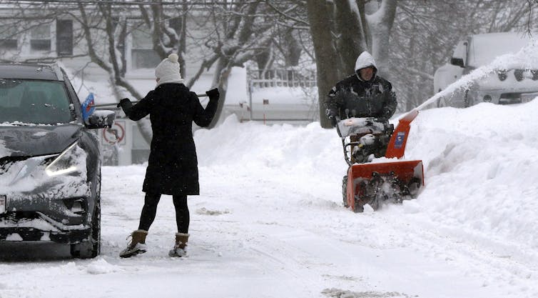
The National Weather Service is forecasting for a chance of snow showers mixed with rain to start Friday morning and to continue on and off until next Tuesday, Feb. 16…
According to the U.S. Department of Agriculture National Water and Climate Center’s snowpack report, the Wolf Creek summit, at 11,000 feet of elevation, had 22.1 inches of snow water equivalent as of 11 a.m. on Feb. 10.
That amount is 102 percent of the Feb. 10 median for this site.
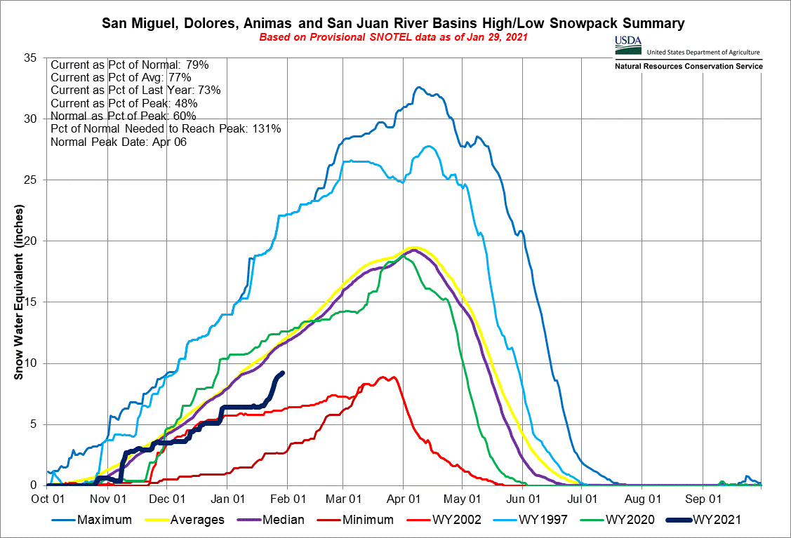
The San Miguel, Dolores, Animas and San Juan River basins were at 79 percent of the Feb. 10 median in terms of snowpack.
Water report
Pagosa Area Water and Sanitation District (PAWSD) Manager Justin Ramsey outlined the current water levels in local lakes in a Feb. 8 press release…
River report
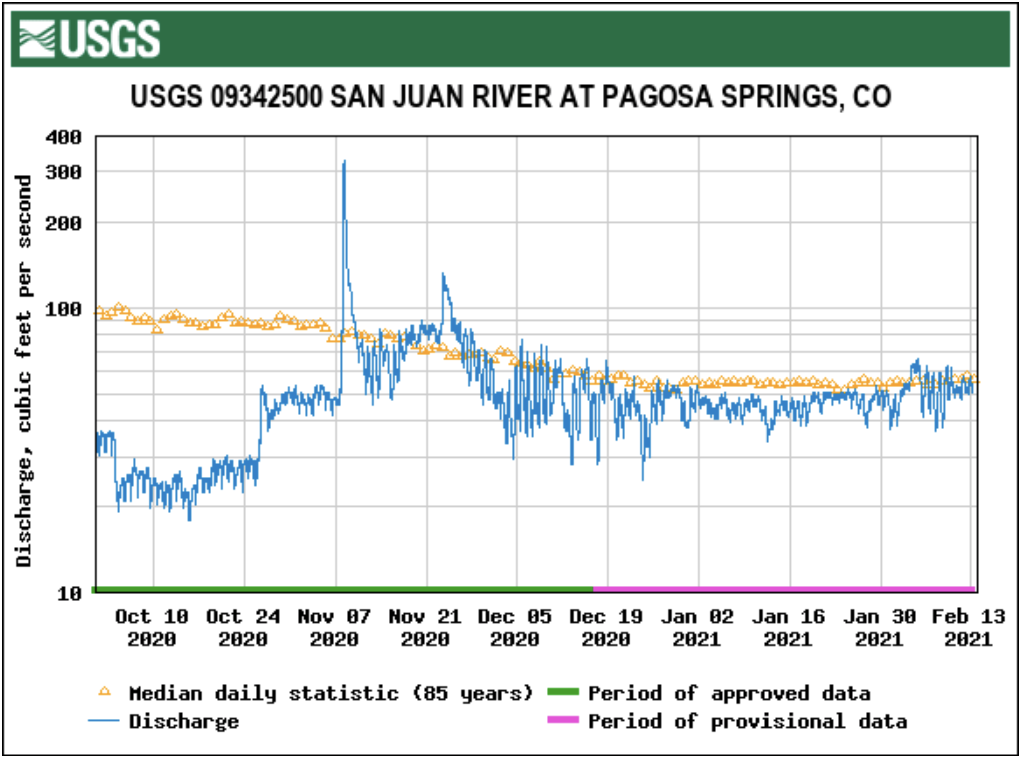
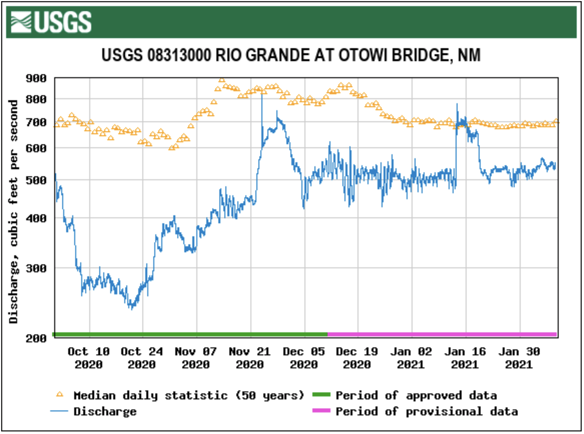
According to the U.S. Geological Survey (USGS), the San Juan River was flowing at a rate of 45.4 cfs in Pagosa Springs as of 11 a.m. on Wednesday, Feb. 10.
Based on 85 years of water records at this site, the average flow rate for this date is 61 cfs.
The highest recorded rate for this date was in 2015 at 128 cfs. The lowest recorded rate was 26 cfs, recorded in 1990.
An instantaneous reading was unavailable for the USGS station for the Piedra River near Arboles.
It is noted on the USGS website for this station that the reading of the river flow rate is affected by ice at the station.
Based on 58 years of water records at this site, the average flow rate for Feb. 10 is 81 cfs.
The highest recorded rate was 200 cfs in 2017. The lowest recorded rate was 16.9 in 2003.
Some Colorado River water users in 2020 will begin taking voluntary reductions to protect the water elevation level at Lake Mead. (Source: Bureau of Reclamation)
The Colorado River system is highly managed, strained, stressed, and challenged, but is also one of the most loved, revered, enjoyed and sacred rivers in the world.
As we teased in a blog last week, we’re back to continue breaking down the compelling, and quite frankly, sea-changing recent study coming out of the Center for Colorado Rivers Studies at Utah State University. In it, we highlighted key findings from the study’s authors, Kevin Wheeler, Jack Schmidt, Eric Kuhn, Brad Udall and others. If you missed the initial release, you really should take a few minutes to at least read the Executive Summary, as it does a great job illustrating the challenges that the entire Colorado River ecosystem faces in the face of climate change. We also took the opportunity to pivot off of a blog post by John Fleck, author and Director of the Water Resources Department at University of New Mexico, about the same study.
At the end of our post, there was what amounts to a Top 10 List of key takeaways from the Center’s white paper, and a few of them seemed especially relevant to American Rivers body of work in the Colorado Basin, and to how we are thinking about the future of the Colorado River.
Laguna Dam, AZ | Photo by Sinjin Eberle
We can’t stop thinking about the line, “The Colorado River has been profoundly altered from its highest reaches to its delta,” which is something we all know, but describing it in that way is significant. There can be no argument that there has been major alteration to the river, from the highest headwaters trickling down from Poudre Pass (and the Grand Ditch, built between 1890 and 1936) all the way to the first dam built on the Colorado River, Laguna Dam near Yuma (1903) on to Morelos Dam on the Mexican border. Major impoundments and diversions like Flaming Gorge and Fontenelle on the Green, Granby Dam in the Colorado headwaters, tributary dams like Ruedi on the Frying Pan and the Aspinall Unit on the Gunnison, and yes, Lakes Powell and Mead, whose storage levels drive the vast majority of the policy rules, compacts, and guidelines that manage the river. We also should acknowledge two other aspects of this changed river – that ecosystems like the Grand Canyon, Glen Canyon, Black Canyon, and the San Juan are changed due to these alterations, but also that nearly 40 million people, a 1.4-trillion-dollar economy, and millions of jobs depend on the sum of all of these parts.
Is the system altered? Absolutely. But does that mean it’s dead and that we should not keep doing whatever we can to preserve it? Absolutely not.
December 8, 2015 Credit: Sinjin Eberle UT, Lake Powell
The Colorado River system is highly managed, strained, stressed, and challenged, but is also one of the most loved, revered, enjoyed and sacred rivers in the world. Tribal communities whose lands are currently located hundreds of miles from its banks still call the Colorado River sacred. Millions upon millions of visitors, from across the country and around the globe, from all walks of life, gaze onto it’s waters every year. Tens of thousands of people raft, fish, swim, kayak, and yes, drink, it’s flowing bounty. It preserves life in so many ways, but the most prominent way is in our hearts. The Colorado River is one of us, and we are it.
In part, that is why the statement from the white paper was so striking. Even if you are not a dedicated river conservationist, you know that the Colorado River has been providing so much, for so long. Now with the onset of a warming climate, even the baseline amount of water the river carries is declining – and will decline over the next 30 years. Our laws and policies around the river were built on a totally different climate, with a totally different set of pressures, and demands, than what we have today.
The science matters, and teasing out the detail, as well as the topline implications from this report will take time, and it will catalyze critical debate, and demand hard choices. American Rivers, our partners, and our team here in the Colorado Basin is ready, and enthusiastic, about confronting and helping to solve the challenges facing the Colorado River. But we can’t solve these challenges alone. Ultimately, we need everyone who relies upon, and who loves the Colorado River on board. Hopefully you are too!
Next week, we will be teasing out more from the report around how climate change is causing flow declines and that additional declines even more likely to occur looking forward. Stay tuned!
Sunrise illuminates clouds over the Black Mountains along the Virgin Basin on Lake Mead in the Lake Mead National Recreation Area on the Arizona-Nevada border (Photo from Arizona looking into Nevada Lake Mead, AZ | by Colleen Miniuk via American Rivers)Graphic via Holly McClelland/High Country News.
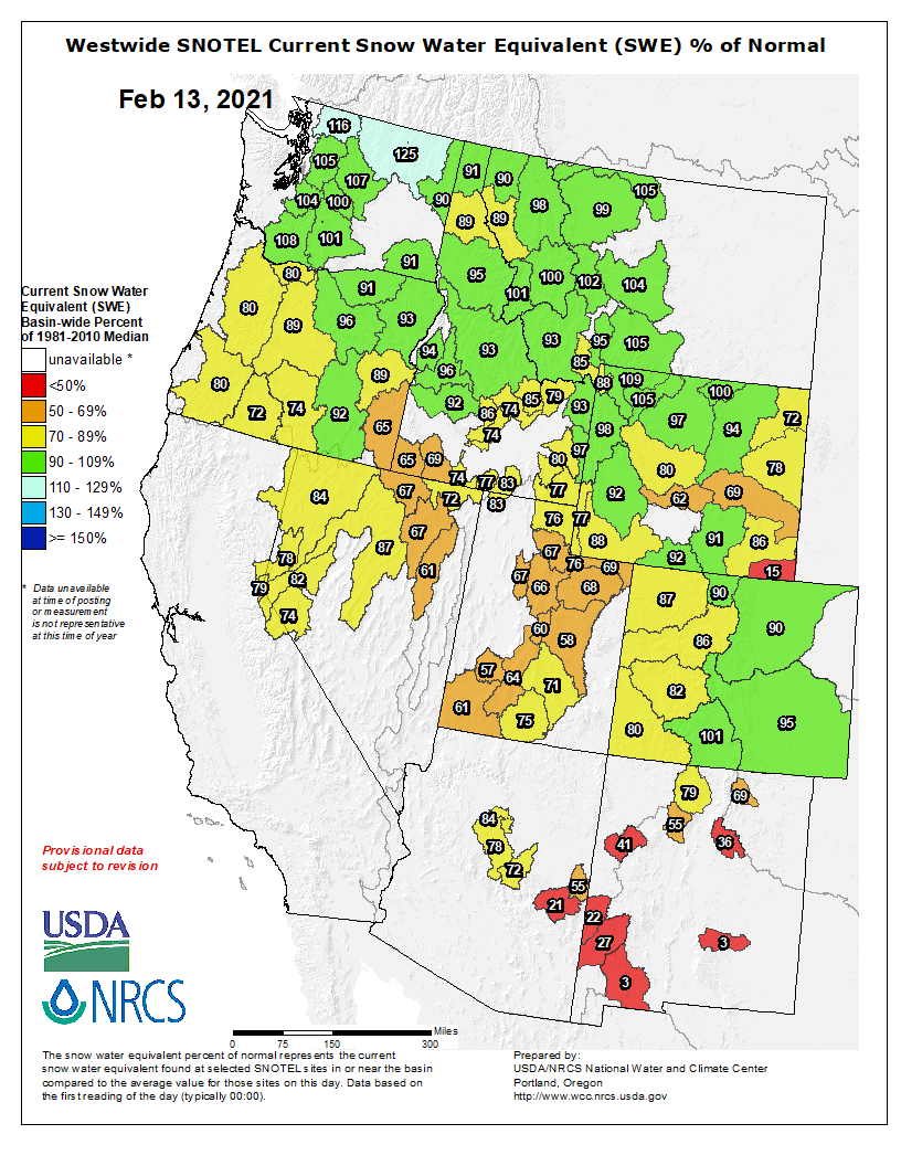
Click on a thumbnail graphic to view a gallery of snowpack data from the NRCS.
Colorado snowpack basin-filled map February 12, 2021 via the NRCS.
Statewide Basin High/Low graph February 11, 2021 via the NRCS.
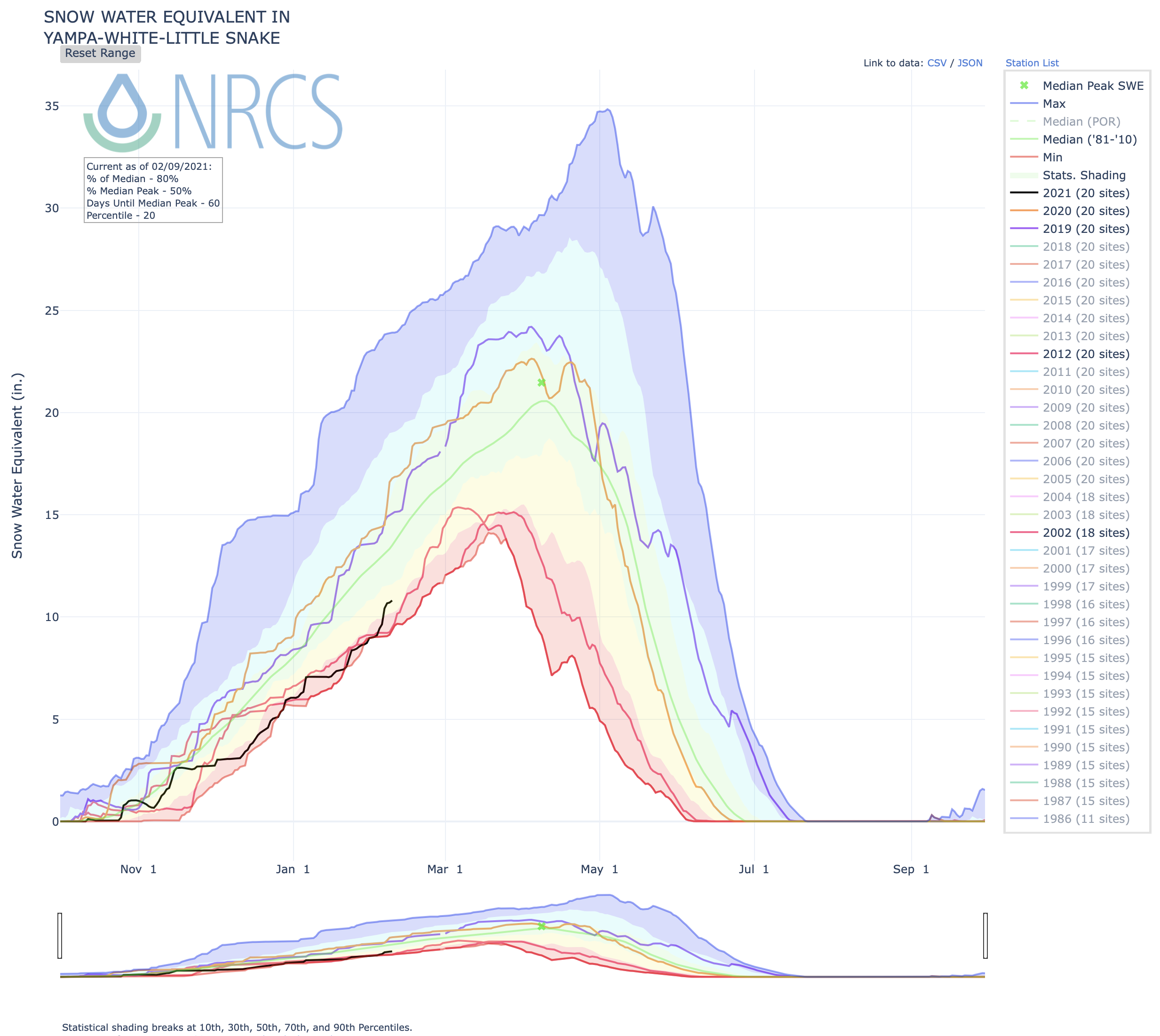
Yampa and White Basin High/Low graph February 11, 2021 via the NRCS.
South Platte River Basin High/Low graph February 11, 2021 via the NRCS.
San Miguel, Dolores, Animas, and San Juan Basin High/Low graph February 11, 2021 via the NRCS.
Upper Rio Grande River Basin High/Low graph February 11, 2021 via the NRCS.
Laramie and North Platte Basin High/Low graph February 11, 2021 via the NRCS.
Gunnison River Basin High/Low graph February 11, 2021 via the NRCS.
Upper Colorado River Basin High/Low graph February 11, 2021 via the NRCS.
Arkansas River Basin High/Low graph February 11, 2021 via the NRCS.
FromThe Grand Junction Daily Sentinel (Dennis Webb):
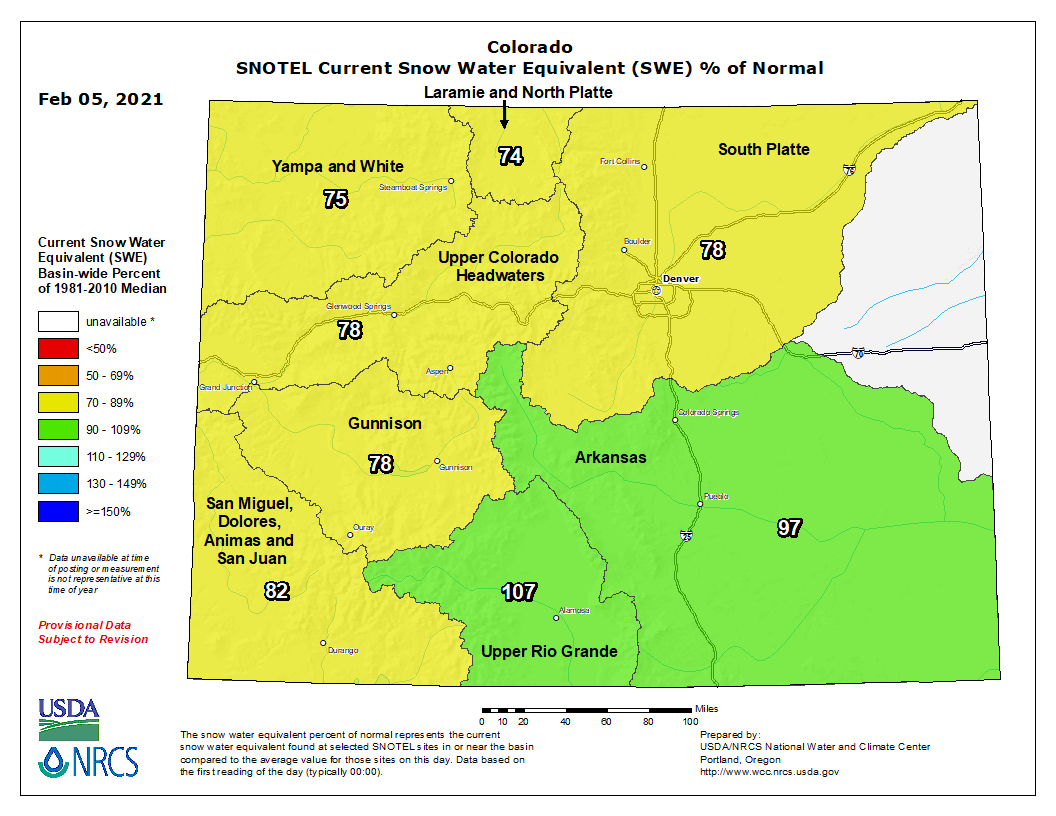
Colorado’s snowpack this winter continues to lag behind normal — much less the above-normal amount needed for the state to escape from a continuing drought — but it has improved thanks to recent storms, and more moisture is on the way.
Snowpack in the state as of Wednesday was at 85% of median, according to the Natural Resources Conservation Services. That’s up from 74% just under a month ago, and reflects a wetter recent weather pattern that has dropped multiple feet of powder on some Colorado ski areas.
Snowpack levels have shown similar increases in the Upper Colorado River and Gunnison River drainages, which now sit at 82% and 79% of median, respectively. The Gunnison drainage currently is the driest major basin in the state, with the Upper Rio Grande Basin having the highest amount of snowpack at 103% of median.
Tom Renwick, a forecaster for the National Weather Service in Grand Junction, noted that a series of weather systems are due to move through the state starting [February 11, 2021]. The second one, now expected to arrive Saturday evening, “really looks like it’s got a lot of precipitation with it,” he said.
A third storm expected to show up Monday night doesn’t look as promising, Renwick said. “Still, anything we can get will help,” he said.
He thinks that if the three systems deliver as now expected, they could push the state close to normal snowpack for this time of year.
In a monthly webinar put on this week by Colorado State University’s Colorado Climate Center, Peter Goble, a climatologist with the center, also indicated the forecasted storms could improve the snowpack situation in the state…
But he reiterated what water-watchers have been saying all winter — that even if the snowpack in the state reaches normal levels before seasonal accumulations peak in a few months, that likely would result in below-normal runoff levels due to dry soils and low base flows in streams as a result of continuing drought…
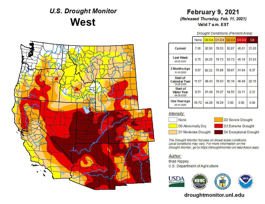
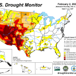
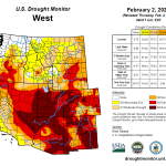
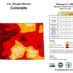
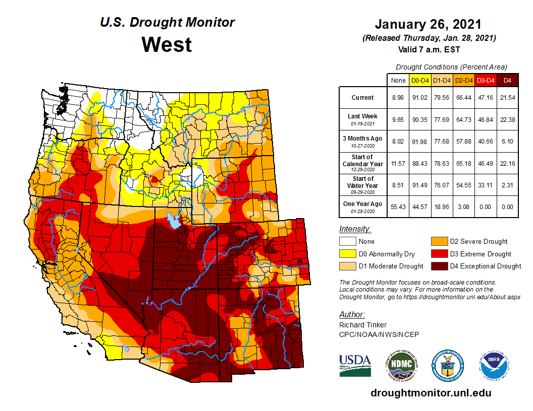
West Drought Monitor February 9, 2021.
All of Colorado remains in drought, according to the U.S. Drought Monitor. Eastern and southwestern Mesa County are in exceptional drought, the worst category, with the northwestern part of the county in extreme drought. Much of western Colorado and much of the state’s eastern plains are in exceptional or extreme drought…
Low soil moisture levels and their streamflow impacts are of concern to the Ute Water Conservancy District, the Grand Valley’s largest provider of domestic water.
“The ground is going to take what it can before it gives us any,” said district spokeswoman Andrea Lopez.
The district tries to rely on the Jerry Creek reservoirs in the Plateau Valley as its primary water supply because of the high quality of the water that fills them. Lopez said those reservoirs are currently doing pretty well, considering the drought that kicked in last year, and are now 95.5% full. But she said that percentage will go down.
Snowpack levels at NRCS measurement sites on Grand Mesa, which feeds those reservoirs, range from 62% to 72% of normal.
Ute Water probably will eventually have to pull water from watersheds that aren’t its first choice, turning to the Colorado River, and mixing that water with water from the Jerry Creek reservoirs.
That affects its water quality and is more expensive due to the pumping and extra treatment that is required.
The Ute Water board could end up deciding to impose drought rates if needed…
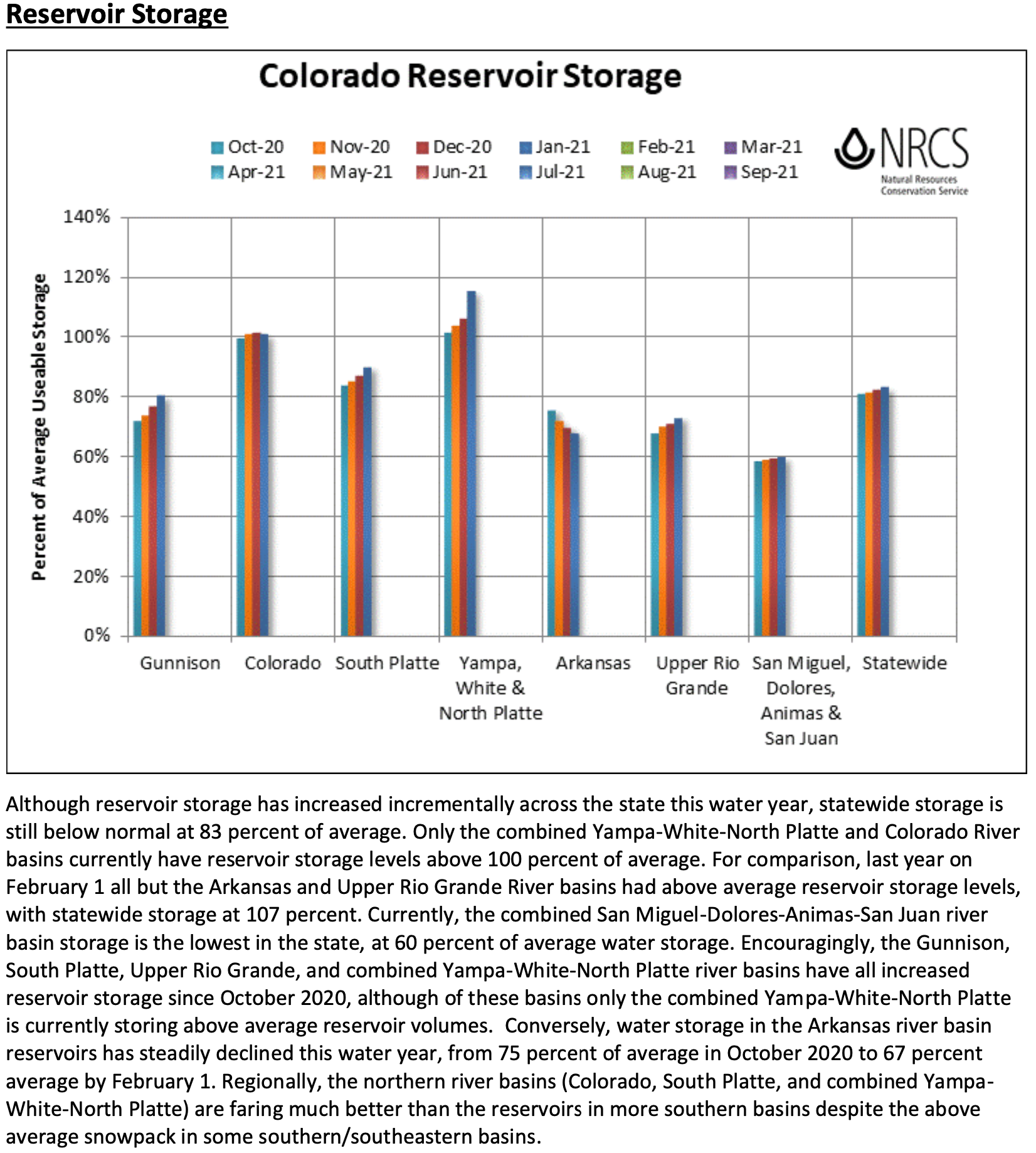
According to the NRCS, reservoir storage at the end of January in the state was at 80% of average for this time of year. The Bureau of Reclamation currently expects runoff into Blue Mesa Reservoir to be at 70% of average between April and July, and for the water level at Blue Mesa to top out this year at 576,000 acre feet, out of a reservoir capacity of 830,000 acre feet…
Renwick said that in La Niña winters, if the Western Slope is going to get precipitation it typically happens as the state starts heading into spring, “which is exactly what is happening.”
Westwide SNOTEL basin-filled map February 12, 2021 via the NRCS.
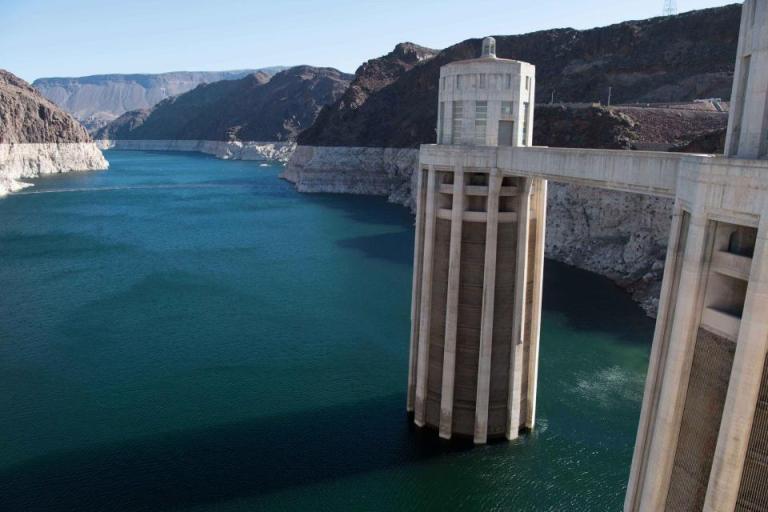
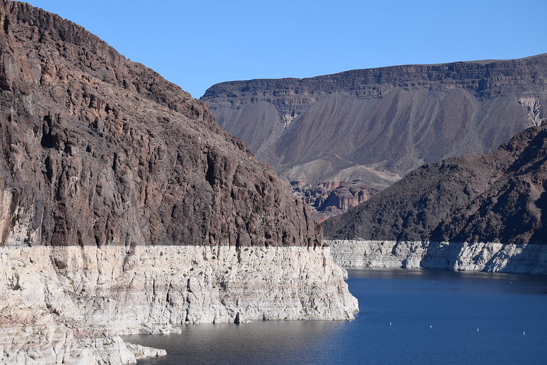
Lake Powell, the current poster child for things gone awry in the Colorado River Basin, is shrinking from the top and sides, its old water lines scarring the southern Utah desert.
The numbers from Lake Powell Water Database don’t make it any prettier; the central storage bin for the Colorado River and a legendary playground for houseboaters, Lake Powell is down 29.67 feet from a year ago. The rivers feeding it are running at 70 percent of average and the 28 tracked reservoirs above it are at 70 percent capacity. The water level is at 39.1 percent of what they call full pool. At capacity, Lake Powell holds roughly 26 million acre feet of water.
The U.S. Bureau of Reclamation, which builds and manages dams, power plants and canals, and which hails itself as the largest wholesaler of water in the country, recently fired a warning shot. In a January forecast the agency warned that lakes Powell and Mead, the two largest reservoirs in the U.S., are heading toward record-low levels, which could result in the loss of hydropower at Glen Canyon Dam. Front-Range cities are girding for water cutbacks as the larger seven-state region stands ready to put drought contingency plans into place.
A seven-hour drive from here, Lake Powell is sufficiently out of sight to not be a constant reminder about the water situation in Colorado. Chaffee County Commissioner Greg Felt calls the reservoir “the big train station for water.” For now he says he’s not panicking about a possible major derailment and reminds us that history can be an optimist. Some dry winters have staged spectacular comebacks, he says.
But Felt also reminds us that we’re in a dry year that was preceded by another dry year. With recent precipitation propping up the snowpack, we’ve seen encouragement in February. But lest we forget, there was 2020.
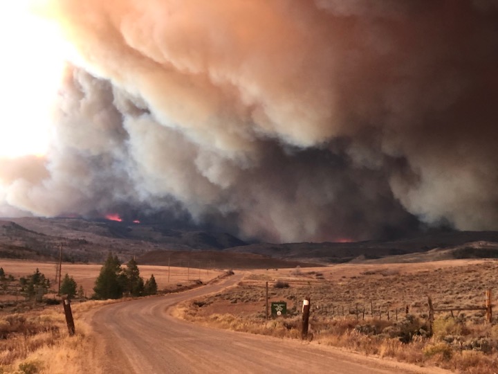
The moisture-sucking year that gave us a global pandemic also wreaked havoc on America’s West. The record-setting wildfires were a reminder that our lands were brittle and dry to begin with.
In layman’s terms, the soil in Colorado is wrung out. Which means, among other things, that much of the runoff heading for our waterways stands a good chance of getting sucked into the ground…
Right now the state drought map remains awash in tones of red and dark brown, and 70 percent of the state is seeing extreme conditions, according to drought.gov. Chaffee County, which has a mix of severe and extreme conditions, is seeing its 13th driest in 127 years, according to the U.S. Drought Monitor. About a quarter of Colorado is categorized as an exceptional drought – the most extreme of the five categories.
Colorado’s snowpack holds much of the story for the spring and summer and currently, the statewide figure is 81 percent of average, according to SNOTEL, a snow-reporting function of USDA’s Natural Resources Conservation Service. On the optimistic side, the Upper Rio Grande Basin is running at 108 percent of normal, which plays into the 243 inches recorded so far at Wolf Creek Ski Area. But the Upper Rio Grande also skews Colorado’s average upward.
Snowpack for the North Platte Basin is at 73 percent, the Colorado River Basin at 79, Gunnison at 78, and the Arkansas Basin at 94 percent…
Felt noted that February, March, and April tend to be the best snow months hereabouts, so there is always hope for a better finish to snow season. But at this point, he says, “it needs to be extraordinary.”
That said, Felt says municipal water supplies in Chaffee County are good. The major questions remain for agricultural production, wildfire danger, and recreation. “It’s worrisome when you combine that with our forest health issues,” he says…
He acknowledges that several long blasts of snow and a significant boost to the snowpack would do wonders to calm some of the emerging warnings.
Two proposed water management bills filed for the 2021 Colorado General Assembly session could prove to be problematic to water interests. Both bills were discussed Tuesday during the Lower South Platte Water Conservancy Districts board of directors meeting in Sterling.
One bill, originated by State Rep. Richard Holtorf, R-Akron and co-sponsored by Sen. Jerry Sonnenberg, R-Sterling, calls for an evaluation of ways to implement underground water storage, as called for in the five-year-old Colorado’s Water Plan. Another seeks to clarify the rights of various members of a mutual ditch company, especially when some shares of the company are owned by non-irrigators.
LSPWCD manager Joe Frank told his board he has “some concerns that we’re mixing apples and oranges” with the underground storage bill. Frank said that, although it’s a statewide bill, it still comes down to taking unappropriated water out of the South Platte River Basin and storing it outside the basin.
“You’d have to move the (water) out of the South Platte basin into a designated basin,” Frank said. “Almost any underground storage inside the (South Platte) basin is going to be alluvial to the river.”
Colorado designated groundwater basins. Map credit: Robert Longenbaugh September 14, 2014
That means attempts to store the water underground inside the basin would only result in water being pulled out of the river in times of excess flow and pumped right back into the river’s aquifer, resulting in no actual benefit. Instead, the water would have to be pumped and piped to a designated basin outside the South Platte basin, such as the Ogallala Aquifer, to be pumped out again at a later time.
The other problem, Frank said, is getting the water into the storage basin in the first place. He said designated basins are best recharged by pumping water into a surface reservoir and letting it seep into the aquifer below. Otherwise, high-powered pumps are required for deep injection well storage.
According to Holtorf’s bill, the Colorado Water Conservation Board would contract with “a Colorado institution of higher education” to do the study, but no specific college or university was mentioned in the draft bill.
The second draft that Frank discussed concerns water rights for members of mutual ditch companies. Sometimes called irrigation companies or just ditch companies, these companies are owned by member shareholders who receive water during the irrigation season according to the size of their shareholdings. As the name implies, the shareholders mutually agree on who gets their water when. Irrigators don’t receive their water continuously during the irrigation season, but in large quantities over short periods of time. Over the course of an irrigation season, all shareholders get their share of the water, just not all at the same time.
Problems arise when non-irrigators, such as municipalities or industries, own shares of mutual ditch companies. That ownership occurs through a change-of-use case adjudicated in Colorado Water Court. Those “change cases” can cause confusion in the running of a ditch company because the new users generally want their water continuously during the irrigating season.
There also is contention over what happens to water that a shareholder doesn’t use; at issue is whether the unused water can be used by other shareholders or must be turned back to the river or reservoir from which it came.
At the heart of the matter is a 1975 water case, Jacobucci v. District Court, which should have settled the matter. A key passage in that decision states, “the benefit derived from the ownership of such stock is the right to the exclusive use of the water it represents …” Exclusivity, as understood by most in the legal profession, means “if it’s mine and I don’t use it, you can’t use it either.”
Most ditch companies, however, don’t actually operate that way, but allow the use of unused water as long as it’s put to beneficial use. It is, according to LSPWCD Vice President Gene Manuello, a matter of common sense.
“It’s just common sense that we all work together,” Manuello said during the meeting Tuesday. “That’s why it’s called a mutual ditch company, we work to our mutual benefit. Let’s not change how we run a mutual ditch company.”
The draft legislation seeks to clarify the rights of mutual ditch company shareholders but, according to the discussion at Tuesday’s meeting, it does anything but that.
Frank told the board the bill has “a lot of moving parts,” and seems to have been inspired by recent change cases. He said attempts to figure out exactly what the bill means haven’t been very helpful. Manuello, who sits on a number of water boards and committees, said he was on a conference call about the bill recently and gained no new insight from the meeting…
The draft legislation was submitted by Rep. Jeni Arndt, D-Fort Collins, who chairs the House Agriculture, Livestock and Water Committee, and Rep. Marc Catlin, R-Montrose, who is the ranking Republican on that committee.
South Platte River Basin via the Colorado Geological Survey
Arkansas River Basin — Graphic via the Colorado Geological Survey
FromColorado Politics (Marianne Goodland) via The Colorado Springs Gazette:
The Biden administration Thursday canceled a Trump administration executive order, issued on the day before the former president’s last day in office, that stripped a program designed to improve access to federal recreation for underserved communities, among other provisions.
On Jan. 19, then-Secretary of the Interior David Bernhardt announced grants totaling $452 million. Colorado’s share was $5,172,872.
Priority for grants totaling $302 million, according to an Interior news release, would be given “to projects that improve physical connectivity between federal and state-managed lands for recreational opportunities such as hunting, hiking, fishing, boating, camping and wildlife observation.”
Another $150 million would be allocated in grants in a competitive bid process, allowed under the Great American Outdoors Act, a bill sponsored by then-Sen. Cory Gardner, R-Yuma.
But the total is about half of what Congress appropriated for the LWCF and left off projects approved for funding in the 2020 budget year.
In addition, $125 million in funding for the Outdoor Recreation Legacy Program was rerouted to other Interior priorities. The program supports parks and greenspace projects in cities, urban areas and historically underserved communities.
The LWCF was approved by Congress for permanent authorization in 2019. Through the Great American Outdoors Act, the LWCF was finally approved for full funding of $900 million per year.
The program dates back to the 1950s and the Eisenhower administration. In 1965, the LWCF was fully funded for the first time; since then, Colorado has seen more than 1,000 projects covered by LWCF funding, according to the Colorado Division of Parks and Wildlife. Its funding comes from federal oil and gas drilling lease revenues from offshore sites. However, over its history, much of its funding has been siphoned off for other purposes, according to the Land and Water Conservation Fund Coalition, a nongovernmental nonprofit that advocates for the LWCF.
Specifically, the coalition said, the order “misuses LWCF funds, patently violates LWCF’s underlying statutes as well as the FY 2021 appropriations law, and undermines conservation and recreation projects across the country. Particularly objectionable is the blatant attempt to simply erase the Outdoor Recreation Legacy Partnership program and siphon away funding that Congress specifically directed to provide equitable and just park access to underserved communities who need it most.”
On Wednesday, the coalition, backed by 100 members of Congress, called on the Biden administration to rescind the order. Among the signatories: U.S. Reps. Diana DeGette, D-Denver; Jason Crow, D-Aurora, and Joe Neguse, D-Boulder.
The letter to the acting secretary of the Interior noted that the Trump administration undermined the LWCF for months after the Great American Outdoors Act was signed…
In the Thursday announcement to rescind the order, the Interior Department news release said that Secretarial Order 3396 “instructs the National Park Service to revise the Land and Water Conservation Fund Assistance Manual to remove the restrictive policies implemented in the previous order, and to reinstate preexisting implementation of the LWCF state assistance program and Outdoor Recreation Legacy Partnership (ORLP) program.”
The coalition cheered the decision Thursday. In a statement, coalition spokesman Tom Cors, director of government relations for lands at The Nature Conservancy, said the administration’s decision is “a swift and decisive step toward reversing the damaging policies of the previous Administration and unleashing the full potential of the Land and Water Conservation Fund in its first year of full funding.”
Moab City and Grand County are reckoning with recent studies that suggest their underground water supply might not be as abundant as originally thought.
Now the city is working to solidify an estimate and determine what restrictions or changes might be necessary to keep the growing area and thriving tourist destination hydrated.
In the early 1970s, a study from U.S. Geological Survey estimated there was 22,000 acre-feet of water entering and leaving the Spanish Valley aquifer system each year…
There are two main aquifers supplying water to the area: the valley-fill aquifer and the Glen Canyon Group aquifers. The city’s culinary water comes entirely from the Glen Canyon Group aquifer, particularly its deeper sections. Douglas Kip Solomon, a University of Utah geologist who helped author both recent reports, told KSL.com that “essentially all” the water recharging the aquifer each year is already being withdrawn for use, about 3,600 acre-feet per year between all entities.
In other words, withdrawing more water would require “mining” the aquifer, or taking out more than is going back in. “There just isn’t any unaccounted-for water,” Solomon said, “that was somewhat, I think, previously assumed.”
Why not just use another source, like the valley-fill? Solomon said the water rights from the valley-fill aquifer and the shallow Glen Canyon waters are already claimed and are used primarily for irrigation and agriculture. They are treatable, he said, but not as high-quality as the Glen Canyon Group waters.
“Water from the Glen Canyon Group aquifer, especially the deep aquifer that the city of Moab uses, is outstanding quality water,” Solomon said. “Just the right amount of salt to be really tasty. It’s thousands of years old, it’s free of contamination — it’s just an excellent source of water supply.”
Solomon said the City of Moab will “have to really think about other sources of water” other than drilling wells into the Glen Canyon Group aquifer. “They may have to think about using water from the Colorado River,” he said, but that’s an “expensive proposition.”
[…]
[Mike] Duncan wants the city to start carefully measuring how much water it’s using, tracking its future commitments and, if necessary, considering a quota system for future allocations. “The city has plenty of water rights,” he said, “but that’s not the issue anymore. How much real water do we have to use?”
Other potential sources include Mill Creek, surface water supplied from the Glen Canyon Group aquifers, which is currently used agriculturally by the Moab Irrigation Company. There’s also the valley-fill aquifer, but its waters would be expensive to treat, and drawing it down could have environmental impacts. Using Colorado River waters would also be expensive.
Every option has its tradeoffs, Duncan and Solomon agree, but it’s important to start this conversation now.
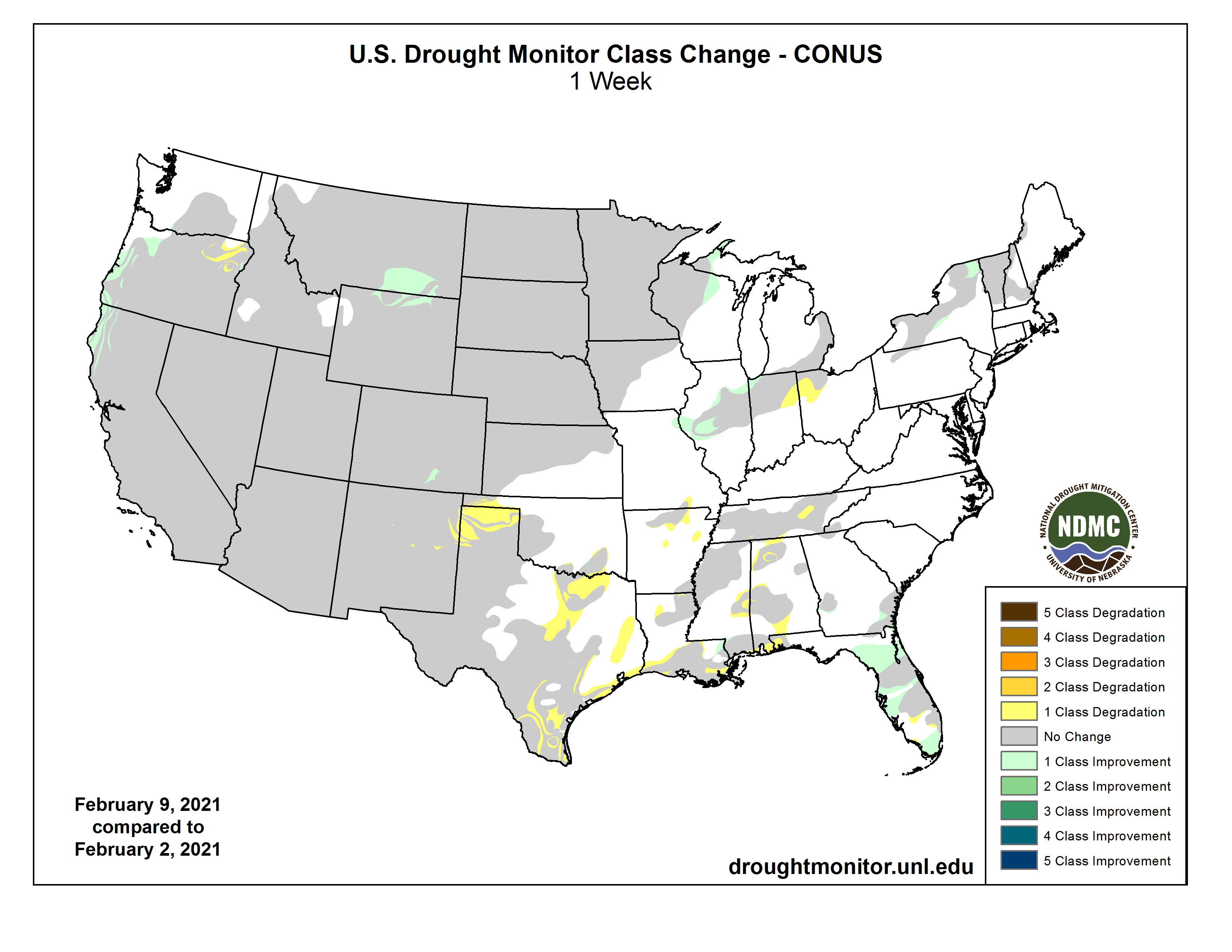
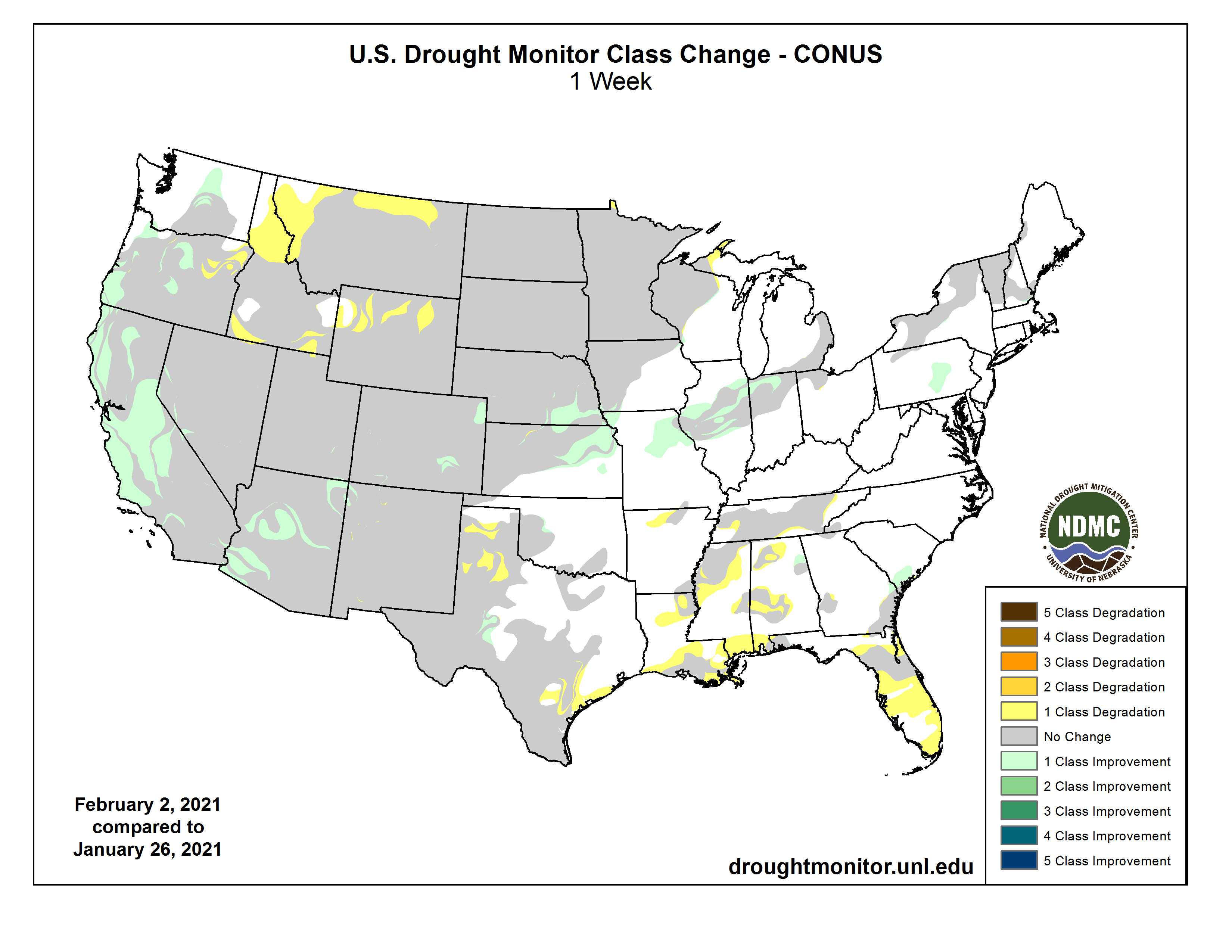
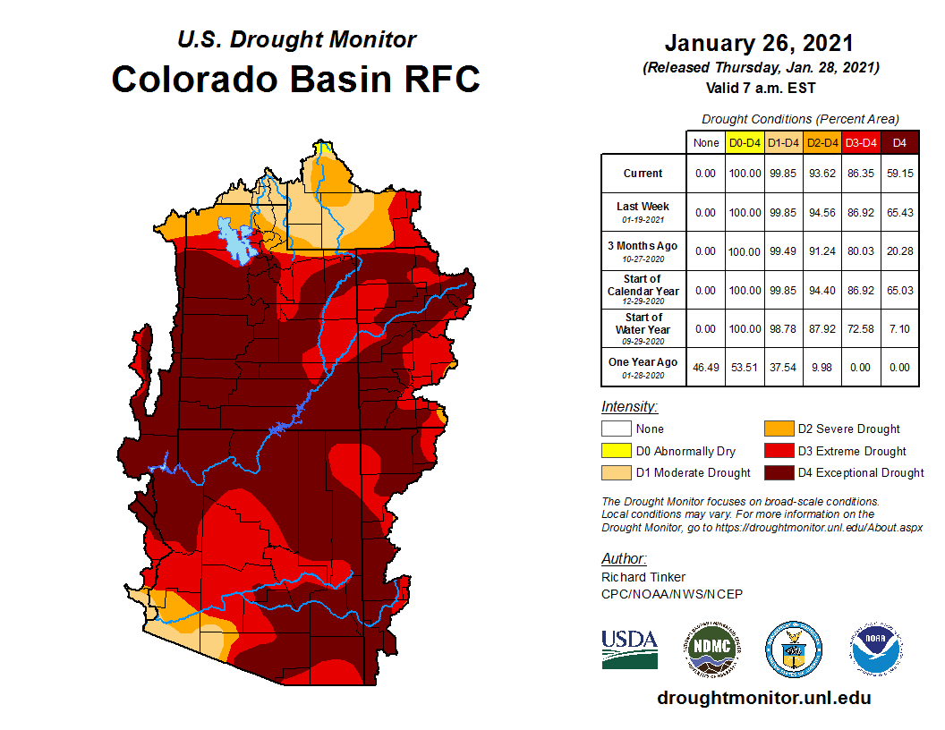
Click on a thumbnail graphic to view a gallery of drought data from the US Drought Monitor.
US Drought Monitor February 9, 2021.
West Drought Monitor February 9, 2021.
Colorado Drought Monitor February 9, 2021.
Click here to go to the US Drought Monitor website. Here’s an excerpt:
This Week’s Drought Summary
A slow-moving coastal storm delivered heavy precipitation in parts of the Northeast on January 31 – February 1, with impacts (windy weather and snow showers) lingering for several days. Later, the focus for stormy weather briefly returned to the western U.S., although significant precipitation was confined to the northern Rockies and Pacific Northwest. By February 4, wintry weather shifted into the upper Midwest, where blowing snow and gusty winds briefly resulted in blizzard conditions. The same weather system produced generally light rain across the South. Later, additional patchy precipitation fell in the central and eastern U.S., although dry weather prevailed during the drought-monitoring period across much of the nation’s southwestern quadrant. At the height of the early-February cold outbreak, temperatures plunged below -20°F across portions of the northern Plains and upper Midwest. Sub-zero readings occurred across a much larger area, extending southward across the central Plains and into the middle Mississippi Valley…
Overall, there were few changes to the High Plains’ drought depiction. Frigid weather settled across the region in early February, accompanied by periods of snow mainly in Nebraska and upslope (western) regions. Mostly dry weather persisted, however, in several areas, including northeastern Montana and the Dakotas, where lack of snow cover remained a concern with respect to lack of insulation for winter wheat during the protracted spell of sub-zero temperatures. In Glasgow, Montana, snow cover totaled an inch or less each day during the cold blast, which began with a low of 0°F on February 4 and included at least four consecutive readings below -20°F from February 7-10. In contrast, parts of Nebraska remained beneath a blanket of snow, some of which had fallen during a major storm on January 25. However, some additional snow fell in Nebraska and environs during the drought-monitoring period. For example, the weekend of February 6-7 featured Nebraska snowfall totals of 11.6 inches in North Platte, 9.6 inches in Lincoln, and 9.3 inches in Grand Island…
Aside from widespread precipitation in the Pacific Northwest and northern Rockies, the western U.S. experienced a much more tranquil drought-monitoring period. In fact, little or no precipitation fell across southern California, the Great Basin, and the Southwest, although mostly status-quo drought coverage was noted in the wake of late-January storminess. Farther north, coverage of severe to extreme drought (D2 to D3) was reduced in parts of southeastern Montana and northeastern Wyoming. Meanwhile, Oregon’s changes were mixed, with some general deterioration of conditions in the northeast and further improvement west of the Cascades. Following the late-January storminess, the California Department of Water Resources indicated that the average water equivalency of the high-elevation Sierra Nevada snowpack stood at nearly 13 inches (65% of normal for February 10), well above the January 24 value of 6 inches…
Despite a few showers, the general trend toward drier conditions continued, with some increasing coverage of abnormal dryness (D0) and moderate drought (D1) in Arkansas, Louisiana, Mississippi, and Tennessee. During the first 40 days of the year (January 1 – February 9), precipitation ranged from one-third to one-half of normal in locations such as Crossville, Tennessee (3.02 inches, or 49% of normal); Meridian, Mississippi (3.24 inches, or 46%); Lake Charles, Louisiana (2.86 inches, or 45%); Greenville, Mississippi (2.95 inches, or 43%); Jackson, Tennessee (2.25 inches, or 41%); New Iberia, Louisiana (2.57 inches, or 40%); Lafayette, Louisiana (2.78 inches, or 39%); Monroe, Louisiana (2.43 inches, or 38%); Vicksburg, Mississippi (2.37 inches, or 36%); and New Orleans, Louisiana (2.39 inches, or 35%). Short-term dryness also extended westward to coastal Texas, where some D1 was introduced between Port O’Connor and Galveston. During the first 40 days of the year, rainfall in Galveston totaled just 0.81 inch (16% of normal). Meanwhile, persistent warmth accompanied dry weather in southern Texas, resulting in growing coverage of moderate to extreme drought (D1 to D3). Drought deterioration was also noted on the High Plains, particularly in northern Texas and portions of neighboring states. According to the U.S. Department of Agriculture, statewide topsoil moisture in Texas was rated 55% very short to short on February 7, although agricultural district values were as high as 96% on the Northern High Plains (Amarillo area), 90% in the Lower Valley (Brownsville area), and 84% on the Southern High Plains (Lubbock area). In addition, 53% of Texas’ rangeland and pastures were rated in very poor to poor condition on that date, along with 31% of the winter wheat…
Looking Ahead
During the next several days, multiple storm systems will travel along or near a boundary separating warm air across the Deep South from frigid conditions farther north. Where storm-related moisture overruns cold air, there will be a significant threat of wintry weather (e.g. snow, sleet, and freezing rain), leading to potential travel disruptions and power outages. The parade of storms will produce generally light snow across the central Plains, Midwest, and Northeast, with periods of wintry precipitation expected from the southern Plains to the mid-Atlantic. Five-day Southeastern rainfall totals could reach 1 to 3 inches or more, except across the southern tip of Florida. Much of the West will also experience multiple rounds of precipitation. Each passing storm system will help to draw cold air farther southward, leading to sub-zero weekend temperatures possibly as far south as northern Texas.
The NWS 6- to 10-day outlook for February 16 – 20 calls for the likelihood of colder-than-normal conditions nationwide, except for near-normal temperatures in southern California and above-normal temperatures along the southern Atlantic Coast. Meanwhile, near- or above-normal precipitation will occur in most areas of country, with drier-than-normal weather limited to southern California, the Desert Southwest, and the north-central U.S.
US Drought Monitor one week change map ending February 9, 2021.
In the five years since Colorado’s Water Plan took effect, the state has awarded nearly $500 million in loans and grants for water projects, cities have enacted strict drought plans, communities have written nearly two dozen locally based stream restoration plans, and crews have been hard at work improving irrigation systems and upgrading wastewater treatment plants.
But big challenges lie ahead — drought, population growth, accelerating climate change, budget cuts, wildfires and competing demands for water, among others.
And though the state has made progress on the plan’s ambitious goals and funding needs since November 2015, it hasn’t yet been able to secure the estimated $100 million needed each year through 2050 to fully fund the plan.
Colorado water leaders are optimistic about advances made under the plan thus far. But they acknowledge that this five-year milestone is just the beginning of a long-term effort with no easy path forward. The plan is also undergoing a comprehensive update that will help refine its direction moving forward by incorporating lessons learned and better data.
“Five years in water time is really a blink of an eye,” said Lauren Ris, deputy director for the Colorado Water Conservation Board (CWCB), the statewide water policy agency tasked with administering the plan. “Even though we’re so proud of the progress we’ve made, we’ve got a lot of work in front of us. There’s a lot to celebrate but I also think we can’t rest too much on our laurels here.”
The water plan, explained
The plan provides a framework for ensuring there’s enough good-quality water for all of Colorado’s diverse users, as well as the state’s downstream neighbors. Gov. John Hickenlooper called for the plan’s creation in May 2013, which set in motion 30 months of meetings, public input, writing and reviewing to ultimately create the 567-page plan.
Colorado has long faced unique water challenges in part because its high-altitude rivers deliver water to 18 other states and Mexico, activity that is carefully governed by legal agreements that include compacts and treaties. Accelerating climate change and rapid population growth have only added more complexity. Colorado’s population is expected to grow as high as 8.1 million by 2050, up from 5.76 million in 2019, with much of that growth occurring on the East Slope. Meanwhile, 70 to 80 percent of the state’s water originates on the West Slope.
Many Colorado water leaders agree that the plan — and the multi-year processes for creating and updating it — has fostered an authentic spirit of collaboration. Even if they disagree, people have to work together to find common ground because the plan prioritizes projects that achieve multiple benefits, which in turn makes them more likely to receive state funding.
“Collaboration is now the starting point of conversations about water and maybe that wasn’t always true before,” said Russ Sands, water supply planning section chief for the CWCB. “Like any dinner party, you have some strong conversations and it’s hard. But then ultimately, we do come together around these multi-purpose, multi-benefit projects.”
Key to putting the plan to work are the public roundtables in each river basin, whose volunteer members are charged with identifying each region’s needs and the methods and funding to meet those needs.
The plan hasn’t completely eased tensions, but it has given water users a forum for voicing their opinions, popular or unpopular. And, perhaps above all else, it has succeeded in keeping water top of mind.
“The best thing the water plan has done is kept the water problem in everybody’s face,” said Max Schmidt, manager of the Orchard Mesa Irrigation District and Grand Valley Project Power Plant. “Traditionally, we have a dry year and everybody gets all worried. Then the next year’s a wet year and everybody forgets about it. People are now saying, ‘This is a long-term, serious problem.’”
Progress under the plan
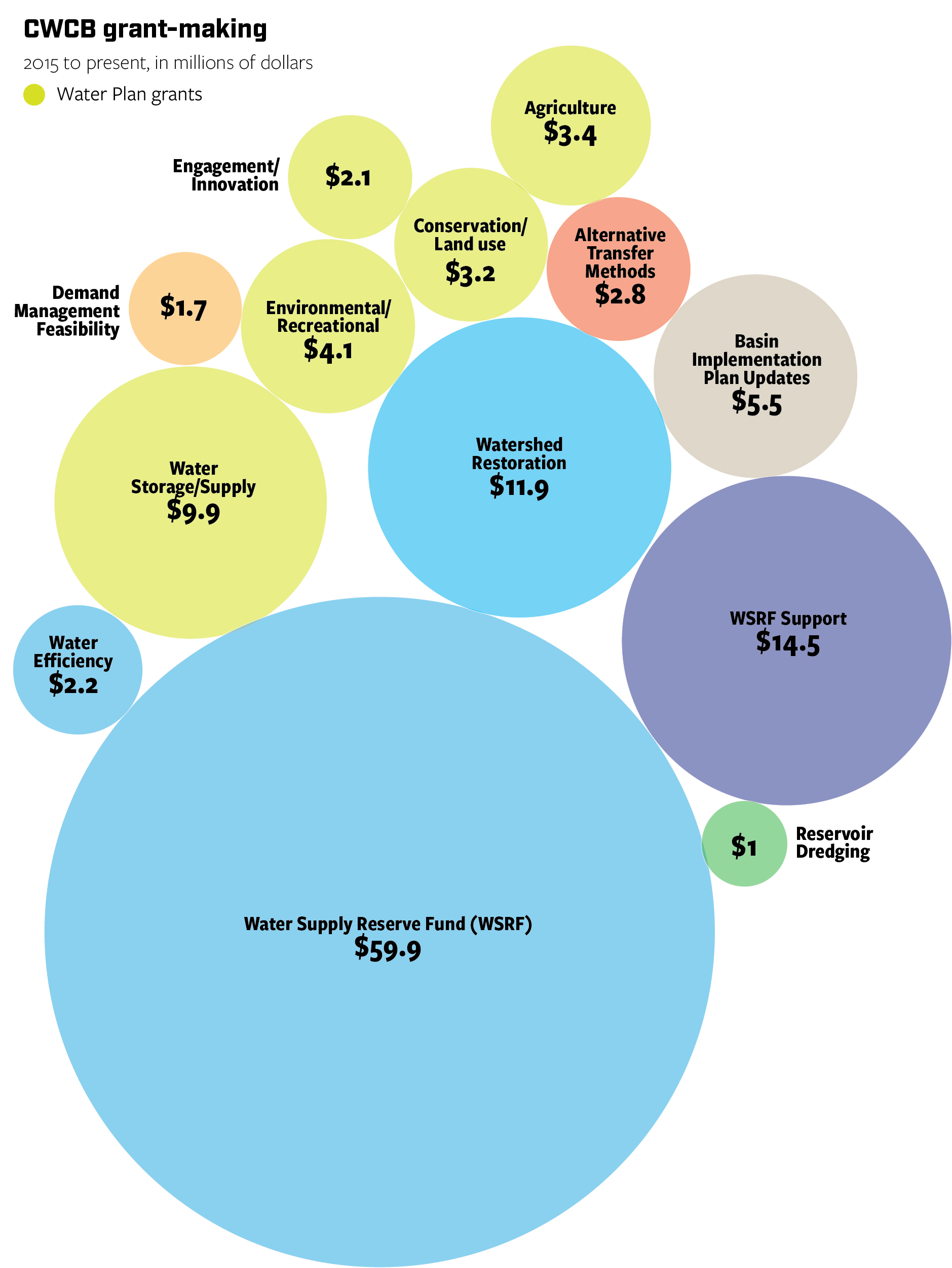
Work on the plan is occurring mostly on specific projects in Colorado’s eight river basins, which are often funded by loans and grants administered by the CWCB. Five years in, the plan has provided $63.5 million in grants to 241 projects, and $420 million in loans to 82 projects.
According to the CWCB’s data, 76 percent of the plan’s actions have been initiated or completed, but how this translates to progress on the plan’s eight measurable objectives isn’t clear yet. Those objectives set measurable targets for things like water conservation, new water storage, and water-smart land use, as well as informing the public. When asked about progress toward the objectives, the CWCB said it is no longer calculating specific progress metrics using the objectives but is instead tracking new projects or programs that work toward the goals outlined in the plan.
Since taking office in 2019, Gov. Jared Polis has made water one of his “Wildly Important Goals,” issuing a call to the CWCB and roundtables to create a database of 500 local water projects that are ready or nearly ready to launch and are backed by strong data demonstrating costs and potential outcomes.
While the “water WIG,” as it is known, did not come with any funding attached, the exercise has forced local water leaders to refine, prioritize and provide cost estimates for their most promising ideas.
Though the focus on specific projects has been effective for achieving goals in each river basin, some water leaders feel the plan doesn’t go far enough to address statewide issues.
“We need to think more broadly about water,” said Kathleen Curry, chair of the Gunnison Basin Roundtable on the West Slope, rancher and lobbyist. “Having a project-specific focus is great if you’re the entity pushing the projects, but really, overall forest health, stream measurement, snowpack measurement, some of the overall statewide water supply challenges that are out there, those need to be part of the plan as well. [We need to] make sure the plan isn’t simply a laundry list.”
Funding wins and challenges
Since the Colorado Water Plan’s inception, state funding for implementation has ranged from a low of $5 million in 2016 to $30 million in 2019, far short of the estimated $100 million needed each year through 2050
In 2020, lawmakers appropriated $7.5 million for the water plan, however, that money is expected to be stretched over three years because of declining oil and gas severance tax revenue and the economic consequences of COVID-19 on the state budget. Many other water-related programs are also not expected to receive additional funding in the near future, according to CWCB spokesperson Sara Leonard.
The plan got a new funding source in 2019 when voters approved Proposition DD, which legalized sports betting and directed tax revenue to the water plan.
Sports betting got off to a slow start in the spring of 2020, thanks to the near-total shutdown of sporting events because of the coronavirus pandemic. But activity picked up speed during the second half of the year, generating $3.4 million in taxes between May and December, double the estimated $1.5 million to $1.7 million per year.
Though not an immediate source of cash, the sports betting initiative was a big win in a state where voters have historically balked at statewide funding for water.
“The water plan requires about $100 million a year in sustainable funding to meet many of the goals outlined for 2025, 2030, 2050,” said Alec Garnett, D-Denver, the lead sponsor of the sports betting bill. “We never thought Prop DD was going to achieve that annual goal, but at least it established a reliable critical revenue source.”
Garnett said he always envisioned general fund money, plus the sports betting tax revenue, to help get the water plan closer to $100 million a year, but this year’s state budget challenges showed just how fraught that path forward may be. Since its launch, lawmakers have contributed general funds to the plan just once.
“Our economy and state budget have been turned upside down by the pandemic and we have to move through this period before we can talk about sustainable funding,” Garnett said. “It’s just hard to navigate with the changing environment.”
There were other wins for water funding over the last five years, too. Several local water districts and initiatives found success at the polls, garnering millions of dollars in new taxpayer support for an array of local and regional goals aligned with the plan.
In November 2020, voters approved property tax increases to support water projects in the Glenwood Springs-based Colorado River Water Conservation District and the Longmont-based St. Vrain and Left Hand Water Conservancy District.
“We’re already seeing where [funding is] being piecemealed together so maybe it’s statewide or maybe it’s a local thing,” said Garrett Varra, who chairs the South Platte Basin Roundtable and sits on the board of the St. Vrain and Left Hand Water Conservancy District. “Voters are more apt to trust people they know and be able to sit down and talk with directly than maybe the state Legislature itself or the CWCB or whoever it is. One way or another, whether it’s done region by region or statewide, it will happen at some point.”
Looking ahead
Colorado water leaders are in the middle of a comprehensive water plan update that will conclude in 2022. The update will incorporate five potential supply and demand scenarios for Colorado water in 2050, created by adjusting variables like water availability, climate change and population growth.
“It’s about choices that we make,” said the CWCB’s Ris. “We’re not locked into any future, that we have the ability to make choices in how we deal with everything coming down the pipe, including population growth, funding, climate change.”
Using the various planning scenarios and other data, the CWCB has also developed new tools to help estimate the environmental impacts and costs of water projects, as well as the costs and consequences of doing nothing. The board also created a new “Engage CWCB” website to encourage more community engagement with the plan.
This month, the Interbasin Compact Committee, a statewide board charged with helping shape policy and coordinating among the various river basins, will re-ignite talks about how best to fund the water plan and, ultimately, achieve its goals.
Set against the backdrop of record-setting wildfires, intensifying drought in the Colorado River Basin and other parts of the state, escalating climate change, and fears around potential water speculation, state water leaders say that funding can’t come soon enough.
“There’s a lot of talk about how do we get to that $100 million mark with the ever-increasing challenges that Colorado faces, with climate change happening faster than anyone really thought, even in 2015 when the water plan was created,” said Garnett.
Sarah Kuta is a freelance writer based in Longmont, Colorado. She can be reached at sarahkuta@gmail.com.
Graphics created by Chas Chamberlin, principal with cdcgraphics. He can be reached at chasdcham@gmail.com.
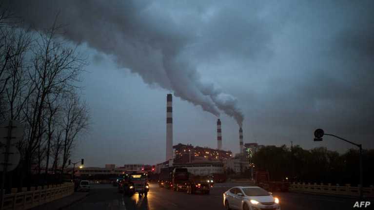
Cars pass the Shanghai Waigaoqiao Power Generator Company coal power plant in Shanghai on March 22, 2016. – Environmental watchdog Greenpeace warned on March 22, 2019 the worlds coal plants are deepening the global water crisis as the water consumed by them can meet the basic needs of one billion people. China, the world’s largest emitter, has promised to reach zero net carbon emissions by 2060. (Photo by JOHANNES EISELE / AFP) via Voice of America
The pledges countries made to reduce emissions as part of the 2015 Paris agreement are woefully inadequate, and the world must nearly double its greenhouse gas-cutting goals to avoid the most catastrophic effects of climate change, according to research published [February 9, 2020].
“The commitments are not enough,” said Adrian Raftery, a University of Washington statistics professor and co-author of the study, published in Communications Earth & Environment.
The study found that even if countries were to meet their existing pledges, the world has only about a 5 percent chance to limit the Earth’s warming to “well below” 2 degrees Celsius (3.6 Fahrenheit) over preindustrial levels — a key aim of the international agreement.
Raftery and a colleague calculated that global emissions would need to fall steadily — about 1.8 percent each year on average — to put the world on a more sustainable trajectory. While no two countries are alike, that amounts to overall emissions reductions roughly 80 percent more ambitious than those pledged under the Paris agreement, he said.
In many respects, the race to slow the Earth’s warming is a daunting math problem. Emissions have risen about 1.4 percent annually on average over the past decade, not including the abnormal plunge in 2020 driven by the coronavirus pandemic.
In 2019, the world logged the highest emissions ever recorded, at 59 billion tons of carbon dioxide equivalent emissions, a category that includes not only carbon dioxide but also methane and other climate-warming agents. If that trend continues unabated, scientists say, the world could begin to cross troubling climate thresholds within the coming decade.
The architects of the Paris accord and numerous world leaders have long underscored that the pledges made in 2015 were not enough to limit warming to acceptable levels. The expectation was always that nations would grow more ambitious with time, and there is evidence that is happening.
But as global emissions have continued to rise, as countries have failed to hit even modest targets and as the consequences of a warming world have become more tangible, the push for leaders to act more aggressively has become only more urgent.
Coloradans legally bet more than $1.1 billion on sports in 2020, exceeding expectations and funneling some cash to the Colorado Water Plan sooner than anticipated.
Colorado collected more than $3.4 million in sports betting taxes in 2020, with operators running from May through December. Voters agreed to legalize and tax sports betting in November 2019 with the passage of Proposition DD, which also directed much of the tax revenue to the Colorado Water Plan, a comprehensive vision for the state’s water future created in 2015.
Colorado’s fiscal year runs from July 1 to June 30, which makes the sports betting numbers even more promising, since December was only the halfway mark for the current fiscal year. From July to December 2020 — the first half of the current 2020-21 fiscal year — Colorado collected $3.1 million in sports betting tax revenue.
Even with six months remaining in the fiscal year — a span that includes big-time sporting events like the Super Bowl, March Madness, the Kentucky Derby and more — that $3.1 million is already double the gaming division’s initial projections of $1.5 million to $1.8 million for the full 2020-21 fiscal year. That means the Colorado Water Plan could see sports betting funds as soon as this fall, a year earlier than initially projected.
“We took a very conservative approach based on how fast the market would pick up, how fast people would embrace it, what effect we were going to have on moving people from the black market to the regular market, and we’ve just really blown all of those things out of the water — no pun intended for the water front,” said Dan Hartman, director of the Colorado Division of Gaming. “We really moved a lot of needles a lot further, a lot faster that we thought we were going to. We’re optimistic and really excited about where sports betting is and, ultimately, that there’s going to be better-than-projected amounts going to the water plan.”
Based on tax revenue collected in the first half of the current fiscal year, and factoring in the other ways sports betting tax revenue must be spent under the new law, the water plan so far stands to gain a little more than $1 million — and counting.
That’s still well short of the $100 million officials estimate they need each year in new funding to accomplish the water plan’s goals by 2050, but sports betting was never expected to fully fund the water plan — and every little bit counts, said Alec Garnett, D-Denver, the lead sponsor of the sports betting bill.
“We’ve always known that Coloradans love sports. We always knew that there was a black market and that people were already doing this,” Garnett said. “From a regulatory standpoint, I feel very strong and good about what these numbers mean for the market we created.”
If these early numbers are any indication, the sports betting program is likely to continue to grow in future years as the market matures and sports calendars get back to normal.
Though he has not created an official updated projection based on 2020’s wagers and tax revenue, Hartman said he believes annual sports betting tax revenue could double by next year.
“I’m comfortable in projecting that we’re probably on pace to do twice as much next year as we did this year,” Hartman said.
Sports betting got off to a slow start in Colorado, since it launched in the middle of the coronavirus pandemic when many sporting events were canceled. But as the sports betting program got underway and more live sporting events were held (often without fans in the seats), the tax revenue started growing.
Even so, before any of that money goes to the Colorado Water Plan, the gaming division must first pay back the $1.7 million lawmakers allocated from the state’s general fund to start the new sports betting program, which will likely happen at the beginning of March, Hartman said. The program’s ongoing operating costs are paid for with fees from licensed sports betting operators in the state, which now number 17.
The gaming division must also set aside 6 percent of tax revenue for a hold-harmless fund, provide $130,000 per year to the Colorado Department of Human Services’ Office of Behavioral Health, and give $30,000 per year to Rocky Mountain Crisis Partners to operate a gambling hotline.
Any remaining tax revenue can then go to the Water Plan Implementation Cash Fund, pending the approval of the Colorado Limited Gaming Control Commission, according to Suzi Karrer, a spokesperson for the Colorado Division of Revenue.
“The gaming commission will take that up in one of their meetings in the fall,” Hartman said. “Legislatively, it’s been turned over to the commission to follow the formula and give [the funds] to the beneficiaries.”
The early sports betting numbers were also a small bright spot for the Colorado Water Conservation Board (CWCB), the state agency tasked with administering the water plan, which expects to be rationing much of its current funding over the next two years.
CWCB hasn’t received any of the sports betting tax revenue yet and, since it’s difficult to predict how much Coloradans will wager in future years, the agency hasn’t yet made plans for spending it.
“Based on what has been collected so far, sports betting revenue does look promising as an additional — and more permanent — funding source for the water plan and important water projects, but again, it is still new, and we really don’t know yet what the revenue generation capacity will be,” said Sara Leonard, CWCB spokesperson.
As of right now, the CWCB is not planning to ask the Colorado Legislature to allocate funding to the Colorado Water Plan for the next two years and will instead rely on the 2020-21 allocation of $7.5 million, according to Leonard and state budget officials speaking at recent CWCB meetings.
The approval of the new sports betting tax, which created a dedicated funding source for the Colorado Water Plan, was an accomplishment in a state where voters have historically rejected statewide water funding efforts. But it’s still not enough to meet the ambitious goals outlined in the plan.
To that end, state and local water leaders plan to re-start conversations about water funding this month. Those talks will begin at the Feb. 23 meeting of the Interbasin Compact Committee (IBCC), according to the committee’s director Russell George. The IBCC, created in 2005, is a statewide public board that helps set policy and coordinate talks between river basins.
“We’re going to re-ignite that large discussion and see where we can go,” said George during his Jan. 25 update to the CWCB. “I don’t have to tell you the need for an input, an infusion of capital, in all of the things that we’re trying to do…It’ll just be the beginning of a conversation that I think’s going to go on until we’ve succeeded.”
Garnett said he wasn’t aware of any upcoming legislation related to new funding sources for the water plan, but said he was happy that funding for Colorado’s water future remains in the public eye.
“There’s just a lot of focus on this area because of the pressures that are being put on our most precious natural resource,” he said. “It’s always hard to find dedicated revenue streams in Colorado and it was certainly a hard process to get Proposition DD passed. I’m sure everyone has their eyes wide open about the challenges.”
Sarah Kuta is a freelance writer based in Longmont, Colorado. She can be reached at sarahkuta@gmail.com.
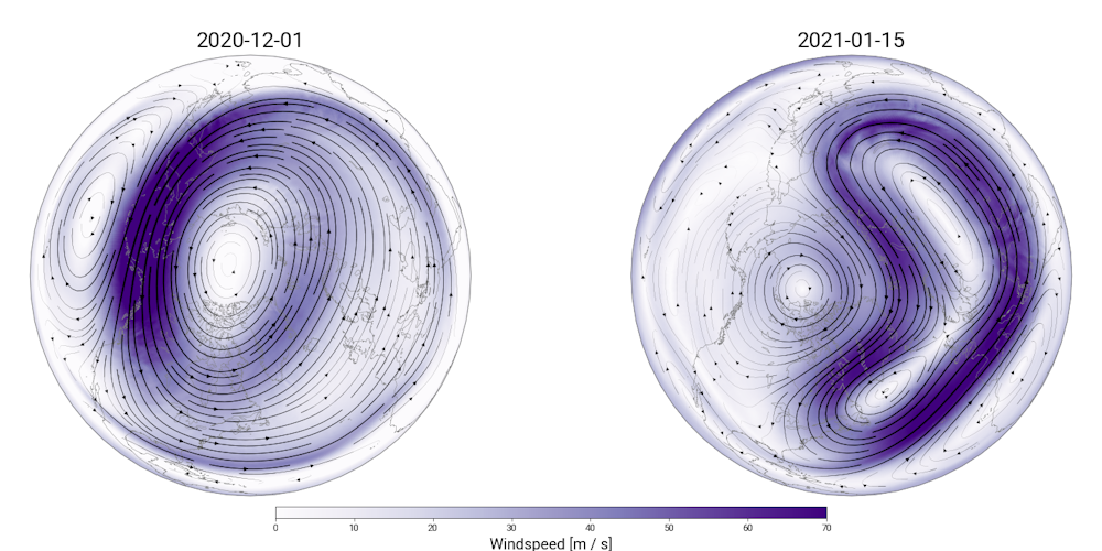
As atmosphericscientists, we cringe when the term polar vortex is used to loosely refer to blasts of cold weather. The actual polar vortex can’t put snow in your backyard, but changes in the polar vortex can load the dice for wintry weather – and this year, the dice rolled Yahtzee.
A weak polar vortex in early 2021 created a curvy jet stream that brought cold and winter storms to the northeastern U.S. AP Photo/John Minchillo
The winds of winter
The polar vortex is an enormous, three-dimensional ring of winds that surrounds the North and South poles during each hemisphere’s winter. These winds are located about 10 to 30 miles (16 to 50 kilometers) above Earth’s surface, in the layer of the atmosphere known as the stratosphere. They blow from west to east with sustained speeds easily exceeding 100 mph (160 kph). In the darkness of the winter polar night, temperatures within the polar vortex can easily get lower than minus 110 F (minus 79 C).
Fortunately for everyone, the stratospheric polar vortex itself won’t appear outside your front door. The polar vortex does influence winter weather, but it is more like a domino – when it is knocked over, it can start a chain of events that later result in wild weather.
The strength of the polar vortex can vary widely during winter, and these variations can lead to shifts in the strength and position of the jet stream, the fast-flowing river of air in the troposphere beneath the polar vortex. When the jet stream changes, it affects the movement of weather systems, causing different parts of the world to see much warmer or colder, or much wetter or drier conditions.
The disruption of the polar vortex during the beginning of 2021 was dramatic. Zachary Lawerence/CIRES/NOAA.
The domino effect
Since the Earth’s atmosphere is one giant shell of air that moves like a fluid, the polar vortex is interconnected with the weather that moves around the Earth at lower altitudes. Normal variations in the jet stream and weather can disturb the structure of the vortex in the stratosphere. Like an elastic band, the vortex usually rebounds back to its normal shape and size, maintaining its strong winds and low temperatures.
Between December (left) and January (right), the polar vortex moved entirely off the North Pole and lost much of its structural integrity. Zachary Lawrence/CIRES/NOAA
But sometimes, these weather and jet stream variations can knock the polar vortex off balance, causing significant wobbles in its shape, location, temperatures and winds. When this happens, the structural integrity of the polar vortex begins to break down. If this happens often enough over a period of time, everything can go haywire with the polar vortex as the winds break down and the vortex warms up.
As the polar vortex deforms between December and January, the jet stream became much wavier and brought cold storms farther south. Zachary Lawrence/CIRES/NOAA
This is precisely what has unfolded this year: On Jan. 5, the polar vortex was completely thrown out of whack by an event called a sudden stratospheric warming. Sudden stratospheric warming is the technical name for these violent disturbances that severely distort and weaken the vortex, knocking it off of the pole or even ripping it apart. When this happens, temperatures in the normally cold polar stratosphere explosively rise by as much as 90 F (50 C) over the span of a few days – hence the name of these events.
At this point, the domino has tipped over: Eventually the jet stream feels the effects of the weakened polar vortex above, and it can begin to undulate. When the jet stream gets wavy, it can dip farther south, bringing cold air and winter storms with it.
The January 2021 event pushed the polar vortex from its normal position over the North Pole all the way over to Europe and Siberia, nearly pulling it apart multiple times in the process. It can take weeks or months for the polar vortex to recover from something like this. While the vortex pieces itself back together, the undulating, curvy jet stream can bring frigid Arctic air and winter storms to the U.S. and Europe while allowing unusually warm weather to get into the far north.
A strong polar vortex means warmer, not colder, weather
In some winters, weather systems barely affect the polar vortex at all, allowing the vortex to grow colder with faster winds. This can have the opposite effect on the jet stream, causing it to keep cold Arctic air from the polar regions locked up north. This is what happened during the Northern Hemisphere winter of 2020, when the polar vortex was extraordinarily strong and many regions experienced an exceptionally warm and mild winter.
Calling any blast of cold air a polar vortex is wrong. The behavior of the polar vortex doesn’t just portend colder weather – it can also foreshadow much warmer weather. Most of the time the polar vortex has little influence on winter weather as it flows like normal, miles above the surface. But forecasting and monitoring huge disturbances to the polar vortex allows us to anticipate the chain of events that may leave feet of snow and frigid weather at your doorstep.
[The Conversation’s science, health and technology editors pick their favorite stories.Weekly on Wednesdays.]
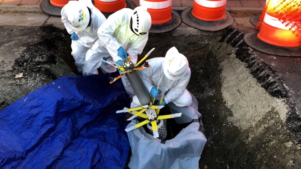
High-tech device ‘swims’ through Denver Water pipelines looking for trouble spots.
How do you inspect a water pipeline buried several feet underground and far too small to safely walk through?
In some cases, you send in a tool specifically designed to go with the flow and collect data along the way.
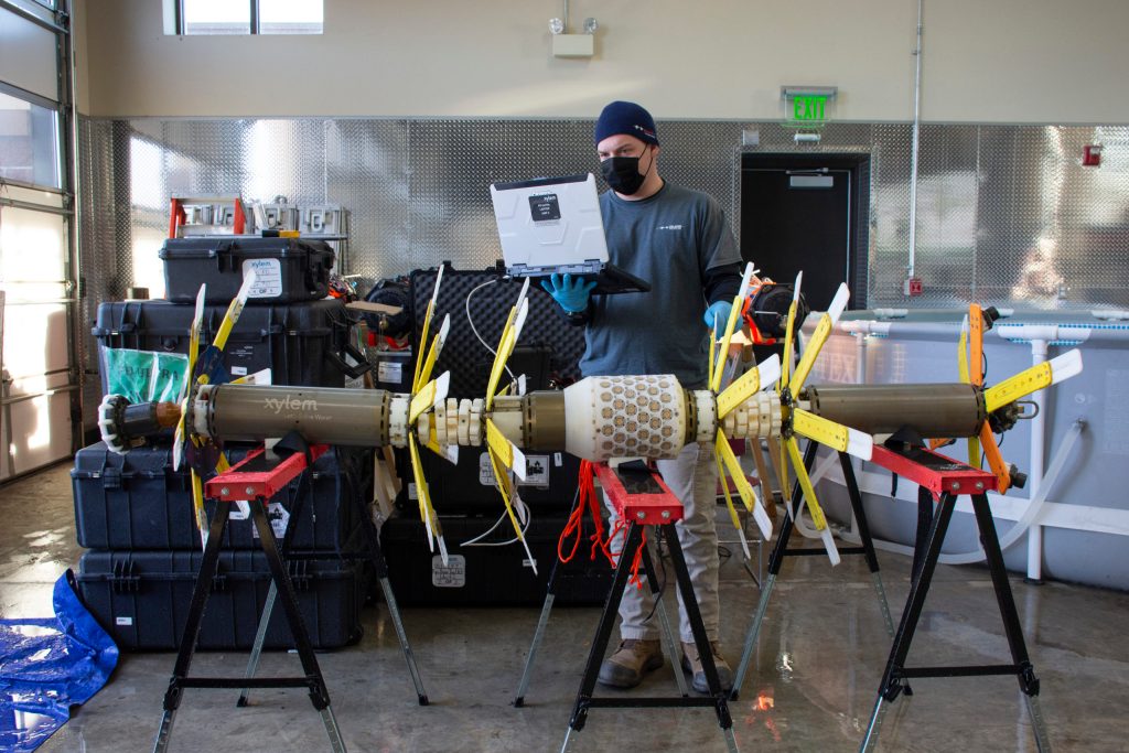
In the fall of 2020, Denver Water tested a somewhat unusual looking, high-tech device called a PipeDiver to inspect several miles of buried pipeline.
The PipeDiver is a state-of-the-art piece of equipment operated by Pure Technologies, a division of Xylem Inc., a company that specializes in pipeline monitoring and assessments for clients around the world. The company has been using the tool for inspections since 2010.
“We have about 3,000 miles of pipes in the metro area and we take a proactive approach toward monitoring their condition,” said Devin Shable, an engineer at Denver Water. “We have several methods to inspect our pipelines, but this was our first time using the PipeDiver.”
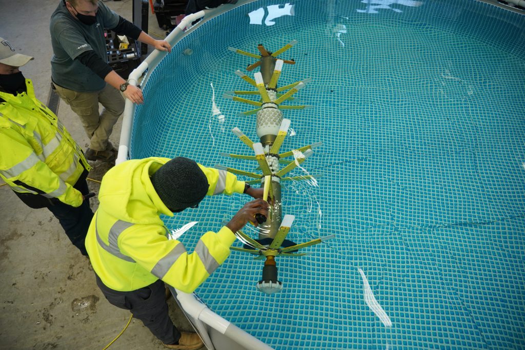
Workers from Pure Technologies carefully insert the PipeDiver into a water pipeline. Photo credit: Denver Water.
Denver Water used the PipeDiver to inspect two pipelines, a 3.7- mile stretch of pipe in Centennial that runs under open space, University Boulevard, East Dry Creek Road and Colorado Boulevard. The other inspection was on a 2-mile stretch of pipe under West Alameda Avenue and West Bayaud Street in Denver’s Baker and Valverde neighborhoods. The pipelines range in size from 30 to 36 inches in diameter.
Over time, pipelines can deteriorate, leading to leaks and ruptures. Many sources of stress from inside and outside the pipe can take a toll on a pipeline’s condition. These sources include soil type, how the soil interacts with the pipe, age, pipe material and how the pipe was constructed.
“Based on problems we’ve had on other pipelines of similar age and conditions, we wanted to do a thorough assessment of these two pipelines to see if there are any issues,” Shable said. “Proactive inspections are a critical part of our operations to prevent pipe breaks.”
Shable said buried pipelines are challenging to inspect for many reasons.
A Pure Technologies worker checks the balance of the PipeDiver in a pool before inspection. Photo credit: Denver Water.
First off, exterior inspections of pipelines would be costly and very disruptive to the community, as they would require large excavations to expose long exterior sections of pipe for inspection.
As for inspecting a pipe from the inside, some pipes are too small for a person to walk through. Even if a pipe is large enough, there are many safety and logistical challenges to overcome before allowing someone to perform an internal “manned” inspection.
Another challenge is that traditional “manned” inspections require draining a pipe, which can lead to lengthy disruptions in water service to customers.
The PipeDiver solves many of these issues.
“One of the biggest benefits of the PipeDiver is that we can leave a pipeline in service while we do the condition assessment,” said Brian Hext, project manager for Pure Technologies. “This tool can be more convenient for water utilities.”
The PipeDiver allows water utilities to keep a pipeline in service during an inspection. Photo credit: Denver Water.
But using the PipeDiver to inspect a buried pipeline still requires extensive planning, coordination and proper execution.
“Each time we do an inspection, we have to custom build the PipeDiver for the specific type and size of the pipe,” Hext said. “For Denver Water, we used two different PipeDivers for the two pipelines.”
The PipeDivers used for the Denver Water inspections look like 10-foot-long, mini-submarines made of several tube-like canisters that contain the electronics systems.
The articulated sections of the PipeDiver allow it to bend around sharp turns in the pipeline, much like the joint at the middle of a “bendy bus” allows it to weave through city streets.
On the front of the PipeDiver is a special nose that helps guide it through valves inside the pipeline. About 24 flexible, flower-like plastic petals stick out of each section to keep the device centered in the pipe as it moves along.
The PipeDiver is equipped with either ultrasonic or electromagnetic technology to inspect concrete or metallic pipes. Photo credit: Pure Technologies.
One of the PipeDivers used in Denver Water’s inspections was equipped with high-definition cameras on the tail to capture images inside the pipe.
“We like to joke that it looks a little bit like a prehistoric fish,” Hext said. “It does not have a motor and simply uses the flow of the water to move through the pipe.”
Crews must carefully assemble, test, balance and disinfect the device before each inspection.
Maintaining safe water quality is critical during the inspection process. In addition to an extensive cleaning and disinfection process for the PipeDiver, Denver Water had a water quality operations expert on hand to run tests during the inspection to ensure the utilities’ safe drinking water standards were not impacted by the inspection.
Once the PipeDiver is put together, the Pure Technologies team inserts it into an access point in the pipeline. The devices are equipped with GPS technology so crews can keep track of them as they float through the pipe.
After the PipeDiver completes its route, crews use custom-designed nets to catch the device and pull it out of the pipe.
The PipeDiver goes through several rounds of disinfection before being inserted into the pipeline. Photo credit: Pure Technologies.
To inspect pipes made of metal, such as cast iron, the PipeDivers are fitted with ultrasonic technology while electromagnetic technology is used to inspect pipes made of concrete.
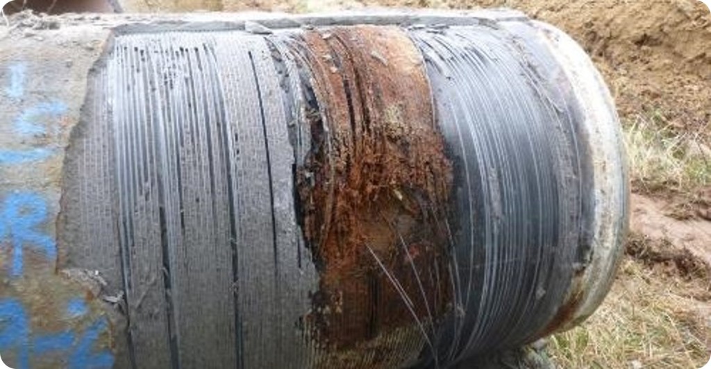
“What we’re looking for with the concrete pipe are the wires wrapped around the pipe that help hold it together,” Hext said. “If those wires break, it can cause the pipe to burst.”
This photo is an example of a prestressed concrete cylinder pipe with wire damage. Photo credit: Denver Water.
The ultrasonic technology used for metallic pipes measures the thickness of the pipe and areas of corrosion.
“If we find a place where the thickness is less than what it should be, we pinpoint that location as a potential issue,” he said.
“As with any new inspection technique, there was a learning curve that we had to work through to complete the inspection with the PipeDiver tool,” Shable said.
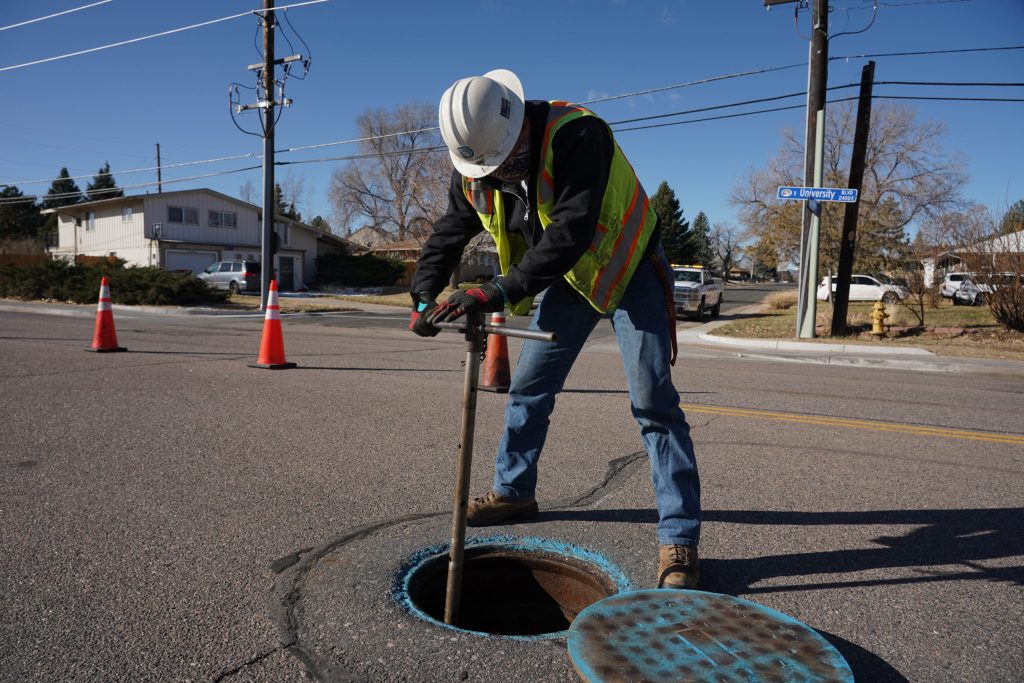
Denver Water crews worked with the Pure Technologies team to open all the valves in the pipeline, to give the PipeDiver a clear path through the pipe sections it was inspecting. Another challenge involved adjusting the flow of water through the pipes to ensure the PipeDiver moved at the optimal speed for data collection.
Denver Water crews adjust valves and the flow of water for the inspection. Photo credit: Denver Water.
Following the inspection, Pure Technologies will analyze the data from the inspections and then send reports with the findings to Denver Water.
“The inspection went well and the PipeDiver did its job,” said Luke Switzer, field team leader with Pure Technologies. “We should be able to get some good data to help Denver Water make informed decisions down the road.”
In addition to using the PipeDiver, Denver Water’s proactive approach to assessing pipelines includes “manned” inspection techniques and real-time pipeline monitoring equipment.
Manned inspections require draining the water from the pipeline to allow for an inspector to walk through and assess the pipe.
Denver Water used the PipeDivers for the first time during two inspections in 2020. Photo credit: Denver Water.
Real-time monitoring equipment, used on some sections of important pipelines, includes the use of acoustic fiber optic monitoring systems (read a TAP story about that technology here) and equipment designed to detect pressure changes and leaks.
Data from inspections also helps in the planning process of prioritizing when pipes should be replaced. This is important because replacing large water pipelines is expensive. For example, a project to replace 2,205 feet of pipeline in north Denver in 2020 cost nearly $4 million dollars.
Denver Water uses inspection data as well as other factors including number of leaks, breaks, maintenance projects and outages to collect a full picture of a pipelines’ overall health.
Once all the information is compiled, the utility decides if small “targeted” repairs are needed or if certain sections need to be repaired to maintain a desired level of pipeline reliability.
If those options are not deemed to be cost effective, then full replacement of the entire pipeline may be needed.
“Having a good understanding of the condition of the pipe allows us to make decisions about the timing of replacement and allows us to push expensive projects out into the future,” Shable said. “The inspections help inform our decisions on what we need to address today and what we need to plan for down the road.”
Jim Broderick. Photo credit: The Southeastern Colorado Water Conservancy District
Here’s the release from the Southeastern Colorado Water Conservancy District (Chris Woodka):
Jim Broderick honored by Colorado Water Congress with Wayne N. Aspinall Award
Jim Broderick, a Pueblo native who has spearheaded regional and state water projects for nearly two decades, was given the top honor at the 2021 Colorado Water Congress convention.
Broderick, executive director of the Southeastern Colorado Water Conservancy District, was presented the 2021 Wayne N. Aspinall “Water Leader of the Year” award at the CWC virtual water conference Tuesday.
“What a great honor,” Broderick said, after being surprised by the award. “Let me thank the past winners for this award. I’d also like to thank the Southeastern Board of Directors for giving me the opportunity to do the work I love to do. I have been privileged to have people on staff who have helped me… Most of all, I thank my wife (Cindy) and daughter (Amy).”
“I couldn’t be more honored to present this award,” said Christine Arbogast, a water consultant who received the Aspinall Award in 2020. She grew up in Pueblo at the same time as Broderick, and works for the Southeastern District.
Pueblo dam releases
The exterior of the James W. Broderick Hydroelectric Power Facility at Pueblo Dam, which began producing electricity this week. Photo credit: Southeastern Colorado Water Conservancy District
Arkansas Valley Conduit “A Path Forward” November 22, 2019 via Southeastern.
Southeastern Board President Bill Long praised Broderick for advancing the Excess Capacity Master Contract for storage in Pueblo Reservoir, hydroelectric power at Pueblo Dam, and the Arkansas Valley Conduit, as well as other District improvements.
Eric Wilkinson, retired executive director of the Northern Colorado Water Conservancy District and an Aspinall Award recipient himself, praised Broderick for his service to Water Congress.
Also on hand for the presentation were Southeastern Board Members Alan Hamel (a 2012 Aspinall recipient), Kevin Karney and Seth Clayton, who were gathered for a presentation on AVC immediately following the Aspinall presentation.
Broderick said he had no idea he was there for anything other than the AVC presentation.
Although about 250 people were in the virtual meeting at the time, only a few were in the Zoom meeting room with Broderick. Normally, there would be a larger crowd, but because of COVID-19 restrictions, only a few presenters were on-screen during the presentation.
Broderick was named executive director of the Southeastern Colorado Water Conservancy District on November 1, 2002. The Southeastern District is the state authority for the Fryingpan-Arkansas Project, which was created by an Act of Congress in 1962. Its primary purpose is to deliver a supplemental supply of water to the Arkansas River basin from the upper reaches of the Colorado River.
At the helm of the Southeastern District, Broderick completed the Excess Capacity Master Contract for storage in Pueblo Reservoir. The contract enables stakeholders to store non-Project water in Pueblo Reservoir for 40 years when space is available. The Master Contract covers environmental compliance issues which otherwise would require annual analysis, and firms up storage options for participants.
Broderick oversaw the construction of a 7.5-megawatt hydroelectric power plant at Pueblo Dam under a Lease of Power Privilege with the Bureau of Reclamation. The facility opened in 2019 and the Southeastern Board voted to name the James W. Broderick Hydropower Plant in his honor. The plant provides a source of clean energy, which is being purchased by the city of Fountain and Fort Carson (through Colorado Springs Utilities).
Broderick revived the Arkansas Valley Conduit project, meeting with stakeholders for a decade, shepherding the AVC through the NEPA process, working with Reclamation to develop AVC, and tirelessly urging Congress to fund the AVC. Those efforts paid off in 2020 with the first federal appropriation for construction of the AVC, which will begin by early 2022. The AVC will be a 130-mile long pipeline that will provide fresh drinking water to 40 communities with 50,000 people east of Pueblo.
Broderick in 2020 completed a two-year term as President of the Colorado River Water Users Association, a non-profit, non-partisan organization that provides a forum to exchange ideas and perspectives on the Colorado River. Its members include Arizona, California, Colorado, New Mexico, Nevada, Utah, Wyoming, and the Ten Tribes Partnership. The group also works closely with Mexico. During his tenure at the helm, the seven states reached a Drought Contingency Plans agreement that describes how states will operate if there is a shortfall of water on the Colorado River basin.
Broderick is past president of the Colorado Water Congress and Arkansas Basin Roundtable. He is also a member of the National Water Resources Association and Family Farm Alliance.
He also served as a director for the Arizona Water and Pollution Control Association from 1996-1999, resided as president on the board from 2001-2002, chaired the Arizona Section of AWWA from 2001-2002., and was President of the Arizona section of WEF from 2001-2002.
Prior to joining the Southeastern District, Broderick was the Business Administrator for Tucson Water which served 700,000 customers at the time in Tucson, Arizona. In that position, he oversaw Financial Services, Operations & Maintenance Budgets, Capital Budgets, Rate and Revenues analysis, Asset Management, Information Technology Systems, Customer Service and Billing, Enterprise Call Center, Meter Reading, Demand-side Energy Efficiency Planning and reengineering for a multi-site operations.
Glen Canyon in 1873, near the confluence of the Colorado and San Juan Rivers. By Timothy H. O'Sullivan – U.S. National Archives and Records Administration, Public Domain, https://commons.wikimedia.org/w/index.php?curid=17428088
A bill would allow the new agency — which environmentalists call “shadowy” — to close its meetings and keep its records confidential.
Utah legislative leaders on Thursday unveiled plans for a new $9 million state agency to advance Utah’s claims to the Colorado River in hopes of wrangling more of the river’s diminishing flows, potentially at the expense of six neighboring states that also tap the river.
Without any prior public involvement or notice, lawmakers assembled legislation to create a six-member entity called the Colorado River Authority of Utah, charged with implementing “a management plan to ensure that Utah can protect and develop the Colorado River system.”
Sponsored by House Speaker Brad Wilson and Senate President Stuart Adams, R-Layton, HB297 would establish the Colorado River Commission of Utah, with a $600,000 annual budget. Utah shares the river’s flow with six neighboring states, most of which have dedicated large resources and expertise to preserve their interests in the river, according to Wilson. HB297 would help Utah better compete as it renegotiates the century-old agreement that governs how the river’s water is apportioned…
Dismayed the bill was drafted in secrecy, environmentalists argued the legislation is premised on the false idea that Utah is not receiving its full allotment of the Colorado’s flow. They characterized the commission as a “shadowy new government agency” aimed at promoting the Lake Powell pipeline and other big water diversions…
The bill would give broad authority to the new agency to close its meetings and keep its records confidential.
“This bill isn’t about water. It’s about money. It’s about climate change denial,” said Zach Frankel of the Utah Rivers Council. “This bill is a water war. This bill ignites more frustration from other states by creating mythologies and ignorances and disinformation. And those conversations can be done behind closed doors because this bill exempts [the authority] from having to comply with all of the open and public meetings.”
Frankel’s impassioned remarks swayed no Republicans on the committee, who voted to advance HB297 on a party-line 9-2 vote…
Utah officials have long complained that the Beehive State is not taking its full allotment, which they say is 1.4 million acre-feet. For years, Utah’s unused share has been slipping past Glen Canyon Dam for use elsewhere, they complain.
But Frankel and others say state water officials ignore the reality of climate change, which has reduced the river’s flows by about 20% over the past two decades. That means Utah’s cut is a lot less than what has been claimed.
HB297 appears to be an outgrowth of a resolution passed last year that commits Utah agencies to “expeditiously develop and place to beneficial use [the Colorado’s flow] wherever within the state the need may arise.”
HCR22 sponsor Rep. Brad Last, R-Hurricane, told colleagues Utah must either use its share of the Colorado or lose it to the other states, framing the question of water development as an us-versus-them proposition…
According to the U.S. Bureau of Reclamation, Utah is drawing about 1 million acre-feet from the Colorado, or about two-thirds of what Utah water officials contend is Utah’s share under the 1922 compact.
The river is under severe pressure from drought and urban growth, according to Gene Shawcroft, Utah’s representative on the Upper Colorado River Commission and the general manager of the Central Utah Water Conservancy District.
In the gloomiest long-term forecast yet for the drought-stricken Colorado River, a new study warns that lower river basin states including Arizona may have to slash their take from the river up to 40% by the 2050s to keep reservoirs from falling too low.
Such a cut would amount to about twice as much as the three Lower Basin states — Arizona, California and Nevada — agreed to absorb under the drought contingency plan they approved in early 2019.
Overall, the study warned that managing the river sustainably will require substantially larger cuts in use by Lower Basin states than currently envisioned, along with curbs on future diversions by Upper Basin states.
While climate change’s impacts on the river have been repeatedly studied, this is the first study that seeks to pinpoint how warming temperatures would translate into reductions in water that river basin states could take over the long term.
Carrying out the study’s recommendations, under the most likely conditions of climate change, almost certainly would mean more supply curbs for the $4 billion Central Arizona Project.
The CAP is already slated to lose nearly half its total allocation under the worst case, shorter-term scenarios envisioned under the 2019 drought plan.
Tucson and Phoenix-area cities and tribes, along with Central Arizona farmers, all depend on the CAP for water for drinking or irrigation.
The study, written by 13 researchers, was posted online about a week ago, at a time the drying river is on the edge of its first major shortage.
Federal forecasters predict Lake Mead will drop low enough to require cutbacks in water deliveries to Central Arizona farmers in 2022 due to river flow declines.
But exactly how much will be cut in long-term, future water deliveries is far from settled. The seven states are about to start renegotiating guidelines under which the river has been managed since 2007. Changes to the guidelines won’t take effect until 2026.
“SELF-INFLICTED WOUNDS”
In other forecasts, the study took a shot at longstanding plans by the four Upper Basin states — New Mexico, Colorado, Utah and Wyoming — to increase their take from the river under rights held from the 1922 Colorado River Compact.
The Upper Basin states’ forecasts of river diversions are unrealistic and would make it virtually impossible to maintain stable water supplies over an extended period, the study said.
“New demands in the era of climate change resulting in decreasing flows are the equivalent of self-inflicted wounds,” the study said.
Also, more, major Upper Basin diversions could drain both lakes Mead and Powell, dramatically reducing the amount of water available to serve people for drinking and irrigation and to generate electricity, the study said.
That would also result in the release of very warm water from Powell, compared to colder waters being released today. The Grand Canyon’s ecosystem downstream would be drastically changed, said Jack Schmidt, one of the study’s authors.
The study also warned that the current, downward trend in river flows will likely continue or worsen as temperatures keep rising.
That will lead to additional evapotranspiration — the absorption of atmospheric water supplies by plants — and aridification of the landscape, in which soils get drier and runoff keeps declining, the study said.
“Under this scenario, the basin will soon face a tipping point,” the study said.
The carbon dioxide data on Mauna Loa constitute the longest record of direct measurements of carbon dioxide in the atmosphere. C. David Keeling of the Scripps Institution of Oceanography began measurements in 1958 at the NOAA weather station. NOAA started its own CO2 measurements in May of 1974, and they have run in parallel with those made by Scripps since then. Credit: NOAA and Scripps Institution of Oceanography.
FromThe Grand Junction Daily Sentinel (Dennis Webb):
Diminishing water supply part of report
Numerous western Coloradans were part of a group that has presented U.S. Sen. Michael Bennet, D-Colo., with recommendations for how to increase resilience to climate change in the West.
Bennet said in a news release that he plans to use the recommended priorities to drive his policy work in the Senate and in working with the Biden administration on its national climate strategy.
“The terrific work this group has done to reimagine climate policy is already informing my team’s work. I plan to share their framework with my colleagues in the Senate and the Biden Administration to help them understand why climate resilience is so important to Colorado and the rest of the Mountain West,” Bennet said in the release. “I will do my part to ensure these priorities are part of every discussion going forward about climate and the country’s economy. I think this framework will be an important tool to demonstrate to the country that climate change isn’t a future condition in the West — it’s here now. And the survival of our economy and our way of life depends on tackling this challenge.”
The group was formed in November and chaired by Andy Mueller, general manager of western Colorado’s Colorado River District, which has been focused on dealing with the challenges of diminishing water supply in a warming climate, and the implications that may have for Western Slope agriculture and communities…
The group made recommendations focused on three overall priorities, saying:
Resilience is dependent on strong local economies in the West, and a climate resilience strategy must include tools for local economies to adapt to changing climate and economic conditions and build long-term prosperity in a future powered by a clean economy.
Supporting healthy soils, forests, rangeland, rivers and watersheds will make communities more resilient and help maximize the climate mitigation potential of western landscapes.
Climate resilience is dependent on a thorough and science-based understanding of actions needed to sustainably adapt to and mitigate climate change.
A wide range of more specific recommendations within the framework of those priorities include:
Helping communities transitioning from fossil-fuel-based economies through measures such as job training, support for building broadband infrastructure, and investing in forest restoration, clean energy and outdoor recreation to attract new business, jobs and tax revenues;
Modernizing and building new infrastructure, including water infrastructure that protects and enhances rivers and habitat, and provides water for communities and agriculture while enhancing a vibrant outdoor economy;
Updating federal management of natural resources so it is informed by the best available science;
Increasing funding for research and development programs throughout the West that focus on developing climate change solutions.
Bennet’s office said he already is taking action based on the recommendations.
He recently urged the Biden administration to prioritize locally driven economic development solutions for communities transitioning away from fossil fuels. He plans in coming weeks to reintroduce a bill to invest in $60 billion in forest and watershed restoration across the West.
A fresh face was appointed to the Southwestern Water Conservation District to bring new ideas to decades-old problems surrounding water in the arid Southwest – at least that’s the hope of La Plata County officials.
In January, La Plata County commissioners Gwen Lachelt and Julie Westendorff, in their last meeting before leaving office, along with commissioner Clyde Church, appointed local water attorney Amy Novak Huff to the district.
The move ousted longtime board member Bob Wolff, who has represented La Plata County on the commission for more than 10 years.
Lachelt, speaking to The Durango Herald, said commissioners will sometimes replace people who have served long bouts of time to bring in new perspectives about various issues facing the county…
Huff was raised in Southern California, but went to school at the University of Colorado-Boulder and never looked back. After teaching high school in Durango and Mancos, she went to law school at the University of Denver while working at Denver Water, where she became drawn to water law.
After she passed the bar exam, Huff was selected for a judicial clerkship in Division No. 1 Water Court and then worked for a water law firm in Denver. All those years on the Front Range, where water is scarce, allowed her to experience firsthand the contentious water issues…
Huff said she has now been practicing water law for 18 years, the majority of which has been in Southwest Colorado where water issues abound, exacerbated by drought, increasing demand and tricky multi-state compacts…
Huff, for her part, will take a seat at her first board meeting Tuesday. She said she understands the gravity of the moment and how important local decisions will affect water availability and people’s way of life.
“We’re going to be faced with water restrictions, changing landscapes and people are going to be forced to learn (about water issues),” she said. “It’s a lot more complicated than people think.”
Several Colorado ski resorts are now reporting more than 2 feet of fresh powder this month, and more is on the way.
It’s a welcoming sight as we’re now more than halfway through the ski season, and still lagging behind.
In just the past week, Vail has reported nearly 2.5 feet of fresh snow.
Places like Breckenridge, Aspen Snowmass, Beaver Creek and Copper Mountain all picked up between 20-25 inches of new snow this past week.
Crested Butte, Keystone, Winter Park and Monarch are all reporting around 1.5 feet of fresh snow…
Home to Wolf Creek Ski Area, the Upper Rio Grande Basin is the only region that’s above average. Currently, Wolf Creek is reporting a base depth of 88-95″, nearly double that of Breckenridge, which has a base of 46″.
Westwide SNOTEL basin-filled map February 9, 2021 via the NRCS.
Vail Mountain is reporting 29 inches of new snow in the past seven days. That’s been enough to boost the measurement site on Vail Mountain — which measures “snow water equivalent,” the amount of water in snow — to 88% of the 30-year median. The same site on Jan. 18 showed snowpack at just 69% of that 30-year median.
The numbers were roughly the same at sites on Copper Mountain and Fremont Pass, the sites closest to Vail Pass and the headwaters of the Eagle River, respectively.
Tom Renwick, a forecaster at the Grand Junction office of the National Weather Service, said the Central Rockies, including the area around Vail, could see between 6 and 12 inches starting late Monday and continuing to Wednesday…
West Drought Monitor February 2, 2021.
The drought persists
But even if the local snowpack nears normal levels, the fact is that Eagle County remains in a prolonged drought period.
Even with normal snowfall, the ground is parched underneath that snow. That means much of the snowpack will melt into the ground before it runs off into local streams.
With that and other factors in mind — including summers when expected rainfall hasn’t materialized — local water officials are urging customers to adapt to a continued dry climate…
[Diane] Johnson’s email notes that reducing outdoor water use is particularly important. Outdoor irrigation uses far more water than indoor domestic use, Johnson wrote. And, while almost all water used indoors eventually returns to local streams, very little water used for outdoor irrigation returns to streams…
It’s all part of being able to “adapt to an aridifying environment,” Johnson wrote. That holds no matter how much more snow this season may bring.
FromThe Steamboat Pilot & Today (Kari Dequine Harden):
Based on recent data and statistical modeling, there is only a 10% chance spring precipitation will be robust enough to bring a normal water supply to the Yampa Valley heading into the summer, said Dave Kanzer, deputy chief engineer at the Colorado River District.
There’s also a 10% chance of reaching record low water supply levels for the Yampa River, Kanzer warned.
And in terms of the drought bell curve, Kanzer said the fringe areas on either side of the middle are increasingly important, as the entire curve looks to be shifting toward a higher propensity for less precipitation and warmer temperatures.
Making summer drought predictions in February is certainly early, Kanzer noted, with the forecast season just beginning.
But the current snowpack is already well below average for the Yampa River Basin.
Based upon data from SNOTEL sites around Routt County that are maintained by the U.S. Department of Agriculture, the area is currently tracking in the range of 75% of what’s typical for this time of year. It should be noted 75% of snowpack does not translate to 75% of water supply season volume.
Runoff primarily occurs between April and July, and that’s the data to show the water flow that makes up about 80% of the whole year’s balance, Kanzer said…
The Yampa River, Kanzer said, has a relatively low amount of storage. And a lot of that flow is essentially gone from the system by July, he said.
Entering this winter with what Kanzer described as “about six to nine months of record dry soil moisture conditions,” the moisture level of soil will also play a critical role in how the summer looks.
The soil is so dry it will soak up a lot of the moisture before it has a chance to run off into streams and rivers.
The above normal temperatures of recent years — some record setting — also causes more evaporation…
Todd Hagenbuch, director and agriculture agent for the Colorado State University Extension Office in Routt County, said he’s seeing data suggesting drought seasons like in 2002 and 2012…
And given a very dry fall for 2020, and very low soil moisture levels, “We are starting way behind the eight ball.”
As of Feb. 1, Kanzer said the forecast for the Yampa River is to be at 50% to 65% of its normal water supply…
Looking at the Colorado River Basin as a whole — of which the Yampa River is part — the numbers are alarming.
A recent article by Yale Climate Connections displayed the headline, “Drought-stricken Colorado River Basin could see additional 20% drop in water flow by 2050.”
The Bureau of Reclamation’s recent quarterly report was grim, showing Lake Powell and Lake Mead, both fed by the Colorado River, at 42% and 40% of capacity, respectively.
Colorado has been experiencing drought conditions for nearly 20 years. About three-quarters of the state is designated as being in extreme drought conditions, according to the U.S. Drought Monitor.
It’s the second worst 20-year period in the past 1,200 years, according to Bradley Udall, a senior climate and water scientist at Colorado State University’s Colorado Water Center.
According to data from the Natural Resources Conservation Service, statewide snowpack is at about 73% of normal.
“That’s the fourth lowest snowpack that we’ve measured for this date in the past 36 years,” said Brian Domonkos, supervisor of the Natural Resources Conservation Service’s Colorado Snow Survey, in a KUNC story.
Most scientists are now projecting a continuation of the hotter and drier conditions — accepting a world in which the current drought is not part of a shorter cycle that will balance itself out, but rather part of the enduring impacts of climate change.
Here’s the release from the State of the Rockies Project at Colorado College (Katrina Miller-Stevens and Jacob Hay):
New Poll Shows Surge in Concern about Nature and Continued Bipartisan Support for Conservation Among Western Voters
11th annual Conservation in the West Poll reveals policy opportunities for new administration and Congress on public land conservation
Colorado College’s 11th annual State of the Rockies Project Conservation in the West Poll released today showed a marked increase in levels of support for conservation, with voters in the Mountain West calling for bold action to protect nature as a new administration and Congress consider their public lands agendas.
The poll, which surveyed the views of voters in eight Mountain West states (Arizona, Colorado, Idaho, Montana, Nevada, New Mexico, Utah, and Wyoming), found 61 percent of voters are concerned about the future of nature, meaning land, water, air, and wildlife. Despite trying economic conditions during the COVID-19 pandemic, the level of concern for things like loss of habitat for fish and wildlife, inadequate water supplies, pollution in the air and water, the loss of pollinators, uncontrollable wildfires, and climate change outpaced the overall level of concern about unemployment.
“We are seeing strong voter concern for nature, which is translating into calls for bold action on public lands in the West,” said Katrina Miller-Stevens, Director of the State of the Rockies Project and an Assistant Professor at Colorado College.
“If federal and state policy leaders are looking for direction on public lands, the view from the West is clear.”
Westerners’ heightened concerns about their natural landscapes are matched with strong consensus behind proposals to conserve and protect the country’s outdoors.
● 77 percent support setting a national goal of conserving 30 percent of land and waters in America by the year 2030, which was recently announced in an Executive Order by the new Biden administration.
● 72 percent support making public lands a net-zero source of carbon pollution, meaning that the positive impacts of forests and lands to create clean air are greater than the carbon pollution caused by oil and gas development or mining.
● 66 percent support gradually transitioning to 100 percent of our energy being produced from clean, renewable sources like solar, wind, and hydropower over the next ten to fifteen years.
● 77 percent support restoring national monument protections to lands in the West which contain archaeological and Native American sites, but also have oil, gas, and mineral deposits.
● 84 percent support creating new national parks, national monuments, national wildlife refuges, and tribal protected areas to protect historic sites or outdoor recreation areas, in part because 77 percent of voters believe those types of protected public lands help the economy in their state.
● 91 percent of voters in the West agree that despite state budget problems, we should still find money to protect their state’s land, water, and wildlife.
Conservation intersects with equity concerns
The poll broke new ground this year in examining the intersection of race with views on conservation priorities. Results were separated by responses from Black, Latino, and Native American voters, along with combined communities of color findings. The poll included an oversample of Black and Native American voters in the region in order to speak more confidently about the view of those communities.
The poll found notably higher percentages of Black voters, Latino voters, and Native American voters to be concerned about climate change, pollution of rivers, lakes, and streams, and the impact of oil and gas drilling on our land, air, and water. The poll also found higher levels of support within communities of color for bold conservation policies like the 30 percent conservation by 2030 effort, transitioning to one hundred percent renewable energy, and making public lands a net-zero source of carbon pollution.
Furthermore, the poll showed a desire by strong majorities of Western voters for equitable access to public lands and to ensure local communities are heard. 73 percent of voters in the West support directing funding to ensure adequate access to parks and natural areas for lower-income people and communities of color that have disproportionately lacked them. 83 percent of voters in the West support ensuring that Native American tribes have greater input into decisions made about areas within national public lands that contain sites sacred to or culturally important to their tribe.
Concerns over climate and fires are growing and viewed as interconnected
More voters than in the past expressed deep concern over both climate and wildfires. 51 percent of voters in the West say climate change is an extremely or very serious problem in their state, compared to 27 percent when the survey began in 2011 and 47 percent as recently as 2020. Similarly, 60 percent of voters in the West say uncontrollable wildfires that threaten homes and property are an extremely or very serious problem in their state, which is up from 32 percent in 2016 and 47 percent in 2020. 71 percent of voters in the West say wildfires are more of a problem than ten years ago, with 42 percent saying the reason is changes in the climate and 40 percent citing drought.
Sights on a cleaner and safer energy future on public lands
With oil and gas drilling taking place on half of America’s public lands, Western voters are well aware of the harmful impacts and want to ensure their public lands are protected and safe. 91 percent of voters support requiring oil and gas companies to use updated equipment and technology to prevent leaks of methane gas and other pollution into the air and 93 percent support requiring oil and gas companies to pay for all of the clean-up and land restoration costs after drilling is finished.
Asked about what policy makers should place more emphasis on in upcoming decisions around public lands, 69 percent of Western voters pointed to conservation efforts and recreation usage, compared to 27 percent who preferred energy production.
Nearly three-fourths of Western voters want to significantly curb oil and gas development on public lands. 59 percent percent think that oil and gas development should be strictly limited on public lands and another 14 percent say it should be stopped completely. That is compared to 25 percent of voters in the West who would like to expand oil and gas development on public lands.
Growing support for water and wildlife protections
The level of concern among Westerners around water and wildlife issues is growing. 52 percent of voters in the West say loss of habitat for fish and wildlife is an extremely or very serious problem in their state, which represents a sharp increase compared to 38 percent in 2011 and 44 percent in 2020. 63 percent of voters in the West believe the loss of pollinators is an extremely or very serious problem. 54 percent of voters in the West also say pollution of rivers, lakes, and streams is an extremely or very serious problem in their state, up from 42 percent in 2011 and 54 percent in 2020.
Those concerns translate into strong support among Western voters for water and wildlife protections:
● 81 percent support designating portions of existing public lands where wildlife migrate each year as areas which should not be open to oil and gas drilling.
85 percent support restoring Clean Water Act protections for smaller streams and seasonal wetlands.
● 73 percent support restoring protections for threatened species under the Endangered Species Act that were removed.
● 67 percent support restoring limits on drilling or industrial activities that could negatively impact threatened wildlife on national public lands, such as sage-grouse.
● 94 percent support dedicating funding to modernizing older water infrastructure and restoring natural areas that help communities protect sources of drinking water and withstand impacts of drought.
This is the eleventh consecutive year Colorado College has gauged the public’s sentiment on public lands and conservation issues. The 2021 Colorado College Conservation in the West Poll is a bipartisan survey conducted by Republican pollster Lori Weigel of New Bridge Strategy and Democratic pollster Dave Metz of Fairbank, Maslin, Maullin, Metz & Associates.
The poll surveyed at least 400 registered voters in each of eight Western states (AZ, CO, ID, MT, NV, NM, UT, & WY) for a total 3,842-voter sample, which included an over-sample of Black and Native American voters. The survey was conducted between January 2-13, 2021 and the effective margin of error is +2.2% at the 95% confidence interval for the total sample; and at most +4.8% for each state. The full survey and individual state surveys are available on the State of the Rockies website.
With another abysmal runoff forecast on the Rio Grande, New Mexico is entering a fascinating experiment, playing out in real time, in climate change adaptation.
The latest model runoff forecast, circulated this morning by the folks at NRCS, is for flow of just 59 percent of average where the Rio Grande enters central New Mexico at a place called Otowi. That’s a midpoint forecast, with a big uncertainty range with a couple of months of snow season to go. But even the best case scenario at this point in the model is for below-average flow.
The worst case scenario is awful.
As my UNM colleague Dave Gutzler points out, there’s some really important recognition of the impacts of climate change embedded in these numbers. The snowpack isn’t actually all that bad. But (thanks to many scientists working on this question, but especially Dr. Gutzler and his collaborators here on the Rio Grande) we now understand that we should expect, for a given amount of snow, less water actually ending up in the rivers.
It’s warmer. Plants take up more water, and more evaporates.
What we also see is a sort of policy window opening up. In John Kingdon’s classic work on policy formation (see the indispensable Paul Cairney on this) the political/policy system, with limited capacity to wrestle with all the things before it, ignores lots of stuff until it doesn’t. Attention lurches from thing to thing, and when it lurches in your direction, you’d best be ready. But, importantly, you’ll be much more successful in contributing in that moment if the people doing the lurching already know you’re there. (Dr. Gutzler is a great example of this. He’s been soldiering along for years making himself available to explain this stuff, and doing the research to advance our understanding. Much of my own understanding of climate change came from many hours, during my time as a journalist, sitting in his office in what amounted to a bunch of on-demand graduate seminars.)
On the Rio Grande, one of those lurches is happening, now, in real time.
Consider first the Elephant Butte Irrigation District, on the Rio Grande in southern New Mexico. Per Veronica Martinez in the Las Cruces Sun-News:
“Unless conditions improve in the late fall and winter, we can expect 2021 to be a critically low water supply year for the Rio Grande Project, perhaps the worst in the project history,” Phil King, the district’s water resource consultant, said.”
Meanwhile upstream in the Middle Rio Grande Conservancy District, the stretch of river where I live, Theresa Davis reports:
“The Office of the State Engineer recommends ‘that farmers along the Rio Chama and in the Middle Valley that don’t absolutely need to farm this year, do not farm,’ according to a staff report that Interstate Stream Commission Director Rolf Schmidt-Petersen presented to the Commission earlier this month.”
The Colorado Basin River Forecast Center (CBRFC) geographic forecast area includes the Upper Colorado River Basin, Lower Colorado River Basin, and Eastern Great Basin.
Water Supply Forecast Summary
Early February water supply volume forecasts are below to much below average throughout the Colorado River Basin and Great Basin. Upper Colorado River Basin water supply forecasts generally range between 35-80% of the 1981-2010 historical April-July average. Great Basin water supply forecasts are 10-80% of average. Lower Colorado River Basin January-May water supply runoff volumes are 20-65% of the historical median. Water supply forecast ranges (percent of normal) by basin:
‘We have shareholders, and when there’s high demand, they’re entitled to use the water.’
As a citizen campaign presses elected officials to intervene in the depletion of Lake Loveland, the Greeley Loveland Irrigation Co. this week responded to criticisms and concerns about the water level in the city’s central lake.
Lake Loveland was transformed from a natural depression into a man-made reservoir around 1900. Today, GLIC operates the lake and owns the land it covers, which fills up in April and May. The company starts delivering water to clients around June, and drainage stops at the end of the irrigation season, around October.
When the lake is drained, parts of the lake bed may become exposed, generating aesthetic complaints from residents as well as clouds of airborne dust.
Greeley Loveland Irrigation Co. general manager Dan Kammerzell said Thursday that the lake was then 38% full, or about 20 feet deep at its deepest point (he said if the lake was filled enough to reach the edge of the landscaped area next to U.S. 34, it would be about 42 feet deep).
He said he believes the frustrations fueling the recent Fill the Love campaign are due to a “misunderstanding” of the fact that the lake is a water storage resource. He added that water levels have always fluctuated with the piping of water to the company’s clients in Weld County…
After a regular meeting of the company’s governing board on Wednesday, Kammerzell declined to answer additional questions about levels relative to past years but sent the newspaper a statement in which he said the lake is generally around 40% full when drainage stops in the fall.
He added in the statement that one factor causing levels to drop in recent years was a 2018 decree by the Northern Water Conservancy District limiting how Colorado-Big Thompson water may be stored…
In 2018, a rule introduced by the district ensured that project partners would only be able to store C-BT water if the water was released and used the same year, Kammerzell wrote. Greeley previously stored about 5,000 acre-feet of C-BT water in the Lake Loveland, a significant share of the lake’s 12,000-13,000 acre feet of storage capacity, but has since stopped…
Loveland Water and Power director Joe Bernosky and City Manager Steve Adams sent a memo to the City Council last week laying out the city’s analysis the problem of “fugitive windborne sand” blowing off of the lake bed,
Council members last held a closed-door meeting on Jan. 19 to talk about the water level of the lake as well as threats of lawsuits from nearby property owners because of the blowing dust. Loveland owns rights to less than 1% of the water and uses it to irrigate city parkland.
The memo states that water levels were lower in 2018-19, when Greeley and GLIC were working on the hydraulic gates that allow filling and drainage of the lake.
A 2020 analysis by Loveland Water and Power’s Water Quality Laboratory shows the dust is primarily comprised of quartz, making up about 60% of the material by weight on the north side of the lake and 56% to the south.
The lab also tested the sediment for potentially toxic chemicals such as aluminum, arsenic, cadmium, copper, lead and iron, but “none were detected at concentrations of concern.” Further analysis showed that less than 5% of the lake bed dust was 10 micrometers in diameter or smaller — small enough to be breathable…
Ultimately, the memo dismisses the possibility that the city could regulate the problem on its own or add its own water to the lake to cover more of the sand.
It recommends that “the Lake Loveland Recreation Club Inc. and affected lakefront residents work with the GLIC to implement lake bed controls such as silt fences or roughening the surface through harrowing or chiseling” to stop the dust from becoming airborne.
Swamps, wet meadows, floodplains, bottomlands, bogs, freshwater and saltwater marshes, places where the water stands still and the soil becomes inundated to the point of saturation — these are wetlands.
Tuesday, Feb. 2, marked the annual celebration of World Wetlands Day (check out http://worldwetlandsday.org). Though this day will have passed once this edition of The SUN makes it to print, it’s important to note that this often-neglected habitat type is a true reflection of life and biodiversity, so let’s celebrate it.
After all, wetlands are the great defenders. They control flooding events by slowing down and spreading out pulse runoff flows, they absorb and purify water by trapping excess sediment, they sequester many impurities by trapping and storing them in their anaerobic soils, thereby protecting the adjacent and often more vulnerable aquatic life in riparian zones. Along coastlines, wetlands act as bulwarks, taking the brunt of tidal shifts and defending inland waterways from erosion.
Why, then, must we continue to undermine and take for granted this portent of necessity and life? In 1990, the U.S. Fish and Wildlife’s National Wetlands Inventory determined that between the 1780s and 1980s in what we now call the lower 48 of the United States, we had somewhere close to a net loss of 53 percent of its total wetlands. A startling figure, it’s been estimated that during this 200-year period, 60 acres of wetland were lost every hour to development and associated means. A more recent (2019-2020) toll included the devastating and uncensored groundwater pumping from the iconic 2,400- acre San Bernardino National Wildlife Refuge in southern Arizona for border wall construction. This wetland complex houses a wide array of diverse life, including two species of native and endangered fish found nowhere else. The bottom line is: We have a long-standing debt to pay back on our wetland take.
Now for the good news. Among other top-line priorities, the current administration plans to restore protections ensured within the Clean Water Act and National Environmental Policy Act (NEPA), two measures that offer wetlands hope and security. If you have access to water rights and have an interest in re-establishing defunct wetlands, consider contacting the Colorado Division of Water Resources to learn more about what you can do to provide valuable habitat. Additionally, development projects can visit Colorado’s Wetland Information Center to learn more about the difference between Compensatory Mitigation vs. Voluntary Restoration.
Ask yourself, how familiar are you with your local wetlands? Consider a visit to a local wetland and ask some questions. If you have children, here are a few activities to try out:
(1) How many different types of plants can you find in and around the wetland? Notice that some of the plants are either partially or fully submerged in the water. These are hydrophytes. What adaptations may these plants have adopted to live in a wetland?
(2) What kind of wildlife can you detect? Though it’s still winter time, pay a visit to our warm-water wetlands downtown and with a few minutes of observation, one may note a surprising amount of life. There are roughly 180 species of birds that visit this area yearly. How many can you spot? Once the red-winged blackbirds arrive, watch for their unique breeding and nesting activities.
(3) As we advance toward spring, keep an eye out for increased activity and noises. One spring tradition I have with my daughter is to crawl commando-style on our bellies as close to our neighborhood wetland as possible to see if we can spot the Houdini-act of the boreal chorus frogs as they emanate piercing mating songs. Give it a shot.
(4) For more age-appropriate challenges, visit http://plt.org/stem-strategies/ watch-on-wetlands/ where Project Learning Tree offers STEM-based activities ranging from mapping activities to quantifying ecosystem goods and services gained from preserving wetlands.
For more regional-appropriate resources, visit http://rockies.audubon.org and enter “wetlands” into our search bar. Additionally, learn of upcoming plant and bird walks along the downtown San Juan Riverwalk by following Weminuche Audubon Society events at http://weminucheaudubon.org and by following Pagosa Wetland Partners, an associated group, on Facebook.
Photo credit from report “A Preliminary Evaluation of Seasonal Water Levels Necessary to Sustain Mount Emmons Fen: Grand Mesa, Uncompahgre and Gunnison National Forests,” David J. Cooper, Ph.D, December 2003.
Here’s the release from the Natural Resources Conservation Service (Brian Domonkos):
While Colorado did receive some mid-month precipitation accumulation, January received below average accumulation to the snowpack. This has been an unfortunate trend throughout the water year after a dry summer. Recent snow accumulations brought statewide snowpack back up to 77 percent of median and water year to date precipitation to 69 percent of average, as of February 1st. NRCS Hydrologist Karl Wetlaufer remarks “While it has been a dry water year so far, there are still two months left in the normal snow accumulation season which leaves time for this pattern to potentially change”. Several years in the recent past have observed substantial late spring and summer precipitation. While this isn’t anything to count on it can be a possibility for the snowpack to still recover to more normal levels.
Reservoir storage varies widely in the state from a low of 60 percent of average in the combined San Miguel-Dolores-Animas-San Juan river basin to a high of 106 percent in the combined Yampa-White river basin. Statewide reservoir storage is currently 82 percent of average. While reservoir storage is currently lowest in southern Colorado, it is encouraging that these basins did receive notable snow accumulation during recent storms.
In addition to the current snowpack and fall precipitation, one major consideration this year is that winter started with notable drought conditions across the state. The summer and fall of 2020 were abnormally hot and dry leaving soils in both the mountains and valleys of Colorado very dry. Wetlaufer continued to note that “With extremely dry soils existing under the snowpack, it is anticipated that soil moisture deficits will have to be satisfied by snowmelt, leaving less water available to make it to rivers and streams. This will lead to lower total streamflow amounts than would be commonly seen with a similar snowpack, regardless of what that ends up being”.
The average streamflow forecasts in different river basins range from 55 percent of average in the combined Yampa-White river basin to a high of 80 percent in the Upper Rio Grande river basin. Given the statewide drought conditions across Colorado going into winter, it will be a challenging year to determine exactly how to forecast the relationship between snowpack and streamflow. These relationships can also remain dynamic throughout the snowmelt season and on into the summer depending on future weather. Going forward, it will be important to keep an eye on changing conditions over the coming months.
We have exciting news! Western Rivers Conservancy is launching a live online series called Great Rivers of the West, and we hope you can join us.
This highly informative, fast-paced, eight-part series begins on March 3, when author and photographer Tim Palmer will take you on a state-by-state virtual journey down the West’s greatest rivers. Each weekly episode will feature a travel- and conservation-inspired slideshow from Tim, a lifelong conservationist and paddler who has made the study of rivers his passion and career for over four decades.
Every episode will begin with an introduction from the founder and CEO of Fishpond, Johnny Le Coq; and WRC’s co-founder and President, Sue Doroff. Tim will follow with an enriching presentation that covers dozens of keystone rivers. He’ll tell you why they matter for fish and wildlife, why they’re worth exploring and ways to see them on your own.
After each episode, Tim and Sue will be on hand to answer questions from the audience.
BONUS! Each episode will end with a drawing for high-end gear from two of our sponsors, Fishpond and Sawyer Paddles & Oars. Just by registering for free you’ll be entered to win in all eight drawings.
The Great Rivers of the West series will air Wednesdays at 6pm Pacific Time, starting March 3.
For more information, and to register for the free series, visit us online.
Basin might become far drier than what managers have been planning for
Much has been said about a “new normal” in the Colorado River Basin. The phrase describes reduced flows in the 21st century as compared to those during much of the 20th century.
Authors of a new study contemplate something beyond, what they call a “new abnormal.”
The future, they say, might be far dryer than water managers have been planning for. This needs to change.
In the white paper, Kevin Wheeler and 11 others affiliated with the Utah State University-based Center for Colorado River Studies argue for the need for “wide-ranging and innovative thinking about how to sustainably manage the water supply, while simultaneously encouraging the negotiators of new agreements to consider their effects on ecosystems.”
In the 133-page report, they identified a wide variety of alternative management ideas, not simple tweaks but “significant modifications or entirely new approaches.” Some may consider these proposed approaches radical, they say, but the situation of the Colorado River Basin demands more than small, incremental changes.
“If the Millennium Drought, which has now persisted for more than two decades, has become the ‘new normal,’ or if the progressive decline of runoff resulting from climate change becomes even more apparent, major structural changes to water management in the basin will be urgently required,” the authors say in an executive summary.
They say they hope their research triggers further thinking and proposals.
Colorado will have to make do with what it has. This is despite projected population growth during the next three decades that will expand the current 5.8 million population by 3 million residents by mid-century. Think of another Aurora, Colorado Springs, and Pueblo every 10 years.
The era of massive new diversions from Colorado’s Western Slope ended decades ago. Relatively small—the key word is relatively—new diversions are planned: two in Grand County, where both Denver Water and Northern Colorado Water Conservancy District have projects using existing infrastructure. Aurora also wants to divert additional water from Eagle County.
This is from theBig Pivots, an e-magazine tracking the energy and water transitions in Colorado and beyond. Subscribe at http://bigpivots.com
Big, new diversions, such as from the Yampa River near Craig, face difficult and likely prohibitive economics, with the need to cross two or three mountain ranges to deliver water to the northern Front Range. Too, with warming very probably decreasing flows over coming decades, there’s uncertainty whether water will be available with any reliability, given Colorado’s commitments under compacts governing the Colorado River.
Between 85 and 90 percent of the Colorado River originates in snowmelt, mostly from Colorado but also Wyoming. A century ago there was plenty for the taking by all these states as well as the three lower-basin states, Arizona, Nevada, and California. Many, however, could see ahead to a time when there would not be plenty for all.
The Colorado River Compact drawn up by representatives of the seven states in 1922 assumed plentiful supplies of that time. The river delivered 17.7 million acre-feet from 1906 to 1930. They accordingly allotted 7.5 million acre-feet to Colorado and its neighboring headwater states and 7.5 million acre-feet to California and its neighbors, leaving water left over for delivery to Mexico.
At times, the river has delivered well enough. Keeping in mind that 90% of the flows come from the upper basin, the gauging station at Lees Ferry, at the top end of the Grand Canyon, the dividing point between upper and lower basins, has had an average annual natural flow of 14.8 million acre-feet between 1906 and 2018.
The drought since 2000 has bent down the numbers. From 2000 to 2018, the average estimated flows have been 12.4 million acre-feet. This is the Millennium Drought.
It could get worse—and it has been worse in the past. Tree rings indicate flows of 11.8 million acre-feet for the last quarter century of the 1500s. That’s natural.
Now come unnatural conditions, the influences of the greenhouse gas emissions that have been accumulating in the atmosphere. Climate change will make some places wetter, and some places drier. In the Colorado River Basin the evidence points strongly toward drier in the basin altogether.
Colorado statewide snowpack basin-filled map February 5, 2021 via the NRCS.
Colorado State University’s Brad Udall and others have already documented a drying underway, the increased evaporation and transpiration caused by rising temperatures. Udall’s research has found roughly half of the Millennium Drought can be attributed to those rising temperatures. He calls it a “hot drought.”
As for future warming, the authors of the report used temperature projections from two pathways identified by the International Panel on Climate Change. They analyzed reductions of flows ranging from 3% to 10% for each degree Celsius of warming.
Where does all this take the 40 million of us who live in the Colorado River Basin or depend in part on imported water from the basin? The latter includes the nearly 5 million people along Colorado’s urbanized Front Range corridor and the nearly 24 million people of southern California.
“Probable climate change conditions” will cause flow declines of 6.5% for each degree of warming, the study says. With less water available, less must be used. “Aggressive commitments to water conservation by both the Upper and Lower Basins will become critical in the next 25 years” to avoid drawing down the reservoirs in the basin, most notably Mead and Powell, below 15 million acre-feet.
Colorado and other upper-basin states should not try to use more water beyond 4 million acre-feet , despite the compact apportionment of 7.5 million acre-feet. They aren’t. Total consumptive use flattened out beginning in 1988. As for lower-basin states, they need to reduce demand to 6 million acre-feet after already cinching their collective belt in the 21st century to get within the 7.5 million acre-feet and then, within the last five years 6.9 million acre-feet.
John Fleck, the author of one book about the Colorado River and the co-author of a second book and former water reporter for the Albuquerque Journal, wrote in his blog on inkstain.net that the report clearly calls for water managers to commit publicly to deeper reductions in water use.
He also credits the level of details in the report, “a credible incorporation of the best climate science into the current Colorado River Basin policy framework, with an analysis done using CRSS, the modeling tool the management community uses to think about the Colorado River. This report, in other words, is written by a team deeply fluent in the language of Colorado River management.”
The report was posted on the same day that I spoke with a resident in Colorado’s Summit County, who said that in 30 years she had never seen it so dry during mid-winter.
As of mid-January, the U.S. Bureau of Reclamation projected 5.72 million acre-feet flow into Lake Powell. That’s 53% of average.
This comes after a subpar runoff in 2020 followed by a hot and dry summer, with massive wildfires from August to November, and now a winter that is, like the children of Lake Wobegone, above average—for warmth, that is.
Gunnison River in Colorado. Source: Bureau of Reclamation via the Water Education Foundation
From the Colorado Water Conservation Board via The Delta County Independent:
During the Colorado Water Conservation Board (CWCB) meeting on Jan. 25, an update on the current and ongoing Demand Management Feasibility Investigation was presented, including reiteration of the state’s guiding principles and the first steps of potential framework concepts for what a program could look like.
“The Demand Management Investigation remains an open, collaborative process, as we continue conversations with the Interbasin Compact Committee, Tribal Nations, non-governmental organizations, and stakeholders across the state,” said CWCB Director Rebecca Mitchell. “The big question is, can we design a program that creates a net benefit for Colorado and protects Colorado water users?”
The Step II Work Plan, which was approved in November 2020, aims to use information developed throughout the course of work done pursuant to the previous 2019 Work Plan to analyze whether a Demand Management program would be achievable, worthwhile, and advisable for Colorado as a whole.
The guiding principles articulated at the board meeting include: Demand Management is not a foregone conclusion; The framework is not a program, but a point for discussion; Issues are explored in an open and collaborative manner including engagement with Tribal Nations; and a program would be run by the state for the benefit of the whole state and its water users.
As part of the Step II Work Plan, CWCB will develop strawman concepts based on a matrix of elements, which were identified by each of the eight workgroups last year.
At the board meeting, staff presented on elements for monitoring and verification; education and outreach; and environmental considerations areas. These were presented as examples, as staff develops content relating to the other subject areas.
While no large-scale pilot programs will be implemented at this time, CWCB will soon begin looking at opportunities to use existing programs and funding sources to conduct smaller-scale demonstration projects that might help with on-the-ground learning. CWCB will also work to incorporate existing and ongoing projects and information into the framework.
A CWCB workshop will be scheduled in the near future to provide the next update on the feasibility analysis. The date and time of this virtual event will be added to the CWCB calendar.
Click on a thumbnail graphic below to view a gallery of drought data from the US Drought Monitor.
US Drought Monitor February 2, 2021.
West Drought Monitor February 2, 2021.
Colorado Drought Monitor February 2, 2021.
Click here to go to the US Drought Monitor website. Here’s an excerpt:
This Week’s Drought Summary
California’s most powerful storm of the season to date delivered drought-easing precipitation, including heavy mountain snow, but caused local flooding and landslides. Impacts from the multi-day storm system extended beyond California, adding to the benefit of other mid-winter weather systems in portions of the Western drought area. As the calendar turned from January to February, the Western storm finally turned eastward, producing wind and wintry precipitation in the Midwest and Northeast, as well as rain showers in the Southeast. As the drought-monitoring period ended, the former Western storm became a powerful low-pressure system along the middle and northern Atlantic Coast. In contrast, mostly dry weather prevailed throughout the 7-day period in several regions, including the northern Plains and the south-central U.S…
Much of the region settled into a cool, dry pattern, following the central Plains’ snowstorm that peaked on January 25. Further assessment of the that storm led to some additional reductions in drought coverage across the central Plains. In addition, a subsequent weather system clipped eastern Kansas with rain on January 30, helping to further reduce coverage of dryness (D0) and moderate drought (D1). For the areas that were affected by the January 25 storm, snow remaining on the ground into February has helped to boost topsoil moisture. (On January 24, just prior to that storm’s arrival, topsoil moisture was rated at least one-half very short to short in each of the states in the High Plains region, led by Wyoming at 90%, and followed by Colorado at 79%, North Dakota at 75%, South Dakota at 62%, Nebraska at 60%, and Kansas at 55%.) Daily-record snowfall totals in Nebraska for January 25 included 14.5 inches in Lincoln, 11.9 inches in Omaha, and 10.2 inches in Grand Island. For Lincoln, it was the snowiest January day on record (previously, 11.4 inches on January 3, 1971) and the snowiest day in any month since February 11, 1965, when 19.0 inches fell. Lincoln also achieved a January snowfall record, with 18.9 inches (previously, 15.6 inches in 2011). For Omaha, it was the snowiest day since January 10, 1975, when 12.1 inches fell…
Heavy precipitation and high winds accompanied a sprawling, slow-moving storm, which primarily impacted California. According to the California Department of Water Resources, the average water equivalency of the high-elevation Sierra Nevada snowpack climbed to 12.5 inches (70% of normal) by February 2, up from about 6 inches (less than 40%) just 10 days earlier. In an average year, nearly 30 inches of liquid accumulates in the Sierra Nevada snowpack by April 1. As the storm arrived on January 27, snow fell on the Sacramento Valley floor, where Redding, California, reported 1.5 inches. From January 25-29, rainfall totaled 14.41 inches in Big Sur, California, about 20 miles north of where a section of State Route 1 slid into the Pacific Ocean. On January 27-28, consecutive daily-record totals were observed in California locations such as Paso Robles (1.39 and 2.94 inches, respectively); Modesto (2.49 and 0.94 inches); and Stockton (1.37 and 1.43 inches). Stockton clocked a southeasterly wind gust to 58 mph on January 27, while Marysville, California, recorded 65 mph. Farther inland, Reno, Nevada, received 10.5 inches of snow, spread across 7 days (January 23-29). Flagstaff, Arizona, reported 43.5 inches of snow from January 19-29, boosting its season-to-date total from 7.1 to 50.6 inches (from 17 to 97 percent of normal). Drought improvements were focused on California, but drought coverage was also reduced—in part based on further analysis of other January storms—in the Pacific Northwest and the Southwest. Meanwhile, dry weather deepened its grip across parts of the interior Northwest, where there were some increases in coverage of dryness (D0) and moderate to extreme drought (D1 to D3)…
Mostly dry weather prevailed, leading to some general expansion of dryness and drought. The region’s most significant drought persisted across western Texas, where modest increases in coverage of moderate to exceptional drought (D1 to D4) occurred. According to the U.S. Department of Agriculture, Texas led the Plains in late January with 41% of its winter wheat rated in very poor to poor condition. Farther east, short-term dryness led to some expansion of abnormal dryness (D0) and moderate drought (D1), mostly from the lower Mississippi Valley and the central Gulf Coast eastward…
Looking Ahead
On February 4-5, a storm system crossing the nation’s mid-section will result in wind-driven snow from the upper Midwest into the Great Lakes region. Parts of the Midwest and Northeast could experience freezing rain, while late-week rain showers will occur in the Southeast, including much of Florida. The Midwest’s coldest air of the season will trail the storm, with temperatures during the weekend and early next week possibly falling to 0°F or below as far south as the Ohio and middle Mississippi Valleys. In parts of Minnesota and North Dakota, temperatures may remain below 0°F for at least 3 consecutive days, from February 6-8. Significant precipitation will be limited after cold air engulfs much of the country, aside from weekend rainfall in the Southeast and some wintry precipitation farther north across the eastern U.S.
The NWS 6- to 10-day outlook for February 9 – 13 calls for the likelihood of colder-than-normal weather nearly nationwide, except for above-normal temperatures across the southern tip of Florida and parts of the Southwest. Meanwhile, drier-than-normal weather west of the Rockies and in the Midwest and Northeast should contrast with near- or above-normal precipitation across the High Plains and Deep South.
US Drought Monitor one week change map ending February 2, 2021.
Just for grins here’s a gallery of early February US Drought Monitor maps for the past few years.
The safety project includes replacing the dam near City Park with drops, which would make it safer for those tubing or kayaking from Lake Pueblo dam through the levee near downtown.
“It’s number one hazard mitigation project, but number two it is a tremendous quality of life project for the community,” said Seth Clayton, Executive Director of The Pueblo Board of Water Works.
The project is estimated to cost a little over ten million dollars. The board is hoping to receive a grant from the Federal Government.
Construction on the drops would begin sometime next year.
The San Juan Water Commission authorized Director Aaron Chavez to request a release from Lake Nighthorse in an attempt to capture that water for San Juan County residents — if the conditions are right.
The San Juan Water Commission hopes to someday have a pipeline that can reduce the losses from the river if a release from Lake Nighthorse is requested. However that pipeline does not yet exist.
That means the only way to deliver water from Lake Nighthorse to the City of Farmington is through the Animas River, and that has never been tried before.
The City of Farmington requested the action as it hopes to gather data while the river levels are low and the irrigators are not pulling water out of the river, the city’s Community Works Director David Sypher explained during the Feb. 3 meeting…
The proposed release would either be 40 cubic feet per second or 53 cubic feet per second. The release would last for five days and the City of Farmington would draw the water out of the Animas River using its pump at the Penny Lane diversion…
Chavez said during low flows he anticipates it could take 103 hours for the water to reach Penny Lane and there will likely be loss along the way. The water commission is projecting that 30 cubic feet of water per second would reach Penny Lane if 40 cubic feet per second was released. One reason Farmington hopes to do the release is to get better data about the amount of water lost.
If this release occurs, it will likely happen in March and it would cost $4,500 to $6,000 to replace the water in Lake Nighthorse. Sypher and Chavez would work together to ensure none of the water released from Lake Nighthorse passes the diversion at Penny Lane, where the pump station would take the water to Lake Farmington…
Multiple organizations would need to be notified, requiring two weeks of notification. These include the Colorado and New Mexico offices of the state engineer as well as the Animas-La Plata Association…
There has never been a release from Lake Nighthorse upon request of the San Juan Water Commission…
Sypher said the current drought forecasts are awful for the region. If the Animas River was to go dry, the water commission would likely need water released from Lake Nighthorse.
This pond is in Red Rock Canyon Open Space in Colorado Springs. State water engineers are beginning an evaluation of ponds without legal water rights throughout the Arkansas River basin. Photo credit: Colorado Division of Natural Resources via Aspen Journalism
State engineers in the Arkansas River basin are beginning to crack down on more than 10,000 ponds without legal water rights, which they say are harming senior rights holders.
Last month, Colorado’s Division of Water Resources in Division 2 rolled out a new pond-management plan, which they say will help relieve pressure in the over-appropriated basin by restoring water to senior rights holders. The first step was mailing on Jan. 14 informational brochures to 317 pond owners.
Even though the ponds targeted in this effort may have existed for many decades, they don’t have a legal right on the books to divert and store the water. The main concern with these ponds is water loss through evaporation. According to the brochure, for every acre of pond surface area, up to 1 million gallons of water — which is just over 3 acre-feet — is lost to evaporation each year. Division 2 Engineer Bill Tyner said, “Tens of thousands of acre-feet over time would be maintained in the Arkansas River system with a pond-management system in place.”
Although the cumulative water loss could threaten Colorado’s ability to meet its obligations to deliver water to Kansas under the Arkansas River Compact, the main issue is injury to senior water users. Added together, these ponds without a water right could deplete enough water that it makes it hard for these senior water rights holders to get the full amount to which they are entitled.
“Once we put the data together and we could look at the images of ponds and get a count of the number and relative sizes on average of those ponds, it did make us just very sure that this was a problem that could have some very negative consequences for the basin if we didn’t get more aggressive about the way that we took it on,” Tyner said.
Colorado transmountain diversions via the State Engineer’s office
Front Range water users divert water from the headwaters of the Roaring Fork and Fryingpan rivers into the Arkansas Basin, but the new pond-management plan probably won’t affect those transmountain diversions, Tyner said.
According to Colorado water law, anyone is allowed to divert water from a stream simply by putting it to beneficial use as long as it does not harm senior water-rights holders. To protect their ability to keep using the water and save their place in line, most users make their water right official by getting a decree through water court. This enshrines the water right in Colorado’s system of prior appropriation in which older water rights have first use of the river.
According to Colorado water law, anyone is allowed to divert water from a stream simply by putting it to beneficial use as long as it does not harm senior water-rights holders. To protect their ability to keep using the water and save their place in line, most users make their water right official by getting a decree through water court. This enshrines the water right in Colorado’s system of prior appropriation in which older water rights have first use of the river.
Because these undecreed ponds don’t have an official water right, they are taking water out of priority, which amounts to stealing water from senior users.
Matt Heimerich, the consumptive-use representative on the Arkansas River Basin Roundtable, said that over the past two decades the Arkansas River system has been under incredible pressure because of erratic and below-average flows. He described the shifting baseline of what constitutes a severe drought.
“It seems to me we just keep moving the bar lower,” he said. “How bad can the river get? We are always looking for the next threshold.”
Drought and warming temperatures fueled by climate change comprise the backdrop for the implementation of the pond-management plan.
“The system is drying out and the water right holder that typically would be in priority, they don’t have the amount of water they had in the past,” Heimerich said. “Ultimately, someone is taking a haircut that has a legitimate water right.”According to Colorado water law, anyone is allowed to divert water from a stream simply by putting it to beneficial use as long as it does not harm senior water-rights holders. To protect their ability to keep using the water and save their place in line, most users make their water right official by getting a decree through water court. This enshrines the water right in Colorado’s system of prior appropriation in which older water rights have first use of the river.
Because these undecreed ponds don’t have an official water right, they are taking water out of priority, which amounts to stealing water from senior users.
Matt Heimerich, the consumptive-use representative on the Arkansas River Basin Roundtable, said that over the past two decades the Arkansas River system has been under incredible pressure because of erratic and below-average flows. He described the shifting baseline of what constitutes a severe drought.
“It seems to me we just keep moving the bar lower,” he said. “How bad can the river get? We are always looking for the next threshold.”
Drought and warming temperatures fueled by climate change comprise the backdrop for the implementation of the pond-management plan.
“The system is drying out and the water right holder that typically would be in priority, they don’t have the amount of water they had in the past,” Heimerich said. “Ultimately, someone is taking a haircut that has a legitimate water right.”
This pond in Chaffee County near Salida is one of thousands in the Arkansas River Basin that is being evaluated by the Division 2 engineer’s office as part of a new pond management program. Engineers say ponds without decreed water rights could injure senior water rights holders. Photo credit: Colorado Division of Natural Resources via Aspen Journalism
Augmentation plans
In order to be allowed to keep water in a pond, pond owners must replace the water loss to the system, usually through what’s known as an augmentation plan.
In some areas in Division 2, pond owners can purchase water to replace their depletions through a conservancy district. Salida-based Upper Arkansas Water Conservancy District offers this replacement water, but manager Ralph “Terry” Scanga doesn’t believe there is enough water to fully augment all the ponds in the already over-appropriated basin.
“That’s a concern of mine because that’s a lot of water,” Scanga said. “I don’t think it’s being overstated what the impact could be.”
Scanga, who also serves on the Arkansas River Basin Roundtable, said it may be time to prioritize certain water uses over others. Having domestic water for use in homes may be more essential than ponds for aesthetic purposes, he said.
“You may want that pond and you may have enough money to purchase that augmentation plan from the district, but is that a wise use of that resource?” Scanga said. “Those are the real hard questions that need to be asked.”
Un-decreed ponds can be found throughout the state, including in the Roaring Fork watershed. Last fall, Division 5 engineers issued five cease-and-desist orders for ponds without water rights that they said were out of priority and depleting the Colorado River system.
So far, state engineers are focusing their pond-management plan on just the Arkansas River basin; it’s not yet a statewide program. Still, Tyner said it’s a big undertaking for his division. It could take five years for engineers and water commissioners to work their way through all the ponds.
“How do you eat an elephant? It’s one bite at a time,” Tyner said. “Our approach is to be systematic about it and fair as we go.”
Aspen Journalism covers water and rivers in collaboration with Swift Communications newspapers. Its water desk is supported by Sam Walton via the Catena Foundation. This story ran in the Feb. 1 edition of The Aspen Times.
Minimal snow was found at the Phillips Station meadow before the start of the first snow survey of 2018, conducted by the Calif. Department of Water Resources. Photo: Kelly M. Grow/ Calif. Department of Water Resources
A new study compares snowpack across the world and offers a tool to help scientists pinpoint where this critical resource is waning — and what that means for ecosystems and economies.
Most of us know a bad drought when we see one: Lakes and rivers recede from their normal water lines, crops wither in fields, and lawns turn brown. Usually we think of these droughts as being triggered by a lack of rain, but scientists also track drought in other ways.
“The common ways to measure droughts are through precipitation, soil moisture and runoff,” says Laurie S. Huning, an environmental engineer at the University of California, Irvine. Her most recent work adds another dimension to that by looking at water stored in snowpack.
Huning is the co-author of a study in the Proceedings of the National Academy of Sciences, with U.C. Irvine colleague Amir AghaKouchak, which developed a new framework for characterizing “snow droughts.” These can occur when there’s an abnormally low snowpack, which may be triggered by low precipitation, warm temperatures or both.
Their research is timely. This winter, southwestern states have received just a quarter to half of the average snow-water equivalent —the amount of water held in the snowpack — the key metric for determining a snow drought.
And that can have sweeping impacts. The water content of a snowpack can change the amount and timing of when runoff occurs, and that has implications for wildlife, ecosystems, water resources, flood control, hydropower and drought mitigation.
Snow droughts can also have far-reaching effects on agriculture — and economies. California’s Central Valley, the heart of its agriculture industry, relies on snow melt from the Sierra Nevada. The state saw $2.7 billion in losses in the sector following low precipitation and warm temperatures during 2014-2015.
Frank Gehrke (DWR Chief of Snow Surveys) addresses the media during a snow survey at Phillips Station on April 1, 2015. The black tag on the pole is where the snow was in the drought year of 1977, the yellow tag is where the snow was last year, and the green tag is where the snow is on an average year. Measurements in Phillips began in 1942, and today is the first time there is zero snow for an April 1 measurement. Below-normal precipitation, combined with unusually warm weather, has produced meager snowfall during the traditional wet season. Florence Low / California Department of Water Resources
Snow droughts can also make conditions dire in regions that are already stressed by conflict and resource shortages. A snow drought in Afghanistan in 2017-2018 triggered crop failures and livestock loses that left 10 million people food insecure.
The concept of a “snow drought” has been around for several years, and it’s been studied in certain key locations, but until now scientists and water managers lacked a worldwide method to assess them.
The study aims to solve that. Huning and AghaKouchak have developed a standardized snow-water equivalent index in an effort better characterize and compare the duration and intensity of snow droughts around the world.
The results already reveal some areas of concern. Looking at data from 1980 to 2018, the researchers found a few hotspots where snow-droughts became longer and more intense during the 21st century.
The most notable area was the western United States, which saw a 28% increase in the length of periods of snow drought. Eastern Russia and Europe also saw increases, though less severe.
And on the flip side, some areas saw a decrease in snow drought duration, including the Hindu Kush, Central Asia, greater Himalayas, extratropical Andes and Patagonia.
“It’s important to remember that not only does the snowpack vary but the impact that it has differs across the world,” says Huning.
Huning hopes the framework developed for the study can help water managers better understand the amount and timing of snowmelt, and to integrate that with drought monitoring systems to recreate better resiliency and management of resources.
“We know that the snowpack is highly variable,” she says. “Further development of this framework can improve our near real-time monitoring of drought.”
The study didn’t delve into the specifics of why snow droughts may be becoming more severe in certain places, but other studies have found that climate change is playing, and will play, a role in reducing snowpack in some areas — including western U.S. states.
A study by UCLA climate scientists published on Aug. 10 found that in California warmer temperatures will cause more rainfall and less snow during the winter in coming decades. This will likely increase flood risks and reduce the snowpack that usually melts slowly over the spring months.
Earlier research found that a decrease in Arctic sea ice leads to changes in atmospheric circulation that creates a high-pressure system, known as an atmospheric ridge, off the Pacific coast. These ridges deflect storms, pushing them northward and leaving the region high and dry. A particularly stubborn system that developed in 2013, nicknamed the “ridiculously resilient ridge,” had a big hand in California’s five-year drought, which extended until 2017.
Better understanding of how to measure and track snow droughts can give water managers another tool to help plan for similar droughts and to better manage this changing resource.
“Snow is a natural resource and, given the warming temperatures that some parts of the world will see, the amount of snow is changing,” says Huning. “We need to recognize that there are so many different ways the environment and humans will be affected.”
Glen Canyon in 1873, near the confluence of the Colorado and San Juan Rivers. By Timothy H. O'Sullivan – U.S. National Archives and Records Administration, Public Domain, https://commons.wikimedia.org/w/index.php?curid=17428088
From American Rivers (Sinjin Eberle & Page Buono):
It’s time for hard conversations about what kind of future we want for the Colorado River and all who depend upon it.
The Center for Colorado River Studies at Utah State University recently published a preprint edition of their new white paper titled, “Alternative Management Paradigms for the Future of the Colorado and Green Rivers.” The authors of the paper include Kevin Wheeler, Jack Schmidt, Brad Udall, and former Colorado River District General Manager, Eric Kuhn, among a few notable others in the climate modeling and Colorado River management space (Disclosure: Jack Schmidt and Eric Kuhn both serve voluntarily on American Rivers’ Science and Technical Advisory Committee.) The new publication builds upon a 2020 white paper, “Strategies for Managing the Colorado River in an Uncertain Future.” Wheeler et. al ran scenarios for various planning strategies on one of the most managed rivers in the world, the Colorado, to better understand the implications of those decisions in a hotter and drier future. Using the same computer modeling tools used by basin managers (the Bureau of Reclamation CRSS model), they integrated new climate and river flow data and looked out decades into the future to explore and predict water supply conditions under various scenarios.
The outcome of the study, in short: we’ve got to be more creative, and we need to have some hard conversations about what kind of future we want for the Colorado River and all who depend upon it. American Rivers has been engaged with the authors of the study, and we’re coming up to speed with its prescient findings. But even more important than that, our desire is to spark a conversation with you about what kind of future lies before us, what this new science tell us about various realities on the river, and how can we design solutions for the river, together.
John Fleck, author of a pair of recent books on western water, recently posted his take on the study, including some of the key highlights. He underscored that “Under a relatively optimistic scenario (things don’t get any drier than they’ve been in the first two decades of the 21st century), stabilizing the system would require:
The Upper Basin to not increase its uses beyond its current ~4-million-acre feet per year of water use.
The Lower Basin to adjust to routinely only getting ~6-million-acre feet of water.
Basically, that means adapting to living in a 10-12 million-acre-foot (MAF) river, rather than a 17 MAF river as the Colorado River Compact assumes. Obviously, this stuck out to us too. While the Law of the River (the Colorado River Compact) essentially promised 7.5 MAF for the Upper Basin and 8.5 MAF for the Lower Basin (then added in Mexico’s allocation later), the Alternative Management Paradigms study makes clear that this is now an unattainable, and unwise, ambition.
Fleck points out that “Upper Basin water users have averaged about 4-million-acre feet/year since the 1980’s, but with plans to use more. The Lower Basin has reduced their use from the allowable 7.5 MAF to 6.9 MAF on average over the last five years. So to balance things out, Upper Basin use can’t grow, and Lower Basin use needs to shrink. More than it already has.”
The authors write that “the primary purpose of this White Paper is to provide provocative new ideas,” and they warn that “the current management approach that allows only incremental changes to the Law of the River may be insufficient to adapt to the future conditions of the basin.”
With both the warning and the desire for new ideas and thoughtful conversation in mind, we wanted to share some of the top conclusions from the study as an invitation for further conversation:
The Colorado River has been profoundly altered from its highest reaches to its delta. In the highly constructed and managed basin—complete with numerous transbasin diversions and large dams—the native river ecosystem has been profoundly altered, the Upper Basin less so than the Lower, but still to significant degree.
Unrealistic future depletion projections for the Upper Basin confound planning. There simply isn’t enough water to meet the aspirations for growth of the Upper Basin. “Unreasonable and unjustified estimations create the impression that compact delivery violations…are inevitable. Such distortions mislead the public about the magnitude of the impending water supply crisis and make identifying solutions to an already difficult problem even harder.”
Climate change is causing flow declines and additional declines are likely to occur. 2000-2018 flows in the Colorado River are nearly 20% less than during the 20th century. Even accounting for this decline is not sufficient for future planning—increased temperatures and the resulting aridity will likely precipitate further decline.
The Colorado River exists in a tenuous balance between supplies, demands and storage. Unplanned changes in this balance are likely to lead to highly undesirable outcomes. The Colorado River is already stretched. Any actions that decrease the inflows or increase demand are untenable. “If the Millennium Drought conditions continue and the 2007 UCRC future depletion projections materialize, the Colorado River’s water supply cannot be sustainably managed.”
Likely lower inflows and/or any increases to Upper Basin consumptive uses will result in a difficult basin-wide reckoning. Future reductions in water supply are likely, due to the effects of climate change, exacerbating tensions between the Upper and Lower Basin, especially if the Upper Basin increases its demand. Negotiations are already massively difficult. Planning for a supply that science suggests will not be realized makes difficult processes profoundly more difficult.
Lake Mead in 2017. Photo: Karen, (CC BY-NC-ND 2.0)
In addition to those “difficult reckonings” it is clear that unless something is done, the environment—the river itself—has the most to lose. But in addition to those, the study outlined these additional takeaways that are key to understanding the expansive challenge facing the Colorado River:
Lower Basin shortage triggers based on combined Lakes Powell and Mead storage are more logical and clearer than existing triggers (and different from simply looking at the individual lake levels on their own)
Neither a Fill Mead First nor Fill Powell First scheme promotes or improves Lower Basin water security
Flaming Gorge Reservoir releases provide little Upper and Lower Basin Risk Protection
Humans have significant control over demands but little control over inflows
Dire situations require solutions far from historic norms
As Kuhn, Fleck and others have stated for years, the study demands a reimagining of what we want versus what we need when it comes to water, and it grounds us in future-looking predictions of what we’re likely to have, which isn’t more and will likely be less. This is, perhaps, the epitome of inconvenient science, but it’s important science nonetheless, and if history has taught us anything, it is science that we can’t ignore. Doing so will cost us greatly.
You can read the study HERE, and you can learn more by staying engaged with us as we continue the work of distilling and contextualizing this research through additional blog posts, and other outreach, in the near future. We hope to catalyze a dialogue here—dare we say, a movement—and we look forward to your reactions, comments and ideas.
New plating at the Glenwood Springs water intake on Grizzly Creek was installed by the city to protect the system’s valve controls and screen before next spring’s snowmelt scours the Grizzly Creek burn zone and potentially clogs the creek with debris. (Provided by the City of Glenwood Springs)
FromThe Glenwood Springs Post Independent (John Stroud):
Some of the work related to Grizzly Creek Fire impacts
Infrastructure improvements associated with Glenwood Springs waterworks system brought on in part by last summer’s Grizzly Creek Fire will likely mean multiple years of increasing water and sewer rates for customers.
In 2020, the city conducted a water and wastewater rate study, which identified several “critical infrastructure needs” over the next 10 years totaling about $36 million.
City council has been reviewing and will decide on a recommended tiered water and wastewater rate increase over those 10 years. It expects to make a decision this spring.
Glenwood Springs Public Works Director Matthew Langhorst presented two rate increase options at a Jan. 21 City Council work session.
Option 1 would increase rates 26.2% this year, followed by 8% for three years, then 7% in 2025 and 5% from 2026 to 2030.
The second option has a higher initial rate increase for this year at 36.8%, followed by 5% for years 2022 through 2030…
Both options also include standard Consumer Price Index (CPI) adjustments annually after 2030. Historically, the CPI has ranged between 1% and 4%.
Langhorst also presented a comparison of what an average user’s monthly bill would look like under both options in year one, assuming different gallon usage.
The average user consuming 5,000 gallons of water currently has an estimated bill of $92. Under Option 1, that would increase to $113. Option 2 would be slightly higher at $122.
Langhorst said that 5,000 gallons of water is equivalent to what a medium-sized home with some landscaping would consume. “Compared regionally, the increased rates are in line with other jurisdictions,” he said.
Some of the identified capital projects are related to the Grizzly Creek Fire, which severely impacted the city’s main No Name and Grizzly Creek water supplies. Others are due to routine replacement of aging infrastructure…
Other capital needs include replacement or rehabilitation of equipment and additional storage capacity for firefighting capabilities, city officials said.
Glenwood Springs operates a municipal water supply system that supplies drinking water to more than 10,000 residents. The city obtains its drinking water from three surface water intakes in the Colorado River watershed…
The work session provided a preliminary overview of funding options. Council is tentatively set to review and make a decision about rates sometime this spring, and will also discuss a possible low-income assistance program, according to the city’s release.
James Eklund, hails from a Western Slope ranching family. He often works to add a touch of levity to otherwise serious-minded state-level water meetings. Photo credit: Aspen Journalism
FromThe Grand Junction Daily Sentinel editorial board:
Nothing unites rivals like a common enemy.
Colorado may be notorious for its intrastate water conflicts, but a recent flurry of newspaper articles on the potential for water speculation by Wall Street firms has water managers across the state agreeing on one thing: Private investment in a precious public resource that dictates every aspect of life in the West is too risky to tolerate.
On [the January 30, 2021] front page, the Sentinel’s Dennis Webb traced the angst stemming from press coverage of this issue to its primary source: friction between James Eklund, a Grand Valley native and fifth-generation Coloradan, and the Colorado River District.
Eklund should be a familiar name. He is the former director of the Colorado Water Conservation Board. He played a major role in getting the state’s water factions to agree to a state water plan that former Gov. John Hickenlooper called for in 2013. Perhaps more relevant, Eklund served as the state’s representative on the Upper Colorado River Commission during negotiations over a drought contingency plan that saw creation of a special storage account in Lake Powell.
Water conserved under a “demand management” program would be stored in this separate account to ensure adequate delivery of water to Lower Basin states. It’s a hedge against a disastrous “compact call” in which Upper Basin water uses could be curtailed to meet delivery obligations of the 1922 interstate compact.
Eklund has since moved to private practice as a Denver-based water attorney. Among his clients is Water Asset Management, a New York investment firm that has spent more than $16 million buying more than 2,000 acres of irrigated farmland in the Grand Valley.
Naturally, the Colorado River District is suspicious about WAM’s intentions — even though Colorado has some of the toughest anti-speculation laws in the nation. While individual landowners own water rights, they must put water to “beneficial use,” which doesn’t include selling water for profit.
Still, “buy and dry” scenarios — in which water is converted from one beneficial use (agriculture) to another (municipal taps) illustrate the ongoing battle against the commoditization of water.
The Colorado River District’s executive director, Andy Mueller, has openly speculated that Eklund is behind a media campaign “to discuss the virtue of free markets and water markets” in the western United States.
More troubling is the district’s assertion that Eklund is trying to help WAM take advantage of a potential drought mitigation tool he helped set up — the storage account in Lake Powell — by lobbying for private accounts within that pool.
That would grease the skids for marketing water from the Upper Basin (where the water is) to the Lower Basin (where the money is).
Eklund met with the Sentinel’s editorial board on Jan. 22. With every right to be indignant about assertions he labeled as “flat-out false,” Eklund struck a conciliatory tone.
“I’m leading with empathy here,” he said. “I share the anxiety of private investment in Colorado water. I understand it.”
Much of Webb’s reporting recounts the series of events that led to the imbroglio, but it’s also offers Eklund an opportunity to defend himself. He wouldn’t push for private accounts in Lake Powell, he said, because it violates the “Law of the River” and undermines the benefit of the bargain Colorado got when it joined the 1922 compact.
Nor would he represent a client bent on profiteering, he said.
In contrast, Eklund said, WAM hasn’t done anything but invest in improvements on agricultural land — boosting efficiency, sequestering carbon in soils and keeping land in production.
“I care too much about my family (his parents operate a ranch in the Plateau Valley), the Western Slope and Colorado agriculture to advise anyone that would cause harm.”
As Eklund noted, for all the district’s concerns, there’s not much separating their views. “They want the Western Slope to control the Western Slope’s destiny and I completely agree with that,” he said.
Eklund will be judged on whether WAM deviates from its current course. In the meantime, the silver lining in this all of this mistrust is that it has brought into sharp focus the need to protect water.
There are all kinds of doomsday scenarios at our doorstep. If we hope to continue life in western Colorado as we know it, we need to fight any changes to the law and work like hell to prevent a call on the river.
Colorado transmountain diversions via the State Engineer’s office
FromThe Grand Junction Daily Sentinel (Dennis Webb):
James Eklund remembers having to work to get the Colorado River District’s trust before, when he was director of the Colorado Water Conservation Board and was seeking support for a state water plan.
He said when talks began on the plan it was “dead on arrival” among representatives of the Western Slope district.
“People were saying it’s the wolf in sheep’s clothing. It’s going to be an excuse for more transmountain diversions” of water to the Front Range, he recalls.
Eventually, a plan was agreed on that the district got behind. But these days Eklund once again finds himself in a battle to gain the district’s trust, now because of his work as a private water attorney representing a New York investment firm that has been buying up Mesa County agricultural land and associated water rights and leaving the river district nervous about its — and Eklund’s — intentions for that water.
Viewed from the river district’s perspective, Eklund is a Denver water attorney that the district fears is trying to help his client take advantage of a potential drought mitigation tool he helped set up, involving the storage of water in a dedicated account in Lake Powell.
But Eklund also is someone who was born in Grand Junction, to parents who own a family ranch in the Plateau Valley that his great-great-grandparents homesteaded in 1888.
He spent every summer there while growing up, and continues to visit and pitch in doing ranch chores to this day when time allows. Given that background, he insists that for all the river district’s concerns, there isn’t much daylight between it and him when it comes to the desire to protect the Western Slope and its water…
He said the river district wants the same thing he does — strong Western Slope agriculture and water that is not at risk…
A MEDIA CAMPAIGN?
The river district’s concerns about Eklund and Water Asset Management, the New York company that now owns more than 2,000 acres of agricultural land in the Grand Valley, were amplified as a result of a Jan. 3 New York Times article on Wall Street investments in the West, followed by a Denver Post guest column in support of temporary, compensated, voluntary fallowing of Western Slope irrigated land to bolster water levels in Lake Powell.
Andy Mueller, general manager of the river district, views the two pieces as part of a media strategy by Water Asset Management, and likely Eklund…
He also views it as an attempt to put pressure on the state and the Upper Colorado River Commission, which includes representatives from Colorado and other Upper Colorado River Basin states, to move forward quickly with a proposal for managing water demand in times of droughts through measures including fallowing by farmers and ranchers, without safeguards to protect local economies…
Agricultural, municipal and other water conserved under a demand management program would be stored in a separate account in Lake Powell as provided for under a drought contingency plan involving the states. It would be available to ensure adequate delivery of water to Lower Basin states as required under a 1922 interstate compact, in order to avoid a potential “compact call” under which Upper Basin water uses could be curtailed to meet delivery obligations.
The river district long has been insistent that water conserved through demand management be temporary, compensated and voluntary, concepts the Colorado Water Conservation Board has committed to as it explores the idea.
The river district also wants the impacts of conservation shared proportionally among users in a way that Western Slope agriculture and ag-based communities are protected…
Mueller also long has been concerned that some entities might push to set up individual accounts within the pool of water created through demand management, to protect water diversions for municipal utilities while Western Slope agricultural use gets shut down under a compact call.
Theoretically, water in those accounts could come from investment firms buying up Western Slope agricultural land and water rights.
Mueller believes Eklund is lobbying for such accounts, based in part on the Times article exploring the concept of a market-based approach to western water that could result in more water being moved from agriculture to municipal use.
If that’s true, it could be argued that Eklund is gaming the very system he helped set up. He served as Colorado’s representative to the Upper Colorado River Commission during the negotiations leading to the drought contingency plan agreements, including establishment of a separate storage account in Powell…
But Eklund said he isn’t pushing for private water accounts in Powell. Only sovereigns can hold water there — not special districts, private entities or individuals — he said.
“That’s always been the case. That always will be the case as far as I can see,” he said.
He said it’s also the way it should be, and he wouldn’t lobby to change something he doesn’t believe in…
Eklund said allowing only sovereigns to hold water in the reservoir is linked to the bargain Upper Basin states got from the 1922 compact. That deal assured that Upper Basin states could develop water at their own pace, as opposed to fast-growing places such as southern California getting their hands on the bulk of Colorado River water.
Mueller told The Daily Sentinel that he knows Water Asset Management has been directly in contact with several Front Range water utilities arguing for their support for individual accounts in Powell.
“James Eklund himself was in the halls of one of the water utilities while I was there, doing exactly that, meeting with them and trying to lobby them for their support on those individual accounts,” Mueller said.
“That’s an amazing accusation,” Eklund said when told of Mueller’s comments. He added that Mueller’s assertion is “flat-out false.”
[…]
Denver Water spokesman Todd Hartman said, “Mr. Eklund has not been lobbying us on the matter of private accounts, and certainly has not done so in our hallways, as they’ve been largely empty since remote work began amid COVID-19 in March of last year.”
Hartman added that “Denver Water is in opposition to the concept of private water storage pools in Powell, as is the law. Private sector entities don’t have the legal ability to manage water across state lines nor within federally owned reservoirs. This can only be done by the states and the federal government.”
Eklund said he understands the river district’s nervousness about what’s being characterized as outside investments in Colorado water. Its job is to protect West Slope water, he said…
[Mueller] said Water Asset Management views water scarcity on the Colorado River as an opportunity to make money by moving water from rural to urban areas. The district believes investment firms are angling to speculate on Colorado’s water, contrary to Colorado’s antispeculation laws when it comes to water. A state task force is looking at strengthening such laws…
The Times article was followed within days by a column in the Denver Post by Brian Richter bluntly headlined, “Western Slope needs to suspend irrigation to avert water shortage catastrophe,” in which Richter supports agriculture playing a role in helping boost Powell water levels…
Bicycling the Colorado National Monument, Grand Valley in the distance via Colorado.com
He said all he and Water Asset Management can do is “make sure we walk the talk” by the company not taking actions such as flipping water for profit and being involved in buy-and-dry schemes to move water off agricultural lands. Eklund said it hasn’t done such things during three years of being invested in the Grand Valley. Rather, he said it is investing in improvements, boosting efficiency, sequestering carbon in soils and keeping land in production.
Eklund said he doesn’t represent companies that speculate on water, and antispeculation is important to him just as it is to the river district.
Flood irrigation in the Arkansas Valley via Greg Hobbs
Here’s a guest column from Terry Scanga that’s running on Heart of the Rockies Radio:
In Colorado, transfer of water from one type of use to another is a historical necessity and will continue throughout Colorado and the semi-arid West.
As economic and social needs change, water moves to new areas to satisfy changing needs.
Historically, mining utilized the majority of water in Colorado. As population increased the mining water rights moved to agricultural use. Due to improved transportation and the economies of scale in agricultural operations, much of our agricultural commodities are produced in areas with climates more conducive to large year-round production.
Many small agricultural operations that are no longer profitable have left the market and sold their operations and, in some cases, sold their water rights separately from the land to meet the changing demands. Some increase in the demand for water is now being driven by small specialty and organic farming operations. Still, in the larger farming areas of the state, there continues to be a demand for water and here these rights are not changing.
In recent years, the term “buy and dry” has become popularized by individuals intent on characterizing the purchase and transfer of an irrigation water right to other uses as an economic and environmental catastrophe. Doing so obfuscates the reason why drying up of formerly irrigated lands is necessary.
In fact, the need in water right transfers to dry up the land is to protect adjacent water rights from injury. This ensures that only the exact amount of water historically owned (used) by the irrigator is transferred to the new use. Without an exact proof of use, the amount of water moved may be much larger than was historically used and the environmental and economic damage would be large.
Of course, for many, the tedium of factual analyses does not lend itself to telling a “juicy” conspiracy story. To some others who really know the facts, there are ulterior motives. One of the motives deals with the promotion of an alternative method of moving water and not using the time-tested court process.
These promoters of the alternative wish to avoid the legal scrutiny and work of accurate analysis and quantification of historic use. They claim many reasons for advocating for alternative methods. Among these reasons are, “It takes too much time,” “It costs too much,” or “It’s too hard.”
The best but totally dishonest reason given is, “It means the land will be dried up forever,” all the while knowing their alternative would require dry-up too. From this has come another popularized term, “alternative transfer method,” or “ATM.”
Alternatives to the traditional water right transfer still require dry-up of former irrigated lands. There are actual alternatives, but these are marginally different from the traditional purchase and transfer of the water rights. These are temporary transfers, such as leasing of the water right and temporary fallowing of the formerly irrigated lands.
These temporary transfers or leasing of the historically consumed water from the irrigated land are complex transactions. To reduce the transactional costs in the engineering analysis required to accurately calculate the amount of water that could be transferred under a temporary lease without causing injury to adjacent water rights, the Upper Arkansas Water Conservancy District sponsored a study and development of a common technical platform called the “Lease Fallowing Tool.”
It is now available free of charge and is widely accepted by the water community. Except for pilot projects of limited duration, the water right still needs to undergo a legal decree change through the water court. In these temporary transfers or ATMs, the land is still dried up.
The legal requirement to prevent injury to remaining adjacent water rights becomes more difficult to ascertain and the ongoing monitoring and development of water infrastructure to maintain historic stream conditions is more daunting. One thing is clear about ATMs, to be effective in meeting future long-term needs, construction of more water storage facilities – reservoirs and recharge basins – will be required.
This really gets to the crux of the matter. Recently, articles have been written about Wall Street investors scooping up water rights in Colorado to market to out of state interests. This concern and others have triggered our legislators to promote legislation to prevent speculation.
The problem is the Colorado Water Doctrine already has anti-speculation inherently built into its water allocation system. In order to own a water right one must demonstrate beneficial use. As described above, it is this quantification of use that determines the amount of water owned that can be bought and sold.
So, unless a prospective buyer has a use in mind, in Colorado, buying a water right to simply hold without use gets him no water.
Firefighters on the march: The Pine Gulch Fire, smoke of which shown here, was started by alighting strike on July 31, 2020, approximately 18 miles north of Grand Junction, Colorado. According to InciWeb, as of August 27 2020, the Pine Gulch Fire became the largest wildfire in Colorado State history, surpassing Hayman Fire that burned near Colorado Springs in the summer of 2002. Photo credit: Bureau of Land Mangement-Colorado, via InciWeb and National Interagency Fire Center.
If there were any doubts that the climate is changing in the Colorado River Basin, 2020 went a long way toward dispelling them, thanks to yet another year of extreme weather.
Unprecedented wildfires, deadly heat waves, withering drought—the many indicators of the climate mayhem that scientists have been warning about for years—ravaged the landscape, claiming dozens of lives and causing billions of dollars in damage.
Colorado endured an unprecedented wildfire season. And so did California, in some cases burning where the wounds were still fresh from the epic fires of 2018. Utah experienced its driest year ever, and persistent high temperatures killed more people in Arizona than ever before. Monsoon rains that typically bring relief throughout the region were a no-show for the second summer in a row and now are being called the “non-soon.”
And, although the final climate data for 2020 just arrived and the new year is just weeks old, forecasters are already filled with apprehension about what lies ahead for the West this year.
“We’ve got a pretty deep hole that 2020 has dug for us,” said Jon Meyer, research climatologist for the Utah Climate Center who points to low soil moisture, high temperatures and other measures of a hotter, drier climate. “Even a good year is not going to break us out of that.”
West Drought Monitor January 26, 2021.
From the California coast to the eastern borders of Colorado and New Mexico, 2021 is beginning with virtually all of the Colorado River Basin in “extreme” or “exceptional” drought, conditions that haven’t been eased by this winter’s snowfall. Forecasters talk about a “snow drought” because the snowpack is so poor and snow cover across the West is lower than at any time over the past two decades. This year Lake Powell, the nation’s second largest reservoir, is expected to receive just half as much runoff as usual.
Record Numbers of Billion-Dollar Disasters and Deaths
Heat turned out to be the biggest factor in weather and climate related deaths in a dozen western and central states last year, according to the latest national billion-dollar disasters tally. The drought and heat wave caused 45 deaths—most of them heat-related—said Adam Smith, who collects the data for NOAA’s National Centers for Environmental Information.
Smith’s analysis is fast becoming a key metric in measuring the impacts of climate change. It compiles the costs in property damage and human lives associated with growing populations, more assets in harm’s way and the increased frequency of extreme weather, much of it driven by global warming. Last year the tally detailed $95 billion in costs tied to 22 events, the largest number of billion-dollar disasters recorded since NOAA began the list in 1980.
Secretarial Disaster Declarations as of January 21, 2021.
Smith said the estimate includes a broad range of quantifiable costs, such as damage to commercial and residential properties, crop losses, increased feeding costs for livestock and spending on fighting wildfires…
A Thirstier Atmosphere Dries Out Farms and Drives Fires
Mistie Christiansen, who oversees USDA Farm Service Agency programs in central Utah’s Emery and Carbon counties, said the climate trends are disrupting life on the land and the people who depend on it.
“Ponds are dry; streams are dry; springs that would normally have supplied livestock and rangeland are dry; rivers are historically low,” she said. “It’s the compound factor of multiple years of this issue that’s really hard. People are really struggling.”
Area ranches and farms that depended on irrigation from Muddy Creek ran out of water by the end of last June. Her family cut just one crop of hay instead of the usual three and had to spend $45,000 to buy more to feed its livestock. This year, they’re expecting to spend at least $30,000 to make up for what the desiccated land cannot provide. Meanwhile, the cows are weaker and pregnancy rates are down, she said.
Based on the string of rough years and how things are looking now, Christiansen said she wouldn’t be surprised to see another bad year for livestock growers. “And if things don’t change, you’ll see a major sell off,” she said.
Despite the pain that global warming brings to rural communities like hers, Christiansen believes a higher power is changing the climate, not humans. Still, she shares one view with many climate scientists.
“There’s no longer normal,” Christiansen said. “I would love to see what is normal anymore, because we just swing from extremes.”
Jeff Lukas, an independent climate consultant in Colorado, said the world’s rapid warming is making the atmosphere thirstier “and that is so apparent in the second half of 2020.” Dry years can happen in the absence of climate change, he said. But the atmosphere’s capacity to hold more water, which leads it to suck moisture from the soil, trees and snowpack, has increased significantly in response to what might seem like an insignificant amount of warming—about 2 degrees Fahrenheit.
“What [last year] will be mostly remembered for, from a weather and climate perspective, is how things dried out so much in the summer and fall as a result of both low precipitation and very high temperatures,” said Lukas, who tracked climate and weather events at the Western Water Assessment for more than a decade. The dryness “led to the kind of fuel conditions and fire weather, that led to those incredible wildfires in August and September.”
East Troublesome Fire. Photo credit: Brad White via The Mountain Town News
For Lukas, one day-long period of extreme fire behavior last year stands out: when Colorado’s East Troublesome Fire ran 20 miles, expanding from 18,000 acres to 180,000 acres, eventually jumping over the Continental Divide in Rocky Mountain National Park last October. He noted that the heat, aridity and winds that set the stage for the blaze are not completely unheard of in autumn. But for such a fire to ignite and grow into the second largest blaze in state history in October, a month that is normally cool and moist, is unprecedented…
2021 Set Up For More Heat and Drought
No one’s started using the word “scary” yet, but all reports seem to suggest 2021 could bring more of the same.
The snowpack for the Colorado River’s four Upper Basin states—Utah, Wyoming, Colorado and New Mexico—is 67 percent of average. That puts this year on par so far with 2018, which went on to be a terrible year for wildfire, drought and heat.
With reservoirs already low, the U.S. Bureau of Reclamation recently nudged those states to prepare for implementing the Upper Basin Drought Contingency Plan so Lake Powell can continue next year to meet the demands of the 40 million people who rely on Colorado River water.
The water that’s flowed into Lake Powell since October is 44 percent of the normally expected flow.
Drought is expected to persist into spring, and odds are that Colorado River Basin states will remain warmer and drier than normal, too.
“There really isn’t any good news for water resources in the Colorado River Basin right now, which is raising a lot of red flags coming into the upcoming year,” said Jon Meyer of Utah’s Climate Center.
Moraine Park and the headwaters of the Big Thompson River in Rocky Mountain National Park. Moraine Park is on the east side of the park and of the continental divide, near the town of Estes Park. This region has a number of areas call “parks”, which refer to open, level areas in the mountains, usage which comes from the French word parque. The names of these areas predate the establishment of the national park and are unrelated to the use of the word “park” in that context. By The original uploader was Kbh3rd at English Wikipedia. – Transferred from en.wikipedia to Commons., CC SA 1.0, https://commons.wikimedia.org/w/index.php?curid=1009783
Peaks to People Water Fund have launched its Big Thompson Initiative in Northern Colorado to proactively treat wildfire risk through accelerated forest restoration and stewardship in the watersheds.
The Big Thompson watershed’s water infrastructure supplies between 40 percent and 55 percent of Fort Collins, Loveland, and Greeley’s annual water needs, providing water to 30 additional towns and cities along the state’s front range. The state’s forests have become dense and overgrown after years of protection from wildfire, which has increased the risk of severe wildfires such as the Cameron Peak Fire that threaten water supplies with sedimentation and debris.
“Living in an environment where fire is part of the natural cycle is our reality in Northern Colorado, but Peaks to People and its partners are working to return the forest to a healthy condition that minimizes the intensity of fires when they do strike,” said Alex Castino, Great Outdoors Colorado Land Protection Program Officer. “This allows people and small businesses, plants and animals, waterways and water infrastructure, to bounce back quickly and thrive in this beautiful place we all call home,” Alex said.
East Troublesome Fire and Cameron Peak Fire map via Inciweb December 7, 2020.
The Cameron Peak and East Troublesome wildfires west of Fort Collins emphasize the urgent need for proactive treatment with a combined cost of over $149 million to suppress them and more than 1,000 miles of river impacted. The Peaks to People Water Fund team has analyzed and determined that treating 37,000 acres within the 575,000-acre Big Thompson watershed could reduce 90 percent of severe fire risk while conserving the forests most essential for water supply.
Peaks to People plans to invest a total of $90 million through the Big Thompson Initiative over the course of the next ten years to restore forests to their natural state and reduce the risk of severe wildfires. Treatments are costly at as much as $3,600 per acre with Peaks to People working with partners to leverage funds to stretch contributions…
Peaks to People have partnered with the Colorado State Forest Service, Nature Conservancy of Colorado, Big Thompson Conservation District, Larimer County Department of Natural Resources, Colorado Forest Restoration Institute, Brendle Group, and the Center for Collaborative Conservation to make this initiative successful. More funding must be raised to accomplish the initiative’s goals even though some funding is already in place.
Fishing the Big Thompson River. Photo credit: Larimer County
The San Juan Water Commission is considering asking for a release of Animas-La Plata Project Water. This water is stored in Lake Nighthorse in Durango, Colorado.
If the commission chooses to move forward with the release, it would be the first time that water is released from Lake Nighthorse upon the request of the San Juan Water Commission.
During the drought of 2018, the San Juan Water Commission took steps to request a release on behalf of the City of Farmington. However that release was cancelled as storms brought rain to the Four Corners region.
The water commission has been discussing a release from Lake Nighthorse as a test run that would allow it to address potential issues that could emerge. For example, making sure the water released from the reservoir reaches its intended destination.
The San Juan Water Commission meets at 9 a.m. Feb. 3 via Google Meets. A link is available on the agenda posted at sjwc.org.
Other agenda topics include legislation and long-term water development opportunities.
An excavator works in the bed of the Roaring Fork River near Basalt below a temporary dam. Boulders were being arranged to create one of two grade-control structures that will smooth out a section of river previously home to a steep drop created by a weir that channeled water to a diversion ditch. Photo credit: Curtis Wackerle/Aspen Journalism
Work currently underway in the Roaring Fork River between old town Basalt and Willits will make for a smoother ride for boaters beginning this spring.
The project, with an estimated price tag of $935,000, requires a temporary cofferdam during construction across much of the river’s channel, with heavy machinery in the exposed river bed. It will create two new “grade-control” structures to replace a weir that was used to channel water toward a diversion for the Robinson Ditch. That weir created a difficult passage for boaters that was often referred to as Anderson Falls.
Instead of that steep drop with no clear passage around or through, the project has been designed by Carbondale-based River Restoration to create a gradual riffle drop between the grade-control structures. The Robinson Ditch diversion structure, which delivers raw water for outdoor irrigation from April through October to customers in the Mid Valley Metropolitan District, will also be rebuilt as part of the project.
An excavator arranges boulders to create one of two grade-control structures in the Roaring Fork River, part of a $935,000 project to smooth out a section of river previously home to a steep drop. Photo credit: Curtis Wackerle/Aspen Journalism
Work on the project, which was approved for funding in March by Pitkin County’s Healthy Rivers and Streams board of directors, began in December and is permitted to take place through March 15, said Quinn Donnelly, an engineer with River Restoration.
The weir, he said, created “probably one of the bigger navigation hazards” on the Roaring Fork, resulting in many boaters avoiding that stretch, which is just above a boat ramp near the FedEx facility off of Willits Lane.
“We are trying to make a natural riffle here” that meets the needs of boaters, Donnelly said. Making that stretch of the middle Roaring Fork more accessible might also have the added benefit of taking pressure off other stretches of river and more crowded boat ramps farther downvalley, he said.
The project should also improve fish habitat as water scours the riverbed around the newly placed boulders.
The cofferdam is blocking the river across most of the channel, funneling the Roaring Fork’s winter flow into a series of culverts on river right. On Thursday morning, an excavator was picking up 3- to 6-foot-diameter boulders and arranging them in a line to form the upper grade-control structure. The site is visible from the bike path connecting Willits Lane to Emma Spur.
Donnelly said that most of the boulders that were being placed this week will be buried by alluvium below “scour depth,” with more rocks placed on top. The project has been designed to keep the ditch headgate clear of sediment and debris carried downstream.
Once the grade-control structures are completed, the current cofferdam will be removed. A second temporary cofferdam will be installed at river right to allow for the new headgate to be built. That, too, will be removed before the project is complete and the river flows unimpeded through the section.
As of last year, project planners had secured $256,200 in grants, including a $171,216 Colorado Water Plan grant and a $45,000 Water Supply Reserve Fund grant from the Colorado Water Conservation Board, as well as a $40,000 Fishing Is Fun grant from Colorado Parks and Wildlife.
Pitkin County’s Healthy Rivers fund, supported by a 0.1% sales tax, will cover the difference when all grants have been applied, said Lisa MacDonald, who works in the Pitkin County Attorney’s Office and provides staff support for the Healthy Rivers program.
MacDonald and Donnelly credited the Roaring Fork Conservancy and the Roaring Fork Fishing Guide Alliance for supporting the project. Donnelly noted that in any river project, there are myriad interests in play involving water users, riparian habitat and recreation. It is a balancing act, he said, but a successful model involves bringing stakeholders together and that has been the goal here.
The Roaring Fork River flows through culverts while being channeled around a temporary dam put in place to allow contractors to work on a project to smooth out a section of river previously home to a steep drop. Anderson Falls, which was created by a weir that funneled water into a diversion ditch, will be gone this spring. Photo credit: Curtis Wackerle/Aspen Journalism
Robinson Ditch Co. president Bill Reynolds, who is also the director of the Mid Valley Metropolitan District, said he’s happy to see the project making progress and believes it will enhance the experience for river users.
The ditch company paid for the engineering and design of its diversion infrastructure, he said. That infrastructure makes it possible for users in a wide swath of the midvalley to irrigate using raw water, as opposed to more-expensive treated potable water, which the district also provides via a series of wells, he said.
Ditch companies typically rely on government grants to make infrastructure improvements, he said, expressing gratitude for Pitkin County’s model of supporting river projects.
“Pitkin County and the funding mechanisms they’ve been using have been a blessing,” Reynolds said.
This story ran in The Aspen Times on Jan. 30.
The headgate for the Robinson Diversion is located on river right, just upstream from the boat ramp on Willits Lane on the Roaring Fork River. The Pitkin County Healthy Rivers Board is moving forward on a nearly $1 million project to fix the Robinson Diversion structure. Photo credit: Heather Sackett/Aspen Journalism
The headgate for the Robinson Diversion is located on river right, just upstream from the boat ramp on Willits Lane on the Roaring Fork River. The Pitkin County Healthy Rivers Board is moving forward on a nearly $1 million project to fix the Robinson Diversion structure. Photo credit: Heather Sackett/Aspen Journalism
The Robinson Diversion, located just upstream from the boat ramp on Willits Lane has long presented a hazard for boaters on the Roaring Fork River. Pitkin County Healthy Rivers has secured roughly $256,000 in grant money to permanently fix the area. Photo credit: Heather Sackett/Aspen Journalism
A view of the headgate on the Robinson Ditch and the boulder structure in the Roaring Fork River that maintains the grade of the river so water can reach the headgate. Pitkin County has received a water-plan grant to help repair the diversion structure and improve boating passage. Photo credit: Brent Gardner-Smith/Aspen Journalism
New Mexico water agencies are urging farmers to think twice about planting crops in what could be a tight water year. The state faces a big water debt to downstream users, and a multi-year drought is taking its toll.
The Office of the State Engineer recommends “that farmers along the Rio Chama and in the Middle Valley that don’t absolutely need to farm this year, do not farm,” according to a staff report that Interstate Stream Commission Director Rolf Schmidt-Petersen presented to the Commission earlier this month.
Irrigation supply along the river from Cochiti Dam to Elephant Butte Reservoir is governed by the Middle Rio Grande Conservancy District. The district cut its 2020 irrigation season a month short, because there wasn’t enough water to go around. A shorter season also helped deliver some river water to Elephant Butte as part of New Mexico’s Rio Grande Compact obligations.
In January, the district board voted to delay the start of the 2021 season until April 1, a month later than usual.
This year is on track to be a situation of water shortages and storage restrictions unlike any since the 1950s, said Mike Hamman, the district’s chief engineer and CEO and an Interstate Stream Commissioner. The district also anticipates receiving as little as half the usual allotment of San Juan-Chama water.
“The hydrology really started to shift in the early ’90s,” Hamman said. “We’ve got into this cycle of below-average, average, above-average years, and I’ve noticed that our climatic conditions (limit) the available snowpack. That exacerbates things a little bit more now, where we need to have well-above-average snowpacks to address the poor watershed conditions that may have resulted from a poor summer rain period or fall moisture.”
[…]
Regional farmers are advised to prepare for severe water shortages by exercising “extreme caution” in planting crops this spring and by using any available water only for the most essential uses…
The current Rio Grande Compact water debt of about 100,000 acre-feet, or 32 billion gallons, restricts how much the state can store in reservoirs.
By the end of January, the state will have released about 3,200 acre-feet, or about 1 billion gallons, of “debit water” from El Vado and Nichols Reservoir near Santa Fe to Elephant Butte.
Last year’s monsoon season from May to September was the driest on record for New Mexico.
The Rio Grande could go completely dry this summer all the way from Angostura Dam north of Bernalillo through Albuquerque, especially if this year brings another lackluster monsoon season…
‘Last page in our playbook’
The fail-safe options New Mexico relied on last year to stretch the Rio Grande water supply won’t be available this year. This summer on the river may look like what water managers and environmental groups worked to stave off during last year’s hot, dry summer months.
The Middle Rio Grande didn’t look good in July 2020. The MRCGD had just a few days of water supply left.
No water could have meant no irrigation for farmers, but also limited river habitat for endangered species, scarce drinking water supply for local communities, and meager flows for river recreation.
Then came word from the other Rio Grande Compact states of Colorado and Texas: New Mexico had permission to boost river flows by releasing a total of 12 billion gallons from El Vado Reservoir.
“That was the last page in our playbook, or pretty darn close to it,” Schmidt-Petersen told the Journal.
The release kept the Rio Grande from drying completely in the Albuquerque stretch and helped extend the irrigation season for central New Mexico farmers.
Colorado River water diverted via the San Juan-Chama Project also added to the trickling native Rio Grande flows.
Last summer’s massive release from El Vado was water that had been stored as assurance that the state’s Rio Grande Compact debt would be paid.
That water is gone. New Mexico still has to “pay back” the 12 billion gallons, plus any obligations accrued this year.
State Engineer John D’Antonio said the drought is shaping up to be as severe as the conditions the state experienced in the 1950s.New Mexico Drought Monitor January 26, 2021.
Gov. Michelle Lujan Grisham’s December 2020 emergency drought declaration could provide some financial relief for communities affected by the record-setting dry conditions.
“There could be appropriated up to $750,000 for each eligible and qualified applicant that the governor may designate from the surplus unappropriated money in the general fund, if there is any,” D’Antonio said.
The state Drought Task Force would determine which organizations or local governments receive the money, which under the emergency declaration could be used for water conservation projects, to offset economic losses caused by the drought, or as a match for federal funding.
Dylan Wilson on the banks of the Rio Grande near Las Cruces, N.M. Photo credit: Allen Best
Gloomy forecast
New Mexico will endure another double whammy of limited water supply and growing Rio Grande Compact water debt if snowpack levels don’t improve dramatically by early spring.
Statewide snowmelt runoff forecasts published Jan. 1 showed most of New Mexico at less than 80% of normal levels.
Since then, some snowstorms have brought much-needed moisture to the northern half of the state.
But New Mexico needs several months of above-average snow and rain to dig out of a drought before the hot summer months.
Westwide SNOTEL basin-filled map February 1, 2021 via the NRCS.
Groundwater wells in the lower Rio Grande region of southern New Mexico supply water for municipal and agricultural uses when the river is low.
“That’s not the same in the middle valley for all the farmers there,” Schmidt-Petersen said. “There are limitations on wells that have been in place for long periods of time, so some places can pump and some cannot, and similarly all the way up the Chama.”
Various efforts along the river or tributaries annually remove about 1.2 million tons of salt. But the largest brine-removal system in the basin has been shuttered for two years over earthquake concerns. In December, President Donald Trump’s outgoing administration released a final environmental review on what to do about it.
The chosen course: No action, leaving the fate of the project and of salt removal murky. Now local suppliers say they will be pressing the Biden administration to do the opposite.
“For the last two years the salt has been flowing back into the river,” said Bill Hasencamp, chair of the Colorado River Basin Salinity Control Forum, which represents all of the states that draw from the river. “We were very disappointed. There’s no plan to capture [it] going forward.”
Water suppliers have filed comment letters about the “no action” decision and sent letters to former Reclamation Commissioner Brenda Burman. The average annual economic loss from salinity levels in the Colorado River is estimated to be $495 million, Reclamation said in its environmental review.
Seismic Threat
At issue is the Paradox Valley Unit near the Colorado-Utah border. The project, in operation since 1996, took saline groundwater before it could hit the Colorado and the Dolores River, a tributary, and injected it more than three miles beneath the surface into a well disconnected from the river system. About 95,000 tons of salt were removed each year.
But injecting, like hydraulic fracturing, can cause seismic shifts.
Reclamation shut down Paradox Valley in March 2019 after a magnitude 4.1 earthquake, which the U.S. Geological Survey considers moderate in size. Operations resumed for a six-week test at reduced use in spring 2020, but the well currently isn’t operating.
Technical experts are evaluating next steps and it’s too soon for the agency to propose a new salinity control plan, Reclamation spokeswoman Linda Friar said in an email.
The agency currently doesn’t plan to issue a record of decision, which would finalize the “no action” plan Reclamation selected, she said.
Hasencamp, also manager of Colorado River resources for the Metropolitan Water District of Southern California, and others had pushed for that delay in comments filed with Reclamation earlier this month…
Rejected Options
In its environmental review, Reclamation considered and rejected building a new injection well, using evaporation ponds for brine to be treated at the surface, and building a discharge facility to evaporate and condense water before sending salt to a landfill.
The “no action” alternative was “in the best interest of public health and safety,” Ed Warner, Reclamation’s Western Colorado Area office manager, said in a news release.
James Eklund, former director of the Colorado Water Conservation Board, said when he served as the state’s representative on salinity control programs, he was “pretty adamant” that the bureau should switch from earthquake-causing deep injection wells to evaporating ponds in order to deal with the saltwater. Eklund is now at Denver-based Eklund Hanlon LLC…
Economic Losses
But more than 600 miles south, the loss of Paradox Valley could increase salinity levels at Imperial Dam by 9 to 10 parts per million, which could lead to $23 million in estimated economic losses each year, Harris, from the Colorado River Board of California, said in a December letter to Burman, a Trump appointee no longer in office.
The EPA doesn’t have a drinking water standard for sodium chloride, but it has a voluntary standard of 250 parts per million for chloride, a component of salt. Voluntary standards are generally related more to aesthetic concerns like taste and appearance.
“It’s not huge, but we get essentially a ton of salt in every acre-foot of water,” said Tina Shields, water manager for Imperial Irrigation District, which borders Mexico. “If you don’t continue to implement these upstream salinity control measures by default, it can only go up.”
Nearly all farmers in the Imperial Irrigation District have drains installed beneath the surface to leach salt away from crops, which requires even more water. But that’s not a permanent solution.
Imperial is the last stop for water before it gets into Mexico, where the Colorado River delivers water to 2.3 million people and 500,000 acres of agriculture…
Expensive Treatment
Urban areas will be able to weather the salt problem better than agricultural ones because they have mass treatment to comply with drinking water standards, said Patricia Mulroy, former general manager of the Southern Nevada Water Authority and owner of the consulting firm Sustainable Strategies.
Paradox Valley Location Map. Credit: Bureau of Reclamation
The Paradox Valley in western Colorado, a place with uranium mineral deposits. (Photo by Emily Hunnicutt via Flickr: Creative Commons)
Dry conditions are the worst they’ve been in almost 20 years across the Colorado River watershed, which acts as the drinking and irrigation water supply for 40 million people in the American Southwest.
As the latest round of federal forecasts for the river’s flow shows, it’s plausible, maybe even likely, that the situation could get much worse this year.
Understanding and explaining the depth of the dryness is up to climate scientists throughout the basin. We called several of them and asked for discrete numbers that capture the current state of the Colorado River basin.
Colorado River Basin Drought Monitor January 19, 2021.Click on a thumbnail graphic to view a gallery of snowpack data from the NRCS.
1. 84% of Upper Basin in extreme to exceptional drought
This is the highest percentage of land in the river’s Upper Basin since 2002, which stands as the region’s driest year on record. The Lower Basin fares worse, with 93% of the land area in those categories…
Nancy Selover, Arizona’s state climatologist, says the Upper Basin figure is concerning because that accounts for the river’s headwaters. If it’s dry there, that means many more problems as the water flows downstream.
“This is when we’re supposed to be gaining and accumulating water in the form of snowpack, and that’s not happening,” Selover said.
Conditions have been deteriorating across the river basin since the summer of 2020. Monsoon rains didn’t arrive. Record-breaking high temperatures dragged well into fall. Even hardy desert plants, the ones well-adapted to water scarcity, have struggled…
2. Three exceptional droughts in 20 years
Exceptional drought is a category that is supposed to capture the severity and frequency of an extended dry period. Climate scientists call it D4. For context, on the scale of “no drought” to “worst drought,” there’s no category that captures conditions more dry than exceptional.
“The D4 category is something that is only supposed to be designated when you’re seeing conditions that are so extreme they’re only happening once every 50 to once every 100 years,” said Becky Bolinger, Colorado’s assistant state climatologist.
The Colorado River basin has experienced three D4 droughts in the last 20 years, including the current one. 2002, 2018 and 2021 are the most intense dry periods on record for the basin.
“The droughts that we are seeing are becoming that much more severe because of the temperature component, they’re warmer,” Bolinger said…
3. A 12-inch deficit
The dryness is currently off the charts in parts of the watershed. Both Utah and Nevada experienced their driest years on record in 2020. Every other state in the watershed had one of its top five driest years on record.
Climatologist Jon Meyer with the Utah Climate Center said the number that captures the severity for him is 12 inches.
“That’s about the amount of water that our soils are behind in terms of what they normally would have,” Meyer said.
That deficit is about the same amount of precipitation that falls across Utah in an entire year. A year’s worth of rain and snow is missing from Utah’s ground…
4. Colorado River reservoirs at 46% capacity
The Colorado River system’s reservoirs combined are currently less than half full. Because of the record dry soils and lagging snowpack, they’re likely headed to their lowest levels since they were filled decades ago.
“These reservoirs are as empty now as when they started filling Glen Canyon Dam in the 1960s,” said John Fleck, director of the University of New Mexico’s water resources program.
The low levels aren’t just causing hand-wringing among the West’s water officials. The dropping water and the reservoirs’ expanding bathtub rings are also tied to policy. As Lake Mead outside Las Vegas and Lake Powell in Utah decline, certain policies are triggered into action. Drought contingency plans for the Upper and Lower Basin are now in use.
The Lower Basin states of Arizona and Nevada have begun to see their deliveries from the river curtailed. Those cutbacks are likely to grow steeper in 2021. An official shortage declaration from the federal government could come as early as this year, as Lake Mead is currently projected to be below 1,075 feet in elevation at the end of 2021.
Meanwhile, Lake Powell’s projected decline in 2021 recently triggered the Upper Basin plan to be used for the first time. Water managers in the four Upper Basin states and the federal government are expected to start monthly planning calls this year to consider options for propping up the reservoir if needed…
5. A deadline in 2026
With the reservoirs approaching their lowest levels in modern history, that brings us to our final number: 2026.
That year is the deadline for water users to negotiate a new set of managing guidelines for the Colorado River.
“The challenges are really hard,” Fleck said. “And it’s easy to put them off if you get a wet year. The dry years are what force the really important steps forward in the policy community.”
The negotiations promise to be a more intense process than the basin saw in the lead-up to the last set of guidelines in 2007, or the effort to bring together drought contingency plans in 2019. Federal and state officials have committed to a more inclusive process that integrates the needs of tribes, environmental and recreation groups, and Mexico.
Meanwhile, climate change is adding pressure to the entire river system, exacerbating existing supply and demand imbalances.
Extremely dry years that produce eye-popping statistics tend to grab officials by the shoulders and give them a good shake. That’s important for the entire region, Fleck said, because the backdrop of an impending crisis will set the tone for those negotiations. For those talks to start in the middle of another record-breaking dry period should make it clear to everyone involved: the future of the Colorado River is all about learning to live with less.
Pagosa Country received nearly 20 inches of snow throughout the past week.
As of 2 p.m. on Wednesday, Jan. 27, Wolf Creek Ski Area reported 51 inches of new snow received over the previous seven days. The recent storms put the ski area at 228 inches of total snowfall received so far this season…
According to the U.S. Department of Agriculture National Water and Climate Center’s snowpack report, the Wolf Creek Summit, at 11,000 feet of elevation, had 20.4 inches of snow water equivalent as of 2 p.m. on Jan. 27.
That amount is 102 percent of the Jan. 27 median for this site.
San Juan, Dolores, Animas, and San Juan Basin High/Low graph January 29, 2021 via the NRCS.
The San Miguel, Dolores, Animas and San Juan River basins were at 79 percent of the Jan. 27 median in terms of snowpack.
River report
According to the U.S. Geological Survey, the San Juan River was flowing at a rate of 37 cfs in Pagosa Springs as of 2 p.m. on Wednesday, Jan. 27.
Based on 85 years of water records at this site, the average flow rate for this date is 58 cfs.
The highest recorded rate for this date was in 2005 at 152 cfs. The lowest recorded rate was 22 cfs, recorded in 1990.
The Piedra River was flowing at a rate of just under 50 cfs near Arboles as of Monday, Jan. 25. An instantaneous value was unavailable for Jan. 27.
Based on 58 years of water records at this site, the average flow rate for Jan. 27 is 75 cfs.
The highest recorded rate was 287 cfs in 2005. The lowest recorded rate was 18.6 in 2003.
Pagosa Springs Panorama. Photo credit: Gmhatfield via Wikimedia Commons
From The Pagosa Springs Sun (Chris Mannara) [I could not find a deep link]:
The Pagosa Area Water and Sanitation District (PAWSD) approved changes to non-rate revenues and set the schedule of fees and charges for 2021 at a meeting on Jan. 14.
According to agenda documentation, most of the non-rate revenues are related to changes that have been made to service charges.
Changes that are highlighted include changes to water and wastewater connections, which, according to agenda documentation, vary annually depending upon quotes received for applicable equipment inside the meter pit, inside the pit, and the cost of the radio read equipment.
Additionally, equity buy-in fees were recalculated according to a prescribed formula, with water equity buy-in fees decreasing by $106 and wastewater equity buy-in fees going down by $102 as a result of “no major additions to assets and ongoing depreciation.”
Within the changes, water equity buy-in fees will go from $5,044 to $4,938 per equivalent unit (EU). Wastewater equity buy-in fees will go from $3,897 to $3,795 per EU.
Wastewater equity buy-in fees will go from $3,897 to $3,795 per EU.
Additional changes
The affordable housing water surcharge will increase from $0.68 to $0.69 and the standard three-quarter inch meter will go from $1,475 per connection to $1,550.
The water system capital investment fee will increase from $4,898 per EU to $5,045 per EU. The wastewater system capital investment fee will increase from $1,079 per EU to $1,111 per EU.
Additionally, the water model data use fee will go from $62 per EU to $62.25, with the max increasing from $6,200 to $6,225.
For raw water charges, the annual rate will increase from $145 per EU to $154 per EU…
Additional changes include an increase in potable water fill station and treated water tanker charges from $1.02 per 100 gallons to $1.08 per 100 gallons.
Prohibitive discharge inspection fees are going to increase from $50 to $55 per inspection and the tax replication fee is going to increase from $10.76 to $13.15.
Aurora Water, the city’s water utility, will co-chair the regional group.
Spokesperson Greg Baker said it’s still too early to tell whether Aurora Water’s vast network of reservoirs and sources will lose enough water to trigger use restrictions in city limits. So far, dry soils, low snowpack and extreme drought conditions in much of the state aren’t painting the picture of a summer flush with water…
Colorado Drought Monitor January 26, 2021.
The utility and others are banking on big snow-makers hitting the mountains in the spring, which tremendously benefit water networks in high river basins…
Currently, Aurora Water has about two years of water supply stored in various reservoirs and facilities. The utility usually hopes for a three-year supply in storage, and low levels may trigger restrictions, Baker said.
Aurora Water would make a decision to restrict water usage in April, Baker said. Until then, water managers have their fingers crossed for big storms in April and May, which can make the difference between a flush and lean water year for Front Range suburbanites.
The water utility last cut water usage in April 2013, according to Baker. That September, the bizarre “1,000-year flood” clobbered Front Range communities in Boulder, Jamestown and Lyons.
Baker noted that, with climate change, extreme weather events are more commonplace.
“You have extreme drought followed by extreme precipitation,” he said. “So managing that is a bigger challenge.”
From top left, Andy Mueller, Bob Wolff, Jim Lochhead, Brad Wind, Marshall Brown, Earl Wilkinson, Seth Clayton, Kevin Lusk, James Broderick. (Provided photos via The Colorado Sun)
FromThe Colorado Sun (Andy Mueller, Bob Wolff, Jim Lochhead, CEO, Brad Wind, Marshall Brown, Earl Wilkinson III, Seth Clayton, Kevin Lusk, James Broderick):
We may not always agree on the particulars of water policy and water use in the Centennial State, but we all recognize the importance of the Colorado River to our statewide economy and our Colorado way of life. The Colorado River is arguably the single most important natural resource to the State of Colorado. It powers economies on both sides of the Continental Divide. It provides food and fiber to the nation and the world from both sides of the Divide. And its fate will determine our own.
Colorado’s constitution and our state’s laws have long recognized one simple truth: The waters that originate in our great state are the property of the public. The people of Colorado have the right to appropriate and use that water for beneficial uses, such as municipal, irrigation, industrial and recreation. Long excluded from the list of beneficial uses of water is holding water for speculation. Our state supreme court has ruled unconstitutional any scheme that “would encourage those with vast monetary resources to monopolize, for personal profit rather than for beneficial use…”
Recently we have seen a series of articles and opinion pieces discussing and even advocating for the potential influx of financial capital from out of state investment funds to buy water from Colorado’s vibrant farms and ranches with the apparent aim of “solving” Colorado’s drought problems.
This is not the first time we have seen venture capital eyeing our state’s water resources. This time around, however, the investors and their representatives are posturing to portray themselves as the only solution to a climate change driven reduction in the flows of our rivers. We have come together to set the record straight on this misguided concept.
Uncompahgre River Valley looking south
Our organizations and the water users we represent are working collaboratively with the State of Colorado to examine solutions to the threat of water shortages brought on by a changing climate and prolonged overuse of the River’s water by downstream states. Together, we are exploring a multi-faceted effort to secure our state’s water supply and protect irrigation for food product, our thriving communities and the environment that depend on this water. Among these approaches is the feasibility of a proposed “demand management” program to temporarily compensate water users in Colorado and other Upper Basin states to reduce their use of water to assure that we are able to meet our obligations under the Colorado River Compact.
Demand management is complex. It is controversial. But we are approaching these conversations in good faith because we recognize that we must work together to protect the economies and livelihoods supported by the Colorado River throughout the entire state. Since solutions to our water challenges must be undertaken for the benefit of the state as a whole, these efforts must be led by the state. The Colorado Water Conservation Board articulated a set of guiding principles for this process in November 2018, principles with which we agree.
One thing is clear. There is no place for private for-profit interests in this process. Moreover, private sector entities do not have the legal ability or authority to manage water across state lines or through federally owned reservoirs. This can be done only by the states and the federal government. Colorado state government has a long history of opposing interstate marketing and transfers of water by private interests, and that opposition should continue.
The introduction of private investors in our statewide water planning efforts will only serve to further exacerbate the water divisions that exist between our urban areas and our irrigated agricultural communities on both sides of the Continental Divide. Our state must stand strong together to protect our Colorado way of life.
Andy Mueller, general manager of the Colorado River District
Bob Wolff, president, Southwestern Water Conservation District
Jim Lochhead, CEO, Denver Water
Brad Wind, general manager, Northern Water
Marshall Brown, general manager, Aurora Water
Earl Wilkinson III, chief water services officer, Colorado Springs Utilities
Seth Clayton, executive director, Pueblo Water
Kevin Lusk, president, Twin Lakes Reservoir and Canal Co.
James Broderick, executive director, Southeastern Colorado Water Conservancy District
Colorado Rivers. Credit: Geology.com
FromThe Durango Herald (Jonathan Romeo) via The Cortez Journal:
In recent weeks, much attention has been focused on an issue not new to officials in the water world: private interests or hedge funds purchasing water rights from agricultural communities and diverting that water to cities.
An open letter from almost 10 water officials from across the state, including the local Southwestern Water Conservation District, lashes out against the practice, saying, “waters that originate in our great state are the property of the public.”
“The people of Colorado have the right to appropriate and use that water for beneficial uses, such as municipal, irrigation, industrial and recreation,” the letter, sent Thursday, says.
The open letter is largely in response to a Jan. 3 article in The New York Times called “Wall Street Eyes Billions in the Colorado’s Water,” which says private investors may become more of a force in the political water world.
The article cites several examples of private investors purchasing water rights from ranches, and then diverting it to cities to feed new developments or subdivisions in drought-strapped places.
Several private equity owners argue the practice could be one of the solutions to curb the impacts of climate change that has resulted in drought and less available water throughout the West.
In one stance, Greenstone, a private investment firm, bought most of the water rights in Cibola, Arizona, and then sold the rights to a suburb of Phoenix known as Queen Creek, 175 miles away.
“One of the things I think we’ve learned over time is that a resource like water is best allocated through kind of a combination of market forces and regulatory oversight,” Grady Gammage, a spokesman for Greenstone, said in the article…
The practice has been more common in urban areas along the Front Range or near Phoenix, and the issue hasn’t reared its head quite yet in Southwest Colorado, according to several water officials interviewed for this story.
Robert Genualdi, Colorado Division of Water Resources Division 7 engineer, which covers Durango, said there are several key distinctions why the hedge funds of Wall Street haven’t set their sights on local waterways.
For one, in most places along the Front Range where it is happening, the waterways are over-appropriated and there is not enough water to go around to serve new developments or subdivisions.
As a result, entities looking for water for urban areas seek out farm and ranch owners who may be interested in selling their rights. Then, the developers use that water for their projects and let the farms go fallow, known as “buy and dry.”
On the other hand, most waterways in the region, like the Animas River, are not over-allocated, meaning water rights can still be bought, Genualdi said.
“In our corner of the state, it’s probably not as prevalent as it might be in other parts of the state because of the water availability down here,” he said.
Also, Genualdi pointed out that much of the water is stored in Bureau of Reclamation projects – like Vallecito, Lake Nighthorse and McPhee reservoirs – which bring some level of federal protections against the practice.
“Those projects were built for specific things, so it’s more of a task to get water use changed,” he said. “You’d have to go to Congress for a change.”
While not currently an issue in Southwest Colorado, efforts should be made to prepare for private interests in water, said Amy Huff, a water attorney recently appointed to the Southwestern Water Conservation Board…
Mike Preston, former manager for the Dolores Water Conservancy District, said several water districts in the region have set up restrictions for people to sell off to private companies.
“They’ve done what they can to protect themselves,” he said. “That water is all tied up to the land.”
Ed Tolen, general manager of the La Plata Archuleta Water District, said his water right holders shouldn’t have to worry because it’s all domestic water use, not for irrigation.
But still, he said there is concern among the agricultural community that some ranchers and farmers may have to send their water to lower basin states to meet water compacts…
“One thing is clear. There is no place for private for-profit interests in this process,” the open letter said. “Colorado state government has a long history of opposing interstate marketing and transfers of water by private interests, and that opposition should continue.”