Click on a thumbnail graphic to view a gallery of snowpack data from the NRCS.
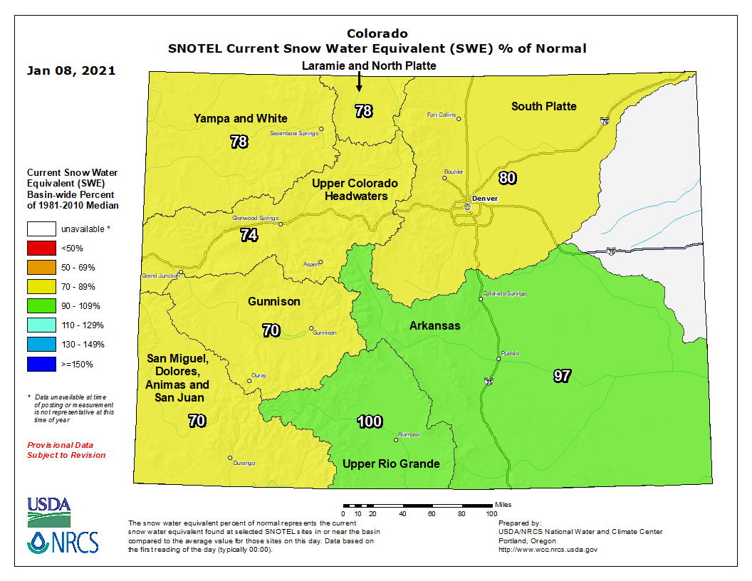
Colorado snowpack basin-filled map January 14, 2021 via the NRCS.
Statewide River Basin High/Low graph January 14, 2021 via the NRCS.
Arkansas River Basin High/Low graph January 14, 2021 via the NRCS.
Upper Colorado River River Basin High/Low graph January 14, 2021 via the NRCS.
Gunnison River River Basin High/Low graph January 14, 2021 via the NRCS.
Laramie and North Platte River Basin High/Low graph January 14, 2021 via the NRCS.
Upper Rio Grande River River Basin High/Low graph January 14, 2021 via the NRCS.
San Miguel, Dolores, Animas, and San Juan River Basin High/Low graph January 14, 2021 via the NRCS.
South Platte River River Basin High/Low graph January 14, 2021 via the NRCS.
Yampa and White River Basin High/Low graph January 14, 2021 via the NRCS.
FromThe Grand Junction Daily Sentinel (Dennis Webb):
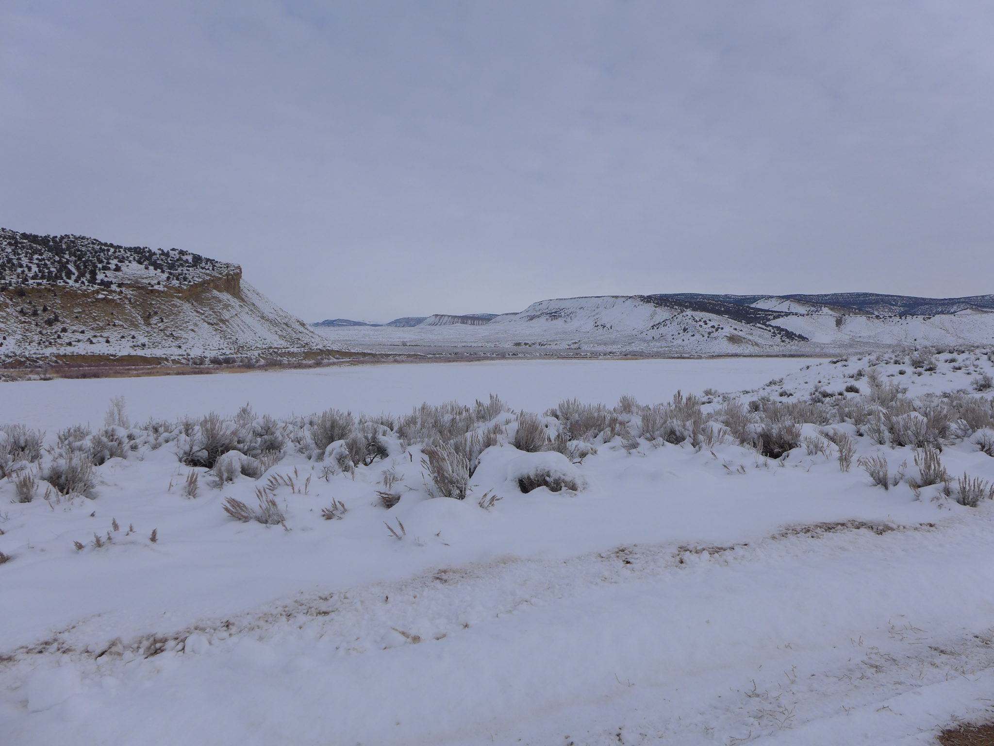
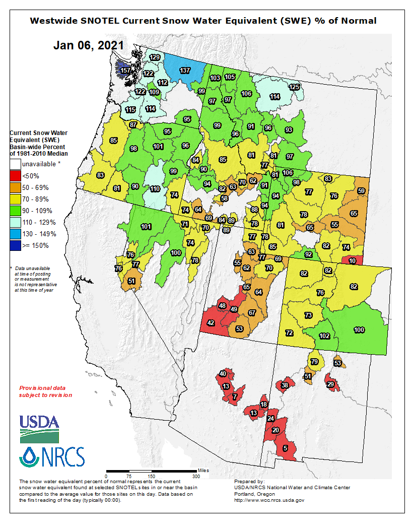
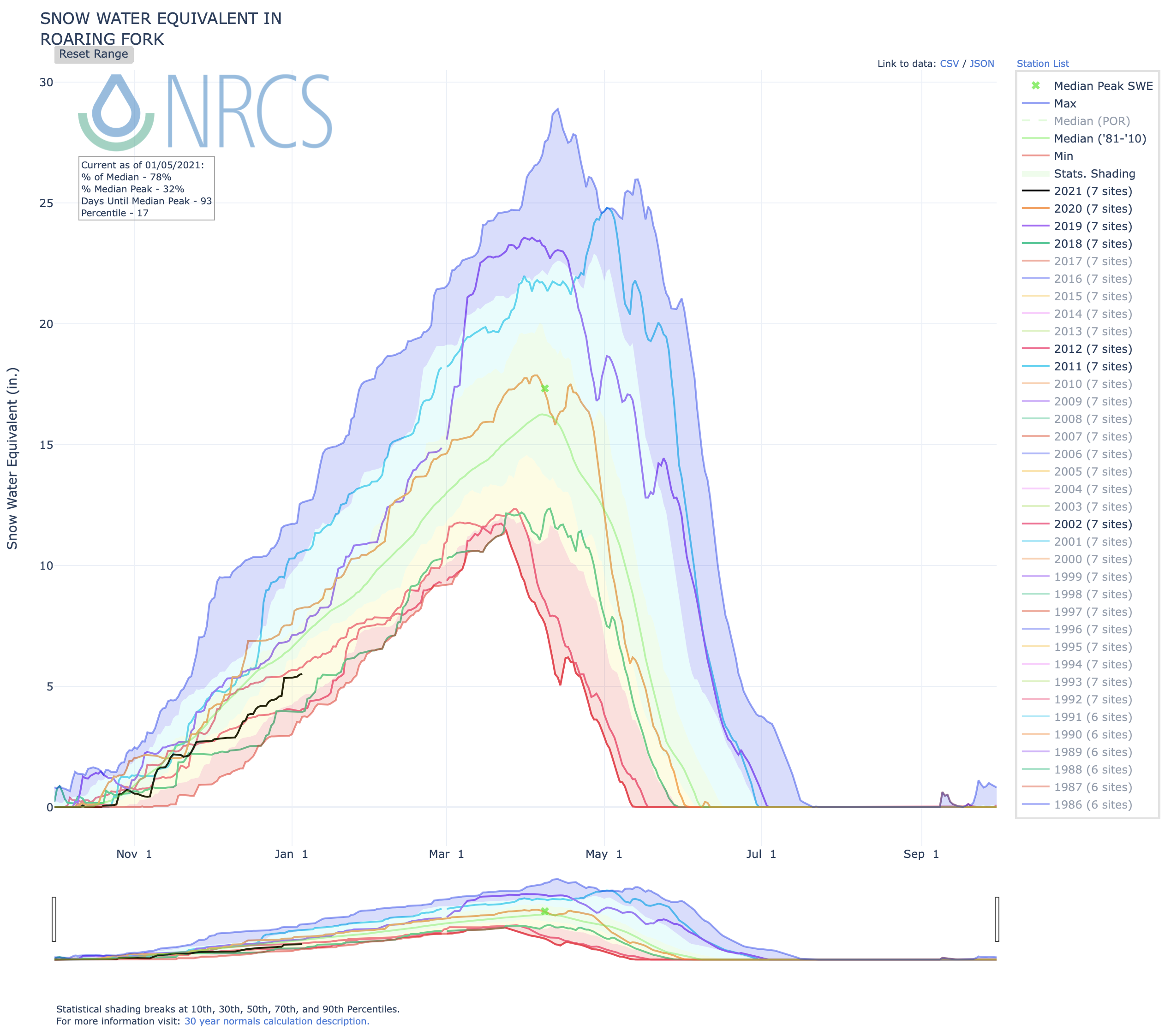
Statewide snowpack was at 74% of median Thursday, with percentages even lower in area basins, at 68% for the Gunnison River Basin and 70% for the Upper Colorado River Basin, according to Natural Resources Conservation Service data.
Local conditions are worse, with measurements ranging from 46 to 57% at NRCS Grand Mesa snowpack-measuring sites, and at 66% for the Plateau Creek drainage.
While conditions can change, the NRCS said in a Jan. 1 water supply outlook report for Colorado that current streamflow forecasts during the snowpack runoff season “for April through July range from a high of 98% of average for the Cucharas River near La Veta, to a low of 42% of average for Surface Creek at Cedaredge.”
It said streamflow volumes for the combined Yampa, White, the Upper Colorado, the Gunnison, and the combined San Migue, Dolores, Animas, San Juan river basins “are all forecasted to be within 64 to 68% of average, with some variability within each basin.”
Colorado Drought Monitor January 12, 2021.
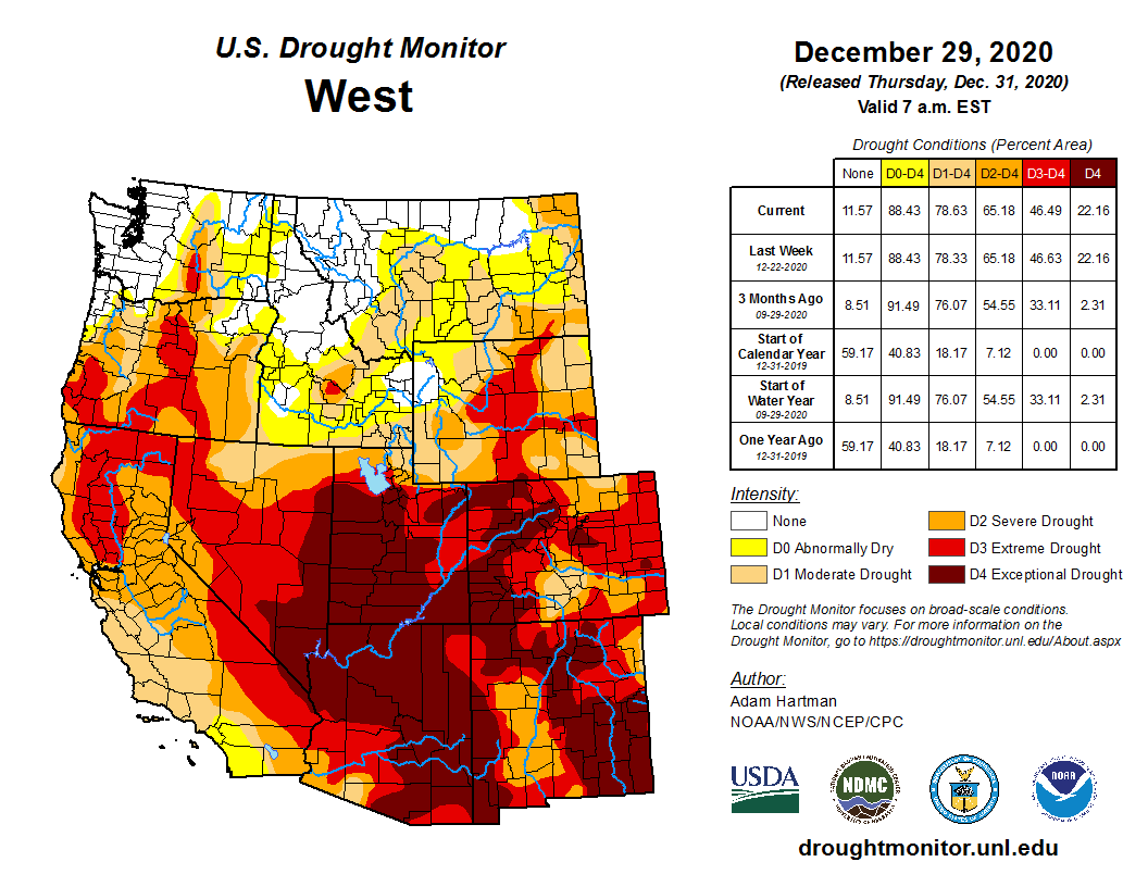
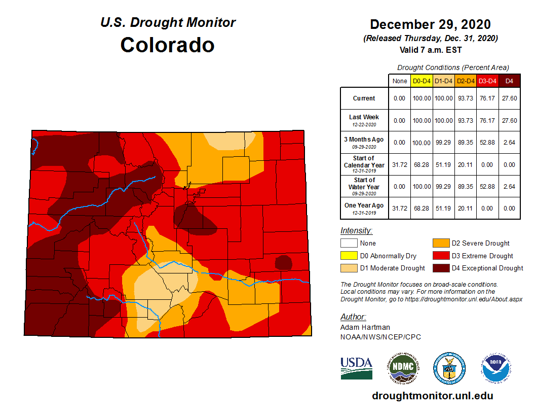
The lagging snowpack accumulations so far in Colorado come as the entire state currently is in a drought. Most of western Colorado is in either exceptional drought, the worst category, or extreme drought, the second-worst category, according to the U.S. Drought Monitor. Much of Mesa County is in exceptional drought, with the northwest part of the county in extreme drought.
According to an NRCS news release, Colorado precipitation in August and September combined totaled the lowest in a 36-year period of record at its measurement sites, and October precipitation was less than half of average.
The National Oceanic and Atmospheric Administration last week reported that combined average annual precipitation last year in Colorado, Arizona, Wyoming, Utah and New Mexico was the second-lowest on record and the lowest since 1956. It said dry conditions are expected to continue for the Southwest…
NRCS said in its news release that near-normal snowpack and reservoir storage leading into last spring helped Colorado stave off significant runoff shortages last year. But current reservoir storage is below normal for this time of year across the state, at 82% of average as of the start of the new year…
Reservoir storage in the Gunnison River Basin is currently at 77% of average, compared to 104% average for Jan. 1 at the same time last year. Blue Mesa Reservoir, Colorado’s largest reservoir, is currently less than half full.
Storage in the Upper Colorado River Basin is much higher than the statewide average, at 102% of normal for this time of year. Currently the Rio Grande Basin, which in recent years has been quite dry, is doing the best across the state in terms of snowpack, at 95% of median. The Arkansas River Basin ranks second-highest, at 93%.
Westwide SNOTEL basin-filled map January 15, 2021 via the NRCS.
There’s a 95% chance that La Niña will continue through the winter and a 55% chance the tropical Pacific will transition to neutral conditions by the spring. After that, the picture is less clear. Certainly less clear than the waters of the tropical Pacific…
Tahiti
Speaking of, let’s take the temperature of the tropical Pacific Ocean. The December 2020 average sea surface temperature in our primary monitoring region, Niño 3.4, was 1.2° Celsius (2.16˚ Fahrenheit) cooler than the long-term (1986-2015) average, according to the ERSSTv5 dataset. This is comfortably within the La Niña boundary of more than 0.5°C cooler than average.
The cooler-than-average wedge of La Niña is clear in the tropical Pacific, amidst the sea of warmer-than-average we’ve come to expect as the globe warms. However, this La Niña is a bit asymmetric, with more blue to the south of the equator and less to the north than other La Niña events of similar magnitude, such as 2007 or 2010.
December 2020 sea surface temperature departure from the 1981-2010 average. The cool waters of La Niña are noticeable at the equator in the Pacific. Image from Data Snapshots on Climate.gov.
Also according to ERSSTv5, the three-month average anomaly (the Oceanic Niño Index) was -1.3°C in October–December. Most computer models predict that the Niño 3.4 sea surface temperature anomaly has reached its lowest value in our current La Niña event and will move back toward neutral from here. Forecasters estimate the most likely scenario for the end of this La Niña is a transition to neutral—a Niño 3.4 anomaly between -0.5° and 0.5°C—during the April–June period.
Fiji
Our frequent readers will be familiar with the idea that atmosphere-ocean coupling is the hallmark of El Niño and La Niña. The atmosphere over the tropical Pacific responds to the changes in ocean surface temperature, creating a critical feedback that reinforces the oceanic changes…
In a nutshell, during La Niña we expect a stronger Walker circulation. That is, the cooler-than-average east-central tropical Pacific leads to reduced convection (rising air and cloud formation) in that region, while convection over Indonesia becomes even stronger than average. The trade winds, which blow east to west at the surface, become stronger than average, allowing cooler deep water to upwell to the surface.
La Niña feedbacks between the ocean and atmosphere. Climate.gov schematic by Emily Eng and inspired by NOAA PMEL.
This winter, both the convection pattern and the near-surface winds have been performing as expected. We can definitely place a stamp on the “strengthened Walker circulation” page of our ENSO passport.
Tuvalu
Speaking of expectations, what about La Niña impacts on global temperature and precipitation patterns? It’s mostly still too early to tell, as the dominant impacts occur during northern hemisphere winter, December–March, and we only have one month on record so far. However, we can take a peek at December’s averages to see how things are shaping up.
The global precipitation map from December shows that the tropical Pacific was indeed drier than average, with more rain over much of Indonesia. These direct impacts from the stronger Walker circulation are very reliable during La Niña. Remote impacts, or teleconnections, via La Niña’s effects on global atmospheric circulation, are more variable. (Revisit the second half of this post for details on the probability of rain and snow impacts.) So far, southeastern Africa has had more rain than average, and the southern tier of the United States has been a bit drier. Also consistent with La Niña is the pattern of below-average precipitation over eastern Brazil and northern Argentina.
December’s surface temperature map reveals the northern half of North America was warmer than average during December, with Florida the only cooler-than-average region in North America. This is opposite of the expected pattern during La Niña. The temperature map also indicates a large swath of the planet was above average, which is a telltale sign of climate change. However, winter is yet young, and we will see if La Niña may have more of an imprint later on. Revisit Mike Halpert’s recent post on the 2020–21 winter outlook to read more about expectations, and see maps of the U.S. winter temperature and precipitation during the strongest 20 La Niña events since 1950.
Palau
One expected La Niña impact—an active Atlantic hurricane season—certainly happened in 2020. As no one is eager for a repeat of that particular teleconnection, many are asking if we could have a second-year La Niña, neutral conditions, or even an El Niño in the fall of 2021. Overall, the answer is “it’s too soon to tell.” ENSO usually changes phase in the spring, as it’s predicted to do this spring, going from La Niña to neutral. This seasonal phase-change contributes to the spring predictability barrier, a time of year when climate models have a particularly difficult time making successful forecasts many seasons in advance.
That said, currently forecasters estimate similar probabilities of either La Niña or neutral for late summer and fall (around 40-45% chance) and much lower odds of El Niño. These lower odds are consistent with history. If we look at a graph of the eventual fate of every first-year La Niña (meaning, the previous winter did not feature La Niña), we see how rare El Niño is the next winter.
Monthly sea surface temperature in the Niño 3.4 region of the tropical Pacific for 2020 (purple line) and all other years starting from first-year La Niña winters since 1950. Climate.gov graph based on ERSSTv5 temperature data.
In our 1950-present record, a La Niña winter is more often followed by either neutral or weak La Niña conditions during the summer, with a re-development of La Niña the subsequent winter.
Of the 12 first-year La Niña events, 8 were followed by La Niña the next winter, 2 by neutral, and 2 by El Niño. We’ll probably have to get through the spring predictability barrier before we can make a more confident prediction about next fall. In the meantime, you can be sure we’ll be closely monitoring the tropical Pacific, while dreaming about swimming in it.
Joe Biden is preparing to deal with climate change in a way no U.S. president has done before – by mobilizing his entire administration to take on the challenge from every angle in a strategic, integrated way.
The strategy is evident in the people Biden has chosen for his Cabinet and senior leadership roles: Most have track records for incorporating climate change concerns into a wide range of policies, and they have experience partnering across agencies and levels of government.
Those skills are crucial, because slowing climate change will require a comprehensive and coordinated “all hands on deck” approach.
We did that with energy when I was governor of Colorado, and I can tell you it isn’t simple. Energy policy isn’t just about electricity. It’s about how homes are built, how they generate power and feed it into the grid and how the transportation, industrial and agriculture sectors evolve. It’s about regulations, trade rules, government purchases and funding for research for innovation. Coordination and collaboration among agencies and different levels of government is crucial.
The task of coordinating climate actions across the government falls to Gina McCarthy, a former EPA administrator who will be Biden’s national climate advisor. Joshua Roberts/Getty Images
A coordinated approach also helps ensure that vulnerable populations aren’t overlooked. Biden has committed to help disadvantaged communities that have too often borne the brunt of fossil fuel industry pollution, as well as those that have been losing fossil fuel jobs.
The Biden-Harris team’s depth of experience will be vital as they take over from a Trump administration that has been stripping government agencies of their expertise and eliminating environmental protections. With Democrats gaining control of both the House and Senate, the Biden administration may also have a better chance of overhauling laws, funding and tax incentives in ways that could fundamentally transform the U.S. approach to climate change.
Here are some of the biggest challenges ahead and what “all hands on deck” might mean.
Dealing with all those climate policy rollbacks
From its first days, the Trump administration began trying to nullify or weaken U.S. environmental regulations. It had rolled back 84 environmental rules by November 2020, including major climate policies, and more rollbacks were being pursued, according to a New York Times analysis of research from Harvard and Columbia law schools.
Many of these rules had been designed to reduce climate-warming pollution from power plants, cars and trucks. Several reduced emissions of methane, a potent greenhouse gas, from oil and gas production. The Trump administration also moved to open more land to more drilling, mining and pipelines.
Some rollbacks have been challenged in court and the rules then reinstated. Others are still being litigated. Many will require going through government rule-making processes that take years to reverse.
Michael Regan will contend with many of the Trump administration’s rollbacks as Biden’s choice to head the EPA. Alex Edelman/Getty Images
Pressuring other countries to take action
Biden can quickly bring the U.S. back into the international Paris climate agreement, through which countries worldwide agreed to reduce the greenhouse gas emissions driving global warming. But reestablishing the nation’s leadership role with the international climate community is a much longer haul.
Former Secretary of State John Kerry will lead this effort as special envoy for climate change, a new Cabinet-level position with a seat on the National Security Council. Other parts of the government can also pressure countries to take action. International development funding can encourage climate-friendly actions, and trade agreements and tariffs can establish rules of conduct.
Then-Secretary of State John Kerry (right), with climate envoy Todd Stern and Brian Deese while negotiating the Paris climate agreement in 2015. Deese (left) is Biden’s choice to head the National Economic Council. Mandel Ngan, Pool photo via AP
Cleaning up the power sector
The Biden-Harris climate plan aims to cut greenhouse gas emissions from the power sector to net zero by 2035.
While 62 major utilities in the U.S. have set their own emission reduction goals, most leaders in that sector would argue that requiring net zero emissions by 2035 is too much too fast.
One problem is that states are often more involved in regulating the power sector than the federal government. And, when federal regulations are passed, they are often challenged in court, meaning they can take years to implement.
Reducing greenhouse gases also requires modernizing the electricity transmission grid. The federal government can streamline the permitting process to allow more clean energy, like wind and solar power, onto the grid. Without that intervention, it could take a decade or more to permit a single transmission line.
What to do about vehicles, buildings and ag
The power sector may be the easiest sector to “decarbonize.” The transportation sector is another story.
Transportation is now the nation’s leading emitter of carbon dioxide. Decarbonizing it will require a transition away from the internal combustion engine in a relatively short amount of time.
Again, this is a challenge that requires many parts and levels of government working toward the same goal. It will require expanding carbon-free transportation, including more electric vehicles, charging stations, better battery technology and clean energy. That involves regulations and funding for research and development from multiple departments, as well as trade agreements, tax incentives for electric vehicles and a shift in how government agencies buy vehicles. The EPA can facilitate these efforts or hamstring them, as happened when the Trump EPA revoked California’s ability to set higher emissions standards – something the Biden administration is likely to quickly restore.
The other “hard to decarbonize” sectors – buildings, industry and agriculture – will require sophistication and collaboration among all federal departments and agencies unlike any previous efforts across government.
A new comprehensive climate bill
The best way to tackle these sectors would be a comprehensive climate bill that uses some mechanism, like a clean energy standard, that sets a cap, or limit, on emissions and tightens it over time. Here, the problem lies more in the politics of the moment than anything else. Biden and his team will have to convince lawmakers from fossil fuel-producing states to work on these efforts.
Democratic control of the Senate raises the chances that Congress could pass comprehensive climate legislation, but that isn’t a given. Until that happens, Biden will have to rely on agencies issuing new rules, which are vulnerable to being revoked by future administrations. It’s a little like playing chess without a queen or rooks.
Years of delays have allowed global warming to progress so far that many of its impacts may soon become irreversible. To meet its ambitious goals, the administration will need everyone, progressives and conservatives, state and local leaders, and the private sector, to work with them.
In 2016, labor and community activists in Lansing, Michigan, called for Governor Rick Snyder to resign over the Flint water contamination crisis. The former governor did not step down—his term lasted through 2019. Photo by Jim West
FromThe Washington Post (Kim Bellware and Brady Dennis):
Former Michigan governor Rick Snyder (R) and several former officials are expected to be indicted in connection with the 2014 Flint water crisis that led to at least 12 deaths and dozens of illnesses in the predominantly Black city, the Associated Press reported Tuesday.
Snyder, his former health department director Nick Lyon and former adviser Rich Baird were among those notified by the office of Michigan Attorney General Dana Nessel (D) of the pending indictments and advised to expect imminent court dates, the AP reported, citing unnamed sources familiar with the prosecution.
The nature of the criminal charges were not immediately clear.
Randall L. Levine, an attorney representing Baird, confirmed in a statement to the Post Tuesday that authorities notified him this week about indictments. He said Baird “will be facing charges stemming from his work helping to restore safe drinking water for all residents and faith in the community where he grew up.” But he added that Baird had not yet “been made aware of what the charges are, or how they are related to his position with former Michigan Governor Rick Snyder’s administration.”
[…]
Nessel’s office dropped all criminal charges in the case in 2019, shortly after she took office, effectively restarting the probe.
Mona Hanna-Attisha, the pediatrician whose research in 2015 first documented dangerously high lead levels in children’s blood, welcomed news of the reported charges.
“As a pediatrician privileged to care for our Flint children, I have increasingly come to understand that accountability and justice are critical to health and recovery,” Hanna-Attisha told The Post in a text message Tuesday. “Without justice, it’s impossible to heal the scars of the crisis.”
Hanna-Attisha, director of pediatric residency at the Hurley Children’s Hospital in Flint, warned that while the news was a salve for the many families whose lives had been affected by the poisoned water, criminal charges are only part of the story…
“Residents of Flint were repeatedly told they were crazy. They were belittled. They were harmed by the water physically, emotionally,” Michigan Senate Minority Leader Jim Ananich (D-Flint) said in an interview Tuesday. “I’ve always said that I think criminal charges are important, because I think it’s criminal what happened to my town.”
Ananich emphasized that he doesn’t know the extent of the charges expected later this week, but he does hope they send a clear message: “No person, no politician, no one is above the law.”
For Flint families who continue to live with the irreversible effects of the tainted water, Tuesday’s news symbolized a level of vindication.
“I can’t believe it,” Gina Luster, a Flint community activist, told The Post in a message. “Finally, after 7 years of fighting for justice.”
This image was taken during the peak outflow from the Gold King Mine spill at 10:57 a.m. Aug. 5, 2015. The waste-rock dump can be seen eroding on the right. Federal investigators placed blame for the blowout squarely on engineering errors made by the Environmental Protection Agency’s-contracted company in a 132-page report released Thursday [October 22, 2015]
FromThe Associated Press (Susan Montoya Bryan) via The Colorado Sun:
Under the settlement with the Navajo Nation, Sunnyside Gold Corp. — a subsidiary of Canada’s Kinross Gold — will pay the tribe $10 million
The Navajo Nation’s Department of Justice announced Wednesday it has settled with mining companies to resolve claims stemming from a 2015 spill that resulted in rivers in three western states being fouled with a bright-yellow plume of arsenic, lead and other heavy metals.
Under the settlement with the Navajo Nation, Sunnyside Gold Corp. — a subsidiary of Canada’s Kinross Gold — will pay the tribe $10 million…
The orange plume flows through the Animas across the Colorado/New Mexico state line the afternoon of Aug. 7, 2015. (Photo by Melissa May, San Juan Soil and Conservation District)
The tribe said the toxic water coursed through 200 miles (322 kilometers) of river on Navajo lands…
The tribe’s claims against the EPA and its contractors remain pending. About 300 individual tribal members also have claims pending as part of a separate lawsuit…
The state of New Mexico also confirmed Wednesday that it has reached a settlement with the mining companies. Under that agreement, $10 million will be paid to New Mexico for environmental response costs and lost tax revenue and $1 million will go to Office of the Natural Resources Trustee for injuries to New Mexico’s natural resources…
The settlement was not an admission of liability or wrongdoing, but Sunnyside agreed to it “as a matter of practicality to eliminate the costs and resources needed to continue to defend against ongoing litigation,” Myers said in an email…
In August, the U.S. government settled a lawsuit brought by the state of Utah for a fraction of what that state was initially seeking in damages.
In that case, the EPA agreed to fund $3 million in Utah clean water projects and spend $220 million of its own money to clean up abandoned mine sites in Colorado and Utah.
The “Bonita Peak Mining District” superfund site. Map via the Environmental Protection Agency
After the spill, the EPA designated the Gold King and 47 other mining sites in the area a Superfund cleanup district. The agency still reviewing options for a broader cleanup.
From the Land Desk newsletter (Jonathan Thompson):
Whether the company [Kinross] is at all culpable for the spill is a question the courts have yet to answer. But there is definitely a connection, both hydrological and historical.
Here’s the short(ish) bulleted explanation:
The Gold King Mine workings are on one side of Bonita Peak (in the Cement Creek drainage) and the Sunnyside Mine workings are on the other side of Bonita Peak (in the Eureka Creek drainage). If you look at the two mines in a cross-section of the peak, they sit side-by-side, separated by a lot of rock.
In the early 1900s the owners of the Gold King started drilling the American Tunnel straight into Bonita Peak below the Gold King. The plan was then to link up with the Gold King in order to provide easier access. More than one mile of tunnel was dug, but the link was never completed, prior to the Gold King’s shutdown in the 1920s.
Photographic and other evidence suggests that prior to the construction of the American Tunnel, water drained from the Gold King Mine. However, after the tunnel’s construction the mine was said to be dry, suggesting that the tunnel hijacked the hydrology of the Gold King.
In 1959 Standard Metals continued drilling the American Tunnel through the mountain in order to provide a better access (from the Cement Creek side) to the then-defunct Sunnyside Mine.
After the Sunnyside shut down, the parent company at the time (Echo Bay), reached an agreement with the state to plug the American Tunnel with huge bulkheads to stop or slow acid mine drainage. They placed three bulkheads, one at the edge of the workings of the Sunnyside Mine (1996), one just inside the opening of the American Tunnel (2003), and another in between (2001).
Shortly after the bulkheads were placed, the Gold King ceased being a “dry” mine, and drainage resumed, eventually flowing at more than 250 gallons per minute. After the ceiling of the adit collapsed, water began backing up behind it until it was finally released in one catastrophic swoop in August 2015.
It seems pretty clear that one or more of the bulkheads caused water to back up inside the mountain and enter the Gold King Mine workings, eventually leading to the blowout. At this point, however, no one knows which bulkhead is the culprit, so no one knows whether the water is coming from the Sunnyside mine pool, or whether it is actually coming from the part of the American Tunnel that is still on Gold King property. Until that is determined, the root cause of the Gold King blowout will remain a mystery.
For the longer explanation of the Gold King saga, read my book, River of Lost Souls: The Science, Politics, and Greed Behind the Gold King Mine Disaster. And for more maps showing the relationship between the Sunnyside and the Gold King, check out my River of Lost Souls reading guide.
Prior to mining, snowmelt and rain seep into natural cracks and fractures, eventually emerging as a freshwater spring (usually). Graphic credit: Jonathan Thompson
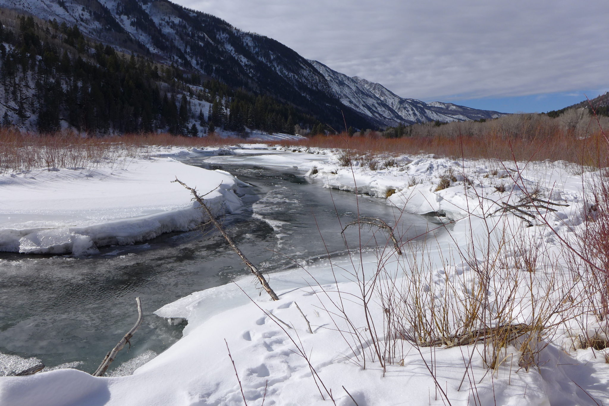
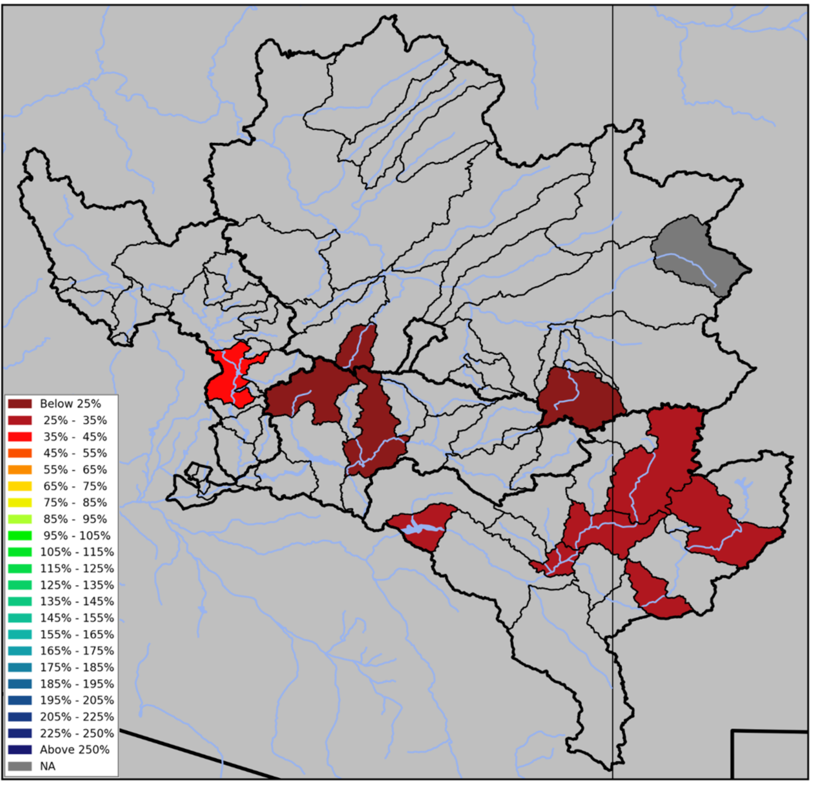
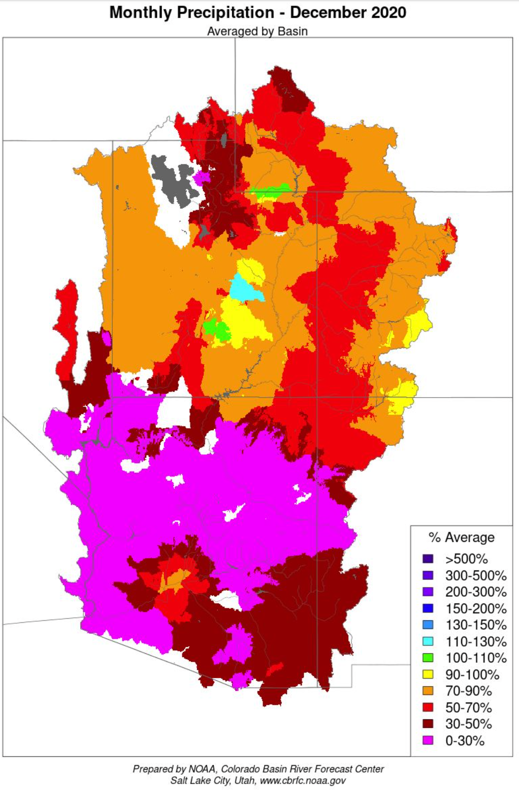
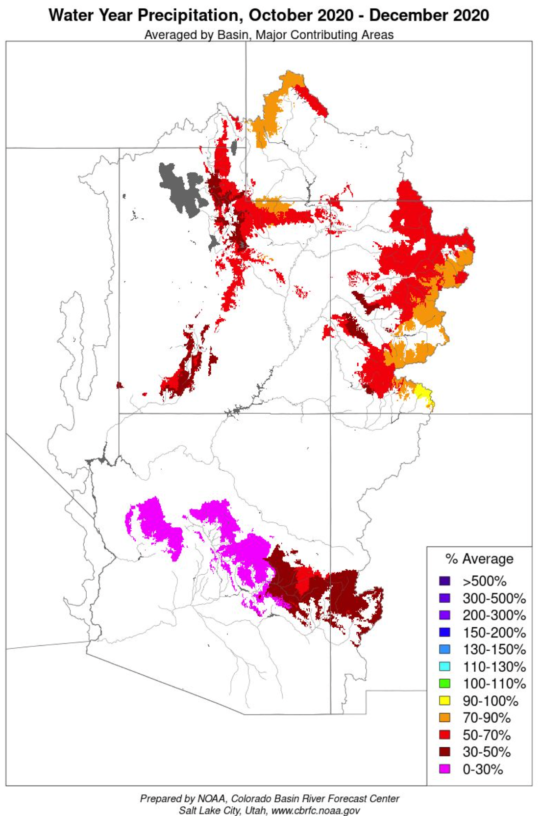
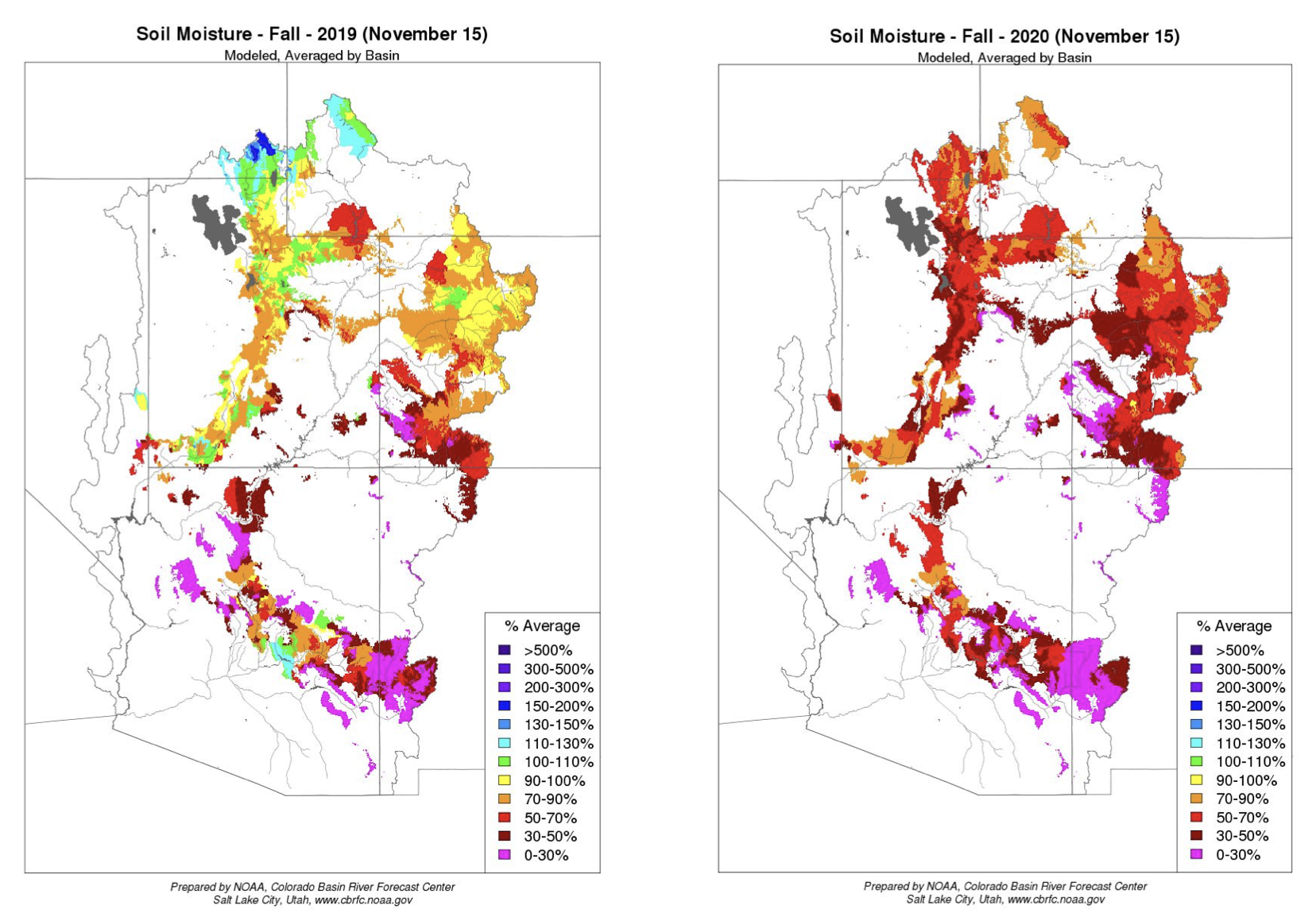
The 2021 water year is off to a slow start. As of January 1st, 2021, Colorado year-to-date mountain snowpack and precipitation was 83% and 70% of normal respectively. For comparison, the at this time last year snowpack and precipitation were 119% and 92% of normal, respectively. “Persistent dry conditions maintain a firm hold on Colorado, not only in the new water year, but extending back into 2020”, states Brian Domonkos, Snow Survey Supervisor for the USDA NRCS Colorado Snow Survey Program. The 2020 water year, ending on September 30th, 2020, finished on a record dry note. According to the SNOTEL network across the state of Colorado, August and September 2020 combined precipitation totaled the lowest in the 36-year period of record. Adding to the drought, October precipitation across Colorado was 47% of average. Domonkos goes on to say, “These dry fall and late summer conditions will impact spring 2021 runoff in similar ways that dry conditions at the end of 2019 impacted water supplies in 2020.”
Near normal snowpack and reservoir storage leading into the spring of 2020 helped Colorado stave off significant runoff shortages. However, this year’s snowpack is below normal, as is reservoir storage across the state which sets up a potentially drier situation than last year. Due to below normal precipitation late this past summer streamflow currently remain low and subsequently reservoirs will see little recharge this winter. Currently statewide reservoir storage is at 82% of average.
There is a bright spot in the state. Over the last few years, the Rio Grande has been quite dry, but this year boasts the best snowpack in the state. The basin currently has 114% of median snowpack, driving streamflow forecasts to indicate a considerable chance of near normal streamflow runoff this spring and summer. These same near normal snowpack conditions also extend into portions of the San Juan and Sangre de Cristo Mountains draining to Southern Arkansas and Upper San Juan River Basins which currently have a better chance of near normal streamflow come spring.
Currently, water supplies this spring and summer are projected to range from just above normal in parts of the Rio Grande, to around half the normal runoff in the Gunnison as well as in the combined Yampa- White-North Platte basins. These water supply projections assume near normal future precipitation. Domonkos remains optimistic, “With slightly more than half of the snowpack accumulation season remaining there is potential for snowpack to improve.”
With the dawning of a new year comes a new source of news, insight, and commentary: the Land Desk. It is a newsletter about Place. Namely that place where humanity and the landscape intersect. The geographical center of my coverage will be the Four Corners Country and Colorado Plateau, land of the Ute, Diné, Pueblo, Apache, and San Juan Southern Paiute people. From there, coverage will spread outward into the remainder of the “public-land states” of the Interior West, with excursions to Wyoming to look at the coal and wind-power industries and Nevada to check out water use in Las Vegas and so on.
This is the time and the place for a truth-telling, myth-busting, fair yet sometimes furious journalism like The Land Desk will provide. This is where climate change is coming home to roost in the form of chronic drought, desertification, and raging wildfires. This is where often-toxic politics are playing out on the nation’s public lands. This is the sacrifice zone of the nation’s corporate extractive industries, yet it is also the playground and wilderness-refuge for the rest of the nation and the world. This is the headwaters for so many rivers of the West. And this is where Indigenous peoples’ fight for land-justice is the most potent, whether it be at Bears Ears or Chaco Canyon or Oak Flat.
The Land Desk will provide a voice for this region and a steady current of information, thought, and commentary about a wide range of topics, from climate change to energy to economics to public lands. Most importantly, the information will be contextualized so that we—my readers (and collaborators) and I—can better understand what it all means. Perhaps we can also help chart a better and more sustainable course for the region to follow into the future, to try to realize Wallace Stegner’s characterization of this place as the “native home of hope.”
I’ve essentially been doing the work of the Land Desk for more than two decades. I got my start back in 1996 as the sole reporter and photographer for the weekly Silverton Standard & the Miner. I went from there to High Country News fifteen years ago, and that wonderful publication has nurtured and housed most of my journalism ever since. But after I went freelance four years ago, my role at HCN was gradually diminished. While I have branched out in the years since, writing three books as well as articles for Sierra, The Gulch, Telluride Magazine, Writers on the Range, and so forth, I’ve increasingly run up against what I call the freelancer bottleneck, which is what happens when you produce more content more quickly than you can sell it. That extra content ends up homeless, or swirling around in my brain, or residing in semi-obscurity on my personal website.
I’m not messing around. The Land Desk is by no means a repository for the stories no one wants. It is intended to be the home for the best of my journalism and a place where you can find an unvarnished, unique, deep perspective on some of the most interesting landscapes and communities in the world. My hope is that it will give me the opportunity to write the stories that I’ve long wanted to write and that the region needs. If my hopes are realized, the Land Desk will one day expand and welcome other Western journalists to contribute.
That’s where you come in. In order for this venture to do more than just get off the ground, it needs to pay for itself. In order to do that, it needs paying subscribers (i.e., you). In other words, I’m asking for your support.
For the low price of $6/month ($60/year), subscribers will receive a minimum of three dispatches each week, including:
1 Land Bulletin (news, analysis, commentary, essay, long-form narrative, or investigative piece);
1 Data Dump (anything from a set of numbers with context to full-on data-visual stories); and,
1 News Roundup, which will highlight a sample of the great journalism happening around the West;
Reaction to and contextualization of breaking news, as needed.
Additionally, I’ll be throwing in all sorts of things, from on-the-ground reporter notebooks to teasers from upcoming books to the occasional fiction piece to throwbacks from my journalistic archives.
Can’t afford even that? No worries. Just sign up for a free subscription and get occasional dispatches, or contact me and we can work something out. Or maybe you’ve got some extra change jangling around in your pocket and are really hungry for this sort of journalism? Then become a Founding Member and, in addition to feeling all warm and fuzzy inside, you’ll receive some extra swag.
I just launched the Land Desk earlier this week and already subscribers are getting content! Today I published a Data Dump on a southwestern indicator river setting an alarming record. Also this week, look for a detailed analysis tracing the roots of the recent invasion of the Capitol to the Wise Use movement of the early 1990s. In the not-so distant future I’ll be publishing “Carbon Capture Convolution,” about the attempt to keep a doomed coal-fired power plant running by banking on questionable technology and sketchy federal tax credits. Plus the Land Desk will have updated national park visitor statistics, a look back on how the pandemic affected Western economies, and forward-looking pieces on what a Biden administration will mean for public lands.
Please subscribe to The Land Desk. Click here to read some of Thompson’s work that has shown up on Coyote Gulch over the years.
FromThe Denver Post (Saja Hindi and Alex Burgess):
A new legislative session is kicking off this week in Colorado, but it won’t really get going until February.
A batch of new Colorado state lawmakers will be sworn in Wednesday, and the legislature plans to pass about seven mostly minor bills this week. When they return Feb. 16, there will be backlogs of popular bills that were sidelined in the pandemic-shortened 2020 session, plus many new priorities.
Democrats are still in control, now with an expanded Senate majority. That means until at least 2022, the GOP will have its say but rarely its way…
Short, distanced start
Lawmakers will work quickly this week to pass time-sensitive bills and meet constitutional requirements before their break…
COVID relief
Ask nearly any lawmaker what they’re plotting for 2021, and they’ll tell you they want to do everything possible to address the coronavirus’ ripple effects.
But the public should temper its expectations, budget officials say, because there’s a limited pot of money for grants, direct payments and new programs…
Restricted ambitions
It is often the case that bills die — or never get introduced in the first place — not because of their merits but because lawmakers are nervous about how much they cost.
We’ll likely be seeing a lot of that in 2021, given the budget outlook. Take, for example, the bipartisan and generally popular proposal to eliminate the wait list for state-funded in-home care for adults with intellectual and developmental disabilities. Last year was supposed to be the year they committed more than $160 million over seven years to the program, but pandemic hits, plan scrapped…
Is the momentum for social justice still there?
The legislature last year repealed the death penalty and passed a police reform package inspired by the Black Lives Matter movement. Lawmakers vowed then that they would not relent on matters of criminal justice and law enforcement.
There’s plenty on the table for 2021, including banning no-knock warrants and restricting the use of ketamine against people detained by police. The latter is particularly close to home: First responders injected Elijah McClain with ketamine after he was violently detained by Aurora police in 2019…
Public participation
Members of the public will have the opportunity to testify on bills in person, remotely or submit written testimony as they were able to do during the special legislative session, but it will likely be limited. People interested in testifying will need to sign up ahead of time at http://leg.colorado.gov.
Plenty of people on both sides of the aisle have sought and failed to obtain a funding boost for Colorado’s chronically underfunded transportation system. This year, there’s real optimism for a breakthrough.
The latest plan involves raising certain fees — remember, Colorado lawmakers can’t raise taxes, but they can raise closely related fees — on things like gas and electric vehicle usage in order to generate money for transportation projects…
Can House Republicans get along?
Democrats have a strong 20-15 advantage in the Senate and in the House, it’s not even close — 41 of the 65 seats.
Having hemorrhaged power and influence in the House in recent years, GOP state representatives turned on last year’s minority leader, Rep. Patrick Neville of Castle Rock, and replaced him with Rep. Hugh McKean of Loveland…
Public option, take two
Last year, sponsors shelved an effort to implement a hybrid public health insurance option that would have provided Coloradans who buy insurance on the individual market another option.
Its return in 2021 amid the coronavirus pandemic will likely bring more conflict between supporters and hospital groups. But one of its sponsors, Avon Democratic Rep. Dylan Roberts said the bill will look very different, because it takes into account the changes to health care due to COVID…
A renewed push for gun legislation
Colorado House Rep. Tom Sullivan was beyond disappointed last year that proposed gun reforms were shelved when COVID arrived. The Centennial Democrat pledged last year to bring gun legislation to the forefront of the 2021 session, and he plans to make good on that promise…
Climate response
After a year of raging wildfires, shrinking water flows and record heat, Colorado’s Democratic lawmakers are planning to address climate and environmental policies.
“Unfortunately, it’s been a big issues for years and I think we’re sort of behind in where we need to be,” Fenberg said. “We basically don’t have the luxury of being able to take a year off of thinking critically about getting our emissions under control.”
Topics on deck include air-quality issues, improving the electric transmission grid in Colorado, addressing issues of methane leaks, a greenhouse road map and increasing the use of energy storage equipment in Colorado.
Westminster Democratic Sen. Faith Winter said climate mitigation is also important for communities of color and others who are disproportionately affected by pollution. She’s working on a bill to better define environmental justice and impacted communities, and also intends to address issues of environment in transportation funding bills.
“Climate change is a huge threat to our state,” she said. “It’s a threat to individual people’s health,” she said. “It’s a threat to our economy.”
George Washington addresses the Continental Congress via Son of the South
FromThe Grand Junction Daily Sentinel (Charles Ashby):
Because of the ongoing pandemic, lawmakers will only meet for three days this week, and then it will go into a recess until mid-February.
“Clearly, there’s going to be a change to how the 73rd General Assembly is going to get started,” said House Speaker Alec Garnett, D-Denver. “Everything is going to look a lot different than it has in the past. We’re still in the midst of a once-in-a-hundred-years pandemic, and the bulk of our work won’t start in earnest until Feb. 16 when we all come back from our temporary adjournment.”
Under the Colorado Constitution, the Legislature can only meet for 120 days. But after the pandemic hit at the start of last year’s session, Democratic leaders decided to recess for an extended period because of it, after Gov. Jared Polis issued his first COVID-19 executive order calling for a state of emergency…
So as a result of this built-in recess, which could be extended or ended early depending on what happens with coronavirus infection rates, lawmakers don’t plan to do much in these first three days…
Beyond typical beginning-of-session matters, including provisions to allow for lawmakers to participate in floor debates and committee hearings remotely, lawmakers have only a handful of bills they expect to address by Friday, one of which is to fix a problem with a bill approved during last month’s special session.
That was on a $57 million Small Business Relief Program, which is intended to provide grants and fee waivers to businesses most impacted by the downturned economy, particularly to restaurants and night clubs.
The bill also sets aside money for hard-hit minority-owned businesses, a provision that currently is facing a lawsuit filed by the white owner of a Colorado Springs barbershop…
Starting on Thursday, counties across the state are accepting applications for that money, and will do so until early February.
Businesses that qualify will then get their share, but how much will depend on how many apply and how much each county is allocated.
Under the bill, money is to go to very small businesses, primarily those hardest hit by the pandemic, such as restaurants, bars, distilleries, wineries, caterers, movie theaters, fitness centers and other recreational facilities, but only those with annual revenues of less that $2.5 million and only if they are following local public health orders.
Because of the monthlong recess, individual lawmakers were given more time to introduce their first three bills — under the law, they are allowed up to five — until the Legislature reconvenes in February.
Meanwhile, the four leaders in the House and Senate from both parties have approved committee assignments for legislators.
Locally, that means that Sen. Ray Scott, R-Grand Junction, will serve on the Senate Transportation & Energy and Finance committees, while Sen. Don Coram, R-Montrose, will be on the Senate Agriculture & Natural Resources and transportation committees.
Sen. Kerry Donovan, a Vail Democrat whose district includes Delta County, will serve as chairwoman of the agriculture committee. She also will serve on the transportation panel, and is the newly chosen Senate pro temp, the second highest-ranking position.
In the House, Rep. Janice Rich, R-Grand Junction, will be on the House Transportation & Local Government, Appropriations and Finance committees, while Rep. Perry Will, R-New Castle, will be on the House Agriculture, Livestock & Water Committee with Rep. Marc Catlin, R-Montrose.
Will also will serve on the transportation committee, while Catlin also will be on the House Energy & Environment Committee.
Rep. Matt Soper, R-Delta, was taken off the House Judiciary Committee where he served during his first term in office. Instead, he will be on the House Health & Insurance Committee and the energy panel.
Meanwhile, Sen. Bob Rankin, R-Carbondale, and Rep. Julie McCluskie, D-Dillon, will continue to be on the Joint Budget Committee. The two local lawmakers also will serve on the appropriations committees in their respective chambers.
Here’s a look at the bills lawmakers will debate this week before taking a break
Legislative leaders said not to expect a robust policy agenda at the start of the session, but rather “minor things we need to get done that are time sensitive,” Garnett said.
So far, nine bill drafts are on the table. One of the first would allow lawmakers to participate remotely in legislative meetings and conduct certain committee hearings even while the General Assembly is temporarily adjourned. Democratic leaders said they plan to conduct oversight hearings — known as SMART Act reviews — for state departments and agencies before returning in February. The public would be allowed to participate remotely.
In addition, the Joint Budget Committee will continue to meet behind closed doors with the public not permitted to attend but allowed to listen online.
The other legislation being considered in the first days would:
Change the requirements for a small business relief fund approved in December’s special session to apply to more than just minority-owned businesses, a move designed to nullify a lawsuit stating that the new law was unconstitutional and discriminatory.
Extend the deadlines to continue to allow for electronic wills and further suspend debt collection due to the pandemic.
Recreate regulations and licensing benchmarks on occupational therapists after lawmakers inadvertently repealed the requirements.
If there’s a dominant force in the Colorado River Basin these days, it’s the Walton Family Foundation, flush with close to $5 billion to give away.
Run by the heirs of Walmart founder Sam Walton, the foundation donates $25 million a year to nonprofits concerned about the Colorado River. It’s clear the foundation cares deeply about the River in this time of excruciating drought, and some of its money goes to river restoration or more efficient irrigation.
Yet its main interest is promoting “demand management,” the water marketing scheme that seeks to add 500,000 acre-feet of water to declining Lake Powell by paying rural farmers to temporarily stop irrigating.
In November 2020, that focused involvement paid off. The Colorado Conservation Water Board boosted demand management into a “step two work plan,” moving the concept closer toward policy in the state, which leads the Upper Basin states of New Mexico, Wyoming and Utah in drought-management planning.
But is this approach, which verges on turning water into a commodity, good for the Colorado River? And was the public debate sufficient for policy about a water source that’s vital to 40 million people?
Without doubt, the foundation has supported the region’s nonprofits. During the last four years, over 60 Colorado River philanthropic organizations received between $5,000 and $2.9 million each, with seven organizations including the Environmental Defense Fund (EDF), The Nature Conservancy, and Western Resource Advocates each receiving $1 million or more in 2019 alone. A good share of the Walton Foundation’s $25 million in annual donations also went toward testing demand management on numerous creeks and tributaries in the Upper Basin states of Colorado, New Mexico and Wyoming.
The Walton Foundation also paid EDF millions to carry out crucial aspects of a $29 million pilot program for demand management in the Lower Basin states of Nevada, California and Arizona.
Then, there’s the Walton Foundation funding media to do stories about the Colorado River. What’s troubling is that some of the stories produced omit the Walton Foundation’s role in advocating for demand management.
Because the foundation’s reach is so extensive, few of its critics are willing to speak publicly. They charge that the Walton Family Foundation doesn’t just have a seat at the table, it sets the table’s agenda. Lately, though, some “water buffaloes” seem skittish about a policy that leads to water speculation, which raises the question: Are the critics of demand management gaining traction?
Dan Beard, former chief of the Bureau of Reclamation under President Clinton, hopes so.
“They (Walton Family Foundation) think they’ve found the solution,” he said “The way they’ve done that is to get all the nonprofits on their side. I think that’s a horrible result, especially for the environmental community. We need to sow the seeds of intellectual curiosity. If you’ve come to a conclusion and you don’t deviate from that, you’re nothing more than an intellectual dictator.”
Then, there’s the impact of Walton Foundation money on media nonprofits.
Brent Gardner-Smith runs Aspen Journalism, a nonprofit statewide news organization that has received $100,000 annually for six years from the Walton Foundation. Public radio station KUNC has received three years of similar funding for its “water desk.”
In May 2020, the two nonprofits collaborated in a story exploring the investment group Water Asset Management (WAM), speculating that it sought to “buy and dry” agricultural water, leaving behind barren dust bowls. What was not reported, that only municipalities can “buy and dry” under Colorado’s already tough water anti-speculation laws. The big omission was that a Walton-funded nonprofit, the Nature Conservancy – had an ongoing demand management study – exactly where WAM was buying land.
Colorado College journalism instructor Corey Hutchins said he was surprised to hear the size of some of the funding KUNC and Aspen Journalism each receiving $100,000 apiece for several years: “That sounds like a big Colorado water story in itself,” he said. “You might also worry about self-censorship.”
A story by Politico, a for-profit news conglomerate, is illustrative. In 2018, Politico received a $200,000 grant from the Walton Foundation for special projects. In December, Politico ran a feature on the drought-stricken Colorado River that quoted the Walton foundation’s head of Colorado River philanthropy, Ted Kowalski. Yet the foundation’s involvement in river policy wasn’t mentioned; nor was Politico’s previous funding from the Walton foundation noted.
Even odder, the recent New York Times article on water speculation in the Colorado River Basin omitted the Walton influence.
Joel Dyer, former editor for Boulder Weekly, who wrote a critical Walton piece, sees the issue of transparency this way: “They’ve (the Walton Family Foundation) spread their money so much they’ve diluted anyone who could push back. The big stories, the big ideas, who’s going to look into that?”
Audubon works to protect wildlife like birds and their habitats.
As part of an agreement between Nebraska, Colorado, and Kansas, this water transfer would help meet the state’s delivery obligations within the Republican River Compact.
But over the years, water from the Platte River has heavily been used by municipalities and agriculture.
This has led to the compact being short on water deliveries for quite some time.
The state also has an agreement with other neighboring states to balance this overused water supply through the Endangered Species Act, which began about 30 years after the river compact, and through the Platte River Recovery Implementation Program that aims to add water back to the river…
A diversion of the already short water supply to the Republican could create a ripple effect.
“Overall, taking water from one basin that is already water short and transferring it to another basin that’s water short.. that doesn’t really give us a long term solution. It doesn’t provide certainty for water users and it potentially has ecological impacts for both river basins,” said Mosier.
Taddicken said almost 70% of the water from the Platte River is gone before it even makes it to Nebraska and an interbasin transfer would heavily impact the its supply.
“This water removed from the Platte actually leaves the basin which is a real problem. Moving water around irrigation canals and things like that, eventually a lot of that water seeps back into the groundwater and back to the Platte River. This kind of a transfer takes it out completely,” said Taddicken.
He said farmers in the Platte River Valley should be really concerned if the transfer goes through…
Streamflow also helps to create multiple channels and varying depths which attract many wildlife species, especially birds.
Sandhill Cranes in flight via Colorado Parks and Wildlife
“Sandhill cranes, whooping cranes, piping plovers and other birds.. they use those sand bars for protection. That’s where they like to nest and roost, so that’s really important. Stream flow makes that happen,” stated Mosier, “there’s also an important connection between streams on the Platte River and wetlands. Those wetlands are where a lot of birds and other wildlife find their protein sources.”
Taddicken said we’ve made a lot of compromises for wildlife already as the width of the Platte River has slowly declined and vegetation has taken over where the waters don’t extend.
The impact then extends its reach to the economy, with less sandhill cranes coming to the area that could impact tourists traveling to Central Nebraska.
Invasive species making their way into Kansas is also a concern.
Back in 2018, former Kansas Governor Jeff Colyer wrote a letter objecting to the transfer due to the risk of invasive species.
The Platte River is formed in western Nebraska east of the city of North Platte, Nebraska by the confluence of the North Platte and the South Platte Rivers, which both arise from snowmelt in the eastern Rockies east of the Continental Divide. Map via Wikimedia.
The white bathtub ring along Lake Mead reflects the effects of years of drought in the Colorado River Basin. Source: Water Education Foundation
From Yale Climate Connections (Jan Ellen Spiegel):
The region is transitioning to a more arid climate, challenging longstanding practices of water-sharing in the basin.
Colorado is no stranger to drought. The current one is closing in on 20 years, and a rainy or snowy season here and there won’t change the trajectory.
This is what climate change has brought.
Brad Udall: Here’s the latest version of my 4-Panel plot thru Water Year (Oct-Sep) of 2019 of the #coriver big reservoirs, natural flows, precipitation, and temperature. Data goes back or 1906 (or 1935 for reservoirs.) This updates previous work with @GreatLakesPeck
“Aridification” is what Bradley Udall formally calls the situation in the western U.S. But perhaps more accurately, he calls it hot drought – heat-induced lack of water due to climate change. That was the core of research released in 2017 by Udall, a senior climate and water scientist at Colorado State University’s Colorado Water Center, and Jonathan Overpeck at the University of Michigan.
Their revelation was that the heat from climate change was propelling drought. “Previous comparable droughts were caused by a lack of precipitation, not high temperatures,” the study said. And all the factors at play were having compounding effects on each other that made the situation even worse. Those impacts were being felt most acutely on the biggest water system in the West – the Colorado River Basin.
Without a dramatic and fast reversal in greenhouse gas emissions to slow climate change, Udall and Overpeck said, the additional loss of flow in the basin could be more than 20% by mid-century and 35% at the century’s end – worse than currently assumed.
“I always say climate change is water change,” says Udall, whose father was Arizona congressman Morris (Mo) Udall, an iconic environmental activist. “It means too much water, not enough water, water at the wrong time. It means reduced water quality. You get all of these things together as the earth warms up.”
In Colorado it’s all pretty much coming true. The drought is the second worst 20-year period in the past 1,200 years, according to Udall. This summer/fall alone had some of the hottest spells on record and the worst wildfire season ever. On the other hand, 2013 brought catastrophic floods to the Front Range. “I got 17 inches of water in my house here in four days. It’s all part of the same change,” Udall says.
It’s forced Colorado to start facing the reality that its perpetual struggle for water can no longer be written off as cyclical weather that will all balance-out over short periods of time. It’s climate change at work, and it requires long-term planning and likely fundamental changes to the paradigm of how the state gets, uses, and preserves its water.
The state and individual municipalities are beginning to address their new reality with policies that range from the obvious – conservation, just using less water, to the more innovative – considering using beaver dams to restore mountain wetlands and generally remediating the landscape to better handle water.
But all those actions and more must face the political reality of the longstanding way water-sharing is handled in the basin. It pits state against state, rural against urban, agriculture against, well, everyone.
In 1922, Federal and State representatives met for the Colorado River Compact Commission in Santa Fe, New Mexico. Among the attendees were Arthur P. Davis, Director of Reclamation Service, and Herbert Hoover, who at the time, was the Secretary of Commerce. Photo taken November 24, 1922. USBR photo.
The Colorado River Compact
The Colorado River Basin provides water to a massive swath of the Rocky Mountain and western states. The Compact that rules it dates to 1922, with California, Nevada and Arizona – the lower basin states – essentially getting first dibs on water that flows from upper basin states – Colorado, Wyoming, New Mexico, and Utah – with secondary access to the water, so they generally absorb the brunt of water losses.
Colorado is a headwaters state – where the river flows down from the continental divide. It relies on whatever falls out of the sky: It does not have the luxury of access to whatever water may flow in farther downstream.
A process to re-evaluate aspects of the Compact is underway with a 2026 deadline. No one expects the basic structure to change, though other contingencies are likely to be layered on, as has happened a number of times in the intervening years.
River levels are off some 20% since the Compact was initiated, compounding the water crunch while the region’s population has grown dramatically, especially in Colorado. That combination of factors have many water experts and administrators convinced any new strategy has to do more than divvy-up the water differently.
That’s because it’s climate change and not cyclical weather causing the problems, Udall says emphatically: “Yup. Yup. Yup.” He notes that scientists already see impacts they hadn’t expected to see until 2050.
“I think some of the predictions about reduced flows in the Colorado River based on global warming are so dire it’s difficult to wrap your brain around them. We have no operating rules for that kind of reduction in supply,” says Anne Castle, a senior fellow at the Getches-Wilkinson Center for Natural Resources at the University of Colorado. “Even with these discussions that will be taking place over the next five years for the Colorado River system, I’m not sure that they will be able to get to an agreement about what would happen if flow is reduced by 50%.”
The critical climate change impacts seem to act in a loop: heat causes more evaporation of surface water. The resulting lower water level means water will warm more easily, and in turn evaporates more readily.
Global warming is also changing the dynamics of snowpacks. They melt faster and earlier and don’t regularly continue to slowly dissipate, creating a gradual runoff that is more beneficial and sustaining to the water supply. Udall notes that on April 1, 2020, there was 100% of normal snowpack above Lake Powell, which with Lake Mead are the two enormous reservoirs in the system. In a normal year that would provide 90-110% of runoff. But it provided only 52% in 2020 as a result of dry warm weather through fall.
Sustainable water supplies are also threatened as weather events occur more often as extremes: major rains in a short period of time sandwiched by extended dry periods. Torrential rains that follow a long drought may help the soil, but runoff may never make it to the water supply.
Wildfires, in recent years larger and longer, complicate matters by dumping ash and crud into water bodies, which results in less water and contamination that can render unusable what water there is. And if difficult climate conditions keep trees from growing back after fires, the resulting ecosystem changes could further damage water supplies.
Big ideas in place
“This is not your average variability,” says Andy Mueller, general manager of the Colorado River Water Conservation District, which covers most of the water used by the state. “Cooperative management of water resources can really help in these hot dry summers,” he says.
Mueller says the district tried releasing additional water from a reservoir that also creates hydropower. The extra water helps cool the river it flows into – slowing evaporation and allowing fishing and other activities often stopped when the water gets too warm and low to resume. That same water was also used for other hydropower plants downstream. Some then continued to other river areas. And some was diverted for crop irrigation, important given that farming and ranching are the biggest consumers of water in the state.
Basic conservation – just using less water – is always the first step, but even Colorado Water Conservation Board senior climate specialist Megan Holcomb admits: “We’re definitely beyond that conversation.”
The Board is considering systems that employ the technique of demand management: finding ways to use minimal water to allow for storage for dry years. So far, the thinking involves a voluntary program.
Already in place is an online tool called the Future Avoided Cost Explorer or FACE: Hazards. It helps quantify impacts of drought and wildfires on sectors of the Colorado economy.
“We know these hazards are going to continue to impact our economy, but we have no numbers to even say how much we should invest now so that we don’t have financial impacts in the future,” Holcomb says.
Castle talks about ideas such as consideration of water footprints on new developments and re-developments; integrating land use planning with water planning including things such as landscaping codes; and use of technology at various levels of water monitoring.
Signing ceremony for the Colorado River upper and lower basin Drought Contingency Plans. Back Row Left to Right: James Eklund (CO), John D’Antonio (NM), Pat Tyrell (WY), Eric Melis (UT), Tom Buschatzke (AZ), Peter Nelson (CA), John Entsminger (NV), Front Row: Brenda Burman (US), and from DOI – Assistant Secretary of Water and Science Tim Petty. Photo credit: Colorado River Water Users Association
In search of more equitable sharing of water
She notes also a drought contingency plan adopted in 2019 by the Compact states calling for reductions in deliveries to the lower basin. It’s pointed in the right direction, she says. “At the same time pretty much everyone involved in those discussions and that agreement also agreed that it was not sufficient,” Castle says.
Many experts have called for more equitable sharing of water reductions. But ideas on what is fair differ from state-to-state and also among different groups within a region where some interests are pitted against agriculture, which accounts for 80% of the water usage in the basin.
“I think people look at that huge volume of water being used in irrigated agriculture as a place where there’s flexibility. And when you get to the politics of working through that in an equitable way, it gets really complicated,” says Jennifer Pitt, Colorado River program director for the National Audubon Society.
The suggestions have included crop switching or alternative transfer mechanisms that call on farmers to periodically grow less water-intensive crops, or pay them not to grow, as a way to make water available for municipal use or storage.
“From a pure economic perspective, it may seem like you pay them and they’re whole,” Udall says. “There are actually a lot of things where they don’t get whole. They potentially lose a market that they’ve established over years and a great relationship with a buyer. And if that goes away for a year, that buyer may not come back.”
In the end, experts say people in the Southwest should definitely not count on more precipitation arriving to bail them out. “I would disabuse people of the idea that you’re going to get more water,” Udall says. “I think it’s pretty clear you’re going to have less water.” So for folks who think building more reservoirs is a solution, Udall says: “It’s not at all clear to me that that works.”
But less conventional strategies just might.
A beaver dam on the Gunnison River. Photo: Brent Gardner-Smith/Aspen Journalism
Beaver dams to the rescue?
Beaver dams are a water management technique that has worked in nature for eons – at least for beavers. Sometimes for people? Not so much.
But the thinking is they could help slow water loss from high-elevation wetlands. That includes the real deals built by beavers or human-constructed beaver dam alternatives.
“We think there’s a possible synergy there that helps to improve water supply for water users and helps to improve habitat conditions for species – birds in particular – that depend on that kind of wetlands being around,” Pitt says.
The goal would be to protect remaining ones, help establish new ones, and do the same for high-elevation meadows.
A lot of research is still needed, Pitt says. “There’s all kinds of instrumentation that has to go into place to understand the groundwater, the surface water, evaporation, the water balance, what it does to your river downstream,” she says. There are water law considerations. And then the inevitable pilot projects.
Overall, she says, this type of holistic approach to water through natural ecosystem restoration could become a component of water-sharing agreements as have already been done with Mexico. In exchange for getting river areas restored to better flow, Mexico agreed to a sharing agreement it might not otherwise have.
More people, less water, and a touch of Johnny Appleseed
More people and less water has forced Denver Water to work with uncertainties not previously considered. “Variability is the name of the game in Colorado,” says lead climate scientist Laurna Kaatz. “And that variability’s going to increase over time. That makes it incredibly challenging to continuously provide high-quality drinking water when you’re not sure what’s coming around the corner.”
The situation calls for adaptive capacity, she says, to provide technical and legal flexibility to adjust for changing circumstances.
Kaatz pointed to the One Water project that pairs water with usage. For instance, treated wastewater could be used to water a golf course, saving the purest water for drinking.
Another project is called From Forests to Faucets, which works on watersheds as natural infrastructure to optimize water flow. It has already proved successful at keeping a wildfire in 2018 from encroaching on a reservoir. In April, Denver Water plans to expand its Airborne Snow Observatory, which uses technology developed by NASA to track snow availability, but now it can be deployed above an altitude of 8,000 feet.
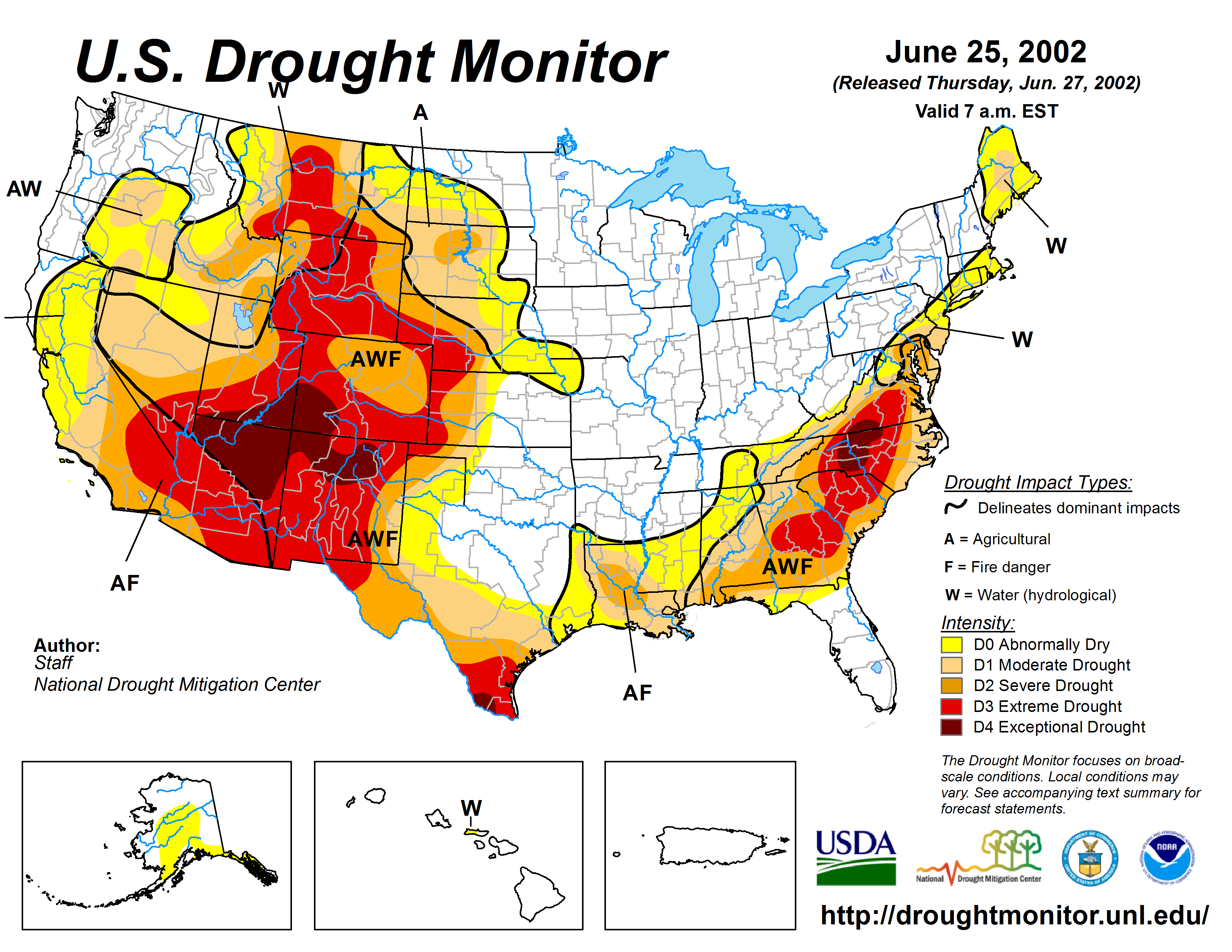
Together the efforts seem to be working – since the 2002 drought, Denver Water has maintained a 22% per-person reduction in water usage from pre-drought levels.
Steamboat Springs is opting for tree-planting. The idea is that trees will help cool down the Yampa River, which is part of the Colorado River Basin. Hot, dry seasons had been pushing stream temperatures so high that part of the river wound up on EPA’s impaired waterbody list.
“That was a call to action,” says Kelly Romero-Heaney, Steamboat Springs’ water resources manager.
The timing also dovetailed with the 2015 release of a Colorado Water Plan that included goals for stream management. Steamboat Springs did a streamflow management plan – released in 2018. In it was the idea of shading the Yampa.
“What we learned was that flow alone cannot overcome the thermal load for the solar radiation, as strength of that radiation increases over time,” she says. “The more that we can prepare the river for that, the better it will buffer against the impacts of climate change.”
They joined forces with the Yampa Valley Sustainability Council’s ReTree program that began in 2010 as a reforestation effort to counteract trees killed by pine beetle infestations. It morphed into a three-year Yampa River restoration.
“That work also increases resilience to future changes,” says Michelle Stewart, the council’s executive director. “We’re really learning the important role soil moisture plays in resilience.”
ReTree planted 200 narrow leaf cottonwoods in 2019 and another 350 this past October. This coming October, its plans are for 450 cottonwoods and 150 mountain alders. All were raised at the Colorado State Forest Nursery from Yampa Valley clippings. “We’re using local trees that are already kind of adapting to big swings in temperature and probably have a little bit more of that hardiness that we need and drought readiness,” she says.
It’s too early to know how the shading is working but there are plans for citizen help to monitor that and to implement a soil moisture monitoring network in the Yampa Basin.
“This is a Johnny Appleseed project,” says Romero-Heaney. “We plant today and hopefully my children will get to enjoy it.”
Months of drought continue for Grand County and most of the western slope.
Grand has been in “exceptional” drought for months, according to the United States Drought Monitor. The drought map for Colorado puts the majority of the county in the worst of five categories for drought intensity…
Colorado Drought Monitor January 5, 2021.
The widespread drought is also apparent in snow water equivalent tracker known as SNOTEL. For the Colorado River Basin, which includes all of Grand, the snow water equivalent is at 73% of the average pack…
It’s even less compared to this time last year at 68% of the snow water equivalent. Last year’s snowpack for the Colorado River Basin was unique because pack coasted above average through April before suddenly dropping in an unusually dry May.
At Winter Park Resort, snowpack is 93% of the 30-year average according to OpenSnow.com. Meteorologist Joel Gratz predicts that the next significant snow storms for the mountain won’t be until around Jan. 16 or Jan. 17.
Westwide SNOTEL snowpack basin-filled map January 11, 2021 via the NRCS.
“The Unfinished Fight of Seldom Seen Sleight” will be screened for free online Tuesday.
San Juan County: When river runner, wilderness guide and legendary environmental provocateur Ken Sleight tells his life story, he likes to start at the beginning.
“I’m a farm boy from Paris,” he often says. “Paris, Idaho.”
Sleight grew up in The Church of Jesus Christ of Latter-day Saints, but when he uses words like “temples,” “paradise” or “heaven” now, at the age of 91, it refers to an earthly fold of the Colorado Plateau, a place he first visited in 1955, named Glen Canyon.
As one of the few commercial outfitters to guide rafts through Glen Canyon prior to its submersion under Lake Powell in the 1960s, Sleight remains haunted by the lost beauty of a place that few non-native Americans experienced as a flowing river.
“I don’t understand human thinking — to destroy temples, cathedrals,” Sleight says in the opening sequence of a new film by Sageland Media, “The Unfinished Fight of Seldom Seen Sleight.”
“Would they flood the Sistine Chapel, flood the Mormon temple?” he continues. “Would the people accept that? Then you say, ‘What could I have done?’ We could have stopped it today. We couldn’t then.”
Sleight was immortalized in “The Monkey Wrench Gang,” Edward Abbey’s 1975 classic novel of environmental sabotage, as the polygamist “Jack Mormon” character named Seldom Seen Smith. It’s an association that Sleight, who remained friends with Abbey until his death in 1989, has never been able to fully shake, and one that often becomes the focus of interviews, including in the new 45-minute documentary that premiered at the Wild and Scenic Film Festival last year and is being screened online Tuesday by the Utah Film Center.
“It helped me become an environmentalist for sure,” Sleight said of his friendship with Abbey and the construction of Glen Canyon Dam in a recent interview with The Salt Lake Tribune. True to form, Sleight interrupted the phone call to share the admiration for the wild turkeys standing on his porch in northern San Juan County.
“Three of them flew up on the railing,” he laughed with obvious joy in his voice. “Beautiful birds.”
Chris Simon, the Utah-based filmmaker who directed the documentary, said Sleight’s love of the natural world also shaped Abbey’s views. “There was a lot of mutual influence” between the two friends, she said…
“He’s one of the classic Utah characters,” Simon said. “He’s touched so many lives. … To me, the number one thing that Ken Sleight has done is inspire people to stand up for whatever land they personally love.”
Standing up has taken on different forms for Sleight over the decades, including after he moved with his wife, Jane, in 1986 to Pack Creek south of Moab, where they ran a backcountry outfitting and guide service.
He fought in the successful campaign to block a nuclear waste dump from being established near Canyonlands National Park in the 1980s, and around that same time protested the construction of the White Mesa uranium mill, which continues to operate and remains a focus of environmental debate in southeast Utah.
Sleight later served as chair of the San Juan County Democrats where he worked with Navajo and Ute Mountain Ute colleagues to expand Native American voting rights, including through a campaign to run a Native American candidate for every open county position one year…
“We were trying to show the county that Native Americans had never had complete representation,” Sleight said. “Mark Maryboy was the only one able to get [into office], but that was the start of a lot of good stuff.”
Sleight said he was happy to see those efforts finally come to fruition with the election of the county’s first majority-Native American Commission in 2018 following a long voting rights lawsuit brought by the Navajo Nation. “[The new commission] has done a great job,” he said.
Perhaps Sleight’s most famous action from that time period came when he rode his horse in front of a bulldozer that was chaining old-growth pinyon-juniper forest on Bureau of Land Management land to clear pasture land near his home in the early ’90s.
“He’s one of the last of … a Western outlaw breed of environmental hero,” Sand Sheff, former wrangler for Ken Sleight Expeditions, says in the film.
The documentary features numerous interviews, including with John Weisheit, a river guide who was inspired by Sleight to found the advocacy organization Living Rivers; Ken Sanders of Ken Sanders Rare Books; and Tim DeChristopher, who, as a University of Utah student in 2008, protested an oil and gas lease sale in southeast Utah by bidding on parcels of Bureau of Land Management land. He spent two years in prison for the action…
“The Unfinished Fight of Seldom Seen Sleight’’ will be screened for free at 7 p.m. on Tuesday, Jan. 12, by the Utah Film Center. Doug Fabrizio of KUER’s Radio West will moderate a question-and-answer session after the screening featuring filmmakers and others. The film will only be available for viewers who tune in during the livestream event. Visit http://utahfilmcenter.org for more information and to pre-order the livestream.
Zak Podmore is a Report for America corps member and writes about conflict and change in San Juan County for The Salt Lake Tribune. Your donation to match our RFA grant helps keep him writing stories like this one; please consider making a tax-deductible gift of any amount today by clicking here.
The Colorado River begins to back up behind Glen Canyon Dam during construction
From Hole in The Rock looking South East across the Colorado River in Glen Canyon at Mile 84.4. By Ken Bertossi – Grand Canyon National Park Museum Collection GRCA 117031, Public Domain, https://commons.wikimedia.org/w/index.php?curid=86669734
Glen Canyon in 1873, near the confluence of the Colorado and San Juan Rivers. By Timothy H. O'Sullivan – U.S. National Archives and Records Administration, Public Domain, https://commons.wikimedia.org/w/index.php?curid=17428088
Looking downstream at the Colorado River from Glen Canyon Dam tailrace. (Source: Bureau of Reclamation)
At capacity, Lake Powell holds more than 26 million acre-feet of water that originates as snowpack from the Upper Basin. (Source: U.S. Bureau of Reclamation via the Water Education Foundation)
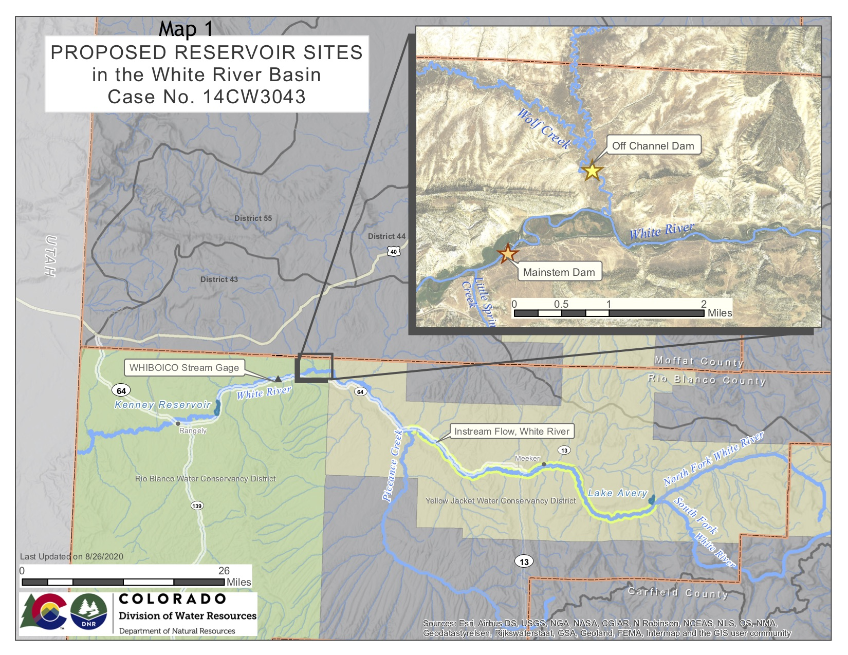
This map shows the potential locations of the proposed White River storage project, also known as the Wolf Creek project, on the White River between Rangely and Meeker. A water court judge has dismissed several of the Rio Blanco Water Conservancy District’s claims for water. Credit: Colorado Division of Water Resources via Heather Sackett/Aspen Journalism
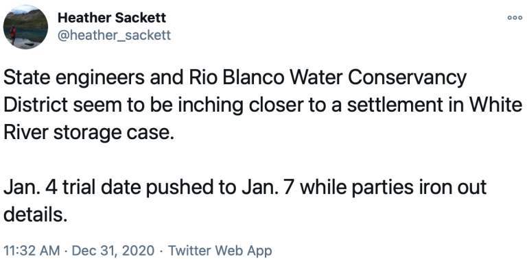
[Rio Blanco Water Conservancy District], Colorado State and Division 6 Engineers agree on water right for the Reservoir
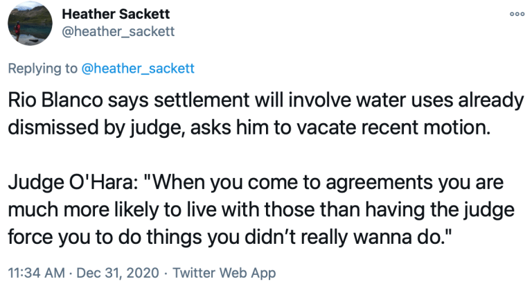
A little over two weeks after Division 6 Water Judge Michael O’Hara III dismissed several water uses, the Rio Blanco Water Conservancy District and the Colorado Division of Water Resources reached an agreement on a conditional water right decree for Wolf Creek Reservoir, Jan. 7.
That settlement led to a decree for the storage right in Wolf Creek Reservoir that was signed by the Division 6 Water Judge, Michael O’Hara III on January 7. As part of his rulings, Judge O’Hara vacated his December 23, 2020 order on summary judgment motions.
The decree will give the District the right to store 66,720 acre-feet of water in a new reservoir that will be constructed in Rio Blanco County near the White River and Wolf Creek confluence, approximately 15 miles upstream of the District’s Kenney Reservoir and 17 miles northeast of Rangely, according to the agreement.
A view of the White River foreground, and the Wolf Creek gulch, across the river. The Rio Blanco Water Conservancy District and the State of Colorado have reached a settlement for a reservoir and dam project at this site. Photo credit: Aspen Journalism/Brent Gardner-Smith
The preferred reservoir site is off-channel on the normally dry Wolf Creek, with water to be delivered to the reservoir from a proposed pump station on the nearby White River.
Decreed uses for water stored in the new reservoir will include municipal water for the Town of Rangely and replacement water that can be released to offset future water uses within the District boundaries and within the Yellow Jacket Water Conservancy District (YJWCD), the conservancy said in a press release…
The District says it continues to work with the Upper Colorado River Recovery Program, the Colorado Water Conservation Board, the Nature Conservancy, the State of Utah, and the Ute Indian Tribe to determine the water needs for the recovery of endangered fish as part of the White River Management Plan…
The new reservoir will allow a small portion of the White River runoff water volume to be stored in the reservoir each year. This water will then be released from storage to offset reduced river flows during periods of droughts, meet the needs of the District’s constituents, and to help offset the effects of climate change on future river diversions.
The Rio Blanco Water Conservancy District includes about 1,300 square miles of land in western Rio Blanco County. The District is responsible for protecting and conserving water within its boundaries.
As the world reacts to the Jan. 6 armed attack on the U.S. Capitol encouraged by President Donald Trump, many Americans are wondering what happens next. Members of Congress, high-level officials and even major corporations and business groups have called for Trump’s removal from office.
Informal actions like this may continue, including House Speaker Nancy Pelosi’s reported request that Gen. Mark Milley, chairman of the Joint Chiefs of Staff, restrict Trump’s ability to use the nuclear codes. But political leaders are considering more formal options as well. They have two ways to handle it: impeachment and the 25th Amendment.
Article II of the U.S. Constitution authorizes Congress to impeach and remove the president – and other federal officials – from office for “Treason, Bribery, or other high Crimes and Misdemeanors.” The founders included this provision as a tool to punish a president for misconduct and abuses of power. It’s one of the many ways that Congress keeps the executive branch in check.
Impeachment proceedings begin in the House of Representatives. A member of the House files a resolution for impeachment. The resolution goes to the House Judiciary Committee, which usually holds a hearing to evaluate the resolution. If the House Judiciary Committee thinks impeachment is proper, its members draft and vote on articles of impeachment. Once the House Judiciary Committee approves articles of impeachment, they go to the full House for a vote.
If the House of Representatives impeaches a president or another official, the action then moves to the Senate. Under the Constitution’s Article I, the Senate has the responsibility for determining whether to remove the person from office. Normally, the Senate holds a trial, but it controls its procedures and can limit the process if it wants.
Ultimately, the Senate votes on whether to remove the president – which requires a two-thirds majority, or 67 senators. To date, the Senate has never voted to remove a president from office, although it almost did in 1868, when President Andrew Johnson escaped removal from office by one vote.
The Senate also has the power to disqualify a public official from holding public office in the future. If the person is convicted and removed from office, only then can senators vote on whether to permanently disqualify that person from ever again holding federal office. Members of Congress proposing the impeachment of Trump have promised to include a provision to do so. A simple majority vote is all that’s required then.
The Constitution’s 25th Amendment provides a second way for high-level officials to remove a president from office. It was ratified in 1967 in the wake of the 1963 assassination of John F. Kennedy – who was succeeded by Lyndon Johnson, who had already had one heart attack – as well as delayed disclosure of health problems experienced by Kennedy’s predecessor, Dwight Eisenhower.
It has never been invoked against a president’s will, and has been used only to temporarily transfer power, such as when a president is undergoing a medical procedure requiring anesthesia.
Section 4 of the 25th Amendment authorizes high-level officials – either the vice president and a majority of the Cabinet or another body designated by Congress – to remove a president from office without his consent when he is “unable to discharge the powers and duties of his office.” Congress has yet to designate an alternative body, and scholars disagree over the role, if any, of acting Cabinet officials.
The high-level officials simply send a written declaration to the president pro tempore of the Senate – the longest-serving senator from the majority party – and the speaker of the House of Representatives, stating that the president is unable to discharge the powers and duties of his office. The vice president immediately assumes the powers and duties of the president.
The president, however, can fight back. He or she can seek to resume their powers by informing congressional leadership in writing that they are fit for office and no disability exists. But the president doesn’t get the presidency back just by saying this.
The high-level officials originally questioning the president’s fitness then have four days to decide whether they disagree with the president. If they notify congressional leadership that they disagree, the vice president retains control and Congress has 48 hours to convene to discuss the issue. Congress has 21 days to debate and vote on whether the president is unfit or unable to resume his powers.
The vice president remains the acting president until Congress votes or the 21-day period lapses. A two-thirds majority vote by members of both houses of Congress is required to remove the president from office. If that vote fails or does not happen within the 21-day period, the president resumes his powers immediately.
Local basins have seen an 11.11 percent decrease in snowpack totals over the last week, with the San Miguel, Dolores, Animas and San Juan River basins sitting at 72 percent of median this week, compared to 81 percent of median last week.
According to the Natural Resources Conservation Service (NRCS), that site was at 117 percent of median this time last year.
A 9 percent decrease was reported for the Wolf Creek summit, with totals going from 111 percent of median to 101 percent of median this week…
Other snowpack reports
The Upper Rio Grande Basin has a snowpack total of 102 percent of median this week. Last year at this time it was 116 percent of median.
At the Arkansas River Basin, totals were 119 percent of median this time last year and are 100 per- cent of median this week.
At the Yampa and White River basins, snowpack totals went from 117 percent of median this time last year to 82 percent of median this week.
The Laramie and North Platte River basins were 112 percent of median this time last year, whereas they are 82 percent of median this week.
The South Platte River Basin’s snowpack total is also 82 percent of median this week. Last year it was 122 percent of median.
Snowpack totals at the Upper Colorado River Basin were 107 percent of median this time last year. This week they are 76 percent of median.
The Gunnison River Basin was 105 percent of median last year. This week, it is 73 percent of median…
River report
According to the U.S. Geological Survey, the San Juan River was flowing below the average rate at 43.5 cfs as of Wednesday at 2 p.m.
Based on 85 years of water records, the average flow rate for Jan. 6 is 59 cfs.
The San Juan River had the lowest flow total for Jan. 4 in 1990. The lowest flow total from that year for Jan. 4 was recorded at 24 cfs.
The highest flow total for that date came in 1987, when the San Juan River had a flow of 116 cfs.
A few inches of snow are expected to land in Colorado on Saturday after days of dryness. After that, no more snow is expected for about a week. This lack of consistent snowfall seems to be the norm this winter, as Colorado continues to experience widespread drought and snowpack remains low.
Colorado Drought Monitor January 5, 2021.
According to the US Drought Monitor, 100 percent of Colorado is experiencing drought of some level, as of January 5, with more than three-quarters of the state experiencing “extreme” drought or worse. Roughly 27 percent of the state is currently in “exceptional” drought conditions, the worst stage of drought, likely to result in major agricultural and recreational economic losses, among negative side effects.
Westwide SNOTEL basin-filled map January 7, 2021 via the NRCS.
The recent dryness in Colorado is reflected in the state’s snowpack. The state’s current snow water equivalent is at just 79 percent of the to-date median and just 35 percent of the median snow water equivalent peak, which typically occurs in early April.
This time last year, just 51 percent of Colorado was experiencing some level of drought, with no portion of Colorado experiencing the two worst levels of drought – “extreme” and “exceptional”.
One option for the White River storage project would be an off-channel dam and reservoir at this location. Water would have to be pumped from the White River into the reservoir site. Photo credit: Heather Sackett/Aspen Journalism
FromThe Grand Junction Daily Sentinel (Dennis Webb):
A legal settlement this week has allowed the Rio Blanco Water Conservancy District to clear a major early hurdle in its attempt to build a large reservoir 17 miles northeast of Rangely.
The agreement reached between the district and state Division of Water Resources averted a trial that was scheduled for this week and led to a decree that was signed by Division 6 Water Judge Michael O’Hara III on Thursday. It gives the district the right to store 66,720 acre-feet of water in a reservoir that would be constructed in Rio Blanco County near the White River and Wolf Creek confluence, approximately 15 miles upstream of the district’s Kenney Reservoir.
The district’s preferred reservoir site would be on Wolf Creek, with water to be delivered to the reservoir from a proposed pump station on White River.
The proposal still faces major challenges, from federal permitting, to financing, to challenges from environmentalists. But water attorney Alan Curtis, who has been representing the district on the project, said getting the water right is necessary before federal regulatory agencies will consider approving a reservoir proposal…
Decreed uses for water stored in the reservoir include municipal water for the town of Rangely, and replacement water that can be released to offset future water uses within the district boundaries and within the Yellow Jacket Water Conservancy District, which includes portions of eastern Rio Blanco County, Moffat County and the town of Meeker. Use of the water also is allowed to mitigate environmental impacts associated with the reservoir, and for hydroelectric power generation. In-reservoir use is allowed for recreation, fisheries and wildlife habitat.
Under the settlement, the Rio Blanco district dropped its proposal for some of the water to be used to benefit endangered fish in rivers. Kevin Rein, state engineer for the Division of Water Resources, said the state was concerned with preventing water speculation, which is prohibited in Colorado. To get a water right appropriated requires having a good, nonspeculative plan to put the water to beneficial use, he said. He said the district proposal lacked things such as a formal agreement with the Upper Colorado River Endangered Fish Recovery Program or a specified amount of water that would be involved.
The water district also had proposed to store water so in-basin diversions could continue should local water have to be released to downstream states if Upper Colorado River states including Colorado ever fall out of compliance with water delivery obligations under an interstate compact. The district dropped that proposal under the settlement.
The Crystal River flows through the town of Marble just after its confluence with Yule Creek. Gunnison County, Pitkin County and local environmental groups want to see a marble mining company mitigate its illegal relocation of a creek by improving downstream riparian habitat. Photo credit: Heather Sackett/Aspen Journalism
The U.S. Army Corps of Engineers has denied local groups’ request for a public hearing in the case of a marble quarry that violated the Clean Water Act.
In a Dec. 28 letter to Pitkin County and others, Benjamin Wilson, project manager for the Army Corps’ Colorado West Section, said the agency does not intend to conduct a hearing or public meeting.
“We do not believe there would be a valid interest served or that we would receive any substantial new information we would not otherwise obtain through the public notice comment and review process we are currently engaged in,” the letter reads.
In separate comments submitted to the Army Corps, Pitkin and Gunnison counties, the Crystal River Caucus, the Roaring Fork Conservancy and the Crystal Valley Environmental Protection Association (CVEPA) had asked for monitoring, restoration, mitigation and a chance for the public to weigh in about the situation at the Pride of America Mine, which sits above the town of Marble.
“We are definitely not going to accept this,” said John Armstrong, director of CVEPA. “To not even offer to hear what the public has to say in a public hearing is kind of shocking to me.”
In the fall of 2018, mine operator Colorado Stone Quarries (CSQ) diverted a roughly 1,500-foot section of Yule Creek from its natural channel on the west side of Franklin Ridge, a rock outcropping, to the east side of the ridge so that it could build a road. Operators piled the streambed with 97,000 cubic yards of fill material, including marble blocks.
In March, the Army Corps determined that these actions, which were done without the proper permit, violated the Clean Water Act. CSQ is now retroactively applying for that permit, known as a 404 individual permit. Under Section 404 of the Clean Water Act, a project requires a permit from the Army Corps if it includes the discharge of dredged or fill materials into waters such as rivers, streams and wetlands.
In its permit application, CSQ proposed making the creek relocation permanent by leaving it where it is on the east side of the ridge. The company says this is the most efficient and environmentally sound option, and it results in the closest return to pre-diversion stream conditions.
Wilson said the Army Corps received more than a dozen comments, which have been forwarded to the mining company, along with additional questions from the Army Corps. Wilson said mining company officials must address these comments and propose a plan to mitigate the damage caused by the creek relocation. The deadline for the quarry to respond is Jan. 23, but Wilson said it will probably take the company longer than that to come up with a mitigation plan.
“We are working towards figuring out which alternative is indeed the least environmentally damaging,” Wilson said in an interview with Aspen Journalism. “I think it’s understood that no matter what alternative we choose to go forward with, additional mitigation will be required.”
The Filoha Meadows area of the Crystal River is one of the places that could benefit from riparian revegetation to improve water quality. Pitkin County would like a mining company to undertake mitigation projects in the Crystal River valley to compensate for damage caused when the company relocated a high-country creek. Photo credit: Heather Sackett/Aspen Journalism
Pitkin County wants the mining company to restore the riparian habitat, conduct water-quality monitoring at multiple sites in the basin and compensate for any damage by doing restoration projects in other areas. County representatives identified eight projects that could provide compensatory mitigation in the Crystal River basin, including restoration of Filoha Meadows streambanks, Thompson Creek riparian restoration and Crystal River streambank stabilization.
Carbondale-based Wilderness Workshop agrees. The conservation organization is also getting involved in the issue, signing on to the comments provided by CVEPA.
“It is a shocking issue,” said Peter Hart, conservation analyst and staff attorney for Wilderness Workshop. “Obviously, the damage is done, but I think that we’d like to see fines for violations imposed and see those funds actually utilized for restoration projects in the Crystal River valley.”
CSQ senior consultant Katie Todt, who is with Lewicki & Associates, said the company is evaluating potential mitigation options, including improvements to the current stream channel within the quarry’s permit area, which should stabilize the creek bank and promote vegetation growth. The company will more fully set out mitigation options in its expected Jan. 22 response to the Army Corps.
Wilson said that even though there won’t be another opportunity for the public to formally provide comments, the Army Corps is still obligated to consider any new information that comes to light.
Assistant Pitkin County Attorney Laura Makar said it was disappointing that the Army Corps decided not to hold a public hearing, especially since this is an atypical, retroactive permit application, submitted after the work needing a permit was already complete. There was significant information that could have been shared in a public hearing, she said.
“It would have been a good opportunity to ensure the record was complete,” Makar said.
This story ran in the Jan. 8 edition of The Aspen Times.
The U.S. Forest Service said it is just weeks away from deciding whether a high-profile request to explore the geological feasibility of a new reservoir site in Colorado’s Eagle County that would capture water flowing from the iconic Holy Cross Wilderness should be granted.
The request comes from Aurora and Colorado Springs, among others, who want to be able to capture more of the water flowing from the wilderness area to meet their own growing needs.
David Boyd, a spokesman for the U.S. Forest Service, said a decision is expected “early this year.”
Proponents had hoped for a decision late last summer, but Boyd said the delay wasn’t unusual and was triggered in part by last summer’s Grizzly Creek Fire.
Aurora and Colorado Springs, which own and operate the only reservoir in the area, Homestake I, hope to demonstrate that they can divert more water and build another reservoir to serve Front Range and West Slope interests without damaging the delicate wetlands and streams in the mountain forests there.
But in advance of any request to build an actual reservoir, they have asked the Forest Service for a special use permit to survey the area and to bore several test holes to determine soil conditions and areas best suited to build the proposed Whitney Reservoir.
If a reservoir were to be built, it would also require that the 122,000-acre-plus wilderness area shrink by 500 acres, an action that will require congressional approval.
Significant opposition to the exploratory permit erupted almost as soon as the proposal became public last year. The U.S. Forest Service received more than 500 comments on the proposal last summer. The majority of those were opposed to it, citing the need to protect the wilderness and the need to preserve as much of the region’s water as possible. The Eagle River, a part of the Colorado River system, is fed in large part by the Holy Cross watershed.
Warren Hern, a co-founder of the Defenders of the Holy Cross Wilderness, said the plan would do irrevocable damage to the rare bogs and wildflowers that populate the area.
He also noted that the proposed reservoir site lies along a major fault line.
“We will do everything in our power to stop this,” Hern said.
Greg Baker, a spokesman for Aurora Water, said his agency is well aware of the special relationship thousands of Coloradans have with the Holy Cross and its spectacular wetlands and hiking trails.
Baker declined to comment for this article, saying the agency would wait until the Forest Service issues a decision.
But in a recent interview, Baker said the cities had little choice but to pursue additional water supplies to meet growing demand.
“Water is a rare commodity and it needs to be used very carefully,” Baker said.
He also said any environmental damage that might occur could be successfully mitigated.
“What you do is wetlands rehabilitation, where you develop wetlands in other areas on a two- or three-to-one basis so you’re restoring additional wetlands for those you may lose,” Baker said.
The new proposal comes under a 1998 agreement known as the Eagle River Memorandum of Understanding, which allows the reservoir proponents to develop enough water to serve environmental, municipal and industrial interests.
Parties to the 1998 agreement include Aurora, Colorado Springs, the Colorado River District, the Eagle River Water and Sanitation District, and the Upper Eagle Regional Water Authority.
Located west of Vail between Minturn and Leadville, the Holy Cross Wilderness Area was the subject of a significant battle in the 1980s when Aurora and Colorado Springs sought to build a second major reservoir there known as Homestake II.
After the case made it all the way to the U.S. Supreme Court, Homestake II was defeated in 1994.
In exchange, however, the cities were granted permission to develop a smaller amount of water in the future in partnership with Western Slope interests, resulting in the permit request now being considered by the Forest Service.
Correction: An earlier version of this article incorrectly listed Vail Associates as a participant in the Whitney Reservoir proposal.
Jerd Smith is editor of Fresh Water News. She can be reached at 720-398-6474, via email at jerd@wateredco.org or @jerd_smith.
This map shows the location of test holes Homestake Partners plans to drill as part of its geotechnical investigation into the feasibility of a dam site in the Homestake Creek valley. The Forest Service has received more than 500 comments, most of them in opposition to, the drilling and the overall reservoir project. Credit: USFS via Aspen Journalism
These wetlands in the Homestake Creek valley are near the site of the proposed Whitney Reservoir. The Forest Service is considering whether to issue a permit for drilling and a geotechnical study to test whether the site would support a dam. Photo credit: Heather Sackett/Aspen Journalism
These wetlands, located on a 150-acre parcel in the Homestake Creek valley that Homestake Partners bought in 2018, would be inundated if Whitney Reservoir is constructed. The Forest Service received more than 500 comments, the majority in opposition to, test drilling associated with the project and the reservoir project itself. Photo credit: Heather Sackett/Aspen Journalism
A map from Colorado Springs Utilities that shows how tunnels could bring water to Whitney Reservoir from Fall and Peterson creeks, and from the Eagle River. The map also shows the route of a pipeline to pump water from Whitney Reservoir to Homestake Reservoir.
A wetland area along Homestake Creek in an area that would be flooded by a potential Whitney Reservoir. The cities of Aurora and Colorado Springs are looking to develop additional water in Eagle County and divert it to the Front Range. Photo credit: Brent Gardner-Smith/Aspen Journalism
A map prepared by Aurora Water that shows a potential 500-acre adjustment to the Holy Cross Wilderness boundary near the potential Whitney Reservoir on lower Homestake Creek. The map as current as of July 16, 2019.
Homestake Reservoir, which is partially in Pitkin County, but mainly in Eagle County. Below the reservoir the Homestake Creek valley is visible, as well as short section of what’s known as Homestake Road. Water held in the potential Whitney Reservoir would be pumped up to Homestake Reservoir and then sent to the Front Range. Photo credit: Brent Gardner-Smith/Aspen Journalism
The dam in the Eagle River headwaters that forms Homestake Reservoir, which diverts water to the Front Range. If the wetlands in the Homestake Creek valley contain ancient peat bogs called fens, it could hinder the progress of the Whitney Reservoir project. Photo: Brent Gardner-Smith/Aspen Journailsm
In response to decreasing tributary flows, the Bureau of Reclamation has scheduled an increase in the release from Navajo Dam from 350 cubic feet per second (cfs) to 400 cfs on Saturday, January 9th, starting at 4:00 AM. Releases are made for the authorized purposes of the Navajo Unit, and to attempt to maintain a target base flow through the endangered fish critical habitat reach of the San Juan River (Farmington to Lake Powell).
The San Juan River Basin Recovery Implementation Program recommends a target base flow of between 500 cfs and 1,000 cfs through the critical habitat area. The target base flow is calculated as the weekly average of gaged flows throughout the critical habitat area from Farmington to Lake Powell.
The outflow at the bottom of Navajo Dam in New Mexico. Photo: Brent Gardner-Smith/Aspen Journalism
Rehydrating would require at least 10 to 20 inches of good precipitation in the next 6 months, but this season’s snow totals are already well behind normal
More than a quarter of the state is in the worst level of drought, and with snowpack significantly below what’s expected this time of year — especially on the Western Slope — scientists are warning that it will take more than just a big snowstorm to alleviate this dry spell.
Colorado has been in drought to varying degrees since August, and this week is no different. Thursday’s U.S. Drought Monitor report found that all of Colorado is in at least “moderate” drought — the second lowest drought category — with 27.6% classified in the most intense category of “exceptional.” The past five weeks of reports have maintained that 27.6% figure; there hasn’t been less than a quarter of the state in “exceptional” drought since eight weeks ago.
US Drought Monitor June 25, 2002.
The last time Colorado saw drought this widespread was in 2002. On one hand, it’s good that the state’s drought status isn’t getting worse; on the other hand, it’s also not improving, and likely won’t anytime soon…
Colorado Drought Monitor January 5, 2021.
Much of Colorado’s water supply is banked up in winter snow, which, to be comparable in analyses, is converted to a liquid water equivalent. In a normal year, Colorado would have accumulated about 45% of its “normal” snowpack by now. Right now, the state has about 35% of its expected snowpack for the year, according to Karl Wetlaufer, hydrologist with the National Resources Conservation Service. Some areas are faring better than others, but across the board, the state is into month four of a concerningly dry water year.
Colorado snowpack basin-filled map January 8, 2021 via the NRCS.
It’s not just that the state isn’t getting much precipitation now; Colorado hasn’t had good precipitation for a long time. Nearly half of the NRCS snow telemetry sites saw their record lowest or second lowest precipitation measures on record from May to October last year, [Karl] Wetlaufer said. The telemetry sites have collected data for three to four decades, depending on the location.
“The drought situation now is pretty dire,” Wetlaufer said.
Even if the state meets or exceeds its snow-water-equivalent totals sometime this season, Wetlaufer noted that the lack of precipitation last year means that this year’s runoff will almost certainly be below average. Already, rivers across the state are reporting record-low streamflows.
A few factors influence how much water runs off into rivers and streams. For one, if soils are dry as they are now, any water that either melts from snow or falls from rain will first go into the ground, with soil soaking it up like a sponge. Plants will also absorb water as it falls or melts until they are satisfied, and right now the state’s vegetation is parched.
The ramifications of the current drought are wide-reaching, according to Wetlaufer; agricultural land is degrading, reservoirs are low, and scant stream flows are putting some wildlife and plant species at risk. The state recently activated its municipal drought response for the second time ever, after activating the agricultural portion of the plan last summer.
Based on the PHDI. PHDI is a primary measure of long-term drought but may not apply to all areas, including those with heavily managed surface water. No additional precipitation is needed for white areas. Map credit: NOAA (Screenshot)
It will take a lot to pull the state out of drought. According to a National Oceanic and Atmospheric Administration model, the state needs at least 10 inches of water-equivalent precipitation, and almost 20 inches on the Western Slope, in the next six months to emerge from its current drought.
It remains to be seen whether a good spring snow season is in the cards, but Wetlaufer said, “from all the outlooks I’ve seen, it’s not looking incredibly encouraging.”
Upper Colorado, Great, Virgin River Basins: Jan 2021 April-July forecast volumes as a percent of 1981-2010 average (50% exceedance probability forecast).Lower Colorado Basin (AZ/NM): 2021 January-May forecast volumes as a percent of 1981-2010 median (50% exceedance probability forecast).
Water Supply Forecast Summary
Early January water supply volume forecasts are below to much below average throughout the Colorado River Basin and Great Basin. Upper Colorado River Basin water supply forecasts generally range between 40-80% of the 1981-2010 historical April-July average. Great Basin water supply forecasts are less favorable at 40-65% of average. Lower Colorado River Basin January-May water supply runoff volumes are fairing the worst at 10-40% of the historical median. Water supply forecast ranges by basin:
Water year 2021 is off to a poor start over much of the region with below to much below normal precipitation. Many SNOTEL sites in the Colorado River and Great Basins are below the 20th percentile for water year precipitation. In addition, the period from April-December was one of the driest on record. As a result, antecedent soil moisture conditions entering the winter are worse compared to a year ago due to record low April-October precipitation across the region and a below average runoff last spring. Modeled soil moisture is generally in the bottom five across the Upper Colorado over the 1981-2020 40-year period.
Much below average October precipitation across the region resulted in a slow start to the high elevation snow accumulation season. Early January snow water equivalent (SWE) conditions are below to much below normal (median) throughout the CBRFC forecast area. Given the dry conditions, an above normal snowpack or a wet spring will be needed to see near average water supply volumes.
April-July unregulated inflow forecasts for some of the major reservoirs in the Upper Colorado River Basin include Fontenelle 460 KAF (63% average), Flaming Gorge 585 KAF (60%), Green Mountain 190 KAF (69%), Blue Mesa 470 KAF (70%), McPhee 170 KAF (58%), and Navajo 450 KAF (61%). The Lake Powell inflow forecast is 3.8 MAF (53% of average).
Water Supply Discussion
December Precipitation
The precipitation in December was mostly below to well below normal over much of the Colorado River Basin and Great Basin. The first 10 days of the month were exceptionally dry as a strong ridge was located across the Intermountain West. A weak storm system brought modest precipitation amounts to the Lower Basin and into southwest Colorado on December 10-11. A more significant storm system moved across southern Utah and Colorado on December 28, producing over 1.5 inches of precipitation in the San Juans and widespread 0.5-1.0 inches across the rest of the Colorado mountains. The higher amounts with this system resulted in near normal monthly precipitation for the headwaters of the San Juan/Gunnison basins.
December 2020 percent of normal precipitation. (Averaged by basins defined in the CBRFC hydrologic model)
Water Year Precipitation
The water year precipitation can be used as a good indicator of early season water supply conditions. The 2021 water year is off to a rather dismal start over much of the region with below to well below normal precipitation. In fact, many of the SNOTELs in the Colorado River and Great Basins are below the 20th percentile for water year precipitation. In addition, the period from April-December was one of the driest on record. As a result of the prolonged period of below normal precipitation since last spring, drought conditions continue to worsen across much of the region.
Water Year 2021 percent of normal precipitation. (Averaged by basins defined in the CBRFC hydrologic model)West Drought Monitor January 5, 2021 showing Extreme to Exceptional Drought covering an extensive area of the Colorado River and Great Basins.
Snowpack
U.S. Drought Monitor showing Extreme to Exceptional Drought covering an extensive area of the Colorado River and Great Basins.
Much below average October precipitation across the region resulted in a slow start to the high elevation snow accumulation season. As of early January, snow water equivalent (SWE) conditions are below to much below normal (median) throughout the CBRFC forecast area. Snowpack conditions generally range from 60-80% of the 1981-2010 historical median across the Upper Colorado River Basin. While the majority of SNOTEL sites are reporting below normal SWE conditions, there are a few SNOTEL stations reporting near to above normal snow conditions scattered throughout the region, most notably in the Upper Green River Basin near the Utah/Wyoming/Idaho border and the headwaters of the San Juan River Basin in southwest Colorado. SWE above Lake Powell is around 75% of normal.
Early January Great Basin snow conditions are well below normal and generally range between 50-70% of the historical median. Lower Colorado River Basin SWE conditions are very poor at 5-40% of median. It should be noted that snowpack conditions in the Lower Colorado River Basin are more variable and tend to fluctuate more frequently over time.
Westwide SNOTEL basin-filled map January 7, 2021 via the NRCS.
Soil Moisture
CBRFC hydrologic model soil moisture states are adjusted in the fall after the irrigation season and prior to the winter snowpack accumulation to accurately reflect observed baseflow conditions. CBRFC model fall soil moisture conditions impact early season water supply forecasts and potentially the efficiency of spring runoff. Above average fall soil moisture conditions have a positive impact on early season water supply forecasts while below average conditions have a negative impact. The impacts are most pronounced when soil moisture conditions and snowpack conditions are both much above or much below average.
Modeled soil moisture conditions as of November 15th were below average across the entire Upper Colorado River Basin and Great Basin. Hydrologic model soil moisture conditions entering the winter are worse compared to a year ago due to record low April-October precipitation across the region and a below average runoff last spring. Modeled soil moisture is generally in the bottom five of the 1981-2020 40-year period across the Upper Colorado. San Juan and Dolores basin soil moisture conditions fall in the bottom three with some areas being record dry. Two consecutive years of poor monsoon seasons have exacerbated the dry conditions in southwest Colorado.
It is not often that such widespread poor soil moisture conditions exist across the region. Similar, but not as poor conditions, existed in the fall of 2002, 2012, and 2018. To produce average runoff, an above normal snowpack or a wet spring will likely be needed to overcome these large soil moisture deficits…
Comparison of November 2019 (left) and November 2020 (right) CBRFC hydrologic model soil moisture conditions entering the winter season.
Upcoming Weather
A ridge of high pressure will dominate the weather pattern through the middle of next week. As such, there will be a lack of significant storms to impact the region. A weak storm system is forecasted to move across Utah/Colorado on Saturday, with only light precipitation amounts (generally less than a half inch). Thus, we continue to be locked into an anomalous ridge pattern with another mostly dry week ahead for the Colorado River and Great Basins.
While there is somewhat more uncertainty looking ahead to the third week of January, the weather models suggest that general ridging will remain in place over much of the Western U.S. There is some indication that storm systems will begin to clip the Upper Green and Upper Colorado basins in northwesterly flow. However, drier than normal conditions are favored for much of the Utah and the Lower Colorado region. With little indication of a significant change to a wetter pattern through at least the third week of January, it is likely that ESP water supply volume guidance will decrease in the next few weeks over much of the region.
March for Science, Denver, Colorado, April 22, 2017
Here’s an in-depth look at 2020 and the climate emergency from William J. Ripple, Christopher Wolf, Thomas M. Newsome, Phoebe Barnard, William R. Moomaw that’s running in Scientific American. Click through and read the whole article. Here’s an excerpt:
The climate emergency has arrived and is accelerating more rapidly than most scientists anticipated, and many of them are deeply concerned. The adverse effects of climate change are much more severe than expected, and now threaten both the biosphere and humanity. There is mounting evidence linking increases in extreme weather frequency and intensity to climate change. The year 2020, one of the hottest years on record, also saw extraordinary wildfire activity in the Western United States and Australia, a Siberian heat wave with record high temperatures exceeding 38 degrees C (100.4 degrees Fahrenheit) within the Arctic circle, a record low for October Arctic sea ice extent of 2.04 million square miles, an Atlantic hurricane season resulting in more than $46 billion in damage, and deadly floods and landslides in South Asia that displaced more than 12 million people.
Every effort must be made to reduce emissions and increase removals of atmospheric carbon in order to restore the melting Arctic and end the deadly cycle of damage that the current climate is delivering. Scientists now find that catastrophic climate change could render a significant portion of the Earth uninhabitable consequent to continued high emissions, self-reinforcing climate feedback loops and looming tipping points. To date, 1,859 jurisdictions in 33 countries have issued climate emergency declarations covering more than 820 million people.
In January 2020, we warned of untold human suffering in a report titled World Scientists’ Warning of a Climate Emergency with more than 11,000 scientist signatories from 153 countries at time of publication. As an Alliance of World Scientists, we continue to collect signatures from scientists, with now more than 13,700 signatories. In our paper, we presented graphs showing vital signs of very troubling climate change trends with little progress by humanity.
Based on these trends and scientists’ moral obligation to “clearly warn humanity of any catastrophic threat” and to “tell it like it is,” we declared a climate emergency and proposed policy suggestions. We called for transformative change with six steps involving energy, short-lived air pollutants, nature, food, economy and population. A short video discussion by thought leaders on the six steps is now available (see below).
Here, we investigate progress for these six steps during 2020. We have seen a few promising developments on energy, nature and food. Impressively, the European Union is on track to meet its emissions reduction goal for 2020 and become zero net carbon by 2050; however, this goal will still increase temperatures from the damaging levels of today. We are also encouraged by the recent trend of governments committing to zero net carbon, including China by 2060 and Japan by 2050. Similar pledges have been made by the United Kingdom, many subnational governments and some corporations, although there is mounting evidence that a 2050 or later target may be inadequate and net zero carbon should be reached much earlier, for example, by 2030.
U.S. President-elect Joe Biden has pledged that the U.S. will rejoin the Paris agreement and proposed a $2 trillion climate plan to phase down fossil fuels by expanding renewable energy capacity while creating jobs, reducing pollution and investing in historically disadvantaged communities. It is critically important to significantly reduce CO2 emissions while simultaneously increasing carbon accumulation by forests, mangroves, wetlands and other ecosystems. Progress for nature came in the form of the Bonn Challenge to restore forest and other ecosystems, but much more investment is needed in natural climate solutions. Global meat consumption, which must be reduced for climate mitigation, is expected to decline 3 percent this year, largely as a result of COVID-19. While likely a temporary decline, this coincides with increasingly popular meat substitutes; annual U.S. sales are projected to reach $1 billion in 2020.
Although lockdowns associated with the COVID-19 pandemic resulted in a decrease in CO2 emissions of 7 percent in 2020, this reduction is unlikely to be long-lived because there has been no major concurrent shift in the way we produce energy. This drop in emissions was a tiny blip compared to the cumulative buildup of greenhouse gases, which has led to all five of the hottest years on record occurring since 2015. In fact, atmospheric concentrations of CO2 continued to rise rapidly in 2020 reaching a record high in September. COVID-19 also led to a one year postponement of the COP26 United Nations climate change conference, after the 2019 failure of the COP25 conference to make meaningful progress. We are concerned that no major industrialized country is on track to limit warming to 1.5 degrees C, the target of the Paris Agreement. Instead, the actions of many wealthy countries—including the U.S. —are consistent with greater than three degrees C warming. Unfortunately, progress in 2020 has also been limited in the areas of short-lived air pollutants, the economy and population.
As we move into 2021 and beyond, we need a massive-scale mobilization to address the climate crisis, including much more progress on the six steps of climate change mitigation. Key actions for each step include the following:
Energy. Swiftly phasing out fossil fuels is a top priority. This can be achieved through a multipronged strategy based on rapidly transitioning to low-carbon renewables such as solar and wind power, implementing massive conservation practices, and imposing carbon fees high enough to curtail the use of fossil fuels.
Short-lived pollutants. Quickly cutting emissions of methane, black carbon (soot), hydrofluorocarbons and other short-lived climate pollutants is vital. It can dramatically reduce the short-term rate of warming, which may otherwise be difficult to affect. Specific actions to address short-lived pollutants include reducing methane emissions from landfills and the energy sector (methane), promoting improved clean cookstoves (soot) and developing better refrigerant options and management (hydrofluorocarbons).
Nature. We must restore and protect natural ecosystems such as forests, mangroves, wetlands and grasslands, allowing these ecosystems to reach their ecological potential for sequestering carbon dioxide. The logging of the Amazon, tropical forests in Southeast Asia, and other rainforests including the proposed cutting in the Tongass National Forest of Alaska is especially devastating to the climate. Creation of new protected areas, including strategic forest carbon reserves, should be a top priority. Payment for ecosystem services programs offer an equitable way for wealthier nations to help protect natural ecosystems.
Food. A dietary shift toward eating more plant-based foods and consuming fewer animal products, especially beef, would significantly reduce emissions of methane and other greenhouse gases. It would also free up agricultural lands for growing human food and, potentially, reforestation (“Nature” step). Relevant policy actions include minimizing tillage to maximize soil carbon, cutting livestock subsidies and supporting research and development of environmentally friendly meat substitutes. Reducing food waste is also critical, given that at least one third of all food produced is wasted.
Economy. We must transition to a carbon-free economy that reflects our dependence on the biosphere. Exploitation of ecosystems for profit absolutely must be halted for long-term sustainability. While this is a broad, holistic step involving ecological economics, there are specific actions that support this transition. Examples include cutting subsidies to and divesting from the fossil fuel industry.
Population. The global human population, growing by more than 200,000 people per day, must be stabilized and gradually reduced using approaches that ensure social and economic justice such as supporting education for all girls and women, and increasing the availability of voluntary family planning services.
The water treatment plant, however, is located on a site known as Gladstone, about 8 miles north of Silverton up County Road 110, owned by the same person who owns the Gold King Mine, Todd Hennis.
Hennis, an entrepreneur based in Golden, has long had an interest in the mines that dot the San Juan Mountains around Silverton, and over the years, has been buying up old mine sites with the hopes of revamping the industry…
After the spill, Hennis agreed to let the EPA use the Gladstone property for a temporary water treatment plant, albeit somewhat begrudgingly.
“When the Gold King event happened, I gave the keys to (the EPA) for Gladstone, and said ‘Go ahead, use anything, just return it after you’re done,’” Hennis said in October 2015. “That rapidly changed into having the hell torn out of my land.”
The water treatment plant continues to operate to this day, and is seen by some invested in the cleanup of mines around Silverton as a possible long-term solution to improving water quality in the Animas River.
Since 2015, the EPA has operated on the Gladstone property through a “general access order,” though the agency has not paid Hennis for use of the land, said EPA spokeswoman Katherine Jenkins.
The EPA has, however, worked for years to come to a long-term lease agreement with Hennis that would include payments for use of the land based on fair market value, but those efforts have not been successful.
“Mr. Hennis has declined EPA’s multiple requests for long-term access and has rejected a long-term lease agreement for EPA’s use of the Gladstone property,” Jenkins said.
Because, in part, of the resources and staff time required to send Hennis monthly general access orders, the EPA on Jan. 6 sent him an “administrative order” that requires him to give the EPA full access to the Gladstone property.
An administrative order, according to the EPA website, is an enforcement tool under the Superfund program.
“We want to have consistent access to the water treatment plant so we can maintain and provide water treatment, that’s the reasoning,” Jenkins said.
When contacted, Hennis said, “I cannot comment on this development, other than to say the EPA currently has access to the site.”
Indeed, Jenkins said that while Hennis has refused to come to a long-term lease agreement, he has not blocked access to the site.
The long-term future of the water treatment plant is an issue high atop the list of priorities in the Superfund around Silverton, known as the Bonita Peak Mining District Superfund site.
Some local officials and members of the public have called to expand the operating capacity of the plant to take in discharges from other mines around Cement Creek, a tributary of the Animas River.
But questions have loomed about this prospect, namely who would be financially on the hook to operate the plant in perpetuity.
But for Hennis, all this is a moot point. He’s still adamant that there are plenty of metals, like gold and tellurium, to be mined in the mountains around Silverton.
“Some of you have government pensions to rely on when you retire,” Hennis said at a public meeting in October 2015. “My retirement is Gladstone. Sitting here, listening to people say Gladstone would make a perfect site for a remediation laboratory, having my land cavalierly dealt with, is not a happy feeling.
“I know you wouldn’t want your backyard or your retirement stolen from you,” he continued. “This is not going to happen. I’ve tried to be very reasonable.”
The EPA’s Jenkins said the administrative order would terminate if a lease agreement is signed or if access to the property is no longer needed by the EPA to conduct response activities at the Bonita Peak Mining District Superfund site.
Tuesday night was a good one for Colorado’s snowpack. Steamboat Ski Resort reported 9 inches of new snow, Loveland another 7 and many other ski areas between 2 and 6 inches…
As of Wednesday, Southwest Colorado struggles the most with just 72% of normal snowpack levels, while the Rio Grande basin is slightly above average. Denver’s South Platte River basin is 82% of the average snowpack, which matches most of the state’s northern half, the Natural Resources Conservation Service in Colorado reports.
Where the snowpack is struggling is also where Colorado’s drought conditions are the worst. The entirety of the Four Corners counties — Montezuma, La Plata, San Juan Dolores and San Miguel — are listed by officials as being in an exceptional drought, according to the National Drought Mitigation Center. Most of the western slope is either recorded as being in stage four drought conditions, which are considered exceptional, or stage three, considered extreme.
Custer and Alamosa counties are faring the best in Colorado, with droughts considered moderate. The two Rio Grande basin counties and the entire San Luis Valley are doing better than the rest of the state.
In its entity, Colorado is in a drought and has been since September when the water year began. Conditions have become much more extreme, meaning snow is all the more critical.
Westwide SNOTEL basin-filled map January 7, 2021 via the NRCS.
An inch of snow is expected to fall in Colorado Springs over the weekend, but the light sprinkling will not be enough to offset this winter’s lag in moisture.
Usually by this point in the year Colorado Springs has had 14.4 inches of snowfall, the National Weather Service reported. But since July 1, 2020, Colorado Springs has only seen 11.1 inches of snow, which is about 3 inches less than the average. The lack of moisture through the fall and into winter could have serious consequences for the trees and the landscape in the region…
About an inch of snow is due in the Pikes Peak region Saturday, Weather Service forecasters predict. The brief storm will clear out Saturday night with sun expected Sunday and temperatures rising into the 40s by Monday…
“There’s nothing we can do there in terms of making up water deficits,” Will said. “It either comes from nature or it doesn’t.”
Click on a thumbnail graphic below to view a gallery of drought data from the US Drought Monitor.
US Drought Monitor January 5, 2021.
West Drought Monitor January 5, 2021 showing Extreme to Exceptional Drought covering an extensive area of the Colorado River and Great Basins.
Colorado Drought Monitor January 5, 2021.
Click here to go to the US Drought Monitor website. Here’s an excerpt:
This Week’s Drought Summary
Since the release of last week’s map, several storm systems impacted the Lower 48. The first spread snowfall across the Rockies and into the Plains and Midwest. The second spread snow and ice from Texas across the central U.S. and into the Northeast. Meanwhile the Pacific Northwest was battered with a series of strong Pacific storms that brought heavy rain and mountain snow. The overall effect generally brought improvements in drought conditions to the Northwest and across an area extending from Texas to Pennsylvania. Deteriorating conditions were minimal and limited to areas such as the Pacific Northwest, North Dakota and Hawaii, where moisture deficits continued to increase. In all, the percent area of the U.S. experiencing moderate drought or worse stands at 45.76%, down from 48.99% last week…
With this week’s band of heavy precipitation falling to the south, the drought status over much of the High Plains remains unchanged this week. Most locations received near-to-below normal amounts. Catching the northern edge of the heavy rain band, one-category improvements were made in southeast Kansas. In North Dakota, extreme drought (D3) was removed from the east central part of the state, since precipitation, soil moisture, streamflow and well data no longer supported the depiction. Severe drought (D2) was expanded in the northwest corner of the state, where moisture deficits have been building for the last six months…
A series of storms brought excess rain and snow to parts of the Pacific Northwest. Washington and parts of Oregon saw precipitation in excess of 200% of normal resulting in local one-category improvements to drought areas where precipitation deficits over the last six to 12 months decreased and streamflow and soil moisture showed recovery. Conditions deteriorated in south central Oregon, with the expansion of severe drought (D3). This area has missed out on most of the rain after a very dry year. Much of the rest of the West was relatively dry last week. State drought teams noted that in areas where rain and snow fell, it wasn’t enough to increase moisture availability; in areas where it didn’t the dryness didn’t yet warrant additional degradations.
In Hawaii, rainfall continued to favor the east-facing windward slopes of the state while leeward areas continued to dry out. As a result, abnormal dryness (D0) was expanded on Kauai to cover all of the southern slopes of the island; moderate drought (D1) was expanded on Oahu to cover the west-facing slopes of the Waianae Range and near South Point on the Big Island. Finally, extreme drought (D3) was expanded on Maui and introduced on Kahoolawe. No changes were made to the maps this week in Alaska. The state continues to be free of drought with areas of abnormal dryness near the Wrangell Mountains, in the Far North, and on Kodiak Island. The map also remained unchanged in Puerto Rico with abnormal dryness and pockets of moderate drought (D1) in the north central part of the island…
Widespread above normal precipitation fell across the region resulting in large swaths of drought improvements. In Texas, this week’s winter storm brought 1 to 4 inches of precipitation, more than what is normally received in an entire month this time of year. This resulted in one-category, and localized two-category improvements to drought areas in all but the far western part of the state, the Panhandle and South Texas. Moderate drought (D1) was removed from southeast Oklahoma and Arkansas and reduced in Mississippi and Tennessee where rainfall exceeded more than three times the normal amount. In addition to helping chip away at short- and long-term precipitation deficits across the region, soil moisture and streamflow showed recovery…
Looking Ahead
The National Weather Service Weather Prediction Center forecast for the remainder of the week calls for continued storminess in the Pacific Northwest. Heavy rain is expected along the coastal ranges of Washington, Oregon and northern California, with snow at higher elevations. As the storms move eastward, snow is forecast for the northern and central Rocky Mountains while the northern Plains are expected to receive a wintry mix of rain, snow and/or ice. Forecasts for the southern Plains, South and Southeast call for showers and thunderstorms. Areas from the mid-Mississippi Valley to the Mid-Atlantic can also expect a wintry mix of precipitation while light snow is forecast for the Great Lakes region, Northeast and central Appalachians. Moving into next week, the Climate Prediction Center 6- to 10-day outlook (valid January 12-16) favors above normal temperatures for the Southwest and much of the northern part of the country. Below-normal temperatures are expected in the southern and Mid-Atlantic States. The greatest probabilities for above-normal precipitation are expected in the Pacific Northwest and Northern Plains.
US Drought Monitor one week change map ending January 5, 2021.
Following more than a year of back-and-forth with state regulators, the Leadville Sanitation District has been issued a new wastewater discharge permit that will allow for the same amount of mercury to be present in treated water released into California Gulch.
The new permit, issued by the Colorado Department of Health and Environment (CDPHE), came after outside evaluations and public comments to the state agency called attention to Leadville Sanitation District’s (LSD) inability to meet proposed lower mercury limits without substantial upgrades.
The previous permit limited acceptable mercury levels in treated water to 0.077 micrograms per liter. Though CDPHE was going to require a lower limit of 0.044 micrograms per liter in the new permit, the limit will remain the same under the recently implemented five-year discharge permit.
While the new permit maintains the same limits for mercury levels, it requires the sanitation district to monitor for a number of contaminants not previously recorded, including uranium and radium, among others.
The permit, citing a 1989 report regarding the release of gasoline from underground storage tanks, also calls for new monitoring of benzene, toluene, ethylbenzene and xylene given the potential for groundwater contamination from the Tabor Grand Hotel service site.
The permit went into effect on Jan. 1, and requires regular reporting of contaminant levels to CDPHE.
LSD has had issues meeting the 0.077 microgram-per-liter mercury limit in the past. The district was found to be out of compliance with state-determined mercury limits in 2017, prompting evaluations of the district’s collection system.
As the organization responsible for receiving, treating and releasing all of Lake County’s wastewater, LSD has since been evaluating the sources of entry for contaminants into the county’s wastewater system.
While the district has not been able to pinpoint the exact entry point for mercury and other contaminants, evaluations of the district’s aging collection system, made up of pipes and drains throughout Leadville, suggest that the intake system has leaks which may allow for contaminant infiltration and leakage.
After recording a lower-than-expected amount of incoming sewage based on the number of residences and businesses served in the sanitation district, CDPHE is requiring LSD address the issue under the new permit. In its explanation of the new requirement, CDPHE says the low input may be a result of sewage leaking from the collection system before reaching the treatment facility.
The new permit requires LSD to meet acceptable mercury limits stipulated in the 2021 permit by September 2023. The district is required to submit a report that identifies sources of cadmium, zinc, benzene, toluene, ethylbenzene and xylene by Sept. 30 of this year.
Sustaining Lake Mead for the benefit of downstream water users in the Lower Colorado River Basin has been a key objective of the 2007 Interim Guidelines and the 2019 Drought Contingency Plans. (Source: Lighthawk via The Water Desk)
The “bathtub ring” at Lake Powell evidences lower flows coming into the reservoir. Federal officials are making emergency releases from upper basin reservoirs to prop up levels and Lake Powell and preserve the ability to make hydroelectric power. CREDIT: BRENT GARDNER-SMITH/ASPEN JOURNALISM
FromS&P Global Market Intelligence (Richard Martin):
In an era of perennial [aridification], when the future of the Colorado River watershed, the lifeline of the U.S. Southwest, is the subject of fierce debate in state capitols across the region, the idea of bringing more than 26 billion gallons of water a year to a community of fewer than 200,000 people on the edge of the Mojave Desert strikes many as folly. To officials in Washington County, of which St. George is the county seat, though, it is a critical resource for the future.
Currently the county has one primary source of water, the Virgin River, said Todd Adams, director of the Utah Division of Water Resources, and more will be needed in the coming decades.
“They only have one water source, and they have potential vulnerabilities with the Virgin River,” Adams said in a recent interview. “They need a second reliable source.”
What’s more, St. George, a bedroom community about 120 miles from Las Vegas with more than a dozen golf courses, lavish resorts and a high percentage of retirees, is expected to continue to grow rapidly through mid-century. To serve all those new arrivals, and all those fairways, more water will have to be imported, say local and state officials.
“Based on the population growth projections for Washington County through 2060, it’s expected to triple in size to over 500,000,” said Adams. “And with that growth, additional water sources will be needed.”
The problem is that taking water from one part of the Colorado River watershed diminishes the water available for other parts. And long before St. George reaches its ultimate population level, there may not be enough to go around…
Proposed Lake Powell Pipeline project map via the Washington County Water Conservation District (Utah) as of November 30, 2020.
Undead
Approved by the Utah state legislature in 2006, the Lake Powell Pipeline has become one of what opponents and environmentalists have dubbed “zombie water projects”: proposals for diversion and transportation in the Colorado River watershed that face significant opposition and may never get built, but that refuse to die.
The pipeline was originally pitched as a source of water and power generation. The initial plan called for a large hydropower generating station along the route and a reservoir for pumped energy storage, but those elements were scrapped to reduce the environmental impact of the overall system, according to Karry Rathje, a spokesperson for the Washington County Water Conservation District. The line will still include six smaller inline hydropower facilities, to manage the water pressure and to reduce the electricity load from the pipeline on the regional grid. Those stations will total 85,000 MWh of generation annually, at full capacity; the full project will consume around 317,500 MWh, making it a net consumer of 232,500 MWh a year.
Reducing the amount of water in Lake Powell, though, could affect electricity production at the two major downstream hydro stations on the Colorado, at Glen Canyon Dam below Lake Powell, built in 1964, with 1,312 MW of generation capacity, and the two plants at Hoover Dam, built in 1936, with a combined capacity 2,078 MW, below Lake Mead. Both dams have become symbols of the 20th-century conquest of the Southwest and of the human depredation of the Colorado River ecosystem. Glen Canyon, in particular, was controversial from its conception; environmentalists today loudly demand its removal…
Together, the two dams produce enough electricity to feed roughly 630,000 homes across the region. Because hydropower generation is dependent on the volume of water stored in the reservoirs, as the levels of lakes Mead and Powell fall, electricity production will follow. Lake Powell has been below its average annual elevation every year in this century, according to data collected by Western Resource Advocates; in 2018 the difference was more than 30 feet.
Electricity production from all three facilities has fallen slightly in recent years, and water experts believe the future could be far worse.
“Higher temperatures and altered precipitation patterns” — i.e., the effect of global climate change — are expected to reduce streamflows in the basin by up to 11% by 2075, according to a 2013 white paper by Aaron Thiel of the University of Wisconsin-Milwaukee’s Center for Water Policy. “These factors, combined with increased summer evaporation rates, could reduce reservoir storage by as much 10-13 percent, and ultimately reduce electricity generation by 16-19 percent in the Colorado River Basin.”
Reduced electricity from hydropower could be only one of the obstacles facing big water-diversion projects like the LPP, as policymakers face the new drier, hotter era in the Southwest.
Brad Udall: Here’s the latest version of my 4-Panel plot thru Water Year (Oct-Sep) of 2019 of the #coriver big reservoirs, natural flows, precipitation, and temperature. Data goes back or 1906 (or 1935 for reservoirs.) This updates previous work with @GreatLakesPeck
Business risk
Governed by a complex web of agreements and water rights stemming from the Colorado River Compact of 1922, water use in the basin has long outstripped the actual water available. As the climate warms that gap is sure to expand.
A 2017 paper in the journal Water Resources Research, by Bradley Udall of Colorado State University and Jonathan Overpeck of the Colorado River Research Group, found that “As temperatures increase in the 21st century due to continued human emissions of greenhouse gasses, additional temperature‐induced flow losses [in the Colorado River] will occur.” Those losses could exceed 20% below the 20th-century average flow by mid‐century and 35% by 2100.
And they could be devastating to the region’s economy. According to a 2014 study that was produced by Arizona State University’s Seidman Research Institute and commissioned by Business for Water Stewardship, a non-profit organization, the Colorado River supports $1.4 trillion in annual economic activity and 16 million jobs across the seven states of the basin. Water from the river is essential to at least half the gross economic product in each of those states, including 65% in New Mexico and 87% in Nevada, the economists found. A drop in available water of only 10% would endanger some $143 billion in economic activity in a year.
Businesses everywhere are increasingly vulnerable to the risks presented by inadequate supplies of clean water. The 2019 Global Water Report produced by CDP, a nonprofit organization focused on the environmental impacts of companies, investors and governments, found that, worldwide, the total business value at risk due to water shortages and water pollution reached $425 billion. In the U.S. Southwest, that risk grows more acute with each year of persistent drought…
Despite being identified in a June 2020 executive order from the Trump administration as among the infrastructure projects that should be pushed quickly through the environmental review process, the LPP has sparked near-universal opposition from the other six states of the basin. That opposition crescendoed in September with a letter to the Secretary of the Interior from a coalition of state water agencies and governors’ offices in Arizona, California, Colorado, Nevada, New Mexico and Wyoming demanding that the project be paused or abandoned…
In southern Utah that debate is complicated by a range of factors with origins in the economics and politics of water in the West.
People in Washington County use around 300 gallons of water per capita per day, according to the most recent figures from the U.S. Geological Survey, more than twice the national average and 90 gallons more per capita than residents of Las Vegas, a city of nearly 650,000. And they get their water cheaply: water rates in the county average around $1.50 per 1,000 gallons, less than half of what Las Vegans pay and way below the $5/1,000 gal. that Denverites pay.
Zach Renstrom, the general manager of the Washington County Water Conservation District, disputes those numbers, saying that the state of Utah includes evaporation from reservoirs and re-used water in its water-use calculations…
Still, simple economics indicate that if people in southwest Utah paid more for their water, they would use less.
“Water use in Utah is subsidized, mostly by property taxes,” said Gabriel Lozada, an associate professor of economics at the University of Utah who has extensively modeled the Lake Powell Pipeline project. “So people in urban areas don’t see what the right price of water is. Unsurprisingly, Utah urban dwellers use a lot more water. The price of water we face is way way too low.”
And Washington County residents will eventually have to pay for the new pipeline, after the state fronts the construction costs. That, says Lozada, in turn would raise water rates — thus obviating the need for the pipeline as residents use less water. The possibility of rising prices leading to more conservation, and thus less demand, has not factored, at least publicly, into the developers’ considerations.
“In many scenarios it’s possible for Washington County to raise rates enough to pay back the cost of the pipeline,” said Lozada, “but they’d be so high that demand for water would be so low that no one would want to buy the water in the pipeline.”
Renstrom claims that Lozada and other opponents have an underlying agenda…
The argument over the Lake Powell Pipeline is a proxy for a larger debate about the future of the economy and society in the West, between competing visions of unlimited growth and boundless prosperity, on the one hand, and a new era of scarcity, conservation and more modest expectations on the other.
The biggest consumer of water in the Southwest, by far, is not cities like St. George but big agriculture. Since the early 20th century farmers have been growing water-intensive crops like alfalfa and cotton in the desert, using groundwater and Colorado River water. That era could be coming to a close. As the region urbanizes, converting farmland to towns, average water use goes down. Even a golf course uses less water than an alfalfa farm. A 2015 report on Utah’s future water resources and needs by the state’s Legislative Audit Division found that the Utah Division of Water Resources “understates the growth in the water supply when estimating Utah’s future water needs.”
“The division has not attempted to identify the incremental growth in supply that will occur as municipalities develop additional sources of water,” the auditors wrote. “That additional supply will mainly come from agriculture water that is converted to municipal use as farmland is developed.”
At the same time, municipal water districts in the West, such as Las Vegas, are actually using less water per capita as their populations grow…
“The widespread presumption that population growth means growing water demand drives much of the politics of water planning in the Colorado River Basin,” write Eric Kuhn, the former general manager of the Colorado River Water Conservancy District, and John Fleck, director of the University of New Mexico’s Water Resources Program, in their 2019 history of Colorado River management, Science Be Dammed. “But it is wrong. Simply put, we are consistently using less water. In almost all the municipal areas served with Colorado River water, water use is going down, not up, despite population growth.”
That means the fundamental presumption at the heart of the Lake Powell Pipeline — that in order to grow, Washington County needs more water from the river — is likewise flawed. And it offers hope that as the climate warms and the region dries, it’s possible to forge a new relationship between the Colorado River and the communities that depend on it.
“We have been getting it wrong for a century,” write Kuhn and Fleck. Time to get it right is growing short.
Westwide SNOTEL basin-filled map January 6, 2021 via the NRCS.
FromThe Grand Junction Daily Sentinel (Dennis Webb):
Drought continues to grip the entire state of Colorado, and drought more regionally continues to drive increasing concerns about the adequacy of water supplies throughout the Colorado River Basin given the drier and warmer weather that generally has prevailed through much of the 21st century. That has added urgency to efforts by Upper Basin states such as Colorado to continue exploring measures to reduce water demand by agriculture, cities and other users in times of drought to help head off the possibility of a mandatory curtailment of uses under an interstate compact.
With snowpack below average so far, this winter has offered little promise of reversing the continuing dry trend. But the winter is young and a few big storms can improve the outlook quickly, which is why everyone from ranchers to municipal water providers to firefighters will be listening closely in coming months to what forecasters have to say about what weather is in store…
The road to Bears Ears via the Salt Lake Tribune.
The Antiquities Act of 1906 was signed into law by Theodore Roosevelt, for “… the protection of objects of historic and scientific interest” through the designation of national monuments by the President and Congress. National monuments are one of the types of specially-designated areas that make up the BLM’s National Conservation Lands. Some of the earliest national monuments included Devils Tower, the Grand Canyon, and Death Valley. They were initially protected by the War Department, then later by the National Park Service. More recently, the BLM and other Federal agencies have retained stewardship responsibilities for national monuments on public lands. In fact, the BLM manages more acres of national monuments in the continental U. S. than any other agency. This includes the largest land-based national monument, the Grand Staircase-Escalante National Monument in Utah featured here. National monuments under the BLM’s stewardship have yielded numerous scientific discoveries, ranging from fossils of previously unknown dinosaurs to new theories about prehistoric cultures. They provide places to view some of America’s darkest night skies, most unique wildlife, and treasured archaeological resources. In total, twenty BLM-managed national monuments, covering over five million acres, are found throughout the western U. S. and offer endless opportunities for discovery. Photos and description by Bob Wick, BLM.
Meanwhile, the Biden administration’s actions on other matters related to public lands and the environment should prove interesting in coming months. For example, Biden could decide to reverse the Trump administration’s decision to shrink the size of the Bears Ears and Grand Staircase-Escalante national monuments in Utah.
Among other actions that would draw strong reactions pro and con, he could follow through on a campaign promise to ban oil and gas leasing and drilling on federal lands. Such a move likely would be cheered heartily by some conservationist and activist groups concerned about the greenhouse-gas, public health and other impacts of oil and gas development.
But the Western Energy Alliance industry group already has promised a legal challenge of such an action, which a University of Wyoming professor has estimated would result in Colorado in an annual average loss of $73 million in tax revenues from 2021-25 and average annual job losses in the state nearing 5,200 over that same timeframe…
LOVED, HOPEFULLY NOT TO DEATH
Public-land use is yet one more issue where what has happened in 2020 raises questions about what might come in 2021. With all the limitations that COVID-19 forced on people, one way they responded was to head in huge numbers into the great outdoors where the socially distanced solace of scenery and fresh air has provided a balm for the malaise of pandemic-related restrictions.
Colorado Parks and Wildlife, the BLM, the Forest Service and the National Park Service all reported strong visitation numbers, from hikers to boaters to back-country skiers.
While those agencies love the fact that people are enjoying the lands and facilities they manage, they cringe at the many problems that can result, such as trail heads overflowing with cars, illegal camping and improper disposal of human waste.
This year, we can only hope, the threat from COVID-19 will subside as vaccination rates increase. It will be interesting to watch if public land visitation eases as well. Here’s guessing that it won’t, at least not by much.
Who, having discovered the joys of getting outdoors and enjoying the lands that belong to all of us, wants to then go backward, retreating to a life involving more indoor pursuits?
We love our public lands, perhaps now more than ever. The trick for us, and for those challenged with managing those lands, is how to prevent our loving them to death.
FromThe Fort Collins Coloradoan (Miles Blumhardt):
Two assessments conducted by Arapaho and Roosevelt National Forests officials offered a sobering look into the devastation the Cameron Peak Fire left on Larimer County’s landscape and recreational sites.
While the Cameron Peak Fire had a fire perimeter that enclosed nearly 209,000 acres, the impacts on the landscape by the largest wildfire in Colorado history varied widely, ranging from swaths that went unscathed to areas that were severely burned.
The survey showed an estimated 36% of the area within the Cameron Peak Fire perimeter suffered high (6%) or moderate (30%) soil burn severity. That indicates an increased risk of erosion and flooding caused by the soil being less able to absorb moisture, along with a lack of vegetation to absorb water and roots to stabilize the soil…
Another 44% of the area suffered low burn severity and 20% was unburned.
The assessment said determining soil hydrophobicity, or the ability to repel water, was hampered by snowfall during the assessments. However, it estimated 55% of the burn area could contain water-repellant soil.
The assessment said there is a 90% to 100% chance that water quality would be impacted by post-fire ash and sediment-laden runoff, nutrient loading and potential debris flows within the first few years following the fire.
Options to reduce the impacts to stream flows, soil erosion and debris flows are limited due to the nature of the burn and slope characteristics, the assessment noted. It stated treatment recommendations should focus on minimizing life/safety threats and damage to property through road and trail closures, trail stabilization, campground treatments and warning signs.
A burnt sign on Larimer County Road 103 near Chambers Lake. The fire started in the area near Cameron Peak, which it is named after. The fire burned over 200,000 acres during its three-month run. Photo courtesy of Kate Stahla via the University of Northern Colorado
Given all the recreational sites in or near the burn area, the assessment said the consequences for potential impacts on life and safety are “major.”
Where it burned hottest
Soil burn severity is the result of fire progression and intensity. The longer the fire remains in an area, the higher the likelihood of high and moderate soil burn impacts. Areas burned during large runs from the wind-driven fire generally suffered lower soil burn severities due to the fire moving more through the tree canopy than on the ground.
The assessment’s soil burn severity map shows the area around the starting point on the west side of the fire near Chambers Lake suffered high soil burn severities. Other high soil severity burn areas occurred north of the Colorado State University Mountain Campus east into the Buckhorn Road area and in the northern section of Rocky Mountain National Park.
The Thompson Zone of the East Troublesome Fire that burned over the Continental Divide to near Estes Park burned mostly in the low to moderate category.
Most of the fire’s rapid growth was driven by high winds usually preceding precipitation events, mostly snow. The map shows the area to the east of the fire’s initial starting point suffered low soil burn severities during such an event.
The Yampa River Core Trail runs right through downtown Steamboat. Photo credit City of Steamboat Springs.
Here’s a guest column from Patrick Stanko that’s running in the Steamboat Pilot & Today:
Do you know the critical water concepts? The Colorado State Water Education plan has identified six critical concepts that all Coloradans should understand about water.
The first concept is “The physical and chemical properties of water are unique and constant.” The physical properties of H2O are unique because its molecular structure gives rise to surface tension. The solid form of water, the white stuff so important to our community, is less dense than the liquid form allowing it to float.
The second concept states, “Water is essential for life, our economy and a key component of healthy ecosystems.” As we all know, there would be no life without water, and the ecosystems need clean water to survive. But the Routt County economy, both recreational and agricultural, depends upon water.
The Yampa Valley receives most of its water in the form of snow, the basin’s biggest reservoir, which is used by the recreational industry to ski and play on. When the spring melt happens, that water is used by agriculture to irrigate and produce the lush green hay fields we all have grown accustomed to, and of course, the river is used for fishing, boating and tubing.
The third and fourth concepts are “Water is a scarce resource, limited and variable” and “The quality and quantity of water, and the timing of its availability, are all directly impacted by human actions and natural events.” One only has to compare the last two years to see how variable and scarce water is in Colorado.
s the weather becomes drier and more variable and the population of Colorado continues to grow, water will become scarer. An update by the Colorado Water Plan predicts that the municipal and industrial gap in water supply will be in the range of 250,000 to 750,000 acre-feet of water annually. As a reference, the Dillon Reservoir holds approximately 250,000-acre feet.
The fifth concept is “Water cycles naturally through Colorado’s watersheds, often intercepted and manipulated through an extensive infrastructure system built by people.” Again, the biggest reservoir and storage of water in the Yampa Valley is snow.
In the spring the snow melts, some of the water returns to the atmosphere via sublimation, evaporation or transpiration. If the soil is dry, then most of the water will seep back into the ground filling the aquifers. The water that makes it to the river is used by the agriculture community to irrigate meadows for grazing and crops. Water is also captured in reservoirs, like Fish Creek Reservoir, that supplies Steamboat Springs with drinking water.
The sixth concept states “Water is a public resource governed by water law.” Colorado has a long doctrine of water laws dating back to the 1860s. A water right allows one to put a public resource to beneficial use as well as a place in line, where the junior water right may be curtailed to meet the needs of the senior water right, “first in time, first in right.”
For more information about critical water facts please see the Water Education Colorado SWEAP website at https://www.cowateredplan.org/ or the Colorado Water Plan formed by the Colorado Water Conservation Board at https://cowaterplan.colorado.gov/. And for information on the local water issues, visit Yampa White Green Basin Roundtable at https://yampawhitegreen.com.
Patrick Stanko wrote this column on behalf of the Yampa White Green Basin Roundtable public education participation and outreach coordinator.
Records show the Animas River recently broke the all-time low flow set on the water gauge behind the Powerhouse Science Center, which has collected data for 109 years.
The previous record low flow at the U.S. Geological Survey’s water gauge was set March 2, 1913, when the Animas River was running at 94 cubic feet per second…
On Dec. 21, flows on the Animas dipped below 94 cfs and continued to fall. At its lowest point, the river was running at 79.6 cfs on Christmas Day, as well as the day after.
As of Tuesday, the Animas was running around 120 cfs, nearly half the historic average on the more than century-old water gauge.
“It’s one of the oldest gauges in Southwest Colorado,” said Steve Harris, with Harris Water Engineering…
A few years ago, the USGS, looking to cut costs, floated the idea of decommissioning the gauge by the Powerhouse Science Center. In response, local stakeholders banded together to form a partnership to help with funding…
The fact the Animas recorded an all-time record low in 109 years of records is a testament to the prolonged drought hitting the region.
As of Tuesday, the U.S. Drought Monitor had Southwest Colorado listed in an “exceptional” drought – the highest category of drought…
West Drought Monitor December 29, 2020.
And snowpack, so far, in Southwest Colorado is behind – federal records show snowpack is just 74% of historic averages as of Tuesday.
Westwide SNOTEL basin-filled map January 4, 2021 via the NRCS.
City council this week will again consider an alternative design for flood control on South Boulder Creek, one that’s been rejected twice before. This time, staff, the open space board and an advisory group of elected and appointed officials are recommending against the plan, pushed by residents opposed to University of Colorado plans for an eventual southern campus.
If city council agrees with that assessment, it will cap an effort to protect south Boulder from flooding — a process that, by the city’s own reckoning, started, nearly half a century ago. Winnowing potential options took two decades…
Council settled on a “final” detention, dam and flood wall design in June, but their vote came with a caveat: One more look at resident-proposed design to detain water further upstream on South Boulder Creek. The Open Space Board of Trustees requested further analysis once it was revealed that flood structures would be built on open space land rather than state right-of-way along U.S. 36.
Upstream detention, as the design is referred two, was ruled inadequate by project staff in 2015 and again in 2018. This time, a staff analysis showed that upstream detention would be more costly than the current plan for the same level of protection and would impact more sensitive habitat.
OSBT agreed on Dec. 16, as did an advisory group assembled by the city that included representatives from OSBT, Water Resources Advisory Board, Planning Board and city council.
“The advisory group concluded that although an upstream alternative could be feasible, it does not perform better than the Variant 1, 100-yr design when considering the June 2020 council comparison criteria, and substantial engineered structures would still be required on OSMP lands.”
Months of dry weather have left much of the Roaring Fork Valley in critical levels of drought, even after snow in December. The region has not been so dry this time of year since 2002. The Roaring Fork River and many others across the state are below normal levels of flow, which is unlikely to change without an extraordinarily wet winter.
Colorado Drought Monitor December 29, 2020.
“An average or slightly below average snowpack is not going to get us out of this drought,” said Steve Hunter, a hydrologist with the City of Aspen. “So we need a pretty epic year.”
[…]
What this year’s winter will bring for the Roaring Fork Valley is unclear. Forecasters are focused on the effects of La Niña, a weather phenomenon that helps shape long-term snow predictions.
Northern Colorado tends to see more snow because of that phenomenon, while the southern part of the state gets less. The Roaring Fork Valley sits between those two regions and tends to see roughly average precipitation during La Niña years…
He said this area’s municipal water supply – which is fed by local creeks – is not at risk right now, but his team could issue usage restrictions if that changes.
“If we have back-to-back droughts – we had a significant drought in 2020, and if we don’t have a significant snow year – we’re going to be doing water restrictions, mainly on the irrigation and landscaping end, to protect water for drinking and residential use.”
Long-term climate data shows a shift toward shorter snow seasons, higher temperatures and less precipitation.
Protections for endangered species, disaster assistance and conservation were all targets of the most recent round of attacks on the environment.
This holiday season just about everything was different. Vacations were postponed. Parties and family get-togethers were canceled or moved online as folks hunkered down at the request of public-health officials. But one thing `continued as usual: President Trump’s attacks on the environment.
In the weeks following the Nov. 3 election, Trump’s team continued its unprecedented onslaught on environmental regulations, with nearly a dozen new rollbacks or threats to public health, wildlife, clean air, public lands and the climate.
As the New Year approached, the assaults didn’t let up. Here are some of the most recent:
1. Cutting Disaster Funding
Despite a record-tying 16 weather and climate disasters topping $1 billion each this year in the United States, the Federal Emergency Management Agency proposed a plan to curtail federal disaster aid.
It would affect wealthier states the most, requiring that they have higher levels of damage than less wealthy states to get federal assistance.
The proposal, announced on Dec. 14, “would be one of the most significant revisions of federal disaster policy in nearly a half-century and comes as states grapple with massive fiscal shortfalls due to the pandemic,” E&E News reported.
The new rule is now open for public comments until Feb. 12 and would fall under the incoming Biden administration to move it forward — if it wishes.
2. Efficiency Rollbacks
The Department of Energy took two steps back on Dec. 15., finalizing new rules that ease efficiency requirements for some fixtures and appliances.
The move comes a year after Trump complained that showerheads don’t have enough flow for him to wash his hair and toilets need to be flushed 10 or 15 times, which earned him a hearty amount of ridicule on social media.
But his new rules are no laughing matter when it comes to conservation and efficiency.
One of the rules would roll back a water-efficiency requirement for showerheads put in place by Congress in 1992 during the George H.W. Bush administration. The other would allow for some new washers and dryers to use more water and energy.
Both would amount to more needlessly wasted energy, water and money.
3. No Help for Monarchs
Photograph of a Male Monarch Butterfly. Photo by and (c)2007 Derek Ramsey (Ram-Man)
Monarch butterflies on both the east and west coasts are in perilous decline, with populations falling 80% or more. So it made sense that on Dec. 15 the U.S. Fish and Wildlife Service ruled that the butterflies were in need of protection under the Endangered Species Act. But the agency unfortunately decided those protections wouldn’t be immediately forthcoming.
Monarchs were essentially told to get in line behind other species awaiting protection — and there are a lot of those these days. “The Trump administration has listed only 25 species — fewer than any since the [Endangered Species] act took effect in 1973,” the AP reported. “The Obama administration added 360.”
The current plan proposes delaying action to list monarchs until 2024, which would then be followed by another year of public comment and development of the final rule: time the species may not have.
4. Pardons
In late December Trump issued dozens of pardons and commutations in what The Guardian called “another audacious application of presidential power to reward loyalists.” The list included predictable names of political allies like Paul Manafort and Roger Stone, but among them was a pardon for Utah state Rep. Phil Lyman.
Lyman has railed against the federal management of public lands and in 2015, when he was serving as a San Juan County commissioner, he led 50 all-terrain vehicles on a ride through Utah’s Recapture Canyon. The area had been closed to motorized vehicle traffic to protect archeological sites. The illegal stunt earned him 5 days in jail and a $96,000 fine.
5. Airplane Emissions
On Dec. 28 the EPA finalized the first rule regulating greenhouse gas emissions from commercial airplanes. But hold your applause: The historic step isn’t likely to amount to much.
The agency said that all the planes likely to be affected by the rule would be compliant by the date required, and therefore, EPA doesn’t think there’ll be any emission reductions associated with the greenhouse gas regulations or that they’ll help spur technical improvements that wouldn’t already have happened.
This “do-nothing rule,” as environmental groups have dubbed it, may be hard for the Biden administration to quickly undo as the EPA has decided to forgo the usual 30-day waiting period between the publication of the final rule and its implementation.
“The agency has used the procedural tactic — which is legally allowed with ‘good cause’ — in recent weeks in an apparent effort to obstruct the incoming Biden administration,” E&E News reported.
6. Endangered Species Act
The outgoing Trump administration took two more swings at the Endangered Species Act, which it has worked to undo in the last four years.
On Dec. 15 the administration finalized a rule that narrowed the definition of habitat to only areas that currently support a species. This would eliminate the government’s ability to protect areas that could help support species in the future and areas previously occupied by the species. The move limits the tools available to protect endangered species, many of which have seen their historic range greatly diminished by development, agriculture and now climate change.
Two days later the Fish and Wildlife Service undermined the law again with a rule that lets money trump science. The change would allow the agency to omit areas from critical habitat designation if a review of the economic costs to industry outweigh the ecological benefits.
Tara Lohan is deputy editor of The Revelator and has worked for more than a decade as a digital editor and environmental journalist focused on the intersections of energy, water and climate. Her work has been published by The Nation, American Prospect, High Country News, Grist, Pacific Standard and others. She is the editor of two books on the global water crisis.
The Confederated Salish and Kootenai Tribal Council unanimously ratified its water compact with the state [December 29, 2020], clearing the path for rehabilitation of the Flathead Indian Irrigation Project and return of the National Bison Range to tribal control.
The Confederated Salish and Kootenai Tribes ratified their water compact with the state on Tuesday, ending a decades-long process to settle water right claims affecting a huge swath of Montana’s irrigated land.
The U.S. Congress ratified the compact — passed by the Montana Legislature in 2015 — last week as part of a massive appropriations bill. President Donald Trump signed the bill on Sunday, leaving ratification by the tribes as the final hurdle to finalizing the agreement.
The CSKT Tribal Council unanimously voted to ratify the agreement on Tuesday during a meeting held via Zoom.
With the tribes’ ratification, the federal government will create a $1.9 billion trust fund for repairing the deteriorating Flathead Indian Irrigation Project. Additionally, the tribes will regain control of the National Bison Range.
In exchange, the tribes agreed to relinquish claims to the vast majority of their off-reservation water rights claims, which could have limited irrigation in 51 of the state’s 85 adjudication basins. The CSKT had filed thousands of claims based on the tribes’ 1855 Hellgate Treaty with the federal government, by which the tribe retained the right to hunt and fish in traditional locations both on and off the present-day Flathead Reservation in exchange for ceding more than 20 million acres of land.
A tribal spokesman didn’t immediately respond to an email seeking comment Tuesday afternoon. But after Congress approved the compact last week, CSKT Tribal Council Chairwoman Shelly Fyant said during a press conference that the agreement would have a “profound and positive impact on the future of the Flathead Reservation for the next century.”
[…]
The compact had languished since Montana U.S. Sen. Jon Tester, a Democrat, introduced legislation to ratify it in 2016. Montana’s other U.S. senator, Republican Steve Daines, introduced a bill late last year, co-sponsored by Tester, to finalize the compact.
Groups including the Montana Stockgrowers Association, Montana Agricultural Business Association and Association of Gallatin Agricultural Irrigators have said finalizing the compact would offer certainty for irrigators, protect the state’s water and help avoid years of costly litigation…
On Tuesday, another tribal attorney, Rhonda Swaney, encouraged the Tribal Council itself to ratify the compact in order to prevent any attempts by “outside entities” to further challenge the agreement, pointing to the Republican legislators’ letter to Daines as an example.
Many Indian reservations are located in or near contentious river basins where demand for water outstrips supply. Map courtesy of the Bureau of Reclamation.
A burnt sign on Larimer County Road 103 near Chambers Lake. The fire started in the area near Cameron Peak, which it is named after. The fire burned over 200,000 acres during its three-month run. Photo courtesy of Kate Stahla via the University of Northern Colorado
To understand, and possibly predict what happens after a river’s headwaters goes up in flames, researchers are descending on newly created burn scars across the West to gather data in the hopes of lessening some of the impacts on drinking water systems.
On a sunny winter morning, a team of researchers led by Colorado State University hydrologist Stephanie Kampf roamed through the steep drainage of Tunnel Creek, a tributary to the Poudre River. Much of the creek burned this summer and fall during the Cameron Peak Fire west of Fort Collins, Colorado…
For more than an hour and a half, Kampf’s team searched for a flat spot to construct a temporary weather station. The university received a National Science Foundation grant to put instruments into the field quickly, before snows began to accumulate in the burned area. At more than 208,000 acres, the burn scar is the state’s largest on record.
The East Troublesome Fire in Grand County burned down to the shore of Willow Creek Reservoir, one of the lakes in Northern Water’s collection system in Grand County. Dec. 13, 2020. Credit: Jerd Smith
Smoke from the Mullen Fire along the Wyoming-Colorado border as seen from the Snowy Range in Wyoming on Oct. 6, 2020. Photo/Allen Best
The Grizzly Creek Fire jumped Grizzly Creek north of Glenwood Canyon. (Provided by the City of Glenwood Springs)
Firefighters on the march: The Pine Gulch Fire, smoke of which shown here, was started by a lighting strike on July 31, 2020, approximately 18 miles north of Grand Junction, Colorado. According to InciWeb, as of August 27 2020, the Pine Gulch Fire became the largest wildfire in Colorado State history, surpassing Hayman Fire that burned near Colorado Springs in the summer of 2002. Photo credit: Bureau of Land Mangement-Colorado, via InciWeb and National Interagency Fire Center.
Two other nearby fires broke size records in 2020 as well. In late October the East Troublesome Fire exploded near the headwaters of the Colorado River, burning 193,812 acres, killing two people and causing thousands to flee their homes. To the north, the Mullen Fire on the Colorado-Wyoming border topped out at 176,878 acres. Downstream on the Colorado River, the Grizzly Creek Fire torched 32,631 acres in and around Glenwood Canyon. And in the Book Cliffs north of Grand Junction, Colorado, the Pine Gulch Fire burned nearly 140,000 acres.
In the case of Cameron Peak, which acts as the headwaters for the Poudre River, Kampf and her colleagues want to know: what happens to the snow that falls on a burned area this high in elevation and this big?
“Some of these streams have burned so much, like the whole riparian zone is burned. And so there’s nothing alive at all,” Kampf said…
Existing research shows fires can affect snowpack in different ways. With fewer trees, and without their full, bushy branches, more snow tends to accumulate on the ground. Snow that’s caught in trees often blows off or turns immediately to vapor. So when a wildfire moves through a forest, scientists say to expect more snow to pile up on the ground.
But the lack of tree cover also causes that accumulated snow to behave differently. Without a shaded canopy above it, the snow is more exposed to the sun, and in the spring, melting can become erratic. Mid-winter melting can occur, which means a lessened runoff come spring.
These general findings can change, depending on the type of forest that burned, the direction the burned slope is facing, and the severity of the burn in that area…
Studies of dust on snow have shown its dramatic effect on the timing of snowmelt. The same is true of snow that’s been mixed with charred debris and smoke particles, [Anne] Nolin said. “All that black guck on the snow makes it melt a lot faster,” she said.
A mis-matched timing of snowmelt makes the job of reservoir management much harder, Nolin said. Many water providers use long-term models to gauge when to release and store water. A burned drainage area makes those historical data less reliable…
With water supply margins already tight in many portions of the West, Boisrame said, water providers, agriculturalists and environmental groups are realizing, “that we actually need to know” the detailed effects of how each individual burn scar will affect the water cycle.
That’s because no two fires are alike. Depending on weather and fuel loads, each fire burns a landscape with varying severity. And that severity matters, not just for forest recovery, but also for water quality immediately following it, said Ben Livneh, a University of Colorado-Boulder engineering professor.
“The most severe impacts actually come from moderate severity fires,” Livneh said.
In fires with lots of high severity burn, much of the vegetation is completely combusted. Dissolved organic carbon can be one of the biggest headaches for water treatment facilities following a fire. Treating it can also result in byproducts found to be carcinogenic, Livneh said. But if there’s not much organic material left in a burned area — because it all burned — it doesn’t cause as many problems.
“And so maybe somewhat counterintuitively, the most severe fires aren’t necessarily the most damaging, at least from a water treatment and water quality perspective,” Livneh said.
Research has shown too that forest management can play a big role in lessening the impacts of fire on water systems. The Desert Research Institute’s Boisrame looked closely at one creek in Yosemite National Park. In that watershed, land managers have been more hands-off with fire suppression, and allowed smaller fires to burn more frequently…
One hurdle in understanding the relationship of burn scars and snowpack is that it’s a challenge to get good data from such dynamic environments. Landslides and floods after a fire can destroy scientific instruments.
That was top of mind for Colorado State University’s Kampf as she traversed the Cameron Peak burn scar. Finding a site for a weather station is like looking for a proper campsite. Researchers want something flat, on stable ground and free from large hazards like falling rocks and trees. That’s often hard to find in a recently burned forest…
The weather station along Tunnel Creek will be compared to another site untouched by fire. Other stations will look at impacts at higher and lower elevations. They’re likely to collect data on soil moisture, solar radiation and precipitation for the next three to four years, Kampf said, though long-term funding hasn’t yet been secured.
Water Asset Management bought this 57-acre parcel as part of a $6 million deal in January 2020. The land is irrigated with water from the Grand Valley Irrigation Company Canal. Photo credit: Bethany Blitz/Aspen Journalism
Investor interest in the river could redefine century-old rules for who controls one of the most valuable economic resources in the United States.
There is a myth about water in the Western United States, which is that there is not enough of it. But those who deal closely with water will tell you this is false. There is plenty. It is just in the wrong places.
Cibola, Ariz., is one of the wrong places. Home to about 300 people, depending on what time of year you’re counting, the town sits on the California border, in a stretch of the Sonoran Desert encircled by fanglike mountains and seemingly dead rocky terrain. Driving across the expanse, where the temperature often hovers near 115 degrees, I found myself comforted by the sight of an oncoming eighteen-wheeler carrying bales of hay, which at least implied the existence of something living where I was headed.
Thanks to the Colorado River, which meanders through town, Cibola is a verdant oasis that chatters at dusk with swooping birds. Along both banks, a few hundred acres produce lush alfalfa and cotton, amid one of the more arid and menacing environments in North America.
This scene is unlikely to last, though. A few years ago a firm called Greenstone, a subsidiary of a subsidiary of the financial-services conglomerate MassMutual, quietly bought the rights to most of Cibola’s water. Greenstone then moved to sell the water to one of the right places: Queen Creek, a fast-growing suburb of Phoenix 175 miles away, full of tract houses and backyard pools.
Transferring water from agricultural communities to cities, though often contentious, is not a new practice. Much of the West, including Los Angeles and Las Vegas, was made by moving water. What is new is for private investors — in this case an investment fund in Phoenix, with owners on the East Coast — to exert that power.
When I reached Holly Irwin, a county supervisor who lives in Cibola, by phone a couple of weeks after my visit, she was angry.
“They’re going to make big bucks off the water, and who’s going to suffer?” she said. “It’s the rural counties going up against big money.”
Grady Gammage Jr., a spokesman for Greenstone, said, “In my view there is enough water both to sustain a significant agricultural economy on the river and to support urban growth in central Arizona.”
[…]
Water from the Colorado River flows through the Grand Valley Irrigation Company’s canal near Palisade, shown in a file photo. Photo credit: Brent Gardner-Smith/Aspen Journalism
In the West, few issues carry the political charge of water. Access to it can make or break both cities and rural communities. It can decide the fate of every part of the economy, from almond orchards to ski resorts to semiconductor factories. And with the worst drought in 1,500 years parching the region, water anxiety is at an all-time high.
In the last few years, a new force has emerged: From the Western Slope of the Rockies to Southern California, a proliferation of private investors like Greenstone have descended upon isolated communities, scouring the driest terrain in the United States to buy coveted water rights.
The most valuable of these rights were grandfathered in decades before the population explosion in desert cities like Phoenix and Las Vegas, and privilege water access to small, often family-owned farms in stressed communities. Rechanneling water from rural areas to thirsty growth spots like Queen Creek has long been handled by municipal water managers and utilities, but investors adept at sniffing out undervalued assets sense an opportunity.
As investor interest mounts, leaders of Southwestern states are gathering this month to decide the future of the Colorado River. The negotiations have the potential to redefine rules that for the last century have governed one of the most valuable economic resources in the United States…
Increasingly, the river is threatened by drought, with flows down 20 percent over the last 20 years. As a result, the talks starting in January will be a vehicle for urgent attempts to manage the water, including replenishing downstream reservoirs. By design, the five-year process is ponderous and built to be consensus-driven, with an eye toward shared sacrifice.
Most of the water in the 1,450-mile-long river comes from Colorado, and as that state’s top water official from 2013 to 2017, James Eklund directed the creation of a comprehensive long-term plan to address climate change, the first by a state in the West. He believes that the last best hope against the drought is a market-based solution, one that allows private investors seeking a profit a significant hand in redrawing the map of water distribution in the West.
“I have seen time and again the wisdom of using incentives that attract private sector investment and innovation,” Mr. Eklund said. “Dealing with the threat of climate change to our water requires all sectors, public and private, working together.”
James Eklund, hails from a Western Slope ranching family. He often works to add a touch of levity to otherwise serious-minded state-level water meetings. Photo credit: Aspen Journalism
To proponents of open markets, water is underpriced and consequently overused. In theory, a market-based approach discourages wasteful low-value water uses, especially in agriculture, which consumes more than 70 percent of the water in the Southwest, and creates incentives for private enterprise to become involved. Investors and the environment may benefit, but water will almost certainly be more expensive…
The interested players range from financial firms to university endowments to investor groups, including at least two in Colorado led by former governors. T. Boone Pickens, the Texas oilman who died in 2019, was an early evangelist of water buys. Another supporter is Michael Burry, the hedge fund manager portrayed by Christian Bale in “The Big Short,” who made more than $800 million shorting the subprime mortgage market in the mid-2000s.
Matthew Diserio, the president and co-founder of the hedge fund Water Asset Management, has called the U.S. water business “the biggest emerging market on earth” and “a trillion-dollar market opportunity.”
WAM, based in New York and San Francisco, invests broadly in water-related ventures, and one of its core businesses is collecting water rights in arid states like Arizona and Colorado. Since leaving government, Mr. Eklund has become WAM’s legal counsel and public face.
“They’re making water a commodity,” said Regina Cobb, the Arizona assemblywoman who represents Cibola. “That’s not what water is meant to be.”
Private investors would like to bring in or amplify existing elements of Wall Street for the water industry, such as futures markets and trading that occurs in milliseconds. Most would like to see the price of water, long set in quiet by utilities and governments, rise precipitously.
Traders could exploit volatility, whether due to drought, failing infrastructure or government restrictions. Water markets have been called a “paradise for arbitrage,” an approach in which professionals use trading speed and access to information for profit. The situation has been compared to the energy markets of the late 1990s, in which firms like Enron made money from shortages (some of which, it turned out, traders engineered themselves).
Many see the compact as a safeguard isolating the river from the market.
The negotiating states will be focused on restoring the flow of the Colorado River, which has been so diminished by use that from 1998 to 2014 it did not even reach its natural terminus in the Gulf of California. But they will also be looking at rebalancing water levels in Lake Powell and Lake Mead, two federally owned reservoirs that hold water to use in case of extreme drought…
“The reality is we have an overallocated river,” said Jeffrey Kightlinger, general manager of the Metropolitan Water District of Southern California, the largest water supplier in the country. “You’ve got two drivers exacerbating the problem. One, moving very rapidly, is climate change. And you’re still seeing continued growth. So you’re going to see a very important negotiation.”
The emergence of open markets could outpace the negotiations. If states, cities, big farms and utilities were able to buy water freely, especially across state lines, the allocations of the compact could be obviated and the governmental power to manage the fate of the river eroded.
“The Western model is a sort of comprehensive, consensus-based public discussion, and it’s worked very well,” said Bruce Babbitt, a former governor of Arizona and secretary of the interior during the Clinton administration. “My fear is that the speculators are going to break it. They’re going to try to break up the system.”
‘A Pool Within the Pool’
In the last few years, Colorado has been debating a water policy approach that has further piqued the interest of private investors: paying farmers not to use the river at all.
Demand management, as the policy is known, is an attempt to solve the so-called wrong places problem and free up water from agriculture and reroute it to urban uses and conservation.
“The idea is, if you pay the farmers enough, they’ll go away,” said Brad Udall, a water and climate researcher at Colorado State University whose family have been lawmakers in the region for 60 years…
It’s not necessarily a new concept — in parts of Southern California, farmers have been paid for more than a decade to fallow land. Nor is it official policy yet. But Mr. Eklund would like it to be.
As Colorado’s water commissioner, he piloted a demand-management program and was known for crisscrossing Colorado’s back roads to convince skeptical farmers of the benefits of the approach. Later, as the state’s negotiator on the Colorado River, he helped make it an official goal of the compact states.
Mr. Eklund secured an “account” in Lake Powell. In theory, water saved by demand management could flow to the account, often called “a pool within the pool,” and be drawn upon if the current drought continues to realize worst-case scenarios.
However, the same water could also flow where water often flows: toward the highest bidder. WAM and other investors could theoretically create their own reservoir “accounts” and let the water sit until its value was maximized.
Andy Mueller, general manager of the Colorado River District, is skeptical. “They’d have to have a storage account of their own in a federal reservoir, and from my perspective that’s a nonstarter,” Mr. Mueller said. “Right now, we have legal and political mechanisms in place to prevent that from happening.”
He added, though, that the pressure of the drought could shift the terrain. “Is that something that can change? Yeah. And crisis drives change.”
[…]
Flipping Water
The proponents of water markets say they are not in it just for the money. They believe that the West has an outdated and overregulated system governing access to water, which has encouraged the cultivation of crops in the desert.
“Agriculture all over the West required the development of irrigation infrastructure, such as dams and ditches,” Mr. Libecap said. “Often, the best land in the West is not along rivers, so you needed to move water.”
The system worked as long as there was enough to go around, said Mr. Libecap, who recently advised the State of Colorado on its growing water problems…
Mr. Mueller believes that the demand management pilot program triggered a land rush in rural western Colorado, with investors snapping up farms and flipping their water rights.
WAM has become one of the largest landholders in the Grand Valley, a high-mountain desert on the Western Slope of the Rockies, 250 miles west of Denver. But Mr. Eklund denies that the firm is flipping water rights…
Of course, not everyone has been displeased by the arrival of hedge funds reportedly paying millions in cash for old farms. Marc Catlin, a third-generation farmer who represents western Colorado in the General Assembly, said, “A farmer’s property is their 401(k).”
The Enron Fear
Where water investors have historically gotten involved in markets is through agriculture, with mixed results.
In 2015, California got just 5 percent of its average annual snowpack, the lowest in 500 years. Utilities, which in previous dry years bought water from farmers, found they could no longer afford it. The price had risen tenfold in a matter of months.
It wasn’t just the drought: California’s crops had shifted from low-value seasonal vegetables like lettuce and bell peppers to permanent non-staples, like almonds, that were so valuable that it was no longer economical for farmers to sell water to cities, even as prices spiked.
Mr. Kightlinger, of the Metropolitan Water District of Southern California, traces the recent private-investor interest in water to the 2015 crisis. “When you have pistachio and almond farmers willing to pay 10 times the average price, people sit up and say, ‘How can I own some of this?’” he said…
California’s agricultural water markets — a mosaic of online exchanges connecting farmers and water brokers — are considered a potential model for the West: fast, flexible and responsive to extreme weather. In September, Nasdaq and CME Group, the world’s largest derivatives marketplace, announced plans to open a futures market for California water, joining it with commodities like Brent crude oil and soybeans.
The market in the Colorado-Big Thompson Project is also nimble and responsive. An engineering marvel from the heyday of federal water construction, the project is a vast network or reservoirs filled by a tunnel that pipes water from the Colorado River 13 miles under the Continental Divide. The high-tech market there services Denver and other cities, fueling development in some of the fastest-growing housing markets in the country. In the last 10 years, the price of water there has gone up more than eightfold.
In Australia, however, water markets have had unintended consequences. Valued at $2 billion after 14 years in existence, Australia’s markets primarily facilitate trades in agricultural areas. When started, they were hailed as a fast, flexible way of redistributing water on the driest inhabited continent, with little regulation attached.
“We went harder and faster than anyone and let the market rip,” said Stuart Kells, a professor at La Trobe Business School in Melbourne. “We let anyone come play.”
This led to domination by professional investors with no ownership of farmland, Mr. Kells said. As a result, “water has turned into a financialized product like what happened to energy in the late 1990s,” he said.
Last year, Australia’s devastating wildfires and drought spiked water prices. Subsequently, the government’s antitrust department started an inquiry. Though it stopped short of calling for a shutdown, an interim report last summer recommended comprehensive changes in water markets, citing inadequate regulation and market exploitation by professional traders.
“Here water is very scarce, and in periods of shortage traders essentially cheer on the drought,” Mr. Kells said. “The markets have become a paradise for arbitrage.” He compared the dynamic to “California in the 1990s, where fires and outages were beneficial for traders because of price spikes and you saw Enron traders cheering on fires.”
Australia has also seen the advent of a market in complex financial products, such as derivatives, based on water.
“What has happened in Australia should be a cautionary tale for America,” Mr. Kells said. “The way the markets were set up left them open to being gamed.”
One option for the White River storage project would be an off-channel dam and reservoir at this location. Water would have to be pumped from the White River into the reservoir site. Photo credit: Heather Sackett/Aspen Journalism
A water court judge has agreed with state engineers and dismissed several of a water conservancy district’s claims for water for a dam and reservoir project in northwest Colorado.
Division 6 Water Judge Michael A. O’Hara III, in a Dec. 23 order, determined that Rio Blanco Water Conservancy District has not provided enough evidence that its current existing water rights won’t meet demands in the categories of municipal, irrigation, domestic, in-reservoir piscatorial, commercial and augmentation for Yellow Jacket Water Conservancy District.
The Rangely-based conservancy district is seeking a conditional water-storage right to build an off-channel reservoir using water from the White River to be stored in the Wolf Creek drainage, behind a dam 110 feet tall and 3,800 feet long. It would involve pumping water uphill from the river into the reservoir.
Rio Blanco initially applied for a 90,000 acre-foot water-storage right but later reduced that claim to 66,720 acre-feet for the off-channel reservoir, which would be located between Rangely and Meeker.
According to Colorado water law, new conditional water rights cannot be granted without a specific plan and intent to put the water to beneficial use. For more than five years, top state water engineers have repeatedly said the project is speculative because Rio Blanco has not proven a need for water above its current supply.
State engineers asked the court to dismiss Rio Blanco’s entire application in what’s known as a motion for summary judgment. The court agreed to dismiss only some of Rio Blanco’s requested water uses.
“The applicant has failed to demonstrate that its existing water rights for municipal, irrigation, domestic, in-reservoir piscatorial, and commercial uses are insufficient to meet its needs and are therefore dismissed,” O’Hara wrote in his order.
The town of Rangely’s water needs and whether water was needed for irrigation were two main topics of questions from state engineers in hundreds of pages of depositions in the case.
O’Hara’s order said there are three water-use claims left to resolve at trial: whether Rio Blanco can get a water right for augmentation in the event of Colorado River Compact curtailment, water for endangered species and water for hydroelectric power.
The trial is scheduled to begin Monday, but the parties could still reach a settlement agreement before then.
“We are involved in productive settlement discussions with the engineers and both sides hope that produces a settlement rather than a trial,” said Alan E. Curtis, an attorney for Rio Blanco.
Even if the parties reach a settlement, the judge will still have to approve the final water-right decree. Curtis said parties often reach settlements at the last minute, sometimes even after a trial has begun.
Ducks swim on Kenney Reservoir, which sits near Rangely, in late October. The reservoir is silting in and approaching the end of its useful life, according to the Rio Blanco Water Conservancy District, which wants to build a new reservoir with water from the White River. Photo credit: Heather Sackett/Aspen Journalism
Compact curtailment
If the case goes to trial next week, a main point of contention will be whether Colorado River Compact compliance is a valid beneficial use of water stored in the White River project. Rio Blanco is proposing that 11,887 acre-feet per year be stored as “augmentation,” or insurance, in case of a compact call. Releasing this replacement water stored in the proposed reservoir to meet these compact obligations would allow other water uses in the district to continue and avoid the mandatory cutbacks in the event of a compact call.
According to the 1922 Colorado River Compact, the upper-basin states (Colorado, Utah, New Mexico and Wyoming) must deliver 7.5 million acre-feet a year to Lake Powell for use by the lower-basin states (Arizona, California and Nevada). If the upper basin doesn’t make this delivery, the lower basin can “call” for its water, triggering involuntary cutbacks in water use for the upper basin.
Water managers are especially worried that those with junior water rights, meaning those later than 1922, will be the first to be curtailed. Many water users in the White River basin, including the towns of Rangely and Meeker, have water rights that are junior to the compact, meaning these users could bear the brunt of involuntary cutbacks in the event of a compact call. Augmentation water would protect them from that.
State engineers argue that augmentation use in the event of a compact call is not a beneficial use under Colorado water law and is inherently speculative. But O’Hara disagreed, saying there is sufficient legal authority for Rio Blanco to develop an augmentation plan for a compact call.
“While it is tempting for the court (to) rule, as a matter of law, that the requested augmentation use is speculative because it is based on an event that may or may not occur, it chooses not to do so here,” O’Hara’s motion reads.
This map shows the potential locations of the proposed White River storage project, also known as the Wolf Creek project, on the White River between Rangely and Meeker. A water court judge has dismissed several of the Rio Blanco Water Conservancy District’s claims for water. Credit: Colorado Division of Water Resources via Heather Sackett/Aspen Journalism
Endangered fish water
Rio Blanco says it needs 60,555 acre-feet of water per year for maintenance and recovery of federally listed and endangered fish. Releases from the proposed reservoir could benefit endangered fish downstream, including the Colorado pikeminnow and razorback sucker.
But the gauge used to measure these flows — the Watson gauge — is located downstream in Utah. State engineers say this violates Colorado’s law regarding exporting water across state lines. Rio Blanco says the water will benefit fish in the White River within Colorado and that they use the Watson gauge because there isn’t one between Taylor Draw dam in Rangely and the state line. Where exactly the fish will benefit from reservoir releases is a matter to be hashed out at trial.
“The court finds that the location of beneficial use is a material fact in dispute,” O’Hara’s order reads. “The expert reports conflict and the characterization of how and where water is to be used vary.”
Another point the parties can’t agree on is how much water from the proposed reservoir would be used by the Upper Colorado River Endangered Fish Recovery Program. The program has not committed to a specific amount of water.
A May 2019 letter from program director Tom Chart says the recovery program “does not know whether, or how much, allocated storage in the project or other White River basin projects may be needed in order to offset depletion effects to the endangered species to assist in the recovery of the endangered fish.”
But, as O’Hara points out, the letter does not say the program will not need water from a future Wolf Creek reservoir.
“The letter creates a material fact in dispute, one more suitable for resolution at trial,” O’Hara’s order reads.
Also to be decided at trial is water use for hydroelectric power. State engineers say hydropower is not an independent use and depends on the court granting the other water uses. They say that if the other uses are dismissed, then hydropower should be dismissed too. But Rio Blanco says water should be stored in the reservoir specifically for hydropower generation and should not be contingent on other uses.
The trial is scheduled to begin [Thursday, January 7, 2021] in Routt County District Court in Steamboat Springs.
Aspen Journalism is a local, nonprofit, investigative news organization covering water and rivers in collaboration with The Aspen Times and other Swift Communications newspapers. This story ran in the Dec. 31 edition of The Aspen Times.
Firefighters on the march: The Pine Gulch Fire, smoke of which shown here, was started by alighting strike on July 31, 2020, approximately 18 miles north of Grand Junction, Colorado. According to InciWeb, as of August 27 2020, the Pine Gulch Fire became the largest wildfire in Colorado State history, surpassing Hayman Fire that burned near Colorado Springs in the summer of 2002. Photo credit: Bureau of Land Mangement-Colorado, via InciWeb and National Interagency Fire Center.
FromThe Grand Junction Daily Sentinel (Alex Zorn):
The Pine Gulch Fire, which started from a lightning strike 18 miles north of Grand Junction on July 31, became the largest wildfire in Colorado history less than a month later. Though it did not keep that title for long, finishing wildfire season third in the state at just over 139,000 acres, its impact on western Colorado will be felt for years to come.
By September, the fire had reportedly cost $28 million to put out and though structure damage was minimal, it may be several years until the habitat is back to normal.
The fire remained in rural Mesa and Garfield counties for its entirety but dry and hot conditions fueled its growth throughout the month of August. Within a week, the fire grew to more than 10,000 acres as triple-digit temperature days became the norm for firefighters on scene.
The extreme dry heat, combined with the drought-stressed vegetation and steep terrain led to weeks of active burning with little extremely dangerous conditions for hand crews. Crews used aircraft to fight the fire early on but it did not stem the growth of the blaze.
“Between August 4 and August 9, 475,228 gallons of water (was dropped) on the Pine Gulch Fire from helicopters,” Incident Command reported…
At its peak, the fire’s closure was about 640,000 acres with around 900 firefighting personnel surrounding its perimeter, helping out at the forward operating base, running equipment up to the firefighters, or out on the front lines putting out hot spots and protecting homes.
About 80% of the fire burned on BLM land. Wayne Werkmeister, the office’s associate manager, told The Daily Sentinel it affected about one-tenth of the acreage in the office’s jurisdiction, and he expected the office to be kept busy for the next decade dealing with the fire’s impacts. Weed threats, range management and recreation impacts will be some of the other longer-term impacts officials will be dealing with for years to come, particularly when it comes to the BLM’s Grand Junction Field Office.
The Grizzly Creek Fire jumped Grizzly Creek north of Glenwood Canyon. (Provided by the City of Glenwood Springs)
GRIZZLY CREEK FIRE SHUTS DOWN Interstate 70 FOR WEEKS
Fire investigators have officially ruled the Grizzly Creek Fire was human-caused. The fire one mile east of Glenwood Springs shut down Interstate 70 in both directions between Glenwood Springs and Gypsum for two weeks, the longest-ever closure for that stretch of the corridor…
The August fire swept through much of Glenwood Canyon, charred many hillsides, scorched the undersides of some elevated portions of I-70 and sent rocks and burned logs down onto the highway and the railroad going through the canyon.
Colorado River “Beginnings”. Photo: Brent Gardner-Smith/Aspen Journalism
Click here to read Ian James’ fantastic article about the current state of the Colorado River from stem to stern that’s running up at AZCentral.com. Click through and read the whole article. Here’s an excerpt:
The warming climate is intensifying drought, contributing to fires and drying out the river’s headwaters, sending consequences cascading downstream.
ROCKY MOUNTAIN NATIONAL PARK, Colorado — Beside a river that winds through a mountain valley, the charred trunks of pine trees lie toppled on the blackened ground, covered in a thin layer of fresh snow.
Weeks after flames ripped through this alpine forest, a smoky odor still lingers in the air.
The fire, called the East Troublesome, burned later into the fall than what once was normal. It cut across Rocky Mountain National Park, racing up and over the Continental Divide. It raged in the headwaters of the Colorado River, reducing thick forests to ashes and scorching the ground along the river’s banks.
The fires in Colorado spread ferociously through the summer and fall of 2020 after months of extreme heat that worsened the severe drought.
As smoke billowed over the headwaters, the wildfires raised warning signs of how profoundly climate change is altering the watershed, and how the symptoms of heat-driven drying are cascading down the heavily used river — with stark implications for the entire region, from Colorado’s ranchland pastures to the suburbs of Phoenix…
Over the past year, the relentless hot, dry months from the spring to the first snows left the soil parched. The amount of runoff into streams and the river dropped far below average. With reservoirs sinking toward new lows, the risks of shortages are growing.
Much of the river’s flow begins as snow and rainfall in the territory of the Colorado River Water Conservation District, which includes 15 counties on Colorado’s West Slope. Andy Mueller, the district’s general manager, said the extreme conditions over the past year offer a preview of what the region should prepare for in the future.
“Climate change is drying out the headwaters,” Mueller said. “And everybody in the Colorado River Basin needs to be concerned.”
Mueller saw the effects while backpacking in Colorado’s Holy Cross Wilderness in the summer with his 19-year-old daughter. Above the tree line, at an elevation of 12,000 feet, they expected to see mushy green tundra. Instead, they found the ground was bone dry…
People who focus on the river have widely acknowledged the need to adjust to a shrinking system with less water to go around.
Many suggest solutions can be achieved through collaborative efforts — often with money changing hands in exchange for water — while working within the existing rules. Others say solutions shouldn’t fall on the backs of farming communities by taking away water that fuels their economies. Some people argue the river seems headed for a crash and its rules need to be fundamentally reimagined…
The deals between the seven states are designed to temporarily lower the odds of Lake Mead and Lake Powell dropping to critical lows over the next five years. The states’ representatives have yet to wade into the details of negotiations on what shortage-sharing rules will look like after 2026, when the current agreements expire.
Still unresolved are difficult questions about how to deal with the shortfall over the long term.
What’s increasingly clear is that the status-quo methods of managing the river are on a collision course with worsening scarcity, and that eventually something will have to give…
Watershed ‘thirstier’ with heat
Last winter, after a dry year, the Rocky Mountains were blanketed with a snowpack that was slightly above average. Then came extremely hot and dry conditions, which shrank the amount of runoff and flows into tributaries and again baked the soils dry.
[Andy] Mueller said the change occurred abruptly at the end of the snow season in the spring…
With the heat, some of the snow didn’t melt but instead evaporated directly into the air, which scientists call sublimation — something that has been happening more over the past two decades. The flows in streams dropped over the next few months, and then August brought record heat, which dried out the headwaters and fueled the fires through the fall…
In a 2018 study, scientists found that about half the trend of decreasing runoff in the Upper Colorado River Basin since 2000 was the result of unprecedented warming. In other research, scientists estimated the river is so sensitive to warming that it could lose roughly one-fourth of its flow by 2050 as temperatures continue to rise…
“A warmer atmosphere is a thirstier atmosphere, and we’re seeing less runoff bang for our precipitation buck,” said Jeff Lukas, an independent climate researcher in Colorado. “We’ll still have wetter and drier years, but the baseline is very likely to be shifting downward, as it has in the last 20 years.”
And when extreme heat comes, it leaves less water running in tributaries and also translates into drier forests, leading to increased fire risk.
The soils were so dry over the past year that they soaked up moisture, contributing to below-average stream flows, said Megan Holcomb, a senior climate change specialist with the Colorado Water Conservation Board.
“You can think of it as like the dry sponge that you haven’t wetted in forever,” Holcomb said. “That kind of soil moisture deficit is not something that you rebound from immediately.”
Lake Powell, behind Glen Canyon Dam, shows the effects of persistent drought in the Colorado River Basin. (Source: U.S. Bureau of Reclamation)
After the hot spring came a dry summer. The lack of monsoon rains compounded the drought. And then came August, Holcomb said, when a map of record-hot temperatures hugged the Colorado River Basin like a “massive red handprint.”
In areas of western Colorado that drain into the river, it was the hottest and driest August on record, breaking the previous temperature record by 2 degrees F, said Russ Schumacher, Colorado’s state climatologist and director of the Colorado Climate Center.
The state usually gets its largest wildfires in June and July. But with the severe drought, the fires burned through August, and then exploded in October with unprecedented speed and intensity. The ultradry conditions, together with high winds, contributed to the three largest wildfires in Colorado history, which together devoured more than half a million acres.
In the future, rising temperatures will lead to more of these scorching summers.
Firefighters on the march: The Pine Gulch Fire, smoke of which shown here, was started by a lighting strike on July 31, 2020, approximately 18 miles north of Grand Junction, Colorado. According to InciWeb, as of August 27 2020, the Pine Gulch Fire became the largest wildfire in Colorado State history, surpassing Hayman Fire that burned near Colorado Springs in the summer of 2002. Photo credit: Bureau of Land Mangement-Colorado, via InciWeb and National Interagency Fire Center.
The Cameron Peak fire soon after it started on Aug. 13, 2020. By Sept. 11, the fire had grown to more than 102,000 acres (now >200,000 acres) and was not expected to be considered out until Oct. 31. Photo credit: InciWeb via The Colorado Sun
East Troublesome Fire October 21, 2020 via Wildfire Today.
Scenes of the CalWood Oct. 17, 2020 (Jivan West/CU Independent)
Abby Burk of the conservation group Audubon Rockies noticed how low the river was in the summer when she went paddling in her kayak. In parts where the river was full and muddy a year earlier, she found bars of gravel. Where there once were channels to paddle through, she encountered dead-end lagoons.
In November, when Burk drove through the headwaters near the smoldering fires, she snapped photos of the hills and mountains, still golden-brown beneath a dusting of snow.
When the soil is so parched, it will always “take the first drink” before water reaches the streams, Burk said. “We need a lot more snow for many years to come to really replenish the soil moisture deficits that we’re seeing now.”
The fire scars will also bring challenges come spring, she said, when melting snow will send runoff carrying ash, debris and sediment into streams, potentially creating complications for water systems.
Burk said she’s hoping there will be a slow melt so the runoff comes gradually, without “bringing down the mountain into the river.”
Rancher and fly-fishing guide Paul Bruchez raises cattle on 6,000 acres near Kremmling. Bruchez has taken an active role in Colorado River issues ever since his family suffered from a critical water shortage during the 2002 drought. Photo credit: Russ Schnitzer via Aspen Journalism
A rancher looks to adapt
Paul Bruchez raises cattle on his family’s ranch in the headwaters near the town of Kremmling, where the Colorado River winds through pastures…
Bruchez has been involved in discussions about the river as a member of the Colorado Basin Roundtable. And while he’s heard many people voice alarm about the watershed lately, Bruchez said he and other neighboring ranchers have been talking about the need to adapt to a river with less water since 2002, when severe drought came.
The flows dropped so low then that even ranchers with the longest-standing water rights, known as senior rights, couldn’t get it to their fields.
“Within this river basin, we have seen a change over time of the quantity and volume of water that is available. And in that same time, we’ve seen a growth of population that relies on it,” Bruchez said. “We knew this in 2002 when we hit that drought, that if we didn’t change how we operated, we weren’t going to survive.”
Since then, Bruchez and other ranchers have been talking about ideas for adapting…
The closer the region gets to a scenario of curtailing water allotments, Bruchez said, the more investors and representatives of cities and towns are going to be contemplating ways of securing water from elsewhere.
For people in agriculture, he said, “we need to be at the table or we’re going to be on the menu.”
[…]
Blue Mesa Reservoir, Curecanti National Recreation Area. Photo credit: Victoria Stauffenberg via Wikimedian Commons
‘It affects everybody’
One of the main tributaries that feeds the Colorado is the Gunnison River, which like the mainstem has shrunk during the heat-amplified drought. Along the Gunnison, cattle ranchers got less water last year and their pastures produced less hay.
The river’s low flows also forced an early end to the river rafting season on Labor Day weekend. After that, releases from a dam had to be cut back and the Gunnison was left much shallower than usual, with rocks protruding in stretches where boats would normally be drifting until the end of September.
Sonja Chavez via Gunnison Basin Roundtable.
The river has dropped to some of its lowest levels in years, said Sonja Chavez, general manager of the Upper Gunnison River Water Conservancy District.
The effects are visible at Blue Mesa Reservoir, one of the state’s largest, which has declined to less than half its full capacity.
Visiting the lake, Chavez walked on sandy ground that used to sit underwater.
Looking across the inlet where the river pours into the lake, she pointed to a gray line on the rock showing the high-water mark. During spring runoff, she said, the river in this channel can reach about 20 feet higher. But with the soil so parched, its level dropped.
“When we are dry in the Upper Gunnison Basin, it affects everybody downstream of us,” Chavez said. And the swings between high and low flows, she said, have made it difficult to plan how to operate the reservoirs…
Iron Fen. Photo credit from report “A Preliminary Evaluation of Seasonal Water Levels Necessary to Sustain Mount Emmons Fen: Grand Mesa, Uncompahgre and Gunnison National Forests,” David J. Cooper, Ph.D, December 2003.
Gunnison River in Colorado. Source: Bureau of Reclamation via the Water Education Foundation
Upper Gunnison watershed May 2019. Photo credit: Greg Hobbs
In the Gunnison Valley, a local climate action group meets to talk about potential solutions. Some conversations have focused on how to manage forests that have grown thick with vegetation over the past century as federal agencies have focused mostly on putting out fires.
While the forests have grown thicker, warmer temperatures have enabled beetles to flourish, littering the mountains with dead trees.
Chavez and others want to prioritize efforts to make the forests healthier and more fire-resilient by thinning the trees through logging, mechanical treatments or controlled burns, which they say would make the whole watershed healthier. She said the federal government needs to be more involved and the region needs funding for these projects.
“Our big push this year is to do some watershed management planning and work with the Forest Service to identify zones of concern, or areas that we can treat,” Chavez said. “We’re worried if we had a big fire what would happen.”
Alongside those efforts, water managers are discussing ways of dialing down water usage…
Ranchers, farmers consider using less
One lifelong rancher who had a smaller-than-usual hay crop was Bill Trampe, who has worked on water issues for years as a board member of the Colorado River District.
His cattle graze on meadows near Gunnison where the grasses survive year after year. He was short of water to irrigate after mid-June, which left the pastures parched.
Palisade is just east of Grand Junction and lies in a fertile valley between the Colorado River and Mt. Garfield which is the formation in the picture. They’ve grown wonderful peaches here for many years and have recently added grape vineyards such as the one in the picture. By inkknife_2000 (7.5 million views +) – https://www.flickr.com/photos/23155134@N06/15301560980/, CC BY-SA 2.0,
Over the past two decades, only a few years brought good snowpack, he said, and ranchers have repeatedly had to weather the financial hits of years when they must buy hay for their cattle…
‘We need to set the terms’
In other parts of the river basin, some representatives of agricultural water agencies are worried about the potential consequences of paying farmers to leave land dry.
One such voice is J.B. Hamby, a newly elected board member of California’s Imperial Irrigation District, who said he’s concerned that while cities and sprawling suburbs continue to grow rapidly, agricultural communities are increasingly at risk. He said people in cities need to realize there is a priority system that shouldn’t be changed…
Arizona gets nearly 40% of its water from the Colorado River. Much of it flows in the Central Arizona Project Canal, which cuts across the desert from Lake Havasu to Phoenix and Tucson.
In 2020, Arizona and Nevada took less water from the river under the drought agreement among Lower Basin states, and in 2021 they will again leave some of their water in Lake Mead. The latest projections show Mead could fall below a key threshold by summer, which would trigger a shortage declaration and larger cutbacks in 2022…
Now, with less water flowing to farms, the amount of runoff into the Salton Sea has shrunk, leaving growing stretches of exposed lakebed that spew dust into the air. The dust is contributing to some of the worst air pollution in the country, and many children suffer from asthma.
Hamby said the Imperial Valley would have been better off without the water transfer deal. Looking at the proposed approach in Colorado, Hamby said, it seems to replicate what occurred in Imperial.
“When you tie money to water, you get users who become addicted to the money and don’t actually in the end start to want to farm anymore,” Hamby said. “That is really corrosive to the long-term survival, much less thriving, of rural communities when people get more hooked on money rather than the way of life and putting the water on the land.”
He argued that such an approach would be “subverting the whole priority system” and enabling cities to avoid taking cuts themselves…
‘Are we doing enough?’
At his ranch by the river, Bruchez said he wants to be on “the preventative side,” getting ahead of the looming problems instead of reacting. And that includes studying and promoting conservation, he said, because the bottom line is “we just all have to figure out how to use less water.”
In early 2019, Bruchez began talking with Perry Cabot, a researcher from Colorado State University, about a project that would help provide data on crop water use, impacts of reduced irrigation and strategies for conserving water.
Cabot gave a presentation to the Colorado Basin Roundtable, and members supported the idea of a study. The project began in 2020 with about $900,000 in funding, including support from the Colorado Water Conservation Board and groups including Trout Unlimited and American Rivers.
A group of nine ranchers participated and were paid for leaving some fields dry or partially dry, Bruchez said. More than 900 acres weren’t irrigated for the entire year, and about 200 acres were “deficit irrigated,” meaning they received less water.
Bruchez’s ranch totals about 6,000 acres. He participated on about 41 acres, where he stopped irrigating on June 15 and didn’t water the rest of the year.
“My end goal is to understand the impacts of water conservation for agriculture so that if and when there are programs to participate, agriculture is doing it based on science,” Bruchez said…
Paul Bruchez said he’s seen that when people talk about solutions, they often seem to draw boxes around different approaches like demand management, water conservation, climate change and forest management, but he thinks they’re all quite connected.
“It’s all the same conversation,” Bruchez said. “To me, the question just comes down to, are we doing enough, quick enough?”
[…]
“It’s that water that is provided by the Colorado River that ties us all together,” Mueller said. “And truly, when we recognize the importance of the Colorado River and how it ties us together, that’s when we succeed as a society.”
Ian James is a reporter with The Arizona Republic who focuses on water, climate change and the environment in the Southwest. Send him story tips, comments and questions at ian.james@arizonarepublic.com and follow him on Twitter at @ByIanJames.
Ruedi Reservoir release will increase tomorrow morning by approximately 14 cfs. The flow at the Fryingpan River gage below Ruedi Reservoir will increase from 46 cfs to 60 cfs for the next two months. The release increase is due to a contract release, and the goal is to mitigate formation of anchor ice within the Fryingpan River channel.
Fryingpan River downstream of Ruedi Reservoir. Photo credit Greg Hobbs
Steamboat Lake, shown here in late August, was closed for two weeks last summer after toxins were detected above harmful levels. Toxic, blue-green algae blooms have been found in Routt County reservoirs each of the past two summers. Photo credit: Juli Arington/Aspen Journalism
Since state officials began a more focused monitoring effort six years ago to detect toxic algae blooms in Colorado’s lakes and reservoirs, testing has documented harmful levels of such toxins three times on the Western Slope.
Two of those toxic blooms occurred in Routt County reservoirs — first at Stagecoach Reservoir in 2019 and then at Steamboat Lake last summer, which was the first year that state park managers were required to regularly test for toxic algae. Results showing bacteria above state thresholds caused a two-week swimming closure at the popular state park.
Since 2014, toxic algae has been discovered in nine Front Range lakes or reservoirs, while the only other Western Slope bloom was found in 2018 at Fruitgrowers Reservoir in Delta County.
More research is needed to determine the causes of these recent blooms. But an increase in testing due to more stringent Colorado Parks and Wildlife (CPW) toxic algae monitoring protocol, a history of ranching around and on reservoir land, and climate change are probably contributing to the increase in recorded toxic blooms on the Western Slope.
Steamboat Lake State Park manager Julie Arington said the updated CPW monitoring and testing guidelines influenced the discovery of the toxic bloom last summer. The new guidelines, which were updated going into the season, require park managers to regularly test for toxins May through September, according to CPW officials.
“It may have been there before (this year), but we just didn’t notice it. We hadn’t been testing for it,” Arington said. But in mid-August, when water temperatures were at their warmest, toxin levels were found to be above the recently-established thresholds and park managers shut down the lake to swimming for two weeks, until winds and cooler temperatures slowed the blooms down.
Blue-green algae that populate lakes in and of themselves are not harmful and form the basis of the riparian food web. Under certain conditions, however, the algae multiply rapidly, form blooms and produce toxins.
Nutrients and warming cause these blooms, said Jill Baron, a research ecologist and senior scientist with the U.S. Geological Survey. “Period.”
Toxic algae feed off phosphorus and nitrogen, nutrients sourced from fertilizers, vehicle emissions, sewage, soil, animal excrement and plant material. If ingested in levels above state health standards, the toxins cause sickness, liver and brain damage when ingested during recreational lake activity or when drinking contaminated water.
Construction of Stagecoach Reservoir takes place in 1988. The U.S. Geological Survey has been collecting data on algae compositions in Stagecoach Reservoir and in the greater Yampa River watershed. Some suspect that the land’s ranching history, which loaded nutrients onto what would become the bottom of the reservoir, may be a factor. Photo credit: Bill Fetcher via Aspen Journalism
Tracing Steamboat and Stagecoach nutrients
Steamboat and Stagecoach reservoirs sit in the greater Yampa basin to the north and south, respectively, of Steamboat Springs. Steamboat Lake, which holds 23,064 acre-feet of water, is portioned off a creek that feeds into the Elk River, a tributary of the Yampa. Stagecoach, which holds 36,439 acre-feet of water, is a dammed section of the Yampa River.
Nutrients deposited at the bottom of both reservoirs from decades of ranching probably contribute to the blue-green algae blooms. By the early 1880s, settlers were ranching in the Yampa Valley, including the lands that would become Stagecoach and Steamboat reservoirs, said Katie Adams, curator for the Tread of Pioneers museum.
The future site of Steamboat Lake is shown here in 1949. The barn pictured was owned by the Wheeler family, one of several families who ranched the land before it was bought by brothers John and Stanton Fetcher. John Fetcher proposed the construction of Steamboat Lake, which was built in 1967 and funded by the operators of Hayden power station and the Colorado Division of Parks and Outdoor Recreation. Photo via Bill Fetcher and Aspen Journalism
Steamboat Lake was constructed in 1967 with funds from the operators of Hayden Station power plant and the Colorado Division of Parks and Outdoor Recreation. It became a state park in 1972.
The former ranch lands where Stagecoach is today were bought in 1971 by the Woodmoor Corporation, which planned to build a residential and recreational community with ski areas and golf courses, but the company went bankrupt in 1974. The site was later bought and developed by the Upper Yampa Water Conservancy District and power companies, which funded the reservoir’s construction in 1988. So, for decades leading up to the post-war era, cattle excrement was enriching the reservoir lands with nitrogen and phosphorus — nutrients that fuel the growth of blue-green algae.
Those involved in planning and constructing Stagecoach Reservoir were told algae blooms were a likelihood, said Stagecoach State Park manager Craig Preston.
“Even when they were going through the (construction) processes, they were told there would likely be algae situations, because of the nutrients in the soil,” Preston said.
Baron agrees that nutrients at the bottom of both lakes probably contribute to the blooms.
“They basically took a meadow and turned it into a lake. So, all that vegetation and organic matter on the bottom of that meadow is slowly decomposing and putting its nutrients into the lake itself,” Baron said.
Researchers are focusing on the region to determine which specific sources of nitrogen and phosphorus prompt harmful algal growth. The USGS has been collecting data on algae compositions in Stagecoach Reservoir and in the greater Yampa River watershed and will analyze possible sources of blue-green algae as part of the report, USGS hydrologist Cory Williams said. The results of the study will be published in February or March, according to Williams.
Toxic-algae blooms appeared in Steamboat Lake last summer. The lake shut down for two weeks after harmful levels of a toxin produced by the blue-green algae were found in the water. As climate change continues, toxic blooms and summer shutdowns of lakes are predicted to become more common. Photo credit: Julie Arington/Aspen Journalism
Origins and evolution of state protocol and monitoring
CPW began drafting toxic-algae protocol the summer of 2014, after a local agency found microcystin — a toxin commonly produced by blue-green algae — in Denver’s Cherry Creek Reservoir, said CPW Water Quality Coordinator Mindi May.
“At the time, we didn’t know what the numbers meant. So, we started looking around for state or federal thresholds, and there just weren’t any,” May said.
That same summer, a toxic bloom in Lake Erie contaminated the drinking water of 400,000 residents, forcing officials in Toledo, Ohio, to cut off water for three days. After these two events, May asked Colorado Department of Public Health and Environment staff to develop toxic-algae thresholds for drinking water and recreation, and traveled to state parks in 2015 to encourage staff to test for — and monitor — toxic algae during summer months.
CDPHE developed protocol and thresholds for toxic algae in 2016, based on Environmental Protection Agency standards created in 2014. The thresholds dictate the maximum amount of toxins that lakes can contain, including 8 micrograms per liter for microcystin and saxitoxin, and 15 micrograms per liter for anatoxin and cylindrospermopsin. If lakes cross this threshold, state park managers must post danger signs and close the lake to activities involving bodily contact with the water until tests show that toxins fall below harmful levels, May said.
In 2018, the CDPHE developed a database to compile monitoring and testing efforts in Colorado reservoirs and track the occurrence of toxic-algae blooms since 2014. Data from park managers’ toxin tests are included, along with data collected by CDPHE officials and other local and federal agencies, said MaryAnn Nason, CDPHE’s communications and special projects unit manager.
“We really learned a lot in those early years, and we have a lot more resources now to monitor and test for toxins,” May said of CPW’s and CDPHE’s efforts.
The Yampa River winds through hay meadows in the Yampa Valley in 1987, prior to construction of the dam that formed Stagecoach Reservoir. Photo credit: Bill Fetcher via Aspen Journalism
Western lakes lack data but will feel burn of climate change
CDPHE data shows an increase in toxic blooms from 2014 to 2020 and hints that these blooms are spreading west. Last summer recorded seven toxic blooms, compared with four in 2019 and one in 2018. Yet, increases could also be due to increased monitoring and testing over the years and due to the new 2020 protocol. For instance, 52 lakes were monitored for toxic algae in 2014, compared with 73 last summer.
More data is needed to determine how climate change and nutrients will interact to produce toxic blooms, and determine the impacts this will have on drinking water and summer recreation for high country and Western Slope lakes.
It is likely that climate change will spur more toxic blooms in the West. In a 2017 study of 27 Rocky Mountain lakes, researchers project that climate change will cause average annual lake-surface temperatures to increase 41% by 2080, with dramatically warmer water in the summer and 5.9 fewer ice-free days with each passing decade.
Warmer lakes create a widened window for toxic algae to bloom. A separate national study, also from 2017, predicts that rising air temperatures and the resultant warmer waters will increase toxic-bloom occurrence from an average of seven days per year in U.S reservoirs now to 16-23 days in 2050 and 18-39 days in 2090.
Long-term solutions for current and future blooms include placing limits on greenhouse gas, as well as nitrogen and phosphorus emissions, Baron said. Short-term solutions include waiting for blue-green algae to stop producing toxins and keeping visitors out of the water while they do, said May.
As frosty temperatures inhibit algal growth, Steamboat and Stagecoach park managers get a break from thinking about the turquoise-tinted toxins. In May, they’ll start the second season of following the parks’ new protocol, May said.
Regarding last summer’s toxic bloom, Steamboat Lake State Park’s Arington said, “I think this won’t be the last year that we see it.”
This story ran in the Steamboat Pilot & Today on Dec. 31.
Here’s the release from Aurora Water (Greg Baker):
Aurora Water has won the 2020 Outstanding Water Laboratory Award from the Rocky Mountain Section of the American Water Works Association (RMSAWWA). RMSAWWA is a nonprofit, scientific and educational association serving members in Colorado, New Mexico and Wyoming that is dedicated to effectively managing and treating water. The annual award recognizes a drinking water analysis lab for its exceptional performance, dedication and teamwork. Aurora Water’s Quality Control Lab is a repeat winner of this prestigious award, having won the honor a total of seven times since 2008.
Aurora Water’s quality control staff of 10 laboratory specialists conduct dozens of tests daily at the Quality Control Laboratory. Hundreds of water samples are collected each month from source to tap, ensuring that the water provided to Aurora residents is consistently and reliably safe.
“This award recognizes the hardworking professionals at Aurora Water’s Quality Control Laboratory, who are dedicated to providing excellent service to our citizens,” said Aurora Water’s Environmental Compliance Principal Sherry Scaggiari. “Through their rigorous sampling, testing and reporting on every aspect of our water and waste water system, they maintained the highest level of service, even during a pandemic.
Click on a thumbnail graphic below to view a gallery of drought data from the US Drought Monitor.
US Drought Monitor December 29, 2020.
West Drought Monitor December 29, 2020.
Colorado Drought Monitor December 29, 2020.
Click here to go to the US Drought Monitor website. Here’s an excerpt:
This Week’s Drought Summary
Precipitation fell across much of the United States this week, with widespread moderate amounts (1-2 inches) falling on the eastern third of the CONUS, as a strong storm system moved eastward and exited the Northeast early in the week (Dec. 24-25). Ahead of the frontal boundary associated with this system, strong southerly flow resulted in a rapid warm up and heavy rainfall (2-3 inches, with locally heavier totals), leading to increased snowmelt throughout the Northeast. Behind this system, and in the following days due to lake effect, new snow blanketed many of the same locations that experienced the rapid snowmelt. Toward the end of the week, moderating temperatures led to additional snowmelt across the region. As a result, much of the Northeast saw 1-category improvements (D1 to D0, and D0 to removal). The Southeast also saw improvements in D0 coverage as the frontal boundary from this system extended all the way to the Gulf Coast as it tracked eastward. In the western CONUS, only minor improvements were made in Oregon as long-term indicators (going back to last year’s below normal rainy season) have improved enough to warrant some reduction in extreme drought (D3) coverage. Late in the week (Dec. 28-29), a storm system finally tracked southward this season, bringing above-normal weekly precipitation to coastal southern California. Unfortunately, long-term deficits (beyond 60 days) remained, foregoing D1 improvement. Status-quo was warranted from the Great Basin eastward to the Great Plains as the energy from this system propagated eastward, building upon snow water equivalent (SWE) values and preventing further deterioration; however, the precipitation that did fall was not enough to improve conditions either. In the Northern Plains, snowpack remains well below-normal, leading to some minor degradation in areas where temperatures averaged above freezing and winds were gusty. Elsewhere, the time of year has minimized degradation of drought in many locations, with low temperatures, little or no evapotranspiration, and frozen ground (upper Midwest and Great Plains).
Much of Alaska has received near to above-normal precipitation during the first half of Fall, with some sporadic stations depicting some minor dryness in the last month. However, snowpack is above-normal everywhere south of the Brooks Range for the season as a whole. Hawaii has experienced a dry December and this has led to some D0 degradation to D1 on the Big Island, as pasture conditions have begun to worsen. Puerto Rico observed below-normal precipitation in areas already experiencing abnormal dryness and moderate drought (D0 and D1, respectively), but USGS 7-day average stream flows remain steady from last week…
A low pressure system developed over the Central Plains on Monday, associated with energy exiting the eastern Rockies Monday into Tuesday (Dec. 28-29). This provided above-normal precipitation, mostly in the form of snow, across the central and eastern High Plains Region (liquid water equivalent precipitation greater than 200 percent of normal). Despite below-normal precipitation southward, it was enough to stave off degradation across Kansas and Colorado. Further north, however, in northwestern South Dakota and southwestern North Dakota, average maximum temperatures remained above freezing, aided by reduced seasonal snowpack. Additionally, high winds, mainly early in the period, and 1 to 2-month SPEIs ranging from D1 to D4, led to degradation to D1, extending westward into southeastern Montana. SWE percent of normal values have continued to improve; however, most basins in the High Plains Region remained below-normal for the season. The exception was in southern Colorado (near to above-normal SWE) where near to above-normal weekly precipitation added to the snowpack…
Despite near to below-normal precipitation across the Pacific Northwest this week, precipitation for the season as a whole has finally improved long-term SPIs and SPEIs below D3 status, warranting some minor reduction in D3 (extreme drought) coverage. Ground water has been slower to recover, but given the continued region-wide improvements to SWE, the various indicators supported the improvement this week. Further south, coastal areas of southern California saw above-normal weekly rains late in the period, from San Luis Obispo County southward to the Mexico border. The heaviest rainfall was observed in Santa Barbara County, with some southeastern locations receiving more than 4 inches. However, this was not enough rainfall to overcome long-term deficits (2 to 4 inch deficits going back 60 days). Elsewhere in the Western Region, much-needed precipitation fell across the Great Basin and the Four Corners Region, adding some additional snowpack and preventing further degradation this week. Basin SWE values remain below 75 percent of normal for the southern Great Basin and the Four Corners, but some gains were made in northeastern New Mexico and southern Colorado…
Most of the precipitation fell on the eastern third of the Southern Region associated with a frontal boundary during Wednesday and Thursday (Dec. 23-24). This led to some minor trimming of D0 in south-central Tennessee and extreme northwestern Alabama which received 1.5 to 2 inches of rain. However, locations along and west of the Mississippi River observed below-normal weekly totals, warranting further expansion of D0 in eastern and northern Arkansas. Some slight improvement (D1 to D0) and removal (D0) north of Houston was also justified in localized areas that received more than 1.5 inches of rainfall. Light precipitation fell over parts of Oklahoma and Texas Monday into Tuesday (Dec. 28-29) as energy exiting the southern Rockies and intensified across the Central and Southern Plains. Despite the late arrival of the system in the Plains this week, the previous week’s release of the Drought Monitor remained representative of conditions across Oklahoma and most of Texas. However, southern Texas saw some slight degradation along the Lower Rio Grande Valley, with D3 expanded northward from Starr County to Webb County, and D2 expansion southward into southeastern Hidalgo and western Cameron Counties. This region has experienced low relative humidity and topsoil moisture. NASA SPoRT soil moisture data depicts the top 10 cm of soil below the 2nd percentile in areas where D3 was expanded, and between the 5th and 10th percentiles where D2 was expanded. NASA GRACE ground water data and the National Land Data Assimilation System (NLDAS) also support this deterioration…
Looking Ahead
The 5-day Quantitative Precipitation Forecast (QPF) from the NWS Weather Prediction Center (December 31, 2020 – January 4, 2021) depicted heavy precipitation along the West Coast, from northern California northward to Vancouver Island, associated with a series of potent storm systems. Across the eastern CONUS, an active storm track favors widespread precipitation totals exceeding an inch from the Southern Great Plains eastward and northeastward to the Atlantic Coast, excluding the Florida Peninsula. This is in addition to precipitation falling in the first 2 days of the period across many of these same areas. Heavier precipitation (more than 3 inches) is likely from eastern Texas to the Tennessee Valley over the next 5 days, and west of the Big Bend area in Florida. Little to no precipitation is expected from the Four Corners Region to the Northern Plains and Upper Midwest. A southern shift in the western storm track is expected to occur toward day 5, leading to below-normal temperatures across the southwestern CONUS. The lack of seasonal snowpack is expected to remain intact across the Northern Plains, contributing to large positive temperature anomalies. In the eastern CONUS, mean southerly flow is expected to dominate, keeping temperatures anywhere from 5°F to 10°F above-normal.
The 6-10 day CPC extended range outlook (January 5-9, 2021) favored amplified mean troughing from Alaska southeastward to the southwestern CONUS, indicating a southward shift in the storm track along the West Coast. Ridging is favored to dominate much of the eastern CONUS, with the highest mean mid-level positive geopotential height anomalies over the Great Lakes and Northeast. Below-normal temperatures and precipitation are favored over western and northern Mainland Alaska, respectively, while odds tilt toward above-normal precipitation along the southern Alaska coast. Increased odds of below-normal temperatures in the southwest CONUS are associated with below-normal mid-level heights. Ahead of the mean trough over the West, above-normal precipitation is favored over the Central Plains and western Corn Belt. Additionally, southerly to southwesterly mean flow enhances odds of above-normal temperatures across much of the eastern two-thirds of the CONUS. With the amplified troughing across the western CONUS, enhanced odds of above-normal precipitation extend along the entire West Coast and into the Great Basin and Four Corners region. Probabilities of below-normal precipitation are increased for the Northeast, underneath positive mean mid-level height anomalies, and in Florida and southeastern Georgia, as any passing frontal boundaries are expected to remain farther north.
US Drought Monitor one week change map ending December 29, 2020.
Here’s the calendar year US Drought Monitor animation.
US Drought Monitor animation of calendar year 2020.
A fly fisherman on the Blue River in Silverthorne on Nov. 28, 2020, which is designated a “gold medal” status based on the size and abundance of trout. A downstream ranch is proposing adding phosphorus to the river in an effort to improve fish habitat. Photo credit: John Herrick/Aspen Journalism
A private ranch is seeking Colorado environmental regulators’ permission to inject the Blue River with phosphorus — a chemical regulated as a pollutant — as part of an experiment that could help improve trout habitat at a popular high-country fishing destination.
Kremmling-based Blue Valley Ranch, owned by the billionaire philanthropist Paul Tudor Jones II, proposes beginning the project as soon as next summer on an 8-mile stretch of the river running through its 25,000-acre ranch, which is located on both sides of the river between Green Mountain Reservoir and Colorado River.
The ranch has not yet applied for a state discharge permit, which it will need before beginning the project. In September, the Colorado Basin Roundtable, a 35-member group of water planners, voted to provide Blue Valley Ranch, which did not request a financial contribution, with a letter of support.
The ranch sits alongside the lower section of the river. Areas on this stretch that have public access are home to relatively large and abundant trout, earning a “gold medal” status from the state. The experiment may help explain why trout farther upstream above the Green Mountain Reservoir appear undernourished. The ranch expects that adding phosphorus to the river will grow more algae, a building block in the aquatic food-chain supporting fish.
If the project helps the fish, water managers could use a similar one to restore the gold-medal status of a section of the Blue River upstream from the ranch’s property that the state delisted in 2016. The designation is based on the size and abundance of fish in rivers with public access. The rare delisting on the river section, north of Silverthorne, was a blow to residents who saw the designation as a way to attract outdoor tourism to the region.
Scientists warn that adding too much phosphorus could create problems downstream. Excess phosphorus [enables algae blooms including cyanobacteria], an algae that can be toxic to humans. Last summer, such algae blooms prompted the state to issue warnings and closures to lakes across the state, from Steamboat Lake, north of Steamboat Springs, to Denver’s Cherry Creek Reservoir.
This is one reason why the Colorado Department of Public Health and Environment is working on new rules to limit phosphorus pollution based on the chemical’s ecological impacts. The state may soon require owners of large facilities, such as wastewater-treatment plants, to make costly upgrades to comply with new limits.
That same agency will have to decide whether to grant the ranch a discharge permit, weighing the possibility of improving trout habitat with the environmental risks. MaryAnn Nason, a spokeswoman for the state’s Water Quality Control Division, said in a statement that the state would evaluate whether the additional phosphorus protects aquatic life, drinking water and recreation, and complies with the state’s regulations on phosphorus.
The theory behind the project is that the river has too little phosphorus, a circumstance that may be preventing the growth of periphyton, an algae eaten by aquatic insects that state biologists say are “sparse” in the river. One of the reasons the river lacks nutrients is that the 231-foot dam in Silverthorne is causing it to back up. The dam was built in 1963 to create the Dillon Reservoir, which Denver Water uses to ship drinking water under the Continental Divide to residents on the Front Range. The dam traps nutrients such as phosphorus and prevents downstream flooding, a natural process that can pull phosphorus back into the river. In the 1980s, the state imposed strict limits on phosphorus pollution from wastewater-treatment plant operators in the basin, which has kept phosphorus concentrations to about 10 parts per billion in the reservoir to prevent algae blooms. That means the cold water flowing out of the bottom of the dam also is relatively low in phosphorus.
“This is a success story,” said William Lewis, a professor at the University of Colorado Boulder and director of its Center for Limnology and who has studied the reservoir’s chemistry for decades.
Whether the successes of curbing pollution are hurting fish habitat downstream is hard to say for sure, Lewis said. But supporters of the Blue Valley Ranch proposal say the experiment could test this one factor among the many affecting the river.
“We have to better understand those factors. And measure them. And then rate them,” said Richard Van Gytenbeek, the Colorado River Basin outreach coordinator for Trout Unlimited, a nonprofit that advocates for fish habitat and supports the ranch’s proposed experiment.
According to a presentation to the Colorado Basin Roundtable by Blue Valley Ranch, the company proposes placing jugs of liquid fertilizer at six sites along the river bordering its property, injecting it with as much as nearly 2,000 gallons per year. In an emailed statement from the company, it said it plans to increase the phosphorus concentrations in the river by 3 parts per billion. It would then sample the growth of periphyton, aquatic insects and the fish population. The company cites a project on Idaho’s Kootenai River in which researchers increased phosphorus levels of as much as about 12.5 parts per billion. Bob Steed, the surface water manager for the Idaho Department of Environmental Quality, said the Kootenai River project has increased the size and number of fish without causing toxic algae blooms or other problems with water quality.
But scientists still have reservations. Lisa Kunza, a professor of chemistry biology and health sciences at the South Dakota School of Mines and Technology who has studied the ecological impacts of the Kootenai River project, said she wondered whether Blue Valley Ranch plans to spend enough time studying baseline conditions before the experiment. And she wondered what’s motivating the company to do the project.
The Blue River in Silverthorne on Nov. 28, 2020. The state has designated this section of the river a “gold medal” status based on the size and abundance of trout. Photo credit: John Herrick/Aspen Journalism
According to the company’s website, the ranch seeks “to be a leader in conservation.” Its owner, Jones, is an investor whose philanthropy has earned him recognition as a “conservationist.” Jones spent $805,000 on Highway 9 wildlife crossings north of Silverthorne as well as other projects across the county, including setting up a foundation aimed at protecting the Florida Mangroves. The property is known for its intensive management, such as using a diesel-powered backhoe to make the river narrower and deeper, and locals call the stretch of river flowing through the ranch “Jurassic Park.”
Brien Rose, a biologist with Blue Valley Ranch who has worked as a researcher for the U.S. Geological Survey, has been giving presentations on the project and speaking with the Department of Public Health and Environment. Rose did not respond to multiple requests for an interview.
Before the ranch stepped up with the idea, the concept of its experiment was already being discussed among the region’s water managers, some of whom are monitoring conditions upstream and perhaps laying the groundwork for a similar project. The Blue River Watershed Group, which helps manage the river, is backing the project. Supporters see it as a way to help restore the river to a more natural state before the dam trapped its nutrients.
“Studies of the lower Blue River have shown that it is deficient in some nutrients because of the two upstream impoundments on the river. A major goal of this research is to add to the base of knowledge that will ultimately benefit other impounded rivers in the Western United States,” said Brett Davidson, a manager with Blue Valley Ranch, in an emailed statement.
But what the river looked like before the dam is unclear, researchers say. Aside from the Dillon and Green Mountain reservoirs, the Blue River has been impacted by hardrock mining and the growing mountain towns of Silverthorn, Frisco and Breckenridge. For decades, the state has been stocking the river with brown and rainbow trout, game fish that white settlers introduced to Colorado. One of the reasons the middle section of the Blue River lost its gold-medal status was because the state scaled back stocking.
Sarah Marshall, an ecohydrologist with the Colorado Natural Heritage Program at Colorado State University, said she sees the value in Blue Valley Ranch’s experiment. She, too, wants to better understand the effects of phosphorus on a river’s ecology.
But Marshall said “further tinkering” with the river to restore it could have its risks. She added: “The proposed study sounds like a Band-Aid, rather than fixing the underlying causes of degraded stream habitat.”
This story ran in the Dec. 28 edition of The Aspen Times.


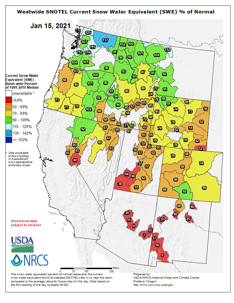
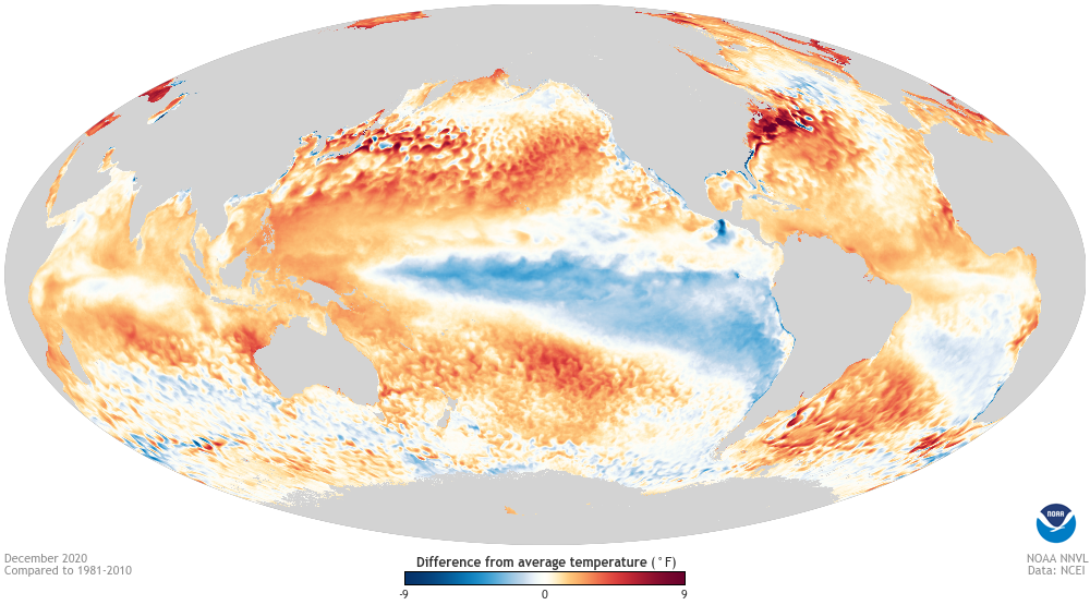
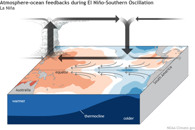
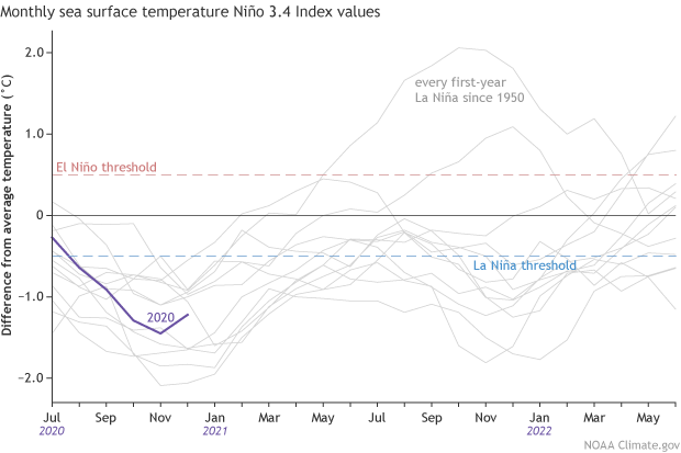


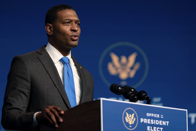


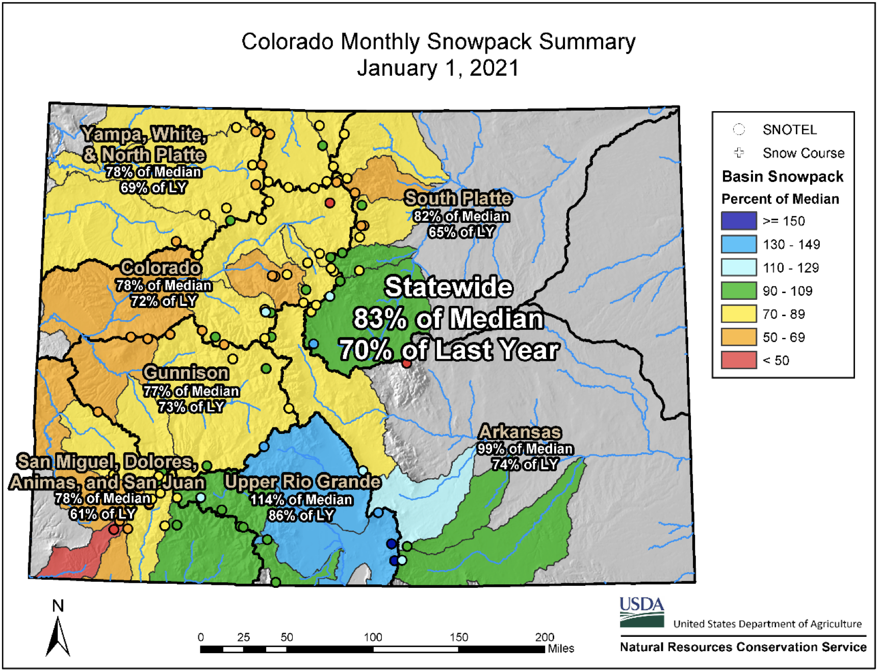


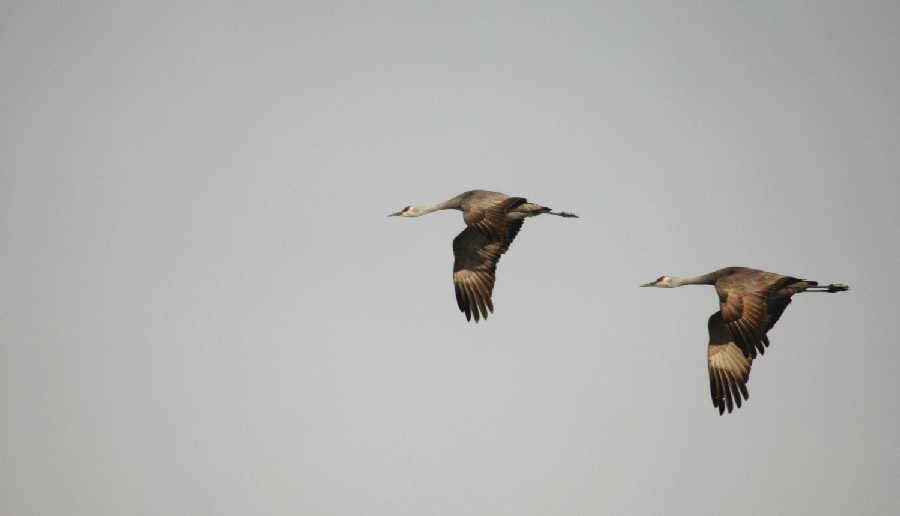


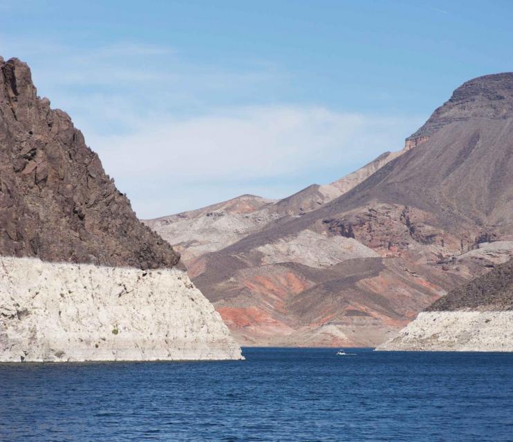


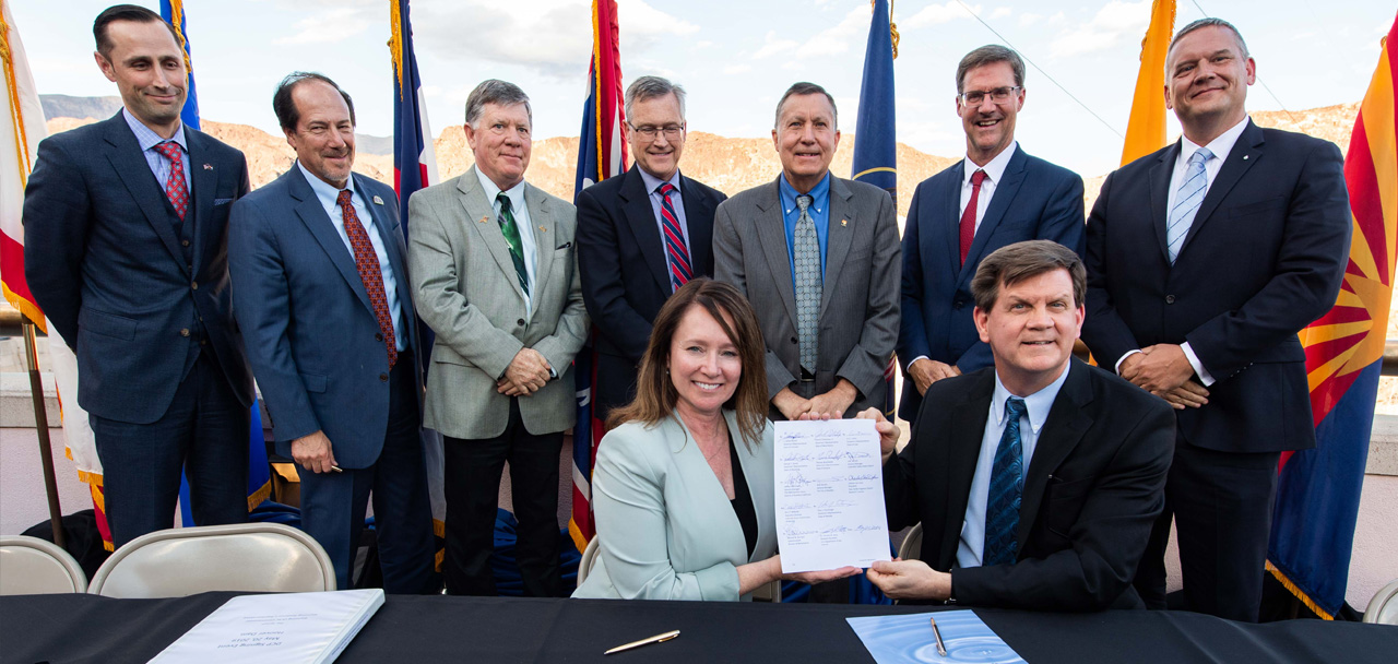


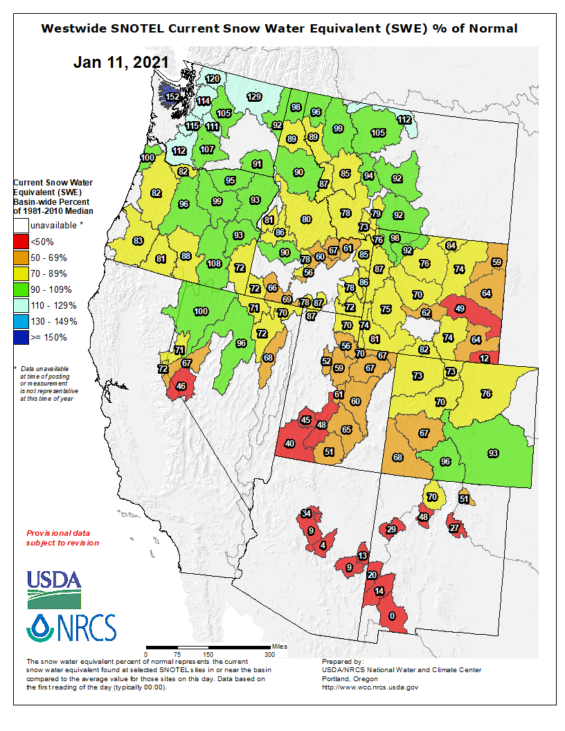


 wikipedia")