The Elizabeth Board of Trustees voted to adopt the 2021 budget at the Dec. 8 meeting. The budget was submitted in October, and a public hearing was held Nov. 24, where taxpayers were given the chance to raise any objections. The budget includes five funds—the general fund, street maintenance fund, street capital improvement fund, water sewer fund and a capital improvement fund, and the estimated balance of all funds going into 2021 totals $12,666,057…
The estimated general fund for 2021 includes $50,689 from unappropriated surpluses, and projects $2,134,782 from other sources such as water and sewer fees. Property taxes will account for $631,286, bringing the general fund total to $2,816,757. The general fund is used to pay for administration, courts, police services, community development and parks and building maintenance.
The street maintenance fund estimates $461,947, the street capital improvement fund comes in at $4,773,644, the water sewer fund is estimated at $4,243,709, and the capital improvement fund at $370,000.
Larimer County has approved a development agreement that delves into details surrounding construction of certain aspects of the Northern Integrated Supply Project.
The county commissioners on Tuesday voted 2-1 to approve the agreement with the Northern Integrated Supply Project Water Activity Enterprise, putting into writing some of the specific requirements that the elected board had put into place earlier in approving a 1041 permit for the water supply project…
The agreement focuses on recreational facilities for Glade Reservoir, and the amount of money Northern Water committed to that piece, as well as pipeline details, environmental mitigations and requirements surrounding the relocation of U.S. 287.
It puts in writing that the county will be involved in construction meetings and inspections and lays out some safety requirements.
“This agreement really protects the interest of Larimer County … whether one supports this project or not,” said Commissioner Steve Johnson, who along with Commissioner Tom Donnelly voted to approve the development agreement. (Both commissioners also voted in September to grant the 1041 permit, which allows the county some input on certain aspects of this water storage and pipeline project.)
The county does not have final say over whether the Northern Integrated Supply Project will be built. That approval would come from the U.S. Army Corps of Engineers, and the federal agency’s decision is expected soon, following more than a decadelong environmental process.
Johnson stressed that the county does not have final say but that he wants to have some say on safety, recreation and construction that will affect residents…
Larimer County has agreed to manage the recreation on and around Glade Reservoir, with Northern Water committing to $20.6 million for recreational facilities and with either the county or another yet-to-be-identified partner bringing $3.775 million to the table.
The money would cover parking lots, boat ramps, a visitors center, camping areas and environmental mitigations at the reservoir and on the surrounding land.
Commissioner John Kefalas, the sole Democrat on the board and the lone vote against the 1041 permit in September, also voted against the development agreement Tuesday. He said he understands the purpose is to describe the water developer’s obligations to the county and “to enhance the general welfare of the county,” but that he had concerns about some pieces of the agreement and could not vote in favor of it without further information.
The development agreement was included on the consent agenda at the commissioners’ weekly administrative matters meeting. The consent agenda typically is a list of actions approved without discussion and all by a single vote. Kefalas moved the item from that single vote so the board could discuss it.
“My rationale for pulling this item from the consent agenda is first to highlight that approval of the NISP project is indeed one of the most significant decisions made by this board of county commissioners, one that will impact Larimer County and future generations in many ways,” Kefalas said. “As such, this development merits public attention and scrutiny and, from my perspective, it is necessary for the people to see how this NISP agreement seeks to mitigate the potential unintended consequences of the proposed Glade Reservoir.”
He also expressed “serious concerns” about the overall project and said two provisions in the agreement add to those worries. He highlighted wording in the agreement that stresses that recreation is a secondary use to the water supply and that Northern Water, which will manage the project, may vary water levels and may modify design and location, at its sole discretion, for operations, maintenance or other issues to prioritize water supply over recreational uses.
“So I ask the question: What will happen to the recreational benefits of the NISP project if it takes 10 years to fill the reservoir perhaps due to higher temperatures, extended droughts and reduced snowpack?” Kefalas said. “Without a science-based answer to this question today, I cannot support this NISP development agreement.”
Northern Integrated Supply Project (NISP) map July 27, 2016 via Northern Water.
The Grand Canyon landscape contains some of the Southwests most unique ecosystems of rivers, springs and riparian zones. These areas are home to many plant and animal species, some found nowhere else in the world, or that represent the last viable populations holding on for existence.
The human connection to these areas also holds much significance for many Indigenous cultures here in the Southwest. The relationship between natural environments and Indigenous peoples is the foundation for much of our traditions, beliefs and values. Therefore, the result of healthy lands, air, water, and the plant and animals that reside within, manifests in healthy Indigenous communities.
Over the years, the water environments of the Grand Canyon have faced threats from various proposals, including uranium mining, pumping of limited groundwater, and large-scale development along the river banks. One area that continues to receive repeated attention is the Little Colorado River (LCR).
First, the Escalade Project sought to construct a large-scale tourist attraction on the rim overlooking the confluence of the Colorado and Little Colorado Rivers. This also included a tramway from the rim down to the rivers edge. This proposal was ultimately defeated, for now.
Currently there are at least 3 new proposals threatening the fragile ecosystem of this area. Outside interests are seeking to build a series of dams within the walls of the LCR Gorge. These dams would flood large areas of the canyon floor, irrevocably damaging areas that are of high cultural significance to many local tribes, including the Hopi Salt Trail and the Hopi Emergence place.
3 Lower Colorado River Dam Proposals. Credit: From the Earth Studio
“We are of water, The water is of us.
When water is threatened,
All living things are threatened.
What we do to water,
We do to our selves.”
–Hopi Hisat Navoti Gathering, October 23, 2003, Second Mesa
Hopi tribal members cross Havasu Creek. Photo credit: From the Earth Studio
It is difficult to superficially discuss the connection between Hopi culture and water, in all its forms, including springs. This connection is held within the hearts and minds of Hopi people and cannot be easily explained in terms of geologic formation and hydrological processes.
The Hopi Tribe’s Integrated Resource Management Plan (IRMP) states (2001:30), “Water resources come in many forms such as springs, lakes, streams, rain, snow and fog. Water comes from the earth and is also a divine gift from the ancestors and Hopi religious deities. All Hopi ceremonies center around the need for water and it is a major cultural theme.”
Centrality of water is expressed in every aspect of Hopi life—thought, prayer, song, dance, and artworks (Sekaquaptewa et al. 2015).
Water metaphors from ancestral ceramics. Credit: From the Earth Studio
Therefore, the importance of springs (Nööngava, water flowing out) within Hopi culture cannot be understated. Since “Time Immemorial”, the phenomena of naturally occurring springs are proof to Hopi people that greater forces exist in the physical world we inhabit. The life-sustaining waters that issue forth are a precious resource, allowing Hopi people and their ancestors to survive within a desert environment. Springs are key components of a Hopi Cultural Landscape; one that is imbued with the history of a living culture such as Hopi.
Due to this importance, many springs are formally consecrated with religious shrines, obtaining ritual significance that is recalled in Hopi oral history, song, prayer, and ceremony. To this day, water is collected from springs, some from great distances, and used within ceremonies at Hopi. The riparian environments associated with springs and other water sources are also considered culturally important. Specific springs are often visited to collect flora, fauna, minerals and pigments, which are used in ceremonies, as medicine or as utilitarian items.
Hopi tribal members collecting spring water at Yam’taqa –Place of ever-flowing water- (vasey’s paradise) in the Grand Canyon. Photo credit: From the Earth Studio
In ancestral and historic times, springs drew people together, often being the place at which villages were built and named for, such as Paaqavi, “Reed Springs Village” located on Third Mesa. When a great drought occurred across the Southwest in the late 12th century, many Hopi clans migrated to areas where more reliable springs could be found, including the southern Black Mesa area, where the modern Hopi villages are located. In recent years, when some of these springs began to dwindle in output, or even completely dry up, Hopi people considered this a manifestation of a much larger problem than simply drought-related.
Rain clouds over Nankoweap Delta. Photo credit: From the Earth Studio
The Hopi Tribe’s IRMP states (2001:30), “Since aquifers depend on infiltration of surface water for recharge, they are vulnerable to overuse, drought, contamination and harmful human activities.” The Hopi people understand that there are connections between springs, the water found therein and its subterranean origins. These connections are both physical and spiritual.
For Hopi people, springs are considered to be living entities that breathe and exhale moisture; a metaphysical connection between the spiritual world of ancestors and the natural world of their descendants. “Water under the ground has much to do with rain clouds. Everything depends upon the proper balance being maintained. The water under the ground acts like a magnet attracting rain from the clouds and the rain in the clouds acts as a magnet raising the water table under the ground to the roots of our crops and plants” (Hopi elders and religious leaders, 1972).
The granting of life from one world to another is commemorated with ceremonial offerings left at springs, which formally acknowledge our ancestors’ existence, as they acknowledge ours.
Spider Grandmother’s presence along the LCR. Photo credit: From the Earth Studio
Blue Spring (Sakwa’vaahu) located along the Little Colorado River near the Confluence of the Colorado River in the Grand Canyon, is one of thousands of springs that exist within the ancestral Hopi homeland. The sensitive details of its religious context remains with Hopi practitioners, however, due to its proximity to Sipaapuni, the Hopi Emergence point – a spiritual and cultural genesis – its significance takes on added meaning. It is akin to Holy Water within a church.
The geographic area around Blue Spring and the Sipaapuni is also imbued with the essence of departed Hopi ancestors, who visit their Hopi relatives in the form of clouds and other moisture. Accordingly, the Blue Springs region is hallowed ground where Hopi ancestors reside, serving as spiritual guardians of the Grand Canyon and Hopi culture.
Again, due to its close association to the Hopi Emergence point and the Hopi Salt Trail (both of which are associated with life-fulfillment traditions for Hopi people), Blue Spring is intimately connected to a larger worldview of Hopi life. Yet, although Sakwa’vaahu lies outside the modern boundaries of the now established Hopi Reservation (a result of federal land policy), the traditional knowledge and connection to Hopi people remains.
The Confluence. Photo credit: From the Earth Studio
In addition, because of its unique qualities of issuing beautiful turquoise blue waters, Sakwa’vaahu serves as a metaphorical representation of a verdant and healthy ecosystem: “blue/green is a significant color because it is the color of plants and thus symbolic or growth as well as because it is the color of water and thus symbolic of rain (Sekaquaptewa et al. 2015:26). As with other springs known to Hopi people, a significant drop in the output at Blue Spring is an indicator of environmental changes or impacts elsewhere, which can negatively affect the spiritual well-being of Hopi people and their culture.
Grand Canyon Spring flowing directly into the Colorado River. Photo credit: From the Earth Studio
Hopi Anthropologist Ferrell Secakuku states (2005), “… every time we go out (to pray and leave offerings)…we also go to a spring…because the spring is very, very important. That represents the blood line of the earth, our mother….” Thus the importance of springs encompasses more than our daily need for survival. Springs are inter-twined with cultural preservation as a whole. As the opening statement remarks, springs are a reflection of the current state of our environment; ecologically, culturally and spiritually.
The Hopi Tribe’s IRMP states (2001:30): Paavahu, Water Resources, are highly valued by the Hopi as a main source of life in a harsh and arid environment. The central focus in Hopi ceremonial life is the propitiation of moisture in its various forms. Moisture provides for the domestic and agricultural needs of Hopi people as well as the supernatural and spiritual essence of Hopitutskwa, the Hopi indigenous lands. As a valuable natural resource to the Hopi people, water must be protected and conserved so that we may all fulfill our ultimate stewardship responsibility: the needs of our children and future generations for this life giving resource.
Grand Canyon Landscape. Photo credit: From the Earth Studio
References Cited
Hopi Elders and Religious Leaders. 1972. Oral Testimony from the Hopi Hearings. Transcript on file, Museum of Northern Arizona, Flagstaff.
Hopi Tribe, et al. 2001. Hopi Tutskwat Makiwa’yta: Soosoy Himu Hopit Tutavoyat ev Hintsaktiwqa Qatsit Oovi Natwaniwa (Hop Land Stewardship: An Integrated Resources Management Plan for the Hopi Reservation).
Secakuku, Ferrell. 2005. Interview transcript on file, “Siitala Life in Balance, World in Bloom” exhibit planning project, Museum of Northern Arizona, Flagstaff.
Sekaquaptewa, Emory, Kenneth C. Hill, and Dorothy K. Washburn. 2015. Hopi Katsina Songs. University of Nebraska Press, Lincoln.
The historic wildfire season of 2020 could impact drinking water for more than a million Colorado residents. Environmental researchers and natural resource specialists have conducted a BAER Survey, which stands for Burned Area Emergency Response.
The survey evaluated how the record-breaking Cameron Peak and East Troublesome fires could impact Colorado’s snowpack and watershed.
The Colorado Big Thompson Project, which Northern Water operates for the U.S. Bureau of Reclamation, lies between the Cameron Peak fire, shown at the top of the map, and the East Troublesome Fire, shown at the bottom left. Credit: U.S. Forest Service
The Poudre and Upper Colorado River Basins provide drinking water for more than a million people in northern Colorado, and soon those in Thornton. The Colorado River also flows from Willow Creek Reservoir near Granby to Las Vegas and farther southwest.
The months-long battle with both blazes charred the natural filters along rivers and creeks, which eventually provide drinking water for most of the northern front range.
“Our concerns really are actually about the entire watershed,” said Jeff Stahla, spokesperson for the Northern Colorado Water Conservancy District.
In an interview with CBS4’s Logan Smith, Stahla said the approach to preserving and protecting the watershed in the years to come was directly altered by the High Park Fire of 2012, where researchers learned what to do and what not to do.
A helicopter drops water on the Cameron Peak Fire near CSU’s Mountain Campus. Photo credit: Colorado State University
For example, pulling undersized culverts and digging water bars is more effective than reseeding or spreading hay bales.
“This is something you won’t be able to resolve by dropping seeds from a helicopter, the scale is so large,” Stahla said. “The concern is that if there is a large weather event that occurs over that area, that you will have uncontrolled removal of debris and sediment that will go in to our reservoirs.”
Ecologist Heidi Steltzer evaluates the site of a 2018 wildfire within 10 miles of her Colorado home. Changes in snow affect the disturbance regime of U.S. mountain regions. (Credit: Joel Dyar)
During the fires of 2020, water conservation experts monitored how the burn scar could impact drinking water.
“We recognized that it was no longer just a small localized event, but it was something that would effect the entire Upper Colorado River shed,” Stahla said.
Due to the extended period the fires burned, especially the Cameron Peak Fire, not every area of the burn scars impact nearby rivers and streams equally. While some portions of the terrain were significantly burned with hot fire that “resided” in the same spot for an extended period, others were more fortunate.
The East Troublesome fire as seen from Cottonwood Pass looking north on the evening of Wednesday, Oct 21, 2020. (Andrew Lussie via InciWeb via The Colorado Sun)
Stahla said many local water districts are now teaming up to help protect the health of the watershed in the years to come. By unifying and prioritizing the health of the water system as a whole, Stahla said the strength of the landscape and watershed can bounce back quicker…
Researchers hope to return to the burn scars in the spring once snow has melted to evaluate next steps. Local municipalities are working with the Bureau of Reclamation to expedite the process.
Kenney Reservoir, located just east of Rangely in late October, has a picnic area. Kenney Reservoir is silting in, and the Rio Blanco Water Conservancy District is proposing building a new off-channel reservoir upstream on the White River, but the state’s top engineers are opposed to the project. Photo credit: Heather Sackett/Aspen Journalism
As its trial date in water court approaches, hundreds of pages of depositions obtained by Aspen Journalism reveal state engineers’ sticking points regarding a proposed reservoir project they oppose in northwest Colorado.
Over a few days in November, state attorneys subpoenaed and interviewed several expert witnesses and the Rio Blanco Water Conservancy District manager in the White River storage-project case, also known as the Wolf Creek project. Their questions centered on the town of Rangely’s water needs and on whether water is needed for irrigation.
The documents, obtained through a Colorado Open Records Act request, also underscore the extent to which fear of a compact call is shaping this proposed dam and reservoir project between Meeker and Rangely.
The Rangely-based Rio Blanco Water Conservancy District is applying for a conditional water-storage right to build a 66,720-acre-foot, off-channel reservoir using water from the White River to be stored in the Wolf Creek drainage, behind a dam 110 feet tall and 3,800 feet long. It would involve pumping water uphill from the river into the reservoir.
There also is an option for a 72,720-acre-foot on-channel reservoir, although this scale of project is now rare in Colorado. Rio Blanco has said they prefer the off-channel option.
For more than five years, top state water engineers have repeatedly said the project is speculative because Rio Blanco has not proven a need for water above its current supply.
Despite Rio Blanco reducing its claim for water by more than 23,000 acre-feet from its initial proposal of 90,000 acre-feet, state engineers still say the water-right application should be denied in its entirety. After failing to reach a settlement, the case is scheduled for a 10-day trial in January. Division 6 Engineer Erin Light and top state engineers Kevin Rein and Tracy Kosloff are the sole opposers in this case.
Rio Blanco already operates Kenney Reservoir, just east of Rangely on the White River. But it is silting in at an average of 300 acre-feet per year and is nearing the end of its useful life, according to court documents.
This map shows the potential locations of the proposed White River storage project, also known as the Wolf Creek project, on the White River between Rangely and Meeker. State engineers oppose the project, saying the applicants have not proven a need for the water. Map credit: Colorado Division of Water Resources
Irrigation needs?
A main point of contention between Rio Blanco and state engineers is whether there will be an increased need for irrigation water in the future. Rio Blanco claims it needs 7,000 acre-feet per year for irrigation.
During the depositions, state attorneys questioned Rio Blanco manager Alden Vanden Brink about the need for irrigation water. He claimed there is a local boom in agriculture and that there is high-value farmland that is not being irrigated simply because of a lack of water. Vanden Brink said happiness for residents on the lower White River will increase with access to irrigation water from the proposed reservoir, adding that if irrigation water is made available, demand for it will increase.
“It will make water available in the lower White River so that people can increase their quality of life and have a garden, you can have a few pigs,” Vanden Brink’s deposition reads. “It’s just going to be improvement all the way around.”
But details were sketchy on what specific lands would be irrigated and the district’s plan to get water from the reservoir to irrigators. State engineers, in a subsequent trial brief, say that just because there are lands that might benefit from irrigation doesn’t mean there will be future increased demand. If you build it, they won’t necessarily come.
“Instead, the premise that there will be a demand for water if the water right is granted is exactly the sort of ‘self-fulfilling prophecy of growth’ prohibited under Colorado’s anti-speculation doctrine,” the state’s trial brief reads.
Engineers also say Rio Blanco has not identified how the reservoir, situated low in the White River basin, would serve the majority of irrigated acres located upstream.
“For instance, Rio Blanco has not identified any pipeline construction or other water project works that could run water up to these other locations,” the state trial brief reads.
Taylor Draw Dam holds back the White River to form Kenney Reservoir, located near Rangely. The reservoir is silting in, and a water conservancy district is proposing building a bigger, upstream, off-channel reservoir, a project that is opposed by the state of Colorado. Photo credit: Heather Sackett/Aspen Journalism
Rangely’s water needs
Rio Blanco and the state also disagree about the amount of water needed for Rangely, a high-desert town of about 2,300 people near the Utah border. Rangely takes its municipal water from the White River.
In their depositions, Vanden Brink and Gary Thompson, an expert witness and engineer with W.W. Wheeler and Associates, refer to “cow water” as the source of Rangely’s water issues.
According to Vanden Brink, who also is the town’s former utilities supervisor, when flows in the White River drop to around 100 cubic feet per second, water quality becomes impaired. That can include increased algae growth, decreased dissolved oxygen, increased alkalinity and increased mineral contaminants, which require more treatment, he said.
“If you want to look at that water and how you can take that water and make it potable, forgive me, but it looks worse than cow water,” Vanden Brink said in his deposition. “I know if I was a cow, I wouldn’t want to drink it. It’s pretty degraded; it’s pretty muddy, it’s bubbly, it’s gross. And there’s a reason Rangely’s got the extensive treatment that it does.”
In an April letter to Rio Blanco, Town Manager Lisa Piering and Utilities Director Don Reed said Rangely would commit to contract for at least 2,000 acre-feet of storage for municipal use after the reservoir is built. According to expert reports, Rangely’s current demands are 784 acre-feet per year.
Project proponents say that increased flows from reservoir releases will dilute contaminants and improve water quality at the town’s intake.
But this argument doesn’t work for state engineers, who say that the water Rio Blanco says Rangely needs is not based on projected population growth and that Rio Blanco has not analyzed whether the town’s existing water supplies would be sufficient to meet future demands.
“Rio Blanco at trial may attempt to offer evidence regarding needs based on water quality, but Rio Blanco has not disclosed any evidence quantifying the amount of water Rangely would need for that purpose,” the trial brief reads.
One option for the White River storage project would be an off-channel dam and reservoir at this location. Water would have to be pumped from the White River into the reservoir site. Photo credit: Heather Sackett/Aspen Journalism
Colorado River Compact influence
Depositions and water court documents reveal how water managers’ and experts’ fear — and expectation — of a compact call could influence the project proposal.
According to the 1922 Colorado River Compact, the upper-basin states (Colorado, Utah, New Mexico and Wyoming) must deliver 7.5 million acre-feet a year to Lake Powell for use by the lower-basin states (Arizona, California and Nevada). If the upper basin doesn’t make this delivery, the lower basin can “call” for its water, triggering involuntary cutbacks in water use for the upper basin.
Water managers and policymakers admit that no one knows how it would play out just yet, but risk of this hypothetical scenario becoming reality is increasing as drought and rising temperatures — both fueled by climate change — decrease flows into Lake Powell.
Water managers are especially worried that those with junior water rights, meaning those later than 1922, will be the first to be curtailed. Senior water rights that existed prior to the compact are generally thought to be exempt from compact curtailment.
Many water users in the White River basin, including the towns of Rangely and Meeker, have water rights that are junior to the compact, meaning the users could bear the brunt of involuntary cutbacks in the event of a compact call.
Rio Blanco is proposing that 11,887 acre-feet per year be stored as “augmentation,” or insurance, in case of a compact call. Releasing this replacement water stored in the proposed reservoir to meet these compact obligations would allow other water uses in the district to continue and avoid the mandatory cutbacks in the event of a compact call.
According to Rio Blanco’s trial brief, “there is significant risk of a compact curtailment in the next 25 years that could negatively impact 45% of the water used in the district.”
In his deposition in response to questions from Rio Blanco attorney Alan E. Curtis, Thompson said drought scenarios will get worse in the future, the White River will be more strictly administered and a compact call is likely to occur.
“Things are — in my opinion — drought conditions are increasingly pervasive,” he said.
But state engineers say that augmentation use in the event of a compact call is not a beneficial use under Colorado water law and is inherently speculative. Compact compliance and curtailment are issues to be sorted out by the Upper Colorado River Commission and the state engineer, not individual water users or conservancy districts, they say. The state of Colorado is currently exploring a concept called demand management, which could pay water users to use less water in an effort to boost levels in Lake Powell.
According to their trial brief, state engineers say that while the desire to plan for compact administration is understandable, “the significant uncertainties involved in future compliance under the Colorado River Compact mean that Rio Blanco cannot show a specific plan to control a specific quantity of water for augmentation in the event of compact curtailment.”
The trial is scheduled to begin Jan. 4 in Routt County District Court in Steamboat Springs. Among the witnesses that Rio Blanco plans to call are Colorado River Water Conservation District Manager Andy Mueller, Colorado Water Conservation Board Chief Operating Officer Anna Mauss and Rio Blanco County Commissioner Gary Moyer.
Aspen Journalism is a local, nonprofit, investigative news organization covering water and rivers in collaboration with The Aspen Times and other Swift Communications newspapers. This story ran in the Dec. 26 edition of The Aspen Times and the Vail Daily, and the Dec. 28 edition of Steamboat Pilot & Today.
The North Fork Valley, part of the service territory of Delta-Montrose Electric, has been known for its organic fruits and vegetables — including corn. Photo/Allen Best
[A.J.] Carrillo is planning to convert his Deer Tree Farm from flood irrigation, which is commonly used in Western Colorado, to a new and much more efficient style of irrigation – microsprinklers.
Changing irrigation methods is something more and more Western Slope producers are doing, from small to large. With help from federal funding, they’re able to apply less water to grow their crops and make their land more resilient to drought. And more importantly, the switch also means that fewer pollutants run off their fields into the Colorado River, keeping it cleaner all the way down to Mexico.
Salt and selenium occur naturally in the shaly soils of the Gunnison Basin, leftovers from a prehistoric inland sea. Both substances are harmful to plants, fish and humans. Flood irrigation of fields allows water to penetrate deep into the soil, where it dissolves out salt and selenium.
The contaminated water then runs off into ditches that eventually dump into the Gunnison River, and from there into the Colorado. The result is that farms in the Gunnison Basin send more than 360,000 tons of salt into the Colorado River each year…
All that salt must be removed before water can be used for drinking or industrial purposes, which is expensive. And when salty river water is used for irrigation, it stunts crop growth and can eventually make farmland unusable if the salt builds to a high enough concentration, said Perry Cabot, a water resources specialist with Colorado State University…
In California’s Imperial Valley, which grows about 80 percent of the nation’s winter vegetables, irrigating with Colorado River water has caused some fields to become so salty that they have been abandoned.
Selenium is a problem too. It’s especially harmful to the Colorado River’s four endangered fish species, including the humpback chub and razorback sucker…
The same actions that reduce selenium – improving irrigation efficiency and reducing runoff – help reduce salt as well. And those programs have a far-reaching impact.
During the 1960s, so much salt flowed into the Colorado River from U.S. farms that Mexico, at the downstream end, could no longer use it for irrigation; a solution was finally negotiated in the 1970s requiring major reductions in the river’s saltiness. Laws were passed, and an array of federal program were created that gave farmers incentives to improve their irrigation methods.
Since then, the Colorado has gotten considerably cleaner. Casey Harrison, a soil conservationist who works with farmers through the federal Natural Resources Conservation Service, or NRCS, is part of that cleanup effort. In the Gunnison River Basin, the NRCS spends about $7 million a year to help roughly 75 farmers and ranchers convert to microsprinklers and other efficient irrigation methods.
The NRCS tailors plans to each producer’s operations, Harrison said, no matter how large or small…
The federal financial support is key. The costs of installing new irrigation systems cannot be borne by farmers alone, CSU’s Perry Cabot said. Agricultural producers are running a business, and they do not want to spend tens of thousands of dollars to make a change unless there is some clear incentive.
“If we as a society value food production as part of our economic infrastructure, it’s unrealistic to expect them to just bear the burden without societal help,” Cabot said.
Back at Deer Tree farm, farmer AJ Carillo says the operation will have a new irrigation system by fall 2021, thanks largely to NRCS funding and support. The change to microsprinklers will give him greater precision and control in water use.
Dragon Line irrigation system. Photo credit: AgriExpo.com.
A banner hangs on a statue of Cornell University’s founder, Ezra Cornell, on Indigenous Peoples’ Day this year. Photo credit: Della Keahna Uran via The High Country News
FromThe High Country News [December 22, 2020] (Jessica Grant):
University officials face pressure to address their history as the recipients of dispossessed Indigenous land.
When High Country News published “Land-Grab universities” last April, the two-year-long investigation shed new light on a dark open secret: One of the largest transfers of land and capital in the country’s history had masqueraded as a donation for university endowments.
HCN identified nearly 11 million acres of land, expropriated from approximately 250 tribes, bands and communities through more than 160 violence-backed treaties and land cessions. Now, in the wake of the investigation, land-grant universities across the country are re-evaluating the capital they built from these stolen Indigenous lands.
More than 150 years after President Abraham Lincoln signed the Morrill Act — the legislation that transferred the lands — new discussions about the universities’ moral and ethical responsibilities have forced Americans to re-examine the law’s legacy. Land-grant institutions have long prided themselves on their accomplishments as beneficiaries: They used the proceeds generated by the land to broaden access to higher education, thereby contributing to economic development across the nation. But many of those institutions paid next to nothing for the public lands they received and sold.
By far the largest beneficiary was Cornell University in Ithaca, New York, which acquired almost 1 million acres from Ojibwe, Miwok, Yokuts, Dakota and other Indigenous nations through 63 treaties or seizures. The land came from 15 states, and by 1935, when the last parcel was sold, Cornell University had generated nearly $6 million for its endowment, the largest of any land-grant institution. Adjusted for inflation, it raised over $92 million.
Now, as the country reconsiders long-standing issues of racial equity and justice — focusing on everything from local political races to national legislation — students and faculty alike are pressuring administrators to address the investigation’s findings.
On Indigenous Peoples’ Day, Oct. 12, 2020, members of Native American and Indigenous Students at Cornell (NAISAC) put forward a list of 10 demands in the form of a petition. The demands include turning the American Indian and Indigenous Studies Program into a university department; recruiting new Indigenous faculty and students, specifically Indigenous students affected and/or displaced by the Morrill Act; waiving tuition for those students; acknowledging the land of the Gayogo̱hó:nǫ’, or Cayuga Nation, before every Ithaca-based event; and reinstating an ad-hoc committee on Native American Affairs to oversee the approval of these demands.
“If the president’s office was responsible, then they would meet each of these demands to the extent that we’ve laid them out in our petition,” said Colin Benedict (Mohawk), the external relations chair for NAISAC. “Each of these demands in my mind is completely 100% justified and should already have been implemented by the university decades ago.”
As of Dec. 1, the petition had more than 900 signatures from students, staff, alumni and community members. The president’s office has yet to respond publicly, but in an email exchange, it stated, “The Office of the President is in receipt of the NAISAC petition, and the President is looking forward to working with the Native American and Indigenous community at Cornell on these issues.”
A faculty committee, headed by American Indian and Indigenous Studies Program Director Kurt Jordan, launched the Cornell University and Indigenous Dispossession Project. The project will research Cornell’s Morrill Act land history, identify the Indigenous communities affected, and foster discussion of possible remedies.
“We’ve had a number of statements that have been made by the administration in light of the George Floyd murder, Black Lives Matter, and all of the other things that have been happening this year about the need for Cornell to really address its legacy, its historical roots, its complicity in … to some degree, with white supremacy,” Jordan said. “Benefiting from stolen Indigenous land has to be part of that.”
History professor Jon Parmenter recently discovered that Cornell is in possession of over 420,000 acres of mineral rights in the Central and Southwestern U.S., a portion of which was retained through Morrill Act lands. In its petition, NAISAC urged the university to release a statement acknowledging the amount of land acquired, the interest accrued and mineral rights funds received, and pledging to refrain from mineral and resource extraction on those lands.
OVER 2,500 MILES WEST OF CORNELL, faculty and students at the University of California, Berkeley have also made strides. Established in 1868, the university received almost 150,000 acres from the Morrill Act. The land raised $730,000 for the university’s early endowment, and, adjusted for inflation, has generated over $13 million. The university paid nothing in return.
The presence and history of Indigenous people has been largely erased from the UC system, said Phenocia Bauerle (Apsáalooke), director of Native American Student Development at the University of California, Berkeley. Two years ago, Bauerle and the Native American Student Development center created a land acknowledgment to honor the Ohlone tribal lands that the university sits upon. However, the university has yet to adopt an official acknowledgment.
According to a California audit, UC Berkeley is the worst offender among the schools when it comes to complying with the Native American Graves Protection and Repatriation Act (NAGPRA), which grants Indigenous nations the right to regain ancestral remains and objects from museums. UC Berkeley has only repatriated 20% of its 500,000-artifact collection. In comparison, the University of California Los Angeles has repatriated 96% of its collection.
“A lot of it comes down to, well, they see these issues as historical and not of the present because they see Natives as historical and not of the present,” Bauerle said. Since the dispossession occurred in the past, contemporary people don’t see themselves as responsible, and they feel no pressure to address the issue today. However, “ ‘Land-Grab’ gave us several concrete (points),” Bauerle said. “This dispossession of Native land that this whole country benefits from — here’s a specific way that we can show you that Berkeley actually played a part in it. These are the receipts. This is how much money you got.”
Bauerle partnered with Rosalie Z. Fanshel, a doctoral student in environmental science, policy and management and the program manager for the Berkeley Food Institute, to organize a conference on the Morrill Act and Indigenous land dispossession.
“The UC Land Grab: A Legacy of Profit from Indigenous Land” was held in two parts in September and October. The conference dug deep into the history of California’s genocide and the founding of the University of California. Participants called for action, including shared land stewardship, research opportunities and tuition options for Indigenous students.
More than 500 people attended both days of the conference. David Ackerly, dean of the Rausser College of Natural Resources in Berkeley, was among them. “I felt like I was learning so much that I had not been aware of,” he said. “This is part of our story, I want to be part of this. I want to learn. I want to figure out where we’re heading.”
Other attendees included staff from the office of UC President Michael V. Drake, the office of the chancellor at UC Berkeley and the governor’s office, as well as deans and administrators from various UC campuses and units.
One of the panelists, Brittani Orona, a doctoral candidate in Native American studies and human rights at UC Davis and a member of the Hoopa Valley Tribe, was surprised by how many people within the university system had no knowledge of the history of land-grant institutions. “I think with Native people and Native students, you know that our land, our places have been taken away from us, from many different institutions and at many different points of time,” Orona said.
At the conference, Orona spoke about the history of genocide in California. “Scholars of California Indian genocide will say it ended in 1873, but I argue it is a continuous process,” Orona said. “Many Native and Indigenous people in the state and across the world have been made promises since colonization, and they’ve been broken. It’s hard not to remember that legacy; I live in that legacy.”
Orona, who will complete her Ph.D. in the coming year, hopes that future Native and Indigenous students have a different experience than she did. “What does that mean, when you’re having California Native students pay out of pocket on land that has been dispossessed from them? I appreciate the discussions that are going on, but I’ll believe it when I see it — and when it moves beyond acknowledgment towards actual actionable items that make life easier for Native and Indigenous students and peoples.”
Orona, who will complete her Ph.D. in the coming year, hopes that future Native and Indigenous students have a different experience than she did. “What does that mean, when you’re having California Native students pay out of pocket on land that has been dispossessed from them? I appreciate the discussions that are going on, but I’ll believe it when I see it — and when it moves beyond acknowledgment towards actual actionable items that make life easier for Native and Indigenous students and peoples.”
As of Dec. 4, UC Berkeley Chancellor Carol Christ has yet to respond about the conference publicly. In an email, however, she wrote, “To achieve this inclusive campus culture, we must acknowledge how our history, including the Morrill Land Grant Act, impacts Indigenous people. Now more than ever, we, as a university, must take immediate action to acknowledge past wrongs, build trusting and respectful relationships, and accelerate change and justice for our Native Nations and Tribal communities.”
Jessica Douglas is a fellow at High Country News. Email her at jessica.douglas@hcn.org.
This story was originally published at High Country News (hcn.org) on December 22, 2020.”
On Nov. 30 Governor Jared Polis sent a “memorandum of drought emergency” to executive directors of state government departments. The memo marks the beginning of phase 3 “full plan activation” of the state’s Drought Mitigation and Response Plan.
The memo said “deep and persistent drought conditions” had covered the state for 15 weeks, noting that this level of drought had not been observed since 2013. It also activated the “Municipal Water Impact Task Force,” chaired by members of the Colorado Water Conservation Board and the Department of Local Affairs.
The memo states: “The initial objective of the Task Force is for water suppliers to coordinate with each other and the state going into winter to prepare for anticipated drought-related challenges and opportunities in 2021.”
“So it’s telling you to get planning for a drought, which is what your water conservancy districts, Yellow Jacket and the Rio Blanco Water Conservancy districts are attempting to do” said Alden Vanden Brink, District Manager for the Rio Blanco Water Conservancy District.
During a Dec. 14 Board of County Commissioners work session, he spoke about the Governor’s memo and its implications for the basin. “I’ve been following up on this quite a bit trying to make sure they understand that there is no drought contingency within our White River basin,” he said.
By drought contingency, Vanden Brink was referring to storage, of which he said there is very little in the basin. “You’re looking at just a couple of days worth of water, literally,” said Vanden Brink, later adding “we have a real problem with the lack of storage in our basin, a real problem, and it makes us extremely vulnerable.”
A view of the White River foreground, and the Wolf Creek gulch, across the river. The Rio Blanco Water Conservancy District and the State of Colorado are headed to a water court trial because they can’t agree on whether the district actually needs the water it claims it does for a reservoir and dam project at this site. Photo credit: Aspen Journalism/Brent Gardner-Smith
That vulnerability, though not exactly new to the basin, is growing more urgent. Colorado’s record drought in 2020 was just the beginning of a more long term trend, according to leading climatologists and groups like the National Oceanic and Atmospheric Administration (NOAA)…
That planning includes preparations for an upcoming water court lawsuit set to begin in the first week of January. “It’s to get a conditional water right to construct a reservoir for drought contingency within the White River basin.” said Vanden Brink, referring to the Wolf Creek Reservoir, also known as the White River Storage project. The project would store between 66,000 and 73,000 acre feet of water, depending on the exact location.
In an expert report submitted earlier this year, state engineers contested that Rio Blanco had failed to identify the need for that much water. Ultimately that disagreement is what prompted the lawsuit between the Rio Blanco Water Conservancy District and the State’s Division of Water Resources.
Adding to his message of urgency, Vanden Brink talked about proposed “demand management” strategies which are likely to become more prevalent in coming years. “What they’re looking at doing is paying a rancher to idle his field for a given period of time, and allow that water to flow by,” said Vanden Brink, noting that the development of those strategies was a changing dynamic. Although he didn’t speak negatively about the concept in general, he was concerned about its potential impact in the region. “Not allowing that water to go be used for flood irrigation….flood irrigation is what recharges our groundwater aquifer. That’s taking away from that groundwater aquifer what little storage we have, which is the aquifer” said Vanden Brink.
He argues that given the lack of existing storage, and thus lack of drought contingency in the basin, the Governor’s memorandum of drought emergency provides more legitimacy to Rio Blanco’s proposed reservoir project.
The Colorado River is one of the most engineered river systems in the world. Over millions of years, the living creatures that call the river home have adapted to its natural variability, of seasonal highs and lows. But for the last century, they have struggled to keep up with rapid change in the river’s flows and ecology.
Dams throughout the watershed create barriers and alter flows that make life hard for native fish. Toss in 70 non-native fish species, rapidly growing invasive riparian plants and a slurry of pollutants, and the problem of endangered fish recovery becomes even more complex. The river system is home to four fish species currently listed as endangered: the razorback sucker, Colorado pikeminnow, bonytail and humpback chub.
For decades, millions of dollars have been spent on boosting populations of the river’s fish species on the brink of extinction. While scientists are learning what helps some species survive in the wild, others are still struggling.
Ouray National Fish Hatchery. Photo credit: USFWS
“Darling little divas”
Much of the work of keeping these fish from going extinct is centered in a handful of hatcheries scattered throughout the West. One such hatchery, the Ouray National Fish Hatchery, is situated along the Green River in eastern Utah. It’s a squat, unassuming building next to a series of ponds where two of the river’s endangered fish — the bonytail and razorback sucker — are raised.
Inside, the room is filled with aqua-colored tubs of water. A pipe feeds each tub with fresh water and creates a whirlpool, simulating a river’s flow. Above the tubs, lights automatically dim up and down to give the fish some semblance of a sunrise, high noon and sunset.
U.S. Fish and Wildlife Service biologist Matt Fry peers into one of the tubs and warns not to do it too quickly to keep from stressing them out. “When they see you, they’ll scatter,” he said.
Fry is the acting manager of this hatchery. This kiddie pool-sized tub is full of bonytail, so named for their slender, tapered bodies.
“I call these guys my darling little divas because you really got to treat them with kid gloves,” Fry said.
A couple decades ago, bonytail were nearly extinct, the last few scooped up from Lake Mohave in the Colorado River’s lower reaches. Hatcheries like this one have kept them alive, while scientists tried to figure out the best way to help them survive and overcome the challenges humans keep throwing at them out in the wild…
“Hurdles to overcome”
That is the question for Tildon Jones, Fry’s colleague at the Fish and Wildlife Service. He’s a habitat coordinator for the agency, and looks for ways to help the endangered fish complete their life cycle in the wild, not just rely on people to keep raising them in hatcheries.
On a bluff overlooking the Green River near the hatchery, Jones points out the features of a riverside wetland. The river — a majority tributary to the Colorado — makes a narrow U-shaped bend, and in the middle is a wetland.
“The river would come up and flood these areas regularly in the past,” Jones said, pointing to the lines of cottonwood trees over a chorus of sandhill cranes that has taken up residence nearby.
Green River Basin
This stretch of the Green, with its abundance of low-lying wetlands, used to be a haven for the razorback sucker, known for its bony hump and down-turned vacuum-like mouth. The fish adapted to the Colorado River’s wild swings between high and low flows by spawning just before its annual spring snowmelt rise. Those flood waters would carry the tiny, just-born fish into protected riverside ponds to grow. At that point, the larval fish look like a grain of rice with two black dots for eyes…
But the Green River hasn’t acted like its former self in more than 50 years. The Flaming Gorge Dam just upstream holds back those flood waters, and regulates the river’s flow, making the tiny razorbacks less likely to end up in wetlands, and more vulnerable to non-native fish that gobble them up…
The fish don’t just have one thing working against them, but a confluence of factors keeping them from thriving. If it were just the restricted, regulated flows or just the addition of non-native fish predators, the problem might be easier to solve, Jones said.
Since 2012, the Fish and Wildlife Service along with other partners in the Upper Colorado River Endangered Fish Recovery Program have turned their focus to managing wetlands to give razorbacks a better chance of reproducing in the wild, and giving juvenile fish the opportunity to grow.
Canals move river water into the wetland during high flows, or coordinated releases from Flaming Gorge reservoir, and metal screens keep out the predatory fish. Researchers can then keep an eye on the growing razorbacks before releasing them back into the river.
After seeing some initial success in this approach, and seeing adult razorback populations stabilize due to stocking, Jones’s agency is proposing to move razorbacks from an endangered status to threatened…
Katie Creighton and Zach Ahrens both native aquatics biologists for Utah Division of Wildlife Resources (UDWR) standing on the temporary Matheson screen. The Nature Conservancy and UDWR partnered together to build the structure to allow the endangered razorback sucker larvae to enter the Scott M. Matheson Wetlands Preserve without the predators also coming in. Courtesy & Copyright Katie Creighton, Photographer via Utah Public Radio
Reconnecting the river to its wetlands
After seeing managed wetlands demonstrate successes on the Green River, The Nature Conservancy’s Linda Whitham says it made sense to replicate the idea on a stretch of the Colorado River near Moab, Utah. The environmental group receives funding from the Walton Family Foundation, which also supports KUNC’s Colorado River reporting.
On a warm fall day, big yellow dump trucks moved dirt, excavated as part of a pond expansion at the Matheson Wetlands Preserve. A deepened channel and water control structure with a screen to keep out the predatory fish were also added.
Humpback chub are one of four federally endangered fish species that rely on habitat in the 15-Mile Reach of the Colorado River. Humpback chub photo credit US Fish and Wildlife Service.
NPS and USFWS use a seine net to trap humpback chubs in the Little Colorado River. Photo credit Mike Pillow via the Arizona Daily Sun.
Wild bonytail chub
Humpback chub
Roundtail chub
One of 23 yearling endangered Colorado pikeminnow captured in 2016 in the San Juan River by the New Mexico Department of Game and Fish biologists is measured. This is only the second time that yearling fish have been captured in the San Juan River. (Photo: Courtesy of New Mexico Department Game and Fish) via The Farmington Daily Times.
A Colorado pikeminnow taken from the Colorado River near Grand Junction, and in the arms of Danielle Tremblay, a Colorado Parks and Wildlife employee. Pikeminnows have been tracked swimming upstream for great distances to spawn in the 15-mile stretch of river between Palisade and Grand Junction. An apex predator in the Colorado, pikeminnows used to be found up to six feet long and weighing 100 pounds. Photo credit: Lori Martin, Colorado Parks and Wildlife via Aspen Journalism
Colorado Pike Minnow
Upper Colorado River Endangered Fish Recovery Program
Ron Rogers biologist with Bio-West Inc., holds a large razorback sucker captured in Lake Mead near the Colorado River inflow area
August 16, 2017: Colorado ParksWildlife and John Sanderson found imperiled bluehead sucker fry on Dolores River — a hopeful sign.
FromThe Denver Post (Bruce Finley) via The Loveland Reporter-Herald:
Clearing swaths of trees creates fire breaks and helps take energy out of wildfires, state forest official says
“The consequences of inaction”
Colorado’s population growth and development boom, particularly the construction of mountain homes by people compelled to escape cities, complicates the forest imbalance. Houses in woods force progressively more aggressive fire-snuffing, which allows more increased thickening of trees.
A recent state report estimated a $4.2 billion backlog in forest-thinning needed to selectively clear trees and create safety buffers around the most at-risk forest homes. That’s tree removal that state agencies and property owners generally must pay for — in contrast to this industrial logging that brings in revenue when market conditions are right.
Last week, state foresters supervising the cutting of a 100-acre patch on Owl Mountain, within a 376-acre parcel controlled mostly by the federal Bureau of Land Management, pointed to the economics — revenue of about $200,000 to state and federal agencies from loggers. And even if logging wasn’t profitable, every dollar spent removing trees from fire-prone forests would save an estimated $7 in avoided firefighting costs, Steamboat Springs-based forester Carolina Manriquez said.
“Now we have 200,000-acre fires rolling through. What is 100 acres? Nothing at the landscape scale,” Manriquez said. “We need to do more of this. I mean, we’re spending millions to suppress fires.”
Colorado forests that increasingly burn, along with millions of acres where beetle-kill leaves trees unusable, might have helped sustain logging companies, said C.J. Pittington, a Walden-based logger running a 40-ton red feller-buncher last week clearing a 140-acre chunk of state land. He can mow through about 5 acres of lodgepole forest in a day and has built up a business his father began in 1973, currently employing a dozen workers, and expressed hope the big fires will lead to greater social acceptance of large-scale logging.
Logging in forests near sprawling mountain municipalities also will help protect people, Pittington said, referring to the East Troublesome fire’s destruction of 300 homes and other buildings…
Future expansion of logging in northwestern Colorado will depend on industrial capacity, said John Twitchell, the supervisory state forester overseeing the work, who also serves on the state’s forest advisory commission.
“Our logging industry has been small. We haven’t had a lot of users of the wood. Our capacity to use wood will dictate how much work we can do on our landscapes,” Twitchell said.
“We want to re-generate a new, healthy forest. As long as this dead timber is here, inevitably, it is going to fall… and in time it will burn,” he said. “We’ve seen the consequences of inaction. … If we can have more cuts like this, we can accomplish a lot of goals at once.”
“A storm of threats”
But forest ecologists raised concerns about the logging. Industrial clear-cuts of 40 acres or more widely have been seen as harmful. Lodgepole forests like those in northwestern Colorado play key roles in nature — stabilizing mountainsides that otherwise erode into streams and eventually municipal reservoirs, helping form soil, giving habitat for raptors and other wild animals.
“If it is just willy-nilly punching holes in forests, it may not do any good at all and may make things worse,” said Greg Aplet, a Denver-based senior scientist for the Wilderness Society.
Forest tree-cutting must be done based on large landscape-scale master plans, connected to broad restoration around the East Troublesome and Cameron Peak burn scars, he said. The risk is that Colorado forest officials, once beetle-killed lodgepole pines are removed from state land, will try to expand cutting on private and federal land by “using social concern about fires to grab the social license to conduct more logging without the kind of review and careful ecological analysis that normally would attend large-scale logging,” Aplet said.
“The Wilderness Society isn’t opposed to logging. We’re not opposed to ‘forest management.’ What we are opposed to is bogus science, poorly-planned projects and squandering money that could be spent on treatments that actually improve forest health,” he said. “There is reason to keep sawmills alive — so that we have a destination for the logs that come out of well-planned forest restoration projects.”
University of Colorado Denver forest ecologist Diana Tomback said much depends on how much forest thinning is done and where. When westerners began snuffing wildfires a century ago, this obligated some form of logging to replace disturbed natural processes, Tomback said. But large clear-cuts cause erosion and even standing majority-dead forests can be preferable ecologically, she said.
“A storm of threats” — climate warming, megafires, insect outbreaks and drought — “is converging now to greatly diminish our nation’s once-magnificent forests,” Tomback said, suggesting Gov. Jared Polis should convene a forest science brain trust to develop a strategy.
“This convergence… is new, and we are learning. And the answers may not all be there,” he said. “But we need a methodical approach. We have to sit down and talk about a new forest management paradigm. We don’t want to do things ad hoc.”
Federal forest managers at U.S. Forest Service headquarters weren’t available for comment. A newly-appointed regional director has declined for a month to discuss the overall health of Colorado forests in the face of climate warming, insect infestations and wildfires.
Lester was looking to make that connection. Most of the acres burned this year were in federally-managed forests, he said, urging better “shared stewardship.”
Polis recently proposed spending $6 million for grants to improve forest health, but the scale of work to save dying forests requires far more, Lester said.
“What do we need from the feds? Certainly we need financial resources. And we need to sit down and coordinate what we are going to do. How are we going to get this done?”
Upper San Juan River Basin SWE December 26, 2020 via the NRCS.
From The Pagosa Springs Sun (Simone Mounsamy):
According to the U.S. Department of Agriculture National Water and Climate Center’s snow pack report, the Wolf Creek summit, at 11,000 feet of elevation, had 13.1 inches of snow water equivalent as of 1:15 p.m. on Dec. 23.
The median snow water equivalent amount for that date was 13 inches.
While the amount of 13.1 inches of snow water equivalent is 101 per- cent of the Dec. 23 median for Wolf Creek summit, the entire basin, including the San Miguel, Dolores, Animas and San Juan River basins, were at 72 percent of the Dec. 23 median in terms of snowpack.
Last week’s reading showed that the Wolf Creek summit had 12.7 inches of snow water equivalent.
River report
As of Wednesday, the San Juan River had a flow of 45.4 cfs and the average for Dec. 23 was 62 cfs, according to the U.S. Geological Survey.
Based on 85 years of water records, the San Juan River had the lowest flow total for Dec. 23 back in 1990, when the river had a flow of 24 cfs.
The highest flow total came in 2011, when the San Juan River had a flow of 130 cfs.
Chuck Miller of Fort Morgan has been vocal in opposing action by the LSPWCD to raise its mill levy from 0.5 mill to 1 mill for the 2020 budget year and retaining that level for 2021. Miller contends that the increase is a violation of the TABOR amendment to the Colorado Constitution. He and others have appealed to county commissioners in Logan, Morgan, Sedgwick and Washington counties to refuse to certify the water district’s mill levy…
The group asserts that, although the water conservancy district freed itself from the restrictions of the TABOR amendment in 1996, it still promised not to raise taxes without a vote. The district board, however, takes the position that, when it was formed in 1964, it was statutorily authorized to levy up to 1 mill on real property within the district, and the 1996 “de-Brucing” question allows the district the right to levy up to 1 full mill; the public vote would only be needed if the district wanted to exceed its original allowance of 1 mill.
The mill levy must be certified in each of the four counties covered by the district. Only Sedgwick County, where Commissioner Chairman Donald Schneider also is a member of the LSPWCD board of directors, voted to certify the mill levy. Washington County Commissioner LeAnne Laybourn told the Journal-Advocate Thursday morning that, contrary to what was previously reported, the Washington County Commissioners pulled the water district’s mill levy from a group of levies they were to certify.
Miller said he has gotten conflicting answers to questions about who enforces the provisions of the so-called Taxpayer’s Bill of Rights, a 1992 amendment to the state constitution. TABOR restricts government spending and forbids raising taxes without voter approval.
Colorado Department of Local Affairs spokesperson Brett McPherson told the Journal-Advocate Wednesday that the state has no role in enforcing TABOR.
“TABOR contains the mill levy/tax rate restriction but is locally interpreted and enforced through the courts,” McPherson said. “TABOR is locally enforced by taxpayers, who elect board members and who can also bring a lawsuit against the taxing entity. There is no state agency role in enforcing TABOR.”
According to state statute, if a mill levy is not certified, the county can be instructed to extend the previous year’s mill levy which, in this case, is still 1 mill, since that was certified the previous year.
Hoover Dam, straddling the border between Nevada and Arizona, holds back the waters of the Colorado River in Lake Mead. In 2016, Lake Mead declined to its lowest level since the reservoir was filled in the 1930s. Source: Bureau of Reclamation
FromColoradoPolitics.com (Marianne Goodland) via The Colorado Springs Gazette:
The week of Dec. 14, the seven states that are part of the Colorado River Compact began the first step for renegotiating guidelines that will decide how much water the three lower basin states and Mexico will get from Lake Mead, on the Arizona-Nevada border, and from Mead’s source, the Colorado River.
The guidelines are interim, signed in April 2007, and are due to expire in 2026. Among the most significant, the guidelines provide long-term stable management of the river and also determine the circumstances under which the Interior secretary could reduce the annual amount of water available from Lake Mead to the Colorado River lower basin states. The guidelines also are a way for the basin states to avoid litigation, part of what prompted the 2007 interim guidelines.
The seven states that make up the Colorado River Compact, and which will negotiate those guidelines, are divided into upper basin states (Colorado, Wyoming, Utah and New Mexico) and lower basin states (Arizona, Nevada and California). Mexico is also part of the lower basin water allotment, as well. About 40 million people across the seven states rely on the Colorado River for water.
Westwide SNOTEL basin-filled map December 22, 2020 via the NRCS.
Colorado, Utah, Arizona and New Mexico are dealing with extreme drought conditions, according to the U.S. Drought Monitor.
What that means for the river heading into in the future, said John Fleck, a former journalist and author and now with the University of New Mexico’s Water Resources Program, is water levels in Lake Mead could drop to 1,060 feet by 2022. That’s 15 feet below what triggers “the next tier of mandatory Lower Basin water use cuts under the river’s 2007 interim guidelines and the supplemental drought contingency plan” signed last year…
Last week, the seven states signed a joint letter to Trump administration Interior Secretary David Bernhardt and Bureau of Reclamation Commissioner Brenda Burman requesting technical support from the federal agency, as the states move forward with negotiations. The states are setting up a working group to look at modeling for the management and operations of Mead and Lake Powell, which is the water “bank” on the Colorado River for the upper basin states…
[Rebecca] Mitchell said she thinks “everything is on the table as we look toward the future.” What’s in the final report — or not — “doesn’t mean we can’t deal with bigger issues outside of the guidelines.”
That’s also where the Biden administration, and his Interior nominee, U.S. Rep. Deb Haaland, D-New Mexico, could make a difference. One of the signs from Biden toward the Colorado River is his appointment of Tanya Trujillo of New Mexico to the Department of the Interior’s transition team. Trujillo is vice chairwoman of the New Mexico Interstate Stream Commission and lower basin project director for the Colorado River Sustainability Campaign. A water lawyer, Trujillo has experience working in Interior on water issues.
“We’re hoping (the new administration) will foster negotiations that are rooted in science and create a framework that recognizes how climate change is affecting and will continue to affect the basin,” Kim Mitchell, a senior water policy adviser with Boulder-based Western Resource Advocates, told BloombergLaw.com in November.
Lake Powell, behind Glen Canyon Dam, shows the effects of persistent drought in the Colorado River Basin. (Source: U.S. Bureau of Reclamation)
Click on a thumbnail graphic to view a gallery of drought data from the US Drought Monitor.
US Drought Monitor December 22, 2020.
West Drought Monitor December 22, 2020.
Colorado Drought Monitor December 22, 2020.
Click here to go to the US Drought Monitor website. Here’s an excerpt:
This Week’s Drought Summary
Most of this week’s precipitation across the CONUS fell on portions of the Pacific Northwest, Southeast, and Northeast. Typical of La Nina conditions, the northward displacement of the storm track across the West so far this season has resulted in near to above-normal snowpack across the Pacific Northwest and northern Rockies, and below-normal southward. This week mainly saw a continuation of that seasonal signal, with above-normal precipitation falling again along coastal ranges and the Cascades from central Oregon northward to Canada, leading to some minor improvements, mainly in northwestern Oregon. However, this week did see a slight southward shift in the storm track, providing central and northern California some much needed, albeit below near-normal, precipitation. Over the eastern United States, a storm system developed over the Southeast early in the period and transitioned into a strong Nor’easter that impacted much of the Mid-Atlantic and Northeast, with a swath of 1 to 2 feet of snowfall extending northeastward from southern Pennsylvania into southern Maine. In the wake of that system, several short-wave troughs provided some additional precipitation across the Great Lakes and Northeast. Elsewhere in the CONUS, several areas of the High Plains, Southwest, and western sections of the Midwest saw little to no precipitation. However, the time of year has minimized degradation of drought in many of these areas with low temperatures, frozen ground, and little or no evapotranspiration. Additionally, temperatures averaged near to below-normal across the southern tier of States, further minimizing any deteriorations.
Much of Alaska has received near to above-normal precipitation during the first half of Fall, with some sporadic stations depicting some minor dryness in the last month. However, snowpack is above-normal everywhere south of the Brooks Range for the season as a whole, limiting impacts and warranting D0 removal in the Yukon Flats. In Hawaii, the Big Island received beneficial rainfall after a dry first half of December. However, farther west, southwestern Oahu has shown a drying trend over the past 90 days, resulting in some D1 expansion. Puerto Rico experienced a dry final 4-6 weeks of its wet season, which ended at the start of December. Some expansion of abnormal dryness (D0) was warranted, including some D1 introduction in counties with some locally higher deficits…
The mountainous areas of Colorado and Wyoming saw some additions to their snowpack this week, but amounts were near-normal at best. Above-normal temperatures were widespread across the region, with the highest positive average temperature anomalies (greater than 8°F) across the Dakotas. These positive anomalies can mainly be attributed to below-normal snowpack across much of the Northern Plains. Liquid-equivalent precipitation amounts averaged between 0.01 and 0.25 inches across several locations in the High Plains Region, with several spotty near-normal amounts reported in the Central Plains (co-located with areas seeing the highest average high temperatures) and portions of the Dakotas, reducing further impacts and degradation. Several USGS stations across the region are reporting near and above-normal 7-average stream flows. As such, no changes to drought coverage are warranted this week across the High Plains Region…
Many improvements in the Western Region this season have been designated to the Pacific Northwest due to typical La Nina conditions aiding in a northward-displaced mean storm track. As a result, the Cascades and northern Rockies have accumulated above-normal snowpack, with snow water equivalent (SWE) of 100%-125%. Meanwhile, areas southward have experienced below-normal precipitation and reduced snowpack, ranging from 75% of normal in the central Rockies to less than 25% of normal in the Southwest. This week saw a continuation of the La Nina projection on seasonal precipitation, with the heaviest precipitation (150%-300% of normal) in the coastal ranges and Cascades, resulting in some localized D1 and D2 improvement in western and northeastern Oregon. Additionally, USGS 7-day average stream flows are above-normal, and these same areas are showing surpluses in water year-to-date (WYTD) precipitation estimates. Some precipitation also fell across northern and central California, the Great Basin, and central Rockies. However, amounts were modest, resulting in no major changes this week. Despite the Southwest missing out on precipitation this week, precipitation from the prior week and below-normal average temperatures this week warranted no further degradation…
Much of the region saw below-normal temperatures, and the largest precipitation amounts fell across southeastern Texas, extending eastward to Louisiana and northeastward to the Tennessee Valley. Locations east of Austin, Texas, and along the western Gulf Coast, saw above-normal precipitation (1 to 1.5 inch totals, with some localities receiving more than 2 inches), leading to some D1 and D2 improvement near Austin and a reduction in D0 coverage in southern Louisiana. Western and central Texas saw some degradation in D1-D3 areas, with lack of precipitation (less than 10 percent of normal precipitation in the last 90 days) and low relative humidity. Some slight trimming of the abnormally dry (D0) area in north-central Oklahoma, with 0.25 to 0.5 inches of precipitation falling last week, near-normal average temperatures, and 30-60 day precipitation totals ranging between 150 and 175 percent of normal. Some D0 reduction was also warranted in northern Louisiana and central Mississippi, as SPIs across several time periods show mixed weak above and below-normal signals, indicating near-normal conditions. Some expansion of D0 conditions occurred in north-central and central Arkansas, in favor of D0-D1 SPIs across various periods, coupled with 90-day deficits of 4 to 6 inches (localized 6 to 8 inches). Some southward D1 expansion in southern Tennessee was also warranted in areas missing out on relatively higher rainfall this week, continuing to add to deficits there (6 to 8 inch deficits going back 90 days)…
Looking Ahead
The 5-day Quantitative Precipitation Forecast (QPF) from the NWS Weather Prediction Center (December 24-28) depicts the heaviest precipitation fall across the eastern and western CONUS. In the eastern CONUS, a strong low pressure system is expected to develop over the Midwest, with a trailing frontal boundary extending southward along the Mississippi Valley to the Gulf Coast, and move eastward early in the period, intensifying as it reaches the East Coast. Heavy precipitation is likely along and ahead of the frontal boundary, along with a strong moderation of temperatures, with some snowfall on the backside of the system. After the system’s departure, below-normal temperatures are favored to last through Saturday, before moderating again near the beginning of next week. In the West, a series of low pressure systems are expected to move into the West Coast bringing more than 1.5 inches of precipitation to many areas from Washington to central California, with some much needed precipitation also making into southern California. Later in the period, some of this energy is expected to move across the Southwest and into the Great Plains, increasing chances of precipitation in those regions.
The 6-10 day outlook (December 29, 2020 – January 2, 2021) favors amplified mean troughing across much of the CONUS, with the greatest negative 500-hPa height anomalies centered over the Southwest. This pattern favors an active storm track across the CONUS and above-normal precipitation extending from the eastern Rockies to the East Coast, with enhanced probabilities of above-normal precipitation over the Central Plains and Middle Mississippi Valley. Above-normal precipitation is also favored along the southern Alaska coast and the Pacific Northwest, with mean onshore mid-level flow. Mean surface high pressure over Canada tilts odds toward below-normal precipitation from Montana to northern Minnesota. In association with negative mid-level height anomalies, below-normal temperatures are favored from the Great Basin eastward to the Great Plains. Above-normal temperatures are favored for the eastern CONUS, associated with mean southerly mid-level flow ahead of the trough. Mean onshore mid-level flow from the Pacific increases odds of above-normal temperatures for much of Alaska, with weaker odds in the Pacific Northwest due to a larger northerly component to the flow.
US Drought Monitor one week change map ending December 22, 2020.
The East Troublesome Fire in Grand County burned down to the shore of Willow Creek Reservoir, one of the lakes in Northern Water’s collection system in Grand County. Dec. 13, 2020. Credit: Jerd Smith
Craig Friar and Steve Anderson had seen wildfires smolder and flare before. But they had never seen one run.
Until Oct. 21 when Grand County’s East Troublesome fire sprinted 17 miles in less than three hours, threatening to engulf communities across the county and giving these Northern Water staffers and others just hours to decide how best to move the water agency’s operations center out of Grand County and over to Northern’s emergency operations center in Berthoud, on Colorado’s Front Range.
It was unchartered territory. The backup center had never been used before.
Northern Water is the largest exporter of water from Colorado’s West Slope to the Front Range, serving farms and dozens of cities from Broomfield and Lafayette to Boulder, Loveland and Greeley.
As dark, fire-stained clouds billowed over the towns of Granby and Grand Lake that day, Northern’s West Slope team grabbed operation logs from the Farr pumping plant on the banks of Lake Granby. They tracked down the half dozen or so mechanics, electricians and operators who would need to make quick exits, and figured out how to ferry everyone to safety over the Continental Divide.
The East Troublesome Fire burns in Grand County in October 2020. Credit: Northern Water
Initially they hoped to keep most of their operators on the West Slope by moving the temporary command center farther West to another Northern operations site. But the East Troublesome Fire, already known for its cranky, unpredictable nature, changed direction, blocking access to the local site.
“Those [plans] quickly went away,” said Friar, who oversees the utility’s collection system. “When things blew up on Tuesday, we said, ‘Scrap that.’ Wednesday we had a call and began moving everyone over to Berthoud.”
Spare rooms and horse trailers
Northern Water General Manager Brad Wind and Director of Administration Karen Rademacher offered their homes to dislocated staffers until hotel rooms could be found.
West Slope staff who weren’t evacuated offered trailers to those who had been, hauling household goods and horses. They tracked down housing for co-workers who feared their homes had burned.
They had dozens of calls with the U.S. Bureau of Reclamation, which owns Northern’s system, as well as emergency managers with the U.S. and Colorado State forest services and the Grand County fire and sheriff departments, and county emergency response teams.
Hundreds of homes and structures in Grand County were threatened or destroyed, and the lakes and reservoirs there that comprise Northern’s water collection system faced the same fate. The agency serves more than 1 million people on the Front Range.
Since mid-August, Northern’s team had watched the Cameron Peak Fire burning in Rocky Mountain National Park just to the north of Grand County, threatening some of Northern’s customers and watersheds, but not the heart of its collection system.
When East Troublesome exploded eight weeks later, the water utility found itself suddenly squeezed between what have now become Colorado’s two largest wildfires in recorded history, with Cameron Peak consuming 209,000 acres and East Troublesome 194,000, before both were declared contained in November.
The Colorado Big Thompson Project, which Northern Water operates for the U.S. Bureau of Reclamation, lies between the Cameron Peak fire, shown at the top of the map, and the East Troublesome Fire, shown at the bottom left. Credit: U.S. Forest Service
Beyond bad
“It was worse than any worst-case scenario we had,” said Northern’s Environmental Services Manager Esther Vincent during a debriefing with the utility’s customers and others post-fire.
East Troublesome Fire. Photo credit: Brad White via The Mountain Town News
Water infrastructure in the West is often built in high-altitude mountain ranges in order to collect the winter snows that fall and melt into streams.
For years, Colorado and other Western States have planned for and dealt with wildfires and their aftermath: the scorched soils and trees that clog their delivery systems, fill their reservoirs with eroded soils, and cloud their once-pristine water supplies.
But the situation now is much worse. As climate change and searing droughts have dried out the forests that blanket these watersheds, impossibly large, so-called megafires are becoming the dangerous new norm.
These fires devastated California over the summer and the same phenomenon struck Colorado in the fall.
That Northern Water found itself stranded between the two fires in hurricane-force winds was something no one had ever envisioned. There was a sense of awful wonder, amid all the emergency phone calls and late-night planning sessions, at the sheer size of the disaster.
Powering down
There was also plenty of worry. Early on, as the fire raged, Northern staffers knew power to the Farr Pump Plant would be cut off in order to keep firefighters safe from exploding transformers, falling power poles and downed electric lines.
The East Troublesome Fire burns near the Farr Pump Plant on Lake Granby October 2020. Credit: Northern Water
The pumping plant lies almost entirely below the surface of Lake Granby. Without power to run its dewatering system, the plant would flood.
But there would be an even bigger problem once the electricity was cut. The Adams Tunnel takes water pumped from Lake Granby to Grand Lake and pipes it under the Continental Divide to the Front Range. If they couldn’t get the Adams Tunnel shut down before the power went off, it would continue to deliver water, dramatically lowering Grand Lake in violation of federal law, something that would trigger an environmental, legal and political firestorm.
The prospect of such an event is unfathomable, Friar said. “I don’t know what would happen. And I don’t want to know. We don’t even go there.”
They moved quickly to get to the controls that operate the tunnel, successfully closing it down.
Ten minutes later, Friar said, the power went off.
For days afterward, they would rotate the chore of going into the silent pumping plant, filling its generators with diesel fuel and checking to make sure the dewatering system was still working.
In and out
Roads in and out of the area remained closed and it took close coordination with the Grand County Fire Department and sheriff for Northern staffers to get past the fire barricades.
“We had to make sure we could get in, get what we needed done, and get out of there,” Friar said.
If there was any comfort during the tense, fast-changing days that the fires ruled Larimer and Grand counties, it was seeing local residents pulling out clothes and food for those in need, offering up spare rooms, spare trucks and trailers, and extra flash lights, snow plows and generators.
“I don’t think anyone up here ever felt alone,” Friar said.
December has delivered more elegant white snows to Grand and Larimer counties since October, when the first winter storm calmed the fires. The white slopes, covered with charred forests that are now stark and black, are a welcome respite from the gray smoke and flames that enveloped the area just a few weeks ago.
Friar and others know they have four short months, the time until winter snows melt, to engineer and put into action a high-stakes rescue plan for the devastated watersheds and reservoirs.
Roughly 30 percent to 80 percent of Northern’s four major watersheds have burned, they estimate. Cleaning them up and protecting the lakes from the debris that is sure to come after the snow melts next spring will take one to three years of “acute” work, fire officials said, and decades of additional treatment, a process so expensive that Northern hasn’t yet put a number to it.
The East Troublesome fire as it tore through the Trail Creek Estates subdivision on Oct. 21, 2020. (Brian White, Grand Fire Protection District)
A daunting future
Denver Water, the only utility larger than Northern in Colorado, battled two smaller—but still epic—fires within the past three decades: the 1996 Buffalo Creek Fire and the 2002 Hayman Fire, which until this year had been the state’s largest. They spent $28 million cleaning up and restoring reservoirs in the first 10 post-fire years and continue to spend millions annually planting trees and doing erosion control, according to Christina Burri, a watershed scientist with Denver Water.
Northern’s Greg Dewey will oversee the fire restoration work. The prospect, he said, is daunting.
“For years we’ve planned for treatments [for the overgrown forests already decimated by pine beetles]. And the ultimate treatment is a wildfire, but I don’t think anyone could have gauged the extent of this,” he said.
The Cameron Peak and East Troublesome megafires have blazed permanent images in the minds of people across Grand and Larimer counties.
What Anderson remembers most now is returning to his Granby home when the evacuation orders were finally lifted. There, he and his family encountered a strange sight:
The house was unharmed, but the front door stood wide open.
As they walked warily up the front steps the first thing they heard was the fire alarm, issuing one piercing screech after another, providing a crazy, haunting reminder of those days in October, when two megafires ruled the skies, the forests and their lives.
Jerd Smith is editor of Fresh Water News. She can be reached at 720-398-6474, via email at jerd@wateredco.org or @jerd_smith.
Colorado River “Beginnings”. Photo: Brent Gardner-Smith/Aspen Journalism
Headgate Rock Dam was constructed by the Bureau of Reclamation and is located in southwestern Arizona along the Lower Colorado River. It forms Lake Moovalya and provides irrigation supply for surrounding agriculture. The dam has ten radial gates which are each 30 feet wide and 24 feet tall. The scope of this project included performing repairs to the stoplog assemblies, lifting beams, and slings that were required for control of water during construction. Once the stoplog assemblies were repaired radial gate rehabilitation could commence. The work included replacement of trunnion pins and bushings, wallplates, removal of radial gate arms, replacement of gate seals and clamp bars, weld repairs, roller refurbishment, flat wire rope replacement, rehabilitation of the gate operating machinery, hazardous waste disposal of paint removed from the gates, and surface preparation and recoating of the gates. Photo credit: Alltech Engineering
On the Arizona-California border, where the Colorado River pushes against Headgate Rock Dam, churning water pours into a wide canal and runs across the desert, flowing toward the farmlands of the Colorado River Indian Tribes.
This tribal nation is the largest single user of Colorado River water in Arizona, with rights to divert about 662,000 acre-feet per year, more than double the amount of water diverted for the state of Nevada.
But unlike other tribes elsewhere in Arizona, the Colorado River Indian Tribes, or CRIT, are legally barred from leasing water to growing cities and suburbs. The reasons go back to a 1964 decree by the U.S. Supreme Court that established the tribal water rights, and to a law enacted in the 1790s that limits tribes’ authority to make such deals without congressional approval.
Now tribal leaders plan to ask Congress to pass legislation that would allow them to put some of their water on the market by leasing it out. They say their water can help Arizona endure shortages as drought and climate change reduce the river’s flow.
They’re already leaving some farmlands dry in exchange for payments, helping Arizona deal with cutbacks under an agreement aimed at boosting the water level in Lake Mead…
Chairman Dennis Patch said the tribe can do more to help as the Southwest grapples with declining water supplies, and in turn would benefit by leasing some of its water. He said it’s also time the Colorado River Indian Tribes gain the ability to use their water as they choose.
“We did this as a tribe because we wanted to claim our own destiny with our land and our water,” Patch said during a virtual meeting on the proposal earlier this month. “Our water is critical to the state’s water security as the drought continues and possibly worsens.”
And because CRIT holds the most senior first-priority rights, its water likely won’t be at risk of cuts during shortages…
Leasing some water would also generate funds to repair and upgrade the aging irrigation system on the reservation, helping its farms use water more efficiently, Patch said. He called the plan “a win for Arizona water users, for the river and for our people and the reservation economy.”
CRIT has about 4,500 tribal members. In January 2019, members voted in a referendum to endorse the approach of seeking federal legislation to lease a portion of the water for use off the reservation.
If Congress agrees and passes a law, the legislation would be the first of its kind in Arizona and could clear a path for other tribal governments along the river to seek authorization for similar water deals…
The Colorado River Indian Tribes’ reservation was established by the federal government in 1865.
Its members come from four tribal affiliations. The Mohave have lived along the river for thousands of years. They were joined by Chemehuevi people, some of whom were displaced by flooding on their lands when dams were built. Later, in the 1940s and 50s, the U.S. government encouraged Navajo and Hopi families to move to the reservation to farm.
Many Indian reservations are located in or near contentious river basins where demand for water outstrips supply. Map courtesy of the Bureau of Reclamation.
Newly passed western water package will support 21st century infrastructure, water supply security, and ecological resilience.
Tucked away in the giant omnibus spending legislation passed this week was a small package of bills focused on western water. Western rivers provide important benefits to rural communities, the recreation economy, and bird and wildlife habitat, in addition to providing critical water supplies for cities, irrigated farmland, and tribes.
More than 40 million people rely on the Colorado River or its tributaries for water, and the Colorado also irrigates over five million acres of ranch and farmland, providing food for the entire nation. Reservoirs in the Colorado River Basin, filled to the brim at the end of the 20th Century, are at historic lows due to a 19-year drought and growing demands. Diminished stream flows now pose serious challenges for cities, farms, wildlife, and recreation. Western birds like the Yellow-Billed Cuckoo, Ridgway’s Rail, and Wilson’s Phalarope depend on ecosystems and habitat throughout the west.
This package of bills expands and improves grant programs within the Bureau of Reclamation that address water conservation and efficiency, drought response, and ecological resiliency. These bills will reauthorize and expand participation in the Cooperative Watershed Management program, an important, collaborative conservation program. In addition, the WaterSMART program is expanded to make non-governmental entities eligible in some circumstances and to fund natural and nature-based projects.
It also establishes a new program to fund fish passage and other improvements to fish and wildlife habitat. The package also includes two sections which provide important funding for scientific advances and improved technology for water desalination and snow supply forecasting.
Finally, the package supports the Navajo-Utah Water Rights Settlement Act and the Aamodt Litigation Settlement Completion Act. Audubon supports the recognition of Tribal water rights and providing funding for water infrastructure in these communities. Read more about the Navajo-Utah Water Rights Settlement Act from my colleague, Jennifer Pitt.
This western water package which will help Tribes, states, communities, and ecosystems throughout the West move towards a more resilient water future for birds and people.
Funds will upgrade plants, replace aging pipelines
An increase in monthly water and sewer service rates in Dolores will go into effect in January.
The base water rate will increase by $5 to $30.84 per month, up from $25.84.
The base sewer rate will increase by $2.50 to $31.16 per month, up from $28.66.
Rate increases were approved by the town board in March, but implementation was delayed until 2021 because of economic challenges due to the pandemic.
The last time water and sewer rates were raised was in 2015. The town is reviewing a senior, income-based exemption from the latest rate increase.
Inflation and the need for infrastructure upgrades are the reasons for the rate increase, said Mayor Chad Wheelus.
While both the sewer plant and water plant are in good condition, outdated pipelines are deteriorating and need replacement.
Many water service pipelines are more than 50 years old, and their 4-inch diameter size is insufficient. The undersized pipes puts limitations on fire protection needs.
Wheelus said the town has replaced aging leaking water and sewer collection lines, more needs to be done…
Priority needs for the water and wastewater pipeline system in Dolores are estimated to cost $2.7 million, according to a recent assessment from SGM Engineering.
Rate increases will help cover current and future repairs and upgrades at the water and sewer plants over several years, town officials said during recent budget discussions.
In the fall, 10 deteriorated water lines passing under Colorado Highway 145 were replaced. The job was a priority because the highway through town is scheduled to be repaved by Colorado Department of Transportation in 2021. An upgrade to the water treatment plant also was completed this year.
To cover the approximate $800,000 cost, the town secured a $292,363 grant from the Department of Local Affairs, and a $25,000 grant from the Colorado Department of Public Health and Environment. Remaining costs were covered from town reserves and a loan from Dolores State Bank.
The water rate increase will go toward paying off the loan…
According to town documents, there are numerous other infrastructure needs pending within the next 5 to 10 years in Dolores. The rate increase will help build up the reserve to pay for future water and sewer upgrade and maintenance projects.
The increase will also help offset ordinary inflation of costs to operate and maintain water and sewer utilities, officials said.
Dolores has significant remaining capacity in both treatment plants, they said, and both plants are also meeting state standards for water quality. Regarding water quantity, SGM said water supply, and the water and sewer treatment systems are sufficient, and the plants have capacity to meet growth in town without major repairs or expansion.
A recent COVID-19 relief bill passed by Congress includes assistance for Navajo Nation water development in Utah, where more than 40% of Navajo homes lack running water or adequate sanitation…
But the COVID-19 relief bill included legislation that will secure Navajo water rights, including a portion of Utah’s Colorado River apportionment.
The bill included funds for water infrastructure, as well as health, education and transportation needs.
In June, the Senate unanimously passed the Utah Navajo Water Rights Settlement Act, a long-awaited piece of legislation aimed to do just that for the Utah portion of the reservation. The legislation would recognize the Navajo Nation’s right to 81,500 acre feet of water from the Colorado River basin in Utah — enough to meet the annual needs of an estimated 160,000 typical American households. It also would settle the tribe’s current and future water rights claims and provide $220 million to build much-needed water projects in San Juan County.
Despite its bipartisan passage, outgoing President Donald Trump threw the entire funding and relief package into uncertainty Tuesday night when he sharply criticized it as “wasteful and unnecessary.”
Over 40% of Navajo Nation homes in San Juan County — where tribal water rights have never been formalized — lack running water and many residents have to fill containers at public taps, a time-consuming and expensive process. Others rely on water delivery from nonprofit organizations.
The bill, made more urgent by the pandemic, garnered bipartisan support after nearly 18 years of negotiation. Every member of the Utah delegation to the House of Representatives, three Republicans and one Democrat, cosponsored it, and the public appeared to back its premise as well…
But months passed and nothing happened. Sen. Mitt Romney, R-Utah, and Rep. Ben McAdams, D-Utah, put out a joint news release in October urging the House to pass the bill. Navajo Nation President Jonathan Nez spoke to a water conference at Colorado Mesa University in November, and worried that if the legislation did not go to a vote in the House before the end of the year, it could continue to founder in Congress like it has since first being introduced by then-Sen. Orrin Hatch, R-Utah, in 2016.
On Monday, however, the legislation finally saw renewed life when it was included in the massive Consolidated Appropriations Act of 2021, a $2.3 trillion spending bill that includes $900 billion in coronavirus relief and a $1.4 trillion omnibus spending package. The legislation is now waiting for Trump’s signature.
“This is truly a historic milestone for the Navajo people and the state of Utah,” Nez said in a statement Monday. “For years, Navajo leaders have advocated for the passage of the Navajo Utah Water Rights Settlement Act to provide clean water for our people that reside in the Utah portion of the Navajo Nation. The COVID-19 pandemic has punctuated our critical need for more clean water resources to keep our people safe and healthy.”
Nez thanked the bill’s advocates in Congress, including Romney, McAdams and Rep. Rob Bishop, R-Utah, as well as Utah Gov. Gary Herbert and Lt. Gov. Spencer Cox, the state’s governor-elect.
Black Phoebe. Photo: Rick Derevan/Audubon Photography Awards
For decades, too many Native American tribes in the Colorado River basin have been denied their fair share of water. Too many families on too many reservations have not had the access to clean water that most Americans enjoy. Today, Congress took a step in the right direction with the Navajo-Utah Water Rights Settlement Act, a bill included in the large omnibus package, the final legislative act of 2020. Audubon supported this settlement and its many benefits including:
Long-needed water infrastructure for citizens of the Navajo Nation in Utah, as well as access to freshwater and wastewater facilities
Affirmed allocation of 81,500 acre-feet of water for the tribe in Utah
More than $200 million from the federal treasury and $8 million from the State of Utah to develop infrastructure for water services on the Navajo reservation in Utah
The right to lease their water off reservation (a right currently denied other tribes in the Colorado River Basin)
Final settlement of all claims for the Navajo Nation in Utah, avoiding the need for future litigation.
As climate change impacts increasingly threaten the Colorado River, the Navajo-Utah settlement will make certain that underserved communities on the Navajo reservation have access to water. Moreover, it ensures the Navajo can realize the full benefit of their water rights as they choose, for their families, their economy, and for the Colorado River and every living thing that depends on it, including hundreds of species of birds.
Audubon will continue to advocate for sensible water legislation and policies at the local, state, and federal levels.
A plane flying across the Sawatch Range in Colorado in the approximate location of Monarch Pass in February 2017 showed the string of 14,000-foot peaks commonly called the Collegiate Peaks to the north. Photo/Allen Best
The Chaffee County Commissioners approved a contract for Denver-based Harvey Economics to conduct an economic impact study of Nestlé Waters North America’s local operations.
In corresponding moves, the Commissioners voted to extend Nestlé’s existing 1041 permit to Aug. 4, 2021, and voted to continue the permit hearing to Jan. 19, 2021.
The existing permit allows Nestlé to pump up to 196 acre-feet of water per year at Ruby Mountain Spring, and Nestlé has applied for a 10-year permit extension.
The Commissioners have temporarily extended the original permit by more than a year, and this most recent extension will allow Nestlé to continue its operations while the economic study is conducted.
The extension also allows time for county officials, Nestlé and members of the public to review and comment on the economic study.
In discussing the timeline for the ongoing 1041 hearing, the Commissioners indicated they expect Harvey Economics to complete the study in approximately 3 months, after which Nestlé will have the study reviewed by a consultant.
Members of the public will have an opportunity to review the study, review Nestlé’s response, and comment on both documents, with Commissioners expecting to render a decision on Nestlé’s permit application by early June.
If the Commissioners deny the permit extension, Nestlé would have until Aug. 4, 2021, to phase out its Chaffee County operations.
Commissioners Chairman Greg Felt raised the issue of plastic bottles and asked Nestlé Natural Resource Manager Larry Lawrence about the feasibility of converting an existing bottling plant to use biodegradable bottles.
The fires burning in the American West were the prompt. Turning to the president, Wallace asked Trump what he believed about climate science and what he would do in the next four years to confront carbon pollution. Trump, at first, demurred.
“I want crystal clean water and air,” Trump responded. Then he pivoted to a familiar talking point: railing against cluttered forests as the cause of wildfires in California and other western states.
The initial line — the desire for crystal clean water — is one that the president repeats frequently, even dating to his 2016 presidential campaign. Immaculate water, he has also said. Clear water. Beautiful water. But the focus on appearances is superficial, according to a number of water advocates and analysts. Revisions to environmental rules that the administration has pursued during the first term of the Trump presidency will be detrimental to the nation’s waters, they said.
“President Trump loves to say that he wants crystal clear water,” Bob Irvin, president and chief executive of the conservation group American Rivers, told Circle of Blue. “But his administration has adopted policies that will result in dirtier water across the country.”
Irvin, an environmental lawyer by training, has worked in Washington D.C. for more than three decades, starting out as a trial attorney in the Justice Department during the Reagan administration. He was senior counsel for fish and wildlife for the Senate Committee on Environment and Public Works. He worked for conservation organizations like the World Wildlife Fund and the National Wildlife Federation. His career has spanned Republican and Democratic administrations and there was always at least some common ground for environmental priorities, he reflected.
Not during the Trump administration, though. Irvin could not name any beneficial administration policy for waterways. “It is stunning for me to say that,” he said.
Others interviewed for this story were not as absolute, but they echoed, to varying degrees, Irvin’s thoughts: “This administration has been unrelentingly hostile to the idea of conservation and environmental protection, and has been single-minded in its determination to undermine that protection.”
[…]
Failure to secure a big win for infrastructure was surpassed by an agenda to undo environmental protections.
First under Scott Pruitt and currently led by Andrew Wheeler, who lobbied for fossil fuel industries he now regulates, the U.S. Environmental Protection Agency took the reins in the administration’s plan to weaken federal authority and relinquish power to the states.
Like his boss, Wheeler made public statements that lifted water to a place of prominence.
“My frustration with the current dialogue around environmental issues is that water issues often take a backseat,” Wheeler told the audience at the Wilson Center on March 20, 2019, in an event to mark World Water Day. “It’s time to change that.”
And yet, many critics and analysts say that the administration did not change that. Regulatory rollbacks not only at the EPA but from the Army Corps of Engineers, Bureau of Reclamation, and the Department of Energy leave the country’s waters more vulnerable to pollution and development, they say. States, which are enduring budget cuts to their environmental units, are not in a position to be a backstop, argues Eric Schaeffer, executive director of the Environmental Integrity Project.
“The assumption that states are going to come in and fill the gap is not warranted,” Schaeffer told Circle of Blue. Schaeffer was the director of EPA’s Office of Civil Enforcement from 1997 to 2002. His group released a study showing that 31 states reduced funding for state pollution control agencies from 2008 to 2018. “When EPA leaves the field, it leaves a lot of work undone,” he said.
The list of places where EPA has left the field or stepped back from it is long. The administration gave coal power plants more time to close unlined waste pits and relaxed standards for pollutants in power plant wastewater that is discharged to rivers and lakes. It narrowed the scope of state reviews of pollution impacts under the Clean Water Act. It withdrew a proposal that would have required mining companies to provide more financial assurance that they could clean up future water contamination. Reversing an Obama-era decision, it decided not to regulate perchlorate in drinking water. Draft rules for lead in drinking water appear to give utilities more time to replace lead service lines.
The U.S. Forest Service, for its part, overturned an Obama-era prohibition on mining leases in about 234,000 acres of Superior National Forest in northern Minnesota. The administration is proceeding with an environmental review of the contested Twin Metals mine, a proposed copper-nickel mine that would be located in the national forest some five miles from Boundary Waters Canoe Area Wilderness.
The Bureau of Reclamation, meanwhile, has sought to increase the height of Shasta Dam over the objections of the state of California and the Winnemem Wintu tribe, which do not want higher waters to submerge salmon habitat and cultural sites along the McCloud River. And the Bureau is carrying out an executive order to maximize water exports from the Sacramento-San Joaquin delta.
Laura Ziemer, the senior counsel and water policy advisor for Trout Unlimited, said that there is a lot of opportunity for the Bureau of Reclamation to invest in drought and climate preparedness in the western states through certain forms of natural water storage and irrigation efficiency. But projects like the Shasta Dam raise are not that…
Rewriting WOTUS
Out of all these deregulatory actions, one stood out. Most people interviewed for this story singled out the administration’s changes to the scope of the Clean Water Act — the definition of what counts as a water of the United States, or WOTUS — as the most damaging policy for water.
“It’s going to have consequences that are irreversible and far-reaching,” Kyla Bennett, New England director and science policy director at Public Employees for Environmental Responsibility, told Circle of Blue.
Photo credit from report “A Preliminary Evaluation of Seasonal Water Levels Necessary to Sustain Mount Emmons Fen: Grand Mesa, Uncompahgre and Gunnison National Forests,” David J. Cooper, Ph.D, December 2003.
Written by the EPA and Army Corps, the WOTUS rule reduces protections for wetlands and ephemeral streams that only flow after rainfall. Agency staff used national hydrological datasets to calculate that as many as half of the nation’s wetlands and 18 percent of streams would be excluded under the new rule. That means developers will not have to seek permits to fill in wetlands and stream segments that formerly had protection. It also means that requirements to minimize damage and offset unavoidable impacts by restoring wetlands elsewhere have been stricken.
Ziemer noted that western rivers are particularly vulnerable to the removal of protections for ephemeral streams…
Watersheds that are connected from headwater channels to floodplains absorb high flows and retain that water through drought periods. “If we allow all of our hydrologic function to be paved over, we are going to expose ourselves to both flood and drought risk moving forward,” Ziemer said.
The EPA press office declined requests from Circle of Blue for interviews with Wheeler and David Ross, head of the Office of Water. It is the agency’s position that no existing map depicts accurately the boundaries of federal regulatory authority under the Clean Water Act. Several federal agencies are now working to publish such a guidepost.
Tipping the Balance of Power
What is the effect of this overhaul? In most cases, it is too early to say. Narrowing the scope of the Clean Water Act took effect this June for every state but Colorado. “It takes a while between the time you push the lever on a new policy or decision and the time the impacts show up in water quality,” Schaeffer said.
The administration touts other steps it has taken to secure the nation’s water: a national plan to coordinate the reuse of water, orders to speed up reviews and permitting of things like the management plan for federally managed dams on the Columbia River, and formalizing a water “subcabinet” of department heads who will coordinate policy, a determination that it will regulate two toxic PFAS substances in drinking water. FEMA, to the pleasure of green groups, also quietly advanced new guidance that allows greater use of federal flood prevention funds for natural infrastructure such as wetlands.
In general, the administration’s rules have tipped the balance of power to users of water: mining companies, energy developers, farmers, homebuilders. Even as it moves to regulate two PFAS in drinking water, the EPA is allowing the chemical industry to produce and sell new PFAS substances.
Among the president’s most ardent supporters is the American Farm Bureau Federation. Don Parrish, senior director of regulatory relations for the Farm Bureau, told Circle of Blue that the administration has assisted in three ways: collaborating with states on nutrient pollution, encouraging market-based systems for trading pollution credits, and simply listening to farm groups.
“One of our biggest priorities coming into this administration was a more realistic definition of waters of the United States,” Parrish told Circle of Blue. Narrowing the scope of the Clean Water Act accomplished that, Parrish said, though the Farm Bureau did not get everything it wanted in the revised rule.
The Utility Water Act Group, a coalition of energy utilities and industry groups that sued to overturn Obama-era coal ash regulations and to support the Trump administration’s environmental policies, declined to comment for this story.
It’s not just the policies that have drawn ire. The Trump administration has sought to transform the process by which those decisions are made: by sidelining scientific evidence and shrinking the environmental review process.
According to a survey of federal scientists, political appointees in the Trump administration raised barriers to using science in policy decisions. More than 4,200 federal scientists responded to the survey, which was conducted in 2018 by the Union of Concerned Scientists and Iowa State University. Half of respondents agreed or strongly agreed that political considerations outweighed scientific conclusions.
The legacy of these four years is still being written. The administration’s policy changes have fared poorly in court. Many have been overturned because of procedural missteps and hastily written justifications. Other rules like the definition of waters of the United States are in the early stages of litigation.
Vehicles and machinery were parked outside the entrances to the marble galleries of the Pride of America Mine in January. Local governments and environmental groups want the quarry operators to undertake mitigation projects to compensate for moving a creek, which violated the Clean Water Act. Photo credit: EcoFlight via Aspen Journalism
Local governments and environmental groups don’t think a proposal submitted by a mining company goes far enough to restore the damage done when the company diverted a section of creek near Marble, and they are asking the U.S. Army Corps of Engineers to hold a public hearing to address various concerns.
They also say the company, which was found to have violated the Clean Water Act for moving the section of Yule Creek without first applying for a permit, should undertake river restoration projects elsewhere in the Crystal River basin as compensatory mitigation for damage the company caused when it moved the waterway to construct a road to better access its marble quarry.
The quarry site and Yule Creek are in Gunnison County, but the creek is a tributary of the Crystal River, which flows through Pitkin County.
In separate comments submitted to the Army Corps, Pitkin and Gunnison counties, the Crystal River Caucus, the Roaring Fork Conservancy and the Crystal Valley Environmental Protection Association (CVEPA) are asking for monitoring, restoration, mitigation and a chance for the public to weigh in about the situation at the Pride of America Mine above the town of Marble.
“I think this is an activity of significant interest for those living in the Crystal River Valley,” said Pitkin County Assistant Attorney Laura Makar.
In its comment letter, CVEPA requested that the Army Corps hold a public hearing in the Crystal River Valley to “allow impacted residents a meaningful opportunity to engage in this decision-making process, and to better understand the situation that has transpired in our local watershed.”
In the fall of 2018, mine operator Colorado Stone Quarries (CSQ) diverted a 1,500-foot section of Yule Creek from its natural channel on the west side of Franklin Ridge, a rock outcropping, to the east side of the ridge so it could build a road. Operators piled the streambed with 97,000 cubic yards of fill material, including marble blocks.
In March, the Army Corps determined that these actions, which were done without the proper permit, violated the Clean Water Act. CSQ is now retroactively applying for that permit, known as a 404 individual permit. Under Section 404 of the Clean Water Act, a project requires a permit from the Army Corps if it includes the discharge of dredged or fill materials into waters, such as rivers, streams and wetlands.
In its permit application, CSQ proposed making the creek relocation permanent by leaving it where it is on the east side of the ridge. The company says this is the most efficient and environmentally sound option, and it results in the closest return to pre-diversion stream conditions. But that analysis doesn’t sit well with some local groups.
The Crystal River Caucus, which represents Pitkin County residents downstream of the site, said in its comment letter that the company’s proposed solution focuses too much on practicability above environmental factors.
“CSQ’s illegal activities have severely reduced, if not eliminated, many viable alternatives which could have been considered if the mining company had complied with the state and federal laws intended to regulate its activities,” the caucus wrote in its comment letter. “CSQ should not be rewarded for its violation of those laws.”
These marble blocks stamped with quarry owner’s name, Red Graniti, and operator’s initials, CSQ, line the banks of the Crystal River near the company’s load-out area in the town of Marble. The U.S. Army Corps of Engineers is considering whether to issue the operator a retroactive permit to allow it to move a stream. Photo credit: Heather Sackett/Aspen Journalism
Mitigation projects
In its comment letter, Pitkin County said CSQ has not demonstrated that it has a plan that eliminates its detrimental impacts. In addition to a public hearing, the county wants the mining company to restore the riparian habitat, conduct water-quality monitoring at multiple sites in the basin and compensate for any damage by doing restoration projects in other areas.
Pitkin County and the Healthy Rivers board identified eight projects that could provide compensatory mitigation in the Crystal River basin, including restoration of Filoha Meadows streambanks, Thompson Creek riparian restoration and Crystal River streambank stabilization.
“These projects could provide the following types of benefits to the watershed: riparian zone improvement, floodplain connectivity, erosion control, habitat for aquatic life and water quantity increase,” the letter reads.
The Basalt-based Roaring Fork Conservancy, in its letter, said it is interested in assisting with developing and implementing a long-term water-quality monitoring plan. According to the conservancy’s 2016 Crystal River Management Plan, the areas near Marble were some of the most ecologically intact prior to the recent mining activity on Yule Creek.
“RFC strongly encourages the applicant to undertake significant efforts, through a qualified and independent organization(s) to design and implement restoration projects and related long-term monitoring to restore the necessary and lasting ecological function in this severely impacted reach of Yule Creek,” the letter reads.
Yule Creek can be seen from a small viewing area at the entrance to the Pride of America Mine, three miles up County Road 3C from the town of Marble. The creek now flows on the east side of Franklin Ridge because mine operators moved it without a permit from the U.S. Army Corps of Engineers. Photo credit: Heather Sackett/Aspen Journalism
Next steps
In a prepared statement, CSQ said it is awaiting guidance from the Army Corps on next steps in the process.
“Once CSQ has received all of the public comments and the Corps’ response, it will review all of this information and consider the best course of action,” said CSQ senior consultant Katie Todt, who is with Lewicki & Associates.
The Army Corps will now decide whether to issue a permit after the fact — an unusual situation. CSQ did not submit any compensatory mitigation plans as part of its application, but the Army Corps could require them if it determines that CSQ can’t minimize all its impacts.
“The applicant is currently considering various options to conduct compensatory mitigation, if needed,” says the Army Corps’ public notice of the application from October. “Discussions thus far have included wetland enhancement and preservation near the confluence of Yule Creek and the Crystal River in effort to improve water quality within the watershed, among other options that seek to improve the ecological function of the Yule Creek watershed. CSQ is amenable to receiving information related to additional compensatory mitigation options.”
According to its public notice, the Army Corps says it will use the public comments received to prepare an environmental assessment of CSQ’s activities.
The public comment period closed Dec. 16, a deadline that had been extended by a month at the request of the Crystal River Caucus. According to Susan Nall, chief of the Colorado West Section of the Army Corps, it is the Army Corps’ goal to issue a decision on a permit within 120 days after receiving the application.
The Pride of America Mine, known locally as the Yule Quarry, is owned by Italy-based Red Graniti. The quarry has been the source of marble for many well-known monuments, including the Lincoln Memorial, the Tomb of the Unknown Soldier and the Colorado Capitol building. In 2016, the state Division of Reclamation, Mining and Safety granted the quarry a permit for a 114-acre expansion for a total of 124 permitted acres. CSQ officials say there is enough marble in its quarries to continue mining at the current rate for more than 100 years.
Aspen Journalism is a local, nonprofit, investigative news organization covering water and rivers in collaboration with The Aspen Times and other Swift Communications newspapers. This story ran in the Dec. 21 edition of The Aspen Times.
Map of the Roaring Fork River watershed via the Roaring Fork Conservancy
At a public hearing in Septem- ber of 2018, the Pagosa Area Water and Sanitation District (PAWSD) Board of Directors approved changes to the rates for water ser-vice customers.
According to information provided by PAWSD, the following changes will be implemented in 2021.
Water charges
Monthly service charges (per equivalent unit) are set to increase from $26.40 to $27.98.
Volume charges (rates per 1,000gallons) are as follows:
For 2,001 to 8,000 gallons of usage, the charge will increase from $4.74 to $5.02.
For 8,001 to 20,000 gallons of usage, the charge will increase from $9.48 to $10.05.
For over 20,001 gallons of us- age, the charge will increase from $11.90 to $12.61.
Water fill station charges per 1,000 gallons are slated to increase from $10.23 to $10.84.
The water availability of service charge will remain at $14.30.
The wastewater availability of service charge will remain at $12.50.
Changes to the rates for water service customers will increase the volume rate charges by 6 percent annually through 2023.
PAWSD Manager Justin Ramsey explained that these volume rate charge increases began in 2019 and were based on a rate study done in 2018.
These increases will equate to a 33.74 percent cumulative increase over the five-year period.
The capital investment fees for both water and wastewater will increase by 3 percent per year.
Wastewater charges
The changes to wastewater service charges include a 2.5 percent annual rate increase beginning in 2024 and ending in 2027.
These increases will equate to a 10.38 percent cumulative increase over the four-year period.
Officials from all seven states in the watershed sent a letter State letter to USBR re: Colorado River 2026 guidelines.[/caption] this week to Interior Department secretary David Bernhardt, letting the federal government know they’re ready to start hammering out details of operating guidelines for the biggest reservoirs in the country.
Dry conditions made worse from climate change have hit Lakes Mead and Powell hard during the last two decades, leaving them well below capacity.
But as those talks begin, long-standing tensions remain.
“The states noted in that correspondence the importance of engaging with water users, tribes, NGOs and Mexico as those discussions progress,” said John Entsminger, president of the Colorado River Water Users Association and general manager of the Southern Nevada Water Authority.
Tribes, environmentalists and recreation advocates have routinely been kept out of past negotiations, and say they’ll be pushing for more transparency in crafting the new rules…
“Greater inclusion earlier in the processes, will likely lead to more creative solutions, with more buy-in from the affected parties,” said Bureau of Reclamation commissioner Brenda Burman. The agency oversees water infrastructure in the West…
Current guidelines put in place in 2007 expire in 2026.
esidential properties will be charged $10 per quarter and commercial properties will be charged $50 per quarter. The fee was passed by Silverthorne Town Council as part of the stormwater management plan to help maintain stormwater drainage facilities and the quality of local rivers, ponds and drinking water.
Town Manager Ryan Hyland noted in a news release from the town that the fee will allow Silverthorne to conduct projects outlined in the 2020 Drainage Master Plan, which include preventative measures against property damage from floodwaters and negative impacts to water.
The release also stated that the fee will help pay for new curb, gutter and sidewalk infrastructure to improve pedestrian corridors.
Silverthorne seen from Ptarmigan Peak. In the background Buffalo Mountain is on the left, while Red Mountain and Mount Silverthorne are located adjacent to each other to the right. By Av9 – Own work, CC0, https://commons.wikimedia.org/w/index.php?curid=15733158
FromThe Arizona Republic (Ryan Randazzo). Click through for the photo gallery:
The demolition of the largest coal burner in the West is a milestone for environmentalists who fought, and continue to fight, to shift the country to renewable energy. But it was a somber moment for the hundreds of people who worked at the plant, some following multiple generations of family members before them, who benefited from the good-paying jobs.
When the plant was running at full capacity, the 775-foot-tall stacks were the third-largest source of greenhouse gas emissions in the nation, but the coal-burning days for the station ended last year as utilities decided to purchase cheaper power from natural-gas plants and renewables like solar.
Now the stacks will no longer linger in the background of tourists’ photos at the famous Antelope Canyon slot canyons and Lake Powell.
The coal plant, and mine 80 miles away that fed it, employed about 750 people before operations began to wind down two years ago, and nearly all of the workers were Navajo and Hopi.
Hundreds of people lined the highways and cliff sides outside Page on Friday to watch the demolition, which sent a huge plume of dust creeping across the landscape…
…environmentalists have urged the plant’s closure for years, noting its contribution to climate-warming greenhouse gasses, the impact from the coal mine on the land and water, and the other pollutants that came out of the emissions stacks creating haze over the region.
From the Upper Thompson Sanitation District via The Estes Park News:
Upper Thompson Sanitation District (UTSD) was established almost 50 years ago. Since then, they have been silently supporting and growing to meet the increasing water treatment needs of Estes Park. From humble beginnings, the UTSD service operation has expanded to over 4,300 households and 96 miles of collection system infrastructure in the Estes Valley. When the plant was built in 1976, it employed some of the most innovative technologies available and provided the highest level of treatment for sensitive waterways. This technology, coupled with unwavering commitment, has enabled UTSD to continue service even through moments of crisis, from fire to flood.
Although excellent care has been taken of the decades-old wastewater treatment facility (WWTF), the effects of age, changing building codes, and outdated equipment mean it is nearing capacity to treat wastewater to the high standards that Estes Valley’s sensitive environment requires. In addition, upcoming stringent regulatory treatment requirements related to nutrients, metals and temperature will be impossible to meet with the current facility. District Manager, Chris Bieker states, “The cost of maintaining our current infrastructure is not worth the investment because it will be obsolete nearly as quickly as it’s repaired. We also have the additional challenge of meeting treatment demand during the large fluctuations of peak visitation season in the summer. We are nearing the limits of processing ability now and need to prepare for tomorrow.” To face these challenges, UTSD has been laying the groundwork to relocate and expand the WWTF to a site near the current plant. This new facility will be able to handle community and visitor growth as well as the more stringent regulatory requirements now and well into the future.
With the large-scale improvements necessary to continue safe and efficient water treatment, additional funding is needed to finance the project. The UTSD sewer rate increase has been assessed at 11% each year over the next three years; 2021-2023, and diminishing increases for subsequent years. In 2021 this translates into an extra $5.33/month for most customers in the District. This fee will vary from customer to customer assessed as a flat rate fee or calculated on metered water use.
“As residents ourselves, we share this cost and are committed to use the resources we have available as responsibly and efficiently as possible” Bieker said. When completed, the new WWTF will meet upcoming strict water quality standards. The new WWTF will also serve future customer and community demands while continuing to preserve the clean water that preserves wildlife and the natural habitat. “It means we will be able to continue to be good stewards of our environment, continue to protect the headwaters, and ensure our quality of life,” states Bieker.
“Most people don’t think about the work we do at UTSD, but it is critical to maintaining our most precious resource, our water” says Bieker. “This is our home and we want to treat it right.”
If you have questions about the upcoming changes please visit UTSD’s website at utsd.colorado.gov.
Aerial view of Lake Estes and Olympus Dam looking west. Photo credit Northern Water.
FromThe Associated Press (Felicia Fonseca) via U.S. News & World Report:
A set of guidelines for managing the Colorado River helped several states through a dry spell, but it’s not enough to keep key reservoirs in the American West from plummeting amid persistent drought and climate change, according to a U.S. report released Friday…
The report by the U.S. Bureau of Reclamation found that the guidelines provided stability, along with other agreements among the states and with Mexico, but they won’t be enough to sustain a region that’s getting warmer and drier and has demanded more from the Colorado River.
The guidelines and an overlapping drought contingency plan expire in 2026. Officials in Wyoming, Utah, Colorado, New Mexico, Arizona, California and Nevada told the Interior Department on Thursday that they have started talking about what comes next…
The Bureau of Reclamation was tasked with reviewing the effectiveness of the 2007 guidelines before year’s end to help with a baseline for the new negotiations. The guidelines spelled out the operations of the nation’s two largest manmade lakes — Lake Powell along the Arizona-Utah border and Lake Mead along the Arizona-Nevada border — outlining what happens when the river can’t supply the water that states were promised in the 1920s.
The guidelines allow water to be stored in Lake Mead, the reservoir created by the Hoover Dam. They set marks for the lake that would trigger water cuts to Nevada and Arizona. California and Mexico have been looped in on possible cuts in other plans.
The guidelines were meant to be flexible and encourage consensus among states, rather than the federal government dictating management of the river, and to avoid litigation because states were required to consult with each other before suing…
In comments before the report was finalized, Native American tribes said they largely were left out of the discussions that led to the guidelines and want a bigger role in the next round of talks, with recognition of their sovereign status. They hold the rights to 3.4 million acre-feet of water annually in the Colorado River basin.
Not all tribes, including the Navajo Nation and Hopi Tribe in northwestern Arizona, have secured the legal right to the water they claim in the basin.
Burman said the Bureau of Reclamation, states, tribes and others will focus in the weeks ahead on creating timelines for the negotiations…
When the 2007 guidelines took effect, Lake Powell and Lake Mead together were about half full. Conservation, delayed water deliveries, a balancing act and other measures have kept them hovering at that level.
States, tribes, cities and other water users are expected to use the Bureau of Reclamation report as a resource for deciding what will replace the guidelines.
A healthy constitutional culture, in which the people and their leaders respect the authority of their Constitution, requires a baseline of trust in the government – a baseline that, in the United States, has eroded from 77% in the early 1960s to 17% today
In the past four years, President Trump has consolidated power to such an extent that the Republican Party has literally declined to adopt a party platform and effectively embraced the president as its alter ego.
But that strategy ultimately failed, because Trump’s populist control did not extend to the federal courts.
Lawyers who helped with Trump campaign lawsuits faced protests, like this one outside Rudy Giuliani’s apartment building in New York. Erik McGregor/LightRocket via Getty Images
Cases need facts
The legal assault on the election was spearheaded by attorneys who were willing to file suits based on unsupported suspicions and beliefs to perpetuate the president’s populist regime by any means necessary. These groundless suspicions and beliefs – bellowed loudly and often by the president and his entourage – may have gotten traction in politics, but they got none in courts of law. The judiciary’s firewall withstood the populist bomb that President Trump detonated.
Apart from the fact that neither the president nor his enthusiasts could threaten the tenure of unelected federal judges who are appointed for life, judges are a different kind of public official, and the lies, bullying and bombast that work well in populist politics fall flat in courts of law.
When judges hear cases, they follow a uniform system of procedural rules that enable them to evaluate the claims that the parties make and amass a body of information on which they rely to determine facts and ascertain truth. It’s a system that has served the judiciary well for generations, and served it well in the postelection cases that the courts decided in recent weeks.
Judges are lawyers who have been steeped in the rule of law for decades. It begins with three years of law school, where they “learn to think like lawyers” and are graded on their command of substantive and procedural law. Upon graduation, they must demonstrate their proficiency in law by passing a bar exam, and then practice law for years and typically decades before ascending the bench.
“We do not have Obama judges or Trump judges, Bush judges or Clinton judges,” Roberts said in a statement. “What we have is an extraordinary group of dedicated judges doing their level best to do equal right to those appearing before them. That independent judiciary is something we should all be thankful for.”
These critics, however, miss the mark. Yes, judges are subject to ideological influences in close cases, when the law is subject to conflicting interpretations, and judges tend to favor interpretations that align with their common sense and policy perspective.
But this does not refute Roberts’ point: Federal judges are trained to take law seriously and do their best to uphold the law as they understand it to be written. So when confronted with postelection fraud cases that were not close – that lacked factual allegations essential to proceeding with the case – judges ruled against the president.
As one judge said to Trump campaign lawyers, “Come on now!”
Chief Justice John Roberts, right, once chastised President Trump for saying that judges make rulings based on their politics. Here, the two shake hands at this year’s State of the Union address Feb. 4. Leah Millis-Pool/Getty Images
Facts and truth
Thanks to those judges, the rule of law held firm against a populist assault.
Celebrating the triumph of the rule of law in the courts, however, obscures the reality that innumerable voters, public officials and lawyers who were ostensibly committed to that rule of law stood ready – for the first time in U.S. history – to overturn a presidential election.
In the past, the majority of Americans drew their conclusions from a common body of information received from the same evening news and morning newspapers.
With the explosion of the information age and the decline of traditional media, that common body of information has disappeared, as the marketplace of ideas has been flooded with limitless information, the truth or falsity of which is increasingly difficult to assess. The consequences are voiced by a nihilistic spy in the latest “Call of Duty” video game: “There is no truth – only who you choose to believe.” And this, it would seem, has become the mantra for many public officials and their constituents.
Americans encountered a similar problem once before, during industrialization, when the nation was deluged with a flood of false and misleading information about new drugs, foods and consumer products – a problem that the administrative state ultimately emerged to regulate.
The trouble is that the government can’t regulate the marketplace of ideas the way it does the marketplace of goods and services – the First Amendment won’t allow it. In most cases, the government cannot prohibit you, media outlets or politicians from telling lies.
So the challenge is to reestablish a way to evaluate the reliability of information upon which we must depend for finding facts and ascertaining truth. Because if that can’t be done, the nation’s ability to elect its leaders and govern itself in an orderly and principled way will be lost.
The Constitution is fragile. It works because we the people will it to work, and that will is being tested, perhaps as never before. The judiciary passed its latest test. The American people will be tested again in the years to come – and the future of the democracy hangs in the balance.
Here’s the release from Reclamation (Patti Aaron and Linda Friar):
The Bureau of Reclamation today released a report intended to bring partners, stakeholders and the public to a common understanding of the effectiveness of the 2007 Colorado River Interim Guidelines for Lower Basin Shortages and Coordinated Operations for Lake Powell and Lake Mead. The technical report documents conservation efforts and operations on the Colorado River since 2007 and provides an essential reference to inform future operations.
“The report presents a thorough review of operations and highlights that we have experienced historic collaboration among states, tribes, water users, non-governmental organizations and the international community in addressing issues affecting one of America’s most important rivers,” said Commissioner Brenda Burman. “Forty million people across seven states and Mexico depend on the Colorado River for life and livelihood, so it’s critical that our actions protect this resource now and into the future. Today’s report highlights both the historic steps taken in the basin, as well as the need for continued progress to meet the growing challenges in the years ahead.”
The report concluded:
– The 2007 Interim Guidelines were largely effective as measured against both their stated purpose and common themes as provided in the 2007 Record of Decision.
– Increasing severity of the drought necessitated additional action to reduce the risk of reaching critically low elevations in Lakes Powell and Mead.
Experience over the past 12 years provides important considerations:
– enhanced flexibilities and transparency for water users
– expanded participation in conservation and Basin-wide programs
– increased consideration of the linkage that occurs through coordinated reservoir operations, particularly with respect to the inherent uncertainties in model projections used to set operating conditions
– demonstrated need for more robust measures to protect reservoir levels
The screenshots from Twitter are from yesterday’s “Federal Friday” event hosted by @CRWUA_Water in partnership with @usbr. The conference hash tag was #CRWUA2020.
Here’s the release from the Upper Colorado River Commission (Rebecca Mitchell):
Colorado joined Arizona, California, Nevada, New Mexico, Utah, and Wyoming to begin preliminary discussions regarding the upcoming negotiations of the Colorado River Basin operational guidelines.
Governors’ representatives from each of the Colorado River Basin States signed a joint letter to Secretary of the Interior David Bernhardt and Bureau of Reclamation Commissioner Brenda Burman requesting technical support from the federal agency as the states move forward with these discussions. Colorado’s Upper Colorado River Commissioner Rebecca Mitchell signed the letter on behalf of Colorado.
“Colorado will continue leading the effort with the other Colorado River Basin States on negotiating the next set of operational guidelines to ensure western water is managed effectively and sustainably, and during the process will engage with all groups invested in the outcome including water users, the Tribal Nations, Mexico, and non-governmental organizations,” said Commissioner Mitchell. “As we continue to face climate change impacts, including persistent drought, working together to find solutions to our water challenges is more important than ever.”
All signs are pointing to a dry start to 2021 across much of the Colorado River watershed, which provides water to about 40 million people in the Western U.S.
A lack of precipitation from April to October made this spring, summer and fall one of the region’s driest six-month periods on record. And with a dry start to winter, river forecasters feel more pessimistic about the chances for a drought recovery in the early part of 2021.
West Drought Monitor December 15, 2020.
“We’re starting off water year 2021 with widespread much below-average soil moisture conditions and snow water equivalent conditions,” said Cody Moser, a hydrologist with the Utah-based Colorado Basin River Forecast Center.
Some weather stations in Colorado, Utah, Arizona and Nevada have recorded their driest years on record, Moser said. There doesn’t seem to be much relief in sight. Short-term and long-term weather forecasts all point to above-average temperatures and below-average precipitation for the foreseeable future.
Exceptional drought conditions have expanded across 65% of the Colorado River watershed. Low soil moisture heading into winter will also play a role in how snowpack accumulates this season, and how much water will flow into streams and reservoirs during spring runoff, adding pressure to large-scale water users like municipalities and farmers.
Most major rivers in the basin are projected to flow well below normal levels next year due to extremely low soil moisture conditions, though Moser said there’s significant uncertainty about water supply forecasts so early in the season.
But given the dry conditions heading into winter, an average snowpack won’t be enough to provide significant relief, Moser said…
A recent forecast from the Bureau of Reclamation, the federal agency that operates Western water infrastructure, showed the Colorado River’s largest reservoirs are likely to drop next year if demands stay the same.
Without a high snowpack this winter, the agency forecasts the Colorado River system’s biggest reservoirs will be reduced to a combined 44% of their total capacity by fall 2021.
Oh no! The Water Desk has created a map index of their photos and other multimedia. Be careful clicking the link since browsing cool photos and such is probably not part of your written job description.
President-elect Joe Biden’s choice of Jennifer Granholm to be his energy secretary is a sign the president-elect’s team will try to spur automakers to sell cars that need little to no gasoline.
The relationship that Granholm, the former two-term governor of Michigan, has with Detroit automakers may prove crucial to the incoming administration’s effort to cut climate-warming emissions spewing from the millions of cars and trucks on American roads.
Biden intends to nominate Granholm to run the sprawling department also responsible for overseeing the nuclear weapons arsenal and managing radioactive waste, Will Englund, Juliet Eilperin and I report.
Cleaning up the transportation sector, now the largest source of greenhouse gas pollution in the United States, will be critical to meeting Biden’s lofty goal of net-zero emissions by the middle of the century.
Biden, the son of a car salesman, pitched no- and low-emissions vehicles not only as a way to combat climate change, but also to create domestic manufacturing jobs. To preserve Michigan’s industrial base undercut by foreign competition, Granholm has also become a vocal proponent of building electric vehicles at home…
The Transportation Department – which under Biden will be run by former South Bend. Ind., mayor Pete Buttigieg, our colleagues Michael Laris, Ian Duncan and Seung Min Kim also reported Tuesday – has “transportation” in its name.
But it is the Energy Department that is the main funder of research into the battery technology responsible for a potential transition to electric vehicles…
During the campaign, Biden promised to install 500,000 electric vehicle charging stations by 2030, provide bigger tax breaks to those who purchase electric vehicles and to tighten fuel-efficiency standards on new cars and trucks…
Today, electric vehicles make up less than 2 percent of new cars and SUVs sold each year domestically. But GM, Ford and other automakers have told investors they plan to build out their fleets of electric vehicles in coming years.
From the International Research Institute for Climate and Society:
The SST forecast is for La Nina conditions to continue through boreal winter, weakening through the spring and early summer. The eastern Indian Ocean is presently warm but is forecast to relax towards climatological temperatures in the spring.
Precipitation forecasts for the coming season are consistent with expected La Niña teleconnections: In Jan-Mar, strongly enhanced probabilities of below normal precipitation are forecast for northwest Mexico and the Southern US, and moderately enhanced probabilities of below normal precipitation are forecast in Southwest Asia. The probabilities in Mexico, the US, and southwest Asia all persist through Apr-Jun; In Apr-Jun enhanced probabilities of below normal precipitation are forecast for Chile and southern India.
Enhanced probabilities of above normal precipitation are forecast for northern South America and Central America, the Philippines, parts of the Maritime Continent, northwest US, and western Australia. Probabilities of above normal precipitation persist in northern South America through Feb-Apr and in the Philippines through Apr-Jun. In Apr-Jun an enhanced probability of above normal precipitation is forecast to northeast India and southeast Asia.
A strongly enhanced probability of above normal temperatures accompanies the probability of below normal precipitation in the Southwest United States from Jan-Mar through Apr-Jun. In Jan-Mar there is also an enhanced probability of above normal temperatures in central Russia.
An enhanced probability of below normal temperatures is forecast for the U.S. Midwest for Jan-Mar, for Alaska, western Canada, Greenland, and northern South America from Jan-Mar to Mar-May.
La Niña continued to gain strength in November as we approach the normal peak for these events in the Northern Hemisphere winter—usually November–January. Forecasters estimate at least a 95% chance that La Niña will last through the winter, with a potential transition to ENSO-Neutral during spring 2021 (~50% chance).
La Niña sticks out like a sore thumb when taking a gander at a map of sea surface temperature anomalies (the difference from the long-term average) over the Pacific Ocean. The Niño3.4 region of the tropical Pacific (the area we look at for determining ENSO status) was much cooler than the La Niña threshold of -0.5°C, at -1.4°C below average for November according to the ERSSTv5 dataset. In fact, the Niño3.4 region surface temperature anomaly has been lower than -1.0°C for the last two months, and the November anomaly was the seventh lowest of all Novembers going back to 1950.
November 2020 sea surface temperature departure from the 1981-2010 average. Cool water at the equator in the Pacific represents La Niña, while waters elsewhere are warmer than average. Image from Data Snapshots on Climate.gov.
In the Tropical Pacific Ocean Lane, the Ocean-Atmosphere is glistening
As always, if we want to see if this La Niña is humming along, we’ll need to take stock of how well our oceans and atmosphere are working together. During La Niña, the expectation is that there will be less rain than average over the central Tropical Pacific Ocean and more rain over the Maritime Continent in Indonesia and the Philippines. This pattern can be seen in looking at changes in the amount of radiation leaving Earth into outer space, which can be detected by satellites.
Clear skies let outgoing longwave radiation (OLR) escape into space. But clouds act like a bouncer, blocking the energy from entering Club Outer Space and telling it to go home. Less OLR reaching the satellite means more clouds and more rain. More OLR means the opposite, sunnier skies and less rain. During November, we saw less rain over the Date Line, but the Maritime Continent rainfall was largely near average (we aren’t sure why, but the expected enhanced rainfall has had trouble sticking around during this event).
Outgoing long-wave radiation anomaly from November 9 – December 4, 2020. Regions with more clouds and rain than average are shown in blue; areas with fewer clouds and less rain are shown in brown. Climate.gov image from CPC data.
Another key signal to how well La Niña is doing lies in the wind. ENSO events disrupt the Walker Circulation, the normal atmospheric wind pattern that blows across the tropics.
La Niñas tend to rev up the existing Walker Circulation. The trade winds, which blow east to west across the Pacific Ocean, blow a little harder, while winds higher up in the atmosphere blow to the east a little bit harder. During November, that is exactly what happened. (For more information on how this is part of a feedback mechanism that gets La Niña going, check out Michelle’s recent post.)
Simply put, this is my long way of saying that this La Niña is looking like a La Niña.
In the Pacific meadow, we can build a forecast
The big question now is how long this La Niña will last. And while we’ve looked a lot at the atmosphere and the ocean surface, to answer that question it’s useful to take a look under the surface of the Tropical Pacific Ocean.
Difference from average (1981-2010) temperatures in the upper 300 meters (980 feet) of the tropical Pacific Ocean for the 5-day period centered on December 4, 2020. The vertical axis is depth below the surface (meters) and the horizontal axis is longitude, from the western to eastern tropical Pacific. This cross-section is right along the equator. Climate.gov figure from CPC data.
There you’ll find plenty of cooler-than-average water across the central and eastern Pacific Ocean. This fount of coolness is (1) a sign of the atmospheric/ocean coupling that I described above and (2) plenty big and strong enough to provide a source for cooler than average water at the surface over the next several months. Although, it is important to note that this fount of cooler than average anomalies in the subsurface ocean has weakened slightly over the last month compared to October.
That small weakening might be a harbinger for the future of this event. Most of the computer models we use as well as the forecasters predict La Niña to last through winter (greater than a 95% chance). But, forecasters do not expect much more strengthening, with the event peaking between -1.0°C to -1.5°C for the seasonal average Niño3.4 surface temperature anomaly (often referred to as “moderate”). After which, the forecast is for La Niña to weaken throughout the spring (~50% chance of ENSO-Neutral during April-June).
As with any forecast six months into the future, there is still plenty of uncertainty as to the eventual path this La Niña takes. But don’t worry, because as those computer model ENSO Bells ring, we’ll be listening. (Is that taking this month’s Winter Wonderland theme too far? No? It’s a beautiful sight? You’re happy tonight? I’ll stop now.)
In general, the warmest year of any decade will be an El Niño year, the coldest a La Niña one. This graph shows annual average surface temperatures (gray bars), grouped by decade, from 1950 to 2017. The warmest and coldest years of each decade are topped with circles: red for El Niño years and blue for La Niña years. El Niño/La Niña labels are based on the December-February anomaly of the Oceanic Niño Index. Only two decades seem to violate the general rule: the 1960s and the 1990s. By our definition, 1963 did not qualify as El Niño year because the December–February ONI value was neutral. However, El Niño did emerge later in the year, and it persisted for 7 months. The bigger surprise was 1992, which was the coldest year of the 1990s despite being an El Niño year. The 1991 eruption of Mount Pinatubo was likely to blame. Graphic by NOAA Climate.gov, based on data from NCEI.
Gone away are the blue colors (cold anomalies). Here to stay are the red colors (warm anomalies) La Niña isn’t the only thing happening across our planet, even though it really sticks out on a map of ocean temperature anomalies. Of course, one reason for why it sticks out is that everywhere else is so much warmer than average. Because even as La Niña formed this year, on a whole, 2020 has been sizzling hot.
Usually, years with La Niñas are cooler than years without due to the huge amount of cooler than average ocean water exposed across the equatorial Pacific. On the flip side, years with El Niños tend to fall on the warm side. For instance, the warmest year on record is 2016 when one of the strongest El Niños since 1950 occurred. Meanwhile, the coolest years of most decades coincides with a La Niña.
And that got me thinking. How does this year’s global temperatures compare to global temperatures in similar years when a La Niña developed in the summer/fall after lukewarm conditions during the preceding winter?
Going back to 1950, there have been only seven cases that sort of matched—1954, 1964, 1970, 1988, 1995, 2007, 2010—and of those, four (bolded) were the closest matches. Comparing the closest matches, 2020 is on track to be almost 0.5°F warmer than the next warmest (2010) and 1.6°F than the coolest year. While that doesn’t seem like much, it is the difference between being ranked as the first or second warmest year on record (2020) or the seventh (2010) or #59 (1970). Clearly, the warming trend due to human-caused climate change is helped to bump up global temperatures over time. And 2020 is no exception. But even then, 2020 has certainly been something else.
Emily will be back later this month with the last ENSO Blog post of 2020, but don’t worry—we’ll still be here in 2021, giving you all the latest news on ENSO.
Scott Hummer, water commissioner for District 58 in the Yampa River basin, checks out a recently installed Parshall flume on an irrigation ditch. Hummer said most water users in the Yampa are complying with a state order issued nearly a year ago that requires measuring devices. Photo credit: Heather Sackett/Aspen Journalism
Here’s a guest column that’s running in the Steamboat Pilot & Today (Gena Hinkemeyer):
Did you know that Colorado’s Water Plan calls for 80% of locally prioritized rivers to be covered by a stream management plan by 2030? Yes, that includes our Yampa River Basin.
The Yampa White Green Basin Roundtable is one of nine grassroots water policy roundtables throughout Colorado working to develop locally driven collaborative solutions to water supply challenges. The roundtable’s Integrated Water Management Plan will combine community input with science and engineering assessments to identify actions that protect existing and future water uses and support healthy river ecosystems in the face of growing populations, changing land uses and climate uncertainty.
So where do we begin with the IWMP process? Why not start with the biggest users of water here in the basin, our agricultural stakeholders. Stakeholders have been clear that agricultural infrastructure is in need of improvement, but there is limited documentation about specific needs. Stakeholder engagement is the most important factor to successful IWMPs. That’s where I come into play.
As a segment coordinator for the project, I am reaching out to our agricultural users to listen and learn from them about their use of water and riverside lands, plus their management concerns and opportunities they may see for improvements. I wasn’t really sure what my job would entail. I had visions of field work and lots of interaction with ranchers. Our work was delayed by COVID-19 restrictions, but we were able to roll with the punches and conduct our interviews over the phone.
Virus or not, ranchers still had to irrigate their fields, so we found a way to continue our work. As it turns out, I learned more about irrigation and the effects irrigation has on our community than I ever thought possible. From the headgates of the Yampa all the way down to the confluence of the Green River, our team chose 50 water diversion structures for assessment.
What does a diversion assessment entail, you might ask? A technical team, J-U-B Engineering out of Grand Junction, conducted site visits on the 50 river structures. The site visit included a field inspection of the river headgate, ditch conditions, inventory and assessment of control structures, measurement devices and level of functionality, overall structural integrity and diversion functionality, along with the ability of the structure to divert a wide range of flows.
The results of the diversion assessment will benefit irrigators by providing a technical evaluation of their structure, including suggestions of ways to improve or modify the structure, if needed. The roundtable will use the information along with a combination of other studies regarding river health and recreation to select future priorities and action planning.
As the work of the IWMP continues, the assessments will also support regional decision making regarding multi-benefit projects — those that overlap agriculture, environment and recreation. Working on the IWMP has opened my eyes to how important agriculture and water are to this community. It’s our livelihood and our heritage.
For more information on the IWMP project, visit yampawhitegreen.com/iwmp.
Gena Hinkemeyer is segment coordinator for the Yampa White Green Basin Roundtable Integrated Water Management Plan.
FromThe High Country News [December 14, 2020] (Graham Lee Brewer and Anna V. Smith):
Representation is important, and so are policy decisions impacting tribes on the ground.
President-elect Joe Biden has pledged to make his administration the most diverse in history, a promise that so far he has fulfilled with several key appointments. For weeks now, momentum has been building behind a push for the Department of the Interior to be run by an Indigenous person for the first time in history. Dozens of tribal leaders have called upon Biden to appoint U.S. Rep. Deb Haaland, D-N.M, an enrolled tribal member of the Laguna Pueblo.
Beyond the obvious symbolic importance of having an Indigenous person lead Interior, a department with a long history of defying the best interests of tribal nations, the possibilities such a position would bring for tribal administrations and citizens alike are endless. Native leaders and advocates are hoping that a Haaland appointment would result in improved tribal consultation on everything from land protections to how agencies like the Environmental Protection Agency, interact with tribal communities. As the country awaits Biden’s decision, Native communities are bracing for what could prove a seismic change in the way the federal government treats the interests of Indian Country.
Dozens of tribal leaders have called upon Biden to appoint U.S. Rep. Deb Haaland, D-N.M, an enrolled tribal member of the Laguna Pueblo. Photo credit: Bridget Badore via High Country News
“It will be a moment to exhale for tribal leaders,” said Judith Le Blanc, a citizen of the Caddo Tribe of Oklahoma and director of the Native Organizers Alliance, a national Native training and organizing network. An Indigenous person leading Interior, she said, would mean having someone who understands the legal and inherent rights of Indigenous peoples to govern their own lands.
“We’re the only peoples in this country who have a collectively owned land base that has been self-governed since the beginning of time,” Le Blanc said. “To have someone who understands that historic fact and therefore the rights and responsibilities to consult and to discuss before a decision is made that will affect treaty lands will be amazing. It creates opportunities and possibilities that tribal leaders will have to step into.”
The possibility of an Indigenous person leading Interior comes after an election in which Indigenous voters supported the Biden/Harris ticket in critical states like Arizona, Nevada and Wisconsin. As IllumiNatives — a nonprofit working to increase Native visibility — put it in a social media post, “Joe, Native people showed up for you. Now, show up for them.” If Haaland — or someone like Michael Connor, a member of Taos Pueblo and former deputy Interior director, whose name has also been floated as a possible nominee — were to run the department, it would have a significant impact on Indian Country policy for the next several years not only for department policies and representation, but also for on-the-ground realities.
Under the Trump administration, environmental laws were significantly weakened, protections of places like the Tongass National Forest were rolled back and large-scale, high-impact projects like the Keystone XL and Dakota Access pipelines were expedited. Many of those policies included a rushed — or, in the case of the U.S.-Mexico border wall, nonexistent — tribal consultation process. While all bureaucracies have flaws, both Haaland and Connor understand that including tribal nations in a government-to-government consultation process is non-negotiable. They could also reverse some of the Trump administration’s controversial decisions. Whoever is chosen, the stakes are high.
The Yurok Tribe was one of a host of tribes to sign a letter to President-elect Joe Biden, urging him to choose Haaland. The tribe has had a protracted battle with the federal government over keeping enough water in the Klamath River to support their lifeways and the river’s salmon population. In 2001, a government decision caused the largest fish kill in Yurok and U.S. history. Vice Chairman Frankie Myers says the representation and experience that would come with Haaland as an Indigenous person and lawmaker would be a welcome change: “Ensuring that Indigenous voices are at the highest level of government, specifically when it comes to resources, is critical for us moving this country in a better, more positive way.”
Bernadette Demientieff, executive director of the Gwich’in Steering Committee, agrees. In November, the Trump administration announced that it would auction off oil and gas leases in the Arctic National Wildlife Refuge just two weeks before Biden takes office. The refuge, which lies within the ancestral lands of the Gwich’in, supports the sensitive populations of Porcupine caribou, polar bears and walruses. The Gwich’in Steering Committee has filed numerous lawsuits to stop the sale. “This current administration has done nothing but disrespect and violate the rights of our people,” Demientieff wrote in a statement to High Country News. As for an Indigenous leader of Interior, “I can’t believe it has taken this long. We have never been included in decisions that will affect our future.”
While Native voters tend to lean left, Indian Country issues on the Hill have typically found support with both Republicans and Democrats. The six Indigenous people who will join the next Congress are split evenly between the parties. And even though the political atmosphere has been considerably polarized under the Trump administration, the prevailing sentiment is that Haaland’s ability to work across the aisle will keep Indian Country policy from becoming a politically divisive issue.
“There’s a reason why people like (Republican U.S. Reps.) Don Young and Tom Cole have publicly spoken out in very positive ways regarding Deb,” said Keith Harper, a member of the Cherokee Nation and an Obama appointee who was the first Indigenous person to represent the U.S. on the United Nations Human Rights Council. “Because they’ve worked with her and know she’s willing to put the party politics aside and get pragmatic about challenges.”
“Because we understand that Native American issues are not a matter of conservative versus liberal, we have accomplished a great deal together,” said Rep. Cole. Out of all representatives in the House, Haaland’s bills have had the most bicameral support, and often bipartisan. And the political allies and partners she’s made in Congress have some predicting that this would translate to consensus building across the government on issues affecting Native people.
“Oftentimes, Interior is looked as the agency that handles Indian affairs,” said Kim Teehee, the Cherokee Nation’s congressional delegate. “We have HUD (Housing and Urban Development) that handles Indian housing, we have the FCC (Federal Communications Commission) that handles broadband, education, the USDA (Department of Agriculture). There is such a cross-cutting nature of Indian Country issues, and I think she has the unique ability as a Cabinet secretary to convene the agencies.”
One non-Native whose name has been floated for the position is retiring Sen. Tom Udall, a Democrat from New Mexico, who has long been a champion of Indigenous affairs in Congress. His father, Stewart Udall, was secretary of Interior from 1961-1969 under presidents John F. Kennedy and Lyndon B. Johnson. A number of progressive Native-led organizations have called on him to remove his name from consideration. When asked what it could mean for an Indigenous person to lead Interior, Udall told High Country News that “Native Americans should be in high positions throughout government in the White House and various agencies – it’s not just about the Interior Department,” adding that the next secretary must prioritize tribal nation’s needs with inclusive consultation, and put in “the hard work to make sure Native voices are front and center throughout the department.”
Graham Lee Brewer is an associate editor at High Country News and a member of the Cherokee Nation. Email him at grahamb@hcn.org.
Anna V. Smith is an assistant editor for High Country News. Follow @annavtoriasmith.
This story was originally published at High Country News (hcn.org) on December 14, 2020.
Despite some snowfall in the past week, Colorado’s drought continues to wear on.
The U.S. Drought Monitor places the southern half of the county in extreme drought while the northern half is in exceptional drought, the worst level on the scale.
The Drought Monitor lists large fires, extremely low reservoirs, increased water temperatures and worsening pasture conditions as impacts of an extreme drought. For exceptional drought, the anticipated impacts include widespread dust storms and topsoil removal as well as large agricultural and recreational economic losses.
Statewide precipitation water year 2021 through December 14, 2020 via the NRCS.
Precipitation has been below normal in Colorado since Oct. 1, and drought conditions have “expanded where long-term precipitation deficits continued to mount,” according to a Drought Monitor summary for Dec. 8. Statewide reservoir storage is below normal, and in the past six months, the southwest region of the country, which includes Colorado, experienced its hottest and driest June to November on record.
Upper Colorado River Basin snowpack December 14, 2020 via the NRCS.
Paul Schlatter, a meteorologist at the National Weather Service office in Boulder, said Summit County has seen only 50% of its normal snowfall for this point in December.
Looking back to November, precipitation totals were on opposite ends of the spectrum depending location in the county, Schlatter wrote in an email. The northwest part of Summit County along the Blue River saw 25% to 33% of normal November precipitation while a whopping 125% of normal precipitation fell to the southwest. Precipitation was around normal along the Interstate 70 corridor, Schlatter said.
Westwide SNOTEL December 13, 2020 via the NRCS.
Breckenridge has recorded 54 inches of snowfall this season as of Monday, Dec. 14. By the same date in 2019, the resort had recorded 68 inches, according to On the Snow data. At Arapahoe Basin Ski Area, 35 more inches of snow was recorded by Dec. 14, 2019, compared with this year. Ski areas don’t begin recording their seasonlong snowfall totals until they are open, so lower totals this year also could be attributed to delayed openings. Breckenridge opened five days later this year than in 2019. A-Basin opened 29 days later than last year, in part due to a water shortage that impacted its ability to make snow.
A change in the weather pattern brought as much as a foot of snow to Summit County ski areas over the weekend, and more snow is on the way.
On Monday, the Supreme Court said a river master overseeing the Pecos River compact between the two states correctly decided New Mexico should receive credit for floodwater it stored for Texas after Tropical Storm Odile dropped significant amounts of rainfall into the Pecos River Basin in 2014.
Some of the water had evaporated while in storage by the time Texas was ready to receive it, prompting that state to claim New Mexico failed to meet its obligations. The river master granted New Mexico delivery credits in 2018.
Texas challenged that decision and asked the Supreme Court to review the case.
“The question presented is straightforward: Under the Pecos River compact, does New Mexico receive delivery credit for the evaporated water even though that water was not delivered to Texas? The answer is yes,” wrote Justice Brett Kavanaugh in delivering the opinion of the court.
The Pecos River, which begins east of Santa Fe at the base of the Sangre de Cristos and runs through Eastern New Mexico, is used by irrigators and cities in both states and is the subject of a 1949 compact.
Critical to the case, Kavanaugh wrote, was an email between Texas’ Pecos River commissioner, in which he asked his New Mexico counterpart to hold Texas’ portion of the flow until it could be utilized at Red Bluff Reservoir on the Texas side of the border south of Carlsbad.
New Mexico agreed, but reminded Texas the water belonged to that state and would have been released downstream if not for the request.
New Mexico, Kavanaugh wrote, “also added (correctly as it turns out) the [e]vaporative losses … should be borne by Texas.”
“The text … and the record evidence of the States’ correspondence establish that New Mexico is entitled to delivery credit for the water that evaporated while New Mexico was storing the water at Texas’ request,” the justice wrote.
D’Antonio said New Mexico has a credit of about 166,000 acre-feet under the Pecos compact. That includes the 16,000 acre-feet that were in play in Monday’s case.
Don’t miss this rare and unique opportunity with Aaron Clay in an online setting to learn more about all aspects of the law related to water rights and ditch rights as applied in Colorado. Subject matter includes the appropriation, perfection, use, limitations, attributes, abandonment and enforcement of various types of water rights. Additional subject matter will include special rules for groundwater, public rights in appropriated water, interstate compacts and more.
From his 26 years as a water referee at the Colorado Water Court, Clay brings his wealth of knowledge that earned him a reputation as one of the top experts in water law to this “Water in a Nutshell” course.
We welcome EVERYONE in Colorado, including landowners, realtors, lawyers, water district employees, and anyone else interested in water law.
Registration is $35.00, which includes a hard copy of the Citizen’s Guide to Colorado Water Law, Citizens Guide to Interstate Compacts ($20.00 value) and course materials all mailed directly to you. **$55.00 if you wish to receive Continuing Education Credits. Includes Registration, all course materials and CE or CLE’s.
Pre-registration is required! Register early as this workshop is sure to sell out.
The National Oceanic and Atmospheric Administration is calling for drought conditions across the state to persist and possibly worsen into next year as a La Niña weather pattern brings above-normal temperatures and dry conditions to the southwestern U.S., said David Miskus, a meteorologist with the Climate Prediction Center.
US Drought Monitor December 8, 2020.
The entire state is already seeing drought conditions, with more than two-thirds in extreme or exceptional drought. Most of El Paso County is in extreme drought, according to the U.S. Drought Monitor.
To help prepare, Colorado has activated its municipal emergency drought plan for only the second time in history as several cities say they need to prepare for what is almost certainly going to be a dangerously dry 2021.
For Colorado Springs Utilities, activating the drought plan means increasing its communication between other major water users about water storage, future water supplies, and operational plans, said Patrick Wells, general manager with Colorado Springs Utilities Water Resources and Demand Management…
Planning for drought and water supply in the state is becoming harder as supply becomes increasingly variable, Wells and other experts said…
Brad Udall: Here’s the latest version of my 4-Panel plot thru Water Year (Oct-Sep) of 2019 of the #coriver big reservoirs, natural flows, precipitation, and temperature. Data goes back or 1906 (or 1935 for reservoirs.) This updates previous work with @GreatLakesPeck
For example, last winter’s snowfall was fairly strong across the state and, on April 1, the snowpack for the upper Colorado River Basin had reached 100% of average. But the basin saw only 52% of normal runoff when experts would have expected to see much, much more water, said Brad Udall, senior water and climate research scientist at the Colorado Water Institute at Colorado State University.
Colorado Springs relies heavily on water from the Colorado River basin.
Water in the Colorado basin was likely lost to thirsty soils because the fall of 2019 was so dry and some water likely evaporated in the warm spring temperatures, he said.
“It’s not typical, but it could very well be our future,” Udall said…
For water users along the lower Arkansas River, in counties like Pueblo and Otero, the runoff from the 2020 snowpack came fast along with higher temperatures that drove evaporation, said Jay Winner, general manager of the Lower Arkansas Valley Water Conservancy District…
But, he agrees with Udall, that higher temperatures and lower flows could be the new normal. Lakes east of Pueblo are seeing 50% of their capacity lost to evaporation and that could go up, he said. So projects to preserve water in the system need to get underway to help deal with it, he said.
“We are still managing water like we did 50 years ago,” Winner said.
Lining ditches and ponds can help more water reach the fields and once it gets there, center-pivot sprinkler systems and drip irrigation can also help farms water more efficiently, he said.
FromThe Grand Junction Daily Sentinel (Dennis Webb):
Winter may be the offseason when it comes to a lot of construction work, but for ongoing efforts to line local irrigation canals, it’s the only practical time for further pursuing multi-year efforts to line them.
Doing so locally helps address salinity problems throughout the Colorado River Basin, meaning that irrigation entities can tap federal funds to pay for much of the work. But it also provides the side benefit of making canals able to deliver water more efficiently, in higher volumes, multiplying the payback for the millions of dollars that get invested in such work.
In September, the federal Bureau of Reclamation announced that it will distribute $33.7 million for salinity control projects in western Colorado over the next three to five years. This includes nearly $4.7 million for the Grand Valley Water Users Association for continued lining of the Government Highline Canal, and about $1.23 million to the Grand Valley Irrigation Company for a fifth phase of lining it has been doing over the past decade or so thanks to Bureau of Reclamation salinity control funding.
Lining canals limits seepage of water into the ground, where that water can pick up salt before eventually reaching the Colorado River, which is relied upon by downstream states and Mexico. High salinity in the river reduces crop yields downstream for farmers reliant on the river water, and can increase water treatment costs and corrode things such as household appliances, reducing their useful life.
In Colorado, salinity control efforts by the Bureau of Reclamation also include the operation of a deep injection well for salty groundwater in Montrose County’s Paradox Valley. While that project has been highly effective in salt removal, it is increasingly causing earthquakes and the future of the Bureau of Reclamation’s Paradox desalination program is uncertain as the well nears the end of its serviceable life.
23,426 TONS OF SALT A YEAR
In the Grand Junction area, groundwater reaching the river percolates through Mancos shale associated with an inland sea that left salt deposits behind tens of millions of years ago. The Bureau of Reclamation estimates that a total of $37.2 million it will distribute to 11 projects in western Colorado and Wyoming over the next few years will keep about 23,426 tons a year from entering the Colorado River.
The last lining work the Grand Valley Water Users Association did on the Government Highline Canal was finished last year and ended at 36-3/10 Road in the Palisade area. The work being undertaken now will pick up from there and run to 35 3/10 Road, covering some 6,100 feet of canal length, said Mark Harris, the association’s general manager.
The canal is operated by the association and owned by the Bureau of Reclamation. The project the new funding will cover most of will take place over three winters, and Grand Valley Water Users Association is covering about 10% of the cost through cash and in-kind contributions.
The funding the Grand Valley Irrigation Company is getting will be used for work on close to a mile of the Grand Valley Canal over multiple years, on stretches running by Bookcliff Gardens and the Crown Point Cemetery area. Phil Bertrand with the Grand Valley Irrigation Company said the hope is to get about 300 or 400 feet lined in the first phase of that work this year.
Grand Valley Irrigation’s project involves a little more than $149,000 in matching funding, according to the Bureau of Reclamation.
Harris said the work on the Government Highline Canal will include restoring its shape where needed. A fuzzy geotextile layer will be laid down to help protect the water-sealing PVC liner that’s put on top of it from the underlying earth and rocks. The PVC liner is covered with another fabric liner, and then three inches of concrete are added on top to help protect the canal from abrasion from sand and silt flowing through the canal.
A drainage system also is being installed below the canal to help control the accumulation of underlying groundwater that can damage the canal lining when it is drained due to pressure exerted on it. The water in the canal when full otherwise counters that pressure…
Canal lining also reduces seepage that can impact adjacent private property. In addition, it can reduce the amount of selenium that also leaches along with salt into the river. High selenium levels in soil are particularly a concern in the Gunnison River Valley, and high levels in the Gunnison and Colorado rivers can threaten wildlife including endangered fish…
Harris said some sections along the Government Highline Canal cause more salt loading in the river than others. Localized levels of salt underground, the underground geological structure in an area and how much water that seeps from the canal actually makes it to the river all can play roles in salt loading, and areas of the canal with a lot of seeping aren’t necessarily where lining results in the most reduction of salt…
GUNNISON PROJECTS
The Uncompahgre Valley Water Users Association got more than $5 million in funding, and Grandview Canal & Irrigation Co. in the Crawford area received more than $6.3 million. Needle/Rock Ditch Company, also in the Crawford area, is receiving about $4.24 million, and Pilot Rock Ditch Company in eastern Delta County is getting more than $940,000. The Turner Ditch Company near Paonia will receive about $6.15 million.
All of those projects entail installing pressurized pipe. Some involve matching funds and others are being completely paid for by the Bureau of Reclamation.
A local initiative called the Lower Gunnison Project tries to take advantage of salinity-control funds and leverage them with other funding sources to make projects go further, Kanzer said. That project’s goals are wide-ranging, from reducing salt and selenium loading in the Gunnison River, to pursuing more efficient delivery and on-farm application of irrigation water, to improving soil health and boosting agricultural productivity…
WETLANDS MITIGATION
Canal-lining projects also can have wetlands projects associated with them. Where wetland habitat is destroyed as a result of the work, it has to be replaced elsewhere, Harris said. In the case of the Grand Valley Water Users Association project, crews will be creating new wetlands at the Colorado River Island State Wildlife Area south of D Road. Harris said the project will involve some 1,500 plantings and will result in creation of habitat far superior to what is being replaced…
The Grand Valley Water Users Association’s canal project is occurring as the association also is in the middle of work to replace electrical and operating equipment at the Grand Valley Diversion Dam, the roller dam in De Beque Canyon. Harris said such projects “all kind of fit together” in improving water delivery in the Grand Valley, but are expensive. It’s hard for the association to pay for something like the current lining project internally through assessments, he said.
Bicycling the Colorado National Monument, Grand Valley in the distance via Colorado.com
The Government Highline Canal, in Palisade. The Government Highline Canal near Grand Junction. The Grand Valley Water Users Association, which operates the canal, has been experimenting with a program that pays water users to fallow fields and reduce their consumptive use of water. Photo: Brent Gardner-Smith/Aspen Journalism
The Grand River Diversion Dam, also known as the “Roller Dam”, was built in 1913 to divert water from the Colorado River to the Government Highline Canal, which farmers use to irrigate their lands in the Grand Valley. Photo credit: Bethany Blitz/Aspen Journalism
These are hills of exposed Mancos shale in Delta County. Selenium is a natural element found in the soil type that is common in the Uncompahgre and Grand valleys. Photo credit: Natalie Keltner-McNeil/Aspen Journalism
Delta County farmer Paul Kehmeier stands atop a diversion structure that was built as part of a project to improve irrigation infrastructure completed between 2014 and 2019. Kehmeier served as manager for the ditch-improvement project, which was 90% funded by the Bureau of Reclamation and serves 10 Delta County farms with water diverted from Surface Creek, a tributary of the Gunnison River. Lining and piping ditches, the primary methods used to prevent salt and selenium from leaching into the water supply, are critical to the protection of endangered fish in the Gunnison and Colorado river basins. Photo credit: Natalie Keltner-McNeil/Aspen Journalism
A drought that flared up in the western United States in spring 2020 has expanded and intensified across the summer and fall. In August, a third of the United States was experiencing at least a moderate level of drought. By December, roughly half of that area was, with about 33 percent facing what the U.S. National Drought Monitor classifies as “extreme” or “exceptional drought.” Initially, Colorado, Utah, Nevada, and northern California faced the most severe conditions. Over the summer and fall, the drought intensified in Arizona and New Mexico and spread onto the Great Plains and Texas.
The map above, built with data from the Drought Monitor, depicts areas of drought in progressive shades of orange to red on December 8, 2020. It is based on measurements of climate, soil, and water conditions from more than 350 federal, state, and local observers around the country. NASA provides experimental measurements and models to this drought monitoring effort.
“Compared to late 2019 and early 2020, when there was very little drought in the continental United States, this is quite an extreme single-year event that developed rapidly over the course of 2020,” said Benjamin Cook, a climate scientist at NASA’s Goddard Institute for Space Studies. “But if you look over longer time scales, I would argue this is really a continuation of a multi-decadal event that began around 2000. There have been some breaks, but the Southwest has been in more-or-less continuous drought conditions since then.”
The consequences of the unusually dry and warm temperatures in 2020 have shown up in a variety of ways. Several states, particularly California, have endured unusually active and destructive fire seasons. Some farmers have already seen—or anticipate—poor yields as they struggle with a lack of water for crops and livestock. Reservoirs, lakes, and streams in several areas are reaching unusually low levels.
This map depicts shallow groundwater storage in the continental U.S. as of December 7, 2020, as measured by the Gravity Recovery and Climate Experiment Follow On (GRACE-FO) satellites. The colors depict the wetness percentile; that is, how the levels of groundwater compare to long-term records for the month. Blue areas have more abundant water than usual, and orange and red areas have less. The darkest reds represent dry conditions that should occur only 2 percent of the time (about once every 50 years).
“The Southwest monsoon was underwhelming this year, and many places in that region rely on that precipitation as part of their water budgets,”” said Christopher Hain, a research meteorologist at NASA’s Marshall Space Flight Center. “Given the La Niña happening now, there is a higher-than-normal chance that winter rains will not help much and below-average precipitation will further exacerbate the drought. That could set the stage for even worse conditions next spring, summer, and fall.”
La Niña—cooler than normal sea-surface temperatures in the central and eastern tropical Pacific Ocean—tends to cause dry weather in the Southwest U.S. The associated weather patterns push the jet stream north and cause it to curve, driving storms to the Pacific Northwest and the Great Plains instead.
“The long-term, multi-decadal drought is largely driven by precipitation deficits connected to persistently cold sea surface temperatures in the eastern tropical Pacific—in essence a string of years with long-lasting and intense La Niñas,” said Cook. “However, there is strong evidence from climate models and centuries of tree ring data that suggest about one-third to one-half of the severity of the current drought can be attributed to climate change.”
NASA Earth Observatory images by Lauren Dauphin, using GRACE data from the National Drought Mitigation Center and data from the United States Drought Monitor at the University of Nebraska-Lincoln. Story by Adam Voiland.
Temperatures records show winter warming across Colorado in the last 50 years. So why not in Denver, too?
Last week it got to 19 below in Fraser, the Colorado town located northwest of Denver in the valley of the same name. The temperature provoked quite a lot of local talk. How things have changed.
The town, adjacent to Winter Park but the elder in incorporation by 25 years, has a storied tradition of deep cold. In the 1960s, it was often reported by morning radio stations—this was before TV really got into the game of morning broadcasts—as having the deepest overnight cold in the nation. (Other places that stood out in my memory: Truckee, Calif., and International Falls, Minn., and less often, Alamosa, Colo.).
Denver KOA’s Weatherman Bowman—there were no women at the microphones in those days—called it the icebox of the nation.
Those temperatures were the result of the steadfast devotion of a couple, Ron and Edna Tucker. They took turns getting up every two hours in order to get an accurate record of the deep freeze. After he died, she kept it up for awhile, then tried to delegate to somebody else. She was also the town’s postmaster. But sometime in the 70s this tedious, detailed record of deep cold lapsed. Since then, it’s been an anecdotal record.
Kirk Klanke arrived in Fraser in 1971, after playing football for the state college in Pueblo.
The difference between now and then?
“Considerable,” he answered. It was 19 below the other night, he reported, which was enough to spark comment. In the 1970s, it would have been typical. “On a clear night it was 25 to 40 below and it sometimes got to 50 below. Even 40 below was memorable. Your car had flat tires from the cold, and they didn’t thaw until you had driven for a little bit.”
“That,” he added, “hasn’t happened in a long time.”
If Fraser were large enough to have had a continuous record, it might have been teased out by Climate Central in that organization’s recent report about the change in winter temperatures across the nation. All but 6 of the 242 sites for which it pulled weather records showed warming in the last 50 years.
Colorado Springs has increased 2 degrees on average, and Grand Junction 1.5 degrees.
Albuquerque rose 3.2 degrees, Casper warmed 1.5 degrees, and Salt Lake City 1.9 degrees.
Denver? No, not much.
Becky Bolinger, the assistant state climatologist in Colorado, studied the Climate Central work and found that the same recording station at Stapleton (an airport until 1995, then gradually a residential neighborhood now called Central Park Denver) was used for the study. She ran the numbers herself and came to the same conclusion: a very, very small trend downward. Why?
“I would say that major land surface changes have been happening over the past 50 years that could be impacting measurements,” she said when posed with this conundrum by Big Pivots.
Becky Bolinger. Photo credit: Colorado State University
What caught her eye was the apparent decrease in variability.
“The peaks and minimums are not as extreme in the latter part of the chart as it was earlier,” she said.
“My speculation is that the land surface changes (airport until mid-1990s, then suburban in the 21st century) has acted to regulate the winter temperatures a little bit more and reduced the extreme warm and cold winters.”
Climate Central meteorologist Sean Sublette says the precise warming levels vary, but the broader picture is clear across the United States. Most prominent was the heating in the Great Lakes states and the Northeast.
But Colorado has clearly warmed altogether, even if the evidence from the state’s largest city is wobbly. Running a chart for Colorado altogether using data from the National Oceanic and Atmosphere Administration’s Climate at a Glance tool, he produced a chart (previous page) from 1895 forward that shows (see blue line) a clear warming trend across Colorado.
Like Bolinger, he points out the lesser variability of recent decades. “The big variations start to go away in the last 30 to 50 years,” he observed.
Climate Central illustrates how a small change in average can produce a big change with this bell curve animation.
There’s been a national trend for more rain in lieu of snow. This has been true even of Denver, according to a 2016 running of the numbers.
At the State Climatologist’s office in Fort Collins, Bolinger says she is not surprised to see some areas of Colorado with little-to-no warming trend during winter.
“Other areas of the country have seen much more pronounced warming in the winter months. For Colorado (and specifically Denver County), more pronounced warming trends are occurring in the summer and fall months.”
What can be said about Colorado’s higher country? Not all that much, because the long-term temperature records are so scant. But in a general way, climatologists know that those places that are coldest tend to warm at a more rapid rate than those are already warm, says Sublette.
“Alaska is warming twice as fast as the rest of the world because it’s so much colder than the rest of the world.”
It stands to reason, he went on to say, that Colorado’s ski resorts are warming more rapidly than, say, the Front Range urban corridor.
“As a general rule, the colder places and higher elevations are going to be warming a little faster than the lower elevations,” he said, but added: “There are always going to be variations.”
In Fraser, you can still see block heaters used to warm engines on cold nights. That wasn’t enough for Kirk Klanke when he was in the construction business. Getting started in the morning was an ordeal. It wasn’t enough to put a block heater on a pickup or car. The oil would freeze. That means steel-on-steel for the first few minutes of operating a vehicle. “You can wear out a motor pretty quickly that way,” he points out.
Instead, he used a 10-inch culvert under the pickup through which he used a weed burner to blow heat and warm the drive train.
Last winter it got to 25 below, he says, but that was the coldest it has been in several years.
If formal records have not been continuous, the evidence of warming became profound in the early part of this century with the bark beetle epidemic. Before, points out Klanke, forests lost about 10% of trees during a bark-beetle epidemic. The deep, cold winters kept the beetles in check. But in the early 21st century, with the warm winters, the beetle populations exploded.
Just to the west of Fraser, in the Williams Fork Valley, where the northern Colorado’s bark beetle epidemic first flared in 1996, a fire this year burned 15,000 acres.
(This writer can personally testify to some of that cold. In January 1979, he arose one morning when living in Kremmling to a temperature of 62 below zero on the thermometer of Bob Shay’s Phillips 66. A Colorado record was set that morning, but elsewhere in Colorado).

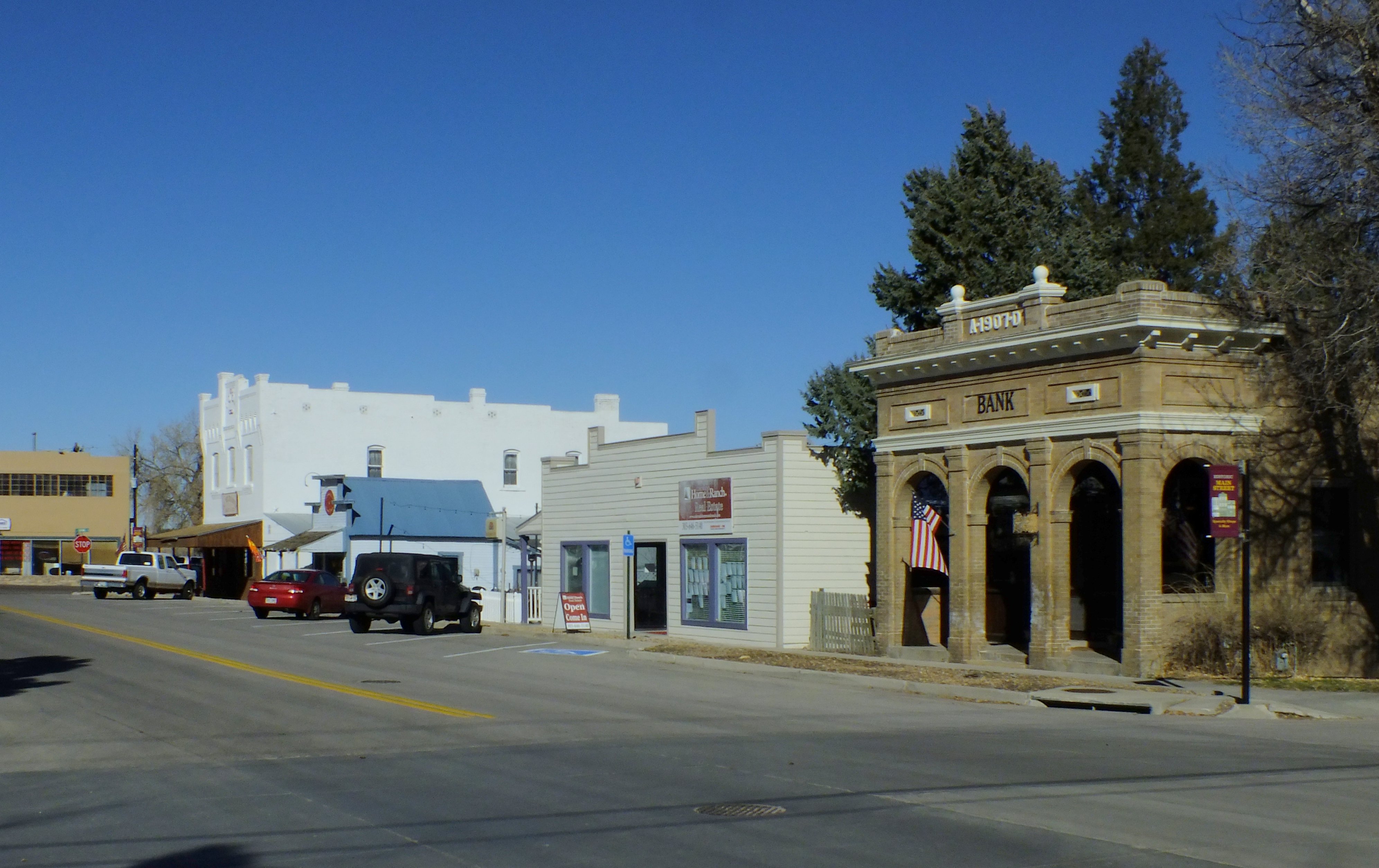
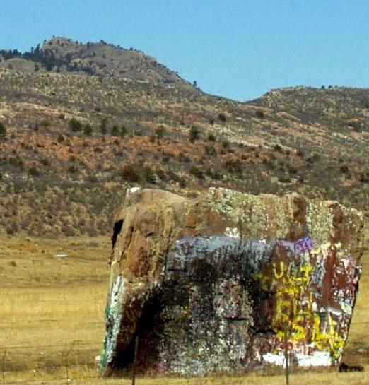

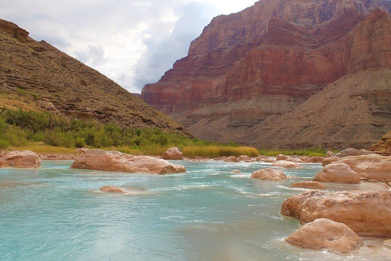
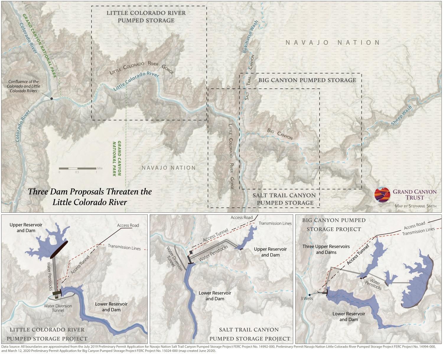


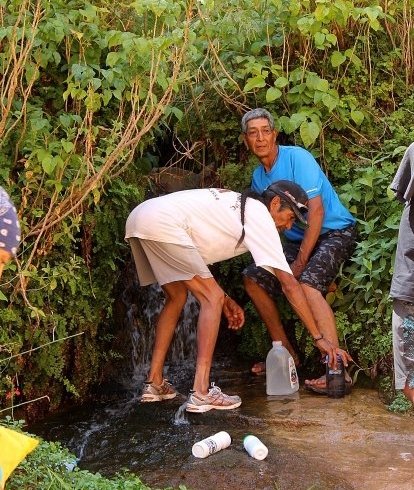
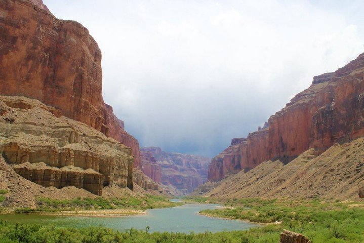
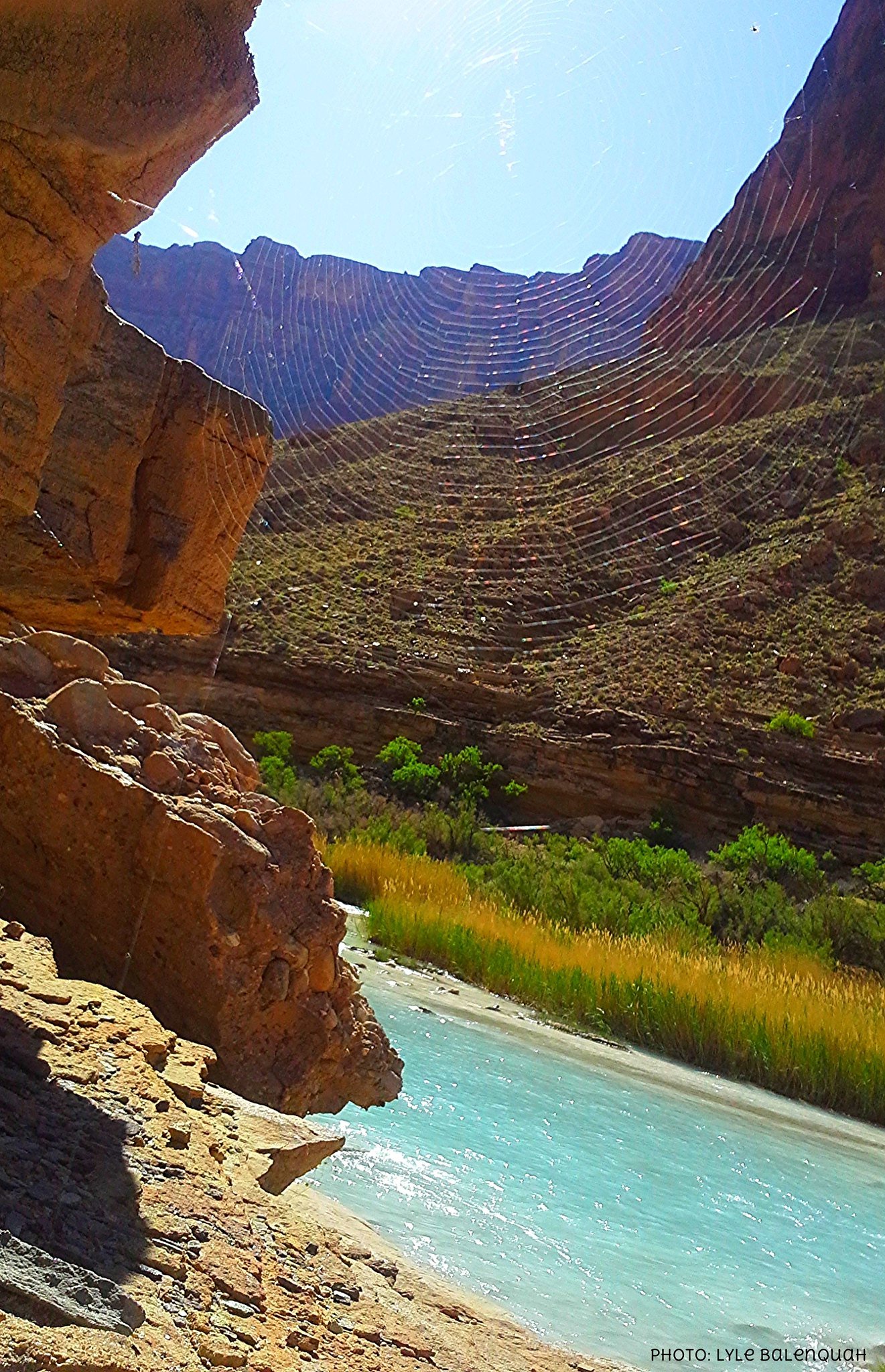
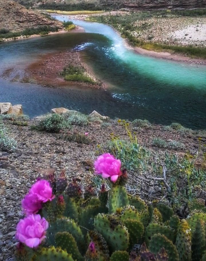
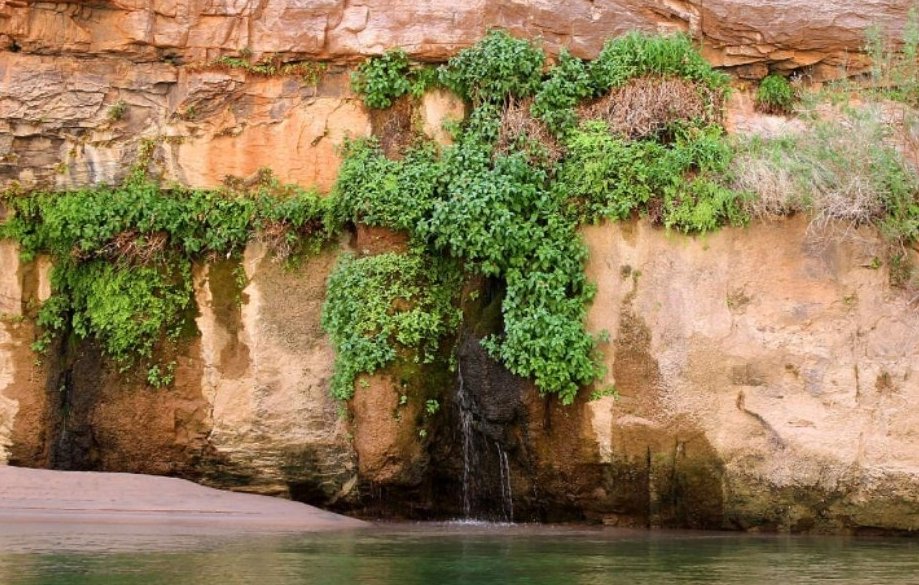
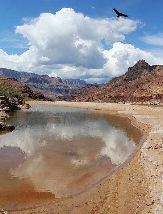


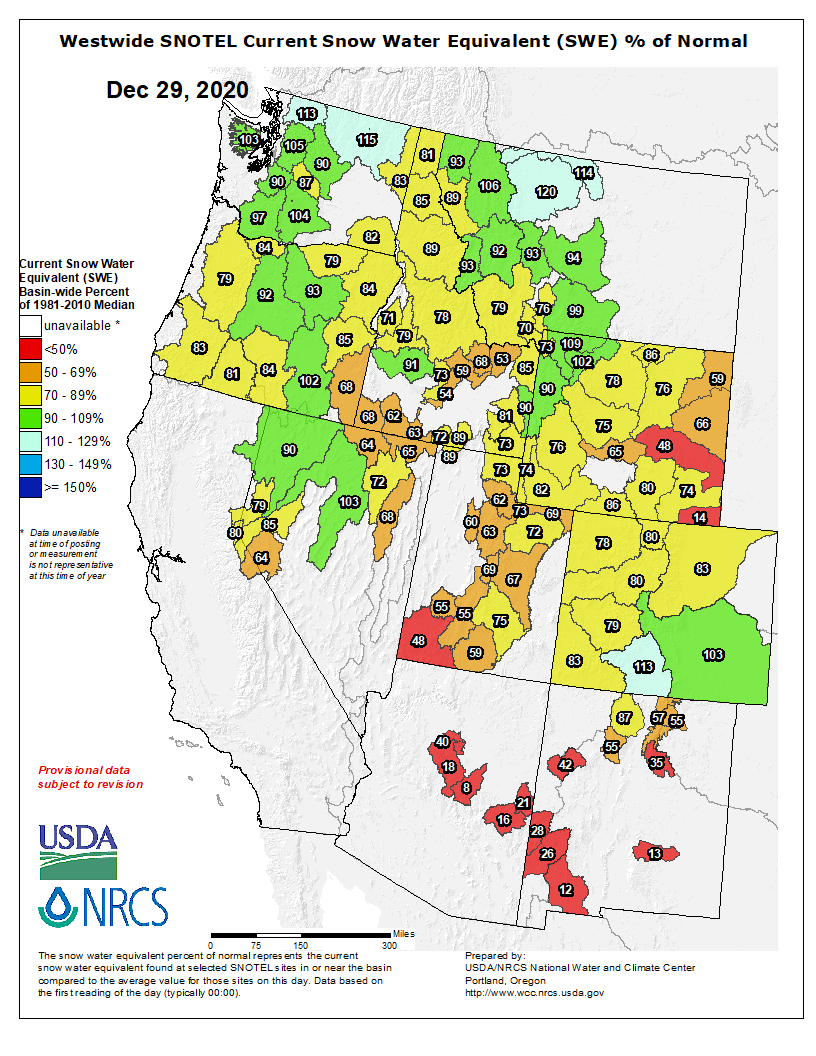
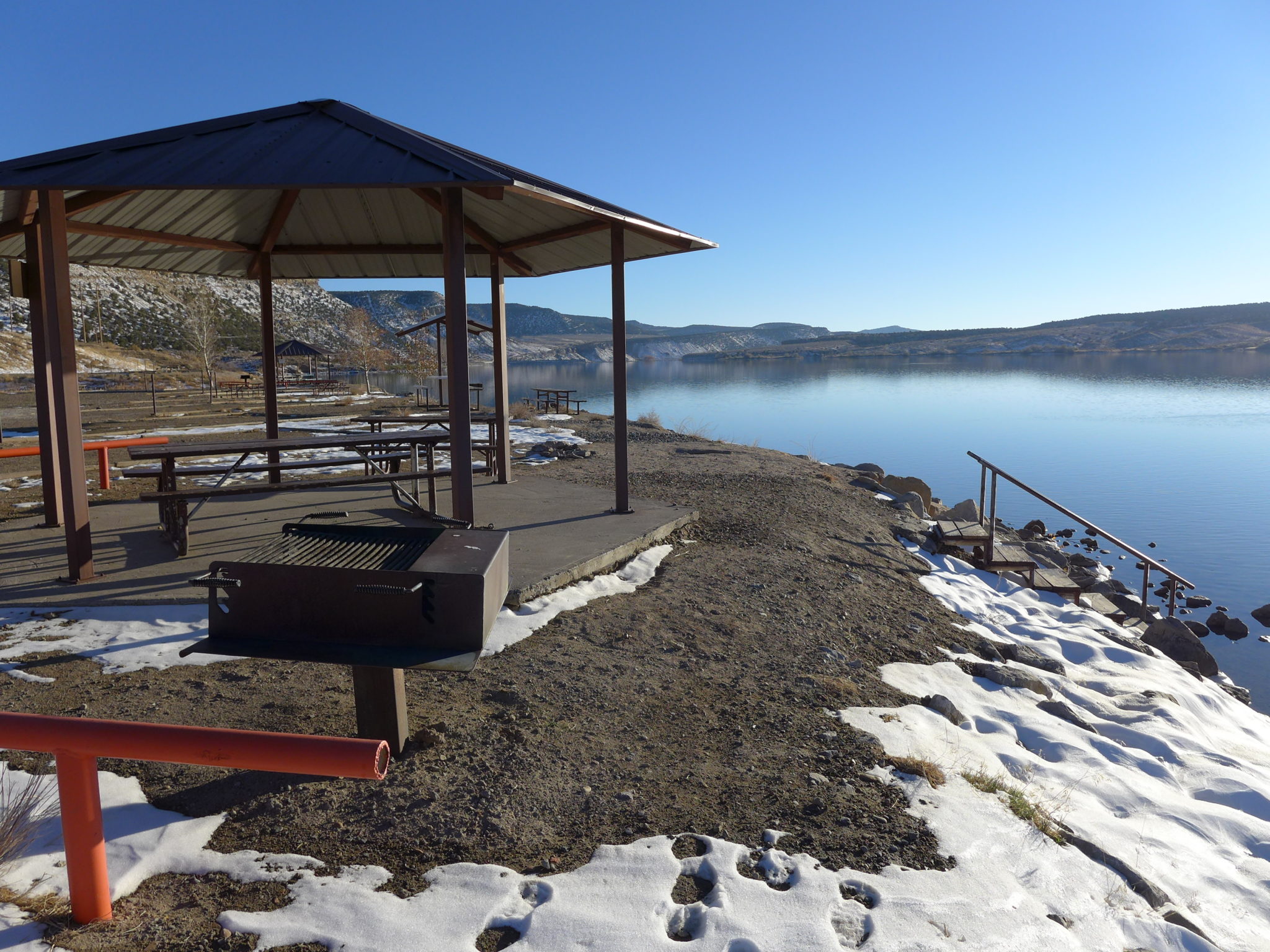
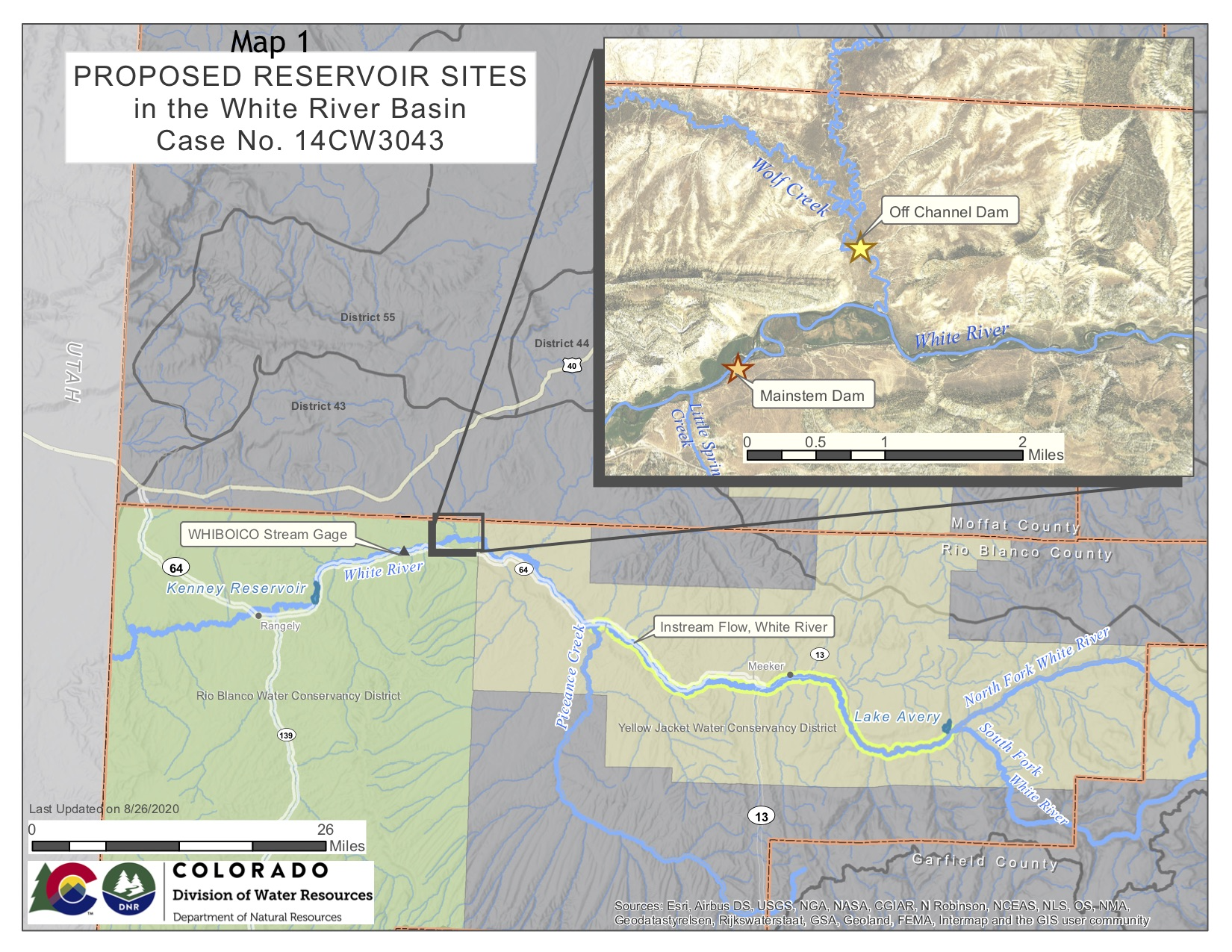
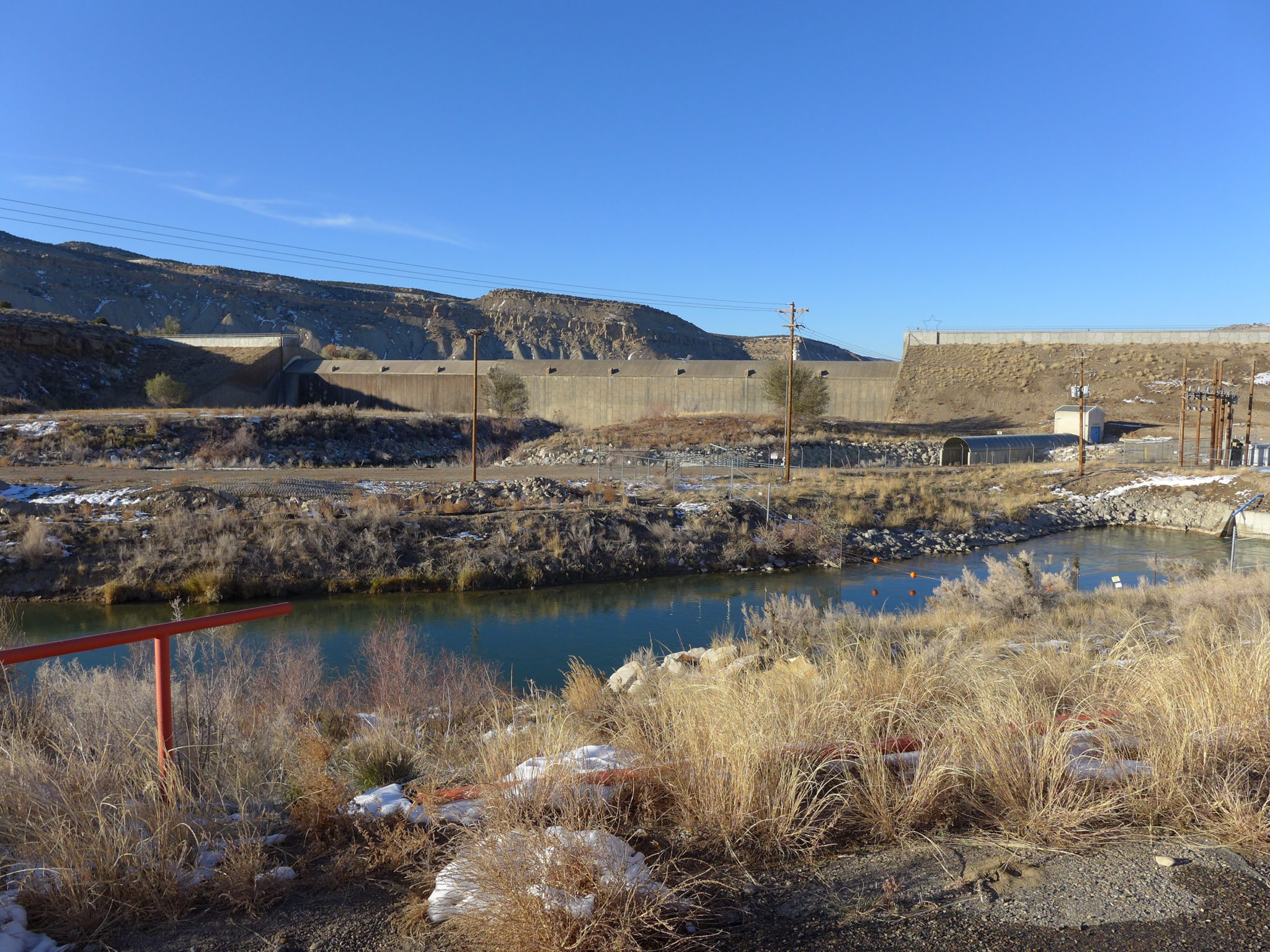
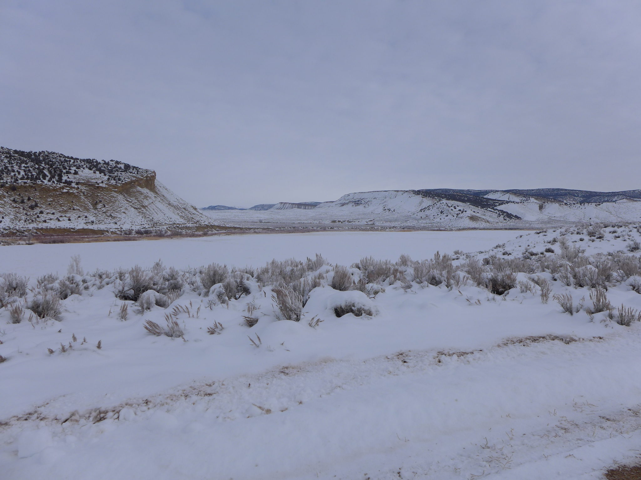


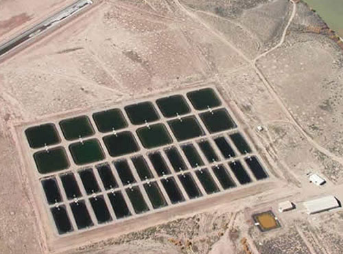

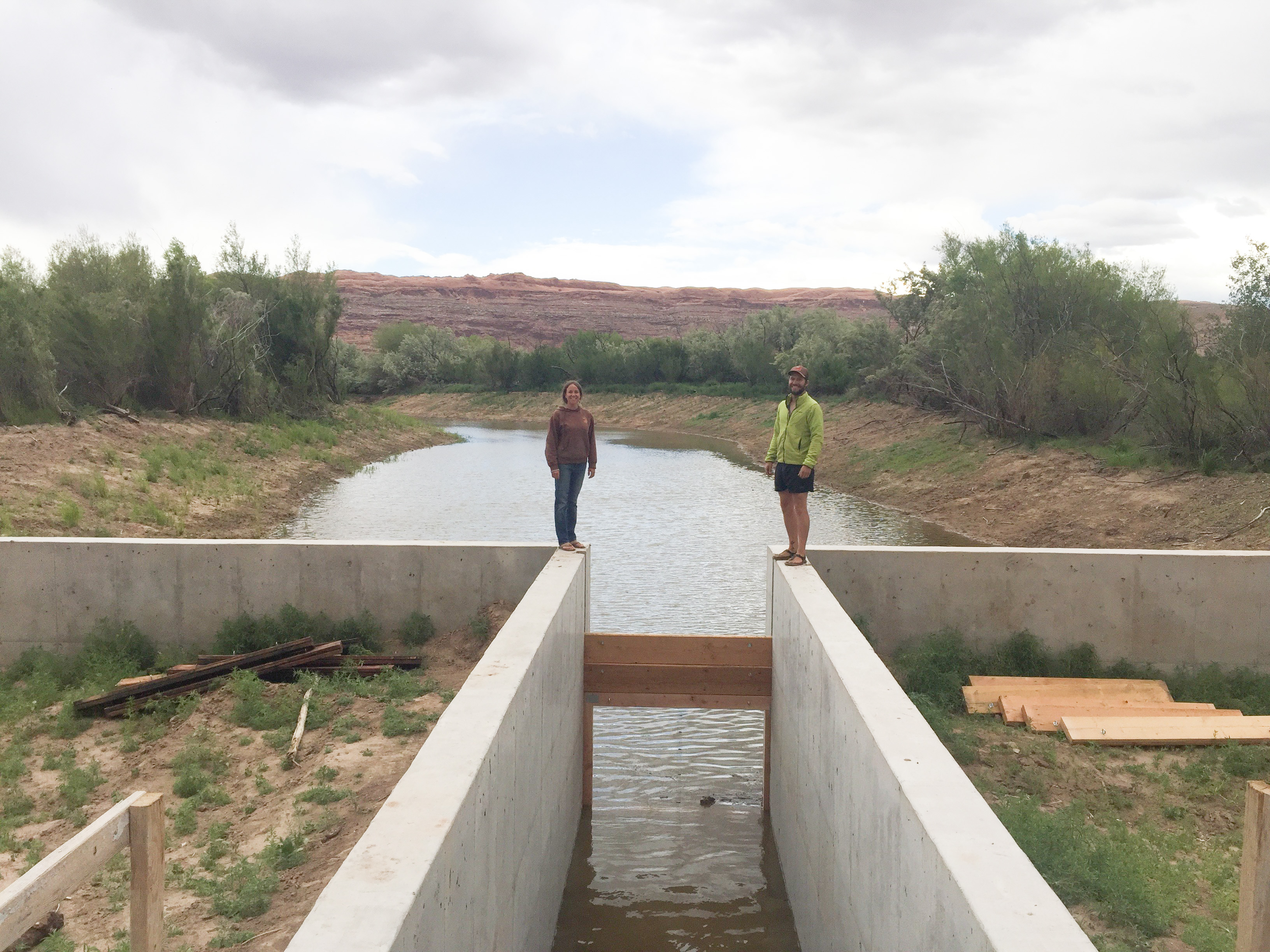


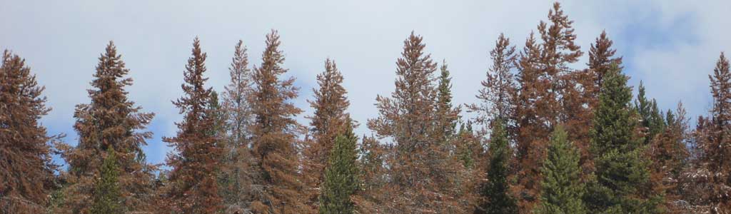

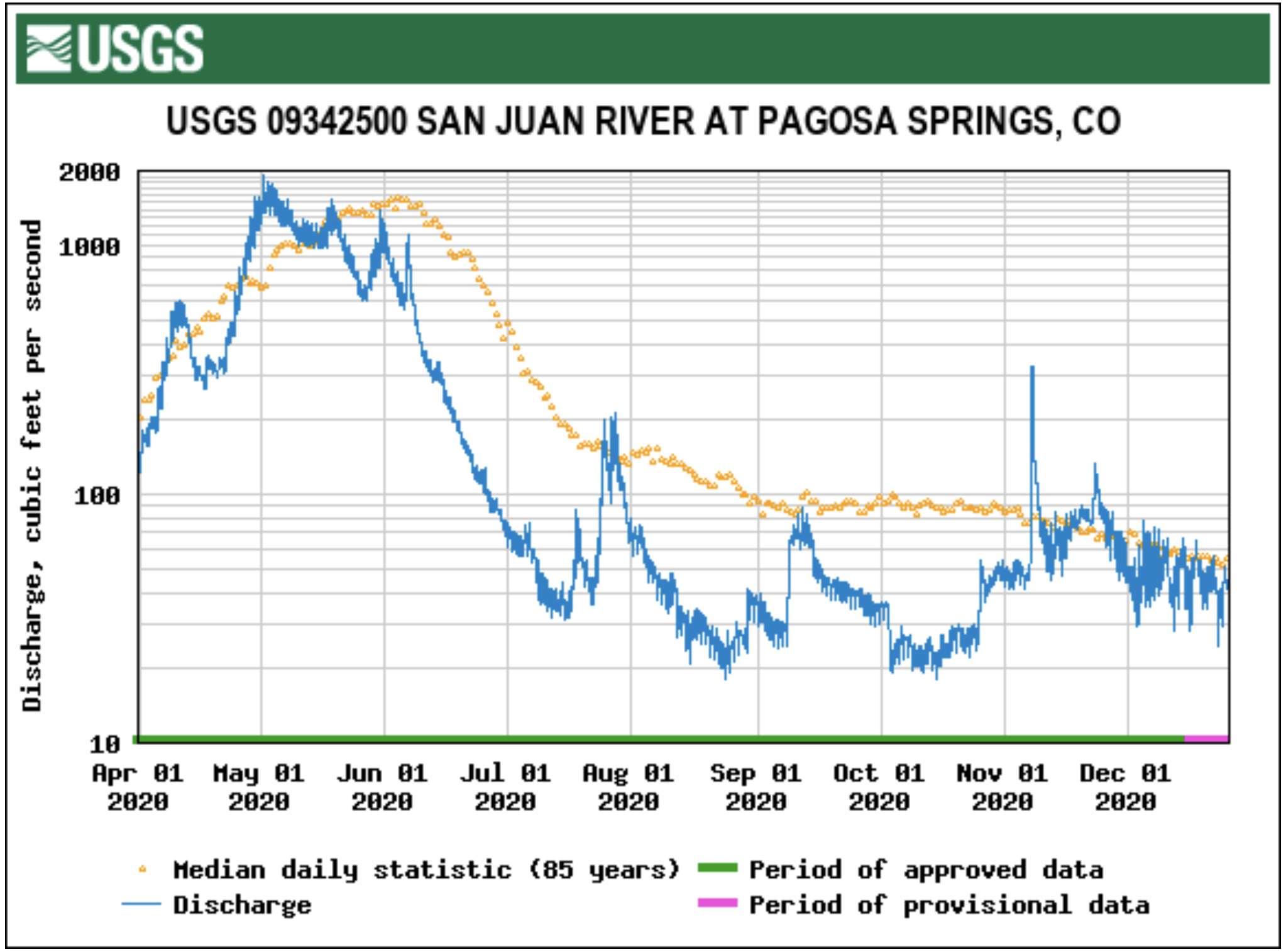
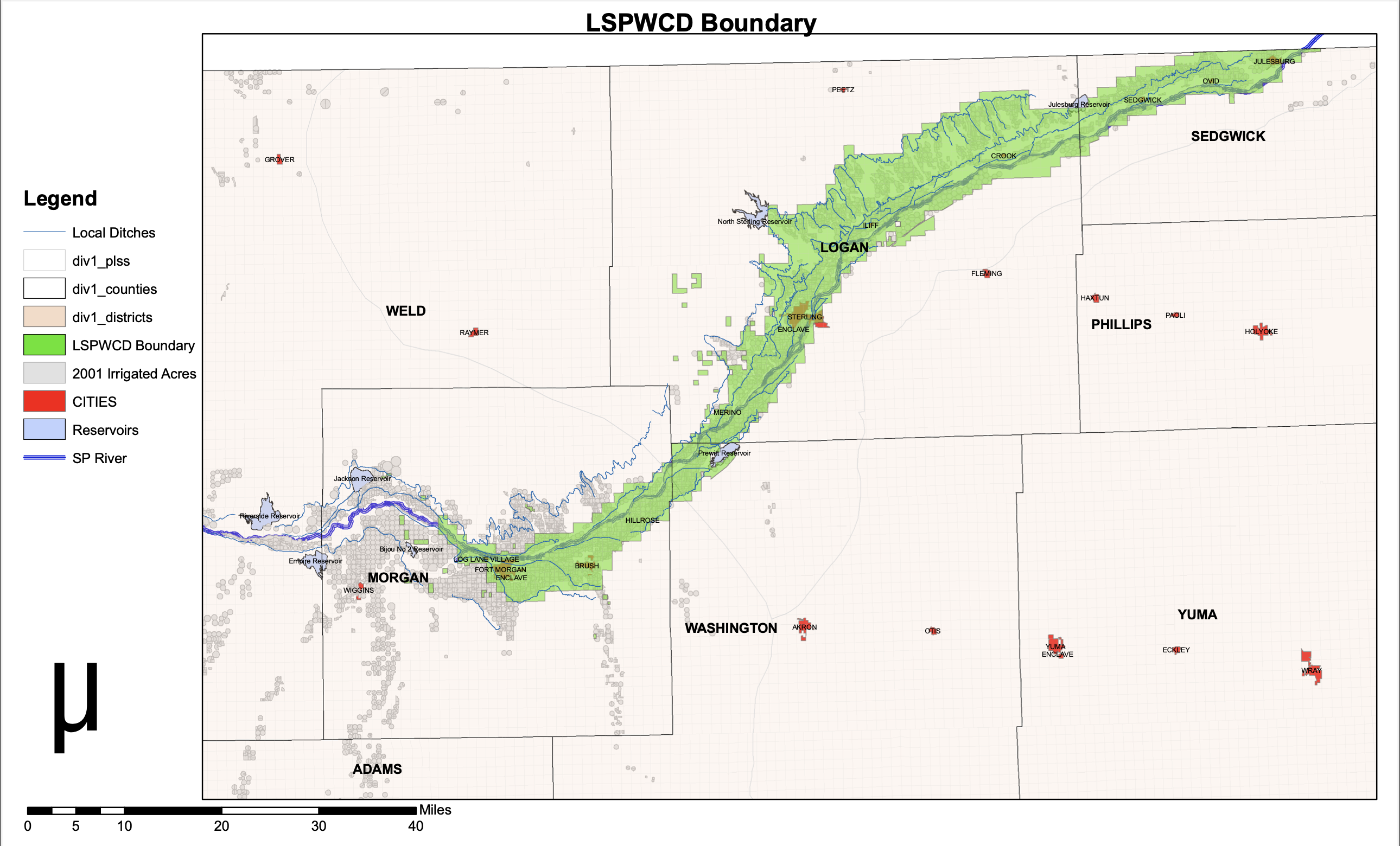


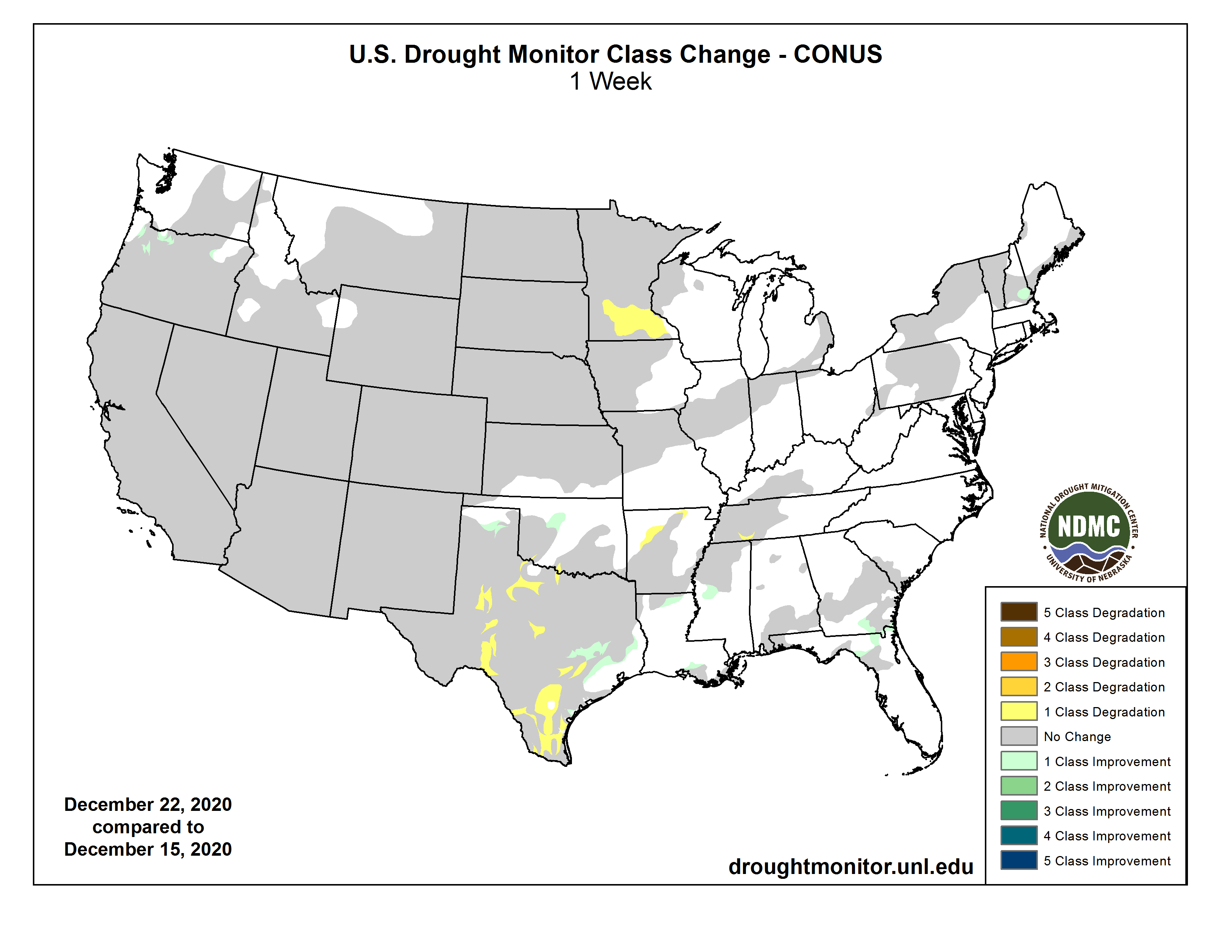
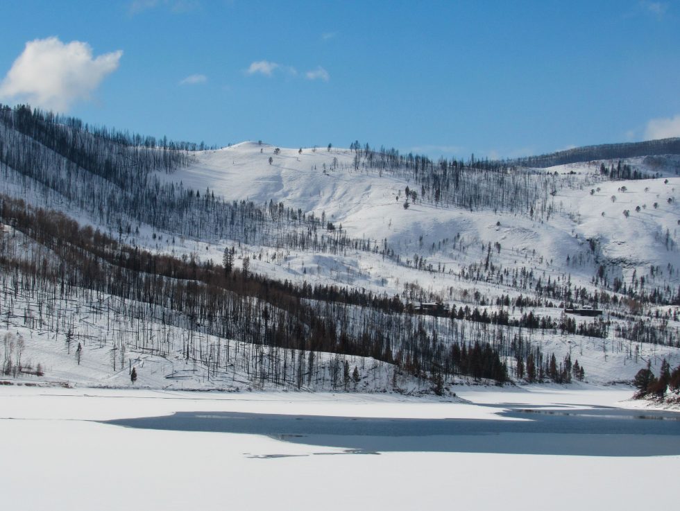
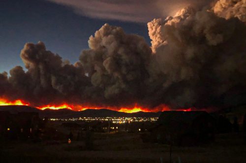
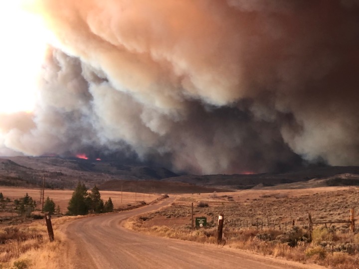
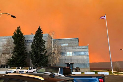


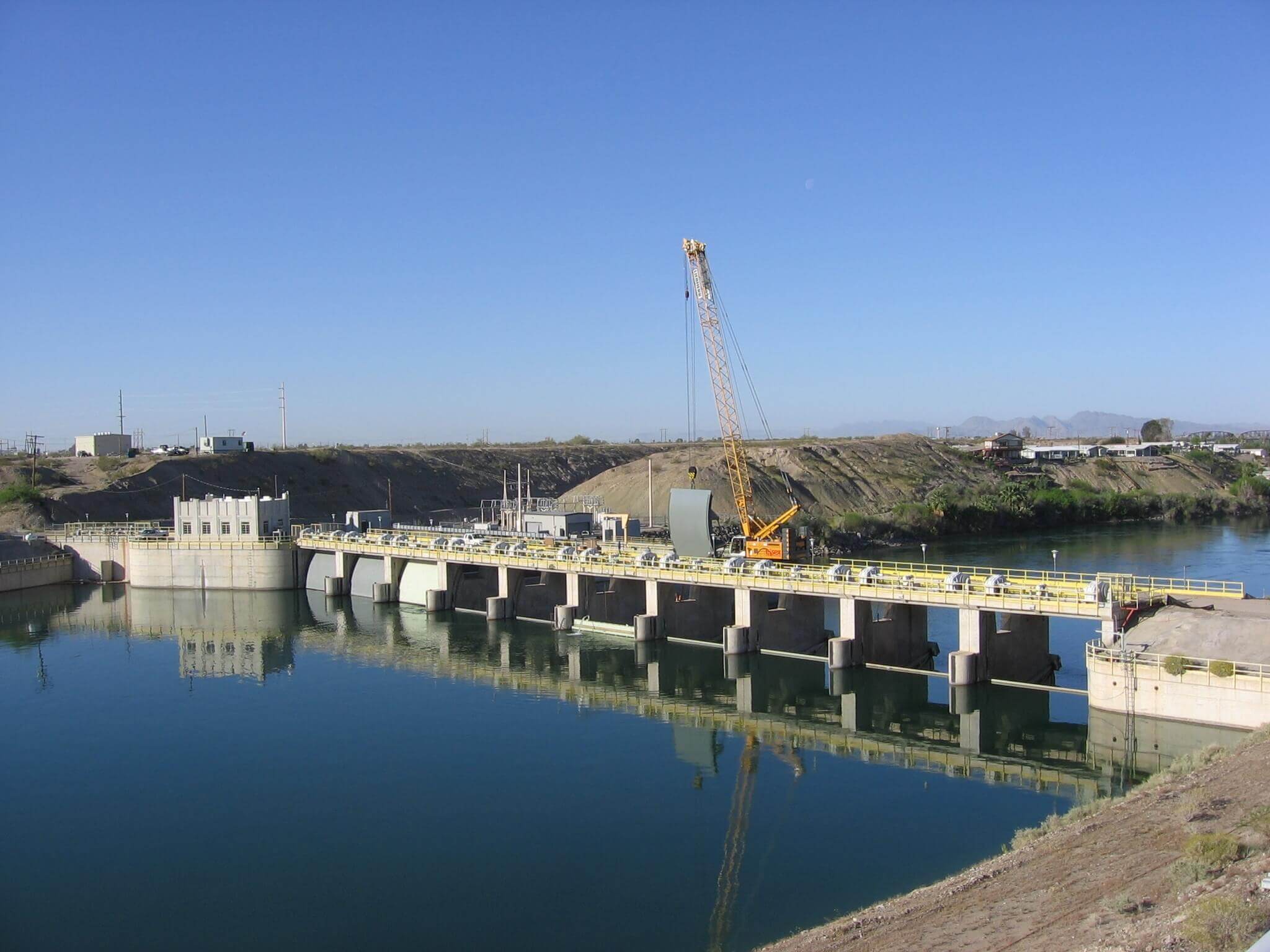


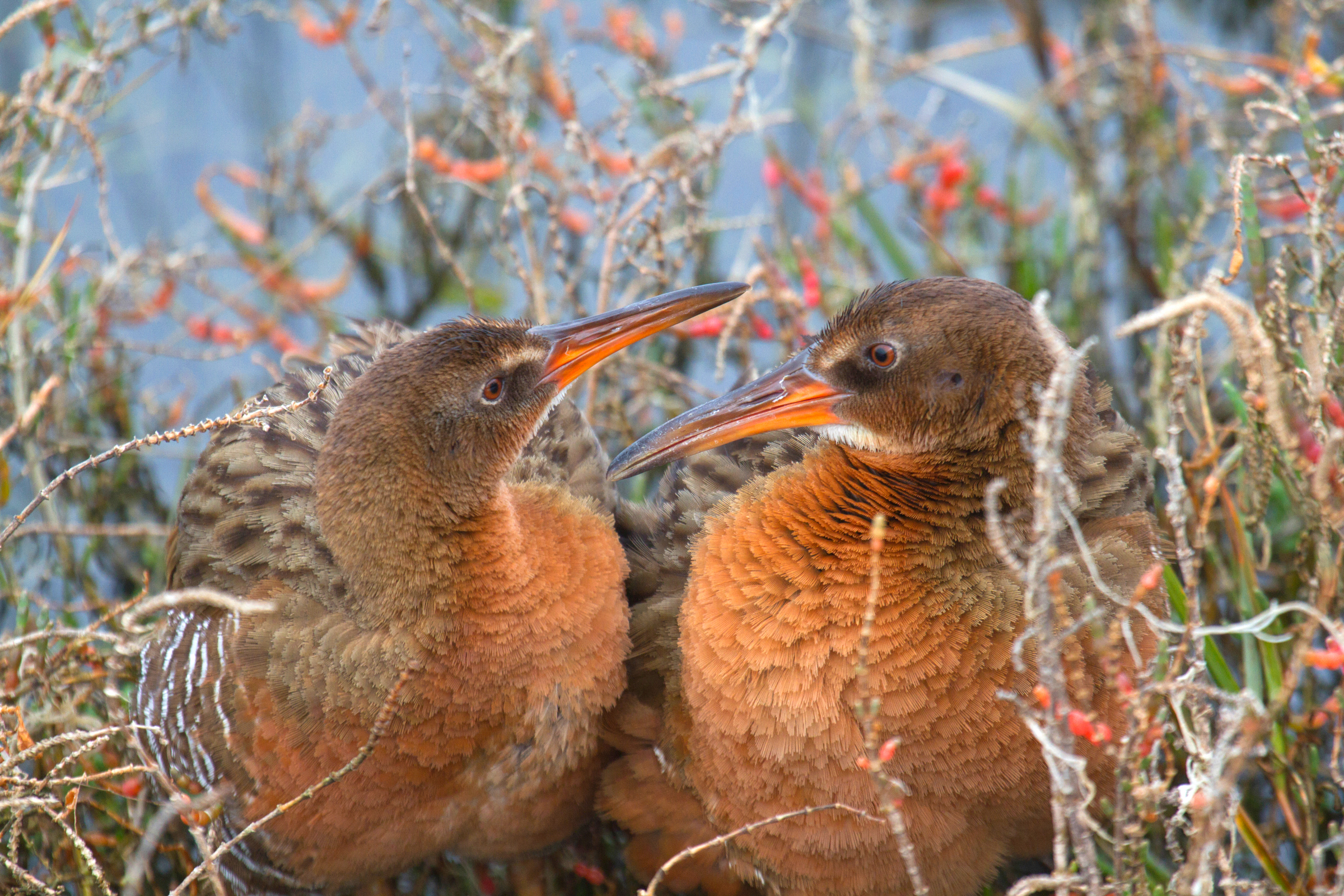

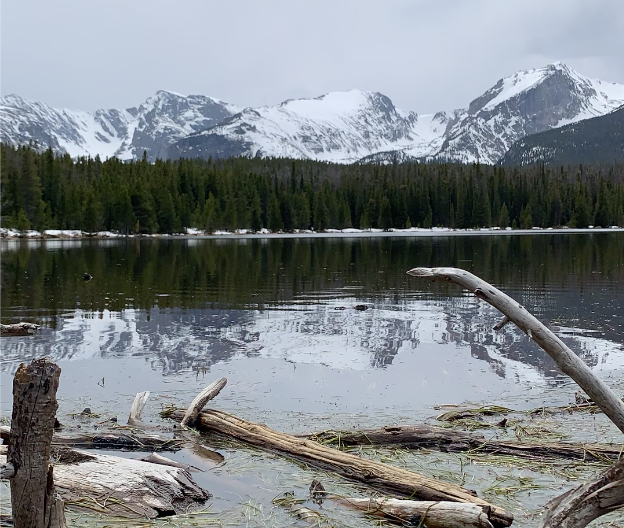


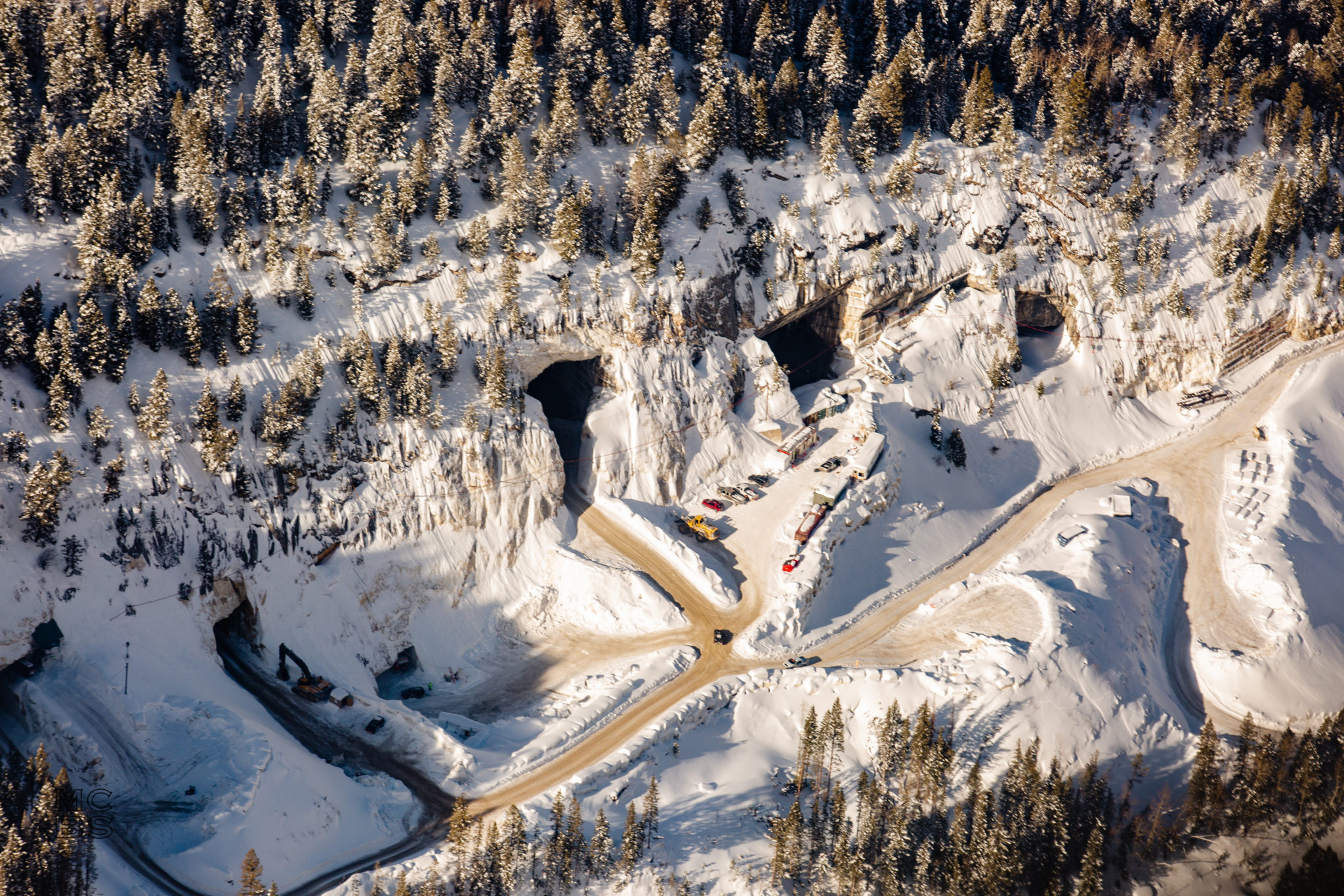
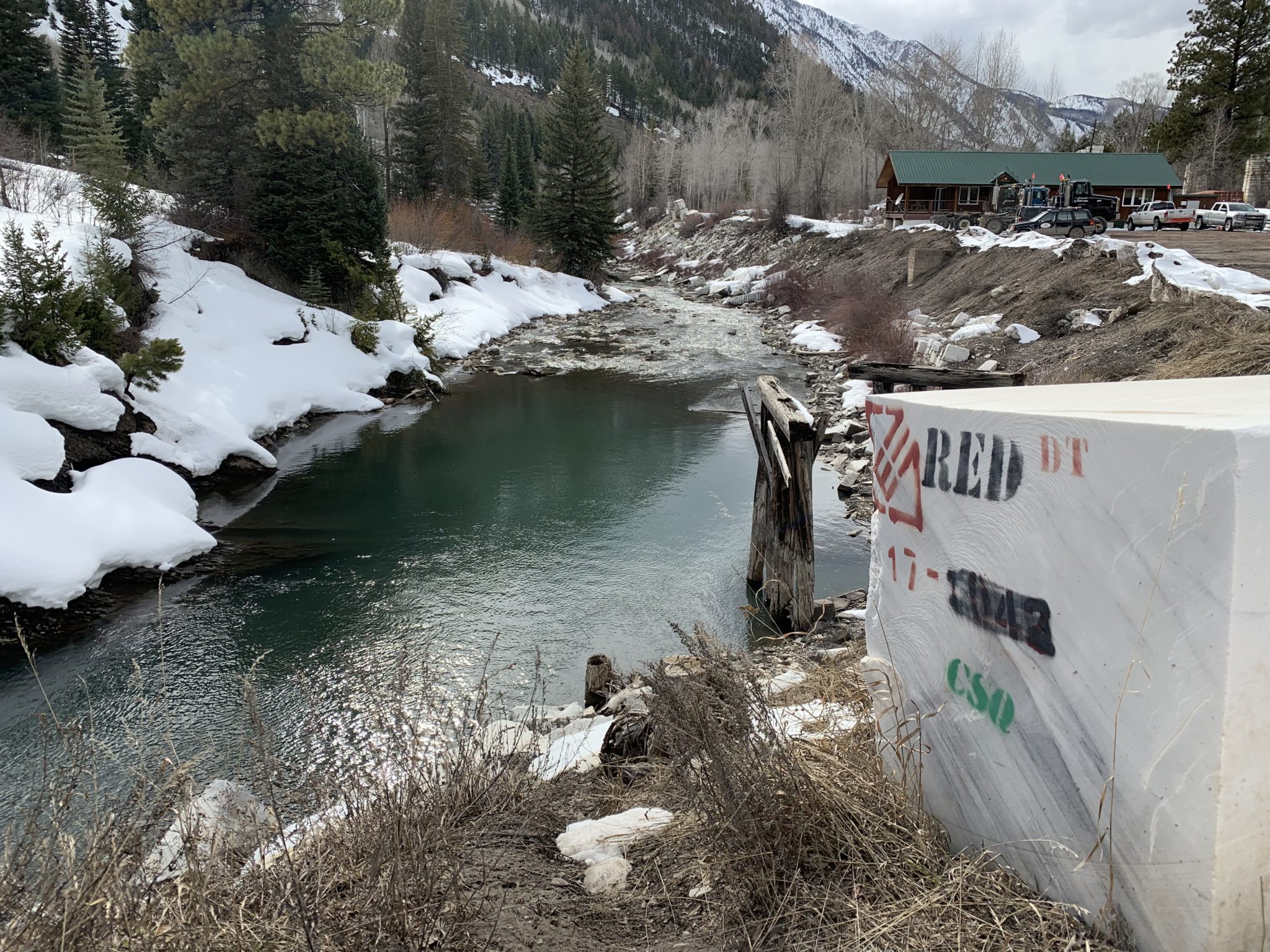
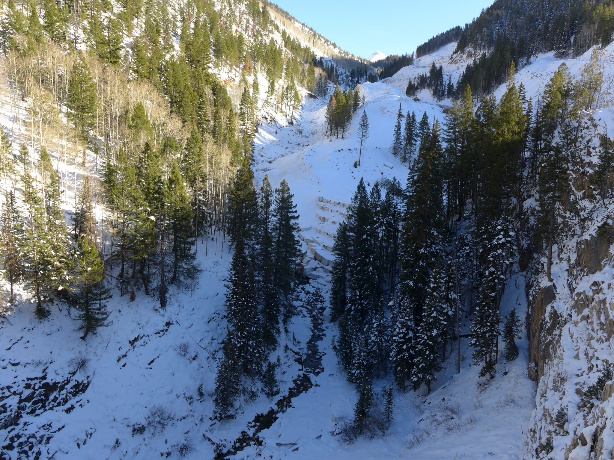
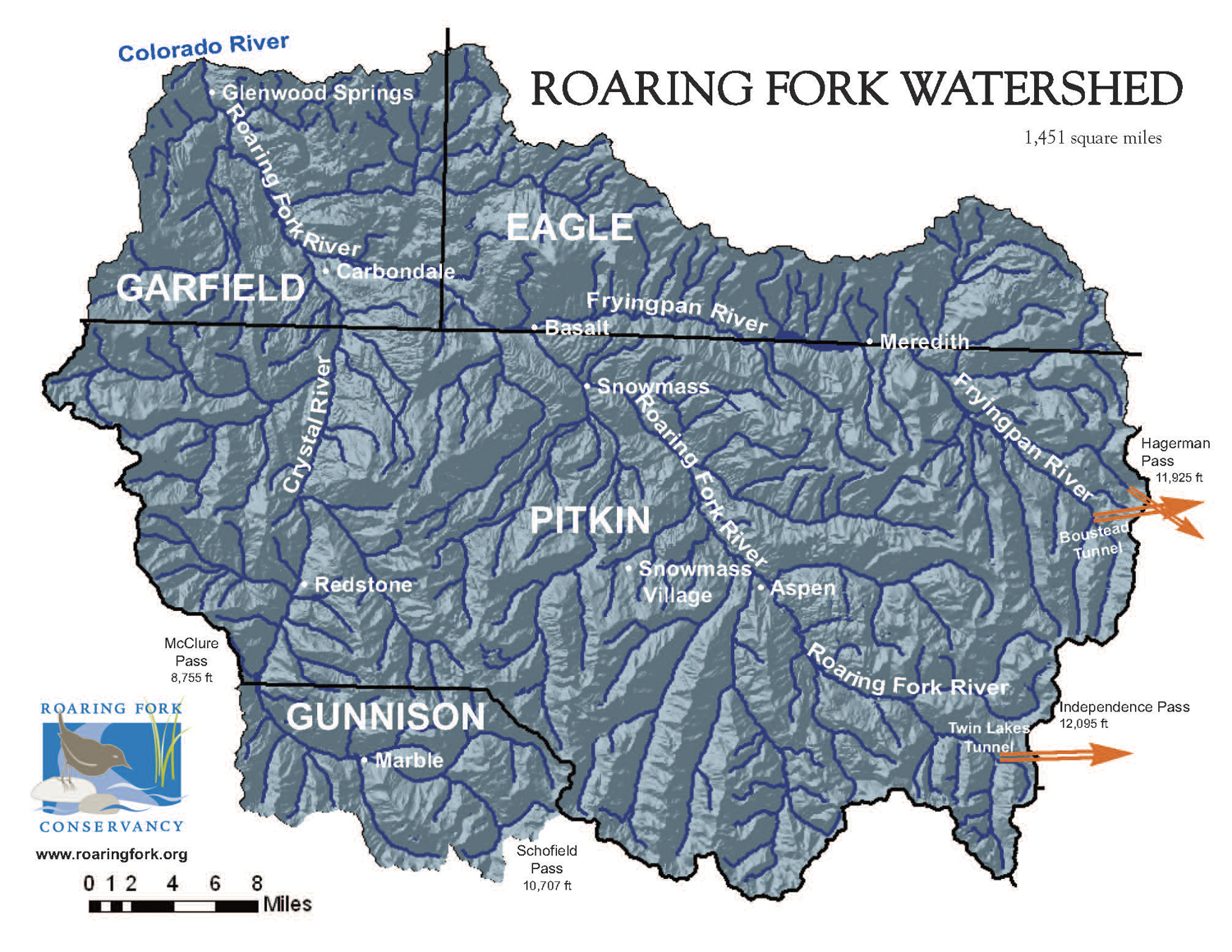

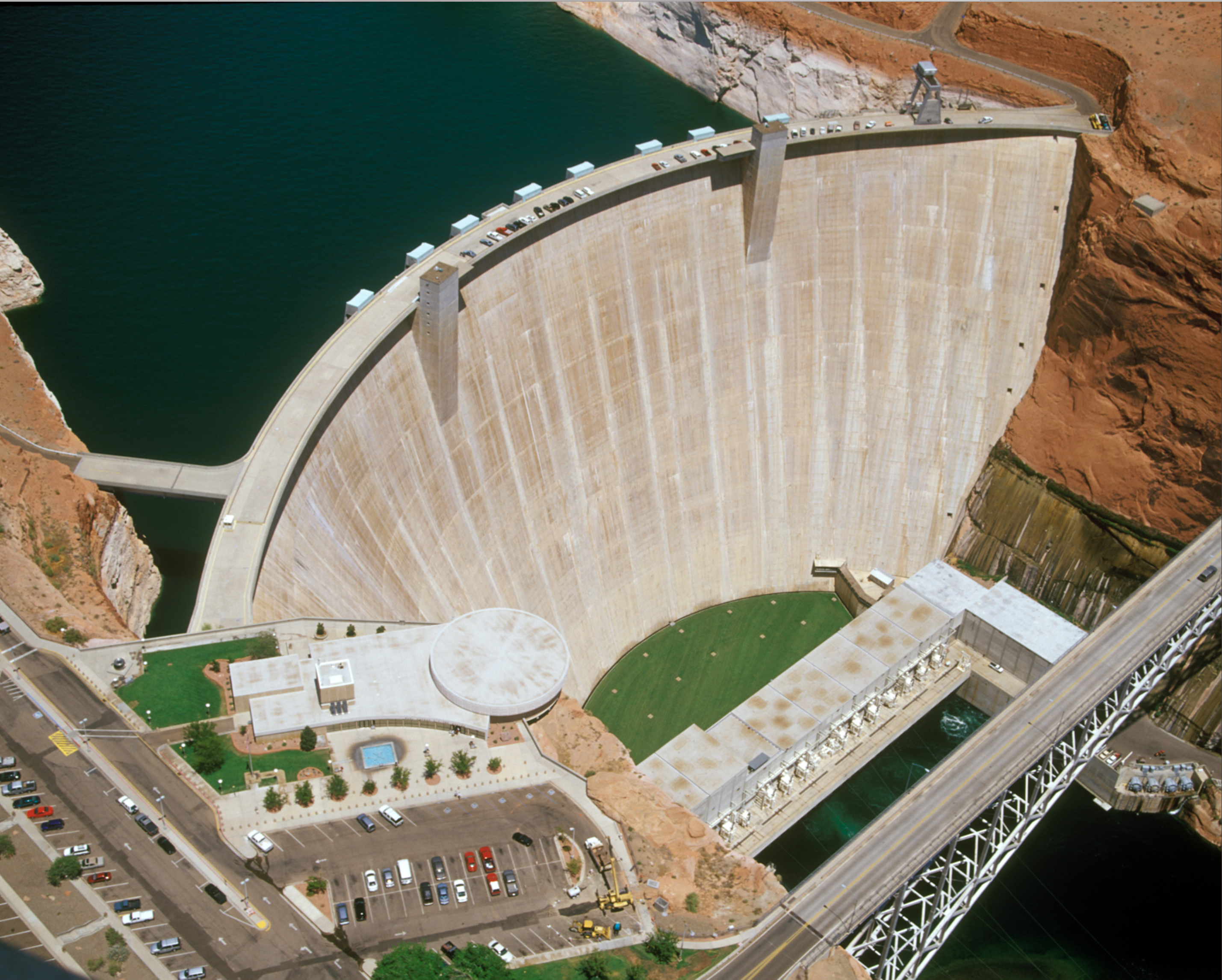
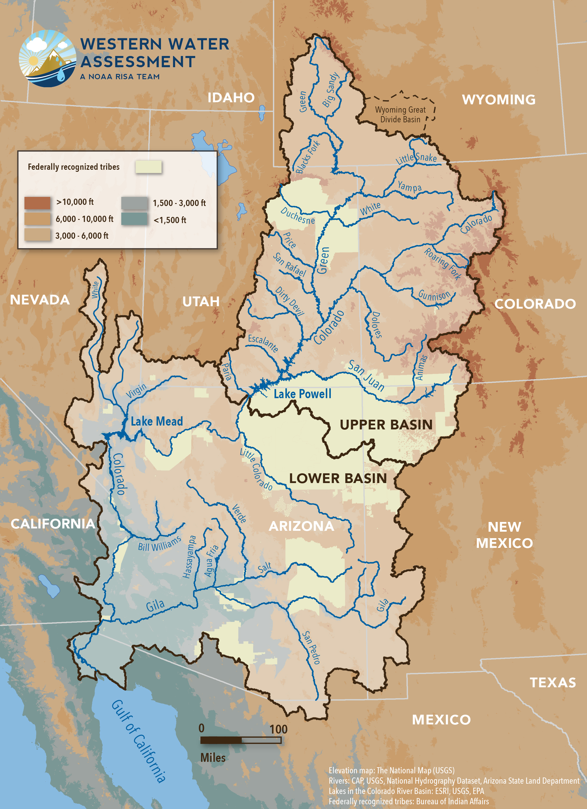


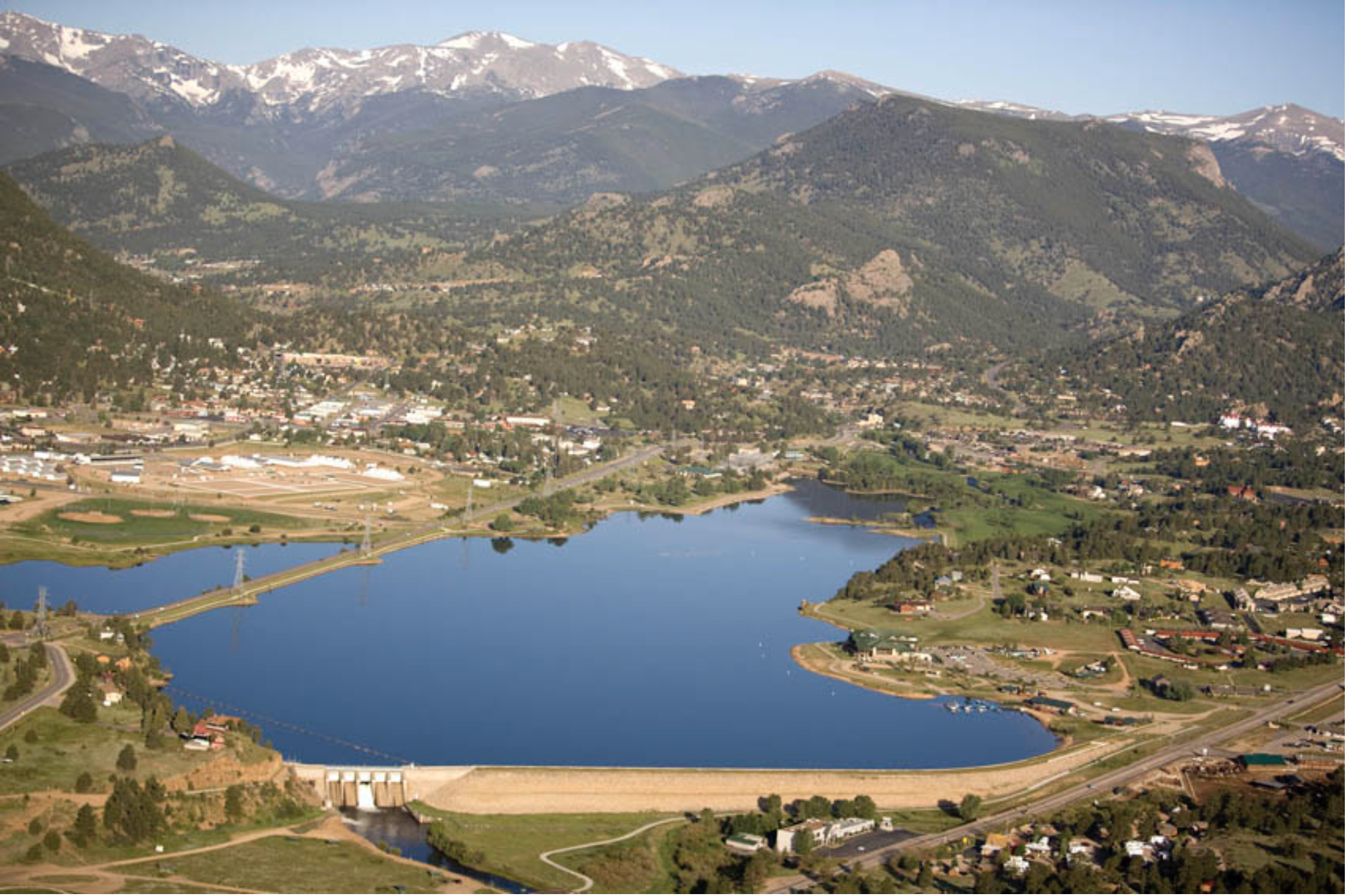


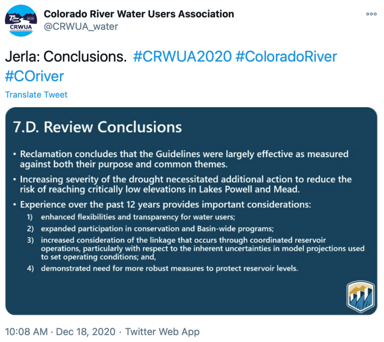
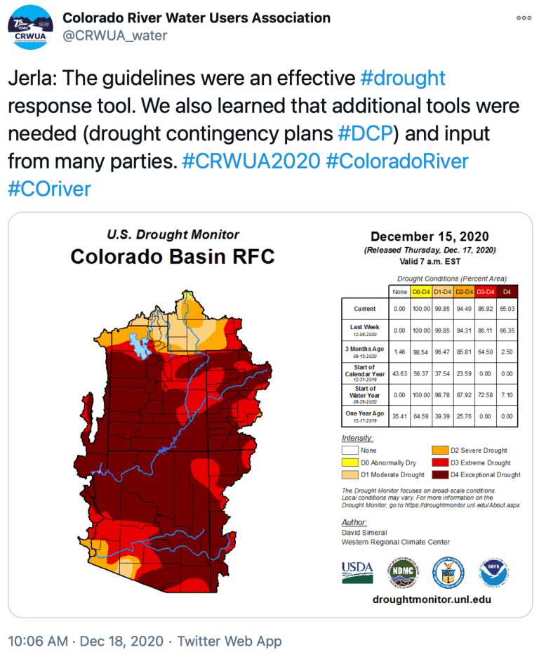
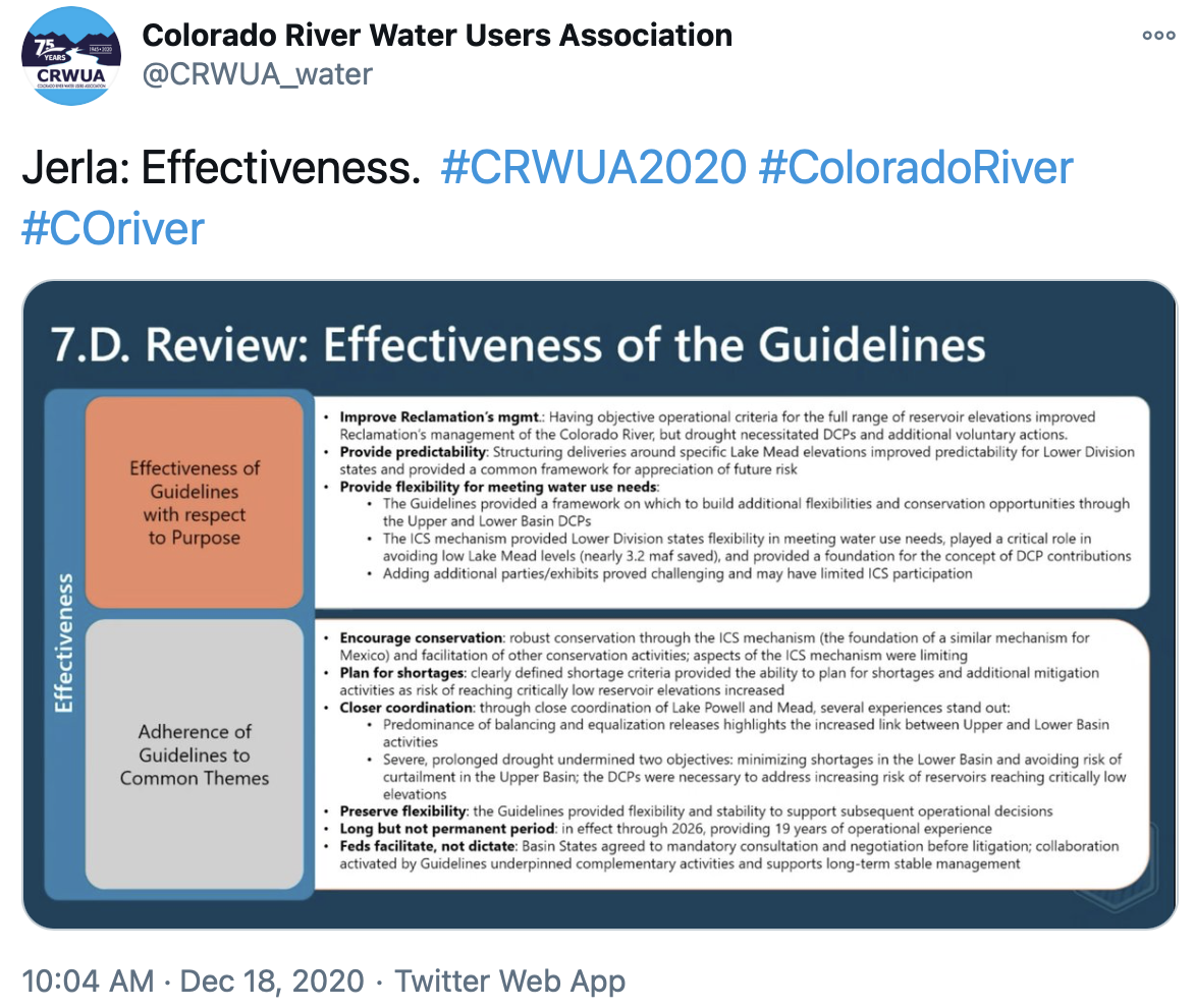
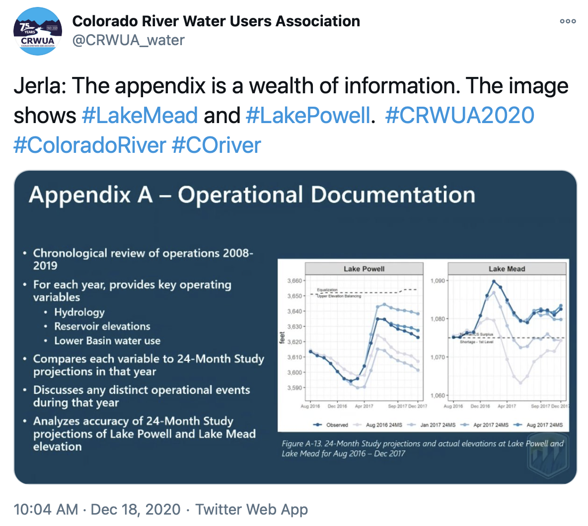
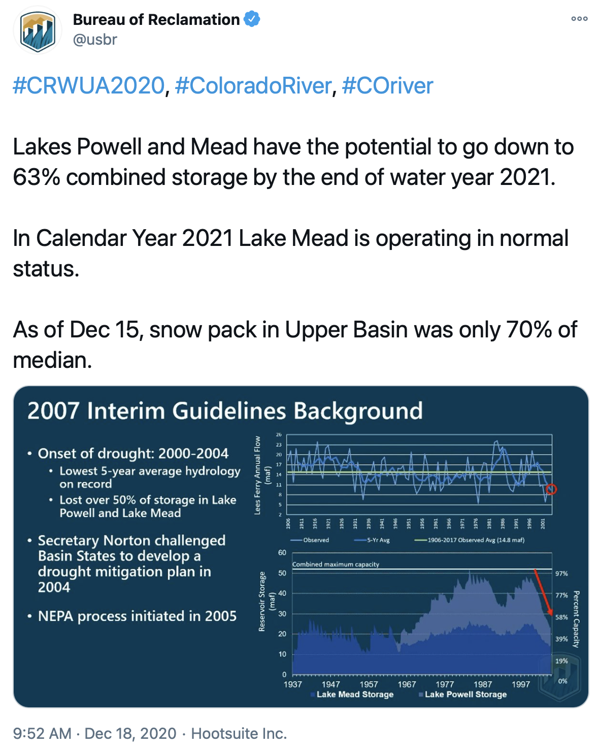
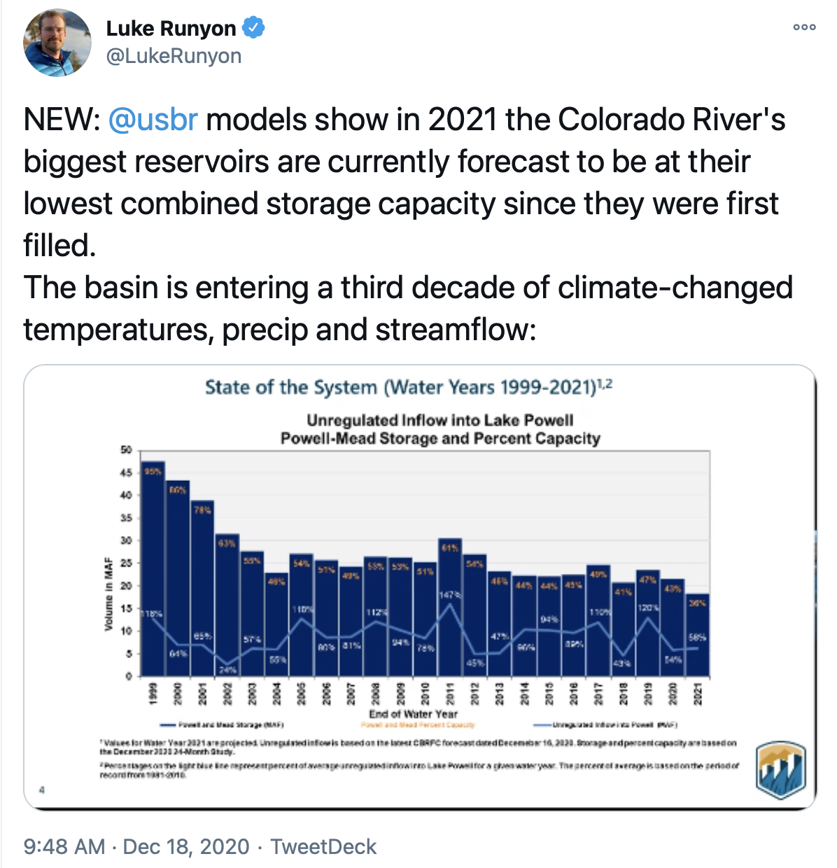
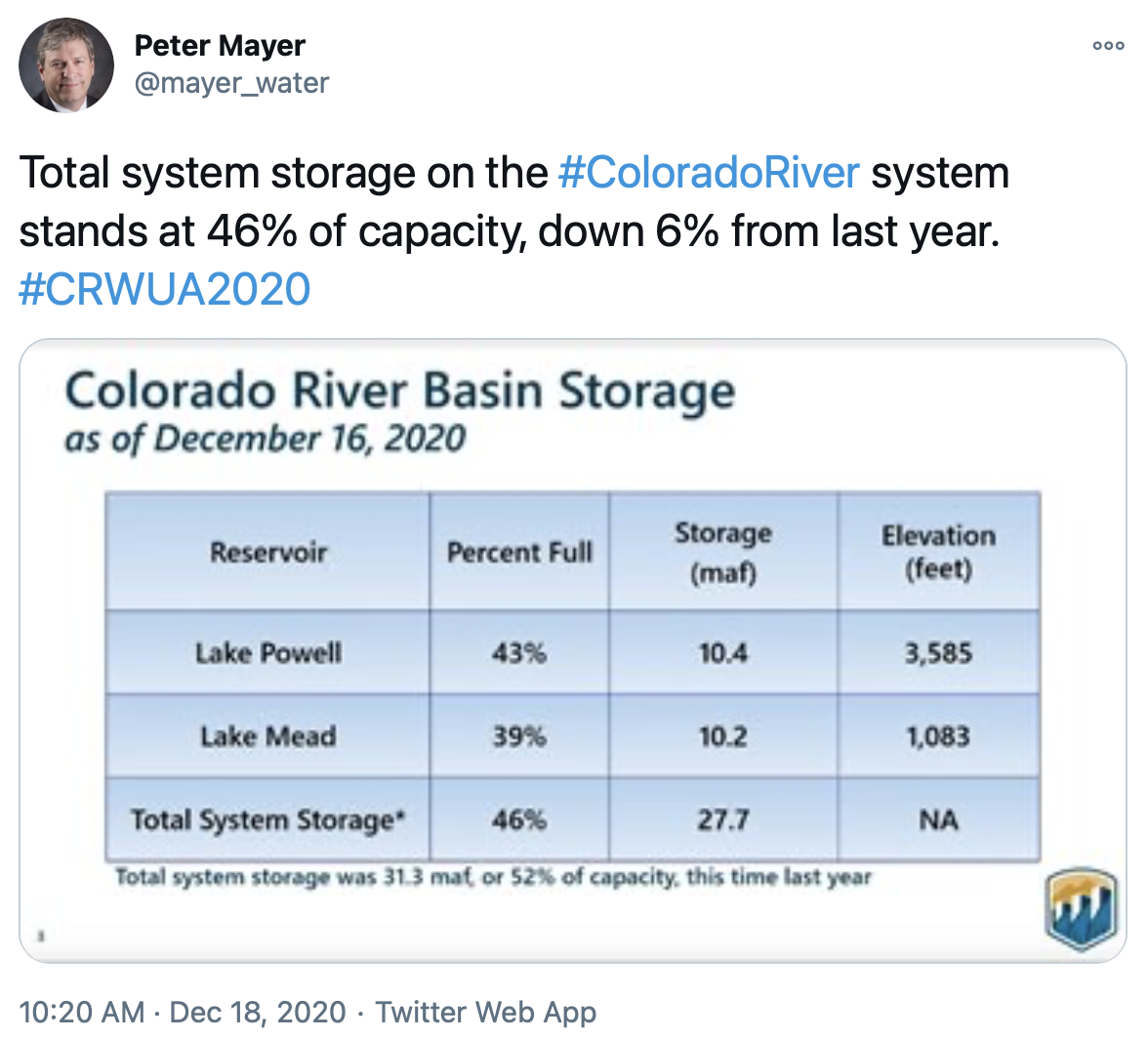

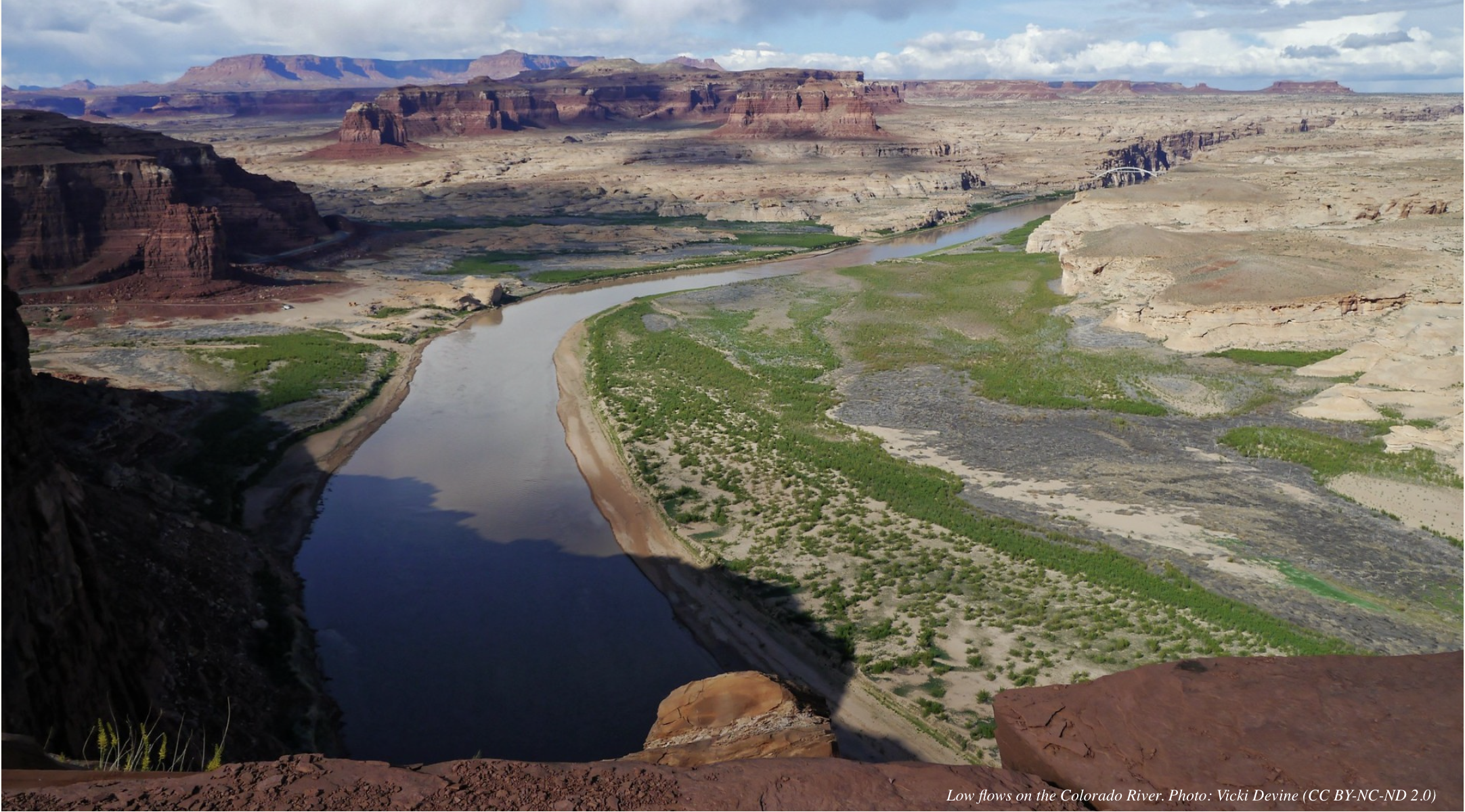
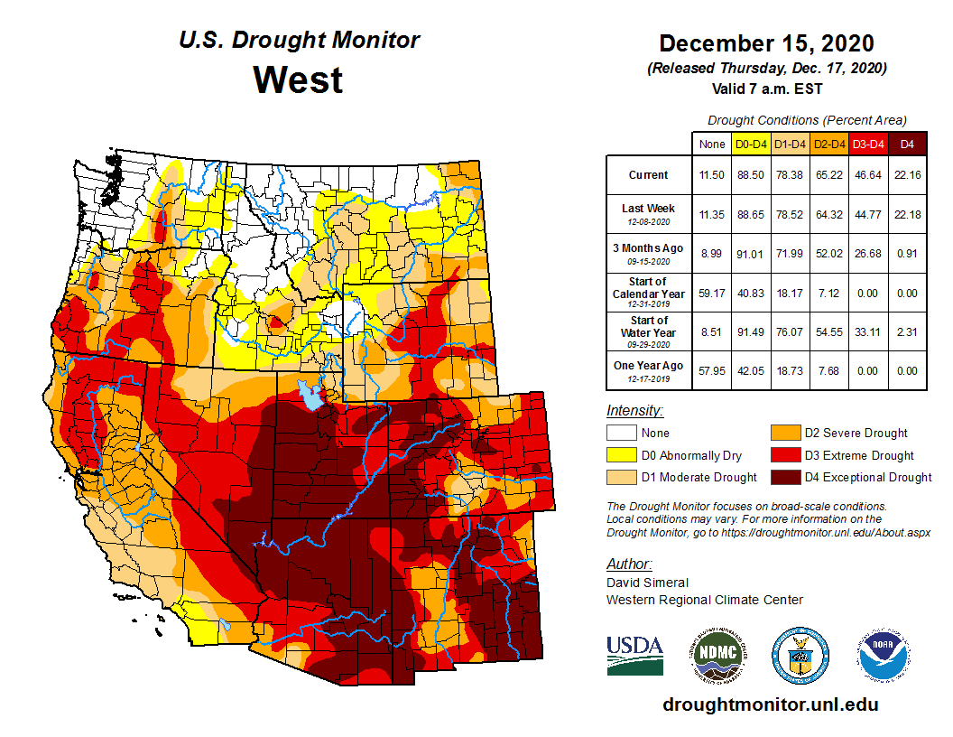

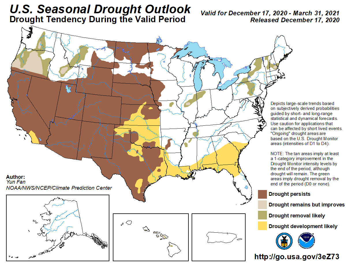


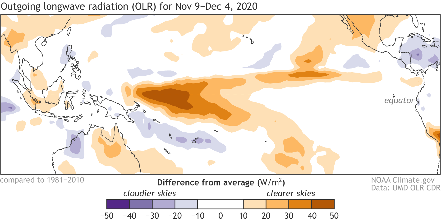
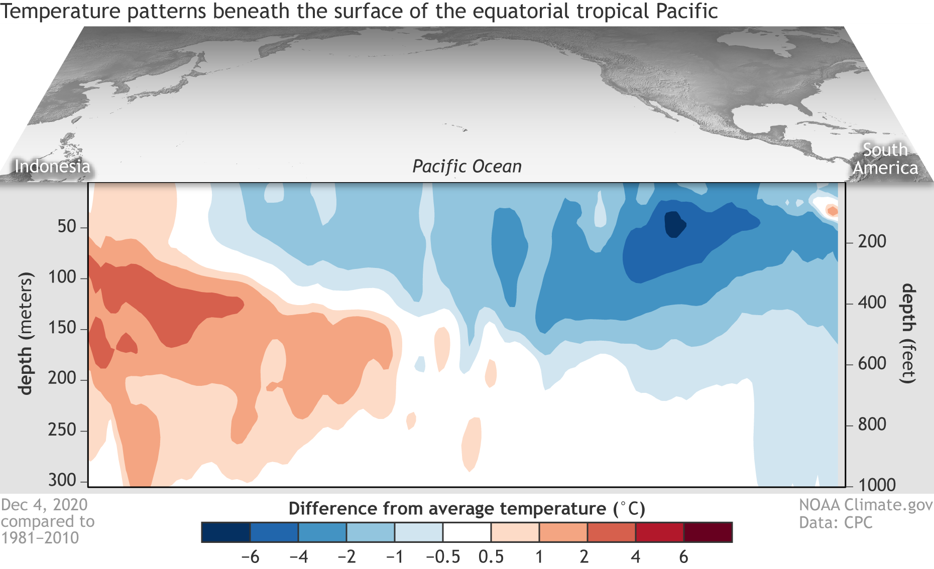


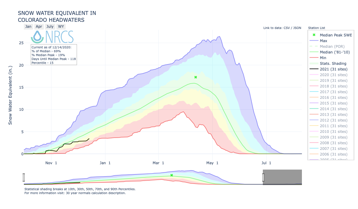
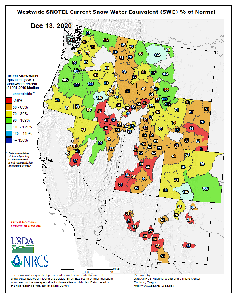
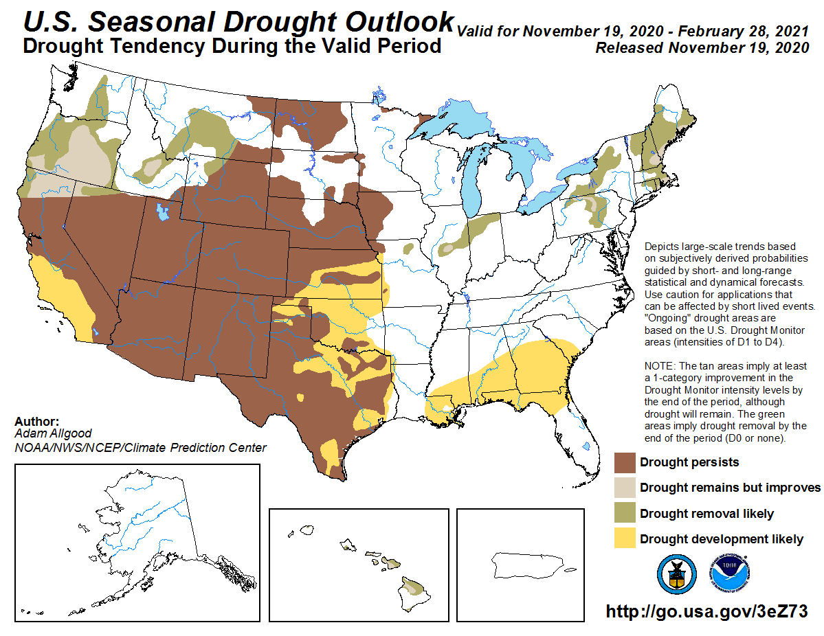
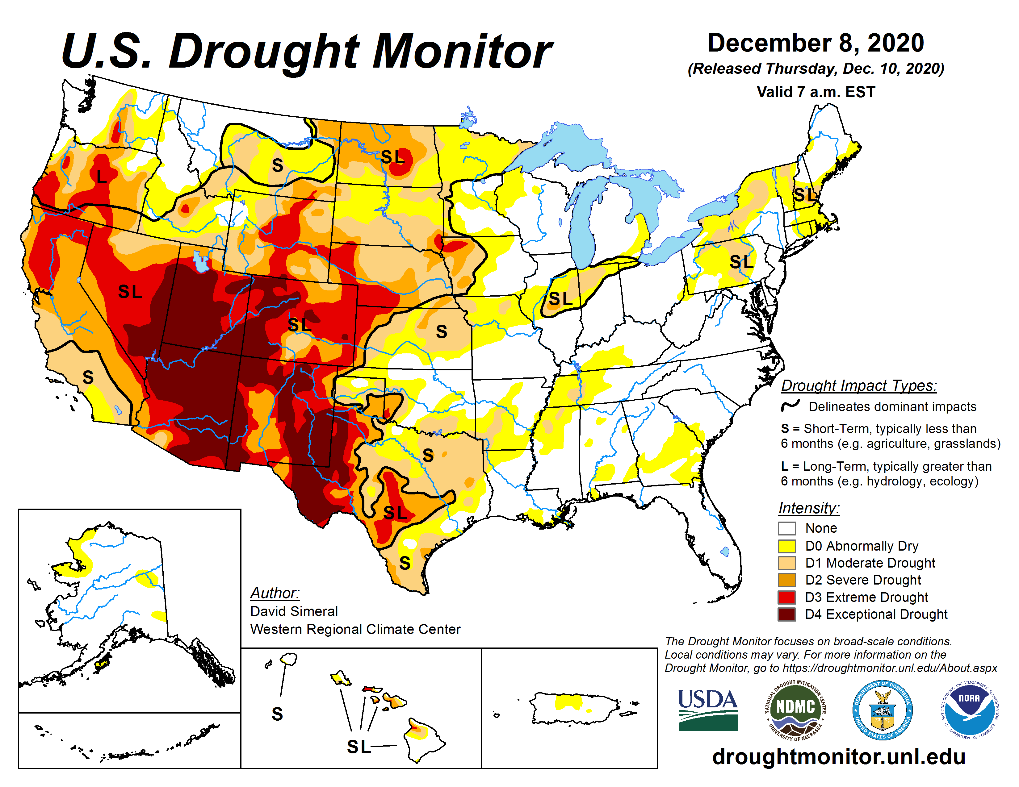


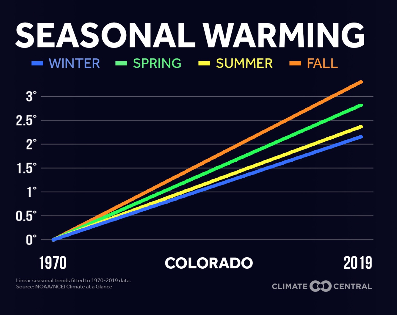
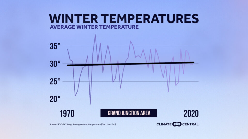

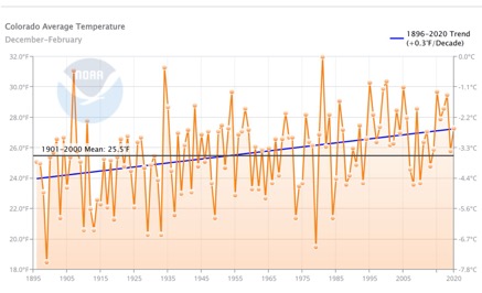
