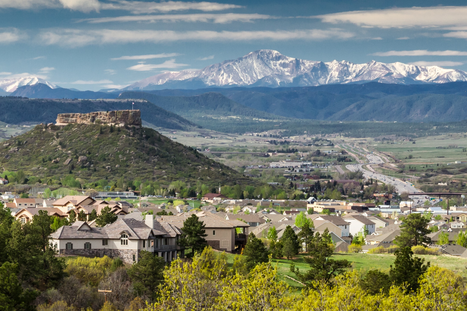
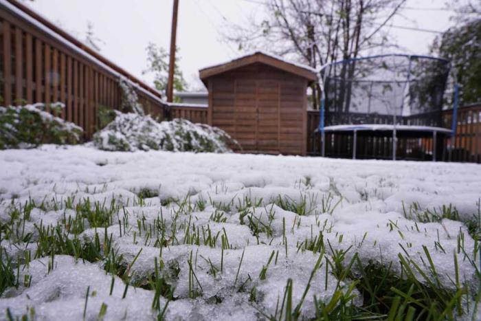
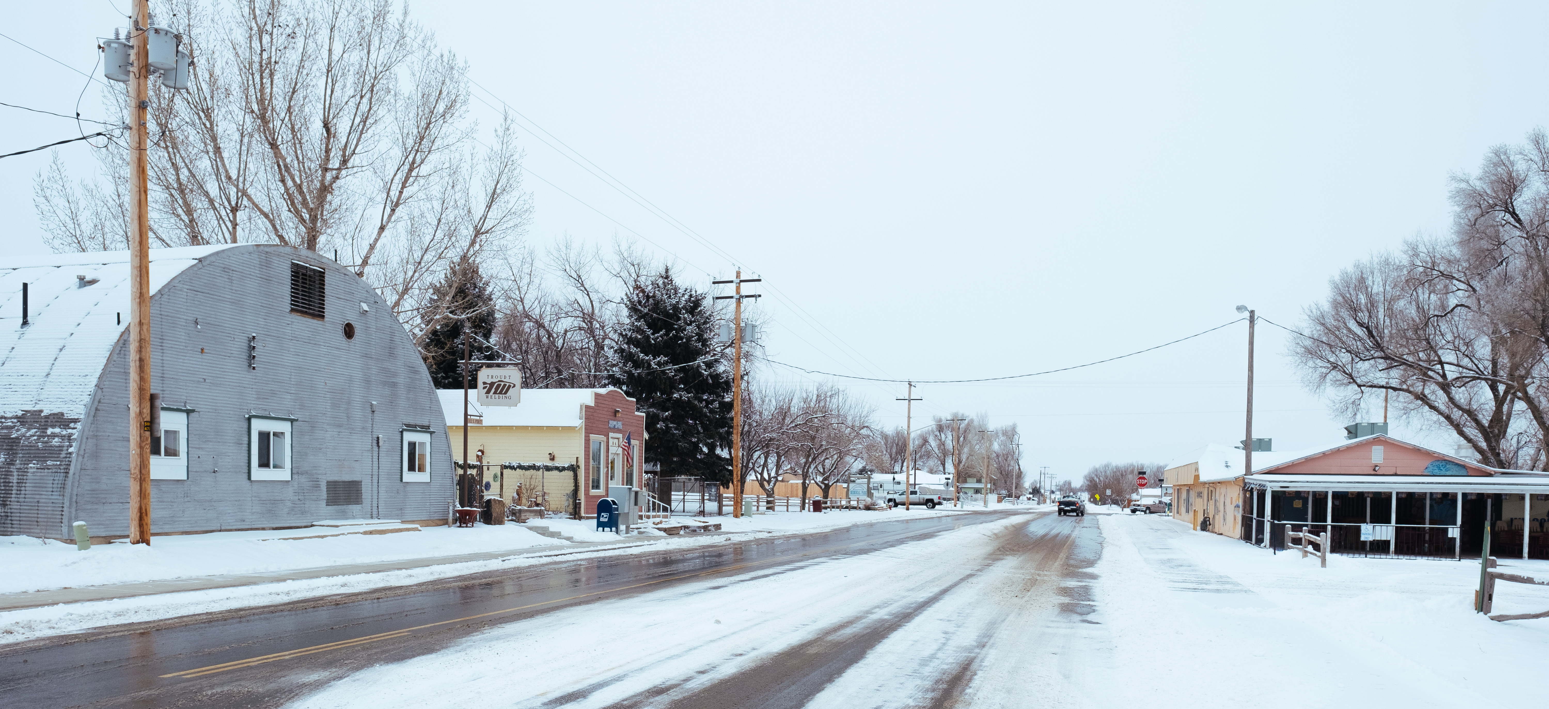
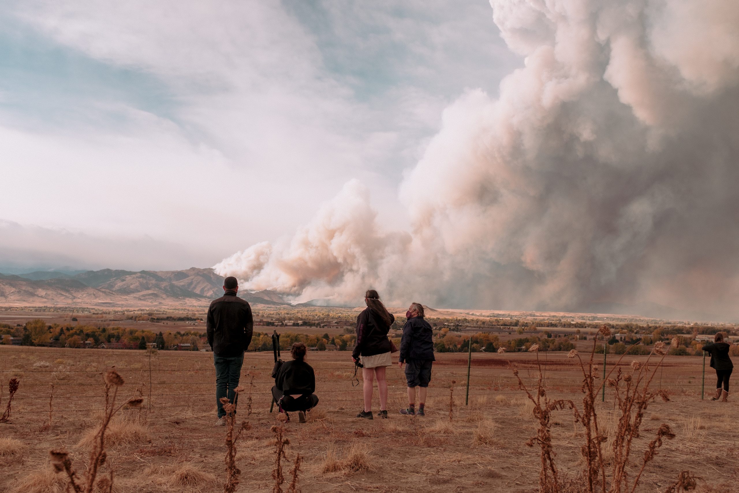
Lawn sizes in Castle Rock are sharply limited to save water, with some homeowners opting to use artificial turf for convenience and to help keep water bills low. Oct. 21, 2020. Credit: Jerd Smith, Fresh Water News
Conservation groups want more “cash for grass” and other plans to acquire new water by saving it. But Denver and Aurora, among others, say there’s only so much to cut before a new dam is needed.
Conservation groups applaud water savings efforts like Aurora’s. What they want is far, far more of the same.
They point to reports required by the state water conservation board showing many large agencies on the Front Range cutting back spending and personnel dedicated to water conservation since 2013, at the same time those water departments press to build massive dam complexes for new water they say they desperately need.
Large water agencies like Denver Water and Aurora Water say they do have ongoing conservation efforts they take seriously, but that fast population growth on the Front Range overwhelms potential savings and they need new water storage…
It would be much better for Colorado’s environment, the conservation groups respond — not to mention cheaper — to acquire water by using less of it, rather than spending billions of dollars on dams and diversions of Western Slope water.
And yet, several projects are on the drawing board:
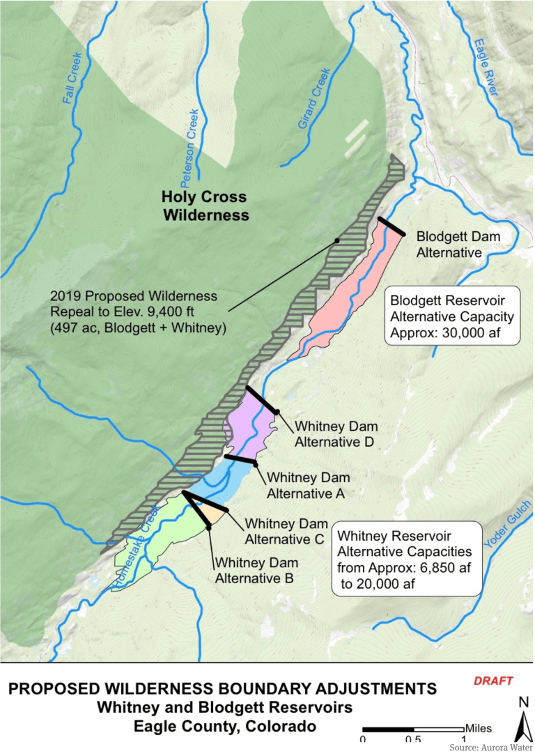
A map prepared by Aurora Water that shows a potential 500-acre adjustment to the Holy Cross Wilderness boundary near the potential Whitney Reservoir on lower Homestake Creek. The map as current as of July 16, 2019.
Aurora wants to team up with Colorado Springs to build Whitney Reservoir and divert more of Homestake Creek over the Continental Divide to the Front Range
Denver Water wants to expand Gross Reservoir above Boulder to hold more Fraser River water diverted from the Colorado River Basin
U.S. Highway 287 runs through the future site of Glade Reservoir. The Larimer county Board of County Commissioners approved the 1041 Land Use Permit for NISP in September, 2020. Photo credit: Northern Water
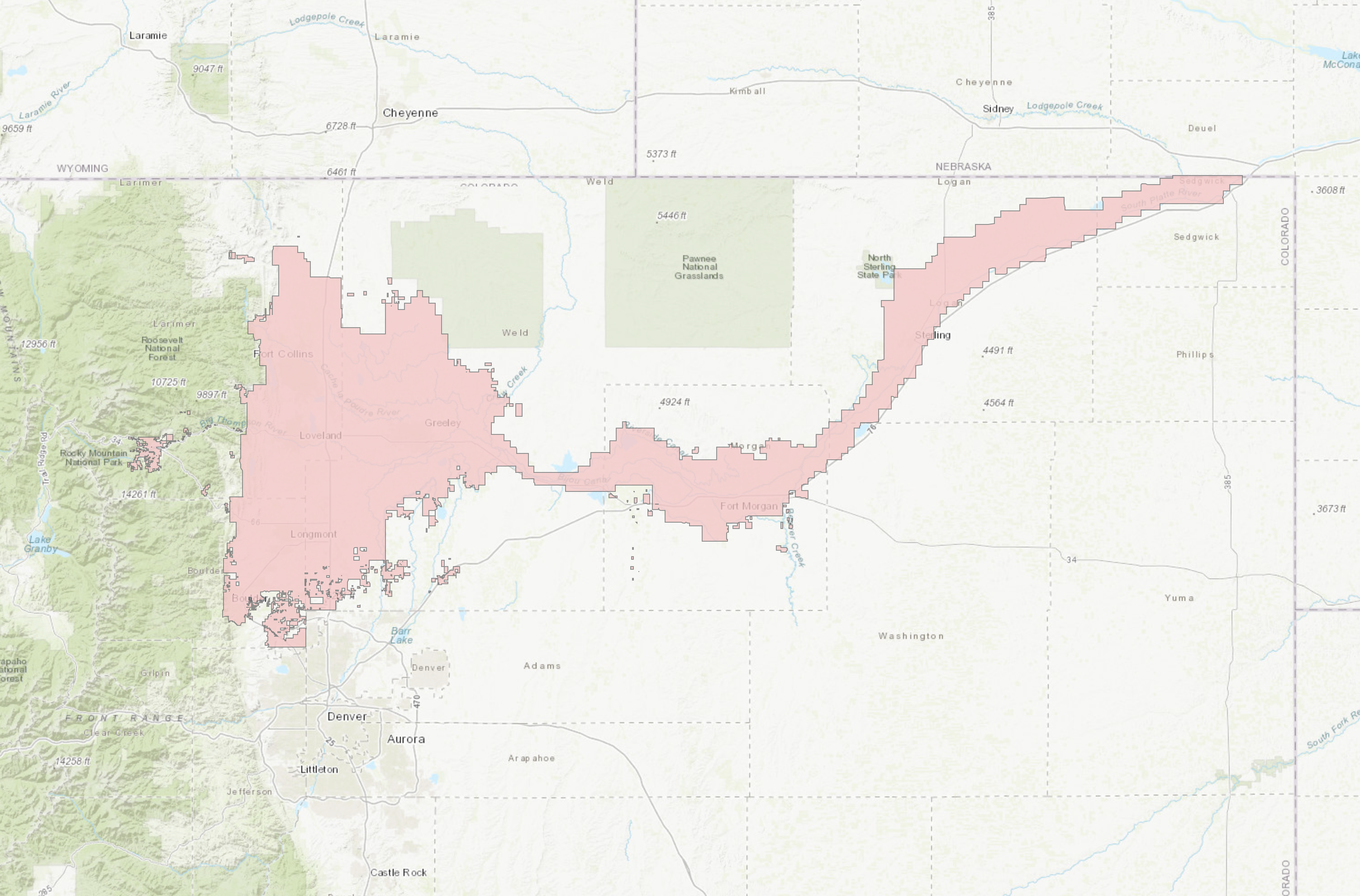
Northern Water has a $1 billion proposal to dam more Cache la Poudre River water for more than a dozen northern suburbs and cities
All of those would be unnecessary, the conservationists say, if the agencies doubled down on water-saving efforts that cut deeply into household use in the years after the devastating 2002 Front Range drought…
“We know that water in the West is increasingly in short supply and will only become more so as climate change results in worsening drought conditions and water shortages. The answer can’t simply be to pull every last drop of water out of our rivers,” said Juli Slivka, policy director at Wilderness Workshop, which is among the groups fighting any new dams on Homestake Creek.
Some of the bigger water agencies on the Front Range respond that conservation remains a primary goal, despite the falloff in their spending evident in annual reports required by the Colorado Water Conservation Board.
Aurora’s population will grow by hundreds of thousands of people by 2050, said Aurora Water spokesman Greg Baker. The agency focuses intensely on conservation to expand its water supply, Baker said, through programs like the smart meters and rebates to property owners who remove thirsty lawns, and with Prairie Waters, the largest potable water recycling system in the state.
But that growth, highly visible on Aurora’s eastern edge at the Highlands or Painted Prairie, means stretching existing water use is not enough for future supply, he added. Acquisition of new water must continue. The agency just spent about $17,000 an acre-foot for 500 acre-feet of farm water in the South Platte River Basin, Baker said.
“That’s more than we could find through conservation right now, unless we took such draconian measures — you know, say we banned all outdoor water use,” he said.
Denver Water, serving 1.5 million customers as the largest water agency in Colorado, said it is proud of conservation efforts launched after the wakeup call of the 2002 drought, achieving its goal of a 22% cut in per capita water use in a campaign from 2007 to 2016. Since then, said Denver Water’s manager of demand planning Greg Fisher, some resources have shifted to the concept of “efficiency” — focusing less on absolute cuts to everyone’s use, and instead consulting with larger customers and homeowners to ensure they are using only the water they actually need…
Denver Water’s officially reported tally of its conservation work fell from 36 full- and part-time staff and a budget of $8 million in 2013 — the first year of required reporting — to five full-time staffers and $1.5 million in spending in 2019, the last full year before the pandemic shut down many field services. Denver’s peak of conservation staffing, at 40 in 2016, was the same year the agency said it achieved the long-set goal of 22% per capita reductions in use.
Denver Water says daily water use fell from 211 gallons per person in 2011, before another severe drought began in 2013, to 165 gallons a day in 2016. Since then, Fisher said daily use has declined to about 140 gallons. In the years since the 2002 drought, Denver Water’s annual overall use has gone down, even as the customer base has climbed by hundreds of thousands.
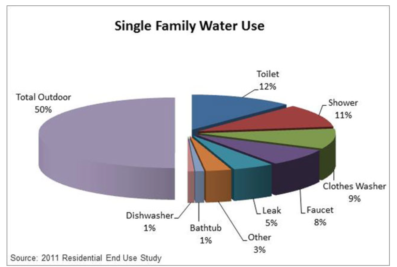
Lawn and plant irrigation still takes up by far the largest part of residential water use on Colorado’s Front Range. (Screen shot, Denver Water website)
The Denver agency says the state conservation reports are partially misleading because they ask for too narrow a classification of spending that ends up cutting water use. For example, Fisher said, Denver Water is spending more money on staff time helping local agencies rewrite green building codes to require more efficient water use…
Aurora’s conservation staffing has changed less dramatically, from 15 full-time and 13 contract positions in 2013, to a total of about 24 positions now, officials said. The emphasis has shifted over the years, Baker said. Most home and building owners have long since swapped out older toilets for efficient models, and individual homeowner irrigation audits are not as productive as broader efficiency programs…
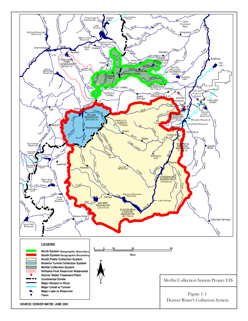
Environmental conservation groups opposed to diverting water from Western Slope rivers are especially focused this year on Boulder County’s Gross Reservoir, where Denver Water wants to raise the dam by 131 feet at a cost of $464 million. A higher dam would allow Denver to bring over more of the water it owns in the Fraser River, part of the Colorado River Basin west of the Continental Divide. Denver also says it needs more water storage on the northern end of the Front Range in case changing climate patterns and wildfire runoff threaten water collection in the southern South Platte River basin, where most of its available water is collected…
Multiple environmental groups have sued to stop Gross Reservoir and sought to scrap it during the local permitting process. Boulder County held the power over a key construction permit Denver Water needs this year. Now Denver Water has asked a federal court to take over jurisdiction for the permit because the agency believes Boulder County Commissioners have already demonstrated their intent to block it…
Aurora Water says it is one of the few Colorado utilities that is doing exactly that [paying cash for grass], with its “water-wise landscape” payments. Aurora will design a homeowner’s low-water garden for free, and pay material costs up to $3,000 for 500 square feet — even more for a zero-water landscape, Baker said…
Denver Water says it offers everything from low-water “garden-in-a-box” kits, to rebates for installing the kind of smart controllers Aurora promotes, to training for landscapers…
Building storage, though, must remain a part of the water acquisition mix, both Denver and Aurora argue. As the system has gotten more efficient through conservation, Denver Water said, possible future gains diminish. In the 2002 drought, Denver said, its short-term restrictions cut water use 30%. After years of conservation work, similar restrictions in the 2013 drought — for a significantly larger customer base — cut water use only 20%.
“We are reaching the edges of supply,” Hartman said.
Settlement involving Windy Gap yields $15 million for science-based work
In the early 1980s, when a dam on the Colorado River near its headwaters was proposed and Andrew Miller was a writer for the Winter Park Manifest, he wrote an editorial called “Requiem for a Cottonwood Grove.”
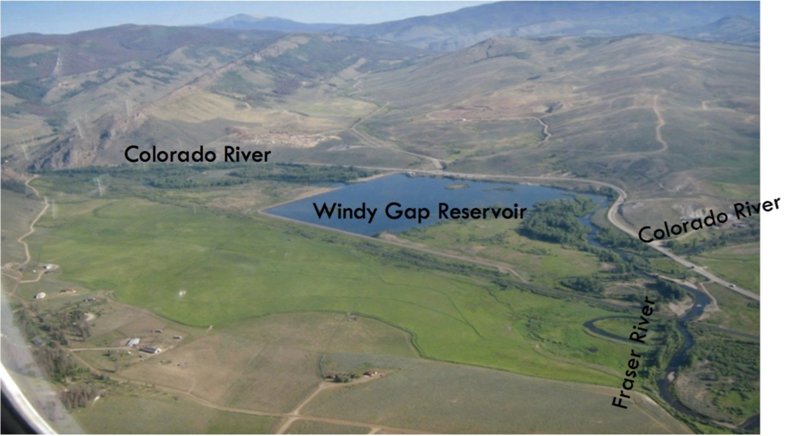
The headline was premature because the dam at Windy Gap, where the Fraser River flows into the Colorado, had not yet been constructed. But it soon was, causing the cottonwood trees to be felled and allowing water from the new reservoir to be pumped uphill to Grand Lake. From there the water flows into diversion under the Continental Divide called the Alva Adams Tunnel to be distributed among cities and some farms in the northern Front Range.
But that story almost 40 years later continues, as news of a settlement suggests. The Grand Foundation will soon receive $15 million remediation for work in Grand County, where the Colorado River originates. The money will be used to try to create strategies for preserving trout and other aquatic life in the warming but ever-more shallow waters.
The big story here is of incremental depletions of the Colorado River at its headwaters by growing Front Range cities now colliding with the impact of the warming climate, hotter and drier. The two, each powerful, leave in doubt how long cold water-loving trout can survive.
“Trout need water temperatures below 70 degrees, and we are regularly bumping up against 70 degrees in our rivers,” says Miller, now a contractor and president of the Upper Colorado River Watershed Group.
The $15 million will come from the municipal subdistrict of the Northern Colorado Water Conservancy District responsible for this incremental diversion. The district built Windy Gap to divert the waters to the northern Front Range. A subsequent project spurred by the distressing drought of 2002 and those of later years yielded an expansion of the diversions at Windy Gap.
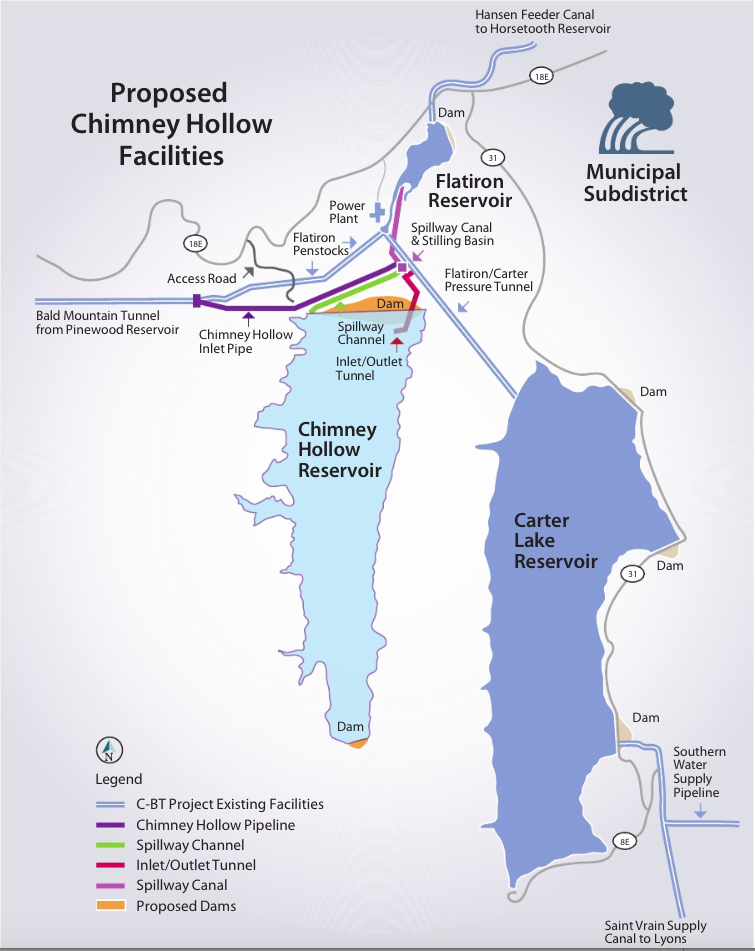
This graphic, provided by Northern Water, depicts Chimney Hollow Reservoir, located southwest of Loveland, after it is built.
The additional water will be stored, in part, at a new reservoir snuggled among the foothills rising from the Great Plain southwest of Loveland. The dam to create that 90,000-acre-foot reservoir, called Chimney Hollow, has not yet been constructed.
The political subdivision responsible for the new diversion consists primarily of towns and cities, from Broomfield, Superior and Fort Lupton on the south to Loveland and Greeley on the north.
Save the Colorado and the Sierra Club, among other groups, in 2017 had sued Northern, arguing that the process used to review the impacts was deficient in failing to adequate address cumulative impacts. In December 2020 a federal court ruled in favor of Northern, but the environmental groups appealed.
In April, a compromise was announced. The environmental groups dropped the lawsuit and Northern agreed to the $15 million settlement in what Northern described as a productive alternative to costly litigation.
The financial documents of the settlement agreement are to be signed by directors of Northern on Aug. 6 and by the Grand Foundation on Aug. 10. Because of delays in signing, Northern will transfer the first payment totaling $5 million immediately after the Grand Foundation signs, says Gary Wockner, of Save the Colorado and an allied group, Save the Poudre.
Administering the $15 million grant will be the Grand Foundation, which is to consist of three members from Miller’s organization, the Upper Colorado River Watershed Group. In addition to Miller, Dave Troutman the treasurer, and Geoff Elliott, the staff scientist, will be on the committee responsible for overseeing allocation of the grant. Northern Water has authority to name the three other members.
“Our charge over the next 10 years is to spend $15 million in ways that improve Grand County’s watershed in a collaborative process,” explained Miller. “In some ways, we are on opposite sides of the fence,” he said, referring to the Northern District’s appointment members. “But in many of the important ways we are on the same side. We both depend upon high-quality water, Northern almost more than us.”
Other measures in the agreement address water quality and provide more water for Western Slope users.
Restoring a river channel in the Upper Colorado Basin
Separately, Northern plans to create a new channel around Windy Gap Dam, to allow the Colorado River to flow without impoundment. The channel is intended to allow fish, macroinvertebrates, nutrients and sediment in the river to bypass the dam and reservoir. The project is called the Colorado River Connectivity Channel. The bypass channel will be the result of a settlement negotiated by Trout Unlimited and others, says Wockner. No draft environmental assessment has been released. “It remains to be seen if the channel will be permitted, funded or built,” he says.
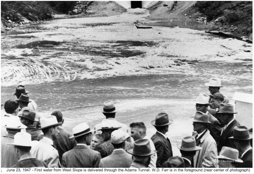
Because of its proximity to the northern Front Range farms and cities and its relative plentitude of water-producing snow, Grand County has been the go-to place for trans-mountain diversions since the late 1880s. The two most significant are those accomplished by the 6.2-mile pioneer bore of the Moffat Tunnel, which allowed diversions from the Winter Park and Fraser area to begin in 1936; and the 13.1-mile Adams Tunnel, which began delivering water to the Estes Park area in 1947.
Miller sees pressing task of the foundation set up to administer the settlement funds will be to lay down a baseline of existing conditions. The existing data, says Miller “really aren’t that good.”
Beyond that, the challenge will be more difficult, perhaps impossible.
“Basically we need to figure out how to run a watershed when we only have 30% of the natural water, which is about all we have left after the diversions by the Front Range.”
In addition to the stepped-up diversions by Northern Water, Denver Water also wants to take additional water through the Moffat Tunnel for impoundment in an expanded Gross Reservoir.
By at least some estimates, 70% of the native water of eastern Grand County currently gets exported to the Front Range. With these new diversions, exports will increase to 80%.
When these incremental diversions were first conceived not quite 20 years ago, the science of global warming was firming up but the effects were not yet evident, at least not like now. Even a decade ago, after significant drought had begun and temperatures had clearly started rising, the big picture was more tentative.
Miller’s group contends no water remains available from the Grand County headwaters of the Colorado River for additional diversion.
“I don’t think anybody realized how persistent this drought would be,” says Miller. “It could be a forever thing. We have created a new climate, and we will never see the rainfalls and snow we have in the past.”
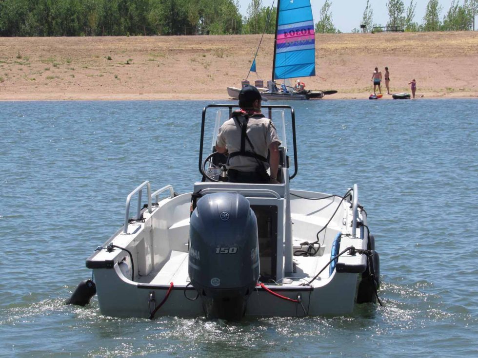
A Colorado Parks and Wildlife officer heads out on patrol at Chatfield Reservoir. A $171 million redesign at the popular lake is now complete, providing more water storage for Front Range cities and farmers. Last week the Colorado Water Conservation Board approved a settlement that will pave the way for an environmental water plan to help offset the impacts of the new storage. Credit: Jerd Smith
Colorado water officials have reached an agreement removing one of the last barriers to a new environmental water program in Chatfield Reservoir.
The agreement settles a dispute among water agencies about who could use storage space in a special environmental pool in the reservoir.
The agreement is one of the final steps in the re-operation of the recreational site just southwest of Denver and comes after years of permitting disputes and lawsuits.
The federally owned reservoir was built in 1967 and was initially designed for flood protection in years when the South Platte River surged beyond its banks.
But as drought and climate change, as well as population growth, increased pressure on urban and agricultural water supplies on the Front Range, federal, state and local agencies began working to convert a portion of Chatfield’s flood storage to municipal and agricultural water storage. The reallocated storage space totals 20,600 acre-feet, of which 2,100 acre-feet is designated as the environmental pool.
The new storage will give south Denver metro area cities such as Highlands Ranch more protection against drought and diminishing groundwater supplies, and will give farmers on the Eastern Plains the ability to use stored water to irrigate crops late in the season when flows in the South Platte River run low. Water from the environmental pool will be used for releases to boost streamflows downstream, improving water quality and providing other environmental and recreational benefits. Downstream irrigators will also benefit from those releases.
The physical work on the re-operation was completed last year after the project won federal approval and a major lawsuit against it failed.
The latest legal dispute stems from a disagreement between Centennial Water and Sanitation District, which serves Highlands Ranch, and the Greeley-based Central Colorado Conservancy District, over whose water rights could be used to fill the environmental storage space and whose space would be filled first.
Centennial’s and Central’s boards must still approve the settlement, according to Lauren Ris, deputy director of the Colorado Water Conservation Board, which negotiated the deal. [Ris also serves on the Board of Trustees for Water Education Colorado, which sponsors Fresh Water News.]
“There was a disagreement among the parties about which water rights could be used,” Ris said, with ultimately the Colorado Water Conservation Board giving up some of its storage space to settle the dispute between the water agencies.
Central officials could not be reached for comment.
Centennial Water Resources Manager Rick McLoud said his agency had spent millions of dollars and more than 20 years to ensure that the new Chatfield plan would serve Highlands Ranch well, and that its ability to store water there would not get bumped too far down the priority list.
“We spent 27 years working to get it and more than $55 million. We did not want to lose out,” McLoud said.
Environmentalists, including the Denver Chapter of the Audubon Society, had long battled the re-operation of the reservoir because it inundated the existing shoreline and resulted in a loss of bird habitat, among other issues.
New habitat has been set aside farther downstream for birds and other species, and water from the environmental pool will help maintain streamflows and habitat as it is released.
Abby Burk, an Audubon Society official, said her group is still deeply worried about the loss of habitat.
But she said the fierce drought and ongoing shortages of water for environmental purposes make the Chatfield habitat water critically important.
“Chatfield was a hard go. We lost some strong riparian areas for birds,” Burk said. “But anytime we can have environmental benefits, particularly in a challenging drought year, we have to go for it.”
Jerd Smith is editor of Fresh Water News. She can be reached at 720-398-6474, via email at jerd@wateredco.org or @jerd_smith.
Denver Water conveying stunningly scenic parcels to Forest Service as part of Gross Reservoir Expansion Project.
It’s been getting crowded on the trails, open spaces and forests along the Front Range, especially since COVID-19 sent lock-down weary residents bursting into the backcountry in an eager search for safe, socially distanced outdoor recreation.
That newfound enthusiasm for backcountry adventure isn’t expected to fade any time soon.
But now, thanks to an agreement between the U.S. Forest Service and Denver Water, explorers will have just a sliver of additional elbow room.
Open meadows and mixed forest are common among the parcels Denver Water is conveying to the U.S. Forest Service. Photo credit: Denver Water.
Denver Water is in the process of conveying 539 acres of wetlands, meadows and forests in Gilpin County to the Forest Service to be managed for public use.
The remote acreage, near the east portal of the Moffat Tunnel, protects ecologically precious lands near two wildly popular wilderness areas (Indian Peaks and James Peak) and the Arapaho and Roosevelt national forests. The land also complements a larger landscape protection effort in the region assembled by The Conservation Fund.
“Denver Water is thrilled to be a part of this landscape preservation effort,” said Jim Lochhead, the utility’s CEO/Manager. “This region near these precious wilderness areas is an environmental gem and one much loved by Coloradans, especially many within our service area.
“Ensuring its permanent protection is an outcome we are proud to be a part of, and we appreciate our partnership with the Forest Service and the Conservation Fund in putting this all together,” he said.
Denver Water agreed to provide the land for its ecological value and public use as part of a sweeping agreement with the Forest Service to offset environmental impacts associated with the expansion of Gross Reservoir to the east of the area.
It’s one of several steps Denver Water has already taken to complete so-called “mitigation” projects years ahead of the expansion work.
Seasonal creeks like this one funnel spring runoff into established waterways and lend the landscape a lush character. Photo credit: Denver Water.
The lands being conveyed are part of what’s known as the Toll Property, the name derived from a ranching family that owned the land for 120 years.
Denver Water’s contribution, scattered across 11 parcels, is part of a much larger agreement, according to reporting in the Boulder Daily Camera. A much larger area of 3,334 acres remains in the Toll family’s private ownership, but with a perpetual conservation easement to prevent development.
An additional 823 acres also were acquired by the Forest Service.
The entire land protection project creates a significant buffer, separating the adjacent James Peak Wilderness to the west from rural development and urban areas to the east, as described in a summary by The Conservation Fund.
These parcels in the Mammoth Gulch area look southwest toward the Continental Divide. Photo credit: Denver Water.
It also helps protect a four-mile stretch of the upper portion of South Boulder Creek, a key part of Denver Water’s supply.
The landscape is familiar not only to backpackers. Train aficionados know the area as part of the route taken by Amtrak’s California Zephyr, between Denver and San Francisco.
Wellington faces a Catch-22, caught between its desire for growth and the water issues that threaten to slow it to a crawl.
The town of about 12,000 has plenty of water — the lifeblood of any community — to serve thousands of new homes. But the cost of water is rising rapidly and the town currently lacks the capacity to store it, treat it or flush it. Both its water and wastewater treatment plants are overextended.
Expansions are underway but still three years away from completion.
It’s not a new problem for Wellington, which earlier this year raised water rates to pay for an expansion of its water and wastewater treatment plants, imposed water restrictions and limited new residential building permits to about 100 per year until the expansions are complete.
The very measures it’s taking to create that infrastructure have raised water rates to the highest in Northern Colorado, which could, in turn, adversely affect growth as builders consider their options.
It’s a fragile balance that’s frustrating residents who are now paying about double what they were two years ago and has the town asking for patience.
Residential water and sewer taps, the largest slice of new development impact fees collected when a building permit is issued, went from $5,500 to $7,500 for a typical home tap and sewer taps increased from $7,500 to $9,700.
Those fees, which also pay for things like parks, streets, water and sewer lines, are typically passed on to the homebuyer or business, which is one reason the cost of homes is going up in Wellington…
Continuing to increase impact fees while at the same time limiting the number of residential permits to stay within treatment capacities “could reach a point where developers or buildings are unwilling to build in Wellington,” the town wrote on its website, “and could result in a slowdown or stop to new development, shifting the cost of paying for improvements onto existing residents…
When treatment plant expansions are done in 2024, they will be able to support Wellington’s expected growth for about 20 years, when the population is expected to double to about 24,000, Town Administrator Patti Garcia said.
Plant expansions won’t bring rate relief, however, she said. Base water rates were raised $31 — to $66 a month — in January to pay the debt service on the water treatment plant. To get the loan, the town had to prove it could pay it back, Garcia said…
For comparison, Fort Collins’ base water rate is $18.30 with a charge of $2.83 per 1,000 gallons of water up to 7,000 gallons. Like Wellington, it has tiered rates that go up the more water used. The charge for water over 13,000 gallons is $3.75 per 1,000 gallons.
That means a Wellington resident using the average 7,000 gallons per month would pay $97.92 per month compared to $38.11 for the same amount of water through Fort Collins Utilities…
It won’t help rates, but finishing the treatment plant expansions should ease water restrictions and lift the moratorium on building permits…
Wellington is served by the North Poudre Irrigation Co., whose share costs have risen 40% since 2018, when the town wrote in its resolution to increase rates. That resolution passed in August 2020. NPIC water currently sells for $200,000 or more per share.
In response to past increases and hedging its bets against future increases, Wellington increased its raw water rates from $19,285.50 to $67,586 for 0.58 acre feet of water — the amount of water it requires for every developed dwelling unit.
“Once we have capacity in the water treatment plant we will be fine,” Garcia said. “We have plenty of water, the issue is having the capacity to provide it, store it, use it and flush it. We’re looking forward to what 2024 can bring.”
Public hearings set for August and September are canceled
Last September (2020), Denver Water submitted an Areas and Activities of State Interest (1041) application to Boulder County Community Planning & Permitting (CPP) for its Gross Reservoir Expansion project.
Since that time, CPP requested additional information from Denver Water. On June 29, 2021, the CPP Director acknowledged Denver Water’s intent to not provide additional requested information, and determined the 1041 review will move to public hearings.
Denver Water filed a lawsuit against the county in July 2021. The lawsuit alleges that the county does not have the authority to regulate the project because the project requires a permit from the Federal Energy Regulatory Commission. Because of the lawsuit, on July 26, Denver Water’s attorney requested that the CPP Director place the 1041 application on hold, and CPP Director Dale Case granted the request the next day, July 27.
Consequently, public hearings that were set for August and September have been canceled.
“It makes sense to have the court resolve the legal issues about whether Boulder County can proceed before conducting hearings on the 1041 review,” said Case. “We have already devoted significant time and resources to processing Denver Water’s application, and it would take even more county resources to proceed with public hearings.”
The Areas and Activities of State Interest (1041) application for the expansion of Gross Reservoir is a request to store an additional 77,000 acre-feet total of water, which includes increasing the dam height by approximately 131 feet, the dam length by approximately 790 feet, and the spillway elevation by approximately 126 feet; quarry operations to obtain aggregate needed for construction; construction of a temporary concrete batch/production plant and an aggregate processing plant; permanent road improvements to Gross Dam Road from State Highway 72 to Gross Reservoir; temporary road improvements to FS359 (Winiger Ridge Road) and FS97 (Lazy Z Road); and the relocation of the Miramonte Multi-Use Trail.
At Hays Market, gallon jugs of drinking water have been flying off the shelves for the better part of two weeks. According to grocery manager Daniel Gehring, the store has gone from ordering several cases of water to palates of it, and not because of the hot weather.
“The town’s water is smelly, funny and has a dirt taste to it, so people are buying the heck out of the gallon water,” Gehring said.
For the grocery store, the business is a plus, but around town, folks like David Salls are concerned. He’s recently turned to filtering all of the water anyone in the family drinks, including his dogs…
Town manager Matt LeCerf says the odor is harmless, and the result of chemical compounds created by algae blooms in the Lone Tree Reservoir, the city’s main water source.
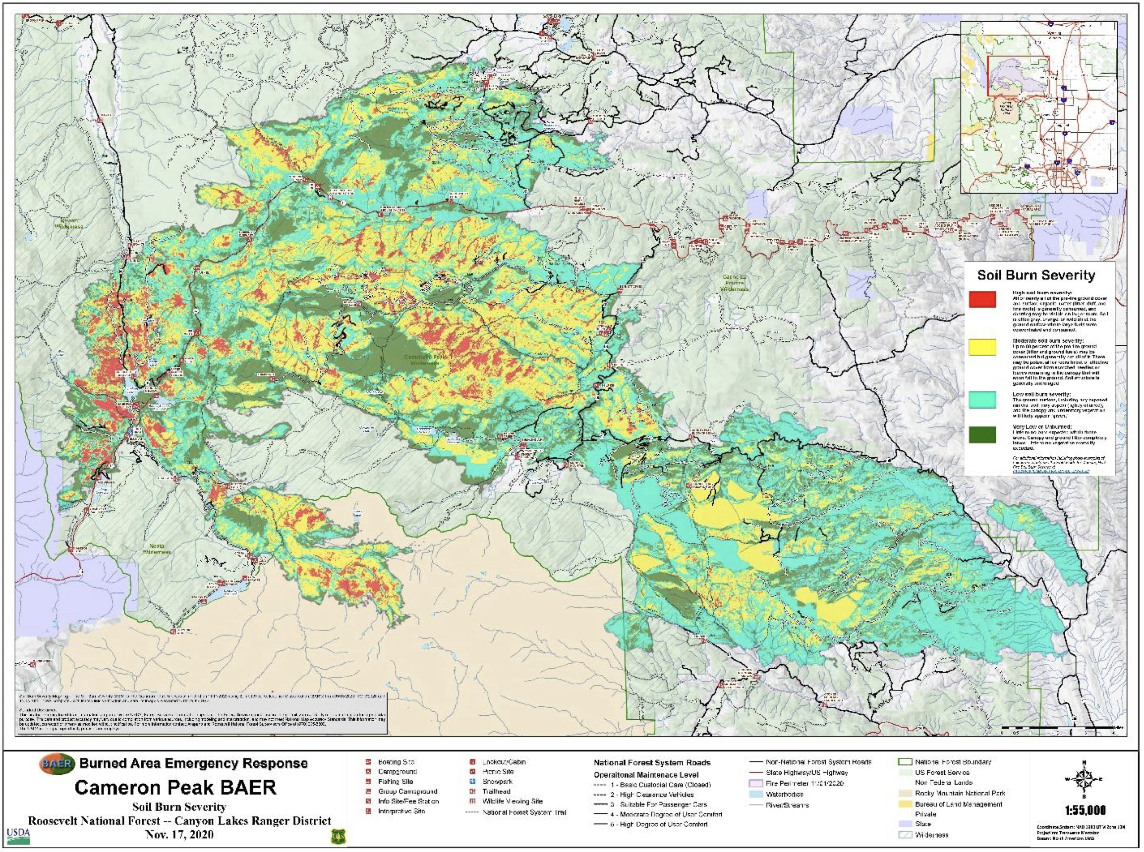
Normally, the water travels into town via a pipeline and drainage ditch, but this year the drainage ditch is not being used because of the nearby Cameron Peak and East Troublesome Fire burn scars…
According to LeCerf, the ditch into town naturally aerates and filters the water more than the pipeline.
“We’re basically in a position where we have to run our water through the reservoirs where we do have that standing water that’s causing some of the taste and odor issues,” LeCerf said.
After hearing similar concerns in the past, the town approved a new $2 million granular activated carbon system earlier this year, which LeCerf said is 90% effective in removing the taste and odor. Construction has been underway for more than two months, and the system is expected to be online Wednesday…
The carbon filtration system isn’t the only improvement in the works for Johnstown. According to LeCerf, the town is also upgrading its water treatment plant and putting special buoys in the reservoir that use ultrasonic wavelengths to help mitigate algae growth.
While Douglas County remains under a drought watch, water officials in Parker and Castle Rock are optimistic about water supplies as the state heads into the hottest part of summer.
Castle Rock Water Director Mark Marlowe said this is the first summer the town is using the reusable water supply. In 2006, the town invested $208 million to build the reusable water facility. Water started pumping into residents’ homes early this year.
Because of the renewable water source, Marlowe said as the high-use water months continue, Plum Creek resources are “holding up well.”
“We have been able to utilize renewable water because the creek is running well,” he said. “Reusable water tends to be more drought resistant, and it does not depend on rainfall. It is water we have already used that will be put back into the system. It is a reliable source, especially during a drought.”
[…]
Ron Redd, district manager for Parker Water & Sanitation District, said water supplies are holding up well, and residents have not even met peak demand as expected this year.
Thanks to a wet spring, Redd said, customers in Parker and Castle Pines have used a lot less water in June and early July this year compared to the same time last year.
With 2020 being so dry, Redd said residents were using about 28 million gallons of water per day. This year, the average use is half that at 14 million gallons.
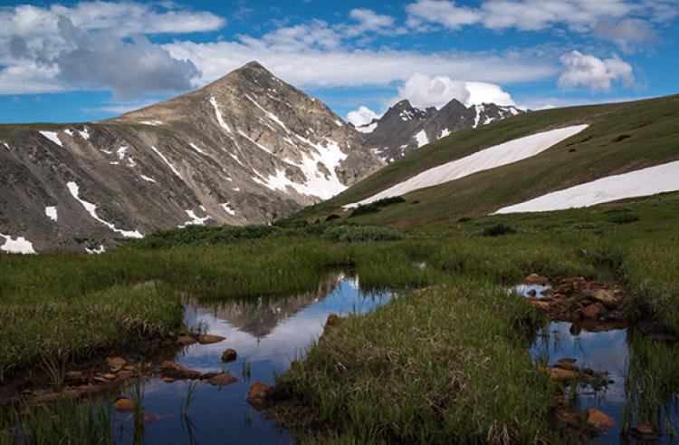
Meadows, forests and mountain ridges create the high alpine landscapes of Niwot Ridge in the Rocky Mountains, 25 miles northwest of Boulder. Forty percent of the City of Boulder’s water is sourced from the Green Lakes Valley within Niwot Ridge. (Credit: William Bowman)
Even in the absence of bark beetle outbreaks and wildfire, trees in Colorado subalpine forests are dying at increasing rates from warmer and drier summer conditions, found recent CU Boulder research.
The study, published in February in the Journal of Ecology, also found that this trend is increasing. In fact, tree mortality in subalpine Colorado forests not affected by fire or bark beetle outbreaks in the last decade has more than tripled since the 1980s.
“We have bark beetle outbreaks and wildfires that cause very obvious mortality of trees in Colorado. But we’re showing that even in the areas that people go hiking in and where the forest looks healthy, mortality is increasing due to heat and dry conditions alone,” said Robert Andrus, lead author of the study and postdoctoral researcher at Washington State University. “It’s an early warning sign of climate change.”
Dead trees in subalpine Colorado forest on Niwot Ridge, west of Boulder. (Credit: Robert Andrus)
These deaths are not only affecting larger trees, thus reducing forests’ carbon storage, but hotter and drier conditions are making it difficult for new trees to take root across the southern Rockies in Colorado, southern Wyoming and northern parts of New Mexico.
It’s well known that rising temperatures and increasing drought are causing tree deaths in forests around the globe. But here in Colorado, researchers found that heat and drought alone are responsible for over 70% of tree deaths in the 13 areas of subalpine forest they measured over the past 37 years. That’s compared with about 23% of tree deaths due to bark beetles and about 5% due to wind damage.
“It was really surprising to see how strong the relationship is between climate and tree mortality, to see that there was a very obvious effect of recent warmer and drier conditions on our subalpine forests,” said Andrus, who conducted this research while completing his graduate degree in physical geography at CU Boulder. “The rate of increasing mortality is alarming.”
With temperatures in Colorado having risen by about 2 degrees Fahrenheit since the 1980s and increasing more quickly at higher elevations, estimates of another possible 2.5 or more degrees of warming in the next few decades due to climate change indicate that the rate of tree deaths will only increase.
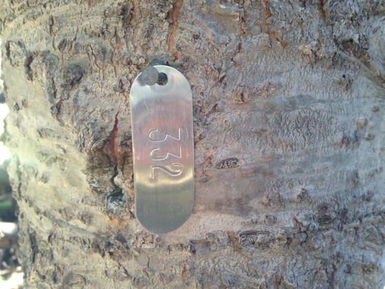
A tagged subalpine fir tree, one of more than 5,000 marked trees monitored as part of this 37-year-long study in the Colorado subalpine forest on Niwot Ridge, west of Boulder. (Credit: Robert Andrus)
Seeing the forest for the trees
Subalpine forests cover over 10,000 square miles in Colorado and are best known by those who ski or recreate in the mountains. Subalpine fir and Engelmann spruce dominate the area above the Peak to Peak Highway in the Front Range, and if you go over any mountain pass in Colorado, you’re going into the subalpine zone, according to Andrus.
Previous research at CU Boulder has shown how wildfire, beetle kill and the two combined can affect the mortality and health of Rocky Mountain subalpine forests. This new research isolated the effects of those two common stressors from those of heat and moisture to find out how much of an effect climate change is having on these tree populations.
“As trees die in increasing numbers due to fire, bark beetles and drought, the warmer and drier climate is making it much less likely that new tree seedlings can establish and replace the dead adult trees,” said Tom Veblen, co-author of the study and professor emeritus of geography.
Launched by Veblen when he arrived on campus in 1982, this is the longest running study of tree mortality in Colorado with measurements made frequently enough to identify the factors causing tree death. Every three years since, graduate students, postdoctoral researchers and undergraduate field assistants have diligently returned to the more than 5,000 marked trees on Niwot Ridge just west of Boulder. In these 13 subalpine forest plots, they recorded that more trees died during summers with higher maximum temperatures and greater moisture deficits.
They found that tree mortality increased from .26% per year during 1982 to 1993, to .82% per year during 2008 to 2019—more than tripling within 40 years.
“It is really challenging because it’s not very visually obvious to the casual observer,” said Andrus. “But the thing to keep in mind is that while warmer, drier conditions are also causing more fire and bark beetle outbreaks, these slow and gradual changes are also important.”
Additional authors on this publication include Rachel Chai of the Veblen Lab at CU Boulder; Brian Harvey, previously a postdoctoral researcher in geography at CU Boulder and now an assistant professor at the University of Washington; and Kyle Rodman, previously a graduate student in the Veblen Lab at CU Boulder and now a postdoctoral researcher at the University of Wisconsin Madison.
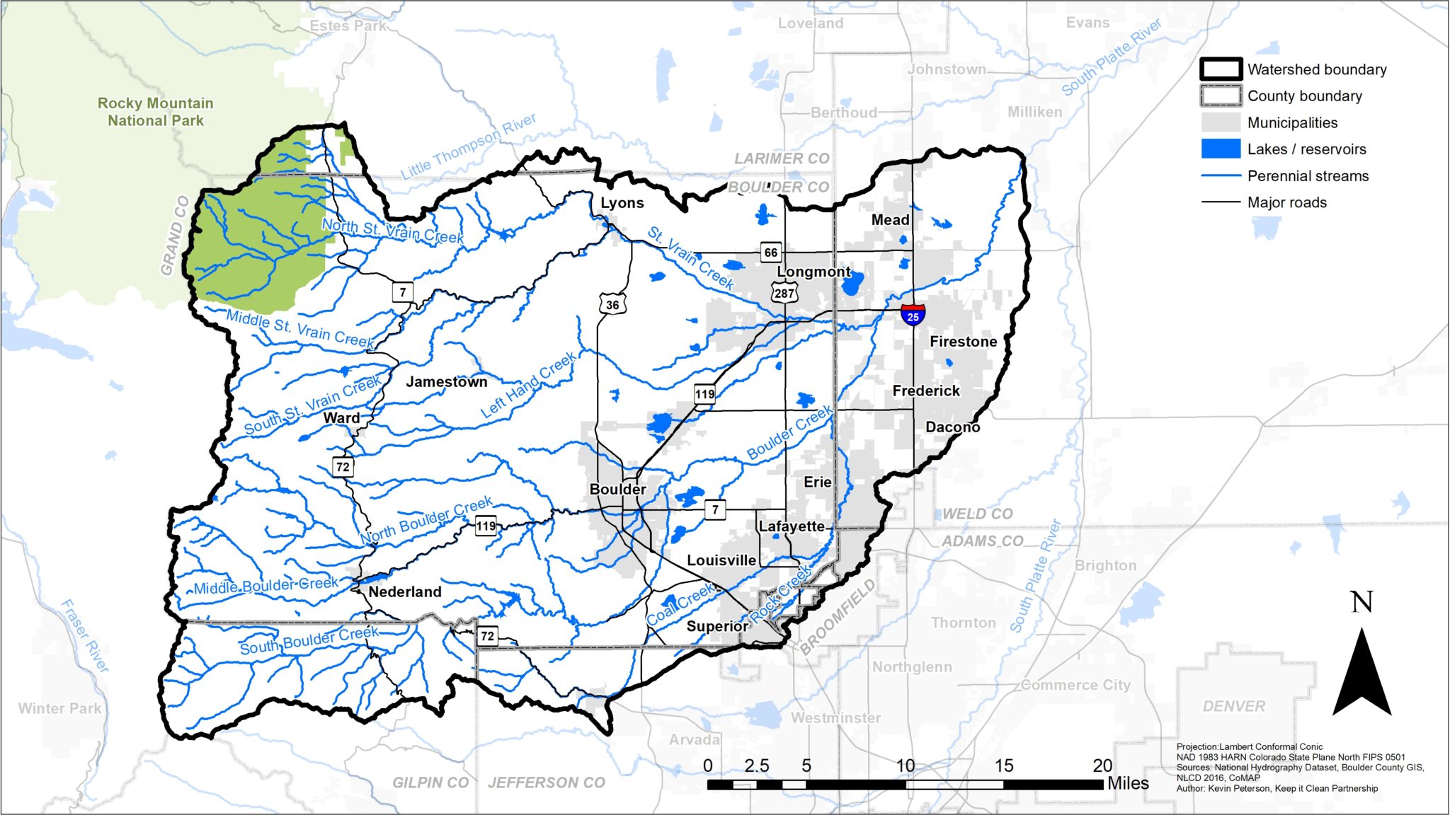
Leaders of the Colorado mountain town Nederland just gave their surrounding 448-square-mile watershed “fundamental and inalienable rights,” like those conferred on people and corporations — bolstering a movement that has gained traction amid concerns nature is suffering.
The Nederland resolution, which passed 5-1 on July 6, also directs town trustees to appoint guardians who can speak for nature in local decision-making the way court-appointed guardians speak for children, dementia-stricken elders and pop star Britney Spears.
Under current U.S. law, forests, mountains and rivers lack legal rights, let alone standing to be represented in court.
Proponents contend subjugating nature as a commodity, used to satisfy human demands, is leading to disaster as the climate warms and they’re pressing for a new paradigm. But federal and state law can preempt local measures, and property rights groups are girding against what they see as an environmentalist grab for moral high ground.
For now, the focus of the nonbinding resolution in Nederland (population 1,600) is simply to spur deeper conversations about effects of population growth and development — and avoid litigation. Upcoming tests include new construction in the Caribou Ridge subdivision on moose and elk habitat, and a proposed new reservoir along Boulder Creek.
Alan Apt. Photo credit: Town of Nederland
“This may become a national movement. We’re at a very early stage, just getting off the ground with this,” said Nederland trustee Alan Apt, a retired publisher and former Fort Collins councilman who led the local effort. “Human needs are important, and we want to make sure we meet the needs of our human population. But we also need to think about the air, water, wildlife, trees – everything that constitutes nature. It’s a survival issue.”
[…]
Multiplying measures
At a time when studies warn of open space disappearing across the United States at the rate of a football field every 30 seconds, elected leaders in recent years have passed rights of nature ordinances in Santa Monica, Calif.; Toledo, Ohio; Grant Township and Tamaqua, Pa.; Mora County, New Mexico; and Orange County, Fla.
The concept has been circulating for decades after emerging a half-century ago in a law professor’s article. The U.S. Supreme Court in 1972 recognized possible rights of nature in a case addressing a proposed ski resort development in a federal forest, with Justice William Douglas declaring in a dissent that “public concern for protecting nature’s ecological equilibrium … should lead to the conferring of standing upon environment objects to sue for their own preservation.”
The United Nations Convention on Biological Diversity, an international treaty, urges leaders worldwide “to consider and recognize when appropriate the rights of nature.” The Yurok tribe in California in 2019 gave rights to the Klamath River, and the Nez Perce did so with the Snake River last year. Nature’s rights are enshrined in Ecuador’s constitution, and Bangladesh in 2019 gave rivers the same legal rights as humans.
Crestone in 2018 became Colorado’s first town to pass general rights of nature legislation, part of a push for official certification as a dark skies community that controls light pollution.
Nederland is the first municipality in the Rocky Mountain West to pass a measure specifically designating a watershed, reflecting water’s essential ecological role and recent river-protection court wins in Colombia and New Zealand based on inherent rights of nature.
Organizations leading the movement — the nonprofit Save the Colorado River in Colorado and California-based Earth Law — say legal rights for nature to exist, flourish and be restored will guide local government decisions, from proposals to build new houses and roads to routing of new pipelines to siphoning of water that humans demand…
Colorado voters’ track record on environment-oriented ballot measures, most recently ordering state officials to reintroduce wolves, has opened this as a possibility for establishing legal rights of nature.
“Young people here in Denver and across the state are talking about it,” GreenLatinos and Sunrise Movement leader Ean Tafoya said. “If corporations have personhood rights, why shouldn’t the natural world?”
Tackling the challenges surrounding climate change and water supply will require collaboration and creative thinking, Colorado’s top water leaders and senior federal officials agreed Thursday.
More than a dozen state officials and water leaders from across the state met at Denver Water’s Operations Complex with Department of the Interior Secretary Deb Haaland to discuss the impacts of climate change, the ongoing drought across the Colorado River Basin and how leadership and collaboration at every level will be needed to help address it.
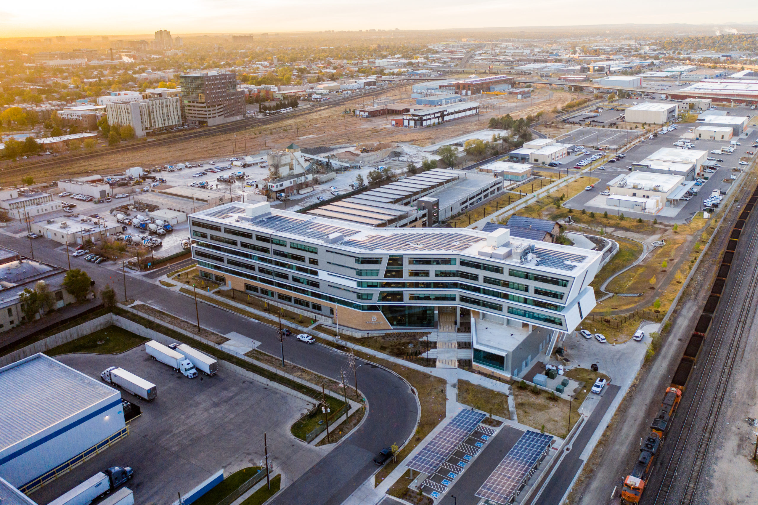
After the discussion, Jim Lochhead, Denver Water’s CEO/Manager, welcomed the group — which included Interior’s Assistant Secretary for Water and Science Tanya Trujillo, Colorado Congresswoman Diana DeGette, Rebecca Mitchell, director of the Colorado Water Conservation Board, and Colorado Commissioner of Agriculture Kate Greenberg — to a news conference at the utility’s Administration Building, completed in 2019, that is itself a demonstration of the future of water and water efficiency in an urban setting.
Graphic via SustainableWater.com.
Lochhead said the roundtable also included a discussion of the investments Denver Water is making in watershed health, through its From Forests to Faucets program that includes partners at the state and federal level, water conservation, resiliency and sustainability.
Haaland said she was glad to tour “this beautiful building” and praised the roundtable for bringing a wide range of people together for a thoughtful and important discussion…
Greenberg said it meant a lot to the people working across Colorado’s agriculture sector to know issues surrounding climate change were “top of mind” at both the state and federal level…
Attendees at the water leaders’ roundtable discussion were:
Deb Haaland, Secretary of the U.S. Department of the Interior.
Tanya Trujillo, Assistant Secretary for Water and Science, U.S. Department of Interior.
Davis Raff, Chief Engineer, U.S. Bureau of Reclamation.
Carly Jerla, Senior Water Resources Program Manager, U.S. Bureau of Reclamation.
Diana DeGette, U.S. Representative for Colorado’s First Congressional District.
Colorado Gov. Jared Polis.
Colorado Lt. Governor Dianne Primavera.
Kate Greenberg, Colorado Commissioner of Agriculture.
Dan Gibbs, Executive Director, Colorado Department of Natural Resources.
Rebecca Mitchell, Director, Colorado Water Conservation Board.
Jim Lochhead, CEO/Manager, Denver Water.
Christine Arbogast, representing Colorado Water Congress.
Peter Fleming, General Counsel, Colorado River Water District.
Jim Broderick, Executive Director, Southeastern Colorado Water Conservation District.
Ken Curtis, General Manager, Dolores Water District Manager (retired).
Steve Wolff, General Manager, Southwest Water Conservation District.
Jennifer Pitt, Colorado River Program Director, National Audubon Society
Diane Carman’s opinion column this morning touches on the cost of moving sustainability and resilience forward in Denver Suburb:
For decades, we’ve heard that a reckoning was coming.
Climate change would threaten our fundamental way of life in the West. After years of neglect, essential parts of our infrastructure would fail. The bills for the costs of maintaining our essential services — kicked willy-nilly down the road to a murky unidentified date in the future — would come due.
We ignored it all, blithely turning up the air conditioning, watering our lawns and tuning out the scientists, the engineers, the city managers.
Now that reckoning has arrived.
If you don’t believe me, just ask the folks in Westminster. They can tell you all about the connections between climate change, infrastructure and money.
Officials from Westminster’s water and sewer departments began warning that the 50-year-old facilities were worn out.
The storage tanks for the city’s water, the pipes and pumps delivering it, and the sewage treatment systems were shot. Concrete was flaking away, pipes deteriorating, pumps becoming unreliable.
The city council looked at the mountain of evidence and made the only responsible choice: it voted to upgrade the system.
To pay for it, the council also voted to raise the rates for water and sewer customers and, since the cost of the projects was estimated in the tens of millions, the increased fees were significant, especially for high users.
When the summer of 2020 came and the thermometer hit 90 or above for a record-setting 75 days, the good folks of Westminster sprinkled their lawns like they always had (maybe not blithely but still …) and the resulting water bills blew their minds.
Still in deep denial of reality, a group of Westminster activists mobilized as Water Warriors to recall several city council members for their failure to kick the problems down the road once more.
The effort was an expensive bust, with the recall of only one council member, Jon Voelz, making it onto the ballot, only to fail spectacularly in the special election last week.
But this war is far from over.
Several Westminster council members will face re-election in November and surely water rates will be an issue. Those who routinely flood their lawns with 20,000 gallons or more each month and pay the highest rates are not about to give up the fight for their right to Kentucky Bluegrass — drought and system failures be damned.
But Westminster is hardly unique. In fact, it’s really Everytown, USA. Its water war is a mere skirmish in the seething national debate about how to face the reckoning now upon us.
The facts are indisputable.
After years of drought in the West, reservoirs, water tables and rivers are at historic lows.
California is forced to forced to choose between leaving enough water in the streams so that salmon can survive and drawing enough to grow crops. Ranchers across the West are reducing their stocks as it becomes more apparent that they won’t be able to feed them. Customers who rely on hydroelectric power face shortages as water levels drop and heat waves stretch even into Canada. Fishermen have been asked to abide by a voluntary ban on angling in the mighty Colorado River.
At the same time, critical infrastructure from bridges and highways to the antiquated electric grid have been left to degrade for most of a century, risking public health and safety for lack of political will.
The backlog of delayed infrastructure projects in Colorado alone is huge: $10 billion for safe drinking water, $9 billion for transportation, $4 billion for wastewater systems … the list goes on.
But while nobody would say the Westminster water wars have been easy (or cheap), the outcome so far is cause for mild optimism.
Mayor Anita Seitz has listened to constituents’ concerns both about the condition of the water system and the painful rate increases and has chosen not to duck the issue for mere political expedience. Instead, she and other council members are working to help the community understand the problem and what the future holds.
Acres of green lawns, long a symbol of abundance, now represent reckless profligacy. Failure to address the crumbling infrastructure can only bring more serious and expensive problems down the road. An unwillingness to fix the problems now will only cost the community more in the future.
“Every single member of council swears an oath to our charter. And our charter dictates that we need to set rates of our utility to meet the operating needs of that utility,” Seitz said. There’s not much “wiggle room.”
She’s right. Whatever wiggle room we had to address climate change and meet our infrastructure needs is long gone.
In this summer of heat domes, wildfires, droughts, floods and structural failures, that message should be loud, clear and irrefutable.
Take it from the folks in Westminster, it’s time for action.
High up on Colorado’s Independence Pass, a narrow, winding road weaves through the evergreens and across mountain streams, up and over the Continental Divide at more than 10,000 feet. At one point that road crosses a canal.
It’s easy to miss if you’re not looking for it, but that canal is part of water infrastructure that makes life on Colorado’s Front Range possible.
The state has a geographical mismatch between where water shows up and where much of the population has settled.
“Wherever you are in this state, you’re either at the source of the drinking water supply, you’re in the middle of the drinking water supply, or you’re at the end of the tap,” said Christina Medved, outreach director at Roaring Fork Conservancy. “So on the Western slope, we are at the source of the water.”
About 80% of Colorado’s water falls on the western side of the state. Much of it is high-mountain snow and rain that eventually trickles down into streams and rivers like the ones on Independence Pass.
But about 80% of Colorado’s people live on the east side of the mountains. Because of gravity, that water doesn’t flow to them naturally. Instead, Colorado’s heavily-populated Front Range relies on a massive plumbing system to keep drinking water flowing to its taps.
Colorado transmountain diversions via the State Engineer’s office
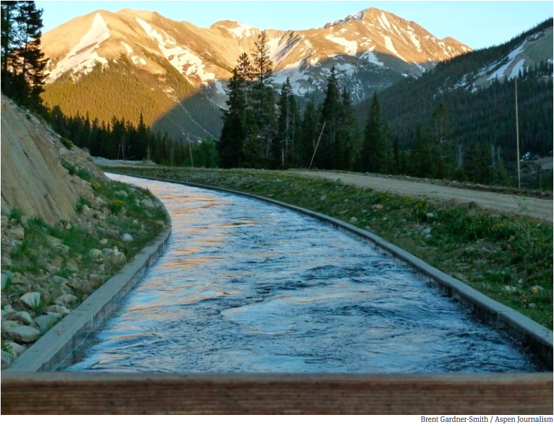
For a century and a half, engineers have carved up the mountains with tunnels and canals that pipe water across the state through trans-mountain diversions. Some of that infrastructure is nestled near the high-alpine headwaters of the Roaring Fork River, which eventually flows through Aspen and Glenwood Springs on its way to the Colorado River. Near Lost Man reservoir, a dam and tunnel create a juncture between water that will follow that natural path westward to the Colorado, and water that will be diverted eastward through the mountains and onto cities such as Colorado Springs.
A tunnel through the mountains draws in water that will pass through two reservoirs and the Arkansas River on its way to the southern portion of the Front Range. Water diverted from the Colorado River basin, through trans-mountain diversions, makes up 60 to 70% of the water used by Colorado Springs. Denver, Greeley, Fort Collins and smaller municipalities on the Front Range also rely heavily on Western Slope water.
And these kinds of set ups aren’t confined to Colorado. Similar systems bring water to big cities all across the region. Salt Lake City, Albuquerque and Los Angeles rely on canals and tunnels to ship faraway water into their pipes. New ones are in the works on the Front Range and in southern Utah.
But these systems aren’t without critics.
Water from the Roaring Fork River basin heading east out of the end of the Twin Lakes Tunnel (June 2016), which is operated by the Twin Lakes Reservoir and Canal Co., a member of the Front Range Water Council. Photo: Brent Gardner-Smith/Aspen Journalism
“When you first learn about it, the concept of a trans-mountain diversion is crazy,” said Andy Mueller, general manager of the Colorado River Water Conservation District. “It seems wrong. It seems antithetical to the health of the river. And I have to say all of that’s true.”
His organization was set up in the 1930s to oppose these diversions and ensure that there is enough water for people on the Western side of the state…
The issue is, contemporary environmental values aren’t written into the West’s water law. Instead, water use is defined by regulations written when Colorado first became a state in the 1800s. The rules say that if you have rights to use water, it doesn’t matter if you want to use it hundreds of miles away from its source – even if that requires miles of cross-mountain plumbing to do so.
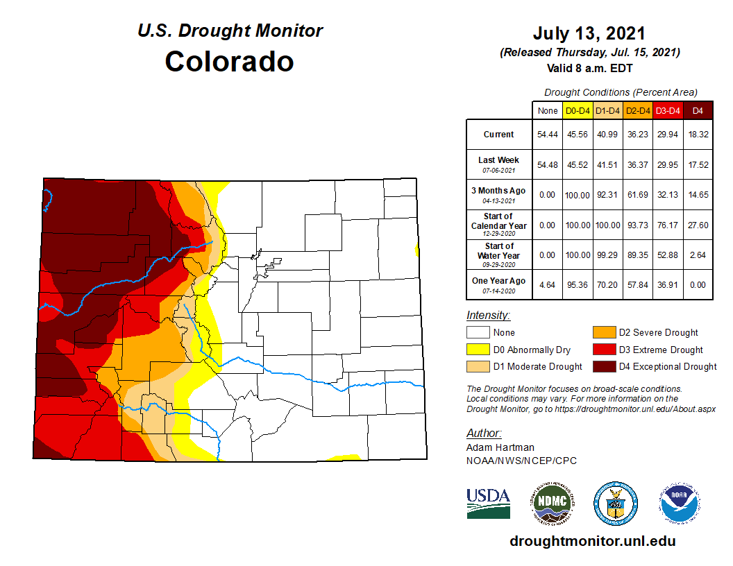
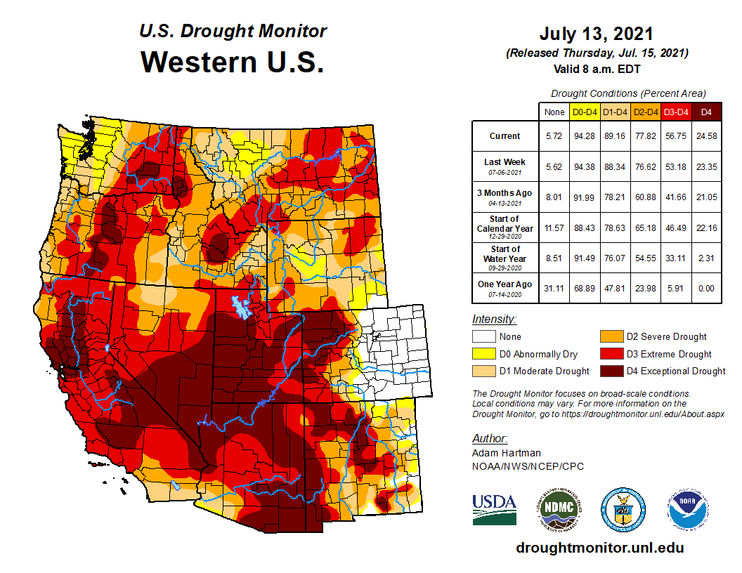
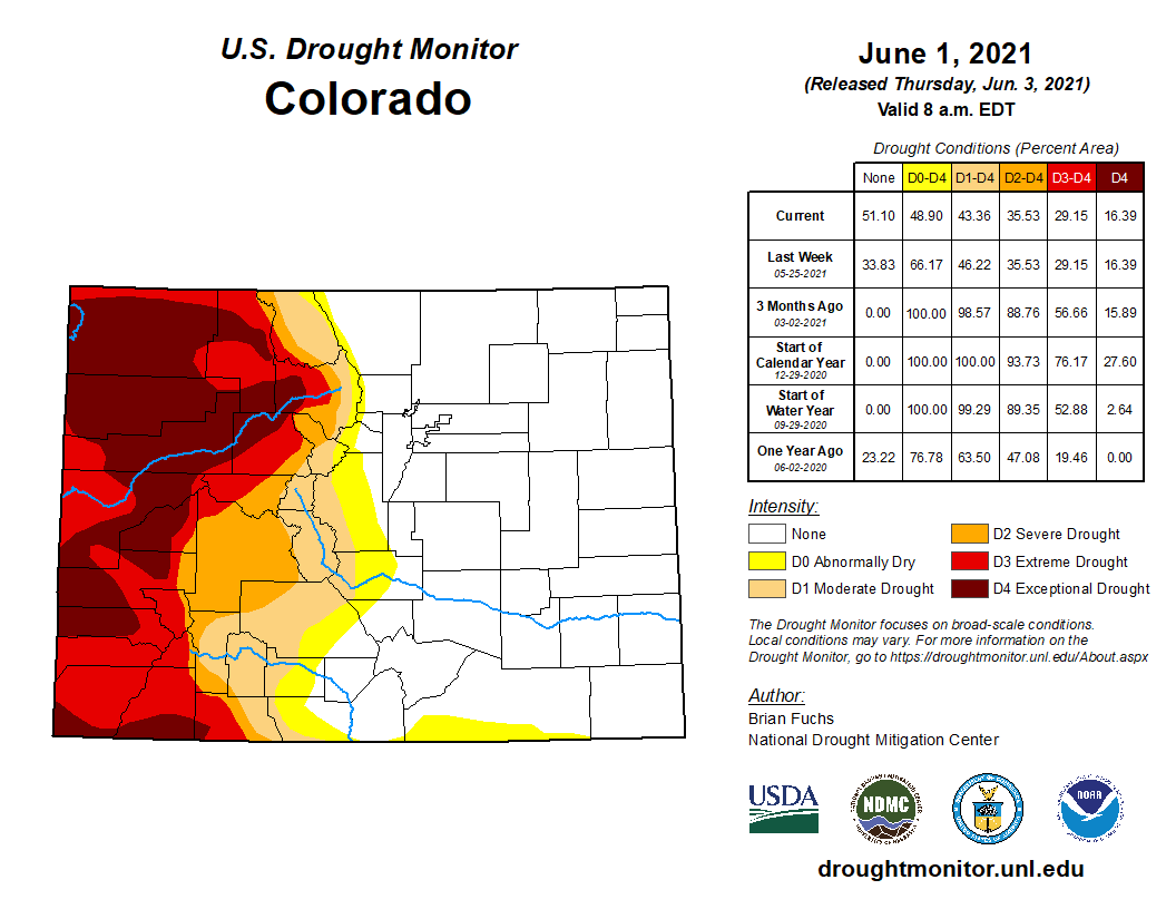
Colorado Drought Monitor map July 13, 2021.
At this moment, there is less water to pull from in every part of the state. The Front Range escaped from drought after steady spring rains, but those high-mountain areas that usually provide a dependable source of water for all of Colorado are experiencing a different fate. The western slope is deep in the second year of drought conditions, leaving snowpack and river flows lower than they should be.
Mueller thinks that only sharpens the need for the Front Range to curtail its water use. Although they retain the legal right to use a certain amount of water, he’s asking them to use less – which he says will promote the health of rivers and their ecosystems west of the divide.
The ditch that moves water from Lost Man Reservoir to Grizzly Reservoir and then under the Divide to the South Fork of Lake Creek and the Arkansas River.
On the Front Range, those on the receiving end of diversions say they are listening to their western counterparts when they put up distress signals during particularly critical times. They also say deliberate conservation work is paying off in the longer term. Nathan Elder, water supply manager for Denver Water, said over the past two decades, per capita water use in his district is down by 22%.
“Everyone in Colorado needs to decrease their use,” he said…
Amid tension between demands for water on both sides, exacerbated by extreme drought conditions, is the fact that there is not much of an alternative. Colorado’s water system is built to accommodate the fact that the majority of its people and the majority of its water are far from each other. Without fundamental changes to the bedrock of water law, those asking for water will have to work within a system built on trans-mountain diversions…
Some contingency planning – within the reality of a diversion-centric system – is already in place. In Colorado Springs, which receives some of the flow diverted from the top of Independence Pass, re-use practices are helping the city get more mileage out of the water it’s apportioned.
Graphic credit: Water Education Colorado
Abby Ortega, water resources manager for Colorado Springs Utilities, said reused water accounts for 26% of the city’s total portfolio and the city relies heavily on storage to get through dry years like this one.
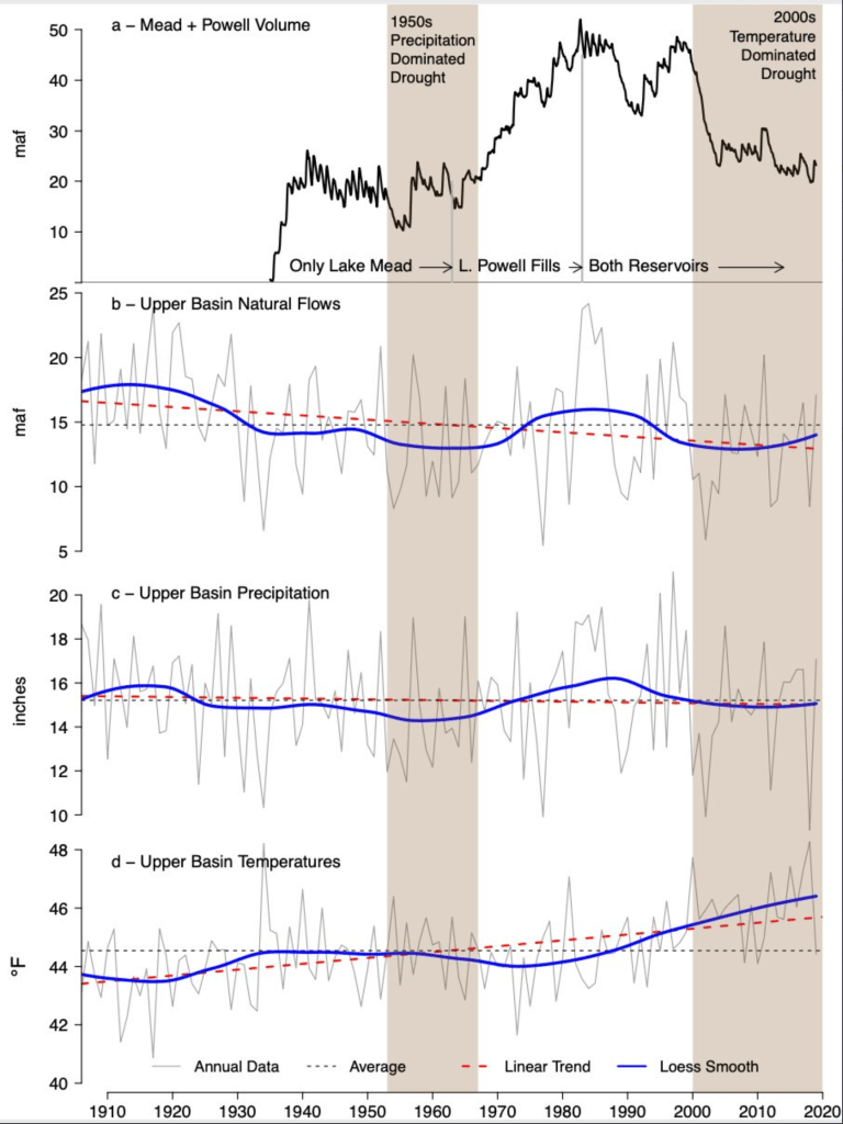
Brad Udall: Here’s the latest version of my 4-Panel plot thru Water Year (Oct-Sep) of 2019 of the #coriver big reservoirs, natural flows, precipitation, and temperature. Data goes back or 1906 (or 1935 for reservoirs.) This updates previous work with @GreatLakesPeck
But climate change threatens to increase the frequency and intensity of droughts, which has water managers on edge and looking more intently at ways to maximize what’s available.
“Every water planner in the state has some worry with the rapidly declining hydrology on the Colorado river,” Ortega said.
Since mid-May, Woodland Park residents and businesses have confronted Level 2 water restrictions conditions, which can affect their daily and weekly watering habits.
Property owners can only water their lawns so often, and the restrictions impact big commercial users, like the Shining Mountain golf course in Woodland Park. Area linksters will be forced to abide by cart-path-only rules for some time due to the lingering drought and because of the city’s limited availability of H2O…
With all the recent rainfall, locals may be wondering why these restrictions are still in place. The story is complicated, as much of the city’s water supply depends on sources some 200 miles away.
According to drought.gov website, in collaboration with The National Oceanic and Atmospheric Administration, (NOAH) and National Integrated Drought Information System, (NIDIS), no one in Teller are affected by drought at this time. Drought.gov states that May of 2021 was the 24th wettest period in 127 years, at 1.52 inches above normal for Teller County.
However, drought.gov also states that 36.4-percent of Colorado is under a “severe drought” and 30-percent of the state is under “extreme drought” conditions. The western slope of Colorado is where the majority of these “severe” and “extreme” drought conditions exist. The western slope headwater drainages are the major source of the city’s augmentation water.
As a result of the drought conditions on the western slope, On July 1, a declaration of a drought emergency for Western Colorado by Gov. Jared Polis opened up federal and state dollars to help those most affected by the lack of moisture. As of July 1, the US Drought Monitor lists 18 counties as being in extreme or exceptional drought.
Drought conditions are so bad on the Colorado river, that water storage in Lake Mead is at historic lows. Lake Mead, the largest US reservoir, and fed by the Colorado River — fell below the elevation of 1,075 feet. It has hit that mark only a handful of times since the Hoover Dam was finished in the 1930s, but it always recovered shortly after. It may not this time, at least not anytime soon…
Lake Mead is currently 16 feet below where it was this time last year and the reservoir is only 37-percent full.
The second largest reservoir in the Colorado river basin, Lake Powell, is not faring any better.
Lake Powell is down 35 feet from last year and sits at just 34-percent of the lake’s total capacity…
According to Wiley, “The amount of water in a share varies according to the source. Our shares never get cut off. We always own those shares. It’s the production of those shares (amount per share). The production is controlled by the amount of precipitation and snowpack and then how water rights are allocated. The only thing that happens is in a dry year the yield (amount) is less on those shares.”
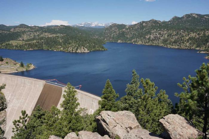
Denver Water is planning to expand Gross Reservoir in Boulder County. The additional storage capacity will create more balance in the utility’s storage and give water planners more flexibility in their operational strategy. Photo credit: Denver Water.
Denver Water today [July 14, 2021] filed a lawsuit in U.S. District Court against Boulder County, asserting the county is overreaching its authority and jeopardizing a federally ordered reservoir expansion critical to a safe and secure water supply for one quarter of the state’s population while risking long-planned benefits for the West Slope environment.
BACKGROUND
For nearly two decades, Denver Water has conducted an exhaustive and comprehensive planning and permitting process at the direction and oversight of six federal and state regulatory agencies. That process culminated last year in a final order to commence expansion of Gross Reservoir from the Federal Energy Regulatory Commission, which has final authority over the expansion project because Gross Reservoir occupies federal lands specifically designated for hydropower production.
For years, Denver Water has also attempted good faith efforts to work with Boulder County to secure county permits, including through two attempts at an intergovernmental agreement, robust engagement with county staff and neighbors, and participation in a local land-use review known as the “1041 process.” Unfortunately, Boulder County has been unreceptive and is using the 1041 process to frustrate the project, extending and delaying its review to the point that it is now placing the entire project at risk.
DENVER WATER STATEMENT ON NEED FOR THE PROJECT
It is hard to overstate the importance of the expansion of Gross Reservoir to the future of the Denver region. It will offer crucial protection to the utility’s water supplies from the urgent threat of catastrophic wildfire and prolonged drought — the same forces that nearly 20 years ago combined to threaten Denver Water’s ability to ensure drinking water to its customers.
This risk to clean water supplies is even higher today, in an era of rapid climate change and increasing periods of extreme weather. Last year’s record wildfire fire season, which generated the three largest forest fires in Colorado history, only just missed triggering major impacts to Denver Water’s supplies. Water providers to the north haven’t been as lucky, unable to treat some supplies running black and brown with ash produced by the Cameron Peak fire. Denver Water must act now to mitigate these risks.
The Gross Reservoir expansion conforms in every way to benchmarks in Colorado’s Water Plan, a plan developed through statewide and bottom-up guidance from eight major river basins over two years and published in 2015. That plan calls for increasing the capacity of existing reservoirs as a key element in creating 400,000 acre-feet of additional storage in the state by 2050.
The State of Colorado, in comments to the U.S. Army Corps of Engineers, expressed its support for the Gross Reservoir expansion and has identified it specifically as fitting within the kind of project defined as necessary in Colorado’s Water Plan: “A significant portion of Colorado’s future needs will be met with the implementation of projects and planning processes that the local water providers are currently pursuing, including the Moffat Collection System Project” (aka Gross Reservoir expansion).
The reservoir expansion also addresses the significant need for additional supplies in the metro region, as referenced in the Water Plan’s 2019 technical update. That update projected metro Denver demand will increase by 134,000 acre-feet to 280,000 acre-feet by 2050 against a 2015 baseline and the area likely will experience a supply shortfall, even accounting for the Gross Reservoir expansion and other water projects, a drop in per-capita use, and further conservation and reuse.
DENVER WATER STATEMENT ON DEVELOPMENT OF THE PROJECT
Denver Water’s diligent and earnest work to build partnerships across the Continental Divide, conduct significant and ongoing environmental mitigation for the project and work closely with regulators since the early 2000s has earned the project the support of major environmental groups, Grand County and each of the last five governors of Colorado. The Colorado Department of Public Health and Environment concluded the project would result in net water quality improvement on both sides of the Continental Divide.
The dam, when built in the 1950s, was designed to be raised. In the 1980s, amid discussion of the Two Forks project southwest of Denver (later vetoed by the EPA) a coalition of environmental groups recommended the expansion of Gross Reservoir as a viable, environmentally stable project. “We feel that additional capacity at Gross Reservoir is an environmentally acceptable and cost-effective way of increasing the overall yield of the system,” the coalition wrote. It included representatives of the Sierra Club, the Environmental Defense Fund and Trout Unlimited, among several other groups.
Denver Water also worked industriously with local governments and citizen groups on the West Slope to address the impacts that putting more water in an expanded Gross Reservoir would have on streams in Grand County. Those talks, often intense, and spanning half a decade, resulted in the Colorado River Cooperative Agreement in 2013, an unprecedented cooperative effort involving 18 signatories and 40 partner organizations that began a new era of collaboration and conflict-resolution between Denver Water and the West Slope.
Expanding Gross Reservoir locks in a key component to that agreement: Denver Water would place a geographic limit on its service area, putting to rest fears the utility would continue to expand its reach to an ever-sprawling suburban ring. The utility also agreed to several measures that would provide more water to West Slope rivers, towns and ski areas and invest in improvements to aquatic habitat. The landmark concord also affirmed that with the Gross Reservoir expansion, Denver Water would benefit from more flexibility in its system, and it would use that flexibility to address stream flow and stream temperature concerns more nimbly and readily in Grand County.
Additionally, Denver Water worked with the cities of Boulder and Lafayette to establish an environmental pool in Gross Reservoir to provide additional water in South Boulder Creek during low-flow periods. Water in that pool would also supplement supplies for those two cities. Many of these commitments, however, depend on the project going forward and are therefore in jeopardy through Boulder County’s actions.
As planning for the expansion moved ahead, the utility undertook a proactive strategy to reduce demand. It deployed a water recycling facility to reduce its dependence on West Slope water supplies, embarked on a conservation program renown nationally for its success — cutting per capita water use by 22% between 2007 and 2016 — and has now undertaken direct efforts at water efficiency that pinpoint savings opportunities at the individual customer level. These are only a sample: The utility remains committed to innovation to drive further savings and expand water reuse as a core part of its strategy, work that will continue to be essential even with an increase in storage at Gross Reservoir.
In short, the effort to build civic and regulatory support for the Gross Reservoir expansion has been persistent, inspired and earnest. The future of the region, its access to clean, safe drinking water, protection of its urban tree canopy and environment, and its economic development rest in large part on the ability of Denver Water to protect water supplies from emerging threats, develop a climate-resilient system and remain prepared for the demands that will result from continued growth within its service area in metro Denver.
DENVER WATER STATEMENT ON BOULDER COUNTY’S PROCESS
Boulder County is endangering the project through delays, repeated and expanding requests for information — information demands that duplicate the already completed federal permitting process in which Boulder County participated — the potential for months of additional hearings and the fact that two of the county’s three commissioners have already publicly stated their opposition to, and desire to stop, the expansion project.
Further, the county’s land use director informed Denver Water on June 29 that the utility — despite over nine months of diligent and painstaking work to respond to Boulder County’s ever-expanding queries — failed to provide sufficient information to county agencies about the project, setting the project up for failure and rendering further involvement with the 1041 process futile.
These actions also put engineering and construction deadlines at risk, threaten to disrupt FERC-ordered timelines and risk other permits and actions necessary for successful completion of the project. A project of this size and complexity requires extensive preplanning, substantial resources and a highly skilled design and construction team. Delays resulting from Boulder County’s refusal to timely process the 1041 application add substantial costs and cause permitting, procurement and logistical issues that seriously disrupt Denver Water’s ability to execute the project.
In summary, the actions of a single local jurisdiction, Boulder County, threaten to derail and undermine a federally permitted and state supported project vital to a safe and secure water supply for one-quarter of Colorado’s population. This presents an unacceptable risk to a critical project spanning nearly 20 years and involving intensive review by environmental agencies at the federal and state levels and the engagement of dozens of organizations and communities across the metro area and the West Slope.
For that reason, Denver Water must seek relief in federal court. The complaint further details Denver Water’s attempts to work with Boulder County, the reasons that federal law preempts Boulder County’s claimed authority over the FERC-licensed expansion project, and the basis for Denver Water’s request that the court prevent Boulder County from further delaying and derailing the project.
It’s going to be difficult for legislators to strengthen Colorado’s already strong water anti-speculation laws, but that’s what a study group is looking at.
Joe Frank, manager of the Lower South Platte Water Conservancy District, told his board’s executive committee Tuesday it will be tough for the study group to come up with viable recommendations to the legislature.
The study group was authorized by Senate Bill 20-048 during the 2020 legislative session. The bill “requires the executive director of the department of natural resources to convene a work group to explore ways to strengthen current anti-speculation law and to report to the water resources review committee by August 15, 2021, regarding any recommended changes.”
Frank said the 18-member working group, which has been meeting since November 2020, is “a pretty diverse group,” and that has caused some concerns about the viability of recommendations that it may propose.
“The hard part, in my mind, is how you distinguish between traditional speculation and investment speculation, and how you protect people’s property rights,” Frank said. “How do you tell a landowner who he can and can’t sell his property to? (Some states have) laws about selling (farmland) to people outside the state, but I’ve talked to some (Colorado) tenants whose out-of-state landowners are really good landlords.”
Water speculation is generally thought of as buying water rights without having an immediate beneficial use for the water, hoping to later sell the water for a profit. The concern is that agricultural water would be taken off the land and sold out-of-state. Current water law requires that anyone buying water shares or buying ag land with a water right must have an immediate beneficial use for the water.
That has led to the practice “buy and dry,” in which cities and utilities buy agricultural land and use the water for their own purposes. One example is when Sterling purchased the Scalva Bros. farm in the early 2000s so it could use the farm’s strong water right to augment pumping for municipal use. Although the water is still being used to irrigate crops on the farm, eventually it will have to be taken off the cropland and the land returned to a natural state.
Board member Gene Manuello said anti-speculation legislation can be a double-edged sword. He referred to a 2009 Colorado Supreme Court decision in which the Pagosa Area Water and Sanitation District and San Juan Water Conservancy District were denied permission to build Dry Gulch Reservoir. Trout Unlimited sued the districts claiming their projections of water needs over the coming 50 years were excessive and amounted to water speculation.
The high court ruled that the Pagosa area water districts, which supply water to nearly all of Archuleta County, had not sufficiently demonstrated a need for the amount of water they claimed, based on projected population growth and water availability over a 50-year planning period…
A report on recommendations from the study group is due in mid-August, Frank said.
In other business Tuesday the executive committee when into executive session to discuss legal and negotiation issues concerning the proposed Fremont Butte project. That project would store excess South Platte River runoff in Prewitt Reservoir and a new reservoir south of there, to later be pumped upstream for use by the Parker Water and Sanitation District.
FromThe Douglas County News-Press (Thelma Grimes):
As afternoon rainstorms have continued through spring and early summer, officials of the Centennial Water and Sanitation District, the water provider in Highlands Ranch, warn residents that the community is still under a drought watch designation.
“A drought is not just about precipitation,” said Swithin Dick, water rights administrator for Centennial Water. “Precipitation is one part of the equation, but you also have to look at snowpack, water runoff, demand and water supply.”
Centennial Water monitors the water supply for the community daily. On July 7, Centennial Water’s reservoir storage was 8,048-acre feet, or 47% of 17,200 acre-feet total capacity. Centennial Water’s median storage level for July over the past 10 years has been 8,904 acre-feet, or 52% of the capacity…
“Despite the precipitation we have received over the past month, the storage level in our reservoirs has declined,” Dick said. “This is because community water demand has increased, which is offsetting the water we have been able to capture.”
Dick said water supplies are based on water rights priority in the region. Water rights determine who is able to capture the water for use…
Centennial Water has three stages for measuring drought condition. In April, the Centennial Water Board of Directors approved the lowest stage level, drought watch. The drought watch designation is for residents in Highlands Ranch, Solstice, and portions of northern Douglas County.
If drought conditions get worse, the board can approve two new stages, Drought Stage 1 and Drought Stage 2, which would mean higher fees to further encourage residents to practice water conservation.
For instance, a resident who uses between 101% and 120% of the allotted amount, rates would go from $5.52 per 1,000 gallons to $6.95 under a Stage 1 designation. Under a Stage 2 designation, rates would increase to $8.38.
For more information about water conservation and drought conditions in Highlands Ranch, visit http://centennialwater.org.
In Chatfield State Park, restoration work on Plum Creek, which flows into Chatfield Reservoir, has included streambed stabilization, planting and seeding of riparian and wetland vegetation to control erosion and provide habitat, plus a new trail system beside the reclaimed creek. Courtesy Chatfield Reallocation Project via Water Education Colorado
The Chatfield Reservoir south of Littleton was built as a flood control measure after the devastating floods in 1965 and is the centerpiece of a beloved state park. But it now serves a new purpose: providing more water storage for the Front Range without adding a major footprint. After a three-decade planning process, the reservoir level was raised 12 feet and storage space has been reallocated to add 20,600 acre-feet of storage, including an environmental pool of up to 2,100 acre-feet.
“At first blush, this doesn’t sound so complicated. You’re taking water storage that already exists and making it multi-purpose storage without any impacts to the dam itself,” says Charly Hoehn, general manager of the reallocation project. But it was the first project of its kind in the state, so Hoehn’s team had to act as “guinea pigs” on permitting and mitigation issues.
While the project didn’t require new dam construction, it was not without challenges. State park facilities had to be moved, and there were environmental concerns, like the removal of trees and wetlands to accommodate the higher water level. The Audubon Society of Greater Denver unsuccessfully sued to stop construction, citing impacts to birds and the Preble’s meadow jumping mouse. Polly Reetz, the Audubon conservation committee chairperson, says she continues to question “whether this would even work at all” with the project’s relatively junior water rights and doesn’t think it was worth impacting “a very important birding area.”
Other green groups worked with project organizers on a mitigation strategy that placed a value on each piece of land that would be affected (accounting for impacts to wetlands and animals), then found other areas to offset any damage. The result was significant restoration to flows on nearby Plum Creek and bank stabilization primarily upstream on the South Platte River to prevent erosion. The environmental pool will accommodate timed releases to help address some low-flow conditions downstream on the South Platte River. Final approval and the completion of mitigation work in 2020 allowed the new storage to begin, but Hoehn says that the low spring runoff allowed only a “marginal amount” to be stored in its first year.
The Colorado Highway 119 Boulder Canyon permanent flood repair project is complete after two and a half years of construction.
The project spanned from Boulder to Nederland to repair damage from the 2013 floods.
Flood waters saturated the area in September 2013, causing numerous material slides, ditch damage and erosion to the roadway embankment. The floods also washed out the road in several places. Large amounts of debris that fell into the creek led to redirected water flows, which further contributed to erosion of the channel banks, undermining the highway.
Altogether, the project included:
13 miles of repaved highway
2 miles of entirely redesigned and reconstructed highway
Rock blasting to widen roadway in areas where highway was washed out
Rock stabilization to prevent rock slides
Cleaned, replaced or added culverts to convey stormwater drainage under the highway
New highway directional and safety signage
Removal of materials placed during emergency repairs
Repaired slopes where material failed in the storm
Re-established native grass seed and erosion control to slopes that were disturbed during emergency recovery work
New, more effective rumble strips
Concrete islands to improve the roundabout in Nederland
3,500 feet of trail extension in partnership with Boulder County
Denver Water cuts back on some of its West Slope supplies to help struggling streams.
The Colorado River is hurting.
The struggles of the river’s largest reservoirs, Lake Mead and Lake Powell, have been well documented over the last decade as drought has ravished the West.
The story, however, starts more than 500 miles upstream in Grand County, Colorado.
The county is filled with streams that make up the beginning of the mighty Colorado’s journey in the mountains north of Grand Lake. Around 60% of the water in Grand County is diverted from these streams and used for agricultural and municipal water supply, mostly on the Front Range.
That includes the Denver metro area, which receives about 20% of its water from Grand County, where Denver Water has water rights dating back to the 1920s. Most of the water is captured in rivers and streams around Winter Park when mountain snow melts in the spring.
Rivers and creeks in Grand County are part of Denver Water’s North Collection System. Water flows through the Moffat Tunnel, under the Continental Divide, to Gross and Ralston reservoirs. Image credit: Denver Water.
But, after a lackluster runoff season on the West Slope combined with dry soils from the past year, the hot, dry conditions in early June meant the high-country rivers and streams needed help.
Denver Water responded by voluntarily reducing diversions from several Grand County creeks and coordinating with the Colorado River District, Grand County, Northern Water and other Learning By Doing partners to adjust operations, where possible, to help boost water levels in some of the more troubled areas.
“While our primary responsibility is to make sure we’re supplying water to 1.5 million people in the metro area, we’re always looking for opportunities to help improve conditions on the rivers, to help the aquatic environment, recreation and communities they flow through,” said Nathan Elder, Denver Water’s manager of water supply.
By reducing diversions, Denver Water foregoes collecting a portion of water it is legally entitled to collect for its water supply in exchange for improving streams and tributaries along the Colorado River.
The Fraser River flows below a Denver Water diversion structure in Grand County in June 2021. Denver Water voluntarily released around 11,000 acre-feet of water from streams in the county from June 6 through early July in 2021 to improve aquatic habitat downstream. Photo credit: Denver Water.
It started with a plea for help
On June 5, the Colorado River District asked Denver Water for help after reporting extremely low water levels and critically high water temperatures on the Colorado River. The river district reported conditions were creating unhealthy habitat for fish and aquatic insects.
“When the email came in Saturday morning, we were in a position to quickly respond and reduce the amount of water we were pulling from several Grand County creeks,” Elder said.
Denver Water has continued making operational adjustments since that email.
The utility estimates that by early July it will have voluntarily foregone collecting around 11,000 acre-feet of water from Grand County to help keep more water in the Colorado and Fraser rivers. That’s roughly enough water to supply over 44,000 residences for one year.
“It has been helpful to hear directly from stakeholders in Grand County, including Trout Unlimited and ranchers along the river, on where we may be able to truly help the river, the community and the environment with our operational adjustments,” Elder said.
“With help from the West Slope, we’ve been able to target specific areas and send some beneficial water downstream.”
This includes adjusting water releases from Williams Fork Dam twice a day in a way that also benefits the Colorado River.
For example, when releasing water from the dam, Elder and his team try to time the flows, so the water reaches the river in Kremmling — an area prone to higher river temperatures — during hotter times of the day.
The higher water level helps to cool down the water, which is better for the aquatic environment.
Warm temperatures and low water levels create unhealthy conditions for fish in Colorado streams. Denver Water worked with the Colorado River District to send cooler water downstream in June to help lower temperatures on the Colorado River near Kremmling. Photo credit: Denver Water.
Position to help
The wet spring conditions along the Front Range boosted water supplies in Denver Water’s South Platte River collection system, which drastically reduced customers’ demand for water across the metro area — where Denver Water serves a quarter of the state’s population.
In fact, from January to May, Denver Water’s customer water use hit a 50-year low across the metro area, despite nearly 600,000 more people in its service area since 1970. That includes years in which the metro area was on mandatory drought restrictions.
“Some of the low use may be due to COVID-19 impacts on business and obviously a wet, cool spring helped,” said Greg Fisher, demand manager for Denver Water.
“It’s a great sign that our customers really understand efficient water use and let Mother Nature do the watering for them when possible.”
This wet spring on the Front Range also helped provide additional flexibility on how Denver Water collected and distributed water across its collection system during the spring snow runoff.
“We were able to turn off the Roberts Tunnel in April, which helped bring water levels up in Dillon Reservoir for boating,” Elder said.
“The conditions also enabled us to send more water down the Blue River below Dillon Dam to help improve fish habitat around Silverthorne instead of sending the water to the Front Range.”
Denver Water uses the Roberts Tunnel to bring water from Dillon — the utility’s largest reservoir — under the Continental Divide to the Front Range.
But flexibility like this is not always possible, especially with the myriad threats Denver’s water system is facing.
“Between the rising temperatures, changes to the timing of spring runoff, extreme fire behavior and half a million more people expected in the metro area by 2040, our ability for flexible operations is decreasing in a time when we need it the most,” said Elder.
“We must take an ‘all-in’ approach that includes conservation, water reuse and development of new water supplies so we can continue to maximize the benefits of a large system.”
Wet conditions in the metro area during the spring of 2021 reduced demand for water for irrigation. The lower demand gave Denver Water more flexibility to fill its reservoirs and provide additional water for environmental benefits on the West Slope. Photo credit: Denver Water.
More flexibility
According to Elder, hot, dry weather conditions highlight the benefits of having a large water collection system, as it provides the water planning team more flexibility in its operational playbook.
Denver Water relies on a network of reservoirs to collect and store water. The large collection area provides flexibility for collecting water as some areas receive different amounts of precipitation throughout the year. Image credit: Denver Water.
The vision for the Gross Reservoir Expansion Project, which is in its final steps of permitting, is an example of how additional water storage can really help streams in times of drought.
“As part of the Gross Reservoir Expansion, some of the voluntary things we’re doing this year — like leaving more water in the Grand County rivers — will become required annual operations for us,” said Elder.
Denver Water is planning to expand Gross Reservoir in Boulder County. The additional storage capacity will create more balance in the utility’s storage and give water planners more flexibility in their operational strategy. Photo credit: Denver Water.
That’s because Denver Water is one of 18 partners who signed the Colorado River Cooperative Agreement in 2013, ushering in a new era of cooperation between the utility and West Slope stakeholders, all with the vested interest in protecting watersheds in the Colorado River Basin.
As part of that agreement, a process called “Learning by Doing” was created, which has helped the utility stay better connected on river conditions in Grand County. The partnership is a collection of East and West Slope water stakeholders who help identify and find solutions to water issues in Grand County.
“Denver Water has been part of Grand County for over 100 years, and we understand the impact our diversions have on the rivers and streams,” said Rachel Badger, environmental planning manager at Denver Water.
“Our goal is to manage our water resources as efficiently as possible and be good stewards of the water — and Learning By Doing helps us do that.”
That’s because Denver Water is one of 18 partners who signed the Colorado River Cooperative Agreement in 2013, ushering in a new era of cooperation between the utility and West Slope stakeholders, all with the vested interest in protecting watersheds in the Colorado River Basin. As part of that agreement, a process called “Learning by Doing” was created, which has helped the utility stay better connected on river conditions in Grand County. The partnership is a collection of East and West Slope water stakeholders who help identify and find solutions to water issues in Grand County. “Denver Water has been part of Grand County for over 100 years, and we understand the impact our diversions have on the rivers and streams,” said Rachel Badger, environmental planning manager at Denver Water. “Our goal is to manage our water resources as efficiently as possible and be good stewards of the water — and Learning By Doing helps us do that.”
The Bureau of Reclamation is awarding $1.14 million in WaterSMART Water Marketing Grants to seven projects in California, Colorado, Utah, and Washington. These grants will provide cost-shared financial assistance for the selected entities to develop water marketing strategies to establish or expand water markets or water marketing activities.
“Water markets and water marketing allow the movement of water between willing buyers and sellers under state and federal law,” said Chief Engineer David Raff. “These strategies will provide water managers more flexibility in addressing their water management challenges and reduce conflicts over water.”
These grants will support more than $2.6 million in water marketing planning activities including the recipients’ cost share. The seven selected projects are:
City of Vallejo Water Department, Water Marketing Strategy Development for Lake Curry Reservoir (California): Reclamation Funding: $200,000, Total Project Cost: $495,995
San Luis Rey Indian Water Authority, San Luis Rey Indian Water Authority Water Marketing Strategy Plan (California): Reclamation Funding: $200,000, Total Project Cost: $400,000
City of Thornton, City of Thornton Northern Properties Stewardship Plan: Water Optimization Market Feasibility Study (Colorado): Reclamation Funding: $275,000, Total Project Cost: $550,000
Rio Grande Water Conservation District, Colorado’s Rio Grande Basin Water Cooperative Project (Colorado): Reclamation Funding: $212,755, Total Project Cost: $425,511
Mt. Nebo Water Agency, South Utah County Water Banking Strategy (Utah): Reclamation Funding: $44,000, Total Project Cost: $88,460
Selah Moxee Irrigation District, Easy Moxie Declining Groundwater Area Water Marketing Strategy (Washington): Reclamation Funding: $150,000, Total Project Cost: $480,000
TransAlta Centralia Generation, LLC, TransAlta Centralia Water Marketing Strategy (Washington): Reclamation Funding: $60,000, Total Project Cost: $120,000
Through WaterSMART, Reclamation works cooperatively with states, tribes, and local entities to plan for and implement actions to increase water supply reliability through investments to modernize existing infrastructure and attention to local water conflicts. Visit http://www.usbr.gov/watersmart to learn more.
Rejection of the NISP pipeline is yet another skirmish in a series of water and pipeline battles playing out in the northern Front Range.
The Fort Collins planning commission on Wednesday rejected an application by Northern Water to run more than three miles of pipeline in a 100-foot-wide construction zone through city parks and neighborhoods as part of the complex Northern Integrated Supply Project.
The 3-to-2 rejection may not stall the massive project for long, as state law allows Northern Water’s own board to override the decision by a two-thirds vote, which it is sure to get. But the unrest in Fort Collins is another skirmish in a series of water and pipeline battles playing out this year in northern Front Range counties.
Water developers say they need supply to meet the demands of growing cities and suburbs, while many residents are objecting to the cost to the environment and to their own wallets.
“What happens during that construction will forever change the activity of wildlife, the patterns of wildlife, and they may never come back to those areas,” Fort Collins planning board member Per Hogestad said before he voted against the NISP pipeline application.
Fort Collins city planners launched the night’s hearing by recommending the board reject the NISP pipeline. Among other objections, city staff said its construction would cut down important riparian cottonwood stands without rebuilding them, and that the plan lacked detailed restoration plans for other areas in the proposed easement…
Northern Water General Manager Brad Wind told the planning commission that the water agency, which serves more than 1 million people in parts of eight counties on the northern Front Range, has made numerous changes to the $1.1 billion NISP to accommodate the steady stream of objections made over more than 10 years. Most importantly, he said, the new system of water buckets and delivery pipes that make up NISP will put a steadier, stronger flow of water into the Poudre River through Fort Collins, improving the health of an overused river that nearly dries up in summer…
Friday morning, Northern Water issued a statement saying in part that it would “look closely at the concerns raised by the City of Fort Collins staff, planning and zoning commissioners and public commenters. We look forward to working with the city to address those concerns while keeping the long-term goal in sight” of building the water delivery project. The board will consider its next steps at a meeting in August, spokesman Jeff Stahla said…
The list of Front Range water fights is long
NISP is one of the longest-running of a growing number of water delivery disputes pitting neighbors against city and county planning boards, and cities and counties against each other.
Thornton wants to build a 74-mile underground pipeline from water it owns in a Larimer County reservoir, through Weld County and onto city treatment plants. After similar years of wrangling, Weld County listened to neighbor and landowner objections and voted against a permit through county space. But Thornton, in Adams County, on Tuesday overrode the decision, which state law allows the applying entity to do when it is financing and building the pipeline.
In Westminster, many residents are furious at city council members for a series of steep increases in domestic water prices, among other planning decisions, and their anger has helped fuel an ongoing series of recalls and marathon voting sessions. Some longtime city residents say the council and city utilities have botched long-term planning for adequate water resources and failed to maintain treatment plants and other infrastructure.
Brighton is also in a series of battles over water use and water prices, including conflicts over power sharing between the city manager and elected officials on water questions.
The Fort Collins planning decision is not likely to be a major hurdle for Northern Water, which is close to breaking ground on the reservoir-and-pipe system that makes up NISP but has more regulatory problems to solve.
The Northern Integrated Supply Project has navigated a tangled route of permits since at least 2004. Fifteen communities that are part of Northern Water want to build new reservoirs called Glade and Galeton, bracketing Fort Collins on the west and east, and connect them through the Poudre and a series of farm water ditches with complex withdrawal and return pipelines.
As part of the overall plan, Northern Water would let about 22 cubic feet per second out of its newly-stored pool in Glade to keep a steady flow in the Poudre through most of Fort Collins, for most of the year. The pipeline under debate Thursday night would then take that water back out of the river and carry it to a separate pipeline that runs on the north side of the project.
Conservationists ridicule that plan, saying Northern Water’s gesture toward the environment would turn the Poudre into a weedy, low-flow “ditch” populated by carp.
The Fort Collins Planning and Zoning Commission denied a development application for the Northern Integrated Supply Project, leaving the ball in Northern Water’s court for a possible overriding vote.
Commission members voted 3-2 on Wednesday to deny the Site Planning Advisory Review (SPAR) application for NISP infrastructure that would be located in Fort Collins city limits.
The components are part of Northern Water’s plan to run a portion of the project’s water deliveries through a 12-mile section of the Poudre River in Fort Collins. A river intake structure at Homestead Natural Area would take the water back out, and a 3.4-mile section of pipeline would shuttle the water southeast to meet up with another pipeline outside city limits.
The decision presents an obstacle to the proposal to take water from the Poudre and South Platte rivers for storage in two new reservoirs, but it isn’t binding…
Commission members who voted against the application — chair Michelle Haefele, vice chair Ted Shepard and member Per Hogestad — agreed with city staff, who recommended denial because of impacts to city natural areas and insufficient detail about several aspects of the project…
Degradation of wildlife and riparian habitat was of particular concern for some of the commission members who voted to deny the application. City staff said the pipeline location would damage restored wetlands and prohibit replanting of cottonwoods the city has worked to restore in riparian corridors. The pipeline route passes through Williams, Kingfisher and Riverbend Ponds natural areas…
Jeff Hansen and Jeff Schneider, the commission members who voted to move the application forward, said they had faith in Northern Water’s ability to address staff feedback. They also wanted to support the agency’s effort to mitigate some of the impacts of NISP by running between 18 and 25 cubic feet per second of water through a portion of the river, which would eliminate some dry-up spots on the river during low flow periods.
“They don’t have to do this pipeline at all,” Schneider said. “They could pull this water out and not even run it through the river. I think there’s some good intent that they’re trying to supply water to the Poudre instead of just pulling it directly out.”
Other points from city staff’s recommendation to deny the application stated that Northern Water didn’t adequately consider protection of natural resources and wildlife when it evaluated alternative routes. Staff also said the application didn’t include enough information about proximity of the NISP pipeline to city-owned utilities; downstream and floodplain impacts of the river intake structure; and how Northern Water will mitigate construction impacts to private property, historic and cultural resources.
Shepard said Northern Water should consider running the water through the river until it intersects with another project pipeline planned for the Larimer-Weld county line.
Brad Yatabe of the city attorney’s office interjected at that point in the meeting to caution commission members against suggesting alternative actions, which he said isn’t in the city’s purview for SPAR.
Northern Water staff described the diversion structure and pipeline as the culmination of a concerted effort to blunt NISP’s impacts on the Poudre through Fort Collins. Northern Water staff picked the diversion point for stability and with a goal of going as far downstream as possible while preserving water quality for drinking, project manager Christie Coleman said…
Northern Water expects that requirements associated with other permits for NISP, including the anticipated record of decision from the U.S. Army Corps of Engineers, will address some of the planning commission’s concerns about environmental impacts, Stahla said. He added that Northern Water will take a closer look at concerns about the construction easement’s impacts to city natural areas.
New Thornton Water Treatment plant June 2021. Photo credit: Emily Hunt
Disclaimer: I work for the City of Thornton.
FromColorado Community Media (Liam Adams) via The Colorado Sun:
Thornton can start building a segment of a water pipeline in Weld County, even though the Weld County Board of Commissioners told the city “no” two months ago.
Thornton City Council on Tuesday night unanimously approved a resolution that overrides Weld County’s denial of a permit to build a segment of the Thornton Water Project, and authorized the start of construction.
The 74-mile Thornton Water Project will deliver water from a reservoir near Fort Collins, nearly doubling the city’s current water supply. Twelve miles of the pipeline will run through Larimer County, 34 miles through Weld County, and 5 miles through Adams County. The rest of the pipeline will pass through towns and cities in those counties…
The council was [approved the measure on June 29, 2021]…
Thornton Water Project route map via ThorntonWaterProject.com
Weld County landowners, including Hicks and her daughter, have been influential opponents of Thornton as the city moved through the permit application process. In 2019, the Weld County Planning Commission recommended approval of the project, but landowner protests caused the panel to reverse its recommendation in 2020. Residents’ complaints were also cited by commissioners as a reason for denying the permit at at a hearing on May 5.
The Weld County commissioners also said in a resolution dated June 3 that the pipeline would negatively affect future growth and that it was inconsistent with a new county comprehensive plan.
Some Weld County residents want Thornton to build its pipeline in the right-of-way, or literally underneath a county road, instead of on private land next to the road.
But since the beginning of the process, Thornton has pursued the private-land option, which was supported by Weld County staff.
Building in the right-of-way requires an easement from the county, while building outside of the right-of-way requires easements from private landowners. Thornton has obtained easements from 98% of landowners. Some were obtained through eminent domain proceedings, frustrating specific landowners and further provoking their protest.
The pipeline, which runs from Terry Lake near Fort Collins to just east of Cobb Lake in Weld County and then south to the Wes Brown Water Treatment Plant in Thornton, will be buried and the city will compensate any landowners, especially farmers, whose land and crops are damaged by construction…
City spokesman Todd Barnes confirmed that the city has already reached an agreement with Hicks’ family to construct part of the pipeline on their land…
Weld County negotiated terms with Thornton after the county recognized the city was able to override the denial. The terms still require the city to apply for road construction permits in areas where the pipeline crosses streets, to regularly communicate with county staff about the progress of construction, and to be diligent about dust management.
The city hasn’t said yet when it plans to break ground.
The Thornton Water Pipeline is closer to becoming reality in Weld County following a unanimous vote Tuesday night by Thornton City Council to override the county commissioners’ denial of a use by special review permit to construct the pipeline.
State law allows political subdivisions to override restrictions of county or municipal zoning regulations in certain cases. The board anticipated the city’s ability to override the decision, sending a letter acknowledging as much to Thornton Mayor Jan Kulmann earlier this month.
The letter, signed by Weld County Commission Chairman Steve Moreno, requested that the city council include a commitment to comply with terms and conditions set forth by the county in its override decision. In overriding the county’s decision, the city council agreed to adhere to the terms and conditions.
Commissioner Mike Freeman said the board denied Thornton’s permit for a number of reasons, including being inconsistent with the county’s comprehensive plan and going through multiple Opportunity Zones. Doing so will negatively affect development on those properties, Freeman said.
Thornton included in its resolution a response to the county’s concerns. The city responded that the pipeline and fiber optic cable will be buried so that it is compatible with the existing industrial zoned properties and heavy industrial use. It also worked with property owners to develop a pipeline alignment that would minimize impacts to those properties, according to the resolution. The city also said impacts to industrial properties will be of limited duration during construction.
Freeman said the county found that the permit application didn’t show that all reasonable efforts had been made to avoid irrigated cropland or minimize negative impacts to agriculture. Weld is the state’s leading producer of beef cattle, grain, sugar beets and dairy, according to the county’s website.
Thornton responded that the pipeline will be buried below the plow line to prevent interference with continuing agricultural and estate land uses. Effects on agricultural uses will be temporary during construction and are anticipated to be minimal after construction, according to the city. Thornton also said it worked with property owners to locate the pipeline, including minimizing effects to the operations of irrigation equipment.
Additional measures the city will take include stripping and storing topsoil separately from excavated trench materials and seeding or leaving land fallow in accordance with the property owner’s agreement for reclamation procedures following pipeline construction.
Another finding by the county that led to the commissioners’ unanimous denial of the permit was that the pipeline could have an undue adverse effect on existing and future development in areas along the municipal limits of Dacono, Firestone, Frederick, Johnstown, Platteville, Severance, Timnath and Windsor.
The city reiterated the pipeline will be buried and that impacts will be temporary during construction and are anticipated to be minimal after construction. Property owners are also compensated for any impacts to future residential, commercial and industrial development if that is the highest and best use of their property, the city added.
Finally, the county found that all reasonable alternatives to the proposal hadn’t been adequately addressed and that the pipeline isn’t consistent with the best interests of the people in Weld County. Multiple property owners have expressed opposition to the pipeline, with at least seven appearing at the Board of County Commissioners’ meeting on May 5, when the commissioners denied Thornton’s application.
The city responded that the pipeline will not have long-term impacts to continuing agricultural uses. It noted that two property owners who opposed the pipeline have since agreed Thornton accommodated their requests. For four property owners whose relocation requests weren’t feasible, the city argues the pipeline will not hinder the property owners’ future development plans.
“What we’re supposed to be looking at on applications is, ‘Is the application in the best interest of Weld County citizens?’ and obviously this pipeline doesn’t benefit Weld County at all,” Freeman said. “At the end of the day, this board did not approve an application that wasn’t in the best interest of the citizens of Weld County, but we can’t prohibit Thornton from doing what they did.”
[…]
While the council did not address Weinmeister’s concerns, Kulmann said the city remains committed to working with communities to the north. In a pointed message, she said, “We remain committed to cooperating with you on our project … we do take their concerns seriously.” She also said the city is committed to securing access to water that it bought back in the 1980s and soon will need for its growing population.
Birdsong fills the air on a sunny May morning along Severance’s cottonwood-lined main street – but it’s soon drowned out by the roar of a backhoe.
The former farm town is replacing crumbling old water lines that serve a rapidly growing population. Severance, which is about an hour’s drive north of Denver, has seen its population double in the past five years, as home buyers thwarted by soaring prices in larger Front Range cities look for more affordable options.
“(We’re) a very quickly growing community in northern Colorado, I think a really good community, but definitely have seen a lot of growth,” said the town’s community development director, Mitch Nelson.
One of the biggest challenges Severance faces as its population climbs toward 8,000 is securing enough water for continued growth.
That wasn’t something Severance had to worry about just a decade ago. Now, as drought strains much of the state and tens of thousands of newcomers move to the bustling Front Range each year, places like Severance are thinking about growth – and water usage – in ways they never have before.
“In the past, the town’s future goals, from a land use standpoint, weren’t discussed alongside water conservation,” Nelson said. “That was the first step.”
As growing towns compare their existing water supplies to the needs of the new residents and businesses coming their way, they expect they’ll need more water. But figuring out where this new water will come from is the question. Large cities on the Front Range have senior water rights and long-established supplies, whereas small towns like Severance usually don’t.
Screenshot of the Colorado-Big Thompson Project boundaries via Northern Water’s interactive mapping tool , June 5, 2019.
Severance gets its water from the Northern Weld County Water District, which in turn draws on the Colorado-Big Thompson project. The CBT, as it’s called, delivers water to more than 1 million Front Range residents each year. That water comes from the state’s Western Slope, where snowmelt in the headwaters of the Colorado River is diverted through a tunnel through the Continental Divide.
However, the cost of one unit of CBT water is approaching $65,000, double the cost just a few years ago, thanks to rapidly escalating demand and shrinking supplies due to a 20-year drought. A unit, which is enough to serve two average households in northern Colorado for one year, sold for $1,500 in 1990.
The burgeoning costs mean that towns have a financial incentive to conserve their existing water instead of simply trying to buy more. Lindsay Rogers, the Colorado Basin program manager for the WaterNow Alliance, says the choice is obvious…
Conserving water also is cheaper for homeowners; their rates don’t have to be increased to cover expensive new water sources. But conservation alone can’t meet all of a town’s future needs, Nelson said.
“You have to do both,” he said. “You have to acquire the potable water because that is what people use to drink, and reduce the usage of water for irrigation.”
That reduction in irrigation water is mostly going to happen in new developments, as Severance and similar towns work to integrate water planning into their land use planning.
Making growth water-smart from the start provides more bang for the buck…
Colorado towns can get help with planning from the state, and through such nonprofits as the Babbitt Center, the WaterNow Alliance and the Sonoran Institute. Severance participated in WaterNow’s training last winter and will get ongoing support from the group’s experts. In January, town officials approved an updated comprehensive plan.
The final plan, which will guide Severance’s land use code, incorporates water conservation throughout and is in line with state objectives for water planning. The plan identifies such opportunities as adopting water-efficient regulations for landscaping, requiring developers to secure their own water supplies for new subdivisions, and working with the Northern Weld County Water District to develop a fee structure that will encourage conservation…
Other small Front Range towns, such as Frederick, Johnstown and Evans, have created similar maps and plans. They’ve implemented water efficiency improvements and passed conservation ordinances. And they’ve bought out farms to use the water rights for more subdivisions.
Nelson said Severance is trying to avoid that.
“I think the goal is to maintain those historic uses and not dry this area up,” he said, “but allow for small scale farming all the way up to the standard agriculture operations we’ve seen historically.”
Following the Weld County Board of Commissioners’ decision to deny the city of Thornton’s application to build a water pipeline through the county, Thornton intends to use a state statute to overrule the commissioners’ decision.
Thornton City Council will vote on a resolution at a June 29 meeting directing the city to bypass the board’s denial and commence pipeline construction, according to a meeting agenda posted Thursday. If approved by the city council at that meeting, Thornton will skip past an otherwise lengthy and cumbersome process for getting the pipeline approved at a point where the city feels like time is wearing thin…
Thornton’s goal is to complete the entire Thornton Water Project, a 75-mile-long pipeline from a reservoir near Fort Collins, by 2025. So far, the city has built six miles of the pipeline in other municipalities where Thornton has negotiated agreements. However, the two biggest sections – one in unincorporated Larimer County and the other in unincorporated Weld County – have faced setbacks.
The Larimer County Board of Commissioners denied Thornton’s application for a “1041 permit” to build the pipeline in 2019, leading to a series of ongoing court battles between the city and Larimer County board. Then in May, the Weld County board denied Thornton’s application for a “use by special review” permit, causing Thornton to file a complaint against the board in Weld County District Court.
Thornton began to seriously consider using a state statute that would essentially reverse the board’s decision right after the Weld County commissioners’ denial, said city spokesperson Todd Barnes. Colorado Revised Statutes 30-28-110(1)(c) allows a utility that is financing and authorizing the construction of a project to overrule a denial by a county board of commissioners.
Thornton can use the statute for the denial in Weld Co., but not in Larimer Co. because the two permit application processes are different. Barnes said the city’s legal challenge in Weld County District Court “remains in place to preserve Thornton’s rights.”
The Weld County board was made aware of Thornton’s intentions to overrule the commissioners’ decision before the June 29 city council meeting agenda published, and the board negotiated with the city certain terms and conditions for the pipeline’s construction. Board Chairperson Steve Moreno issued a response to the city that was included in the agenda packet.
Moreno said, “Clearly, the Thornton City Council has statutory authority to override the Board’s decision.” Moreno asks the city to comply with the newly negotiated terms and conditions that are “based upon the original Conditions of Approval and Development Standards of USR 18-0130 (use by special review permit) but have been modified to better fit the circumstance of an override by Thornton.”
For the Parker Water and Sanitation District, collaboration is a guiding principle when it comes to water storage. To add supply for its 50,000-person Douglas County district and surrounding agricultural users, Parker acquired land that had water rights in Prewitt Reservoir, the 32,000 acre-foot reservoir south of Sterling, which it could pump more than 100 miles south to store in its own reservoirs. The Prewitt Reservoir was built for sugar beet farmers in northeastern Colorado, where North Sterling Irrigation District manager Jim Yahn says he worries that having municipalities draw from it could end up taking storage from agricultural users. Yahn encouraged Parker to consider a way to serve all users, including farmers.
“Buy and dry is the old way, and on the one hand, it’s probably easier to do it that old way. But it’s not the right way,” says Ron Redd, executive director for Parker Water. “Farmers have knowledge and they’ve helped us out on what we can and can’t do. When multiple stakeholders benefit, it’s a win all around.”
Parker is now looking at two new reservoirs, both on the Eastern Plains: a 6,000-7,000 acre-foot site near Iliff, northeast of Sterling, and, eventually, a 72,000 acre-foot site near Fremont Butte, southwest of Sterling and still some 100 miles from Parker’s Rueter-Hess Reservoir. Not only will they serve Parker, but through a partnership with the Lower South Platte Water Conservancy District, local agricultural users could draw from the reservoirs as well. The project will efficiently convey water through existing and improved Prewitt infrastructure.
Project partners are still working out how to share the water, but Yahn says the partnership represents a new way of thinking. “Even if agriculture can’t afford a new storage project, a new storage project can incorporate agriculture.” Parker will offset some maintenance costs for Prewitt when it draws from the reservoir as part of a deal Yahn describes as “a little like a toll road.”
Redd says the deal is just the start of work that could continue with the collaborative South Platte Regional Opportunities Water Group.
“Partnerships are hard and that’s why most people used to go it alone,” Redd says. “But our customers pay us to do the hard work and we’re seeing a lot more benefits when we partner with other districts.”
Jim Yahn: Photo by Havey Productions via TheDenverChannel.com
The Suncor refinery in Commerce City is pictured on Sand Creek near where it meets the South Platte River. Both streams have highly challenged water quality, though many conservationists argue they can get still better. Photo credit: Suncor
Members of the Water Quality Control Commission said they were shocked by the blowback to a proposed change that would have made it easier for industry, utilities to send more pollution downstream.
The state Water Quality Control Commission has delayed for at least a decade a controversial proposal that would have allowed further degradation of Colorado waters already challenged by pollution
In a scheduled review of the state’s “antidegradation” provision — a key to the federal Clean Water Act — some on the commission had sought to broaden chances for industries to discharge more pollutants into streams already considered heavily impacted by historic degradation. The rule currently in place says polluters must make a compelling argument that worsening the conditions of a stretch of river is unavoidable in creating economic growth for a community.
Colorado waters are divided into three categories: “outstanding” waters, where no degradation can be permitted; “reviewable,” meaning degradation is only allowed if there is no other way for the economic activity to move forward; and “use protected,” where industrial or city dischargers can degrade existing water quality in heavily impacted streams in order to maintain or expand their operations.
Conservation groups and multiple local and state officials argued last week that the commission’s proposed change would have allowed many more Colorado streams to fall under “use protected,” even when the entity seeking higher pollution permits was the one responsible for historic pollution.
Metropolitan Wastewater Reclamation District Hite plant outfall via South Platte Coalition for Urban River Evaluation
Heavy industrial users, such as Metro Wastewater Reclamation, which treats all metro area sewage, could have used the opening to say they didn’t need to further clean up their discharge.
Citing the intense blowback against the proposed change by dozens of conservation and community groups testifying earlier in the week, the commission late Friday said current protections would stay in place until at least 2031.
“The decision comes after extensive stakeholder engagement with the EPA, Colorado Parks and Wildlife, environmentalists and regulated entities, and it maintains the regulations as they are for the time being,” the state Water Quality Control Division said in a statement…
Coors Brewery in Golden Colorado. Photo credit: Molson Coors via Westword
Opponents of the change said it would open the door for existing permitted polluters such as Molson Coors, Suncor and Metro Wastewater to discharge more pollutants if they could show the water was already degraded beyond a chance for improvement. The industries could have asked for the leeway even if they were the ones whose waste had previously damaged streams, such as on the South Platte River through Adams County. In that stretch of river, discharge from Metro Wastewater’s treatment facility makes up most of the stream volume for much of the year.
Groups testifying against the change ranged from Adams County commissioners to Colorado Parks and Wildlife, to Trout Unlimited and Green Latinos. Industrial dischargers, meanwhile, had argued in submitted filings that their use of waters supported important economic interests for communities, and that some heavily used Colorado streams simply won’t support more aquatic life than they already do…
Conservation groups did not get the relief on Friday that they’d sought since a 2020 commission decision declining to upgrade protections for urban stretches of the South Platte River and Clear Creek, which flows past the Molson Coors plant. They said they will continue to seek ways to tighten down on pollution discharges into those waters and give them a chance to recover further.
MPC-Buoy controls algal blooms in large lakes and reservoirs. It uses LG Sonic’s interactive ultrasound technology with integrated water quality monitoring.
Responding to concerns from residents about the taste and smell of the town’s water, Johnstown officials have announced the planned installation of three new systems to help mitigate the issues.
The town is installing the three systems at the end of June with the goal to improve the water service, according to a June 14 news release. Residents can look forward to a new Granular Activated Carbon feeder system, a Powdered Activated Carbon filtration system and an ultrasonic buoy.
Residents of Johnstown should see difference in their water with the new installations, according to the release.
The GAC system, installed at the town’s water treatment plant, removes contaminant and controls taste and odor. The PAC system, located at Lone Tree Reservoir, will filter out organic components, which can contribute to taste and odor problems.
The last portion of the new systems is the ultrasonic buoy that will reside in the Johnstown reservoir. This system prevents algae’s growth in the surface of the reservoir, and reduces algae from impacting the water’s odor and taste.
This isn’t the first strive towards better-tasting water in Johnstown. At the beginning of this year, new water and sewer rates and fee schedule were created to provide better water service to residents.
Storage tanks at Denver Water’s new, state-of-the-art water treatment plant taking shape.
The work started in the dark, at 2:30 a.m., continued through the dawn and lasted until noon on Friday, May 14.
Loaded concrete trucks trundled onto the site of the Northwater Treatment Plant, along Highway 93 north of Golden. A truck arrived every four minutes, delivering concrete that was pumped, then smoothed into place by an army of about 100 workers.
They shaped the round, concrete floor of what will be the first of the new treatment plant’s two water storage tanks. The tanks will hold clean, treated water to be delivered into Denver Water’s distribution system that sends safe drinking water 1.5 million people every day.
Placing the concrete floor for the first of two 10-million-gallon water storage tanks at the new Northwater Treatment Plant started at 2:30 a.m. on Friday, May 14, and continued through noon that day. Photo credit: Denver Water.
“It’s a big milestone day. Each tank can hold 10 million gallons of water — and to put that in perspective, that’s 15 Olympic-sized swimming pools,” said Bob Mahoney, Denver Water’s chief engineering officer.
“The project is going very well. It’s ahead of schedule and — in addition to pouring the floor of the new treated water reservoir — the overall project is about 38% complete.”
More than 100 concrete trucks were needed to deliver 1,400 cubic yards of concrete for the base of the storage tank. Photo credit: Denver Water.
A look at the numbers behind the work:
23 feet, the height of the storage tank when finished, although most of it will be buried underground.
300-plus feet, the diameter of the tank, longer than a football field.
1,400 cubic yards of concrete were needed for the floor of the tank.
145 concrete trucks delivered the concrete.
100 workers were involved with the concrete placement.
The first of two 10-million-gallon water storage tanks begins to take shape. Photo credit: Denver Water.
The new, state-of-the-art water treatment plant, being built next to the utility’s Ralston Reservoir, is expected to be complete in 2024 and will be capable of cleaning up to 75 million gallons of water per day. Concrete for the floor of the second water storage tank is expected to be put in place July 2, weather permitting.
The Northwater Treatment Plant is part of Denver Water’s $600 million North System Renewal effort, which includes a new pipeline to carry water from the new plant and upgrades at the old Moffat Treatment Plant built in Lakewood in the 1930s.
About 100 workers were involved in the project, getting the concrete into the forms and smoothing it out to dry. Photo credit: Denver Water
The concrete work in mid-May drew a steady stream of curious onlookers, including workers building the new plant — and those who will run it when it’s finished.
“I had to come out. I really wanted to see how they do this,” said Nicole Babyak, a water treatment plant supervisor at Denver Water.
“The team and I, we’ve been involved in this project for years. We’re going to be running the plant and have seen parts of the facility being built from the ground up, but I haven’t seen a large concrete pour like this yet. It’s so neat to be here while they’re pouring the first tank.
“It’s just so cool.”
Denver Water’s new, state-of-the-art Northwater Treatment Plant is being built between Ralston Reservoir, seen in the distance on the left, and Highway 93, seen on the right. Photo credit: Denver Water.
Citizen groups Save the Poudre and No Pipe Dream are suing to stop the city of Fort Collins from processing an application for Northern Integrated Supply Project infrastructure in city limits.
The two groups filed a lawsuit Wednesday against the city and the Northern Integrated Supply Project Water Activity Enterprise over Northern Water’s SPAR (site plan advisory review) application for the controversial Poudre River reservoir project. The complaint argues that SPAR is the wrong way for the city to review NISP infrastructure and seeks to terminate the SPAR application. It also seeks to cancel the Fort Collins Planning and Zoning Board review of the application set for June 30…
At the heart of the dispute is whether NISP, which seeks to divert flows from the Poudre and South Platte rivers for two new reservoirs, is an appropriate fit for the SPAR process. SPAR is a type of development review intended for “improvements to parcels owned or operated by public entities,” according to the city’s land use code.
SPAR, compared to the more commonly used development review process, puts the city’s P&Z board in an advisory position rather than giving Fort Collins City Council the final say on a proposal. The governing board of a SPAR applicant can override P&Z’s vote and proceed with the development over the city’s wishes.
The P&Z board must review a SPAR application within 60 days of the city accepting it. The city deemed Northern Water’s SPAR application complete on May 21.
The city directed Northern Water to submit a SPAR application for components of NISP within city limits: the Poudre intake diversion structure, a river diversion that would be located in Homestead Natural Area northwest of Mulberry Street and Lemay Avenue, and a 3.4-mile length of pipeline running from the river diversion to the southeast, passing through Fort Collins and unincorporated Larimer County land as well as three city natural areas (Williams, Kingfisher Point and Riverbend Ponds)…
The complaint also argues that Northern Water doesn’t meet the state’s legal guidelines for an entity that can overrule a municipal body’s decision on a development. The state gives that authority only to “the city council of a city … the board of trustees of a town, or any other body, by whatever name known, given authority to adopt ordinances for a specific municipality,” the complaint states…
City attorney Carrie Daggett said the city is still reviewing the complaint and declined further comment. Northern Water spokesman Jeff Stahla affirmed that the water district will continue to pursue SPAR review for NISP as city staff directed…
Fort Collins’ review of NISP is not the last step for the project. The project is awaiting a crucial record of decision from the Army Corps of Engineers that’s expected to come this year. An affirming record of decision would likely trigger another legal appeal.
Two additional lawsuits filed by Save the Poudre, No Pipe Dream and Save Rural NoCo related to Larimer County’s approval of NISP infrastructure are also working their way through the courts.
Two oil stains within eight days at Sand Creek near the Sankoa Energy Refinery have caused state health officials to worry that the 20-year-old underground clay wall containing toxic chemicals isn’t working. ing.
More than a year ago, the Colorado Department of Public Health and Environment ordered Sanko to replace a wall that stretched about 2,000 feet below about 30 feet parallel to Commerce City’s creek, records show. That mission came after a similar oil slick, And Suncor is set to begin designing wall modifications at the end of July.
“The refinery is in the final stages of planning to improve the boundary barrier system and is working with CDPHE on these plans. Work is expected to be completed in 2021 and will be more effective along Sand Creek. A barrier system will be built, “said Suncor spokeswoman Mita Adesanya in an email.
This is a sensitive moment for Suncor.Colorado officials Review Company application to update Outdated business license. Due to equipment failures and other failures at the refinery, 15 accidents occurred between March 27 and April 22 this year, and more than 100 failures occurred at the refinery in the last five years. , Air pollution has exceeded the permissible range. Since 2011, Colorado has settled at least 10 proceedings against Suncor.
A Sanko official said in an email on Friday that he was investigating the cause of the recent oil slick. On May 22 and May 31, Sand Creek’s public bike paths and green roads popular for fishing Occurred along.
Sanko and state officials do not expect permanent effects on creeks and wildlife, but “trends in groundwater data indicate that walls are less effective.” Was sent by director Jennifer Opira, according to a June 2 email received by The Denver Post, to local government officials in CDPHE’s Hazardous and Waste Management Department.
The cause of the May 22 spill has not been identified, Opila said in an email, but said it could have been due to a “May 20 power outage.” The refinery side of the wall, she said.
“It’s likely that groundwater levels have risen during this closure,” she wrote, and petrochemicals “flowed on and through walls,” she wrote. An emergency generator was installed to pump contaminated groundwater from the refinery side of the wall.
On May 31, a fuel leak at the refinery flowed down the road into an outdoor basin and then reached a stream, according to state officials. Suncor deployed three orange booms and vacuum trucks to clean them.
Along the green road on Thursday, fisherman Mike Medina threw a fishing line for carp in a Burlington irrigation ditch near the spill site…
According to state records, benzene levels at the time of the spill were as high as 3,900 ppb in refinery groundwater. This is more than the federal drinking water standard of 5 ppb. Colorado’s current water quality standards have been relaxed in industrial areas, allowing up to 5,300 ppb of benzene in Sand Creek.
Benzene levels found in pipes discharged to Sand Creek first soared beyond Sanko’s permit limits in the first week of June, but soon disappeared, according to state officials.
Loveland’s City Council gave the first OK to issuing $47 million worth of bonds for the proposed Chimney Hollow Reservoir on Tuesday, clearing one of the last obstacles in the way of the project breaking ground.
Between 2000 and 2020, the city contributed about $8.4 million to the construction of the 90,000-acre-foot reservoir, also known as the Windy Gap Firming Project…
Loveland’s water utility is one of a dozen Northern Colorado agencies partnering on Chimney Hollow. The city has laid claim to one-ninth of the water in the future reservoir and assumed responsibility for one-ninth of project costs, which are now expected to total about $696.2 million…
On Tuesday, the council gave the first of two affirmative votes needed to issue bonds worth $47 million, which along with $21.9 million in the Raw Water Fund already earmarked for the project and the $8.4 million already spent will be enough to cover Loveland’s stake in the project.
In addition to the $47 million in bonds issued for Chimney Hollow, the council also voted to approve the issue of $5.5 million in bonds for a new water storage tank at 29th Street and Rio Blanco Avenue, as well as the refinancing of $8.1 million in year-2013 bonds for improvements at the Loveland Water Treatment Plant, which chief financial officer Alan Krcmarik guessed will save the city about $850,000. About $523,490 in proceeds will also be spent on the costs associated with the issuance itself.
The $61.3 million in revenue bonds will be repaid through the Water Enterprise Fund, which receives payments from the city’s utility customers.
Krcmarik said the 25-year life of the bond issue was chosen as the shortest increment of time during which the city could pay the securities down without disrupting its current projection of average fee increases for customers — 7% in 2022 and 2023, then 3.5% per year until 2031.
The Suncor refinery in Commerce City is pictured on Sand Creek near where it meets the South Platte River. Both streams have highly challenged water quality, though many conservationists argue they can get still better. Photo credit: Suncor
Clean water advocates say a state commission is preparing to double down on a bad decision last year that failed to protect Clear Creek and the South Platte, and that a broader ruling may endanger more pristine streams.
year ago, the state’s water quality commissioners overruled not only their staff but other state agencies like Colorado Parks and Wildlife, along with a broad and very angry coalition of conservation groups.
Now, according to the conservation groups, the commission is about to do the same thing again. Only this time, the river advocates say, their proposals threaten every river in the state, weakening a bedrock 33-year-old rule the state uses to implement the federal Clean Water Act.
Colorado industries and city wastewater plants could legally dump more pollution into state rivers if water quality commissioners endorse this year’s plan while also sticking with last year’s changes, conservation groups say.
They argue the actions would mean the potential reversal of intensive efforts to clean city waters flowing past low-income areas already heavily impacted by economic and environmental problems.
They claim it opens the way for water dischargers like Metro Wastewater, Molson Coors and others to seek permits for discharges that would further degrade waters they themselves have already tainted.
“It’s just going to roll the clock backwards on pollution,” said Mely Whiting, legal counsel for the Colorado chapter of Trout Unlimited.
Last year, the Colorado Parks and Wildlife division argued to upgrade protection of the South Platte and Clear Creek by saying there is “no evidence that pollution is irreversible,” according to supporting statements filed at the state. The Water Quality Control Commission in June rejected stronger protections for those urbanized stretches of water, including Clear Creek, which flows out of Golden and past the Molson Coors plant on its way to the South Platte.
“I’ve always felt that a strong anti-degradation policy is very important in Colorado,” Water Quality Control Commission Paul Frohardt said during last year’s hearing about the South Platte and Clear Creek. “But I also believe that that policy makes sense and will have broad public support when it’s focused on truly high quality waters.”
Sand Creek in Aurora.
Now the commission is taking on a scheduled five-year review of the anti-degradation rule applying statewide. Conservationists fear the commission is leaning toward loosening the strictest level of water quality review for all streams.
The “anti-degradation” rule currently in place says polluters seeking a new or renewed water quality permit must make a compelling argument that worsening the conditions of a stretch of river is an unavoidable part of an important economic development or civic improvement.
They must offer this proof even if the given stretch of water is already better than EPA water quality minimums. The state has until now effectively raised the floor of quality as a stream improves, and says those waters can’t be “degraded” below the new floor.
The Water Quality Control Commission has proposed new rules critics say would weaken that long-standing practice, by allowing dischargers to degrade the overall quality of a stream if even one regulated contaminant in the stream is already high.
Fierce opposition by conservationists
Big water dischargers who opposed the upgrade of urban river protections in written statements last year include Metro Wastewater, whose treated discharge makes up most of the water in the South Platte through Commerce City, and heavy industrial water users like Coors, according to state documents.
Metro Wastewater declined to comment. Molson Coors spokesman Marty Malone said in an emailed statement, “We have an established track record of leading water protection initiatives in our industry. We do not support degradation of water quality.”
Now that commissioners are pushing for a statewide weakening of the anti-degradation rule at their June 14 meeting, environmental advocates from Audubon to Trout Unlimited to Conservation Colorado are combining to mount fierce opposition.
Decades of intense and expensive cleanup efforts on urban streams like the South Platte, including by Metro Wastewater, have improved water quality and given the river a chance at more fish, wildlife and recreation, the coalition says. The state’s job is to keep pushing for even cleaner water, Whiting said, not to clear the way for backsliding…
At last year’s hearing, commission chairman Frohardt mentioned concerns of Metro Wastewater and others that they shouldn’t be responsible for further cleaning up river sections like the urban South Platte, because the waters are unlikely to ever support a major improvement in fish and wildlife beyond what they’ve recently achieved…
State officials said Thursday they are writing alternate versions of the change that they hope will satisfy concerns of the conservation groups. The commissioners will hear the various proposals and arguments about them in their June 14 meeting…
State officials have struggled, though, to explain why the regulations need to be changed. Clarifying the rules, Oeth said, will help establish how Colorado rivers got to their current water condition, and “to provide more clear direction to the commission about how to apply that past when they’re considering the specific example of segments in the future.”
[…]
The conservation alliance said the draft alternatives are also unacceptable unless they come with much stronger language guaranteeing the state will include economic justice concerns, and the voices of impacted neighborhoods, when considering controversial water discharge permits.
Clear Creek, Standley Lake watersheds including the Standley Lake Canal Zone via the Clear Creek Watershed Foundation.
The South Platte River Basin is shaded in yellow. Source: Tom Cech, One World One Water Center, Metropolitan State University of Denver.
A boater floats in the waters at Chatfield Reservoir, near Denver, on October 18, 2020. Reservoirs across the state reported surging or record use this year as the COVID-19 pandemic drove more people outdoors. Photo credit: Lindsay Fendt/Aspen Journalism
Click here to read the newsletter. Here’s an excerpt:
CCWCD stores water in Chatfield Reservoir reallocation space.
Denver— June 3, 2021—CCWCD (Central Colorado Water Conservancy District (Central) is announcing the District’s water rights have filled 4,274 acre-feet of space in the Chatfield Storage Reallocation Project (CSRP), enabling irrigation users in Central’s groundwater augmentation plan to utilize Chatfield water for the 1st time.
“Central’s Board of Directors in 1983 appropriated the water rights necessary for the concept of storing water in Chatfield Reservoir. The intent in 1983 was to convert or reallocate flood control capacity in the reservoir to active water storage. Starting in about 1996, coordinated efforts of interested water providers along with non-profit organizations including The Greenway Foundation, Capitol Representatives, State of Colorado, United States Army Corps of Engineers and many others have led us to where we are today.” said Randy W. Ray, Central’s Executive Director.
Proposed reallocation pool — Graphic/USACE
Impact of Chatfield Reallocation
In addition to Central, six (6) other water providers benefit from water storage in the 20,600-acre-foot reallocation storage pool in Chatfield Reservoir. Central, a Water Conservancy District located in Greeley, CO, owns just over 20% of the reallocated space. The average annual groundwater withdrawals allotted to Central’s agricultural water users is 65,000 acre-feet.
“Having water storage located upstream of the Central District enables us to efficiently manage our water stored in Chatfield. We benefit from the on-stream nature of the reservoir in which large amounts of water can be stored in a short period of time. For example, on May 31st, the inflows to storage resulted in 558-acre feet. The recent precipitation events we have experienced this spring allow the project participants to store water which otherwise would have flowed down the river and into Nebraska.” said William Mihelich, Central’s District Engineer.
Denver Water’s collection system via the USACE EIS
FromColorado Public Radio (Michael Elizabeth Sakas):
The National Weather Service said Denver has seen its wettest start to a year since 1983.
All that rain has made significant improvements to Colorado’s drought map. Three months ago, nearly the entire state was in a moderate drought or worse. Now that’s just 43 percent.
But the map shows a tale of two Colorados. While above-average rain has brought relief to the eastern half of the state, the West Slope is in a terrible drought.
Colorado Drought Monitor map June 1, 2021.
“Half of Denver Water’s supply comes from that West Slope side,” said Nathan Elder, manager of water supply at Denver Water.
So while those who live in Denver and the Front Range might be thinking, “What drought?”, Elder says it’s important to understand that water conservation is still needed, especially since half the city’s system exists in areas that are historically dry…
Elder says he expects reservoirs in the South Platte system will fill…
Elder says peak flows into Dillion reservoir will be about half of what’s normal. But overall, Denver’s reservoirs are 89 percent full, which Elder says is average for this time of year.
City takes same legal action it did against Larimer County
The city of Thornton formally went to court against the Weld County Board of Commissioners after the board denied the city’s application to build a water pipeline through the county.
The board’s decision, “exceeds its jurisdiction and/or is contrary to law, misinterprets and misapplies its criteria, and was arbitrary and capricious because its findings lack competent evidence to support the BOCC’s denial,” read the complaint filed June 2 in Weld County District Court.
As Thornton nears its deadline to construct a pipeline from a reservoir near Fort Collins, the quickest and most direct way for the city to get approval for a Weld County pipeline is through the courts, rather than submitting a whole new application. The city asks in the complaint for a district court judge to intervene and overturn the board’s decision.
Thornton started the process for the Weld County section of the Thornton Water Project in 2015. In 2018, the city formally submitted its application to build a pipeline through 34 miles of unincorporated county land. The city then went before the county’s planning commission twice and the board of commissioners four times. That fourth meeting, May 5, is when the board unanimously voted to deny the application…
The city is engaged in a separate legal battle — currently in the Colorado Court of Appeals — with the Larimer County Board of Commissioners, who denied a similar application from Thornton in 2019. The complaint Thornton filed in Weld County is the same kind that it filed in Larimer…
In both the Larimer and Weld County cases, Thornton argued the boards of commissioners didn’t have the jurisdiction to deny the city’s application because it has owned the WSSC rights for decades. What’s different about Thornton’s argument against Weld County is that it’s simpler, according to legal filings.
Weld County staff, the planning commission and the board initially told Thornton to not construct the pipeline in the right-of-way, or literally underneath county roads. Instead, they suggested planning to build on privately owned land next to the road. However, the planning commission and board later asked the city to consider areas for the pipeline in the right-of-way. Thornton did that and over time, submitted several amended applications.
The board asked also Thornton to obtain more construction easements from private landowners before the board reached a decision. So, by the May 5 board meeting, Thornton obtained easements for 95% of the total stretch of the pipeline.
Thornton described itself in the complaint as a good partner to Weld County, despite larger changes along the way. Still, the board denied the application. The city also argued that the board didn’t “orally find or conclude” that Thornton failed to meet five of eight criteria that the board is supposed to consult in its decision-making.
The city added in the complaint that the board still hasn’t issued Thornton a written denial…
The main reason for Thornton’s haste is rapid growth. The City council won’t approve applications related to large developments, such as Parterre, without the assurance of water from Larimer County.
The lowered section of I-70 opened May 24, taking traffic off the remaining portion of the viaduct near the Purina plant.
Before the roadway was built, pipes were laid down. Some are 20 feet by 6 feet and can be driven through. Others are 6 feet by 6 feet and big enough to walk through.
The water from Central 70 flows to one of eight detention ponds. According to CDOT, the largest can hold 26 football fields worth of water: 8.5 million gallons. The smallest can hold 6,400 bathtubs full of water: 320,000 gallons.
The water from the tunnel portion of Central 70 gets some help getting back to the surface.
“We pump it to a very large holding tank,” said Inzeo…
A pump station near York Street brings the water to one of the detention ponds. From there, the water goes through a micro-pool, to get the solids and sediments taken out before the water ends up in the South Platte River behind the Denver Coliseum.
Half of the pump station is for taking water out, the other half is to support the fire suppression system inside the tunnel.
New research shows forests not bouncing back from fires as quickly, which could lead to erosion and strains on drinking water
The U.S. Forest Service and Boulder County have begun a $6.5 million emergency push to try to stabilize slopes here before hard summer rain. It’s an immediate fix for what research indicates could be a long-term problem…
In Washington, D.C., Democratic Sen. Michael Bennet and Rep. Joe Neguse are pushing legislation to deploy tens of thousands of workers to thin western forests before fires break out — a technique Boulder County land managers have used repeatedly over the last decade. Federal land managers, meanwhile, said they’re evaluating whether to replant and how much in an effort to promote at least partial recovery from a wildfire…
Focus on forest health
Wildfires played key roles in forming forests over thousands of years, bringing balance and diversity. But natural cycles were distorted by decades of humans aggressively suppressing fire, which is still a priority in Colorado and other western states. The resulting tree density, along with high temperatures and aridity, led to last year’s record-breaking megafires in California and Colorado.
“In many recently burned areas, trees aren’t reestablishing. We’re seeing this especially in wildfires that burned in Ponderosa pine forests,” said Tony Cheng, director of the Colorado Forest Restoration Institute and professor of forest and rangeland stewardship at Colorado State University.
Cheng recently testified in Congress, warning that forest fires are releasing more carbon into the atmosphere, that forest recovery may take centuries — if it happens at all — and that the United States’ capacity to sequester carbon is diminishing.
“If recent research is providing insight into the future, the prospects are low for forests to return to what people were used to seeing,” Cheng told The Denver Post. “Forest cover could be sparser, trees would be replaced with shrubs and other plants, the wildlife might be different, and the water-holding and filtering capacity of forests would be altered for a long time.”
A University of Colorado study published in February tracks with his assessment and blames climate warming. A 2017 study using data from 1,485 burn sites found increasingly unfavorable conditions for forests to regenerate throughout the Rocky Mountain West.
Slopes above Cheesman Reservoir after the Hayman fire photo credit Denver Water.
And northwest of Colorado Springs, the 70-square-mile core of the 214-square-mile scar from the 2002 Hayman fire shows how severe burning can reduce a towering 200-year-old Ponderosa and Douglas fir forest to grasses and shrubs two decades later.
Fighting to ‘keep the soil on the slopes’
Up on the blackened mountainsides between standing dead pines, orange-vested contractors recently were scoping sites to install 30 small dams and a pond to try to keep soil, crucial for new growth, from eroding.
Ground crews sawed into the pines, leaving roots in place. Amid a staccato thudding, red helicopters crisscrossed overhead, hoisting cut trunks using dangling hooks and hauling them into massive piles. A tractor-sized grinder turned the trunks to tons of mulch, which helicopters hauled in nets and dropped over severely scorched slopes six inches thick.
This emergency effort must stabilize the burned terrain as quickly as possible, Glowacki said, adding, “Our role in this is to keep the soil on the slopes.”
But by May 21, only 200 acres out of 1,800 acres prioritized in the project had been covered. The grinder had broken.
If scorched slopes remain barren, hard rain likely will cause flooding, possible slides and wash sediment into Geer and Plumley creeks, which flow into Lefthand Creek, the drinking water source for communities north of Boulder.
Crews have started installing a 42-inch welded steel pipeline through portions of northern Colorado with the goal of bringing clean water to Thornton through 2065.
However, even though Thornton legally purchased the water rights from the Cache la Poudre River northwest of Fort Collins in the 1980s, the counties it needs to pump water through are preventing the pipeline from becoming a full reality, for now.
“We got the water in 1985. That is all done. We have the permission to move the water, we just need the facilities to move it,” said Mark Koleber, Water Supply Director for Thornton…
Thornton needs to install more than 80 miles worth of pipes from the river near Ted’s Place all the way to the Denver suburb. However, in Larimer County, they have come across issues getting permits to install the pipeline along roadways…
While Thornton navigates the next steps of building their pipeline through unincorporated Weld and Larimer counties, they have been given permission to start construction through towns like Timnath, Windsor and Johnstown.
Timnath and Windsor have seen a dramatic spike in residents in the past few years, and many homes are being built along WCR-13 in Windsor, right where Thornton planned to build their pipeline…
To avoid the stresses of more disruption, Thornton was granted permission to install their pipeline along the roadway before the neighborhoods were completed.
“We can do that so we can get ahead of the development,” Koleber said. “That is really important for us, to make sure we don’t impact the communities any more than we have to.”
[…]
More than seven miles worth of pipeline have been installed through Windsor and Johnstown. Some of that stretch has already been installed, reclaimed and built over.
The Raindance Community in Windsor has already built homes along the now-hidden pipeline, with sidewalks and landscaping covering where the construction was completed.
Following the state’s orders, Thornton had to develop a plan to cross over two rivers in Northern Colorado without disturbing them.
Koleber’s team dug massive holes on each end of the Poudre and Big Thompson rivers. Then machinery was lowered into the holes. The machinery then dug itself under the rivers, sending back carts full of mud as it continued to burrow. The pipes were then lowered into the holes and slid through the makeshift tunnels, leaving the Poudre and Big Thompson unscathed.
“That will allow us to move the water under the Poudre without disturbing the Poudre at all. We can cross it without touching the Poudre,” Koleber said.
Thornton has engaged in legal action against Larimer County, hoping the courts can help them claim what they legally purchased decades ago. The city has not ruled out taking similar action in Weld County if common ground cannot be reached in a timely manner.
CBS4 contacted Larimer County commissioners for comment on this article. However, multiple commissioners wrote back saying they could not comment on the story due to ongoing litigation.
Here’s the release from the City of Boulder (Samantha Glavin and Julie Causa):
Due to recent warm weather and increased snowmelt and runoff, Barker Reservoir is expected to start spilling later this week, as early as this Friday, May 28.
This is a normal and expected event that will increase flows in Boulder Creek throughout the city and residents are urged to take caution near the creek during the high flow period, which may last for several weeks.
Each spring as temperatures warm, stream flows increase due to runoff from melting mountain snow. Before peak stream flows occur at lower elevations (like in the city of Boulder), mountain reservoirs must first fill and start spilling.
Barker spill typically occurs between mid-May to late June, with the exact date dependent on weather, snowpack and early spring reservoir levels.
Barker Reservoir has relatively limited storage space, which means that when the reservoir is full, any excess inflow passes over the spillway and continues flowing downstream into Boulder Creek. To provide a sense of scale, the volume of water that flows through Middle Boulder Creek each spring could fill the reservoir multiple times.
The unanimous passing of Resolution 43-21 approved a United States Department of Agriculture (USDA) Loan Resolution for a project that will update the Glacier Creek Water Pre-Treatment Plant which was built in 1970. Presently, Estes Park, acting by and through its Water Activity Enterprise, provides drinking water service to most of the Estes Valley through the Glacier Creek and Mary’s Lake water treatment plants.
In 2018, The Colorado Department of Public Health and Environment’s (CDPHE) Disinfection Outreach and Verification Evaluation (DOVE) inspection resulted in the Glacier Creek Water Treatment Plant which was built in 1970 being de-rated from a ‘conventional’ plant to a ‘direct filtration’. Meaning the plant can no longer meet drinking water regulatory requirements.
According to Utilities Director Rueben Bergsten and Town Attorney Dan Kramer, the resolution will allow for the rebuilding of the existing pretreatment process to restore the conventional plant rating and bring the plant back into compliance under all operating conditions.
The improvements consist of a new pretreatment building with a rapid mix basin, flocculation, sedimentation with plate settlers, and supporting ancillary systems. The USDA will finance the total cost of the completed project with a guaranteed $7,675,000 loan at 1.375 percent interest rate over 40 years in addition to a $2,369,000 grant.
An aerial view of Windy Gap Reservoir, near Granby. The reservoir is on the main stem of the Colorado River, below where the Fraser River flows into the Colorado. Water from Windy Gap is pumped up to Lake Granby and Grand Lake, and then sent to the northern Front Range through the Adams Tunnel. Photo credit: Aspen Journalism
Here’s a guest column from Merrit S. Linke, Jack Buchheister, Kathy Chandler-Henry, and Marti Whitmore that’s running in The Colorado Sun:
As Western Colorado leaders, we congratulate the parties involved in continuing a history of cooperative solutions to benefit water users and choosing collaboration over litigation.
The history of Western Colorado’s water is told in stories of hard-fought wins and losses, of lawsuits and government petitions, of tough negotiations and collaboration.
In Grand County, the history of West Slope water — and Front Range demand for that water — is more visible than in other areas west of the Continental Divide. It is visible at the base of a concrete spillway below Windy Gap Reservoir that disconnects our state’s namesake river; and at the Fraser River’s edge, where visitors see only a fraction of the river that once carved its way downstream.
Top row: Merrit S. Linke, Jack Buchheister. Bottom row: Kathy Chandler-Henry, Marti Whitmore. Credit: The Colorado Sun
But Grand County has also been the backdrop for stories that center on the importance of collaboration and negotiation. Stories of water users coming together to protect and preserve Western Colorado’s water security, communities and local economies.
A recently-announced $15 million settlement between environmental groups and Northern Water’s Municipal Subdistrict is a win for the Western Slope, adding to the nearly $100 million in benefits already secured for water users in Grand County and further downstream.
We commend the parties for reaching this settlement and look forward to partnering with them on projects to further restore and enhance the aquatic environment in Grand County.
The settlement allows the Windy Gap Firming Project to move forward with construction of Chimney Hollow Reservoir near Loveland. It also unlocks the benefits of water, reservoir storage and funding outlined in a nearly 10-year-old agreement and clears the way for the long-promised Colorado River Connectivity Channel to break ground in Grand County.
The enhancements secured by the prior agreement will create a healthier river system and benefit irrigators, communities and people who recreate on Grand County’s rivers.
In 2012, after years of negotiation, the Colorado River District, Grand County, Middle Park Water Conservancy District and the Northwest Colorado Council of Governments signed an intergovernmental agreement with Northern Water that secured hard-fought yet collaborative resolutions to restore and protect the health of our rivers and communities in Grand County.
This agreement provides a secure water supply for Middle Park water users in Grand and Summit counties. It also secures perpetual reservoir releases for the environment, which will improve aquatic habitat and water quality and boost flows for recreation and endangered fish downstream in the Colorado River.
These releases will provide more cool water in the river when it is most needed, alleviating low flow in the hottest, driest portion of summer and early fall. In addition, Grand County residents and visitors will enjoy preserved open space and public access to Willow Creek.
Finally, the agreement supports the Colorado River Connectivity Channel, which will boost river health by reconnecting the Upper Colorado River to its channel around Windy Gap Reservoir. The Connectivity Channel demonstrates how diverse interests can collaborate on solutions that benefit both water supply and watershed health.
Security of our West Slope resources remains at the forefront for Grand County leaders, and the agreement includes important protections barring Northern Water from future water development or water rights acquisitions in Grand County without prior approval from Grand County and the Colorado River District.
Each of these enhancements contribute to better water quality and a healthier river, and they will increase the resilience of our water supply in drought years. This is an achievement for everybody who uses the river.
When the Chimney Hollow Reservoir was first proposed more than a decade ago, West Slope leaders had the foresight to secure these protections for water users.
We congratulate the parties involved in the recent settlement in continuing a history of cooperative solutions to benefit West Slope water users and choosing collaboration over litigation.
Merrit S. Linke is the chair of the Grand County Board of County Commissioners. Jack Buchheister is the president of the Middle Park Water Conservancy District. Kathy Chandler-Henry is the chair of the Northwest Colorado Council of Governments’ Water Quality and Quantity Committee. Marti Whitmore is the president of the Colorado River District Board of Directors.
Northern Colorado is getting its biggest new reservoir in about 70 years, at the cost of diminished Colorado River flows.
Construction of Chimney Hollow Reservoir will begin in August southwest of Loveland, just west of Carter Lake. An April legal settlement between project proponent Northern Water and environmental advocacy groups cleared the way for the project, which began the permitting process in 2003.
The 90,000-acre-foot reservoir is the main component of the Windy Gap Firming Project, a plan to increase the reliability of Colorado River water rights in the Windy Gap Project. The project’s 12 participants include Platte River Power Authority, Loveland, Broomfield, Longmont and Greeley. Construction is expected to take until August 2025, after which it will take about three years to fill the reservoir.
The reservoir’s water will come from the Colorado River, decreasing flows below Lake Granby by an annual average of 15%. Most diversions will take place in May and June.
The 18-year journey toward construction demonstrates the extensive maneuvering required to build new reservoirs in Colorado as rivers become increasingly stressed from climate change and heavy diversions as growing Front Range communities seek to shore up their water supplies. Northern Water won approval from key government agencies and some advocacy groups with a suite of mitigation measures and spending commitments for areas impacted by the project.
Map from Northern Water via the Fort Collins Coloradan.
Northern Water spokesman Jeff Stahla described Chimney Hollow as “in the right place at the right time.” The reservoir site has a few qualities that have helped Northern Water avoid some common setbacks for new water project construction: It’s near existing Colorado Big Thompson Project infrastructure, so Northern Water won’t have to build much new infrastructure for water deliveries, and there are no homes or businesses at the site, which Northern has owned since the 1990s.
“The one assumption you have to make is that water storage is part of the future way that we’re going to provide water,” Stahla said, and he thinks it is. “If you get past the ‘Do we need storage’ question, this ends up being an incredible site that will meet lots of needs, including the ancillary needs of recreation, into the future.”
[…]
Northern Water Engineering Director Jeff Drager acknowledged the new reservoir’s impact on Colorado River flows, but he said the project’s targeted mitigation efforts still offer a major value and are a key reason why it crossed the regulatory finish line.
Restoring a river channel in the Upper Colorado Basin
One of the most significant mitigation measures, known as the Colorado River connectivity channel, will involve shrinking the existing Windy Gap Reservoir in Grand County to about half its current size and building a new channel around it. The Windy Gap dam currently blocks the Colorado River, preventing movement of fish, silt and sediment.
The connectivity channel will allow the river below the reservoir to act more like “a stream without a reservoir on it” when Northern Water’s water rights aren’t in priority, Drager said. The mitigation measures will also open up a mile of stream to public fishing in an area where private landowners possess most of the land adjacent to riverbanks…
During wetter years, Lake Granby can overflow and the water that would’ve been delivered to Windy Gap users flows downstream. During drier years, Northern Water is often unable to divert the full extent of its water right because it is a junior right, meaning more senior water users get access to water first. During the 23-year period between 1985 and 2008, for example, no Windy Gap water was delivered for seven of those years.
Abstract
In the Southwest and Central Plains of Western North America, climate change is expected to increase drought severity in the coming decades. These regions nevertheless experienced extended Medieval-era droughts that were more persistent than any historical event, providing crucial targets in the paleoclimate record for benchmarking the severity of future drought risks. We use an empirical drought reconstruction and three soil moisture metrics from 17 state-of-the-art general circulation models to show that these models project significantly drier conditions in the later half of the 21st century compared to the 20th century and earlier paleoclimatic intervals. This desiccation is consistent across most of the models and moisture balance variables, indicating a coherent and robust drying response to warming despite the diversity of models and metrics analyzed. Notably, future drought risk will likely exceed even the driest centuries of the Medieval Climate Anomaly (1100–1300 CE) in both moderate (RCP 4.5) and high (RCP 8.5) future emissions scenarios, leading to unprecedented drought conditions during the last millennium.
INTRODUCTION
Millennial-length hydroclimate reconstructions over Western North America (1–4) feature notable periods of extensive and persistent Medieval-era droughts. Such “megadrought” events exceeded the duration of any drought observed during the historical record and had profound impacts on regional societies and ecosystems (2, 5, 6). These past droughts illustrate the relatively narrow view of hydroclimate variability captured by the observational record, even as recent extreme events (7–9) highlighted concerns that global warming may be contributing to contemporary droughts (10, 11) and will amplify drought severity in the future (11–15). A comprehensive understanding of global warming and 21st century drought therefore requires placing projected hydroclimate trends within the context of drought variability over much longer time scales (16, 17). This would also allow us to establish the potential risk (that is, likelihood of occurrence) of future conditions matching or exceeding the severest droughts of the last millennium.
Quantitatively comparing 21st century drought projections from general circulation models (GCMs) to the paleo-record is nevertheless a significant technical challenge. Most GCMs provide soil moisture diagnostics, but their land surface models often vary widely in terms of parameterizations and complexity (for example, soil layering and vegetation). There are few large-scale soil moisture measurements that can be easily compared to modeled soil moisture, and none for intervals longer than the satellite record. Instead, drought is typically monitored in the real world using offline models or indices that can be estimated from more widely measured data, such as temperature and precipitation.
One common metric is the Palmer Drought Severity Index (PDSI) (18), widely used for drought monitoring and as a target variable for proxy-based reconstructions (1, 2). PDSI is a locally normalized index of soil moisture availability, calculated from the balance of moisture supply (precipitation) and demand (evapotranspiration). Because PDSI is normalized on the basis of local average moisture conditions, it can be used to compare variability and trends in drought across regions. Average moisture conditions (relative to a defined baseline) are denoted by PDSI = 0; negative PDSI values indicate drier than average conditions (droughts), and positive PDSI values indicate wetter than normal conditions (pluvials). PDSI is easily calculated from GCMs using variables from the atmosphere portion of the model (for example, precipitation, temperature, and humidity) and can be compared directly to observations. However, whereas recent work has demonstrated that PDSI is able to accurately reflect the surface moisture balance in GCMs (19), other studies have highlighted concerns that PDSI may overestimate 21st century drying because of its relatively simple soil moisture accounting and lack of direct CO2 effects that are expected to reduce evaporative losses (12, 20, 21). We circumvent these concerns by using a more physically based version of PDSI (13) (based on the Penman-Monteith potential evapotranspiration formulation) in conjunction with soil moisture from the GCMs to demonstrate robust drought responses to climate change in the Central Plains (105°W–92°W, 32°N–46°N) and the Southwest (125°W–105°W, 32°N–41°N) regions of Western North America.
RESULTS
We calculate summer season [June-July-August (JJA)] PDSI and integrated soil moisture from the surface to ~30-cm (SM-30cm) and ~2- to 3-m (SM-2m) depths from 17 GCMs (tables S1 and S2) in phase 5 of the Coupled Model Intercomparison Project (CMIP5) database (22). We focus our analyses and presentation on the RCP 8.5 “business-as-usual” high emissions scenario, designed to yield an approximate top-of-atmosphere radiative imbalance of +8.5 W m−2 by 2100. We also conduct the same analyses for a more moderate emissions scenario (RCP 4.5).
Over the calibration interval (1931–1990), the PDSI distributions from the models are statistically indistinguishable from the North American Drought Atlas (NADA) (two-sided Kolmogorov-Smirnov test, p ≥ 0.05), although there are some significant deviations in some models during other historical intervals. North American drought variability during the historical period in both models and observations is driven primarily by ocean-atmosphere teleconnections, internal variability in the climate system that is likely to not be either consistent across models or congruent in time between the observations and models, and so such disagreements are unsurprising. In the multimodel mean, all three moisture balance metrics show markedly consistent drying during the later half of the 21st century (2050–2099) (Fig. 1; see figs. S1 to S4 for individual models). Drying in the Southwest is more severe (RCP 8.5: PDSI = −2.31, SM-30cm = −2.08, SM-2m = −2.98) than that over the Central Plains (RCP 8.5: PDSI = −1.89, SM-30cm = −1.20, SM-2m = −1.17). In both regions, the consistent cross-model drying trends are driven primarily by the forced response to increased greenhouse gas concentrations (13), rather than by any fundamental shift in ocean-atmosphere dynamics [indeed, there is a wide disparity across models regarding the strength and fidelity of the simulated teleconnections over North America (23)]. In the Southwest, this forcing manifests as both a reduction in cold season precipitation (24) and an increase in potential evapotranspiration (that is, evaporative demand increases in a warmer atmosphere) (13, 25) acting in concert to reduce soil moisture. Even though cold season precipitation is actually expected to increase over parts of California in our Southwest region (24, 26), the increase in evaporative demand is still sufficient to drive a net reduction in soil moisture. Over the Central Plains, precipitation responses during the spring and summer seasons (the main seasons of moisture supply) are less consistent across models, and the drying is driven primarily by the increased evaporative demand. Indeed, this increase in potential evapotranspiration is one of the dominant drivers of global drought trends in the late 21st century, and previous work with the CMIP5 archive demonstrated that the increased evaporative demand is likely to be sufficient to overcome precipitation increases in many regions (13). In the more moderate emissions scenario (RCP 4.5), both the Southwest (RCP 4.5: PDSI = −1.49, SM-30cm = −1.63, SM-2m = −2.39) and Central Plains (RCP 4.5: PDSI = −1.21, SM-30cm = −0.89, SM-2m = −1.17) still experience significant, although more modest, drying into the future, as expected (fig. S5).
Fig. 1 Top: Multimodel mean summer (JJA) PDSI and standardized soil moisture (SM-30cm and SM-2m) over North America for 2050–2099 from 17 CMIP5 model projections using the RCP 8.5 emissions scenario. SM-30cm and SM-2m are standardized to the same mean and variance as the model PDSI over the calibration interval fromthe associated historical scenario (1931–1990). Dashed boxes represent the regions of interest: the Central Plains (105°W–92°W, 32°N–46°N) and the Southwest (125°W–105°W, 32°N–41°N). Bottom: Regional average time series of the summer season moisture balance metrics from the NADA and CMIP5models. The observational NADA PDSI series (brown) is smoothed using a 50-year loess spline to emphasize the low-frequency variability in the paleo-record. Model time series (PDSI, SM-30cm, and SM-2m) are the multimodel means averaged across the 17 CMIP5models, and the gray shaded area is the multimodel interquartile range for model PDSI.
In both regions, the model-derived PDSI closely tracks the two soil moisture metrics (figs. S6 and S7), correlating significantly for most models and model intervals (figs. S8 and S9). Over the historical simulation, average model correlations (Pearson’s r) between PDSI and SM-30cm are +0.86 and +0.85 for the Central Plains and Southwest, respectively. Correlations weaken very slightly for PDSI and SM-2m: +0.84 (Central Plains) and +0.83 (Southwest). The correlations remain strong into the 21st century, even as PDSI and the soil moisture variables occasionally diverge in terms of long-term trends. There is no evidence, however, for systematic differences between the PDSI and modeled soil moisture across the model ensemble. For example, whereas the PDSI trends are drier than the soil moisture condition over the Southwest in the ACCESS1-0 model, PDSI is actually less dry than the soil moisture in the MIROC-ESM and NorESM1-M simulations over the same region (fig. S7). These outlier observations, showing no consistent bias, in conjunction with the fact that the overall comparison between PDSI and modeled soil moisture is markedly consistent, provide mutually consistent support for the characterization of surface moisture balance by these metrics in the model projections.
For estimates of observed drought variability over the last millennium (1000–2005), we use data from the NADA, a tree-ring based reconstruction of JJA PDSI. Comparisons between the NADA and model moisture are shown in the bottom panels of Fig. 1. In the NADA, both the Central Plains (Fig. 2) and Southwest (Fig. 3) are drier during the Medieval megadrought interval (1100–1300 CE) than either the Little Ice Age (1501–1849) or historical periods (1850–2005). For nearly all models, the 21st century projections under the RCP 8.5 scenario reveal dramatic shifts toward drier conditions. Most models (indicated with a red dot) are significantly drier (one-sided Kolmogorov-Smirnov test, p ≤ 0.05) in the latter part of the 21st century (2050–2099) than during their modeled historical intervals (1850–2005). Strikingly, shifts in projected drying are similarly significant in most models when measured against the driest and most extreme megadrought period of the NADA from 1100 to 1300 CE (gray dots). Results are similar for the more moderate RCP 4.5 emissions scenario (figs. S10 and S11), which still indicates widespread drying, albeit at a reduced magnitude for many models. Although there is some spread across the models and metrics, only two models project wetter conditions in RCP 8.5. In the Central Plains, SM-2m is wetter in ACCESS1-3, with little change in SM-30cm and slightly wetter conditions in PDSI. In the Southwest, CanESM2 projects markedly wetter SM-2m conditions; PDSI in the same model is slightly wetter, whereas SM-30cm is significantly drier.
Fig. 2 Interquartile range of PDSI and soil moisture from the NADA and CMIP5 GCMs, calculated over various time intervals for the Central Plains. The groups of three stacked bars at the top of each column are from the NADA PDSI: 1100–1300 (the time of the Medieval-era megadroughts, brown), 1501–1849 (the Little Ice Age, blue), and 1850–2005 (the historical period, green). Purple and red bars are for the modeled historical period (1850–2005) and late 21st century (2050–2099) period, respectively. Red dots indicate model 21st century drought projections that are significantly drier than the model simulated historical periods. Gray dots indicate model 21st century drought projections that are significantly drier than the Medieval-era megadrought period in the NADA.
When the RCP 8.5 multimodel ensemble is pooled together (Fig. 4), projected changes in the Central Plains and Southwest (2050–2099 CE) for all three moisture balance metrics are significantly drier compared to both the modern model interval (1850–2005 CE) and 1100–1300 CE in the NADA (one-sided Kolmogorov-Smirnov test, p ≤ 0.05). In the case of SM-2m in the Southwest, the density function is somewhat flattened, with an elongated right (wet) tail. This distortion arises from the disproportionate contribution to the density function from the wetting in the five CanESM2 ensemble members. Even with this contribution, however, the SM-2m drying in the multimodel ensemble is still significant. Results are nearly identical for the pooled RCP 4.5 multimodel ensemble (fig. S12), which still indicates a significantly drier late 21st century compared to either the historical interval or Medieval megadrought period.
Fig. 3 Same as Fig. 2, but for the Southwest.Fig. 4 Kernel density functions of PDSI, SM-30cm, and SM-2m for the Central Plains and Southwest, calculated from the NADA and the GCMs. The NADA distribution (brown shading) is from 1100–1300 CE, the timing of the medieval megadroughts. Blue lines represent model distributions calculated from all years from all models pooled over the historical scenario (1850–2005 CE). Red lines are for all model years pooled from the RCP 8.5 scenario (2050–2099 CE).
With this shift in the full hydroclimate distribution, the risk of decadal or multidecadal drought occurrences increases substantially. We calculated the risk (17) of decadal or multidecadal drought occurrences for two periods in our multimodel ensemble: 1950–2000 and 2050–2099 (Fig. 5). During the historical period, the risk of a multidecadal megadrought is quite small: <12% for both regions and all moisture metrics. Under RCP 8.5, however, there is ≥80% chance of a multidecadal drought during 2050–2099 for PDSI and SM-30cm in the Central Plains and for all three moisture metrics in the Southwest. Drought risk is reduced slightly in RCP 4.5 (fig. S13), with largest reductions in multidecadal drought risk over the Central Plains. Ultimately, the consistency of our results suggests an exceptionally high risk of a multidecadal megadrought occurring over the Central Plains and Southwest regions during the late 21st century, a level of aridity exceeding even the persistent megadroughts that characterized the Medieval era.
Fig. 5 Risk (percent chance of occurrence) of decadal (11-year) andmultidecadal (35-year) drought, calculated from the multimodel ensemble for PDSI, SM-30cm, and SM-2m. Risk calculations are conducted for two separate model intervals: 1950–2000 (historical scenario) and 2050–2099 (RCP 8.5). Results for the Central Plains are in the top row, and those for the Southwest are in the bottom row.
DISCUSSION
Within the body of literature investigating North American hydroclimate, analyses of drought variability in the historical and paleoclimate records are often separate from discussions of global warming–induced changes in future hydroclimate. This disconnection has traditionally made it difficult to place future drought projections within the context of observed and reconstructed natural hydroclimate variability. Here, we have demonstrated that the mean state of drought in the late 21st century over the Central Plains and Southwest will likely exceed even the most severe megadrought periods of the Medieval era in both high and moderate future emissions scenarios, representing an unprecedented fundamental climate shift with respect to the last millennium. Notably, the drying in our assessment is robust across models and moisture balance metrics. Our analysis thus contrasts sharply with the recent emphasis on uncertainty about drought projections for these regions (21, 27), including the most recent Intergovernmental Panel on Climate Change assessment report (28).
Our results point to a remarkably drier future that falls far outside the contemporary experience of natural and human systems in Western North America, conditions that may present a substantial challenge to adaptation. Human populations in this region, and their associated water resources demands, have been increasing rapidly in recent decades, and these trends are expected to continue for years to come (29). Future droughts will occur in a significantly warmer world with higher temperatures than recent historical events, conditions that are likely to be a major added stress on both natural ecosystems (30) and agriculture (31). And, perhaps most importantly for adaptation, recent years have witnessed the widespread depletion of nonrenewable groundwater reservoirs (32, 33), resources that have allowed people to mitigate the impacts of naturally occurring droughts. In some cases, these losses have even exceeded the capacity of Lake Mead and Lake Powell, the two major surface reservoirs in the region (34, 35). Combined with the likelihood of a much drier future and increased demand, the loss of groundwater and higher temperatures will likely exacerbate the impacts of future droughts, presenting a major adaptation challenge for managing ecological and anthropogenic water needs in the region.
MATERIALS AND METHODS
Estimates of drought variability over the historical period and the last millennium used the latest version of the NADA (1), a tree ring–based reconstruction of summer season (JJA) PDSI. All statistics were based on regional PDSI averages over the Central Plains (105°W–92°W, 32°N–46°N) and the Southwest (125°W–105°W, 32°N–41°N). We restricted our analysis to 1000–2005 CE; before 1000 CE, the quality of the reconstruction in these regions declines.
The 21st century drought projections used output from GCM simulations in the CMIP5 database (22) (table S1). All models represent one or more continuous ensemble members from the historical (1850–2005 CE) and RCP 4.5 (15 models available) and 8.5 (17 models available) emissions scenarios (2006–2099 CE). We used the same methodology as in (13) to calculate model PDSI for the full interval (1850–2099 CE), using the Penman-Monteith formulation of potential evapotranspiration. The baseline period for calibrating and standardizing the model PDSI anomalies was 1931–1990 CE, the same baseline period as the NADA PDSI. Negative model PDSI values therefore indicate drier conditions than the average for 1931–1990.
To augment the model PDSI calculations and comparisons with observed drought variability in the NADA, we also calculated standardized soil moisture metrics from the GCMs for two depths: ~30 cm (SM-30cm) and ~2 to 3 m (SM-2m) (table S2). For these soil moisture metrics, the total soil moisture from the surface was integrated to these depths and averaged over JJA. At each grid cell, we then standardized SM-30cm and SM-2m to match the same mean and interannual SD for the model PDSI over 1931–1990. This allows for direct comparison of variability and trends between model PDSI and model soil moisture and between the model metrics (PDSI, SM-30cm, and SM-2m) and the NADA (PDSI) while still independently preserving any low-frequency variability or trends in the soil moisture that may be distinct from the PDSI calculation. The soil moisture standardization does not impose any artificial constraints that would force the three metrics to agree in terms of variability or future trends, allowing SM-30cm and SM-2m to be used as indicators of drought largely independent of PDSI.
Risk of decadal and multidecadal megadrought occurrence in the multimodel ensemble is estimated from 1000 Monte Carlo realizations of each moisture balance metric (PDSI, SM-30cm, and SM-2m), as in (17). This method entails estimating the mean and SD of a given drought index (for example, PDSI or soil moisture) over a reference period (1901–2000), then subtracting that mean and SD from the full record (1850–2100) to produce a modified z score. The differences between the reference mean and SD are then used to conduct (white noise) Monte Carlo simulations of the future (2050–2100) to emulate the statistics of that era. The fraction of Monte Carlo realizations exhibiting a decadal or multidecadal drought are then calculated from each Monte Carlo simulation of each experiment in both regions considered here. Finally, these risks from each model are averaged together to yield the overall risk estimates reported here. Additional details on the methodology can be found in (17).
UPPLEMENTARY MATERIALS
Supplementary material for this article is available at http://advances.sciencemag.org/cgi/ content/full/1/1/e1400082/DC1
Fig. S1. For the individual models, ensemble mean soil moisture balance (PDSI, SM-30cm, and SM-2m) for 2050–2099: ACCESS1.0, ACCESS1.3, BCC-CSM1.1, and CanESM2.
Fig. S2. Same as fig. S1, but for CCSM4, CESM1-BGC, CESM-CAM5, and CNRM-CM5.
Fig. S3. Same as fig. S1, but for GFDL-CM3, GFDL-ESM2G, GFDL-ESM2M, and GISS-E2-R.
Fig. S4. Same as fig. S1, but for INMCM4.0,MIROC-ESM, MIROC-ESM-CHEM, NorESM1-M, and NorESM1-ME models.
Fig. S5. Same as Fig. 1, but for the RCP 4.5 scenario.
Fig. S6. Regional average moisture balance time series (historical + RCP 8.5) from the first ensemble member of each model over the Central Plains.
Fig. S7. Same as fig. S6, but for the Southwest.
Fig. S8. Pearson’s correlation coefficients for three time intervals from the models over the Central Plains: PDSI versus SM-30cm, PDSI versus SM-2m, and SM-30cm versus SM-2m.
Fig. S9. Same as fig. S8, but for the Southwest.
Fig. S10. Same as Fig. 2, but for the RCP 4.5 scenario.
Fig. S11. Same as Fig. 3, but for the RCP 4.5 scenario.
Fig. S12. Same as Fig. 4, but for the RCP 4.5 scenario.
Fig. S13. Same as Fig. 5, but for the RCP 4.5 scenario.
Table S1. Continuous model ensembles from the CMIP5 experiments (1850–2099, historical + RCP8.5 scenario) used in this analysis, including the modeling center or group that supplied the output, the number of ensemble members, and the approximate spatial resolution.
Table S2. The number of soil layers integrated for our CMIP5 soil moisture metrics (SM-30cm and SM-2m), and the approximate depth of the bottom soil layer.
This is an open-access article distributed under the terms of the Creative Commons Attribution-NonCommercial license, which permits use, distribution, and reproduction in any medium, so long as the resultant use is not for commercial advantage and provided the original work is properly cited.
The U.S. Army Corps of Engineers, Omaha District, will conduct its annual sediment flushing exercise at Cherry Creek Reservoir, Colorado, Wednesday, May 26.
Katie Seefus, water manager, Omaha District said that the exercise involves high releases from Cherry Creek Dam, located south of Interstate 225 near Aurora.
“When the gates are opened, the high velocity of the water leaving the reservoir scours the area immediately upstream of the gates and transports sediment with the flow,” she said. “This sediment flush is required to allow proper operation of the outlet gates.”
Cherry Creek Dam will begin releasing 50 cubic feet per second on Tuesday, May 25, at 2:30 p.m. The actual flushing exercise will take place Wednesday, May 26, beginning at 9:00 a.m. and ending at 12:30 p.m. when the release will be set back to normal levels. The exact times are subject to change based on conditions. Each of the five gates will take turns releasing a maximum of 250 cfs. The water’s travel time from Cherry Creek Dam to the streamgage located at the Champa Street Bridge is approximately six hours.
Col. Mark Himes, Omaha District commander asks the public to be aware that high flows will take some time to reach the downtown channel and flows from the last gate opened will not reach the downtown channel until Wednesday evening.
“In the interest of public safety I urge the public not to attempt to cross the stream during this event,” Himes said.
The high flows will cause higher than normal creek levels and potential flooding of bike paths and stream crossings, he added.
Although Brian Werner has served on the WEco Board of Trustees for just over a year, he was involved with helping found the organization nearly 20 years ago. Now retired from his 38-year career as the Communications Department Manager and Public Information Officer at Northern Water, and still a life-long water historian, Brian has written and given hundreds of presentations on the role of water in the settlement and development of Colorado and the West. We spoke with Brian about Northern Water’s storage, the impacts of fire on water storage, permitting, and more.
How long have you been on the WEco board?
I’ve been involved with WEco since WEco has been around. I was involved with the first couple incarnations of water education efforts in Colorado in the late 80’s and early 90’s, and then I helped when WEco came into being in 2002. I was never on the board, until a couple of years ago. It was something I wanted to do towards the end of my career and I retired just last year in January 2020. Luckily I was appointed to the board and I’ve truly enjoyed it.
What kind of experience do you bring to the group?
I think the fact that I had a 38-year career in the water business with Northern Water is an asset. At Northern Water, I’d established relations with people from all over the state and I also coordinated probably 150 to 200 different children’s water festivals, so clearly I was into education. I’m really a big believer in the trickle up theory of water knowledge. Where if you can educate the kids, that knowledge is going trickle up to mom and dad, and those kids will somebody be parents themselves. Ultimately, I’ve been trying to build that ethic in what I’ve been about for most of my career.
How would you describe your experience being on the board?
I’ve really enjoyed being on the board. I’ve watched it and been very much involved for a long time. Both Nicole Seltzer and Jayla Poppleton worked with me at Northern Water, so I have a personal vested interest in them succeeding, and they really have. Nicole moved the organization in a wonderful direction and Jayla has just been top-notch in where she has taken WEco. It has been really interesting because we have a diverse board, and I have enjoyed getting to know people who I didn’t know previously.
Screenshot of the Colorado-Big Thompson Project boundaries via Northern Water’s interactive mapping tool , June 5, 2019.
I understand you recently retired from Northern Water, can you tell me what your role with them was and maybe what Northern Water does in a general sense?
Northern Water is the largest water conservancy district in the state of Colorado and operates a large Bureau of Reclamation project that is one of the largest in the entire western United States; the Colorado-Big Thompson project. It brings a quarter-million acre-feet a year from the West Slope into Northeastern Colorado to supplement both urban and rural supplies, meaning that it is both a municipal as well as an agricultural water supply. Now there are well over a million people that get a portion of their water supply from that project, but back in 1937, there were only 50,000 people living within Northern Water’s boundaries. So, nobody could have foreseen the growth that occurred since then. This growth has brought all sorts of issues and concerns, but Northern Water is one of the top water agencies in the state and I certainly had a wonderful career there and couldn’t have asked for anything better.
Personally, I was a public information officer for 35 of those 38 years. My role, in essence, was to be the public face of Northern Water and so I talked about Northern Water and its activities all the time. I was able to use my historical training, I have a master’s degree in history, to discuss the historical background of both water development and Northern Water. I focused very much on education, but ultimately, I spent my entire career talking all things water, which was a lot of fun.
I was also the manager of our communications department as we expanded and grew. As we grew, we brought on writers and pushed publications and annual reports, and then we got into the social media craze. So, for some time I managed that department. But really, it was about telling people what Northern Water was all about.
The map above displays estimates of the likelihood of debris flow (in %), potential volume of debris flow (in m3), and combined relative debris flow hazard. These predictions are made at the scale of the drainage basin, and at the scale of the individual stream segment. Estimates of probability, volume, and combined hazard are based upon a design storm with a peak 15-minute rainfall intensity of 24 millimeters per hour (mm/h). Predictions may be viewed interactively by clicking on the button at the top right corner of the map displayed above. Map credit: USGS
Perhaps a topical question, but how have the numerous forest fires affected the work that Northern Water does in trying to ensure water storage?
That is going to be Northern Water’s principal focus this coming year. Both of our major watersheds burned last year, the Upper Colorado with the East Troublesome wildfire, and then the Poudre watershed with the Cameron Peak wildfire. And both of these watersheds are where we get the vast majority of our water. Luckily, Northern Water had been looking at forest water management for years. Northern Water has been working with the U.S. Forest Service, the counties, the Bureau of Reclamation, and the National Parks Service. It wasn’t that these fires hit us and Northern Water had no idea what to do. We learned quite a lot from Denver Water after the Hayman Fire, with all of the issues that they had centering around water quality. Northern Water isn’t pleased, but we are certainly going to see some water quality impacts because of these fires.
We went in with our eyes open and with some plans in place for post-fire activities. We always said, ‘it’s not if, it’s when those fires hit.’
What do these fires mean for water supply and water quality now, as well as moving into the future?
One of the things that we see from these fires is a greater level of awareness in terms of forest management, not just if you have a house in a forest or nearby, but for those people living in major metropolitan areas, too. Those people in Denver, Fort Collins, and Colorado Springs are all paying attention now, because they saw the two largest fires in Colorado history and what it did to our environment. And I think now there will be a lot more attention focused on the post-fire impacts, which obviously include water. People will certainly be paying attention to the water piece of the post-fire mitigation and clean-up. Overall, I think moving into the future we will have a better awareness, which is always a good thing. There is no way around it, it is going to take money, and where we are at with COVID-19 that discussion is not easy, but the state is making a concerted effort to put monetary resources and people into handling the situation.
First water through the Adams Tunnel. Photo credit Northern Water.
How the present or future storage planning is different than what the state has done historically?
One thing I would point out is that the Federal government is no longer in the water storage building business. For years Reclamation, which had been established in 1902 helped jumpstart and build water projects, as they did the Colorado-Big Thompson Project in the 1930s, ’40s and ’50s. The Federal government neither has the resources nor are they paying for water storage anymore. Now, water storage is something that is having to be more or less self-funded. Meaning that the growing cities are trying to figure out how they can finance additional water for their future citizens.
We are also now looking at the multiple uses of water. Nowadays, water is being used for environmental purposes, which means that we are looking to make sure that there is enough to release into the rivers to help the aquatic habitat. This is a much larger part of the picture today. At a base level of awareness, we want people to understand why we need storage reservoirs. It is a dry year, and it sure looks like we are only getting drier, and when you have the drier years you better make sure that you store when you have the wetter periods to carry you through. I think we are going to have difficulties trying to match up the storage, which we are going to continue to need, with all the environmental issues and issues surrounding the development of water infrastructure.
Northern Integrated Supply Project (NISP) map July 27, 2016 via Northern Water.
In the past 20 years, Northern has been in permitting so can you talk about that process?
We say water project permitting works at a glacial pace. When I started working on the Northern Integrated Supply Project permitting at Northern Water, I told my wife that I thought we would have a permit in around 5 years … I’m now retired. Northern Water is going on 17 years later, and they still haven’t received that permit. That’s frustrating. This wasn’t for lack of energy; I mean we were really working hard to secure that permit. These things take much longer than you would probably expect. You have to have a lot of perseverance because the process can really drive you crazy, but my hope is that in the future this process will become much better for all parties involved.
FromThe Boulder Daily Camera (Katie Langford) via The Burlington Record:
The Colorado Department of Public Health and Environment designated a stretch of Boulder Creek from the mouth of Boulder Canyon through Boulder’s Eben G. Fine Park as impaired in December 2019, and that assessment has not changed…
The city is continuing its program to better understand sewer sheds and creek inflow, Owen said, though it continues to be a “very challenging problem” not only in Boulder, but across the state.
City officials cannot prevent people from entering the creek, but the city has installed signs cautioning people about entering the water, Owen said…
The state continues to monitor Boulder’s progress on reducing E. coli levels, Nason said, and will likely reevaluate water quality in 2023 and updating the creek’s impairment status in 2025.
About this event
Participants will meet and check-in at the Morgan Conservation District’s office at 8:30 a.m., with the ride beginning at 9:00 a.m. Tours on the ride include an irrigated corn producer, a dairy farmer, and a local vineyard. The tour will wrap up with lunch at the vineyard. This is a 7-mile ride, with approximately 3 miles back to town. Your registration includes an Ag Bike Tour water bottle and hat. Lunch will be provided by Blue Ribbon BBQ. Cost of tour is $30 and cost of lunch (without tour) is $20. RSVP by May 15th. Please contact us with any questions!
Reservoirs, snowpack in good shape for coming South Platte irrigation season
Recent wet weather has lifted parts of northern Colorado, especially Logan County, out of drought status, but forecasters say that’s probably a temporary situation. The National Oceanic and Atmospheric Administration’s 60-day forecast for most of northern Colorado, including the South Platte Basin, is a 60-percent chance of less than normal precipitation and slightly higher than normal temperatures.
South Platte River Basin High/Low graph May 12, 2021 via the NRCS.
The runoff and storage situation for the Lower South Platte Valley seems particularly bright, with snowpack in the South Platte Basin higher than normal, thanks to late-winter snowstorms in the high country. Local reservoirs are full or nearly so, and should fill completely before demand for irrigation water begins. A spot check of the Lower South Platte Water Conservancy District’s point flow chart showed approximately 650 cubic feet per second flowing past Sterling at mid-day Wednesday.
Statistically, NOAA’s data site showed that, so far, 2021 is the 29th driest year to date in the 127 years that records have been kept, the county had the 53rd driest February over that same time period and, as of April 30, about 14.5 percent of people in Logan County still are affected by drought.
Fort Collins City Manager Darin Atteberry signed a Declaration and Order for a voluntary Water Shortage Watch pursuant to Fort Collins City Code Section 26-167(a) and the Water Shortage Action Plan (WSAP). The Water Shortage Watch and corresponding voluntary water restrictions (water-saving actions) went into effect Thursday, April 29 for Fort Collins Utilities water customers.
The Water Shortage Watch has been enacted due to possible limitations on Utilities’ ability to treat Cache la Poudre River supplies following the Cameron Peak Fire. Runoff and thunderstorms may cause sediment and ash from the burn area to flow into the river. This erosion, in addition to irrigation demands during what is projected to be a hot and dry summer, has the potential to create a water shortage.
Upon determination that a watch is no longer needed or that conditions have worsened, the city manager will publish another Declaration and Order, either declaring the end of the watch or indicating the need for mandatory water restrictions following guidelines identified in the WSAP. For more information on the WSAP, visit fcgov.com/WSAP.
A Water Shortage Watch is a voluntary action level in the WSAP, used when our community is experiencing conditions that may lead to a water shortage. During a watch, all Fort Collins Utilities residential and business customers are encouraged to voluntarily reduce water use based on best practices for efficient outdoor and indoor water use. There are no water rate increases or citations associated with a watch.
The voluntary water-saving actions implemented during a Water Shortage Watch follow measures under WSAP Action Level I, including limiting lawn watering to two days a week, no watering between 10 a.m. and 6 ppm, and using a shutoff nozzle on hoses, including while hand watering and washing vehicles at home.