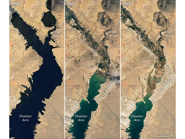
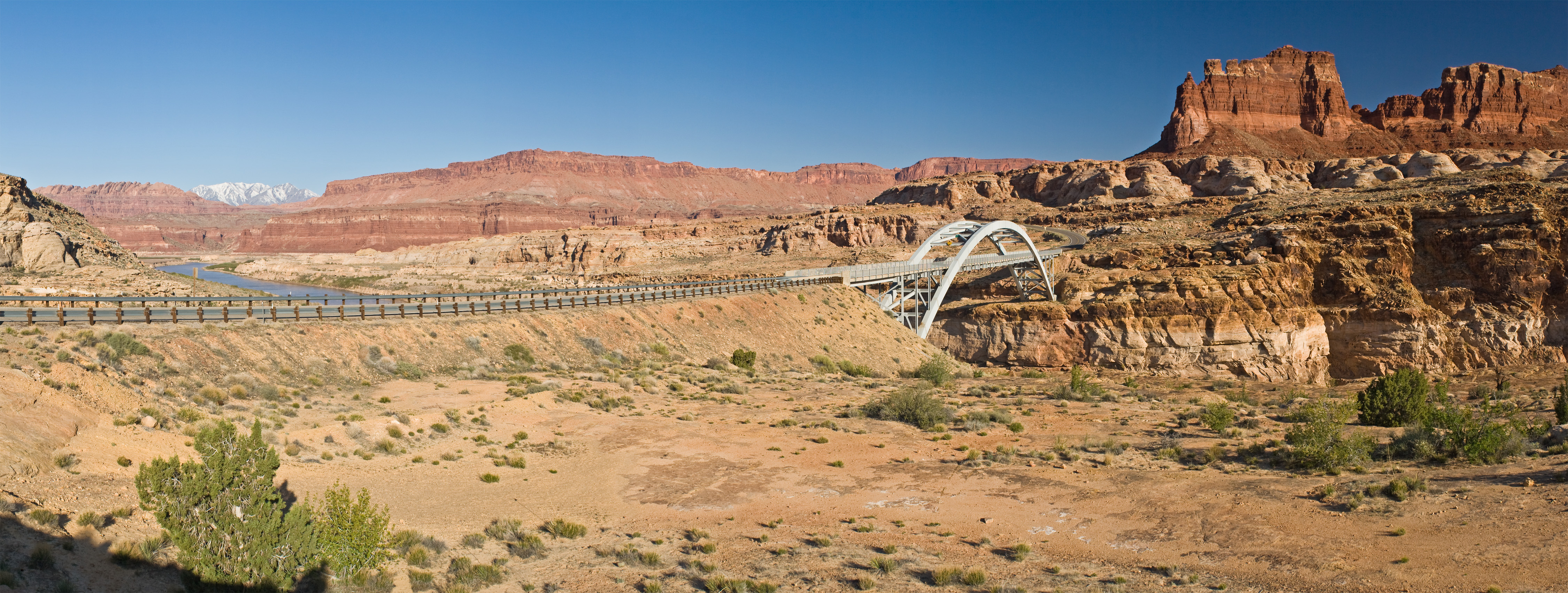
Images from the NASA Earth Observatory released in early July focused on the northern arm of Lake Mead and its decline from 2000 until now. As western states are being asked for solutions to keep Lake Mead and Lake Powell from hitting critical low points, there is more talk about what it would take to pump water from the Mississippi River to western states as well. (Image courtesy of NASA Earth Observatory)
Click the link to read the article on the Sierra Club Magazine website (Jeremy Miller). Here’s an excerpt:
This summer in the southwestern United States has been defined by climate chaos. At one point, more than 75 million people were under an extreme heat advisories, and temperature records were broken in cities throughout the region. As the climate warms, these kinds of events will become more common, straining states’ ability to care for the most vulnerable. The warmer temperatures have also intensified the drought—the most severe dry spell in nearly 1,300 years—and strained the Colorado River, which supplies 40 million residents in the West with drinking water, to the breaking point. That’s why a group of western Democrat senators including Colorado’s Michael Bennet, Nevada’s Catherine Cortez Masto, and Arizona’s Mark Kelly secured $4 billion in funding as part of the Inflation Reduction Act to deal with persistent drought.
The funds will be directed to the Bureau of Reclamation, the federal agency that operates and maintains hundreds of dams and reservoirs across the country, including Lake Powell and Lake Mead. The Inflation Reduction Act stipulates that the $4 billion can be spent in one of three ways: to pay water users to reduce consumption; to fund conservation projects that reduce demand in the upper and lower basins of the Colorado River; and restorations of ecosystems and habitat directly harmed by drought. The bill also allocates $220 million to tribal nations (who collectively hold rights to 2.9 million acre-feet of Colorado River water) to fund climate resilience and adaptation programs.
In addition to funding for the Colorado River Basin, the Biden bill allocates another $8.3 billion “to address water and drought challenges and invest in our nation’s western water and power infrastructure, while rebuilding our existing projects to withstand a changing hydrology,” according to a Department of the Interior press release…
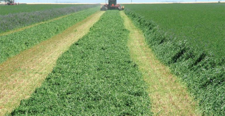
Robert Glennon, emeritus professor of law at the University of Arizona, says that there are solutions available that can save the Colorado River from ecological and hydrological collapse. While residential water scofflaws and “lawn cops” in Las Vegas and Los Angeles draw headlines, the biggest and most conspicuous user of the river water by far is agriculture, which accounts for roughly 80 percent of use. In Pinal County, near Phoenix, for example, water is delivered at great expense across the desert to irrigate tens of thousands of acres of water-intensive crops such as cotton and alfalfa (a large portion of the latter is shipped overseas to feed livestock). Efforts to update infrastructure such as improving canals and replacing antiquated flood irrigation systems with modern drip irrigation could reap potentially large savings, says Glennon. But these projects are also very expensive and, therefore, subsidies and grants will be necessary to aid in the transition. “Farmers tend to be land rich and cash poor, so the bureau could play a major role in helping farmers modernize their infrastructure,” Glennon said.
Click the link to read the article on the WUNC website (Kirk Siegler). Here’s an excerpt:
SIEGLER: It’s not? Kmiec says there are two big reasons why. The first is aggressive conservation, like water recycling. Tucson uses the same amount of water as it did in the 1980s, yet it’s added 200,000 more people.
KMIEC: It’s all about adaptation and making sure you – the water that you use, particularly in the desert, is for what you need.
SIEGLER: But the other even bigger reason why Kmiec isn’t up all night worrying…
KMIEC: Because we’ve banked more than 5 1/2 years of excess Colorado River water in these aquifers already.
SIEGLER: You can think of it like a secret reservoir hidden underneath this vast Sonoran desert with its blazing sun and saguaro cactus.
KMIEC: It looks like about a 40-acre basin, the one we’re standing next to.
SIEGLER: This basin is mostly dried dirt, with occasional stocks of green grass from recent monsoons – not exactly what you picture when you think of a city’s water plant, though another basin in front of us does have some water.
KMIEC: We fill these large reservoirs up. They look like small lakes. But what’s actually happening is the water is slowly going down and percolating into the aquifer and turning into groundwater.
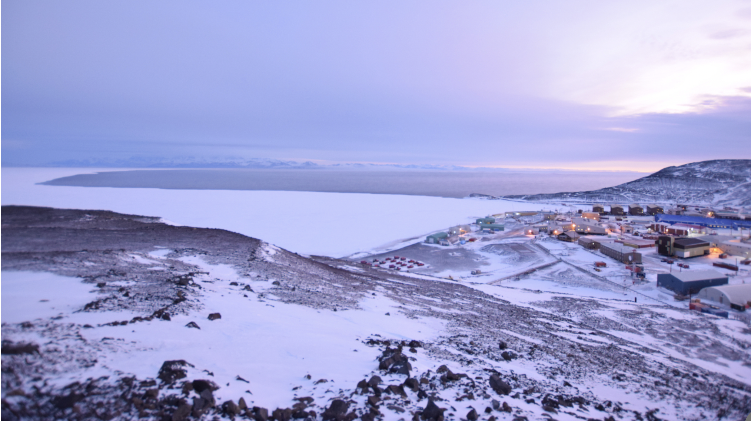
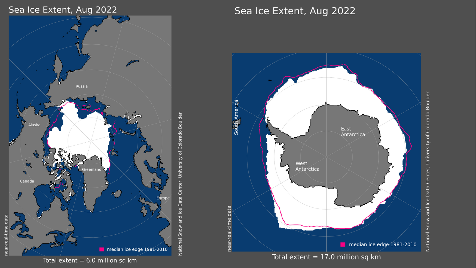
After months of darkness, the sun rose briefly at McMurdo Station, Antarctica, on August 7, 2022. The flat white visible beyond the land is the annual sea ice that forms on top of McMurdo Sound. The darker area is open ocean water. By August, the annual sea ice normally is five or six feet thick and will extend 30 or 40 miles north before open water is visible. It is unusual to have open water this far south in August. Antarctic sea ice coverage hit a record low for the third consecutive month in August 2022. (Steve McGowan/National Science Foundation/Antarctic Photo Library/Creative Commons License CC BY-NC-ND 4.0)
Click the link to read the article on the NOAA website:
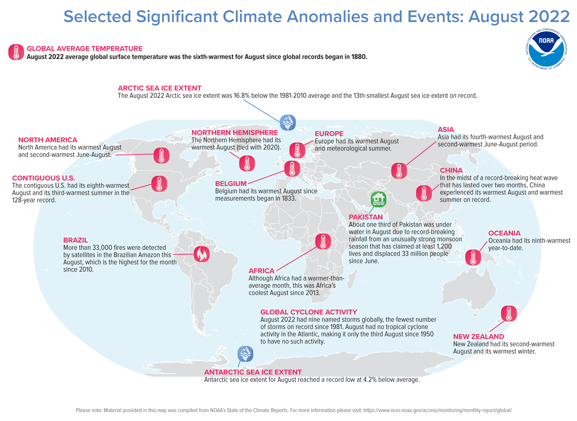
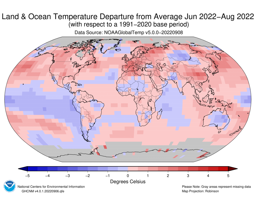
Globally, August 2022 was the sixth-warmest August in the 143-year NOAA record. The year-to-date (January-August) global surface temperature was the sixth-warmest on record. According to NCEI’s Global Annual Temperature Outlook, there is a greater than 99% chance that 2022 will rank among the 10-warmest years on record but less than 11% chance that it will rank among the top five.
This monthly summary, developed by scientists at NOAA’s National Centers for Environmental Information, is part of the suite of climate services NOAA provides to government, business, academia and the public to support informed decision-making.
Monthly Global Temperature
The August global surface temperature was 1.62°F (0.90°C) above the 20th-century average of 60.1°F (15.6°C). This was the sixth-warmest August in the 143-year record. August 2022 marked the 46th consecutive August and the 452nd consecutive month with temperatures, at least nominally, above the 20th-century average. The Northern Hemisphere August temperature tied with 2020 as the warmest for August on record at 2.16°F (1.20°C) above average.
North America and Europe each had their warmest August on record. Asia had its fourth-warmest August on record. South America, Africa and the Oceania region had August temperatures that were above average, but not among their top 10 warmest on record.
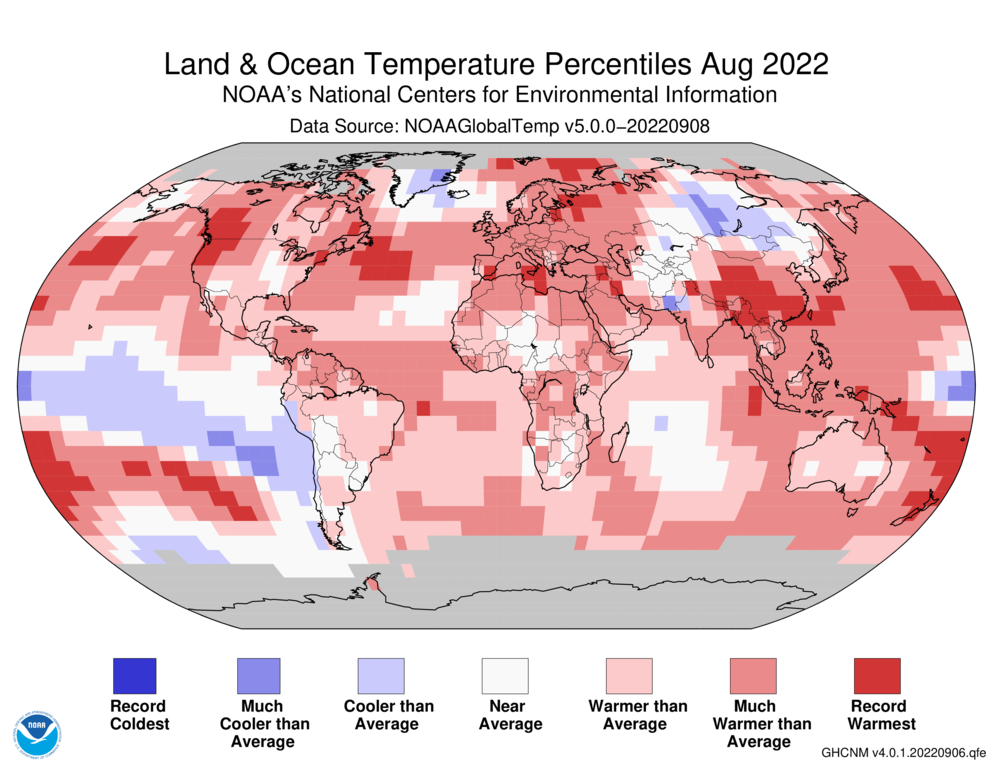
Temperatures were above average throughout most of North America, Europe, and southern and southeastern Asia, and across parts of northern Africa, northern South America, the Arabian Peninsula, western Asia and northern Oceania. Parts of the northwestern U.S., southwestern Canada, Spain, Italy, China, southeast Asia and New Zealand experienced record-warm temperatures for August. Sea surface temperatures were above average across much of the Gulf of Mexico and the northern, western and southwestern Pacific, as well as parts of the northern and southern Atlantic oceans.
Temperatures were near- to cooler-than-average throughout most of South America and across parts of central Asia. Consistent with La Niña, sea surface temperatures were below average over much of the south-central, central, and eastern tropical Pacific. None of the world’s surface had a record-cold temperature in August.
Seasonal Global Temperature
The June-August 2022 global land and ocean surface temperature was 1.60°F (0.89°C) above the 20th-century average of 60.1°F (15.6°C) and tied with 2015 and 2017 as the fifth-warmest June-August period in the 143-year record. The five warmest June-August periods on record have occurred since 2015.
The June-August period is defined as the Northern Hemisphere’s meteorological summer and the Southern Hemisphere’s meteorological winter. The Northern Hemisphere summer 2022 temperature was the second-warmest summer on record at 2.07°F (1.15°C) above average. Summer of 2020 was warmer by only 0.05°F (0.03°C). Meanwhile, the Southern Hemisphere had its 10th-warmest winter on record.
Regionally, Europe had its warmest meteorological summer in the 113-year continental record. Asia and North America each had their second-warmest June-August on record, while Africa had its 11th-warmest June-August (tied with 2002) on record. South America and Oceania had above-average June-August periods, but they did not rank among their top 10 on record.
Arctic sea ice extent in August averaged 2.31 million square miles, which is about 467,000 square miles below the 1981-2010 average. This marks the 13th-smallest August extent in the 44-year record. Sea ice extent was well below average in the Barents, Chukchi, Laptev, Kara, and Greenland seas, and the Hudson Bay. Sea ice extent for August was not above average anywhere in the Arctic this month.
For the third consecutive month, Antarctica set a record low sea ice extent since records began in 1979. The August 2022 Antarctic sea ice extent was 6.55 million square miles, or about 290,000 square miles below average.
Global Tropical Cyclones
Nine named storms occurred across the globe in August. Four of those reached tropical cyclone strength (74 mph), including Super Typhoon Hinnamnor, the first Category 5 tropical cyclone of 2022. August 2022 had no named tropical cyclone in the Atlantic, which is only the third August since 1950 to have no such activity. The Augusts of 1961 and 1997 were the only others to also finish with no activity in the Atlantic. This August marks only the seventh year since 1950 to have no hurricanes in the Atlantic Ocean through August 31.
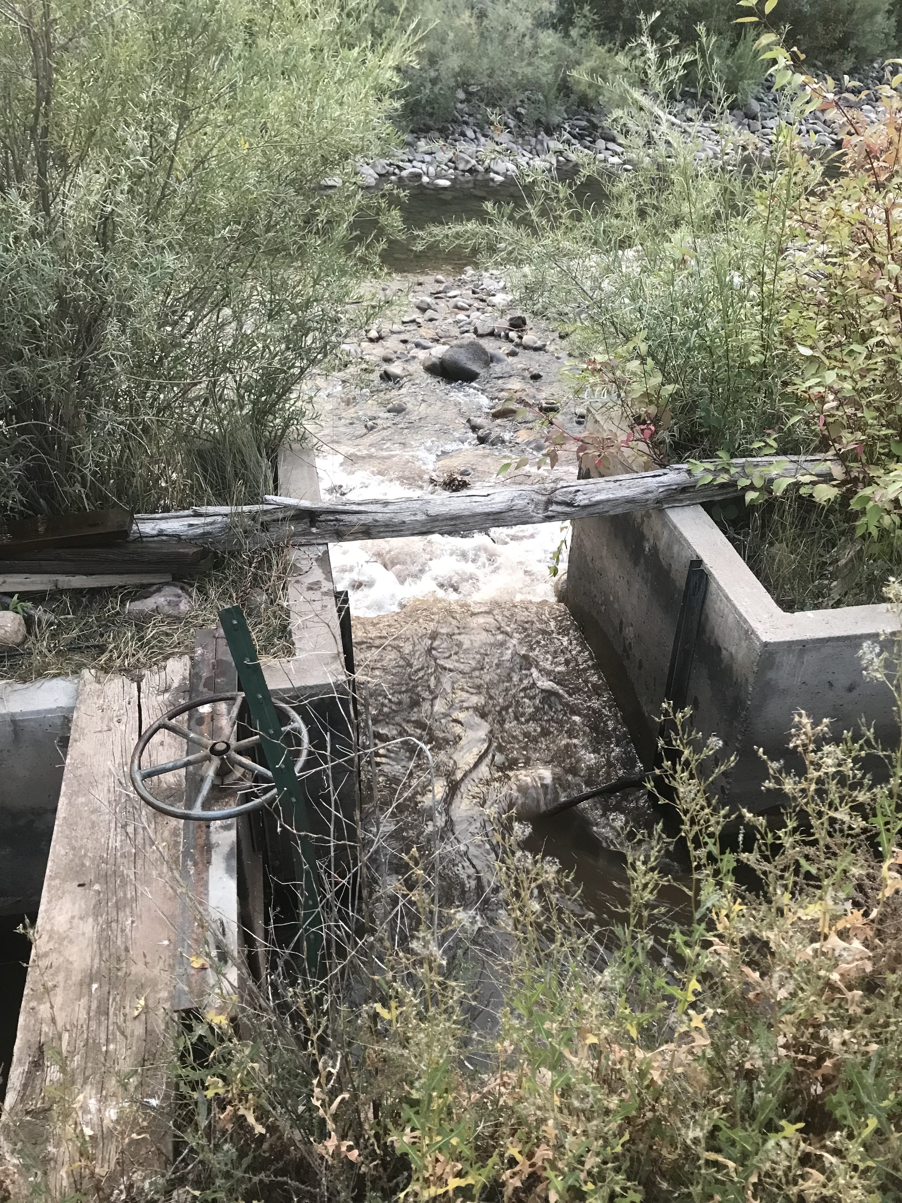
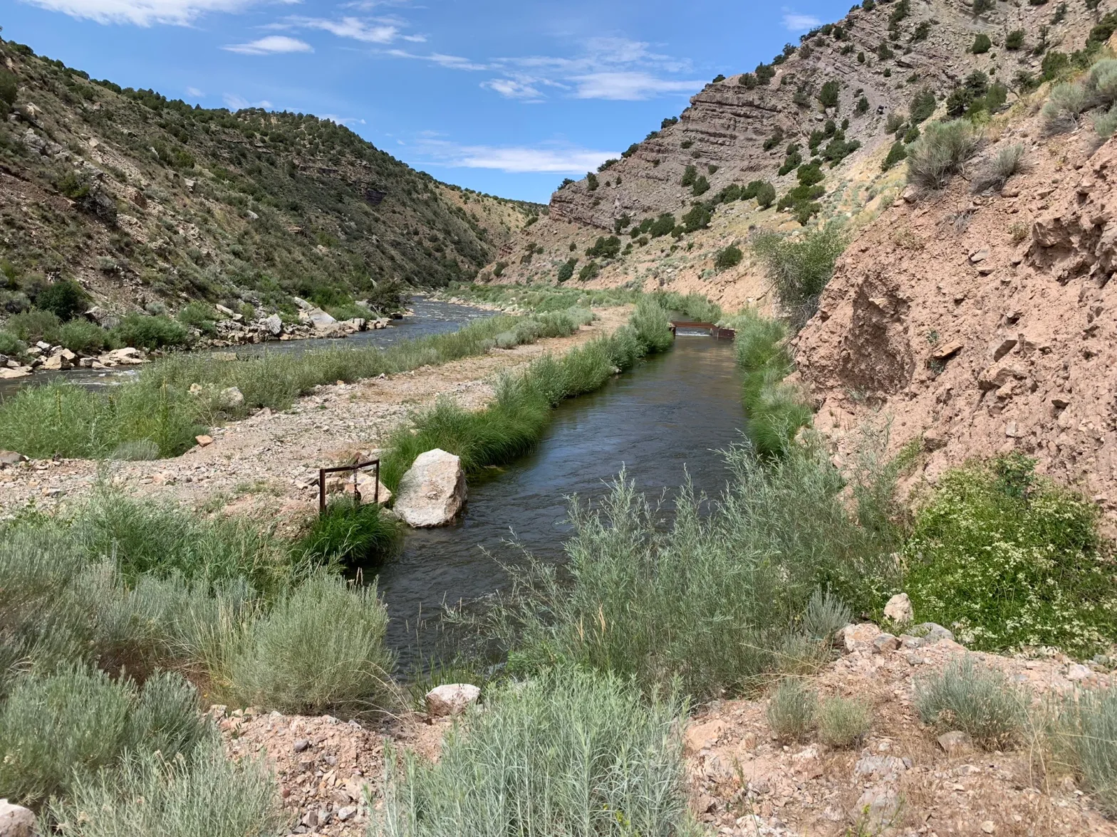
Helms Ditch Headgate. Photo credit: Colorado Water Trust
Here’s the release from the Colorado Water Trust (Alyson Meyer Gould, Bill Fales and Marj Perry):
On the 13th of September, 2022, Cold Mountain Ranch, with compensation from Colorado Water Trust, is boosting streamflows in the Crystal River, which is suffering from low flows during this hot and dry summer. This is the first year of implementation in a second pilot program with Colorado Water Trust and Cold Mountain Ranch to add flow to the River during dry years. The agreement compensates the Cold Mountain Ranch owners, Bill Fales and Marj Perry, for leaving their irrigation water in the Crystal River when it needs it most.
The Crystal River drops out of the Elk Mountains near Marble and flows north to its confluence with the Roaring Fork River in Carbondale. The river supports a number of traditional ranching operations as well as towns, recreationalists, and fish populations. Cold Mountain Ranch relies on the Crystal River to irrigate grass meadows that support its cow-calf operation. Under the agreement, the Water Trust monitors flows in the river. When flows fall to 40 cubic feet per second (cfs) in August and September, the ranch may voluntarily decide to cease diversion from the Crystal River in August through October. Colorado Water Trust determines the amount of water left in the natural stream and then pays the ranch $250 per cfs per day for up to 20 days each year. Once streamflows reach 55 cfs in the River (based on a 3-day rolling average), payments cease, but should flow again drop below 55 cfs, diversions can stop again and compensation resume. The pilot agreement can restore up to 6 cfs in the Crystal River.
In 2018, Colorado Water Trust and Cold Mountain Ranch signed a similar three-year pilot agreement that ended in 2020. Unfortunately, within this initial three-year period, Colorado Water Trust and Cold Mountain Ranch were unable to run the project. In 2018, the Crystal River’s flows were too low to implement the agreement – there was not enough water available to result in significant benefits instream. In 2019, the river was high enough to avoid triggering the agreement during the timeframe of the agreement. Although it flirted with the low flow trigger in the late fall, the timing was out of range for the agreement. And in 2020, because of dry and hot conditions and impacts to their hay crop, Colorado Water Trust’s partners at Cold Mountain Ranch needed to use as much water as possible to maximize their late season production and keep their ranching operation sustainable.
Colorado Water Trust and Cold Mountain Ranch’s initial three-year pilot agreement was the first crack at a highly customized, market-based solution that works for agriculture and rivers on the Crystal River, and offered lessons for the renewal and re-tooling of that initial agreement. In this new contract, the partners tried to account for drier years and changing climatic conditions, as well as the economic needs of the Ranch. The changes include a $5,000 signing bonus to support agricultural operations, additional payment and flexibility for coordination, and extending potential coordination into October.
“Although we certainly wish conditions were wetter, we are excited for a chance to run the program. On one hand it enables an active, family-owned ranching operation to use its water rights portfolio in a new and flexible way. On the other hand, it keeps water in the river when it is most in need. It checks the boxes for the definition of a win-win solution,” Alyson Meyer Gould, Staff Attorney, Colorado Water Trust.
The legal and technical framework created by Colorado Water Trust and informed by local interests and support from Lotic Hydrological, has the potential, if successful, to have far-reaching implications. In the end, it brings environmental benefits to the river without affecting enrolled ranches’ long-term sustainability. Thus, the project will support both people and the environment.
The Water Trust would like to thank Cold Mountain Ranch, Public Counsel of the Rockies, the Roaring Fork Conservancy, Lotic Hydrological, WestWater Research, the Colorado River Water Conservation District, Pitkin County, Colorado Cattlemen’s Agricultural Land Trust, Bonneville Environmental Foundation, the Aspen Skiing Company Environment Foundation, Catena Foundation, and the stakeholders of the Crystal River Management Plan for making this project possible.
Click the link to read the article on the Mother Jones website (Stephanie Mencimer). Click through and read the whole article, here’s an excerpt:
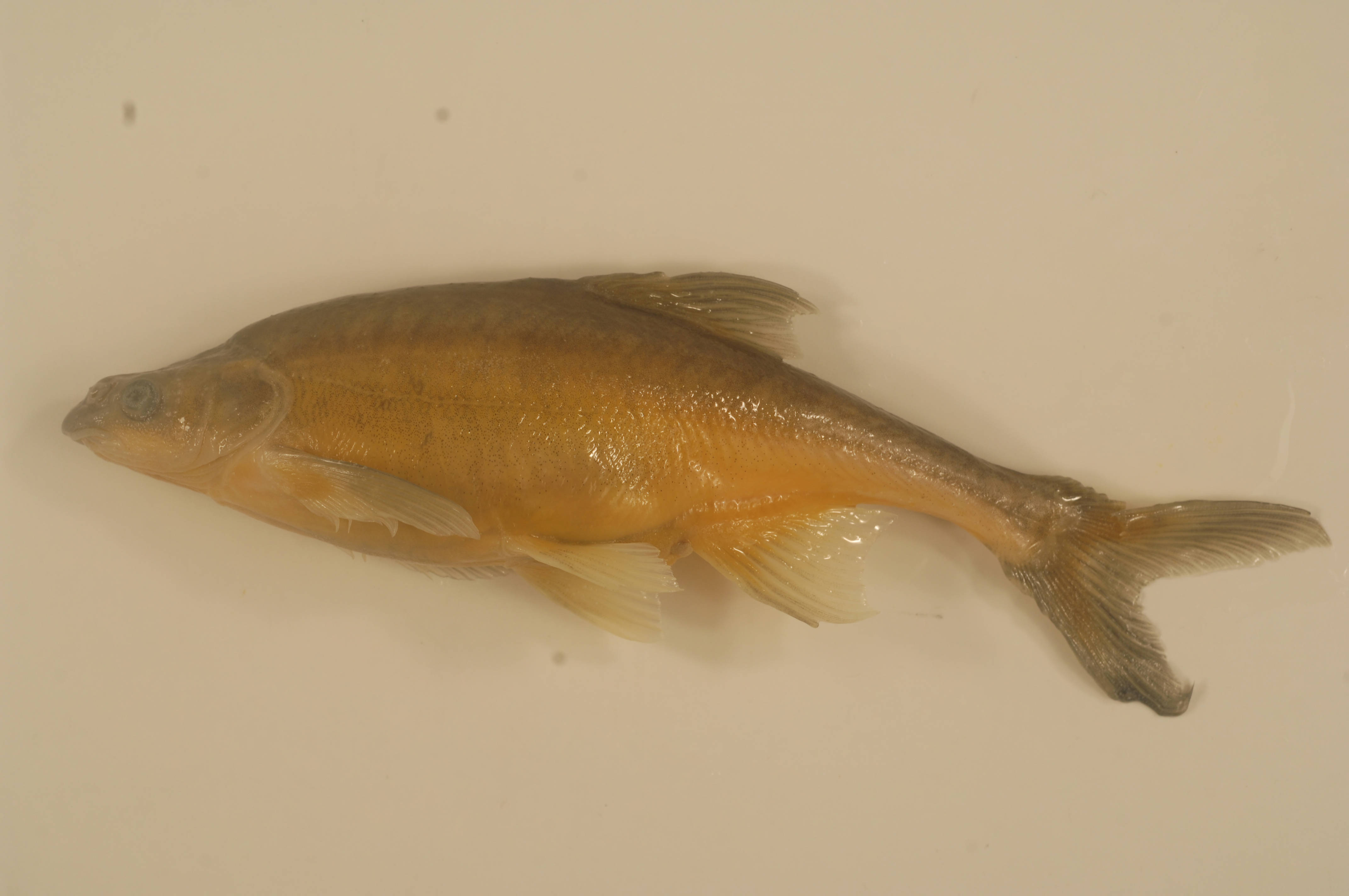
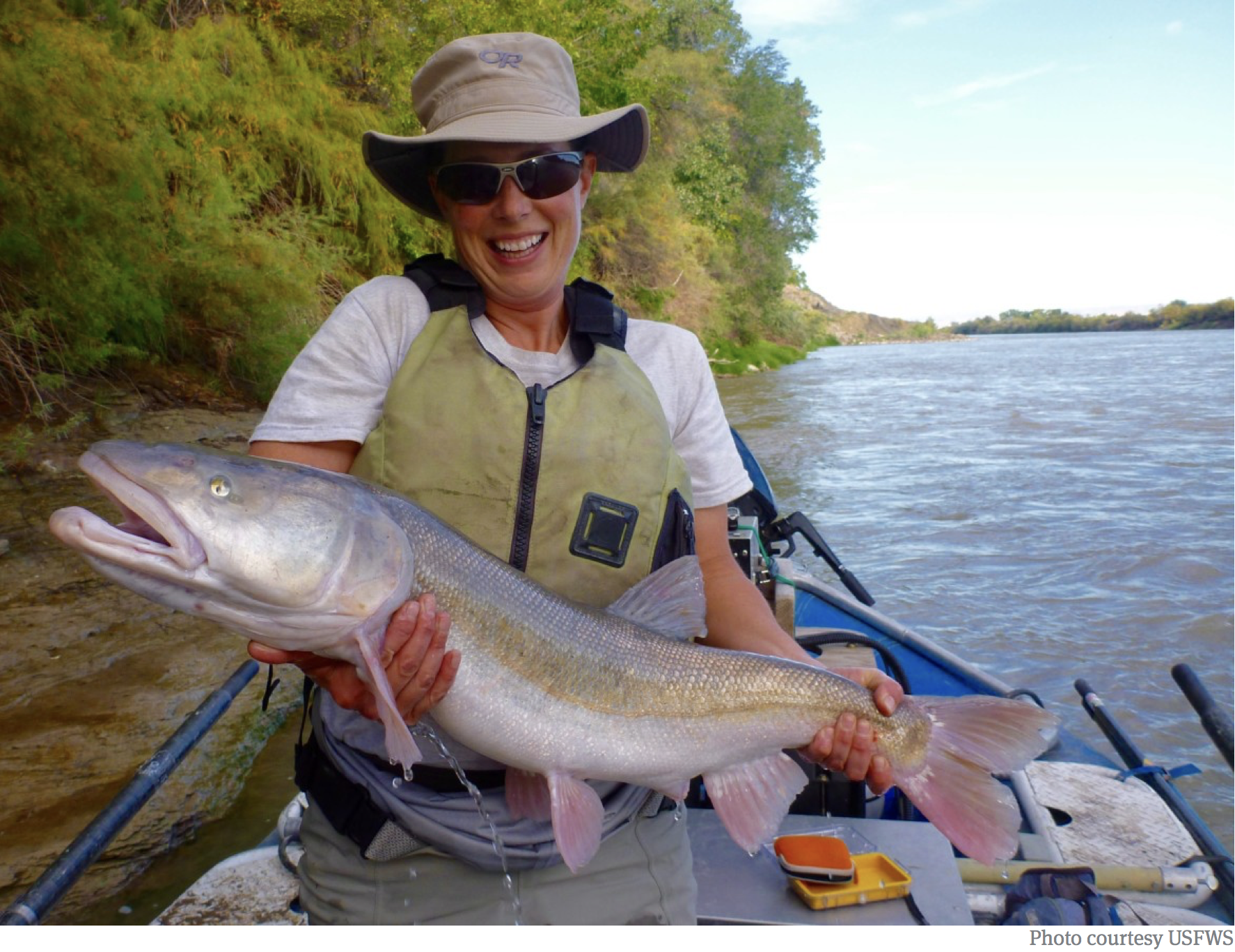
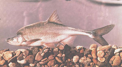
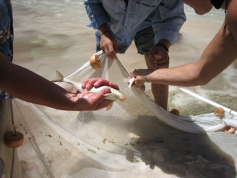
Found nowhere else in the world, the native razorback has occupied the waterways of the Colorado River basin for at least 3 million years, one reason why Olsen says they’re known as the “dinosaurs” of the Colorado. Known as “detritivores,” the bottom-feeding fish were once an important part of the river’s food chain because they nosh on dead plant and animal matter that might otherwise build up and cause disease while returning essential nutrients to the ecosystem. The fish have adapted to the harsh monsoon-to-drought cycles of the desert rivers that flood with melted mountain snowpack in the spring and are parched in the late summer. Razorback suckers can grow up to three feet long, 80 pounds, and live for 50 or 60 years. But such geriatric monster fish are rare in the wild today.
The native fish have not fared so well over the past century since humans began trying to make the western desert bloom by damming the Colorado and its tributaries, a watershed that was once one of the most biologically diverse in North America. “They’re a bellwether for the health of the entire river ecosystem, from Wyoming to the Gulf of California,” says Taylor McKinnon, senior public lands advocate at the nonprofit Center for Biological Diversity…
The US Fish and Wildlife Service first listed the razorback as endangered in 1991, and the species would be extinct in the Upper Basin but for the hatchery program, which was established in 1996 as part of the Upper Colorado River Endangered Fish Recovery Program and is funded by the US Fish and Wildlife Service. The program has been successful enough that last year, FWS proposed downlisting the razorback from “endangered” to merely “threatened” under the Endangered Species Act. But the extreme mega-drought of the past two years makes that proposal seem wildly optimistic…
Meanwhile, the biggest ongoing threat to the Colorado’s endangered fish is other, nonnative fish. Only 12 fish are native to the Upper Colorado River Basin, Breen says. But now more than 50 species compete in the rivers. Many that were intentionally introduced to promote sport fishing are highly predatory in a way the razorback and others have not evolved to survive…The recovery program spends more than $2 million a year trying to eliminate the non-native fish from the Green River and elsewhere in the system—a move that is not always popular with local anglers who like to fish for the bass. “For the record: I love smallmouth bass,” says Breen. “I grew up fishing for smallmouth bass in the Midwest. But that’s where they’re supposed to be. Bass are very predacious, and they’re not supposed to be in that river.”
Green River BasinMap of the Colorado River drainage basin, created using USGS data. By Shannon1 Creative Commons Attribution-Share Alike 4.0
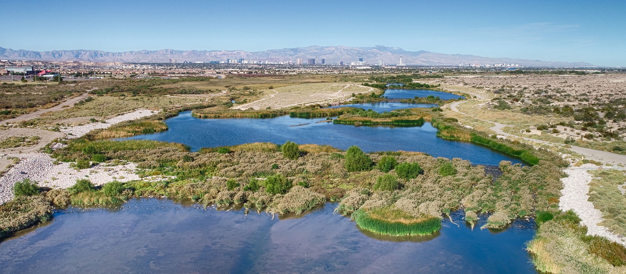
The Las Vegas Wash(Opens another site in new window) is the primary channel through which the Las Vegas Valley’s excess water returns to Lake Mead. Contributing approximately 2 percent of the water in Lake Mead, the water flowing through the Wash consists of urban runoff, shallow groundwater, storm water and releases from the valley’s four water reclamation facilities. Photo credit: Southern Nevada Water Authority
Click the link to read the article on the Nevada Independent [Nevada’s only statewide nonprofit newsroom] website (Daniel Rothberg):
Only a few miles from the Las Vegas Strip, in the Mojave Desert, is an unlikely scene: A county park with walking trails and thick vegetation that surround a vibrant rush of flowing water.
Known as the Las Vegas Wash, the water running through this channel is a crucial part of how Nevada has managed to keep its net Colorado River use below its allocation, despite booming population growth and two decades of persistent drought, worsened by a changing climate.
Every time a shower or a faucet is turned on in Las Vegas, the water flowing down the drain is treated at wastewater plants and recycled. The treated water is discharged into the wash, which flows into Lake Mead, a declining Colorado River reservoir held back by the Hoover Dam. Once there, the water can be used for a second time, effectively increasing Nevada’s overall supply.
“It allows Las Vegas to exist in its present form,” said John Hiatt, a conservationist who sits on a coordination committee for the wash. “[Without it], we’d be half our size and really struggling.”
When the Colorado River Compact was negotiated in the early 1900s, only about 5,000 people lived in Clark County, home to Las Vegas. Few envisioned the massive growth that has turned the desert into a sprawling paved landscape of nearly 2.3 million people — and growing. Today, about 74 percent of all Nevadans live in Clark County, making it the state’s economic center.
The laws governing the Colorado River give Nevada the smallest cut of water: 1.8 percent, or just 300,000 acre-feet (an acre foot is the amount of water needed to fill an acre to a depth of one foot). The small share has meant Nevada has long had to live on a tight water budget and rely on conservation measures that are only now being considered by other Western states.
Nevada has one main Colorado River user: Las Vegas. It accounts for more than 90 percent of the state’s diversions, with additional water going to the Fort Mojave Indian Tribe, whose rights were recognized in a case known as Arizona v. California, and other water users in Nevada.
For decades, Las Vegas has relied on wastewater recycling and removing water-guzzling grass to stretch and conserve its small Colorado River share. But even with proactive management, Las Vegas, like other cities, faces challenges and uncertainties when it comes to future growth.
“We still have some room with the water resources we have today,” said Assemblyman Howard Watts, a Democrat who has worked on water issues for years, including in the Legislature. “But eventually we’re going to reach a point where we’re going to go past that limit and that’s when we really have to consider what a sustainable path is for Southern Nevada moving forward.”
Many of the Southern Nevada Water Authority’s future planning scenarios are premised on an ability to collaborate with other states to augment Las Vegas’s current supply. Yet negotiations over the Colorado River have become increasingly difficult for the seven states that rely on the shrinking river and its reservoirs, including Lake Mead, which has fallen to critically low levels.
Nevada, even though it has a small slice of the Colorado River, has a huge stake in those talks. Las Vegas is reliant on the Colorado River. It’s the source of about 90 percent of the city’s water supply. The remainder comes from a local groundwater aquifer, which was historically overused.
Any other water in Nevada is far away. For years, Las Vegas had looked to import rural eastern Nevada groundwater hundreds of miles away as a potential supply. But local water managers shelved the controversial plan in 2020 amid legal challenges and concerns about environmental impacts. While it still owns ranches in eastern Nevada, the water authority has said its focus is on supplementing its supply through collaborations, including a recycling project in California.
How Southern Nevada has managed to grow, thus far, on such a tight supply has everything to do with the Las Vegas Wash, which empties into Lake Mead. Colby Pellegrino, deputy general manager of the Southern Nevada Water Authority, described the natural stream as something of “a silent miracle,” helping Nevada operate one of the largest water reuse programs in the nation.
Through the Las Vegas Wash, recycled water flows back to Lake Mead. Each drop of water that is returned allows Nevada to divert an equivalent amount of water, while keeping its overall use within its 300,000 acre-foot allotment. Last year, Nevada diverted more than 480,000 acre-feet from Lake Mead, but it returned about half of that water for an overall use below its allotment.
Because nearly all indoor water in Southern Nevada is treated and returned to the wash, it has allowed Las Vegas to focus its conservation efforts on aggressive turf removal. This, combined with water recycling, has meant that Nevada has under-used its Colorado River apportionment.
As for future growth, Pellegrino said “it depends on how we grow.”
“The future of our growth has to have the smallest water footprint possible,” she added.
Las Vegas is preparing for the realities of a shrinking river by incentivizing and requiring greater degrees of conservation — with a target goal of decreasing per capita water use from about 110 gallons per capita per day to 86 gallons per capita per day by 2035. The water authority’s plan includes a transition from evaporative cooling, pool size limits and prohibiting decorative turf.
Still, with only 1.8 percent of the Colorado River, Las Vegas cannot fix the problem on its own. In a recent letter, water authority General Manager John Entsminger called for swift cuts aimed at stabilizing the Colorado River’s reservoirs while longer-term agreements can be negotiated. The water authority has also pushed other states to consider climate change in long-term planning.
Hiatt, on the Las Vegas Wash Coordination Committee, came to Southern Nevada in the 1970s, when the population of Clark County was about 350,000 people. He said he is concerned about what a future might look like as climate change continues altering the river’s flows. If conserved water is only re-dedicated to new growth, he worries “we’re going to be in the same position of pushing against our allotment — and our allotment may be significantly lower than it is now.”
“It’s hard to believe anyone is going to come out with more water,” he added.
Click the link to read the article on the Montrose Press website (Katharhynn Heidelberg). Here’s an excerpt:
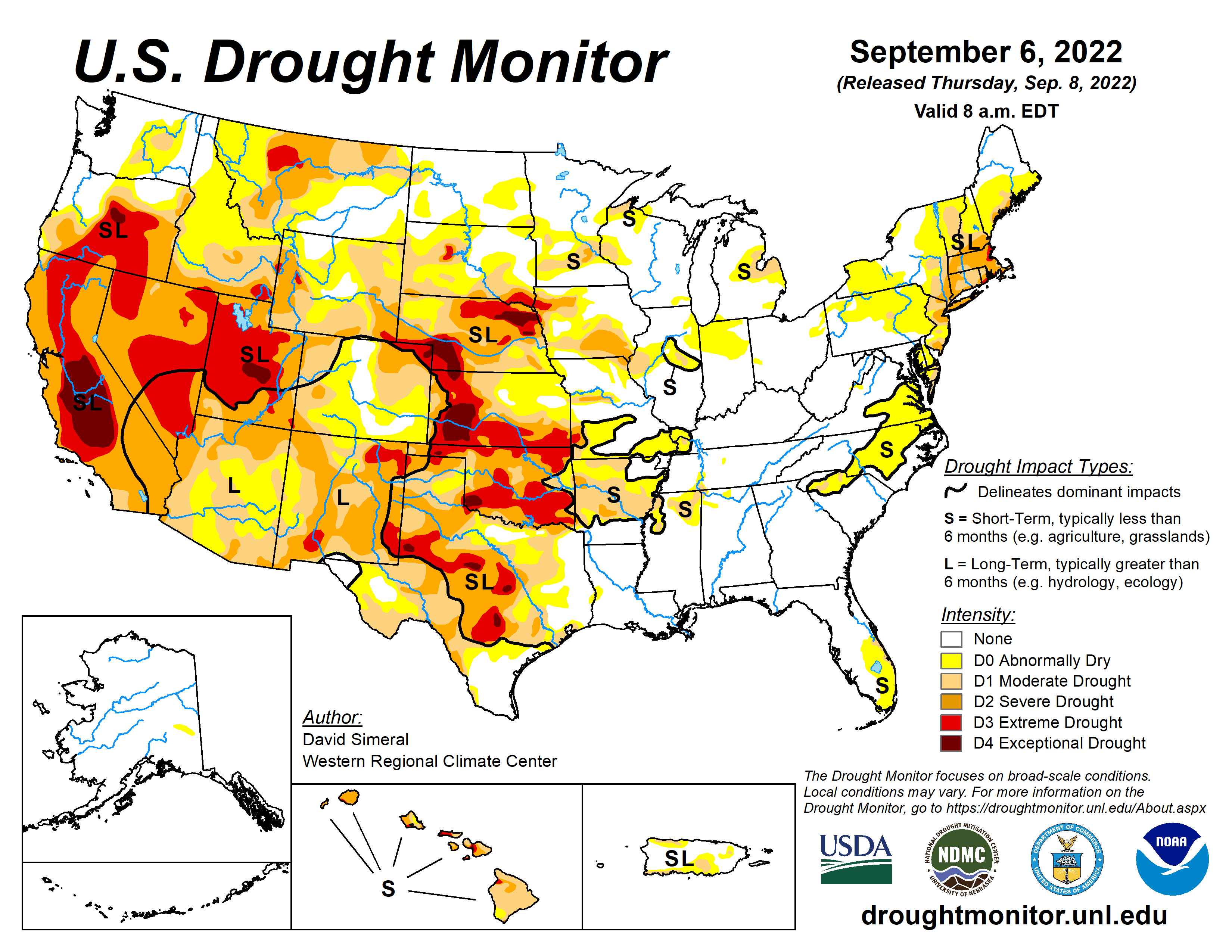
The Upper Colorado River Basin recorded its ninth-warmest water year on record through August — and five of those record warm water years have fallen within the last 12. Despite recent, good moisture in the Southwest — sufficient to lift some pockets into a drought-free status — the region should brace itself for another warmer, drier winter and lower snowpack next year, climatologist Peter Goble said during the Tuesday, Sept. 13, Southwest drought briefing…Montrose enjoyed some wetter weather earlier this summer. It also saw near-record temperature highs during the first week of this month, which climatologists said is in keeping with the last four or so years. The U.S. Drought Monitor on Wednesday showed most of Montrose County in moderate drought, with a pocket of severe drought.
Goble also discussed long-term temperature and precipitation in the Upper Colorado Basin, delivering the bad — although perhaps unsurprising — news that it’s experiencing yet another warm water year…When it comes to precipitation, the Upper Colorado Basin has seen three drier than normal years in a row…
Goble said although monsoons this year brought some shorter term relief, “arguably” helped with wildfire season and somewhat improved the soil moisture picture, groundwater in the basin is still well below normal. Root zone soil moistures are in better shape than groundwater, but are still on the low side, which is anticipated to negatively influence runoff next year as the drier soils drink down moisture from precip. Goble said 2022’s spring snowpack was low and runoff, even lower, with values peaking between 70 and 90% of normal…Runoff values stood in the 50 to 80% range…
The winter precipitation outlook is not good, Goble said. Data show an increased chance of it falling below normal, edging up to equal chances north of central Utah and central Colorado. The La Niña weather pattern of drier winters is expected to hold sway and overall, the odds of a warmer, drier fall and winter “are elevated,” he said.
Buschatzke and Cooke named Environmental Leaders of the Year
Wednesday’s [September 14, 2022] online presentation of the Arizona Capitol Times’ “Morning Scoop on Water Issues in Arizona” served up an hour-long assessment of how the State’s water supply is faring during the current, epic drought conditions.
Some of the news, like that from Leslie Meyers, the newly appointed Associate General Manager & Chief Water Resources Executive for Salt River Project, included refreshing good news. The in-state SRP water supply is in good shape, she reported.
But, as anticipated, most of the Morning Scoop discussion focused on the strained Colorado River system. The Morning Scoop panelists – including ADWR Director Tom Buschatzke and Central Arizona Project General Manager Ted Cooke – could report very little that could be considered upbeat.
ADWR Director Buschatzke reported that declines in the system will continue because “we are still using more water than is going into Lake Mead.”
The Director noted, however, that “we have done many good things” in recent years, including the Drought Contingency Plan of 2019, the 500+ Plan of 2021 and other conservation measures. “And while they have not stabilized the system, we would have been in much worse shape if we had not done those things.” [ed. emphasis mine]
The situation on the Colorado River system, nevertheless, is dire.
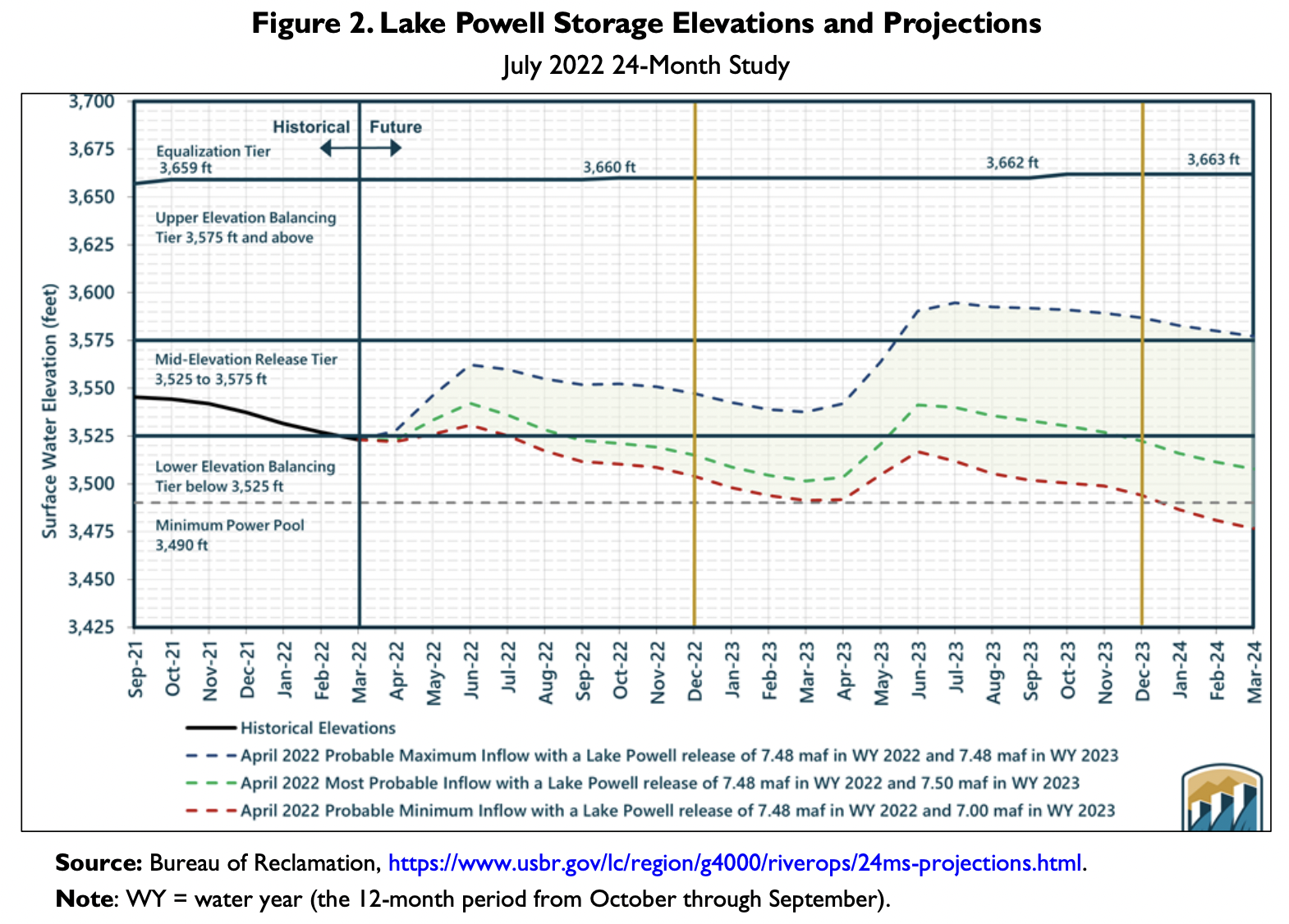
Credit: USBR
“We’re heading into, essentially, a crisis period.”
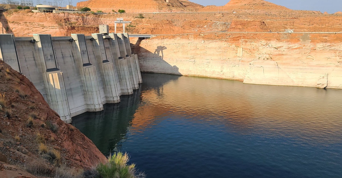
Without the 2-4 million acre-feet of needed conservation identified by Bureau of Reclamation Commissioner Camille Touton in June, “we could see as early as 2024 Lake Mead and Lake Powell falling to elevations in which the ability to move water past (Hoover Dam and Glen Canyon Dam) could be compromised.”
Buschatzke made his online comments with an image of the Colorado River flowing through the Grand Canyon behind him.
“If you think about the background of my picture, the Grand Canyon, if you can’t move water past Glen Canyon Dam, you would have no water in the Grand Canyon. Think about what that would mean.”
Credi: USBR
CAP General Manager Cooke gave an assessment of the current capacity of the two big reservoirs – both at a quarter of their capacity with just 13 million acre-feet of storage – a small fraction of the 50 million acre-feet of total capacity.
“We’re about a year away from not being able to move water past those two dams,” said Cooke.
Terry Goddard, chairman of the Central Arizona Water Conservation District, welcomed the nearly 300 viewers in front of a virtual background photo of Lake Mead’s notorious “bathtub ring” – a reminder of the crisis enveloping the Colorado River system.
The ring, he noted, “is a grim reminder of how far that lake has fallen in a very short time.”
Credit: USBR
Goddard registered disappointment that the Department of the Interior in mid-August failed to announce actions to protect the river system from potentially catastrophic storage declines in its primary reservoirs. He recalled that, in June, the Bureau of Reclamation had vowed that if the Colorado River States failed to agree to voluntarily conserve between 2-4 million acre-feet, in addition to the already planned cuts, the federal government would act to protect the system.
Goddard observed that when the states failed to find agreement, “something much bigger was supposed to happen” in addition to the announcement of the planned cutbacks. “But it didn’t,” he said. “They blinked.”
Also on the panel, was Joe Gysel, President of the private water-provider, EPCOR USA.
Arizona Capitol Times’ “Morning Scoop on Water Issues in Arizona” can be found below:
This is a follow-up to our May Morning Scoop about Water issues in Arizona. In this session we will explore what has changed in the past few months, the current outlook and then dive into some solutions that are being examined. Credit: Arizona Capitol Times
Earlier in September, the Capitol Times announced the recipients of its annual “Leaders of the Year in Public Policy.”
Each year, the Capitol Times recognizes leaders who have contributed to the growth of our state.
According to the Cap Times, “These are the people and groups that hunker down each day to find ways to improve the quality of life of Arizona’s citizens.”
The awardees will be recognized at an awards luncheon at noon. on Sept. 27 at the Phoenix Art Museum. They will also be profiled in a special edition of the Arizona Capitol Times.
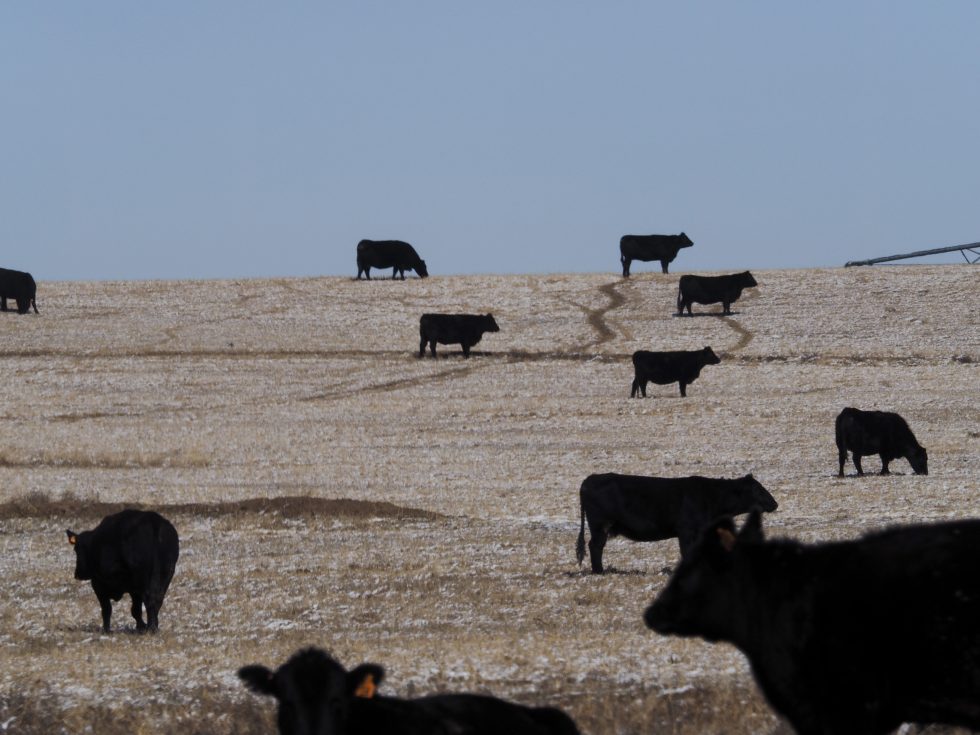
Cattle of the Bow & Arrow herd, graze in a frosted corn field on the 7,770 acre Ute Mountain Ute Farm & Ranch Enterprise near Towoac, Colorado. About 700 head of cattle, graze on the farm and ranch lands during the winter. During the summer the herd is moved to mountain pastures. (Dean Krakel photo, special to EWC)
At Spring Born, a greenhouse in western Colorado near Silt, you see few, if any, dirty fingernails. Why would you? Hands never touch soil in this 113,400-square-foot greenhouse.
You do see automation, long trays filled with peat sliding on conveyors under computer-programmed seeding devices. Once impregnated, the trays roll into the greenhouse.
Thirty days after sprouting, trays of green and red lettuce, kale, arugula, and mustard greens slide from the greenhouse to be shorn, weighed and sealed in plastic clamshell packages. Hands never touch the produce.
Spring Born says it needs 95% less water compared to leafy greens grown using Colorado River water a thousand miles downstream in Arizona and California. That region supplies more than 90% of the nation’s lettuce. At Silt, the water comes from two shallow wells that plumb the riverine aquifer of the Colorado River, delivering about 20 gallons per minute. The water is then treated before it is piped into the greenhouse. This is agriculture like nowhere else.
he all-mechanized operations at Spring Born’s large greenhouse near Silt, Colo., produce leafy greens by maximizing the use of water. Spring Born says it needs 95% less water compared to greens grown using Colorado River water 1,000 miles downstream in Arizona and California. From the Hip Photo courtesy of Spring Born
Great precautions are taken to avoid contamination and prevent the spread of pathogens. Those entering the greenhouse must don protective equipment.
There’s no opportunity for passing birds or critters to leave droppings. As such, there is no need for chlorine washes, which most operations use to disinfect. Those washes also dry out the greenery, shortening the shelf life and making it less tasty. The Spring Born packages have an advertised shelf life of 23 days.
Spring Born likely constitutes the most capital-intensive agricultural enterprise in Colorado. Total investment in the 250-acre operation, which also includes traditional hay farming and cattle production, has been $30 million. The technology and engineering come from Europe, which has 30 such greenhouses. The United States has a handful.
Agribusiness in Colorado generates $47 billion in economic activity but it ties to one reality: The future is one of less water. So how exactly can agriculture use water more judiciously?
The Thirsty Future
A Desert Research Institute study published in April 2022 concluded that the warming atmosphere is a thirstier one. Modeling in the study suggests that crops in some parts of Colorado already need 8% to 15% more water than 40 years ago. Agricultural adaptations to use less water are happening out of necessity.
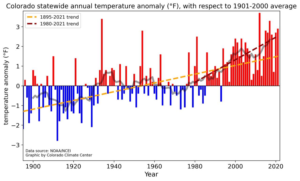
Grahic credit: Colorado Climate Center
Colorado has warmed about 2.5 degrees Fahrenheit in the last 120 years. Warming has accelerated, with the five hottest summers on record occurring since 2000.
Higher temperatures impact the amount of snowfall and amount of snowpack converted to water runoff. “As the climate warms, crops and forested ecosystems alike use water more rapidly,” says Peter Goble, a research associate at the Colorado Climate Center. “As a result, a higher fraction of our precipitation goes into feeding thirsty soils and a lower fraction into filling our lakes, streams and reservoirs. Essentially, a warmer future is a drier future.”
This year was a good example of the drying trend.
Dolores River watershed
Snowpack was around average in the San Juan Mountains, but spring arrived hot and windy. Snow was all but gone by late May, surpassed in its hurried departure only in 2018 and 2002. Farmers dependent on water from the Dolores River, still reeling from last year’s meager supplies, were required to accept lesser supplies yet again as the growing season began this year.
The Ute Mountain Ute Farm and Ranch Enterprise, the most southwesterly agriculture operation in Colorado, expected less than 30% of its regular water delivery from McPhee Reservoir. This was on top of a marginal year in 2021, too. Simon Martinez, general manager of the operation, said just 15 of the 110 center pivots had crops under cultivation in early June. Employment was cut in half, and the 650-head cow-calf operation had been slimmed to 570.
Pressured by compacts
The warming climate is not alone in spurring adaptations. In many river basins, irrigators must also worry about delivery of water to downstream states specified by interstate compacts.
Water conservation districts formed in the last 20 years are paying farmers to decrease pumping and planting to save the water that remains in the aquifers, comply with compacts, and transition to less water use.
Directors of the Republican River Water Conservation District, in northeastern Colorado were successful in voluntarily retiring 4,000 acres by June 2020. They are confident about retiring 10,000 acres in the area between Wray and Burlington before 2025. They’re less sure of achieving the 25,000 acres that compact compliance will require by 2029.
Rio Grande Water Conservation District directors in south-central Colorado have an even greater lift. They must figure out how to retire 40,000 irrigated acres by 2029. They’re at 13,000.
High commodity prices have discouraged farmer participation. The pot of local, state and federal money hasn’t been sufficient to fund high enough incentives to compete with commodity pricing. A bill, SB22-028, Groundwater Compact Compliance Fund, which passed in the Colorado Legislature in May, will allocate $60 million to both the Republican and Rio Grande basins to help them comply with interstate river compacts by reducing the acreage outlined above. The law says that if voluntary reductions cannot be attained, Colorado may resort to mandatory reductions in groundwater extraction.
From Sprinklers to New Crops
Even as center-pivot sprinklers are removed in the Republican River Basin and San Luis Valley, they are going up in the Grand Valley of western Colorado. There, instead of drafting groundwater, they are distributing Colorado River water, because they are reducing labor costs and reducing water use.
The geography of the valley from Palisade to Fruita and Loma does not immediately favor center pivots. They work best as a pie within a square, a full 40 or 160 acres. Parcels in the Grand Valley tend to be more rectangular. That means a pivot can arc maybe three-quarters of a circle. That slows the payoff on investment.
Why the pivot, so to speak, on pivots? Perry Cabot, a water resource specialist with Colorado State University’s Western Colorado Research Center near Fruita, sees two, sometimes overlapping, motivations. (Cabot also serves on the Water Education Colorado Board of Trustees.)
The greater motivation is the desire to save labor. That itself is good, he says, because the investment reflects an intention to continue farming. “People are obviously doing it for the long haul,” he says.
The other motivation appears to be water related. “The feedback I get is, to paraphrase the farmers, at some point in the future we are going to have less water to farm with and so we must prepare for that,” Cabot says.
Incremental improvements have improved efficiency. Experiments at the CSU research center in Walsh have shown conclusively the advantage of long-drop nozzles that spray the water just a couple feet off the ground, reducing evaporation.
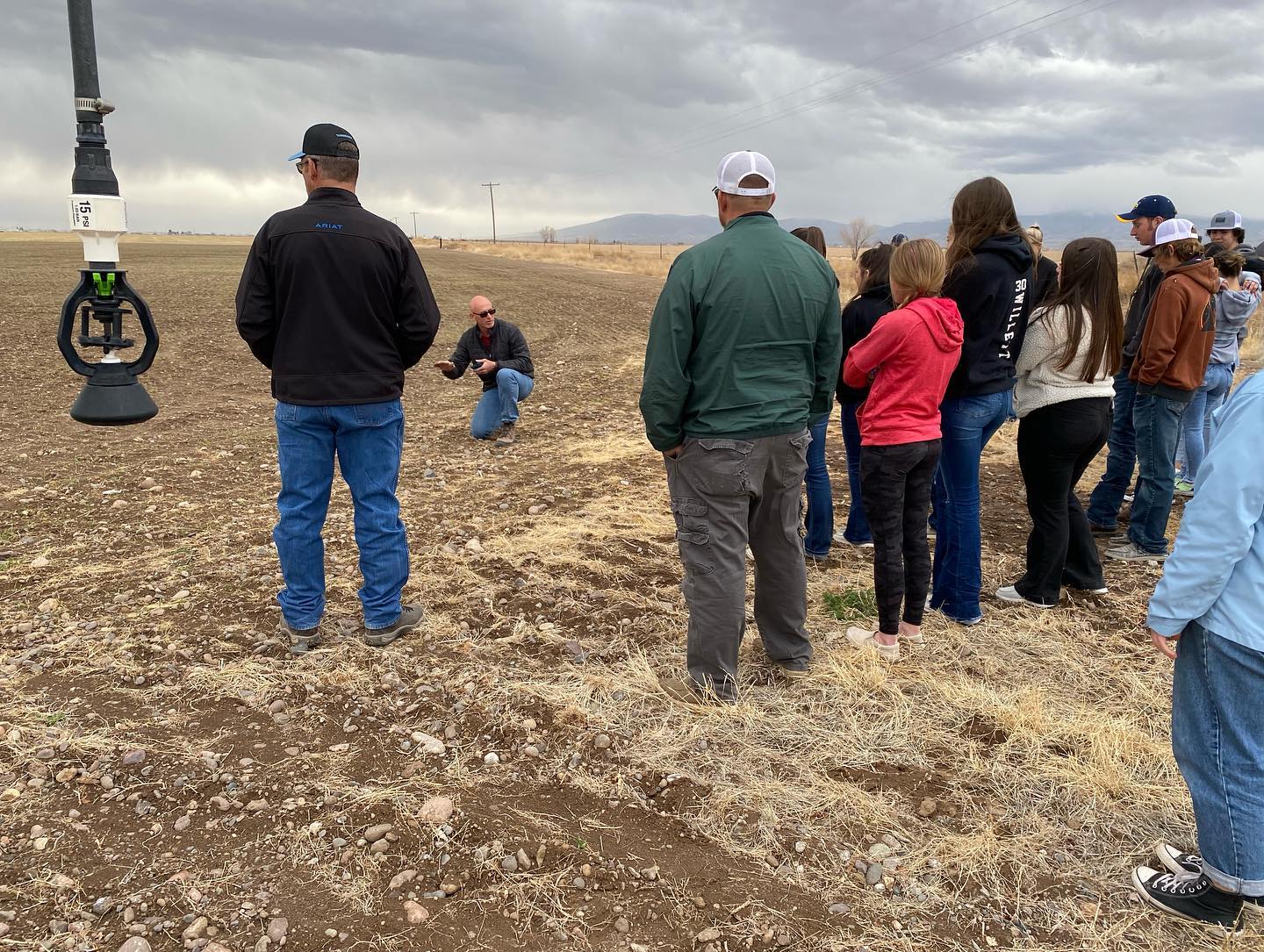
Jason Lorenz with Agro Engineering talks about irrigation, soil moisture and chemistry during a soil workshop for students in Colorado’s San Luis Valley.Courtesy of AgroEngineering
Technology can help perfect a producer’s irrigation set up. Consider work in the San Luis Valley by Agro Engineering, crop consultants who seek to assist growers in producing maximum value with minimum water application. Potatoes, the valley’s largest cash crop, thrive in warm, but not hot, days and cool nights. They need 16 to 18 inches of water per year, of which 13 to 15 inches comes from irrigation. This includes two inches applied during planting, to moisten soils sufficiently for germination. They do not do well with too much water, explains Jason Lorenz, an agricultural engineer who is a partner in the firm. That, and the need to align use with legal requirements, gives growers compelling reason to closely monitor water.
The company uses aerial surveys conducted from airplanes to analyze whether the desired uniformity is being achieved. The latest advancement, multispectral aerial photography, enables the detection of green, red and near-infrared light levels. These images indicate the amount of vegetative biomass, vegetative vigor, and the greenness of the leaves. Variations show where crops are healthier and where there are problems, including insects and diseases, water quality, or soil chemistry problems.
Any discussion of water and agriculture in Colorado must include a focus on corn. In 2021, according to the U.S. Department of Agriculture, almost 1.4 million acres in the state were devoted to corn, with well more than half of that irrigated.
Corn is also thirsty. So far, efforts to produce corn with less water have come up short, says Colorado State University water resources specialist Joel Schneekloth. But if corn still needs the same amount of water, researchers have succeeded in producing greater yields.
How about alternatives to corn? Sunflowers, used to make cooking oil but also for confections, came on strong, but acreage shrank from 132,000 acres to 59,000 acres statewide between 2010 and 2019. For farmers, corn pays far better.
Quinoa may be possible. It consumes less water. But no evidence has emerged that it’s viable in eastern Colorado. The demand is small. Demand also remains small for black-eyed peas, which a bean processing facility in Sterling accepts along with pinto, navy and other beans.
“We can find low-water crops, but they just don’t have huge markets,” explains Schneekloth who conducts studies for the Republican and South Platte basins at a research station in Akron. There has to be enough production to justify processing facilities, he said. One such processing facility proximate to the Ogallala aquifer in Colorado—it was in Goodland, Kansas—closed because it didn’t have enough business.
Nearly all of the corn in Colorado is grown to feed livestock. What if, instead of eating beef or pork, we ate plant-based substitutes? The shift, says Schneekloth, would save water. It takes seven pounds of forage and grain to produce one pound of meat. For a meat substitute, it’s closer to one for one. But that tradeoff isn’t that simple in most places. Much of the cattle raised in Colorado start on rangeland, feeding off of unirrigated forage, which is not suitable for crop production.
Besides, Schneekloth says he has a hard time imagining a mass migration to meat substitutes in the near future. Plant-based substitutes cost far more and the product, to many people, remains unsatisfactory. “Mass migration will be a hard one to sell,” he says. “Maybe eventually, but it won’t happen for a long time, I don’t think.”
Healthier Soils
Soil health has emerged as a lively new frontier of research and practice and the integration of livestock and crop production is one of its tenets—manure adds nutrients to the soil and builds organic matter, improving soil health.
Soil, unlike dirt, is alive. It’s full of organisms, necessary for growing plants. Wiggling worms demonstrate fecund soil, but most networking occurs on the microscopic level. This organic matter is rich with fungi and bacteria. Iowa’s rich soils have organic content of up to 9%. The native soils of Colorado’s Eastern Plains might have originally had 5%. The farms of southeastern Colorado now have 1% to 3%.
Derek Heckman is on a quest to boost the organic matter of his soil to 5% or even higher. It matters because water matters entirely on the 500 acres he farms in southeastern Colorado, just west of Lamar.
Derek Heckman, who farms near Lamar in eastern Colorado, is implementing various soil health practices to build the organic matter of his soil, improve water retention, and stretch limited water supplies farther.Allen Best
“Water is the limiting factor for our farms a majority of the time,” he explains. “We are never able to put on enough water.”
Heckman’s water comes from the Fort Lyon Canal, which takes out from the Arkansas River near La Junta. In a good year, he says, his land can get 25 to 30 runs from the ditch. Last year he got 16 runs. This year? As of early May, Heckman was expecting no more than 10 runs.
“The more organic matter there is, the more the moisture-holding capacity of the soil,” he explains. This is particularly important as water supplies dwindle during the hot days of summer.
“Let’s say we have 105 degrees every day for two weeks,” says Heckman. “Organic content of your soil of 3% might allow you to go four additional days without irrigation and without having potential yield loss or, even worse, crops loss.”
Heckman, 31, practices regenerative agriculture.
In explaining this, Heckman shies away from the word sustainable. It’s too limiting, he says. “I don’t want to just sustain what I’m doing. Regenerative is bringing the soil back to life.”
Growing corn in the traditional way involved plowing fields before planting. The working of the field might involve five passes by a tractor, compacting the soil and reducing its porosity. The plows disrupt microbial life.
For several decades, farmers and scientists have been exploring the benefits of less intrusive tilling of the soil. Beginning about 20 years ago, Heckman’s father was one of them. The scientific literature is becoming robust on the benefits of what is generically called “conservation tillage.”
Irrigated corn fields of eastern Colorado can require 10% less irrigation water depending upon tillage and residue management practices, according to a 2020 paper published by Schneekloth and others.
Heckman experiments continuously, trying to find the best balance of cover crops, minimal tilling, and the right mix of chemicals.
“A lot of guys are comfortable with what grandpa did and what dad did, and that’s what they do,” he says. “I want to see changes in our operation.”
On the Western Slope, soil health restoration is being tested in an experiment on sagebrush-dominated rangelands south of Montrose. Ken Holsinger, an ecologist with the U.S. Bureau of Land Management, says the intent is to restore diversity to the lands and improve the water-holding capacity of the soil.
Holsinger says the federal land was likely harmed by improper livestock grazing, particularly prior to adoption of the Taylor Grazing Act in 1934, but may well have continued until the 1970s prior to implementing modern grazing practices.
This experiment consists of a pair of one-acre plots that have lost their topsoil and have become dominated by sagebrush and invasive vegetation. Such lands produce 200 to 300 pounds of forage per acre but should be producing 800 to 1,000 pounds per acre of native grasses. The soil will be amended with nutrients to restart the carbon cycle. Afterward, 50% of the sagebrush will be removed.
“We are looking at restarting the carbon cycle and ultimately holding more water in the soil profile,” says Holsinger.
One way these enhanced, restored soils help is by preventing the monsoonal rains that western Colorado typically gets in summer from washing soil into creeks and rivers, muddying the water. If the experiment proves successful, then the task will be to cost-effectively scale it up, ideally to the watershed level.
Back in Silt, at the site of Spring Born, Charles Barr, the company’s owner, speaks to the need for innovation. “That will be the model going forward for all of these agricultural areas,” he says. “They have to find new sources of revenue, they have to find new ways of doing business, and they have to find new ways to conserve water.”
An earlier version of this article appeared in the Summer 2022 edition of Headwaters magazine.
Allen Best grew up in eastern Colorado, where both sets of grandparents were farmers. Best writes about the energy transition in Colorado and beyond at BigPivots.com.
Michael Bennet. Photo credit: WikipediaJoe O’Dea. Photo credit: Wikipedia
Click the link to read the article on The Buzz website (Floyd Ciruli):
The Colorado senate race is being closely followed by the national media for indications of a Republican tide that could sweep even an incumbent out of a state that has been supporting Democrats since 2016.
In July, Mark Barabak wrote a column for the L.A. Times, “How bad could November be for Democrats? Watch this Senate race and see.” (7-26-22). I said it about incumbent Democrat Michael Bennett.
“He’s not in danger yet,” said Floyd Ciruli, a Denver pollster who has spent decades surveying Colorado voters. “But [President] Biden is in terrible shape and if that becomes a major factor, a lot of candidates we assume would be safe could be in trouble.”
The Denver Post updated the senate race in a weekend story by Nick Coltrain (9-10-22). He reported that mixed signals from polls still don’t show a Republican win and that the national party has not put much money behind their candidate, Joe O’ Dea. (Since the story appeared, McConnell gave $500,000)
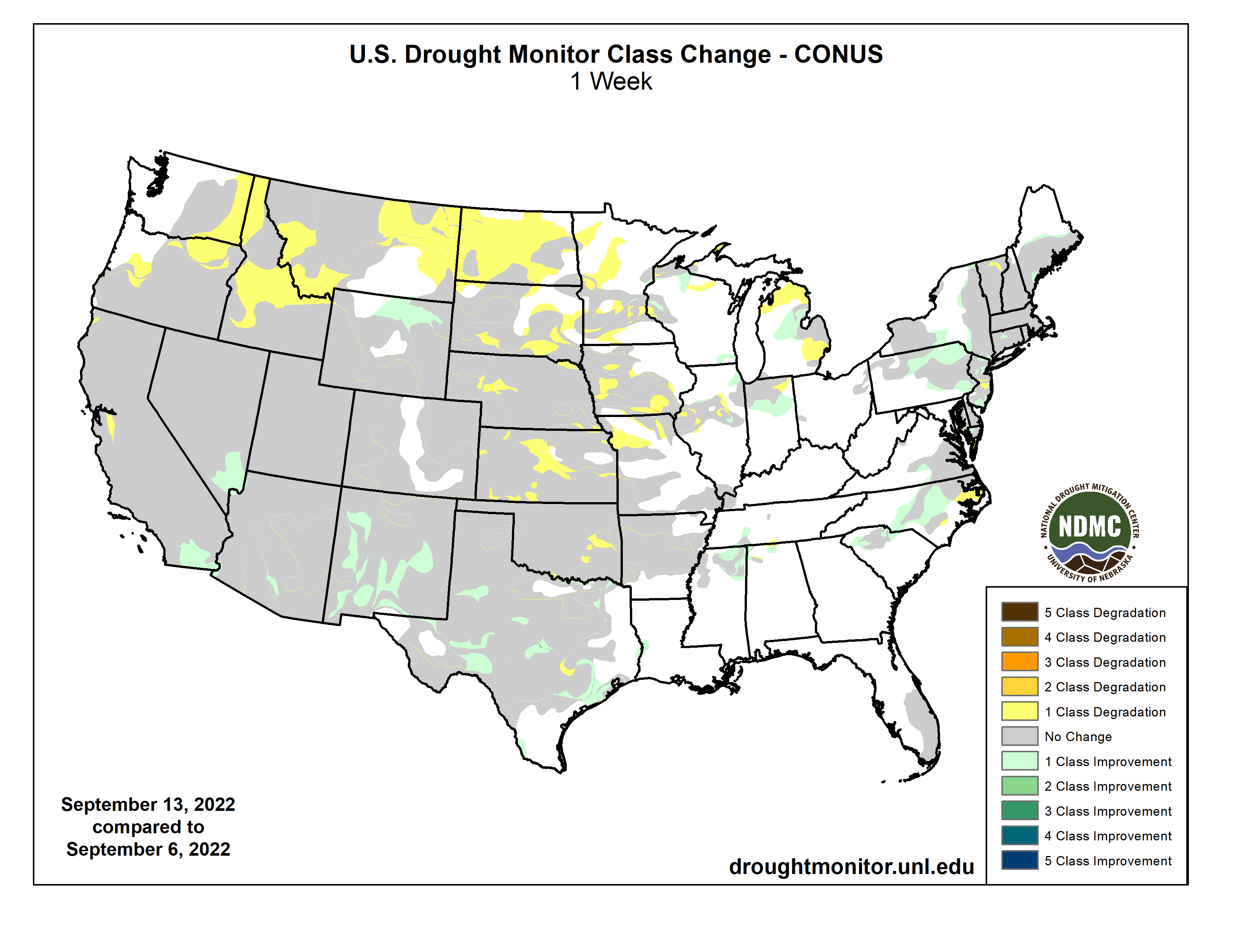
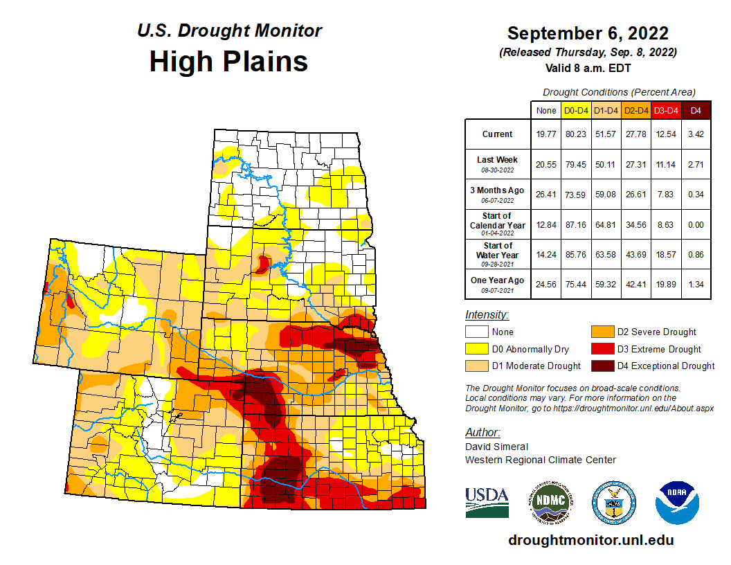
This U.S. Drought Monitor (USDM) week saw areas of isolated heavy rainfall in Southern California and the Desert Southwest in association with remnant moisture from Tropical Cyclone Kay late last week. Over the weekend and early this week, the residual moisture from the system moved further onshore impacting areas including Southern California, southern Sierra Nevada, Desert Southwest, and portions of the Great Basin. Overall, the heaviest accumulations were observed in very isolated higher-elevation areas of the Peninsular Ranges and Transverse Ranges of Southern California with accumulations ranging from 3 to 5-inches in addition to reports of wind gusts between 70-100 mph. Unfortunately, the overall impact of the precipitation on the long-term drought in California was negligible. In the High Plains, above-normal temperatures (2 to 6 deg F) and generally dry conditions during the past week continued to exacerbate drought conditions across areas of the central and northern Plains, with a growing number of drought impacts within the agricultural sector being reported to the National Drought Mitigation Center. In Texas, areas of isolated heavy rainfall accumulations (3 to 5+ inches) this week continued to ease drought-related conditions in the Rio Grande Valley and South Texas. In the Midwest, widespread heavy rainfall accumulations ranging from 2 to 6+ inches impacted northern Illinois and southern Wisconsin over the weekend—erasing some of the short-term precipitation deficits. Elsewhere in the region, a combination of short and longer-term precipitation deficits in Iowa led to degradation on the map, with rainfall deficits during the past 90-day period ranging from 4 to 8+ inches in southern Iowa. In the Northeast and Mid-Atlantic states, widespread shower activity this week helped to improve drought-related conditions in the southern portion of the Northeast region as well as alleviate short-term (past 30-60 days) precipitation deficits in areas of the Coastal Plain and Piedmont of North Carolina. In the Southeast, most of the region remained drought-free with exception of coastal areas of east-central and southern Florida, where rainfall deficits for the past 90-day period ranged from 4 to 12+ inches, causing some concerns regarding hydrologic drought (some low groundwater and surface water levels) with the end of the wet season approaching. Looking back at the 2022 summer months, the contiguous U.S. experienced its 3rd warmest June-August period on record since 1895 in terms of average temperatures (+2.52 deg F anomaly). Average minimum temperatures nationwide for August (+3.20 deg F) and the July-August (+3.12 deg F) periods were the warmest on record, according to NOAA National Centers for Environmental Information (NCEI). Precipitation in the contiguous U.S. during August and the July-August 2022 period ranked at 19th and 28th wettest, respectively, placing it in the top 1/3rd wettest…
On this week’s map, degradations were made in areas of Kansas, Nebraska, South Dakota, and North Dakota in response to continued dryness, decreased soil moisture, poor pasture and rangeland conditions, and impacts to dryland crops. In Kansas and Nebraska, the latest 7-day streamflow levels were showing widespread well-below-normal flows, especially in Nebraska. In southern Nebraska, numerous gaging stations on rivers and creeks were observing flows in the 1st to 2nd percentile range, according to the U.S. Geological Survey. For the week, average temperatures were above normal in the Dakotas (1 to 4 deg F) while Nebraska, eastern Wyoming, and Kansas were near normal to slightly below normal. According to NOAA NCEI, the Great Plains Region saw its 5th warmest (+2.7 deg F) and 19th driest June-August on record. Statewide, Nebraska experienced its 3rd driest June-August as well as its 2nd driest August on record…
Colorado Drought Monitor one week change map ending September 13, 2022.
Out West, numerous large wildland fires are currently burning across areas of California, Oregon, and Idaho causing evacuations, damage to structures, and reduced air quality. On this week’s map, some improvements were made in southeastern California, southern Nevada, and New Mexico in response to rainfall this week associated with residual moisture from Tropical Cyclone Kay as well as the overall impact of this summer’s monsoonal rainfall that has helped improve short-term meteorological drought conditions and vegetation health. Elsewhere in the region, a combination of short and long-term dryness, low streamflow, and declining soil moisture led to intensification of drought in areas of Montana and Idaho. For the week, average temperatures were 2 to 10+ degrees above normal across California, the Great Basin, northern portions of Arizona and New Mexico, and portions of the Pacific Northwest. Conversely, cloud cover associated with the remnants of Kay reduced daytime heating in the southeastern deserts of California and southern portions of Arizona and New Mexico, where average temperatures were 2 to 6 degrees below normal. According to NOAA NCEI, the June-August 2022 period was the 3rd warmest on record for the West Climate Region, which includes California and Nevada. Additionally, in terms of average minimum temperatures, both August (+5.6 deg F) and the July-August (+4.8 deg F) periods were the warmest on record. Looking at precipitation, it was the 8th wettest August on record for the West Climate Region and the driest (-6.95 inches) January-August period on record. For the Southwest Climate Region, it was the 7th wettest June-August period on record and the 7th warmest for the contemporaneous period. In the Northwest Climate Region, August (+6.2 deg F) and the July-August (+5.3 deg F) period were the warmest on record…
In the South, improvements were made across isolated areas of Mississippi, Tennessee, and Texas. Degradations were made on the map in areas of Oklahoma, where rainfall deficits during the past 90-day period ranged from -3 to -7+ inches. According to the Oklahoma Mesonet, the last 90-days were the 7th driest statewide with a -4.79-inch departure from normal (50% of normal). During the past week, rainfall accumulations across the region were generally light (<1 inches), with some isolated areas of Mississippi, southeastern Arkansas, Tennessee, and southern Texas receiving 2-inch accumulations. For the week, average temperatures were near normal across the region. According to NOAA NCEI, the South Climate Region experienced its 12th wettest August on record due to well-above-normal rainfall across areas of Texas, Louisiana, and Mississippi. For the June-August period, average temperatures for the South Climate Region ranked 5th warmest, with Texas ranking 2nd warmest for the contemporaneous period…
Looking Ahead
The NWS WPC 7-Day Quantitative Precipitation Forecast (QPF) calls for moderate-to-heavy precipitation accumulations ranging from 2 to 4+ inches across areas of the Upper Midwest, with the heaviest amounts expected in Upper Peninsula Michigan and northeastern Minnesota. Likewise, 2 to 4+ inch accumulations are expected across areas of Florida. Elsewhere, lesser accumulations ranging from 1 to 2+ inches are forecasted for northern portions of New England as well as areas out West including the Northern Rockies, Wasatch Range, eastern Great Basin, and portions of the Southern and Central Rockies. The CPC 6-10-day Outlooks calls for a moderate-to-high probability of above-normal temperatures for all areas east of the Rockies, while much of the West is expected to be cooler than normal with exception of coastal areas of California. Precipitation is forecasted to be above normal across much of the West. Below-normal precipitation is expected across most of the Eastern Tier.
US Drought Monitor one week change map ending September 13, 2022.
Releases from the Aspinall Unit will be decreased from 1450 cfs to 1350 cfs on Thursday, September 15th. Releases are being decreased due to the cooler and wetter conditions that have caused the river to rise above the baseflow target on the lower Gunnison River. The actual April-July runoff volume for Blue Mesa Reservoir came in at 68% of average.
Flows in the lower Gunnison River are currently above the baseflow target of 890 cfs. River flows are expected to remain above the baseflow target for the foreseeable future.
Pursuant to the Aspinall Unit Operations Record of Decision (ROD), the baseflow target in the lower Gunnison River, as measured at the Whitewater gage, is 890 cfs for September.
Currently, Gunnison Tunnel diversions are 1050 cfs and flows in the Gunnison River through the Black Canyon are around 440 cfs. After this release change Gunnison Tunnel diversions will still be around 1050 cfs and flows in the Gunnison River through the Black Canyon will be near 340 cfs. Current flow information is obtained from provisional data that may undergo revision subsequent to review.
Click the link to read the article on the Yahoo! Finance website (Grace O’Donnell). Here’s an excerpt:
“You know, our farmers and ranchers are used to dealing with curveballs coming their way, but we’re in a new era,” Kate Greenberg, commissioner of the Colorado Department of Agriculture, told Yahoo Finance Live (video above). “We’re really thinking about diversity, resilience, perseverance to make sure that we can keep producing food here in Colorado, knowing we’re under a future of less water.”
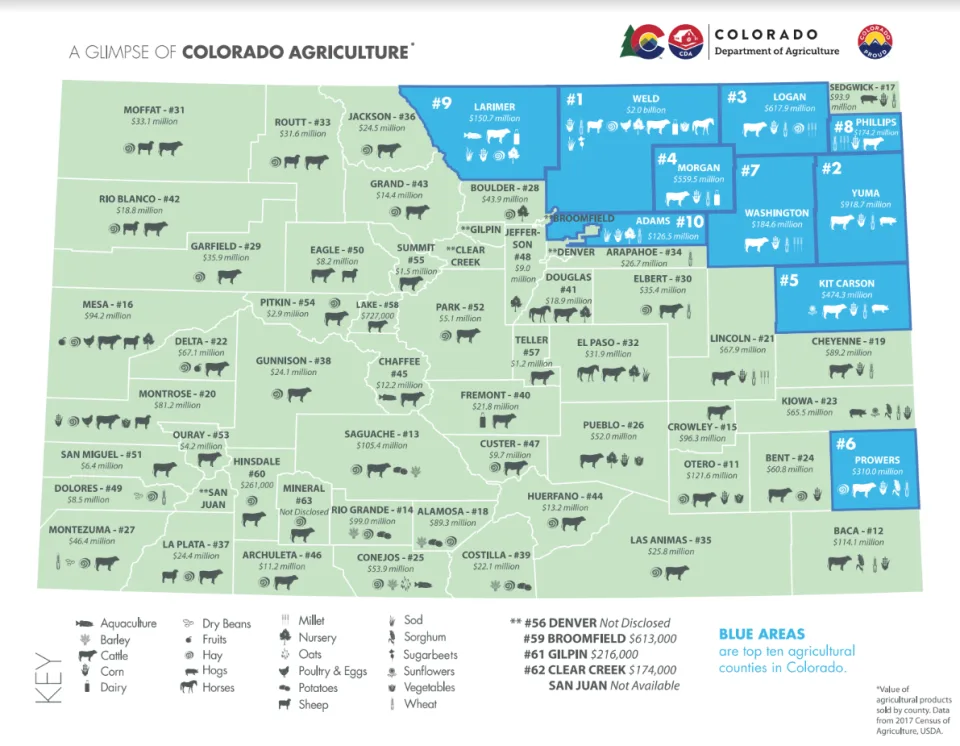
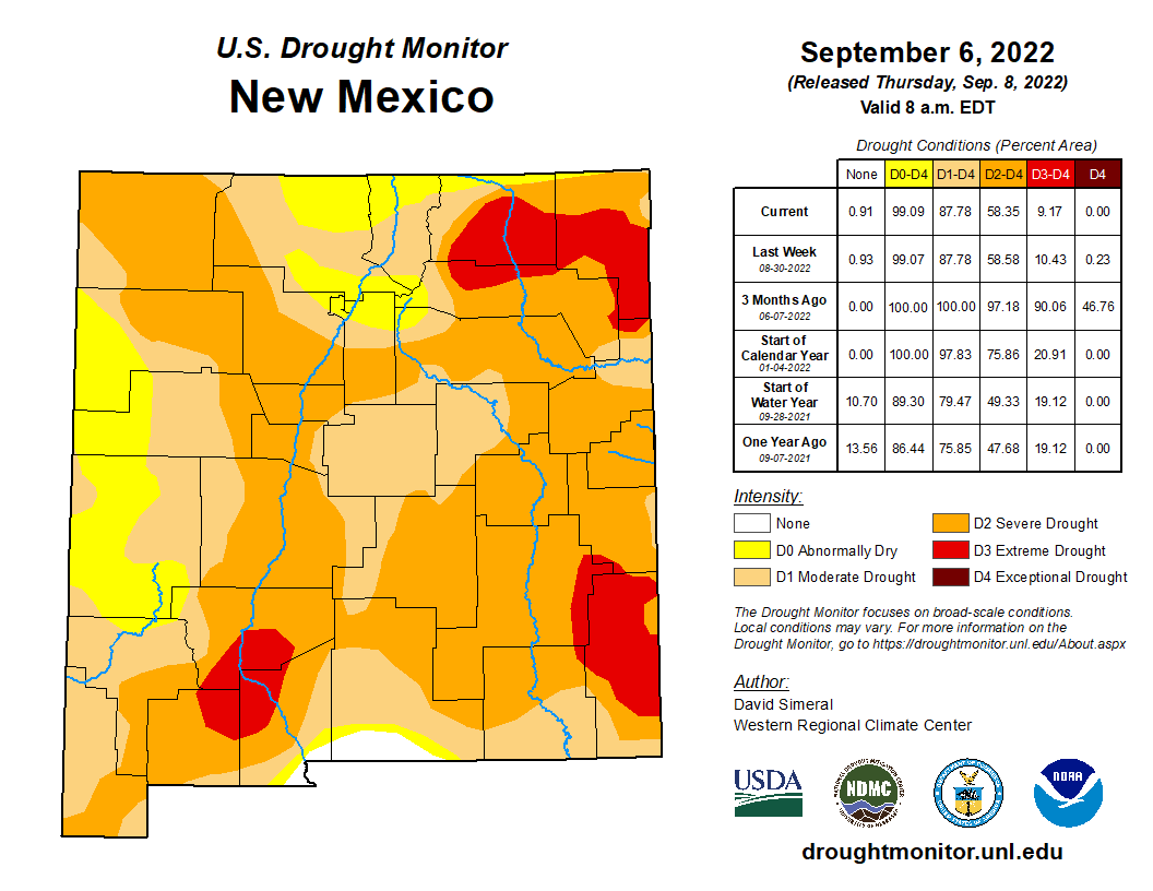
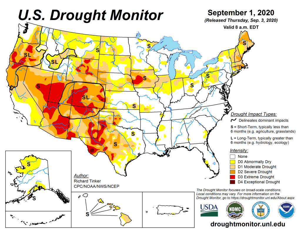
As of August 30, nearly half of the state (46%) is experiencing drought conditions, while 86% of the state is classified as “abnormally dry,” according to the latest Drought Monitor report. The most severely drought-stricken areas also happen to overlap with the top agricultural-producing counties in the state, as seen in the maps below. Agriculture makes up a $47 billion industry in the state, around a tenth of Colorado’s gross economic output, and employs over 195,000 workers. Cattle is the top commodity produced in the state…
Colorado Drought Monitor map Septermber 13, 2022.
Greenberg explained that Colorado farmers and ranchers started adapting by diversifying revenue streams, including building solar farms and looking at new ways of production that use less water. The Department of Agriculture also announced a $1.9 million investment into drought preparedness projects, including grants to farmers and funding for water infrastructure…
The top agricultural producing counties in Colorado are experiencing drought. (Colorado Department of Agriculture)
“We’re dealing with both the surface water and the groundwater issues out here in many of our basins,” Greenberg said. “While we’re experiencing this tightening in both the surface and the groundwater, we’re also seeing development of new technologies, new forms of collaboration, new ways of thinking about how we support our local economies in a drier future.”
Drawing to end of growing season and start of #harvest22. #drought22 showing its issue in condition reports. Worst in #plains. Not as bad central #cornbelt.
In response to a cooler weather pattern and sufficient flows in the critical habitat reach, the Bureau of Reclamation has scheduled a decrease in the release from Navajo Dam from 900 cubic feet per second (cfs) to 850 cfs for tomorrow, September 14th, at 4:00 AM.
Releases are made for the authorized purposes of the Navajo Unit, and to attempt to maintain a target base flow through the endangered fish critical habitat reach of the San Juan River (Farmington to Lake Powell). The San Juan River Basin Recovery Implementation Program recommends a target base flow of between 500 cfs and 1,000 cfs through the critical habitat area. The target base flow is calculated as the weekly average of gaged flows throughout the critical habitat area from Farmington to Lake Powell. This scheduled release change is calculated to be the minimum required to meet the minimum target baseflow.
Click the link to read the article on the Summit Daily News website (Eili Wright). Here’s an excerpt:
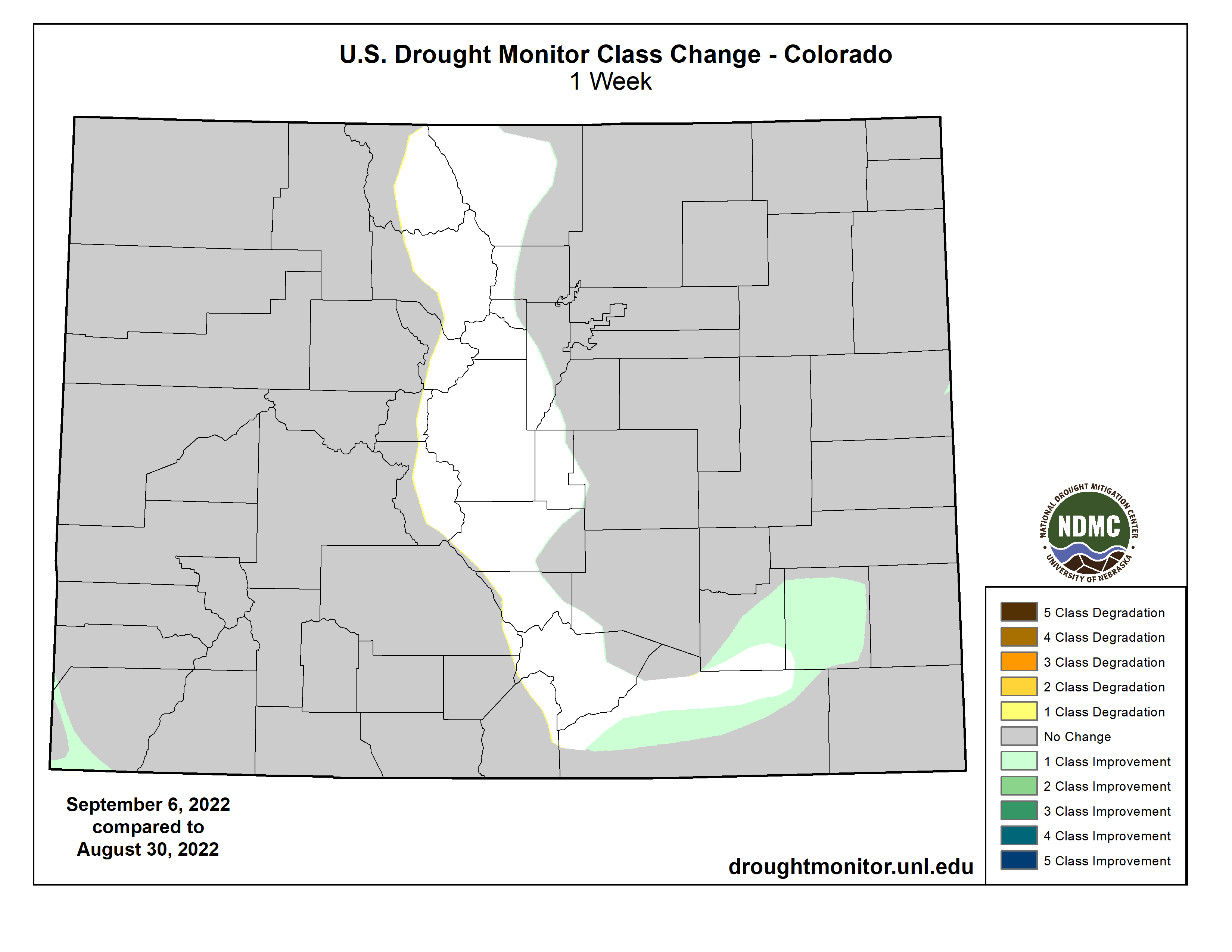
The southern half of Summit County has been lifted from drought status as of the morning of Sept. 6., according to the U.S. Drought Monitor. The line begins just south of Ute Peak, stretches along Interstate 70 and ends around Chalk Mountain, a Lake County landmark slightly south of the Summit County border. A quick glance at the map shows the boundary between the southern area of the county that is out of drought and the northern half of the county is only “abnormally dry” a slightly curved, vertical line that encapsulates every town south of Silverthorne…
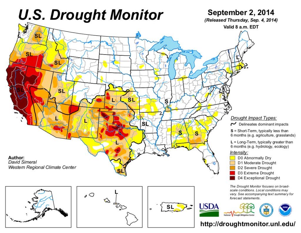
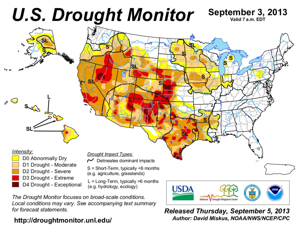
US Drought Monitor Colorado Map September 17, 2013
Summit County was last relieved from a drought in the spring of 2019, ending in the spring of 2020. The last time a drought was lifted in the fall was in 2013…This summer’s monsoonal rains are what changed the tide. Precipitation levels at Hoosier Pass, south of Breckenridge received the “second wettest June through August” on record, [Peter] Goble reported. The difference was the prolonged and spread out nature of this summer’s monsoonal rains, said Rocky Mountain Area Coordination Center wildland fire meteorologist Valerie Meyers. The consistency of the rains gave the county a chance to catch up on moisture from last summer, she added.
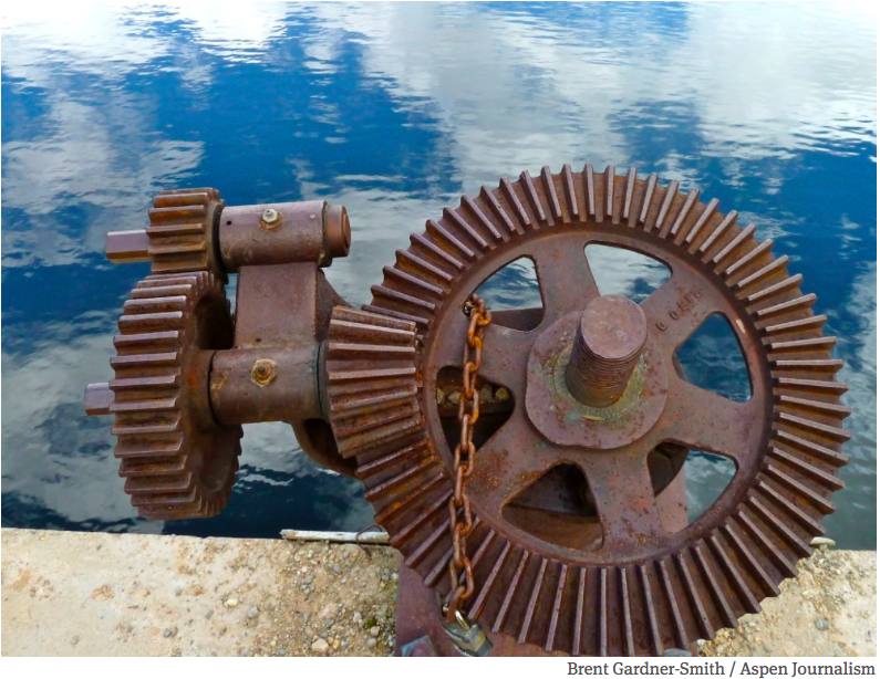
A gate mechanism on the dam that forms Lost Man Reservoir on a tributary of the upper Roaring Fork River. Diversions from the Colorado River basin could be curtailed if water shortages continue, either on a voluntary or involuntary basis. Photo credit: Aspen Journalism/Brent Gardner-Smith
Click the link to read the post on The Buzz website (Floyd Ciruli):
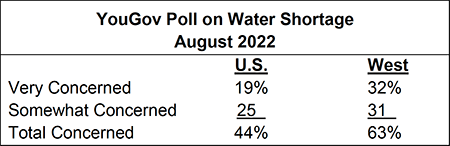
Three new public polls report that water supply and shortage is a top concern for the public. Although many parts of the country are dealing with drought and excessive heat, this summer the problem was especially acute in the western United States.
A recent YouGov poll shows that overall concern about water shortages among Americans is 44 percent, but concern rises to 63 percent among residents living in western states. The panel survey of 7,627 adults was conducted in August 2022.
New surveys in California indicate that concern about water shortage is even more intense among its residents. The latest Berkeley IGS poll reports that 71 percent of voters stated the current water shortage was “extremely serious.”
A Public Policy Institute of California poll conducted in July agreed. In it, more than two-thirds of Californians said that water supply issues were a “big problem” in their part of the state. Californians were also likely to say water supply and drought are currently the top environmental issues facing the state.
The Berkeley IGS survey was conducted online August 2022 with 9,264 registered voters. The Public Policy Institute of California poll was conducted July 8-15, 2022, with 1648 adult residents by Ipsos with its online KnowledgePanel.
Lost in much of the coverage of the region’s water woes is the ecological crisis caused by prolonged drought, climate warming and development.
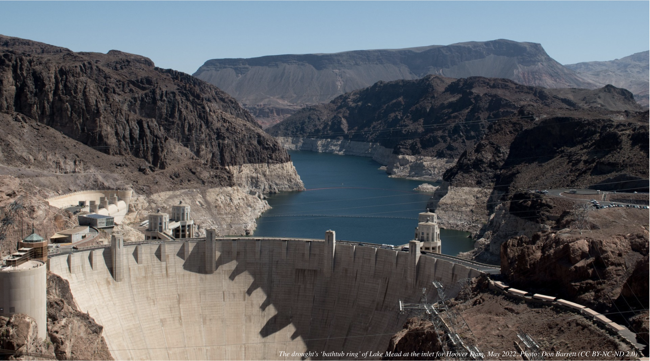
In the Colorado River basin, our past has come back to haunt us.
We’re not just talking about the dead bodies emerging from the drying shoreline of Lake Mead. The river’s water crisis has caused the nation’s two biggest reservoirs to sink to historic lows.
It’s a problem of our own making — in more ways than one.
The Colorado River Compact, signed a century ago, overallocated the river’s water. Experts have long warned that nature can’t continue to deliver the water that the government has promised to farms, cities and towns.
A drying West, warmed by climate change, has now made that shortage impossible to ignore.
Brad Udall: Here’s the latest version of my 4-Panel plot thru Water Year (Oct-Sep) of 2021 of the Colorado River big reservoirs, natural flows, precipitation, and temperature. Data (PRISM) goes back or 1906 (or 1935 for reservoirs.) This updates previous work with @GreatLakesPeck. Credit: Brad Udall via Twitter
For years demand has outstripped natural flows on the river, and some states and Tribes have already taken cuts to their allocations. Additional conservation measures were expected as the seven U.S. states that share the river — Colorado, New Mexico, Utah, Wyoming, Arizona, California and Nevada — have been working on hammering out a new deal. The region’s more than two dozen federally recognized Tribes have also been fighting for a seat at that table and a hand in the river’s management. But the deadline for a revised agreement between all the parties came and went this summer with no resolution in sight.
To say there’s a lot at stake would be an understatement.
Some 40 million people rely on the 1,400-mile-long river in the United States and Mexico, including in many of the West’s biggest cities. It also greens 5 million acres of irrigated agriculture.
But that’s come at a cost. Long before cities and industrial farms emerged, the river supported diverse mountain and desert ecosystems, providing refuge and resources for countless animals and plants.
Many of those species now struggle to survive the cumulative pressures from drought, climate warming and human developments. And they remain an overlooked part of the region’s water crisis…
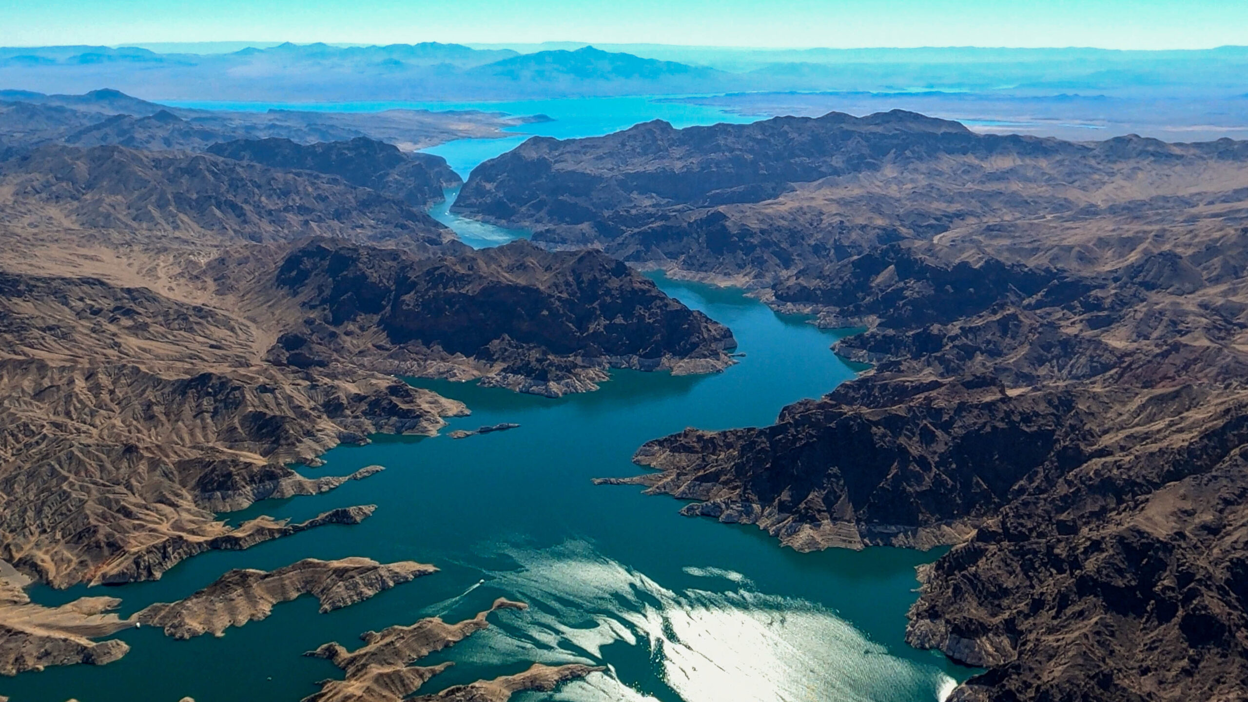
Hot Drought
A lot can happen in two decades.
In 2000 Lake Mead and Lake Powell, which help manage water supplies along the Colorado, were nearly full. Today they’re both hovering just above one-quarter capacity — the lowest ever since being filled.
Echo Bay Marina in the Lake Mead National Recreation Area, 2014. Photo: James Marvin Phelps (CC BY-NC 2.0)
In the intervening 20 years the Colorado River basin has seen a prolonged drought that’s now believed to be the driest period in the region in the last 1,200 years. River flows have fallen 20% compared to the last century’s average.
And it’s not just from a lack of precipitation. Researchers attributed one-third of that reduced river flow to climate change. Warming temperatures increase evaporation, as well as evapotranspiration by plants. So even when the Rocky Mountains do receive snow or rain, less of that runoff makes it to the Colorado River and its tributaries.
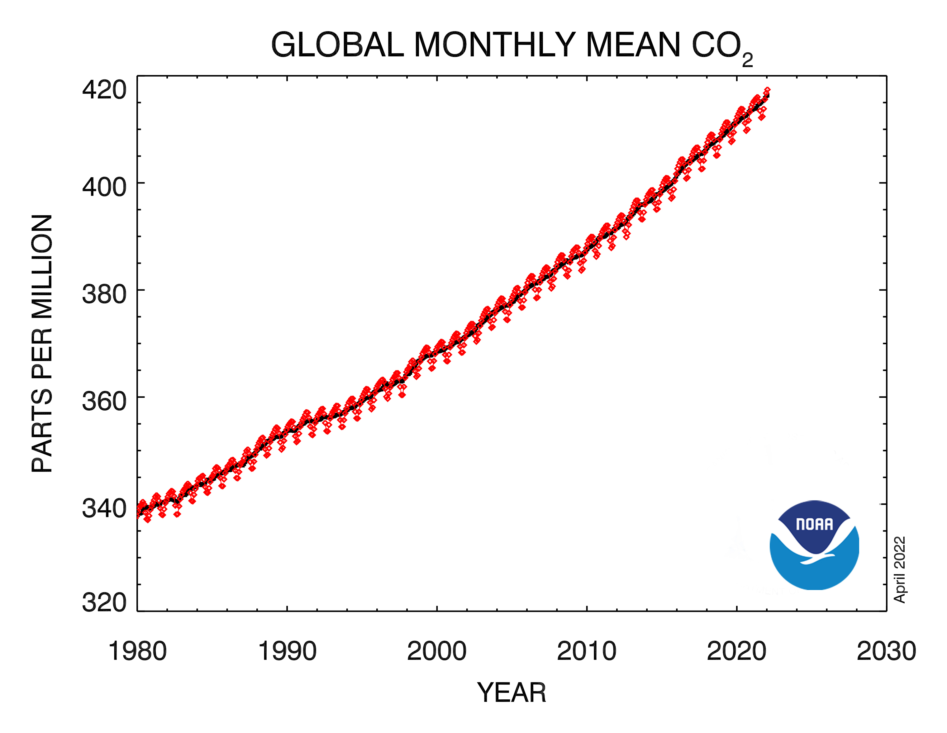
CO2 trend: This graph shows the monthly mean abundance of carbon dioxide globally averaged over marine surface sites since 1980. (NOAA Global Monitoring Laboratory)
Experts say we’ll see more of these so-called “hot droughts” as the climate continues to warm. The basin is expected to see a five degree-Fahrenheit jump by 2050. That will make things not just hotter but drier. If we don’t dramatically cut greenhouse gas emissions, the Colorado’s flow could drop 35% to 55% by the end of the century.
Years ago the region’s prolonged drought was dubbed a “megadrought,” but some of the region’s top scientists say “aridity” may be a better term. That means that the combination of warming and drying will be much more permanent.
Aridity and Animals
The region’s ecosystems — and those who live in them — are feeling the heat.
“Climate warming is just hammering this basin, and part of what we see in addition to the water disappearing is this protracted wildfire season,” says Jennifer Pitt, the Colorado River program director for Audubon, the bird-conservation organization. “The fires are more intense and cover ever-larger landscapes, that in turn has the possibility to severely impact the health of the watershed.”
Millions of trees have also been lost to insects and disease exacerbated by drought, including along riverbanks, where less shade is warming streams. Many desert plants, like ocotillos, Washington fan palms and Joshua trees, are also declining from warming temperatures, less precipitation and thirstier animals.
Across the region streams and springs are drying up, too, leading to declines in populations of aquatic amphibians, fish and insects that make up the base of the food chain.
“We haven’t seen any entire species go extinct yet,” says Michael Bogan, an assistant professor in the School of Natural Resources and the Environment at the University of Arizona. “But if you project this into the future, that’s certainly something we’re worried about.”
His concern includes the fate of endangered desert pupfish and Gila topminnows.
“They used to be present in large river systems, but the changes in the habitat and the introduction of non-native fishes have basically excluded them from all of those large historic habitats,” he says. “Now the only refuge where they can survive is these smaller habitats — these headwater streams and springs — and those are the exact types of places that are disappearing now.”
Birds are at risk, too, a recent study found. The researchers visited areas of the Mojave Desert that had been studied in the previous century and found that, on average, the sites lost 43% of their species. The main driver, they believe, is decreased precipitation from climate change.
Birds who live in the desert already endure harsh conditions, but climate change could push them past tolerable limits, causing lethal hyperthermia or dehydration. A lack of water can also cause reduced fitness and or force birds to skip a breeding cycle.
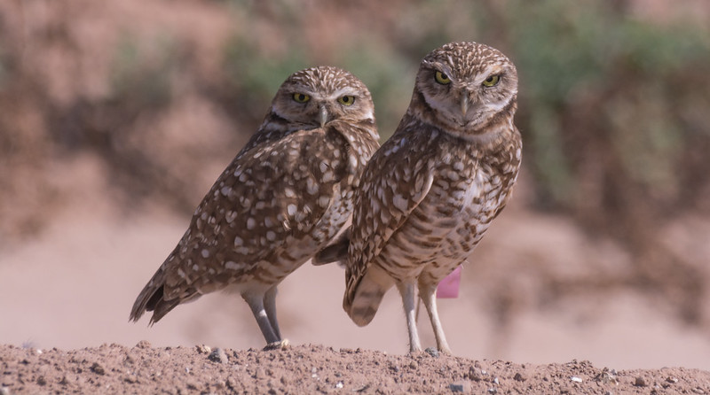
We already see this happening with burrowing owls. A study by researchers from the University of New Mexico looked at how increasing air temperature and aridity affected the species.
Burrowing owls. Photo: Wendy Miller (CC BY-NC-ND 2.0)
Between 1998 and 2013 the birds at their study area in New Mexico experienced a decline in the number of young that left the nest and a precipitous 98.1% drop — from 52 breeding pairs to just one.
The researchers associated the declines with the effects of decreased precipitation and increased temperature. “An increasingly warm and dry climate may contribute to this species’ decline and may already be a driving force of their apparent decline in the desert Southwest,” they concluded.
Mammals aren’t immune to the changes, either. Another recent study found grave threats to pronghorn across the region. Their models predicted that half of the 18 populations they studied would disappear by 2090.
A decrease in water supply affects animals’ health but can also cause behavioral changes that could put them in harm’s way. If animals need to move outside their normal range in search of declining food or water, it could lead to more interactions with predators or more human-wildlife conflicts, especially if animals look for resources in more urbanized areas.
Fewer sources of water also force a greater number of animals to congregate at the remaining watering holes. Experts say this increases the risk of disease outbreaks like the one that happened in 2020 along the Pacific flyway in California and Oregon, when 60,000 birds crowded into sparse wetlands perished from avian botulism.
An Altered River
Many of the most severe ecosystem impacts currently affecting the Colorado basin predate the 20-year drought.
Hoover Dam’s construction in 1936, followed by the building of Glen Canyon Dam 30 years later, dramatically altered river’s flow, blocked sediment that creates riparian habitat, and changed the temperature of the river…
Glen Canyon Dam on the Colorado River. Photo: Simon Morris (CC BY-ND 2.0)
Today the 360 miles between the two dams, which include the Grand Canyon, have become “a river that’s managed to pool-to-pool,” says Pitt. “There’s not much flowing river once you get below Hoover Dam.” That’s caused a loss of riparian forest, which supported birds and other wildlife, and pushed four native fish — humpback chub, bonytail chub, Colorado pikeminnow and razorback sucker — to the brink of extinction.
“There’s concern for quite a number of species because of the historically altered river flow,” says Pitt.
Colorado River Delta via 2012 State of the Rockies Report
It also decimated 1.5 million acres of wetlands downstream at the Colorado River Delta in Mexico.
“For most of the last 50 years, the river has not flowed to the sea,” says Pitt. “An untold wealth of wildlife disappeared off the map because of the desiccation of that landscape.”
Compounding Problems
Development, dams and water diversions along the Colorado, along with today’s drought and climate warming, have pushed many species to the razor’s edge. Some are barely hanging on.
Humpback chub
Of particular concern right now are humpback chub, which suffered after Glen Canyon Dam’s construction. Managers have spent decades trying to recover the fish — with some recent success.
But now the species faces a new threat: non-native largemouth bass — a voracious predator of humpback chub — who thrive in the warmer water that’s being released from the diminished reservoir.
In June researchers detected the fish downstream of Glen Canyon Dam, in the same habitat where humpback chub numbers were finally improving.
“The National Park Service is really worried that if those populations of non-native fish get established in the Colorado River downstream from Glen Canyon Dam, that could be catastrophic for the humpback chub,” says Pitt.
Echo Bay Marina in the Lake Mead National Recreation Area, 2014. Photo: James Marvin Phelps (CC BY-NC 2.0)
The situation is emblematic of the larger ecological consequences stemming from our river management.
“How we manage the dams and the water levels is directly affecting the ecology of the Colorado River itself,” says Bogan.
And while that imperiled ecology may not be the headline news regarding the Colorado River crisis, its significance shouldn’t be understated.
Millions of people visit the Grand Canyon each year to peer over the canyon’s lip and glimpse the Colorado’s path through the ancient towering walls. They come, too, to see California condors, bald eagles and southwestern willow flycatchers — all of whom could disappear if the river does.
The loss of plants and animals across the basin is also a loss of cultural resources for the region’s Tribes.
And as the river declines, so does everything around it…
Worse Before It Gets Better
As states work to deal with shortages of water from the Colorado River, there’s a chance that things could get worse before they get better.
One concern is an overdrafting of groundwater, particularly in Arizona, which legally bears the brunt of shortages on the Colorado and has many areas where groundwater pumping is not regulated.
That can leave groundwater-dependent springs and streams at risk of drying.
Another area of concern is California’s Salton Sea — the famously saline lake in the desert fed now only through agricultural runoff from the neighboring irrigation districts. One of those is the Imperial Irrigation District, which gets the biggest chunk of California’s Colorado River allotment. As the region attempts to work out a new plan to decrease water use, there’s pressure on the agency to fallow some of its 475,000 acres, but that would also mean less runoff making it to the Salton Sea.
Burrowing owls. Photo: Wendy Miller (CC BY-NC-ND 2.0)
“The Salton Sea is some of the only remaining habitat for migrating water birds and shorebirds in interior California,” says Pitt. “The Central Valley was that habitat once upon a time, but has been completely developed. So it’s a critical habitat for many species.”
It’s also a public health threat. As winds sweep across the drying lake, particles of dust and pollution are swept into neighboring communities where residents suffer from high rates of asthma and respiratory problems.
“The answer is not that we can’t reduce any water use from the Imperial Irrigation District,” she says. “As uses of water are reduced in irrigated agriculture that drains to the sea, there needs to be mitigation.”
A plan, that includes habitat restoration and dust mitigation suppression projects, created decades ago to do just that has been slow to get off the ground. It needs to “ramp up quickly to protect wildlife and to protect public health,” she says.
The Path Forward
There is some good news.
Minute 323 environmental section signing. Photo credit: Colorado River Water Users Association
Agreements between Mexico and the United States in the past decade have enabled “pulse flows” of water to flow downstream to repair a small amount of the lost wetland habitat in Mexico’s California River Delta. And in the desert, fortunately, a little can go a long way.
“We’re seeing improvements in both the number of bird species detected there and the populations of those species,” says Pitt. She’s optimistic that the two governments will continue to support that environmental program in the future.
It’s an idea that could help upstream habitat as well.
“I think really the most important thing that’s being done at both the state level and at the local level is trying to get dedicated flows in streams that are explicitly for the conservation of aquatic species,” says Bogan. Although right now, because of the complexities of water rights, that work is limited and usually local in scope.
“But it’s something that at least has given me a little bit of hope,” he says.
Another strategy, says Pitt, is “natural distributed storage,” which means restoring wetlands and high-elevation meadows to slow water down as it runs across the landscape. That can help recharge groundwater and provide moisture to soil and plants.
“The more moisture we’re keeping around the less vulnerable these areas are to fire,” she says. “It will have an incredible wildlife benefit because those meadows are rich habitat.”
It’s akin to the work that beavers do naturally, but people can replicate.
“It sounds small if you look at it on one little creek,” she says, “but if we can start to see it implemented across the upper basin, I think it could really scale up to make a difference.”
With the cumulative impacts of human development and climate change adding up, Pitt says we should look to the federal government and states to make sure that Endangered Species Act programs are supported to help protect and restore habitat for the dozens of already at-risk species in the basin. This means going beyond supplementing the number of endangered wild fish with hatchery-raised fish, which is the current management strategy.
And of course, the region still needs to grapple with how it allocates and manages the Colorado River’s water. Pitts says she’d like to see a greater role for Tribes in that process and the inclusion of adequate water to maintain healthy ecosystems.
“Environmental water needs to be recognized as part of our objectives for water management,” says Pitt.
“It’s both extremely challenging at this moment because there’s so much less water available to carve up between users,” she says. “But it’s a moment to really rethink how we do things.”
A presentation for San Juan County commissioners on the status of local watersheds on Sept. 6 illustrated that while the Four Corners region remains locked in the grip of a long-running drought, it is in relatively good condition compared to other parts of the Southwest. The 14-minute presentation delivered by Aaron Chavez, executive director of the San Juan Water Commission, was designed to bring commissioners up to speed on the health of the county’s two main watersheds, those associated with the Animas and San Juan rivers.
New Mexico Drought Monitor map September 6, 2022.
But Chavez, who is beginning a two-year term as president of the Colorado River Water Users Association, also devoted a significant amount of attention to the status of that watershed, which serves as a crucial water supplier to tens of millions of residents of New Mexico, Colorado, Wyoming, Utah, Arizona, Nevada, California and Mexico…Chavez began his presentation by noting that while last winter’s snowpack in southwest Colorado was close to normal, it did not yield the kind of runoff one might have expected because the soil moisture content in the region was down substantially after years of substandard precipitation…
Nevertheless, most of the indicators Chavez examined this year were an improvement over the recent past, he said, as he noted the Four Corners area has had a good monsoon season this year that has helped make up for the relatively poor spring runoff. Most river basins in the area, he said, are at 90% to 100% of average…
Navajo Reservoir, New Mexico, back in the day.. View looking north toward marina. The Navajo Dam can be seen on the left of the image. By Timthefinn at English Wikipedia – Transferred from en.wikipedia to Commons., Public Domain, https://commons.wikimedia.org/w/index.php?curid=4040102Vallecito Lake via Vallecito ChamberMcphee ReservoirLake Nighthorse and Durango March 2016 photo via Greg Hobbs.
According to figures from the U.S. Bureau of Reclamation cited by Chavez, Navajo Lake was 55% full as of Aug. 24 — a level that was roughly equal to other local reservoirs, as Vallecito Lake northeast of Durango, Colorado, was at 49% and McPhee Reservoir north of Cortez, Colorado, was at 53%. The good news was that Lake Nighthorse west of Durango was listed at 99% full…But those figures stood in sharp contrast to the Southwest’s two mammoth reservoirs fed by the Colorado River. Lake Powell in Utah and Arizona was only 26% full, while Lake Mead in Nevada and Arizona was at only 28% of capacity.
The Maybell Ditch headgate in the lower left pulls water from the Yampa River for irrigation. A major reconstruction project will fix the diversion structure to create better passage for fish and boats. CREDIT: HEATHER SACKETT/ASPEN JOURNALISM
The Maybell Ditch is the largest diversion on the Yampa River and irrigates about 2,500 acres of grass and alfalfa in northwest Colorado. But the remote and antiquated headgate, along with a hazardous diversion structure and 18 miles of nearly flat canal, create problems for irrigators, boaters and endangered fish alike.
Now the Maybell Irrigation District and The Nature Conservancy are working together on an ambitious project to rehabilitate and modernize the historic structure with the goal of improving conditions for all the water users on this stretch of river. So far, TNC has secured about $3.5 million in funds for the project, which it hopes can begin next summer.
Yampa River Basin via Wikimedia.
The Yampa River flows from the Flat Tops Wilderness, through the city of Steamboat Springs, then turns west and eventually joins with the Green River in Dinosaur National Monument. Along the way it turns the semi-arid landscape of Routt and Moffat counties into a ribbon of green, irrigated meadows.
In recent years the Yampa has started experiencing issues that have long been a part of other river basins like over-appropriation, calls and water shortages.
“That reach has seen declines in water levels over time with drought and long-term climate impacts,” said Jennifer Wellman, TNC project manager. “(The Maybell Ditch project) was one of those that rose to the surface where we could hopefully work with the water users to have a greater impact in that basin … . That whole reach is really special, and it warrants more water if it’s available, especially during the low flow periods.”
This map shows the 18 miles of the Maybell Ditch, which irrigates land with water from the Yampa River. The Nature Conservancy is planning an overhaul and modernization of the headgate and diversion structure.
Challenges for irrigators, boaters, fish
Maybell Irrigation District manager Mike Camblin said historically some ranchers couldn’t get their full amount of water unless the ditch, which was constructed in the 1890s, was running full blast.
“We had one field where if the ditch wasn’t full, they couldn’t get it wet because there wasn’t enough elevation to it,” he said. “It was too flat.”
That meant more water was being sent through the ditch as “push water” to make sure flows make it to dry fields. It also meant more water was flowing back into the Yampa River at the end of the approximately 18-mile-long ditch, known as tailwater. If there’s too much tailwater, that can mean a ditch is taking more out of the river than it is able to use, a no-no according to the state Division of Water Resources.
A first round of improvements to the ditch added a liner to reduce seepage and check structures, which slow the flow of water. Those measures only partially addressed the issues.
The project that is now being proposed is much more extensive and involves reconstructing the diversion and modernizing the headgate, which controls the flow of water from the river into the ditch. By fixing a grade control structure — essentially arranging boulders in mid-stream that push up the water in the river upstream of the headgate — it creates more elevation to allow gravity to move water into the ditch, which should reduce the need to push water. It will also smooth out a passage for both fish and boats.
The twin, circular headgates of the Maybell Ditch are rusted, antiquated and must be open and closed manually. A modernization project includes plans to make it possible to operate the headgate remotely.CREDIT: HEATHER SACKETT/ASPEN JOURNALISM
Remote location
The twin, circular, century-old headgates are rusted and hard to operate.
“There’s no way those things are easy to adjust,” said Erin Light, Division 6 engineer at the state Division of Water Resources. “Quite frankly, if the water commissioner had to adjust it, I don’t think he or she could. We would have to rely on (the irrigation district) to do that, which is not preferred.”
The remote location of the headgate — a three-mile round trip hike down the rugged Juniper Canyon off an already-remote dirt road — is a challenge for the district. When all the headgates on the ditch are opening and closing according to the differing schedules and water needs of the irrigators, it can be hard to coordinate the manual operation of the main headgate. The new headgate will be automated and controlled remotely.
“That’s a four- or five-hour deal by the time you drive up there, walk up there, adjust it and drive home,” Camblin said. “The automation on that will be huge. As far as management, it will be our biggest tool.”
But construction won’t be easy. Heavy equipment can’t make it down to the river along the ditch and will have to access the diversion using newly constructed roads on Bureau of Land Management land. The BLM considers the ditch a cultural resource and project proponents will have to be careful to avoid impacts to it.
Western Colorado Area Manager for JUB Engineers Luke Gingerich explained the complexities of the project on a site visit in July.
“They are going to have to create a couple miles of nice road to get in,” Gingerich said. “It will be a large disturbance and we’ve got to come back and make sure we return this as close as we can to the condition it was in before.”
According to Camblin, it was the federal Upper Colorado River Endangered Fish Recovery Program that first pushed the district to take a look at where it could manage its water better. That stretch of river is designated critical habitat for species of endangered fish. Water is released out of the upstream Elkhead Reservoir for the fish, and the new automated headgate will allow the Maybell Ditch to more easily let that water flow past it, to get to where it’s needed.
The Maybell Ditch diversion, located in Juniper Canyon in northwest Colorado, takes water from the Yampa River to irrigate hay fields. The Nature Conservancy is fundraising for a project that would overhaul and modernize the diversion structure and headgate.CREDIT: HEATHER SACKETT/ASPEN JOURNALISM
Boon for boaters
The diversion reconstruction project will also be a boon for boaters. River advocacy nonprofit Friends of the Yampa said in a letter of support for the project that the Maybell Diversion is the most significant barrier for safe, passable recreation along a 200-mile stretch of the Yampa River. Boaters often have to get out to portage the rapid formed by the diversion structure. The new diversion will create a boat passage, connecting two sections of boatable river.
At July’s site visit, recreation and education coordinator for Friends of the Yampa Kent Vertrees said he’s grateful for the collaboration between the agriculture, recreation and environmental water users.
“As a recreation person, I’ve said all along we get the dregs of all the other water users,” Vertrees said. “We rely on agriculture more than anyone to make sure there’s water in the river. It’s really great, our partnerships in northwest Colorado.”
But that partnership was a bit of a hard sell at first, Camblin said. Some Maybell Ditch irrigators were skeptical about a project spearheaded by an environmental group. Tensions can sometimes run high between irrigators, who take water out of rivers, and environmental groups, who want to leave water in rivers. Camblin said the district held several meetings between irrigators and TNC to assure water users their water rights or how they manage their ranch wouldn’t be threatened.
“One of our goals we talked about when we started this was, we wanted to show people the agriculture community can work with groups they don’t normally work with,” Camblin said. “We are hoping other ag communities say, ‘Hey, you know what? Some of this stuff is possible. I might have to reach across the table to make it work but this will be a beneficial project to so many people.’”
The headgate and diversion reconstruction could come with a hefty price tag and TNC is still fundraising for what could end up costing more than originally thought due to supply chain interruptions and inflation. The project has secured almost $3.5 million so far, nearly $2 million of which comes from a Bureau of Reclamation WaterSMART grant. The Colorado Water Conservation Board has contributed about $1 million so far; the Colorado River Water Conservation District will give $500,000; $40,000 will come from the Yampa River Fund and the irrigation district is also contributing money and in-kind resources. However, the total final price tag remains unknown and is likely to be higher than what’s already been secured. Wellman said some of the additional funding needed will also come from the National Resources Conservation Service.
Aspen Journalism covers water and rivers in collaboration with The Aspen Times. This story appeared in the Sept. 11 edition of The Aspen Times.
Last night’s storm (July 30, 2021) was epic — Ranger Tiffany (@RangerTMcCauley) via her Twitter feed.
Click the link to read the article on the Aspen Times website (Cassandra Ballard). Here’s an excerpt:
On Thursday [September 8, 2022], a minor fire popped up on the line between two fire districts in Grand Valley, the Colorado River Fire Rescue District and the Grand Valley Fire Protection District. It was quickly contained, but it could be a sign of things to come this fall if the Western Slope’s drying trend continues as forecast by the National Weather Service through November.
“As things dry out, those kinds of fires are common,” said Chief Lief Sackett of Colorado River Fire Rescue. “Just knowing how brown and cured out all the grass is this time of year, and how dry and hot it’s been, those are common fires.”
The good news is the worst extent of the anticipated heat is finally over, and a little rain should be coming.
Increases in most of the West and Plains states (except, not surprisingly, TX) led to a 1% increase across the Lower 48. 49% of topsoil moisture in the Lower 48 is now short/very short.
Brad Udall: Here’s the latest version of my 4-Panel plot thru Water Year (Oct-Sep) of 2021 of the Colorado River big reservoirs, natural flows, precipitation, and temperature. Data (PRISM) goes back or 1906 (or 1935 for reservoirs.) This updates previous work with @GreatLakesPeck. Credit: Brad Udall via Twitter
Senior water and climate research scientist at Colorado State University and one of the authors of the National Climate Assessment. Photo credit: Colorado State University Water Institute
Brad Udall, a Senior Water and Climate Research Scientist at Colorado State University, spoke at a virtual meeting of the RNRF Washington Round Table on Public Policy on March 9, 2021. He discussed the imbalance between water supply and demand in the Colorado River basin, how climate change is exacerbating the issue, and the ongoing renegotiation of the river’s management guidelines.
Introduction and Background
The Colorado River basin extends into seven states (Wyoming, Colorado, Utah, Arizona, New Mexico, Nevada, and California) as well as Mexico, along with the land of 29 Native American tribes. The American portion of the basin represents 8% of the area of the lower 48 states. Altogether, about 40 million people, including the populations of all major cities in the Southwestern U.S., rely on the Colorado for some portion of their water supply. The river is used heavily for municipalities as well as agriculture, with about 4.5 million acres of irrigated land in the basin.
The water supply in the river is often measured by the water levels in its two major reservoirs, Lake Mead and Lake Powell. These are the two biggest reservoirs in the U.S. In order to maintain sustainable levels in these two reservoirs over a long time period, withdrawals from the river must equal the supply being provided by the river’s flow. This was the case in 2000, when the combined contents of the reservoirs were over 90% full. Since then, their water level has dwindled to less than 50% due to a “structural deficit” – demand for the river’s water consistently outpacing supply. This is due in large part to the fact that over the past 20 years, the basin has been experiencing its worst drought on record. The flow of the river has decreased from ~14.75 million acre-feet (maf) to ~12.4 maf. Even before the drought began, water demand was high in the basin; since about 1990, it has not reliably reached the ocean.
While the current situation in the watershed is usually described as a drought, a lack of precipitation is really only half the story. Regional temperature increases, exacerbated by climate change, have also had a significant impact on the reduction of water availability. Udall noted that evaporative losses will only become more severe as climate change worsens. The Southwest is already one of the quickest-warming areas of the country, a trend that is expected to continue. The risk of multidecadal droughts will also continue to drastically increase in coming decades. The 2000-2018 period was the second-driest 19-year period in the basin since 800 AD. While this is partially attributed to natural variation, researchers have said that 50% of the decrease in soil moisture can be attributed to anthropogenic climate change. Climate change has turned what would likely be a moderate drought into an extreme, historic drying event. Aridification and heating, along with reduction in precipitation, are causing drastically drying conditions in a river basin that tens of millions of people rely on for their water.
Historical Management of the River
In 1922, to fully allocate use of the river’s water, the basin states agreed to the Colorado River Compact. This agreement still serves as the basis for the Law of the River, which is the set of rules for the river’s allocation and management. In response to the “hot drought” happening since 2000, new modifications to the Law of the River have been necessary to prevent the reservoirs from becoming depleted. The first of these, called the Colorado River Interim Guidelines, went into effect in 2007. These guidelines set out a series of complicated rules for how Lakes Powell and Mead are operated, allowing different quantities of water to be released from them when they are at certain elevations. They constrain use of water when the reservoirs are low. One innovative structure used to accomplish this is “intentionally created surplus,” which allows parties in the lower basin to store their water in a sort of “bank account” in Lake Mead.
Around 2013, it was becoming clear that persistently dry and hot conditions were rendering the 2007 Interim Guidelines insufficient. A new agreement was necessary. As a result, two new “Drought Contingency Plans” (DCPs) for the Upper and Lower Basins were adopted in 2019. Early in 2021, for the first time, drought conditions in the river reached the point where the DCPs’ provisions were activated. Udall noted that these agreements made some progress toward making the river’s use more sustainable but were not a permanent solution.
Future Management of the River
Udall finished his presentation by discussing future prospects for sustainably managing the river in these drying conditions. In 2026, the 2007 Interim Guidelines and DCPs expire. The seven basin states, 29 tribes, Mexico, and the federal government have already begun the multi-year process of renegotiating a new set of guidelines which will be adopted in 2027. The following are some central considerations for a successful new agreement described by Udall.
The Upper Basin’s “Delivery” Obligation
Among the problems that stakeholders are aiming to resolve is the nature of the Upper Basin’s delivery obligations. There is a clause in the original Colorado River Compact that says that the Upper Basin shall not allow the flow of the river to decline below 75 maf every ten running years. However, it is not clear if this obligation is really a “delivery” obligation or if it is a “non-depletion” obligation. If it is a delivery obligation, that means that the entire reduction of flow coming from the Upper Basin due to climate change falls on the Upper Basin to solve. Clearly, this was not the intent of this clause in the original 1922 compact, and the Upper Basin states are making this argument.
Native American tribes are expected to have a much more significant role in the renegotiation of the Interim Guidelines than they have had in previous decision-making processes for management of the river. There are 29 tribes in the basin. Altogether, they have a right to control about 20% of the basin’s water. This right derives from a 1908 Supreme Court decision which issued the “Winters Doctrine.” This doctrine said that when the federal government creates a reservation of land for a tribe, implicit in that reservation is a water right.
However, tribal interests were still left out of the 1922 compact, and many of their rights remain unquantified. Even in the 21st century, the tribes in the basin were not invited to participate in the 2007 Interim Guidelines negotiations or the 2012 Basin Study. The 2019 DCPs were an important development in the inclusion of tribes in river management discussions after their needs and rights had been historically ignored. For the first time, these 29 distinct tribes were acting collectively and were included in the planning process. The DCPs were also the first time that a tribe agreed to accept a monetary payment in exchange for using less than their full water right. Inclusion of tribal interests in the renegotiation of the Interim Guidelines is expected, and will be essential to the new agreement’s success.
The Structural Deficit
Fundamental to the dilemma faced by basin stakeholders in this renegotiation process is the “structural deficit.” This is, quite simply, an imbalance between the supply of and demand for water in the basin. Since 2000, demand has outpaced supply. Demand reductions are challenging because once a water user has access to a supply of water, it is difficult to get them to relinquish it. The supply-side is more challenging to address. In the absence of cooler temperatures and more precipitation – conditions increasingly unlikely as climate changes — it is difficult to create more supply. It is easier to change consumption patterns than it is to change the hydrology of the river. Without demand reductions in the Upper and Lower Basins, there is a high probability that the amount of water in the reservoirs will continue to fall.
Udall referenced a recent study that found that the Upper Basin’s water demand is unsustainably high. Despite this finding, parts of the Upper Basin actually want to increase their demand, which in the face of declining flows is an issue that will need to be addressed in the negotiation process. Demand Management measures, by which water users can voluntarily accept money in exchange for reducing their water consumption, will likely be part of the solution in the Upper Basin but caps on demand may also be necessary to ensure that the delivery obligation is fulfilled.
In the Lower Basin, the Central Arizona Project diverts water from the Colorado River into Arizona, providing water for an area including the cities of Phoenix and Tucson. As a part of the original agreement that permitted this project, it was agreed that if there ever was a shortage of water in the basin, Arizona would bear the brunt of demand reductions. Demand reductions will likely be necessary in the Lower Basin but Udall noted that it would be difficult in practice to mandate that they all come from Arizona. Solving this dilemma will be a part of the new Interim Guidelines negotiations. One method that may be used is to begin charging evaporative losses to state water budgets in proportion to their use. Currently, evaporation is being charged to nobody, which is a part of the overuse problem.
Guidelines for Successful Renegotiation
Udall also identified other steps that can be taken by stakeholders to work toward a successful new set of interim guidelines. First, he emphasized the importance of good science. Realistic climate and hydrological modelling are necessary to inform the negotiations. Udall noted that many of the models being used by watershed states are overly optimistic with regard to future hydrology. Beginning the negotiations with inaccurate presumptions about the future of the watershed are setting the new agreement up for failure. While the renegotiation is a political process, it needs to be informed by most accurate scientific information possible.
Because the structural deficit is a basin-wide issue, Udall advocated for the use of a combined metric that adds the quantity of water in Lakes Mead and Powell. This would be a more accurate way to gauge water shortages because the water in the reservoirs individually is less important than the total quantity between them when informing the management of the entire river basin. He also said that using clear language in negotiations is critical. For instance, one should never inaccurately say that the Colorado River Compact itself is being renegotiated. It is only the Interim Guidelines that are being replaced; the Compact remains the foundation for the river’s allocation.
The renegotiation process is more than just a group of stakeholders sitting around a table, working out a plan for the river. It is a series of large and small meetings, some more formal than others. Since not everything is negotiated in official sessions, there is room for behind-the-scenes discussion while also maintaining transparency. During the round table’s Q&A session, Udall mentioned that river management issues under discussion will be reported by many talented journalists, who will bring transparency to the process for interested parties.
Ultimately, the process of renegotiating the Interim Guidelines requires a balancing of political, economic, environmental, and societal values. Climate change is the defining issue of our time, and it is at the center of these water issues in the American West. While one can easily become disillusioned by political processes, especially in the realm of climate and environmental issues, Udall ended on a note of optimism. While the solutions are not all clear, there are good relationships among stakeholders, which will form a solid foundation for successful negotiations.
– Stephen Yaeger, RNRF Program Manager
The PowerPoint Udall used during his presentation can be found here.
In his presentation, Udall referenced a series of studies about the climate and hydrological conditions of the Colorado River. They can be found at the following links:
Hayfield in Orderville, Utah, irrigated with water from the East Fork of the Virgin River, a Colorado River tributary. Jonathan P. Thompson photo.
Click the link to read the article on the Land Desk website (Jonathan P. Thompson):
By now you may have heard that the Colorado River is in trouble, as are the 40 million or so people who rely on it and all the people (and livestock) that eat the crops it irrigates. It’s not the only Western river facing a crisis: The situation on the Klamath is dire and the Rio Grande pretty much dried up this summer, its demise delayed by an abundant monsoon.
The problem is simple: The collective water users are consuming more water than is actually in the river and its tributaries; that is, they are pulling about 14 million acre feet each year out of a river that only has about 12 million acre feet of water in it. And consumption continues to hold steady even as the river continues to shrink, drawing down reserves to a critically low level.
Or to put it in the possibly more relatable terms of a household budget: Spending is remaining constant even as the household income shrinks. The household is running a deficit, in other words, which is rapidly emptying the savings accounts (Lakes Mead and Powell). And, on top of that, the household has outstanding debts (to tribal nations whose senior water rights have yet to be developed, honored or even quantified). The accountants have tapped into retirement accounts (Upper Basin reservoirs such as Flaming Gorge and Blue Mesa) and imposed temporary cuts (Tier 1 and 2a Shortages) to shore up the savings accounts, but it isn’t enough.
Spending must be dramatically and permanently slashed to better-than-sustainable levels, now, to avert crisis, allow the household to start building back its savings—and, finally, to settle those outstanding debts.
Which is why Bureau of Reclamation Commissioner Camille Calimlim Touton told the collective water users in the Colorado River Basin states that they needed to figure out how to cut 2 million to 4 million acre-feet of consumption, per year. That’s a whopping amount (Arizona’s total use is less than 2.8 million acre-feet per year). And it may not even be enough. The lower end of those cuts will just about solve the deficit spending, but it won’t be adequate to build up the savings or to settle outstanding debts. If climate change continues to shrink the river even 4 million acre-feet may not be enough.
So, we—the Colorado River users—must make huge cuts. And that means the biggest users of water (the biggest spenders, to go with our earlier analogy) are going to have to play a major part. The biggest user is agriculture and the thirstiest crop is hay, alfalfa in particular. For High Country News’s Landline I wrote about alfalfa and the need to grow less. This Data Dump is intended to provide some more data to support and supplement that piece. Some of it you’ve seen in previous Data Dumps, but some of it will be new.
But first, a note: I’m not making value judgments here, nor am I “vilifying” a particular crop, as one reader suggested. I’m not saying that alfalfa is somehow less valuable or more wasteful than almonds, or golf courses, or even your daily shower. Remember that alfalfa not only feeds beef cattle, but also dairy cattle (I can’t find reliable stats on how much alfalfa goes to beef vs. dairy—if anyone knows, please tell me!). So if you eat cheese or butter or ice cream, all of which are high on my list of yummy foods, you’re probably eating alfalfa. Nor am I saying that we need to fallow alfalfa fields instead of drying up golf courses or anything else (if it were up to me golf courses and turf lawns would be banned long before alfalfa, and canals covered with solar panels before alfalfa fields).
Cuts are going to have to come from across the board and across every sector. It’s just that as the biggest water user in the Colorado River Basin, alfalfa must play a part (it’s just math). And according to federal agricultural data, farmers are growing less alfalfa in the Colorado River Basin than they were five years ago. That is certainly a beginning.
Now, on to the numbers. For reference: 1 acre-foot = 325,851 gallons. Most of the stats come from the U.S. Bureau of Reclamation and the U.S. Department of Agriculture’s Farm Service Agency, National Agricultural Statistics Service, Foreign Agriculture Service and Census of Agriculture.
“Natural Flow” is a calculation of how much water would flow in the Colorado River without any withdrawals or reservoir evaporation. In other words, it’s the amount of water available for use. The 1922 Colorado River Compact assumed that there would be at least 15 million acre feet running past Lee’s Ferry. Over the last two decades it’s averaged in the 12 MAF to 13 MAF range—and falling. Source: USBR
For the life of me, I cannot find a more updated version of the breakdown of consumptive uses in the entire Colorado River Basin. The USBR has Consumptive Use and Losses reports for the Upper Basin up to 2020 (see below); and “accounting reports” for the Lower Basin, which break use down by irrigation district, but not sector. So I’m relying on this. (If any readers have more up to date breakdowns, send them my way!). Total consumptive use has dropped to between 13 million and 14 million af and agriculture continues to use the lion’s share of the water. Source: USBR.
2 million to 4 million acre-feet Amount of additional cuts—on top of those already made this year and last year under the emergency shortage declarations—Colorado River water users need to make to bring consumption in line with water supplies. That’s enough to fill 1.8 million to 2.2 million Olympic-size swimming pools; or 222,222 Kim Kardashians-worth (see data point below).
244,635 acre-feet Amount of Colorado River water Nevada is forecast to use this year, nearly all of which goes to Las Vegas and neighboring cities. The state’s water users withdraw about 450,000 acre feet from Lake Mead, but then return about 230,000 acre-feet in the form of treated wastewater via the Las Vegas Wash.
39 Number of golf courses in Las Vegas
459 acre-feet Average annual water used to irrigate a golf course in the Southwest, according to the U.S. Golf Association.
300 Number of golf courses in Arizona, according to Golf Arizona.
921 Number of golf courses in California.
3.18 million gallons per acre (9.76 af) Amount of water needed per year to keep grass alive in the Mojave Desert. That’s about twice as much as what alfalfa requires.
13,455 square feet Size of an Olympic-size swimming pool, which holds 1.8 acre feet of water.
600 square feet Maximum size of a swimming pool in Las Vegas’ new building code, which SNWA says will save 32 million gallons of water over the next decade.
470 square feet Average size of a Las Vegas residential swimming pool, but some are over 3,000 square feet.
2.2 million Approximate number of residential swimming pools of all sizes in the seven Colorado River Basin states.
232,000 Gallons of water over the maximum limit Kim Kardashian used at her L.A. property in June (about .7 acre-feet). If she were to continue that rate of excessive use she’d consume about 9 acre-feet per year—or twice as much as alfalfa.
145million gallons Daily consumptive water use of power plants in Colorado River Basin states, which amounts to about 162,000 acre-feet per year.
Okay, those numbers are there to give some perspective, and to show that, yes, golf and lawns and soccer and football fields and coal power plants and Los Angeles celebrities use a bunch of water. And now let’s look at alfalfa:
This is the breakdown of water use for the Upper Basin (Colorado, Utah, Wyoming, New Mexico) only. Agriculture guzzles the lion’s share of the water, as you can see. You may also notice that the Upper Basin uses less water than California, alone. That may seem unfair, but it’s how the Colorado River Compact was set up: The Upper Basin states aren’t guaranteed a set amount, they just get what’s left over after delivering 7.5 MAF per year to the Lower Basin. Lately that has not been very much. USBR.
The Imperial Irrigation District is by far the biggest single water user on the Colorado River, consuming about 850 billion gallons per year, nearly all of which is used for agriculture in the Imperial Valley. As much as one-third of that water was used to irrigate alfalfa, based on 2017 USDA agriculture census figures. *This figure for the Southern Nevada Water System does not account for Las Vegas Wash return flows, which are subtracted from this amount (to arrive at a net total of about 245,000 af). USBR.
2 to 6 acre-feet Amount of water needed annually to irrigate an acre of alfalfa, depending on location and climate. In Colorado’s San Luis Valley alfalfa consumes about 2 acre-feet per year, while in California’s Imperial Valley it can be a bit more than 6 acre-feet annually. Most other places fall somewhere in between.
4.1 million Acres of irrigated agricultural land in Utah, Arizona and Colorado in 2017.
2.7 million Acres of irrigated agricultural land in those three states planted with alfalfa and other hay crops.
3 million Acres of irrigated agricultural land in Western states (including the Colorado River Basin) planted with alfalfa grown for forage (hay), grazing or seed in 2022.
18,000acres Amount of land planted with alfalfa in in San Juan County, New Mexico, in 2022, all of which relies on water from Colorado River tributaries for irrigation.
76,070 acres Amount of land planted with alfalfa in the San Luis Valley in Colorado in 2022. Fields here are irrigated with water from the Rio Grande, which dried out in Albuquerque this year.
85,795 acres Amount of land planted with alfalfa in Imperial County, California, this year, consuming as much as 510,000 acre feet of Colorado River water—more than twice as much as the entire Las Vegas metro area’s yearly consumptive use. Imperial County has come to be known as the hottest county in the nation.
139 Number of Imperial County farms on which more than 500 acres of alfalfa was grown in 2017.
88,252acres Amount of land planted with alfalfa this year in Maricopa County, Arizona, home of Phoenix.
90,000 acres Amount of photovoltaic solar panels needed to equal the generating capacity of Diablo Canyon nuclear power plant, according to a 2021 MIT/Stanford study.
1.73 million metric tons Amount of hay shipped overseas via San Francisco and Los Angeles ports in 2021. This amounts to 50 million gallons of water, according to rough calculations based on 240 lbs of water/ton of hay.
$880 million Value of last year’s hay exports from Colorado River Basin states.
$450 million Value of that hay that went to China.
$73 million Value shipped to Saudi Arabia.
75% Portion of Utah’s Colorado River use consumed by agriculture in 2018.
446,000 acre-feet Estimated amount of water that evaporates annually from major Upper Basin reservoirs, including about 359,000 acre-feet from Lake Powell.
As you begin to descend towards Echo Lake on the Mestaa’ėhehe Pass road, Mt Evans and its barely visible road come into focus. Photo credit: Colorado Bike Maps
Click the link to read the article on the Aurora Sentinel website (Mead Gruver). Here’s an excerpt:
The U.S. government has joined a ski resort and others that have quit using a racist term for a Native American woman by renaming hundreds of peaks, lakes, streams and other geographical features on federal lands in the West and elsewhere…
The changes announced Thursday capped an almost yearlong process that began after Haaland, the first Native American to lead a Cabinet agency, took office in 2021. [Deb] Haaland is from Laguna Pueblo in New Mexico.
The Native American Rights Fund, a nonprofit legal organization, welcomed the changes.
“Federal lands should be welcoming spaces for all citizens,” deputy director Matthew Campbell said in a statement. “It is well past time for derogatory names to be removed and tribes to be included in the conversation.”
Other places renamed include Colorado’s Mestaa’ėhehe (pronounced “mess-taw-HAY”) Pass near Mestaa’ėhehe Mountain about 30 miles (48 kilometers) west of Denver. The new name honors an influential translator, Owl Woman, who mediated between Native Americans and white traders and soldiers in what is now southern Colorado.
Sunset from the western shore of Antelope Island State Park, Great Salt Lake, Utah, United States.. Sunset viewed from White Rock Bay, on the western shore of Antelope Island. Carrington Island is visible in the distance. By Ccmdav – Own work, Public Domain, https://commons.wikimedia.org/w/index.php?curid=2032320
Click the link to read the article on the Science Magazine website (Eli Kintisch). Here’s an excerpt:
Utah’s Great Salt Lake is smaller and saltier than at any time in recorded history. In July, the U.S. Geological Survey (USGS) reported that the world’s third-largest saline lake had dropped to the lowest level ever documented. And last week researchers measured the highest salt concentrations ever seen in the lake’s southern arm, a key bird habitat. Salinity has climbed to 18%, exceeding a threshold at which essential microorganisms begin to die. The trends, driven by drought and water diversion [ed. and aridification influenced by Climate Change], have scientists warning that a critical feeding ground for millions of migrating birds is at risk of collapse.
“We’re into uncharted waters,” says biochemist Bonnie Baxter of Westminster College, who has been documenting the lake’s alarming changes. “One week the birds are gone from a spot we usually see them. The next week we see dead flies along the shore. And each week we have to walk further to reach the water.”
After years of inaction, the prospect of a dying lake, plus the risk of harmful dust blowing from the dry lakebed, is galvanizing policymakers to find ways of restoring water to the shrinking lake.
Satellite photo of the Great Salt Lake from August 2018 after years of drought, reaching near-record lows. The difference in colors between the northern and southern portions of the lake is the result of a railroad causeway. The image was acquired by the MSI sensor on the Sentinel-2B satellite. By Copernicus Sentinel-2, ESA – https://scihub.copernicus.eu/dhus/#/home, CC BY-SA 3.0 igo, https://commons.wikimedia.org/w/index.php?curid=77990895
The Great Salt Lake is really two lakes, divided in 1959 by a railroad causeway. Over time, the northern arm, which has few sources of fresh water, became saltier than the southern arm, which is fed by three rivers. Historically, salinity in the northern arm has hovered around 32%—too salty to support more than microorganisms—and about 14% in the southern arm. Although the southern part is about four times saltier than seawater, it supports a vibrant ecosystem characterized by billions of brine shrimp and brine flies, which feed on photosynthetic cyanobacteria and other microorganisms. Birds, in turn, devour prodigious numbers of flies and shrimp when they arrive at the lake to nest, molt, or rest during migrations. A diving waterbird called the eared grebe, for example, needs 28,000 adult brine shrimp each day to survive.
There’s no evidence that John Wesley Powell, the second director of the U.S. Geological Survey, ever made it to this stretch of the Rio Grande back in the winter of 1888-89, when he dispatched a crew to the site to establish the nation’s first river flow measurement site…
The first USGS streamgage, at Embudo, New Mexico, just turned 125 years old. Public domainThe first USGS streamgage, at Embudo, New Mexico, just turned 125 years old. Public domain
In the world of U.S. water management, this narrow strip where the river funnels between high bluffs is historic. Powell, most famous as the first person to survey the Grand Canyon, had realized that the ambitions of the continent’s European immigrants spreading west across North America were running up against an arid reality that Easterners failed to understand. Collective effort would be needed to confront the region’s aridity…Powell realized, and one of the first things the young nation needed was to measure how much water there was in the rivers.
Powell’s young agency, founded a decade before, dispatched a crew to Embudo in the winter of 1888-89 to try to figure out how to do that. The initial team that winter was led by Frederick Newell, who 13 years later became the founding director of the U.S. Reclamation Service, the predecessor to today’s U.S. Bureau of Reclamation, and the agency responsible for the dams and irrigation systems that changed the western U.S. forever.
The first experiment, done on the Rio Grande at Embudo, just north of Española, was simple. They surveyed the channel’s depth and width, then built a simple pontoon boat and floated downstream. A bit of simple arithmetic – the river’s cross section multiplied by the speed of the flowing water – gave their first measurement of the volume of water flowing past Embudo.
Big Thompson Canyon before and after September 2013 flooding. Photo credit: Flywater.com
Click the link to read the article on the Fort Collins Coloradoan website (Mile Blumhardt). Click through and read the whole article with video and photos. Here’s an excerpt:
Deaths, damage caused by 2013 flood in Colorado
– At least nine people were killed
– The flood covered 4,500 square miles, or the size of more than 10 Rocky Mountain National Parks
– The damage estimate reached nearly $4 billion
– More than 19,000 people were evacuated and 3,000 had to be rescued
– 26,000 homes were damaged or destroyed
– 200 businesses were destroyed and 750 were damaged
– 485 miles of road were damaged or destroyed statewide, including U.S. Highway 34 in the Big Thompson Canyon
– 50 major bridges were damaged
– There were 65 flash flood warnings
Storm pattern over Colorado September 2013 — Graphic/NWS via USA Today
“The surprise of the 2013 flood was that it happened that time of year,” state climatologist Russ Schumacher said in a Coloradoan story on the eight-year anniversary of the flood. “Events like this that come to mind tend to come in late July and early August during monsoon storms or in May and June with intense thunderstorms.”
Click the link to read the article on the Pagosa Springs Sun website (Dorothy Elder). Here’s an excerpt:
At its Sept. 6 meeting, the Pagosa Springs Sanitation General Improvement District (PSSGID) Board of Directors heard an update about the district’s major pump replacement project that relayed that the pumps are, so far, a success. The project, which began during the last week of June, was meant to address a history of broken parts and inefficiencies within the system. At this point, the new pumps are achieving flows “near to what is desired,” the agenda brief explains. However, the project has come with costs, with a total cost to date of $780,000, according to the brief. Town Manager Andrea Phillips explained that the project “may be slightly over budget” due to having to order some additional parts and retrofits.
However, the town will seek reimbursement from a $400,000 grant from the state, Phillips explained…
Some of these improvements include additional pretreatment that “may be needed in order to ensure that the longevity of the pumps continue,” such as a grit removal system or moving to an automated bar screen, Phillips explained.
City Spokesperson Todd Barnes said the city will decide between three ways to move forward: asking for a rehearing at the Court of Appeals, appealing to the Colorado Supreme Court or applying for a new permit. The project will now cost the city an additional $126 million because of the delays and increase in labor and steel costs.
“While we are disappointed with the court’s ultimate decision, we appreciated that the court acknowledged Thornton’s lengthy and active efforts to work with Larimer County and its citizens as we went through the permit process,” said Barnes…
The Larimer County Planning Commission voted to deny the permit on May 16, 2018. In response, Thornton worked to address the concerns raised by the Commission. Thornton then submitted a revised application, which included changing the preferred route: a corridor approach that was recommended by the Commission. With the new edits, the Commission recommended to the Board of Commissioners to approve the project. However, the Board voted unanimously to deny the application on Feb. 11, 2019, saying the project did not meet seven of the 12 criteria. Thornton took the decision to the District Court, claiming the board abused its discretion in denying Thornton’s application. While the Board said that seven of the criteria weren’t met, the District Court ruled that there were only three instances with competent evidence to support the Board’s conclusion. Thornton appealed the decision at the Court of Appeals, who dealt a blow to Thornton, but recognized the Board’s abuse of power.
“Although we agree with Thornton that the Board exceeded its regulatory powers in several respects, we ultimately affirm its decision to deny the permit application,” they wrote in the opinion…
The Larimer Board of County Commissioners also recommended Thornton use the river, but Thornton said that running that water through the City of Fort Collins would degrade the water. The Court of Appeals said the method would also require modification of the water decree and ruled in favor of Thornton. As well, that court noted that making that request is outside of the Board’s power. Additionally, the Court of Appeals ruled the Board abused its discretion by suggesting Thornton’s potential use of eminent domain weakened its application because it was “disfavored by property owners.” The Court said that can’t be considered in the 1041 process.
“It is clear that the Board may not consider Thornton’s potential use of eminent domain during its 1041 review,” the judges wrote.
Thornton Water Project route map via ThorntonWaterProject.com
Click the link to read the article on the Wyoming Public Media website (Will Walkey). Here’s an excerpt:
Officials in Jackson sent notices last month asking property owners to cut back on water use following a record-breaking July for the town’s pumping system, according to the Jackson Hole News & Guide. Carlin Girard, Executive Director of the Teton Conservation District, said collective action can make a massive difference…In particular, Girard points to landscaping as an area that could be improved. He said simple changes, like planting native vegetation in your yard or cutting and watering your lawn less frequently, can save precious aquifer resources…A rainy summer has been helpful for reducing local drought conditions, but it doesn’t replace a recent string of dry winters with relatively low snowpack, according to Girard…
Girard also said his advice could be extended to other parts of the Cowboy State. Rawlins users have been asked to cut back in recent months, in part due to infrastructure issues. And Southeast Wyoming is currently facing “severe” drought, according to the U.S. Drought Monitor.
This page features images and footage shot with a GoPro camera during a pilot-only Lighthawk flight above Lake Mead and Hoover Dam, along the Colorado River near Las Vegas, Nevada July 29, 2020. Photo credit: The Water Desk
Lake Mead is projected to drop about 30 feet over the next two years based on the “most probable” outlook by the Bureau of Reclamation released Aug. 31. It is most likely that Lake Mead will be at 1,013.70 feet above sea level by July 2024, according to officials.
As of 10 a.m. Wednesday, the surface of the lake at Hoover Dam was at 1,044.12 feet, a rise of 3.41 feet since its summer low of 1,040.71 feet on July 27 — partly because of unusually heavy monsoon rainfall runoff into the lake and partly because of lower demand from downstream users.
A beaver complex in California, about an hour and a half north of Lake Tahoe, stayed green and healthy even as the Dixie Fire and Sugar Fire burned the surrounding landscape in 2021. A year later, the beavers and broader ecosystem are still thriving (while nearby areas remain burnt). Smokey the Beaver protects another wetland ecosystem during drought and wildfire!
Beavers are having a good week. Click the link to read “Beavers Are Finally Getting the Rebrand They Deserve” on the Mother Jones website (Jackie Flynn Mogensen). Here’s an excerpt:
It’s been a good week for beavers. On Monday, the New York Times ran an article highlighting the rodents’ position as “highly skilled environmental engineers” capable of mitigating threats like wildfires and drought. The same day, the San Francisco Chronicledubbed beavers “one of California’s best chances to fight climate change.” And on Tuesday the Los Angeles Timesreported that the Golden State is seeking applications for its brand-new beaver restoration unit to protect this “untapped, creative climate solving hero.”
And it’s not just California; pro-beaver policy changes are happening across the US. Here’s the Times:
“Beavers, you might say, are having a moment. In Colorado, Idaho, Montana, Nevada, Oregon, Utah, and Wyoming, the Bureau of Land Management is working with partners to build beaver-like dams that they hope real beavers will claim and expand…In Maryland, groups are trying to lure beavers to help clean the water that flows into Chesapeake Bay. In Wisconsin, one study found that beavers could substantially reduce flooding in some of the most vulnerable areas of Milwaukee County.”
American beaver, he was happily sitting back and munching on something. and munching, and munching. By Steve from washington, dc, usa – American Beaver, CC BY-SA 2.0, https://commons.wikimedia.org/w/index.php?curid=3963858
The Colorado River bridge on the Utah State Route 95 at Hite, Utah. Panorama stitched from 7 portrait format images. Photo credit: Christian Mehlführer via Wikimedia Commons
The Biden administration has given Western states a deadline to tackle the escalating emergency.
The Colorado River’s literal race to the bottom hit another low last month.
As the waterline dropped farther and shortages hit dire new levels, the Biden administration announced unprecedented cuts, giving Colorado and six other Western states 60 days to reach an agreement on how to radically reduce their water use.
There is good reason for such urgency. Last month, the U.S. Bureau of Reclamation imposed the first-ever Tier 2 water restrictions — a “break glass” emergency measure that was unthinkable even a few years ago.
The latest stark cuts mean that Arizona, Nevada and Mexico next year will see their shares of Colorado River water drop by 21%, 8% and 7%, respectively. And there are likely even more grueling restrictions ahead.
“People need to understand how important the Colorado River is for all of us,” said Elizabeth McVicker, Ph.D., J.D., a Management professor at Metropolitan State University of Denver who was instrumental in creating the One World One Water Center (OWOW). “It provides drinking water for 40 million people across seven states, fuels many major cities and generates electricity for 5 million households. If it fails, we all fail.”
The Colorado River meanders through ranch land near Kremmling on Aug. 17, 2021. Choked by chronic overuse, a 22-year drought and the effects of climate change, the Colorado River’s flow has declined by nearly 20% this century. Photo credit: Denver Water.
Standoff among states
The crux of the current problem? Neither Upper Basin states (Colorado, Wyoming, Utah and New Mexico) nor Lower Basin states (California, Nevada and Arizona) want to make further water cuts — they each think the other side should make more sacrifices.
In essence, they are like seven people arguing over who gets the biggest bite of an ice-cream sandwich as it melts away before them.
However, McVicker sees glimmers of light. “Personally, I’m optimistic that the states will ultimately make progress because there’s a growing awareness that without serious action, we’ll all lose,” she said.
(Left to right) John McClow, Rebecca Mitchell, Gene Shawcroft, Tom Bucshatzke at the Colorado Water Congress 2022 Annual Summer Conference. Photo credit: Heather Sackett/Aspen Journalism
Unsurprisingly, she points out, state politicians are rattling their sabres and fighting their respective corners. “But we are seeing more meaningful collaboration between on-the-ground water agencies,” she added, “and that’s what counts.”
Climate consequences
It’s no mystery how we got here. The U.S. is caught up in a historic 23-year megadrought. Our mountain snowpack is rapidly diminishing. Extreme heat is evaporating more water off the top of the great reservoirs. And unprecedented signs of depletion are seemingly everywhere.
Around the Lake Powell reservoir, a white “bathtub ring” outlines the recent steep water loss.
At Lake Mead, once-sunken boats have risen from the depths like ghoulish tombstones. Last month, receding waters in Texas revealed 113 million-year-old dinosaur tracks.
“We reached this point much more quickly than anyone thought,” McVicker conceded. “Most people thought it would be several more years before we reached Tier 2 status, but then it came along all at once.”
Students with answers
The urgency of the U.S. water shortage has long been recognized at MSU Denver, which runs a range of pioneering water-studies courses, including via the OWOW Center and a noncredit option via Innovative and Lifelong Learning. And many MSU Denver students are rolling up their sleeves to tackle an issue that will likely be around for their entire adult lives.
MSU Denver Computer Science major Victor Lemus Gomez presented a policy to lawmakers that proposed water loss audits as a way to plan for the future. Photo by Alyson McClaran
This summer, Victor Lemus Gomez took part in a Colorado fellowship program designed to give policymaking experience to STEM students. He created a proposal urging water providers to conduct water-loss audits, which would help state leaders plan better for the future. And the best part? He got to deliver it personally.
“It was such a privilege to present my policy proposal directly to lawmakers,” he said. “It gave me a firsthand look at the hard work and urgency that our state elected officials bring to this fight.”
Also in the fellowship program was fellow student Claire Sanford, who focused her efforts on water-wise landscaping. “It’s so important for water conservation,” she said. “Using native plants empowers people to tackle climate change while simultaneously lowering their water bills and encouraging biodiversity.”
Equally important, she said, it gives Coloradans a chance to connect with beautiful native landscapes that flourished in these same spaces centuries ago. “It’s always exciting to see people interacting with regionally appropriate plant life,” she said, “and it makes me feel hopeful for the future.”
Water waste
Tackling this imminent crisis will necessarily mean improving the efficiency of U.S. agriculture, which accounts for 80% of the Colorado River’s water use. But that’s a tall order, given that there is so much waste, leakage and, sometimes, plain poor judgment.
“Right now, our desert-based farmers are using billions of gallons of American water to grow crops such as cotton and hay for export to competitor countries like Saudi Arabia and China,” McVicker said. “Where is the sense in that?” The whole agricultural industry, she argues, needs to take a strong look at itself.
MSU Denver Environmental Science major, Claire Stanford, observes native plants and water wise landscaping at Botanical Gardens in Denver. Photo by Alyson McClaran
For a better example of how to do things, McVicker points to Aurora, where a new city proposal seeks to eliminate “nonfunctional turf” in almost all new developments, including residential lawns, medians and commercial properties. “They are taking real, concrete action and standing up for the simple idea that we have to preserve to thrive,” she said.
Persuading Coloradans to adopt a more responsible approach is also at the core of Sanford’s fellowship work. “People are awestruck when I show them how our native plants have complex root systems up to 5 feet deep, as opposed to the shallow Kentucky bluegrass,” she said. “These plants are literally rooted in our tradition, so we should be using them much more.”
One positive side effect of the ongoing crisis has been that the water industry is growing fast and increasingly becoming a realistic career choice for students. Smitten by the water bug himself, Gomez is encouraging others to explore potential opportunities in this fascinating field.
“Water is one of those critical elements that encompasses every aspect of our lives,” he said. “And the great courses at MSU Denver offer a pathway into a field of study that isn’t just fascinating and rewarding — it can also bring about real social change.”
The San Juan River’s Navajo Dam and reservoir. Photo credit: U.S. Bureau of Reclamation
From email from Reclamtion (Susan Novak Behery):
In response to a hot dry weather pattern and continued decreasing flows in the critical habitat reach, the Bureau of Reclamation has scheduled an increase in the release from Navajo Dam from 850 cubic feet per second (cfs) to 900 cfs for tomorrow, September 10th, at 4:00 AM.
Releases are made for the authorized purposes of the Navajo Unit, and to attempt to maintain a target base flow through the endangered fish critical habitat reach of the San Juan River (Farmington to Lake Powell). The San Juan River Basin Recovery Implementation Program recommends a target base flow of between 500 cfs and 1,000 cfs through the critical habitat area. The target base flow is calculated as the weekly average of gaged flows throughout the critical habitat area from Farmington to Lake Powell. This scheduled release change is calculated to be the minimum required to meet the minimum target baseflow.
The collapse of the Greenland ice cap is one of the tipping points that may already have been passed. By Hannes Grobe 20:10, 16 December 2007 (UTC) – Own work, CC BY-SA 2.5, https://commons.wikimedia.org/w/index.php?curid=3237742
Click the link to read the article on The Guardian website (Damian Carrington). Here’s an excerpt:
The climate crisis has driven the world to the brink of multiple “disastrous” tipping points, according to a major study. It shows five dangerous tipping points may already have been passed due to the 1.1C of global heating caused by humanity to date. These include the collapse of Greenland’s ice cap, eventually producing a huge sea level rise, the collapse of a key current in the north Atlantic, disrupting rain upon which billions of people depend for food, and an abrupt melting of carbon-rich permafrost. At 1.5C of heating, the minimum rise now expected, four of the five tipping points move from being possible to likely, the analysis said. Also at 1.5C, an additional five tipping points become possible, including changes to vast northern forests and the loss of almost all mountain glaciers.
In total, the researchers found evidence for 16 tipping points, with the final six requiring global heating of at least 2C to be triggered, according to the scientists’ estimations. The tipping points would take effect on timescales varying from a few years to centuries.
“The Earth may have left a ‘safe’ climate state beyond 1C global warming,” the researchers concluded, with the whole of human civilisation having developed in temperatures below this level. Passing one tipping point is often likely to help trigger others, producing cascades. But this is still being studied and was not included, meaning the analysis may present the minimum danger.
Prof Johan Rockström, the director of the Potsdam Institute for Climate Impact Research, who was part of the study team, said: “The world is heading towards 2-3C of global warming.
Subsequent rains following the Hayman Fire in 2002 led to erosion problems and silt buildup in the creeks surrounding the reservoir. Photo credit: Denver Water
Just about every video game, young adult novel and buzz-worthy streaming series agree that we need to prepare for a post-apocalyptic world. Up ahead, around a sharp curve or off a cliff, it is waiting—The Apocalypse.
Maybe not “the complete final destruction of the world,” but certainly “an event involving destruction or damage on an awesome or catastrophic scale,” to quote the two definitions in the Oxford Online Dictionary. Not yet, but soon.
This has me wondering: How will we know when we move from pre- to post-apocalypse? This summer, my hometown in southern Oregon was crushed under a heat dome, sweltering in triple-digit temperatures. A fire across the state line ignited and within 24 hours exploded to become California’s largest wildfire this year so far.
The two mountain lakes that provide water to our valley orchards and vineyards are at 2% and 6% full, that is, 98% and 94% empty. Last year, an even more severe heat dome pushed temperatures in normally cool Seattle and Portland to record-shattering levels, wildfires burned more than a million acres in Oregon and 2000-year-old giant sequoias perished in fires of unprecedented severity in California’s Sierra Nevada.
Catastrophic extremes are becoming normal. The Great Salt Lake is at the lowest level ever recorded, spawning toxic dust storms. A mega-drought has shriveled the Colorado River, with the beginning of major cutbacks in water deliveries to Arizona and Nevada. Elsewhere in the West, flooding devastated Yellowstone National Park in June, collapsing roads and leading to the evacuation of over 10,000 visitors.
Widening our view, Dallas is currently inundated with what is described as a “1,000-year” flooding event, following similar flooding disasters in Las Vegas, St. Louis and Kentucky earlier this summer. Across the Atlantic, Europe was scorched by the highest temperatures ever recorded this summer, triggering massive wildfires, the collapse of a glacier in Italy and over 10,000 heat-related deaths. India, China, and Japan experienced record heat waves this year.
I could go on, but no doubt you have read the news, too, about climate-caused apocalyptic events. Closely related is the global extinction crisis, with over a million species at risk by the end of this century. Bird populations in the United States have collapsed by one-third in the past 50 years, and the world’s most diverse ecosystems, including tropical rainforests and coral reefs, could largely disappear in coming decades.
Let’s also not forget the COVID-19 pandemic, which has killed at least 6.46 million people worldwide and sickened 597 million. That pandemic shows no sign of ending as the virus continues to evolve new variants. Meanwhile, the new global health emergency of monkeypox has been declared. And polio, once eliminated in this country, is back, thanks to people who aren’t vaccinated.
What about America’s social fabric? According to a poll taken this summer by the New York Times, a majority of Americans surveyed now believe that our political system is too divided to solve the nation’s problems. The non-profit Gun Violence Archive has documented 429 mass shootings so far this year in America, with “mass shootings” defined as at least four people killed or injured.
Meanwhile, the Supreme Court’s overturning of Roe v. Wade has led to a rapid and stark division of the country into states that permit abortions versus those that outlaw it. Republicans and Democrats increasingly live in separate media universes, with both sides concerned about the possibility of a civil war.
I admit this is a staggering list of “damage on an awesome or catastrophic scale,” but I’m not ready to declare myself a citizen of the post-apocalypse. We don’t have to live there. Instead, let’s accept that humanity and the whole planet are “apocalypse-adjacent.” The apocalypse is before us and we can see it clearly. But the world is not yet ruined.
Human beings do have this redeeming and also infuriating trait: We are at our most creative and cooperative when it is almost too late. We can — we must — pull each other back from the brink. To fail is to condemn our children to live in the hellscape of a dystopian video game. As they will tell you, that is no place to be.
Pepper Trail is a contributor to Writers on the Range, writersontherange.org, an independent nonprofit dedicated to spurring lively conversation about the West. He is a naturalist and writer in Ashland, Oregon.
Click the link to read the article on the NOAA Website (Theo Stein):
The people, economy, and ecosystems of the Pacific coast states of California, Oregon and Washington are highly dependent on cool-season atmospheric rivers for their annual water supply. These long, narrow flows of saturated air can transport enormous amounts of water vapor – roughly equivalent to the flow at the mouth of the Mississippi River. They can unload heavy precipitation on the Cascade and Sierra Nevada ranges, but their annual yield regularly swings between boom and bust.
When atmospheric rivers, or ARs, fail to materialize, droughts often follow – especially in California, where they account for over 50% of the total annual precipitation. Anticipating future climate-induced changes to AR patterns is therefore exceedingly important. Global models, however, do a poor job of simulating precipitation over the complex terrain of coastal and inland mountain ranges. Now, a new NOAA study using data generated by regional climate models and published in the journal Climate Dynamics suggests climate change will likely alter atmospheric rivers in ways that will make managing water more difficult.
“These high-resolution climate simulations showed something we hadn’t seen before, which was decreased future precipitation amounts across many mountainous regions of the western United States,” said lead author Mimi Hughes, a research scientist in NOAA’s Physical Sciences Laboratory.
Atmospheric rivers can be both beneficial — when they provide water to fill reservoirs and build snowpack — and calamitous — when they generate so much precipitation over a short period of time that they cause flooding. Although numerous studies have investigated climate projections for atmospheric rivers, few have examined whether climate change would have a uniform impact on all events.
Downscaling climate models to better predict future impacts
For the new paper, Hughes and a team of Physical Science Lab and colleagues from CIRES and NCAR analyzed data from regional climate models simulating weather conditions over most of North America for the period 1950–2100. They specifically looked at the end-of-21st-century changes in integrated water vapor transport (IVT) events along the western US coast in three of the highest-resolution regional climate models. IVT is a measure of how much water vapor is moving through the air and was used as an indicator of atmospheric rivers making landfall.
Rather than evaluate the simulated impact on all model-generated atmospheric rivers, researchers partitioned the events into two categories – modest and extreme – and then looked for different outcomes.
Hughes said their findings are consistent with previous global climate model projections of increased lower-elevation precipitation across much of the western U.S. However, differences did emerge. The simulations projected moderate events to be less frequent and deliver less high-elevation precipitation, a finding that tracks another recent NOAA study.
A drier future for California’s most important “reservoir”?
The Sierra Nevada mountains are an irreplaceable component of California’s current water system. Snowpack in the high Sierras acts like a giant reservoir, releasing clean water during the melt season. Sixty percent of California’s water supply originates in the high Sierras. More than 75% percent of Californians drink water generated by Sierra snows.
Notably, more than half of the model runs in the new study showed that Sierra snowpack would receive decreased precipitation by 2100, while the arid Great Basin might benefit from a moisture boost.
This study suggests these two types of atmospheric rivers could change in different ways under climate change, with the beneficial kind becoming less frequent, Hughes said.
“While we did not specifically examine seasonal precipitation outcomes like droughts, it’s fair to conclude that if these projections bear out, California’s strained water resources may become even more challenging to manage,” she said.
For more information, contact Theo Stein, NOAA Communications, at theo.stein@noaa.gov.
Oregon State University scientists are proposing management changes on western federal lands that they say would result in more wolves and beavers and would re-establish ecological processes.
In a paper published today [September 9, 2022] in BioScience, “Rewilding the American West,” co-lead author William Ripple and 19 other authors suggest using portions of federal lands in 11 states to establish a network based on potential habitat for the gray wolf – an apex predator able to trigger powerful, widespread ecological effects.
In those states the authors identified areas, each at least 5,000 square kilometers, of contiguous, federally managed lands containing prime wolf habitat. The states in the proposed Western Rewilding Network, which would cover nearly 500,000 square kilometers, are Oregon, Washington, California, Nevada, Idaho, Montana, Wyoming, Colorado, Arizona, New Mexico and Utah.
“It’s an ambitious idea, but the American West is going through an unprecedented period of converging crises including extended drought and water scarcity, extreme heat waves, massive fires and loss of biodiversity,” said Ripple, distinguished professor of ecology in the OSU College of Forestry.
Gray wolf. Photo credit: Oregon State University
Gray wolves were hunted to near extinction in the West but were reintroduced to parts of the northern Rocky Mountains and the Southwest starting in the 1990s through measures made possible by the Endangered Species Act.
“Still, the gray wolf’s current range in those 11 states is only about 14% of its historical range,” said co-lead author Christopher Wolf, a postdoctoral scholar in the College of Forestry. “They probably once numbered in the tens of thousands, but today there might only be 3,500 wolves across the entire West.”
American beaver, he was happily sitting back and munching on something. and munching, and munching. By Steve from washington, dc, usa – American Beaver, CC BY-SA 2.0, https://commons.wikimedia.org/w/index.php?curid=3963858
Beaver populations, once robust across the West, declined roughly 90% after settler colonialism and are now nonexistent in many streams, meaning ecosystem services are going unprovided, the authors say.
By felling trees and shrubs and constructing dams, beavers enrich fish habitat, increase water and sediment retention, maintain water flows during drought, improve water quality, increase carbon sequestration and generally improve habitat for riparian plant and animal species.
“Beaver restoration is a cost-effective way to repair degraded riparian areas,” said co-author Robert Beschta, professor emeritus in the OSU College of Forestry. “Riparian areas occupy less than 2% of the land in the West but provide habitat for up to 70% of wildlife species.”
Similarly, wolf restoration offers significant ecological benefits by helping to naturally control native ungulates such as elk, according to the authors. They say wolves facilitate regrowth of vegetation species such as aspen, which supports diverse plant and animal communities and is declining in the West.
The paper includes a catalogue of 92 threatened and endangered plant and animal species that have at least 10% of their ranges within the proposed Western Rewilding Network; for each species, threats from human activity were analyzed.
The authors determined the most common threat was livestock grazing, which they say can cause stream and wetland degradation, affect fire regimes and make it harder for woody species, especially willow, to regenerate.
Nationally, about 2% of meat production results from federal grazing permits, the paper notes.
“We suggest the removal of grazing on federal allotments from approximately 285,000 square kilometers within the rewilding network, representing 29% of the total 985,000 square kilometers of federal lands in the 11 western states that are annually grazed,” Beschta said. “That means we need an economically and socially just federal compensation program for those who give up their grazing permits. Rewilding will be most effective when participation concerns for all stakeholders are considered, including Indigenous people and their governments.”
In addition to Beschta, Wolf and Ripple, authors from Oregon State include J. Boone Kauffman, Beverly Law and Michael Paul Nelson. Daniel Ashe, former director of the U.S. Fish and Wildlife Service and now the president of the Association of Zoos and Aquariums, is also a co-author.
The paper also included authors from the University of Washington, the University of Colorado, the Ohio State University, Virginia Tech, Michigan Technological University, the University of Victoria, the Turner Endangered Species Fund, the National Parks and Conservation Association, RESOLVE, the Florida Institute for Conservation Science, Public Lands Media and Wild Heritage.
Two Gunnison River water districts in the headwaters of the Colorado River system are embarking on a $700,000 drought planning effort, aided by hundreds of thousands of dollars in new funding from the U.S. Bureau of Reclamation.
The Montrose-based Uncompahgre Valley Water Users Association, one of the largest suppliers of agricultural water in the Upper Colorado River Basin, will spend $400,000 to develop an action plan for dealing with the ongoing and future droughts, with $200,000 in federal funds, and matching funds from local sources.
The Gunnison-based Upper Gunnison River Water Conservancy District will spend $300,000 for a similar program, with $140,000 in federal funds, and another $166,000 from local partners, according to its application. The Upper Gunnison district is responsible for delivering agriculture water, but also serves the city of Gunnison and the town of Crested Butte as well as the ski area.
Reclamation granted this funding through its WaterSMART program. On Aug. 2 the agency awarded more than $865,000 in drought planning funds to water districts and agencies in five states, including California, Arizona, New Mexico and Oregon, as well as Colorado.
The seven-state Colorado River Basin is facing severe water shortages and is operating under a basin-wide set of state-level drought contingency plans. Those plans include water cutbacks for users in Arizona and Nevada, and possibly California in the Lower Basin, as well as emergency releases of water from reservoirs in the Upper Basin, including Flaming Gorge and Blue Mesa. The Upper Basin includes Colorado, New Mexico, Utah and Wyoming.
Compared to the multi-million dollar state and federal efforts, the local WaterSmart grants are fairly small, but officials say they provide critical help in important areas and create opportunities to win matching funds from other agencies.
“This really helps because there is so much that has to be done,” said Sonia Chavez, general manager of the Upper Gunnison district. “And anything we can get will help us leverage funding to get more done. A couple of hundred thousand dollars really helps.”
Steve Pope, manager of the Uncompahgre association, said the money will go toward developing contingency plans and designing improvements to the association’s aging federal infrastructure on which it relies.
“Our infrastructure is extremely old,” Pope said. “Even though this grant is for planning purposes it will have a big impact on our system in the sense that it will allow us to best manage our water without having to make big infrastructure changes.”
Pope is responsible for delivering 500,000 to 700,000 acre-feet of water, through more than 700 miles of canals, laterals and drains, to farmers and some small towns in the Gunnison Valley.
Both districts occupy key territory in the Upper Colorado River Basin, with the Gunnison district lying just above Blue Mesa Reservoir, and the Uncompahgre district lying below.
Blue Mesa Reservoir, Colorado’s largest water storage reservoir operated by the U.S. Bureau of Reclamation, has been hard hit by drought and by emergency releases of water to help stabilize Lake Powell.
Chavez said her small, largely rural district has never implemented a drought plan, in part because one has never been needed until now.
The new grant funds will allow it to better monitor and analyze its water supplies, develop ways to conserve water, and determine equitable ways for farmers and cities to use whatever water is available.
“If we get into a drought, how is my little community here going to get through that drought?” Chavez said, “and how could we better share the water we do have available?”
Jerd Smith is editor of Fresh Water News. She can be reached at 720-398-6474, via email at jerd@wateredco.org or @jerd_smith.
Click the link to read the article on the NOAA website (Emily Becker):
Ocean and atmospheric conditions tell us that La Niña—the cool phase of the El Niño-Southern Oscillation (ENSO) climate pattern—currently reigns in the tropical Pacific. It’s looking very likely that the long-predicted third consecutive La Niña winter will happen, with a 91% chance of La Niña through September–November and an 80% chance through the early winter (November–January).
91%! That’s very high. Why so confident?
The first reason is that La Niña is already clearly in force in the tropical Pacific. The August sea surface temperature in the Niño-3.4 region, our primary location for ENSO monitoring, was about 1.0 °C (1.8 °F) cooler than the long-term average, according to ERSSTv5, our favorite dataset for sea surface temperature. (“Long-term” is currently 1991–2020.) This is substantially cooler than the La Niña threshold of 0.5 °C (0.9 °F) below average.
Sea surface temperatures in the tropical Pacific Ocean from mid-June through early September 2022 compared to the long-term average. East of the International Dateline (180˚), waters remained cooler than average, a sign of La Niña. Graphic by Climate.gov, based on data from NOAA’s Environmental Visualization Lab. Description of historical baseline period here.
La Niña’s characteristic tropical atmospheric response—more rain and clouds over Indonesia, less over the central Pacific, and stronger-than-average winds both aloft and near the surface—was also clearly active in August. Taken together, the oceanic and atmospheric conditions tell us that La Niña is solidly in place. Once active, La Niña conditions are reinforced by feedback processes between the ocean and atmosphere. Read more about those feedbacks here.
La Niña feedbacks between the ocean and atmosphere. Climate.gov schematic by Emily Eng and inspired by NOAA PMEL.
What else is providing confidence in the forecast?
There is a substantial amount of cooler-than-average water under the surface of the eastern-central tropical Pacific. This subsurface water will provide a source of cooler water to the surface over the next couple of months. Also, the computer climate model consensus predicts that La Niña will continue into the winter.
How long will La Niña last?
While there’s high agreement through the winter, there is a lot of uncertainty about how long this La Niña will last and when we will see a transition to neutral conditions. Current forecaster consensus gives La Niña the edge through January–March (54%), with a 56% chance of neutral for the February–April period.
NOAA Climate Prediction Center forecast for each of the three possible ENSO categories for the next 8 overlapping 3-month seasons. Blue bars show the chances of La Niña, gray bars the chances for neutral, and red bars the chances for El Niño. Graph by Michelle L’Heureux.
When have previous La Niñas transitioned to neutral?
There are 24 La Niña winters in our historical record, which dates back to 1950. Of those, only one (2016–17) changed to neutral in December–February. Four transitioned to neutral in January–March, one (2000–01) by February–April, two by March–May, and 16 in April–June or later. Especially when you’re slicing and dicing a relatively short record, it’s tough to find truly analogous events. For example, this will be only the third La Niña three-peat on record, and the first not to follow a strong El Niño event.
Three-year history of sea surface temperatures in the Niño-3.4 region of the tropical Pacific for the 8 existing double-dip La Niña events (gray lines) and the current event (purple line). Of all the previous 7 events, 2 went on to La Niña in their third year (below the blue dashed line), 2 went on to be at or near El Niño levels (above the red dashed line) and three were neutral. Graph is based on monthly Niño-3.4 index data from CPC using ERSSTv5. Created by Michelle L’Heureux.
All this is to say that past La Niñas aren’t providing much guidance on how long we can expect this event to last. The current forecaster estimate, which favors an earlier than typical transition to neutral, is based on computer model guidance.
Remind me why I should care about La Niña…?
I admit, as scientists, we sometimes get wrapped up in how interesting the inner workings of El Niño and La Niña are! But ENSO has some serious practical applications. In a nutshell, La Niña and El Niño affect global atmospheric circulation patterns in (somewhat) predictable patterns, altering jet streams and storm tracks around the world and influencing temperature, rain/snow, and tropical cyclone seasons. Since we can predict ENSO months in advance, we can get an early picture of potential upcoming climate patterns. Of course, nothing is guaranteed with weather and climate—ENSO merely “tilts the odds” toward certain patterns. For more on how ENSO affects climate patterns, as well as why it’s so difficult to make specific predictions, check out Michelle’s post here.
Can I have some examples of how La Niña can affect North American weather?
Yes! Here’s a map, followed by a list of some specifics.
During La Niña, the Pacific jet stream often meanders high into the North Pacific. Southern and interior Alaska and the Pacific Northwest tend to be cooler and wetter than average, and the southern tier of U.S. states—from California to the Carolinas—tends to be warmer and drier than average. Farther north, the Ohio and Upper Mississippi River Valleys may be wetter than usual. Climate.gov image.
La Niña winters in Alaska tend to be cooler and wetter, and La Niña winters in Hawaii tend to be rainier.
La Niña can reduce the number of atmospheric rivers impacting the West Coast.
What about global impacts?
Temperature and precipitation patterns that are typical of La Niña during (top) Northern Hemisphere winters and (bottom) summers. Map by NOAA Climate.gov, based on originals from the Climate Prediction Center. Larger images and maps for El Niño are available in this post.
La Niña can reduce crop yields in several regions around the world.
La Niña tends to produce colder, drier conditions in west Antarctica.
Drought impacted corn. Water stress can lead to insufficient water supply for cities, agriculture, and vegetation. Dry vegetation may facilitate the propagation and increase the risk of wildfires.
Click the link to read the article on The Washington Post website (Laura Reiley). Here’s an excerpt:
Corn, wheat and other agricultural products withered in a year of glaring climate change impacts
Farmers, agricultural economists and others taking stock of this summer’s growing season say drought conditions and extreme weather have wreaked havoc on many row crops, fruits and vegetables, with the American Farm Bureau Federation suggesting yields could be down by as much as a third compared with last year. American corn is on track to produce its lowest yield since the drought of 2012, according to analysts at Rabobank, which collects data about commodity markets. This year’s hard red winter wheat crop was the smallest since 1963, the bank’s analysts said. In Texas, cotton farmers have walked away from nearly 70 percent of their crop because the harvest is so paltry, according to the U.S. Department of Agriculture. The California rice harvest is half what it would be in a normal year, an industry group said.
The poor yields are probably more than a one-year blip, as climate change alters weather patterns in agriculturally important parts of the country, contributing to higher food prices that experts don’t see ebbing any time soon. Drought has consumed 40 percent of the country for the past 101 weeks, USDA meteorologistBrad Rippey said. But precisely where that 40 percent is has shifted over time, meaning different swaths of the country’s agricultural land have been affected at different times, spreading pain and difficult choices geographically and by crop.
US Drought Monitor map September 6, 2022.
“The biggest impacts this year have been the Central and Southern Great Plains — Nebraska southward through Texas — and the two big crops hit this year are grain sorghum [primarily used for animal feed] and cotton,” Rippey said…
In California, farmers are making tough choices to give up on their strawberries and tomatoes, lettuces and melons, so that whatever water they get goes to crops such as almonds, grapes and olives, into which they’ve sunk multiyear investments and which provide a better payoff, Rippey said…
The USDA had reduced its corn forecast last month because of this summer’s drought. But thePro Farmer Crop Tour, which concluded Aug. 25, found the corn yield was even worse than that lowered expectation. The on-the-ground inspectors also found the corn quality had suffered as a result of heat and dry conditions, with cobs carrying small grains and many suffering from “tipback,” when kernels are missing from the outer edge…Wheat has taken a walloping this year, with rains impeding spring planting after a protracted La Niña weather pattern meant several years of hotter and drier weather over key production areas. Drought is also having a dramatic effect on California rice, which isgrown mostly in the Sacramento Valley. The state, which grows medium-grain rice such as sushi rice, is at about half of a normal year’s production, said Katie Cahill, spokeswoman for the California Rice Commission. Many growers decided to fallow their fields and sell their water to perennialcrops such as almonds to defray their losses…The USDA recently estimated that the tomatoharvest this year will be 10.5 million tons, more than a million tons shy of a normal season, which will be reflected in the next year’s pizza, spaghetti sauce and ketchup prices. Harvest of the new potato crop is underway, and Rabobank analysts say the harvested area is projected to drop 4 percent from last year (and last year’s crop was the lowest in a decade). Its analysts also said year-to-date shipments of carrots are down 45 percent, sweet corn down 20 percent, sweet potatoes down 13 percent, and celery down 11 percent, all an indication of short supply. And according to the USDA, total peach production was down 15 percent from 2021, mostly because of California’s small crop…
But the bad news extends to cattle, portending bad news for next year’s beef prices. When weather is dry and hot, there’s not enough natural feed to go around. To sustain a herd, ranchers must bring in hay, and feed prices soar, prompting ranchers to sell their animals a little early, and often to sell heifers, the young females, rather than keep them as breeding stock, said Sarah Little, spokeswoman for the North American Meat Institute, a trade association. This has resulted in lower beef prices for consumers in the short term but signals that there probably will be a tighter supply next year.
The Department of the Interior today [September 8, 2022] announced the Board on Geographic Names (BGN) has voted on the final replacement names for nearly 650 geographic features featuring the word sq___. The final vote completes the last step in the historic efforts to remove a term from federal use that has historically been used as an offensive ethnic, racial and sexist slur, particularly for Indigenous women.
“I feel a deep obligation to use my platform to ensure that our public lands and waters are accessible and welcoming. That starts with removing racist and derogatory names that have graced federal locations for far too long,” said Secretary Deb Haaland. “I am grateful to the members of the Derogatory Geographic Names Task Force and the Board on Geographic Names for their efforts to prioritize this important work. Together, we are showing why representation matters and charting a path for an inclusive America.”
The final vote reflects a months-long effort by the Derogatory Geographic Names Task Force established by Secretary’s Order 3404, which included representatives from the Department’s Bureau of Indian Affairs, Bureau of Land Management, Bureau of Safety and Environmental Enforcement, National Park Service, Office of Diversity, Inclusion and Civil Rights, Office of Surface Mining Reclamation and Enforcement, and the U.S. Geological Survey and the Department of Agriculture’s U.S. Forest Service.
During the public comment period, the Task Force received more than 1,000 recommendations for name changes. Nearly 70 Tribal governments participated in nation-to-nation consultation, which yielded another several hundred recommendations. While the new names are immediately effective for federal use, the public may continue to propose name changes for any features — including those announced today — through the regular BGN process.
The renaming effort included several complexities: evaluation of multiple public or Tribal recommendations for the same feature; features that cross Tribal, federal and state jurisdictions; inconsistent spelling of certain Native language names; and reconciling diverse opinions from various proponents. In all cases, the Task Force carefully evaluated every comment and proposal.
In July, the Department announced an additional review by the BGN for seven locations that are considered unincorporated populated places. Noting that there are unique concerns with renaming these sites, the BGN will seek out additional review from the local communities and stakeholders before making a final determination.
Secretary’s Order 3404 and the Task Force considered only the sq___ derogatory term in its scope. Secretary’s Order 3405 created a Federal Advisory Committee for the Department to formally receive advice from the public regarding additional derogatory terms, derogatory terms on federal land units, and the process for derogatory name reconciliation. Next steps on the status of that Committee will be announced in the coming weeks.
Black Canyon July 2020. Photo credit: Cari Bischoff
From email from Reclamation (Erik Knight):
Releases from the Aspinall Unit will be increased from 1350 cfs to 1400 cfs on Thursday, September 8th. Releases are being increased due to the hot and dry conditions that have caused the river to drop below the baseflow target on the lower Gunnison River. The actual April-July runoff volume for Blue Mesa Reservoir came in at 68% of average.
Flows in the lower Gunnison River are currently under the baseflow target of 890 cfs. River flows are expected to be under the baseflow target until the additional release from Crystal Dam arrives.
Pursuant to the Aspinall Unit Operations Record of Decision (ROD), the baseflow target in the lower Gunnison River, as measured at the Whitewater gage, is 890 cfs for September.
Currently, Gunnison Tunnel diversions are 1050 cfs and flows in the Gunnison River through the Black Canyon are around 345 cfs. After this release change Gunnison Tunnel diversions will still be around 1050 cfs and flows in the Gunnison River through the Black Canyon will be near 400 cfs. Current flow information is obtained from provisional data that may undergo revision subsequent to review.
This U.S. Drought Monitor (USDM) week saw continued improvements on the map across areas of the South, including Texas, in response to another round of localized heavy rainfall during the past week. Overall, the recent rainfall in Texas throughout the past month has started to make a significant dent in the state’s drought conditions in some areas. In contrast, drought conditions intensified in areas of the central and northern Plains with additional degradations on this week’s map. In these areas, recent drought impact reports submitted to the National Drought Mitigation Center indicated drought-related impacts within the agricultural sector including reduced crop yields as well as deteriorating pasture and rangeland conditions. Out West, the big story of the past week has been the heat wave that has impacted the region with record-setting temperatures and critical fire-weather conditions. The hot temperatures and strong winds exacerbated conditions on the Mill Fire, which broke out in Northern California on Friday, forcing the evacuation of the town of Weed, California as well as neighboring communities. In Death Valley, California, high temperatures exceeded 125 deg F multiple times during the past week including on September 1st when the high temperature reached 127 deg F―potentially breaking the record for the hottest temperature ever recorded during September, according to preliminary reports. Elsewhere, shower activity in the Northeast led to isolated improvements in drought-affected areas of Massachusetts and Connecticut, while further to the south conditions deteriorated on the map in Delaware. In the Midwest, short-term precipitation deficits and declining soil moisture levels led to the expansion of areas of drought in northern Missouri and central Illinois…
On this week’s map, drought-related conditions continued to intensify across areas of southeastern Wyoming, northeastern Montana, Nebraska, southern South Dakota, and western Kansas, as anomalously hot temperatures impacted western portions of the region. According to the National Drought Mitigation Center’s Condition Monitoring Observer Reports (CMOR), numerous drought impact reports have been submitted during the past 30-day period. Impacts include reduced crop yields, poor pasture conditions, and the need for supplemental feeding of livestock. The current drought situation was exacerbated by this week’s intense heat, with average maximum temperatures ranging from 95 to 100 deg F in areas of eastern Montana, northern and eastern Wyoming, and western portions of South Dakota, Nebraska, and Kansas…
Colorado Drought Monitor one week change map ending September 6, 2022.
Out West, an anomalous upper-level ridge parked over the central Great Basin during the past week—leading to a dangerous heat wave and record-high temperatures across the region. The record heat exacerbated fire-weather conditions across Northern California, the Pacific Northwest, and the Northern Rockies as well as taxed California’s power grid in response to the record-high demand reported this week. Most of the region saw no precipitation this week, except for some isolated storm activity in western Washington, Arizona, eastern Colorado, and eastern New Mexico. On this week’s map, areas of drought expanded in southwestern and central Montana, and in northern Wyoming. Areas of Extreme Drought (D3) in the Four Corners region were trimmed back as part of a re-assessment of the impact of monsoonal rainfall during the past several months. Looking at reservoir storage conditions, the two largest reservoirs in the Colorado River system, Lake Mead and Lake Powell, are currently 28% and 24% full, respectively.
In the South, widespread improvements were made across Texas this week in response to another round of moderate-to-heavy rainfall that impacted isolated areas of the state, with accumulations ranging from 2 to 6+ inches. The recent rains have provided a much-needed boost to soil moisture and streamflow levels. Despite the recent rains, streamflow levels in some areas of the Hill Country have yet to recover, with gaging stations on numerous rivers and creeks reporting below-normal flows (ranging from the 2nd to the 24th percentile), according to the U.S. Geological Survey. Elsewhere in the region, this week’s rainfall led to improvements in eastern Oklahoma, northern Arkansas, northern Mississippi, and western portions of Tennessee. For the past 30-day period, much of the region experienced above-normal precipitation with the greatest positive departures (ranging from 6 to 12+ inches) observed in the Basin and Range and southern portion of the Gulf Coastal Plains of Texas, northern Louisiana, and central Mississippi. Overall, average temperatures for the week were within a few degrees of normal, with larger negative departures (2 to 4 deg F below normal) observed in western Texas.
Looking Ahead
The NWS WPC 7-Day Quantitative Precipitation Forecast (QPF) calls for moderate-to-heavy precipitation accumulations ranging from 2 to 5+ inches across areas of the Southeast including Georgia, Florida, and South Carolina. Likewise, 2 to 4+ inch accumulations are forecasted for areas of the Upper Midwest in Wisconsin and Upper Peninsula Michigan. Conversely, lighter accumulations (<1.5 inches) are expected across eastern portions of the South, Lower Midwest, Mid-Atlantic, and the southern extent of the Northeast. Out West, accumulations of less than an inch are expected in areas of Southern California including the Mojave Desert, Transverse Ranges, and the southern Sierra. Elsewhere, areas of the central Great Basin, Northern Arizona, and Northern Rockies are expected to receive modest rainfall accumulations. The CPC 6-10-day Outlooks calls for a moderate-to-high probability of above-normal temperatures across the West, the Plains states, and along much of the Eastern Seaboard. Below-normal temperatures are expected across the Pacific Northwest and the Upper Midwest while there is a low-to-moderate probability of below-normal temperatures across areas of the South and Lower Midwest. In terms of precipitation, below-normal precipitation is expected across the South, Plains states, and Upper Midwest, whereas above-normal precipitation is expected across much of the West, and East Coast. In Alaska, above-normal precipitation is forecasted across much of the Interior, Southwest, and Southcentral, while areas of the southern Panhandle have a low-probability of below-normal precipitation.
US Drought Monitor one week change map ending September 6, 2022.
Just for grins here’s a gallery of early September Drought Monitor maps for the past few years.
Following heavy rains which fell mid-September 2013 in Colorado, the pool elevation at the Bear Creek reservoir rose several feet. At 4 a.m., Sept. 15, the reservoir pool elevation surpassed its previous record elevation of 5587.1 feet, and peaked at a pool elevation of 5607.9 ft on Sept. 22, shown here. Bear Creek Dam did what it was designed to do by catching the runoff and reducing flooding risks to the hundreds of homes located downstream.
Click the link to read the article on the CBS Colorado website (Ben Warwick). Here’s an excerpt:
The Colorado Water Conservation Board, Army Corps of Engineers and City of Lakewood partnered on a study to examine gaps in water supply and demand, as part of the Colorado Water Plan. The study looked at several different scenarios to forecast and address water supply gaps through the year 2050. The South Platte Basin, which serves the Denver metro area, Northern Colorado, and the northeastern plains, is projected to have a gap anywhere between 509,000 acre-feet and 835,000 acre-feet per year.
The CWCB and Army Corps of Engineers chose Bear Lake because it has an existing dam and provides an opportunity to store more water at what the group calls a more reasonable cost. The study is examining whether an expansion can decrease the supply/demand gap, possible impacts to flood control, and environmental and recreational impacts.
If deemed feasible, funding for expansion and enhancement of recreational areas and open space would be a large part of the project.
There is no set timeline for the project. The feasibility study is ongoing.
Click the link to read the guest column on the Boulder City Review website (Rod Woodbury). Here’s an excerpt:
Over the last two decades, however, the river has generated average flows of only 12.3 million acre-feet annually, a huge shortfall despite serious municipal conservation and reuse efforts. Southern Nevada has led the way in those laudable efforts. Despite adding 750,000 to our population since 2000, we’ve somehow managed to cut consumptive use by 26 percent due to aggressive conservation and recycling programs. Still, it’s not nearly enough. Global warming and the megadrought are projected to continue, which means river flows and lake levels will keep plummeting without drastic policy changes. We’re now only 90 feet above the “dead pool” level at which Hoover Dam will cease generating electricity.
And it’s no longer alarmist to prophesy that it could happen within our lifetime or even the next decade. That’s why the federal government recently issued its first-ever shortage declarations, reducing Nevada, Arizona and Mexico’s collective allocations by over 700,000 acre-feet annually, then tasking the seven river states to create a collaborative plan cutting an additional 2-4 million acre-feet annually next year.
So, here’s where I get brutally honest, which always seems to get me in big trouble. But I’ll say it anyway. Nevada isn’t the problem. If we were feeling generous, Nevadans could permanently donate back our entire annual allocation and it wouldn’t even make a dent. River flows would still be woefully insufficient to supply current uses and Lake Mead would still be rapidly draining. Of course, just because Nevada isn’t the problem doesn’t mean we can’t be part of the solution. Southern Nevadans should continue our conservation and recycling efforts, even if only to set an example and because it’s the right thing to do. But we need to stop pretending that eliminating more Clark County lawns, reducing the size of more (Las) Vegas golf courses and swimming pools, or even recycling all 1 million gallons of Boulder City’s daily wastewater will somehow solve the systemic river and lake problems. It won’t. Nevada amounts to nothing more than a statistical rounding error in the riverwide problem, and absolutely nothing Nevadans do to better conserve or recycle is going to change that…
Domestic water use also isn’t the problem. Nor are golf courses and resorts. If we completely wiped out the residential populations of Nevada, Utah, Wyoming and New Mexico, for instance, drying up millions or acres of turf and water features in the process, the lake would still be dropping.
Let’s be honest. Desert agriculture is the real problem source. It uses approximately 80 percent of the Colorado River’s water to irrigate 15 percent of the nation’s farmland, producing a high percentage of winter fruits and vegetables. In fact, 20 percent of the entire Colorado River system’s output is channeled across the desert to a few wealthy landowners in California’s once-arid but now-productive Imperial Valley. And growers of cattle feed like alfalfa are by far the biggest river water consumers. So, if we really want to solve our Colorado River problem, then desert agriculture either needs to evaporate out of existence like the water it uses or become vastly more efficient. The best way to ensure that happens is to let the market dictate price. Make agriculture, commercial and industrial users pay for every drop they use, sending it to the highest bidders. With the market in control, we’ll be shocked how quickly irrigation ditches get lined with concrete, recycling projects ramp up and the lake start rising again.
Brad Udall: Here’s the latest version of my 4-Panel plot thru Water Year (Oct-Sep) of 2021 of the Colorado River big reservoirs, natural flows, precipitation, and temperature. Data (PRISM) goes back or 1906 (or 1935 for reservoirs.) This updates previous work with @GreatLakesPeck. Credit: Brad Udall via Twitter
The 1960s and 1970s were a golden age of infrastructure development in the U.S., with the expansion of the interstate system and widespread construction of new water treatment, wastewater and flood control systems reflecting national priorities in public health and national defense. But infrastructure requires maintenance, and, eventually, it has to be replaced.
That hasn’t been happening in many parts of the country. Increasingly, extreme heat and storms are putting roads, bridges, water systems and other infrastructure under stress.
Two recent examples – an intense heat wave that pushed California’s power grid to its limits in September 2022, and the failure of the water system in Jackson, Mississippi, amid flooding in August – show how a growing maintenance backlog and increasing climate change are turning the 2020s and 2030s into a golden age of infrastructure failure.
I am a civil engineer whose work focuses on the impacts of climate change on infrastructure. Often, low-income communities and communities of color like Jackson see the least investment in infrastructure replacements and repairs.
Crumbling bridge and water systems
The United States is consistently falling short on funding infrastructure maintenance. A report by former Federal Reserve Board Chairman Paul Volcker’s Volcker Alliance in 2019 estimated the U.S. has a US$1 trillion backlog of needed repairs.
A water main break now occurs somewhere in the U.S. every two minutes, and an estimated 6 million gallons of treated water are lost each day. This is happening at the same time the western United States is implementing water restrictions amid the driest 20-year span in 1,200 years. Similarly, drinking water distribution in the United States relies on over 2 million miles of pipes that have limited life spans.
The underlying issue for infrastructure failure is age, resulting in the failure of critical parts such as pumps and motors.
Aging systems have been blamed for failures of the water system in Jackson, wastewater treatment plants in Baltimore that leaked dangerous amounts of sewage into the Chesapeake Bay and dam failures in Michigan that have resulted in widespread damage and evacuations.
Inequality in investment
Compounding the problem of age is the lack of funds to modernize critical systems and perform essential maintenance. Fixing that will require systemic change.
Infrastructure is primarily a city and county responsibility financed through local taxes. However, these entities are also dependent on state and federal funds. As populations increase and development expands, local governments have cumulatively had to double their infrastructure spending since the 1950s, while federal sources remained mostly flat.
Inequity often underlies the growing need for investment in low-income U.S. communities.
Over 2 million people in the United States lack access to safe drinking water and basic sanitation. The greatest predictor of those who lack this access is race: 5.8% of Native American households lack access, while only 0.3% of white households lack access. In terms of sanitation, studies in predominantly African American counties have found disproportionate impacts from nonworking sewage systems.
Jackson, a majority-Black state capital, has dealt with water system breakdowns for years and has repeatedly requested infrastructure funding from the state to upgrade its struggling water treatment plants.
Climate change exacerbates the risk
The consequences of inadequate maintenance are compounded by climate change, which is accelerating infrastructure failure with increased flooding, extreme heat and growing storm intensity.
Much of the world’s infrastructure was designed for an environment that no longer exists. The historic precipitation levels, temperature profiles, extreme weather events and storm surge levels those systems were designed and built to handle are now exceeded on a regular basis.
Unprecedented rainfall in the California desert in 2015 tore apart a bridge over Interstate 10, one of the state’s most important east-west routes. Temperatures near 120 degrees Fahrenheit (49 C) forced the Phoenix airport to cancel flights in 2017 out of concern the planes might not be able to safely take off.
A heat wave in the Pacific Northwest in 2020 buckled roads and melted streetcar cables in Portland. Amtrak slowed its train speeds in the Northeast in July 2022 out of concern that a heat wave would cause the overhead wires to expand and sag and rails to potentially buckle.
Power outages during California’s September 2022 heat wave are another potentially life-threatening infrastructure problem.
The rising costs of delayed repairs
My research with colleagues shows that the vulnerability of the national transportation system, energy distribution system, water treatment facilities and coastal infrastructure will significantly increase over the next decade due to climate change.
We estimate that rail infrastructure faces additional repair costs of $5 billion to $10 billion annually by 2050, while road repairs due to temperature increases could reach a cumulative $200 billion to $300 billion by the end of the century. Similarly, water utilities are facing the possibility of a trillion-dollar price tag by 2050.
A city bus was caught and several people were injured when a bridge collapsed in Pittsburgh in January 2022. Jeff Swensen/Getty Images
After studying the issue of climate change impacts on infrastructure for two decades, with climate projections getting worse, not better, I believe addressing the multiple challenges to the nation’s infrastructure requires systemic change.
Two items are at the top of the list: national prioritization and funding.
Prioritizing the infrastructure challenge is essential to bring government responsibilities into the national conversation. Most local jurisdictions simply can’t afford to absorb the cost of needed infrastructure. The recent infrastructure bill and the Inflation Reduction Act are starting points, but they still fall short of fixing the long-term issue.
Without systemic change, Jackson, Mississippi, will be just the start of an escalating trend.
Colorado River Allocations: Credit: The Congressional Research Service
Click the link to read the article on the Rocky Mountain Collegian website (Ivy Secrest):
Dry, hot air settles over a small suburb in Fort Collins. The heat pushes residents indoors to crank the air conditioning, and the constant spurt of sprinklers is the only sound breaking the midday silence. This is a common occurrence of exceptional waste that may need to become a scene that only exists in memory, especially for states like Colorado.
Colorado has been experiencing drought conditions on and off for decades. And combating the issue of water scarcity in the region has been a priority for the states that rely on Colorado’s water resources.
“As a headwater state, we’re a really critical location in terms of the different rivers that originate in Colorado,” said Melinda Laituri, professor emeritus in ecosystem science and sustainability at Colorado State University.
One of these rivers is the Colorado River, the sixth-longest river in the country, which serves nearly 40 million people. It’s a critical resource for the Southwest United States and Mexico.
“The lower basin and the southern half of the upper basin had been in drought for 22 years,” said Steven Fassnacht, a snow hydrologist and professor at CSU.
Governor Clarence J. Morley signing Colorado River compact and South Platte River compact bills, Delph Carpenter standing center. Unidentified photographer. Date 1925. Print from Denver Post. From the CSU Water Archives
The Colorado River Compact of 1922 has been a focus, as the rights established in the compact are being renegotiated to protect the river. [ed. this statement is not correct, no renegotiation of the Compact is in the works.]
A lot of this water access is dependent on snowpack. From the flow of the Colorado River to ground water resources, snow is integral to water access, and Colorado is simply not getting the amount it used to.
“From the mid ’30s to the mid ’70s, the snowpack was actually increasing,” Fassnacht said. “And since then, the trend has been a decrease in the snowpack.”
This is particularly concerning when resources are used to manufacture snow for skiing or water lawns that aren’t beneficial to local ecosystems. The larger ecological impacts Colorado has been facing, like fires and excess use of resources, have to be considered.
The aftermath of July 2021 floods in Poudre Canyon, west of Fort Collins. (Credit: Colorado Parks and Wildlife)
“If you burn the hillside, then you really increase the likelihood that you’re going to have rainfall causing erosion,” Fassnacht said. “You’ve got a lot of sediment that ends up in the river. Ash is terrible for the water treatment plants.”
Think of what it would mean to have ash in your drinking water or even just damaging water treatment facilities. This reality means the way we interact with water may have to drastically change in order to protect it.
“We have the expectation that we can go to the tap and turn it on and water will be there,” Laituri said.
Even using your sprinklers in the middle of the day or overusing natural resources by running your AC all of the time can have serious impacts on water resources and the ecosystems they serve.
“It comes down to education too because not everyone is a watershed scientist,” said Eric Williams, president of the Watershed Science Club at Colorado State University.
Williams said lawns and developers should concern the public in regard to water use.
“I think if we want to point the finger at something, it should be all of these lawns that we have,” Fassnacht said. “I’m not saying let’s get rid of every last piece of lawn, but let’s be a lot more strategic.”
This is not a new idea. Nevada has begun to remove lawns, and the City of Fort Collins has an initiative to encourage xeriscaping, the replacement of lawn with local plants that fare better in drought conditions. Participating in these programs and educating yourself, Williams said, are some of the best ways to get involved. However, the average citizen can’t simply stop watering their lawn and expect the drought to no longer exist.
“I don’t know if this can be really driven at the individual level,” Laituri said. “Yes, it makes us feel good to do things that we feel are contributing. … Will that be enough? It’s the larger water users that are going to have to really come to the table.”
We cannot continue to live in a world wherein wealthy citizens and major celebrities can abuse their water allocations while others go without access to clean water at all. The issue of water scarcity is an elaborate entanglement of social justice and environmental concern, meaning the resource must first be treated like a necessity before it can be allocated for luxury.
Native American lands where tribes have water rights or potential water rights to Colorado River water. Graphic via Ten Tribes Partnership via Colorado River Water Users Association website.
“There’s 30 federally recognized (Indigenous) tribes across the lower basin that should have access to water, and many other reservations actually don’t have running water,” Laituri said. “Assuring that they have access to that resource is part of this conversation.”
Indigenous groups were not included in the Colorado River Compact, and as some of the most prominent advocates of water rights, they have a lot to contribute to the conversation.
Indigenous groups are not the only population to be considered as water rights are negotiated. Laituri emphasized new populations coming to Fort Collins should be considered.
Laituri said if we want to conserve water, we need to consider the state’s capacity when developing. We need to consider if we can house more people and if it’s responsible to continue this growth in population.
While the concerns around the river are complex and still not fully understood, that doesn’t mean action isn’t being taken. And it doesn’t mean there aren’t any solutions.
“Please be curious,” Williams said. “No question is (a) dumb question.”