In remarks at the National Congress of American Indians 2022 Mid Year Conference today, Secretary of the Interior Deb Haaland announced the launch of the first-ever Secretary’s Tribal Advisory Committee (STAC).
The STAC, which was announced as part of the 2021 White House Tribal Nations Summit, will ensure Tribal leaders have direct and consistent contact and communication with the current and future Department officials to facilitate robust discussions on intergovernmental responsibilities, exchange views, share information and provide advice and recommendations regarding Departmental programs and funding that impact Tribal Nations to advance the federal trust responsibility.
“Tribes deserve a seat at the decision-making table before policies are made that impact their communities. Tribal members who are joining the first-ever Secretary’s Tribal Advisory Committee will be integral to ensuring Tribal leaders can engage at the highest levels of the Department on the issues that matter most to their people,” said Secretary Haaland. “I look forward to continued engagement and ensuring that the Department honors and strengthens our nation-to-nation relationships with Tribes.”
The STAC is composed of a primary Tribal representative from each of the 12 Bureau of Indian Affairs Regions (BIA), and one alternate member from each region. The members are appointed on a staggered term for up to two years. The Secretary, in consultation with the Assistant Secretary for Indian Affairs, will designate one member of the STAC to serve as chairperson.
The members of the STAC, listed by BIA Region, are below:
Alaska Region
Primary member: Robert Keith; President, Native Village of Elim
Alternate member: Gayla Hoseth; Second Tribal Chief for the Curyung Tribal Council
Eastern Region
Primary member: Kelly Dennis; Councilwoman, Shinnecock Indian Nation
Alternate member: Stephanie Bryan; Tribal Chair, Poarch Creek Indians
Eastern Oklahoma Region
Primary member: Gary Batton; Chief, Choctaw Nation of Oklahoma
Alternate member: Del Beaver; Second Chief, Muscogee (Creek) Nation
Great Plains Region
Primary member: Dionne Crawford; Councilwoman, Sisseton-Wahpeton Oyate for the Lake Traverse District
Alternate member: Cora White Horse; Councilwoman, Oglala Sioux Tribe
Midwest Region
Primary member: Whitney Gravelle; President, Bay Mills Indian Community
Alternate member: Michelle Beaudin; Councilwoman, Lac Courte Oreilles Band of Lake Superior Chippewa Indians of Wisconsin
Navajo Region
Primary member: Jonathan Nez; President, Navajo Nation
Alternate member: Daniel Tso; Council Delegate, Navajo Nation
Northwest Region
Primary member: Kat Brigham; Chair of the Board of Trustees, Confederated Tribes of Umatilla Indian Reservation
Lees Ferry, located 15 miles downstream of Glen Canyon Dam is the dividing line between the upper and lower Colorado River basins. Photo/Allen Best
Click the link to read the article on the Big Pivots website (Allen Best):
The Colorado River Basin has suffered a handful of extended, deep droughts. We’re in one of them. But as bad as the current drought is, leaving reservoirs far more empty than full, new evidence has emerged of an even worse drought. It occurred 2,000 years ago.
“The new findings should “help water managers plan for even more persistent and severe droughts than previously considered,” said Subhrendu Gangopadhyay, the lead author of the study that was published in Geophysical Research Letters. Gangopadhyay is principal engineer for the Water Resources Engineer and Management Group at the Bureau of Reclamation.
September 21, 1923, 9:00 a.m. — Colorado River at Lees Ferry. From right bank on line with Klohr’s house and gage house. Old “Dugway” or inclined gage shows to left of gage house. Gage height 11.05′, discharge 27,000 cfs. Lens 16, time =1/25, camera supported. Photo by G.C. Stevens of the USGS. Source: 1921-1937 Surface Water Records File, Colorado R. @ Lees Ferry, Laguna Niguel Federal Records Center, Accession No. 57-78-0006, Box 2 of 2 , Location No. MB053635.
The definition of average used by the team of researchers was the average of flows recorded at Lees Ferry since 1906. This location below Glen Canyon Dam is the official dividing line between the lower Colorado River Basin and the upper basin. The latter is where nearly all of the river flows originate, more than half in Colorado.
The new research finds that compared to the current 220-year drought in the Colorado River, with only 84% of average water flow, it was surpassed by a 22-year period in the second century, when the average water flow was 68% of average.
Farview Reservoir Mesa Verde NP
Paleoclimatologists have long known of severe droughts in the Colorado River. One occurred in the late 16th century, about the time Spanish colonists were staking claims in the Southwest, and others occurred midway through the 12th century, and again in the late 13th century, about the time the ancestral Pueblo were vacating cliff dwellings in Mesa Verde.
This new study stretches the record deeper into the past.
“This new finding suggests that the range of natural hydroclimatic variability in the Colorado River is broader than previously recognized, setting a new bar for worst-case scenario from natural variability alone,” the study concludes.
In other words, Mother Nature could deliver even worse.
Annual CO2 emissions from fossil fuels, by world region
That’s not even including the effect of artificial heating of the atmosphere caused by accumulating greenhouse gases. Previous studies have calculated that a third to a half of the reduced precipitation is due to global warming.
New tree ring studies in Alaska help shed light on climate-change impacts to forests.
Paleoclimatologists have a variety of tools for establishing precipitation of past centuries. Tree rings reflect growing conditions, especially precipitation. Wider bands correspond with more moisture, narrower rings less.
These tree ring studies have been catalogued at many areas. For example, one of the researchers in the current study, Connie Woodhouse, then affiliated with the University of Colorado at Boulder but now with the University of Arizona, has studied Douglas fir trees near Eagle among many other places.
San Juan Mountains December 19, 2016. Photo credit: Allen Best
Prominent in this study was research conducted in the San Juan Mountains southwest of Alamosa, near the former mining site of Summitville. It is not in the Colorado River Basin but it does reflect the climate in the San Juan Mountains, which provides a tributary for the Colorado River. That particular site showed a severe drought in the second century, the driest in the last 2,250 years.
For this study, tree rings were not enough. There were just a few fragments. “Tree-ring records are sparse back in the second century,” said Woodhouse. “However, this extreme drought event is also documented in paleoclimatic data from lakes, bogs, and caves.”
Researchers also used statistical method called grid-point reconstructions.
The take-away, once again, is that the natural drought could lift from the Colorado River Basin next year. Or it could deepen.
As for the aridification caused by greenhouse gases in the atmosphere, we’re likely stuck with that even if a miracle occurs and the world figures out how to stop the production of carbon dioxide and other gases.
The storm track remained active across much of the contiguous U.S. (CONUS) this week. Much of the Northern Tier states experienced beneficial rainfall and near to below-normal temperatures, predominantly leading to drought improvements from the Pacific Northwest to the Northern Plains. Storm systems and clusters of thunderstorms also resulted in some improvements from the Mississippi Valley to the East Coast. However, where the heaviest rains did not fall, there was some deterioration and slight expansion of abnormal dryness or drought conditions, particularly in parts of the Southeast and Ohio and Tennessee Valleys. Above-normal temperatures and below-normal precipitation was the main story across much of the southwestern CONUS, extending into Texas, leading to general persistence and degradation of drought conditions. Weak trade winds in Hawaii and below-normal precipitation in Alaska have continued, resulting in degradations this week. Warm and dry conditions also contributed to worsening conditions in Puerto Rico…
Much of the High Plains Region has seen beneficial rainfall and temperatures averaging near to below-normal over the past 30 days. However, above-normal temperatures finally crept in this week, as temperatures ran more than 3°F above-normal for much of the region. Despite the above-normal temperatures, precipitation was also above-average for many locations, warranting broad 1-category improvements in the drought depiction where more than 1 inch 7-day surpluses were observed and where longer-term deficits were appreciably diminished. Only areas in southwestern Colorado and just east of the Front Range in Wyoming experienced some degradation, as temperature anomalies were highest in those areas (6°F to 9°F above-normal). Also, high winds have helped to exacerbate ongoing drought in those locations…
Colorado Drought Monitor one week change map ending June 14, 2022.
Much of the Northern Tier of the U.S. from the Pacific Northwest to the Northern Plains, has seen marked improvements in recents months due to a persistent storm track and near to below-normal temperatures. That same pattern continued this week and continued to eat away at long-term precipitation deficits and indicators, such as groundwater. Additionally, some high-elevation locations have even picked up additional snowpack and stream flows are running near to much above-normal over the past 28 days. Given the wet conditions in recent months and the continuation of the active storm track, broad improvements are warranted again this week. The only exception is parts of north-central Montana, where precipitation has generally missed many areas near the Golden Triangle in recent months, warranting some slight degradation this week, as precipitation again missed these areas. Elsewhere in the Western Region, despite the much above-normal temperatures, a general status quo depiction was warranted, the exception being Nevada and New Mexico. A slight expansion of extreme drought (D3) was warranted in central Nevada, where 7 to 28-day average stream flows are running below the 5th percentile of the historical distribution, vegetation indices are indicating similar signals as D3 areas to the east, and KBDIs are indicating high soil moisture deficiency in the upper layers. Despite some nearby monsoon precipitation in parts of New Mexico and Arizona, accumulations were not enough to change the severe (D2) to exceptional (D4) drought depictions in areas where the rains fell. Given the temperatures were running anywhere from 5°F to 10°F above-average, and coupled with windy conditions, additional degradations were made in parts of western and southern New Mexico. Additionally, CPC soil moisture continues to remain below the 5th percentile much of the region and nearby stream flows are averaging in the bottom 2 percent of the historical distribution.
Short-term (30 to 60-day) rainfall deficits continue to mount across parts of the Lower Mississippi and Tennessee Valleys. Coverage of D0 (abnormal dryness) was generally expanded, although coverage is sporadic. Seasonal temperatures in these areas helped keep evapotranspiration rates at bay this week. However, daily soil moisture anomalies continue to become more negative, particularly over the past couple of weeks from northern Louisiana, extending northeastward toward the Tennessee Valley, as several locations have seen continued declines in surface moisture. Similar to the Carolinas, these areas will need to be watched in the coming weeks, as potentially excessive heat and below-normal precipitation is forecast through the end of the month. Drought deterioration is also warranted across much of Texas, which saw another week of much above-normal temperatures, high winds, and below-normal precipitation. Some of these degradations extended into western Louisiana also. However, in eastern Louisiana, a cluster of thunderstorms provided some relief to abnormally dry (D0) and moderate drought (D1) areas. Improvements are also warranted in western Oklahoma, particularly in areas that received at least 1 inch rainfall surpluses this week. Some 2-category improvements occurred in areas where year-to-date precipitation deficits declined and daily soil moisture estimates improved to near-normal down to 200 cm…
Looking Ahead
A storm system with a trailing frontal boundary will exit the northeastern contiguous U.S. (CONUS) over the next 2 days (June 16-17), bringing below-normal temperatures and chances for precipitation to parts of the Great Lakes and Northeast. High pressure is forecast to build over the central CONUS and spread eastward through Tuesday, June 21. Maximum temperatures across parts of the north-central CONUS may reach 15°F to 20°F above-normal. The northwestern CONUS is expected to remain active, as another storm system is forecast to push onshore into the Pacific Northwest and into the Intermountain West during the weekend and leading up to the Tuesday cutoff. With it will come increased chances for precipitation in areas that experienced improvements in recent weeks. Below-normal temperatures are also forecast across much of the western third of the CONUS, in the wake of this passing system.
The Climate Prediction Center’s 6-10 day outlook (valid June 21-25, 2022) favors above-normal temperatures and near to below-normal precipitation across the eastern CONUS. Below-normal temperatures and below-normal precipitation are favored across the Pacific Northwest and northern Great Basin, in the wake of a passing storm system near the start of the 6-10 day period. However, there is a weak tilt in the odds toward above-normal precipitation in northern Washington. A surge of moisture is expected to bring increased chances of precipitation to the Four Corners region, signaling a potential early start to the Southwest Monsoon season, with probabilities of above-normal precipitation extending northeastward into portions of the Central and Northern Plains. Near to below-normal precipitation and above-normal temperatures are favored over much of California.
US Drought Monitor one week change map ending June 14, 2022.
Click the link to read the article on the Associated Press website (Anita Snow). Here’s an excerpt:
After experiencing global warming’s firsthand effects, U.S. Latinos are leading the way in activism around climate change, often drawing on traditions from their ancestral homelands.
Juan Roberto Madrid via LinkedIn
“There has been a real national uprising in Latino activism in environmentalism in recent years,” said Juan Roberto Madrid, an environmental science and public health specialist based in Colorado for the national nonprofit GreenLatinos. “Climate change may be impacting everyone, but it is impacting Latinos more.”
[…]
Latino activists are now sounding the alarm about the risks of global warming for their neighborhoods and the world. They include a teen who protested every Friday for weeks outside U.N. headquarters in New York, a Southern California academic who wants more grassroots efforts included in global climate organizing and a Mexico-born advocate in Phoenix who teaches young Hispanics the importance of protecting Earth for future generations.
“Many members of the Latinx community have Indigenous roots,” said Masavi Perea, organizing director for Chispa Arizona, a program of the League of Conservation Voters. “A lot of us grew up on ranches, so many of us already have a relationship with nature.”
[…]
A Pew Research Center study released last fall showed about seven in 10 Latinos say climate change affects their communities at least some, while only 54% of non-Latinos said it affects their neighborhoods. The self-administered web survey of 13,749 respondents had a margin of error of plus or minus 1.4 percentage points…
Colorado College’s Conservation in the West Poll published this year showed notably higher percentages of Latino, Black and Indigenous voters in eight western states concerned about climate change, pollution and the impact of fossil fuels.
Latino and other communities of color are disproportionately affected by climate change, such as more frequent, intense and longer heat waves in Phoenix, Las Vegas, Palm Springs and other arid western communities.
Graphic credit: Colorado College Conservation in the West poll 2022
A view of Reflection Canyon in Lake Powell, Glen Canyon National Recreation Area, in 2013. Sedimentary rock forms the landscape surrounding Lake Powell, on the Colorado River at the Utah-Arizona border. (Gary Ladd/National Park Service/Public domain)
WASHINGTON — The federal agency in charge of managing much of the West’s water warned Tuesday that it will act unilaterally to reduce water usage in the Colorado River Basin if state and tribal leaders can’t reach an agreement this summer.
Bureau of Reclamation Commissioner Camille C. Touton told a U.S. Senate committee that states within the region will need to cut usage between 2 and 4 million acre feet in 2023 to protect the Lake Mead and Lake Powell reservoirs.
GET THE MORNING HEADLINES DELIVERED TO YOUR INBOX
For now, Touton said, the bureau is “pursuing a path of partnership,” though she noted the agency has the authority “to act unilaterally to protect the system.”
“There is so much to this that is unprecedented and that is true. But unprecedented is now the reality and the normal in which Reclamation must manage our systems,” she testified. “A warmer, drier West is what we are seeing today.”
Touton said the Bureau of Reclamation is currently prioritizing short-term actions to prevent Lakes Mead and Powell from reaching dead pool, a condition where water levels get so low they can’t flow past a dam.
“This is the priority for us, between the next 60 days to figure out a plan to close that gap,” she said.
The Colorado River Basin covers more than 250,000 square miles and provides water to Arizona, California, Colorado, Nevada, New Mexico, Utah and Wyoming.
Extreme drought
The hearing in front of the U.S. Senate Energy and Natural Resources Committee, on which Democratic Sen. John Hickenlooper of Colorado sits, gathered together officials from the Environmental Defense Fund, the Family Farm Alliance and the Southern Nevada Water Authority to look at short- and long-term solutions for extreme drought.
John J. Entsminger, general manager of the Southern Nevada Water Authority, told panel members that while the situation is bleak, it’s not unsolvable.
“I can assure you from on the ground that the ominous tenor of recent media reports is warranted,” Entsminger said. “What has been a slow motion train wreck for 20 years is accelerating and the moment of reckoning is near.”
I can assure you from on the ground that the ominous tenor of recent media reports is warranted …What has been a slow motion train wreck for 20 years is accelerating and the moment of reckoning is near.
– John J. Entsminger, general manager of Southern Nevada Water Authority
The solution, he said, is working toward “a degree of demand management previously considered unattainable.”
Entsminger pointed to his home state of Nevada as an example for others in the region to follow, noting that while the state’s population has increased by 800,000 people during the last two decades, its water consumption dropped by 26%.
The state, which gets 1.8% of the Colorado River Basin’s water allocation, has paid residents to remove grass, set a mandatory irrigation schedule and enforced water waste rules.
He said that long-term solutions cannot just focus on residential and urban water use, but must include changes to how farms operate in the region.
Eighty percent of the Colorado River’s water allocation is used for agriculture and 80% of that is used for forage crops like alfalfa, Entsminger testified.
“I’m not suggesting that farmers stop farming. But rather that they carefully consider crop selection and make the investments needed to optimize irrigation efficiency,” he said.
Patrick O’Toole, president of the Family Farm Alliance, told U.S. lawmakers that he believes water storage and improving forest health are important steps to addressing severe, ongoing drought in the West.
The Alliance formed three decades ago to “ensure the availability of reliable, affordable irrigation water supplies to Western farmers and ranchers” in 17 states.
O’Toole cautioned that taking water away from farms would increase the amount of food the United States needs to import from other countries.
“We are about to do with agriculture what we did with manufacturing and let it go overseas,” O’Toole testified.
Brad Udall: Here’s the latest version of my 4-Panel plot thru Water Year (Oct-Sep) of 2021 of the Colorado River big reservoirs, natural flows, precipitation, and temperature. Data (PRISM) goes back or 1906 (or 1935 for reservoirs.) This updates previous work with @GreatLakesPeck.
‘Aridification’
New Mexico Democratic Sen. Martin Heinrich, a member of the panel, pushed back against the committee using the term drought to refer to the situation in Western states, using aridification instead.
That word refers to a region gradually moving to a drier climate, whereas drought often refers to a shorter term reduction in water.
“This is not some random event, it’s frankly a direct result of the lack of action on climate that we have seen for more than 20 years,” Heinrich said. “And we all collectively own that.”
Colorado Newsline is part of States Newsroom, a network of news bureaus supported by grants and a coalition of donors as a 501c(3) public charity. Colorado Newsline maintains editorial independence. Contact Editor Quentin Young for questions: info@coloradonewsline.com. Follow Colorado Newsline on Facebook and Twitter.
Here’s the release from the Central Arizona Project:
The drought on the Colorado River is critical and we recognize the importance of taking additional actions now to protect the system.
Central Arizona Project has been participating with our partners in conservation efforts to protectLake Mead since 2014. This has included voluntary contributions of funding and water, mandatory
Tier 1 reductions and actions associated with the Drought Contingency Plan and the 500+ Plan.
In 2022 alone, this equals a contribution to Lake Mead of approximately 800,000 acre-feet. In Arizona, reductions have been borne primarily by CAP water users.
Despite our very best efforts, our reservoirs have rapidly declined to record low levels. This is a serious situation and it’s clear that Colorado River Basin users need to do much more. We support
the efforts of the Bureau of Reclamation to address this concerning issue.
Collaboration has been a hallmark in Arizona and across the Basin. Now, more than ever before, it will be essential to work together as we take action to address the effects of drought and climate change throughout the Colorado River Basin system.
SNWA intake #1 exposed April 2022. Photo credit: SNWA
Click the link to read “Major water cutbacks loom as shrinking Colorado River nears ‘moment of reckoning’” on The Los Angeles Times webasite (Ian James). Here’s an excerpt:
As the West endures another year of unrelenting drought worsened by climate change, the Colorado River’s reservoirs have declined so low that major water cuts will be necessary next year to reduce risks of supplies reaching perilously low levels, a top federal water official said Tuesday.
Bureau of Reclamation Commissioner Camille Calimlim Touton said during a Senate hearing in Washington that federal officials now believe protecting “critical levels” at the country’s largest reservoirs — Lake Mead and Lake Powell — will require much larger reductions in water deliveries.
“A warmer, drier West is what we are seeing today,” Touton told the Senate Energy and Natural Resources Committee. “And the challenges we are seeing today are unlike anything we have seen in our history.”
The needed cuts, she said, amount to between 2 million and 4 million acre-feet next year. For comparison, California is entitled to 4.4 million acre-feet of Colorado River water per year, while Arizona’s allotment is 2.8 million.
The push for a new emergency deal to cope with the Colorado River’s shrinking flow comes just seven months after officials from California, Arizona and Nevada signed an agreement to take significantly less water out of Lake Mead, and six weeks after the federal government announced it is holding back a large quantity of water in Lake Powell to reduce risks of the reservoir dropping to a point where Glen Canyon Dam would no longer generate electricity. Despite those efforts and a previous deal among the states to share in the shortages, the two reservoirs stand at or near record-low levels. Lake Mead near Las Vegas has dropped to 28% of its full capacity, while Lake Powell on the Utah-Arizona border is now just 27% full.
Click the link to read “Painful Colorado River cuts are coming, whether basin states agree or not” on the AZCentral website (Joanna Allhands). Here’s an excerpt:
The window to avoid even more painful cuts on the Colorado River just closed. The federal Bureau of Reclamation is asking states to conserve 2 to 4 million acre-feet of water, just to keep Lake Powell and Lake Mead out of critically low territory in 2023. And we’ll need a plan to do so by mid-August when shortage levels and other important operating details for the next water year are set…
Colorado River users have about 8 weeks to decide
We’re talking a mind-boggling amount of water. That’s roughly 650 billion to 1.3 trillion gallons…
If we were to carry out every cut contemplated in the Lower Basin Drought Contingency Plan, which applies to Arizona, California and Nevada, that would amount to 1.1 million acre-feet of water. That means the full basin would need to conserve at least twice as much as the deepest levels of shortage for which our three states have planned. In the best-case scenario. And we’ll need to agree on a plan to do so in about eight weeks – or else, the feds will act for us. Reclamation Commissioner Camille Touton made that clear during a June 14 Senate hearing on drought.
Finding this much water will be tough
That’s going to be tough, considering that the Lower Basin has only met about half of this year’s target under the 500-plus plan, which calls for the three states to voluntarily save 500,000 acre-feet in Lake Mead, over and above what we are mandated to cut, each year through 2026. Most of what has been saved so far this year has come from tribes, cities and farmers in Arizona. California is not yet mandated to cut its use, so it has instead decided to take its full allocation this year, plus withdraw some of the water it had previously volunteered to store in Lake Mead, to help cushion the blow of a severely curtailed State Water Project. Meanwhile, the Upper Basin has not agreed to a plan to temporarily curtail use among states. Colorado, Wyoming, Utah and New Mexico have been talking about conservation and demand management ideas for years, including paying folks not to use water, but have never reached consensus…
It must be noted that saving 2 million to 4 million acre-feet next year won’t rebuild Lake Mead or Lake Powell; it just keeps them from falling to the point where hydropower can no longer be generated.
Remains from a batch plant used in construction of Glen Canyon Dam emerged from the receding waters of Lake Powell in February. Photos/Allen Best
Following a busy legislative session for the Colorado General Assembly, which ended May 11, Governor Polis signed several bills directing funding to numerous programs administered by the Colorado Water Conservation Board (CWCB).
“The Colorado Water Conservation Board is pleased by the support of the Colorado Legislative and Governor Polis for Colorado water issues in this past legislative session,” said CWCB Director Becky Mitchell. “This support is shown by the passage and signing of multiple bills that will do things like boost project funding for the Colorado Water Plan, help communities address watershed health issues and better prepare for future wildfires, and allow for so many other critical water programs to continue with needed funding.”
Below is a summary of signed legislation affecting CWCB in 2022:
Goose Pasture Tarn. Photo credit: City of Breckenridge
Construction Fund Projects Bill House Bill 1316, or the Projects Bill, annually supports multiple programs that fall within the Construction Fund. Programs supported through this bill, among others, include: floodplain map modernization, weather modification permitting (cloud seeding), the Platte River Recovery Implementation Program, dam safety evaluations for reservoir enlargements, and the Colorado Water Plan Grant Program. This bill also for the first time includes funding from Proposition DD (taxes collected on sports betting in Colorado) to supplement Colorado Water Plan grant awards. Also unique to this year’s bill, it allows for CWCB to provide a low-interest loan to the Town of Breckenridge to rehabilitate the Goose Pasture Tarn Dam.
Wildfire Prevention Watershed Restoration Funding Bill House Bill 1379 directs $10 million for post-wildfire watershed restoration and wildfire mitigation grants, as well as $5 million for technical assistance for local governments when applying for additional federal funding and for hiring support staff.
Mrs. Gulch’s Blue gramma “Eyelash” patch August 28, 2021.
Turf Replacement Program Bill House Bill 1151 directs $2 million to CWCB to establish a new funding program to incentivize replacement of turf with water-wise landscaping. This voluntary program defines water-wise landscaping as a “water and plant management practice that emphasizes using plants with lower water needs.” Local governments, certain districts, Tribal Nations, and nonprofit organizations may apply to CWCB for funding to help finance their own existing turf replacement programs as well. More information about this pending program will become available in Spring 2023.
The Republican River basin. The North Fork, South Fork and Arikaree all flow through Yuma County before crossing state lines. Credit: USBR/DOI
San Luis Valley. In this perspective, S is on top. Costilla County is along the edge of the southeastern side of the Valley between the Sangre de Cristo sub-range known as the Culebra Mountains (on the E) and the Rio Grande (on the W); upper left quadrant within SLV on this map. Source: http://geogdata.scsun.edu.
Groundwater Compact Compliance Bill Senate Bill 028 creates the groundwater compact compliance and sustainability fund to help finance groundwater use reduction efforts in the Rio Grande River Basin and the Republican River Basin (such as buying and retiring irrigation wells and irrigated acreage in these river basins). Specifically, the bill appropriates $60 million to CWCB to administer the fund and its intended efforts in coordination with the Division of Water Resources, the Rio Grande Water Conservation District, and the Republican River Water Conservation District.
This map shows the 15-mile reach of the Colorado River near Grand Junction, home to four species of endangered fish. Map credit: CWCB
Species Conservation Trust Fund Senate Bill 158 appropriates $6 million for conservation programs designed to protect threatened or endangered native species. Funding is allocated to programs through the Colorado Department of Natural Resources, and this bill includes $1.9 million for the Platte River Recovery Implementation Program, $800,000 for upper Colorado River endangered fish recovery and San Juan River Basin recovery implementation programs, and $250,000 for Ruedi Reservoir water releases for environmental benefits on the15-mile reach of the Colorado River.
Governor Polis signs SB22-028 at the Rio Grande Conservation District office in Alamosa. Photo credit: CWCB
Observed upper 2000 m ocean heat content and ocean salinity trends in the past half century. Data from IAP ocean dataset (http://www.ocean.iap.ac.cn/).
Click the link to read the article on the EurekAlert website (Institute of Atmospheric Physics, Chinese Academy of Sciences):
Even if society is able to slow all greenhouse gas emissions and get to “net zero” by mid-century as targeted by nations of the world in the UN Paris Agreement, there is a lag built into the climate system primarily as a result of ocean thermal inertia (also ice sheets) that means slow emerging changes such as deep ocean warming and sea-level rise will continue very long afterward.
Climate scientists argue in a new review paper that this means climate actions need to be established at multiple time scales. The paper has recently been published in Atmospheric and Oceanic Science Letters.
In the near term (∼2030), goals such as the United Nations Sustainable Development Goals (SDGs) will be critical. Over longer times (∼2050–2060 and beyond), global carbon neutrality targets may be met as countries continue to work toward reducing emissions. The climate actions need to extend far beyond the current period of focus to time scales of hundreds of years. On these time scales, preparation for “high impact, low probability” risks—such as an abrupt slowdown of Atlantic Ocean circulation and irreversible ice sheet loss—should be fully integrated into long-term planning.
The global ocean, which covers some 70 percent of the Earth’s surface, is slower to absorb and release heat than land. The large mass and heat capacity also means the ocean is much more capable of storing heat than air or land, and the ocean is hence the most important controlling component of the Earth’s climate.
This “ocean thermal inertia” offers both good news and bad news with respect to climate change. It means that the planet is not heating up as fast as it would without an ocean. But it also means that even once we halt greenhouse gas emissions by about 2050 to 2060, as laid out in the United Nations Paris Agreement—like a speeding train taking time to slow down once the brakes are hit—the climate system will still continue to change for a considerable amount of time afterward.
The ocean will keep on warming as heat is transported downwards into deeper ocean waters, and the climate system will only re-stabilize when that deep ocean stops warming and the Earth reaches an equilibrium between incoming and outgoing heat.
“This process means that while surface warming may stabilize at about 1.5-2℃ when global emissions reach net-zero emissions, sub-surface ocean warming will continue for at least hundreds of years, yet we normally only talk about climate action on the scale of a few decades to the end of the century at the most,” said lead-author, Prof. John Abraham, a mechanical engineering researcher with the University of St. Thomas in Minnesota, “That needs to change.”
As a consequence, a system of scientific ocean monitoring with that time-scale in mind needs to be developed. Besides subsurface temperature and sea level, the tracking of ocean climate trends such as pH, sea ice, ocean surface heat flux, currents, salinity, carbon, will require long-duration consistent and calibrated measurements, and compared with temperature, these essential climate variables are currently much less observed.
“Changes to the ocean will also continue to impact extreme weather over these longer periods, as well as sea-level rise.” said Prof. Lijing Cheng, an ocean and climate scientist from Institute of Atmospheric Physics, Chinese Academy of Sciences. “And infiltration of sea water into fresh water supplies can affect coastal food supplies, aquifers, and local economies. Other impacts that are connected to ocean warming and so need to be considered for the very long term include more damaging storm surges, coastal erosion, marine heatwaves, ocean acidification, and marine oxygen depletion.”
“Clearly this later group of measures will take a much longer time to implement but will also provide much longer lasting benefits”, added Pennsylvania State University climatologist Michael E Mann, another co-author of the paper. “Multi-scale adaptation practices like this should be considered throughout the globe.”
Finally, the researchers argue, societies need to begin to consider ensuring they are resilient in the face of “high impact, low probability” events (an unlikely event that would have significant consequences if it happens), such as an abrupt slowdown of Atlantic Meridional Overturning Circulation, large methane emissions from the seabed or thawing permafrost, passing a tipping point for losing a major ice sheet, or an abrupt shift and transition of ocean ecosystem including a major extinction event.
Moving forward, the researchers hope to connect with key decision-makers, city planners, and vulnerable communities that will need to be involved with such very long-term social decision-making to ensure that are basing their conclusions on sound climate and ocean science.
The confluence of the Colorado and Little Colorado rivers in the Grand Canyon, shown here in a September 2020 aerial photo from Ecoflight, represents an area where the humpback chub has rebounded in the last decade. That progress is now threatened by declining water levels in Lake Powell, which could lead to non-native smallmouth bass becoming established in the canyon. CREDIT: JANE PARGITER/ECOFLIGHT
As climate change continues to shrink the nation’s second-largest reservoir, water managers are scrambling to prevent the release of an invasive fish into the Grand Canyon.
Smallmouth bass, a voracious predator and popular game fish, have been introduced into reservoirs throughout the Colorado River basin, including Lake Powell. The looming problem now is that as lake levels drop to historically low levels, the invasive fish are likely to escape beyond Glen Canyon Dam, threatening endangered fish in the canyon, whose populations have rebounded in recent years.
Smallmouth bass are a warm-water-loving species, hanging out in the top part of the water column, which is warmed by the sun. Until recently, the intakes for turbines at Glen Canyon Dam had been lower in the water column, where colder temperatures kept the fish away. But as the lake level falls, the warmer water band containing the smallmouth bass is sinking closer to the intakes, making it more likely that they will pass through the dam to the river below.
Warmer water below the dam also means a more ideal environment for the bass, which thrive in temperatures above 61 degrees Fahrenheit (16 degrees Celsius).
“With the levels we are expecting to get to this coming year, water temperatures are going to be warmer than they’ve been in 52 years in the Grand Canyon,” said Charles Yackulic, a research statistician with the U.S. Geological Survey’s Grand Canyon Monitoring and Research Center.
The research center has been modeling the likelihood that smallmouth bass will become established below the dam under different scenarios and providing that information to decision-makers and water managers.
Jack Schmidt, a Colorado River researcher at Utah State University and former director of the research center, co-wrote — along with Yackulic and others — a March 2021 paper that sounded the alarm that future warming is likely to disproportionately benefit nonnative fish species to the detriment of native species. The problem from which all others stem, including the changing fish communities, and the reason Powell is so low in the first place is the climate-change-driven supply-demand imbalance, Schmidt said.
Annual CO2 emissions from fossil fuels, by world region
“If we are going to continue to load the atmosphere with carbon such that the atmosphere warms and the runoff in the Colorado River keeps getting lower and if we are going to keep consuming water, … then you can only play this game of staving off the inevitable for so long before it’s game over,” he said.
The Colorado River Water Conservation District spans 15 Western Slope counties. Voters across the district are considering a mill-levy increase that would raise the River District’s budget by $5 million, funding a variety of water-related projects. Colorado River District/Courtesy image
Click the link to read the article on the Summit Daily website (Eliza Noe). Here’s an excerpt:
Community Funding Partnership’s accelerator grants are designed to help Western Slope water users build a competitive application for federal funding. This includes support in grant-writing, feasibility, design, preliminary environmental review, benefits analysis and engineering. The Colorado River District will consider supporting up to 85% of funding needs for this limited funding opportunity.
Grant deliverables must include a timely application to a federal funding opportunity that must be submitted by Dec. 31, 2023 and in no cases later than Dec. 31, 2024. Priority will be given to applications targeting a 2023 federal funding round. For more information, visit http://ColoradoRiverDistrict.org.
Applications for the Community Funding Partnership grants are due Aug. 1.
Yellowstone National Park’s Northeast Entrance Road washed out near Soda Butte Picnic Area on June 13, 2022. (National Park Service)
Click the link to read the article on the WyoFile website (Mike Koshmrl):
Unprecedented precipitation and flooding clobbered Yellowstone National Park starting Sunday, destroying bridges, making roads impassable, stranding scores of people and wreaking untold havoc on infrastructure within Northwest Wyoming’s tourism engine. The scope of the damage prompted park officials to close all park entrances Monday.
A U.S. Geological Survey gauge on the Lamar River near the Tower Ranger Station tells the tale of the remarkable weather event. The tributary to the Yellowstone River on Monday topped 18,000 cubic feet of water per second, which surpassed the previous daily record by nearly 50%. The Lamar rose so high that its peak water level, 17 feet over the riverbed, surpassed the gauge’s “operational limit” by 2 feet, and the water level was 5 feet higher than during any other time in 82 years of record keeping.
“It’s down to 15.5 feet right now, so at least it’s coming down,” National Weather Service meteorologist Jason Straub said Monday morning.
The weather calamity comes on the heels of an exceptionally dry winter, Natural Resources Conservation Service hydrologist Eric Larsen said. There was a record-low April 1 snowpack in the Yellowstone River headwaters, but that snow stuck around because of a wet, cool spring. Sunday and Monday’s torrential rains melted much of that snow, and the combined precipitation overwhelmed the waterways coursing through and surrounding the park.
“All the streamflows that would have been running over the last month, it’s all coming off right now, quickly,” Larsen said.
The Lamar River’s historic June 2022 flows eroded away the Northeast Entrance Road, which connects Yellowstone National Park headquarters in Mammoth Hot Springs with Silver Gate and Cooke City, Montana. (Yellowstone National Park)
Flows are setting new hydrological high-water records in the Yellowstone River headwaters and well downstream into Montana.
“The Corwin Springs gauge on the Yellowstone, which is just upstream of my house, hit like 52,000 CFS, which is way higher than it’s ever been before,” Larsen said.
“It wiped out the Carbella bridge,” he said of the raging Yellowstone River.
Infrastructure in Yellowstone took such a beating that the National Park Service took the extraordinary step of shutting down all entrances into the park midmorning Monday. Park gates won’t open to inbound traffic Tuesday or Wednesday, officials announced in a press release.
“Due to record flooding events in the park and more precipitation in the forecast, we have made the decision to close Yellowstone to all inbound visitation,” Superintendent Cam Sholly said in a statement. “We will not know the timing of the park’s reopening until flood waters subside and we’re able to assess the damage throughout the park. It is likely that the northern loop will be closed for a substantial amount of time.”
The community of Gardiner, Montana — home to many Yellowstone headquarters staffers — was “currently isolated,” as of Sholly’s midday statement: “We are working with the county and State of Montana to provide necessary support to residents, who are currently without water and power in some areas.”
A footbridge across the Gardner River along the Rescue Creek Trail was totally destroyed by the flooding event in Yellowstone National Park on June 13, 2022 (Yellowstone National Park)
Evacuations took place within the park and in locations just outside.
The Cooke City-Silver Gate Volunteer Fire Department reported that there was “major flooding” in those two neighboring communities and that the Bannock Bridge in Cooke City is “gone.”
Silvergate was evacuated at 3 a.m. Monday, a host for the Beartooth Cafe told WyoFile.
There were also overnight evacuations in the Roosevelt area, according to Yellowstone visitors who posted online.
Yellowstone’s southern loop fared better initially, but was still being evacuated over the course of Monday, Sholly said in the statement. That’s due, he said, to “predictions of higher flood levels” and “concerns with water and wastewater systems.”
The rain that fell in Yellowstone Sunday and Monday sailed past daily records, Straub said. A rain gauge on the Gibbon River near Norris Junction tallied 1.63 inches of precipitation by 9 a.m. Tuesday. A site on the north side of Yellowstone Lake recorded up 1.75 inches, beating the old daily record, 0.43 inches, by more than 400%, he said.
“Single day observations over an inch are very rare,” Straub said. “We were already getting snowmelt, and add this 1 to 2 inches of rainfall and it started flowing fast into the valleys.”
Northwest Wyoming was forecasting “periodic showers” into Tuesday, he said. Those rains could drop “a tenth or two-tenths” of precipitation at a time, but should abate by Tuesday evening.
In the meantime, Straud cautioned area travelers to make good choices.
“Keep away from any flooded roads,” he said, “and don’t go around barriers.”
It’s all but assured there will be longer-term impacts to commerce and business in Yellowstone, said Mike Keller, general manager for the park’s largest concessionaire, Xanterra.
“The road between Mammoth and Gardiner is pretty much gone in several places,” Keller said. “It’s completely eroded, plus into the hillside beyond. There are some roads in this park that are not going to reopen for a period of time.”
All of Xanterra’s guests in the park are in the process of being evacuated. Employees, for now, are being allowed to stay.
“We’ve closed everything in the park through Thursday night,” Keller said Monday afternoon. “We’re hoping to start opening things back up Friday, but the rivers still haven’t peaked yet.”
MIKE KOSHMRL
Mike Koshmrl reports from Jackson on state politics and Wyoming’s natural resources. Prior to joining WyoFile, he spent nearly a decade covering the Greater Yellowstone Ecosystem’s wild places and creatures.
WyoFile is an independent nonprofit news organization focused on Wyoming people, places and policy.
Severe flooding due to unprecedented heavy rain on snow is forcing the closure and evacuation of Yellowstone National Park.
Mudslides, rockslides and flooding are wiping out roads and bridges across the region.
Aerial view from the south of Hayman Fire June 30, 2002. Road traversing from left to right is U.S. Highway 24. Town of Manitou Springs is in lower part of photo, Colorado Springs to the right. Garden of the Gods park defined by three upright orange rock formations in right center just below smoke line. Creative Commons Attribution-Share Alike 4.0 International license.
When the Hayman Fire sparked in Colorado 20 years ago this week (June 8, 2002), it incinerated 138,000 acres of forest. Though many at the time thought it was an anomaly – burning bigger, faster and hotter than most fire managers thought possible and diminishing the natural vegetation’s ability to regenerate as a result— it turned out to be a harbinger of the region’s future fire regime. The lessons learned from the Hayman Fire, however, have led to systemic changes in forest management and post-fire restoration efforts that have helped many western communities recover from similarly uncharacteristic fires and begin to build more resilient forests.
For starters, the Hayman Fire brought much-needed attention to the effects of post-fire erosion and flooding. “It spurred us to action as we saw not only the effects of the fire, but the post-fire erosion and flooding that were more damaging than the fire itself,” Brian Banks, the South Platte River District Ranger, told the Pikes Peak Courier. That attention has prompted government agencies, utilities and even private companies to dramatically increase resources for post-fire restoration.
The White River National Forest in Colorado was recently allocated over $2 million for restoration work in the Grizzly Creek and Sylvan Fire burn areas. The funds are part of the 2021 Extending Government Funding and Delivering Emergency Assistance Act, which provided $85 million to the U.S. Forest Service’s Rocky Mountain region to recover and restore national forests, watersheds and communities impacted by 2020 and 2021 wildfires.
Using funds from the Forest Service’s 10-year strategy to confront the wildfire crisis and improve forest resilience, The Umpqua National Forest in Oregon partnered with the National Forest Foundation and the Arbor Day Foundation to plant 440,000 tree seedlings across the million-acre burn scar left behind by Labor Day fire.
But while money is always good, with so much acreage affected (20,000 acres within the Umpqua National Forest still need to be replated), new tools are needed to make a real impact. After the East Troublesome Fire tore through Colorado in 2021, crews used helicopters to re-seed and mulch 5,000 acres in the Willow Creek Reservoir watershed.
In New Mexico, crews working the Hermits Peak and Calf Canyon Fire started post-fire erosion control before the fire had even been fully contained.
In Arizona, a coalition of government agencies, nonprofits and businesses are collaborating to restore the wildfire burn scar left behind by the Bush Fire by rescuing cacti from construction sites and replanting them in affected areas.
At the University of California Riverside, ecologists are collaborating with the US Forest Service to develop strategies for the restoration of chaparral shrublands so that these biodiversity hotspots rebound with native plants after a fire. They’re also tracking the progress of burned conifer forests that were replanted with more drought-tolerant pine species that normally grow at lower, drier elevations.
To help in these replanting efforts, researchers at New Mexico State University’s Forestry Research Center saved precious seeds used to rebuild resilient forests and created models that predict the best locations to plant seedlings after wildfires. Additionally, the state’s Forestry Division and several universities submitted an $80 million proposal to the federal government for a reforestation pipeline that includes seed collection, seed sowing in nurseries and the location.
Of course, some landscapes are so irreparably altered that communities have no other choice than to adapt. “Hayman is one of the many examples we have from the western U.S. of those fires from around 2000 that, really, (the forest) is not coming back,” Camille Stevens-Rumann, the assistant director of the Colorado Forest Restoration Institute…“But it’s really important to acknowledge that it’s not a lost landscape. There’s still value to grassland or shrubland. And it’s up to us to make sure that that’s still a healthy ecosystem — even if we can’t reforest every part of it.”
After the Caldor Fire destroyed five Sierra-at-Tahoe ski lifts in 2020, “we’re no longer dealing with a pristine forest,” John Rice, the resort general manager, said. “We’ve got a burnt landscape, so how do we utilize the terrain and the natural resources to create a ski product that will be next level for people?” Other wildfire-affected landscapes in California are seeing a ‘gold rush’ of morel mushrooms that have a symbiotic relationship with burned trees. The influx of mushrooms is creating a market for commercial and recreational hunters.
The Colorado River Compact turns 100 this year, but any celebration is damped down by the drying-up of the big reservoirs it enabled. The Bureau of Reclamation’s “first-ever” shortage declaration on the river acknowledges officially what we’ve known for years: the Compact and all the measures augmenting it, collectively known as The Law of the River, have not prevented the river’s over-development.
Nearly every pronouncement from the water establishment about the centennial of the Colorado River Compact calls it the “foundation,” “the cornerstone” of the Law of the River – as though before the Compact was adopted, the river was lawless.
It wasn’t. The real foundation of the Law of the River is the appropriation doctrine that all seven river basin states embraced from their start, an evolving body of common law foundational to all water development in the arid American West.
There is much to appreciate in the appropriation doctrine. It allows water to be claimed only by those who are actually putting it to beneficial use, thus precluding speculation. It protects existing downstream users from having their supply dried up by new upstream users. It has shown flexibility in incorporating new uses.
But the appropriation doctrine also evolved as a powerful engine for growth. Its “first in time, first in right” promise of perpetual secure use rewards those who get to the water first.
Map credit: AGU
Judicial decisions then increased its potential for spurring growth. The abstract “right to use water” came to be a property right that could be bought and sold like an automobile, and water whose use was so purchased could then be moved anywhere – along with its seniority. This enabled cities and other large entities with concentrated economic power to buy and move water far from its origin, including water they were not yet ready to use, which clashed with the appropriation doctrine’s anti-speculation intent.
The Colorado River Compact commission came together 100 years ago to impose some control on that growth engine. The seven Basin states had finally acknowledged that they would have to honor each other’s prior appropriations, and they knew that could precipitate a chaotic seven-state horse race, with each state trying to appropriate as much water as possible as quickly as possible.
Their initial strategy was to prevent that by determining what each state could “equitably” use. That failed because the cumulative sum of what they each believed they deserved added up to considerably more than the river’s average flow.
Finally, they just divided the seven-state horserace into three-state and four-state horse races, details to be worked out later, and that became the essence of the Compact. It wasn’t quite what they had set out to do, but it satisfied the federal government enough to allow Reclamation’s eager beavers to begin developing the river’s mainstem.
The Compact and subsequent laws, agreements, contracts and other measures we know as The Law of the River impose public priorities on the Upper and Lower Basins, limit water for California, designate water for Mexico, add recreation as a beneficial use, incorporate environmental restrictions, limit California again, construct shell games with reservoirs, et cetera.
But a good question for evaluating the Compact and the Law of the River today is this: Would the situation on the Colorado River today have been any worse, or different, had there been no Colorado River Compact and its augmenting “Law of the River”?
Brad Udall: Here’s the latest version of my 4-Panel plot thru Water Year (Oct-Sep) of 2021 of the Colorado River big reservoirs, natural flows, precipitation, and temperature. Data (PRISM) goes back or 1906 (or 1935 for reservoirs.) This updates previous work with @GreatLakesPeck.
Given that the desert empire watered by the Colorado River continues to grow virtually unchecked, with 50 to 80 percent more growth anticipated by mid-century, even as the water supply shrinks four to five percent for every degree of temperature increase, it may be time to stop trying to construct control systems around the growth engine, and look into the engine itself.
This is, of course, something no one wants to touch. But what can else be done when an appropriation doctrine has nothing left to appropriate and the growth it enables has become dollar-driven and spiraling out of control?
George Sibley as the Water Buffalo in “Sonofagunn.” Photo courtesy of the Gunnison Arts Center via the Upper Gunnison River Water Conservancy District
George Sibley is a contributor to Writers on the Range, http://writersontherange.org, an independent nonprofit dedicated to spurring lively discussion about Western issues. He writes extensively about the Colorado River.
Colorado has just enacted a statewide turf replacement incentive program. So, what does this mean for water conservation? WRA’s Laura Belanger joined us to explain the benefits for Colorado’s communities and water security.
Vail has begun methodically removing grass from its parks from areas that serve little purpose, partly with the goal of saving water. Buffehr Creek Park after xeriscaping. Photo: Town of Vail
Liza Mitchell, a natural resource planner and ecologist with Pitkin County, stands near the wetlands on the North Star Nature Preserve on Aug. 26. A restoration project aims to keep water in the fen, which is habitat for many kinds of wildlife, including ducks, plovers and moose. Photo credit: Heather Sackett/Aspen Journalism
Colorado Parks and Wildlife (CPW) is pleased to announce the Colorado Wildlife Habitat Program (CWHP) 2022 Request for Proposals (RFP). The CWHP is a statewide program that supports CPW’s mission by offering funding opportunities to private or public landowners who wish to protect wildlife habitat on their property, and/or provide wildlife-related recreational access to the public.
The CWHP is an incentive-based program that funds conservation easements, public access easements, and fee title purchases to accomplish strategic wildlife conservation and public access goals.
Funding for the 2022 cycle is approximately $11 million and is made possible by revenue generated from the sale of the Habitat Stamp, hunting and fishing licenses, and through CPW’s partnership with Great Outdoors Colorado (GOCO).
To Apply
The landowner or a third party representative must complete application forms which address one or more of the following CPW’s 2022 funding priorities:
Public access for hunting, fishing, wildlife viewing
Big game winter range and migration corridors
Protecting habitat for species of concern (specifically those Species of Greatest Conservation Need, as identified in the Colorado Parks and Wildlife Statewide Action Plan)
Riparian areas and wetlands
Landscape-scale parcels and parcels that provide connectivity to conserved lands
2022 funding preferences include working farms and ranches and properties adjacent to wildlife crossings. Application materials will be available on Monday, June 13, 2022 here: https://cpw.state.co.us/cwhp.
All proposals must be received by 5 p.m. on Thursday, October 13, 2022.
Completed applications are to be emailed to: Wildlife.RealEstateProposals(at)state.co.us.
Applicants will receive a confirmation email acknowledging receipt.
The CWHP funds conservation easements held by CPW or qualified third parties. Third parties may submit a proposal on behalf of the landowner and applications must be signed by the landowner(s). It is strongly recommended that applicants contact the CWHP manager before submitting an application.
Additional Information
CPW recognizes that maintaining wildlife-compatible agriculture on the landscape is an important benefit that can be achieved through conservation easements and land management plans. All conservation easements funded through the CWHP will require a management plan. The plan must be agreed upon by the landowner and CPW prior to closing, and may include provisions for the type, timing, and duration of livestock grazing, recreational activities, and overall management of wildlife habitat.
Landowners are encouraged to develop a clear vision for the future of the property prior to submitting a proposal. Proposals are scored and ranked through a rigorous review process to evaluate strategic conservation impacts, biological significance, public benefits, and project feasibility. Local CPW staff can help describe the wildlife and habitat values accurately. Local CPW office contact information may be found here: https://cpw.state.co.us/learn/Maps/CPW_Areas.pdf.
Initial funding recommendations will be deliberated in March 2023. Final decisions on which projects will move forward is expected to be determined at the Parks and Wildlife Commission’s May 2023 meeting.
All conservation easement properties are required by law to be monitored annually. Third Party conservation easement holders will be required to submit to CPW copies of the annual monitoring report for each conservation easement funded through the CWHP.
Public access is not required for all conservation easement projects, but compensation is available for granting wildlife-related public access to CPW. Landowners are welcome to submit proposals for projects where the sole purpose is to provide hunting or fishing access through a public access easement, without an associated conservation easement.
Under Colorado law, terms of the transaction become a matter of public record after the project is completed and closed. Additionally, it is important for CPW and major funding partners to provide accurate information to the public regarding the CWHP’s efforts to protect vital habitats and provide hunting and fishing access opportunities. Applicants should be aware that after a project has closed, information about the transaction, including funding amounts, may be used by CPW for internal planning and public information purposes.
All CWHP real estate transactions are subject to an appraisal and an appraisal review to verify value. Applicants are strongly encouraged to consult their legal and financial advisors when contemplating any real estate transaction associated with the CWHP.
Contact Information
For additional information about the CWHP or application process, please contact: Amanda Nims, CWHP Manager
Colorado Parks and Wildlife, Real Estate Section 6060 Broadway
Denver, CO 80216
(303) 291-7269
Amanda.nims@state.co.us
A few days ago The Times published a report on the drying up of the Great Salt Lake, a story I’m ashamed to admit had flown under my personal radar. We’re not talking about a hypothetical event in the distant future: The lake has already lost two-thirds of its surface area, and ecological disasters — salinity rising to the point where wildlife dies off, occasional poisonous dust storms sweeping through a metropolitan area of 2.5 million people — seem imminent.
A comparison of the Aral Sea in 1989 (left) and 2014 (right). Credit: NASA. Collage by Producercunningham. [Public domain], via Wikimedia Commons.
As an aside, I was a bit surprised that the article didn’t mention the obvious parallels with the Aral Sea, a huge lake that the Soviet Union had managed to turn into a toxic desert.
In any case, what’s happening to the Great Salt Lake is pretty bad. But what I found really scary about the report is what the lack of an effective response to the lake’s crisis says about our ability to respond to the larger, indeed existential threat of climate change.
If you aren’t terrified by the threat posed by rising levels of greenhouse gases, you aren’t paying attention — which, sadly, many people aren’t. And those who are or should be aware of that threat but stand in the way of action for the sake of short-term profits or political expediency are, in a real sense, betraying humanity. That said, the world’s failure to take action on climate, while inexcusable, is also understandable. For as many observers have noted, global warming is a problem that almost looks custom-designed to make political action difficult. In fact, the politics of climate change are hard for at least four reasons.
First, when scientists began raising the alarm in the 1980s, climate change looked like a distant threat — a problem for future generations. Some people still see it that way; last month a senior executive at the bank HSBC gave a talk in which he declared, “Who cares if Miami is six meters underwater in 100 years?”
[…]
…the second problem with climate change: It’s not yet visible to the naked eye, at least the naked eye that doesn’t want to see.
Weather, after all, fluctuates. Heat waves and droughts happened before the planet began warming; cold spells still happen even with the planet warmer on average than in the past. It doesn’t take fancy analysis to show that there is a persistent upward trend in temperatures, but many people aren’t convinced by statistical analysis of any kind, fancy or not, only by raw experience.
Then there’s the third problem: Until recently, it looked as if any major attempt to reduce greenhouse gas emissions would have significant economic costs. Serious estimates of these costs were always much lower than claimed by anti-environmentalists, and spectacular technological progress in renewable energy has made a transition to a low-emission economy look far easier than anyone could have imagined 15 years ago. Still, fears about economic losses helped block climate action.
Leaf charging in Frisco September 30, 2021.
Finally, climate change is a global problem, requiring global action — and offering a reason not to move. Anyone urging U.S. action has encountered the counterargument, “It doesn’t matter what we do, because China will just keep polluting.” There are answers to that argument — if we ever do get serious about emissions, carbon tariffs will have to be part of the mix. But it’s certainly an argument that affects the discussion.
Click the link to read the article on the InkStain website (Eric Kuhn and John Fleck):
With a single statement, the United States Supreme Court changed the direction and tone of the compact negotiations:
“[T]he waters of an innavigable stream rising in one state and flowing into a state adjoining may not be disposed of by the upper state as she may choose, regardless of the harm that may ensue to the lower state and her citizens.”
In a unanimous ruling, on June 5, 1922, the court issued its decision in Wyoming v. Colorado, ruling that Colorado could not develop waters of the Laramie River in a manner that ignored and injured downstream senior appropriators in Wyoming.
Salt Lake Tribune, June 8, 1922 via InkStain
The decision, and its clear implications for the development of the Colorado River, echoed around the West. “State Lines on Colorado River Are Wiped Out”, blared a front page headline in the Salt Lake Tribune, adding “Federal Officials Say California is Already Owner of Stream’s Summer Use.”
This was the risk that states in the river’s upper basin had long feared – that the doctrine of prior appropriation, used by the states within their own borders, might be determined to apply across state lines. Nervously, they all eyed California.
Laramie and Poudre Tunnel inlet October 3, 2010.
The Laramie, the river at the center of the court’s ruling, has its headwaters in the Northern Front Range Mountains about 40 miles west of Ft. Collins. From there it flows 280 miles north into Wyoming, reaching the North Platte River near Ft. Laramie, WY. Wyoming farmers and ranchers began using the river for irrigation purpose in the 1880s and 1890s. Within Colorado there is little irrigable land along the river’s path, but its elevation just happens to be about 225 feet higher than the Cache La Poudre River where the two rivers are a little more than two miles apart. Thus, in 1909 two Colorado water companies, including the North Poudre Irrigation District, a client of Colorado’s Delph Carpenter, began construction of an 11,500 foot tunnel that would divert 800 cfs (essentially the entire river in low flow years) from the Laramie River into the already fully developed Poudre. In 1911 the State of Wyoming filed suit against Colorado to protect its existing irrigators.
Over the course of the eleven-year case, the Supreme Court held three oral hearings, the last in January 1921, only weeks before the Colorado River Commission first met. Wyoming’s basic argument was that Colorado’s proposed project would cause great damage and injury to its citizens who were already using the river for irrigation. Colorado’s basic argument was that it had a sovereign right to take and use any water within its boundaries without regard to the rights of states or individuals outside of Colorado. Both states used prior appropriation, but details of how the doctrine was administered were quite different. In Colorado water rights were adjudicated by the local district court. In Wyoming they were granted by a state Board of Control.
The opinion, written by Justice William Van Devanter, determined that since both states used prior appropriation, this doctrine would set the rule for the equitable interstate division of water on the Laramie River. The effect of the opinion was that to protect downstream senior appropriators in Wyoming, the Colorado project would be limited to an annual diversion of 15,500 acre-feet per year, about 20% of the original plan. The opinion was not a complete loss for Colorado. Wyoming had challenged the legality of the Colorado’s project because it was a transbasin diversion. The court found that there was nothing illegal with projects that move water.
As soon as the opinion was released, Colorado River Compact Commission Secretary Clarence Stetson sent copies of the opinion to the commissioners along with a six-point summary. For Colorado’s Carpenter, the loss was probably not a great surprise, but it was nonetheless a bitter defeat. He told his upper river colleagues that the decision left them badly exposed.
For the compact negotiations, the court decision required Carpenter to change his basic strategy. Up to this point, he and Utah’s Caldwell had held firm for a compact based on the concept that water projects in the Lower Basin would never interfere with water uses in the Upper Basin. The decision coupled with building public pressure for Congressional approval of a large storage reservoir to control floods, regulate the river, and produce much needed hydroelectric power meant that it was now time for Carpenter to propose a more practical alternative. He turned his attention to a concept proposed by Reclamation Service Director Arthur Powell Davis at the Los Angeles field hearing – a compact based on dividing the use of the river’s waters between two basins.
Stetson’s goal was to get the Commission back together in August. Hoover had asked New Mexico Governor Merritt Mechem for a recommendation on where they might meet in relative seclusion. Mechem found such a place, but finding a date that would work for Hoover and the other commissioners would push the meeting date out to November – stay tune[d].
Map of the North Platte River drainage basin, a tributary of the Platte River, in the central US. Made using USGS National Map and NASA SRTM data. By Shannon1 – Own work, CC BY-SA 4.0, https://commons.wikimedia.org/w/index.php?curid=79266632
In the 1930s, an archeologist from the Smithsonian wrote a short paper remarking on the exquisite vegetation around First Nation villages in Alaska. The villages’ surroundings were filled with nuts, stone fruit, berries, and herbs—several non-native to the area and many that would never grow together naturally. The significance of these forest gardens went largely overlooked and unrecognized by modern archeology for the next 50-plus years.
Location of Study Sites. Archaeological village complexes in this study: (1) Dałk Gyilakyaw on the Kitsumkalum River, a tributary of the Skeena River; (2) Kitselas Canyon (Gitsaex) on the Skeena River; (3) Say-mah- mit in Burrard Inlet; (4) Shxwpópélem on the Harrison River. Map credit: Ecology and Society
In the last few decades, archeologists have learned that perennial forest management—the creation and care of long-lived food-bearing shrubs and plants next to forests—was common among the Indigenous societies of North America’s northwestern coast. The forest gardens played a central role in the diet and stability of these cultures in the past, and now a new publication shows that they offer an example of a far more sustainable and biodiverse alternative to conventional agriculture.
This research, which was done in collaboration with the Tsm’syen and Coast Salish First Nations, shows that the gardens have become lasting hotspots of biodiversity, even 150 years after colonists forcibly removed the inhabitants from their villages. This work, combining archeology, botany, and ecology, is the first to systematically study the long-term ecological effects of Indigenous peoples’ land use in the region. The gardens offer ideas for farming practices that might restore, rather than deplete, local resources to create healthier, more resilient ecosystems.
Cultivated over millennia
Indigenous forest gardens in the tropics and subtropics have been increasingly appreciated as presenting a valuable model for more sustainable agriculture. The practices have been somewhat easier for researchers to identify because some are still in use today, and they also more closely resemble Eurocentric notions of agriculture—such as annual cycles of planting and harvesting.
In contrast, the forest gardens of the Pacific Northwest are cleared spots nestled alongside the native coniferous forests. The gardens contain collections of perennial plants and shrubs like Pacific crabapple, wild cherry, plum, soapberry, wild ginger, rice roots, and medicinal herbs. Rather than engaging in annual planting cycles, the Indigenous people collected, transplanted, and carefully tended these plants over many years—pruning, fertilizing, coppicing, and using controlled burns to promote productivity.
Four Corners potato (Solanum jamesii) growing in sand at the base of slick rock waterfall, just above site 42SA244, a two-story cliff dwelling in Bears Ears. The species reproduces only by tubers that have very limited dispersal capability. The situation repeats itself among archaeological sites in southern Utah, Arizona, and New Mexico. Photos by Kari Gillen via the paper “Plant species richness at archaeological sites suggests ecological legacy of Indigenous subsistence on the Colorado Plateau
These lasting effects are seen elsewhere in North America, including the semiarid Bears Ears region in Utah. The archeological sites in both regions have diverse plant species that cannot be explained by natural causes alone, suggesting the potential transplantation of these species over significant distances.
From above, the cultivated area is move obvious. Photo credit: Ars Technica
One of the cornerstone species of the Pacific Northwest gardens—hazelnut—was even transplanted from 700 km away. “Hazelnut is a big piece of our understanding of forest gardens because it was one of the first species recognized as having no business being there—but it’s in this nice pocket where we see a cultural explosion about 5000 years ago,” said Chelsey Armstrong, first author of the study. “As I studied, it was increasingly clear that it wasn’t just hazelnut—these were entire ecosystems. And it wasn’t just gathering—this was a completely different food system where there was clearly active management and investment in the landscape.”
Sustainable and biodiverse
For their latest research, Armstrong and her collaborators selected villages that had been continuously inhabited for more than 2,000 years before the residents were forced to leave. The team surveyed the plant species and an ecological metric called “functional diversity.” The researchers measured the range of traits represented, such as seed mass, shade tolerance, and the method of pollination and seed distribution.
By comparing the gardens to the neighboring forests, the researchers’ results clearly showed that the gardens had a much higher species and functional diversity. In addition, the gardens frequently showed a carefully overlapped structure, with a canopy of fruit and nut trees, a mid-layer of berries, and roots and herbs in the undergrowth. Thanks to the increased availability of fruit, nuts, and other edible plants, these places also supported local wildlife, such as moose, bears, and deer.
“There’s a kind of false dichotomy debate going on right now that biodiversity is at odds with food production, and what we see here is very clearly that it’s not,” said Armstrong. “Forest gardens are one of the examples of how you can get multiple species occupying multiple niche spaces—there are all sorts of ecological lessons there.”
Restoring a legacy
Although the First Nation people aren’t using the gardens as much as when the villages were inhabited, many have been returning to them over the past decades to preserve these places and the knowledge about them. Despite being confined to reservations and penalized for practicing their culture in the past, there’s been a strong movement to restore as much of the traditional knowledge as possible.
“There’s a conscious effort to revive traditional use of the land—it’s taught now in our schools, and it’s being shared more openly among all age groups,” said Willie Charlie, a former chief and current employee of the Sts’ailes Nation of the Coast Salish people who has helped form a working group to maintain and manage access to the gardens. “More and more people are going back to these traditional places to harvest the plants, herbs, medicine, and food.”
Dozens of tribes live in the region, each with different practices and different relationships to their ancestral lands, but land-based foods are a staple for many. Armstrong is collaborating with these communities and designing her research to aid the preservation and restoration of the gardens—and to provide additional evidence to counter local logging interests as well.
“Our people’s belief is that we don’t own the land—we are the land,” said Charlie. “Sharing our continued use of the land is a way of bringing awareness, which brings protection.”
K.E.D. Coan is a freelance journalist covering climate and environment stories at Ars Technica. She has a Ph.D. in Chemistry and Chemical Biology.
Geneva, 10 June 2022 – There is a high probability that the ongoing protracted La Niña event, which has affected temperature and precipitation patterns and exacerbated drought and flooding in different parts of the world, will continue until at least August and possibly to the northern hemisphere fall and start of winter. This is according to a new Update from the World Meteorological Organization.
Some long-lead predictions even suggest that it might persist into 2023. If so, it would only be the third “triple-dip La Niña” (three consecutive northern hemisphere winters of La Niña conditions) since 1950, according to WMO.
La Niña refers to the large-scale cooling of the ocean surface temperatures in the central and eastern equatorial Pacific Ocean, coupled with changes in the tropical atmospheric circulation, namely winds, pressure and rainfall. It usually has the opposite impacts on weather and climate as El Niño, which is the warm phase of the so-called El Niño Southern Oscillation (ENSO).
The ongoing drought in the Horn of Africa and southern South America bear the hallmarks of La Niña, as does the above average rainfall in South-East Asia and Australasia and predictions for an above average Atlantic hurricane season.
Annual CO2 emissions from fossil fuels, by world region
However, all naturally occurring climate events now take place in the context of human-induced climate change, which is increasing global temperatures, exacerbating extreme weather and climate, and impacting seasonal rainfall and temperature patterns.
“Human induced climate change amplifies the impacts of naturally occurring events like La Niña and is increasingly influencing our weather patterns, in particular through more intense heat and drought and the associated risk of wildfires – as well as record-breaking deluges of rainfall and flooding,” said WMO Secretary-General Prof. Petteri Taalas.
Graphic credit: WMO
“ WMO is providing tailored support to the humanitarian sector – as witnessed by a recent multi-agency alert on the worsening drought in East Africa. Improved seasonal forecasts are pivotal in this because they help plan ahead and gain substantial socio-economic benefits in climate sensitive sectors like agriculture, food security, health and disaster risk reduction, “ said Prof. Taalas.
“In addition to improving climate services, WMO is also striving towards the goal that everyone should have access to early warning systems in the next five years to protect them against hazards related to our weather, climate and water,” he said.
The current La Niña event started in September 2020 and continued through mid-May 2022 across the tropical Pacific.
There was a temporary weakening of the oceanic components of La Niña during January and February 2022, but it has strengthened since March 2022.
WMO Global Producing Centers for Long Range Forecasts indicate that there is about a 70% chance of the current La Niña conditions extending into boreal summer 2022, and about 50-60% during July-September 2022.
There are some indications that the probability may increase again slightly during the boreal fall of 2022 and early boreal winter of 2022-23.
Global Seasonal Climate outlook
El Niño and La Niña are major – but not the only – drivers of the Earth’s climate system.
In addition to the long-established ENSO Update, WMO now also issues regular Global Seasonal Climate Updates (GSCU), which incorporate influences of all other major climate drivers such as the North Atlantic Oscillation, the Arctic Oscillation and the Indian Ocean Dipole.
The Global Seasonal Climate Update is based on forecasts from WMO Global Producing Centres of Long-Range Forecasts and is available to support governments, the United Nations, decision-makers and stakeholders in climate sensitive sectors to mobilize preparations and protect lives and livelihoods.
Despite the stubborn La Niña in the equatorial central and eastern Pacific, widespread warmer than-average sea-surface temperatures elsewhere are predicted to dominate the forecast of air temperatures for June-August 2022. However, the extent and strength of predicted warming is less than during March-May 2022, according to the GSCU. Models indicate increased chance of negative Indian Ocean Dipole (IOD) over June-August 2022.
Precipitation predictions are similar to typical rainfall effects of La Niña.
Click the link to read the article on the NASA website:
The rugged, steep Rocky Mountains rise abruptly in the middle of Colorado, splitting the state roughly in half between the western high country and the eastern plains. The extreme contrast of these landscapes also brings an extreme disparity in water.
The Western Slope receives 80 percent of the state’s precipitation, as weather systems rising to cross the continental divide shed their loads of rain and snow before moving east. Water that falls to the west of the divide drains toward the Pacific Ocean, while water that falls to the east runs toward the Gulf of Mexico and Atlantic.
The plains of eastern Colorado, however, are semi-arid. In 1820, explorer Stephen Harriman Long—for whom Long’s Peak is named—famously dismissed it as a “Great Desert” unsuitable for agriculture. But the sandy, loamy soil can make fertile farmland when irrigated.
Grand River Ditch
In the mid- to late-19th century, the Gold Rush and the arrival of the railroad brought an influx of settlers to Colorado, including ranchers and farmers. Then in the 1880s, the plains received higher-than-average precipitation. The new settlers plowed under native drought-resistant grasses and used eastern farming techniques to grow wheat and corn, practices that would later contribute to soil erosion and the Dust Bowl.
When drier conditions returned, the residents looked to the Rocky Mountain snowpack and the Colorado River, then known as the Grand River, as a reliable source of water for irrigation. One of the first efforts to tap that supply was the Grand River Ditch. Beginning in 1900, the ditch diverted water from the Never Summer Mountains through Poudre Pass and into the Cache la Poudre River.
First water through the Adams Tunnel. Photo credit Northern Water.
In the early 1930s, during the Great Depression and the Dust Bowl drought, farmers and their representatives formed the Grand Lake Committee and conceived a more ambitious plan to divert water from the Western Slope of the Rockies and connect the Colorado and Big Thompson rivers. After much negotiation, construction of the Colorado-Big Thompson Project was begun by the U.S. Bureau of Reclamation in 1938. By the time it was completed and declared fully operational in 1957, it comprised 18 dams, 12 reservoirs, six hydroelectric plants, 95 miles (150 kilometers) of canals, and 35 miles (55 kilometers) of tunnels. The most critical of these is the tunnel that runs 13 miles (21 kilometers) under Rocky Mountain National Park and was named for U.S. Senator Alva B. Adams, who championed the project in Congress.
In 1940, two teams of workers began tunneling from either side of Rocky Mountain National Park: one from the West Portal at Grand Lake and one from the East Portal southwest of Estes Park, Colorado. In 1944, when the drilling teams met thousands of feet below the continental divide, the two sides of the tunnel were misaligned by just the width of a penny. The complex task of lining the 9.75-foot (3-meter) diameter tunnel with concrete took a few more years before first water flowed through the tunnel in 1947.
The portals are visible in the image above, which was acquired on September 2, 2021, with the Operational Land Imager (OLI) on Landsat 8 and overlain with topographic data from the Shuttle Radar Topography Mission (SRTM).
Photo credit: NASA
Snowmelt and runoff collected in Lake Granby is pumped to a canal that flows into Shadow Mountain Reservoir and Grand Lake, where it enters the West Portal of the Adams tunnel. Upon exiting the East Portal, the water flows into the Wind River toward Mary’s Lake, then proceeds through other tunnels and canals to multiple Front Range reservoirs. Between the West and East portals, the tunnel’s elevation drops 109 feet (33 meters). Driven by the force of gravity, water flows through the tunnel at a rate of 550 cubic feet (15.5 cubic meters) per second—traveling the length of the tunnel in about two hours.
It was a $160 million feat of civil engineering (roughly equivalent to $2 billion in today’s dollars). But it was not achieved without some controversy. Many residents of the Western Slope felt they were not being adequately compensated for the loss of water. Conservationists feared the project would despoil the natural beauty of Rocky Mountain National Park. The project proceeded after officials reached an agreement to construct the Green Mountain dam and reservoir to store water on the Western Slope, and to move the tunnel portals outside the boundaries of the national park.
Today, the Colorado-Big Thompson project delivers 200,000 acre-feet of water a year to northeastern Colorado, quenching the thirst of one million residents and irrigating more than 600,000 acres of farmland. Although the diversion project was initially built to irrigate farms and fields, it now also supplies water for cities and towns, industry, hydropower generation, recreation, and fish and wildlife. In Colorado, where more than 80 percent of the people live where only 20 percent of the precipitation falls, such transbasin water diversions have become a part of life.
NASA Earth Observatory images by Joshua Stevens, using Landsat data from the U.S. Geological Survey and topographic data from the Shuttle Radar Topography Mission (SRTM). Story by Sara E. Pratt.
Map of the Colorado-Big Thompson Project via Northern Water
Click the link to read the article on The Deseret News website (Amy Joi O’Donoghue). Here’s an excerpt:
Heat and dwindling water supplies have combined to result in an outbreak of a harmful algal bloom in the Virgin River watershed, according to the latest drought update issued by the Utah Division of Water Resources.
Southern Utah saw little to no precipitation in May and both Cedar City and St. George tied records for the driest May in 127 years.
Utah Drought Monitor map June 7. 2022.
The U.S. Drought Monitor this week shows that nearly 6% of Utah has reached exceptional drought, the absolute worst category.
West Drought Monitor map June 7, 2022.
Other states in the West are faring no better in this generational drought, with Nevada with more than 21% of its land mass in the exceptional category and California approaching 12%.
Click the link to read the article on The Aspen Times website (Carolyn Sackariason). Here’s an excerpt:
For the third year in a row, the city of Aspen will continue to be under stage two water restrictions due to elevated drought conditions in Pitkin County. The U.S. Drought Monitor last month elevated Aspen and Pitkin County from abnormally dry to moderate drought conditions, according to Steve Hunter, the city’s utilities resource manager.
Map credit: The High Plains Regional Climate Center
Not only has the area experienced above-normal temperatures and below normal precipitation, Aspen started this spring with below average soil moisture. What that means is that drier soils will infiltrate snowmelt runoff reducing the amount reaching the streams, according to Hunter…
The city’s drought response committee has recommended in a staff memo to Aspen City Council that the municipality remain in stage two water restrictions, which it has been since the fall of 2020.
The 2021-22 snowpack was average to slightly above average for the Roaring Fork watershed as Western Colorado saw above average temperatures and below average precipitation in April and May, which have accelerated snowmelt, according to Hunter. Stream flows in the Roaring Fork watershed are estimated to be from 45% to 80% of average, and most rivers are predicted to have a smaller and earlier peak than normal.
Mrs. Gulch’s Moon Garden May 10, 2020.Click the link to read the article on the City of Boulder website (Jonathan Thornton):
Growing trees in our region is difficult in wet years, let alone in drought years. What can you do during the hot, dry summer to help our leafy friends?
During the growing season from April to October it’s important to maintain new and existing trees by watering them and placing mulch within the dripline. Here are some tips to help your trees weather Colorado summers:
Keep the soil moist. Check the soil moisture at least once a week by digging down four inches, approximately 20 inches from the base of the tree. If the soil is dry, then soak well. Maintaining consistent soil moisture allows for better root water absorption. Drought stressed trees are more vulnerable to disease and insect infestations and branch dieback.
Water throughout the dripline. Tree root systems can spread two to three times wider than the height of the tree with most of the tree’s absorbing roots in the top twelve inches of the soil. Water at the tree’s “dripline,” which is the outermost circumference of the tree branches (in the red box below), and three to five feet beyond the dripline for evergreens.
Water deeply and slowly. Apply water to many locations within the dripline. The best methods for watering are with a garden hose, soaker hose, or sprinkler. Water slowly to prevent runoff of water.
Provide the right amount of water. For newly planted trees, water approximately 10 gallons per inch of trunk diameter, two times a week. For an established or mature tree, water 15 gallons per inch of trunk diameter every other week. For example, if your tree is 15 inches in diameter, water using 225 gallons of water.
Mulch the dripline. Mulch conserves the soil’s moisture. Apply organic mulch (like wood chips, bark or evergreen needles) within the dripline two to four inches deep. Leave a one-inch space between the mulch and tree trunk. Eliminate turf prior to adding mulch; turf grass competes with the tree for water and nutrients.
Plant a tree. The city plants free trees in the public right of way. Apply for a free tree this summer, and Forestry staff will check the requested planting site in the fall. If your site qualifies, we’ll plant a tree there for free next spring! The Boulder Forestry annual tree seedling giveaways were canceled in 2020-2022 due to COVID restrictions but we hope to bring the events back in spring 2023. Check the Boulder Forestry website for announcements about upcoming events.
Properly maintained trees are critical to mitigating climate change, drawing down carbon, creating shade to cool heat islands, intercepting stormwater to reduce flooding, and improving air quality and public health. Thanks for taking care of the urban forest and for keeping your parched tree refreshed!
Sunrise March 16, 2022 San Luis Valley with Mount Blanca in the distance. Photo credit: Chris Lopez/Alamosa Citizen
Click the link to read the article on the Monte Vista Journal website (Priscilla Waggoner). Here’s a excerpt:
Two memos the commissioners received addressed Laydon’s hesitation in making a decision. The memos, both generated by Stephen Leonhardt — Douglas County’s legal counsel who attended the public meetings, including the one held April 23 — presented a 26-point list of significant obstacles the county would have to overcome if deciding to vote for the export, not the least of which involved the need to “develop a legislative strategy” to change state law and “numerous hurdles to obtain federal, state and county permits for the project”, including obtaining approval from the Secretary of the Department of Interior.
As the memo explains, that may be problematic in relation to the Wirth Amendment, which specifically applies, at the federal level, to conditions that must be met for any project to export water from the San Luis Valley. The memo also suggests that that will be a solo effort, stating, “The RWR project is not consistent with the Colorado Water Plan so it likely will not qualify for any state assistance in meeting permit requirements.”
Many of the points also validated concerns raised numerous times by opponents throughout the meetings, such as “RWR has not yet developed an augmentation plan in sufficient detail”, “there is no unappropriated water available in the confined aquifer for RWR’s proposed pumping” and RWR is presenting an inaccurate picture of how much water is available.
Agriculture, water and land experts urged the federal government to take decisive action on drought, wildfires and the climate crisis in the western United States on Wednesday at a U.S. Senate hearing.
The hearing was held by the Senate Subcommittee on Conservation, Climate, Forestry and Natural Resources and was chaired by Sen. Michael Bennet, D-Colo. It included testimony from experts from Colorado and Kansas about water conservation, agriculture and climate issues.
West Drought Monitor map June 7, 2022.
The hearing focused on finding solutions to persistent drought and creating resilience for issues facing forests and farmlands in western states such as Colorado. According to the U.S. Drought Monitor, almost all of Colorado is at least abnormally dry, with parts of the state falling into severe, extreme or exceptional drought categories. The drought affects the water supply of the Colorado River, which provides water to 40 million people.
Mark Miller, a meteorologist with the National Weather Service, discussed the prospects for summer monsoonal rains Tuesday during a meeting the agency held in Grand Junction to discuss monsoon planning and preparation with partners such as the Colorado Department of Transportation and area emergency management planners.
Summer monsoonal moisture pushing into Arizona and New Mexico and sometimes farther north can bring welcome relief from dry and hot conditions. But it also can pose challenges such as flooding, sometimes exacerbated by previous wildfires that leave slopes more flood-prone. That can lead to results like last year’s shutdown of Interstate 70 through Glenwood Canyon for about two weeks. Flooding also occurred last year in the area of the 2020 Pine Gulch Fire north of Grand Junction…
While monsoon moisture can largely fail to arrive locally some summers, Miller said La Niña periods, like the one that continues to persist now, tend to be associated with above-normal monsoonal rainfall in Arizona and New Mexico. That is helping create expectations for an active monsoon season in western Colorado as well…
[ Jaime Kostelnik] said vegetation recovery in Glenwood Canyon over the first year after the fire, while not uniform, was good, and experts are watching to see what happens this year in terms of further recovery. But she said understanding watershed response in year two and beyond in a burn area “is a complex problem.”
The Colorado River below Glen Canyon Dam. Photo credit: USBR
Click the link to read the release on the Reclamation website (Peter Soeth):
New study will help inform understanding of natural climate variability and assist the evaluation of the current drought compared to history
The drought currently impacting the upper Colorado River Basin is extremely severe. A new study from federal government and university scientists led by the Bureau of Reclamation and published in Geophysical Research Letters identifies a second-century drought unmatched in severity by the current drought or previously identified droughts.
“Previous studies have been limited to the past 1,200 years, but a limited number of paleo records of moisture variability date back 2,000 years,” said Subhrendu Gangopadhyay, lead author and principal engineer for the Water Resources Engineering and Management Group at the Bureau of Reclamation. “While there has been research showing extended dry periods in the southwest back to the eighth century, this reconstruction of the Colorado River extends nearly 800 years further into the past.”
The research finds that compared to the current 22-year drought in the Colorado River, with only 84% of the average water flow, the water flow during a 22-year period in the second century was much lower, just 68% of the average water flow.
“Tree-ring records are sparse back to the second century,” said Connie Woodhouse, a professor at the University of Arizona and a study co-author. “However, this extreme drought event is also documented in paleoclimatic data from lakes, bogs, and caves.”
The authors reconstructed the streamflow at Lees Ferry on the Colorado River to develop these findings. Paleoclimatic data for the reconstruction is from a gridded network of tree-ring-based Palmer Drought Severity Index values. These extended records inform water managers whether droughts in the distant past were similar to or more severe than observed droughts in the past centuries. The baseline for the study’s analysis uses the natural flow estimates data from 1906 to 2021 from the Lees Ferry gage.
What’s Next?
The reconstructed streamflow data developed in this research is now available for public use. It is anticipated that water managers will use this new extended data to understand past droughts better and to plan for future droughts.
“The results of this work can provide water managers with an increased understanding of the range of flow variability in the Colorado River,” added Gangopadhyay. “It should provide information to help water managers plan for even more persistent and severe droughts than previously considered.”
“For future work, collection and analysis of more remnant wood can further document this second century drought,” added Woodhouse.
The Colorado River basin is experiencing a severe 22-year drought with extensive impacts throughout the West. This includes water for homes and crops to the generation of electricity that supports everything we do. Drought impacts everything within the basin.
Study co-authors also include Greg McCabe of the U.S. Geological Survey, Cody Routson from Northern Arizona University, and Dave Meko of the University of Arizona.
Lake Mead now sits just 29 percent full, dropping below 30 percent for the first time since the reservoir was initially filled more than 80 years ago, according to the most recent weekly report released this week by the U.S. Bureau of Reclamation.
“We have been planning for this and preparing for this potential for more than two decades,” said Bronson Mack, spokesman for the Southern Nevada Water Authority. “We anticipate that Lake Mead’s water level is going to continue to decline as a result of drought and climate change conditions. But this further emphasizes the seriousness of this issue. And it does serve as a very stark reminder that we all need to conserve the water that we use outdoors.”
Lake Mead’s continued drop is not a surprise. Beyond the rising temperatures and dwindling water supply in the Colorado River, the Bureau of Reclamation recently implemented a plan to hold back 480,000 acre-feet of water in Lake Powell that would normally be released downstream and to Lake Mead, a measure taken to ensure that Glen Canyon Dam can continue to generate electricity amid what the Department of Interior has said are the driest conditions in the American West in more than 1,200 years.
Summer numbers have remained stable for 25 years despite dire warnings
For years, scientists have warned that monarch butterflies are dying off in droves because of diminishing winter colonies. But new research from the University of Georgia shows that the summer population of monarchs has remained relatively stable over the past 25 years.
Published in Global Change Biology, the study suggests that population growth during the summer compensates for butterfly losses due to migration, winter weather and changing environmental factors.
“There’s this perception out there that monarch populations are in dire trouble, but we found that’s not at all the case,” said Andy Davis, corresponding author of the study and an assistant research scientist in UGA’s Odum School of Ecology. “It goes against what everyone thinks, but we found that they’re doing quite well. In fact, monarchs are actually one of the most widespread butterflies in North America.”
The study authors caution against becoming complacent, though, because rising global temperatures may bring new and growing threats not just to monarchs but to all insects.
Callippe Silverspot butterfly (Speyeria callippe callippe). By SACRAMENTO FISH AND WILDLIFE OFFICE; U.S. Fish and Wildlife Service – This image originates from the National Digital Library of the United States Fish and Wildlife Serviceat this pageThis tag does not indicate the copyright status of the attached work. A normal copyright tag is still required. See Commons:Licensing.See Category:Images from the United States Fish and Wildlife Service., Public Domain, https://commons.wikimedia.org/w/index.php?curid=15237505
“There are some once widespread butterfly species that now are in trouble,” said William Snyder, co-author of the paper and a professor in UGA’s College of Agricultural and Environmental Sciences. “So much attention is being paid to monarchs instead, and they seem to be in pretty good shape overall. It seems like a missed opportunity. We don’t want to give the idea that insect conservation isn’t important because it is. It’s just that maybe this one particular insect isn’t in nearly as much trouble as we thought.”
This study represents the largest and most comprehensive assessment of breeding monarch butterfly population to date.
Summer breeding makes up for winter monarch losses
The researchers compiled more than 135,000 monarch observations from the North American Butterfly Association between 1993 and 2018 to examine population patterns and possible drivers of population changes, such as precipitation and widespread use of agricultural herbicides.
The North American Butterfly Association utilizes citizen-scientists to document butterfly species and counts across North America during a two-day period every summer. Each group of observers has a defined circle to patrol that spans about 15 miles in diameter, and the observers tally all butterflies they see, including monarchs.
By carefully examining the monarch observations, the team found an overall annual increase in monarch relative abundance of 1.36% per year, suggesting that the breeding population of monarchs in North America is not declining on average. Although wintering populations in Mexico have seen documented declines in past years, the findings suggest that the butterflies’ summer breeding in North America makes up for those losses.
That marathon race to Mexico or California each fall, Davis said, may be getting more difficult for the butterflies as they face traffic, bad weather and more obstacles along the way south. So fewer butterflies are reaching the finish line.
“But when they come back north in the spring, they can really compensate for those losses,” Davis said. “A single female can lay 500 eggs, so they’re capable of rebounding tremendously, given the right resources. What that means is that the winter colony declines are almost like a red herring. They’re not really representative of the entire species’ population, and they’re kind of misleading. Even the recent increase in winter colony sizes in Mexico isn’t as important as some would like to think.”
Roadside milkweed. Photo: Katie McVey/USFWS
Changing monarch migration patterns
One concern for conservationists has been the supposed national decline in milkweed, the sole food source for monarch caterpillars. But Davis believes this study suggests that breeding monarchs already have all the habitat they need in North America. If they didn’t, Davis said, the researchers would have seen that in this data.
“Everybody thinks monarch habitat is being lost left and right, and for some insect species this might be true but not for monarchs,” Davis said. If you think about it, monarch habitat is people habitat. Monarchs are really good at utilizing the landscapes we’ve created for ourselves. Backyard gardens, pastures, roadsides, ditches, old fields—all of that is monarch habitat.”
In some parts of the U.S., monarchs have a year-round or nearly year-round presence, which leads some researchers to believe the insects may in part be moving away from the annual migration to Mexico. San Francisco, for example, hosts monarchs year-round because people plant non-native tropical milkweed. And Florida is experiencing fewer freezes each year, making its climate an alternative for monarchs that would normally head across the border.
“There’s this idea out there about an insect apocalypse—all the insects are going to be lost,” said Snyder. “But it’s just not that simple. Some insects probably are going to be harmed; some insects are going to benefit. You really have to take that big pig picture at a more continental scale over a relatively long time period to get the true picture of what’s happening.”
The study was funded by grants from the USDA National Institute of Food and Agriculture.
The paper was co-authored by Timothy Meehan, of the National Audubon Society; Matthew Moran, of Hendrix College; and Jeffrey Glassberg, of Rice University and the North American Butterfly Association. Michael Crossley, who worked on the study as a postdoctoral researcher in the Department of Entomology and is now at the University of Delaware, is first author of the paper.
This webinar looks at the past, present and desired water future of the Colorado Ute Tribes.
With speakers:
Chairman Manuel Heart, Ute Mountain Ute Tribe
Council Member Lorelei Cloud, Southern Ute Indian Tribe
Amy Ostdiek, Colorado Water Conservation Board
Mike Preston, Weenuch-u’ Development Corporation President
Scott McElroy, Retired – McElroy, Walker, Meyer and Condon, P.C.
Steve Wolff, Southwestern Water Conservation District (moderator)
Aerial image of entrenched meanders of the San Juan River within Goosenecks State Park. Located in San Juan County, southeastern Utah (U.S.). Credits Constructed from county topographic map DRG mosaic for San Juan County from USDA/NRCS – National Cartography & Geospatial Center using Global Mapper 12.0 and Adobe Illustrator. Latitude 33° 31′ 49.52″ N., Longitude 111° 37′ 48.02″ W. USDA/FSA, Public domain, via Wikimedia Commons
From email from Reclamation (Susan Novak Behery):
In response to decreasing flows in the critical habitat reach, and a declining flow forecast, the Bureau of Reclamation has scheduled an increase in the release from Navajo Dam from 300 cubic feet per second (cfs) to 500 cfs for Monday, June 13th, at 4:00 AM.
Releases are made for the authorized purposes of the Navajo Unit, and to attempt to maintain a target base flow through the endangered fish critical habitat reach of the San Juan River (Farmington to Lake Powell). This release change is calculated as the minimum required to maintain the target baseflow.
The San Juan River Basin Recovery Implementation Program recommends a target base flow of between 500 cfs and 1,000 cfs through the critical habitat area. The target base flow is calculated as the weekly average of gaged flows throughout the critical habitat area from Farmington to Lake Powell.
Click the link to read the article on the Westminster Window website (Luke Zarzecki). Here’s an excerpt:
The biggest risk to Westminster’s drinking water is wildfires and algae blooms, according to Tom Scribner, water treatment superintendent with Westminster. The water flows from Loveland pass to Clear Creek to Farmers Highline canal and into the lake.
Borgers said wildfire risk is high.
“Unfortunately, Clear Creek is at a very high risk for having a catastrophic wildfire,” she said.
It is something the city is very aware of and Westminster is heavily involved with mitigating wildfire in the watershed, she said.
“If it were to get into Stanley Lake, Semper probably would have a hard time treating it. But we have the ability to divert water around Standley so that Semper is not having to treat that poor quality water,” Borgers said.
The Semper Water Treatment Plant was built in the 1960s and does not have the technology to treat wildfire contaminated water to make it drinkable, according to Scribner.
Standley Lake has about a year of water storage the city would use, she said. The city would be able to find a new, reliable source for drinking water in that year, she said. Standley Lake supplies water for Northglenn and Thornton as well as Westminster.
Glen Canyon Dam from the east side. Photo credit: Allen Best/Big Pivots
Click the link to read the article on the Big Pivots website (Allen Best):
Drought and aridification have exposed relics of construction of Glen Canyon Dam but also weaknesses of the 1922 agreement governing allocations. Can this document be salvaged?
In late May, I stood on the lip of Glen Canyon Dam, peering over the concrete edge to study the receding waters of Lake Powell. The reservoir was 75% empty.
Below I saw what appeared to be railroad tracks in a bench along the canyon wall. Acting dam manager Gus Levy said they were remnants of a concrete batch plant created to construct the dam in the early 1960s. They had emerged in February, the first time in nearly 60 years they had been above water.
The 21st century drought, now long and still deepening, coupled with aridification, has exposed problems in the compact governing allocations among the seven states in the Colorado River Basin. One clause in the Colorado River Compact would seem to saddle headwater states with taking up all the slack for reduced flows caused by climate change.
Now comes an important voice counseling a new view. Bruce Babbitt, the two-time governor of Arizona and then secretary of the interior in the Clinton administration, says it’s time to revisit this obligation.
“While I once thought that these aridification scenarios were kind of abstract and way out in the future, I don’t think that anymore,” Babbitt said in an interview with the Los Angeles Times.
Remains from a batch plant used in construction of Glen Canyon Dam emerged from the receding waters of Lake Powell in February. Photos/Allen Best
“It’s absolutely urgent that we start thinking now, while there’s time, about how we adjust the compact, the regulations, the necessary reductions, in the most careful way so that we limit the damage, which can really be extreme.”
“Huge,” tweeted Eric Kuhn, former manager of the Glenwood Springs-based Colorado River District, after Babbitt’s remarks were published.
At the Getches-Wikinson Center at the law school in Boulder next week, a conference subtitled “Hard Conversations about Really Complex Issues” will take up just what will constitute the thoughtful approach that Babbitt advises. The river and its tributaries provide water for up to 40 million people and some of its most productive farms across seven states.
Delegates from the basin states who gathered in Santa Fe, New Mexico, in 1922 assumed the river would deliver roughly 20 million acre-feet annually. That was unjustifiably optimistic. Evidence already existed of climate swings. The 20th century mostly failed those expectations, and the 21st century has been even stingier, delivering 17% less.
Jeff Lukas, a climatologist based in Lafayette who will speak at the conference, warns that even less water should be expected in coming decades.
“If forced to pick numbers right now, I’d go with 7%-25% lower by midcentury and 13%-33% less by the 2080s,” Lukas said.
End of natural drought might improve water flows, he adds, but only so much. Multiple studies attribute roughly half of the declined flows to human-caused greenhouse gases.
“But you don’t need a dire view of the future to know that the compact’s hydrologic assumptions and subsequent allocations are unworkable going forward,” he says. “I think the last 22 years alone have demonstrated that pretty clearly.”
Since 2007, the basin states have been patching up the compact with new agreements. A new sense of cooperation and shared sacrifice has become evident. Still untouched is that heart-burning stipulation that Colorado and the three other upper-basin states “will not cause the flow of the river at Lees Ferry to be depleted about an average of 75 million acre-feet for any period of 10 consecutive years …”
Lees Ferry is located in Arizona, above the Grand Canyon. Upstream 15 miles is Glen Canyon Dam, which generates hydroelectric power consumed in Basalt and Edwards as well as many other towns and farms in Colorado. However, the reservoir allows upper basin states to reliably deliver water to the lower-basin states and Mexico.
Brad Udall of Colorado State University’s Water Institute says the compact must be reinterpreted, not renegotiated. He believes delegates from upper-basin states who helped draft the compact a century ago would never have agreed to a fixed obligation in a changed climate. To assume so now also violates common sense.
The 19th century thinking was rooted in winners and losers, he says. Today, the intertwined economies of Southwestern states need solutions that maximize certainty even if the volume of water declines.
“The only thing that makes sense to me is that the two basins share this fundamental risk of declining flows, and I think that is a key part of a 21st century reinterpretation of the compact.”
Runoff from last winter’s snowstorms, if once again below average, has likely once again inundated those tracks I saw at Glen Canyon in May. They won’t stay submerged. Colorado River forecasters expect Powell’s resumed decline later this year. By January, it will be 80% empty.
Governor Jared Polis signed Senate Bill 22-114 into law Wednesday, authorizing the designation of fire-suppression ponds that will be exempt from the Prior Appropriation System established by the Colorado Constitution. The law allows up to 30 acres of fire-suppression ponds per county and bars the Colorado Division of Water Resources from requiring the replacement of water lost to evaporation from those ponds.
Chaffee County Commissioner Greg Felt, a member of the Colorado Water Conservation Board, supported the legislation…
[Terry] Scanga said the new law allows “clear injury to water rights. Our legislators can’t just wave a wand and magically say stealing water is okay.” The Upper Ark District, he added, will protest if someone tries to get a fire-suppression pond exemption in the Upper Ark Basin as it would injure water rights that the District was established to protect.
Scanga said Chaffee County already has a better system in place, requiring new subdivisions to install cisterns that store water for firefighting. Cisterns don’t lose water to evaporation, and they have firefighting hookups. Also, ponds ice over during winter months; cisterns don’t.
Felt said he can see why the new law is “problematic from a pure water rights perspective” but noted the increasing importance of considering forest health issues, a perspective reflected in support for the new law by “the big players in the South Platte Basin” – Denver Water, the Northern Colorado Water Conservancy District and Aurora.
“A very small and well-prescribed amount of injury is perhaps acceptable in order to mitigate the risk of catastrophic wildfire,” Felt said, noting that, to be eligible for the new designation, ponds “have to have been in place for at least 50 years.”
EL NIÑO/SOUTHERN OSCILLATION (ENSO) DIAGNOSTIC DISCUSSION
issued by
CLIMATE PREDICTION CENTER/NCEP/NWS and the International Research Institute for Climate and Society
9 June 2022
ENSO Alert System Status: La Niña Advisory
Synopsis: Though La Niña is favored to continue through the end of the year, the odds for La Niña decrease into the Northern Hemisphere late summer (52% chance in July-September 2022) before slightly increasing through the Northern Hemisphere fall and early winter 2022 (58-59% chance).
During May, below-average sea surface temperatures (SSTs) continued across most of the central and eastern equatorial Pacific Ocean. However, negative SST anomalies weakened during the past month, as reflected by the Niño indices, which ranged from -0.6ºC to -0.9ºC during the past week. Subsurface temperatures anomalies (averaged between 180°-100°W and 0-300m depth) also weakened with values returning to near zero. Below-average subsurface temperatures persisted near the surface to at least ~75m depth from the central to the eastern equatorial Pacific Ocean, with above-average temperatures continuing at depth (~100 to 200m) in the western and central Pacific Ocean. Low-level easterly wind anomalies prevailed in the east-central equatorial Pacific, while upper level westerly wind anomalies continued over most of the equatorial Pacific. Convection was suppressed over the western and central Pacific and was weakly enhanced over parts of Indonesia. Overall, the coupled ocean-atmosphere system continues to reflect La Niña.
The most recent IRI/CPC plume average for the Niño-3.4 SST index forecasts La Niña to persist into the Northern Hemisphere winter 2022-23. This is now in greater agreement with the forecast consensus this month, which also predicts La Niña to continue into the winter. However, it is clear that recent observed oceanic and atmospheric anomalies have weakened and this is anticipated to continue through the summer. Uncertainty remains over whether La Niña may transition to ENSO-neutral during the summer, with forecasters predicting a 52% chance of La Niña and a 46% chance of ENSO-neutral during July-September 2022. After this season, the forecast is for renewed cooling, with La Niña favored during the fall and early winter. In summary, though La Niña is favored to continue through the end of the year, the odds for La Niña decrease into the Northern Hemisphere late summer (52% chance in July/September 2022) before slightly increasing through the Northern Hemisphere fall and early winter 2022 (58-59% chance; click CPC/IRI consensus forecast for the chances in each 3-month period).
A slow-moving cold front resulted in thunderstorms with heavy rainfall (locally more than 3 inches) across the central to southern Great Plains, lower Mississippi Valley, and the Ozarks Region from May 31 to June 2. As this front progressed eastward, locally heavy rain also fell across the Ohio Valley and Northeast. Mid-level low pressure, which has persisted over the northeastern Pacific through much of the spring, continued to enhance onshore flow and precipitation from the Pacific Northwest eastward to the northern Rockies. 7-day precipitation amounts from May 31 to June 6 exceeded 0.5 inches (locally 2 inches or more) over a broad spatial area of Oregon, Washington, Idaho, Montana, and northern Wyoming. After Hurricane Agatha made landfall on the southern coast of Mexico, its remnant low pressure system tracked northeast to the Yucatan Peninsula and reemerged over the southern Gulf of Mexico. This low pressure system, which became Tropical Storm Alex, brought more than 5 inches of rainfall to southern Florida and triggered flooding in Miami. Seasonal dryness prevailed across southern California and the Desert Southwest. 7-day temperatures, from May 31 to June 6, averaged above-normal across much of the eastern and southern tier of the U.S., while cooler-than-normal temperatures prevailed throughout the northern to central Great Plains and upper Mississippi Valley. Mostly dry weather was accompanied by above-normal temperatures across Alaska during late May into the beginning of June. Trade wind showers brought beneficial wetness to the Big Island of Hawaii. Short-term precipitation deficits continue to increase across Puerto Rico, following another drier-than-normal week…
Heavy rainfall (1.5 to 3 inches, locally more) this past week resulted in a 1-category improvement to southeastern and central Kansas. More than 1.5 inches of rainfall this past week, along with soil moisture and long-term SPIs, supported a change from exceptional (D4) to extreme (D3) drought in parts of southwestern Kansas and adjacent southeastern Colorado. Widespread beneficial rainfall, exceeding 1 inch, this past week prompted a 1-class improvement to much of eastern Colorado. Swaths of heavy rainfall (more than 1 inch) also led to improvements of various Dx categories across parts of Nebraska and South Dakota. Much above-normal precipitation during the past 30 to 90 days and soil moisture percentiles supported the elimination of moderate drought (D1) across much of west-central Wyoming…
Colorado Drought Monitor one week change map ending June 7, 2022.
The wet late spring continues to support improving conditions from the Pacific Northwest eastward to the Northern Rockies. Based on multiple indicators including springtime precipitation, soil moisture, and streamflow, a broad 1-class improvement was made to eastern Washington with improving conditions also supported for parts of Oregon. The recent precipitation was enough to shift the long-term SPEIs out of exceptional (D4) drought in much of Klamath and Lake Counties of Oregon. In western Idaho, severe drought (D2) was improved to moderate drought (D1) based in part on the hydrologic response in the Weiser Basin. Southwestern Montana had a 1-class improvement, following recent wetness, soil moisture recharge, and 60-day SPI. Precipitation amounts of 1 to 3 inches along with below-average temperatures resulted in a 1-category improvement to parts of north-central Montana. Despite the recent cool pattern, 90 to 180-day SPIs supported 1-category degradation to parts of northern Montana. Impacts in this worsening drought area include required supplemental feeding, very dry soils, and dry stock ponds. Based on 90-day SPI and hydrology considerations in the Sevier River basin, extreme (D3) to exceptional (D4) drought was expanded across parts of Utah. Widespread severe to exceptional drought persists throughout much of the Southwest, Great Basin, and California. Hydropower production concerns at reservoirs in California and Nevada continue due to low water levels…
Heavy rainfall (1.5 to 3 inches, locally more) resulted in a 1-category improvement to west-central OK and northwestern TX, setting up a tight west to east gradient in Dx categories. In areas such as Custer County in western Oklahoma, that locally received as much as 8 inches of rainfall during the past week, a 2-category improvement was justified. This heavy rainfall extended southward into southeastern New Mexico and western Texas where parts of the Permian Basin, Davis Mountains, and Big Bend received more than 2 inches at the beginning of June. Farther to the east across parts of central and eastern Texas, along with northwestern Louisiana, increasing short-term precipitation deficits (2 to 4 inches), above-normal temperatures, and higher evapotranspiration rates resulted in a 1-category degradation. This expansion of abnormal dryness (D0) was supported by 30 to 60-day SPEI and these areas stand out on the EDDI product for flash drought. Eastern Texas and northern Louisiana will have to be closely monitored in subsequent weeks as short-term drought could rapidly develop. Locally heavy rain (more than 1 inch) this past week resulted in a slight decrease in D0 for northeastern Louisiana. On June 6, heavy rainfall extended south of the Ohio River which led to a general decrease in the small areas of D0 in Tennessee…
Looking Ahead
A couple of low pressure systems and trailing cold fronts are forecast to bring widespread, heavy rainfall to the Northeast and Mid-Atlantic through June 11. Along a nearly stationary front, a swath of heavy rainfall is forecast to spread southeastward from the Ozarks Region to the northern Gulf Coast on June 9 and 10. The wet pattern is likely to continue from the Pacific Northwest eastward to the northern Rockies and northern Great Plains through June 13, as another low pressure system emerges from the northeastern Pacific. Meanwhile, a heat wave is forecast to expand from California and the Desert Southwest eastward to the south-central U.S. during mid-June.
The Climate Prediction Center’s 6-10 day outlook (valid June 14-18, 2022) depicts large probabilities (more than 70 percent) for above-normal temperatures across the southern Great Plains, lower Mississippi Valley, and Southeast. Below-normal temperatures are favored to persist across the Pacific Northwest. Below-normal precipitation is favored for the central to southern Great Plains, middle to lower Mississippi Valley, and much of the Corn Belt. Probabilities for above-normal precipitation are elevated across the Pacific Northwest along with parts of the Southwest.
US Drought Monitor one week change map ending June 7, 2022.
And just for grins here’s a gallery of early June US Drought Monitor maps for the past few years.
A cottonwood forest in Bosque del Apache National Wildlife Refuge. Credit: Matthew Schmader/Open Space Division
Click the link to read the blog post on the InkStain website (John Fleck):
Sometime last weekend (June 4-5, 2022), the Rio Grande south of Socorro, New Mexico, began drying. By this morning (Monday June 6) river managers reported 20+ miles of drying. The gage north of the 380 bridge at San Antonio dropped to zero today.
The Albuquerque Bernalillo County Water Utility Authority, which normally gets the largest share of our drinking water from the Rio Grande (supplemented with imported Colorado River water via the San Juan-Chama Project), will likely be shutting down its river diversions within the next week to ten days, switching entirely to groundwater through late summer or fall. Which means my tap will still run, and I’ll still be able to water my lush suburban oasis cactus.
Flows on the Rio Grande through Albuquerque right now are the lowest since 1977, which was a crazy bad water year here. Absent a good summer monsoon (which bailed us out last year), we’re expecting the Rio Grande to dry in the Albuquerque stretch this year. As I understand it, this would be the first time we have seen that since 1983, though historically it has happened with some frequency in the past.
But it’s never happened since I’ve been here. (I hope readers will forgive a post now and then as I bear witness to my river going dry.)
Folks who depend on surface water for irrigating their yards, horse pastures, and the like are likely to see dry ditches…
One of the things I’ll be watching this year is the health of our bosque, the cottonwood gallery forest that lines the river. The trees are phreatophytes, which means they stick their roots down into the water table to drink directly. Even as the river dries, they’re still able to tap into the shallow aquifer, and we’ve seen them do well in recent years even as the surface manifestation of the river dries. It’s almost like under a nature-drive doctrine of prior appropriation, the trees are the senior users on the system. They’ll continue to take their cut.
Rio Grande adjacent to Valle de Oro National Wildlife Refuge. Courtesy of Janelle Golden, U.S. Fish and Wildlife Service.
Click the link to read the article on the USGS website (Shaleene Chavarria and C. David Moeser):
The Rio Grande is a vital water source for the southwestern States of Colorado, New Mexico, and Texas and for northern Mexico. Because streamflow in the basin is highly altered, disentangling the impacts of climate change and changes in streamflow due to anthropogenic influences such as dams, diversions, and other forms of water use is difficult. Therefore, a model that simulates naturalized flow (defined as streamflow that would occur in the absence of anthropogenic modifications) was developed to determine to what degree changes in streamflow can be attributed to potential changes in future temperature and precipitation without quantifying future changes in anthropogenic influences.
In this study, the calibrated Upper Rio Grande Basin PRMS model (Moeser and others, 2021) was run with projected climate data (Dixon and others, 2020) to produce a set of streamflow projections through the year 2099 that represent potential future changes in Rio Grande streamflow due to changes in climate. The PRMS model was forced with projections of daily precipitation, minimum daily temperature, and maximum daily temperature from 27 datasets for 1981- 2099. These datasets include data generated from three general circulation models (GCM; Table 1) included in the Coupled Model Intercomparison Project phase 5 (CMIP5) suite of models, using three statistical downscaling methods for three RCP scenarios. To arrive at potential climate-induced impacts, simulated streamflow for the model historical period (1981–2015) was subtracted from three simulated future time periods (2022-47,2048-73, 2074-99), and an analysis of changes in [naturalized] streamflow volume and timing was conducted for the Rio Grande and its tributaries.
In general, downscaled climate projections show consistent increases in temperature across the Upper Rio Grande Basin. The average projected change in total precipitation during the monsoon and snowmelt seasons suggests that, in general, precipitation will decrease during both seasons across the Upper Rio Grande Basin. However, there is considerable spread between individual downscaled climate projections and time periods. With the changes in temperature and precipitation, simulated hydrographs of streamflow and cumulative streamflow volume for streamgages on the main stem Rio Grande and outflow streamgages in near-native subbasins show changes from the historical period (1981–2015) in the magnitude and timing of streamflow for all future time periods and RCP scenarios. In general, changes in streamflow timing at all Rio Grande main stem gages showed shifts in timing of peak flow toward earlier in the year, whereas changes in streamflow timing at gages in near-native subbasins varied by location in the basin. Changes in streamflow volume along the Rio Grande main stem showed a similar trend for all RCPs and time periods where streamflow volume increases at headwater gages (Del Norte and Stateline) and decreases at all other gages below the headwaters. The largest percent differences in streamflow volume between the historical period and the future time periods were not found in the main stem gages but rather in the gages in the near-native subbasins.
Projected change in cumulative streamflow volume for all Precipitation-Runoff Modeling System stream segments using the ensemble mean of general circulation models (GCMs) and downscaling scenarios for three future time periods based on the representative concentration pathways (RCPs) 2.6, 4.5, and 8.5.
Projected change in cumulative streamflow volume for all Precipitation-Runoff Modeling System stream segments using the ensemble mean of general circulation models (GCMs) and downscaling scenarios for three future time periods based on the representative concentration pathways (RCPs) 2.6, 4.5, and 8.5.
Projected change in cumulative streamflow volume for all Precipitation-Runoff Modeling System stream segments using the ensemble mean of general circulation models (GCMs) and downscaling scenarios for three future time periods based on the representative concentration pathways (RCPs) 2.6, 4.5, and 8.5.
Projected change in streamflow timing for all Precipitation-Runoff Modeling System stream segments for the snowmelt season using the ensemble mean of general circulation models (GCMs) and downscaling scenarios for three future time periods based on the representative concentration pathways (RCPs) 2.6, 4.5, and 8.5. Center of mass date is defined as the date in which 50 percent of the total yearly (or seasonal) volume of water has runoff.
Projected change in streamflow timing for all Precipitation-Runoff Modeling System stream segments for the snowmelt season using the ensemble mean of general circulation models (GCMs) and downscaling scenarios for three future time periods based on the representative concentration pathways (RCPs) 2.6, 4.5, and 8.5. Center of mass date is defined as the date in which 50 percent of the total yearly (or seasonal) volume of water has runoff.
Projected change in streamflow timing for all Precipitation-Runoff Modeling System stream segments for the snowmelt season using the ensemble mean of general circulation models (GCMs) and downscaling scenarios for three future time periods based on the representative concentration pathways (RCPs) 2.6, 4.5, and 8.5. Center of mass date is defined as the date in which 50 percent of the total yearly (or seasonal) volume of water has runoff.
The Silver City Hotshots conduct firing operations along Highway 518 west of Holman, New Mexico, on May 9, 2022, during the Hermits Peak Fire. The fire became New Mexico’s largest wildfire in state history in May 2022, scorching more than 315,000 acres. (Inciweb)
Click the link to read the report on the NOAA website:
Key Points:
The average temperature of the contiguous U.S. in May was 61.9°F, which is 1.7°F above average, ranking in the warmest third of the 128-year record. Temperatures across the Northwest and northern Rockies were below average, with much of the Southwest, Deep South and locations east of the Mississippi River above average. Triple-digit heat scorched portions of the South throughout the month, setting a number of temperature records across Texas.
May precipitation for the contiguous U.S. was 3.17 inches, 0.26 inch above average, ranking in the wettest third of the historical record. Precipitation was above average across portions of the Northwest, northern and central Plains, Upper Mississippi Valley, Ohio Valley, eastern Gulf of Mexico coast and the Appalachians. Precipitation was below average from California to Texas and across portions of the Northeast. California experienced its driest January-May on record.
As of May 31, the largest fire on record in New Mexico, the Hermits Peak Fire, had consumed more than 315,000 acres and was 50 percent contained. Across all 50 states, 1.9 million acres have burned from January 1 through June 2 — more than two times the average for this time of year.
Several severe weather events occurred across the U.S. during May, producing 196 preliminary tornado reports. This is 71 percent of the 1991-2010 average of 276 tornadoes for the month of May.
According to the May 31 U.S. Drought Monitor report, 49.3 percent of the contiguous U.S. was in drought. Severe to extreme drought remains widespread across the western half of the contiguous U.S.
A map of the United States plotted with significant climate events that occurred during May 2022. Please see the story below as well as the full climate report highlights at http://bit.ly/USClimate202205offsite link. (NOAA/NCEI)
Other Highlights:
Temperature
For May, a persistent trough of low pressure over the Pacific Northwest contributed to Washington state ranking eighth coldest on record while the downstream ridge brought unseasonable warmth to the Deep South, resulting in Texas ranking second warmest.
The meteorological spring (March-May) average temperature for the Lower 48 was 52.2°F, 1.3°F above average, ranking in the warmest third of the record. Temperatures were above average from California to the Deep South and, in general, from the Mississippi River to the East Coast. Temperatures were below average from the Pacific Northwest to the Upper Midwest. Rhode Island ranked fourth warmest while nine additional states across the Northeast, Southeast and Southern Tier ranked among their warmest 10 spring seasons on record.
Averaged over the first five months of the year, the contiguous U.S. temperature was 44.3°F, 1.0°F above the 20th-century average, ranking in the warmest third of the January-May record. Temperatures were above average from California to Texas and from the central Gulf Coast to New England. California ranked eighth warmest on record for this period. Temperatures were below average in parts of the Northwest and from the northern Plains to parts of the Midwest.
The Alaska statewide May temperature was 39.9°F, 2.1°F above the long-term average. This ranked among the warmest one-third of the 98-year period of record for the state. Temperatures were above average across much of southern mainland Alaska as well as the northern Panhandle and parts of the North Slope. Temperatures were near average across much of the rest of the state.
The Alaska spring temperature was 27.3°F, 3.3°F above the long-term average, ranking in the warmest third of the record for the state. Temperatures were above average across most of the state with the eastern Interior regions and parts of the Panhandle region near average for the season.
The year-to-date temperature for Alaska was 18.8°F, 3.0°F above the long-term average, ranking in the warmest third of the record for the state. Above-average temperatures were observed across most of the southern half of the state, as well as much of the West Coast.
Precipitation
A ridge of high pressure suppressed precipitation across the Southwest in May and resulted in Arizona ranking fifth driest for the month. Conversely, the Pacific Northwest received above average precipitation, and Washington ranked eighth wettest.
The U.S. spring precipitation total was 8.07 inches, 0.13 inch above average, ranking in the middle third of the March-May record. Precipitation was above average across parts of the Northwest, northern Plains, Great Lakes, central Plains, along portions of the central and eastern Gulf Coast and across parts of the Northeast for the season. Precipitation during March-May was below average from California to the High Plains and western Gulf Coast. North Dakota ranked fourth wettest while New Mexico ranked sixth driest for the spring season.
The January-May precipitation total for the contiguous U.S. was 11.48 inches, 0.91 inch below average, ranking in the driest third of the record. Precipitation was above average from the northern Plains to the Great Lakes and from the mid-Mississippi Valley to the Northeast. Precipitation was below average across much of the West and Deep South, as well as portions of the central Plains during the January-May period. California ranked driest on record while Nevada, Utah and Arizona ranked third driest for this five-month period. North Dakota ranked fourth wettest for January-May.
Integrated across the state, precipitation across Alaska ranked fourth driest for May. Precipitation was above average across parts of the North Slope and eastern interior regions, but was generally very dry across much of the state throughout the month.
For the spring season, precipitation ranked 12th driest across Alaska although wetter-than-average conditions were observed across the Southeast Interior division. Precipitation was below average across much of the remainder of the state.
Despite the dry May and Spring season across Alaska, precipitation averaged across the state for the January-May period ranked in the wettest third of the record and was generally above average across much of southeastern Alaska and near or below average for much of the rest of the state. Record precipitation received in early 2022 contributed to the Southeast Interior division ranking wettest on record for the January-May period.
Other Notable Weather
Severe storms formed across the central Plains on May 4, producing several tornadoes including an EF3 near Lockett, TX. A line of severe storms, also known as a derecho, barreled across the central Plains into the Upper Midwest on May 12, causing extensive damage from at least 13 tornadoes and straight-line winds. The Upper Midwest was again impacted by severe weather over Memorial Day weekend, where more than 20 tornadoes were reported, including an EF2 in Forada, MN, and an EF3 in Altamont, SD.
US Drought Monitor map May 31, 2022.
Drought
According to the May 31 U.S. Drought Monitor report, 49.3 percent of the contiguous U.S. was in drought, down about 4.5 percentage points from the beginning of May. Drought intensified and/or expanded across the Southwest, West and parts of the Northeast. Exceptional drought expanded in southern Nevada, southern California, and in areas of the South, primarily along the Texas-New Mexico border. Areas of the Pacific Northwest, northern Rocky Mountains and High Plains saw drought conditions improve over the month of May. Moderate drought was introduced to portions of south-central Alaska, drought expanded across Puerto Rico and the extent of drought across Hawaii lessened during May.
Black Canyon July 2020. Photo credit: Cari Bischoff
From email from Reclamation (Erik Knight):
Releases from the Aspinall Unit will be decreased from 1400 cfs to 1350 cfs on Thursday, June 9th. Releases are being decreased to save water in Blue Mesa Reservoir as the baseflow targets on the Gunnison River are being met. The forecasted April-July runoff volume for Blue Mesa Reservoir is 68% of average.
Flows in the lower Gunnison River are currently above the baseflow target of 900 cfs. River flows are expected to stay at levels above the baseflow target for the foreseeable future.
Pursuant to the Aspinall Unit Operations Record of Decision (ROD), the baseflow target in the lower Gunnison River, as measured at the Whitewater gage, is 900 cfs for June, July and August.
Currently, Gunnison Tunnel diversions are 1030 cfs and flows in the Gunnison River through the Black Canyon are around 380 cfs. After this release change Gunnison Tunnel diversions will still be around 1030 cfs and flows in the Gunnison River through the Black Canyon will be near 330 cfs. Current flow information is obtained from provisional data that may undergo revision subsequent to review.
Water supports the lives of birds and people every day and was a high, bi-partisan priority for Colorado lawmakers during the 2022 legislative session. The General Assembly wrapped up the 120-day session on May 11. Audubon and our partners were active in securing several wins for water, our most precious natural resource. Funding for water projects, watershed resilience, and capacity are through lines for these wins. Here are a few highlights.
Watershed Assessment Vulnerability Evaluation (WAVE) volunteers work to install silt fencing immediately above Northern Water’s Willow Creek Reservoir. Photo by Emanuel Deleon, Colorado State University
Wildfire Prevention Watershed Restoration Funding, HB22-1379 appropriates $20 million from the Economic Recovery and Relief Cash Fund for projects to protect watersheds and river resiliency from wildfire impacts. The funding breaks down as $2 million to the Wildfire Mitigation Capacity Development Fund, $3 million to the Healthy Forests and Vibrant Communities Fund, and $15 million to the Colorado Water Conservation Board to fund watershed restoration projects with a boost for capacity to assist in applying for natural resource management federal grants. The Audubon network activated and supported HB-1379 by submitting 2,468 supportive responses!
Water infrastructure as sidewalk art
Infrastructure Investment And Jobs Act Cash Fund, SB22-215 creates a new cash fund that allows the state or local governments to receive federal funds for certain categories of infrastructure projects allowed under the Infrastructure Investment and Jobs Act (IIJA). For Colorado to be competitive for this once-in-a-lifetime funding under IIJA, it is necessary to have funds available as nonfederal match. SB-215 requires the state treasurer to transfer $60 million to the fund. Among the winners, 25 percent of this fund will be used toward water, environmental, and resiliency programs. The money in this fund is appropriated by the general assembly and the governor. Audubon and our partners met with decision makers and applaud bill sponsors for the foresight in creating this fund.
Mrs. Gulch’s Blue gramma “Eyelash” patch August 28, 2021.
Turf Replacement Program, HB22-1151 creates a program to incentivize water-wise landscapes. Irrigation of outdoor landscaping accounts for nearly half of the water use within cities and towns and is mostly used for nonnative turf grass. Voluntary and incentivized replacement of nonessential irrigated grass turf with water-wise landscaping increases communities’ resilience regarding drought and climate change, reduces the sale of agricultural water rights to municipal demand, and helps protect river flows. The bill defines water-wise landscaping as a water- and plant-management practice that emphasizes using plants that need less water. To learn more about native plants that support birds and pollinators, visit Rockies’ Habitat Hero program. Audubon thanks Habitat Hero Ambassador Don Ireland for his influential testimony in support of this bill.
The 2015 Colorado Water Plan, on a shelf, at the CU law library. Photo: Brent Gardner-Smith/Aspen Journalism
Colorado Water Conservation Board Construction Fund Project, HB22-1316 appropriates $8.2 million from the Colorado Water Plan implementation cash fund to the Colorado Water Conservation Board for grant-making for projects that assist in implementing the Colorado Water Plan. Water Plan grants serve as the bridge for Coloradans to implement actions within the plan. The Plan contains actions that can improve river health and support clean, reliable drinking water for communities and flourishing economies. Without a strong plan and funding for implementation, Colorado’s birds, rivers, and people will face a problematic water future with unacceptable consequences.
Heron wading in the Colorado River. Photo credit: Brent Gardner-Smith
Thank you for your engagement during the 2022 Colorado legislative session! Great Blue Herons, Yellow Warblers, and American Dippers depend on you to support our healthy rivers, wetlands, and watersheds for all of us. Audubon will continue to work with lawmakers and partners to prioritize water security for people, birds, and the healthy freshwater ecosystems that we all depend upon.
Low snowpack and soaring temperatures made 2020 the third-driest year on record in Colorado. When similar conditions repeated in 2021, tribal farmers in southwest Colorado had to scramble, fallowing thousands of acres of land and laying off workers at the Ute Mountain Ute Tribe’s farm and ranch outside of Cortez.
“It made me very aware that our farm is in the desert. We have to look at it that way,” says Simon Martinez, general manager for the Ute Mountain Ute Tribe Farm and Ranch Enterprise and the Bow and Arrow Brand non-GMO cornmeal business. The 7,700-acre farm is located on the tribe’s 553,008-acre reservation in southwest Colorado, less than 20 miles from the Four Corners.
When Dolores River flows below McPhee Reservoir were reduced to just 10% of normal in 2021, the tribe was able to operate only eight center pivot sprinklers, compared to its usual capacity of 110 sprinklers. A single center pivot sprinkler system irrigates circles of crops ranging from 32 to 141 acres in area. Lack of water meant fallowed acres, leaving the tribe to use only 500 acres in 2021, compared to 4,500 acres of alfalfa alone grown in 2020.
Without irrigation water, the farm’s ability to grow its mainstay crops of alfalfa and corn was majorly reduced, and without crops to harvest, employment, too, was cut to 50%. Twenty farm workers lost their jobs.
This year the tribe is expecting slightly more water, 20% to 25% of its normal allocation, or roughly 6,000 acre-feet of water, according to Mike Preston, president of the Weenuch-u’ Development Corporation, which oversees the farm’s operations. But some 6,000 acres of its 7,700-acre farm remain fallowed, a situation that requires the tribe to spend millions of dollars to keep weeds in check.
There is also hope in rising wheat prices, which are expected to reach $11.16 a bushel by December, according to Wall Street Journal crop pricing data. Preston said the tribe hopes to plant a late wheat crop this year to capitalize on the world-wide wheat shortages triggered by the war in Ukraine.
Overall, the tribe’s farm and ranch enterprises operate for economic empowerment and employment. And operations are largely successful—before the drought, the farm had been productive and profitable since it began operating in the late 1980s.
For Bow and Arrow Brand, operations didn’t slow, even last year. The cornmeal operation was launched years ago in order to stretch the shelf life of the tribe’s corn. Fresh sweet corn can last about two weeks, but by creating cornmeal, the produce remains profitable for around 18 months. Even during the drought and pandemic, sales continue. Full staff employment has been maintained.
Sustaining everything has been a challenge, but Martinez is up for the challenge, as he must be, he says. “We’re going to do our best to keep employment.”
Some help and funding is available to make up for losses, such as drought impact funding. And Martinez is working to help the farm adapt. He’s spreading the limited amount of water as far as possible through work with the Natural Resources Conservation Service to upgrade sprinkler nozzle packages and continued consultations with agronomists on crop selection for increased drought tolerance. But those efforts can only go so far.
Martinez is hopeful that McPhee, the third-largest reservoir in Colorado, which serves the tribe, will see its water levels restored to meet tribal needs.
“We’re kind of teetering on the brink,” says Preston. The Dolores River watershed relies entirely on snowpack. But conditions aren’t looking great—100% of Montezuma county remains in severe or extreme drought, according to the National Drought Mitigation Center. Forecasts for the Dolores River Basin, as of June 1, project 45% to 60% of water supply availability this year, according to the Colorado River Basin Forecast Center.
What seems clear to many in the region is that desert-like conditions are likely to continue and that means the Ute Mountain Utes must shift their operating plans to accommodate drier conditions.
“We’ve got to adapt,” Martinez says.
An earlier version of this article appeared in the Spring 2022 edition of Headwaters magazine. Additional reporting was contributed by Fresh Water News Editor Jerd Smith.
Rachelle Todea is Diné and a citizen of the Navajo Nation. She is a freelance reporter based in Westminster, Colo., who reports on climate change and Indigenous peoples.
Known for its breathtaking scenery, the Dominguez-Escalante National Conservation Area is a fine example of the spectacular canyon country of Colorado’s Uncompahgre Plateau. Red-rock canyons and sandstone bluffs hold geological and paleontological resources spanning 600 million years, as well as many cultural and historic sites. The Ute Tribes today consider these pinyon-juniper–covered lands an important connection to their ancestral past. The Escalante, Cottonwood, Little Dominguez and Big Dominguez Creeks cascade through sandstone canyon walls that drain the eastern Uncompahgre Plateau. Unaweep Canyon on the northern boundary of the NCA contains globally significant geological resources. Nearly 30 miles (48 km) of the Gunnison River flow through the Dominguez-Escalante NCA, supporting fish, wildlife and recreational resources. The Old Spanish National Historic Trail, a 19th Century land trade route, also passes through it. A variety of wildlife call the area home, including desert bighorn sheep, mule deer, golden eagle, turkey, elk, mountain lion, black bear, and the collared lizard. There are 115 miles (185 km) of streams and rivers in the NCA, and there is habitat suitable for 52 protected species of animals and plants. By Bob Wick; Bureau of Land Management – Dominguez-Escalante NCA, Public Domain, https://commons.wikimedia.org/w/index.php?curid=42092807
The Bureau of Land Management is kicking off Great Outdoors Month by finalizing two land acquisitions in Colorado and Wyoming that will unlock over 40,000 acres of previously inaccessible public land.
In partnership with The Conservation Fund, a national nonprofit that supports the voluntary protection of public lands and waters, the Bureau of Land Management finalized two acquisitions through the Land and Water Conservation Fund: the 160-acre Escalante Creek Parcel within the Dominguez-Escalante National Conservation Area in Colorado, and 35,670 acres of private land southwest of Casper, Wyoming that will unlock access to 40,000 acres of existing BLM and State of Wyoming land.
“The BLM works hard to provide additional access to previously inaccessible public lands by working with partner organizations like The Conservation Fund and through the Land and Water Conservation Fund,” said BLM Director Tracy Stone-Manning. “We are so grateful for these partnerships that allow us to conserve and expand access to public lands for many generations to come.”
Marton Property Acquisition
The BLM Wyoming acquisition is the largest land purchase that the BLM has undertaken in Wyoming, creating a 118-square-mile contiguous block of public land and improving public access to the North Platte River.
The Conservation Fund worked closely with the Marton family to acquire the property, and recently transferred it to the BLM for permanent protection using funding from the Land and Water Conservation Fund. The Conservation Fund’s initial purchase was also supported by a grant from the Rocky Mountain Elk Foundation. Congress provided funding to acquire the ranch over several years, and BLM received $21 million from the Land and Water Conservation Fund in 2021 to purchase the ranch in its entirety.
Located east of Alcova Reservoir, the Marton property is bordered to the north by 8.8 miles of North Platte River frontage and extends south into Carbon County. Acquisition of the property will connect formerly inaccessible BLM and State lands and ensure the continued conservation of important wildlife habitat for Greater Sage-Grouse, raptors, and big game species. The property’s proximity to Casper and ease of access furthers the Department of the Interior’s commitment to ensuring equitable access to America’s lands and waters.
“This acquisition marks a big step forward for improving public access,” said BLM High Plains District Manager Kevin Christensen. “Through our lasting partnership with The Conservation Fund, we have a unique opportunity to conserve crucial wildlife habitat at a landscape scale and expand access to the river and public land for our local community and visitors.”
The inclusion of an additional 8.8 miles of public access to the North Platte River, a blue-ribbon trout fishery boasting more pounds per mile of fish than any other stream in Wyoming, provides growth opportunities for the tourism and recreation economy in Casper and Natrona County. In 2021, travelers spent $285.1 million in Natrona County, generating $16.3 million in state and local taxes.
The acquired lands will be managed initially the same as adjoining BLM-managed lands, with existing decisions in place that protect wildlife habitats and other resources while promoting recreation. The BLM will undertake a planning effort to develop management prescriptions specific to the area that take into account the purposes of the Land and Water Conservation Fund and the input of Tribes, partner agencies, and the public.
“Ensuring a conservation solution like this one requires not just an outstanding landscape, but outstanding private citizens and public servants to match it,” said Dan Schlager, Wyoming state director at The Conservation Fund. “Thanks to the truly exceptional land management and determination of the Marton family, and an unwavering problem-solving commitment from the BLM, this remarkable landscape will remain permanently conserved for the enjoyment of the entire Wyoming community.”
Dominguez-Escalante National Conservation Area
The Dominguez-Escalante National Conservation Area, located in canyon country of the Uncompahgre Plateau in Western Colorado, is part of the BLM’s National Conservation Lands system. It is designated as an Area of Critical Environmental Concern, Watchable Wildlife Area, and Special Recreation Management Area. The parcel being transferred includes about a half-mile of Escalante Creek, which is home to three sensitive fish species and provides a popular whitewater kayaking destination. The creek is also an important tributary to the nearby Gunnison River. The lands are used for recreation activities like camping, fishing, and kayaking and contain essential wildlife habitats for desert bighorn sheep and mule deer.
“This acquisition in Colorado allows the BLM to permanently protect and enhance the cultural, recreational, and wildlife resources in Escalante Canyon for the benefit and enjoyment of present and future generations,” said Collin Ewing, Dominguez-Escalante National Conservation Area Manager. “We appreciate our continued partnerships with The Conservation Fund and the local community that allows us to improve equitable access on our public land.”
The Conservation Fund worked with the former owners of the 160-acre Escalante Creek property to find a permanent conservation solution for their land that will secure public access, improve recreational opportunities, and preserve ecosystem benefits for the local communities.
“Increasing recreational access to the spectacular red-rock canyons in the Dominguez-Escalante National Conservation Area is a great addition to the public lands that belong to all of us,” said Kelly Ingebritson of The Conservation Fund’s Colorado office. “We appreciate the leadership of the BLM, Colorado’s Congressional delegation, the landowners, and local supporters to protect a strategic treasure on Escalante Creek and in the heart of the National Conservation Area.”
“We are proud to see this land protected for public access and future generations,” said Paul Felin, former landowner, and representative for the family who owned the parcel. “The property’s portion of Escalante Creek is a wonderful recreation area that our family and friends enjoyed visiting since the 1970s, which the public will now be able to experience going forward under the BLM’s ownership.”
The Bureau of Land Management has acquired a 160-acre private parcel of land along Escalante Creek southwest of Delta, in the Dominguez-Escalante National Conservation Area, using Land and Water Conservation Fund money. The land now in public hands includes about a half-mile of the creek. The acquisition occurred with the help of the nonprofit Conservation Fund, which worked with the property’s former owners to find a permanent conservation solution for the land to secure public access, improve recreational opportunities and preserve ecosystem benefits, the BLM said in a news release.
A Conservation Fund fact sheet on the acquisition indicates it’s being made possible with the help of $480,000 in federal fiscal year 2022 Land and Water Conservation Fund dollars. The fund derives its revenues from federal offshore oil and gas leasing. It receives $900 million a year in permanent funding because of a bill passed by Congress in 2020. The Conservation Fund fact sheet says the acquisition is intended to permanently protect what had been a private inholding within the National Conservation Area.
It is accessible by a county road and is southwest and upstream of the Escalante Potholes Recreation Site. The acquisition will provide new access for camping, fishing and other recreation in a creek corridor also popular for whitewater boating during spring runoff season. The property also provides important wildlife habitat for species such as mule deer and desert bighorn sheep, and protecting it helps protect three sensitive fish species in the creek.
La Niña continued to influence regional weather during May with cooler than average temperatures throughout most of the region and above average precipitation for northern Wyoming. June 1st SWE was much above normal in much of Wyoming, near normal in northern Colorado and east of the Continental Divide and generally below normal or completely melted in Utah. June 1st seasonal streamflow forecasts were below to much-below normal for the Upper Colorado River and Great Basins. While drought remains present in 92% of the region, drought conditions significantly improved in northern Wyoming, but worsened in Utah and southern Colorado.
May precipitation was generally below normal in the Intermountain West. The driest conditions were observed in southern Utah and southwest Colorado where many locations saw no measurable precipitation. May precipitation was above normal in northwestern Wyoming, central Wyoming and locations along the Continental Divide in Colorado. Due to mostly below normal May temperatures, many mid-to-high elevation locations saw significant snowfall.
Regional temperatures were near-to-below normal during May. In northern Utah, northwestern Colorado and western Wyoming, temperatures were 2-4 degrees below normal.
June 1st snow water equivalent (SWE) was generally above normal in the northern portion of the region and completely melted out or below normal in southwestern Colorado and southern Utah. Near normal June 1st SWE was observed in northern Colorado, northern Utah and southern Wyoming despite below average May 1st SWE in many of these locations. In much of Wyoming, June 1st SWE conditions ranged from 126% – 705% of normal. Improvements in June SWE conditions compared to May1st SWE conditions were due to below normal temperatures and areas of much above average precipitation.
June 1st seasonal streamflow forecasts are below to much-below normal in the Upper Colorado River and Great Basins. Seasonal runoff forecasts were highest, but still below normal, for the Upper Colorado, Upper Gunnison, and Upper Yampa River basins. Seasonal runoff forecasts are much-below normal for all other river basins. Many locations in Utah and western Colorado, where temperatures were near normal and precipitation was below normal, dust storms caused significant dust accumulation on snowpack and speeded melt. Inflow forecasts for all major regional reservoirs are much-below normal with Green Mountain (79% normal) and Blue Mesa (68%) Reservoirs faring best and Lake Powell, Flaming Gorge, McPhee and Navajo Reservoirs are forecasted to have less than 55% normal inflow volumes.
Drought conditions continue across 92% of the region. Overall, drought conditions improved in the northern portion of the region and deteriorated in the south. Cooler and wetter conditions led to a two-category improvement of drought conditions in northern Wyoming and a large decrease in the coverage of extreme (D3) drought. D3 drought developed in southwestern Wyoming during May. Drought conditions worsened in western Colorado with the emergence of D1 drought along the Colorado River and expansion of D2 and D3 drought. Drought was removed in portions of Larimer and Routt Counties in northern Colorado. In Utah, D3 drought emerged over large areas of the state, now covering 72% of its area.
West Drought Monitor map May 31, 2022.
La Niña conditions continued during May with eastern Pacific Ocean temperatures averaging 1ºC below normal. La Niña conditions are expected to persist at least through June and there is a greater than 50% probability of La Niña continuing through early winter. A typical La Niña weather pattern is forecasted to continue during June with a higher probability of wetter and cooler than normal conditions for northern Wyoming. The NOAA seasonal forecast for June-August predicts a 60-70% probability of above average temperatures for most of the region and an increased probability of below normal precipitation for Wyoming, most of Colorado and northern Utah. There is an increased probability of above average summer precipitation in southern Arizona, suggesting the possibility of a stronger than normal monsoon.
Click the link to read the article on the Ark Valley Voice website (Jan Wondra). Here’s an excerpt:
While Chaffee and Fremont counties have been released (temporarily) from fire restrictions, such is not the case in San Luis Valley. The entire San Luis Valley is under fire restrictions. The Saguache County Office of Emergency Management is urging residents to prepare for wildfire…
The three National Weather Service offices in Colorado issued 62 red-flag warnings in April — the most since record-keeping began in 2006. Snowpack levels were well below average with the San Luis Valley recording less than half of its normal levels, according to the USDA’s Natural Resources Conservation Center…
Drought is expected to persist well into the summer according to the National Integrated Drought Information System. Models from the National Weather Service’s Climate Prediction Center also suggest the coming months will be warmer and much drier than normal across Colorado. Above normal significant fire potential is expected to continue from June through September according to the National Interagency Fire Center.
Click here to access the paper on the Nature website (Bryam Orihuela-Pinto, Matthew H. England & Andréa S. Taschetto). Here’s the abstract:
Climate projections suggest a weakening or collapse of the Atlantic Meridional Overturning Circulation (AMOC) under global warming, with evidence that a slowdown is already underway. This could have significant ramifications for Atlantic Ocean heat transport, Arctic sea ice extent and regional North Atlantic climate. However, the potential for far-reaching effects, such as teleconnections to adjacent basins and into the Southern Hemisphere, remains unclear. Here, using a global climate model we show that AMOC collapse can accelerate the Pacific trade winds and Walker circulation by leaving an excess of heat in the tropical South Atlantic. This tropical warming drives anomalous atmospheric convection, resulting in enhanced subsidence over the east Pacific and a strengthened Walker circulation and trade winds. Further teleconnections include weakening of the Indian and South Atlantic subtropical highs and deepening of the Amundsen Sea Low. These findings have important implications for understanding the global climate response to ongoing greenhouse gas increases.
Click the link to read “A huge Atlantic ocean current is slowing down. If it collapses, La Niña could become the norm for Australia” on The Conversation website (Matthew England, Andréa S. Taschetto & Bryam Orihuela-Pinto):
Climate change is slowing down the conveyor belt of ocean currents that brings warm water from the tropics up to the North Atlantic. Our research, published today in Nature Climate Change, looks at the profound consequences to global climate if this Atlantic conveyor collapses entirely.
We found the collapse of this system – called the Atlantic meridional overturning circulation – would shift the Earth’s climate to a more La Niña-like state. This would mean more flooding rains over eastern Australia and worse droughts and bushfire seasons over southwest United States.
East-coast Australians know what unrelenting La Niña feels like. Climate change has loaded our atmosphere with moister air, while two summers of La Niña warmed the ocean north of Australia. Both contributed to some of the wettest conditions ever experienced, with record-breaking floods in New South Wales and Queensland.
Earth’s climate is dynamic, variable, and ever-changing. But our current trajectory of unabated greenhouse gas emissions is giving the whole system a giant kick that’ll have uncertain consequences – consequences that’ll rewrite our textbook description of the planet’s ocean circulation and its impact.
What is the Atlantic overturning meridional circulation?
The Atlantic overturning circulation comprises a massive flow of warm tropical water to the North Atlantic that helps keep European climate mild, while allowing the tropics a chance to lose excess heat. An equivalent overturning of Antarctic waters can be found in the Southern Hemisphere.
Climate records reaching back 120,000 years reveal the Atlantic overturning circulation has switched off, or dramatically slowed, during ice ages. It switches on and placates European climate during so-called “interglacial periods”, when the Earth’s climate is warmer.
Since human civilisation began around 5,000 years ago, the Atlantic overturning has been relatively stable. But over the past few decades a slowdown has been detected, and this has scientists worried.
The main components of the Atlantic meridional overturning circulation. The northward flowing upper branch (red arrow) transports warm salty waters to the North Atlantic, and forms the North Atlantic Deep Waters (NADW) at high latitudes. The southward flowing NADW lies above the Antarctic Bottom Water (AABW). Stefano Crivellari, University of São Paulo/Research Gate
Why the slowdown? One unambiguous consequence of global warming is the melting of polar ice caps in Greenland and Antarctica. When these icecaps melt they dump massive amounts of freshwater into the oceans, making water more buoyant and reducing the sinking of dense water at high latitudes.
Around Greenland alone, a massive 5 trillion tonnes of ice has melted in the past 20 years. That’s equivalent to 10,000 Sydney Harbours worth of freshwater. This melt rate is set to increase over the coming decades if global warming continues unabated.
A collapse of the North Atlantic and Antarctic overturning circulations would profoundly alter the anatomy of the world’s oceans. It would make them fresher at depth, deplete them of oxygen, and starve the upper ocean of the upwelling of nutrients provided when deep waters resurface from the ocean abyss. The implications for marine ecosystems would be profound.
With Greenland ice melt already well underway, scientists estimate the Atlantic overturning is at its weakest for at least the last millennium, with predictions of a future collapse on the cards in coming centuries if greenhouse gas emissions go unchecked.
The ramifications of a slowdown
In our study, we used a comprehensive global model to examine what Earth’s climate would look like under such a collapse. We switched the Atlantic overturning off by applying a massive meltwater anomaly to the North Atlantic, and then compared this to an equivalent run with no meltwater applied.
Our focus was to look beyond the well-known regional impacts around Europe and North America, and to check how Earth’s climate would change in remote locations, as far south as Antarctica.
An Atlantic overturning shutdown would be felt as far south as Antarctica. Shutterstock
The first thing the model simulations revealed was that without the Atlantic overturning, a massive pile up of heat builds up just south of the Equator.
This excess of tropical Atlantic heat pushes more warm moist air into the upper troposphere (around 10 kilometres into the atmosphere), causing dry air to descend over the east Pacific.
The descending air then strengthens trade winds, which pushes warm water towards the Indonesian seas. And this helps put the tropical Pacific into a La Niña-like state.
Australians may think of La Niña summers as cool and wet. But under the long-term warming trend of climate change, their worst impacts will be flooding rain, especially over the east.
We also show an Atlantic overturning shutdown would be felt as far south as Antarctica. Rising warm air over the West Pacific would trigger wind changes that propagate south to Antarctica. This would deepen the atmospheric low pressure system over the Amundsen Sea, which sits off west Antarctica.
This low pressure system is known to influence ice sheet and ice shelf melt, as well as ocean circulation and sea-ice extent as far west as the Ross Sea.
A new world order
At no time in Earth’s history, giant meteorites and super-volcanos aside, has our climate system been jolted by changes in atmospheric gas composition like what we are imposing today by our unabated burning of fossil fuels.
The oceans are the flywheel of Earth’s climate, slowing the pace of change by absorbing heat and carbon in vast quantities. But there is payback, with sea level rise, ice melt, and a significant slowdown of the Atlantic overturning circulation projected for this century.
Now we know this slowdown will not just affect the North Atlantic region, but as far away as Australia and Antarctica.
We can prevent these changes from happening by growing a new low-carbon economy. Doing so will change, for the second time in less than a century, the course of Earth’s climate history – this time for the better.

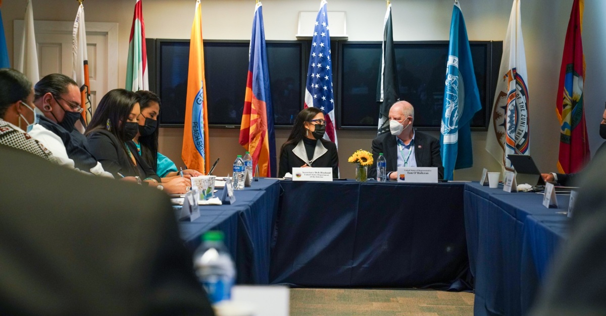

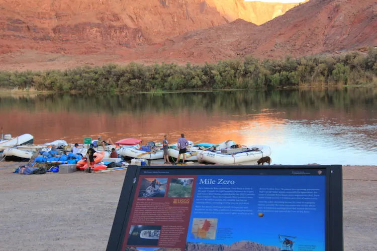


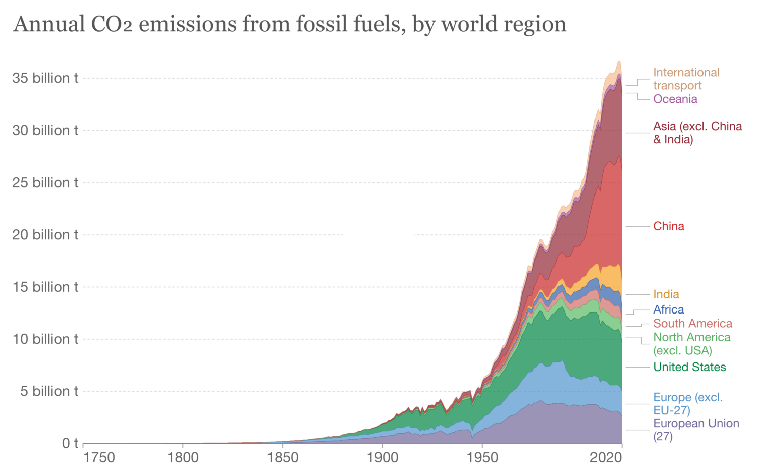
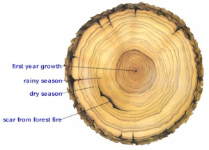
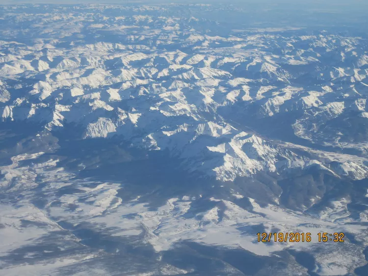
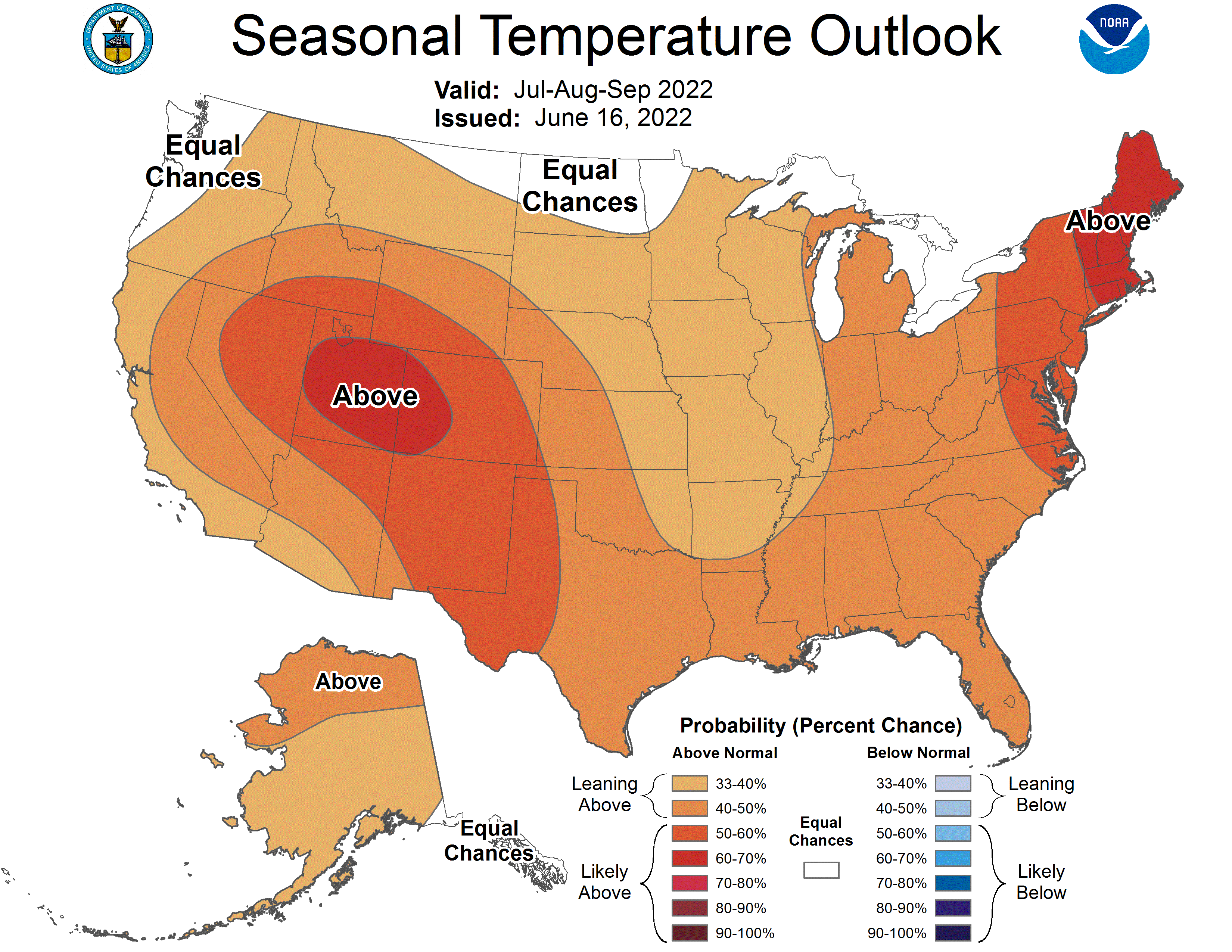
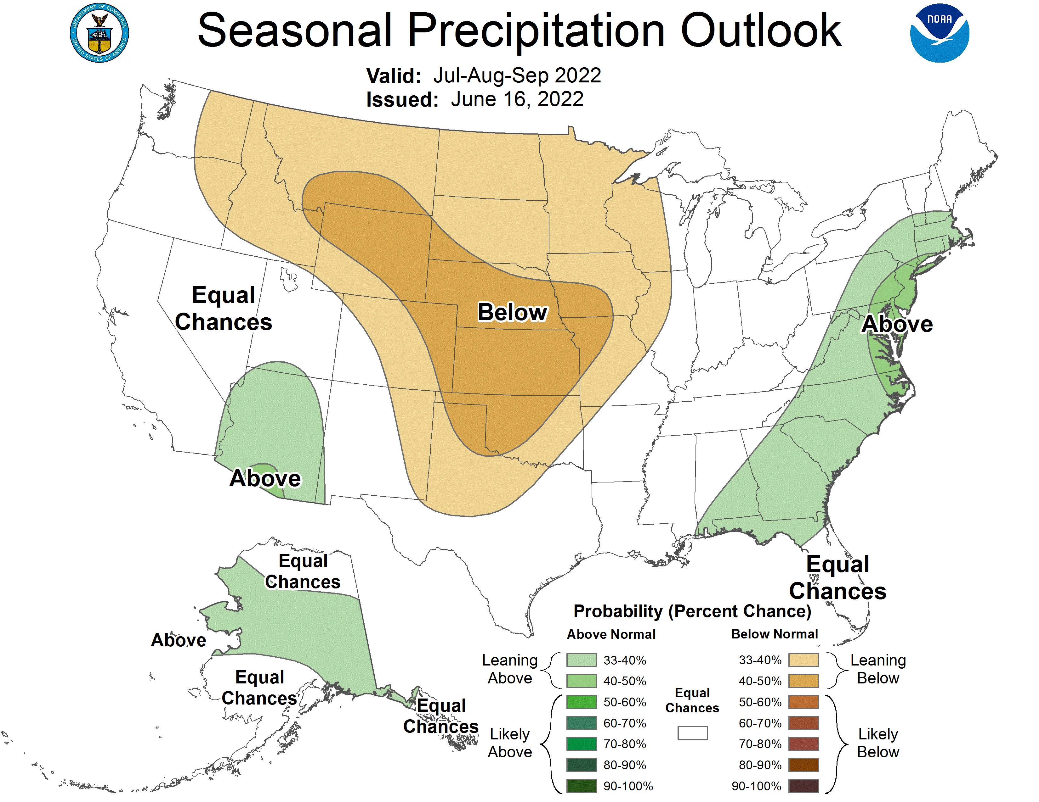
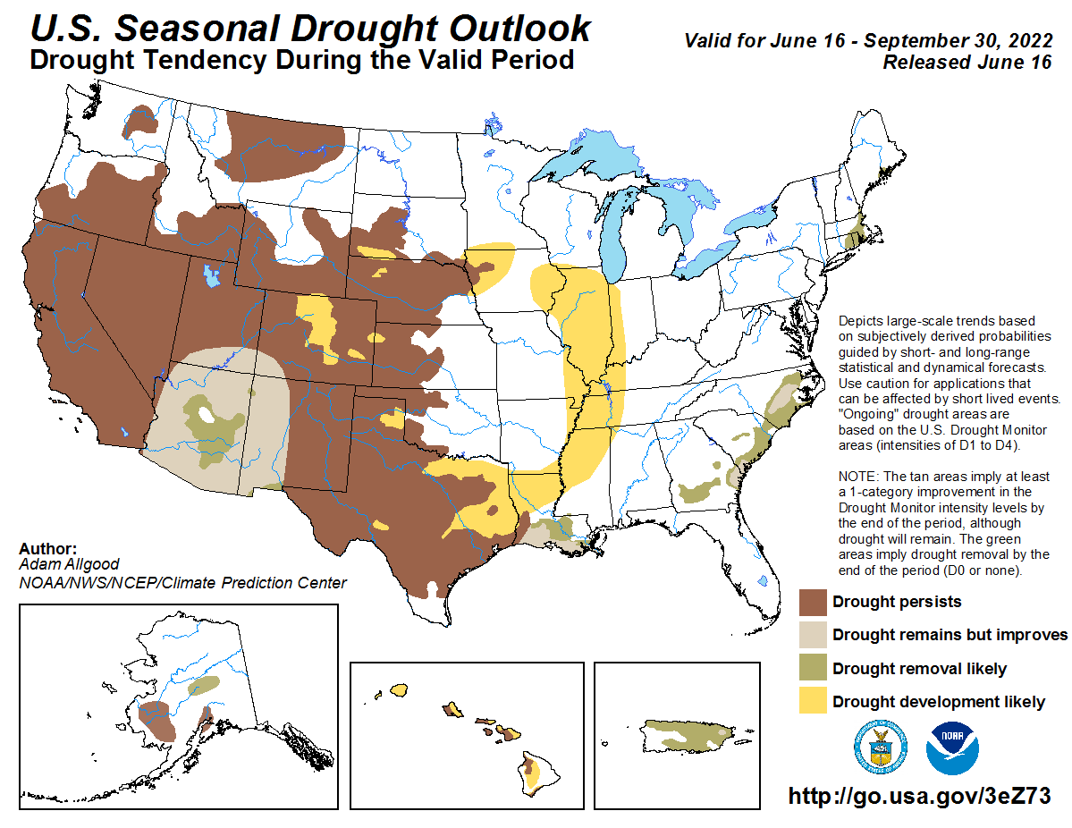


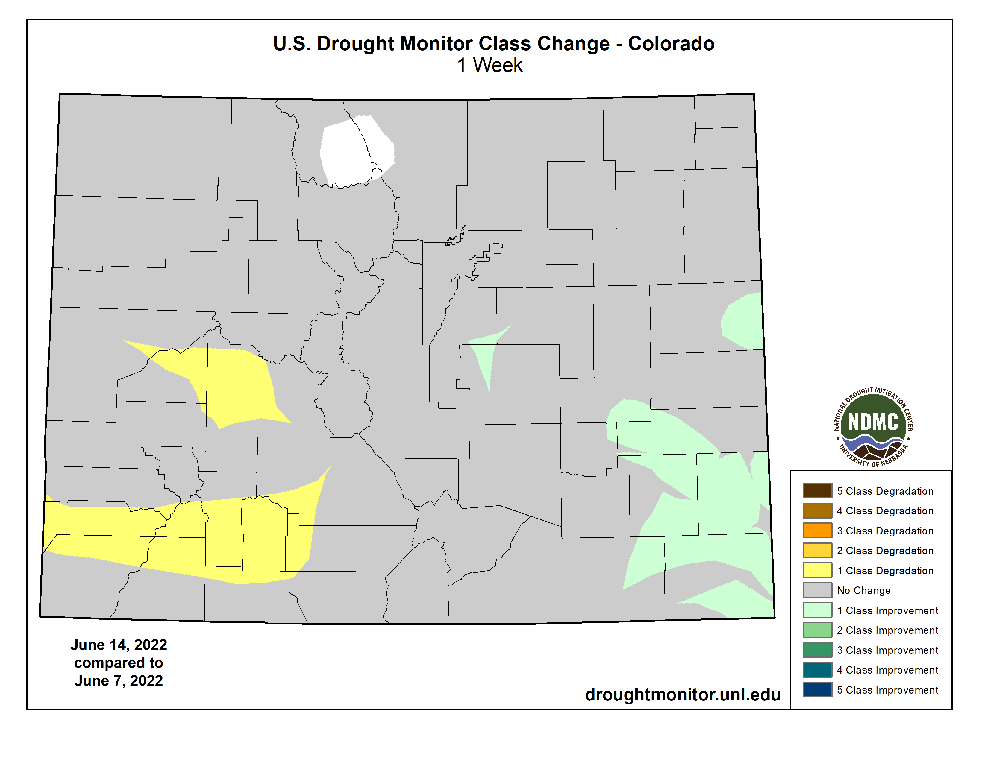
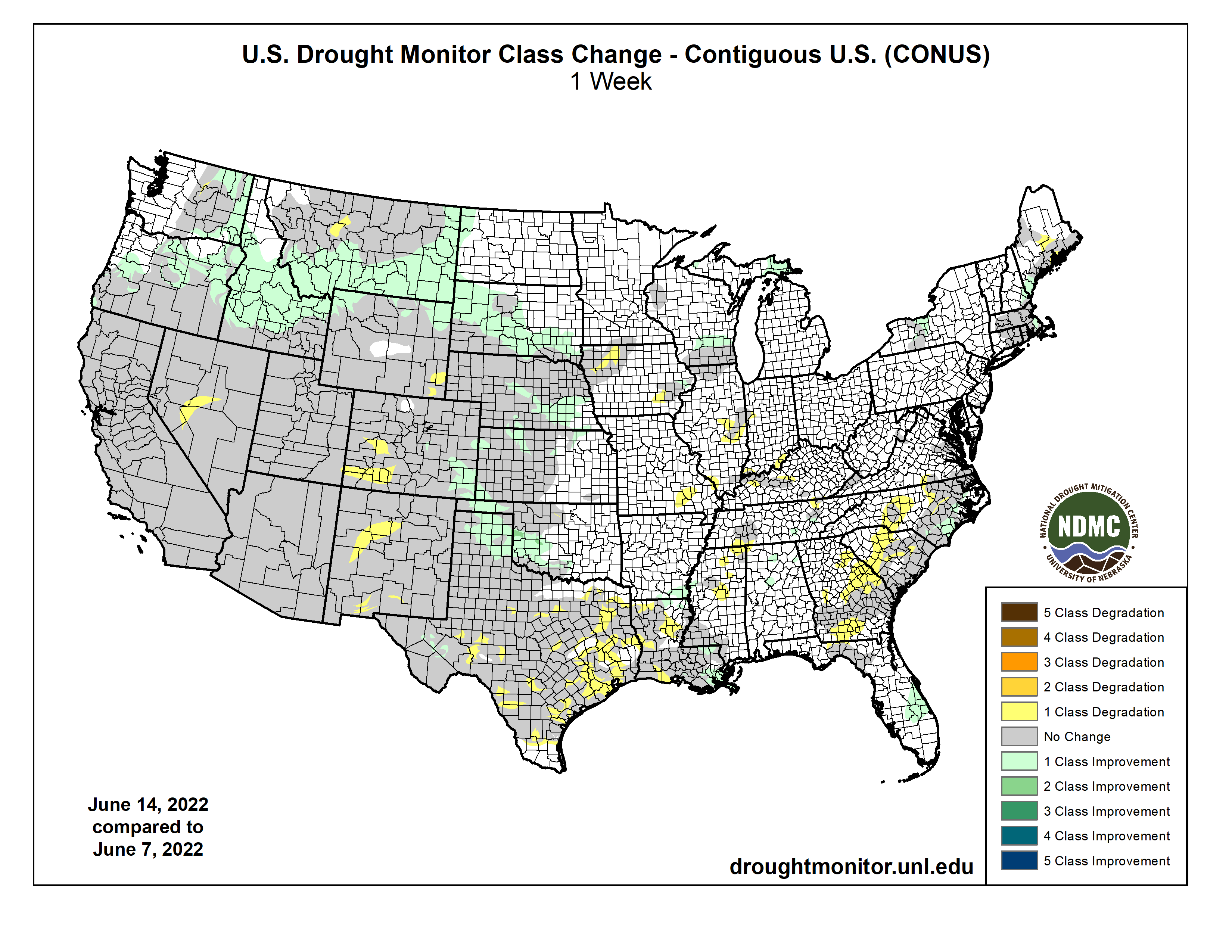
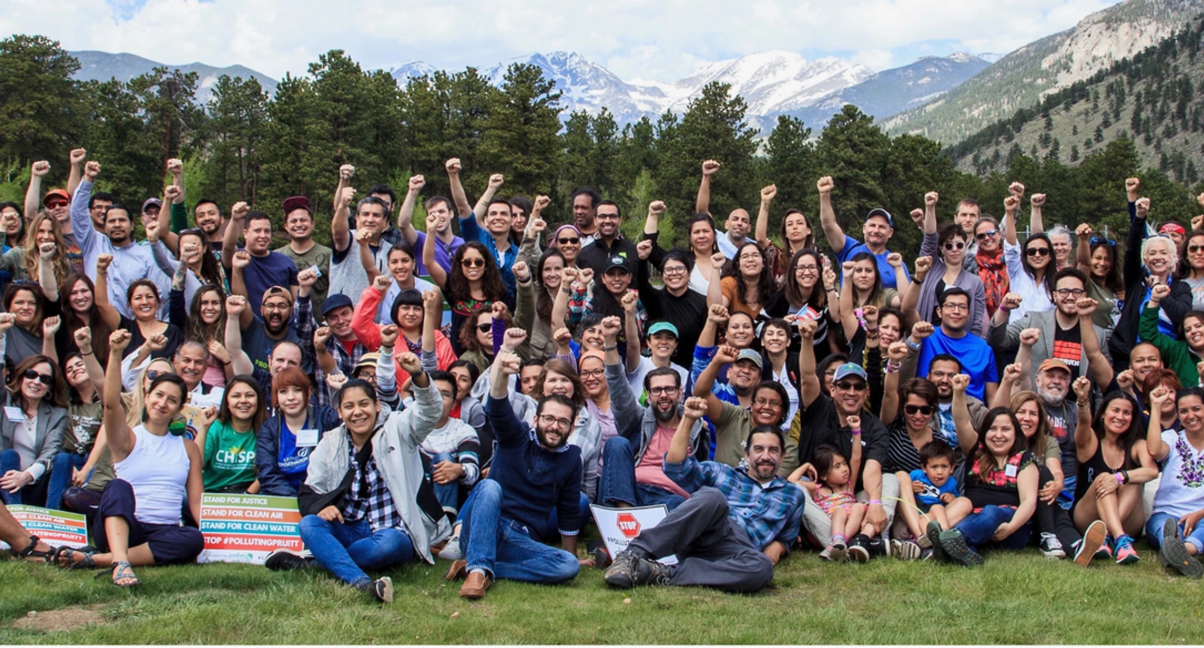
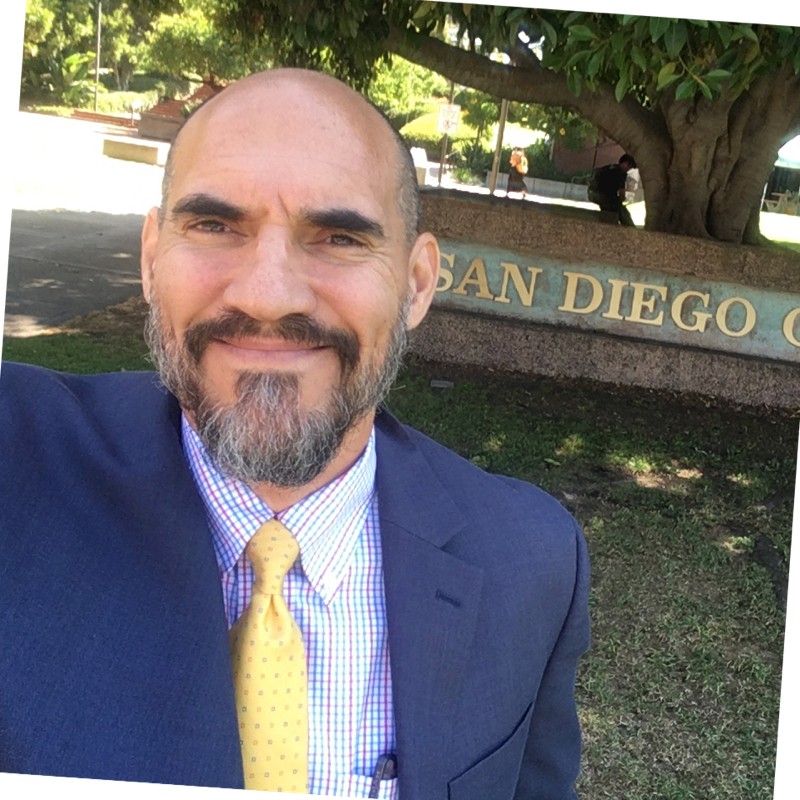
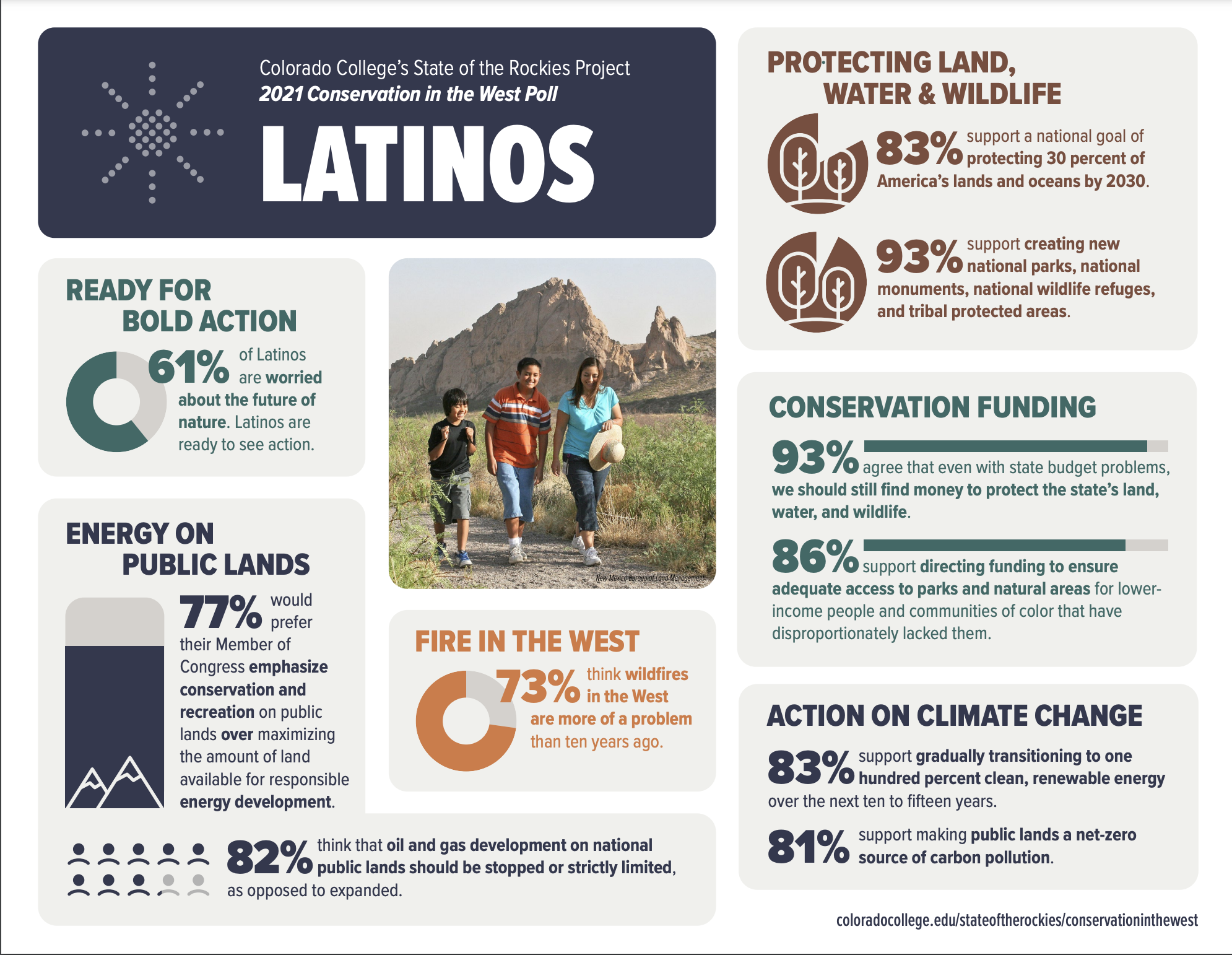
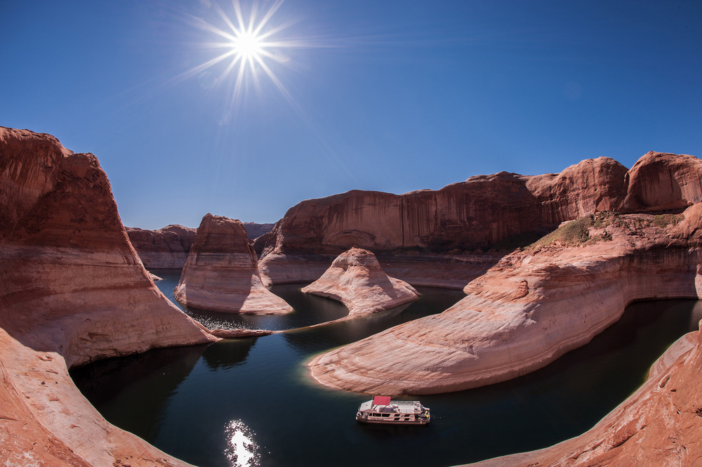


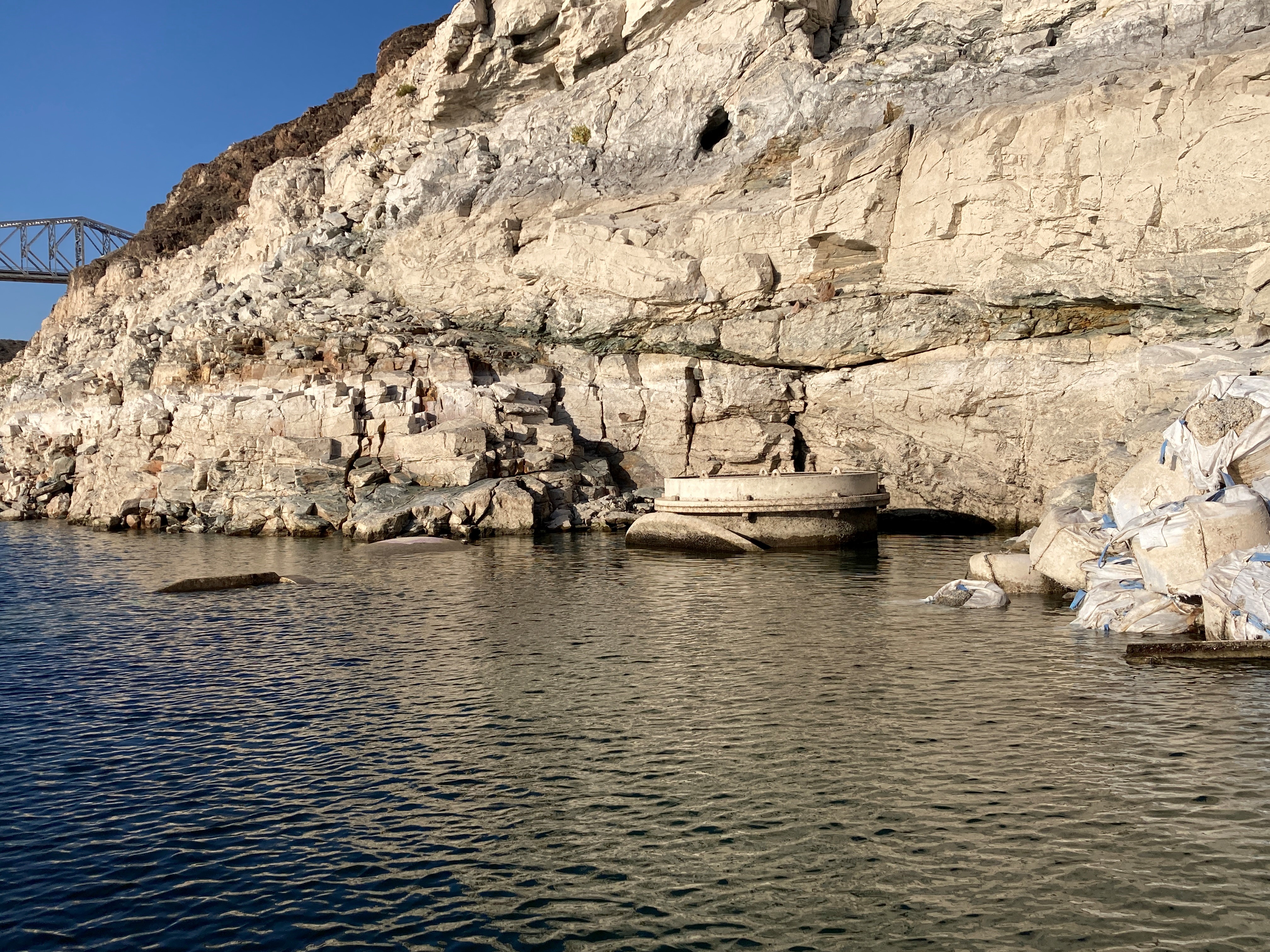
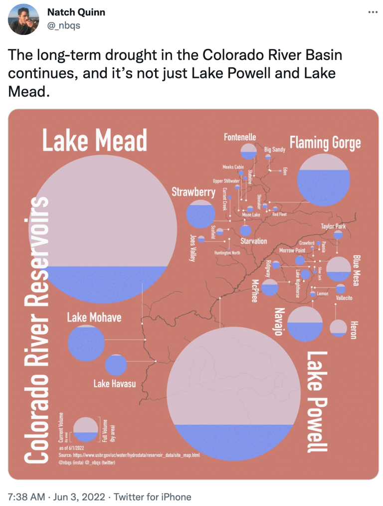


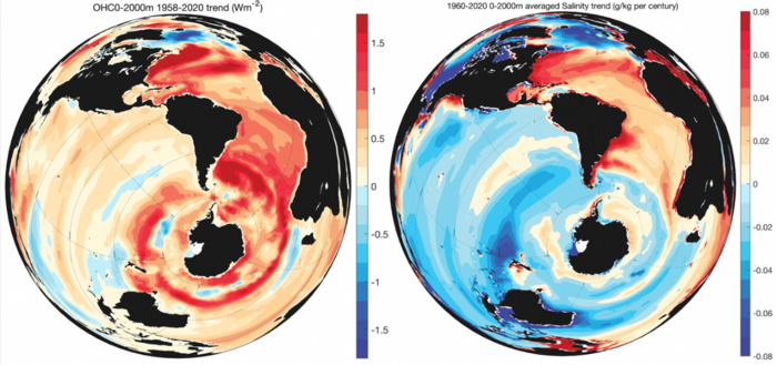
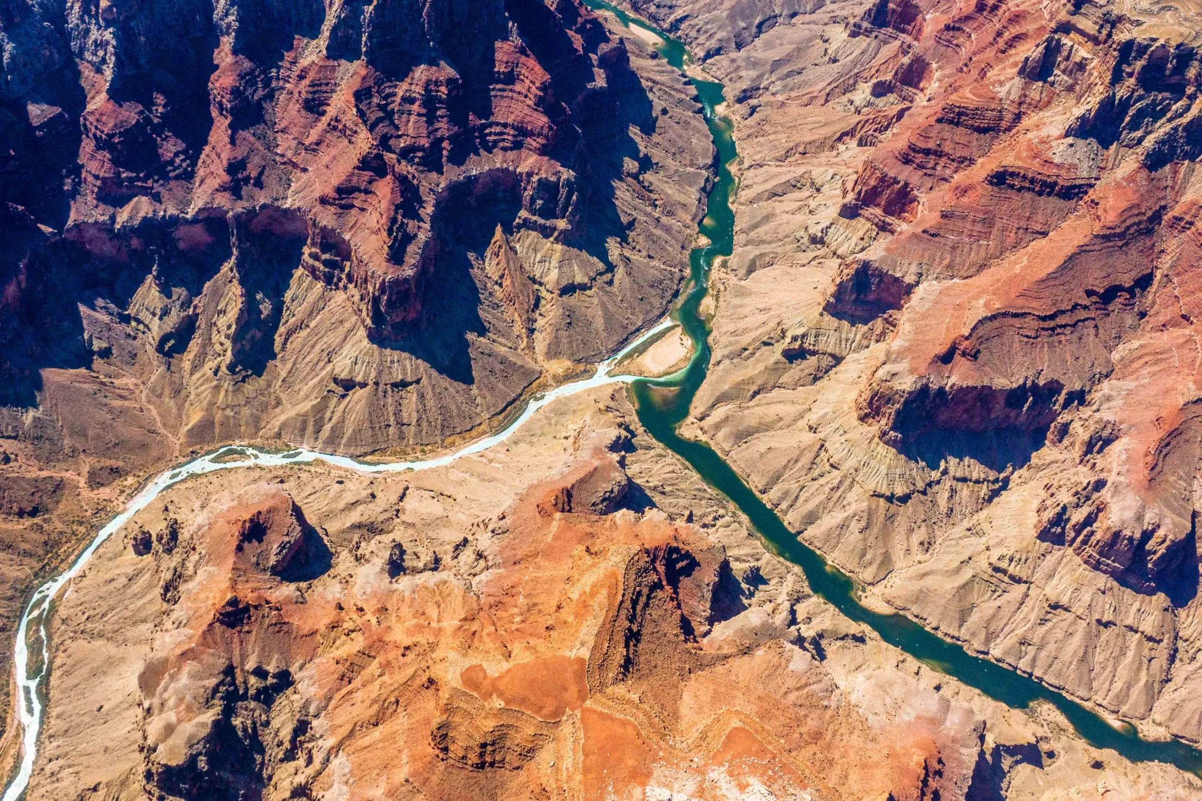
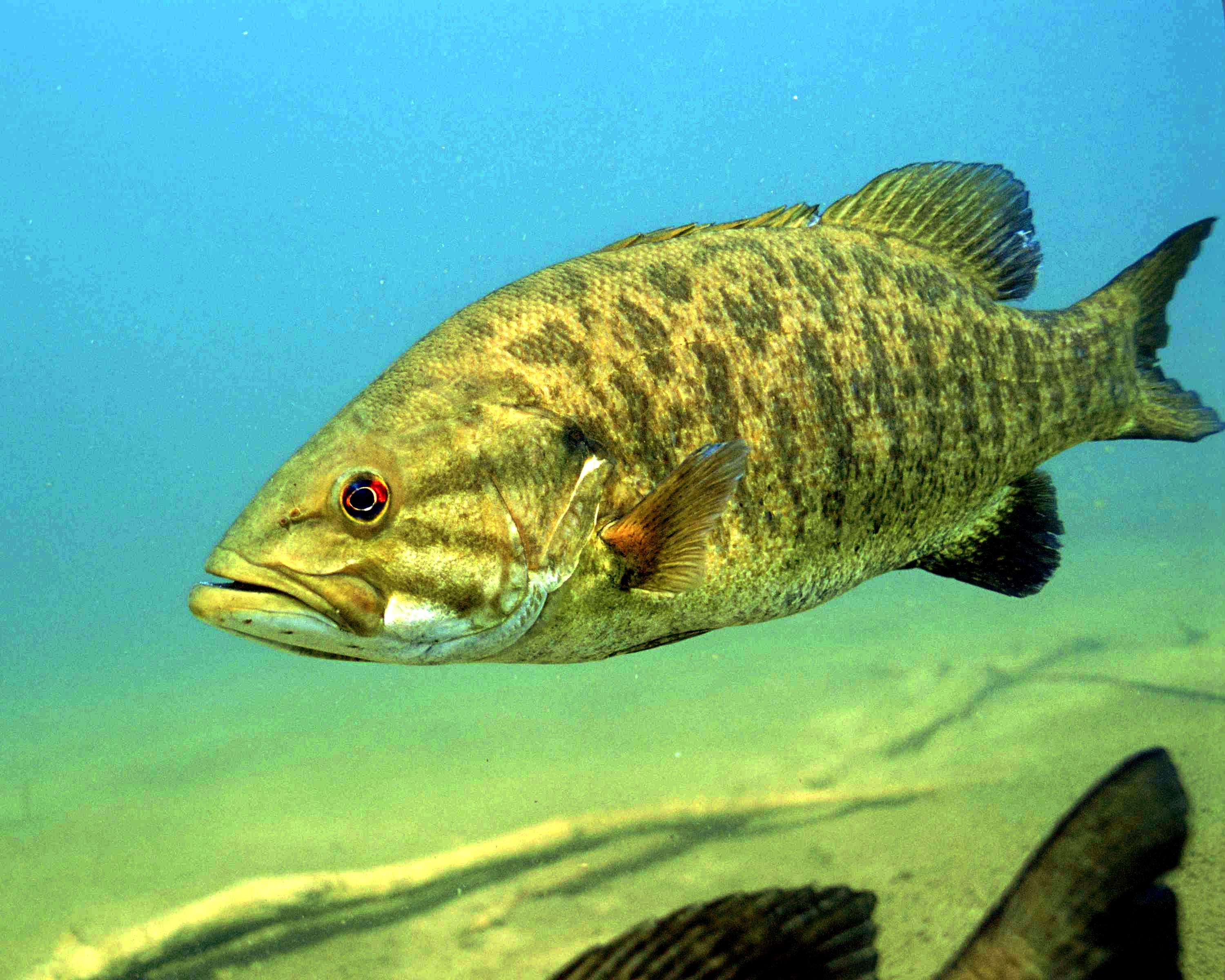

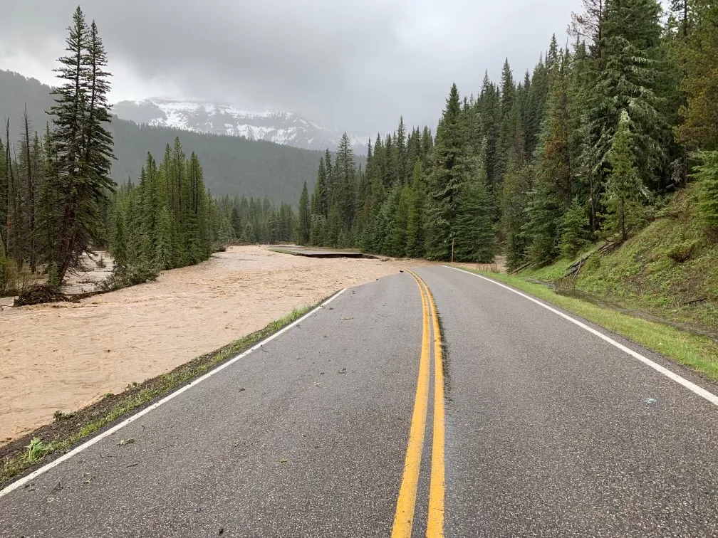
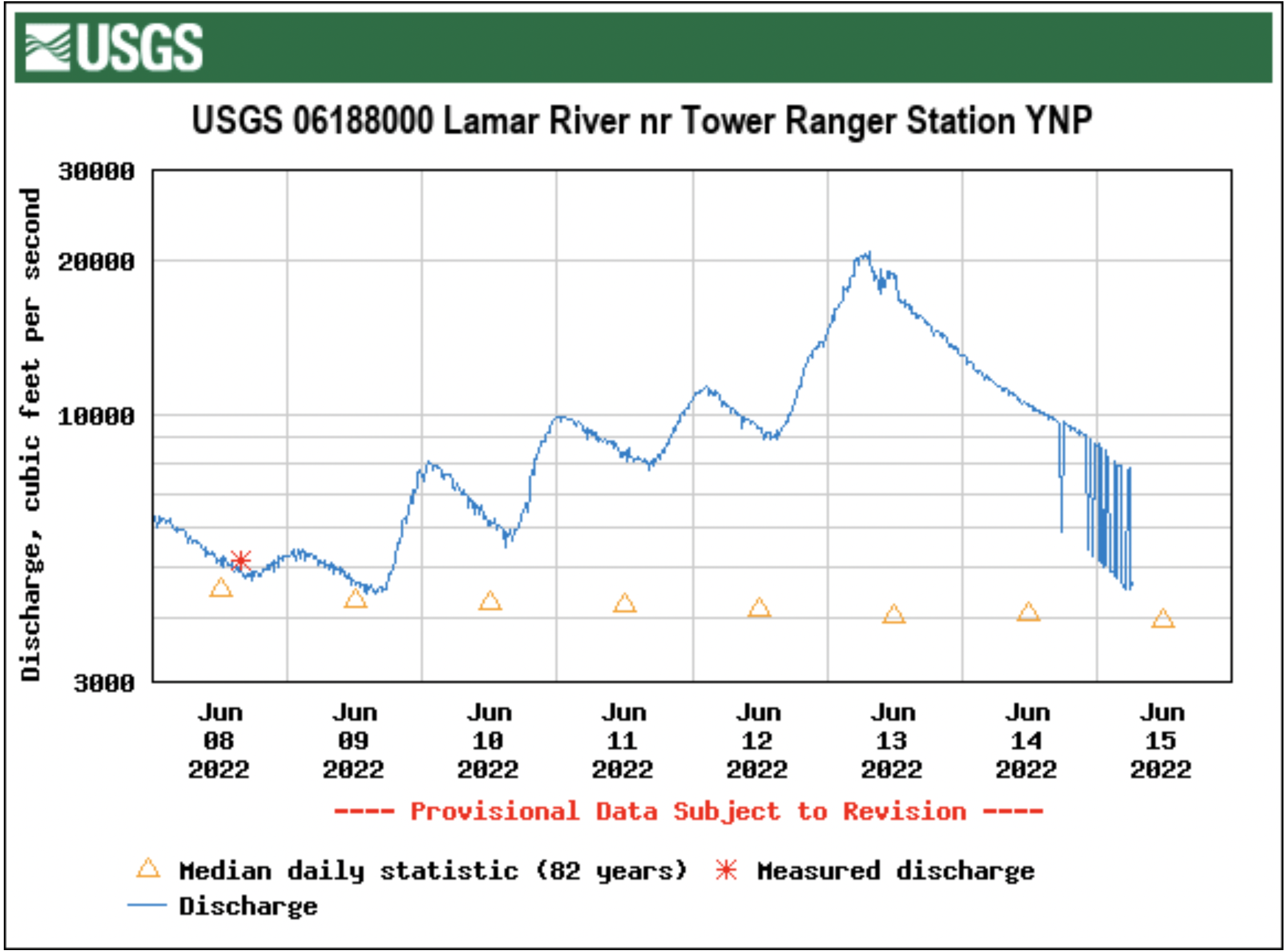
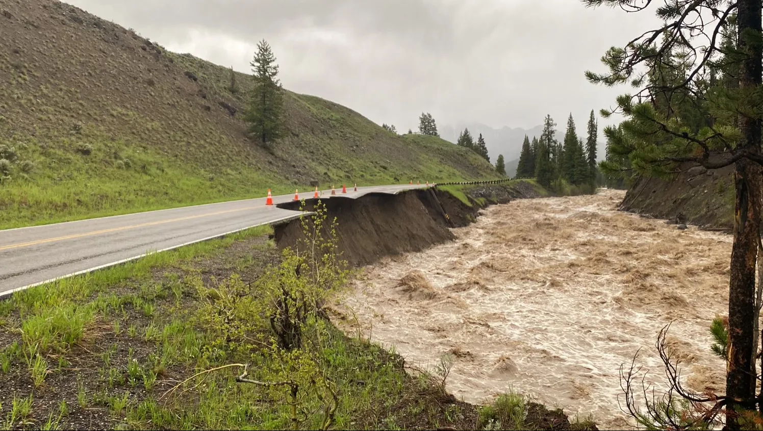
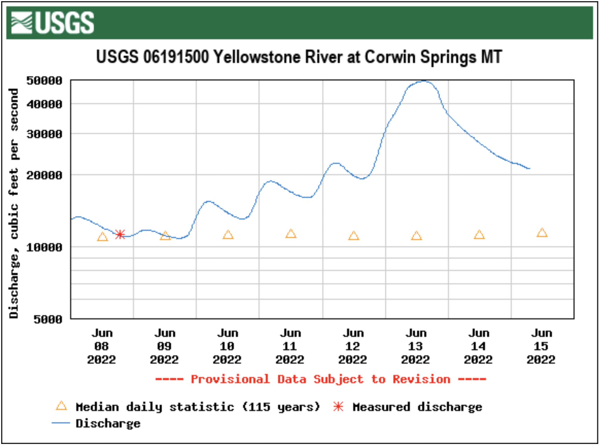
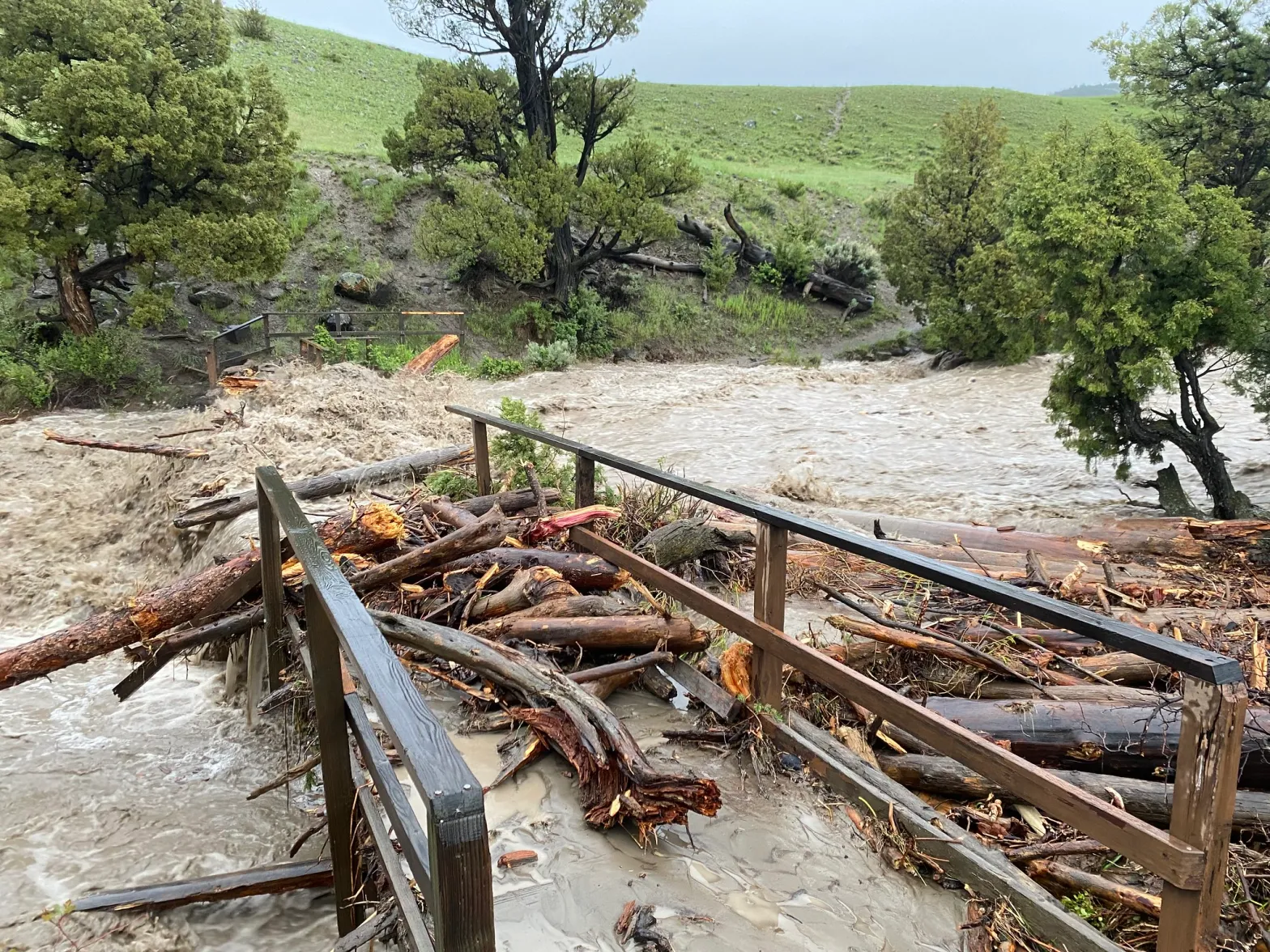


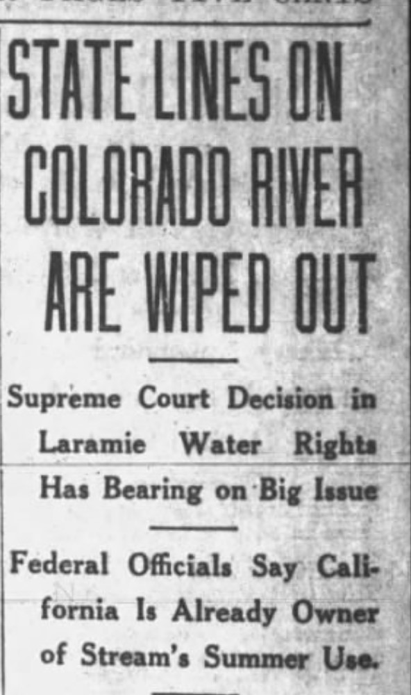

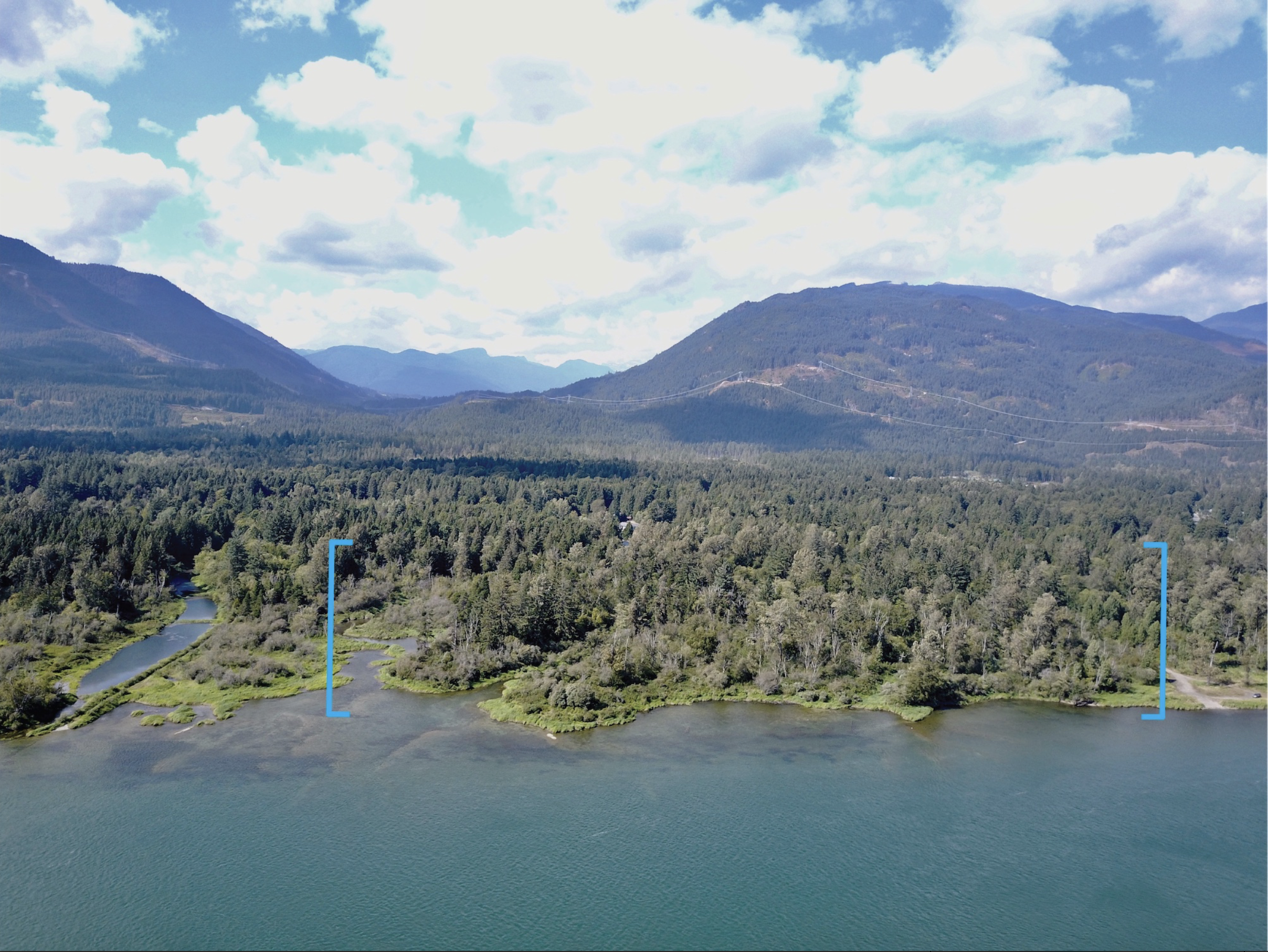
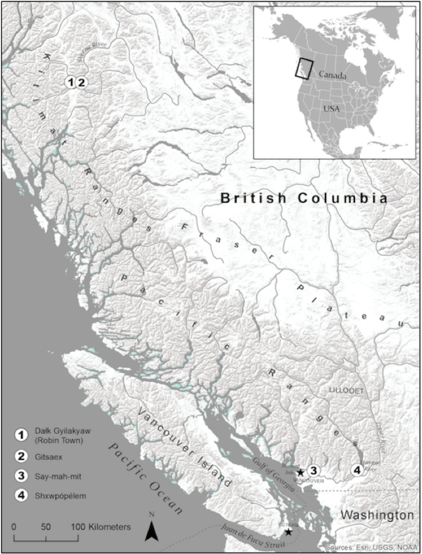
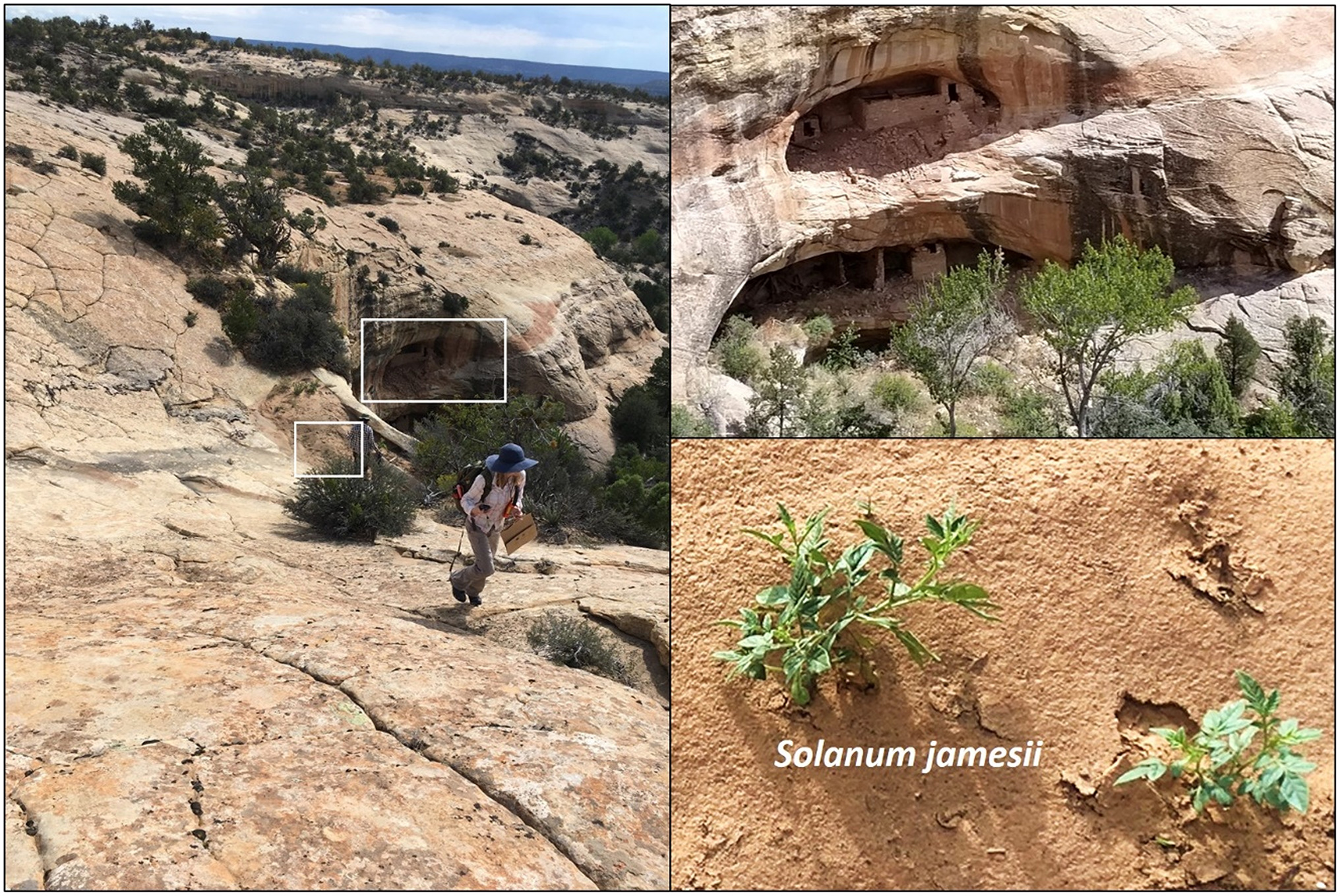
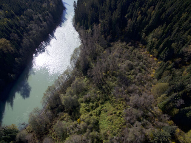

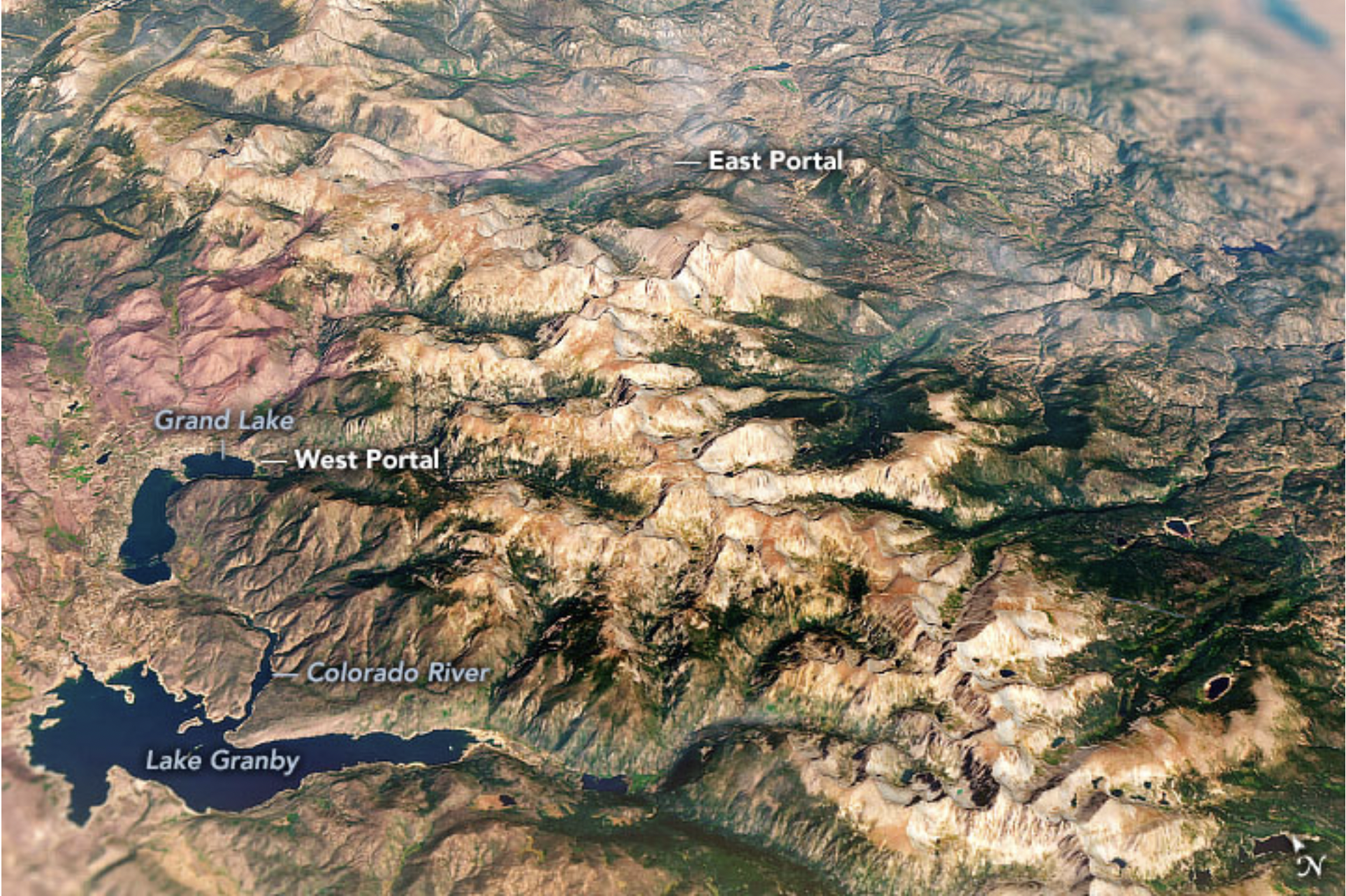

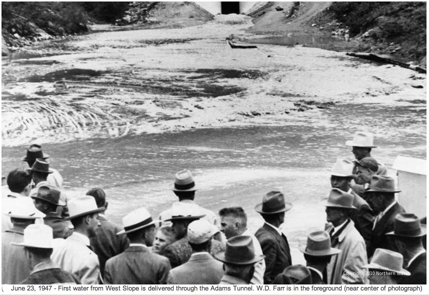


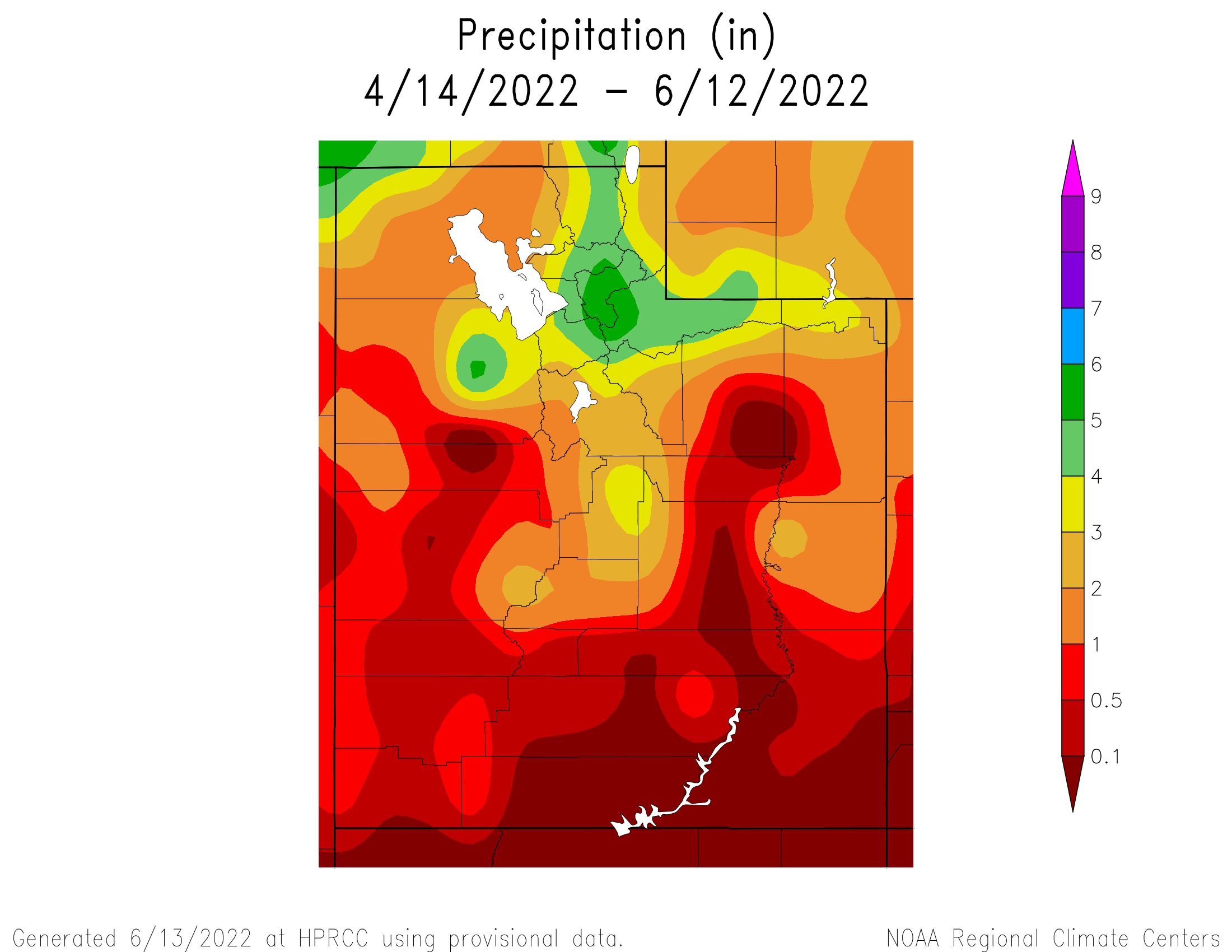
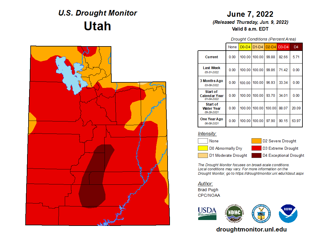
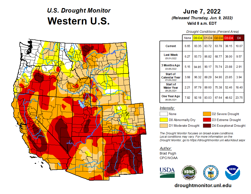
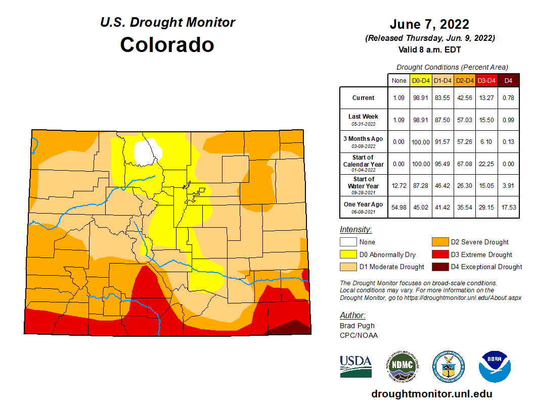

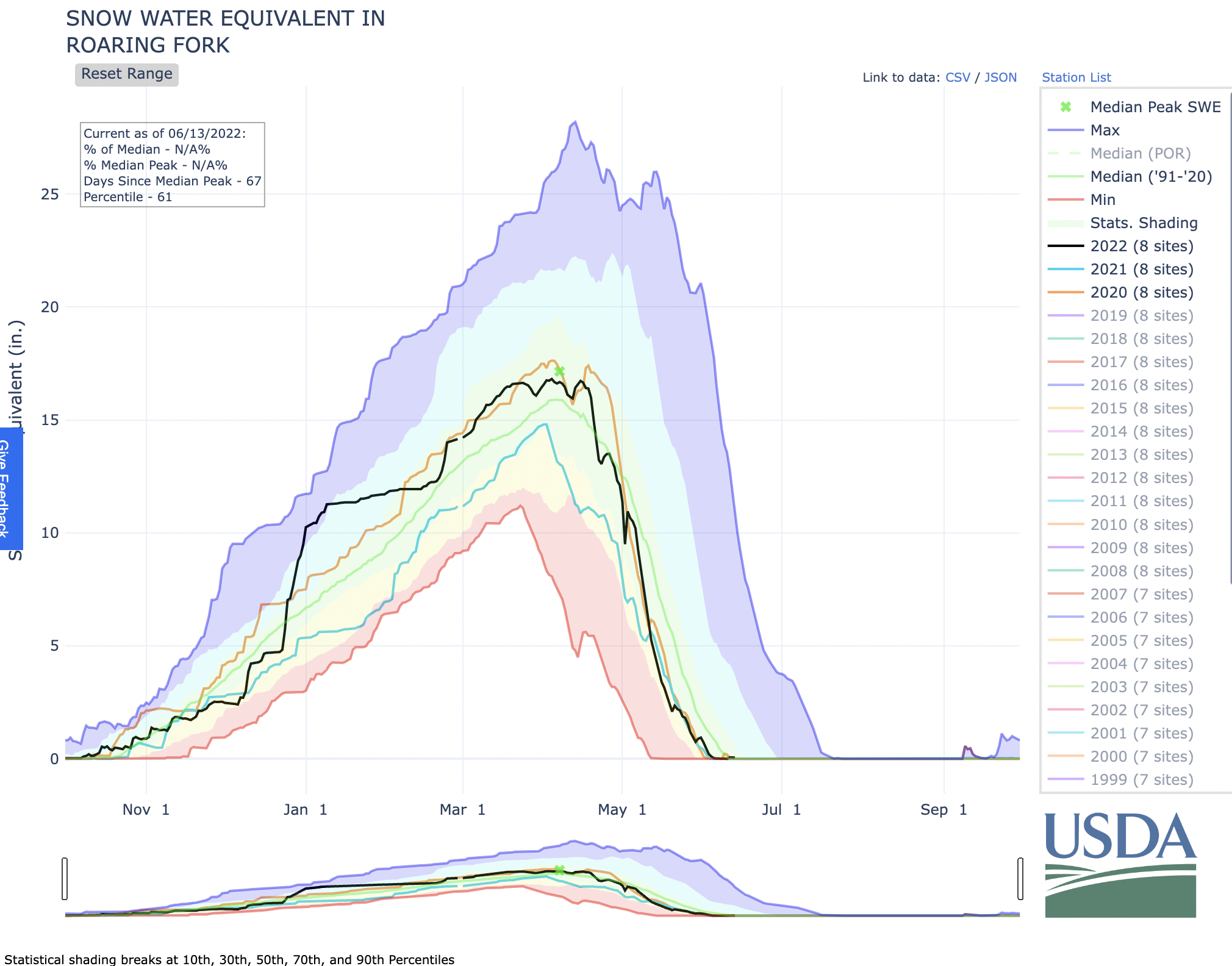

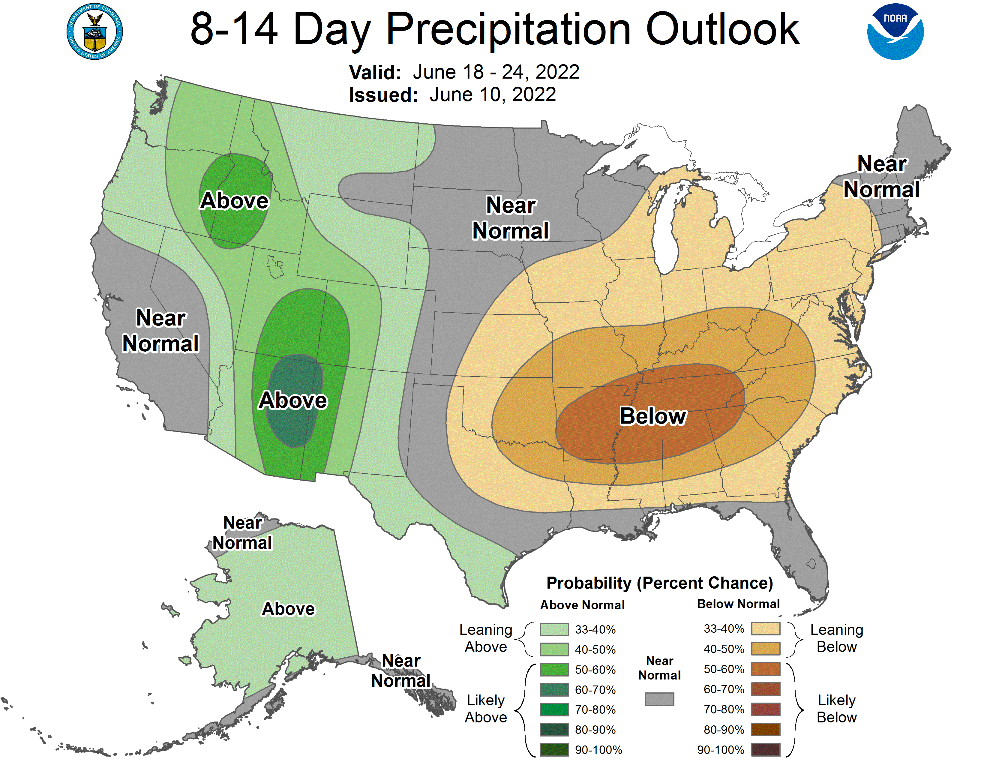


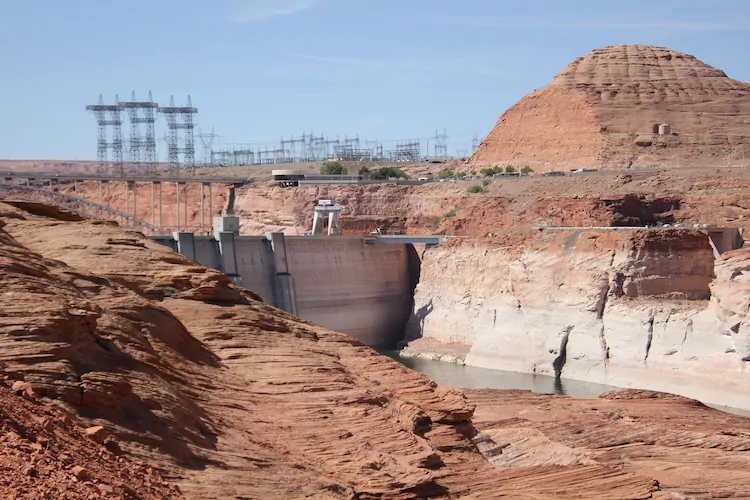


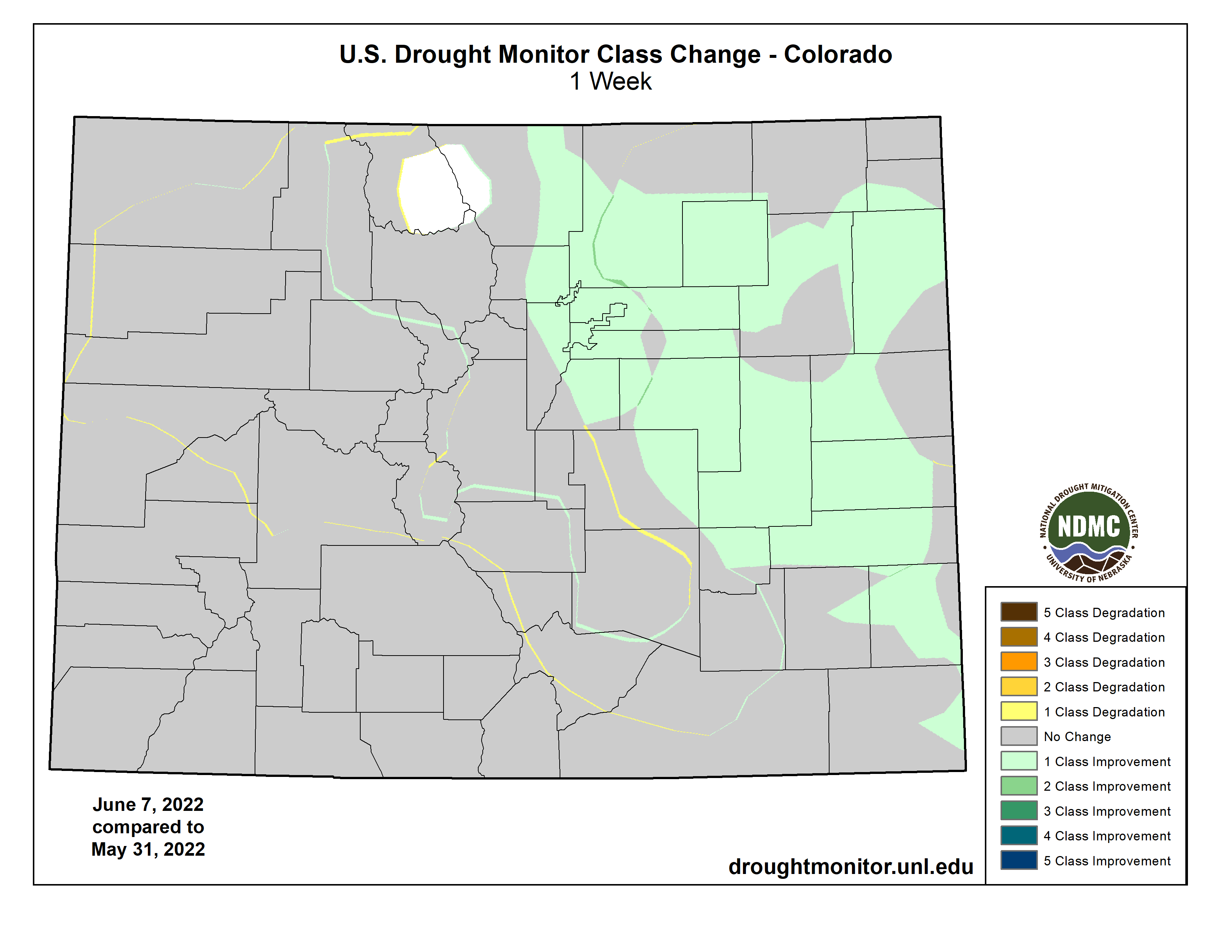
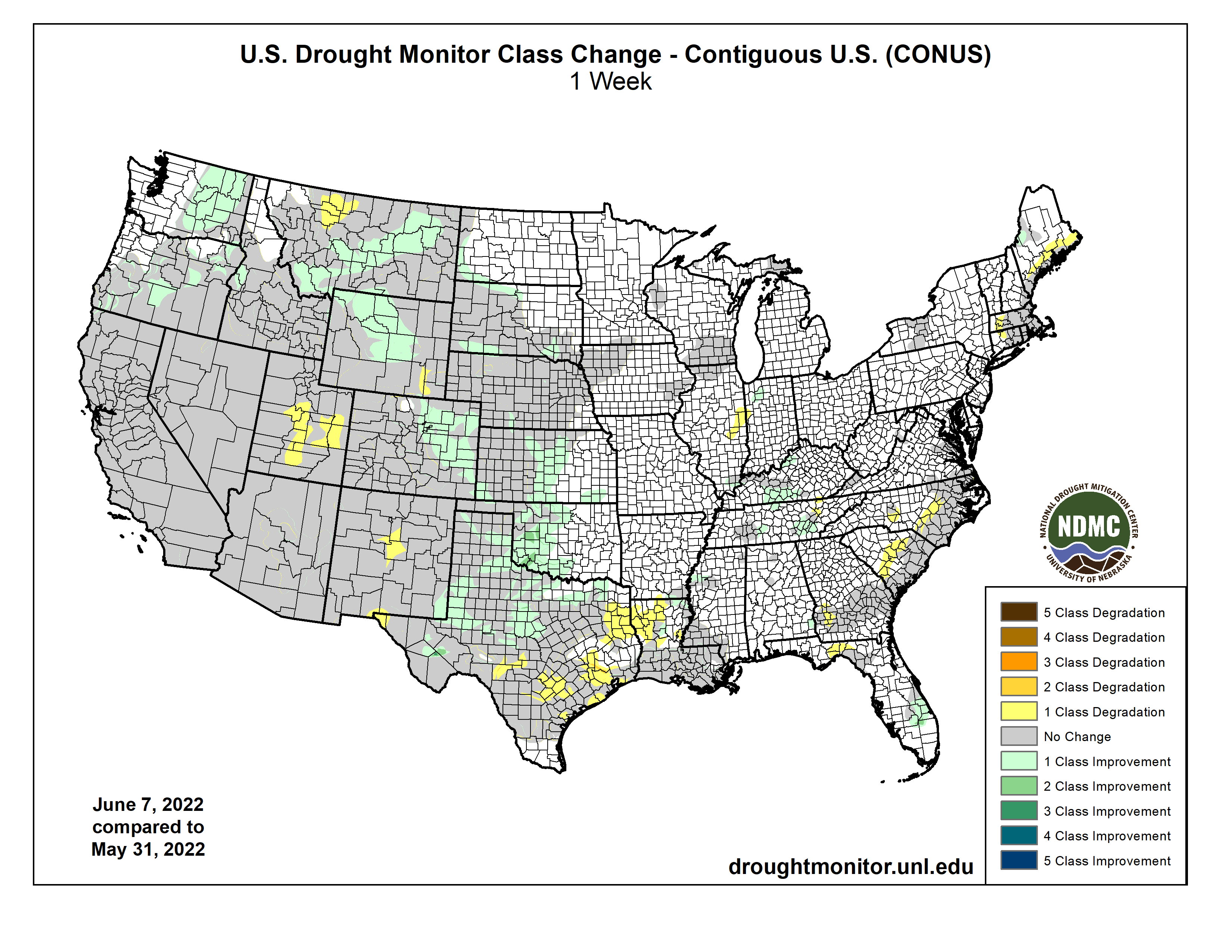

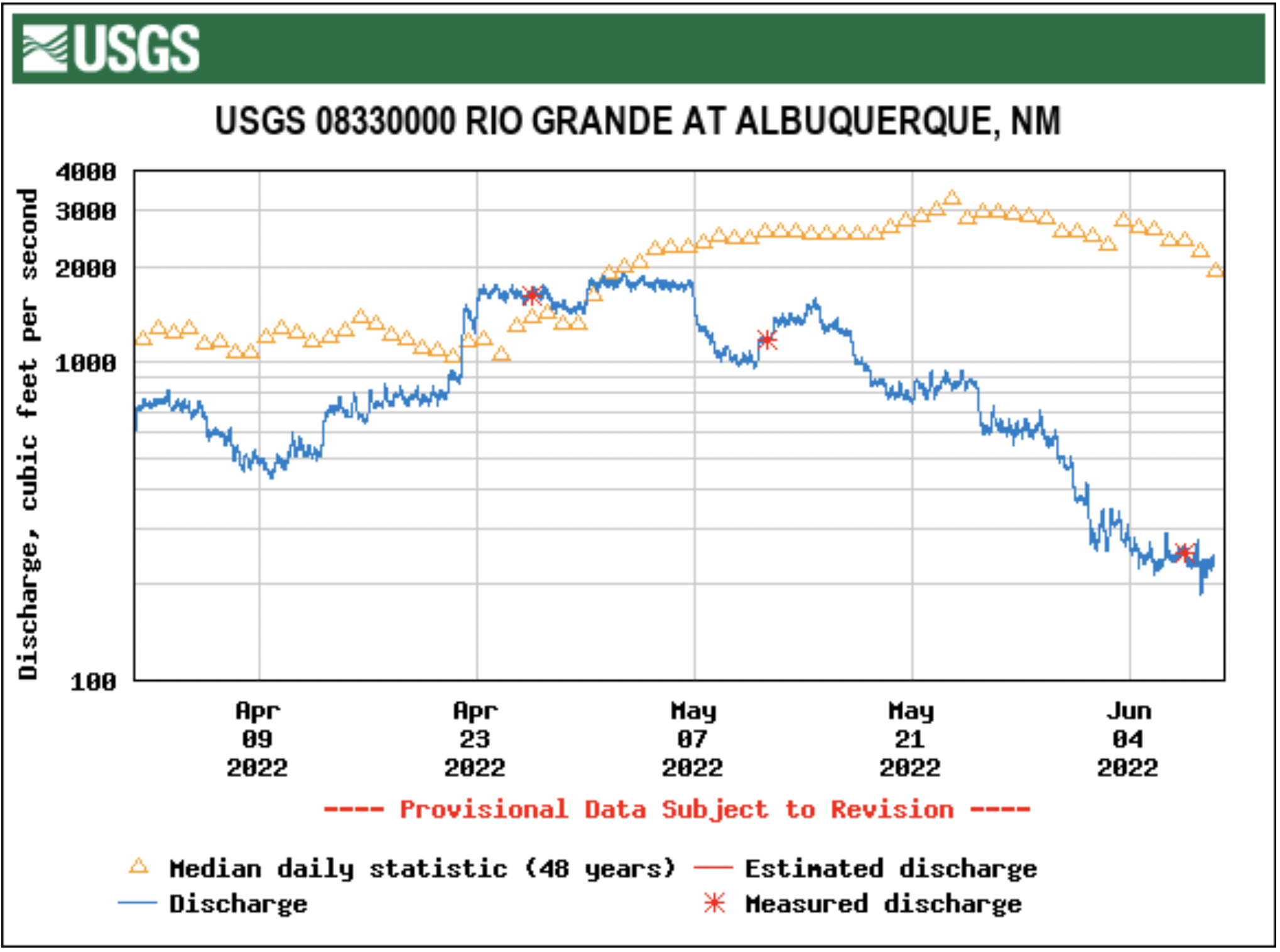


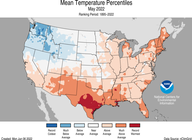
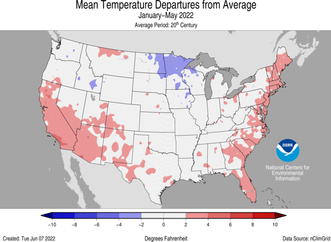
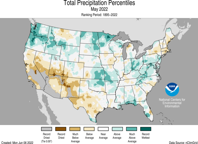

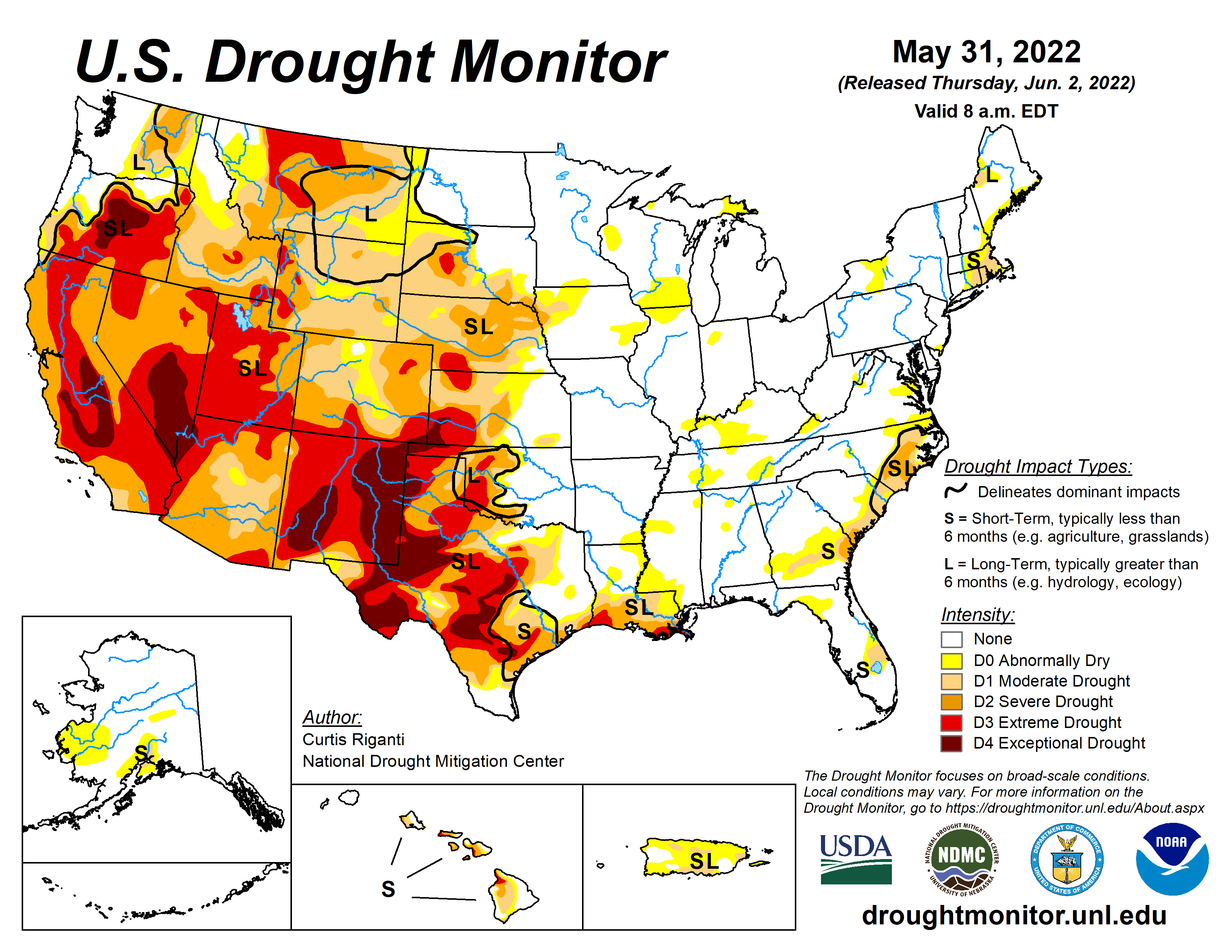

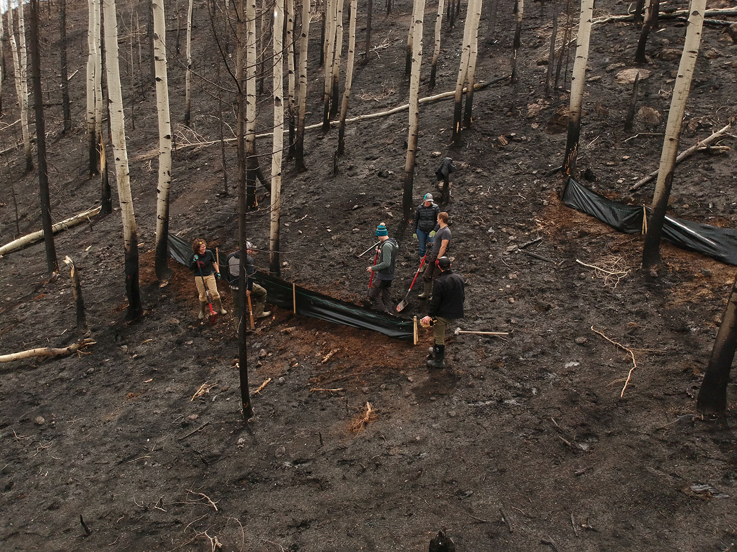


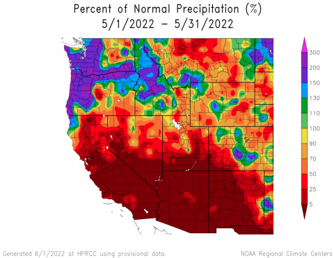


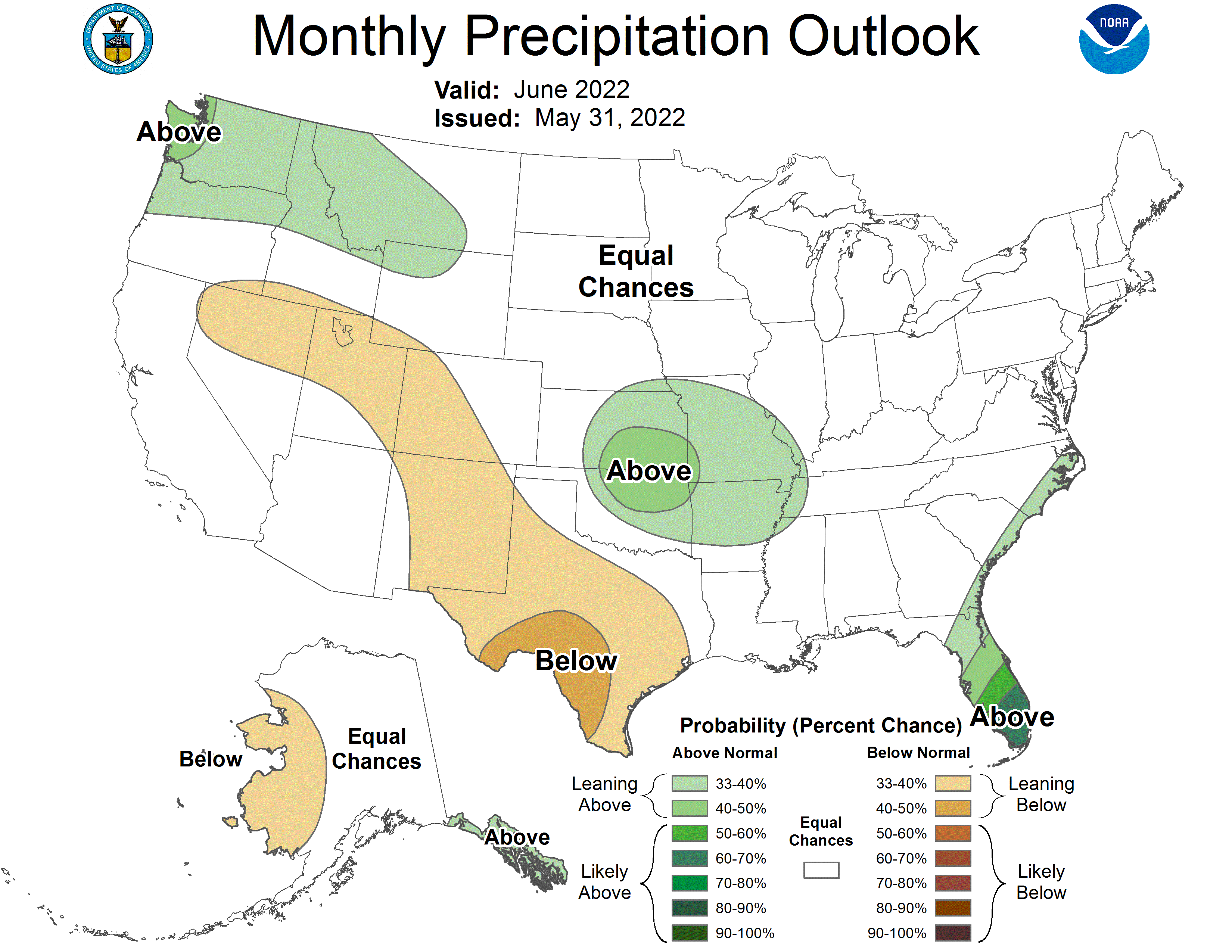
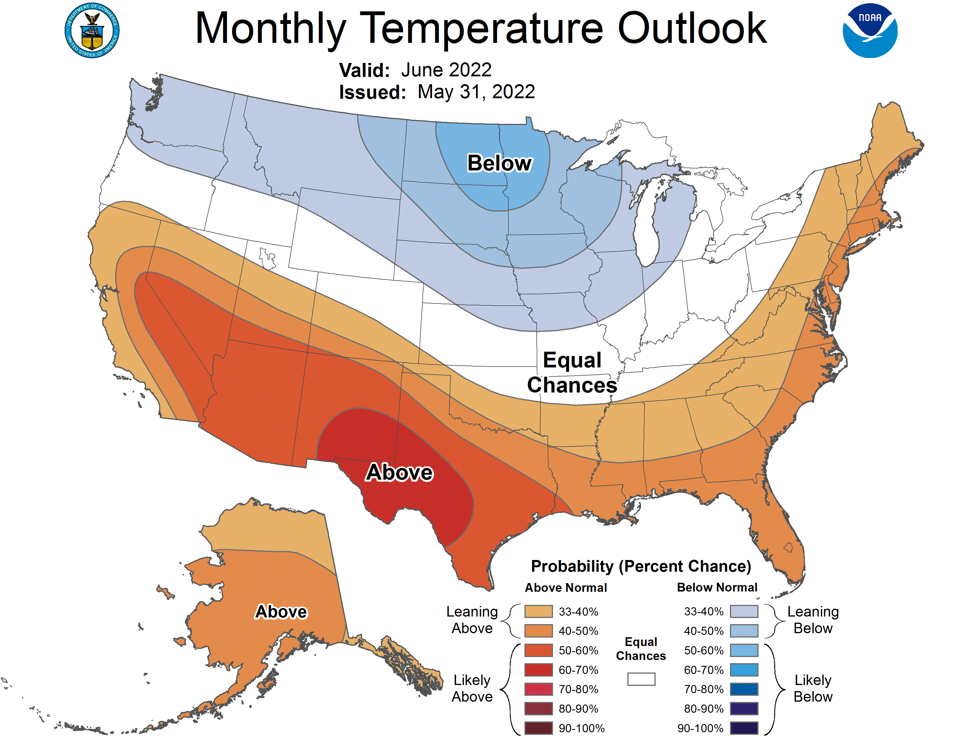
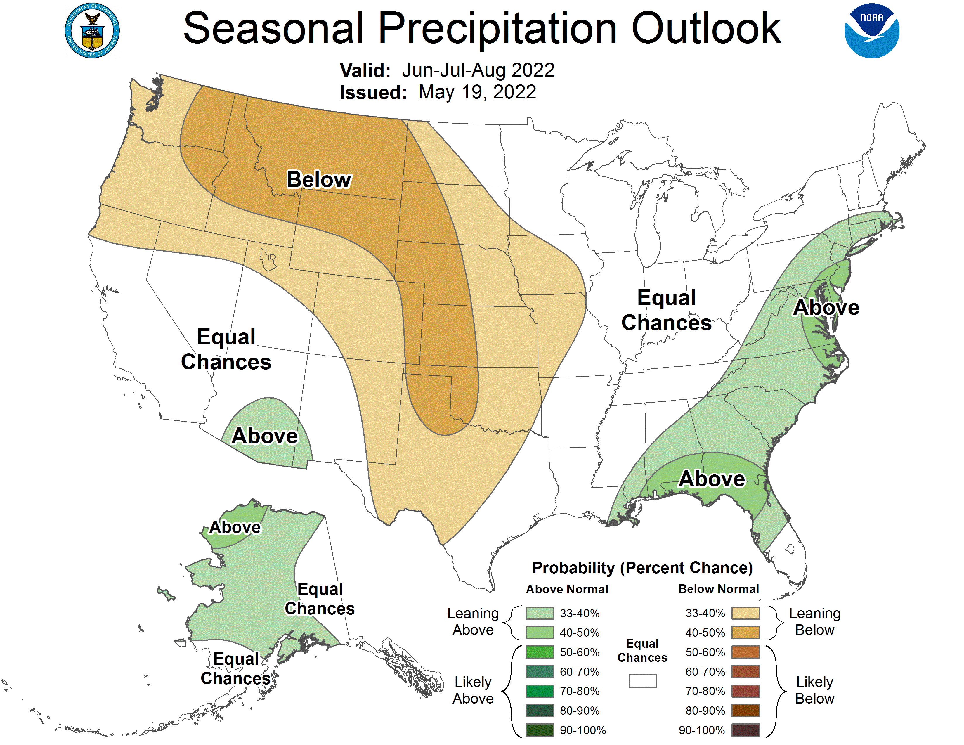
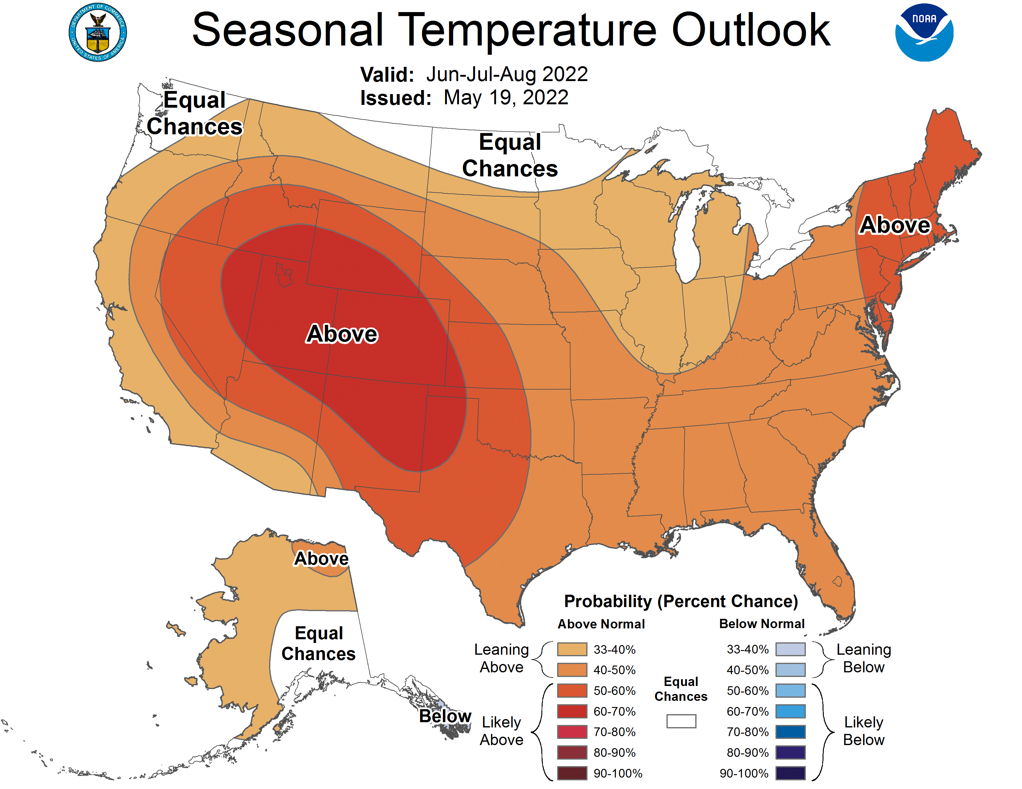
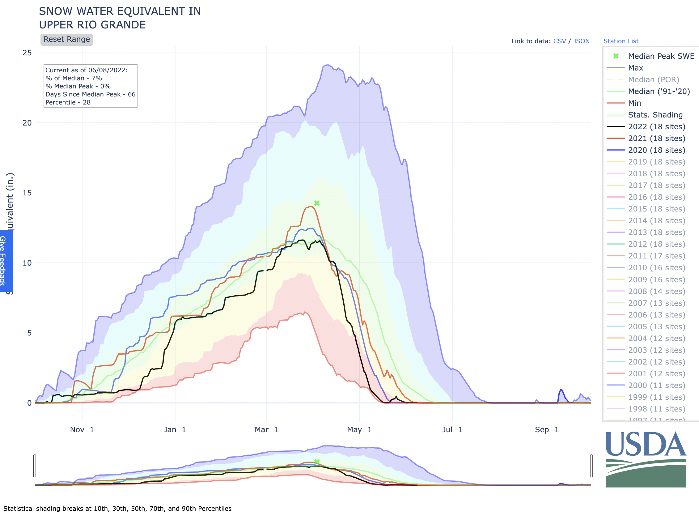
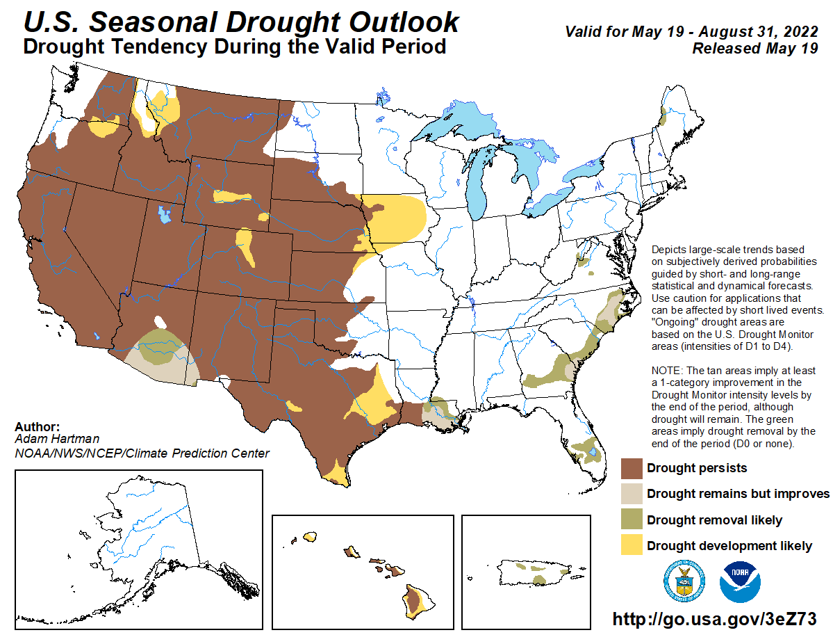
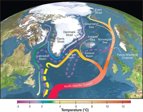
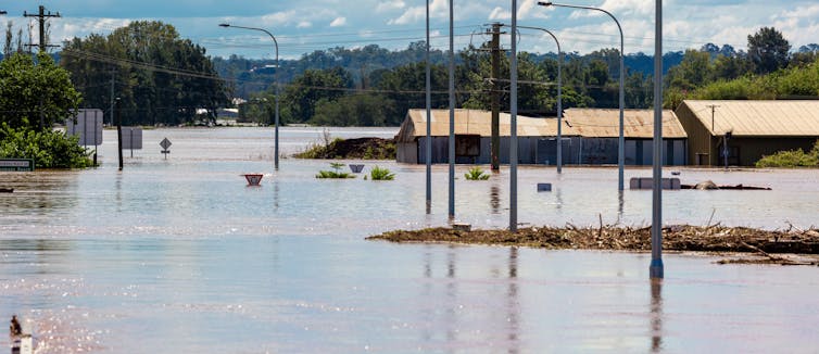
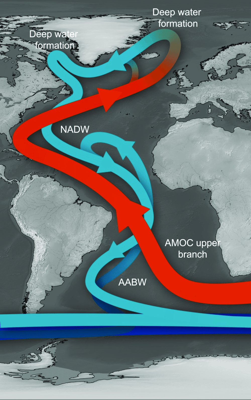
