
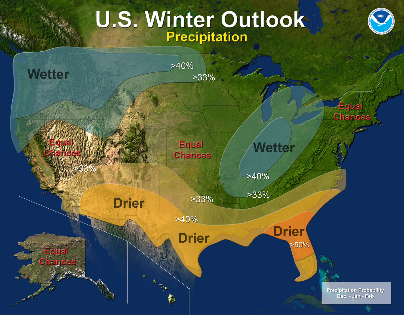
Our friends at NOAA have released a precipitation forecast graphic. Click on the thumbnail to the right for a larger view. It illustrates the usual La Niña pattern. This year’s event set up quick and big. Here’s their release (James Peronto). Here’s an excerpt:
Regional highlights include:
Pacific Northwest: colder and wetter than average. La Niña often brings lower than average temperatures and increased mountain snow to the Pacific Northwest and western Montana during the winter months, which is good for the replenishment of water resources and winter recreation but can also lead to greater flooding and avalanche concerns;
Southwest: warmer and drier than average. This will likely exacerbate drought conditions in these areas. All southern states are at risk of having above normal wildfire conditions starting this winter and lasting into the spring;
Northern Plains: colder and wetter than average. Likely to see increased storminess and flooding;Southern Plains, Gulf Coast States & Southeast: warmer and drier than average. This will likely exacerbate drought conditions in these areas. All southern states are at risk of having above normal wildfire conditions starting this winter and lasting into the spring;
Florida: drier than average, with an equal chance for above-, near-, or below-normal temperatures. Above normal wildfire conditions;
Ohio and Tennessee Valleys: warmer and wetter than average. Likely to see increased storminess and flooding;
Northeast and Mid-Atlantic: equal chances for above-, near-, or below-normal temperatures and precipitation. Winter weather for these regions is often driven not by La Niña but by weather patterns over the northern Atlantic Ocean and Arctic. These are often more short-term, and are generally predictable only a week or so in advance. If enough cold air and moisture are in place, areas north of the Ohio Valley and into the Northeast could see above-average snow;
Central U.S.: equal chances of above-near-or below normal temperatures and precipitation;
Hawaii: drier than normal through November, then wetter than normal December through February. Statewide, the current drought is expected to continue through the winter, with several locations remaining on track to become the driest year on record. Drought recovery is more likely on the smaller islands of Kauai and Molokai, and over the windward slopes of the Big Island and Maui;
Alaska: odds favor colder than average temperatures with equal chances of above or below normal precipitation. The interior and southern portions of the state are currently drier than normal. A dry winter may set Alaska up for a greater chance of above normal wildfire conditions in the spring.
From The Denver Post (Kieran Nicholson) via the Grand Junction Free Press:
The National Oceanic and Atmospheric Administration announced today long-term weather outlooks for the nation. A current La Nina pattern is expected to get stronger, bringing colder wetter weather to the Pacific Northwest and the north, with warmer drier weather across the southern United States. In Colorado “temperatures will tilt toward a warm winter,” said Mike Halpert, deputy director of NOAA’s Climate Prediction Center. As for precipitation this winter in the state, “Colorado if anything should be drier,” Halpert said in a conference call. In general, NOAA forecasters are leaning toward a warmer and drier winter for Colorado this year, Halpert said.