Colorado Division of Water Resources retools to make sure that the ‘primary obligations’ are covered

A picture named lodorecanyonfromdouglasmtnnps.jpg

From The Pueblo Chieftain (Chris Woodka):

The division is also largely funded from the state’s general fund, which has been hit hard by the recession that began in 2007 — causing all state agencies to scramble in filling a $4.4 billion funding gap. That gap is expected to continue next year. The state so far has met the gap by using federal stimulus funds, cash reserves, new fees and by shaving personnel costs. Hiring freezes, furloughs, suspension of raises and retirement fund contribution changes have all played a part.

The water resources division also has eliminated eight positions since 2009, which along with the other statewide budget measures reduced its expenses by more than $1 million annually. “We have the resources to take care of our primary obligations, but it has put some projects on back burner,” Wolfe said. “We went to restructuring, because it’s going to be some time before we get those resources back.”

Some water commissioner slots are vacant, but the most critical ones in the Arkansas and South Platte river basins are filled “Water commissioners are our highest priority, along with dam safety and hydrographers,” Wolfe said. “We’ve had to prioritize internally what those positions are. Some positions are in a holding pattern.”

The division has made more information available online, which reduces the walk-in traffic and staff time in dealing with questions, Wolfe said. The impacts for 2011 aren’t fully known yet, but Wolfe believes another lean year is ahead.

More coverage from Chris Woodka writing for The Pueblo Chieftain. From the article:

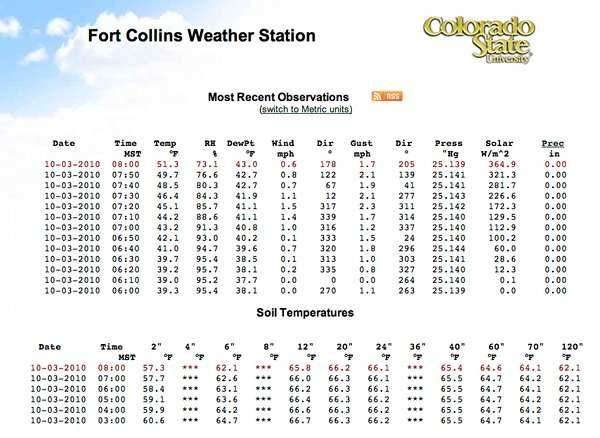
Today, the [satellite] network of state-operated gauges has grown tenfold, and their importance continues to grow both to the state and other water interests. “The most important thing is that we are able to take real-time information from the Internet,” State Engineer Dick Wolfe said. “That aids us in compact compliance throughout the state, administering water rights and assisting the Colorado Water Conservation Board with in-stream flow rights.”

The state operates 518 gauges, and the U.S. Geological Survey another 384 in Colorado. About 94 percent of the gauges are on streams, with a few monitoring reservoir levels. That number is up from 52 state and 98 USGS gauges in 1985. “We’re responsible for making sure the data coming in are accurate and reliable,” said Tom Ley, who heads the satellite monitoring branch of the state engineer’s office, at a forum in Salida last week.

The information is widely used, both by the Division of Water Resources staff, which administers water rights throughout the state and the public. Last year, there were more than 4.6 million page views at the website maintained by the state, which provides access to all of the gauges. The information includes raw data, detailed graphs or tables and tools for customized analysis. The system also can alert water users when critical levels are reached at any of the measuring stations, Ley said. In addition to the satellite readings, a statewide staff of 29 maintains the gauges, makes 4,000 streamflow measurements annually to make sure readings are accurate and keeps the information available online. Ley said it takes at least $7,500 annually — almost $4 million total — to operate each gauge, including the staff time. Most of the funding comes from the state general fund, although some of the money comes from dedicated cash funds.

Colorado-Big Thompson Project update

A picture named coloradobigthompsonmap.jpg

From email from Reclamation (Kara Lamb):

Now that fall has arrived, we have several maintenance projects going on across the Colorado-Big Thompson Project. To accommodate this work, most of the C-BT is basically shut down for the next few weeks.

On the C-BT West Slope, our operating partner for the Collection System, Northern Water, is working in the connecting channel between Shadow Mountain Reservoir and Grand Lake. You can learn more information on that project by visiting Northern’s “Latest News” section on their Website at LINK Diversion of West Slope water to the east portion of the C-BT is significantly slowed while this work is underway. The channel work is scheduled through October 30.

We are bringing a minimal amount of water through the Alva B. Adams Tunnel into the Estes Park area. Marys Lake is currently full and will remain high into next week. Similarly, Lake Estes is also near full. The water elevation there will remain around 7473–about two feet from full–through this weekend and into next week, as well. Marys and Estes could start going down sometime next week.

Releases from Olympus Dam on Lake Estes are currently bypassing native inflow–the amount of water normally in the Big Thompson River this time of year. We anticipate that the 35 cfs currently being released from the dam to the river will continue through October.

Pinewood Reservoir will be drawn to dead storage by this Sunday, October 3. The purpose of lowering the reservoir is to facilitate work inside the Bald Mountain Pressure Tunnel, the pipeline taking water from Pinewood to the Flatiron Penstocks. This work is scheduled through October and into mid- November. We anticipate we will start filling Pinewood Reservoir again in late November.

The water elevation at Carter Lake reservoir will continue to drop over the course of October. With Pinewood drawn down, deliveries to the water users on the Big Thompson River will be made from Carter Lake. This means, demands will be pulling water from Carter at both the Flatiron Plant and from Dam #1 for the rest of the month. Currently, Carter is at a water level elevation of 5703. That is approximately 56 feet down from full. While the South boat ramp is out of the water, the two boat ramps at the north end of the reservoir will likely not be impacted this year. The current rate of drop is about 3 inches a day, but that will vary day-by-day and is dependent on the weather. It is likely hotter weather will drive higher demands.

One of the most significant changes for fall operations is at Horsetooth Reservoir. Water levels at Horsetooth have been unusually high all year due to the snowpack, large run-off, and wet spring. Now that the C-BT project is down for one of its annual maintenance periods, no water is being delivered to Horsetooth. With the heat and the nearing of the water year’s end for the reservoir, water users are taking their water. As a result, approximately 760 cfs is currently being delivered out of Horsetooth. Today, the rate of drop was around 2/3 a foot, a day. But just like the draw from Carter, the rate of drop at Horsetooth will also fluctuate day-by-day throughout the month. As of this e-mail, the water elevation at Horsetooth is 5399, about 31 feet from full and about 12 feet above the 3-lane boat ramp in the South Bay. The majority of boat ramps at Horsetooth stay in the water until an elevation of 5385. Normally, we hit that elevation around Labor Day. This year, we might not see it until the second week of October. The water year at Horsetooth Reservoir ends on Halloween, October 31.

We typically complete our annual maintenance work and being bringing the C-BT system back up to full operating status in November. This includes beginning to refill Carter and Horsetooth reservoirs in late November and early December. We typically turn the pump on to Carter first, then start running water to Horsetooth. I will keep you all posted as best I can as we move through this season’s changes.

More Colorado-Big Thompson coverage here.

Precipitation news

A picture named roaringfork.jpg

From The Aspen Times:

According to preliminary data for the month of September, logged at the Aspen Water Department, Aspen saw scant precipitation on just five days during the entire month, and no snow fell in town. Area peaks were dusted with snow a couple of times in September, though. The water plant recorded 0.71 inches of rainfall in September, below the average of 1.8 inches for the month. The average high temperature was about 72 degrees, and the average low hovered at a relatively temperate 40 degrees or so. The high for the month was 80.7 degrees, recorded on Sept. 20.

Energy policy — nuclear: Moab uranium mill tailings update

A picture named moabtailingscleanupsite.jpg

From the Deseret News (Amy Joi O’Donoghue):

In August, the Department of Energy and its primary contractor on removal, EnergySolutions, marked the removal of 2 million tons of tailings to a disposal site 30 miles to the north. An infusion of $108 million in federal stimulus funding in April 2009 accelerated the daily cleanup to two trainloads of dirt. At 3 p.m. each day, 144 containers are loaded onto the railroad cars by a Gantry crane to ferry 5,000 tons of waste to Crescent Junction. At 3 a.m., the next trainload departs. Don Metzler, the DOE’s project director, said even absent the stimulus funding, the removal is 44 trains ahead of schedule and the project is well under budget…

Cleanup of the Moab tailings site may be completed as early as 2019, with Rep. Jim Matheson, D-Utah, pushing hard for the U.S. Department of Energy to keep funding levels the same at the 130-acre site. If the funding drops, cleanup completion could be delayed to 2025, or possibly later.

More nuclear coverage here and here.

Southern Delivery System update

A picture named sdspreferredalternative.jpg

From The Colorado Springs Gazette (Daniel Chacón):

So far, Utilities has paid nearly $4 million to acquire easements on 131 properties. That’s more than one-third of the property it will need to build the pipeline. Utilities has a $37 million land acquisition budget for phase one of the pipeline project. Some of that money will help buy the estimated 760 acres needed for the future Upper Williams Creek Reservoir about 14 miles southeast of downtown Colorado Springs. The reservoir will be built in the project’s second phase…

To build the pipeline, Utilities must acquire mostly easements. Property owners retain the use of their land after construction. But permanent structures cannot be placed above the pipeline in case Utilities needs access for maintenance. All the land acquisitions to date have been “consensual transactions.” About 169 parcels are left. Utilities pledges to work cooperatively with the remaining property owners, paying them a fair price and then revegetating their land…

Although Utilities plans to build the pipeline in segments rather than starting in Pueblo and working its way to Colorado Springs, the land acquisitions will affect the construction schedule. They’re working to acquire adjacent properties to speed up the building. “It makes sense for us to start on the areas where we have a good section of land acquired, so we’re going to try to move forward with some of those sections early on in the schedule,” Rummel said. “For those sections that may take more time for the land acquisition, those will come later in the schedule.”

More Southern Delivery System coverage here and here.

Two Rivers Water Company now owns 91% of the Huerfano-Cucharas Irrigation Company

A picture named cucharasriver.jpg

From Benzinga.com:

Two Rivers Water Company (“Two Rivers”) announced today it has acquired an additional 14% of the outstanding shares of the Huerfano-Cucharas Irrigation Company (“HCIC”). With this purchase, Two Rivers now owns 91% of HCIC. “With this additional purchase, we continue to solidify our interest in HCIC. We believe that HCIC is the cornerstone to our efforts for the re-introduction of agriculture to land that was once extremely productive but has for the last several decades laid fallow,” commented John McKowen, CEO of Two Rivers. Two Rivers plans to rapidly expand its farming operations with the water, storage and distribution provided by HCIC along with the recently announced agreement to purchase the Orlando Reservoir and its associated water assets.

More Arkansas River Basin coverage here and here.

Conservation: Showering tips to cut water use

A picture named singingintheshower.jpg

From MySouthwestGeorgia.com:

Cut your shower time in half from 10 to 5 minutes and you’ll save more than 4,200 gallons of water a year and lower your utility bill too! Now another idea is to take a “Navy” shower. Get in get wet turn the water off while you wash then rinse off. This alone can save a bunch of water. Switching out your shower head to a low flow model can conserve water and you may be surprised on how well they work.

More conservation coverage here.

2010 Colorado elections: Gubernatorial candidates on the hot seat in Glendale

A picture named farviewreservoir.jpg

From The Durango Herald (Joe Hanel):

Lamm pressed Hickenlooper on his promises to be friendly to business, asking which regulations he would change. Hickenlooper pointed to the gas and oil rules adopted in 2008. Most of them work, but some were too burdensome without being helpful, he said. The only specific example he gave was a rule that requires produced water from coal-bed methane to be injected into the ground. It doesn’t make sense for the area around Trinidad, he said. Hickenlooper thinks it is important to have an inclusive process for adopting new rules for businesses. “Find a place where those being regulated are satisfied,” as well as people who want tighter rules, he said.

Meanwhile, here’s a report on polling in the governor’s race from The Denver Daily News. From the article:

The Colorado governor’s race is increasingly looking like a contest between Democrat John Hickenlooper and independent Tom Tancredo, according to Rasmussen. The latest Rasmussen Reports telephone survey of Likely Colorado voters shows Hickenlopper still ahead with 43-percent support, but Tancredo now earns 35 percent of the vote, his best showing so far. Republican candidate Dan Maes trails with 16 percent. One percent like another candidate in the race, and five percent are undecided. The survey of 750 Likely Voters in Colorado was conducted on Oct. 3.

More 2010 Colorado elections coverage here.

Forecast: Dry winter ahead for the Upper Colorado River Basin?

A picture named coloradoriverbasin.jpg

UCLA forecasters may be on to something. The Front Range has drifted into D1 (Drought-Moderate) status according to the U.S. Drought Monitor. Here’s a report on a recent UCLA forecast from NewDesignWorld. From the article:

“If I were concocting a recipe for a perfect drought, this would be it,” said Glen MacDonald, co-author of the study and director of UCLA’s Institute of the Environment and Sustainability. Along with a former graduate student, MacDonald has found that the combination of La Niña with two less commonly known ocean conditions — the Pacific Decadal Oscillation and the Atlantic Multidecadal Oscillation — tends to result in drought in the upper reaches of the Colorado River. The ocean conditions have been known to diminish precipitation in the Southwest but, examined separately, have proven to be poor indicators of drought conditions in the upper reaches of the river.

“It’s the combination that’s key,” said lead author Abbie Tingstad, who conducted the research as a graduate student in geography at UCLA. She is now an associate physical scientist at the RAND Corp.

The convergence of these patterns in the Pacific and Atlantic oceans may well drive water levels in the Lake Mead reservoir below a critical threshold and could potentially result in reduced water allocations for Arizona and Nevada, the researchers say…

By studying ancient tree rings, Tingstad and MacDonald were able to reconstruct river flow and winter snowpack levels going back several hundred to almost 1,000 years for a mountainous region of northeastern Utah. Responsible for 10 percent to 15 percent of the flow in the river, the Uinta Mountains region has a climate representative of the upper Colorado River basin, the researchers say, so conditions experienced there are similar to those that occurred elsewhere in the upper basin. The tree rings came from a combination of dead and living pinyon pines that grow on extremely dry slopes in the Uintas. Described by Tingstad as “listening posts for climate variability and drought,” the trees produce annual rings that are so sensitive to water stress that the researchers can track changes in annual precipitation on the order of an inch by studying them under microscopes. Tingstad and MacDonald then compared their records with existing records for La Niña, the Pacific Decadal Oscillation (PDO) and the Atlantic Multidecadal Oscillation (AMO). During a La Niña episode, the sea-surface temperature across the Pacific Ocean at the equator plummets by as much 18 degrees Fahrenheit, resulting in drops in precipitation rates of as much as 50 percent across the southwestern and southeastern United States for between five and 18 months.

The PDO is a pattern of climate variability with longer-term shifts that last between 20 and 30 years and also affect weather. A negative PDO is characterized by cooler sea-surface temperatures off the Pacific Coast of North America that can result in below-average precipitation in the southwestern U.S. The effect can be thought of as an extended La Niña event. Each phase of the AMO can last for more than 60 years and is characterized by temperature changes in the North Atlantic Ocean. In its positive phase, the AMO has little impact on California weather if it occurs in absence of a negative PDO. But the positive AMO has been linked to past occurrence of major droughts in the Midwest and the Southwest, including the Dust Bowl of the 1930s. “It’s three different things working on different times scales,” MacDonald said. “You may not get them to line up that frequently.”

Tingstad and MacDonald found a “striking and significant propensity” for droughts in northeastern Utah when cool sea-surface temperatures in the Pacific associated with La Niña and the negative phase of the PDO were coupled with warm temperatures in the North Atlantic linked to the positive phase of the AMO. During such episodes, snowpack declined on average between 9 percent and 10 percent, and river discharge decreased on average by 18 percent. The three conditions last converged at least five times between 1945 and 1965, a period that was characterized by generally depressed but variable flows in the river, they said. The findings are troublesome because not only are all three conditions predicted for 2010–11, but they are expected to be particularly strong, the researchers say. The coming year’s La Niña and AMO are at this point supposed to be the strongest in 10 years, and a strong negative PDO is also building.

Invasive mussels update

A picture named zebramusselinfestation.jpg

From The Pueblo Chieftain (Chris Woodka):

No confirmed reports of the mussels within Colorado have been received so far this year, although there have been eight cases where mussels were found on boats coming into the state, Colorado State Parks reported Monday. The mussels were found on the boats as inspectors looked at more than 200,000 boats coming into the state…

“We are seeing more boaters showing up already cleaned, drained and dry,” said Rob Billerback, manager of the biological programs for Colorado State Parks. “Most boaters also show up having heard of zebra mussels, so they understand why we are doing this program to protect Colorado’s lakes, reservoirs and streams.”[…]

Researchers continue to test above and below Pueblo Dam, but have found no new evidence of mussels in Lake Pueblo. The first larvae of zebra mussels were found in Lake Pueblo in late 2007 and confirmed in 2008.

More invasive species here and here.

World Water Monitoring Day: Littleton recap

A picture named studentslesherjhsamples.jpg

From the Littleton Independent (Tom Munds):

The Littleton Preparatory Academy class was among several schools that made Sept. 28 field trips to take part in the World Water Monitoring Day program hosted by the Littleton/Englewood Waste Water Treatment Plant. When schools arrived, classes were usually split into two groups. One group went to the plant building to look at displays and watch a slide show about the river, while the other group went to the river, where they ran a series of tests on the water. The groups then changed places.

At the river, students were divided into three- or four-member teams and each team ran the same series of tests on the river water. Advisers from the plant were on hand to guide them step-by-step through the testing process…

Tests include determining how much oxygen is in the water and performing a pH test to measure the level of acidity in the river. The students also run a test to determine turbidity or a measure of the clarity of the water. When the tests were completed, students got to wade out into the river with nets to see what creatures and critters they could find living in the water.

More education coverage here.

Energy policy — geothermal: Great Pagosa Aquifer has big potential to drive economic growth in the Upper San Juan Basin

A picture named pagosahotsprings.jpg

From the Pagosa Sun (Jim McQuggin):

Meeting with town and county officials last week, representatives from the National Renewable Energy Laboratory (NREL) — part of the U.S. Department of Energy’s (DOE) Office of Energy Efficiency and Renewable Energy — concluded a two-day visit to Pagosa Springs by telling local officials that, while future research is warranted, initial indications suggest a vast resource with almost unlimited potential. “There are a huge amount of resources,” said Gerald Huttrer, president of the Geothermal Management Company, Inc. and consultant for NREL. “The resource is way, way bigger than anybody had anticipated.”

That knowledge, said Elaine Wood, former Pagosa Springs resident and a consultant on clean energy projects with NREL, “Takes away the fear of scarcity.”[…]

The result of the visit and subsequent analysis of the Great Pagosa Aquifer, all three agreed, was a surprising view of a resource that had been previously viewed by many as a limited pool at risk of depletion. Not only did all three concur that ample resources existed for further possible use, but that processes could be employed to replenish geothermal water taken out of the aquifer. Calling Pagosa Springs a “pump and dump” community (meaning that geothermal water is currently dumped into the river after using it for heating), Lund proposed that future production wells be accompanied by injection wells — the means to put water back into the aquifer after drawing it up for heating or other purposes. While Lund stated that the aquifer contains ample amounts of water, injection wells would ensure adequate levels — as well as provide a psychological assurance that little danger exists of depleting the geothermal water. Huttrer added that reinjection would not alter the aggregate temperature of the aquifer. Comparing the reinjection process to trying to cool a hot bath with a drop of cold water, Hettrer said, “A 10 to 20 degree change (in reinjected water) relative to the amount of water (in the aquifer) would be immeasurable.”

From the San Juan Silver Stage Online:

The magma-heated Great Pagosa Hot Springs draws its name from the Utes who, after frequent skirmishes with other tribes and (legend has it) a decisive knife fight, eventually claimed the springs as their own. They called it “Pah gosah,” The term is open to loose interpretation. According to local lore, the name has been variously translated in recent years as meaning “boiling water” or “healing water.” However, a Ute elder once suggested that a more accurate translation would be “water that has a strong smell.” The sulphur-like odor comes from the water’s high concentration of hydrogen sulfide. For centuries, long before the white man came, the Utes and other Native Americans availed themselves of the mineral-rich water’s curative powers for multiple ailments. Some uses were rather imaginative. For instance, young warriors suffering from adolescent skin eruptions treated them by coating the offensive spots with the mineral rich mud.

The practice was later repeated by cowboys sparking a lady when the white man first came to the area and cattle ranching, and along with lumbering, was the economic backbone of Pagosa Springs. The cowboys often brought their horses to heal sore hooves in the warm, soothing mud after a long cattle drive. (The Indians did that too, supposedly bathing first the men, then the horses and last, the women!) But mostly, it was people who sought healing from the springs. Following the Civil War, and in conjunction with a world view that considered mineral baths a curative for all sorts of ailments, the Pagosa Springs became a popular spot for those suffering from arthritis, rheumatism, intestinal problems and more. It still is.

The Mother Spring dates back to as much as ten million years ago, when it was formed by volcanic activity that helped form what is now the San Juan Mountains. Nobody knows how deep it is, although several have tried to find out over the last century or two—none with much success. According to The Springs Resort, The Springs’ retained hydrologist coated an aluminum boat in foam, paddled out to the center of the pool and tested its depths with a sounding device. At 1500 feet, the device floated back up, buoyed by the hot water and hotter gasses streaming up from the Pagosa Aquifer below. So, it may very well be the deepest hot springs in the world. The water contains heavy concentrations of sulfate, sodium (no wonder we floated), chloride, potassium, silica and magnesium.

More geothermal coverage here and here.

South Platte River basin: Denver’s Overland pond

A picture named overlandponddenver.jpg

From the Washington Park Profile (Paul Kashmann):

Born as remains of a once-active gravel pit that provided material for local road beds as well as fill for the Valley Highway (I-25), the pond and surrounding habitat that exists today was the 1980s brainchild of the late Merle Grimes. As a UCD graduate student in landscape design, Grimes had the idea for an ecological education park that would bring together a broad range of Colorado’s eco-zones in one location.

In 1986, having taken a position with the Greenway Foundation, Grimes put his ideas into action, spearheading creation of the Overland Pond habitat that would become the first natural area reclamation project along the Platte River Greenway.

Today, locals of all ages relax around the pond, fishing, listening to the birds and hoping to get a glimpse of the variety of other wildlife – fox, beaver, skunk, snakes, raccoons and turtles – that call the area home.

Fulfilling Grimes’ original mission, thousands of local students visit the pond each year. SPREE, the educational arm of the Platte River Greenway Foundation, brings all Denver Public Schools 5th graders either to nearby Grant Frontier Park or Overland Pond Park each year, and other school districts in the area make use of the pond for a variety of environmental programs.

More South Platte River basin coverage here.

2010 Colorado elections: Proposition 101, Amendment 60 and Amendment 61

A picture named norwood.png

From The Denver Post (Tim Hoover):

SurveyUSA conducted the recorded-voice poll of likely voters Tuesday through Thursday…

Amendments 60 and 61 and Proposition 101, which opponents have dubbed “the ugly three” as part of an expensive ad campaign, were polling abysmally. The three measures on the November ballot would cut billions in state and local taxes, prohibit all state borrowing and severely limit local debt. A coalition of businesses, labor groups and nonprofit organizations opposes the measures, which also are roundly opposed by most elected officials regardless of party. The poll showed 10 percent of likely voters supported Amendment 60, which would cut property taxes, while 48 percent opposed the measure and 42 percent said they were not certain. Similarly, 10 percent supported Amendment 61, which would bar state borrowing and limit local debt, while 49 percent opposed the initiative and 40 percent said they were unsure. Meanwhile, 12 percent of poll respondents said they were supporting Proposition 101, which would cut income taxes and vehicle and phone fees, while 44 percent opposed it and 44 percent were unsure.

The three measures are dead, said Denver political analyst Eric Sondermann. “I think these three initiatives have been successfully branded as way, way outside the pale,” Sondermann said. “Voters are in an angry mood. They’re in a disenfranchised mood. They’re in an alienated mood. “But they’re not in a crazy mood.”

More coverage from The Colorado Statesman (Marianne Goodland). From the article:

Former state budget director Henry Sobanet of Colorado Strategies did one of the estimates on the job losses that could result from passage of the three measures. He wrote in a July white paper that K-12 education could be the biggest loser, with 21,448 jobs lost; general construction could lose 20,744 jobs; general government, which includes local and state government, could lose 13,359 jobs; health care could drop 11,761 jobs; and transportation could lose 5,814 jobs.

In terms of revenue impacts, according to Sobanet’s report, Amendment 60 would require the state to cover $1.2 billion in lost mill levy revenues that would support K-12 education; Amendment 61 would cost the state more than $2 billion in lost public finance, and Amendment 101 would cost state and local governments about $2.3 billion in lost sales and income tax revenue. Amendment 60 amends the Taxpayers’ Bill of Rights in Colorado’s Constitution. It would reduce local property taxes for public schools’ operating expenses by 50 percent over 10 years and require the state to cover that lost funding. It also would require publicly-owned enterprises to pay property taxes. The largest of those enterprises is Colorado’s public colleges and universities that collectively hold more than $6 billion in property assets.

Amendment 61, which also amends TABOR, prohibits the state from issuing bonds for long-term needs, such as road and building construction; borrowing for short-term needs, such as day-to-day operations; and borrowing for lease-to-own purposes, primarily for new buildings or equipment. It also would prevent enterprises, such as public colleges and universities, from issuing bonds to finance new buildings. Proposition 101 is a statutory change that has constitutional implications. It would reduce or eliminate taxes and fees on vehicle registration, leases, rentals and purchases; eliminate taxes and fees for telecommunication services. It also would reduce the state income tax rate from 4.63 percent to 4.5 percent beginning in 2011, and eventually to 3.5 percent.

While Proposition 101 is a statutory change, its reduction of the state income tax could not be overturned without voter approval, due to TABOR. In addition, Proposition 101 requires voter approval for any increase in taxes or fees for vehicle or telecommunication services…

Amendment 61 is especially dangerous, perhaps even insidious, said John Beeble, president of Saunders Construction. Because the amendment uses “borrowing” instead of “bonding, people think it has something to do with overspending in Washington,” Beeble said, but what it really does is end publicly-financed construction projects. “Colorado will be the only state that prohibits the use of bonding and revenue notes,” Beeble said. “I don’t want to be in that state.” Beeble also noted that had Amendment 61 been in place in the past, the TRANS project that funded T-Rex and other transportation projects could not have happened, nor could the building of the University of Colorado Anschutz Medical Campus. “Bonding is a responsible way to fund public infrastructure such as roads, dams, airport, light rail, school, college buildings and water treatment facilities,” Beeble told reporters. “The people behind 61 want to take bonding off the table and [that will cost] 21,000 jobs in small businesses — painters, pavers, plumbers, architects and electricians — who make large projects happen in Colorado.”

More coverage from Joe Hanel writing for The Durango Herald. From the article:

There’s a difference between financing and deficit spending, [Dan Hopkins, spokesman for Coloradans for Responsible Reform] said. The state and local governments already have to have balanced budgets.

More coverage from the Sky-Hi Daily News (Reid Armstrong and Tonya Bina). From the article:

But, if 101 passes, the hurt would be felt across the county, according to Grand County Director of Accounting Scott Berger, who said Proposition 101 could reduce county revenues by $500,000, cutting support primarily to Grand County’s road and bridge department. The full combined effects of 101 impact Grand Lake by an estimated $46,455 in the first year while the Town of Winter Park predicts that it will lose almost $198,000 in the first year alone from Prop 101, according to a report complied by Finance Director Bill Wengert. Winter Park might not have to shut the doors, but putting that first-year total in perspective, Grand Lake’s total road maintenance budget in 2010 is $45,000, according to Grand Lake Town Manager Shane Hale. And for towns like Granby, income from franchise fees alone, which amount to $35,000, are the equivalent to the wages of one town employee, pointed out Granby Town Manager Wally Baird.

Hale calls the measures a “race to the bottom.” “Let’s see how quickly this state can get under states like Arkansas for the least favorable public perception,” he said.

More 2010 Colorado Elections coverage here.

Energy policy — coalbed methane: State Engineer’s Office forum recap

A picture named nontributarycoalbedmethane.jpg

From The Pueblo Chieftain (Chris Woodka):

Before last year, the state did not administer water produced by coal-bed methane wells. The water in question is groundwater commonly found along the seams of coal from which methane gas is extracted. In the Arkansas River basin, there are hundreds of wells located in Las Animas and Huerfano counties. There are also large coal-bed methane fields in the San Juan and Picance basins in Western Colorado, as well as at smaller sites around the state…

The state Legislature subsequently passed a law, 09-HB1303, that affirmed the Supreme Court decision that removal of water for coal-bed methane is a beneficial use. The law also directed State Engineer Dick Wolfe to develop rules for oil and gas wells. “So, what does it mean? It means the state could issue permits, and it could mean a big curtailment,” [Kevin Rein, assistant state engineer] said. Nontributary groundwater is not affected by the decision or the law, however. The state does not administer nontributary groundwater — that which is pumped from wells that would not have a 1 percent depletion on surface flows over 100 years. Earlier state laws, 73-SB213 and 85-SB5, give certain rights to landowners or oil and gas drillers to nontributary water. Because gas wells often are thousands of feet deep, as opposed to hundreds of feet for most domestic or irrigation wells, many could be nontributary, Rein explained…

In coal-bed methane production, the removal of water itself is considered a beneficial use, so all require a permit if the groundwater is deemed tributary. In other oil and gas production, the state still regards only water used for purposes such as dust suppression or fracturing geologic formations as beneficial. So far, about 5,000 coal-bed methane wells have obtained permits, and some companies have begun filing for water rights in Water Court or substitute water supply plans from the Division of Water Resources.

More coalbed methane coverage here and here.

Dust on snow

A picture named dirtycareinstein.jpg

Here’s Part 1 of Mike Horn’s in-depth look at the problem of dust on snow events and their effects on the snowpack and runoff. His series will include a close look at the Gunnison Basin. From the article:

The new study shows this is due to increased dust caused by human activities in the region during the past 150 years. In addition, peak spring runoff now comes three weeks earlier than before the region was settled and soils were disturbed. Annual runoff is lower by more than 5 percent on average compared to pre-settlement levels…

Tom Painter, a snow hydrologist at both NASA’s Jet Propulsion Laboratory in Pasadena, Calif., and the University of California at Los Angeles, led the research team. His team examined the impact of human-produced dust deposits on mountain snowpacks over the Upper Colorado River basin between 1915 and 2003. Studies of lake sediment cores showed the amount of dust falling in the Rocky Mountains increased by 500 percent to 600 percent since the mid-to-late 1800s, when grazing and agriculture began to disturb fragile but stable desert soils…

The NASA press release explains why dust on snow is such a downer for water supplies. “More than 80 percent of sunlight falling on fresh snow is typically reflected back into space. In the semi-arid regions of the Colorado Plateau and Great Basin, winds blow desert dust east, triggering dust-on-snow events. When dark dust particles fall on snow, they reduce its ability to reflect sunlight. The snow also absorbs more of the sun’s energy. This darker snow cover melts earlier, with some water evaporating into the atmosphere. Earlier melt seasons expose vegetation sooner, and plants lose water to the atmosphere through the exhalation of vapor. The study shows an annual average of approximately 35 billion cubic-feet of water is lost from this exhalation and the overall evaporation that would otherwise feed the Colorado River.

More Gunnison River Basin coverage here.

Precipitation news

A picture named csufortcollinsweatherstation.jpg

From the Fort Collins Coloradoan (Bobby Magill):

Total monthly rainfall in Fort Collins was .06 inches – 4.3 percent of normal – making last month the seventh-driest September on record. The last year it was so dry in September was in 1992, when only .02 inches of rain fell that month. The culprit for all the dry weather was a giant high pressure over the Rockies, shunting storms well to the north, said Colorado State Climatologist Nolan Doesken.

Particularly unusual, he said, were wide temperature swings between day and night. Some mornings, he said, the temperature here dipped to below 40 degrees, but the daytime temperatures were in the 80s…

The region’s reservoirs are well above normal for this time of year, he said, with Horsetooth Reservoir at two-thirds capacity and Lake Granby nearly full. Lake Granby filled completely this year, something that hasn’t occurred since 1999, [Brian Werner from the Northern Colorado Water Conservancy District] said. There’s so much water in the region’s water supply system that “even with a below-average runoff and snowpack next year, we’re still going to be in good shape,” Werner said.

2010 Colorado elections: Proposition 101

A picture named saguachecreek.jpg

From The Pueblo Chieftain (Patrick Malone):

The Bell Policy Center quantified the impact to Colorado communities if Proposition 101 passes in November, cutting property taxes and vehicle and telecommunication fees.

When fully implemented, Proposition 101 would eliminate $1.7 billion a year in state revenue for road maintenance, emergency medical services, colleges and services to low-income and disabled citizens. Local governments would be deprived of funds for schools, road and bridge maintenance and libraries, it said…

Together with Amendments 60 and 61, Proposition 101 would place stringent limits on governments’ collection of taxes and ability to borrow and spend. Bell’s analysis of the impact showed that $3.84 million a year that goes to Pueblo County’s budget evenutally would shrink to $65,816, and the city of Pueblo’s funding would be cut from $1.06 million to $18,143. Funding to libraries in Pueblo County would dip from $652,513 today to $11,195. The local contribution to Pueblo City Schools would fall from the current $161 per student to $2.76 per student in 15 years or so. At School District 70, the contribution from local fees and property taxes would dip from today’s $240 per student to $4.11. School districts in surrounding counties would see per-pupil annual revenue streams strangled similarly: Canon City from $304 to $6.08, Florence from $422 to $8.44, Cotopaxi from $764 to $15.27; East Otero $298 to $6.94; Rocky Ford from $203 to $4.73, Manzanola from $127 to $2.96; Fowler from $277 to $6.45; Cheraw from $125 to $2.91; Swink from $315 to $7.34; Trinidad from $224 to $3; Primero from $1,650 to $21; Hoehne from $532 to $7; Aguilar from $555 to $7; Branson from $57 to $1 and Kim from $623 to $8.

Pueblo County’s two school districts currently receive $4.73 million annually from the fees that the proposition would impact. That amound would be cut to $81,063. The $1 million that Canon City School District receives now from local property taxes and fees would shrink to $20,709. And Florence School District’s $591,924 would shrivel to $11,834; Cotopaxi’s $164,423 would wane to $3,287. Funding for Las Animas County’s general fund would fall from $727,999 to $9,240. That county’s ambulance district funding would fall from $186,136 to $2,363, and its fire district’s current $163,386 would plummet to $2,074.

More 2010 Colorado elections coverage here.

It was a good week around Coyote Gulch

A picture named coyotegulchandedqullen10022010

Yesterday’s shindig at the Quillen’s in Salida was a hoot. The conversation ranged from George E. Ohr (1857-1918), of Biloxi , Mississippi whose break with traditions in potting earned him the moniker, The Mad Potter of Biloxi, to the legitimacy of unelected quasi-governmental water conservancy district boards.

Ed told me that Mike Rosso’s job — Rosso is the owner and publisher of Colorado Central Magazine — was to get the writers to the party. Ed’s role was to invite, “all the old Salida hippies.” The San Luis Valley was well represented as well.

Earlier in the week I was the guest of the Water Supply and Storage Company on a tour of their transmountain facilities. They operate both the Grand River Ditch and the Laramie-Poudre Tunnel. Those projects bring water into the South Platte Basin via the Poudre River. The WSSC representative said that it takes 1100 acre-feet a day to run the system.

Colorado Central Magazine’s 200th issue celebration

A picture named salidacolorado.jpg

I’m heading to Salida for potluck with Ed and Martha Quillen and the gang at Colorado Central Magazine.

I write a column every other month concentrating on stories from the headwaters of the Arkansas, Rio Grande, Gunnison and South Platte rivers. A few years back Ed sent me email promising, “a nickel a word, often late,” for a report.

I’ll see y’all tomorrow.

Energy policy — hydroelectric: The Pitkin County Healthy Rivers Fund board is ponying up $15,000 for mediation around Aspen’s proposed hydroelectric plan

A picture named microhydroelectricplant.jpg

From the Glenwood Springs Post Independent (Aaron Hedge):

The board wants to bring in independent contractors to find a middle ground between the city and a number of Pitkin County residents who have voiced concerns that the project will have deleterious effects on Castle and Maroon creeks, where flows would be reduced to feed the hydropower plant…

Ruthie Brown, chairwoman of the Healthy Rivers and Streams Board, said the mediation will bring in a “whole crew of experts in the field.” She declined Tuesday to talk in further detail about the personnel involved in the initiative because the board is still negotiating with contractors. “In three or four days, we will have a lot more information that we can go public with,” she said.

A county memo regarding the $15,000 expenditure says the “review process would be in conjunction with valley nonprofits and other public citizen boards.” The memo also indicates the expenditure will allow an independent review of the hydrology and other information the city has used regarding the project’s impacts on Castle and Maroon creeks.

More hydroelectric coverage here and here.

2010 Colorado elections: Water as an issue in the Governor’s race

A picture named sanjuan.jpg

From the Colorado Independent (Scott Kersgaard):

“We have to get serious about water,” Republican gubernatorial candidate Dan Maes said during a debate Saturday. When the Colorado Independent asked Democratic nominee John Hickenlooper on Friday what campaign issue was not getting enough coverage, his answer was “water.”[…]

Everybody knows water is an issue in the West. Hickenlooper brags regularly that Denver has cut per capita water use by nearly 20 percent during his tenure. According to The Times, Phoenix and Las Vegas have each made similar cuts in usage. Hickenlooper said he expects Denver consumption to continue going down. The fact that Denver has a legal right to a certain amount of water does not mean Denver should use it all, he said. Hickenlooper said some of the things that make Denver a great place to live require that other places in the state have water as well. In the past he has pointed to some of the recreational uses that Denverites rely on water for — such as fishing, skiing and whitewater rafting. At a debate recently in Loveland, he also pointed out that Denver needs the state’s agricultural community to have plenty of water so that people in the state can eat fresh, locally grown food. Toward that end, he said, it is important that Denver not use water just because it can.

Maes hasn’t always made a lot of sense when he’s talked about water, but he has the right idea: water will define Colorado’s future.

American Constitution Party candidate Tom Tancredo said a couple of weeks ago that Colorado has excess water storage capacity that isn’t being used because of environmental regulations and federal interference.

Hickenlooper, the mayor of Denver, said he wasn’t aware that the state had excess capacity, but did say it is very important that Colorado keeps all the water in the state that it is legally able to keep. “We need to make sure we control” all the water it is in the state’s power to control, he said.

More 2010 Colorad elections coverage here.

NIDIS Weekly Climate, Water and Drought Assessment Summary of the Upper Colorado River Basin

A picture named precipitationaugseptcolorado.jpg

Here are Henry Reges’ notes from Tuesday’s webinar.

More Colorado River basin coverage here.

Aspinall Unit update

A picture named blackcanyoninnercanyonnps.jpg

From email from reclamation (Dan Crabtree):

On Monday October 4th, flows in the Black Canyon and Gunnison Gorge will be increased temporarily to accommodate the Colorado Division of Wildlife’s trout census. Due to the equipment and procedures necessary for the work, the preferable flow is 800 cfs. Therefore, releases will be increased 200 cfs starting at 6:00 a.m. on Monday, October 4th and will remain at that level until Thursday, October 7th when they will return to 600 cfs. Flows in the Gunnison Gorge and Black Canyon will then remain at 600 cfs through the following week at which time another reduction will likely take place. Expect another notification prior to this mid-October reduction.

More Aspinall Unit coverage here.

Fryingpan-Arkansas Project update

A picture named coloradopikeminnow.jpg

From email from Reclamation (Kara Lamb):

[Wednesday], the Fish and Wildlife Service completed its call for Ruedi water for the Upper Colorado Endangered Species Recovery Program. As a result, we curtailed releases by about 50 cfs. Today, there is approximately 115 cfs in the Fryingpan River at the Ruedi Dam gage.

More Fryingpan-Arkansas Project coverage here.

High School Students, Community Invited to Colorado State University to Learn about Engineering Careers Saturday, Oct. 2

A picture named barkermeadowdam.jpg

Here’s the release from Colorado State University:

What/when:

High school students, their parents and community members can learn about engineering majors and careers at Colorado State University’s Engineering Exploration Day from 9 a.m. to 1 p.m. on Oct. 2. The informative event, which is free and open to the public, will be in the Engineering Building and Lory Student Center on CSU’s Fort Collins campus, with the opening session taking place in the Lory Student Center Main Ballroom.

Details:

Several hundred students and their parents are expected for their event. Engineering Exploration Day participants view numerous demonstrations from all engineering programs, including robotics and electronics displays. Participants will also learn about engineering majors and careers, and about undergraduate life at Colorado State University. Engineering professors will describe the university’s Biomedical Engineering, Chemical and Biological, Civil and Environmental, Electrical and Computer, Engineering Science, and Mechanical Engineering programs.

Scholarships, advising, housing and dining and the university’s financial aid program will also be discussed. Tours of the CSU campus and the Academic Village (living and learning community) are offered.

More education coverage here.

Energy policy — hydroelectric: The San Juan County Historical Society scores $105,000 from History Colorado for micro-hydroelectric project at the historic Mayflower Mill

A picture named mayflowermill.jpg

From The Telluride Watch (Peter Shelton):

The grant recipient, the San Juan County Historical Society, which has owned the Mayflower since 1995 and operated it as a National Historic Landmark since 2000, will use the money to restore a water supply pipeline and install, with help from Telluride Energy, a micro-hydro turbine. When completed, it should offset the mill’s $600/month electric bill and, possibly, have enough left over to contribute power to the grid…

The Mayflower, also known as the Shenandoah/Dives Mill, is the last mill of its kind in the San Juans and is undergoing considerable restoration thanks to an earlier $375,000 grant from the State Historical Fund. “Your heritage effort here in Silverton is a model for rural economic development in small communities,” Nichols said. “You’re telling these stories together, as a community. You’re living proof that if you take that past and link it to the future – make this a current resource – you are creating a basis for a sustainable future.”[…]

The Mayflower was built in 1929 to take advantage of a new technology called flotation, “which allowed them to mine lower grades of ore profitably,” Rich said. In its time, the mill processed 1,940,100 ounces of gold and 30 million ounces of silver. “Charles Chase ran the mill clear up until 1952. He kept this town alive.” Then the mill was sold to Standard Metals which supplied the mill with ore from its Sunnyside Gold Mine until its closing in 1991. “One of our board members, Zeke Zanoni, said, ‘You know, all of the mills in the San Juans have been torn down. We oughta save this one.’ We got it in 1995. We’ve created a nice mill tour. We have the mine tour up the valley. Now we can tell the complete story of mining and milling. “Another thing we got,” Rich said of the acquisition by the Historical Society, “was the Arastra Creek water rights. A century ago, mills all over the San Juans were powered by hydroelectric. Now we have this new grant from the Sustainability Initiative. And here we are.” Past meets present meets future.

More hydroelectric coverage here and here.

2010 Colorado elections: Amendment 60

A picture named kiowacreek.jpg

From The Telluride Watch (Barbara Uhles):

Here are the impacts Amendment 60 would have on the City of Ouray:

Amendment 60 could be the most devastating to Ouray services.

• The reduction of significant (50 percent) funding to Ouray Schools could force our school board to face some tough choices:

• Combining Ouray and Ridgway schools, resulting in lay-offs of teachers and causing larger class sizes,

• Lowering teachers’ already low salaries, resulting in not being able to keep good teachers,

• Reducing school office staff,

• Elimination of sports programs,

• Elimination of industrial arts and specialty classes,

• Lack of funding for school library,

• The dream of ever having the money to enlarge the school.

The stipulation that the state must backfill school funding seems impossible. A state budget that has already been trimmed to the bone because of the recession and the reduction of over $1 billion to the state budget if Proposition 101 passed, would make it impossible that the state could ever come up with the funding.

• Because all government entities would be forced to pay property tax, Ouray could have to pay property tax on City Hall, Community Center, Box Canon Falls Park, Children’s ski hill, Sewer treatment plant, both water storage tanks, Weehawken Springs area, Ouray Hot Springs Pool, Fellin Park, Rotary Park, and the Woman’s Club Park.

Due to the fact that Colorado’s business property tax rate is three times that of the residential property tax rate, this could equate to millions of dollars in property tax that the city would have to pay.

• Because of these additional property taxes that would have to be paid by the city if this Amendment 60 passed, Ouray residents, our visitors and utility users could possibly face:

• Significantly higher rates to use the hot springs pool, decreasing the usage of the pool, thus bringing in less money to the city,

• Local residents/children no longer being admitted to Box Canyon or pool free

• Significantly higher water and sewer rates

• The pool being closed in the winter

• Having to sell park property or vacant land owned by the city,

• Decreased maintenance levels for our beautiful parks and other city facilities.

• Because state authorities and enterprises (such as state universities, hospitals, etc.) will also have to pay property taxes, residents in Ouray and the rest of Colorado can expect to pay significantly higher college tuition, hospital bills, fishing and hunting license fees, increased fees for the use of other state owned authorities and enterprises.

• About one-fourth of the city’s property tax mill levy plus all of the mil levy for the Ouray Public Library has been de-Bruced, allowing the city and library to keep funds collected that were above the Tabor limit.

Amendment 60 would repeal the de-Brucing efforts of all these funds and force the city to incur the costs of elections to re-de-Bruce. Any funding source that does NOT pass this re-de-Brucing would have to reset its revenue maximum limits to the 1992 TABOR levels, meaning the city would have to return any income received that is over that. limit to “who knows who.”

• There are a number of homes owned by part-time residents to Ouray, some who might be here only one or two months out of the year. Provisions from this amendment allow for them to vote in any local election, having an impact on issues that might impact our school, property taxes, or any other important local issues.

• Because the provisions of this amendment allow citizens to sue a municipality or the State if they feel it isn’t enforcing the amendment, proponents of the amendment would be constantly harassing Ouray officials if they felt it was not being enforced to their satisfaction. This and the other two proposed initiatives are extremely complex and it will take a very long time to determine all their nuances. The cost in legal fees to Ouray could be significant if that occurs and could be a lawyer’s full-employment-for-life dream.

More 2010 Colorado elections coverage here.

The EPA is taking another look at regulating perchlorate

A picture named perchloratebystate.jpg

From the Associated Press (Frederick J. Frommer) via AZCentral.com:

A government official briefed by the EPA told the Associated Press on Thursday night that the agency has proposed that the chemical, perchlorate, be regulated under the Safe Drinking Water Act. The official, who did not want to be named because a final decision has not been made, said the plan is now under interagency review…

The Defense Department used perchlorate for decades in testing rockets and missiles, and most perchlorate contamination stems from defense and aerospace activities.

In 2008, under President George W. Bush, the EPA decided against regulating the chemical, saying that setting a federal standard would do little to reduce risks to public health. That decision angered environmentalists and Democratic lawmakers. The Pentagon and EPA have tussled over the issue for years, with the Pentagon potentially facing liability if the standard were to force water agencies around the country to undertake costly cleanup efforts. Defense officials have denied trying to influence EPA’s decision and maintain that releases of perchlorate has been reduced as disposal practices have improved. Some states, like California and Massachusetts, have set their own standards.

An EPA spokeswoman, Betsaida Alcantara, said in a statement that the agency is in the process of making a decision on whether to set a drinking-water standard for perchlorate.

More water pollution coverage here. More perchlorate coverage here.

Hoover Dam’s 75th birthday bash

A picture named hooverdamaerial.jpg

From the Las Vegas Review-Journal (Henry Brean):

Franklin D. Roosevelt made a return trip to the dam he dedicated 75 years ago, albeit in the form of historical impressionist Peter Small. Speaking before a crowd of more than 100 people, the long-dead president said the dam “still looks brand new as if it hasn’t aged at all.”[…]

Michael Connor, commissioner of the U.S. Bureau of Reclamation, said the dam “conquered what had been previously unconquerable”: a famously fickle Colorado River prone to damaging floods and crop-killing dry spells. Before Hoover tamed it, Connor said, the silty river was often described as “too thick to drink and too thin to plow.”

Anne Castle, the Department of the Interior’s assistant secretary for water and science, used the occasion to preach conservation. “Growth has stressed water supplies, even with this massive dam,” she said. “We can’t let water become the next endangered species.”

More coverage from MyFoxPhoenix.com. From the article:

The U.S. Bureau of Reclamation celebrated the Hoover Dam’s diamond anniversary on Thursday with a re-creation of the dedication ceremony that started it all…

“This is the one dam within Reclamation that’s truly known around the world,” said Ken Rice, area manager for Hoover and the other federal dams along the lower Colorado River. “People here take pride and ownership in it.”

More Colorado River basin coverage here.

Southern Delivery System: Colorado Springs Utilities sells $180 million in stimulus-subsidized bonds

A picture named sdspreferredalternative.jpg

From the Denver Business Journal (Cathy Proctor):

The utility said the bonds were sold at an interest rate of 5.51 percent a year. Through the Build America Bonds program, part of the American Recovery and Reinvestment Act, the federal government will reimburse 35 percent of the bond’s interest cost. That subsidy brings the net interest on the bonds down to 3.62 percent, the utility said.

The bond money will pay for initial construction of a raw-water pipeline, a treated-water pipeline, a connection to the Pueblo Reservoir dam, land and engineering work on pump stations and a treatment plant, the utility said…

“Interest rates on 40-year bonds are at historic lows,” said Bill Cherrier, Colorado Springs Utilities chief planning and finance officer, in a statement. “This is an opportune time to build SDS. Contracted construction costs are less than we projected, and there is a strong pool of highly qualified contractors available and eager to work on the project.”

More coverage from Daniel Chacón writing for The Colorado Springs Gazette. From the article:

The interest rate on the so-called Build America Bonds is 5.51 percent, but since the federal government reimburses 35 percent of the interest cost on those bonds, the net interest rate is 3.62 percent, according to the municipally owned utility. “By executing this strategy, Colorado Springs Utilities estimates it will realize total savings in interest expense of $31.5 million over the life of the bonds,” Utilities said today.

More Southern Delivery System coverage here and here.