Denver Water conveying stunningly scenic parcels to Forest Service as part of Gross Reservoir Expansion Project.
It’s been getting crowded on the trails, open spaces and forests along the Front Range, especially since COVID-19 sent lock-down weary residents bursting into the backcountry in an eager search for safe, socially distanced outdoor recreation.
That newfound enthusiasm for backcountry adventure isn’t expected to fade any time soon.
But now, thanks to an agreement between the U.S. Forest Service and Denver Water, explorers will have just a sliver of additional elbow room.
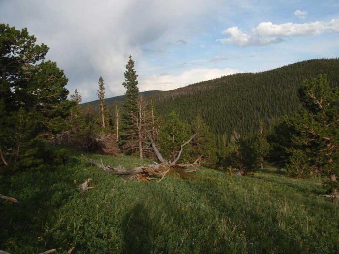
Open meadows and mixed forest are common among the parcels Denver Water is conveying to the U.S. Forest Service. Photo credit: Denver Water.
Denver Water is in the process of conveying 539 acres of wetlands, meadows and forests in Gilpin County to the Forest Service to be managed for public use.
The remote acreage, near the east portal of the Moffat Tunnel, protects ecologically precious lands near two wildly popular wilderness areas (Indian Peaks and James Peak) and the Arapaho and Roosevelt national forests. The land also complements a larger landscape protection effort in the region assembled by The Conservation Fund.
“Denver Water is thrilled to be a part of this landscape preservation effort,” said Jim Lochhead, the utility’s CEO/Manager. “This region near these precious wilderness areas is an environmental gem and one much loved by Coloradans, especially many within our service area.
“Ensuring its permanent protection is an outcome we are proud to be a part of, and we appreciate our partnership with the Forest Service and the Conservation Fund in putting this all together,” he said.
Denver Water agreed to provide the land for its ecological value and public use as part of a sweeping agreement with the Forest Service to offset environmental impacts associated with the expansion of Gross Reservoir to the east of the area.
It’s one of several steps Denver Water has already taken to complete so-called “mitigation” projects years ahead of the expansion work.
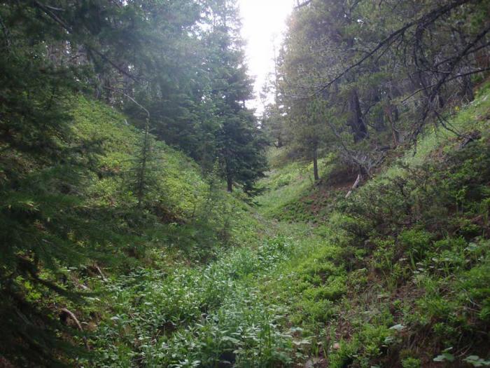
Seasonal creeks like this one funnel spring runoff into established waterways and lend the landscape a lush character. Photo credit: Denver Water.
The lands being conveyed are part of what’s known as the Toll Property, the name derived from a ranching family that owned the land for 120 years.
Denver Water’s contribution, scattered across 11 parcels, is part of a much larger agreement, according to reporting in the Boulder Daily Camera. A much larger area of 3,334 acres remains in the Toll family’s private ownership, but with a perpetual conservation easement to prevent development.
An additional 823 acres also were acquired by the Forest Service.
The entire land protection project creates a significant buffer, separating the adjacent James Peak Wilderness to the west from rural development and urban areas to the east, as described in a summary by The Conservation Fund.
These parcels in the Mammoth Gulch area look southwest toward the Continental Divide. Photo credit: Denver Water.
It also helps protect a four-mile stretch of the upper portion of South Boulder Creek, a key part of Denver Water’s supply.
The landscape is familiar not only to backpackers. Train aficionados know the area as part of the route taken by Amtrak’s California Zephyr, between Denver and San Francisco.
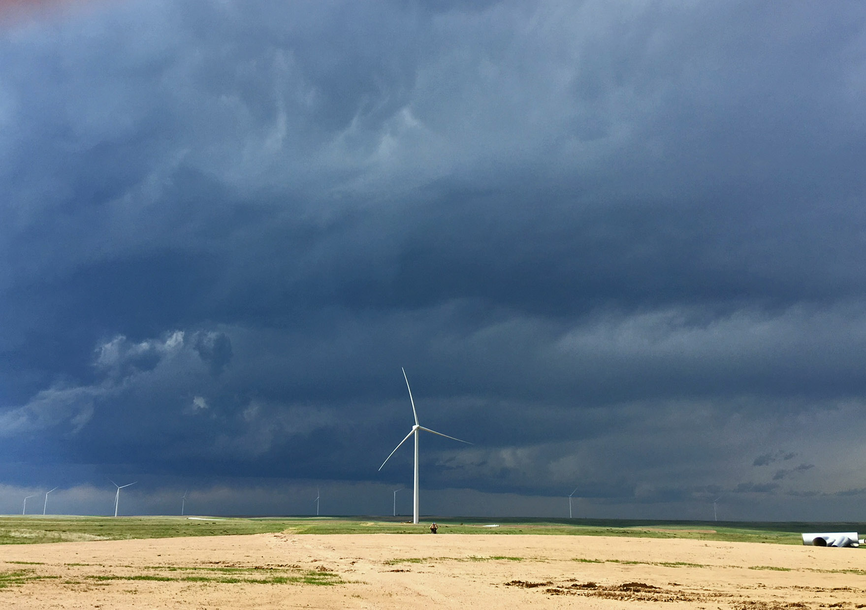
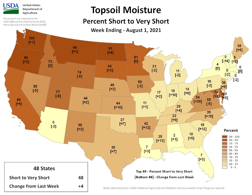
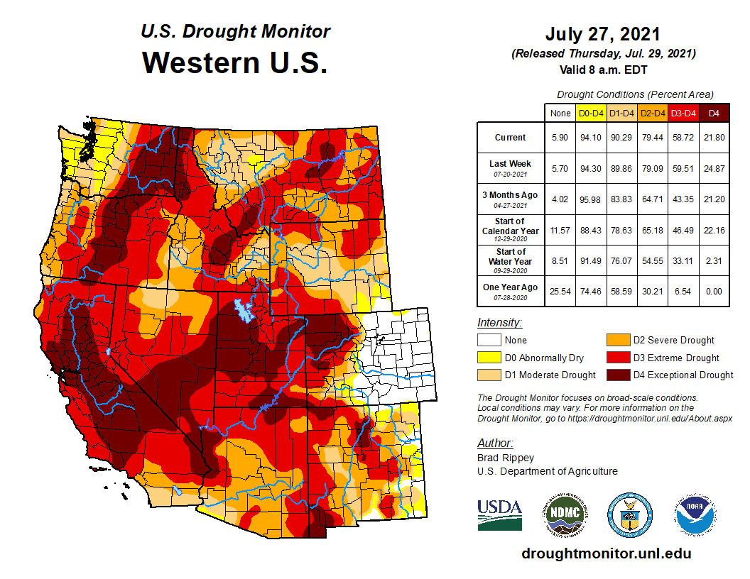
The situation in the Northwest across to the Northern Plains is frankly, bleak. 100% in WA, 98% in MT, 91% in ND, 90% in OR. The surrounding states aren’t much better.
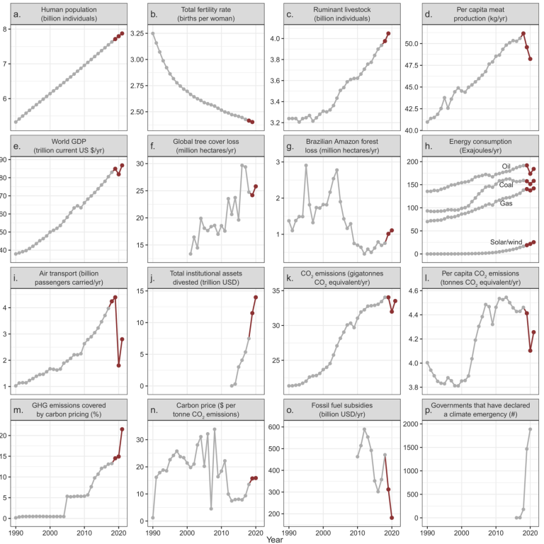
Time series of climate-related global human activities. In panels (a), (d), (e), (i), and (m), the most recent data point(s) are a projection or preliminary estimate (see the supplemental material); in panel (f), tree cover loss does not account for forest gain and includes loss due to any cause. With the exception of panel (p), data obtained since the publication of Ripple and colleagues (2020) are shown in red. In panel (h), hydroelectricity and nuclear energy are shown in figure S1. Sources and additional details about each variable are provided in the supplemental material. Complete time series are shown in supplemental figure S2.
Two years ago, more than 11,000 scientists from 153 countries declared a climate emergency. They did so in a report that said scientists have “a moral obligation to clearly warn humanity of any catastrophic threat and to ‘tell it like it is.'”
Now, they say things look even worse.
On Wednesday, an updated version of the report was published in the journal BioScience, and included an additional 2,800 scientists’ signatures.
The study evaluated 31 variables, like ocean changes and energy use. It found that over half are at new all-time record lows or highs.
For example, in April 2021, carbon dioxide concentration reached 416 parts per million—the highest monthly global average concentration ever recorded. Glaciers are losing 31% more snow and ice per year than they did just 15 years ago, a rate that is much faster than previously believed.
And for the first time, the world’s ruminant livestock (cattle, sheep, and goats) passed four billion, which represents much more mass than all humans and wild mammals combined.
The findings were shocking to lead author William Ripple of Oregon State University…
With so many variables moving in the wrong direction, the paper calls for big, transformative changes. That includes eliminating fossil fuels and switching to mostly plant-based diets.
The group plans to update its findings on a regular basis.
This story was produced by the Mountain West News Bureau, a collaboration between Wyoming Public Media, Nevada Public Radio, Boise State Public Radio in Idaho, KUNR in Nevada, the O’Connor Center for the Rocky Mountain West in Montana, KUNC in Colorado, KUNM in New Mexico, with support from affiliate stations across the region. Funding for the Mountain West News Bureau is provided in part by the Corporation for Public Broadcasting.
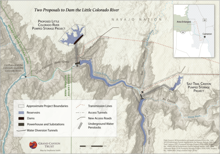
Good news! After two years of tireless advocacy led by the Navajo Nation, Hopi Tribe, and Hualapai Tribe, a would-be hydroelectric dam developer has requested the cancellation of two preliminary permits for dams on the lower Little Colorado River above the confluence with the Colorado River inside the Grand Canyon.
Pumped Hydro Storage LLC sent two letters to the Federal Energy Regulatory Commission (FERC) requesting the permits for its Little Colorado River and Salt Trail Canyon proposals be surrendered, citing strong opposition from the Navajo Nation, environmentalists, and others, as well as investment risks. This news comes two years after the developer first proposed the projects on Navajo Nation land in a region of deep cultural importance to many tribes.
Developer failed to work with tribes
Despite community opposition to the two dam proposals and interventions and objections from the Navajo Nation, the Hopi Tribe, and the Hualapai Tribe, Native organizations like Save the Confluence, and conservation organizations including the Grand Canyon Trust, FERC awarded preliminary permits for both the Little Colorado River and Salt Trail Canyon dam proposals. The developer was not required to get consent from the Navajo Nation or even consult with tribes, underscoring deep flaws in the permitting process. The company’s decision to surrender the permits for these two projects is a testament to the hard work of tribes, community organizers, and concerned citizens like you who took action and submitted comments. Thank you.
A river too fragile for dams
Had these hydroelectric dam proposals moved forward, the consequences on this arid landscape would have been severe. The lower Little Colorado River flows perennially into the Colorado River in the Grand Canyon, and its warm turquoise-blue waters shelter the endangered humpback chub when it is spawning.
The lower Little Colorado River is a spiritual place best left untouched by development, as grassroots community members and tribes have requested. It is home to the Hopi place of emergence along with innumerable other cultural sites. Upstream dams could alter this place of reverence and beauty.
Two down, one more dam to go
Map credit: The Grand Canyon Trust
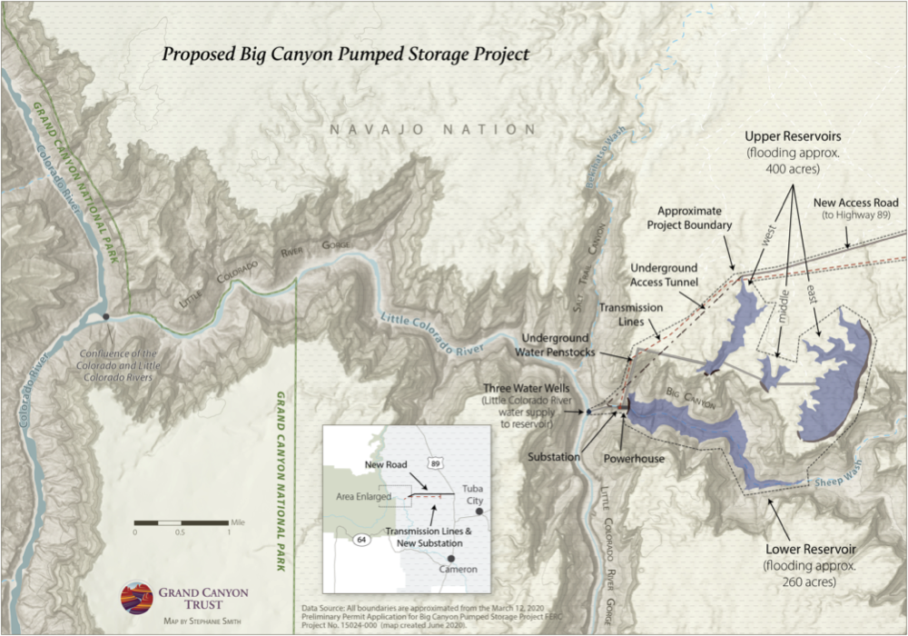
Unfortunately, the developer’s request to surrender these two permits is a reminder of the work ahead. The developer is still waiting to hear back on a preliminary permit for the Big Canyon dam proposal on a tributary to the Little Colorado River. The Big Canyon dam remains the developer’s priority — and our biggest concern. The Big Canyon dam proposal, which is also on Navajo Nation land and opposed by many tribes, would require pumping groundwater and likely alter the blue waters of the Little Colorado River.
West Drought Monitor map July 27, 2021.
Drought underlines the imprudence of the Big Canyon dam
The developer is proposing to pump about 44,000 acre feet (about 14.3 billion gallons) of groundwater, plus an additional 10,000 to 15,000 acre feet (3.2 to 4.8 billion gallons) per year to make up for water lost to evaporation in order to fill the Big Canyon dam in an arid landscape already facing extreme drought and water restrictions. Currently, there are potable water restrictions across the Navajo Nation. It is alarming that the developer is continuing to push a proposal to pump additional groundwater to power this project in order to produce electricity for distant city centers in the middle of this drought.
It is unknown when FERC will make a decision on the Big Canyon dam proposal’s preliminary permit application, which, if granted, would initiate a 3-year period for a feasibility study. What we do know is we will continue to stand with local communities and fight this unwanted and inappropriate proposal tooth and nail. If you haven’t already, please sign the petition to Keep the Canyon Grand and join our action alert network. We’ll let you know when there’s an opportunity to speak up.
Confluence of the Little Colorado River and the Colorado River. Climate change is affecting western streams by diminishing snowpack and accelerating evaporation. The Colorado River’s flows and reservoirs are being impacted by climate change, and environmental groups are concerned about the status of the native fish in the river. Photo credit: DMY at Hebrew Wikipedia [Public domain]
The Confluence. Photo credit: From the Earth Studio
Spider Grandmother’s presence along the Little Colorado River. Photo credit: From the Earth Studio
The turquoise waters of the Little Colorado River. Photo credit: Lyle Balequah/From the Earth Studio
Little Colorado River. Photo credit: Sinjin Eberle via American Rivers
Little Colorado River Upstream towards Big Canyons. Photo credit: Sinjin Eberle
NPS and USFWS use a seine net to trap humpback chubs in the Little Colorado River. Photo credit Mike Pillow via the Arizona Daily Sun.
The time between rainfalls has become longer and the rains occurred more erratically in the Southwest during the last 50 years.. Photo credit: The Mountain Town News/Allen Best
Drought conditions improve across the state but not erased west of the Continental Divide
Summit County is experiencing both a monsoon and a lingering drought.
How does that work? To put it simply, a drought takes a long time to release its grip. Whether the downpours will lift the area out of drought conditions or not, the precipitation is welcome relief, according to National Weather Service meteorologist Greg Hanson.
“We are in a monsoon pattern right now, and so that means we’re getting … a plume of moisture that comes up from the tropics, from the Gulf of Mexico and the Gulf of California,” Hanson said. “It’s not the individual storms; it’s the weather pattern that brings the storms to the area.”
The Dillon weather station recorded 3.76 inches of rain in July, which is more than double the month’s 1.87-inch average. On Saturday morning, July 31, the weather station recorded 1.13 inches of rain for the previous 24 hours, which is the most in a single 24-hour period so far this summer. According to National Weather Service records, it has been the rainiest July since 2011.
While an extra inch or two might not sound like much, Hanson said it makes a difference in the High Country…
Colorado Drought Monitor one month change map ending July 27, 2021.
Hanson said there have been some drought improvements in western Colorado, and areas east of the Continental Divide are in “great shape.” He said the wet spring and snowy March erased the drought in the east. In western Colorado, where conditions have been more severe, the precipitation has helped but has not gotten rid of the drought.
Colorado Drought Monitor map July 27, 2021.
Summit County’s drought conditions have not changed since the beginning of June, according to weekly updates from the U.S. Drought Monitor. The county currently ranges from no drought in the east to severe-to-extreme drought in the northwest.
North American Monsoon graphic via Hunter College.
Pueblo has received enough rain since January that records will still show Pueblo as receiving above-average rainfall for the year — even if not another drop of rain falls until December…
According to the National Weather Service’s data, Pueblo has received 12.91 inches of rain since Jan. 2021, which is 0.89 inches more than the annual average. This is a marked difference from 2020, when the area only received 5.33 inches during the whole year.
ommunity Funding Partnership projects like the Artificial Intelligence for Sustainable Water, Nutrient, & Salinity Management Project in Mesa County will support the advancement of precision agriculture as we move forward into a hotter, drier climate on the West Slope. Photo via the Colorado River District
Here’s the release from the Colorado River District:
Five grant awards to benefit agricultural, municipal, and recreational water users across Western Colorado
From enclosing irrigation canals to precision agriculture research; from creating reliable water storage to building redundancy in municipal water sources, the Colorado River District’s Community Funding Partnership is directly helping Western Colorado water users.
At its most recent Board meeting on July 21, the Colorado River District awarded a total of $494,350 to five projects across the West Slope. Since the beginning of 2021, a total of approximately $1.9 million has been awarded to thirteen different water projects, all of which benefit multiple stakeholders.
“In the midst of exceptional drought on the West Slope and increasing pressures on our rivers, our Community Funding Partnership continues to demonstrate the need for water funding to ensure our communities thrive into a hotter, drier future,” said the Colorado River District’s Director of Strategic Partnerships, Amy Moyer. “Developing solutions across a diverse geographic area and across diverse water uses is key. These projects advance multiple benefits to support our farmers and ranchers, recreators, and economies on the West Slope.”
Funded Projects:
Cedar Mesa Ditch Piping Project – Cedar Mesa Ditch Company Delta County
$45,000 in funds awarded
Just outside of Cedaredge, this project will pipe 3.5 miles of the lower Cedar Mesa Ditch that passes through Mancos Shale to avoid losing a significant amount of water to seepage. By preventing this water loss, particularly in drought years, the ditch users will face fewer cutbacks in the production of hay and fewer declines in the quality and quantity of crops such as fruit, hemp, vegetables, and greenhouse flowers. It will also improve water quality by eliminating salt and selenium returns to the Gunnison River and the broader Colorado River Basin.
Lake Irwin Valve and Piping Project Design and Engineering – Town of Crested Butte Gunnison County
$42,000 in funds awarded
This project will fund the necessary geotechnical and structural investigations required to better understand the infrastructure of a crucial source of water for the Town of Crested Butte. From this information, an engineered design will be developed to replace the valve structure, valve, and pipeline which conveys water from Lake Irwin. In addition, the project will conduct a condition assessment of the upstream portion of the tunnel which was originally installed in 1877 and is assumed to be timber set construction. Failure of this inlet tunnel would restrict the drinking water for the town and result in costly emergency repairs.
Artificial Intelligence for Sustainable Water, Nutrient, & Salinity Management in the Western U.S. – Colorado State University Mesa County
$50,000 in funds awarded
This project will construct and equip the Western Colorado Research Center at Grand Valley (WCRC-GV) with an overhead traveling sprinkler system on a 12.5-acre field to support research on digital and precision agriculture. A significant body of research into precision agriculture supports the improvement of crop yields, efficient irrigation, and reduced fertilizer use. This infrastructure addition will support emerging technologies and ensure cutting-edge research has a grounded presence in the Colorado River Basin for our communities to test and learn from.
GH Lateral Enhancement Project – Uncompahgre Valley Water Users Association Delta County
$57,350 in funds awarded
The GH Lateral Enhancement Project includes the construction of a 70 acre-foot in-system, regulating reservoir to provide a more reliable water supply to farms served by the northern portion of the Uncompahgre Project. This funding will support the land acquisition for the reservoir and a permanent easement for the GH Lateral Pipeline, leveraging approximately $14 million in federal funding. This area experiences high diurnal fluctuations, and the regulating reservoir will allow for water storage during peaks and the subsequent release during low flows. The project will allow water managers to optimize water diversions from the Uncompahgre River and minimize spills from the project.
Roaring Fork Pump Station Pipeline Connection Project – City of Glenwood Springs Garfield County
$300,000 in funds awarded
The project consists of the construction of a raw water transmission line from the City of Glenwood Springs’ existing Roaring Fork Pump Station to the Red Mountain Water Treatment Plant. Constructing a new pipeline connection will expand the City’s water supply capabilities, creating redundancy within the water system. This redundancy will not only mitigate drought and wildfire hazards, but will also mitigate increased hazards for sediment, debris flow, and rockfall issues within the No Name and Grizzly Creek watersheds caused by the August 2020 Grizzly Creek Fire.


![Confluence of the Little Colorado River and the Colorado River. Climate change is affecting western streams by diminishing snowpack and accelerating evaporation. The Colorado River’s flows and reservoirs are being impacted by climate change, and environmental groups are concerned about the status of the native fish in the river. Photo credit: DMY at Hebrew Wikipedia [Public domain]](https://i0.wp.com/coyotegulch.blog/wp-content/uploads/2019/11/1024px-usa_little_colorado__colorado_rivers.jpg?w=558&h=376&ssl=1 "1024px-USA_Little_Colorado_&_Colorado_Rivers")