Click on a thumbnail graphic to view a gallery of drought data from the US Drought monitor.
US Drought Monitor map August 3, 2021.
High Plains Drought Monitor map August 3, 2021.
West Drought Monitor map August 3, 2021.
Colorado Drought Monitor map August 3, 2021.
Click here to go to the US Drought Monitor website. Here’s an excerpt:
This Week’s Drought Summary
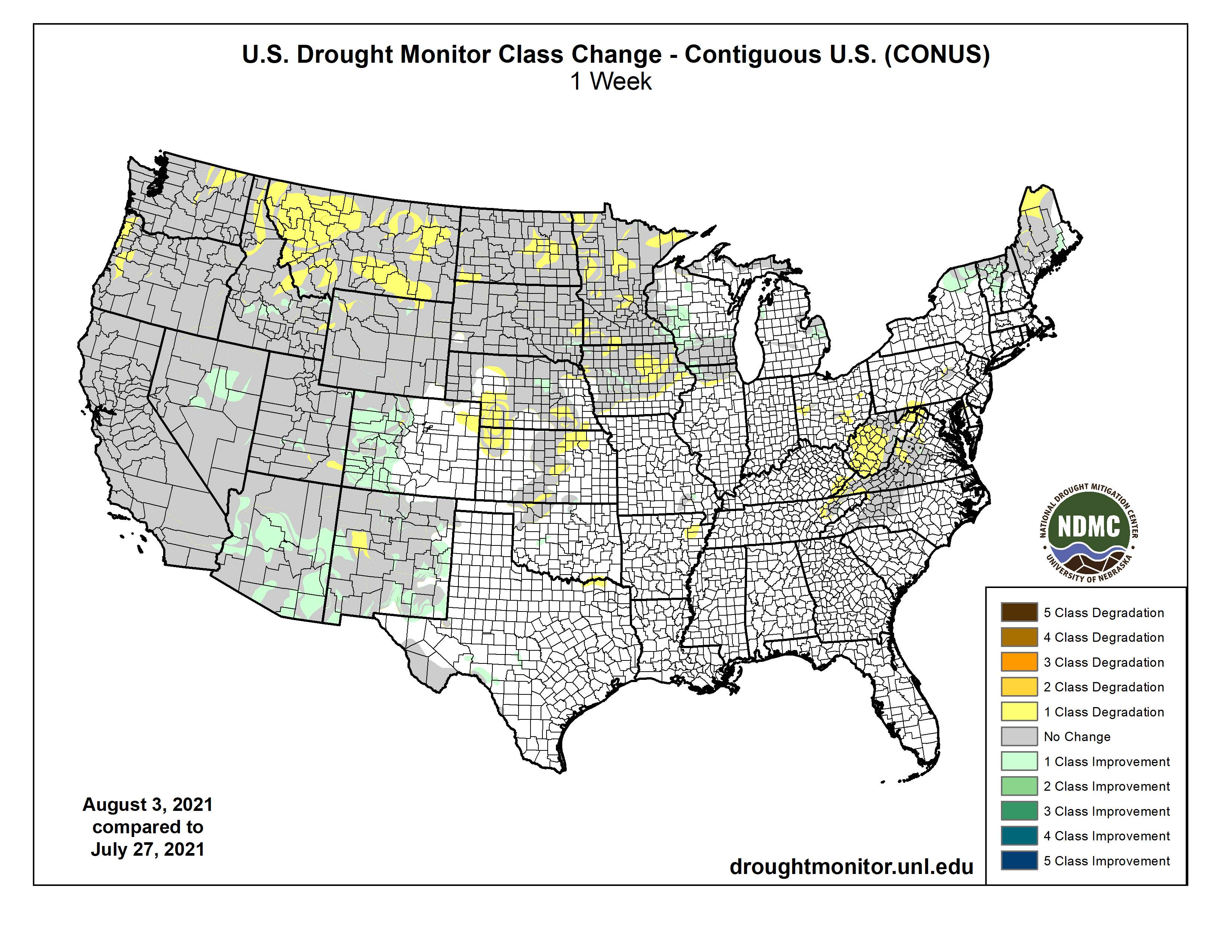
Abundant monsoonal precipitation again spread from the Southwest as far as eastern Nevada, southern Idaho, southern and western Wyoming, and western Colorado. Totals exceeding an inch were common, and 2 to 4 inches doused some of the higher elevations, especially across the central Rockies and Intermountain West. Most other areas of dryness and drought recorded at least light precipitation, but totals were not enough to significantly improve dryness and drought from the Plains eastward. Conditions deteriorated in several areas where there was little or no rainfall, specifically the northern Plains from eastern Montana through western Minnesota, from central Kansas and adjacent Colorado northward into Nebraska, across northeastern Arkansas, over the central Virginias, and in the climatologically dry areas of the Far West. Temperatures fluctuated during the week, with unusual heat covering central and southeastern parts of the country early in the period, but restricted to near the Gulf Coast by the end of the period. On the other hand, abnormally hot conditions slowly developed in much of the West after a relatively mild start (due in large part to monsoonal rainfall)…
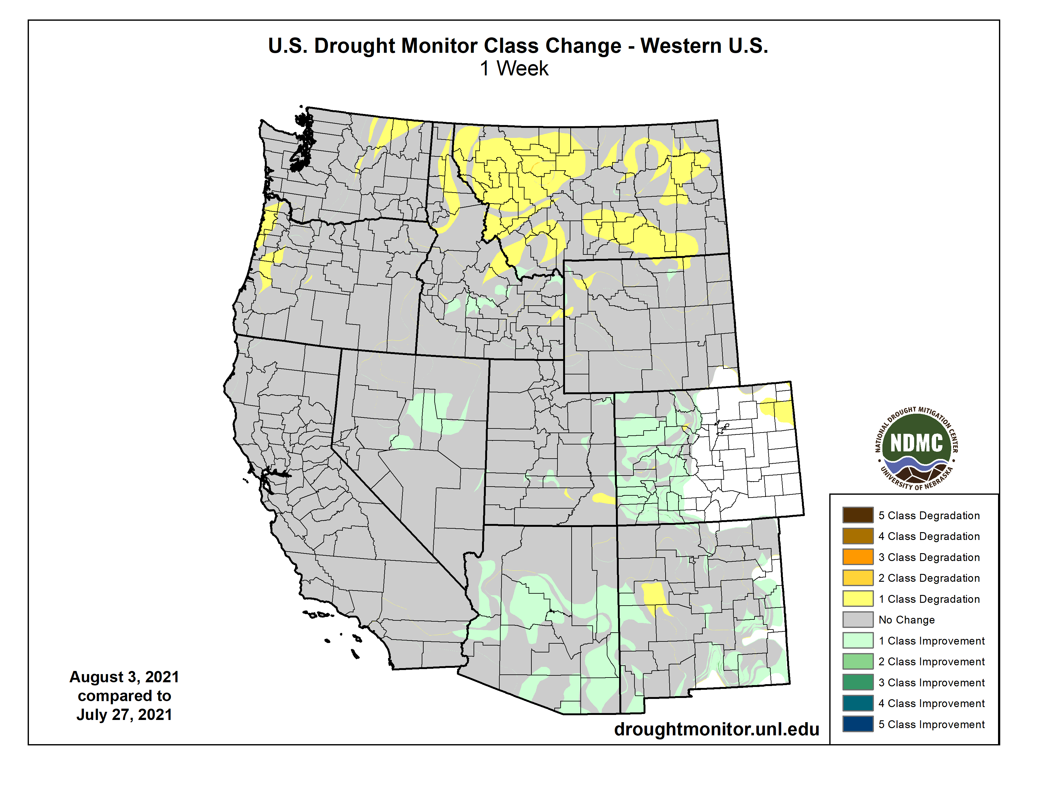
Abundant rainfall associated with the Southwest monsoon fell on the western half of Colorado, prompting widespread 1-category improvement. Exceptional drought (D4) is now confined to northwestern parts of the state and a small region in central Colorado. Areas farther north an east recorded less precipitation, allowing dryness and drought to remain intact or intensify. There was little change across Wyoming, but D0 and D1 classifications expanded from northeastern Colorado and Kansas northward into Nebraska. Deteriorating conditions were also noted across North Dakota, where drought has been evident since at least spring. Exceptional drought (D4) expanded substantially to cover much of the state’s interior…
West Drought Monitor one week change map ending August 3, 2021.
This has been a region of extremes for a few weeks now. Abundant monsoonal rainfall has affected Arizona and New Mexico for about a month, and recently heavy rains expanded as far northward as eastern Nevada, southern Idaho, Utah, and the adjacent fringes of the High Plains Region. July 2021 was the wettest month ever in Tucson, Arizona, where more than 8 inches of rain fell. This stands in sharp contrast to the approximately 0.5 inch of rain that fell last July. A 5-day stretch in late July saw more rain than the entire year of 2020. Across southeast Arizona, 13 flood warnings were issue for a least a brief time in a small area during 2020. So far this summer, 83 such warnings have been issued. Still, while the monsoon has been very beneficial across southern and central sections of the West Region, the protracted length and severity of the drought there still has most of this region in Severe Drought (D2) or worse, with a large area of D3 and D4 covering Utah and most of Nevada. Across the northern and western tiers of the West Region, conditions have been far drier, and with frequent rounds of abnormal heat, drought conditions and impacts continue to increase. Eastern Washington, central Oregon, and now parts of Montana are in Exceptional (D4) drought, with 1-classification deterioration noted across the entire state of Montana last week. The dryness and periodic intense heat have abetted the development and spread of large wildfires. So far this year, roughly the western half of the country has endured almost 17,000 large fires which have scorched about 2.5 million acres of land…
Scattered patches of dryness can be found in the South, but they are few and far between. One to two months of subnormal rain prompted new, small areas of abnormal dryness (D0) in northeastern Tennessee and part of northeastern Arkansas. The latter area has seen 30 to 65 percent of normal precipitation in the past month. A small new D0 area was also introduced in the eastern Red River Valley while dryness slightly expanded in Oklahoma and remained intact across lower reaches of the Big Bend. Other areas remained free of significant dryness…
Looking Ahead
During the next 5 days (August 3 – 9, 2021) the heavy monsoonal rains that have soaked a large part of the southern Rockies and interior West should ease up, with significant totals exceeding 0.5 inch restricted to some higher elevations. Farther north, moderate to heavy rains are expected in the upper Midwest and most of the Great Lakes region. Between 1.5 and 3.0 inches are expected at most locations from the northeastern quarter of Iowa through northern Illinois and much of Wisconsin. Meanwhile, light to moderate rains are forecast northwest Washington, part of east-central Idaho and southwestern Montana, the east-central Great Plains, most of southern Texas, the central Appalachians, portions of eastern Ohio, and northwestern Maine. Elsewhere, only isolated areas of light to moderate rain are anticipated, with little or none expected through much of the Great Plains, the lower Mississippi Valley states, and the lower elevations in the southwestern quarter of the contiguous 48 states. Above-normal temperatures will accompany dryness in most of the northern and western parts of the Nation, particularly at nighttime. Daily minima should average 6 to locally 9 degrees F in parts of the southern Rockies and Intermountain West, with near normal temperatures restricted to much of California and the relatively drought-free Southeast. Daytime high temperatures will be near to somewhat above normal through most areas of dryness and drought, with the largest anomalies (+6 to +10 degrees F) exacerbating the dryness in the central Plains
The CPC 6-10 day extended range outlook (for August 10 – 14, 2021) favors subnormal precipitation through a large part of the country, but not with high confidence. But everywhere from the Southeast coastal plain and Florida northward and westward through the Gulf Coast region, the central and western Mississippi Valley, The Plains, all but the southernmost Rockies, California from the Cascades and Sierra Nevada eastward, and the Pacific Northwest. Monsoonal moisture may increase again in southern areas, with above-normal precipitation slightly favored in the southern half of Arizona and part of New Mexico. Odds also favor above-normal precipitation in the Great Lakes region, Ohio Valley, Northeast, and the dry areas in Alaska. Subnormal temperatures are expected to accompany the increased precipitation in Alaska, but a vast majority of the contiguous states should average warmer than normal. Odds exceed 60 percent (compared to climatological odds of 34 percent) from the central and northern Plains eastward, topping 80 percent from the central Appalachians through the Northeast. Only parts of southern Texas and southern Arizona do not have enhanced chances for above-normal temperatures.
US Drought Monitor one week change map ending August 3, 2021.
Just for grins here’s a gallery of US Drought Monitor maps for early August for the past few years.
You probably remember your grade school science teachers explaining that energy can neither be created nor destroyed. That’s a fundamental property of the universe.
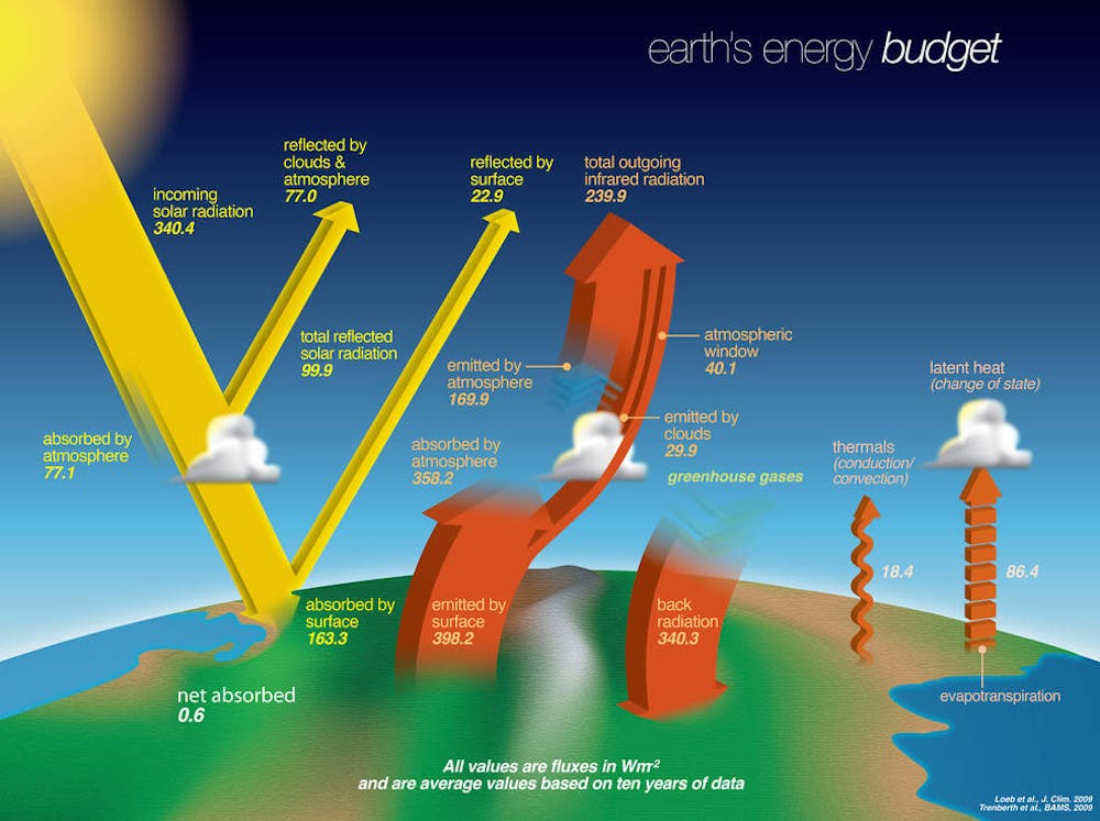
Energy can be transformed, however. When the Sun’s rays reach Earth, they are transformed into random motions of molecules that you feel as heat. At the same time, Earth and the atmosphere are sending radiation back into space. The balance between the incoming and outgoing energy is known as Earth’s “energy budget.”
Our climate is determined by these energy flows. When the amount of energy coming in is more than the energy going out, the planet warms up.
That can happen in a few ways, such as when sea ice that normally reflects solar radiation back into space disappears and the dark ocean absorbs that energy instead. It also happens when greenhouse gases build up in the atmosphere and trap some of the energy that otherwise would have radiated away.
99.9 watts are reflected back into space by clouds, dust, snow and the Earth’s surface.
The remaining 240.5 watts are absorbed – about a quarter by the atmosphere and the rest by the surface of the planet. This radiation is transformed into thermal energy within the Earth system. Almost all of this absorbed energy is matched by energy emitted back into space. A tiny residual – 0.6 watts per square meter – accumulates as global warming. That may not sound like much, but it adds up.
The atmosphere absorbs a lot of energy and emits it as radiation both into space and back down to the planet’s surface. In fact, Earth’s surface gets almost twice as much radiation from the atmosphere as it does from direct sunshine. That’s primarily because the Sun heats the surface only during the day, while the warm atmosphere is up there 24/7.
Together, the energy reaching Earth’s surface from the Sun and from the atmosphere is about 504 watts per square meter. Earth’s surface emits about 79% of that back out. The remaining surface energy goes into evaporating water and warming the air, oceans and land.
The tiny residual between incoming sunshine and outgoing infrared is due to the accumulation of greenhouse gases like carbon dioxide in the air. These gases are transparent to sunlight but opaque to infrared rays – they absorb and emit a lot of infrared rays back down.
Earth’s surface temperature must increase in response until the balance between incoming and outgoing radiation is restored.
Another look at Earth’s energy budget. Credit: California Academy of Sciences
What does this mean for global temperatures?
Doubling of carbon dioxide would add 3.7 watts of heat to every square meter of the Earth. Imagine old-fashioned incandescent night lights spaced every 3 feet over the entire world, left on forever.
At the current rate of emissions, greenhouse gas levels would double from preindustrial levels by the middle of the century.
Climate scientists calculate that adding this much heat to the world would warm Earth’s climate by about 5 degrees Fahrenheit (3 C). Preventing this would require replacing fossil fuel combustion, the leading source of greenhouse gas emissions, with other forms of energy.
Earth’s energy budget is at the heart of the upcoming IPCC climate assessment, written by hundreds of scientists reviewing the latest research. With knowledge of what’s changing, everyone can make better choices to preserve the climate as we know it.
A new coalition aims to re-shape the way people think about Colorado’s Gold Medal fisheries while also rally support for preserving and expanding signature waters around the state.
The coalition is “still very much a work in progress,” said Scott Willoughby, the Colorado field organizer with Trout Unlimited. But the campaign called Colorado Gold has added muscle with dozens of major business partners that include Patagonia and Fishpond, along with angling groups and towns centered around the state’s streams and lakes with the sport’s greatest distinction.
Colorado Parks and Wildlife manages some 322 river miles and three lakes with Gold Medal designations, based on those locations producing “the highest quality cold-water habitats.” The designation is reserved for fisheries producing a variety of trout 14-plus inches.
“When we talk about these Gold Medal waters, people seem to associate them with trophy trout fishing,” Willoughby said. “I think it’s time we shift that thinking from trophy trout to trophy trout habitat.”
With the sport’s growing popularity, Trout Unlimited has identified over-fishing as one threat to those habitats. Colorado Gold has a bold mission to conserve enough habitat to merit a 30% increase in Gold Medal fishing waters by 2030.
Doing this “will help safeguard more Colorado fisheries while redistributing pressure on a currently limited resource,” reads a coalition statement. Colorado Gold’s website adds: “We can’t afford to simply sit back and watch (Parks and Wildlife) do all the heavy lifting.”
[…]
Bigger and hotter fires of recent years have been another threat to prized streams. In 2019, officials reported the 416 fire near Durango effectively killed 80% of the fish population along the Gold Medal Animas River…
“Obviously, (climate change) will take federal action, as well as local action,” Willoughby said. “That’s why it’s so important that we continue to broaden this coalition.”
Settlement involving Windy Gap yields $15 million for science-based work
In the early 1980s, when a dam on the Colorado River near its headwaters was proposed and Andrew Miller was a writer for the Winter Park Manifest, he wrote an editorial called “Requiem for a Cottonwood Grove.”
The headline was premature because the dam at Windy Gap, where the Fraser River flows into the Colorado, had not yet been constructed. But it soon was, causing the cottonwood trees to be felled and allowing water from the new reservoir to be pumped uphill to Grand Lake. From there the water flows into diversion under the Continental Divide called the Alva Adams Tunnel to be distributed among cities and some farms in the northern Front Range.
But that story almost 40 years later continues, as news of a settlement suggests. The Grand Foundation will soon receive $15 million remediation for work in Grand County, where the Colorado River originates. The money will be used to try to create strategies for preserving trout and other aquatic life in the warming but ever-more shallow waters.
The big story here is of incremental depletions of the Colorado River at its headwaters by growing Front Range cities now colliding with the impact of the warming climate, hotter and drier. The two, each powerful, leave in doubt how long cold water-loving trout can survive.
“Trout need water temperatures below 70 degrees, and we are regularly bumping up against 70 degrees in our rivers,” says Miller, now a contractor and president of the Upper Colorado River Watershed Group.
The $15 million will come from the municipal subdistrict of the Northern Colorado Water Conservancy District responsible for this incremental diversion. The district built Windy Gap to divert the waters to the northern Front Range. A subsequent project spurred by the distressing drought of 2002 and those of later years yielded an expansion of the diversions at Windy Gap.
This graphic, provided by Northern Water, depicts Chimney Hollow Reservoir, located southwest of Loveland, after it is built.
The additional water will be stored, in part, at a new reservoir snuggled among the foothills rising from the Great Plain southwest of Loveland. The dam to create that 90,000-acre-foot reservoir, called Chimney Hollow, has not yet been constructed.
The political subdivision responsible for the new diversion consists primarily of towns and cities, from Broomfield, Superior and Fort Lupton on the south to Loveland and Greeley on the north.
Save the Colorado and the Sierra Club, among other groups, in 2017 had sued Northern, arguing that the process used to review the impacts was deficient in failing to adequate address cumulative impacts. In December 2020 a federal court ruled in favor of Northern, but the environmental groups appealed.
In April, a compromise was announced. The environmental groups dropped the lawsuit and Northern agreed to the $15 million settlement in what Northern described as a productive alternative to costly litigation.
The financial documents of the settlement agreement are to be signed by directors of Northern on Aug. 6 and by the Grand Foundation on Aug. 10. Because of delays in signing, Northern will transfer the first payment totaling $5 million immediately after the Grand Foundation signs, says Gary Wockner, of Save the Colorado and an allied group, Save the Poudre.
Administering the $15 million grant will be the Grand Foundation, which is to consist of three members from Miller’s organization, the Upper Colorado River Watershed Group. In addition to Miller, Dave Troutman the treasurer, and Geoff Elliott, the staff scientist, will be on the committee responsible for overseeing allocation of the grant. Northern Water has authority to name the three other members.
“Our charge over the next 10 years is to spend $15 million in ways that improve Grand County’s watershed in a collaborative process,” explained Miller. “In some ways, we are on opposite sides of the fence,” he said, referring to the Northern District’s appointment members. “But in many of the important ways we are on the same side. We both depend upon high-quality water, Northern almost more than us.”
Other measures in the agreement address water quality and provide more water for Western Slope users.
Restoring a river channel in the Upper Colorado Basin
Separately, Northern plans to create a new channel around Windy Gap Dam, to allow the Colorado River to flow without impoundment. The channel is intended to allow fish, macroinvertebrates, nutrients and sediment in the river to bypass the dam and reservoir. The project is called the Colorado River Connectivity Channel. The bypass channel will be the result of a settlement negotiated by Trout Unlimited and others, says Wockner. No draft environmental assessment has been released. “It remains to be seen if the channel will be permitted, funded or built,” he says.
Because of its proximity to the northern Front Range farms and cities and its relative plentitude of water-producing snow, Grand County has been the go-to place for trans-mountain diversions since the late 1880s. The two most significant are those accomplished by the 6.2-mile pioneer bore of the Moffat Tunnel, which allowed diversions from the Winter Park and Fraser area to begin in 1936; and the 13.1-mile Adams Tunnel, which began delivering water to the Estes Park area in 1947.
Miller sees pressing task of the foundation set up to administer the settlement funds will be to lay down a baseline of existing conditions. The existing data, says Miller “really aren’t that good.”
Beyond that, the challenge will be more difficult, perhaps impossible.
“Basically we need to figure out how to run a watershed when we only have 30% of the natural water, which is about all we have left after the diversions by the Front Range.”
In addition to the stepped-up diversions by Northern Water, Denver Water also wants to take additional water through the Moffat Tunnel for impoundment in an expanded Gross Reservoir.
By at least some estimates, 70% of the native water of eastern Grand County currently gets exported to the Front Range. With these new diversions, exports will increase to 80%.
When these incremental diversions were first conceived not quite 20 years ago, the science of global warming was firming up but the effects were not yet evident, at least not like now. Even a decade ago, after significant drought had begun and temperatures had clearly started rising, the big picture was more tentative.
Miller’s group contends no water remains available from the Grand County headwaters of the Colorado River for additional diversion.
“I don’t think anybody realized how persistent this drought would be,” says Miller. “It could be a forever thing. We have created a new climate, and we will never see the rainfalls and snow we have in the past.”
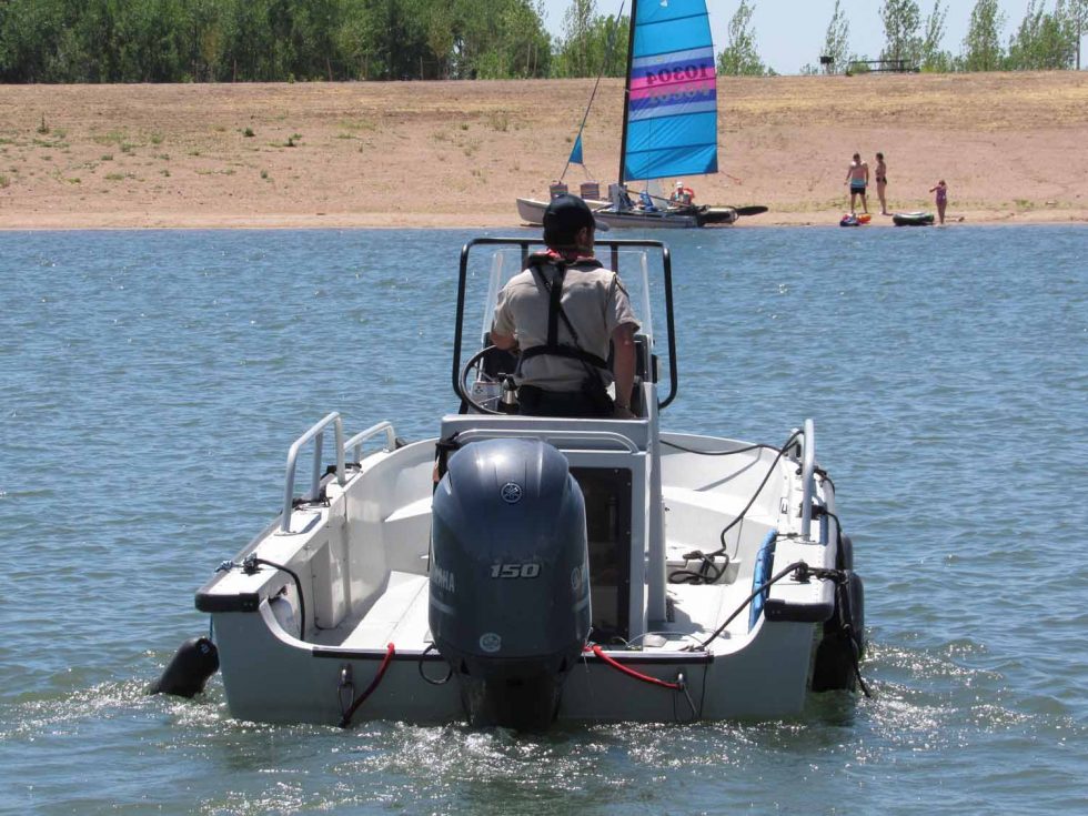
A Colorado Parks and Wildlife officer heads out on patrol at Chatfield Reservoir. A $171 million redesign at the popular lake is now complete, providing more water storage for Front Range cities and farmers. Last week the Colorado Water Conservation Board approved a settlement that will pave the way for an environmental water plan to help offset the impacts of the new storage. Credit: Jerd Smith
Colorado water officials have reached an agreement removing one of the last barriers to a new environmental water program in Chatfield Reservoir.
The agreement settles a dispute among water agencies about who could use storage space in a special environmental pool in the reservoir.
The agreement is one of the final steps in the re-operation of the recreational site just southwest of Denver and comes after years of permitting disputes and lawsuits.
The federally owned reservoir was built in 1967 and was initially designed for flood protection in years when the South Platte River surged beyond its banks.
But as drought and climate change, as well as population growth, increased pressure on urban and agricultural water supplies on the Front Range, federal, state and local agencies began working to convert a portion of Chatfield’s flood storage to municipal and agricultural water storage. The reallocated storage space totals 20,600 acre-feet, of which 2,100 acre-feet is designated as the environmental pool.
The new storage will give south Denver metro area cities such as Highlands Ranch more protection against drought and diminishing groundwater supplies, and will give farmers on the Eastern Plains the ability to use stored water to irrigate crops late in the season when flows in the South Platte River run low. Water from the environmental pool will be used for releases to boost streamflows downstream, improving water quality and providing other environmental and recreational benefits. Downstream irrigators will also benefit from those releases.
The physical work on the re-operation was completed last year after the project won federal approval and a major lawsuit against it failed.
The latest legal dispute stems from a disagreement between Centennial Water and Sanitation District, which serves Highlands Ranch, and the Greeley-based Central Colorado Conservancy District, over whose water rights could be used to fill the environmental storage space and whose space would be filled first.
Centennial’s and Central’s boards must still approve the settlement, according to Lauren Ris, deputy director of the Colorado Water Conservation Board, which negotiated the deal. [Ris also serves on the Board of Trustees for Water Education Colorado, which sponsors Fresh Water News.]
“There was a disagreement among the parties about which water rights could be used,” Ris said, with ultimately the Colorado Water Conservation Board giving up some of its storage space to settle the dispute between the water agencies.
Central officials could not be reached for comment.
Centennial Water Resources Manager Rick McLoud said his agency had spent millions of dollars and more than 20 years to ensure that the new Chatfield plan would serve Highlands Ranch well, and that its ability to store water there would not get bumped too far down the priority list.
“We spent 27 years working to get it and more than $55 million. We did not want to lose out,” McLoud said.
Environmentalists, including the Denver Chapter of the Audubon Society, had long battled the re-operation of the reservoir because it inundated the existing shoreline and resulted in a loss of bird habitat, among other issues.
New habitat has been set aside farther downstream for birds and other species, and water from the environmental pool will help maintain streamflows and habitat as it is released.
Abby Burk, an Audubon Society official, said her group is still deeply worried about the loss of habitat.
But she said the fierce drought and ongoing shortages of water for environmental purposes make the Chatfield habitat water critically important.
“Chatfield was a hard go. We lost some strong riparian areas for birds,” Burk said. “But anytime we can have environmental benefits, particularly in a challenging drought year, we have to go for it.”
Jerd Smith is editor of Fresh Water News. She can be reached at 720-398-6474, via email at jerd@wateredco.org or @jerd_smith.


