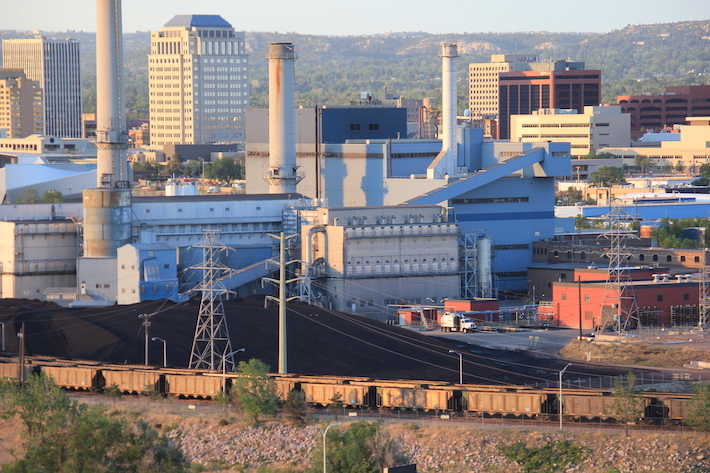
Martin Drake Coal Plant Colorado Springs. The coal plant in downtown Colorado Springs will be closed by 2023 and 7 gas-fired generators moved in to generate power until 2030. Photo credit: Allen Best/The Mountain Town News
The Martin Drake Power Plant will burn its last load of coal this Friday, Aug. 27, ending more than a century of coal-burning near downtown Colorado Springs for electrical generation.
Closing of coal plants will become a regular thing in coming years. By decade’s end, only one plant, Comanche 3, is scheduled to remain in operation in Colorado, if at much reduced capacity. Even that limited use scenario remains in doubt.
What will replace the electricity generated by coal combustion in times when neither the wind blows nor the sun shines or—increasingly problematic—the dams that produce hydroelectric generation whither to dead pool?
The answers remain unclear. In the case of Colorado Springs, six natural gas-burning units have been erected at the power plant along Interstate 25. But as Colorado Springs Utilities has made clear, these units costing $100 million, are to be temporary, while energy technology and economics shift further.
Like Xcel Energy and Tri-State Generation and Transmission and other utilities, Colorado Springs continues to wait for technological and perhaps political breakthroughs.
Coal has been a mainstay for the last century. At first, the plants were small. A practiced eye can see those brick buildings erected along rivers in Fort Morgan and Fort Collins.
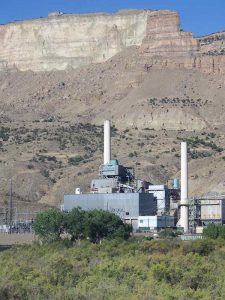
Cameo power plant circa 2010. Photo via Big Pivots
Then, coal plants became larger and then larger yet. Cameo Station, located along the Colorado River east of Grand Junction, had generating capacity of 73 megawatts when it went on line in the late 1950s. At Hayden, the two units that went on line in the ‘60s and ‘70s together have 441 megawatts of capacity. Then came the true behemoths at Craig and Pueblo, the former with 1,283 megawatts of generating capacity and the latter, called Comanche, with 1,410 megawatts.
Now, the closings have started. The smaller and older ones came first, and Cherokee, located north of downtown Denver, was converted from coal to burn natural gas. Hayden will be shut down by 2028 and Craig by 2030.
What a lot of change. In 2010, utilities were still very tentatively clinging to the past, unsure how much renewable generation they could absorb and still ensure your refrigerator had juice. Too, renewables were still expensive.
Then came 2014-2018, during which a profound shift occurred as wind generation became the lost cost resource, but solar prices rapidly declined, too, both aided by federal tax policies. And now coal has become the expensive fuel in almost all cases.
Utilities also were learning to integrate higher levels of renewables without sacrificing reliability. This was easier done in the middle of the night, when wind was blowing hard across Colorado’s eastern plains, but it applied to all hours of the day, too.
A hallmark of this progression came in December 2018, when Xcel Energy assembled Colorado’s political leaders, reporters and others at the Denver Museum of Nature and Science to announce a goal worthy of national attention. The company said it would cut carbon emissions from its electrical generation 80% by 2030 as compared to 2005 levels.
Days later, directors of Platte River Power Authority—the power provider for Fort Collins, Longmont, Loveland and Estes Park—announced a 100% goal for 2030, if with a list of caveats.
Tri-State, Colorado’s second largest electrical distributor, with 18 member cooperatives from Cortez to Holyoke, in January 2020 announced closings that will allow it to reduce emissions 80%.
Colorado Springs is a microcosm of this expansion of more than a century and now rapid shrinking of coal-based electrical generation. Electricity was introduced into the town in the 1880s, a light bulb at the end of a dangling cord representing the ritziest convenience in the city, a later brochure said. It was enormously expensive to operate, 6.5 cents per kilowatt-hour. Demand was small: a 60-kilowatt-generation plant met the needs of the 350 customers.
In 1968, when the Drake plant was dedicated, cost of electricity has declined to 2 cents per kilowatt hour, but demand had grown, as a brochure noted, to include everything from color TVs to electric blankets.
In June 2020, Colorado Springs Utilities announced that first Drake and then the Ray Nixon Plant, the latter a newer power plant, would close. The passage of Drake will be marked Friday afternoon with remarks by Colorado Springs Mayor John Suthers and Aram Benyamin, the chief executive of Colorado Springs Utilities since 2015.
Colorado Springs has been adding solar and wind generation but, at least during the coming decade, expects to remain reliant on natural gas. Natural gas in 2020 was responsible for 49% of electrical generation. In 2030, according to the municipal utility’s current plan, it will still be 42%. But on that, refer back to 2011 when some utilities were still theoretically planning to build more coal plants. It is, at this point, a placeholder.
What will it take to decarbonize electricity completely? Xcel says it believes it can hit 100% emissions-free energy by mid-century if the answers are not yet clear about that last 10% to 20%. Holy Cross Energy, the electrical cooperative serving Vail, Aspen, and Rifle areas, made its goal of 100% by 2030 unconditional.
Answers must be found. The vulnerability of the electrical grid was exposed by the windless days of February. That winter storm paralyzed Texas, exposing the fallacy of short cuts no matter what the fuel source. Colorado was not immune, though. Xcel Energy spent $600 million buying suddenly expensive natural gas. Tri-State spent only $11 million in extra costs, but turned to burning fuel oil when wind farms that produced an average of 51.2 megawatts of electricity fell to just 0.9 megawatts.
Storage has become the Holy Grail of the 100% quests. Lithium-ion batteries, which have about a four-hour storage life, will be inadequate when the wind doesn’t blow several days in a row on the Eastern Plains.
A regional transmission organization that allows Colorado to use electricity being generated in California or Arizona or even wind from Iowa, might help a lot. Tri-State wants such an organization. So does Holy Cross Energy—and, it would appear, Colorado Springs Utilities. In 2021 Colorado legislators approved a bill that requires integration of the state’s utilities into such an organization within a decade. One energy attorney, Mark Detzsky, calls it the most important energy or climate bill among Colorado’s 30-plus bills adopted in the 2021.
Other storage technologies may deliver the answers. Xcel Energy says molten salt tops the list of storage technologies when it closes its coal units at Hayden in 2027 and 2028. It also is considering green hydrogen, which can use electricity—presumably from renewable sources—to create hydrogen from water (venting the oxygen into the atmosphere). That technology faces cost and other hurdles.
As for Comanche 3, Colorado’s youngest coal plant, completed in 2010, and also its largest. Xcel Energy wants to keep it operating until 2040 at about a third of capacity or just seasonally. Pueblo and Pueblo County have also registered their support. They want the tax base.
But will a new energy storage technology make Comanche 3 obsolete? Maybe not, but that’s a bet I’d take.
Ouray County Water Users Association wants to build a 260-foot dam at this location on Cow Creek that would hold about 25,000 acre-feet of water. One goal would be to lessen daily flow fluctuations, especially during spring runoff. CREDIT: HEATHER SACKETT/ASPEN JOURNALISM
Water users in Ouray County are hoping to satisfy water shortages with what they say is a multi-beneficial reservoir and pipeline project. But the Ram’s Horn reservoir, Cow Creek pipeline and exchange are facing opposition from the state of Colorado and others.
The complicated, three-pronged project proposes to take water from Cow Creek and pipe it into Ridgway Reservoir, take water from local streams via ditches and store it in the reservoir, and build a new dam and reservoir on Cow Creek. This stored water would eventually be sent downstream to be used by the Uncompahgre Valley Water Users Association (UVWUA).
Ridgway Dam via the USBR
The project applicants — Ouray County, Tri-County Water Conservancy District, Ouray County Water Users Association and the Colorado River Water Conservation District — say they need 20 cubic feet per second of water from Cow Creek. Cow Creek is a tributary of the Uncompahgre River with headwaters in the Cimarron mountains. Cow Creek’s confluence with the Uncompahgre River is below Ridgway Reservoir, which is why an upstream pipeline would be needed to capture the water and bring it into the reservoir.
The applicants are also seeking to build Ram’s Horn Reservoir on the upper reaches of Cow Creek, which would hold about 25,000 acre-feet of water behind a 260-foot-tall and 720-foot-long dam. Ram’s Horn would help regulate what are known as diurnal flows during spring runoff — streamflows are higher during the day as the snow melts with warming temperatures, and lower at night as snow re-freezes. UVWUA says they can’t adjust their headgates to capture the high point of this daily fluctuation in flows, leaving the water to run downstream unused. The project would capture these diurnal peaks.
Ouray County Water Users Association wants to build Ram’s Horn Reservoir on the upper reach of Cow Creek, shown here. Colorado Parks and Wildlife opposes the project, in part, because of its potential impact to fish. CREDIT: HEATHER SACKETT/ASPEN JOURNALISM
Goal to prevent a call
The goal of the project is to prevent the UVWUA — one of the big senior water rights holders in the Gunnison River basin — from placing a call on the river.
When the UVWUA, which owns the Montrose & Delta Canal and has a 1890 water right, is not able to get its full amount of water, it places a call on the river. This means upstream junior water rights holders, like Ouray County Water Users, have to stop using water so that UVWUA can get its full amount. According to a state database, the M&D Canal has placed a call three times this summer, most recently from July 12 to 22. In 2020, the call was on for nearly all of July and August. Under Colorado water law, the oldest water rights have first use of the river.
By releasing the water stored in either Ridgway or Ram’s Horn reservoirs to satisfy a UVWUA call, Ouray County Water Users Association would then be able to continue using its own water.
The Glenwood Springs-based River District, which advocates to keep water on the Western Slope, is a co-applicant of the project.
“This (project) is consistent with the River District’s goals and objectives with supporting our constituents and making sure they have a reliable water supply,” said Jason Turner, River District senior counsel.
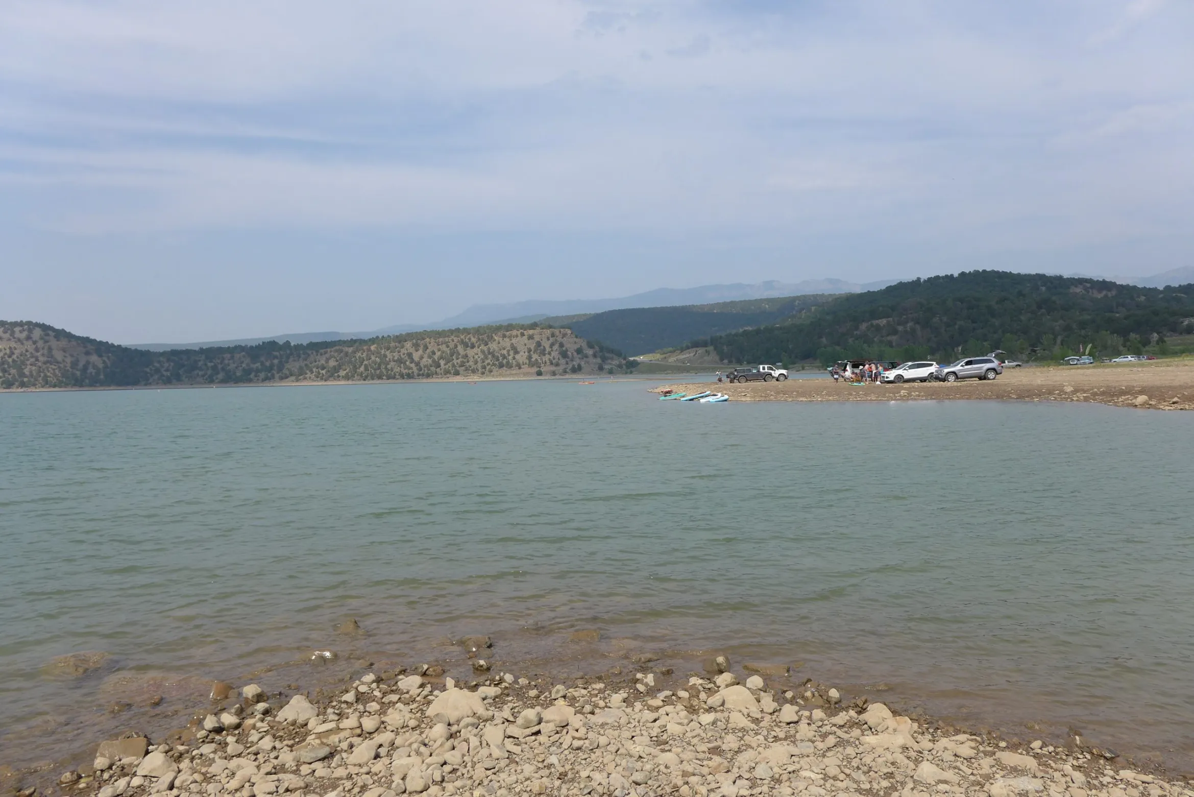
Ridgway Reservoir, on the Uncompahgre River in Ouray County, is popular with boaters. A proposed pipeline project that would bring water from Cow Creek into the reservoir is being met with opposition for environmental reasons. CREDIT: HEATHER SACKETT/ASPEN JOURNALISM
Potential impacts to fish, instream flows
But some state agencies, environmental groups and others have concerns about the project. Colorado Parks and Wildlife and Colorado Water Conservation Board have both filed statements of opposition to the application, which was originally filed in December 2019, amended in January and is making its way through water court. CPW claims that its water rights in the basin, which it holds for the benefit of state wildlife areas, fisheries and state parks, could be injured by the project. CPW owns nearly a mile of access to Cow Creek on the Billy Creek State Wildlife Area.
Between August 2019 and January 2020, CPW recorded water temperatures of Cow Creek and found they exceeded a state standard for trout. A report from CPW aquatic biologist Eric Gardunio says that the proposed project would likely cause an even bigger increase in water temperatures, resulting in fish mortality.
“The flow and temperature analysis for Cow Creek indicates that the water rights application has the likelihood to damage or eliminate the native bluehead sucker population as well as the rest of the fishery in the downstream end of Cow Creek through the degradation of water quantity and quality,” the report reads.
While less water in Cow Creek could result in temperatures that are too high for trout, water released from the proposed Ram’s Horn reservoir could be too cold for bluehead suckers.
“There’s going to be some changes to temperature and what our temperature data has outlined is that the species are at their extreme ends,” Gardunio said. “It’s nearly too cold for bluehead sucker and it’s nearly too warm for trout, so changes in temperature are going to have an impact to one or the other of the fishery.”
The Colorado Water Conservation Board opposes the project because they said it could injure the state’s instream flow water rights. Instream flow rights are held exclusively by the CWCB to preserve the natural environment to a reasonable degree. Ram’s Horn reservoir would inundate a section of Cow Creek where the CWCB currently holds an instream flow right.
“The application does not present sufficient information to fully evaluate the extent to which the CWCB’s instream flow water right may be injured,” the statement of opposition reads.
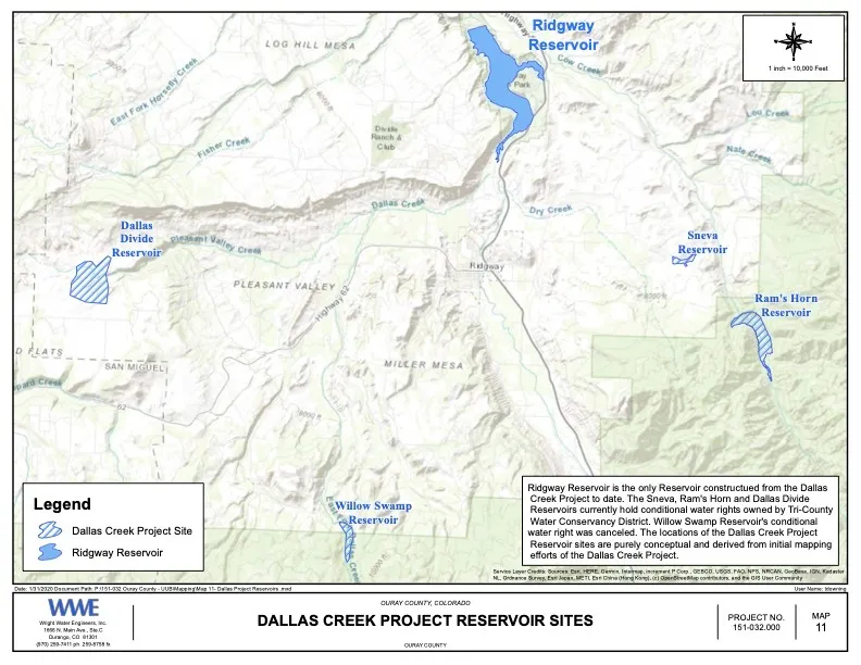
Environmental group Western Resource Advocates also opposes the project. Ram’s Horn Reservoir, with conditional water rights owned by Tri-County Water Conservancy District, is one of five reservoirs planned as part of the U.S. Bureau of Reclamation’s Dallas Creek Project, which dates to the 1950s. Ridgway Reservoir is the only one of the five that has been built.
This map shows the potential location of Ram’s Horn Reservoir, as well as other reservoirs originally conceived as part of the U.S. Bureau of Reclamation’s Dallas Creek Project. Only Ridgway Reservoir has been built. CREDIT: MAP COURTESY WRIGHT WATER ENGINEERS
Complex exchange
The third piece of the proposed project is what’s known as an exchange, where water would be conveyed via existing ditches connecting tributaries above Ridgway Reservoir. The exchange water would be stored there and released when senior downstream water users need it, which would benefit upstream water users. In addition to Cow Creek, the applicants are proposing to take water from Pleasant Valley Creek, the East and West Forks of Dallas Creek, Dallas Creek and the Uncompahgre River to use in the exchange.
Colorado Division of Water Resources Division 4 Engineer Bob Hurford laid out the issues his office has with this exchange in his summary of consultation. He recommended denial on the exchange portion of the application until the applicants list the specific ditches participating in the exchange and their locations, and agree that they are responsible for enlarging the ditches so they can handle the increased capacity of water.
“I have to have actual ditch names, the owners of the ditches have to be willing to participate and it has all got to be tracked to a tenth of a cfs,” Hurford said. “It’s not a loosey-goosey thing. It has to be dialed in and defined precisely.”
Another criticism of the project is that it won’t provide water directly to water users in Dallas Creek, which according to a report by Wright Water Engineers, is the most water-short region of the Upper Uncompahgre basin. Even if Dallas Creek water users participate in the exchange, in dry years still there may not be enough water in local creeks for them to use.
“This project has been sold as the savior of agriculture in Ouray County but this project will not provide wet water that would not otherwise be available to anybody that is an ag producer,” said Ouray County water rights holder and project opponent Cary Denison. “I don’t know one irrigator who is saying we need to build Ram’s Horn Reservoir.”
The project application is making its way through water court and applicants say they are continuing to negotiate with opposers. A status report is due in October. Attorney for the Ouray County Water Users Association and River District board representative Marti Whitmore said they want to make sure it’s a multi-purpose project that benefits everyone.
“Fish flows and recreation uses are important, so we are just trying to work out terms and conditions that are a win-win for everyone,” she said.
Aspen Journalism covers water and rivers in collaboration with The Aspen Times and other Swift Communications newspapers. This story ran in the Aug. 30 edition of The Aspen Times.
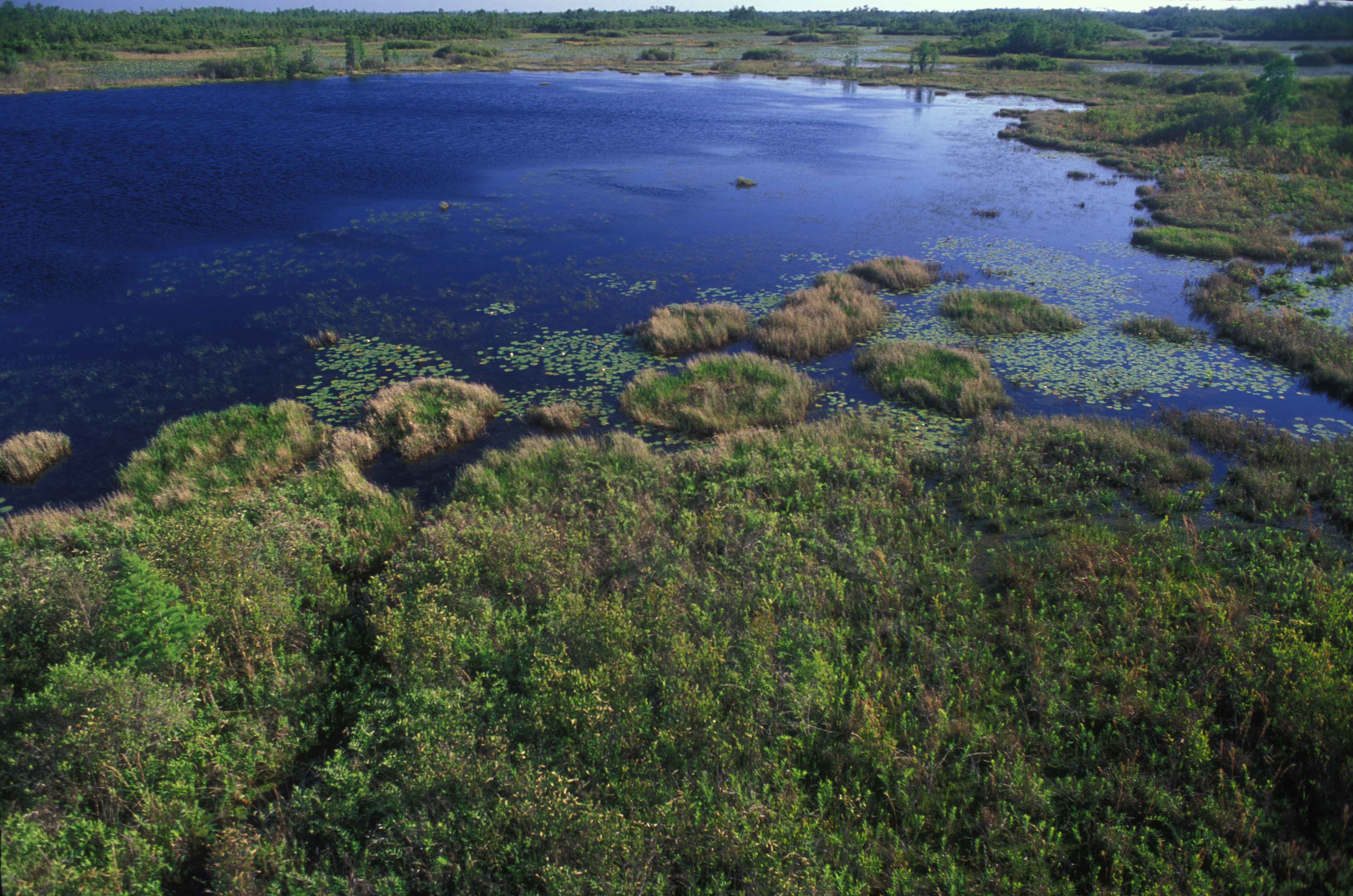
Photo credit from report “A Preliminary Evaluation of Seasonal Water Levels Necessary to Sustain Mount Emmons Fen: Grand Mesa, Uncompahgre and Gunnison National Forests,” David J. Cooper, Ph.D, December 2003.
FromThe Washington Post (Dino Grandoni and Brady Dennis):
A federal judge Monday threw out a major Trump administration rule that scaled back federal protections for streams, marshes and wetlands across the United States, reversing one of the previous administration’s most significant environmental rollbacks.
U.S. District Judge Rosemary Márquez wrote that Trump officials committed serious errors while writing the regulation, finalized last year, and that leaving it in place could lead to “serious environmental harm.”
A number of business and farm groups had supported the push to replace Obama-era standards with the Navigable Waters Protection Rule, on the grounds that states were better positioned to regulate many waterways and that the previous protections were too restrictive.
The ruling in the U.S. District Court for the District of Arizona, which applies nationwide, will afford new protections for drinking-water supplies for millions of Americans, as well as for thousands of wildlife species that depend on America’s wetland acreage.
Márquez, a Barack Obama appointee, noted that the U.S. Army Corps of Engineers, which oversees permits to dredge and fill waterways under federal jurisdiction, determined that three-quarters of the water bodies it reviewed over a nearly 10-month period did not qualify for federal protection under the new rule. Federal agencies identified 333 projects that would have required a review under the Obama rule, she added, but did not merit one under the Trump standards…
Home builders, oil drillers and farmers — who have long argued that earlier restrictions on developing land made it too difficult to do their work — are likely to appeal…
North American Indian regional losses 1850 thru 1890.
In June, the Biden administration announced that it would write regulations to strengthen wetland protections but would keep the Trump-era rule on the books while it did so. But tribal and environmental groups pressed the court in Arizona to vacate the previous administration’s rule sooner, since some wetlands may be irreparably harmed during the time it would take to replace it…
“We came in and said, ‘No, no, no, no, you can’t leave this in place,’” said Janette Brimmer, a senior attorney for Earthjustice, which represented the Native American and green groups in court. She added, “This is hugely good.”
The ruling marks the latest salvo in a decades-long legal and regulatory battle over the full extent of the Clean Water Act’s reach.
That landmark 1972 law prohibits polluting “waters of the United States” without a permit. But the question of which waterways fall under that category has been debated in courtrooms and agencies ever since.
In 2015, Obama’s administration moved to protect a broad swath of water bodies, including “ephemeral” streams that appear only after rainfall and help purify water. Hydrologists have found that even these intermittent rivulets can affect the water quality of large rivers and lakes downstream.
But the Trump administration replaced that regulation with a far narrower one, on the grounds that the Obama rule exceeded the government’s legal authority.
“They basically ignored it all,” Mark Ryan, a former EPA lawyer who helped craft the Obama-era regulation, said of the Trump team. “It was a voluminous bit of science.”
With Monday’s court ruling, agencies will go back to applying water protection standards from the 1980s, which are more expansive than the Trump-era rule but not as sweeping as Obama’s.
The push to overhaul federal clean-water regulations has caused ongoing fights in places such as in Georgia, near the sprawling Okefenokee Swamp. A proposal to strip-mine for titanium would have received strict scrutiny under the Obama-era standards, and some federal officials and environmental groups raised concerns about its potential impacts.
But last year the Army Corps of Engineers determined that under the revised Trump rule, the area was no longer federally protected…
“This is a welcome day for the Okefenokee, the wetlands surrounding the refuge, and will force Twin Pines to reevaluate this disastrous project,” Christian Hunt, Southeast program representative for Defenders of Wildlife, said in an email.
Created by Imgur user Fejetlenfej , a geographer and GIS analyst with a ‘lifelong passion for beautiful maps,’ it highlights the massive expanse of river basins across the country – in particular, those which feed the Mississippi River, in pink.
Today, the U.S. District Court for the District of Arizona said Trump’s Navigable Waters Protection Rule must be vacated because the rule contains serious errors and has the potential to cause significant harm to the Nation’s Waters if left in place while the Biden administration works on revisions to the rule. It represents the culmination of a lawsuit brought by six federally recognized Indian tribes, who are represented by Earthjustice and sued the Environmental Protection Agency (EPA) and Army Corps of Engineers for passing a rule that eliminated Clean Water Act protections for thousands of waterbodies by redefining them as not “waters of the U.S.”
Thanks to this lawsuit and the Court’s ruling, the country will now return to water protections that were in place for years starting in 1986, wiping the Trump Dirty Water Rule off the books. This outcome ensures Clean Water Act protections are in effect while the Biden administration works to develop a new rule. The Dirty Water Rule was particularly damaging for waters throughout the West, Southwest and Great Lakes. The six tribes and their members have been disproportionately harmed by the rule as their livelihoods and culture were put at risk when the Dirty Water Rule eliminated protection for thousands of wetlands, headwater streams, and desert washes.
“The court recognized that the serious legal and scientific errors of the Dirty Water Rule were causing irreparable damage to our nation’s waters and would continue to do so unless that Rule was vacated,” said Janette Brimmer, Earthjustice attorney. “This sensible ruling allows the Clean Water Act to continue to protect all of our waters while the Biden administration develops a replacement rule.”
For Tribes, just like for every living being on the planet, water is life and has been so since time immemorial. The Trump administration, however, wholly disregarded that when it put industry profit over people by rolling back Clean Water Act protections. Even though the Biden administration has initiated the process to repeal the Trump Dirty Water Rule, it continues to apply the rule in the meantime, exacerbating the harms to Tribes.
In court filings, the federal government acknowledged that the Dirty Water Rule completely disregarded decades of the best science and neglected to assess the impacts the rule had on downstream communities. EPA’s own science advisors said Trump’s rule threatened to weaken protection of the nation’s waters by disregarding the established connectivity of ephemeral wetlands and small streams to downstream rivers and lakes.
Earthjustice is representing the Pascua Yaqui Tribe, Tohono O’odham Nation, Quinault Indian Nation, Menominee Indian Tribe of Wisconsin, Fond du Lac Band of Lake Superior Chippewa, and the Bad River Band of Lake Superior Chippewa.
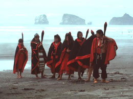
Quinalt Indian Nation dancers on beach. Photo credit: Quinalt Indian Nation
“Small headwater streams are fundamental to the protection and restoration of salmon and our way of life,” said Guy Capoeman, president of the Quinault Indian Nation. “Today’s ruling will protect all waters on which the Quinault people rely.”
This morning, the #GOESEast satellite's water vapor channel is showing what is now Tropical Storm #Ida as it moves further inland. @NHC_Atlantic says that a dangerous storm surge and flash flooding are continuing over portions of southeastern LA, southern MS, and southern AL. pic.twitter.com/ZBEQP6uzmu
Hurricane Ida, which struck the Louisiana coast on Sunday with winds of 150 miles an hour, gained power faster more than most storms. Because of climate change, such rapid strengthening is happening more often as hurricanes pick up more energy from ocean water that is warmer than before.
But in a summer of extreme weather, Ida’s intensification was extreme.
According to the National Hurricane Center’s forecast bulletins, the storm’s maximum sustained winds as of Saturday morning were about 85 m.p.h., making it a Category 1 hurricane. Less than 24 hours later they were 65 m.p.h. stronger, bringing Ida close to a Category 5.
The storm intensified more than the hurricane center’s forecast, which had called for maximum winds reaching 140 m.p.h. The hurricane center’s definition of rapid intensification is at least a 35 m.p.h. increase in wind speed in 24 hours. Ida strengthened that much in just six hours overnight.
Climate change is part of the reason. Researchers have found that the frequency of rapidly intensifying Atlantic hurricanes has increased over the past four decades as ocean temperatures have risen, in large part because warmer water provides more of the energy that fuels these storms. In the 1980s, there was about a 1 percent chance that a hurricane would undergo rapid intensification. Now, there’s a 5 percent chance.
But experts who study the behavior of hurricanes said other factors played a role with Ida, including seasonal warming of the Gulf of Mexico, the amount of moisture in the atmosphere and the presence or absence of winds that can affect the structure of a storm.
Right now the Gulf is extremely warm because it accumulated heat throughout the summer. It’s this seasonal warming, which happens in the Atlantic Ocean as well, that makes mid-August through October the most active part of the hurricane season every year.
But it’s not just the surface temperature of the Gulf that’s important, said Joshua Wadler, a researcher with the University of Miami and the National Oceanic and Atmospheric Administration. Hurricanes actually cool the ocean as they travel across it, because they stir up the water down to about 150 feet, mixing in colder water from below.
In this case, Ida traveled across water that was much warmer down to that depth. Probes sent into the water by hurricane hunter aircraft on Saturday revealed that the temperature, after it had been mixed by Ida, was about 30 degrees Celsius, or 86 degrees Fahrenheit, Dr. Wadler said.
“That’s on the very high end of sea surface temperatures that hurricanes ever experience,” he said.
The storm’s path happened to track over this warm water, what scientists call an eddy, said Chris Slocum, a NOAA researcher.
“Ida found the perfect path across the gulf, where the warmest water is,” he said, and that provided plenty of energy for the storm to extract. “You could say it’s a worst-case scenario.”
Dr. Slocum compared the situation to that of Katrina, in 2005, which crossed a cooler water column as it neared Louisiana, weakening from a Category 5 to a Category 3. Ida did not encounter any cooler water.
“This one is continuing the upward trend,” he said. “The only thing that’s going to stop the intensification process is landfall,” he said.
Eddies occur in the Gulf every year, formed when part of a looping current breaks off, Dr. Wadler said. And while it’s extremely difficult to link a specific one to climate change, this one “is as deep as we’ve seen in a very long time,” he said.
While ocean temperatures are most important, two other factors affect how much and how quickly a storm strengthens, Dr. Slocum said.
Atmospheric moisture affects the thunderstorms that make up a tropical cyclone. The more humid the air, the more these storms will survive and persist. And the way these thunderstorms interact with each other, particularly at the eye of the storm, can affect whether it strengthens or weakens.
Wind shear — changes in wind speed and direction with height in the atmosphere — can also affect the structure of a hurricane. If the wind shear is too strong, “you can tear a storm apart,” Dr. Slocum said.
The hurricane center’s forecasters had been watching wind shear closely. It had been a factor as the storm entered the Gulf on Friday, giving Ida an asymmetric structure. But the shear dissipated on Saturday, allowing the storm to assume a more regular spiral shape.
The effect on wind speed can be likened to what happens with figure skaters during a spin. Skaters who keep their arms in a tight, precise position will rotate faster. But if one of their arms is extended, they’ll rotate much more slowly.


