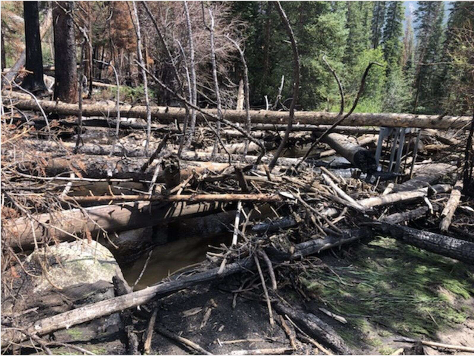
The head gate to Grand Lake’s hydro power plant is blocked by trees washed up during Saturday’s flash flooding. You can see the head gate on the right side of the picture. Photo credit: Town of Grand Lake
Here’s the release from Grand County via The Sky-Hi Daily News:
Flash flooding on Tonahutu Creek piled up enough trees, mud and debris Saturday night to shut down Grand Lake’s hydro plant.
Town Manager John Crone estimated Monday that there are about 50 large downed trees piled up at the plant’s head gate while ash and mud filled the ditch leading to another gate.
Grand Lake owns water rights on the creek and uses them to generate power for the town’s wells. The wells on which the town relies for water are fine and operating on other power sources with the hydro power stalled.
Because the creek is on national park land, Crone said the town is working with the National Parks Service to clear the debris.
“It has to happen soon,” Crone said. “We have to get the trees cleared and the water flowing.”
Crone said the floodwater also carried ash into Grand Lake and that some ash washed up onto the beach.
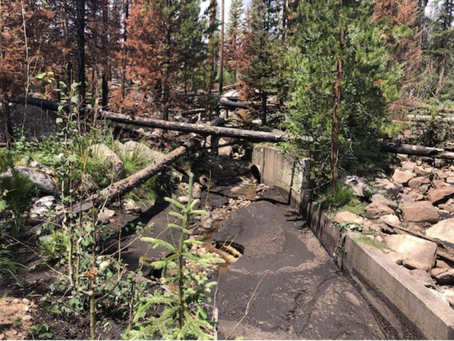
Ash fills the ditch before water flows through the second head gate to Grand Lake’s hydro power plant. Courtesy Grand Lake via The Sky-Hi Daily News
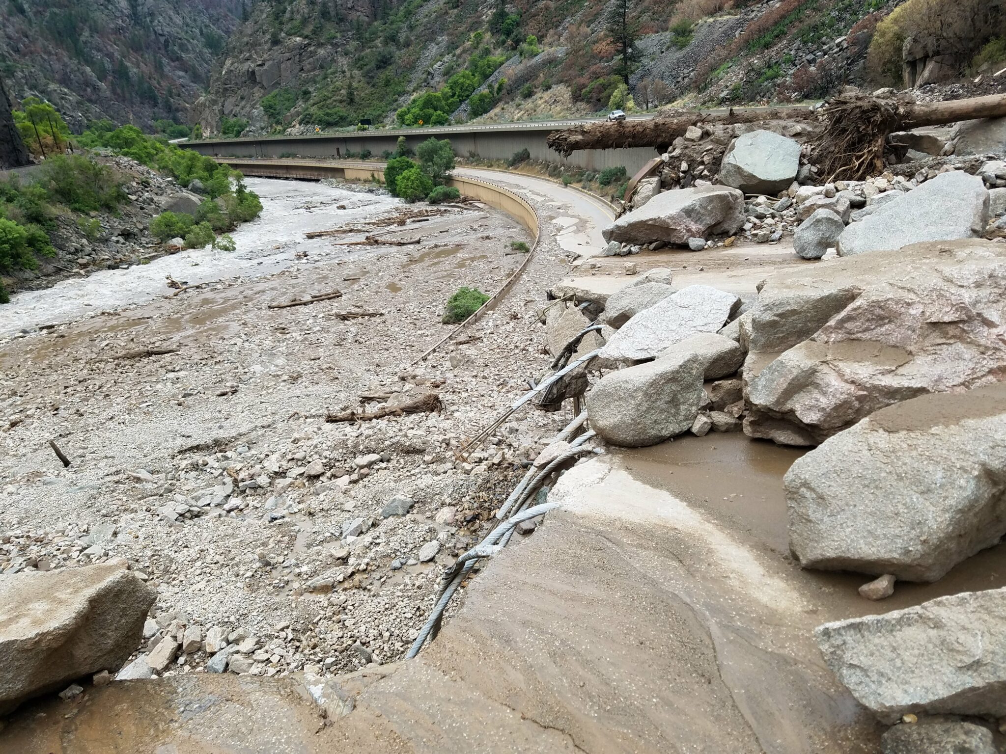
Other damage from mudslides has occurred along Colorado Highway 125 in Grand County and Interstate 70 at Glenwood Canyon, both where major wildfires burned last year.
Flash flooding has been a persistent threat in Grand County, which saw two large wildfires last year and has seen repeated mudslides and flash floods in the burn scars.
Flash flooding can occur with relatively little rainfall in burn areas and often inundates small creeks and streams, gulches, roads, and poor drainage and low-lying areas.
Almost two of every three flash flood deaths occurr in vehicles. Drivers should not attempt to cross flowing streams and never drive through flooded roadways.
According to the National Weather Service, as little as a foot of swift water can float most cars, and two feet of fast-moving water can sweep away many vehicles, including SUVs and trucks.
Streamflows on the local Eagle River have certainly seen a spike the past few days thanks to the recent rain.
According to the Eagle River Water and Sanitation District, the Eagle River is experiencing flows 170% higher than normal near Minturn and 144% higher than normal in Avon. This is quite the difference from just four days ago, July 29, when the river level was 49% of the average streamflow for this time of year in Avon.
According to Diane Johnson, the communications and public affairs manager for the Eagle River Water and Sanitation District, there have only been seven days since April 1 where the river levels have exceeded the average…
It’s too early to tell whether this will have any impact on drought conditions. While Holly Loff, executive director of the Eagle River Watershed Council, is hopeful this unusual spike in streamflow will have a positive impact, she expects, as we return to hotter and dryer temperatures, “it’s not going to have a huge impact.”
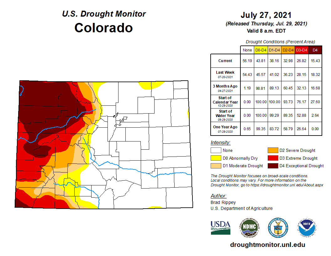
Colorado Drought Monitor map July 27, 2021.
The area’s soil has seen the greatest impact of the drought conditions and with the fast and quick monsoon rains, the soil doesn’t get the chance to absorb the moisture and recover from the drought conditions.
The Chaffee County Board of Commissioners voted Tuesday to approve the conditions under which a water bottling company could continue to pull water from a spring connected to the Arkansas River.
They are allowed to do so through the water right they bought back in 2010, but the county gives the green light if it finds the company follows all of the rules.
The 1041 permit process outlines specific conditions that BlueTriton has to meet in order to pull water out of Chaffee County. BlueTriton, previously known as Nestle, owns two wells. State water records obtained by 9Wants to Know show the company can pull up to 196 acre-feet of water each year…
[Della] Malone said regardless of the amount of water BlueTriton will take, Colorado is at the point where as much water as possible needs to stay in the river to keep fish, and the birds that feed on them, alive…
For the most part, BlueTriton has been a good steward of the water. The county hired W.W. Wheeler and Associates to conduct an updated analysis in 2020 and said the company is not using as much water as it could be.
Gary B. Thompson, an engineer for the water engineering firm W.W. Wheeler and Associates, found the utilization of the wells was not causing problems…
Jennifer Davis, Chaffee County attorney, said in an email that Monroe’s report led to increased wetlands monitoring in the 2009 contract. Any 2021 contract would have similar measures that would allow the county to cancel the contract if there was evidence that the wetlands were being stressed.
“It is important to note that during the recent hearings, evidence was presented that the applicant has substantially complied with those plans over the past 10 years,” Davis wrote. “…If [BlueTriton Brands] fails to comply with the plans, the permit can be suspended or terminated.”
In 2020, Wheeler found the nearby wetlands are healthy and the permit has “adequate” monitoring protocols.
Turrquoise Reservoir, which stores water brought under the Continental Divide from the Eagle, Fryingpan and Roaring Fork river headwaters. Photo credit: Aspen Journalism
Clear Creek Reservoir
The well permits allow for a maximum of 196 acre-feet per year. On average, the Wheeler report found the wells pulled in 111.7 acre-feet on average. The well had not been tapped for more than 100 acre-feet per year since 2014, according to the report. Any water taken for the water bottling operation is replaced with water from the nearby Turquoise Reservoir and Clear Creek Reservoir…
How much water goes to water bottles?
Kevin Rein, a state engineer and the director of the Colorado Division of Water Resources, said water bottling facilities use a small portion of the state’s water. He wrote in an email that one fairly standard-sized Colorado bottled water company found it was responsible for 0.0006% of the state’s annual water use.
For context – 85.2% of the state’s water goes to agriculture each year and 6.6% are used by cities and commercially according to data from the Colorado Division of Water Resources…
Other requirements of the permit
Other requirements of the contract have mostly been met. Davis said in an email BlueTriton did not finalize a conservation easement, but that commissioners did not penalize the company because deadlines were not clearly explained in the permit.
According to a letter from the Colorado Department of Natural Resources, Nestle did not begin discussions about donating land for an easement until 2019, 10 years after the original 1041 permit was issued by the Chaffee County Commissioners…
BlueTriton will pay $1.2 million across 10 years to various causes like water sustainability, forest health and affordable housing. It will pay $430k in just the first year, then $92,500 each year afterward.
Nestle sold its North American water brands to BlueTriton for $4.3 billion dollars.
Arkansas River Basin — Graphic via the Colorado Geological Survey
Without a doubt, one of the largest threats to American infrastructure is climate change.
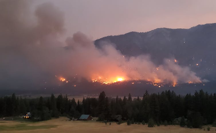
This was illustrated yet again as upwards of 10 landslides ravaged sections of Colorado’s Interstate 70 corridor, closing the Glenwood Canyon portion of the highway indefinitely. This came after weeks of intermittent slides that have exhausted personnel and had a chilling effect on local economies.
Yet despite the impacts, few have sought to elaborate on the relationship between extreme debris flows and the burning of fossil fuels.
This is a grave oversight.
Dismissing the role of climate change in infrastructure resiliency fails to appreciate the inherent relationship between infrastructure and environment. As global temperatures rise, so, too, will the number of extreme events. This places existing structures and byways in new dangers, ranging from some damage to full destruction.
GET THE MORNING HEADLINES DELIVERED TO YOUR INBOX
In the case of mudslides, as wildfires burn bigger and hotter due to rising temperatures and severe drought, ground vegetation of the forest floor is burned off at alarming rates. This creates a layer of dusty ash over bare, scorched soil, resulting in a decreased ability of the soil to absorb water.
While healthy forest floors can hold several inches of water per hour, high or moderately burned areas might only hold one-third of an inch. This results in top layers that can be easily washed away, at least until enough ground vegetation is reestablished — roughly the first year or two post-burn. Meanwhile, even small amounts of rainfall can result in dangerous runoffs, posing great risks to structures and byways located in slide paths. Combined with more intense rainfall — also due to climate change — landslides may occur more frequently and over larger areas with greater force and debris.
This dynamic is consistent with recent events on I-70. Based on post-fire assessments conducted by the Burned Area Emergency Response team, the Grizzly Creek Fire — which was fueled by especially hot and dry conditions last year — burned areas surrounding the canyon. Soil testing revealed that 55% of this area had incurred moderate to high soil burns, leaving the region with unusually high risks of extreme runoffs. Only 12% of the 32,370 acres were estimated to be unburned.
Certainly, mudslides are possible in any canyon so steep — and it’s happened before. However, the size and severity of this particular burn created enhanced risks for severe infrastructure damage. Accordingly, at the recommendation of BAER, mitigation efforts were made.
Shortly after the fire, one large, natural berm was created to protect the most critical infrastructure in the canyon — a mostly hidden command center in the heart of Glenwood Canyon that serves to monitor the interstate. As predicted, less than a year later, some 100,000 cubic yards of debris was diverted with that very berm. John Lorme, the Colorado Department of Transportation director of maintenance and operations, hailed the effort as saving the state millions of dollars and extensive closed highway time — a testament to the role of climate research in protecting infrastructure.
There are, however, limits to our current preventative measures — as evidenced by the current debris damage. During a 47-minute press conference with CDOT, Region 3 director Mike Goolsby acknowledged the lack of radar technology and understanding in predicting slides with enough time to close or protect the highway.
According to the U.S. Geological Survey — the only science agency to exist within the U.S. Department of Interior — much additional research funding and efforts regarding landslides are needed as climate change intensifies. Especially relevant are the needs to better understand debris flow mechanisms, forecasting and mitigation strategies, all efforts that would help safeguard core infrastructure.
One Colorado-based hydrologic engineer, Kelsey McDonough, agrees, adding that some in the private sector may also have access to better, more localized technology. “This could be really useful in a state like Colorado where local knowledge can be utilized to build better regional monitoring and modeling systems than are currently available at the national scale,” she says.
Certainly, Colorado has a number of cutting-edge national laboratories and private companies that may be inclined to help find solutions with the right incentives. Securing these funds is just one of many roles local representatives can play in helping the state navigate the new challenges.
Still, perhaps the most important thing we must do is disentangle the notion that discussions of human-driven climate change during extreme events are signals of political interference. They are not. Climate change is well established in scientific literature, as is its impact to structural integrity. Addressing the role of reducing fossil fuels in related press conferences and articles is therefore necessary to serve the long-term goal of infrastructure stability.
SUPPORT NEWS YOU TRUST.
Colorado Newsline is part of States Newsroom, a network of news bureaus supported by grants and a coalition of donors as a 501c(3) public charity. Colorado Newsline maintains editorial independence. Contact Editor Quentin Young for questions: info@coloradonewsline.com. Follow Colorado Newsline on Facebook and Twitter.
Here’s a short video (~4 minutes) from CDOT to give you an overview of the slide area.
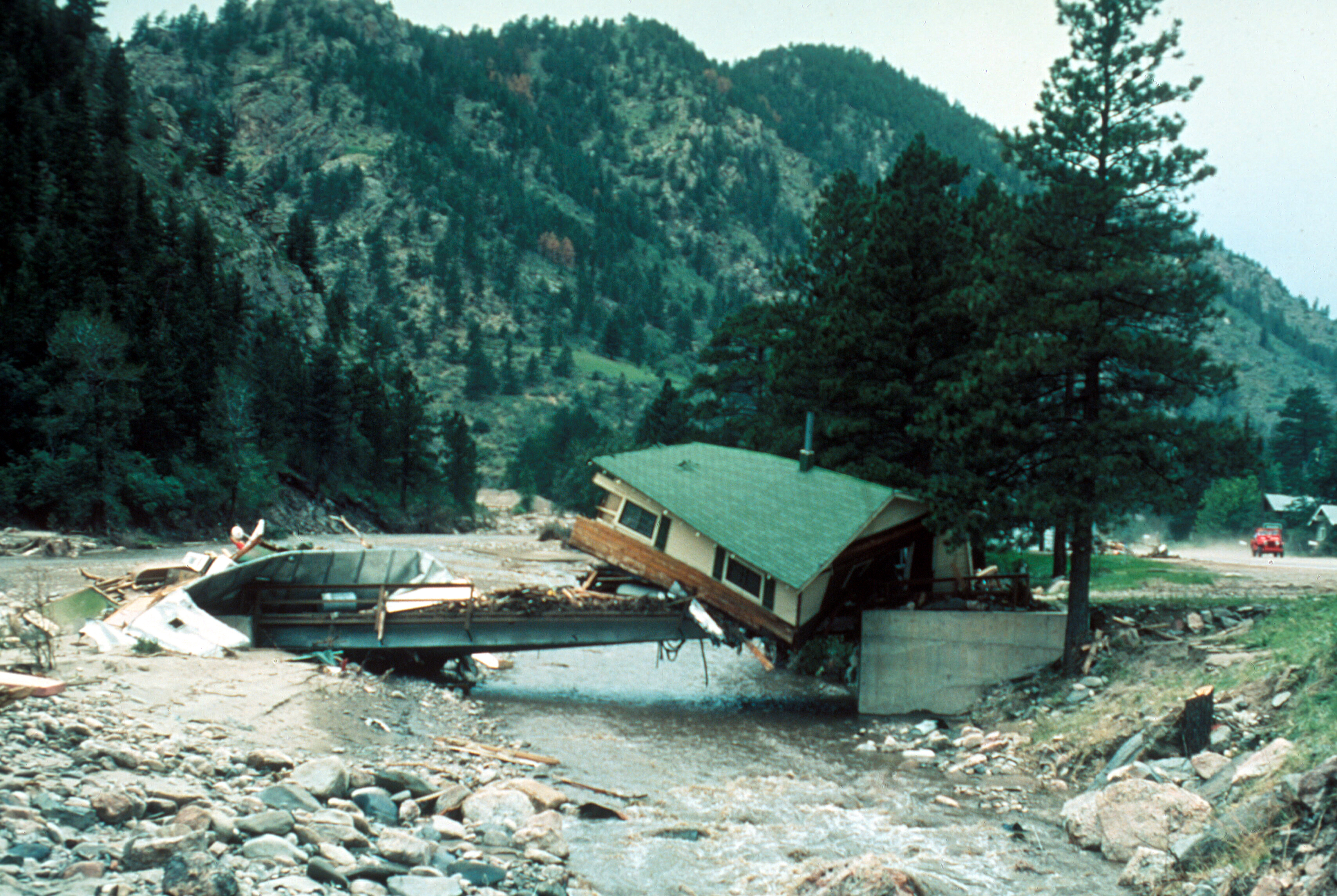
Big Thompson Flood, Colorado. Cabin lodged on a private bridge just below Drake, looking upstream. Photo by W. R. Hansen, August 13, 1976. Photo via the USGS.
FromThe Fort Collins Coloradoan (Miles Blumhardt):
For the past month, Coloradans have been inundated with flash flood watches and warnings and a weather event — called a monsoon…
Neither flash floods nor the annual monsoon season have grabbed Colorado headlines the past several years because neither had much impact on the state.
That changed this year.
“This year is more normal of what we would expect from monsoon season compared to the past couple of years,” said Jennifer Stark, a meteorologist who manages the National Weather Service office in Boulder. “We are seeing bigger impacts, and people are really beginning to take notice because it is impacting their ability to recreate and move across the state and affecting homes.”
A series of events that has led to devastation started last year when the state experienced its worst wildfire season in its recorded 145-year history…
This summer, those burn scars, largely left denuded, have been continually saturated with abundant monsoonal moisture, resulting in large debris slides.
Those slides have continually closed Interstate 70 in Glenwood Canyon, which remains closed Monday due to what the Colorado Department of Transportation has called “extreme damage” to the major transportation corridor. It also resulted in the deaths of three people with a fourth still missing and six residences destroyed in the Poudre Canyon…
The Colorado Climate Center said the monsoon pattern is created by abundant moisture that builds in the atmosphere from the Gulf of Mexico and Pacific Ocean.
A shift in wind pattern results from a high pressure system with clockwise flow over the Rocky Mountains and low pressure near the Gulf of Mexico with a counterclockwise flow that settles over the region and squeezes moisture northward into the atmosphere.
In Colorado, the moisture is more prevalent on the Western Slope but can spill over the Continental Divide, which is happening this year.
This creates persistent afternoon thunderstorms that park over areas that can produce large amounts of rain, sometimes in a short period of time…
When that happens on burn scars, soil that repels water is washed down canyons, gullies and ravines that act as funnels of accumulating water. As it gains momentum, the slide brings with it large boulders and burned trees.
Stark said many of the state’s most devastating floods have taken place during the monsoon season, including the 1976 Big Thompson flood and 1997 Spring Creek flood in Fort Collins, both of which occurred in late July.
After so many smoke-filled summers and record-setting burns, residents of Western North America are no strangers to wildfires. Still, many questions are circulating about why forest fires are becoming larger and more severe – and what can be done about it.
Is climate change fueling these fires? Does the long history of fighting every fire play a role? Should we leave more fires to burn? What can be done about Western forests’ vulnerability to wildfires and climate change?
We invited 40 fire and forest ecologists living across the Western U.S. and Canada to examine the latest research and answer these questions in a set of studies published Aug. 2, 2021. Collectively, we are deeply concerned about the future of Western forests and communities under climate change.
Ironically, a chronic lack of fire in Western landscapes also contributes to increased fire severity and vulnerability to wildfires. It allows dry brush and live and dead trees to build up, and with more people living in wildland areas to spark blazes, pressure to fight every forest fire has increased the risk of extreme fire.
The problem with fighting every wildfire
Historically, fire was a regular visitor to most Western forests, except moist locations like those along the Pacific Northwest coast and in British Columbia. Frequent or periodic fires from Indigenous burning and lightning strikes created patchworks of grasslands, shrublands and regenerating forests of all ages.
Past fires influence the way subsequent fires burn and what they leave behind. For example, Indigenous burning practices not only enhance cultural resources and wildlife habitat but also reduce the amount and connectedness of fuels that drive large, severe wildfires. Similarly, patchy burns from lightning ignitions create forest landscapes that are less likely to burn all at once.
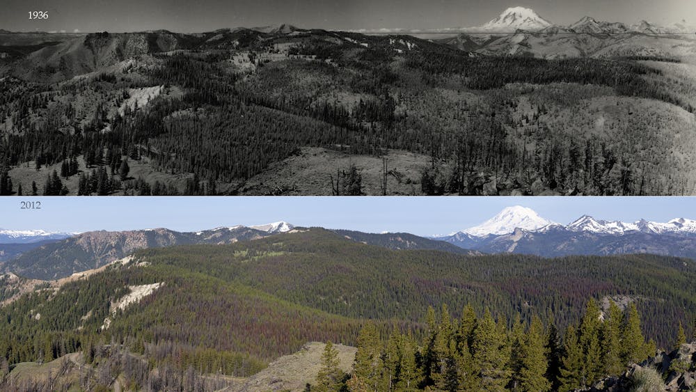
Photos of Bethel Ridge, a moist mixed conifer forest in eastern Washington, show the difference in patchiness in 1936 compared with 2012. National Archives (1936); John Marshall Photography (2012)
The U.S. and Canada effectively suppress all but 2%-3% of wildfire starts. However, this small percentage of fires burn at the height of each fire season, when dry conditions and extreme fire weather thwart even the most aggressive attempts to suppress them.
Unintentionally, by focusing on short-term risks of wildfires, the U.S. is predisposing forests to burn under the very worst conditions. Active fire suppression contributes to what is often referred to as the wildland fire paradox – the more we prevent fires in the short term, the worse wildfires become when they return.
In one of the new studies, Paul Hessburg and co-authors explain how fire managers can mitigate the severity of future fires by managing fire-excluded forests to foster resilience to wildfires and drought. Management approaches include thinning dense forests, reducing fuels through prescribed burning and managing wildfires to restore more typical patterns of forests, meadows, shrublands and woodlands.
For example, fire exclusion has compromised aspen stands – biodiversity hot spots for everything from bears to butterflies. Increased forest cover diverts water from downslope meadows, allowing conifer forests to further encroach on aspen habitat.
A path forward
Amid the daunting reality of climate change and severe wildfires, there is a path forward for Western forests.
In a third article, Susan Prichard and her co-authors examine which adaptive forest management approaches have worked to increase resilience to wildfires and climate change. There is strong scientific evidence that fuel reduction treatments – including forest thinning, prescribed burning, Indigenous cultural burning and managed wildfires – are effective approaches for mitigating future fire impacts to Western forests. However, land managers can’t expect these treatments to work if they are applied to only a small fraction of Western forest landscapes.
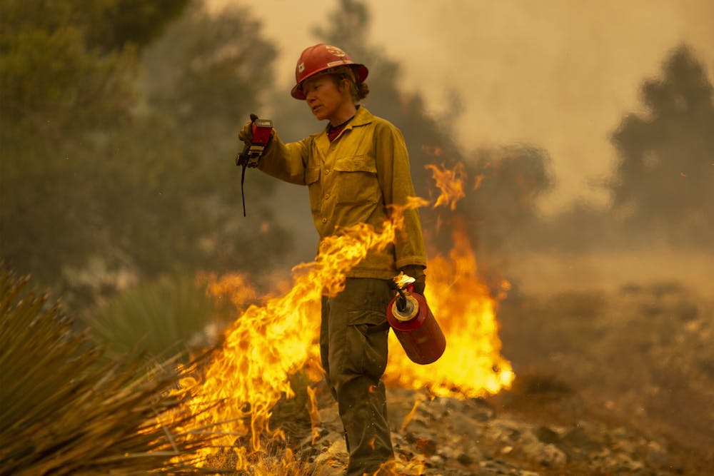
Mormon Lake Hotshots firefighter Sara Sweeney uses a drip torch in a controlled burn that removes fuel from a wildfire’s path in 2020. David McNew/Getty Images
When combined, forest thinning and prescribed burning in dry ponderosa pine and in dry and moist mixed-conifer forests have been shown to be highly effective at reducing the fire damage to forests. However, this type of treatment is not appropriate for all forest types. Fire managers in some wilderness areas and national parks have allowed fires started by lightning to burn in some wind and weather conditions. Over the past 40-plus years, these wildfires have been allowed to burn and reburn landscapes, generally limiting the size and severity of subsequent wildfires.
Given the immense diversity of Western forests, there is no one-size-fits-all solution. However, in forests that historically supported more frequent fire, revitalizing and continuing cultural burning practices, prescribed burning, and forest thinning combined with prescribed burning can reduce overcrowding and the potential for severe fires. Thinning and prescribed burning aren’t appropriate or feasible everywhere. In reality, only a portion of landscapes can be treated this way. Allowing wildfires to burn in more areas under moderate weather conditions is also part of the solution.
Promoting resilient Western forests will require that our society builds a new relationship with fire by creating fire-adapted communities and looking for opportunities to restore fire to Western forest landscapes.
Paul Hessburg explains how fire suppression efforts allowed forests to overgrow and become fire hazards.
In this era of warmer, drier summers and longer fire seasons, there are no fire- or smoke-free solutions. The current approach to fire management poses unnecessarily high stakes for Western forests. There is no doubt that the future of Western forests is a fiery one. How we choose to live with fire is still up to us.
[Over 100,000 readers rely on The Conversation’s newsletter to understand the world.Sign up today.]