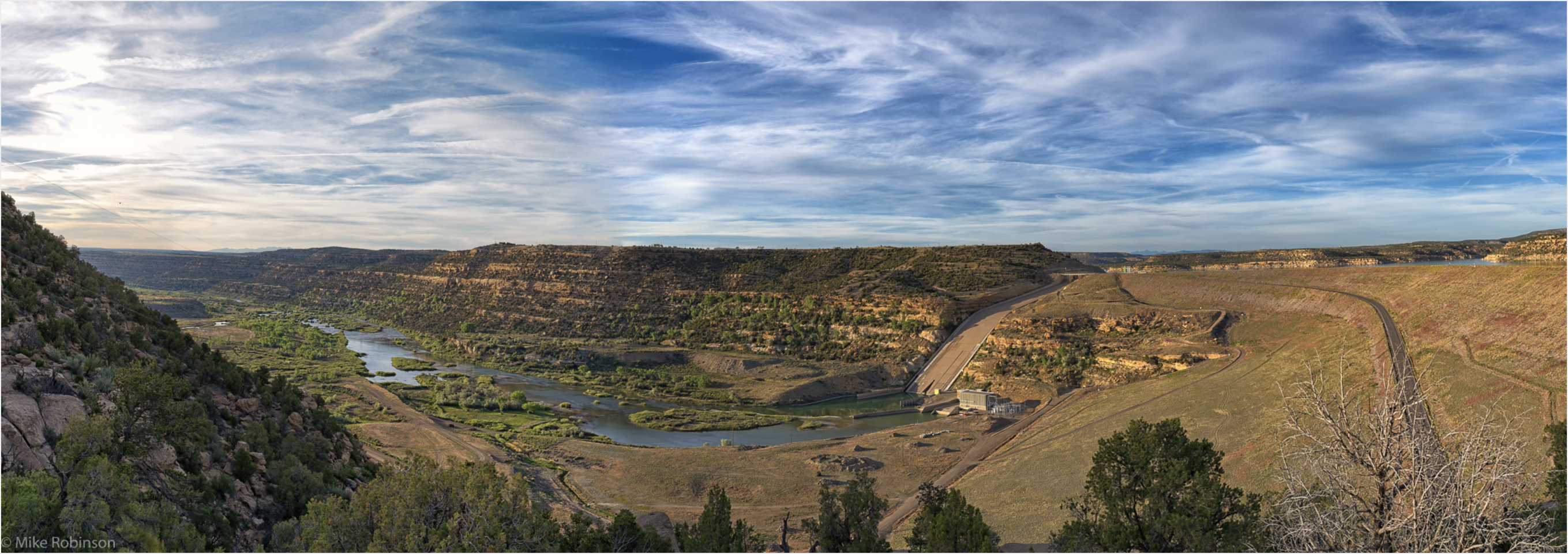
The Navajo Dam on the San Juan River.Photo credit Mike Robinson via the University of Washington.
From email from Reclamation (Susan Novak Behery):
The next coordination meeting for the operation of the Navajo Unit will be virtual, and is scheduled for Tuesday, August 24th, at 1:00 pm. At the meeting time, click here to join the meeting.
This meeting is open to the public and will be held virtually via Microsoft Teams video. The meeting should open in any smartphone, tablet, or computer browser, and does not require a Microsoft account. If you are away from a computer, you can also call-in at (202) 640-1187 (Phone Conference ID: 460 056 201#).
A copy of the presentation and meeting summary will be distributed to this email list and posted to our website following the meeting. If you are unable to connect to the meeting, feel free to contact me (information below) following the meeting for any comments or to ask questions.
The meeting agenda will include a review of operations and hydrology since April, current streamflow and hydrologic conditions, a discussion of hydrologic forecasts and planned operations for remainder of this water year and next water year, planned drought operations, updates on maintenance activities, and the Recovery Program on the San Juan River.
If you have any suggestions for the agenda or have questions about the meeting, please call Susan Behery at 970-385-6560, or email sbehery@usbr.gov. Visit the Navajo Dam website at https://www.usbr.gov/uc/water/crsp/cs/nvd.html for operational updates.
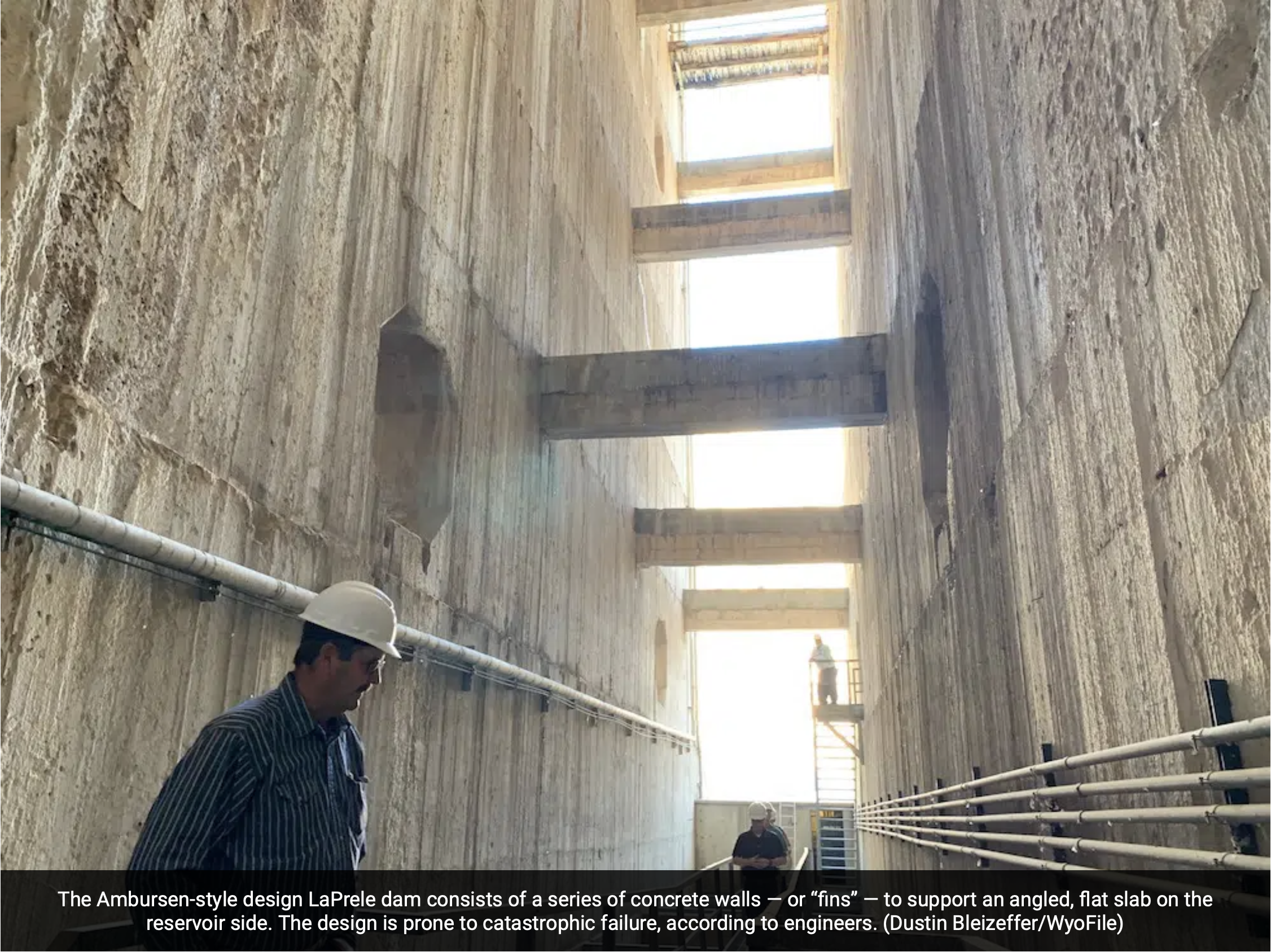
A pair of engineering firms contracted by the state warn that cracks in the 112-year-old concrete LaPrele dam, along with deterioration in its geologic foundation, could result in catastrophic failure.
Such an event would threaten people and infrastructure downstream, including the town of Douglas, and likely destroy the Ayres Natural Bridge Park directly below the dam, as well as two Interstate 25 bridges, the Wyoming Water Development office said during a tour last week.
“This is more than an irrigation district matter,” Water Development Office Director Brandon Gebhart said. “It’s a hazard.”
Rehabilitating the dam might be impossible, according to Gebhart. Instead, the office and its governing citizen commission is considering building a new dam directly below the existing structure. The commission will consider seeking funds to develop a complete engineering study for a project that could exceed $50 million.
Such an effort may qualify, in part, under several provisions in the $1 trillion infrastructure bill passed by the U.S. Senate this month, buttressing a Wyoming policy ambition to impound more water for use before it leaves the headwaters state, according to state officials. Meantime, the state is examining multiple other funding sources due to the potential for loss of life and property if the dam were to fail.
The matter is urgent, officials say.
“It’s not a slow failure with this dam design,” Gebhart said. “It would be very abrupt.”
The water office organized a public tour of the dam Aug. 12 to better inform the public of the risks and potential solutions under consideration.
A rumble and a warning
When a magnitude 3.7 earthquake rumbled the towns of Glenrock and Casper on the night of Aug. 1, personnel at the nearby Ayres Natural Bridge Park said it felt like a sonic boom. They sprang into action, caretaker Dee McDonald said.
Dee and her husband Doug McDonald have served as caretakers for six years.
The natural arch was still intact. But their minds were on a more pressing danger still looming: water. So they evacuated the handful of campers in the park that night.
“Anybody with any sense would do that,” McDonald said.
The park is situated in a small geologic bowl filled with old boxelder and tall cottonwood trees, along with manicured grass and picnic areas surrounded by high sandstone cliffs carved out over millennia by LaPrele Creek. The creek runs directly under the natural bridge. The rare high-plains oasis was a retreat for European settlers traveling the Oregon Trail. Today it remains a popular leisure destination for locals and travelers alike.
Visitors from around the world packed into the park on Aug. 21, 2017 to experience the totality of the solar eclipse that swept across central Wyoming.
Less than two miles upstream, however, is a not-so-natural wonder: the LaPrele dam. Completed in 1909, the concrete structure today presents a danger to an area far beyond the Ayres Natural Bridge Park, state officials and engineering teams say.
Aging, patchwork infrastructure
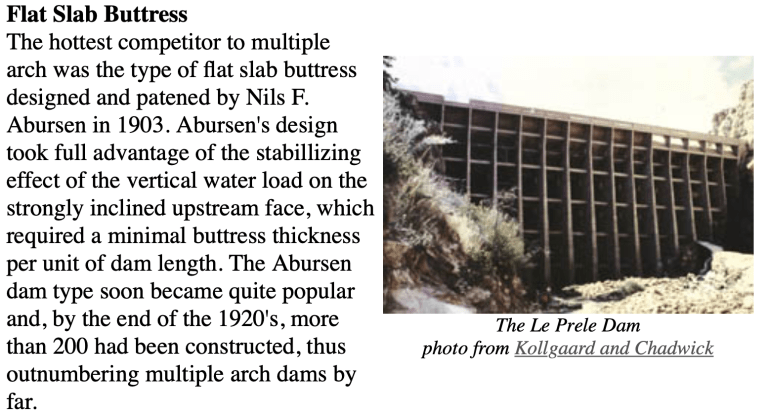
The Ambursen-style-designed LaPrele dam consists of a series of concrete buttresses supporting an angled, flat slab on the reservoir side. It is 130 feet high and 325 feet wide, and serves late-season water to about 100 irrigators via 94 miles of irrigation infrastructure, according to the state. The dam is anchored into a fractured Madison limestone formation on both sides.
Construction was funded via the federal Carey Act of 1894, a measure pushed by Wyoming U.S. Sens. Francis E. Warren and Joseph M. Carey to help arid western states develop more water for irrigation.
In the 1970s, the LaPrele dam was determined to have reached the end of its useful life. But dozens of irrigators downstream still depended on late-season releases from the reservoir to help them eke out a living on the plains along the North Platte. Neither the state nor federal government were eager to pay for refurbishing the dam, so the Panhandle Eastern Pipeline Co. agreed to fund the repair effort in return for a share of water for a coal-gasification project.
Crews grouted cracks and added new layers of concrete to the dam. Panhandle Eastern Pipeline Co., along with the lead engineering company that oversaw the project, received the “Outstanding Civil Engineering Achievement of 1979” award from the American Society of Civil Engineers.
Panhandle Eastern’s coal gasification project never came to fruition. Grateful for the investment and newfound confidence in the dam, however, members of the LaPrele Irrigation District went about their business of relying on the patched up dam for late-season water.
Then, in 2016, a boulder in the west limestone wall behind the dam fell. The event was listed as a mere notation in records reviewed a couple years later by a team commissioned to assess water and water infrastructure along the North Platte.
Discovered by accident
When the team of engineers examined the rockfall behind the LaPrele dam, it alarmed them.
Peter Rausch of the engineering firm RESPEC said that during the initial inspection it appeared that if another large boulder in the same strata were to fall it might roll into one or more of the dam’s concrete fins. Then, looking at the potential targets, they noticed what looked like a large, unrepaired crack in one of the boulder-zone concrete structures.
RESPEC called another firm, HDR, which specializes in dams, to assess the structure itself. Apart from the potential of damage via rockfall, developing cracks in the dam pose a risk of catastrophic failure, according to the company.
In November 2019, the Wyoming Water Development Office ordered the LaPrele Reservoir be maintained at a lower level to avoid stress on the dam. Consequently, the LaPrele Irrigation District receives about 55% of its normal appropriation of water, according to the state.
That’s concerning enough for eastern plains irrigators facing a warming, drier Wyoming where late-season irrigation is becoming increasingly vital in the face of a global climate crisis. But the risk of a dam failure, and the catastrophes that might result, add to anxieties — even if it might move a new dam construction project higher up the list of infrastructure priorities.
“This is a classic example of aging infrastructure,” Gebhart said. “We were lucky to find this — it was happenstance that we found the deficiencies in this.
“I think there’s probably a lot of infrastructure in the state, not just irrigation but also municipal, that is maybe at or near the end of its useful life,” Gebhart said. “Some of it may not even be known. It’s an example of a significant problem I see in the state.”
WyoFile is an independent nonprofit news organization focused on Wyoming people, places and policy.
Le Prele Dam a slab buttress design. Credit: Cornell.edu
The U.S. government announced its first-ever water shortage declaration for the Colorado River on Aug. 16, 2021, triggering future cuts in the amount of water states will be allowed to draw from the river. The Tier 1 shortage declaration followed the U.S. Bureau of Reclamation’s forecast that the water in Lake Mead – the largest reservoir in the U.S., located on the Arizona-Nevada border – will drop below an elevation of 1,075 feet above sea level, leaving less than 40% of its capacity, by the end of 2021.
The declaration means that in January 2022 the agency will reduce water deliveries to the Lower Colorado River Basin states of Arizona and Nevada and to Mexico, but not to California – yet.
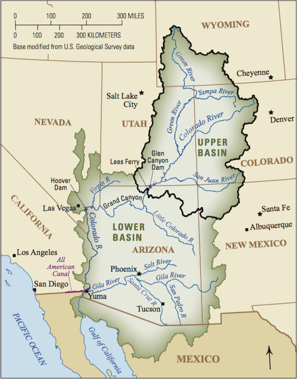
The Colorado River Basin drains seven western states. The Lower Basin is more heavily developed than the Upper Basin and consumes more water. USGS
Arizona will lose the most water: 512,000 acre-feet, nearly a fifth of its total Colorado River allocation of 2.8 million acre-feet. Nevada will lose 21,000 and Mexico 80,000. An acre-foot is enough water to cover an acre of land, which is roughly the area of a football field, to a depth of one foot – about 326,000 gallons.
Central Arizona farmers are the big losers in this first round of cuts. The cities are protected because they enjoy the highest priority in Arizona for water delivered through the Central Arizona Project, a 330-mile canal from the Colorado River. From my experience analyzing Western water policy, I expect that this declaration won’t halt growth in the affected states – but growth can no longer be uncontrolled. Increasing water supply is no longer a viable option, so states must turn to reducing demand.
Conservation remains the low-hanging fruit. Water reuse – treating wastewater and using it again, including for drinking – is also viable. A third option is using pricing and trading to encourage the reallocation of water from lower-value to higher-value uses.
Interstate collaboration
The Colorado River Basin states have formally negotiated who can use how much water from the Colorado River since they first inked the Colorado River Compact in 1922. In 2007 they negotiated interim shortage guidelines that specified how much each state would reduce its use depending on the elevation of Lake Mead. A series of subsequent agreements included Mexico, increased the scale of reductions and authorized the secretary of the Interior, ultimately, to impose truly draconian cuts.
California does not take a cut until the level in Lake Mead drops even lower. But that could happen as soon as 2023. The water level is dropping partly because of the Western drought but also because of the shape of Lake Mead, which was created by damming Boulder Canyon in 1936.
Like most Western river canyons, Boulder Canyon is wide at the rim and narrow at its base, like a martini glass. As its water elevation drops, each remaining foot in the lake holds less water.
Lake Mead, the largest U.S. reservoir, has lost 5 trillion gallons of water in the past 20 years.
Lake Mead feeds Hoover Dam, one of the largest hydroelectric generating facilities in the country. The plant produces electricity by moving water through turbines. When Lake Mead is high, Hoover Dam’s generating capacity is more than 2,000 megawatts, which produces enough electricity to supply some 450,000 average households in Nevada, Arizona and California.
But the plant has lost 25% of its capacity as Lake Mead has dropped. If the water level declines below about 950 feet, the dam won’t be able to generate power.
Sending water south
The Upper Basin states – Colorado, Wyoming, Utah and New Mexico – will also suffer.
That’s because the Colorado River Compact obligates the Bureau of Reclamation to release an annual average of 8.23 million acre-feet from Lake Powell, the nation’s second-largest reservoir, which extends from southern Utah into northern Arizona.
The Bureau of Reclamation predicted in mid-July that runoff into Lake Powell for 2021 will total just 3.23 million acre-feet, or 30% of average. To make up for this shortfall, the bureau will release more water from three Upper Basin reservoirs: Flaming Gorge in Utah, Blue Mesa in Colorado and Navajo on the Colorado-New Mexico border.
The ultimate problem facing the Colorado River Basin states is simple. There are more water rights on paper than there is water in the river. And that’s before considering the impact of climate change and evaporation loss from Lakes Mead and Powell.
The urgency of the Tier 1 shortage declaration has generated wild-eyed proposals to import water from far-flung places. In May 2021, the Arizona legislature passed a bipartisan resolution calling on Congress to study a pipeline from the Mississippi River that would augment the Colorado River. Space does not permit me to elaborate all the obstacles to this idea, but here’s a big one: the Rocky Mountains.
Similarly, the city of St. George in southwest Utah has proposed building a 140-mile pipeline from Lake Powell to augment its supply. St. George has some of the highest water consumption and lowest water prices in the country.
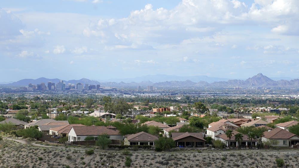
According to data released on Aug. 12, 2021, from the 2020 Census, Phoenix was the fastest-growing large city in the U.S. AP Photo/Ross D. Franklin
The gospel of growth still motivates some cities. Buckeye, Arizona, on the west side of Phoenix, has a planning area of 642 square miles, which is larger than Phoenix. The city has approved 27 housing developments that officials project will increase its population by 800,000 people by 2040. Yet its water supply depends on unsustainable groundwater pumping.
Other communities have faced reality. In early 2021 Oakley, Utah, east of Salt Lake City, imposed a construction moratorium on new homes, sending shivers up the spines of developers across the West.
Enabling farmers to be more efficient
The Tier 1 declaration gives states and local communities reason to remove barriers to transferring water. Market forces are playing an increasingly critical role in water management in the West. Many new demands for water are coming from voluntary transfers between willing sellers and desperate buyers.
Water markets threaten rural communities because farmers cannot hope to compete with cities in a free market for water. Nor should they have to. Water remains a public resource. I believe the states need a process to ensure that transfers are consistent with the public interest – one that protects the long-term viability of rural communities.
As the West enters an era of water reallocation, most of the water will come from farmers, who consume more than 70% of the region’s water. Cities, developers and industry need only a tiny fraction of that amount for the indefinite future.
What if municipal and industrial interests created a fund to help farmers install more efficient irrigation systems instead of simply flooding fields, a low-tech approach that wastes a lot of water? If farmers could reduce their water consumption by 5%, that water would be available to cities and businesses. Farmers would continue to grow as much food as before, thus protecting the stability of rural communities. This could be a win-win solution to the West’s water crisis.
More than 50 people ranging from legislative aides to state department heads participated in an on-the-ground opportunity to learn about the extreme drought in Northwest Colorado during this week’s Drought Impacts Tour in the Yampa and White River Basins.
On two warm, hazy days, state and local leaders conversed during bumpy bus rides and educational stops at ranches, lakes and the Yampa River in Routt and Moffat counties. During the tour, participants and educators discussed many aspects of drought impacts such as agricultural livelihood, recreation, tourism, wildlife, water, wildfires and forest management.
“I have been learning way more than I ever expected on this drought tour. Hearing directly from ranchers and the things that they are experiencing is truly eye-opening and wonderful,” said Becky Bolinger, Ph.D., assistant state climatologist who works at the Colorado State University Colorado Climate Center. “We do know that the climate is warming, and with that warming climate, we are experiencing more frequent droughts, more severe droughts. These are things that all Coloradans are going to have to deal with.”
Bolinger said a key point people need to realize is how to make the connection between climate science information and residents’ own changes in work practices, especially in agricultural and tourism businesses. Bolinger said the facts of the shifting climate need to translate into changes in business practices and seasonal offerings in order to prepare for a warmer, drier future in Colorado.
“Knowing that they are already prepared by improving their management practices and other things to mitigate the impacts but also to adapt, hopefully it’s not always going to be this doom and gloom situation when we are talking about climate change,” Bolinger said.
The atmospheric scientist said Coloradans should focus on “always working on actionable solutions and getting through this together.”
The tour was organized by the Colorado Drought Task Force, which includes directors of multiple state departments such as natural resources and agriculture. The task force operated in past times of drought and was activated again by the governor in 2020. Task force information listed online (http://cwcb.colorado.gov/drought) notes that water year 2020 concluded as the 12th warmest water year on record in Colorado since 1895 and the third driest water year on record, trailing only 2002 (driest) and 2018 (second driest)…
Gov. Jared Polis joined for part of the tour on Wednesday in Moffat County including a picnic at Loudy-Simpson Park south of Craig…
One message from the tour is that drought-related financial assistance and grant opportunities are broad and plentiful at this time. Leonard encouraged agencies, nonprofits and agricultural producers to review funding options found at http://cwcb.colorado.gov/drought-assistance.
For example, the Colorado Department of Agriculture is promoting new stimulus funding available as of July 1, including $2.5 million to expand market opportunities for funding for Colorado Proud producers, $5 million to expand agricultural efficiency and soil health initiatives, $30 million for agricultural revolving loan and grant programs including for individual farmers and ranchers, and more than $1.8 million for agriculture drought resiliency activities that promote the state’s ability to anticipate, prepare for, mitigate, adapt to or respond to drought.
The CWCB Agricultural Emergency Drought Response Program has a $1 million fund available on a rolling basis that provides immediate aid for emergency augmentation water during drought years in the form of loans or grants.
Residents who would like to share drought-related impact stories with state leaders can contribute to Colorado Drought Stories via the interactive website http://engagecwcb.org/agricultural-task-force.
Ralph Parshall squats next to the flume he designed at the Bellevue Hydrology Lab using water from the Cache la Poudre River. 1946. Photo Credit: Water Resource Archive, Colorado State University, via Legacy Water News.
From email from DWR (Chris Arend):
The Division of Water Resources is holding a webinar on a number of West Slope water issues and water issues of concern to all Coloradans, including upcoming measurement rules and consideration of establishing the Yampa River Basin in certain select areas as over-appropriated.
The webinar will discuss the phases and timing of measurement rulemaking and how the public and interested parties can provide comments or participate in upcoming stakeholder events. Also to be discussed are explanations of short-term and medium-term activities and plans to prepare for potential rulemaking for Compact Administration Rules. Time will be left towards the end of the webinar for questions and answers from participants.
WHO: State Engineer, Kevin Rein and Deputy State Engineer, Mike Sullivan, Colorado Division of Water Resources
WHAT: Webinar on Upcoming West Slope Measurement Rules and other water issues WHEN: Thursday, August 19, 2021, 6 PM to 7 PM
A working group submitted a report on Friday that includes several “concepts” that it says the Colorado Water Resources Review Committee should consider when exploring how to bolster the state’s anti-speculation law.
The 22-member group, which includes members from the legal, nonprofit, municipal, and agricultural sectors, convened due to the passage of Senate Bill 20-048. The group submitted a total of 19 “concepts” organized into five categories that the committee will consider when making future regulations.
Some of the recommendations include modifying current legal proceedings to give water courts a more active role in anti-speculation cases, encouraging local governments and state police to invest in water speculation, and establishing a maximum water rate increase with corresponding tax penalties for those who overcharge.
In its final report, the working group said it does not recommend any of the concepts for implementation due in part to the drawbacks members identified during their sessions and a lack of consensus among the group.
Instead, it recommended that lawmakers “gather additional feedback from multiple and diverse stakeholders within Colorado for any change in law considered.”
Water speculation – defined as obtaining a water right without a plan to put the water to beneficial use – is a foundational issue for the state of Colorado.
The state’s constitution expressly provides that water is “declared to be the property of the public, and the same is dedicated to the use of the people of the state.” This means that no one in the state can horde water without a legitimate need.
The approach has become known colloquially as the “Colorado Doctrine” in the water court system, according to the working group’s report.
Anti-speculation laws are also gaining more public attention as drought conditions are causing issues for some Colorado ranchers.
Gov. Jared Polis recently visited with the local agricultural communities in Craig and Steamboat Springs and declared that the recent “historic” water plan won’t be enough to help ease the conditions. The plan will spend $50 million to increase conservation and address the gap between supply and demand.
“This is an important part of who we were, who we are and who we will be now in the future,” Polis told the Craig Daily Press.


