From the Walton Family Foundation (Peter Skidmore):
From May to October, a surge of water is replenishing the Colorado River Delta
Seven years ago, the Colorado River Delta found its pulse when 105,000 acre-feet of water was released into Mexico from the Morelos Dam, filling dry channels and reviving wetland habitat. For the first time in decades, the Colorado flowed from source to sea.
The 2014 “pulse flow” recharged a portion of the West’s most important river that has been dying of thirst since the middle of the last century. It also reignited the memory and imagination of Mexican residents of the Delta, who celebrated the return of water and began to understand the river’s potential to support nature and people in the region.
For scientists, conservationists and governments, the pulse flow was a learning event. We learned that communities were enthusiastic about restoring the Delta and ready to seize the opportunity created by conservation projects in areas once dry and desolate.
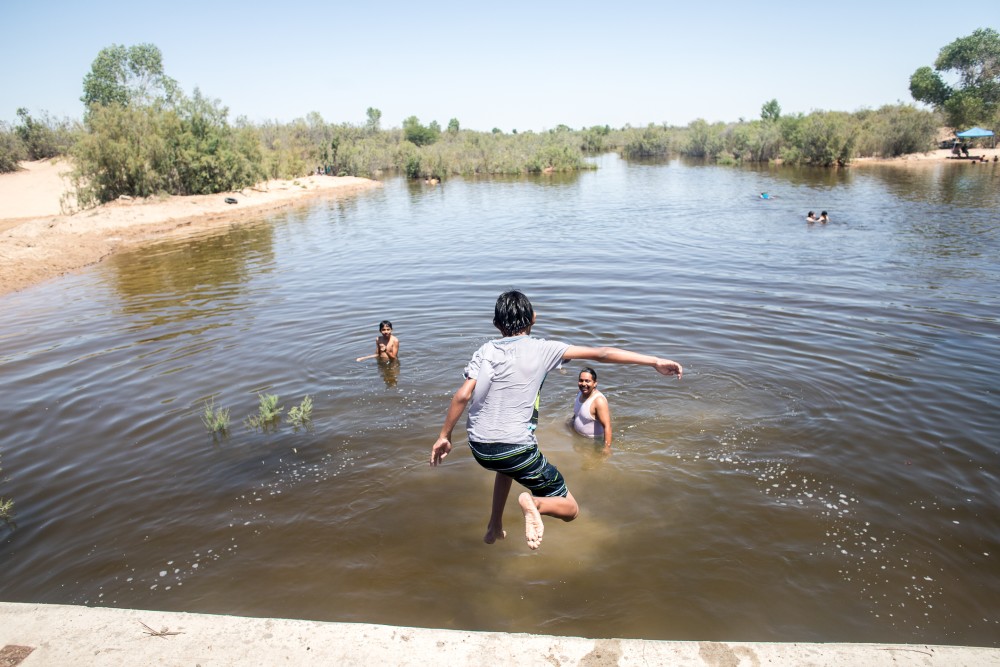
A flowing river benefits the environment and local communities. The Vado Carranza site has been popular with kids of all ages to cool off on hot summer days. Photo Credit: Jesús Salazar/Raise the River via the Walton Family Foundation
We also learned it was possible to provide greater environmental benefit to the river with smaller flows over multiple years. To build on the 2014 pulse flow’s success, the U.S. and Mexican governments in 2017 reached an agreement – called Minute 323 – that provides at least 210,000 acre-feet of water over nine years for ongoing riparian restoration and recreation in the Delta.
Fast forward to this summer – and the Colorado River is again flowing in the region.
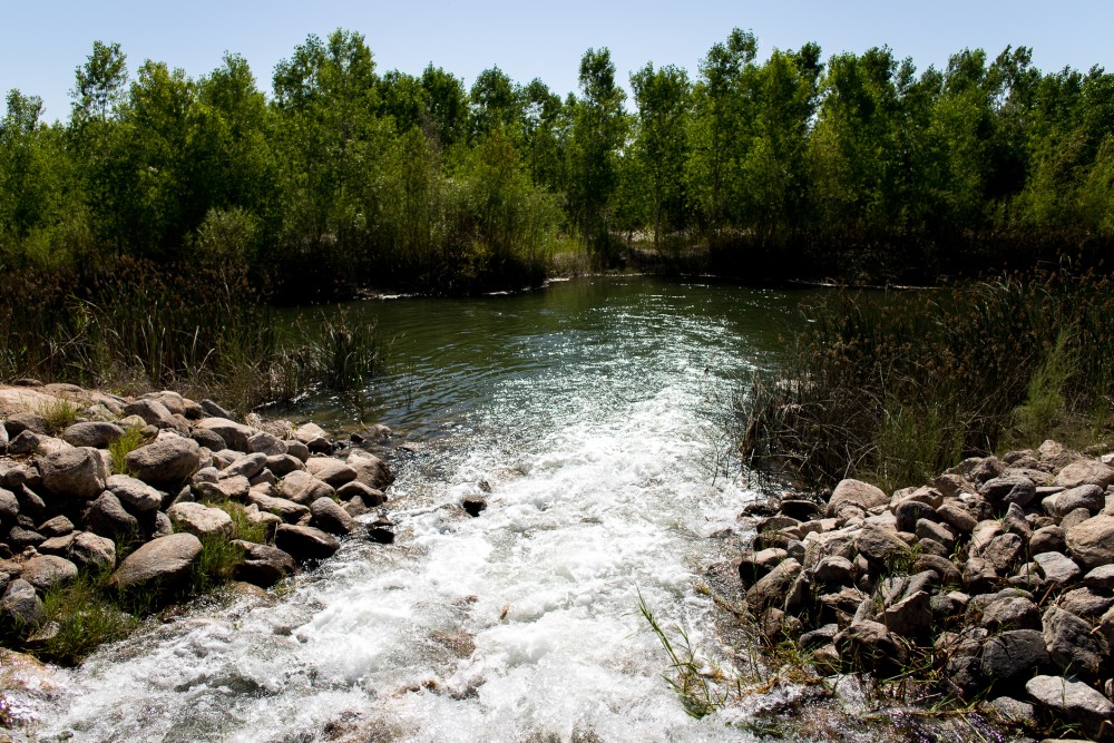
The first water from the 2021 “pulse flow” is delivered at the Chausse restoration site in the Colorado River Delta. Photo Credit: Jesús Salazar/Raise the River via the Walton Family Foundation
For 126 days, from May to October, more than 35,000 acre-feet of water – about 11 billion gallons – is being released into the Delta, supporting local economies and improving riparian and wetland habitat for wildlife.
The timing and rate of flow for this year’s release were designed by a team of scientists to maximize environmental and recreational benefits.
The current flow coincides with seed dispersal from cottonwood trees – mimicking how floods and seeds have coordinated for millennia – and to maximize recreation during the hottest part of the summer.
While only one-third as big as the 2014 pulse flow – and a fraction of the river’s historic flows – even this smaller amount of water is making a big difference in the health of the delta region.
Throughout the Colorado River Delta, the coordinated release of water is bringing life back to this region. Photo Credit: Jesús Salazar/Raise the River via the Walton Family Foundation
Instead of releasing the water directly into the river at the border, water managers have bypassed the Morelos Dam via canals and released the water about 45 miles downstream. By doing this, more water is delivered to restoration and recreation areas and avoids being absorbed into the driest parts of the river channel.
The flows are delivered to existing restoration sites where they flush salts from soils, replenish local groundwater and provide seasonal habitat for migratory and resident waterfowl. Diverse wildlife – from beavers to panthers – are also returning to the river.
Because the flows are delivered to the central Delta through canals, they are also benefitting local farmers. The extra water in the canals helps water reach farms further down the Delta and reduce salinity, which improves agricultural productivity.
The release of water was carefully planned at strategic points near restoration sites to maximize impact. Photo Credit: Jesús Salazar/Raise the River via the Walton Family Foundation
This year’s flow is proving the value of collaboration that made the 2017 binational water-sharing agreement possible. The deal included a unique three-party arrangement among the U.S. government, the Mexican government and Raise the River, a coalition of six nonprofits committed to conservation in the Delta. While this flow is delivered by the U.S. to meet its obligations under the agreement, our partner organizations in Raise the River are providing additional flow to all of the restoration sites and to the lower river channel every year.
Coming in the midst of the worst drought year on record, as the West is experiencing shortages in available water, this year’s Delta flow is a testament to the strength of Minute 323 and commitment of its partners to community and environment.
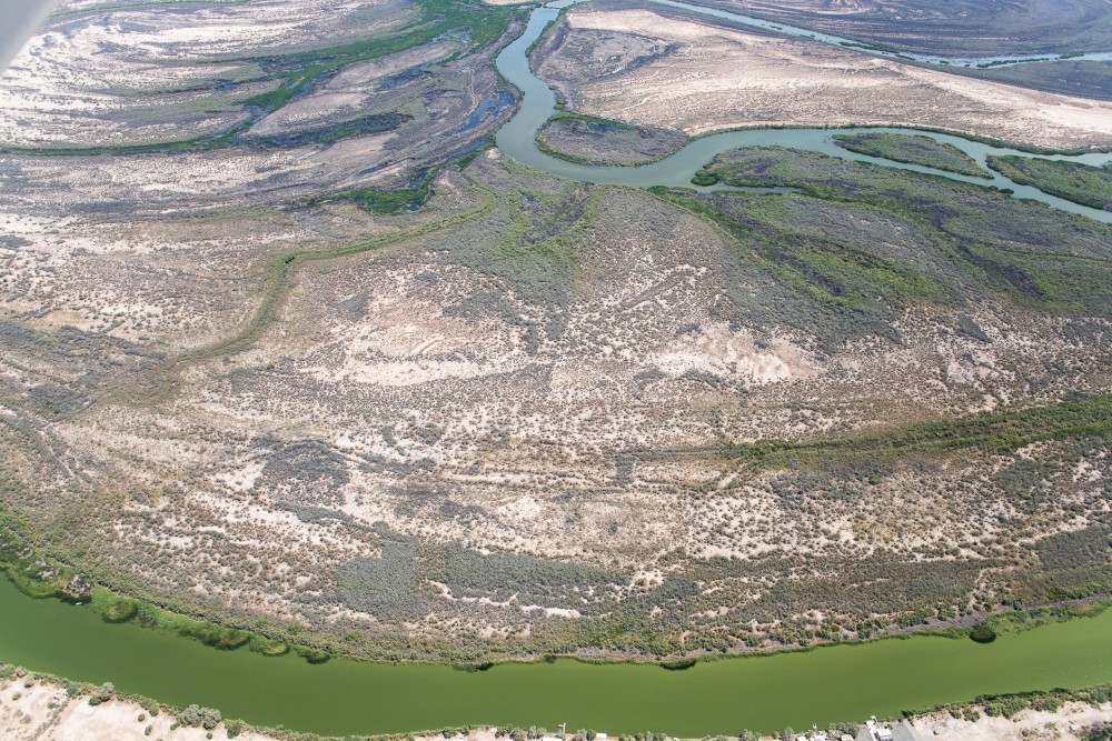
By mid-June, the released water reached the sea in the estuary region of the Colorado River Delta. Photo Credit: Jesús Salazar/Raise the River/Lighthawk via the Walton Family Foundation
The agreement has become a global model for binational river management, showing how we can invest in water projects that conserve and share water between countries and dedicate environmental water at the same time.
There is much more work to do for all of us who care about the Delta’s future.
Of all the ecosystems impacted by the harnessing of the Colorado in the 20th century, the Delta suffered most. The construction of the Hoover Dam in the 1930s, and then the Glen Canyon Dam from 1956 to 1966, sapped the Delta of its fresh water and sparked its decline.
Riparian forests of cottonwoods, willows and mesquite, as well as marsh and estuarine wetlands, that once thrived across about 2 million acres now cover just a small fraction of that area.
Workers measure federal flow deliveries in the canals that deliver water for irrigation and to restoration sites in the Colorado River Delta. Photo Credit: Jesús Salazar/Raise the River via the Walton Family Foundation
But based on a decade of testing and refining successful restoration practices, the potential of reconnecting the river to the sea is now in reach.
We see that in the success of this year’s flow.
As of late June, the river is reconnecting with the sea. During high tides, flows in the river channel are meeting the Delta estuary in the Sea of Cortez, mixing fresh water with salt water to sustain estuarine marshes.
As summer builds toward fall, we’re hopeful that this year’s flows will continue to reach the sea, reconnecting the river once again as it did in 2014 – and hopefully as it will do again in the future.
Without a doubt, one of the largest threats to American infrastructure is climate change.
This was illustrated yet again as upwards of 10 landslides ravaged sections of Colorado’s Interstate 70 corridor, closing the Glenwood Canyon portion of the highway indefinitely. This came after weeks of intermittent slides that have exhausted personnel and had a chilling effect on local economies.
Yet despite the impacts, few have sought to elaborate on the relationship between extreme debris flows and the burning of fossil fuels.
This is a grave oversight.
Dismissing the role of climate change in infrastructure resiliency fails to appreciate the inherent relationship between infrastructure and environment. As global temperatures rise, so, too, will the number of extreme events. This places existing structures and byways in new dangers, ranging from some damage to full destruction.
GET THE MORNING HEADLINES DELIVERED TO YOUR INBOX
In the case of mudslides, as wildfires burn bigger and hotter due to rising temperatures and severe drought, ground vegetation of the forest floor is burned off at alarming rates. This creates a layer of dusty ash over bare, scorched soil, resulting in a decreased ability of the soil to absorb water.
While healthy forest floors can hold several inches of water per hour, high or moderately burned areas might only hold one-third of an inch. This results in top layers that can be easily washed away, at least until enough ground vegetation is reestablished — roughly the first year or two post-burn. Meanwhile, even small amounts of rainfall can result in dangerous runoffs, posing great risks to structures and byways located in slide paths. Combined with more intense rainfall — also due to climate change — landslides may occur more frequently and over larger areas with greater force and debris.
This dynamic is consistent with recent events on I-70. Based on post-fire assessments conducted by the Burned Area Emergency Response team, the Grizzly Creek Fire — which was fueled by especially hot and dry conditions last year — burned areas surrounding the canyon. Soil testing revealed that 55% of this area had incurred moderate to high soil burns, leaving the region with unusually high risks of extreme runoffs. Only 12% of the 32,370 acres were estimated to be unburned.
Certainly, mudslides are possible in any canyon so steep — and it’s happened before. However, the size and severity of this particular burn created enhanced risks for severe infrastructure damage. Accordingly, at the recommendation of BAER, mitigation efforts were made.
Shortly after the fire, one large, natural berm was created to protect the most critical infrastructure in the canyon — a mostly hidden command center in the heart of Glenwood Canyon that serves to monitor the interstate. As predicted, less than a year later, some 100,000 cubic yards of debris was diverted with that very berm. John Lorme, the Colorado Department of Transportation director of maintenance and operations, hailed the effort as saving the state millions of dollars and extensive closed highway time — a testament to the role of climate research in protecting infrastructure.
There are, however, limits to our current preventative measures — as evidenced by the current debris damage. During a 47-minute press conference with CDOT, Region 3 director Mike Goolsby acknowledged the lack of radar technology and understanding in predicting slides with enough time to close or protect the highway.
According to the U.S. Geological Survey — the only science agency to exist within the U.S. Department of Interior — much additional research funding and efforts regarding landslides are needed as climate change intensifies. Especially relevant are the needs to better understand debris flow mechanisms, forecasting and mitigation strategies, all efforts that would help safeguard core infrastructure.
One Colorado-based hydrologic engineer, Kelsey McDonough, agrees, adding that some in the private sector may also have access to better, more localized technology. “This could be really useful in a state like Colorado where local knowledge can be utilized to build better regional monitoring and modeling systems than are currently available at the national scale,” she says.
Certainly, Colorado has a number of cutting-edge national laboratories and private companies that may be inclined to help find solutions with the right incentives. Securing these funds is just one of many roles local representatives can play in helping the state navigate the new challenges.
Still, perhaps the most important thing we must do is disentangle the notion that discussions of human-driven climate change during extreme events are signals of political interference. They are not. Climate change is well established in scientific literature, as is its impact to structural integrity. Addressing the role of reducing fossil fuels in related press conferences and articles is therefore necessary to serve the long-term goal of infrastructure stability.
SUPPORT NEWS YOU TRUST.
Colorado Newsline is part of States Newsroom, a network of news bureaus supported by grants and a coalition of donors as a 501c(3) public charity. Colorado Newsline maintains editorial independence. Contact Editor Quentin Young for questions: info@coloradonewsline.com. Follow Colorado Newsline on Facebook and Twitter.
The San Juan Water Conservancy District (SJWCD) board met on Monday, Aug.16, to hear a report, among other business, from the board’s attorney, Jeff Kane, on the Bureau of Land Management’s (BLM) intent to file two applications for water rights.
According to agenda information posted on the SJWCD website, the two water rights applications are for transmountain diversions to the Rio Grande River basin from a tributary of Wolfe Creek. (Note: This spelling of Wolfe Creek is what is found in the BLM’s original application for water rights.) This is a tributary to the West Fork of the San Juan River.
These two applications could mean the diversion of up to 20 cubic feet per second (cfs) of water.
The BLM stated in its applications that the diversion of the water would be to support wildlife management and wetlands habitat at the BLM’s Blanca Wetlands Area and South San Luis Lakes Area.
According to the memorandum presented to the board by Kane, this means that any authorization of this type of diversion causes 100 percent depletion to the originating stream basin. The water that would be diverted under this water rights application would then not be available to support any uses or habitats in the San Juan River or its
tributaries.
The BLM is requesting a change in the places and types of use of the already existing 7 cfs of the Treasure Pass Ditch water right. This water right was purchased in 2019. This current agreement calls for a 1922 priority for the irrigation of 80 acres. The new water rights application by the BLM asks for 13 cfs for the Treasure Pass Ditch and for the right to authorize the BLM to store and deliver water from the Treasure Pass Ditch through several reservoirs in the Rio Grande Basin for support use to the wetlands in the San Luis Valley.
The BLM is also seeking flexibility in approval so it can use the water it wants to divert from the Treasure Pass Ditch in the Rio Grande Basin in a variety of ways, according to Kane.
Kane’s report to the board states, “the applications do not limit the ultimate use of diverted water to support wetlands and wildlife.”
The BLM has the burden of proof when making a request for water rights changes. In a request for a change of water rights, the applicant must prove that the request will not cause an increase in use of requested water as compared in amount, time and place to what has been historically used, according to the memorandum presented by Kane.
A request for an exchange of water rights is when proof is required of the applicant that the request will not harm or impede other water rights and can be applied, Kane’s memorandum explains. A request for a new water right requires the applicant to provide proof that the water to be used will only be beneficial and that there is actually water available to be diverted.
As Kane presented his report on the BLM applications to the board, he noted that both the board and its constituents could be adversely affected in many ways.
The ability of the district to divert and store water under existing water rights or future appropriations considering the diverting water from the Treasure Pass Ditch would not only reduce flows in the San Juan River, but also reduce the water available for Dry Gulch Reservoir, he suggested.
The report also states that the habitat in the tributaries of the San Juan River may also be impacted. The BLM’s applications could also affect the district’s constituents’ efforts to divert and use water if the event a Colorado Compact call were to arise.
The Colorado Compact call is the need to reduce the increasing risk of a compact-driven curtailment which could result in cutting of water to users across the upper basin states of Colorado, New Mexico, Arizona, Utah and Wyoming, Kane reported to the SJWCD board.
Heron Lake, part of the San Juan-Chama Project, in northern New Mexico, looking east from the Rio Chama. In the far distance is Brazos Peak (left) and the Brazos Cliffs (right), while at the bottom is the north wall of the Rio Chama Gorge. By G. Thomas at English Wikipedia – Transferred from en.wikipedia to Commons., Public Domain, https://commons.wikimedia.org/w/index.php?curid=1598784
Kane also noted that the San Juan-Chama Project is currently diverting an average of 110,000 acre feet a year from the San Juan River to the Rio Grande Basin and the BLM is proposing to divert more water from the Wolfe Creek tribu- tary than at any time in history.
Kane recommended that the board file statements of opposition to the BLM’s applications.
Don Everly, half of one of rock’s earliest and most influential harmony groups, the Everly Brothers, died Saturday in his Nashville home at the age of 84. A rep for the singer confirmed his death to the Los Angeles Times. A cause of death was not immediately known.
“Don lived by what he felt in his heart,” Everly’s family said in a statement to the Times. “Don expressed his appreciation for the ability to live his dreams … with his soulmate and wife, Adela, and sharing the music that made him an Everly Brother.”
Starting with 1957’s “Bye Bye Love” and continuing for five more years, the Everlys ruled the pop and country charts with 15 Top 10 hits, including “Wake Up Little Susie,” “All I Have to Do Is Dream,” and “When Will I Be Loved.” Although many of their songs were written by outside writers, Don, the more prolific of the duo, penned three of their finest songs: the rollicking “Cathy’s Clown,” “(‘Til) I Kissed You” and the forlorn “So Sad (to Watch Good Love Go Bad).” In most cases, Don sang lead, with Phil’s wispier, more velvety harmonies wrapping around his brother’s.
The resulting blend, steeped in country music, Appalachia, and early rock & roll, impacted on nearly every harmony-based band that followed, including the Beatles, the Mamas and the Papas, the Hollies and Simon & Garfunkel. But the Everlys’ influenced never waned. The brothers were among the first acts inducted into the Rock & Roll Hall of Fame in 1986. In 2013, just a few months before Phil Everly’s death in January 2014 of chronic obstructive pulmonary disease, Billie Joe Armstrong and Norah Jones released a collection of Everly covers in honor of the brothers.
Born February 1st, 1937, in Kentucky, Isaac Donald Everly — known as Donald to family and friends — was steeped in music from the start. His father Ike was a coal miner who also happened to be a gifted guitarist. The family relocated to Chicago when Don was two; his brother Phillip was born in 1939. Their father played guitar in bars and later hosted a radio show in Iowa. “When he grows up, Donald, 8, wants to be an entertainer like his dad so they can form a vocal and musical team,” read a program at the Iowa radio station. Known as “Little Donnie,” Everly had his own segment on that show while he was in grade school; during an Everly family program, little brother Phil began joining in.