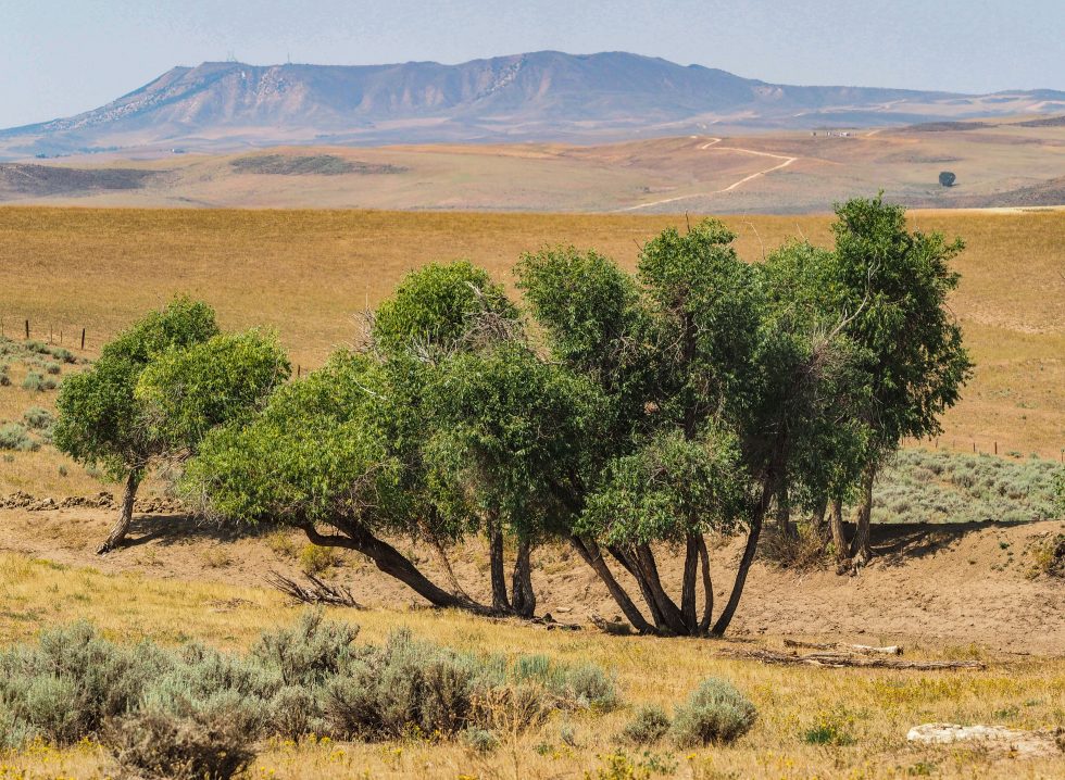
A stock pond that is normally full of water stands dry because of drought on the Little Bear Ranch near Steamboat Springs, Colo., on Aug. 11, 2021. Due to low snowpack, warming temperatures and dry soil during the past two years, followed by the same in 2021, Northwest Colorado is in a severe drought. Credit: Dean Krakel, special to Fresh Water News.
A low snowpack, absent monsoon rains, dry soils, record-high temperatures and thirsty crops made 2020 the third-driest year on record in Colorado, and, according to the Colorado Climate Center, it was the first time since 2012 that 100 percent of the state was in drought for some portion of the year.
A repeat of similar conditions in 2021 is making Colorado’s continuing drought across broad swaths of the state’s Western Slope even more devastating.
“At any given time you can find drought somewhere in our state,” said Assistant State Climatologist Becky Bolinger during a state Drought Task Force tour in Northern Colorado last week. “This may not be the worst drought we’ve ever had, but what makes this year particularly bad is that it follows on the tail of two other droughts [in 2019 and 2020]. We don’t have enough time [between droughts] to recover from the previous drought before we’re in the next one.”
Nowhere is that more clear than in the seven-state Colorado River Basin, where Monday the U.S. Bureau of Reclamation declared the drought situation so extreme that for the first time in history Arizona and Nevada will see their annual water supplies drawn from Lake Mead dramatically reduced.
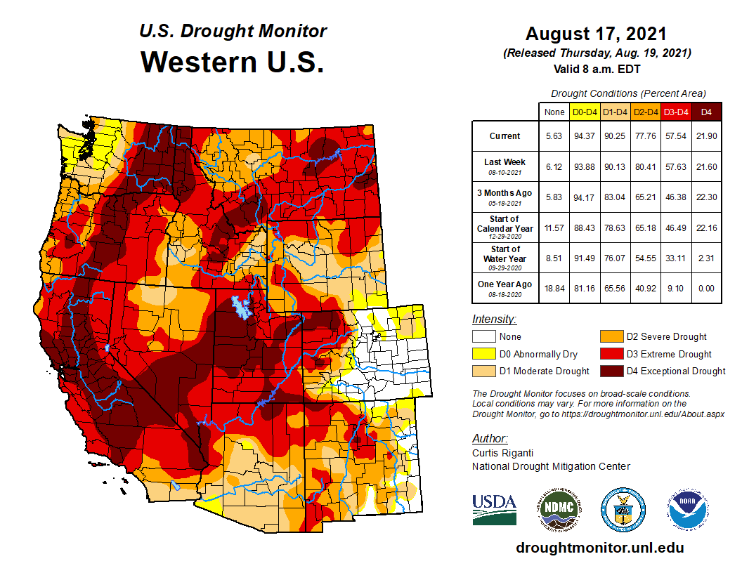
Closer to home in Colorado, west of the Continental Divide, the state has experienced 50 consecutive weeks of category D4 drought, the most extreme drought condition, according to the U.S. Drought Monitor.
Whether the fall and winter will bring any relief isn’t clear yet.
“I’m not particularly optimistic, unfortunately, about the coming winter,” said Peter Goble, a climatologist with the Colorado Climate Center in Ft. Collins. Goble said La Niña conditions will return for the fall and winter, bringing the potential for more moisture in the north and western parts of the state, but there is little indication that the Four Corners region will get any benefit. In addition, because 2022 is shaping up to be a second La Niña year, “events tend to be warmer and dryer,” he said.
Bolinger described the Colorado River Basin as being at a breaking point and the current drought affecting Colorado, Utah and Arizona as “the final straw that might break the camel’s back.” Lake Powell and Lake Mead, the downstream catchalls, have dropped to historic low levels. The lakes will never be 100 percent full again, said Bolinger, “unless we have 10 amazing winters in a row. The amount of water we have isn’t enough to meet expected demands so in the next 5-10 years we’re going to have to rethink how all of these states are supposed to equally share the water.”
Ranchers across Western Colorado are witnessing water shortages never seen before.
Cattle and sheep are being sold off early. There hasn’t been enough water to grow enough hay. Normally full stock ponds are dry. Grasses are dying. Weeds and grasshoppers are rampant.
“In 40 years this is the first time we’ve had to haul water to our cattle,” said Chad Green, owner of the Little Bear Ranch in the Yampa River Basin. “Usually our irrigation water runs until July 1. This year it was shut off on May 29. We harvested our wheat crop for hay. The past two years have been bad. But this year,” Green paused, “this year is horrible.”
But it’s not just farmers who are suffering. Those who rely on the state’s iconic rivers for recreation are also seeing the devastation this multi-year drought cycle has imposed.
“This river is critical to our community’s health,” said Kara Stoller, CEO of the Steamboat Springs Chamber. Like other mountain communities, Steamboat is home to an array of outdoor gear companies and tubing and rafting companies. And the ski resort relies on the river for snowmaking.
This summer the river has been closed to recreation on multiple occasions to relieve stress on the fish population.
“Our water resources are our lifeblood,” said Stoller.
Bolinger doesn’t feel the “doom and gloom on a state level” that she feels for the entire Colorado River Basin. “But when people talk about drought, they talk about the new normal. We haven’t gotten to the new normal yet. We’re on the climate change train and things are still changing. Where we land will ultimately dictate what things look like.”
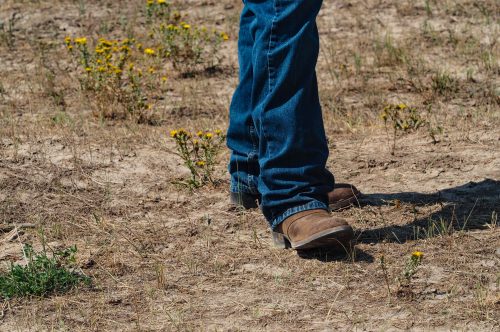
A rancher digs a boot heel into the dry ground of the Little Bear Ranch near Steamboat Springs, Colo., during the Northwest Colorado Drought Tour on August 11, 2021. Credit: Dean Krakel, special to Fresh Water News.
To Marsha Daughenbaugh, a 4th generation rancher near Steamboat Springs, the relentless dry spells are about much more than the condition of the local ranching economy.
“This is just one ranch, one county, one region, one state, but really, this is the story of the whole West,” Daughenbaugh said.
Dean Krakel is a photographer and writer based in Almont, Colo. He can be reached at dkrakel@gmail.com.
checking in from a twitter break…was looking at the rain that caused the awful flash flood in the Poudre Canyon on Tues. Nearly 2" in 2 hours at that elevation (9500+ ft) is really unusual, and happened in about the worst possible location with respect to the burn scar 1/ #cowxpic.twitter.com/lMIbeIJTNh
FromThe Fort Collins Coloradoan (Miles Blumhardt):
Two Larimer County floods in July caused $2 million in damages to roads and other infrastructure and prompted a report that concluded the risk to residents of Black Hollow from another flood is too great for them to stay overnight in their homes.
Lori Hodges, the county’s director of Emergency Management, said most of the damage to county roads and culverts has occurred in Buckhorn Canyon west of Fort Collins and the Retreat area just east of Glen Haven. About 6 miles of the newly rebuilt Buckhorn Road from the 2013 flood sustained damage.
Because of the ongoing risk of another flood in the Cameron Peak Fire burn scar, the county will take a wait-and-see approach to rebuilding the roads and replacing culverts, she said, which were damaged during July 20 and July 30 flash floods.
“We have a few more weeks to get through the monsoon season, and so we will have to figure out the best way to rebuild to better be able to withstand more flooding,” she said.
She said a Colorado Geologic Survey assessment of the Black Hollow neighborhood in the upper Poudre Canyon stated the danger from the instability of the area is so great that no one should spend the night.
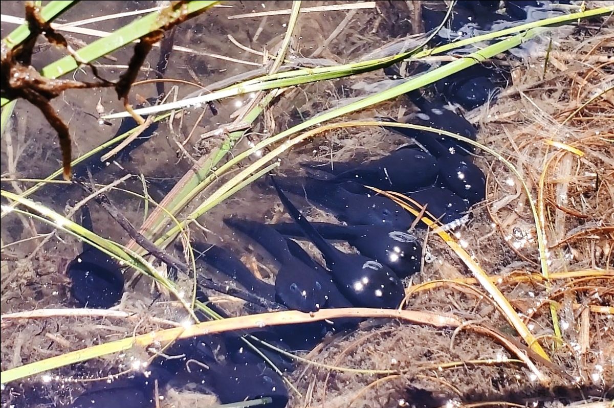
Squirming black boreal toad tadpoles feed on algae along the shore of Titan Lake above Leadville and just below the 13,209-foot summit of Homestake Peak. Colorado Parks and Wildlife biologists, staff and partner agencies hiked them to the high alpine lake in an effort to rescue the state-endangered toad. Photo courtesy of Colorado Parks and Wildlife/Bill Vogrin
Here’s the release from Colorado Parks & Wildlife (Bill Vogrin):
CPW and partners hike miles in heat to stock state-endangered boreal toad tadpoles
Under a blistering late July sun, a team of Colorado Parks and Wildlife native aquatic biologists, staff and volunteers hiked a steep mountain trail, each loaded with 30-pound bags of water filled with 100 or so squirming, black boreal toad tadpoles.
They were joined by other members of the Arkansas Basin Boreal Toad Team – an interagency workgroup created to coordinate conservation and management of the state-endangered Boreal toads within the Arkansas River basin in Colorado.
Besides CPW, the workgroup includes the Bureau of Land Management (BLM), the Colorado Natural Heritage Program (CNHP) and U.S. Forest Service (USFS).
In all, about 20 people hiked 7-plus miles, round trip, to deposit some 1,800 tadpoles into an alpine wetland along West Tennessee Creek at 11,500 feet elevation.
There, in the shallow waters of Titan Lake, they released their tadpoles, which immediately began swimming and feeding along its algae laden shores, beneath the jagged, snow-tipped summit of Homestake Peak at 13,209 feet.
The tadpole relocation project was done in consultation with the Colorado Boreal Toad Recovery Team. The interagency workgroup long ago identified the West Tennessee Creek drainage as a possible relocation site, given the quality of its wetlands and the potential for breeding and its history as a home to Boreal toads.
Similar parades of CPW biologists, staff and volunteers have recently taken place to high-altitude wetlands statewide as the agency pursues several avenues in its efforts to rescue the tiny brownish-black state-endangered toad.
Boreal toads once thrived in Colorado high country wetlands, but their numbers have been crashing due to a deadly “chytrid” skin fungus that is threatening amphibians worldwide.
The grueling hike was led by Paul Foutz, CPW native aquatic species biologist in the Southeast Region and Boreal Toad specialist. Partner teams were led by Jeni Windorski, wildlife biologist with the U.S. Forest Service in Leadville and Brad Lambert, a zoologist with the Colorado Natural Heritage Program at Colorado State University in Fort Collins.
The tadpoles were taken as eggs from the East Fork Homestake Creek boreal toad population in the Northwest Region, and grown (hatched & grown?) at the John Mumma Native Aquatic Restoration Facility hatchery in Alamosa, in the Southwest Region.
“With our partners, CPW is working hard to recover the state-endangered Boreal toad by creating new populations,” Foutz said. “The deadly chytrid fungus and other impacts to their natural habitat is causing this species to decline dramatically, and we’re doing everything we can to preserve them.
“We have just a few robust populations left on the landscape. They’ve been declining in recent decades. This is the first translocation in Lake County. We’re hoping the tadpoles we released today will survive and thrive, and in a few weeks metamorph into land-dwelling toadlets. We’ll continue to monitor this new population along with existing populations around the state in our effort to maintain boreal toads across the Colorado landscape for generations to come.”
Mature Boreal toad. Photo credit: Colorado Parks & Wildlife.
In an ongoing conservation project, CPW recently released 1,700 boreal toad toadlets in a wetland in the San Juan mountains. Photo credit: Colorado Parks & Wildlife
Biologists collect and record data at a field laboratory as they bathe 35 Boreal toads captured on South Cottonwood Creek, west of Buena Vista, on Sept. 6, 2018. Photo courtesy Colorado Parks and Wildlife.
A submerged Boreal toad. Photo courtesy Colorado Parks and Wildlife / Melissa Butynski
Boreal toad
Squirming black boreal toad tadpoles feed on algae along the shore of Titan Lake above Leadville and just below the 13,209-foot summit of Homestake Peak. Colorado Parks and Wildlife biologists, staff and partner agencies hiked them to the high alpine lake in an effort to rescue the state-endangered toad. Photo courtesy of Colorado Parks and Wildlife/Bill Vogrin
The growing threat of catastrophic wildfires blazing across the West and the resulting detrimental effects, such as hazardous air quality, were top of mind for Nevada and California leaders gathered on a slightly hazy shore Thursday morning for the 25th annual Lake Tahoe Summit.
Before speakers launched into remarks on climate change, wildfires, infrastructure and legislation aimed at preserving the popular year-round tourist destination, Washoe Tribe of Nevada and California Chairman Serrell Smokey began with a prayer.
“We’re in a changing world right now,” he said. “The waters are low. We pray for snow. We pray for better weather, we pray for better change to come … We have a lot of fires going on around right now, a lot of areas being wiped out. We pray for restoration, we pray for regrowth and new beginnings.”
The air quality across the Tahoe region was labeled as “moderate” on Thursday as the Caldor Fire, which is zero percent contained and has scorched more than 65,000 acres, burns less than 100 miles from the southern shore of the lake. While favorable winds provided some relief during the event, a huge plume of smoke from the fire caused the region’s air quality to plummet to hazardous levels earlier this week.
“We know that fires and drought and sky-high temperatures are already taking a toll on Lake Tahoe’s people and their plants and their animals,” said Sen. Catherine Cortez Masto (D-NV).
Elected officials offered solutions against the backdrop of discouraging trends for the lake during the annual event that brings together bistate leadership to collaborate on preservation efforts.
According to the 2021 State of the Lake report published by the Tahoe Environmental Research Center, the region’s annual average temperature increased by more than 3 degrees last year to 58 degrees. The area saw diminished snowpack and increased rain, with annual precipitation below average at 20 inches. Snow made up less than 50 percent of the precipitation average last year.
The precipitation data shows a break in a prior four-year trend of average or above-average levels.
As a result, the lake’s water levels fell by two feet last year. In the report, researchers said it’s likely that the lake will fall below its natural rim for the first time in a decade by October, at which point the water will stop flowing to the Truckee River. The river delivers 80 percent of all drinking water to Reno and Sparks residents and is the main water source for Pyramid Lake.
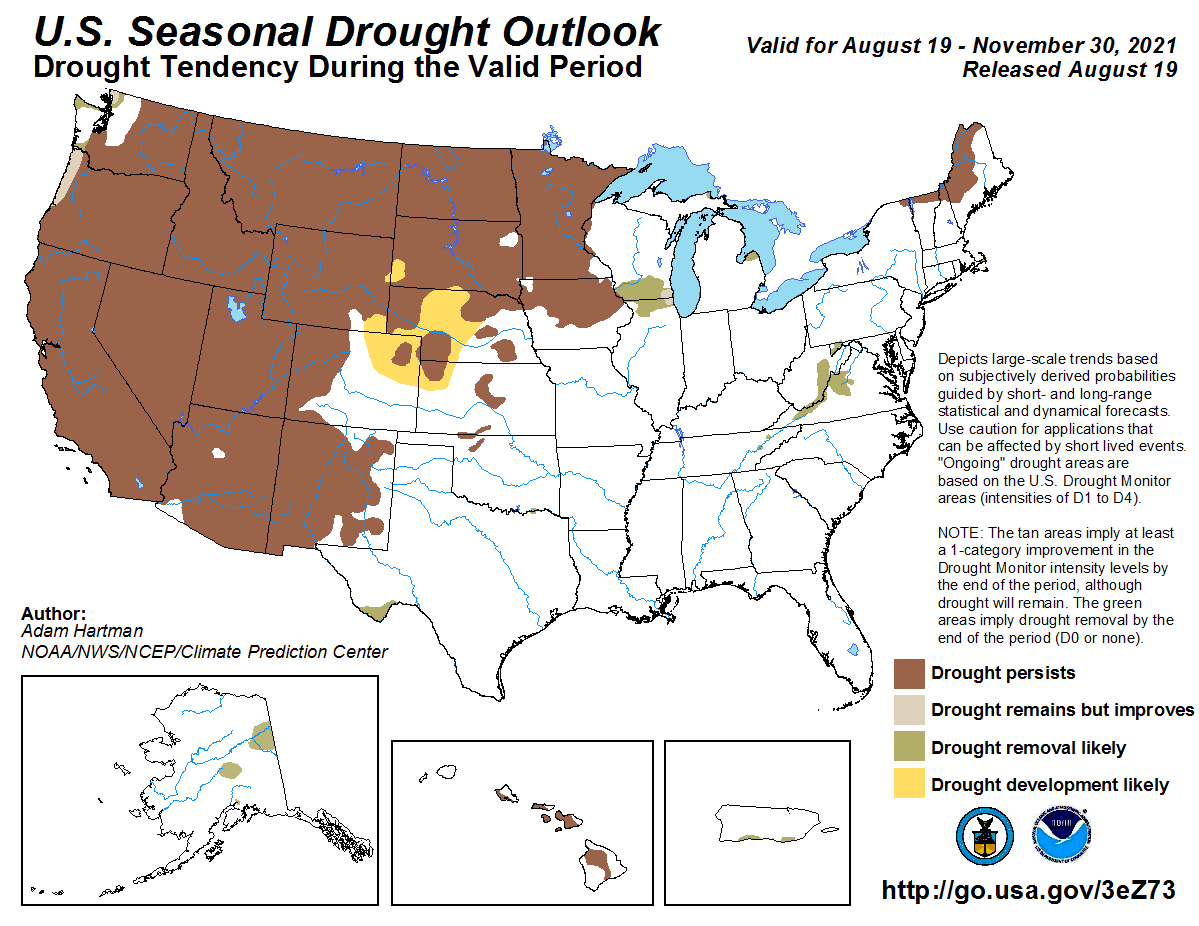
The forecast, from the National Oceanic and Atmospheric Administration, comes as almost half of the land area of the lower 48 states is experiencing drought.
The severe drought that has gripped much of the western half of the United States in spring and summer is likely to continue at least into late fall, government forecasters said Thursday.
The outlook for September through November, prepared by meteorologists with the National Oceanic and Atmospheric Administration, suggests that above-average temperatures are likely across almost all of the West, except for Washington and parts of Idaho, Montana and North Dakota.
Precipitation is expected to be below normal from the Southwest into the Rockies and the Northern Plains…
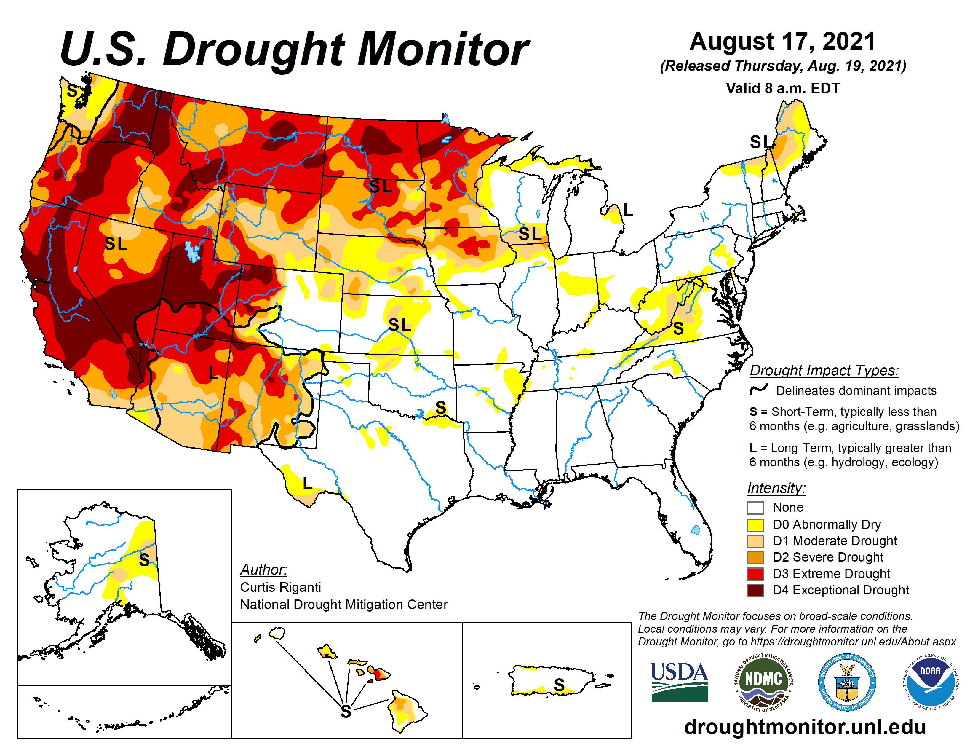
US Drought Monitor map August 17, 2021.
According to the United States Drought Monitor, currently 47 percent of the land area of the contiguous 48 states is experiencing various degrees of drought, nearly all of it in the High Plains or from the Rocky Mountains westward. Drought affects the entirety of nine states, including California, Nevada, Arizona, Utah, Oregon and North and South Dakota.
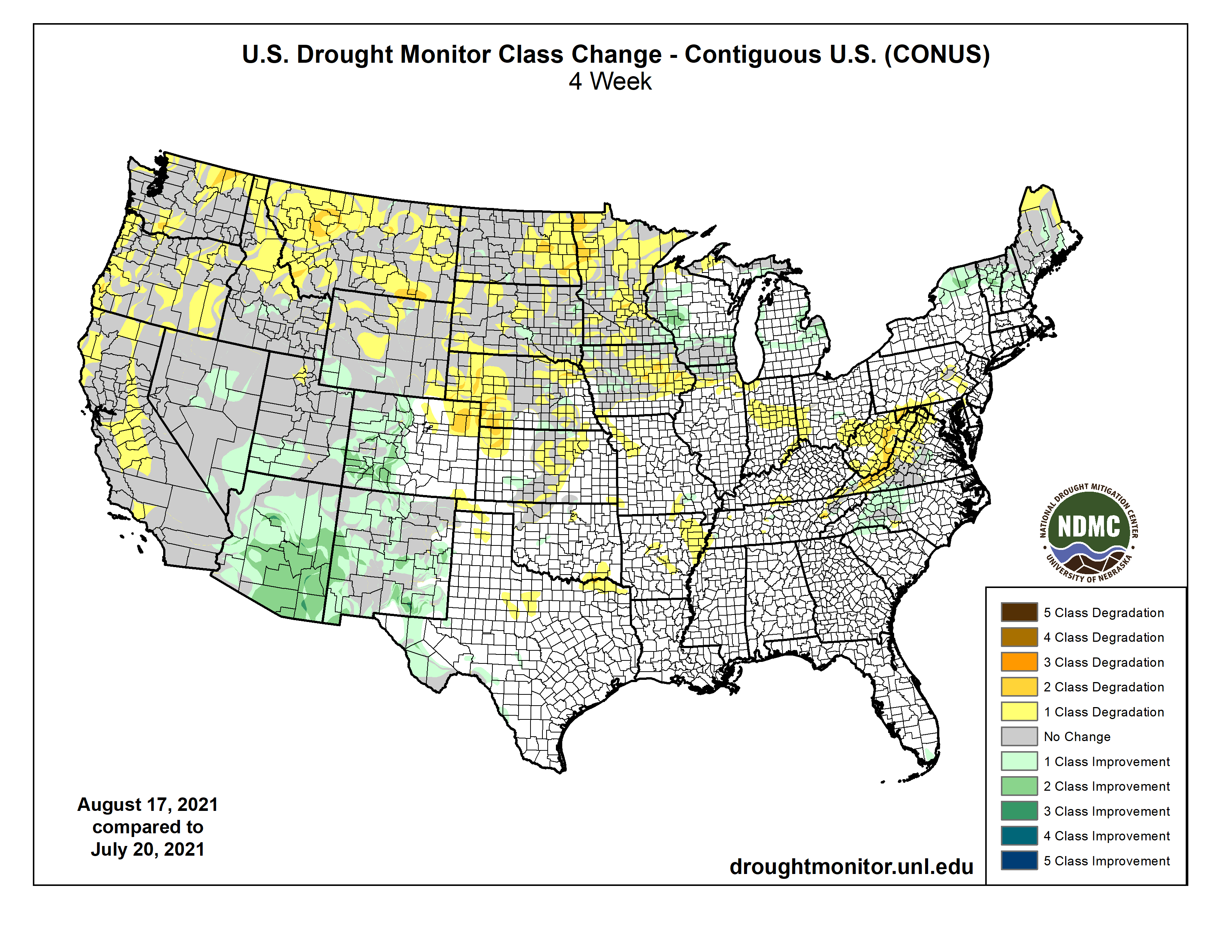
US Drought Monitor Four Week change map ending August 17, 2021.
In the past month, the drought has become less severe in Arizona and New Mexico…monsoon rains have helped, Mr. Rosencrans said. These occur in summer when atmospheric conditions draw Pacific moisture into the region…
But elsewhere in the West, the dry and hot conditions have continued through July, NOAA announced. California, Nevada, Oregon and Washington experienced their hottest July in 127 years of record keeping, while five other states, including Utah and Colorado, came close to setting records.
The drought situation is particularly dire in California, where 49 percent of the state is in the most severe drought category. Farmers in the state’s Central Valley have had sharp cuts in their water allotments, wells are going dry in some towns and several large wildfires are currently raging, including the Dixie Fire, now the largest single fire in California history…
About half of Utah, one-third of Nevada and one-quarter of Oregon are in the most severe category as well.
Over the next three months, the drought may develop in northeastern Colorado and western Nebraska, Mr. Rosencrans said. The only improvement may be in western parts of Oregon and Washington…
Overall, NOAA said, the 48 contiguous states experienced its 13th-warmest July ever. Offsetting the Western heat, below-average temperatures were recorded in the central Plains, parts of the Midwest and Southeast, and northern New England.
Colorado River “Beginnings”. Photo: Brent Gardner-Smith/Aspen Journalism
Click here to read the newsletter. Here’s an excerpt:
SHORTAGE DECLARATION
The Bureau of Reclamation has declared the first-ever official shortage for the lower Colorado River basin, which requires delivery cuts to Arizona, Nevada and Mexico under the 2007 Interim Guidelines for operating Lakes Mead and Powell. The determination was made in response to the Mead elevation projected in the August 24-month Study. This Fact Sheet by the Bureau explains how the declaration was made, how much deliveries will be reduced and details about drought response operations. Under the shortage, Arizona will lose about 18% of its Colorado River supplies, the largest cut. This Central Arizona Project page has details on how the cuts will be allocated and how the state is responding.