Aerial image of entrenched meanders of the San Juan River within Goosenecks State Park. Located in San Juan County, southeastern Utah (U.S.). Credits Constructed from county topographic map DRG mosaic for San Juan County from USDA/NRCS – National Cartography & Geospatial Center using Global Mapper 12.0 and Adobe Illustrator. Latitude 33° 31′ 49.52″ N., Longitude 111° 37′ 48.02″ W. USDA/FSA, Public domain, via Wikimedia Commons
From email from Reclamation (Susan Novak Behery):
In response to decreasing flows in the critical habitat reach, the Bureau of Reclamation has scheduled an increase in the release from Navajo Dam from 700 cubic feet per second (cfs) to 800 cfs on Friday, August 27th, starting at 4:00 AM. Releases are made for the authorized purposes of the Navajo Unit, and to attempt to maintain a target base flow through the endangered fish critical habitat reach of the San Juan River (Farmington to Lake Powell).
The San Juan River Basin Recovery Implementation Program recommends a target base flow of between 500 cfs and 1,000 cfs through the critical habitat area. The target base flow is calculated as the weekly average of gaged flows throughout the critical habitat area from Farmington to Lake Powell. This release change is calculated to be the minimum release required to maintain the minimum target base flow.
Click on a thumbnail graphic to view a gallery of drought data from the US Drought Monitor.
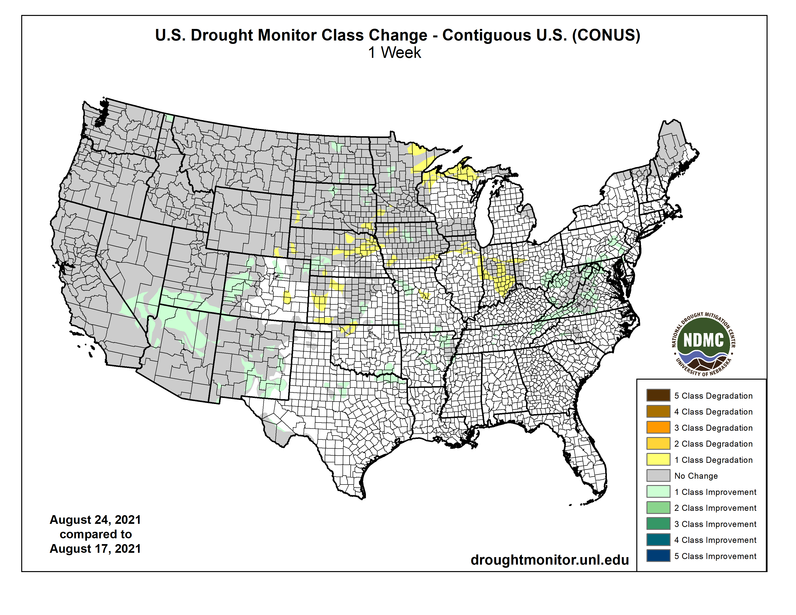
US Drought Monitor August 24, 2021.
High Plains Drought Monitor August 24, 2021.
West Drought Monitor August 24, 2021.
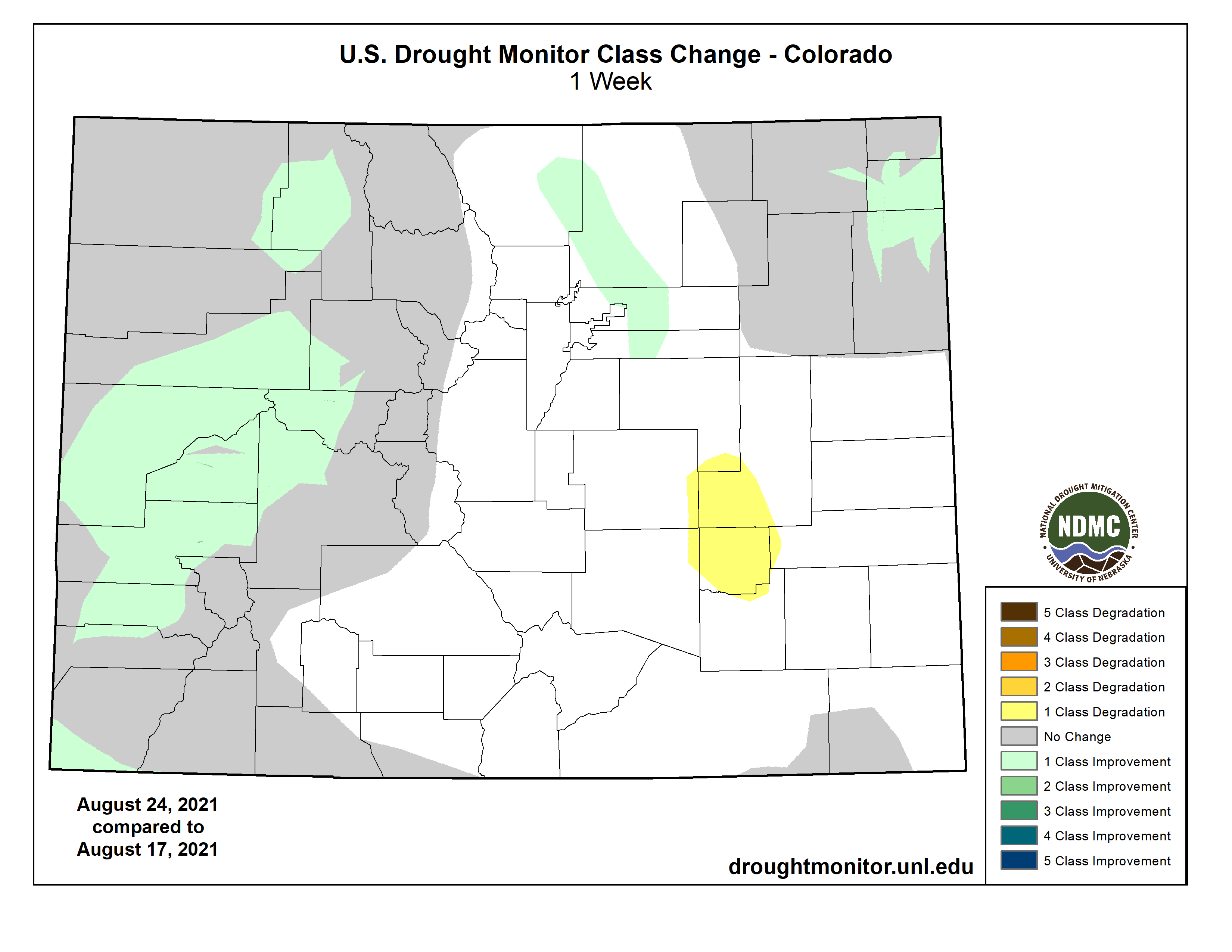
Colorado Drought Monitor August 24, 2021.
Click here to go to the US Drought Monitor website. Here’s an excerpt:
This Week’s Drought Summary
Temperatures this week were generally cooler than normal west of the Continental Divide, while warmer than normal temperatures were common in the Upper Midwest and Northeast. Heavy rain fell across widespread sections of the eastern United States, in many locations due to the influences of tropical cyclones Fred and Henri and their remnants. The widespread rainfall led to condition improvements in areas suffering from abnormal dryness or moderate drought. Tragically, this led to a flash flood event with numerous fatalities in Tennessee. Parts of the Midwest, High Plains, and West regions received beneficial rainfall this week, which led to improvement in drought conditions in some locales. Many locations across the central United States that missed out on heavier rains this week saw drought conditions degrade…
In the High Plains region this week, temperatures were mostly below normal west of the Continental Divide in Colorado, in Wyoming, and in far western parts of South Dakota and North Dakota. Elsewhere, temperatures were generally above normal. Rain fell over wide areas of Nebraska, South Dakota, North Dakota, Wyoming, and western Colorado, leading to some improvements in drought conditions. Parts of the Missouri River Valley in northeast Nebraska, northwest Iowa, and southeast South Dakota did not see much rain, however, and moderate, severe, and extreme drought expanded there. Heavy rain, with some areas seeing 5 or more inches, struck northeast Colorado and southwest Nebraska, though as is typical of warm season thunderstorm complexes, rainfall gradients were rather tight in some areas. Drought conditions improved in areas that saw heavy rain, while some expansion of severe drought occurred in areas of southwest Nebraska that missed out on the rain, where agricultural drought impacts and precipitation deficits have been mounting. Heavy rainfall in North Dakota led to some localized improvements to ongoing drought, though some short-term and especially long-term precipitation deficits remain in areas which received heavy rain. Ongoing drought also impacted the bee population in North Dakota…
Colorado Drought Monitor one week change map ending August 24, 2021.
Drought continued to plague much of the West region of the United States this week. Heavy rains in parts of Arizona, Idaho, Montana, and Utah combined with well below normal temperatures (ranging from 4 to 8 degrees below normal) to stave off any expansion or worsening of drought areas this week. Due to recent monsoonal rainfall, drought conditions improved in northern Arizona and southern Utah, and adjacent parts of southern Nevada and southeast California, and in New Mexico. Heavy rain in the far northern Idaho Panhandle led to a small reduction in exceptional drought coverage. It is possible that conditions may continue to improve in some locations after this week’s rainfall, though it is currently unknown how beneficial this week’s rains were in locations that were quite dry previously…
Heavy rains fell this week across parts of central and northeast Texas (and adjacent southeast Oklahoma), in much of central and eastern Tennessee, and in northern Mississippi and Louisiana. A small area of short-term moderate drought straddling the Red River in southeast Oklahoma/northeast Texas received sufficient rainfall to see conditions improve out of drought. Heavy rainfall led to the removal of moderate drought in parts of eastern Tennessee. Northwest Oklahoma was left drier this week, and small areas of short- and long-term moderate drought expanded there and in adjacent southern Kansas. Temperature departures varied across the region and generally were not extreme in either the warm or cool direction…
Looking Ahead
As of Aug. 25, the National Weather Service (NWS) Weather Prediction Center is forecasting two areas of heavy rainfall between Aug. 26-31. The first is expected to span from southern North Dakota south to northeast Nebraska, then northeast to Lake Superior. The second, which is expected near the end of that period, is expected near coastal parts of Texas and Louisiana. From Aug. 31-Sept. 4, the NWS Climate Prediction Center’s forecast leans towards near normal or warmer than normal temperatures for much of the contiguous United States. However, the forecast for the Pacific Northwest leans towards cooler than normal conditions being more likely. Warmer than normal temperatures are also likelier in Alaska during this period. Below normal precipitation is favored in the Pacific Northwest, western Texas and eastern New Mexico, the Florida Peninsula, and parts of the Northeast. Wetter than normal conditions are favored to extend from Arizona and Utah through the northern Great Plains and Upper Midwest, and from Texas and Louisiana northward through the Lower Mississippi River Valley.
US Drought Monitor one week change map ending August 24, 2021.
Ralph Parshall squats next to the flume he designed at the Bellevue Hydrology Lab using water from the Cache la Poudre River. 1946. Photo Credit: Water Resource Archive, Colorado State University, via Legacy Water News.
FromThe Grand Junction Daily Sentinel (Dennis Webb):
Responding to challenges posed by drought, greater demand from a growing population and potential interstate Colorado River compact issues, a state water agency is looking to phase in rules in western Colorado that would require the use of measurement devices when exercising surface and groundwater rights.
State law already requires that owners of irrigation ditches and reservoirs install headgates with measurement devices where necessary, but while the Division of Water Resources can order installation of measurement devices, it never has adopted surface water measurement rules.
Groundwater measurement rules already are in place in several river basins east of the Continental Divide, in some cases as a result of court orders.
“Those have been largely in response to the need to administer groundwater rights within our (seniority-based) prior appropriations system along with surface water rights,” said State Engineer Kevin Rein, director of the Division of Water Resources.
He said surface water in basins such as the South Platte, Rio Grande and Arkansas also long has been overappropriated in terms of water rights, and water rights holders are accustomed to measuring their diversions closely, so surface water measurement rules in those places are not an immediate concern of the state, unlike the Western Slope…
[Mike Sullivan] said that in areas of high demand, many structures already have adequate controls and measurement devices, but some may need repairs to work properly, which is something the new rules can address.
Sullivan said growth in the state and more frequent drought years are contributing to calls for administration of water by DWR under the priority system and helping drive the consideration of the measurement rules…
The division sees measurement as important should Colorado ever face curtailment of water uses under a 1922 interstate compact if it and other Upper Basin states are no longer able to meet a compact provision regarding the amount of river water that flows to Lower Basin states on a 10-year average.
[Kevin] Rein thinks an Upper Basin failure to comply with that provision isn’t likely to happen until at least 2026, and says it’s easy to oversimplify the compact’s possible resulting ramifications.
But he thinks measurement would be important to determine how much water Colorado has been using and how much water would be taken from it in the case of curtailment.
The Division of Water Resources plans to make all the data gathered through measurement publicly available, as it involves diversions of what are waters of the state, administered through a system involving ownership not of water but of water rights…
Scott Hummer, water commissioner for District 58 in the Yampa River basin, checks out a recently installed Parshall flume on an irrigation ditch in this August 2020 photo. Compliance with measuring device requirements has been moving more slowly than state engineers would like. CREDIT: HEATHER SACKETT/ASPEN JOURNALISM
The Division of Water Resources is looking to phase in new rules on the West Slope region by region, likely starting with the Yampa/White/North Platte river basins, DRW’S Division 6…
Rein said DWR may want to successfully work through rulemakings in a couple of its divisions between getting to Division 5, which covers the Colorado River Basin, as the basin is so large, with a lot of water volume and diversion points.
He thinks that Division 5 and Division 4, covering the Gunnison River Basin, have a lot more measurement devices than elsewhere in western Colorado, but said the devices aren’t as prevalent in some of the Colorado and Gunnison sub-basins.
Surface water measurement can be done using systems such as flumes, weirs, radar and current meters, while groundwater use is measured with meters or other devices. State officials say they don’t plan to impose one-size-fits-all rules.
They will takeinto account things such as the size of a diversion and a desire to require devices no more costly than what is needed to properly measure a diversion.