Some mountain ranges have already received more than 2 feet of snow in the first three weeks of October…
So far, that snowpack measurement is way above the average for this early in the season.
Those early-season numbers look pretty dramatic, but that’s just because the averages are very low this early on. We usually don’t see too much snowpack in our mountains in October.
Colorado snowpack basin-filled map October 25, 2021 via the NRCS.
For example, the Grizzly Peak weather station on Loveland Pass has an average of just two-tenths of an inch of SWE for this day, which is about two inches of snow. But there are 1.1 inches of SWE currently being measured, which is about 11 inches of snow. That equals 550% of the average.
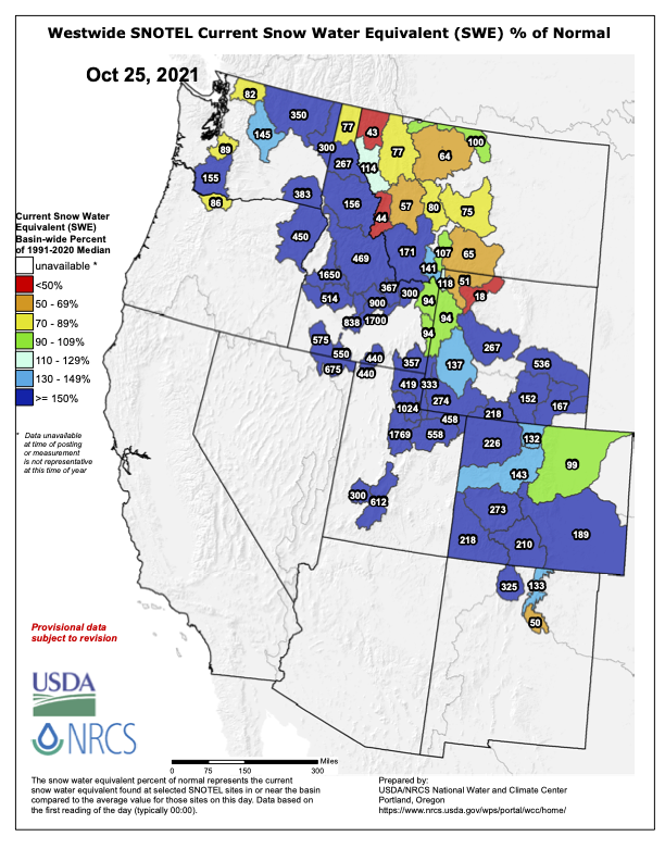
All the stations combined in the South Platte River headwaters are currently at [99%] of average.
These big early season numbers are not just fun to look at, but they also have importance. When Colorado has good early-season snowpack, it increases the chances of finishing the season in April at or above average.
When there is ground exposed with no snowpack, the darker mountainside can absorb more sunlight, and melt more snow. The earlier in the season that ground gets covered by snow, the more snow we’ll keep through the year, because the white snow can reflect more than 80% of sunlight.
Westwide SNOTEL basin-filled map October 25, 2021 via the NRCS.