(That’s an incomplete list! I’d love to see readers use the comments to identify all the seasonal climate extremes over the past year that are consistent with the typical influence of El Niño.)
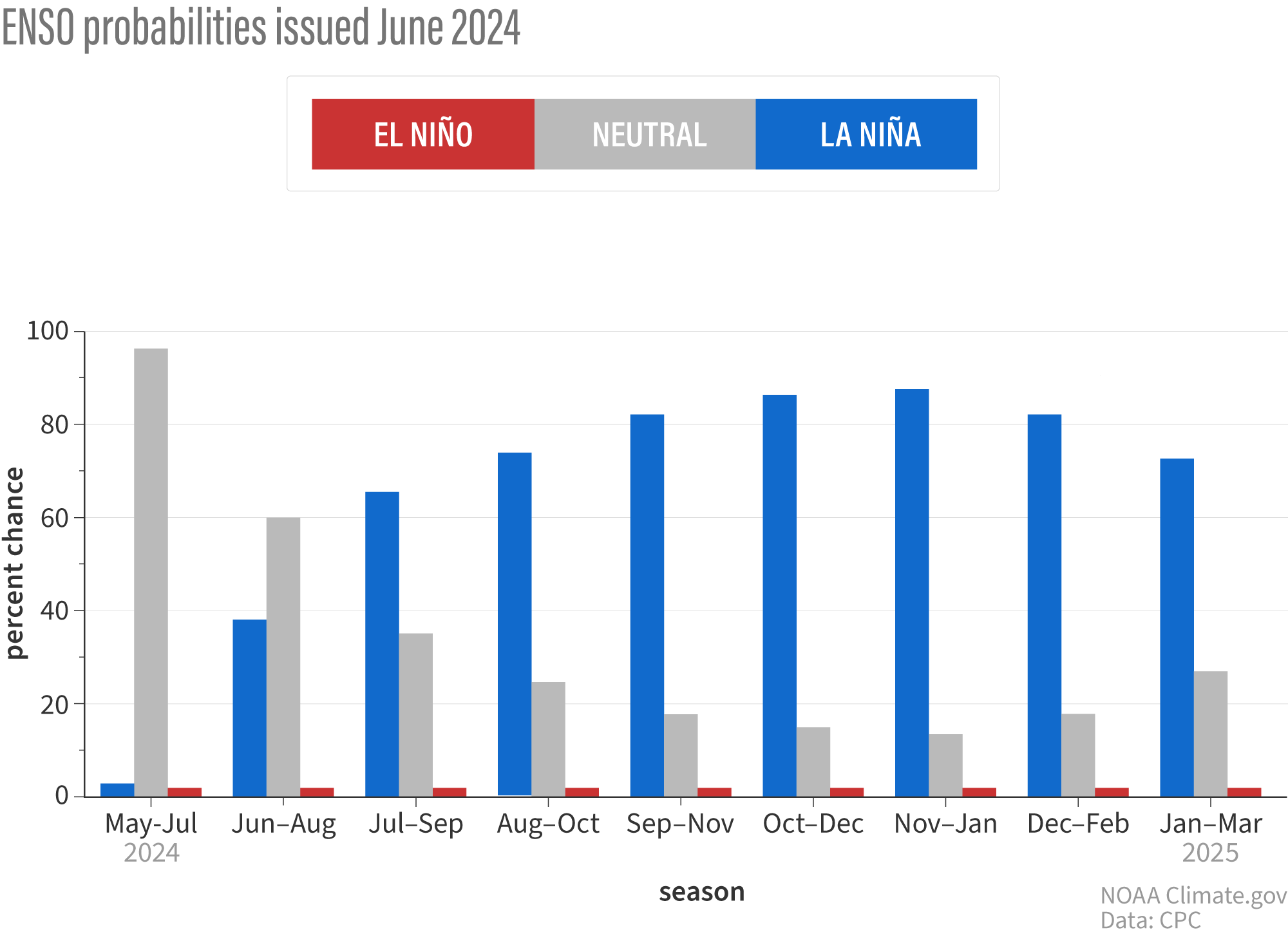
That’s a lot of climate upheaval. Is ENSO going to give us some time to idle in neutral (a state in between the warmer and cooler extremes of the El Niño-La Niña cycle) and catch our breaths? Not much, apparently. The tropical Pacific’s climate pendulum appears to be swinging back toward its other extreme: La Niña. In the Pacific, La Niña brings cooler-than-average temperatures in the central-eastern part of the basin, stronger winds both near the surface and at high altitudes, and heavier rain than normal over Indonesia and the rest of the Maritime Continent. The forecasting team thinks there’s a 65 percent chance that La Niña will arrive by July-September.
For each upcoming 3-month season, NOAA forecasts the chances of El Niño (red bars), La Niña (blue bars), or neutral conditions (gray bars) in the tropical Pacific. Neutral is overwhelmingly favored for the May-July period (labeled MJJ on the graph), but the chances for La Niña increase rapidly as soon as the June-August (JJA) period. By late summer (July-August-September, JAS), odds of La Niña are 65 percent. NOAA graph by Michelle L’Heureux.
That timing means there’s a pretty good chance La Niña will be around to influence the peak of the Atlantic hurricane season. (1) Even if the transition occurs more slowly, the odds of La Niña being in place by Northern Hemisphere winter are still 85 percent, which is similar to the NOAA forecast in previous months. Given those odds, it’s probably a good idea to refresh your memory of the typical impacts of La Niña on U.S. temperature and precipitation.
The slow pokey ocean
Emily explained in our April update that the atmospheric part of El Niño—weak-to-absent east-to-west trade winds across the tropical Pacific, dryness over Indonesia, strong convection and rainfall east of the International Dateline—had more or less shut down by early April. But surface water temperatures in the central-eastern tropical Pacific were still more than a degree Celsius (nearly 2 degrees Fahrenheit) warmer than the long-term average (long-term = 1991-2020), and some parts of the tropics still appeared to be experiencing El Niño’s typical side effects. Forecasters concluded it was too soon to issue El Niño’s curtain call.
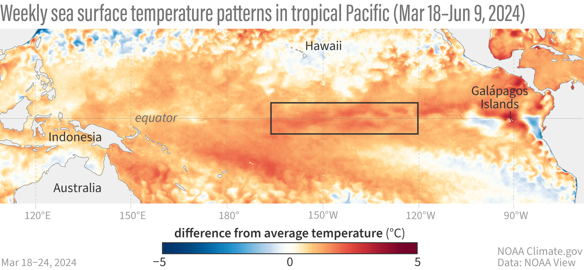
Without the atmosphere reinforcing those warm anomalies (anomaly means “difference from average”), however, surface temperatures cooled off significantly through April and May. We’re already seeing stronger easterly (from the east) trade winds, which have cooled the overheated surface waters. You can see it happening in the animation below.
This animation shows weekly sea surface temperatures in the Pacific Ocean compared to average from March 18-June 9, 2024. Orange and red areas were warmer than average; blue areas were cooler than average. Warmer-than-average sea surface temperatures in the key ENSO-monitoring region of the tropical Pacific (outlined with black box) have started to be replaced by cooler-than-average waters—a sign that La Niña may be brewing. NOAA Climate.gov animation, based on Coral Reef Watch Data and maps from NOAA View. View the full-size version in its own browser window.
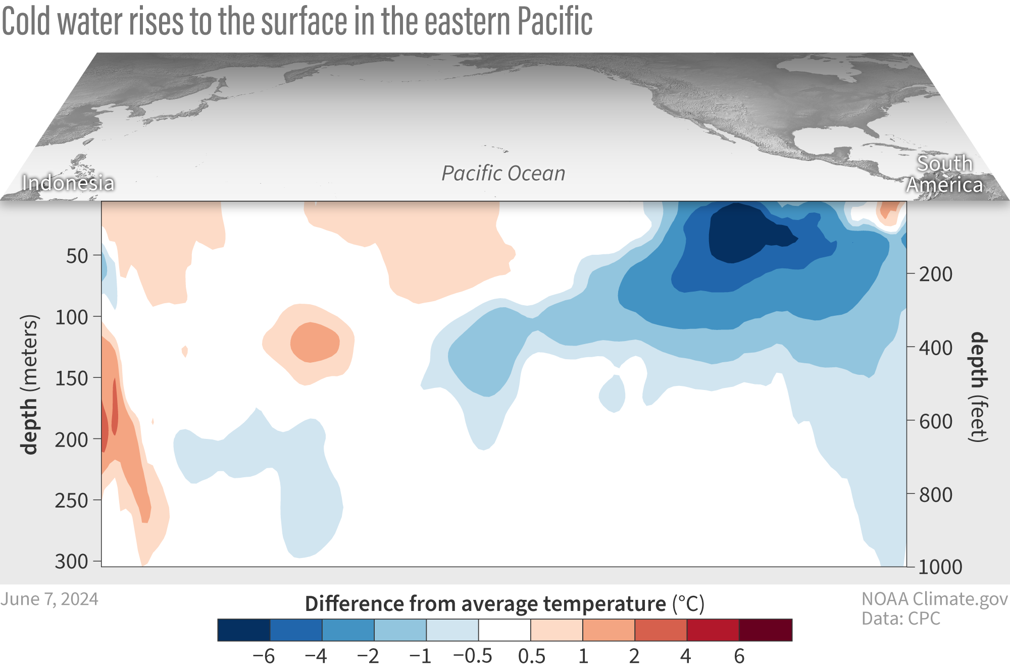
The most recent weekly and monthly observations from the key ENSO-monitoring region (dubbed “Niño 3.4”) show surface temperatures are close to average, and now cooler, deeper waters have begun surfacing. Now that both the atmosphere and the ocean have shifted away from El Niño, the event is truly over. Beneath the surface of the eastern pacific, a pool of cool water has been lurking for several months in standby mode, ready to re-supply the surface and intensify the cool anomaly required to create and maintain La Niña.
Water temperatures in the top 300 meters (1,000 feet) of the tropical Pacific Ocean compared to the 1991–2020 average in February–April 2024. NOAA Climate.gov animation, based on data from NOAA’s Climate Prediction Center.
Historically, does big El Niño=big La Niña?
Of course, one of the most common questions we receive from readers is how strong do we expect the predicted La Niña to be? As far as model forecasts go, it’s too soon to put much stock in the forecasts: we’re just barely out of the notorious spring predictability barrier. The spread of possible outcomes is still pretty wide.
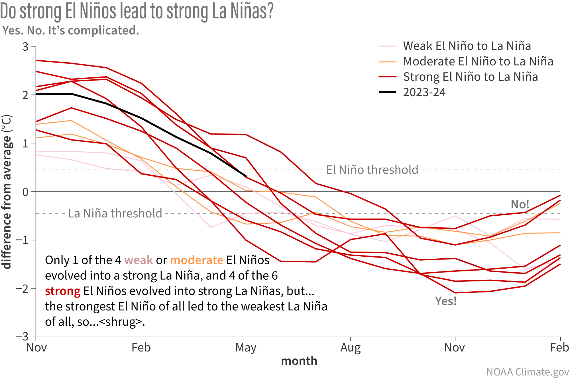
So, how about historical events? Does coming off a relatively strong El Niño like the recent one mean the developing La Niña will also be strong? That’s the question I posed to the team via email earlier this week. In true scientist fashion, Michelle answered me with a plot (2), which I have translated below.
Since 1950, there have been 10 cases in which the ENSO climate pattern flipped from El Niño to La Niña with no neutral winter in between. Each line on this graph shows the evolution of sea surface temperature anomalies in the Niño-3.4 region of the tropical Pacific (the key ENSO-monitoring region) through the switch. Many, but not all, of the strongest El Niños (red lines) evolved into strong La Niñas. NOAA Climate.gov image, based on analysis by Michelle L’Heureux.
First things first, let’s acknowledge that there have only been 10 times in the historical record where ENSO flipped from El Niño into La Niña within a year. That’s not enough examples to draw any solid conclusions from. Still, it’s interesting to look at what we have and speculate as to what it might mean, so that’s all I am doing here.
Each line on the graph above represents a year in which the tropical Pacific shifted from El Niño to La Niña with no neutral winter in between. The lines are colored based on the strength of the El Niño: red for strong events (peak Niño 3.4-region sea surface temperature anomalies above 1.5 ˚C, or 2.7 ˚F), orange for moderate events (peak anomaly between 1 and 1.5 ˚C, or 1.8-2.7 ˚F), and pink for weak events (peak anomaly less than 1 ˚C, or 1.8 ˚F).
The relationship between the strength of the El Niño and the strength of the subsequent La Niña is kinda messy. It’s unlikely, but not impossible, for weak and moderate El Niños to lead to a strong La Niña (Niño 3.4 temperature anomaly of more than 1.5 ˚C below average). Only one of the pink and orange lines gets below that threshold. Meanwhile, 4 of the 6 strong El Niños do evolve into strong La Niñas. But before we put too much stock in that pattern, we should note that the strongest El Niño of all (top red line at the left hand side of the graph) wound up developing into the weakest La Niña (3). So…yeah. It’s complicated.
Strong events not required for strong impacts
The likely strength of the upcoming La Niña will become clearer the closer we get, and you’ll hear more about that in coming posts. Of course, it’s also important to remember that the strength of a given El Niño or La Niña isn’t a good predictor of the strength of the temperature or precipitation impacts in a particular place. Stronger events do make it more likely that places prone to be influenced by El Niño or La Niña will experience some level of their typical impacts, but they don’t necessarily lead to stronger impacts. In other words, even a moderate or weak La Niña can have a strong impact on a given place. So it’s important to pay attention to what we already know, which is that odds are very high (85% chance) that this winter will feature La Niña. If you’d like to know more about what a La Niña winter might mean for your part of the world, here are some great places to start.
Later this month, we’ll have a guest post about how La Niña influenced NOAA’s 2024 seasonal hurricane outlooks from lead forecaster Matt Rosencrans of NOAA’s Climate Prediction Center. In the meantime, you can read a vintage post from our early days and a more recent one with some additional detail.)
Scientists use the word plot to refer to any data visualization, whether map or graph.
This analysis defines strength based on how temperatures in the Niño 3.4-region compare to the long-term average in that area. By this definition, that top line is occupied by the 2015-16 El Niño. But as we have blogged about before, when it comes to ENSO impacts, what may matter more is how warm temperatures in that area are relative to the rest of the tropical oceans. Relative to the tropics-wide average, the warm anomaly associated with the 2015-16 event might not have been large enough to really count as record strong, which might explain why the La Niña that followed it was also not very strong.
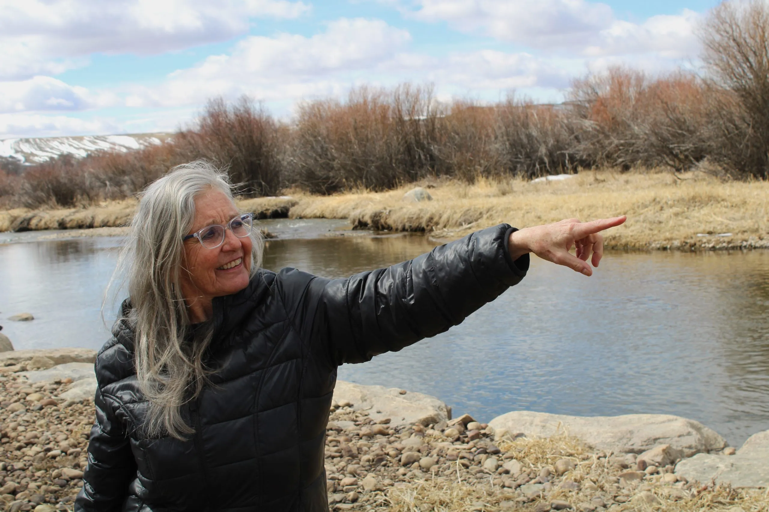
Leslie Hagenstein stands in front of the New Fork River on Mar. 27, 2024. Through the federally-funded System Conservation Pilot Program, she was able to make 13 times more than she would have by leasing her fields out to grow hay. CREDIT: ALEX HAGER/KUNC
Click the link to read the article on the Aspen Journalism website (Heather Sackett and Alex Hager):
May 30, 2024
This story was reported and produced collaboratively with Northern Colorado-based public radio station KUNC, as a part of KUNC’s ongoing coverage of the Colorado River supported by the Walton Family Foundation. Additional editing resources and other support for this story came from The Water Desk, an independent initiative of the University of Colorado Boulder’s Center for Environmental Journalism.
Upper Basin conservation program dogged with concerns over cost and efficacy
Wyoming native Leslie Hagenstein lives on the ranch where she grew up and remembers her grandmother and father delivering milk in glass bottles from the family’s Mount Airy Dairy.
The cottonwood-lined property, at the foot of the Wind River Mountains south of Pinedale, is not only home to Hagenstein, her older sister and their dogs, but to bald eagles and moose. But this summer, for the second year in a row, water from Pine Creek will not turn 600 acres of grass and alfalfa a lush green.
On a blustery day in late March, Hagenstein stood in her fields, now brown and weed-choked, and explained why she cried after she chose to participate in a program that pays ranchers in the Upper Colorado River basin to leave their water in the river.
“You have these very lush grasses, and you have a canal or a ditch that’s full of this beautiful clear, gorgeous water that comes out of these beautiful mountains. It’s nirvana,” Hagenstein said. “And then last year, it looks like Armageddon. I mean, it’s nothing, it’s very sad, there’s just no growth at all. There’s no green.”
Wyoming rancher Leslie Hagenstein’s fields were brown and weed-choked after she didn’t water them in 2023. She made 13 times more by participating in a conservation program that pays her to leave her water in the river than she could have leasing her fields out to grow hay.
CREDIT: HEATHER SACKETT/ASPEN JOURNALISM
The Colorado River basin has endured decades of drier-than-normal conditions, and steady demand. That imbalance is draining its largest reservoirs, and making it nearly impossible for them to recover, putting the region’s water security in jeopardy. Reining in demand throughout the vast western watershed has become a drumbeat among policymakers at both the state and federal level. Hagenstein’s ranch is an example of what that intentional reduction in water use looks like.
“New plot using the nClimGrid data, which is a better source than PRISM for long-term trends. Of course, the combined reservoir contents increase from last year, but the increase is less than 2011 and looks puny compared to the ‘hole’ in the reservoirs. The blue Loess lines subtly change. Last year those lines ended pointing downwards. This year they end flat-ish. 2023 temps were still above the 20th century average, although close. Another interesting aspect is that the 20C Mean and 21C Mean lines on the individual plots really don’t change much. Finally, the 2023 Natural Flows are almost exactly equal to 2019. (17.678 maf vs 17.672 maf). For all the hoopla about how this was record-setting year, the fact is that this year was significantly less than 2011 (20.159 maf) and no different than 2019” — Brad Udall
In Sublette County, Hagenstein said it’s rare for people to make a living solely on raising livestock and growing hay anymore. In addition to ranching, she worked as a nurse practitioner for more than 40 years before retiring. And when she looked at her bank accounts, she realized she needed a better way to meet expenses if she was going to keep the ranch afloat in the future. Hagenstein said it was a no-brainer. She signed up for the System Conservation Pilot Program (SCPP) in 2023. Through the federally funded program, she was able to make 13 times more than she would have by leasing it out to grow hay.
Since its inception as a mass experiment in water use reduction, the program has divided farmers and ranchers. Concerns over the high cost, the limited water savings, the difficulty in measuring and tracking conserved water, and the potential damage to local agricultural economies still linger. But without fully overhauling the West’s water rights system, few tools exist to get farmers and ranchers — the Colorado River’s majority users — to conserve voluntarily.
“I’m a Wyoming native,” Hagenstein said. “I don’t want to push our water downstream. I don’t want to disregard it. But I also have to survive in this landscape. And to survive in this landscape, you have to get creative.”
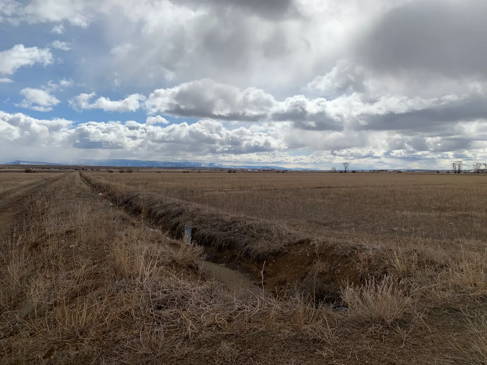
A ditch runs dry through Leslie Hagenstein’s fields near Pinedale, Wyo. on Mar. 27, 2024. She signed up for a program that pays her to pause irrigation on her land in order to save Colorado River water. Some experts say the System Conservation Pilot Program, or SCPP, is costly and may not be the most effective way to save Colorado River water.
CREDIT: ALEX HAGER/KUNC
SCPP participation doubles in 2024
Driven by overuse, drought and climate change, water levels in Lake Powell fell to their lowest point ever in 2022. The nation’s second-largest reservoir provided a stark visual indicator of the Colorado River’s supply-demand imbalance. Those falling levels also threatened the ability to produce hydroelectric power and prompted officials from the U.S. Bureau of Reclamation to call on states for an unprecedented level of water conservation. The agency gave the seven states that use the Colorado River a tight deadline to save an additional 2 million to 4 million acre-feet of water. (An acre-foot is the amount of water needed to fill 1 acre of land to a height of 1 foot. One acre-foot generally provides enough water for one to two households for a year.)
States gave the federal government no plans to save that much water in one fell swoop, instead proposing a patchwork of smaller conservation measures aimed at boosting the reservoirs and avoiding infrastructural damage.
The Upper Colorado River Commission (UCRC), an agency that brings together water leaders from Colorado, Utah, Wyoming and New Mexico, offered up the “5-Point Plan,” one arm of which was restarting the SCPP.
In 2023, after the federal government announced it would spend $4 billion from the Inflation Reduction Act (IRA) on Colorado River programs, the Upper Colorado River Commission decided to reboot the SCPP, which was first tested from 2015 to 2018. The program pays eligible water users in the four Upper Basin states to leave their fields dry for the irrigation season and let that water flow downstream.
But a hasty rollout to the SCPP in 2023 meant low participation numbers. Only 64 water-saving projects were approved, and about 38,000 acre-feet of water was conserved across the four states, which cost nearly $16 million. Water users complained about not having enough time to plan for the upcoming growing season and said an initial lowball offer from the UCRC of $150 per acre-foot was insulting and came with a complicated haggling process to get a higher payment. UCRC officials said the short notice and challenges with getting the word out about the program contributed to low participation numbers in 2023.
A University of Wyoming study surveyed the region’s growers about water conservation between November 2022 and March 2023. Eighty-eight percent of respondents in the Upper Basin were not even aware that the SCPP existed.
UCRC commissioners voted to run the program again in 2024, but said this time that projects should focus on local drought resiliency on a longer-term basis. UCRC officials tweaked the program based on lessons learned in 2023, and the 2024 program had nearly double the participation, with 109 projects and nearly 64,000 acre-feet of water expected to be conserved.
“I view the doubling of interest and participation from one year to the next as a significant success,” said UCRC Executive Director Chuck Cullom.
What happens to conserved water?
Despite one of its stated intentions — protecting critical reservoir levels — water being left in streams by SCPP-participating irrigators is not tracked to Lake Powell, the storage bucket for the Upper Basin.
In total, across 2023 and 2024, the program spent $45 million to save a little more than 1% of the Colorado River water allocated to Colorado, Utah, Wyoming and New Mexico.
Although engineers have calculated how much water is saved by individual projects, known as conserved consumptive use, officials are not measuring how much of that conserved water ends up in Lake Powell. And the laws that govern water rights allow downstream users to simply take the water that an upstream user participating in the SCPP leaves in the river, potentially canceling out the attempt at banking that water.
These types of temporary, voluntary and compensated conservation programs aren’t new to the Upper Basin. In addition to the pilot program from 2015 to 2018, the state of Colorado undertook a two-year study of the idea of a demand management program by convening nine workgroups to examine the issue.
System conservation and demand management, while conceptually the same, have one big difference: A demand management program would track the water so that downstream users don’t grab it and create a special pool to store the conserved water in Lake Powell. With system conservation, the water simply becomes part of the Colorado River system, with no certainty about where it ends up.
This lack of accounting for the water has some asking whether the SCPP is accomplishing what it set out to do and whether it is worth the high cost to taxpayers.
Even if all the roughly 64,000 acre-feet from the SCPP in 2024 makes it to Lake Powell, it’s still a drop in the bucket for the reservoir; last year, 13.4 million acre-feet flowed into Lake Powell. The reservoir currently holds about 8.2 million acre-feet and has a capacity of about 25 million acre-feet.
“I still haven’t really seen evidence of total water savings or anything like that,” said Elizabeth Koebele, a professor of political science and director of the graduate program of hydrologic sciences at the University of Nevada, Reno. Koebele wrote her doctoral dissertation on the first iteration of the SCPP. “As far as getting water to reservoirs, I’m not sure that we’ve seen a lot of success from the System Conservation Pilot Program so far.”
And the program has been expensive. For the 2024 iteration of the program, UCRC officials offered a fixed price per acre-foot that applicants could take or leave — no haggling this time. Colorado, Utah and Wyoming paid agricultural water users about $500 an acre-foot; the Navajo Agricultural Products Industry, New Mexico’s sole participant in 2023 and 2024, received $300 an acre-foot. Projects that involved municipal or industrial water use were compensated on a case-by-case basis, and those that involved leaving water in reservoirs were paid $150 an acre-foot. The majority of projects in both years involved taking water off fields for the whole season or part of the season, known as fallowing.
The UCRC doled out nearly $29 million in payments to water users in 2024. The program paid about $45 million to participants in 2023 and 2024 combined. Some participants are using these payments to upgrade their irrigation systems, Cullom said, which helps maintain the vitality of local agriculture.
But even with this amount of money spent, Koebele said it may still not cover the costs to participants for things such as long term impacts to soil health that come with taking water off fields for a season or two. After the infusion of IRA money runs out, it’s unclear how such a program would be funded in the future.
“I also worry that we don’t have an endless supply of money to compensate users for conservation in the basin,” Koebele said. “And perhaps we need to be thinking about — rather than doing temporary conservation — investments in longer-term conservation beyond what we’re already doing.”
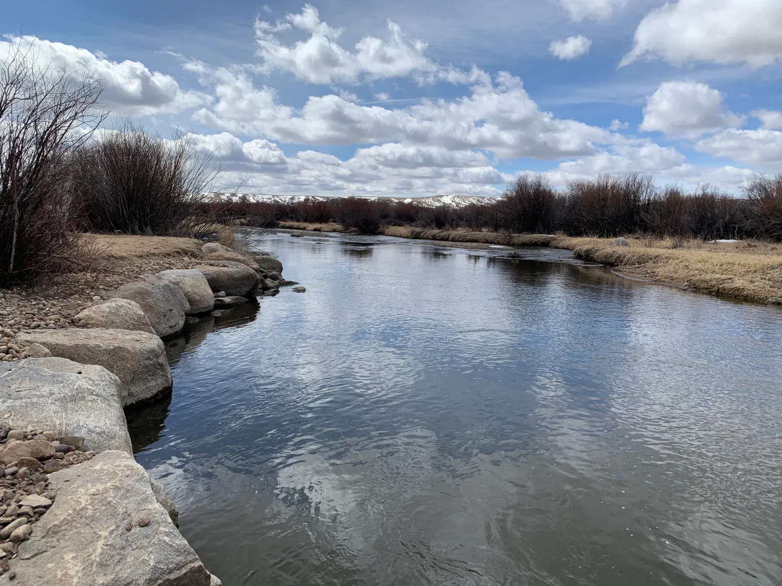
The New Fork River runs past Leslie Hagenstein’s property south of Pinedale, Wyoming. A program in the Upper Colorado River basin is paying farmers and ranchers like Hagenstein to conserve water. Photo credit: Heather Sackett/Aspen Journalism
Western Slope water managers critical of SCPP
Some groups have concerns with the SCPP beyond its issues with accounting for how much water ends up in Lake Powell.
The Glenwood Springs-based Colorado River Water Conservation District represents 15 counties on Colorado’s Western Slope. Their mission is to protect, conserve, use and develop the water within its boundaries, which has often meant fighting Front Range entities that want to take more from the headwaters of the Colorado River in the form of transmountain diversions. Sometimes, that means voicing concerns about conservation programs that it thinks have the potential to harm Western Slope water users.
River District officials have been vocal critics of the SCPP, pointing out the ways that it could, if not done carefully, harm certain water users and rural agricultural communities. Because of the way water left in the stream by participants in the SCPP can be picked up by the next water user in line, some of which are Front Range cities, at least two of the projects this year could result in less — not more — water in the Colorado River, according to comments that the River District submitted to the state of Colorado. (One of these projects dropped out in 2024.)
“Without significant improvements, it would be hard for the River District to support additional expenditures on system conservation,” said Peter Fleming, the district’s general counsel.
The River District had also wanted a say in the SCPP process in 2023, going as far as creating their own checklist for deciding project approval, but UCRC officials said the commission had sole authority to approve projects.
Water users from all sectors — including agriculture, cities and industry — are allowed to participate in the program, but, in practice, all of the 2023 and 2024 projects in Colorado involve Western Slope agricultural water users. That’s partly because the price that the SCPP offered was less than the market value of water on the Front Range.
“If you’re simply basing it on a set dollar value per acre-foot, you’re going to result in disproportionate impacts to areas of the state where the economic value of water is not as high as others,” Fleming said. “You’re going to end up with all the water coming from the Western Slope. … You shouldn’t create sacrificial lambs.”
This alfalfa field near Carbondale is irrigated with water from the Crystal River. All of the projects in a conservation program that pays water users in the Upper Colorado River basin to cut back involve Western Slope agriculture.
CREDIT: HEATHER SACKETT/ASPEN JOURNALISM
Upper Basin facing increased pressure
The Upper Basin’s conservation program is playing out against the backdrop of watershedwide negotiations with the Lower Basin states (California, Arizona and Nevada) about how to share the river after the current guidelines governing river operations expire in 2026.
After failing to come to an agreement, the Upper and Lower basins submitted competing proposals to the U.S. Bureau of Reclamation. Lower Basin officials committed to a baseline of 1.5 million acre-feet in cuts, plus more when conditions warrant. They also called for the Upper Basin to share in those additional cuts when reservoirs dip below a certain level.
Upper Basin officials have balked at the notion that their water users should share in any cuts, saying they already suffer shortages in dry years. The source of the problem, they say, is overuse by the Lower Basin.
Plus, without ever having violated the 1922 Colorado River Compact by using more than the 7.5 million acre-feet allotted to them, they say there’s no way to enforce mandatory cuts on the Upper Basin.
But under increased pressure from the Lower Basin, and facing a drier future as climate change continues to rob the Colorado River of flows, Upper Basin water managers have made one small concession. In their proposal, they have offered to continue “parallel activities” like the SCPP, but said these programs will be separate from any post-2026 agreement with the Lower Basin. The congressional authorization for the SCPP expires at the end of 2024, and it’s unclear whether water managers will implement a program in 2025 or beyond.
Inherent in the Upper Basin’s stance is a contradiction: Why maintain that both the source of the problem and responsibility for a solution rest with the Lower Basin, but then agree to do the SCPP or a conservation program like it?
“I think that they’re basically saying that the Lower Basin needs to get their act together before we actually really need to come to the table in a realistic way,” said Drew Bennett, a University of Wyoming professor of private-lands stewardship. “I think they feel like, ‘We don’t actually really need to do anything.’ That the SCPP is actually above and beyond what they need to be doing. Is that reality? I don’t know. But I think that’s sort of the message they’re trying to send in negotiations.”
Docks and buoys, once floating atop dozens of feet of water, sit stranded on the sand at Lake Powell’s Bullfrog Marina on April 9, 2023. Record-low levels at the reservoir helped spur water officials to reboot the System Conservation Pilot Program.
CREDIT: ALEX HAGER/KUNC
Grower attitudes key to program success
Some experts say the program’s real value is not getting water into depleted reservoirs. It is testing out a potential tool to help farmers and ranchers adapt to a future with less water. They frame it as an experiment that provides crucial information and lessons on how an Upper Basin conservation program could be scaled up. It also continues to ease water users into the concept of using less should a more permanent water conservation program come to pass.
“This program kind of, I think, helps grease the skids for that process that gets people comfortable for how it operates,” said Alex Funk, who worked for the Colorado Water Conservation Board in 2019 and helped to guide the state’s demand management study with regard to agricultural impacts. “Just seeing the doubling of the amount of acre-feet conserved under the second year and then the interest shows that, yeah, I think there could be some longevity to the program. … I think one has to be optimistic because I don’t see how the Upper Basin navigates a post-2026 future without such a program.”
Funk now works as senior counsel and director of water resources at the nonprofit Theodore Roosevelt Conservation Partnership. The group receives funding from the Walton Family Foundation, which also funds a portion of Colorado River coverage from KUNC and The Water Desk.
Cullom, executive director of the agency that runs the SCPP, pushed back on the idea that it is intended to help correct the supply/demand imbalance on the river, which he said is the fault of the Lower Basin.
“The intent of the program is to develop new tools for the upper division water users to adapt to a drier future,” he said. “We’re trying to develop tools that benefit the local communities and producers and water users in the four upper division states through drought resiliency, new tools, the ability to explore crop switching and irrigation efficiencies.”
Of all the challenges in setting up a program such as this — funding, pricing, calculating water saved, getting the word out — the biggest may be the attitudes of water users themselves, some of whom have a deep-seated mistrust of the federal government. Like Hagenstein, all of the water users that Aspen Journalism and KUNC interviewed for this story said financial reasons were the biggest driver behind their participation in the SCPP.
Bennett’s research also explained some of the reasons why growers may be hesitant to enroll in conservation programs such as the SCPP. It found that farmers and ranchers trusted local organizations to administer conservation programs significantly more than state or federal ones.
If demand management strategies were deployed, 74% of survey respondents said they’d prefer to have a local agency manage the program, as opposed to a state or federal agency. Only about 14% of growers said there is a high level of trust between water users and water management agencies in their states. The same percentage said their state’s planning process was adequate for dealing with water supply issues.
These findings point to a stumbling block that the UCRC and other agencies must overcome if they hope to create a longer-term conservation program.
Hagenstein, the Wyoming rancher, has experienced those attitudes firsthand. She has been on the receiving end of insults and name-calling because of her participation in the SCPP.
But Hagenstein says the SCPP has allowed her to have money in her pocket to continue ranching long term.
“I didn’t anticipate it would be so beneficial,” she said. “It bought us time to stay in ranching is the long and the short of it. So, I’m most grateful for the abundance that the federal government offered us. … You know, some would call it a golden goose.”
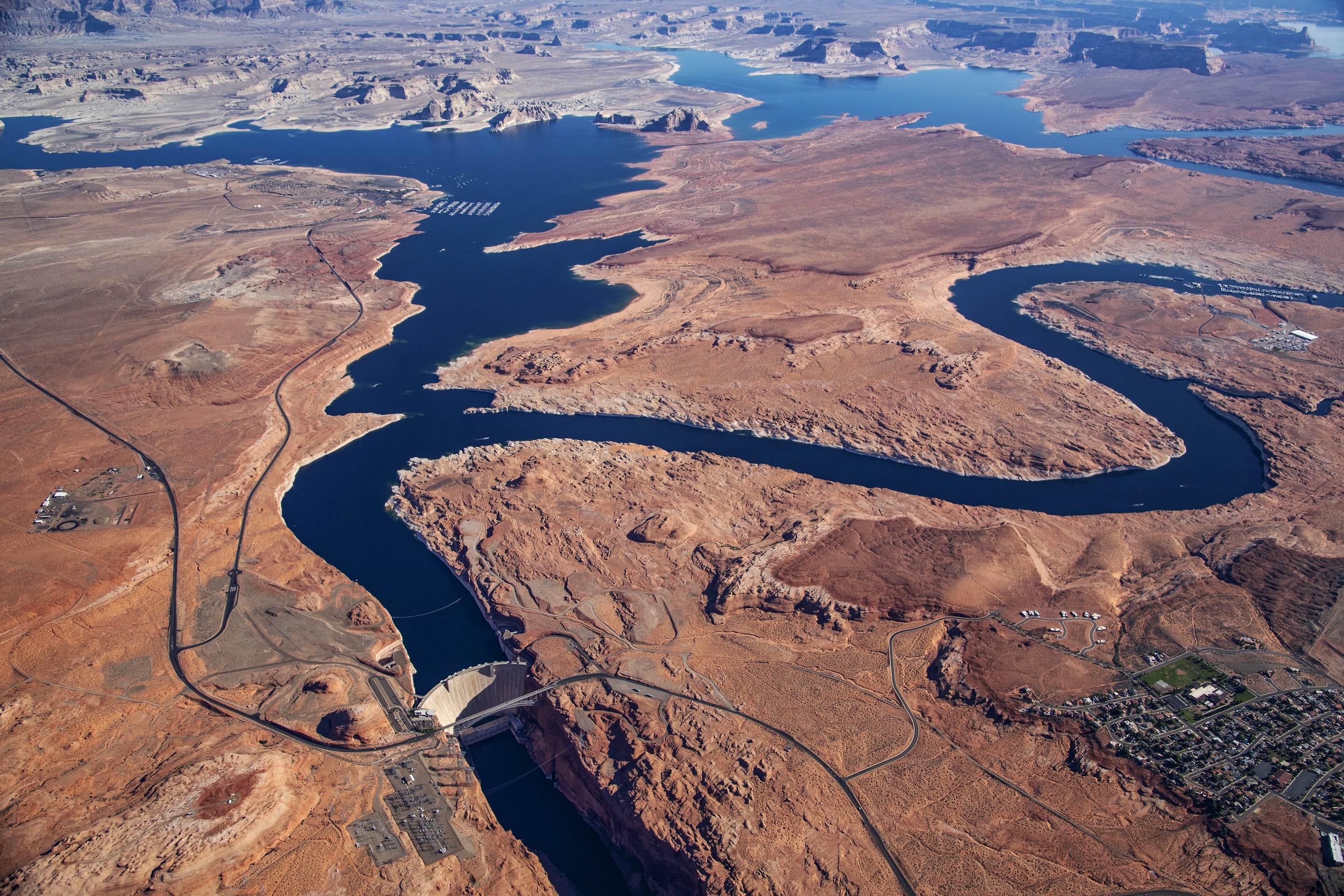
The downstream face of Glen Canyon Dam, which forms Lake Powell, America’s second-largest water reservoir. Water is released from the reservoir through a hydropower generation system at the base of the dam. Photo by Brian Richter
As the drought-strapped Colorado River struggled to feed water into Lake Powell to keep its massive storage system and power turbines from crashing in 2021 and 2022, the U.S. Bureau of Reclamation, its operator, was scrambling to bring in extra water from Flaming Gorge and Blue Mesa reservoirs.
Since the return of healthier flows in 2023, water levels in Flaming Gorge and Blue Mesa have been restored, as required under a 2019 Colorado River Basin drought response plan.
But the subsequent shifting of water in 2023 to balance the contents of lakes Powell and Mead, required under a set of operating guidelines approved in 2007, resulted in an accidental release of 40,000 acre-feet of water that will not be restored to the Upper Basin because it is within the margin of error associated with such balancing releases, according to Alex Pivarnik, supervisory hydrologist with Reclamation’s Upper Colorado Basin Region.
“Under the 2007 Interim Guidelines, this was the first time Reclamation balanced the contents between lakes Powell and Mead in near real-time, working against quickly changing hydrology over the course of just a few months. Getting it within 0.5% is pretty remarkable, given the circumstances,” Pivarnik said via email, referring to the hundreds of thousands of acre-feet of water that was being moved at the time relative to the size of the mistake.
Though 40,000 acre-feet of water isn’t much on the massive Colorado River, it is enough to serve some 80,000 houses for one to two years, to irrigate 20,000 acres of corn on the Eastern Plains or to keep the taps flowing in the Grand Junction-area for two years.
“Some people might wonder what’s the harm,” said Mark Ritterbush, water services manager for Grand Junction. The city is one of three water providers in the Grand Valley, some of whom also rely on the Colorado River. “But does it matter? Absolutely. It is all one water.”
Map credit: AGU
The seven-state Colorado River Basin is divided into an upper and lower section, with the Upper Basin covering Colorado, New Mexico, Utah and Wyoming and the Lower Basin comprising Arizona, California and Nevada.
Flaming Gorge Reservoir July 2020. Photo credit: Utah DWR
Blue Mesa Reservoir. MichaelKirsh / CC BY-SA (https://creativecommons.org/licenses/by-sa/4.0)Navajo Dam. Photo credit: ReclamationThe Colorado River is impounded behind the Glen Canyon Dam in Lake powell. Photo credit: Dave Showalter
The Upper Basin is home to four major reservoirs. Flaming Gorge, on the Utah-Wyoming border, Colorado’s Blue Mesa, New Mexico’s Navajo, and Lake Powell. They serve as liquid bank accounts, ensuring the Upper Basin states can meet their legal obligations to deliver water to states in the Lower Basin, where Lake Mead serves a similar function.
Looking ahead, Upper Basin states say the way the reservoirs are managed during drought emergencies needs to change to protect against such mistakes and to better protect Upper Basin water supplies.
“Reclamation missed its operating target for releases by 40,000 acre-feet. Everyone should recognize that this is a shortcoming of the 2007 guidelines,” said Chuck Cullom, executive director of the Upper Colorado River Commission, which oversees the Colorado River for the Upper Basin states.
“It’s almost impossible to hit perfect. But this is a function of trying to balance contents [of Powell and Mead],” Cullom said.
Despite the drought response and a healthy water year in 2023, lakes Powell and Mead have returned to critical low levels, leaving the system vulnerable in ways similar to those that existed prior to the emergency loans from the Upper Basin states, according to the Colorado Water Conservation Board (CWCB), whose staff presented a memo on the topic at its May meeting. The CWCB is the state’s lead water planning agency.
As the giant river system continues to struggle to serve 40 million people, tribal communities, farmers and Mexico, tense negotiations to redo the 2007 operating guidelines, which expire in 2026, are underway.
“With regard to future reservoir operations in the post-2026 negotiations,” Cullom said, “I would say that the upper division states have learned a great deal from the operation of the [drought response plan], and in the event that the federal government wants to continue to have the flexibility to move the water from upper basin units to protect the operation of Lake Powell. … I would expect those lessons would be reflected [in the new operating guidelines].”
More by Jerd SmithJerd Smith is editor of Fresh Water News. She can be reached at 720-398-6474, via email at jerd@wateredco.org or @jerd_smith.
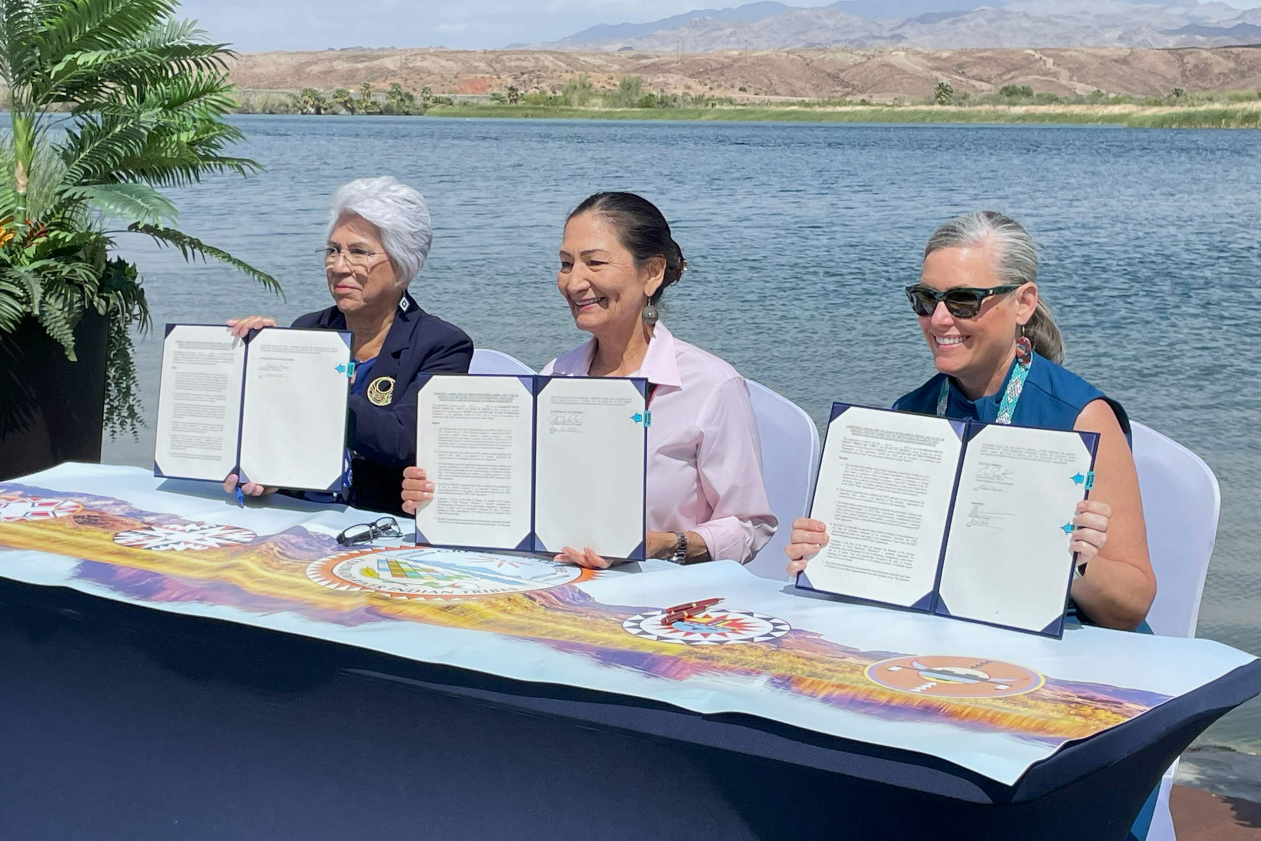
From left: Amelia Flores, Colorado River Indian Tribes chairwoman, Secretary of the Interior Deb Haaland and Arizona Gov. Katie Hobbs approve the tribe’s authority to lease, exchange or store its portion of Colorado River water. Credit: Noel Lyn Smith/Inside Climate News
At a ceremony at the tribe’s waterside resort in April, [Interior Secretary Deb] Haaland, Colorado River Indian Tribes Chairwoman Amelia Flores, Arizona Gov. Katie Hobbs signed the agreement, which will enable the 4,300-member tribe to move forward with enacting lease agreements, river conservation and other strategies. Over the past two months, Arizona tribes have celebrated several victories in the effort to secure water rights and the resources to use the life-giving water at the heart of their communities and for tribes with the most senior water rights to have more direct control over those waters…
CRIT first pondered leasing some of its water 40 years ago, said the tribe’s former water attorney Margaret Vick. But despite having senior water rights dating back to 1865 when its reservation was established, the tribe was legally barred from leasing some of its Arizona-side allocation of 662,000 acre feet. The tribe also has rights to about 57,000 acre feet on the California side of its reservation…In May, the Tohono O’odham Nation received nearly $1.59 million for a new treatment plant to address rising arsenic levels in groundwater wells in Sells. The San Carlos Apache Tribe will replace wells impacted by E. coli contamination thanks to a $986,000 grant. Those two grants were part of more than $225 million allocation to improve water and wastewater infrastructure across Indian Country. The Navajo Nation, Hopi Tribe and San Juan Southern Paiute Tribe signed onto the Northeastern Arizona Indian Water Rights Settlement Agreement, which, if confirmed by Congress, will enable the three tribes to claim a share of Colorado River water.
Sprinklers irrigate a field in Hamilton County, Kansas, where some farmers have petitioned to be removed from a local groundwater management district. State lawmakers are pressuring the district to do more to conserve water in the Ogallala Aquifer. (Allison Kite/Kansas Reflector)
Click the link to read the article on the Kansas Reflector website (Allison Kite and Kevin Hardy):
June 13, 2024
After decades of local inaction, Kansas lawmakers are pushing for big changes in irrigation.
This story, the second in an occasional series about water challenges facing the American heartland, is a partnership between Kansas Reflector and Stateline. Read the first story here.
JETMORE, Kan. — An inch or two of corn peeks out of the dirt, just enough to reveal long rows forming over the horizon.
Sprinkler engines roar as they force water from underground to pour life into dusty fields.
Thunder cracks. The wind whips up dirt as a trail of dark storms looms. The crashing hot and cold fronts would probably set off tornado sirens — if there were any in this remote part of the state.
It’s spring in southwest Kansas, a hub for the nation’s crop, dairy and beef industries.
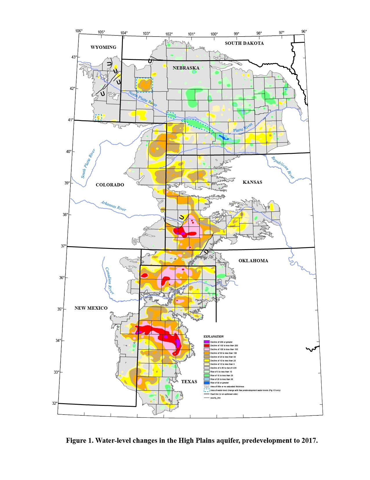
Ogallala aquifer via USGS
As the familiar seasonal rhythm plays out, some farmers are bracing for major changes in how they use the long-depleting Ogallala Aquifer. The nation’s largest underground store of fresh water, the Ogallala transformed this arid region into an agricultural powerhouse.
After 50 years of studies, discussions and hand-wringing about the aquifer’s decline, the state is demanding that local groundwater managers finally enforce conservation. But in this region where water is everything, they’ll have to overcome entrenched attitudes and practices that led to decades of overpumping.
“It scares the hell out of me,” farmer Hugh Brownlee said at a recent public meeting in the district on the changes to come.
Last year, Kansas lawmakers passed legislation squarely targeting the Southwest Kansas Groundwater Management District, which spans a dozen counties. Unlike the two other Kansas districts that sit atop the crucial aquifer, this one has done little to enact formal conservation programs that could help prolong the life of the aquifer. The new law aims to force action.
The district has come under fire from legislators increasingly incensed by its substantial travel expenses, its lack of formal conservation policies and its alienation of farmers who are trying to save water. At a hearing in February on a bill meant to help farmers in one county leave the district, a Kansas House member floated the idea of doing away with the organization, also known as Groundwater Management District 3, altogether.
“Maybe that’s something that we need to consider — just dissolve GMD 3 so that these other boards that are doing good work are not affected,” said state Rep. Cyndi Howerton, a Republican from Wichita.
District leaders think the criticism is unfair. But even they acknowledge that painful change is brewing. Change that will force farmers to cut back.
Clay Scott, a farmer and rancher who has served on the district’s board for more than two decades, said most local farmers are ready to change. That’s partly because they don’t want to give the state a reason to impose its own restrictions, he said.
Scott said the problem of overuse has been generations in the making and can’t be reversed overnight.
“It’s going to take us time to turn this ship around,” he said.
But critics say the organization has already had plenty of time. Decades.
“My biggest disappointment with GMD 3 is they’ve had 50 years to build a consensus on conservation and they failed to do it,” said Frank Mercurio, who works for a dairy with facilities across southwest Kansas and southeast Colorado.
The discussions here mirror those occurring not just across the eight Ogallala states (Colorado, Kansas, Nebraska, New Mexico, Oklahoma, South Dakota, Texas and Wyoming) but also across the country. The dual threat of climate change and overpumping of groundwater threatens farming and agricultural communities coast to coast.
Outside the town of Syracuse, Kansas, Brownlee runs a small farm with dryland and irrigated fields divided by a curvy two-lane blacktop. More than 200 years ago, Mexican and American traders following the Santa Fe Trail crossed this part of the plains on ox-pulled wagons.
Brownlee, who farms part time and drives a propane truck, said he understands the shrinking water supply. But he thinks the state is to blame — not farmers. Decades ago, Kansas officials issued more water rights than the aquifer can sustain.
The state should fix that, rather than punishing farmers with across-the-board cuts, he said.
“They want to be able to flip the switch and just stop it,” Brownlee said. “That’s not going to do anybody no good.”
Hugh Brownlee walks by a dry creek bed on his farm near Syracuse, Kansas. Farmers such as Brownlee could face irrigation cutbacks following legislation from Kansas lawmakers. (Allison Kite/Kansas Reflector)
‘Should have been done 40 years ago’
In a community center on Main Street in Lakin, Kansas, a few dozen farmers in feed and seed hats last month pulled folding chairs off a big metal rack.
Just below the stained drop ceiling panels, a tilted projector shone onto a bare beige wall the district’s plans to comply with the new law. The first step: identifying priority areas for its conservation efforts.
An expert from the Kansas Geological Survey pointed to maps of the district. Blood red blots showed where aquifer conditions were most severe. In some parts of the district, the aquifer is already all but gone. Other areas have more than 60 years of water left even if they don’t cut back their usage.
But at this and a series of meetings across southwest Kansas, district leaders outlined plans to declare its entire territory a priority area. Some critics viewed the move as a stall tactic, but district leaders say it leaves all options available to them. The district in 2026 will have to present an action plan, which it says will reflect the huge variations in aquifer conditions.
Kansas’ chief engineer, Earl Lewis, who will evaluate the board’s plan and future conservation efforts, said the board likely can designate the whole region a priority, though he’s not sure it meets “the spirit” of the law.
In the series of meetings, farmers ran through familiar questions, concerns and excuses.
What about the farms pumping the aquifer down in Oklahoma?
What about all the new dairies and feedlots coming in?
What about city drinking water wells?
Crop irrigation accounts for 85% of all water use in Kansas — even more in western Kansas.
The group also discussed the possibility of paying growers to shut down their wells.
But one farmer said he can’t farm his sandy soil without irrigation. After the meeting, he declined to be named, saying he could get in big trouble for sharing his real feelings.
Local farmer Steve Sterling interjected at the first meeting in Garden City to say conservation planning “should have been done 40 years ago.” Some of his neighbors abandoned their farm when he was 12, he said. They were out of water.
Katie Durham, who manages Groundwater Management District 1 in western Kansas, drove south to attend some of the meetings in GMD 3. She said she hoped the farmers in attendance understood that change is coming under the new law.
“This is happening,” Durham said. “I just hope that urgency and sense of wanting to be involved and kind of taking ownership of the future on a local level — I just hope people are understanding that.”
McGuire, V.L., and Strauch, K.R., 2022. Data from U.S. Geological Survey.
‘This is a cultural thing’
Between the 1950s and the 1970s, Kansas created the fundamental problem that allows aquifer depletion by granting farmers the right to pump more water out of the aquifer each year than returns to it via rainfall. But the state has largely left it up to locals to find solutions to the problem.
The state charged the three groundwater management districts over the Ogallala with protecting both the agricultural economy and aquifer water. But their five-decade histories primarily have been marked by further decline of the Ogallala Aquifer. Two districts have made progress in recent years and helped farmers to slow, or even stop, the decline.
GMD 3 is different.
Burke Griggs, a water attorney who previously worked for the state, argues the southwest Kansas district isn’t doing much compared with the other two.
“The law is the same. The regs are basically the same,” he said. “This is a cultural thing.”
He argues the state should take a firmer stance in aquifer management.
“I think it’s time for a reckoning,” Griggs said.
District officials say farmers in GMD 3 have used 13% less water in the past 10 years compared with the decade before. But it’s unclear how much of that change is intentional — from conservation — or a reflection of the limited water available in the declining aquifer.
Though its territory is twice the size of the other two districts’ combined, the southwest Kansas district hasn’t accomplished as much. The other districts have offered financial assistance to farmers investing in water-efficient irrigation systems and championed large-scale restrictions on pumping.
GMD 3 has done none of that. Between 2010 and 2022, financial records show, the district spent, on average, only 13% of the money it budgeted for conservation. In most years, it didn’t spend anything on conservation.
Mark Rude, who has been the organization’s executive director for nearly two decades, said the district’s entire budget supports water conservation. The district takes in more than $1 million per year and spends 70% of that on salaries and benefits, according to financial documents received through a records request. The rest goes largely to office equipment, travel and other administrative costs.
“I mean, ultimately, that’s why we’re here,” Rude said, “and if you look at the $600,000-plus we (spend) on staff, why is the staff here?”
This summer, the district board will consider a 38% increase in the fee it imposes on water users, which is expected to raise more than $200,000 each year. Rude said that money would primarily be used to hire two new employees to help with grant projects offering technical assistance to farmers trying to conserve water.
Between 2010 and 2022, GMD 3 spent about four times as much on travel for Rude and staff as on water conservation. On average, the GMD pays more than $20,000 each year for Rude’s travel — plus another $20,000 for the rest of its staff members — compared with $10,000 for water conservation.
Last year, the district changed its financial statements, reporting fewer, broader categories. The new financial structure did not distinguish travel costs from other expenses.
Rude defends the spending by saying it’s necessary to build the partnerships and relationships needed to achieve district goals, including its aim of piping in water from out of state.
“How else do you do it?” Rude said. “Really, please show us: How else do you do it?”
Mark Rude, executive director of the Southwest Kansas Groundwater Management District, addresses farmers at a community center in Lakin, Kansas, on May 20, 2024. Kansas lawmakers are requiring the district to create a new plan to help preserve the Ogallala Aquifer, which spans eight states. (Allison Kite/Kansas Reflector)
Last year, lawmakers from both sides of the aisle questioned Rude during a committee hearing on why the district wasn’t doing more to conserve groundwater.
State Rep. Lindsay Vaughn, an Overland Park Democrat, said during a legislative hearing that the district had 50 years to act but made no progress on addressing aquifer decline.
“The issue is only becoming more urgent,” Vaughn said, “and I am discouraged to see that there aren’t any real efforts right now to get the ball rolling and coming up with a long-term plan.”
The district’s lack of action also has drawn the attention of farmers who mounted a campaign to secede.
In 2022, Hamilton County farmers submitted a petition to withdraw from the groundwater district.
They characterized the organization as a bureaucratic mess with a ballooning budget that spends little on conservation, obstructs programs meant to slow groundwater decline and provides no benefits for dryland farmers who also pay assessments.
Kansas Aqueduct route via Circle of Blue
The petition criticized groundwater district leaders’ fixation on building an aqueduct across the state. The organization twice has trucked water 400 miles from the Missouri River to western Kansas in an effort to sell the idea.
In their petition, Hamilton County farmers said the project only managed to move and dump water with “no tangible benefit to anyone.”
Richard Geven, owner of the 10,000-head Southwest Plains Dairy, was among those who signed the petition to leave.
Geven, a native of the Netherlands who has been farming here for nearly 20 years, said he sees little reason for the groundwater district. When he has issues with his wells or needs clarity on water rights, he works with state regulators.
But he pays assessments every year to the district.
“We don’t know what the purpose is,” he said. “We think, ‘What are they doing? We don’t need them.’”
Vast expanses of wheat grow in Southwest Kansas. Long an agricultural hub, the region is facing renewed pressure from state leaders seeking to preserve the quickly depleting Ogallala Aquifer. (Kevin Hardy/Stateline)
‘They will face the same choices’
Across most of the Ogallala states, governments have preferred to encourage voluntary conservation rather than mandating steep cutbacks, said Kevin Wagner, director of the Oklahoma Water Resource Center at Oklahoma State University.
Oklahoma allows farmers to use up to 2 feet of water each year on every acre they own. But usage is not monitored. Farmers report annual estimates of water usage.
And the state has not banned the drilling of new irrigation wells.
Researchers have closely monitored the decline of the aquifer across the Oklahoma Panhandle — it’s dropping about half a foot per year, he said.
But there’s no telling how much individual farmers are using or conserving.
“When I talk to producers in Oklahoma, there’s a lot of feeling that Oklahoma producers are doing just as good at conserving as their neighbors in Texas and in Kansas,” Wagner said. “And honestly there’s no data out there right now.”
Oklahoma state Rep. Carl Newton, a Republican, introduced legislation this year that would require irrigators to meter their water use.
The measure passed, but amid steep opposition from agriculture trade groups, Republican Gov. Kevin Stitt vetoed it. He called it government overreach and a violation of private property rights.
Newton said he plans to reintroduce the bill, which he described as “a starting point” for conservation efforts.
“You’ve got to find out where your problem is to get an idea of where to go,” he said. “That was my whole goal.”
Kansas started requiring irrigators to install meters and report water usage in the early 1990s.
Formal conservation efforts have been underway in other parts of the region for years.
In Nebraska’s Republican River Basin, groundwater regulators have helped producers install soil moisture probes and more accurate meters that use telemetry to conserve. And Colorado offers a master irrigator course to help farmers grow crops more efficiently.
In Wichita County, Kansas, just beyond the bounds of GMD 3, farmers created a conservation program that launched in 2021. Called a local enhanced management area, farmers committed to cutting water use by at least 25%.
Farmer Don Smith said the program provided a chance for locals to act together before the state stepped in.
Smith, his brother and nephews together run Smith Family Farms, which grows corn, wheat and milo against a backdrop of massive wind turbines. Shiny grain bins emblazoned with the family name tower near the office, where a curious Australian shepherd keeps watch, rearing up on hind legs to peer through the door.
The farm is mostly dryland. Its irrigated fields draw upon 38 wells, connected to advanced sprinkler systems that help reduce water use. The farm also has transitioned to no-till methods, which keeps more moisture in the soil.
Smith said the farm shows that growers can save water and still make money. Lower water use does lead to lower yields, he said. But it also makes growing crops less expensive.
Smith knows the groundwater district just to his south has deeper wells and more abundant water. But the declining aquifer eventually will force changes there.
“I guess it’ll be interesting to see if at some point somebody responds before the gun’s to their head,” he said. “They will face the same choices we all north of them have had to face.”
In Wichita County, Smith said, test wells show the changes have slowed or even reversed aquifer decline. But even so, he doesn’t think irrigated farming will last forever. He expects the day will come when pumping small amounts of water won’t be worth the cost.
“We all understand that we are sucking water out of a bathtub,” he said. “And the rate we’re taking it out of the bathtub exceeds the rate Mother Nature can put it back in.”