


Click on a thumbnail graphic to view a gallery of drought data from the US Drought Monitor website.
Click the link to go to the US Drought Monitor website. Here’s an excerpt:
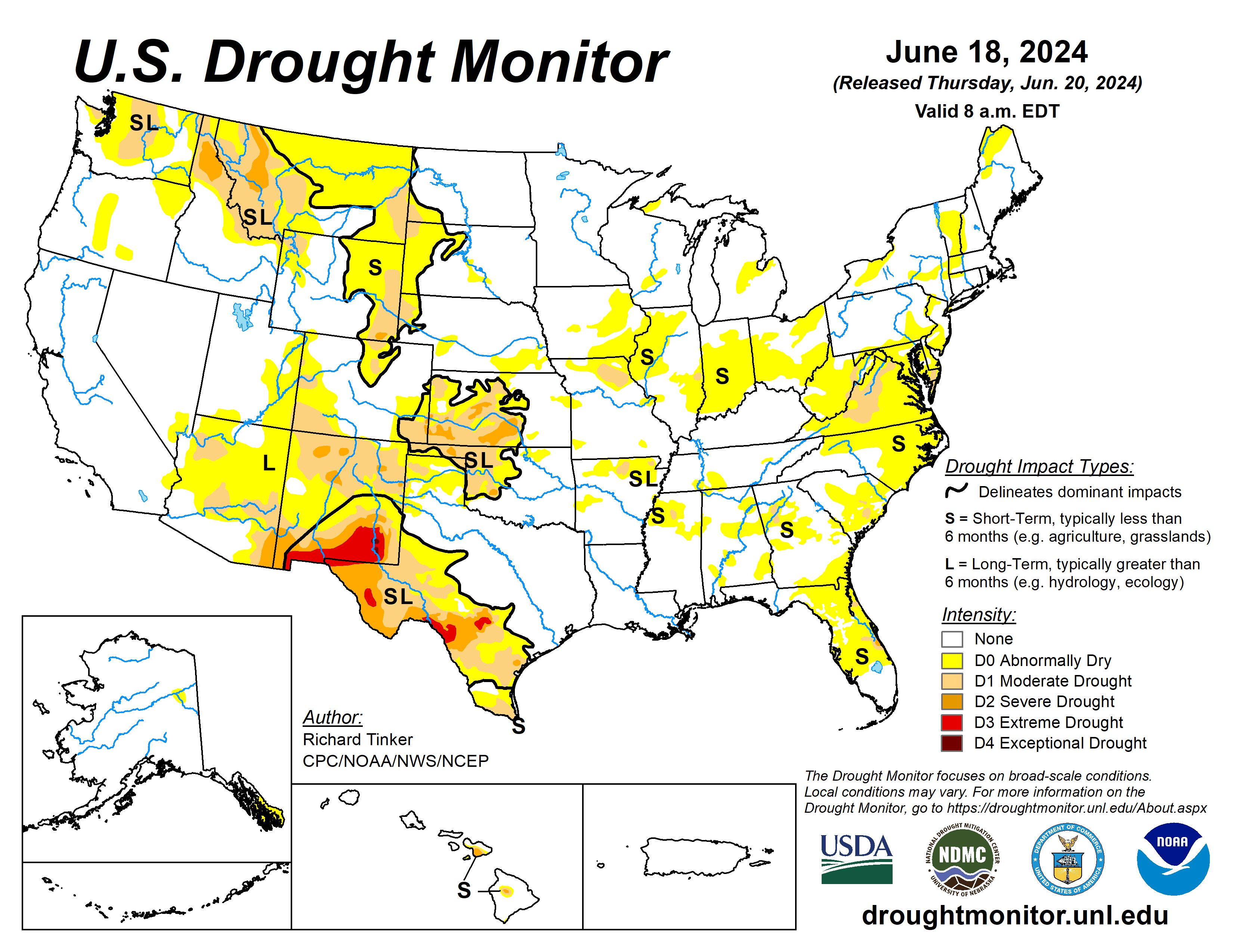
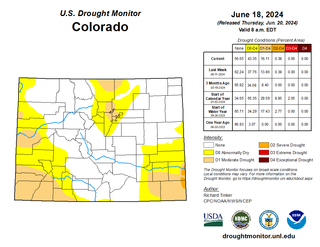
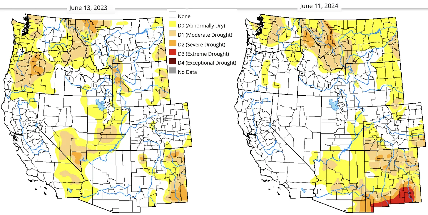
This Week’s Drought Summary
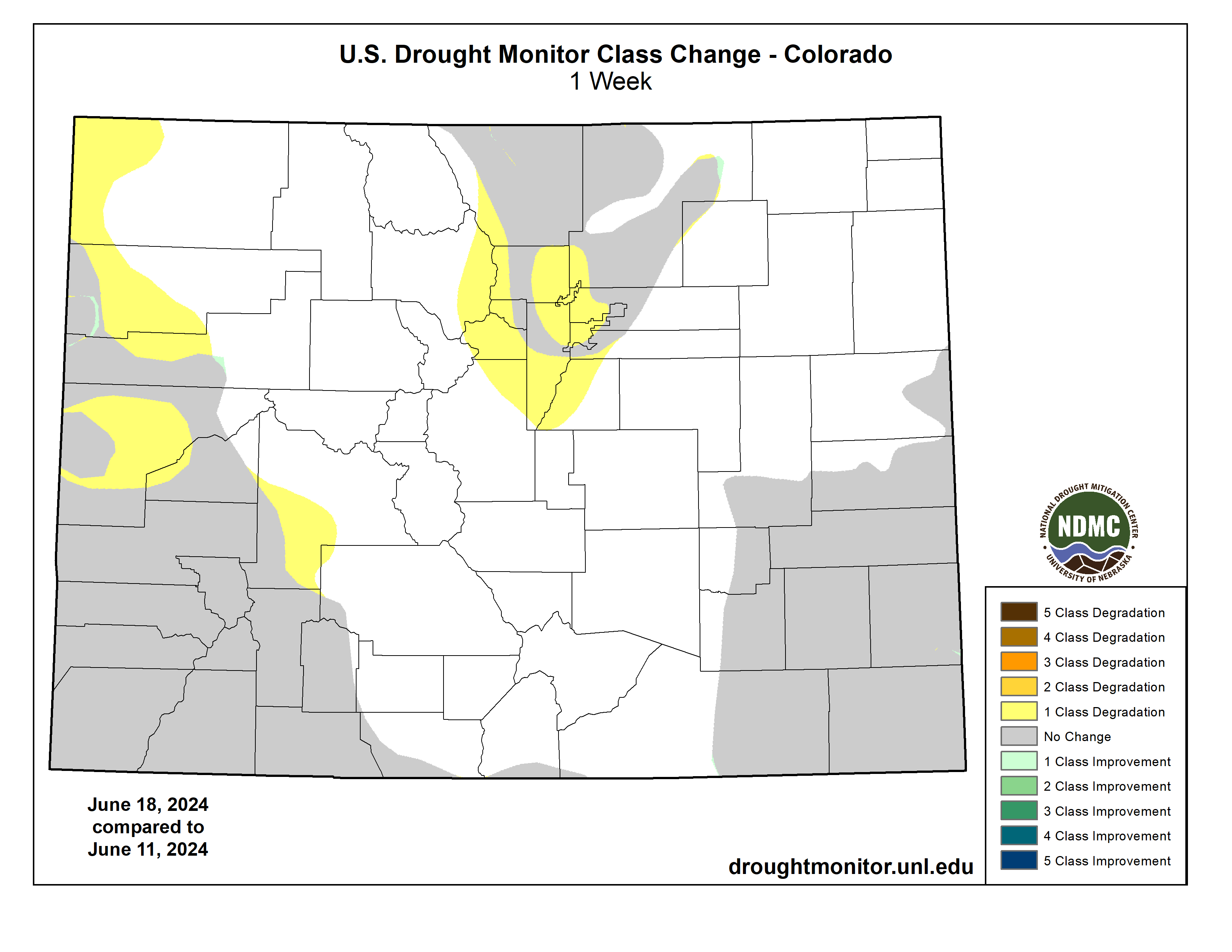
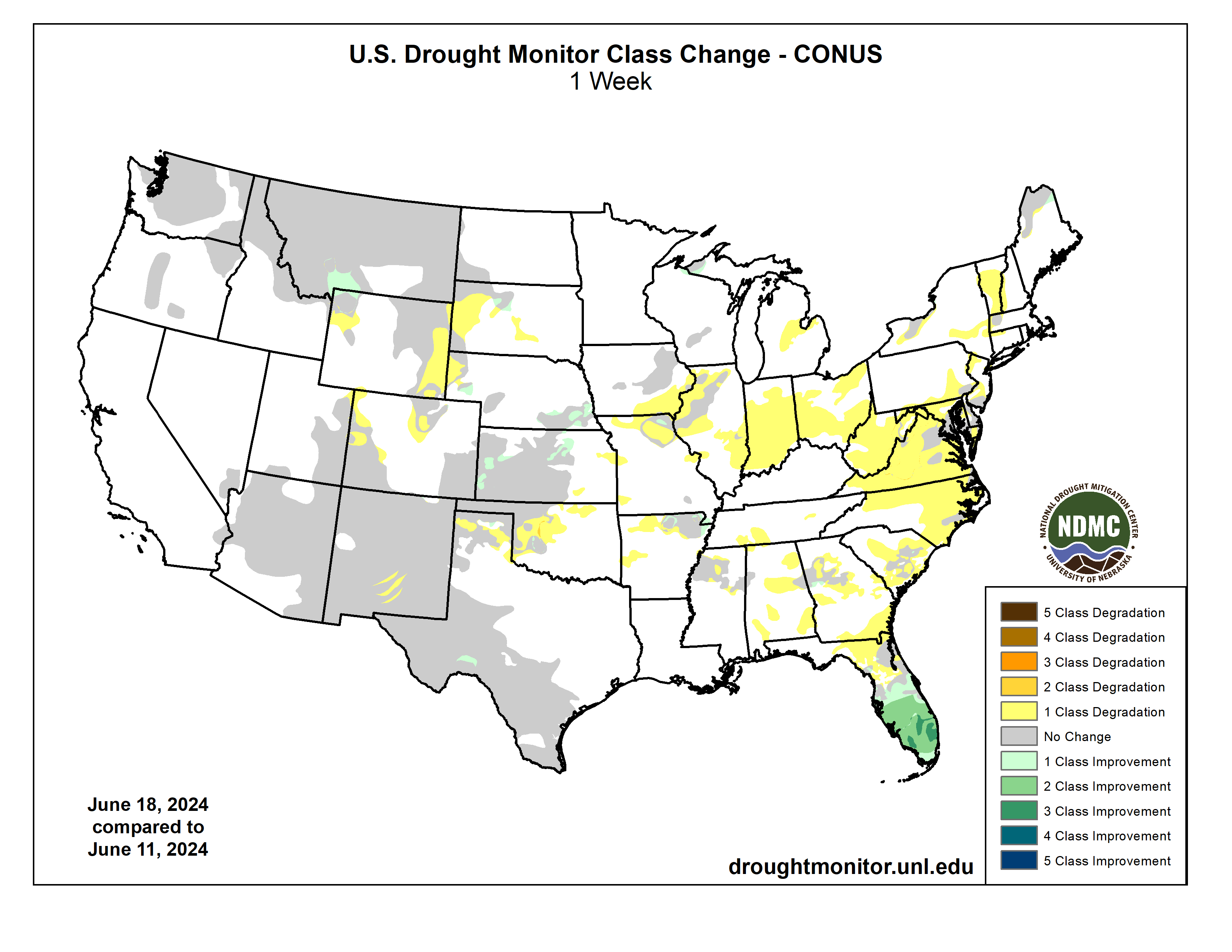
There were big changes in the Drought Monitor depiction of dryness and drought this week compared to last, primarily across the contiguous U.S. east of the Mississippi River. Inundating tropical rains literally washed away the entrenched moderate to severe drought (D1 to D2) that had covered southern Florida. The opposite was the case farther north across most of the Eastern States. Rainfall has been generally below-normal across a majority of this region for the past 1 to 2 months, with subnormal rainfall dating back 3 or more months in some areas. Increasingly, above-normal temperatures have accompanied the dryness, which has added to the rate of surface moisture depletion. Temperatures have had the greatest impact on conditions in the climatologically-hotter areas across the South until late this past week, when excessive heat started to engulf the Great Lakes and Northeast. Declining streamflows and dropping soil moisture started to become obviously apparent this past week over large sections of the East, and as a result, there was an expansive increase in new D0 coverage east of the Mississippi River and north of central Florida, with only small spots in Georgia and Maine experiencing any discernable relief. Farther west, although changes were not as expansive, both south-central and north-central portions of the Plains and Rockies also saw significant areas where dry conditions developed or intensified. There were other areas of heavy rain outside southern Florida, but most of it fell on sections of the Upper Midwest that have received consistently above-normal precipitation for at least several weeks, thus bringing no changes to areas of dryness and drought. West of the Mississippi River, limited improvement was introduced in relatively small swaths in northeastern Arkansas, central and western Kansas, southern Nebraska, southwestern Montana, and a few adjacent locales…
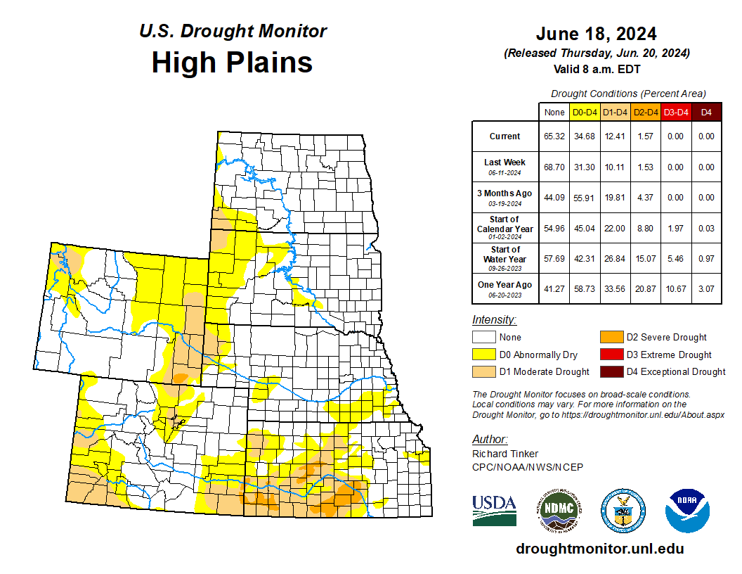
High Plains
Moderate to heavy rains soaked a sizeable part of the High Plains Region last week. Most fell on locations not experiencing antecedent dryness and therefore provided no relief, but several areas that have been entrenched in drought did record enough rainfall to consequentially improve conditions. Heavy rainfall totals of 2 to locally 4 inches were fairly common over a fairly broad swath from northeastern to southwestern Kansas, making this one of the few states to experience more relief than deterioration last week. Patches of 1-catregory improvements were introduced where heavier rains fell, continuing a general trend of decreasing dryness observed since mid-May. At that time, almost one-third of the state was covered by severe drought (D2) or worse. Four weeks later, less than 8 percent of the state is similarly dry. Farther north, heavy rains also affected parts of areas experiencing antecedent dryness in southern Nebraska. Generally 1 to 3 inches of rain eliminated moderate drought (D1) in south-central Nebraska, and whittled away some D0 in some other parts of south-central Nebraska. Moderate to heavy rains also ended D0 conditions in a few small areas in central South Dakota as well. Farther west, however, continued dry and warm weather engendered areas of deterioration in central portions of the Rockies and High Plains, as has been scattered across these areas occasionally for the past several weeks. Burgeoning 60- to 90-day precipitation shortfalls along with acute root-zone moisture and ground water deficits led to a broad expansion of moderate drought (D1) in eastern Wyoming and western Nebraska. The dry week compounded by recent heat and increasing short-term precipitation shortfalls also led to some lesser D0 and D1 expansion in other parts of Wyoming and a few areas across Colorado and the central and western portions of South Dakota…
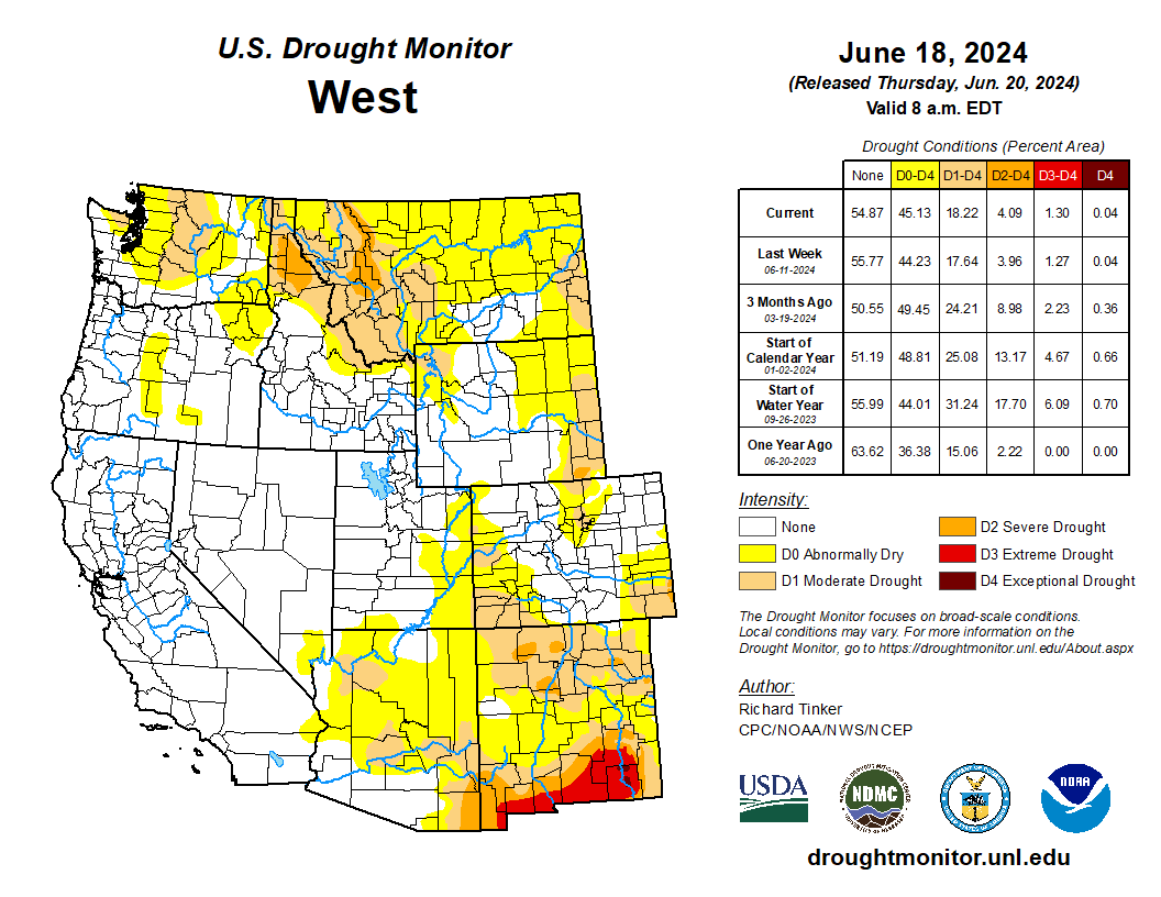
West
Conditions were seasonably dry in this broad region, so in sharp contrast to areas farther east, very few changes were made. But one area of deterioration was in part of New Mexico, based on high wildfire danger and ongoing fires that are threatening dwellings and other structures near the town of Ruidoso. Unusually dry, hot, and windy weather combined with low fuel moisture are abetting favorable conditions for the rapid development and spread of wildfires near and south of Ruidoso, so the D1 through D3 areas in this region were expanded somewhat to the northwest. Meanwhile, improving soil moisture and some recent light to moderate precipitation – especially at higher elevations – prompted improvement from moderate drought (D1) to D0 in southwestern Montana and a small part of adjacent Wyoming…
South
D0 expansion was observed in this region as well, but mostly near and east of the Mississippi River, and not nearly to the extent seen farther north and east. New, relatively small areas of D0 were brought into south-central Tennessee and part of east-central Tennessee, with abnormal dryness expanding from the areas covered last week into somewhat larger parts of north-central Mississippi, and portions of northern and western Arkansas. In contrast, light to moderate rains (up to 1.5 inches) eased brought just enough relief to prompt 1-category improvements in parts of northeastern Arkansas, and scattered moderate rains (1 inch or more) with isolated heavy amounts (up to 3 inches) moistened parts of the northeastern fringes of the D0 region in central Texas, and some patches in eastern New Mexico and western Texas. Meanwhile, growing short-term deficits have begun to quickly reduce surface moisture levels in western Oklahoma east of the Panhandle, so this entire region has been placed in moderate drought (D1). Streamflows declined significantly this past week, with several locations reporting flows more indicative of D2 to D4 conditions if no other parameters were considered, especially over the southern half of this area. Declining streamflows and increasing short-term rainfall deficits prompted new D0 areas in parts of northern and western Arkansas where little or no rain fell last week, and similarly low streamflows were observed in parts of this region as well…
Looking Ahead
In the 24 hours after the valid period for this Drought Monitor ended (8 a.m. EDT Tuesday June 18, 2024), excessive to historically heavy rains fell on the central Oklahoma Panhandle and some adjacent locales in Texas and, to a lesser extent, Kansas. Over 7 inches of rain inundated some sites in the central Oklahoma Panhandle during the 24-hour period. Climatologically, these amounts are expected only once every few hundred years, at most, in this region. During the next five days (June 20-24, 2024), moisture from the first named tropical system in the Atlantic basin this year (Tropical Storm Alberto) is expected to stream into southern Texas, dropping 3 to locally 8 inches of rain from Webb County (north of Laredo) and San Patricio County (north of Corpus Christi) southward into Mexico. An inch or more is possible as far north as Del Rio and East Matagorda Bay. Farther north, heavy to excessive rains of 3 to 6 inches are expected to drench a swath from southeastern South Dakota through much of southern Minnesota and into part of northern Wisconsin – an area frequently affected by heavy rains over the past several weeks – and a smaller area over southwestern Colorado. Amounts exceeding 1.5 inches are forecast from parts of the north-central Great Plains eastward through the upper Mississippi Valley and the northern and western Great Lakes region, with similar amounts expected over much of New England and adjacent eastern New York, part of northeastern Florida and some adjacent areas, and scattered higher elevations in northern New Mexico and western Colorado. In contrast, fairly dry weather – featuring a few tenths of an inch of precipitation at best – is expected in the areas of dryness and drought affecting the Far West, Intermountain West, central and northern Texas, most of Oklahoma, interior portions of the lower Mississippi Valley and Southeast, the lower Ohio and Tennessee Valleys, and the mid-Atlantic Piedmont. Other locations across the contiguous United States are forecast to receive near typical amounts for a week in mid-June.
Most of the contiguous states are expected to average warmer than normal for the 5-day period, with all areas north and east of the middle and lower Mississippi Valley, the immediate Gulf and South Atlantic Coasts, and Florida forecast to average at least 2 deg. F above normal. Similar anomalies are anticipated in the central and south-central Plains, the northern half of the Rockies, the Intermountain West, and the Far West. Parts of interior California, the northern Great Basin and adjacent northern Intermountain West, south-central Great Plains, and a large swath from the middle Mississippi Valley eastward through the mid-Atlantic and adjacent regions are expected to average 6 to 10 deg. F above normal. Subnormal mean temperatures should be confined to Deep South Texas, much of the Rio Grande Valley, much of the Big Bend, part of the upper Mississippi Valley, and portions of the immediate Pacific Coast
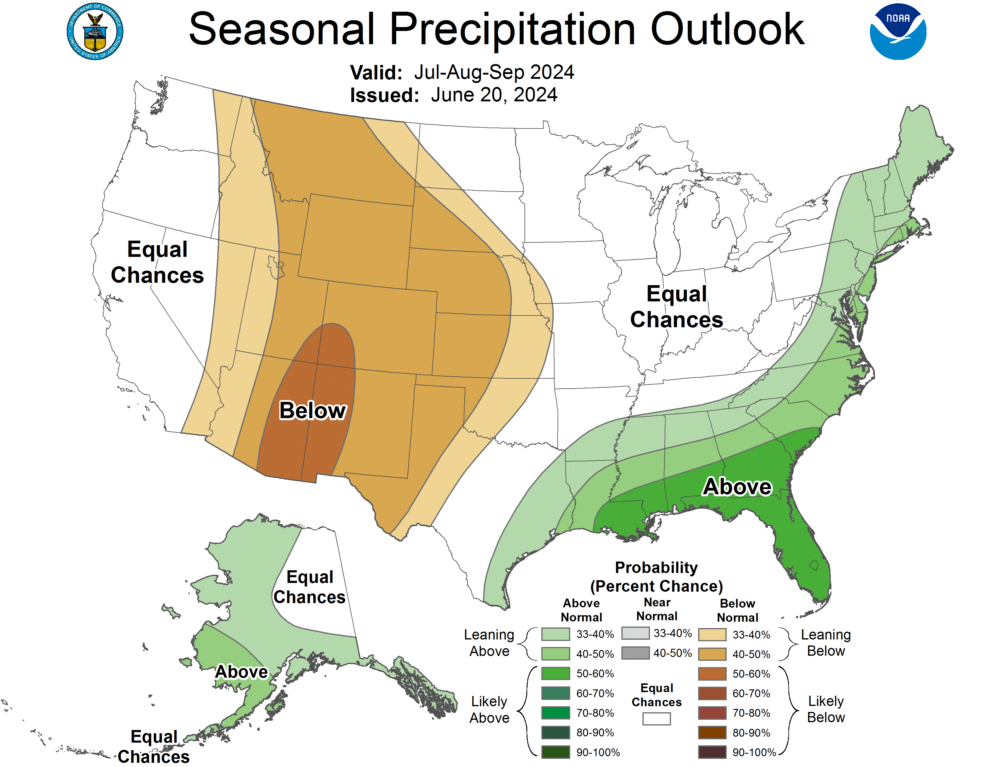
The Climate Prediction Center’s 6-10 day outlook (valid June 25-29, 2024) favors a continuation of above-normal temperatures over a vast majority of the contiguous states, with the greatest odds (over 80 percent) across much of the Four Corners region, and farther east over most of the Carolinas and Virginia. Enhanced chances for below-normal temperatures are restricted to part of the Pacific Northwest. Somewhat enhanced chances for abnormally high temperatures also cover most of Mainland Alaska while below-normal temperatures are favored in southeastern Alaska and across Hawaii. A large part of the contiguous states also show elevated chances for above-normal precipitation, although in most areas the shift of the odds is modest. There is a 33 to near 50 percent chance of surplus precipitation in the Pacific Northwest, most of the Four Corners region, and from the Plains eastward through the Mississippi and lower Oho Valleys, Great Lakes region, southern Appalachians, Southeast, and Florida. Odds for wetter than normal weather exceed 50 percent in much of Arizona and New Mexico. Neither abnormal wetness nor dryness is favored in the Northeast, mid-Atlantic region, northern Rockies, and Southwest while drier than normal conditions are only favored in the Great Basin and adjacent areas in the northern Intermountain West and California. Meanwhile, there are slightly increased odds for above-normal precipitation over the southeastern two-thirds to three-quarters of Alaska and throughout Hawaii.

Click the link to read the article on The Land Desk website (Jonathan P. Thompson):
June 18, 2024
🥵 Aridification Watch 🐫
Wildfire season has hit the West and it’s already a doozy, with several fires popping up in the last few days across California, most centered in the Los Angeles area. Arizona has had a handful of threatening fires this season, a lightning-caused blaze was burning at El Malpais National Monument in New Mexico, and on Monday night a blaze broke out in the Rabbit Valley right on the Colorado-Utah line near Fruita. The National Interagency Fire Center reported near midnight that the latter had burned 500 acres, but other reports said it was significantly smaller.
But probably the scariest incident is the South Fork/Salt Fire in southern New Mexico. The two fires — which seem destined to merge into one — were first spotted on Mescalero Apache land Monday morning. By late Monday night they had erupted into a 5,252-acre and a 2,815-acre blaze, respectively, with the former advancing rapidly toward Ruidoso and forcing the evacuation of the entire village and surrounding areas.
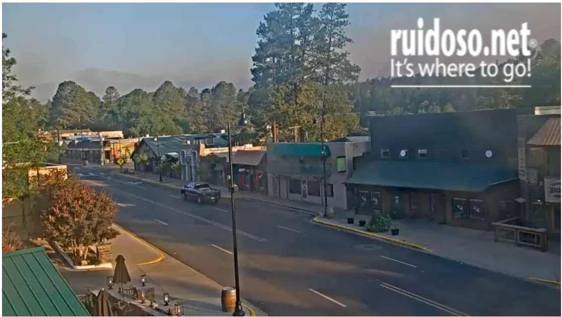
Average to above average snowpacks this winter kept drought at bay in much of the West. But nearly all of New Mexico is experiencing some level of drought, with the southern part of the state — including Ruidoso — being especially dry.
The entire village of Ruidoso is considered to be a wildland/urban interface, or WUI, community as its surrounded by conifer forest. According to a Federal Emergency Management Agency case study, New Mexico and federal forestry officials deemed Ruidoso as having the state’s highest, and the nation’s second highest, risk of catastrophic fire. The primary danger was that tree densities in the surrounding forest were more than 10 times that of a healthy Ponderosa pine ecosystem due to decades of fire suppression and a dearth of prescribed or cultural burning.
The Cree Fire in 2000 spurred the community to action, and in the ensuing years the community created and implemented a fire hazard mitigation plan. The plan, which extends to the county as a whole, was updated and renewed in March of this year. Let’s hope it works.

6,500: The number of new homes that could be coming to the desert just west of Las Vegas if two pending developments are realized.
522 million: Estimated gallons of water those households would consume annually.
Yes, you read that right: Even as the Southwest suffers through the most severe megadrought in the last 1,200 years or so, even as officials throughout the Southwest grapple with how to live within the Colorado River’s shrinking limits, and even in a place where the mercury has topped out above 100 degrees Fahrenheit on 19 days so far this year, developers are looking to build a crapload of new homes. Both proposed developments are near Red Rock Canyon National Conservation Area.
- The less controversial of the two is a 3,000-home master-planned community proposed by Olympia Companies on just over 500 acres of land on the northwest fringe of Las Vegas’s sprawl. Up until November of last year, the land was owned by the American public — i.e. the Bureau of Land Management. Olympia purchased it for $55 million as part of the Southern Nevada Public Land Management Act, a 1998 law that allowed the BLM to sell off developable land on the urban fringe in exchange for protecting more sensitive lands. The Las Vegas Review-Journal’s story gives some details about the planned trail network, but doesn’t mention water. Go figure.
- Then there’s the proposal at Blue Diamond Hill, an old gypsum mine that lies a bit further afield, and right next to the conservation area. Originally the developer wanted to build 5,000 homes here. Clark County pushed back, preliminarily approving 429 homes in 2022. The developers took the county to court, alleging bias and a conflict of interest. Earlier this month the county agreed to pay the developer $80 million and allow it to build about 3,500 homes to settle the issue. Local advocates have been fighting the development since its inception two decades ago, since it would bring sprawl right up to a national conservation area’s doorstep.
Granted, because they’re new homes, they will have more water use restrictions on them than older homes, in terms of how much turf they can have or the size of swimming pools. But it’s not like they’re replacing the older, less efficient homes — they’re still adding to Southern Nevada’s overall consumption of water, energy, space.
I’m sure there are folks who believe building all these new homes will help solve the affordable housing crisis by increasing the overall supply. I doubt it. Aside from being on an industrial extraction site, the Blue Diamond Hill development will surely be rather desirable, given its location, and expensive. And while Olympia says they will have some “entry-level” homes, they don’t say what that means. Home prices in nearby Olympia developments are mostly over $400,000, which doesn’t exactly qualify as affordable. More likely the added supply will — akin to adding lanes to congested freeways — merely induce more demand rather than lower prices in any meaningful way.
But that won’t stop politicians from using the housing crisis to push more public land into developers’ hands. Federal lawmakers are considering two such bills, including one that would make 25,000 acres of public land in Southern Nevada available for development in exchange for wilderness designations for some 2 million acres of federal land. This is being touted as a way to build more affordable housing. Yet the bill does not restrict what kind or price of housing could be developed on the land. (Read Jennifer Solis’s run-down for Nevada Current)
Nor, for that matter, does it say anything about where the water would come from.
Update: Click the link to read “Acreage burned in two Ruidoso area fires rises to 23K as rain bring flash flooding” from the Ruidoso News (Mike Smith). Here’s an excerpt:
June 19, 2024
Two large fires burning around Ruidoso continued to grow as firefighters pursued containment efforts in the air and on the ground, according to the Southwest Area Incident Fire Management Team, and heavy rains brought flooding to parts of the area. The South Fork Fire burned around 16,335 acres as of Wednesday afternoon and the Salt Fire burned over 7,000 acres, read a press release from the agency...Zero containment was noted in the press release as mixed conifer, grass, pine and juniper are the main fuels for both fires.
“Extreme fire behavior occurred across the South Fork and Salt Fires on Tuesday with crowning and long-range spotting observed,” stated the press release…A flash flood watch was active until Thursday morning for the Ruidoso area, according to a forecast from the National Weather Service (NWS) in Albuquerque.