


Click the link to read the article on the KUNC website (Alex Hager):
June 7, 2024
This story is part of ongoing coverage of the Colorado River, produced by KUNC in Colorado and supported by the Walton Family Foundation. KUNC is solely responsible for its editorial coverage.
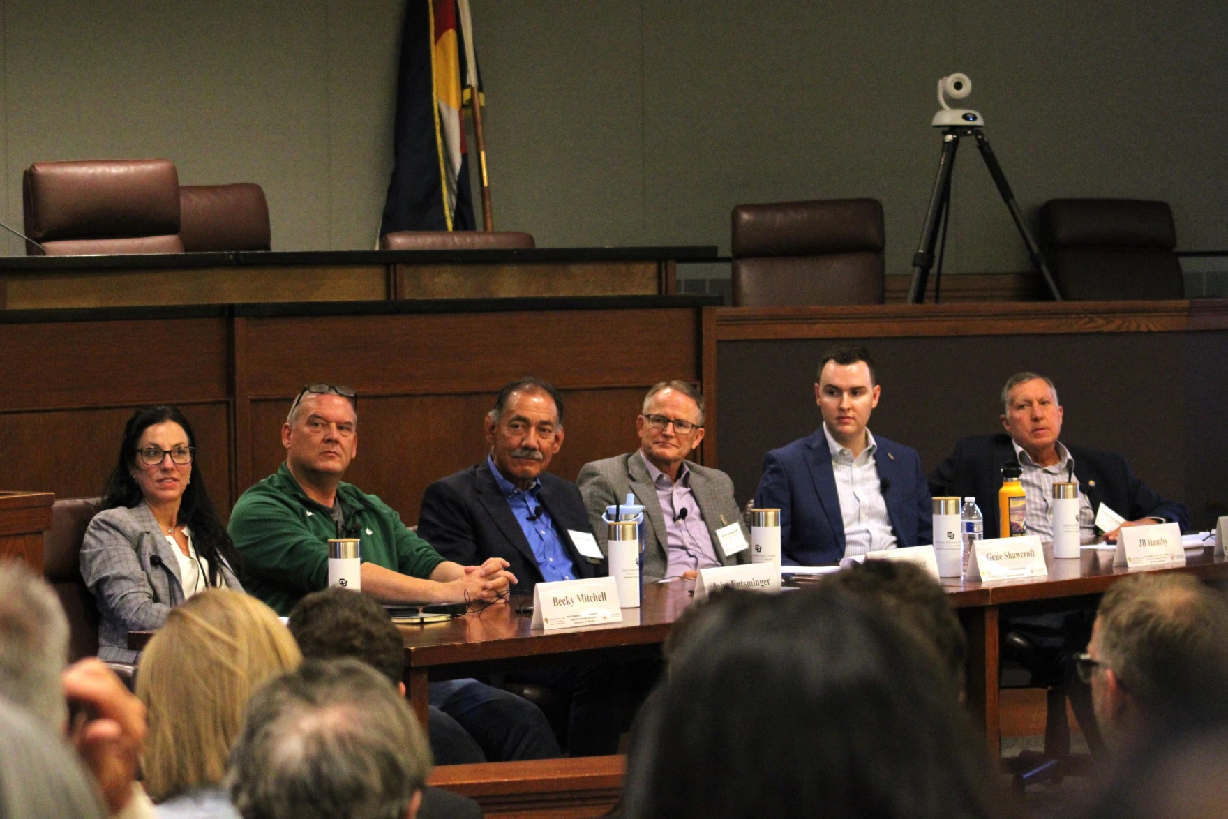
The future of the Colorado River is in the hands of seven people. They rarely appear together in public. This week, they did just that – speaking on stage at a water law conference at the University of Colorado, Boulder.
The solution to the Colorado River’s supply-demand imbalance will be complicated. Their message in Boulder was simple: These things take time.
“We’re 30 months out,” said John Entsminger, Nevada’s top water negotiator. “We’re very much in the second or third inning of this baseball game that we’re playing here.”
The audience was mostly comprised of the people who will feel the impact of their decisions most sharply – leaders from some of the 30 Native American tribes that use Colorado River water, nonprofit groups that advocate for the plants and animals living along its banks, and managers of cities and farms that depend on its flows.
The conference comes in the middle of a tense time for the Southwest’s most important river. The fate of the water supply will have an impact on kitchen faucets in major cities like Denver, Los Angeles and Phoenix, as well as sprawling farm fields which grow produce that gets consumed across the nation.
The current rules for managing the river expire in 2026, and state negotiators are under pressure to agree on a set of replacement guidelines before then. The Biden Administration wants those states to find compromise before the November election, but negotiators hinted that they may take longer than that.
In March, they found themselves divided into two groups, along lines that have split Colorado River states since the early 20th century. Those two camps – the Upper Basin states of Colorado, Utah, Wyoming and New Mexico, and the Lower Basin states of California, Arizona and Nevada – submitted two competing proposals for managing the river.
Since then, they’ve been meeting behind closed doors and say they’re working towards compromise. Details from those meetings have been scant, but negotiators do not appear to be finding much common ground, and are instead divided over major ideological differences about who should reduce their demand on the river.
“I wouldn’t call it a breakdown, but I do think that there was kind of a hiatus,” said Estevan López, the water negotiator from New Mexico. “It’s indicative of just how difficult these issues are and how passionate people are about protecting their state’s interests.”
López and his peers stressed their commitment to reaching agreement eventually, but did not explain exactly how they plan to bridge major divisions in their ideas about water-sharing.
The states do seem to agree on one thing: they all say they’d prefer to avoid this issue going to court. But when asked by the panel’s moderator whether they would commit to avoid taking Colorado River negotiations to the supreme court, none of the state representatives said yes.
Nevada’s Entsminger said the threat of legal action, and the threat of the federal government stepping in and making a decision because the states can’t agree, are actually motivators to work towards compromise. He said the “federal anvil” hanging over negotiators has long been a part of negotiations.
New federal funding
When asked what success looks like on the Colorado River, the federal government’s top Western water official said this.
“Success is continuing the tradition of this basin.”
Camille Calimlim Touton, commissioner of the Bureau of Reclamation, said she sees success as “continuing dialogue,” expressing optimism that the region’s leaders will find some agreement about managing the Colorado River’s next chapter.
But the “tradition of the basin,” is marked by disagreement and century-old rivalries.
When it comes to Western water, the federal government pretty much does what the states tell it. Reclamation, the federal agency which manages the West’s dams and reservoirs, ultimately puts new water rules into law, but depends on the states to help write them.
States, throughout the messy recent history of Western water management, have had trouble navigating the region out of crisis. Climate change has depleted the Colorado River’s water supplies, and the states that depend on it have struggled to cut back on demand.
Previous agreements to limit water demand have staved off catastrophe, but ultimately kicked the can down the road and set up the region’s current crisis.
But there is one thing the federal government can do. Spend.
And spend they have. The Biden Administration has earmarked billions of dollars for water projects in communities around the Western U.S. On the first morning of the conference in Boulder, they allocated a big chunk of infrastructure spending for even more water conservation.
Touton and her colleagues announced that $700 million from the Inflation Reduction Act (IRA) would go to water saving in the Colorado River’s Lower Basin. The agency said that money will go toward “innovative projects like water distribution structures, advanced metering infrastructure, farm efficiency improvements, canal lining, turf removal, groundwater banking, desalination, recycling water and water purification.”
That’s a continuation of existing work. The federal government has already spent a big portion of the $4 billion of IRA money that was allocated for Colorado River projects. Perhaps most notably, sending payouts to farmers and ranchers that offered to pause growing in exchange for a federal check.
This latest $700 million spend may do some of the same. The agency said it could save more than 700,000 acre-feet of water in Lake Mead. That amount is fairly substantial – smaller than the 3 million acre-foot in water conservation proposed in a $1.2 billion deal struck in 2023, but larger than a 100,000 acre-foot conservation deal with the California farm district that uses more water than any other city or farm district in the Southwest.
The Biden Administration’s big spending on Colorado River water conservation has been a key part of buying time for water negotiators, helping to prop up water levels at major reservoirs and create space for talks about longer-term solutions. However, the spending pattern has raised some anxieties about the precedent it might set for the river’s long-term future.
Basically, this kind of funding might not come around again soon.
On the other hand, it could be a means of giving new momentum to a variety of projects that each represent a small piece of the puzzle that is a sustainable future for the Colorado River.
As one state negotiator put it, the Colorado River crisis won’t be solved by a silver bullet, but instead “silver buckshot.”
That buckshot approach is already underway. Hundreds of millions of dollars are currently at work to save water – from programs that pay farmers in rural Wyoming to pause growing and leave their water in the river to massive purification facilities that can help the Los Angeles area keep using more of the water it already has.
Tribes still calling for more representation
Tribes have long been left onthe sidelines of talks about sharing water from the Colorado River. In Boulder, tribal leaders celebrated recent moves to bring Native voices into negotiations, but made it clear that there is still work to be done.
After more than a century of exclusion, tribes are still asking for more representation. Leaders say that a seat at the table for tribes is especially important at this juncture in Colorado River negotiations.
“We’re not participants,” said Dwight Lomayesva, Vice Chairman of Colorado River Indian Tribes. “Our engagement is secondhand at best.”
Some tribal leaders pointed to new government coordination efforts over the past few years as signs of progress. Lorelei Cloud, vice-chairwoman of the Southern Ute Indian Tribe, pointed to a new agreement between the six tribes and the four states that make up the Colorado River’s Upper Basin.
She said leaders in water management need to build on that work.
“I’m asking everybody in here to normalize tribal voices being at the decision making table,” Cloud said. “Letting us make those decisions that affect our people.”

One state negotiator raised the question of whose responsibility it is, exactly, to make sure tribal input shapes the next set of guidelines for the Colorado River.
JB Hamby, the water negotiator for California, said his state had made progress with including tribal leaders, but said the federal government is on the hook for making sure tribal voices are included.
“Everybody’s comments get evaluated equally,” he said. “And ultimately, that’s a Reclamation/Interior decision about how that goes.”
States split into two groups to submit proposals. At least one major tribe, the Gila River Indian Community, has said publicly that it does not support the proposal put forth by Arizona, the state in which its land resides. The two competing state proposals were joined by a letter from tribal groups. A majority of tribes that use Colorado River water added their signatures to the memo, outlining common values they’d like to see represented in post-2026 river management.
Some tribal leaders said Indigenous people aren’t just being excluded, but there are active efforts to keep them from having an influence on the next chapter of water-sharing rules.
“There are whisper campaigns from some of you trying to undermine tribal positions and efforts to try to pit tribes against one another,” said Stephen Roe Lewis, governor of the Gila River Indian Community. “The old divide and conquer strategy.”
Lewis said those campaigns are not public, but thanked Jordan D. Joaquin, president of the Quechan Indian Tribe, for calling out those efforts at a recent meeting.

“During Westward expansion we were conquered by the divide and conquer strategy,” Lewis said. “We can’t let that happen again here in the midst of what we’re dealing with in regards to water policy.”
Lewis said those tactics won’t work, because “at the end of the day, all the basin tribes have a common bond, a historic bond, a sacred bond that trumps the artificial constructs that non-Indians have and still use to carve up” the Colorado River.


Click the link to read the article on The Grand Junction Daily Sentinel website (Dennis Webb). Here’s an excerpt:
May 30, 2024
Reservoir operators in the Colorado River basin upstream of Grand Junction are looking to coordinate water releases in coming days to help bolster the river’s peak runoff volumes to aid imperiled fish. The coordinated peak-flow releases would be the first that have occurred since 2020. Annual conditions such as winter snowpack accumulations, current reservoir storage levels and the pace of spring runoff help determine what years coordinated releases occur. The releases are intended to help federally endangered or threatened fish in a 15-mile stretch of the Colorado River between irrigation water diversion points in the Palisade area and the river’s confluence with the Gunnison River. Those fish include the razorback sucker, Colorado pikeminnow, humpback chub and bonytail. The goal of the releases is to intensify peak spring runoff levels in the river in order to help clean fine sediment out of gravel beds that serve as spawning habitat for the fish. Such flows also can improve habitat for insects and other macroinvertebrates that fish feed on…
The U.S. Fish and Wildlife Service hopes to see peak runoff reach 16,700 cfs during a year like this one under coordinated releases. But during an online meeting of water officials Tuesday as they look to coordinate operations, David Graf, an instream flow coordinator for the Fish and Wildlife Service, said reservoir releases that extend peak flows in the 15,000-15,500 cfs range a little longer also would be beneficial…The Bureau of Reclamation also has been making extra water releases to boost peak flows in the lower Gunnison River in recent days, again in hopes of benefiting imperiled fish. Those flow increases are expected to largely wind down before the Colorado River flows ramp up, meaning there shouldn’t be a threat of flooding downstream of the confluence. Reservoir operators and water users in some years also try to boost flows in the 15-mile reach during particularly low flows later in the summer, and around early April after irrigation diversions have begun but before the river levels increase from spring runoff.

Click the link to read the article on the Summit Daily News website (Robert Tann). Here’s an excerpt:
May 28, 2024
Early predictions point towards a dryer, warmer than normal summer. But a lot can still change — and how much of an influence La Nina will be is hard to say.
So what does the transition from an El Nino winter and spring to a La Nina summer mean for Colorado?
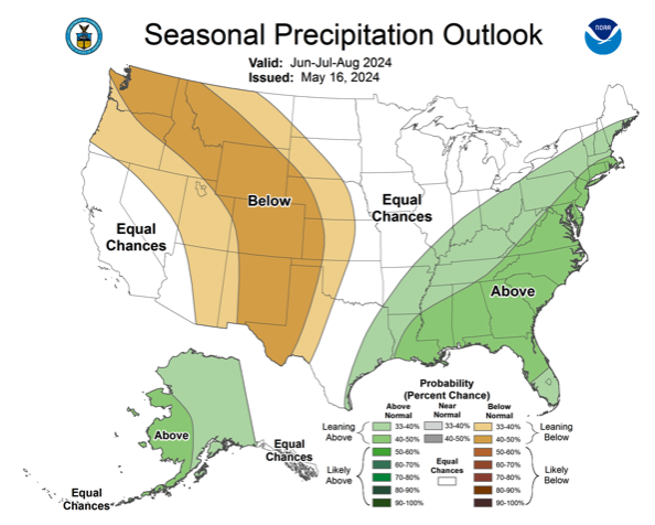
Early predictions show the state could be in for a hot and dry summer. A three-month outlook from the Climate Prediction Center issued on May 16 shows Colorado has a chance of seeing above-normal temperature and below-normal precipitation from June to August. Specifically, northeast Colorado has a 33% to 50% of higher-than-normal temperatures while southwestern Colorado has as much as a 60% to 70% chance. Northwest and southeast areas, as well as central Colorado, have between a 50% and 60% chance for higher temperatures. Practically all of the state has a 40% to 50% chance of seeing below-normal precipitation, according to the projections…
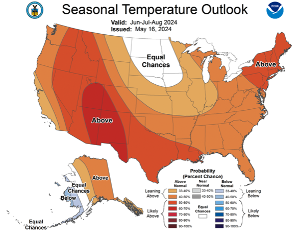
La Nina tends to have the strongest influence on summer weather in areas east of the Rocky Mountains, particularly the midwest. Any impact in Colorado tends to be concentrated around the eastern plains, with La Nina potentially bringing warmer, dryer weather, Johnson added.

Click the link to access the report on the American River website. Here’s the introduction:
Introduction
One year ago, the Supreme Court issued its sweeping decision in the case Sackett v. EPA, which invalidated federal Clean Water Act protections for most streams and wetlands in the United States. Since then, the fight for clean water protections has been at the state level. This report outlines the state of clean water protections one year out from the Sackett decision and why federal protections for our critical waters is vital in the face of worsening climate change and other threats.In the year since the Supreme Court ruling, two states passed or introduced legislation to create new permitting programs to fill the gap in federal protections and eight states passed or introduced stronger laws and policies to strengthen state protections. Two states passed legislation weakening state-level protections, while efforts to weaken state protections failed in four other states.
Click the link to read the article on the Denver Water website (Todd Hartman):
May 21, 2024
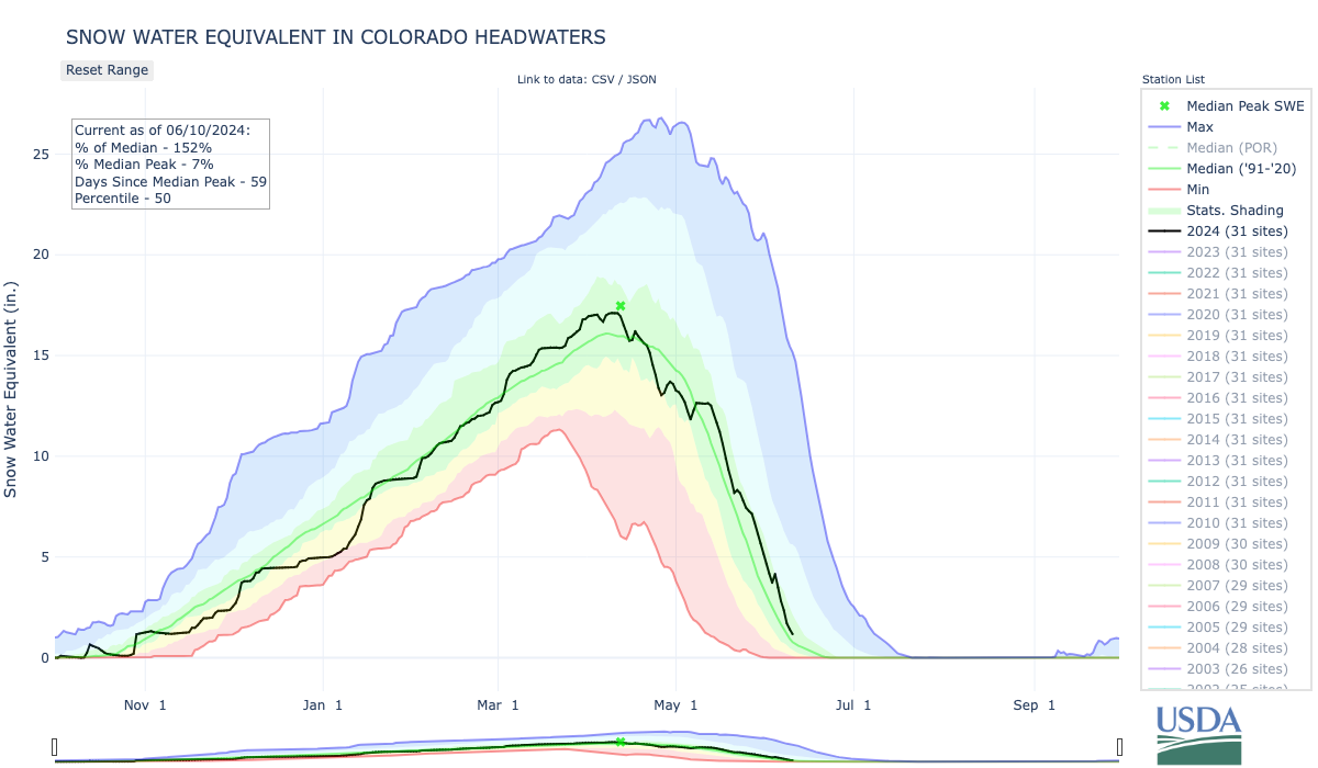
The snow that piled up in Denver Water’s collection system brought good numbers and big surprises this spring.
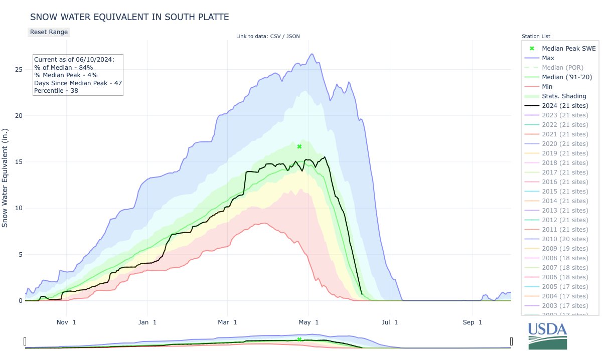
The numbers were strong: A peak at 100% of average in the South Platte River Basin and a peak at 124% in the Colorado River Basin.
Those figures translate to a good snow year and a strong water supply for the warm months ahead.
The bigger surprise was how late into spring the snow stacked up.
In the portion of the Colorado River Basin where Denver Water collects its water, peak didn’t hit until May 15 — three weeks after the typical April 24 high point for snowpack.
Such a late peak is good news for water supplies.
Can you sing the summer watering rules? The Splashstreet Boys, with “I Water That Way.”
It means higher streamflows in the warmer months and reduces wildfire risk, among many other benefits. It often means a boost for recreation, too, with more water available for rafting season and elevated reservoirs deeper into the summer.
“Most importantly, it means water availability coincides with water demand,” said Nathan Elder, Denver Water’s manager of supply. “We don’t see big water demands from our customers in April and May, so if the snowpack peaks later and runs off later in June and July, it keeps our reservoirs stable, sustaining our savings account, so to speak.”
This year, May packed a big punch, delivering a whopping 10% of the snowpack in the Colorado River Basin portion of Denver Water’s system.
“That volume of May snowfall is rare,” Elder said. “We typically see snowpack losses in May and this year it gained.”
The season produced another quirk: snowpack peaked April 10 in Denver Water’s South Platte system, creating a 35-day stretch between peaks in the two basins.
That kind of gap has only occurred once in 44 years of data. That was in 1983, when the peaks were separated by 36 days (April 15/May 21).
Know before you go: Check denverwater.org/Recreation for updates and information about recreation on Denver Water reservoirs.
“This gap makes for a big deviation from the norm, which typically sees both basins hit peak within a couple of days of each other, in late April,” Elder said. “It’s another sign of how variable snowfall patterns can be in Colorado.”
Even so, both basins came in with strong snowpack numbers, bringing Denver Water a second straight year of healthy water supply.
The wealth of snow also means Denver Water will need to spill water from some of its reservoirs, an uncommon situation. The utility prefers to keep water in storage if it can, but a big runoff can force it to release water downstream to make room for more snowmelt coming off the high country.

Strontia Springs, located about 6 miles up Waterton Canyon southwest of Denver, along with Cheesman Reservoir further up the South Platte, began spilling in mid-May.
The healthy winter also means average reservoir storage was at 88% in early May.
That translates to a big splash of additional water — 35,000 acre-feet, greater than the capacity of Chatfield Reservoir south of Denver — above what is typically stored in Denver Water’s reservoirs at this point in the year.
Finally, a cool and wet spring have helped reduce customer demand for water. That, in turn, helps keep water in reservoirs and streams for later use.
“Our customers continue to watch the weather and be smart with their irrigation practices,” Elder said. “They play a big part in the water supply picture.”

Click the link to read the article on the CIRES website:
May 1, 2024
The Colorado River’s future may be a little brighter than expected, according to a new modeling study from CIRES researchers. Warming temperatures, which deplete water in the river, have raised doubts the Colorado River could recover from a multi-decade drought. The new study fully accounts for both rising temperatures and precipitation in the Colorado’s headwaters, and finds precipitation, not temperature, will likely continue to dictate the flow of the river for the next 25 years.
Precipitation falling in the river’s headwaters region is likely to be more abundant than during the prior two decades. The work, published today in the Journal of Climate, comes as policymakers, water managers, states, and tribes look for answers on how to govern the Colorado River’s flows beyond 2025.
“It’s a sort of nuanced message,” said Balaji Rajagopalan, CIRES Fellow and co-author of the study. “Yes, the temperature is warming, but that’s not the full story—you add precipitation and you get a fuller picture.”
CIRES affiliate Martin Hoerling and Fellow Balaji Rajagopalan worked with colleagues from several other institutions to analyze data from a suite of models, including climate projections from the Intergovernmental Panel on Climate Change (IPCC). They determined that while warming temperatures have depleted Colorado River flows in recent decades, precipitation variations have mostly explained the swings between wet and dry periods since 1895.
Because precipitation has explained the vast majority of the ups and downs of the Colorado River’s flows in the last century, climate models forecasting a 70 percent chance of increased precipitation offer hope that the river’s near-term future is not necessarily drier than the last two decades.
“We find it is more likely than not that Lee Ferry flows will be greater during 2026-2050 than since 2000 as a consequence of a more favorable precipitation cycle,” said Martin Hoerling, the paper’s lead author. “This will compensate the negative effects of more warming in the near term.”
The authors analyzed flow records at Lee’s Ferry, the dividing point of the river’s upper and lower basins, dating back to 1895. They confirmed natural changes in precipitation have ebbed and flowed over the century, dictating extreme wet and dry periods for the river, when flows exceeded 15 million acre-feet or dropped well below that key figure. For example, the current megadrought that began in 2000 has resulted mostly from low precipitation which left the river at about 12.5 million acre-feet reducing it to dry sandy river beds in Mexico.
Looking ahead, the team used climate models, including the latest climate projections from the IPCC, to predict the river’s flow 25 years into the future. Most of the water that feeds the Colorado River begins as snow in the region’s headwaters—mountains above 10,000 feet in Colorado and Wyoming. The area represents a small slice of the basin’s geography, about 15 percent, but generates 85 percent of the water that flows through seven states. So precipitation in this “upper basin” is integral to flows in the entire river system. And the team found it is likely to increase, partially offsetting further declines linked to rising temperatures.

While an increase in precipitation is likely, the study finds a low probability that precipitation might not recover and could decline even further. If this happens, ongoing warming would further reduce water resources, resulting in even lower flows at Lee’s Ferry than those that have led to today’s crisis.
“There’s roughly a 4 percent chance that Lee Ferry flows could decline another 20 percent in the next quarter century compared to the last 20 years,” Hoerling said. “So, policymakers who must especially take into account risks of extended dry times, might consider this non-zero threat that the river could yield only 10 million acre-feet a year during 2025-2050.”
As the deadline slowly approaches to determine the next set of guidelines that will govern the river for the next 25 years, the new forecast may shed new light on the future
“Decision makers are confronted with a more optimistic vision of the available supply in coming decades than might have generally been foreseen previously,” Hoerling said, “but also confronted with a small, but perhaps unacceptable, risk for historically low flows.”

Click the link to read the latest briefing on the Western Water Assessment website:
June 7, 2024 – CO, UT, WY
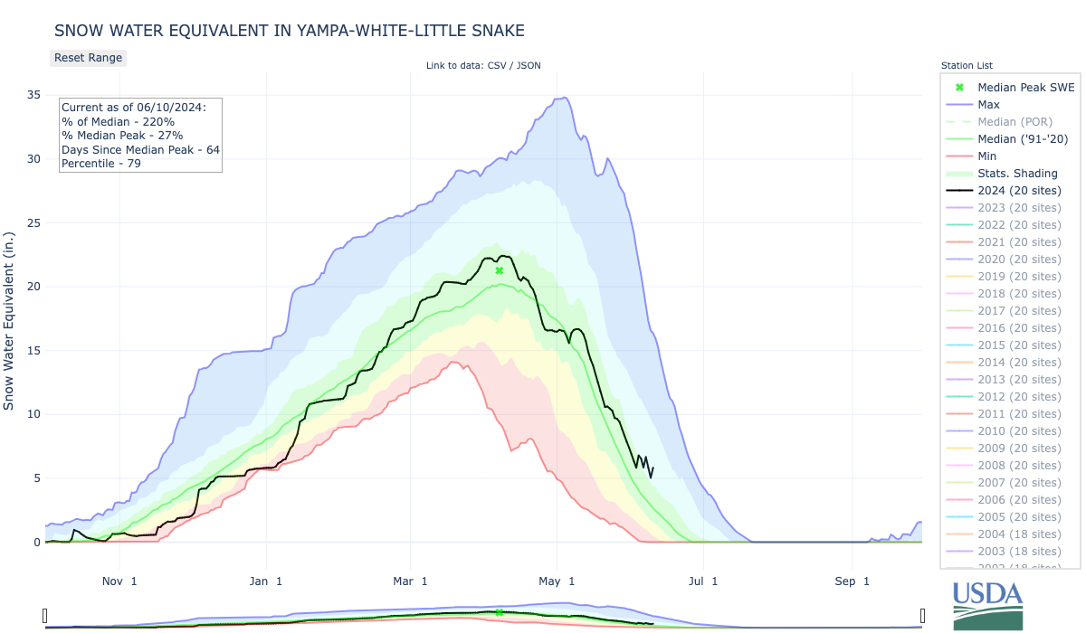
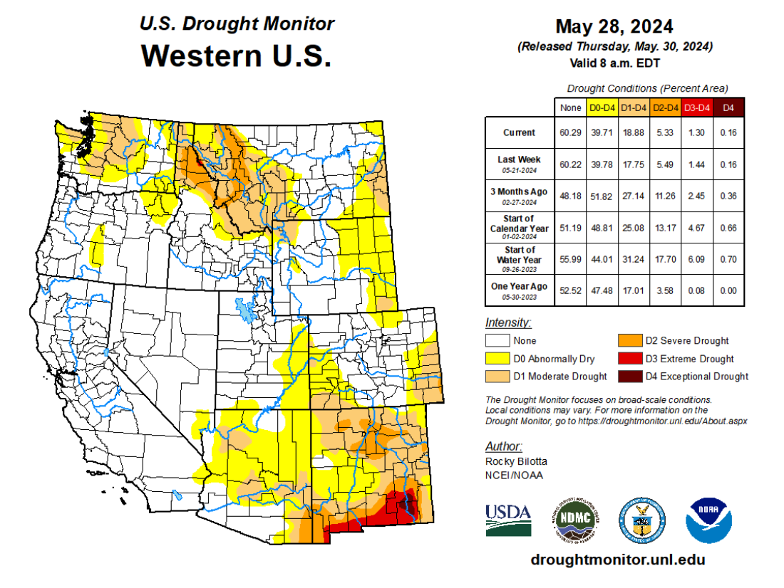
Cool May temperatures coupled with continued snowpack accumulation in some mountain areas slowed snowmelt, leading to above average seasonal streamflow volume forecasts for many river basins including the Arkansas, Gunnison, North Platte, Powder, Provo, Six Creeks, Weber and Yampa. Regional drought conditions contracted to cover 8% of the region, driven largely by drought removal in northern Wyoming. NOAA seasonal outlooks predict an increased probability of above average temperatures and below average precipitation for June-August.
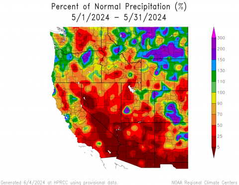
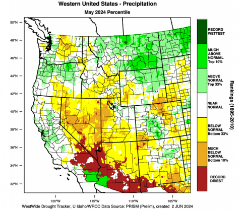
Regional May precipitation was a mix of above and below average conditions. Average to much-above average (150-200%) precipitation fell in northwestern and central Colorado and northern Wyoming. In Utah, the central Wasatch and western Uinta Mountains received near-average precipitation during May. Locations in western and southern Utah, southwestern and northeastern Colorado and southeastern Wyoming received less than 50% of average May precipitation. Isolated locations in Larimer and La Plata Counties in Colorado and Washington County in Utah received record low May precipitation. In Boulder, CO, total May precipitation was only 0.44”, the driest May in 50 years and the second driest on record.
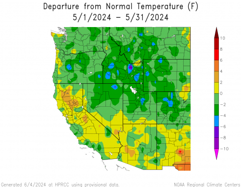
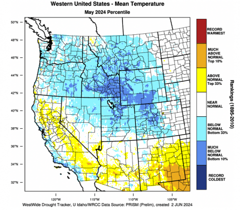
May temperatures were below average for nearly the entire region. In central Colorado, northern Utah and western Wyoming, temperatures were 2-4ºF below average. Region-wide (CO, UT, WY), May 2024 was the coldest since May 2019.
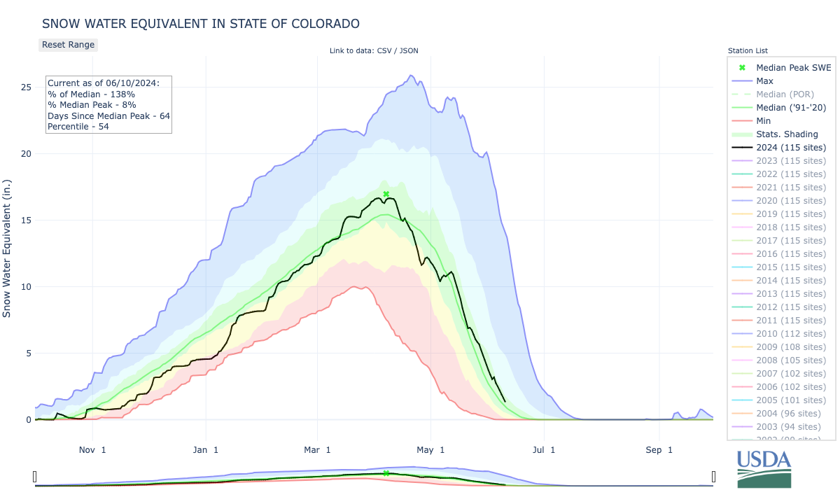
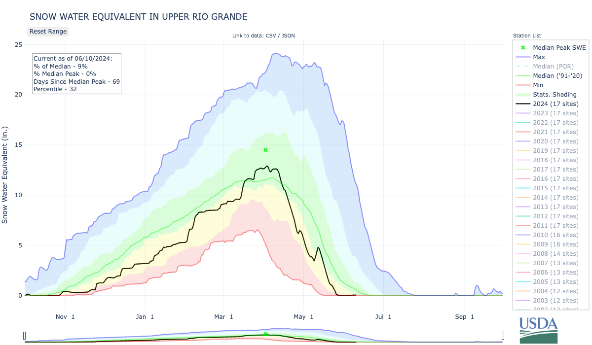
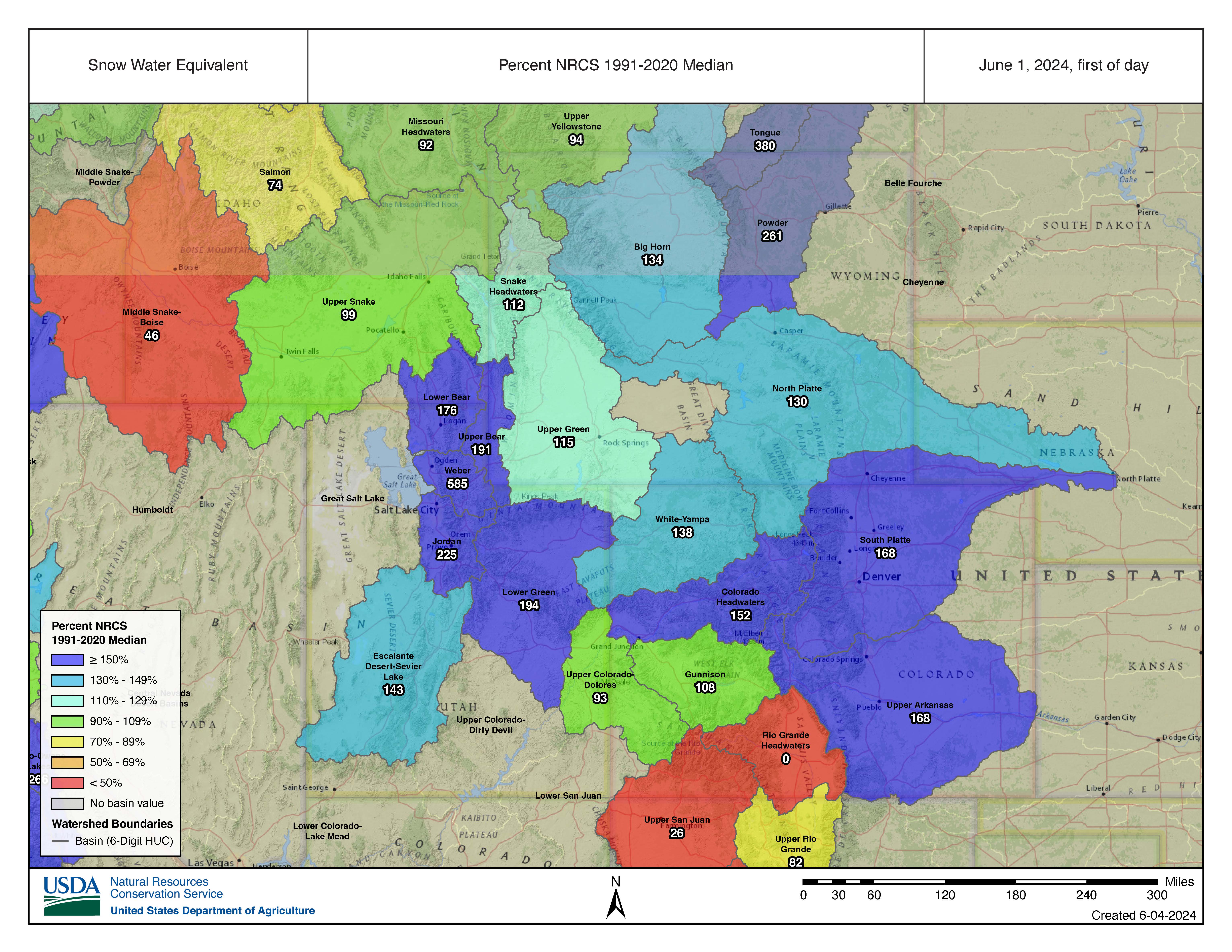
Despite below average May precipitation across much of the region, cool May temperatures preserved existing snowpack and regional snow water equivalent (SWE) is above-to-much-above average in most river basins. SWE is highest relative to average in Utah where SWE is 585% of average in the Weber River Basin and 225% of average in the Provo-Jordan River Basin. On a statewide basis, SWE is 136% of average in Colorado, 196% of average in Utah and 125% of average in Wyoming. Snow is completely melted in the Rio Grande River Basin and nearly melted in the Dolores and San Juan watersheds. Significant May snow accumulation occurred in Wyoming’s Bighorn Mountains and in parts of the Colorado Rockies.

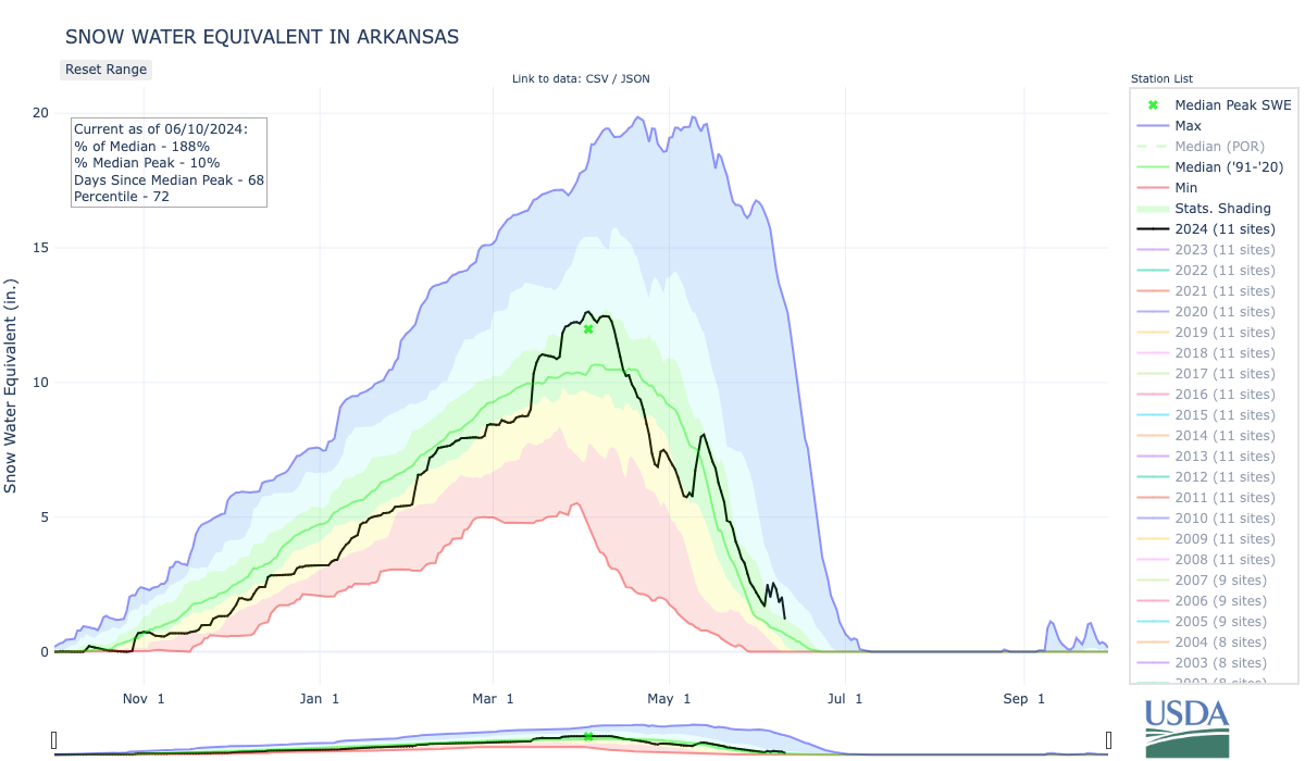
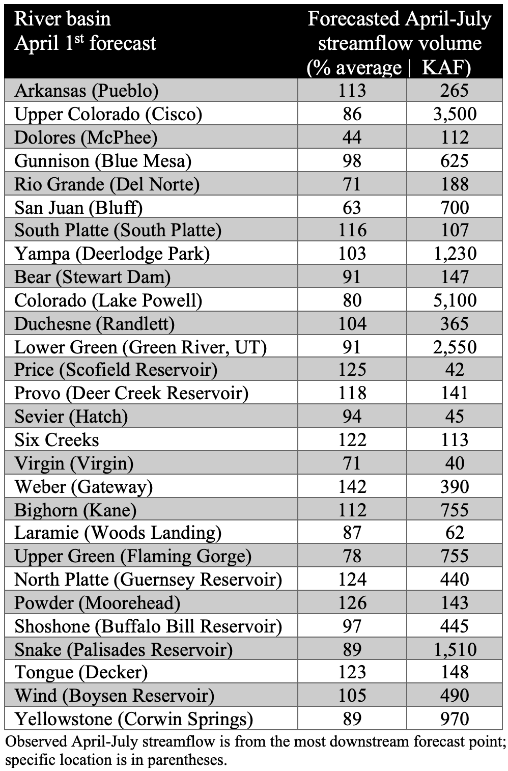
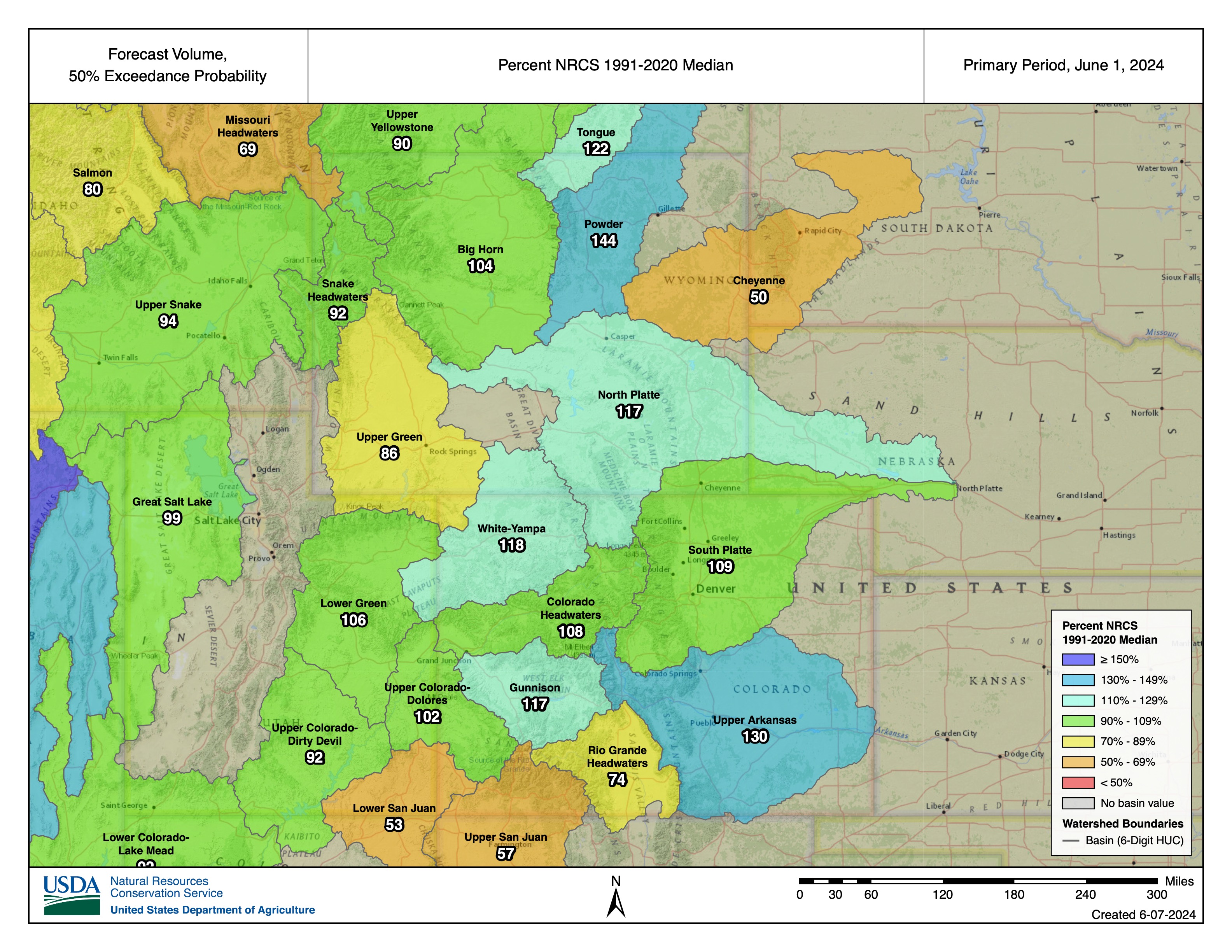
Seasonal streamflow volume forecasts on June 1 are generally average to slightly above average except for below average streamflow forecasts in the Cheyenne, Upper Green, Rio Grande and San Juan River Basins. Snowpack accumulation continued in some mountain regions during May and cool May temperatures slowed snowmelt for much of the month. Relative to average, the highest streamflow volumes are forecasted in northern Utah, particularly the Provo, Six Creeks and Weber River Basins. Significant increases in streamflow volume forecasts compared to May 1 were observed in the Arkansas, Gunnison, North Platte, Powder and Tongue River Basins. The lowest streamflow volumes relative to average are forecasted for the Dolores (44%) and San Juan Rivers (64%). The inflow volume forecast for Lake Powell is 80% of average (5.1 million acre-feet).
Regional drought conditions improved during May and now cover 8% of the region, compared to 10% at the end of April. Much-above average precipitation in northern Wyoming caused the removal of D1 and D2 drought conditions. Drought was entirely removed from Utah during May and the area of D1 drought contracted in western Colorado. Dry conditions in other parts of the region caused drought emergence in southeastern Wyoming, severe (D2) drought emergence in southeastern Colorado and a slight expansion of D1 drought conditions in southwestern Colorado.
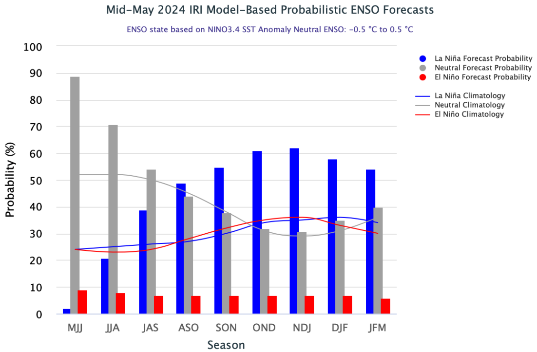
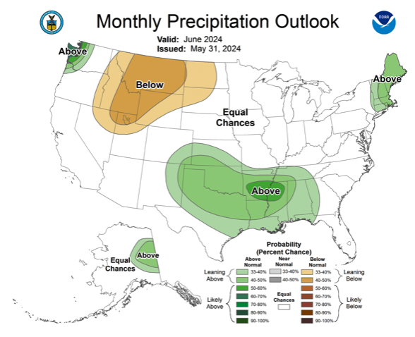
The strong El Niño event of 2023-2024 ended during May and Pacific Ocean temperatures are near average and ENSO-neutral conditions exist. There is at least a 70% probability of ENSO-neutral conditions remaining through summer, but by fall, there is a 50-60% probability of La Niña conditions forming. The NOAA Monthly Precipitation Outlook suggests an increased probability of below average June precipitation in northern Utah and above average June precipitation for southeastern Colorado. The NOAA Seasonal Outlook for June-August forecasts an increased probability of below average precipitation and above average temperatures for the entire region.
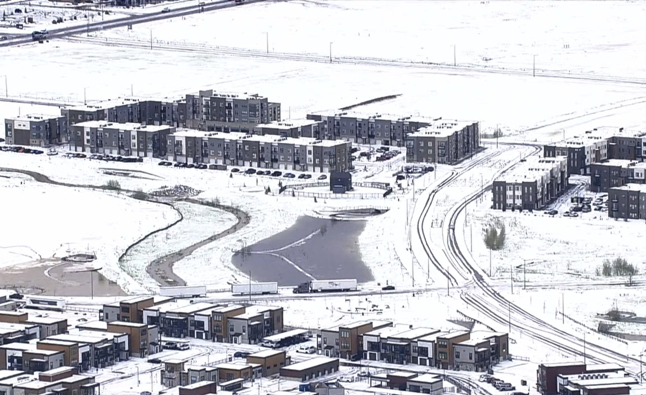
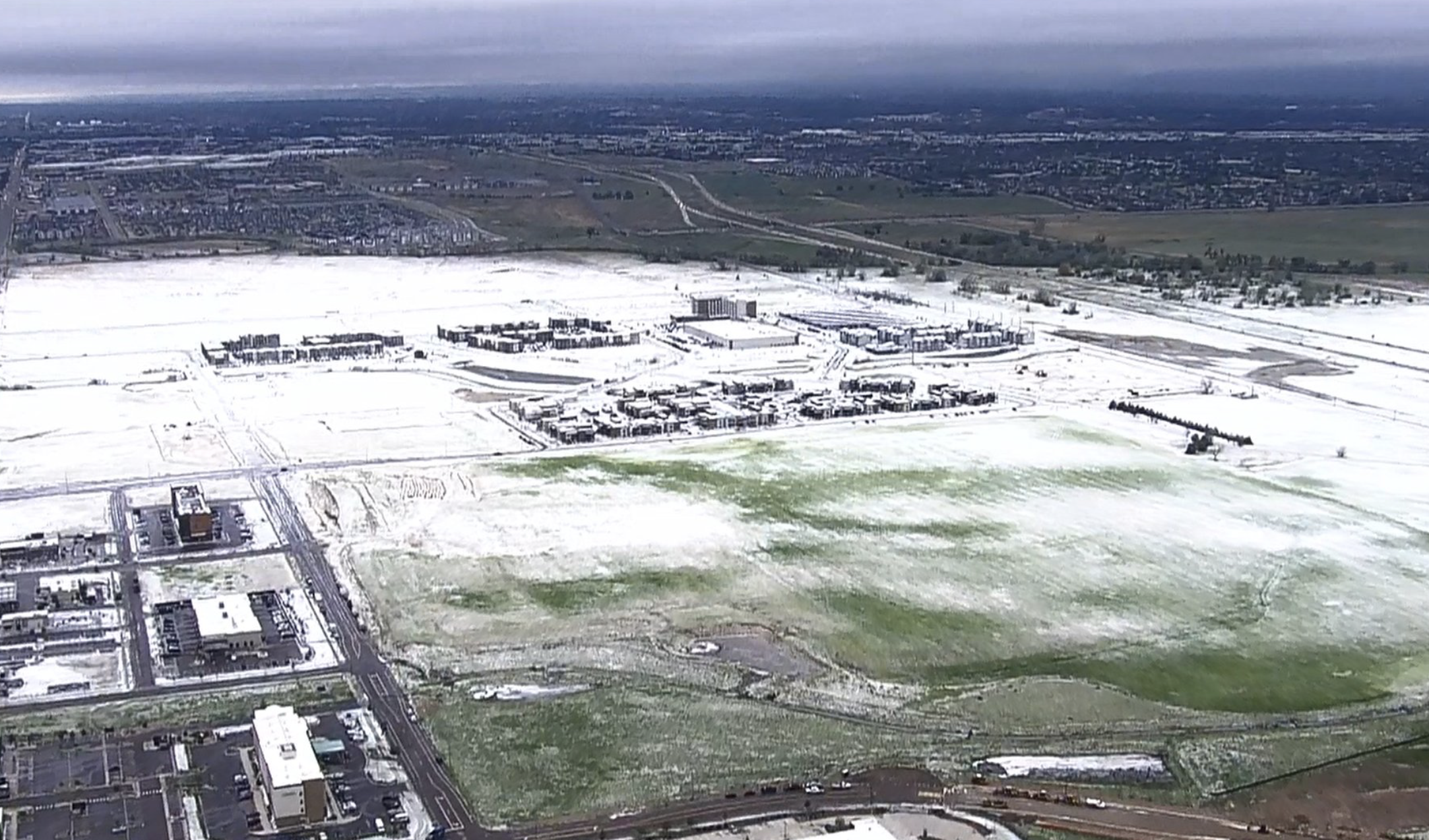
May significant weather event: Front Range severe thunderstorms. On May 30, two supercell thunderstorms rapidly formed over the Front Range and caused severe hail damage in the northern Denver metro area. Very large hail fell on the north side of Denver with hail covering roads and reaching up to 2” in diameter. (BoulderCast, Denver Hailstorm Recap, https://bouldercast.com/denver-hailstorm-recap-unexpected-nocturnal-supercells-pummeled-parts-of-the-denver-area-with-up-to-baseball-sized-hail-thursday-night/) Rainfall amounts from these thunderstorms were only a quarter to a half inch in the Denver area, but storms lingered to the northeast of Denver where up to 1.3” of rain fell in Akron on 5/30-5/31.
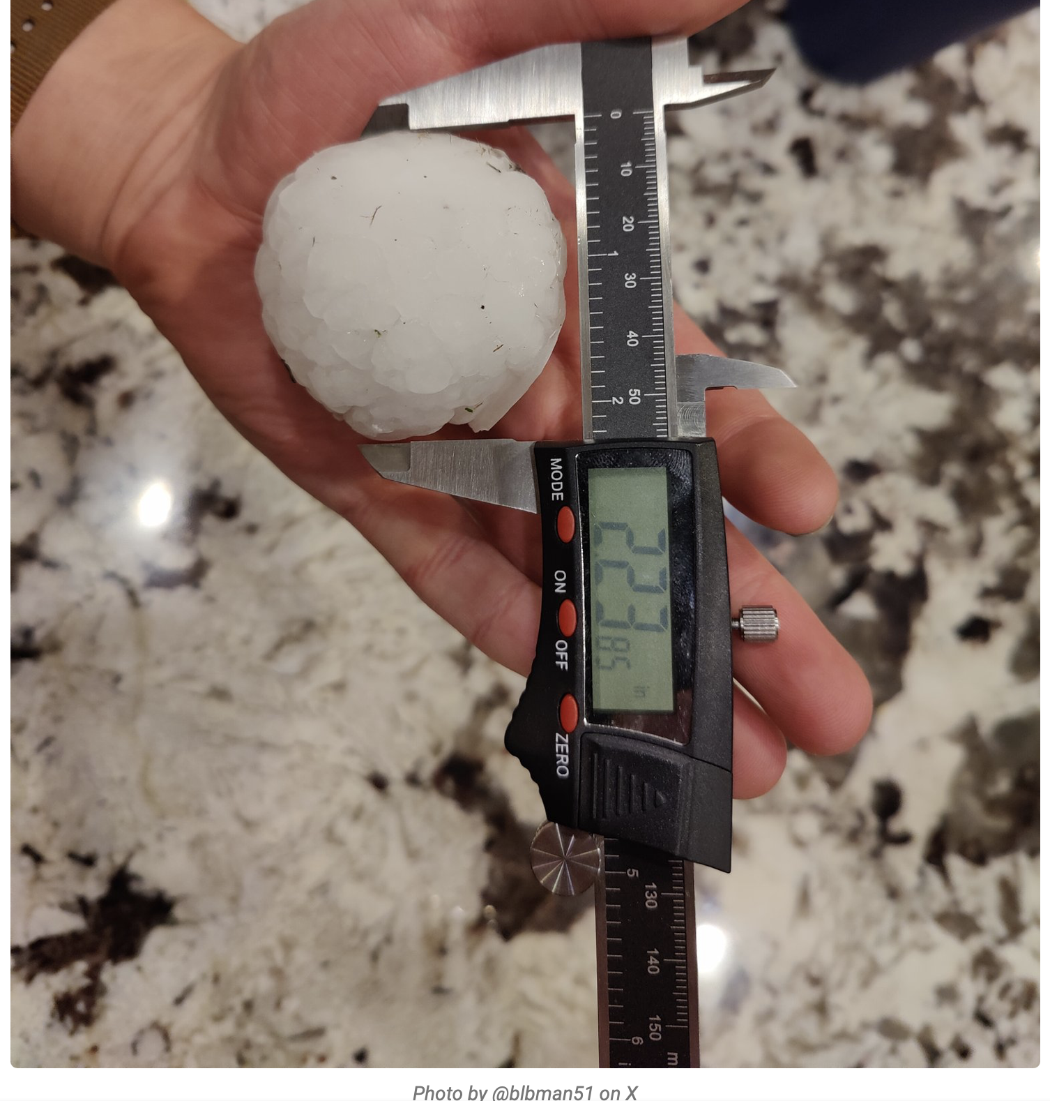
Hail images from Jayson Luber on X @Denver7Traffic.