New look for stretch of forest critical to #Denver’s water supply: Forest thinning project treats 1,500 acres in Denver Water’s watershed. — News on Tap #SouthPlatteRiver

Click the link to read the article on the Denver Water website (Jay Adams):

June 6, 2024

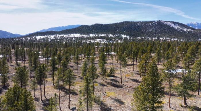
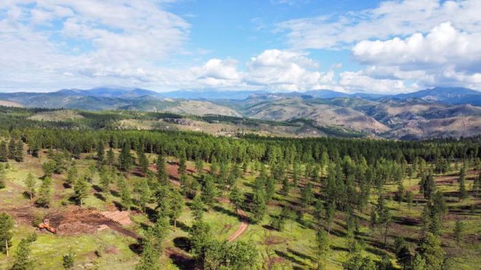
The rolling hills southwest of Denver offer spectacular views of the Pike National Forest, and the land is as rugged as it is beautiful. 

Tucked in among the ponderosa pines, hills and rock formations is Miller Gulch, a popular recreation area for bikers and hikers near Bailey, Colorado. To the casual observer, seeing a forest dense with trees looks healthy, but it’s actually cause for concern.

That’s why in 2022, the U.S. Department of Agriculture’s Forest Service and Denver Water launched a forest health project to thin 1,500 acres of ponderosa pine and Douglas fir trees in the area. 

The goal was to help return the forest to its natural structure and composition. The project wrapped up in the spring of 2024. 

A look at the Miller Gulch area of the Pike National Forest after thinning work was completed. The spacing between the trees leads to a healthier forest that is less prone to large, catastrophic wildfires. Photo credit: Denver Water.

“While small fires are beneficial to the forest, large wildfires can be devastating,” said Ryan Kolling, a Forest Service Supervisory Forester. “Thinning the forest helps reduce the risk of large wildfires and helps the trees become more resilient to disease and insect infestation.”

Improving the health of the forest protects nearby homes and recreation trails from large fires. A healthier forest also offers better protection for an area that supplies water to Denver and several surrounding suburbs.

The Miller Gulch area before tree thinning shows the overly dense forest that is susceptible to large wildfires. Photo credit: Denver Water.

“Denver’s source water begins as the snow and rain that travels across the forests west of Denver,” said Madelene McDonald, a watershed scientist at Denver Water.

“As the water flows downhill into rivers and streams, the forest acts as a natural filter for what will eventually become our drinking water. That’s why forest health is critical to Denver Water and our customers.” 

Forest treatments

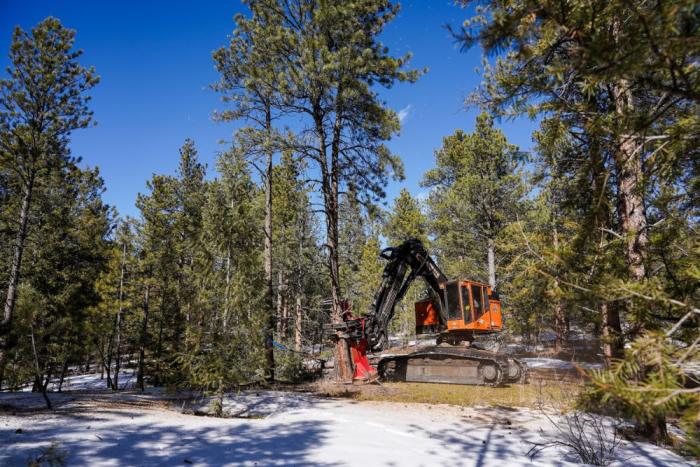
Improving the health of the forest is done through “treatments” that reduce the amount of vegetation, or “fuels,” that could catch fire. Treatments range from using machines to remove trees and thin the forest to using prescribed fires to burn away debris on the forest floor.

Before any treatments began in the Miller Gulch area, the Forest Service conducted an analysis of the area and created a “prescription” that outlined which trees should be removed and which ones would stay. The agency partnered with the nonprofit Stewardship West to streamline the process and complete the work.

The treatment work involved a multistep process to thin the forest. 


Learn how Denver Water is “Building a better forest.” 


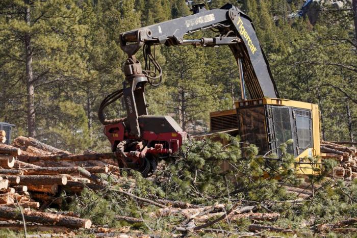
The first step involved removing selected trees with a large feller-buncher cutting machine equipped with two saws and a large “claw.” 

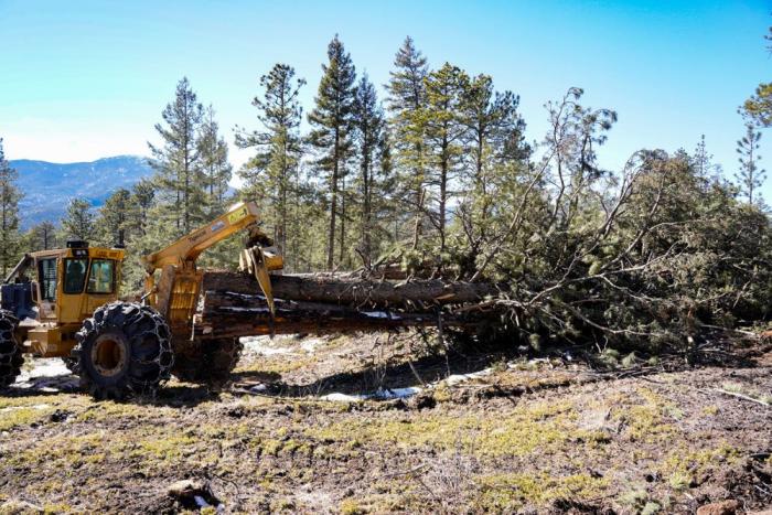
After the trees were cut down, a machine called a “skidder” dragged them to a collection area, where another machine called a “dangle-head processor” removed the branches. 

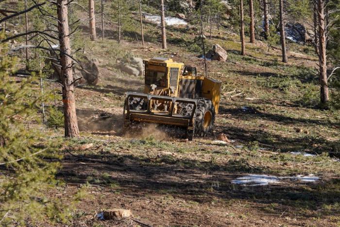
The last step involved a bulldozer-like machine called a “masticator” that works like a lawnmower, chopping up any remaining debris and spreading it across the ground. 

A cutting machine, known as a feller-buncher, saws the bottom of a tree, lifts it and sets it aside on the ground for removal. Photo credit: Denver Water.
A “skidder” grabs the downed trees and drags them to a collection area. Photo credit: Denver Water.
A dangle-head processor removes branches from the downed trees and stacks the trees in piles. Photo credit: Denver Water.
A mastication machine drives around the area where trees have been removed like a lawnmower. The machine’s blades chop up debris and spread it across the forest floor. Photo credit: Denver Water.

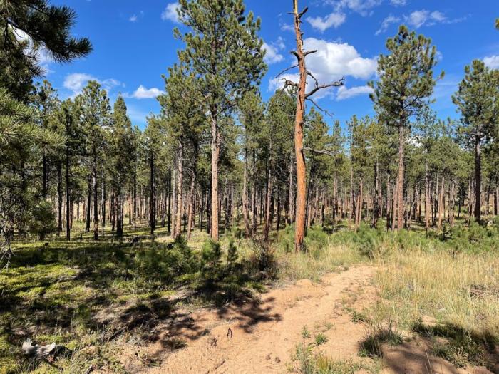
After the treatment is complete, the forest will have openings and meadows between groups of trees, so if one tree is hit by lightning and catches fire, it will be harder for flames to jump to other trees and spread.

The area in the foreground shows the treated areas of Miller Gulch. There is more space between the trees and the forest is less dense compared to the untreated areas in the background. Photo credit: Stewardship West.

“The forest land recovers quickly after treatments. As an example, in areas around here where we’ve done treatments in the past, there are now grasses, new trees and wildflowers already coming back,” Kolling said. 

“Thinning also helps stimulate new growth and gives the forest more diversity in terms of the age of trees as older ones are removed and new ones take root.”

Putting debris to good use

A key part of forest management is to make sure the removed trees are put to beneficial use. 

In the Miller Gulch area, the cut trees were separated into large and small piles. The larger trees are taken to sawmills in Colorado where they’re turned into materials such as two-by-four boards and wood pallets. 

Some tree piles are left on-site for the public to cut into smaller pieces for use as their own firewood. (A permit is required.) 

Large trees on the left are taken to sawmills and turned into various wood products. The smaller branches and trees on the right are turned into firewood and mulch to be sold in the community. Photo credit: Denver Water.

The smaller trees and branches are used for firewood or turned into mulch and sold in the community. Other debris is scattered across the forest in areas where work was done to help the land recover. 

“We’ve worked hard over the years to make sure we’re getting added benefit from our forest treatments, so these projects help the community in many ways,” Kolling said.

From Forests to Faucets

The first phase of the Miller Gulch project was funded through From Forests to Faucets, a partnership between Denver Water, the U.S. Forest Service, the Colorado State Forest Service, the National Resources Conservation Service and the Colorado Forest Restoration Institute. The partnership started in 2010 to reduce the risk of catastrophic wildfires in Denver Water’s collection area for water.

“The Buffalo Creek, Hayman and Hi Meadow fires were all high-intensity fires that burned on the Pike National Forest, which is in our South Platte watershed,” McDonald said. 

“When these types of wildfires occur, the exposed landscape can experience significant erosion that degrades our water quality and fills up our reservoirs with sediment.”

Downed trees and debris from the 1996 Buffalo Creek fire ended up in Strontia Springs Reservoir after a flood hit the burn scar. Denver Water is trying to prevent future disasters from happening by investing in forest health to prevent major wildfires. Photo credit: Denver Water.

Denver Water has prioritized treatment in the Miller Gulch area because of its proximity to the North Fork of the South Platte River, which flows into Strontia Springs Reservoir. The reservoir is where 80% of the utility’s water passes through before heading to water treatment facilities.

“It’s very important to reduce the wildfire risk above Strontia Springs,” McDonald said. 

“We’ve seen several big fires here in the past three decades that have caused significant problems to our water treatment operations and water delivery infrastructure.”

Federal help

The Pike National Forest is located in the Colorado Front Range Landscape, an area of 3.6 million acres recently identified in the Forest Service’s Wildfire Crisis Strategy as one of 21 landscapes at high risk for large wildfires. This is due to the area’s fire history, current vegetation conditions, number of homes and importance to the water supply for people across metro Denver.

The Wildfire Crisis Strategy is a 10-year plan developed by the Forest Service to dramatically increase the pace, scale and scope of forest health treatments across the Western U.S. The plan addresses wildfire risks to critical infrastructure, protecting communities and making forests more resilient.

The original From Forests to Faucets plan for Miller Gulch called for treating 419 acres. However, since the project was already in progress, it was selected for additional federal funding in 2022 and received $3.3 million from the Bipartisan Infrastructure Law and the Inflation Reduction Act. This additional funding allowed for the treatment of an additional 1,102 acres.

A section of Miller Gulch in 2023 shows how quickly the land recovers after treatment as grasses and wildflowers grow back. Photo credit: Denver Water.

“For years, Denver Water and the Forest Service have leveraged resources through the From Forests to Faucets partnership. And with support from the Wildfire Crisis Strategy, we are able to continue this proven approach and essentially triple the number of acres treated in Miller Gulch,” McDonald said.

“All of the work expands our efforts to reduce the wildfire risk in the area and helps protect our water supplies.” 

Connecting landscapes

The Miller Gulch project is one of many forest health efforts that in recent years have been done in the Upper South Platte River Basin on the Pike National Forest. May of those projects are in the area of Bailey, Buffalo Creek and the Colorado Trail.

A prescribed fire along the Colorado Trail near Buffalo Creek in June 2023 is an example of other fuel reduction treatments in the Pike National Forest. Photo credit: Andrew Slack, Colorado Forest Restoration Institute.

“The goal is to connect the dots of forest treatments across the landscape,” Kolling said. 

“We try to combine our treatment efforts with our partners and work with natural features like roads and rivers. This creates fuel breaks which will help us bring large-scale fires down to fighting size if one breaks out.” 

Stewardship Agreements and partnerships

The Miller Gulch project is a prime example of what partnerships can accomplish by using Stewardship Agreements

In 1999, Congress created the Stewardship Agreement tool, which gave the Forest Service the authority to work with partners collaboratively across shared landscapes. The goal is to accomplish impactful work and achieve mutually beneficial goals for the national forests. 

For Miller Gulch, the Forest Service partnered with Stewardship West to speed up the treatment process and achieve shared forest health goals. Stewardship West is a nonprofit organization that is dedicated to improving forest health across the Western U.S. 

“We are a boots-on-the-ground, action-focused organization with a mission of engineering heathy and resilient forests,” said Kevin Zeman, president and CEO of Stewardship West. 

“The Forest Service gives us the treatment plan and we do the coordination and implementation to make the project happen. This has allowed us to treat 1,500 acres in just 2.5 years, which is really unheard of in terms of land management.” 

Ryan Kolling (right), a Forest Service supervisory forester, meets with Stewardship West’s Jennifer Baker (left) and Kevin Zeman to discuss the forest treatments in Miller Gulch. Photo credit: Denver Water.

As a neighboring water provider with shared wildfire risks, Aurora Water joined forces with Denver Water and the Forest Service in 2022 to help fund the Miller Gulch project. Aurora Water works with Denver Water and also uses Strontia Springs Reservoir to deliver water to its customers. 

The Miller Gulch project also received funding from the Colorado Department of Natural Resources’ Strategic Wildfire Action Program, also known as COSWAP, because the Miller Gulch area is considered a high-risk landscape within the state. 

Denver Water’s entire collection system. Image credit: Denver Water.

Denver Water’s collection system spans more than 4,000 square miles of forest land, so working with other agencies is critical, according to McDonald.

“We rely on our regional, state and federal partners to help protect our watersheds,” McDonald said. 

“It really is a team effort, and the Miller Gulch project is a great example of how we can ensure a reliable water supply and improve the forest health at the same time.” 

Water and Cooperation Breathe New Life Into Klamath Basin Wildlife Refuges

by Juliet Grable, The Revelator
May 29, 2024

Tule Lake National Wildlife Refuge, located in far Northern California, harbors what remains of a once vast, shallow lake. On a recent April morning, I toured the area with John Vradenburg, supervisory fish and wildlife biologist for the Klamath Basin Refuges. A few months earlier, birds had all but abandoned Tule Lake. Now they were back in the thousands: clumps of eared grebes; dipping swallows; black-necked stilts with their impossibly spindly legs.

As we drove along the edge of the refuge’s largest wetland — evocatively called “Sump 1A” — pairs of Canada geese swam away from shore, followed by fluffy goslings. Vradenburg stopped the truck to rescue one that was trapped behind a headgate. He gently tossed the ball of fluff into the water, where it made a beeline for its two siblings.

View this post on Instagram

A post shared by Mickey (@marshallmickey66)

A few yards later Vradenburg stopped again to point out a pair of western grebes. Facing each other, they took turns dipping their needle-like bills into the water, then shook them off. They were getting ready to dance, side by side, across the water — part of their spectacular courtship ritual.

“It’s just so good to see birds moving around in here again,” he said.

A Transformed Ecosystem

The Klamath Basin National Wildlife Refuges are a complex of six refuges straddling the Oregon-California border — remnants of vast wetlands that once expanded and contracted with the seasons, breathing an almost unfathomable abundance of life into the dry region. A century or so ago, flocks of geese and swans darkened the sky. There were masses of white pelicans; hordes of grebes, ducks, and ibises; eagles and hawks in profusion. On Lower Klamath Lake, which sprawled nearly 100,000 acres, boats conveyed tourists from the Klamath River to the lake’s southern tip.

In typical early 20th century fashion, the Bureau of Reclamation remade the basin into a network of dikes, canals, drains, sumps and pumps called the Klamath Reclamation Project. Both Lower Klamath Lake and Tule Lake were drained to feed new farms established by homesteaders, including veterans returning from both World Wars.

[CALIFORNIA-J-0025] Tule Lake farms

To preserve what remained of the shrinking habitat, President Theodore Roosevelt in 1908 established the Lower Klamath National Wildlife Refuge. At nearly 47,000 acres, it was the nation’s first wildlife refuge dedicated to waterfowl. The 39,000-acre Tule Lake refuge was established in 1928 to protect what was left of the drained expanse.

Though a fraction of their former splendor, these wetlands still serve as a vital stopover for the millions of birds that use the Pacific Flyway every year.

The region has always experienced periodic drought, but the past 20 years have been drier than usual, culminating in several years of extreme to exceptional drought. Between 2019 and 2022, the Lower Klamath and Tule Lake refuges received essentially no water. Wetlands like Sump 1A turned to cracked expanses of dry mud. The birds disappeared.

Now, thanks to two decent water years in a row and a surge of funding for restoration projects across the Klamath Basin, a new optimism about reconnecting this broken ecosystem has emerged.

Reconnecting the Pieces

On March 24 members of the Tulelake Irrigation District gathered in front of a blocky concrete building for an unlikely ceremony: the revving up of “D plant,” a series of pumps that route water from Tule Lake to the Lower Klamath refuge via a 6,000-foot tunnel. The plant used to run nearly continuously, moving some 80,000 acre-feet of water per year, but it had been silent since 2020. (One acre-foot of water is about 326,000 gallons.)

Ironically, this ecosystem now needs D Plant, says Brad Kirby, manager of the Tulelake Irrigation District. In this remade basin, the Lower Klamath refuge is cut off from the Klamath River; D Plant functions like a heart, powering an artificial artery that delivers lifeblood to the refuge. This water also helps recharge the aquifer and eventually drains back to the Klamath River underground.

Typically, irrigators want to conserve every drop. Encouraging the “flow through” of water among farmland, wetlands, and the river is a “new goal, counter to when I first started, when our goal was to minimize drainage,” says Kirby.

The Klamath Refuge system and farmers of the Klamath Project have long been intertwined. Farmland surrounds the refuges; in addition, 21,000 acres within the refuges are leased for agriculture.

Even though the refuges hold a senior water right — an older right with higher priority — they are the last to receive water.

First priority goes to three endangered species. The Bureau of Reclamation must manage flows in the Klamath River to protect coho salmon and levels in Upper Klamath Lake to ensure the survival of c’waam and koptu — sucker fish that are of critical importance to the Klamath Tribes.

Next the agency must fulfill contracts with irrigators. The refuges largely depend on drain water from the irrigation districts — and that’s in good years.

The Klamath Basin has a fraught history, with Tribes, irrigators, and wildlife advocates fighting over scarce and precious resources. The recent drought showed everyone — refuge staff, irrigators, tribes, hunters — the unthinkable: the “Everglades of the West” transformed into a desert. This vision scared stakeholders to the table to hammer out solutions that benefit the landscape as a whole, and, they hope, everyone.

“It’s the first time — at least since I’ve seen here — where you see everyone interested in what everyone else has going on, and everyone participating in a proactive, collaborative way,” says Vradenburg. “You hear a lot about co-benefits.” Wetlands absorb and slowly release water, filter out pollutants, recharge groundwater, and provide habitat for birds and fish.

View this post on Instagram

A post shared by Mike McVey (@tulelakeguide)

“The thing that’s different from the historic Klamath Basin to today is the connectivity,” says Vradenburg. “Can we look at the infrastructure that we have in this highly modified system and bring that connectivity back?”

Across the basin working groups are looking at ways to restore wetlands and “re-wet the sponge.” Ducks Unlimited, which helped secure funding to run D Plant, is working with area irrigation districts to improve water conveyance and management. The nonprofit has secured funding from the U.S. Fish and Wildlife Service to install new pumping stations to deliver agricultural drain water to the Lower Klamath Wildlife Refuge. Money from that same pot will go to improve management of the wetlands — or “sumps” — on Tule Lake refuge.

The current infrastructure “is not set up to handle this new paradigm of less water,” says Amelia Raquel, a regional biologist at Ducks Unlimited.

It’s not just the quantity of wet ground that’s important — it’s the timing. Prolonged drying can be devastating, allowing invasive species to take root and even causing land to sink, or subside. But managing wetlands so they go dry for shorter periods “resets the whole health of that wetland,” says Raquel. “This allows the seedbank in wetland soils to germinate, starts succession [and] brings in invertebrates food for waterfowl and fish.”

The Klamath Drainage District has proposed modifying one of the main diversions that delivers irrigation water from the Klamath River so that it first enters a large wetland in the Lower Klamath Wildlife Refuge. This would provide important habitat for ducks and other waterfowl, especially during spring and summer molting and breeding seasons. It would also benefit fish, including salmon that will have access to the Upper Basin once dams on the Klamath River are removed this year.

“The reason we started thinking about this is we had a dry refuge,” says Scott White, general manager of the Klamath Drainage District. Birds need habitat in spring. “If they’re not going to the refuge, then they’re out in the fields as the little baby plants are starting to grow, munching away. They just wreak havoc on a crop.”

The district is also looking at using some of their private farmlands as floodplain habitat, similar to the way rice fields in California’s Central Valley function.

This project is one part of a new memorandum of understanding signed between the Klamath Water Users Association, Klamath Tribes, Yurok Tribe, and Karuk Tribe. In it the parties agreed to work together on projects that support their common goals, and the Department of Interior pledged to help secure funding.

Some of the old tension remains. Irrigators are disappointed with the Bureau of Reclamation’s latest water allocation, announced in April; they feel they should have received more water on the heels of such a wet winter. Clayton Dumont, chairman of the Klamath Tribes, is also worried about the allocation. He supports projects that restore wetlands and functionality of the ecosystem, but he also wants to make sure none of these projects further compromise c’waam and koptu in Upper Klamath Lake.

“We’re not interested in having the refuges fill at the expense of suckers in the upper basin,” he says.

And the shadow of the next drought is never far.

A Resilient Landscape

The refuge wetlands are still recovering from being dry for so long. At Tule Lake submerged aquatic vegetation is starting to return — a good sign, says Vradenburg. “That’s a really a big driver for a lot of our waterbird communities, especially diving ducks and grebes, those birds that like to nest on top of the water.”

On our way back to refuge headquarters, we stopped to watch a small flock of ibis pick through the mud, their glossy backs flashing green and rust. Then we stopped yet again to listen to the insistent murmur of hundreds, maybe thousands, of white-fronted geese. While the Canada geese are already rearing families, these birds still have to make it all the way to their breeding grounds in Alaska.

It’s a different landscape from just two years ago. During the drought going to work every day was heartbreak, says Vradenburg. “The refuge staff was so beaten down. Now people are grabbing keys to a work vehicle just so they can see the birds flying at sunrise.”

Get more from The Revelator. Subscribe to our newsletter, or follow us on Facebook and LinkedIn. 

Previously in The Revelator:

This article first appeared on The Revelator and is republished here under a Creative Commons license.