

Click the link to read the article on The Land Desk website (Jonathan P. Thompson):
June 18, 2024
🥵 Aridification Watch 🐫
Wildfire season has hit the West and it’s already a doozy, with several fires popping up in the last few days across California, most centered in the Los Angeles area. Arizona has had a handful of threatening fires this season, a lightning-caused blaze was burning at El Malpais National Monument in New Mexico, and on Monday night a blaze broke out in the Rabbit Valley right on the Colorado-Utah line near Fruita. The National Interagency Fire Center reported near midnight that the latter had burned 500 acres, but other reports said it was significantly smaller.
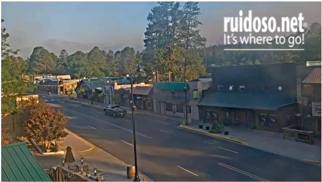
But probably the scariest incident is the South Fork/Salt Fire in southern New Mexico. The two fires — which seem destined to merge into one — were first spotted on Mescalero Apache land Monday morning. By late Monday night they had erupted into a 5,252-acre and a 2,815-acre blaze, respectively, with the former advancing rapidly toward Ruidoso and forcing the evacuation of the entire village and surrounding areas.
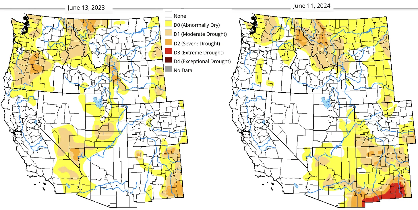
Average to above average snowpacks this winter kept drought at bay in much of the West. But nearly all of New Mexico is experiencing some level of drought, with the southern part of the state — including Ruidoso — being especially dry.
The entire village of Ruidoso is considered to be a wildland/urban interface, or WUI, community as its surrounded by conifer forest. According to a Federal Emergency Management Agency case study, New Mexico and federal forestry officials deemed Ruidoso as having the state’s highest, and the nation’s second highest, risk of catastrophic fire. The primary danger was that tree densities in the surrounding forest were more than 10 times that of a healthy Ponderosa pine ecosystem due to decades of fire suppression and a dearth of prescribed or cultural burning.
The Cree Fire in 2000 spurred the community to action, and in the ensuing years the community created and implemented a fire hazard mitigation plan. The plan, which extends to the county as a whole, was updated and renewed in March of this year. Let’s hope it works.

6,500: The number of new homes that could be coming to the desert just west of Las Vegas if two pending developments are realized.
522 million: Estimated gallons of water those households would consume annually.
Yes, you read that right: Even as the Southwest suffers through the most severe megadrought in the last 1,200 years or so, even as officials throughout the Southwest grapple with how to live within the Colorado River’s shrinking limits, and even in a place where the mercury has topped out above 100 degrees Fahrenheit on 19 days so far this year, developers are looking to build a crapload of new homes. Both proposed developments are near Red Rock Canyon National Conservation Area.
- The less controversial of the two is a 3,000-home master-planned community proposed by Olympia Companies on just over 500 acres of land on the northwest fringe of Las Vegas’s sprawl. Up until November of last year, the land was owned by the American public — i.e. the Bureau of Land Management. Olympia purchased it for $55 million as part of the Southern Nevada Public Land Management Act, a 1998 law that allowed the BLM to sell off developable land on the urban fringe in exchange for protecting more sensitive lands. The Las Vegas Review-Journal’s story gives some details about the planned trail network, but doesn’t mention water. Go figure.
- Then there’s the proposal at Blue Diamond Hill, an old gypsum mine that lies a bit further afield, and right next to the conservation area. Originally the developer wanted to build 5,000 homes here. Clark County pushed back, preliminarily approving 429 homes in 2022. The developers took the county to court, alleging bias and a conflict of interest. Earlier this month the county agreed to pay the developer $80 million and allow it to build about 3,500 homes to settle the issue. Local advocates have been fighting the development since its inception two decades ago, since it would bring sprawl right up to a national conservation area’s doorstep.
Granted, because they’re new homes, they will have more water use restrictions on them than older homes, in terms of how much turf they can have or the size of swimming pools. But it’s not like they’re replacing the older, less efficient homes — they’re still adding to Southern Nevada’s overall consumption of water, energy, space.
I’m sure there are folks who believe building all these new homes will help solve the affordable housing crisis by increasing the overall supply. I doubt it. Aside from being on an industrial extraction site, the Blue Diamond Hill development will surely be rather desirable, given its location, and expensive. And while Olympia says they will have some “entry-level” homes, they don’t say what that means. Home prices in nearby Olympia developments are mostly over $400,000, which doesn’t exactly qualify as affordable. More likely the added supply will — akin to adding lanes to congested freeways — merely induce more demand rather than lower prices in any meaningful way.
But that won’t stop politicians from using the housing crisis to push more public land into developers’ hands. Federal lawmakers are considering two such bills, including one that would make 25,000 acres of public land in Southern Nevada available for development in exchange for wilderness designations for some 2 million acres of federal land. This is being touted as a way to build more affordable housing. Yet the bill does not restrict what kind or price of housing could be developed on the land. (Read Jennifer Solis’s run-down for Nevada Current)
Nor, for that matter, does it say anything about where the water would come from.
Update: Click the link to read “Acreage burned in two Ruidoso area fires rises to 23K as rain bring flash flooding” from the Ruidoso News (Mike Smith). Here’s an excerpt:
June 19, 2024
Two large fires burning around Ruidoso continued to grow as firefighters pursued containment efforts in the air and on the ground, according to the Southwest Area Incident Fire Management Team, and heavy rains brought flooding to parts of the area. The South Fork Fire burned around 16,335 acres as of Wednesday afternoon and the Salt Fire burned over 7,000 acres, read a press release from the agency...Zero containment was noted in the press release as mixed conifer, grass, pine and juniper are the main fuels for both fires.
“Extreme fire behavior occurred across the South Fork and Salt Fires on Tuesday with crowning and long-range spotting observed,” stated the press release…A flash flood watch was active until Thursday morning for the Ruidoso area, according to a forecast from the National Weather Service (NWS) in Albuquerque.