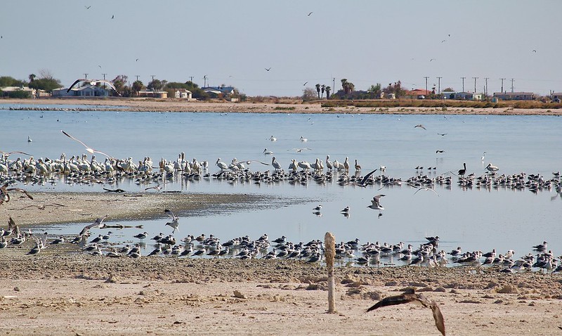
The outflow at the bottom of Navajo Dam in New Mexico. Photo: Brent Gardner-Smith/Aspen Journalism
From email from Reclamation (Susan Novak Behery):
Due to sufficient flows in the critical habitat reach, the Bureau of Reclamation has scheduled a decrease in the release from Navajo Dam from 700 cubic feet per second (cfs) to 600 cfs for Friday, August 23rd, at 4:00 AM.
Releases are made for the authorized purposes of the Navajo Unit, and to attempt to maintain a target base flow through the endangered fish critical habitat reach of the San Juan River (Farmington to Lake Powell). The San Juan River Basin Recovery Implementation Program recommends a target base flow of between 500 cfs and 1,000 cfs through the critical habitat area. The target base flow is calculated as the weekly average of gaged flows throughout the critical habitat area from Farmington to Lake Powell.
This scheduled release change is subject to changes in river flows and weather conditions. If you have any questions, please contact Susan Behery (sbehery@usbr.gov or 970-385-6560), or visit Reclamation’s Navajo Dam website athttps://www.usbr.gov/uc/water/crsp/cs/nvd.html
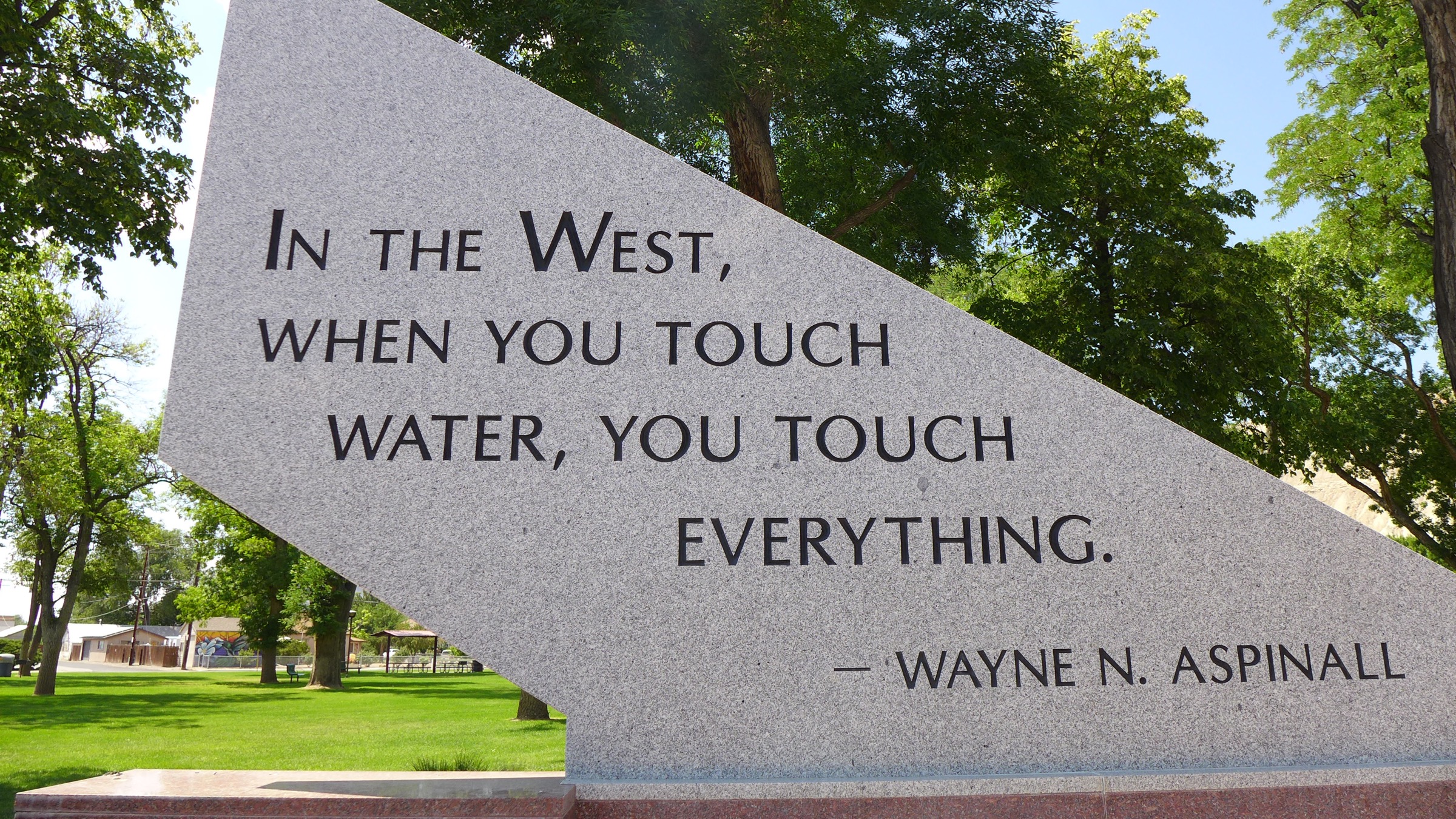
Doug Kemper was surrounded by previous Wayne N. Aspinall recipients at the CWC Summer Conference, where he received the award.
Here’s the release from the Colorado Water Congress:
August 20, 2024
Douglas Kemper awarded prestigious 2024 Aspinall Award
Presented by the Colorado Water Congress
Colorado Springs – Aug. 20, 2024– The Colorado Water Congress awarded Douglas Kemper, a life-long advocate of Colorado water issues, the 2024 Wayne N. Aspinall “Water Leader of the Year’ Award.
The Aspinall Award is given annually in recognition of a career of service and contribution to Colorado’s water community. It is awarded to a person who has dedicated a significant part of his or her career to the advancement of the state and its programs to protect, develop and preserve the state’s water resources.
It is tradition for the Aspinall Award to be presented at CWC’s annual event. This year, the previous Aspinall Award winners decided to honor Mr. Kemper with this award at his last CWC conference preceding his upcoming retirement this fall.
About Douglas Kemper Doug Kemper is the longtime Executive Director of the Colorado Water Congress, where he has worked tirelessly to convene the Colorado water community to find shared solutions since 2005. Active involvement with the CWC spans most of his career, including leadership positions on the CWC Board of Directors.
Prior to leading at CWC, he spent nearly 20 years directly planning, developing, and operating the raw water supply system at Aurora Water. His proficiencies include water policy development, surface and ground water resources management, and collaborative negotiations. Doug has used his extensive skillset to create ripple effects in the Colorado water community that will reverberate long after his upcoming retirement this fall.
Through his position as Executive Director of the Colorado Water Congress, Doug has also supported Colorado’s strong involvement in the National Water Resources Association. In his recent years, Doug has served as the State Executive’s Chair for 4 years and served as the Vice Chair for many years before that. He has increased the State Executives’ activity and their working relationships with one another.
Doug has a Bachelor’s and Master’s degrees in Civil/Water Resources Engineering. His Master’s work focused on agricultural irrigation efficiency and water quality studies. His is a Colorado registered Professional Engineer.
About the Wayne N. Aspinall Award The Colorado Water Congress presents the prestigious Wayne N. Aspinall Award annually to a Coloradan who has long demonstrated courage, dedication, knowledge and leadership in the development, protection and preservation of Colorado water – those attributes possessed by Mr. Aspinall. The late Wayne Aspinall, a lawyer and former member of the U.S. House of Representatives, remains one of the most influential water leaders in Colorado history.
Part of the memorial to Wayne Aspinall in Palisade. Aspinall, a Democrat, is a legend in the water sector, and is the namesake of the annual award given by the Colorado Water Congress. Photo: Brent Gardner-Smith/Aspen Journalism
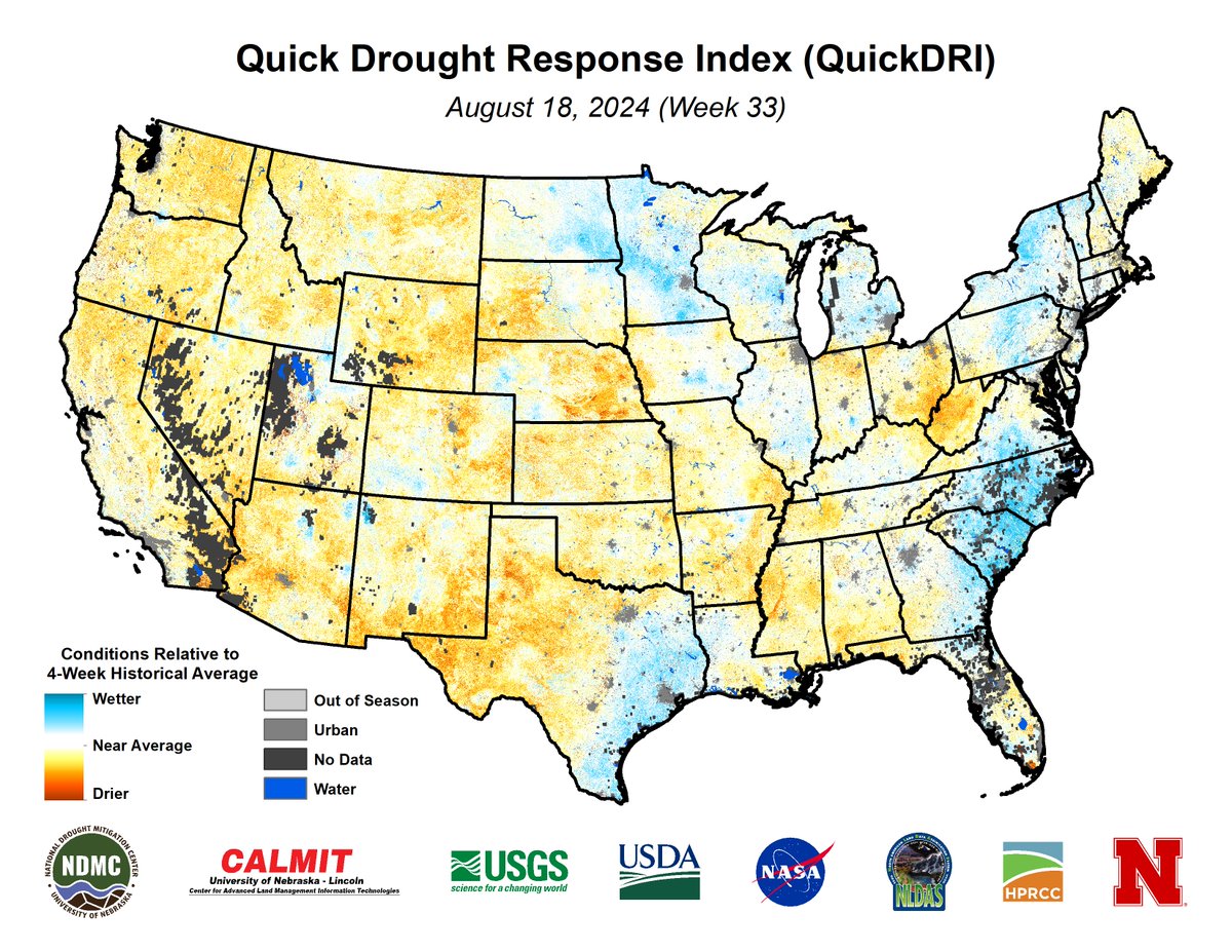
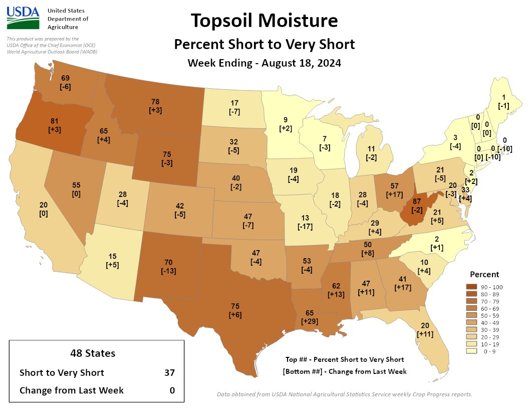
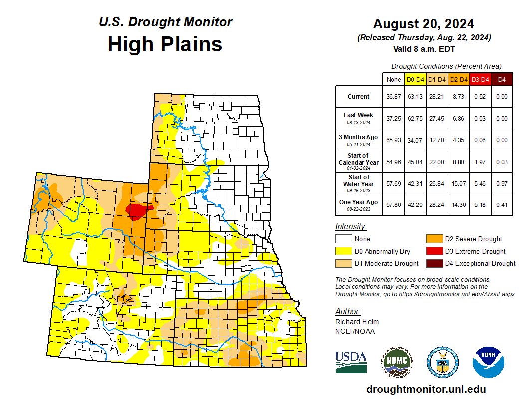
37% of the Lower 48 is short/very short, same as last week. Soils dried out in the Southeast, TX, and OH. Much of the North & Midwest improved. NM, WV, & the Northwest remain the driest areas, in terms of topsoil moisture.
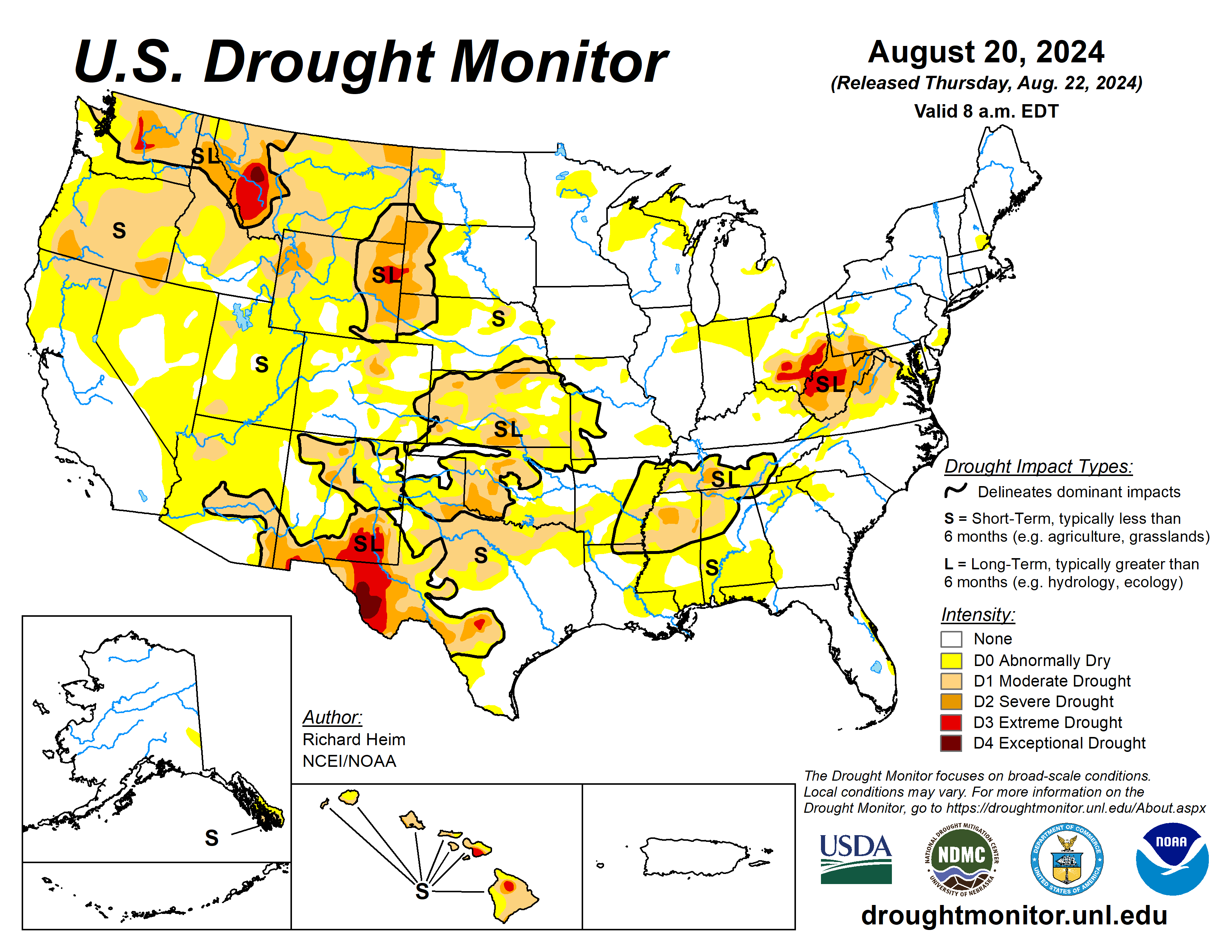
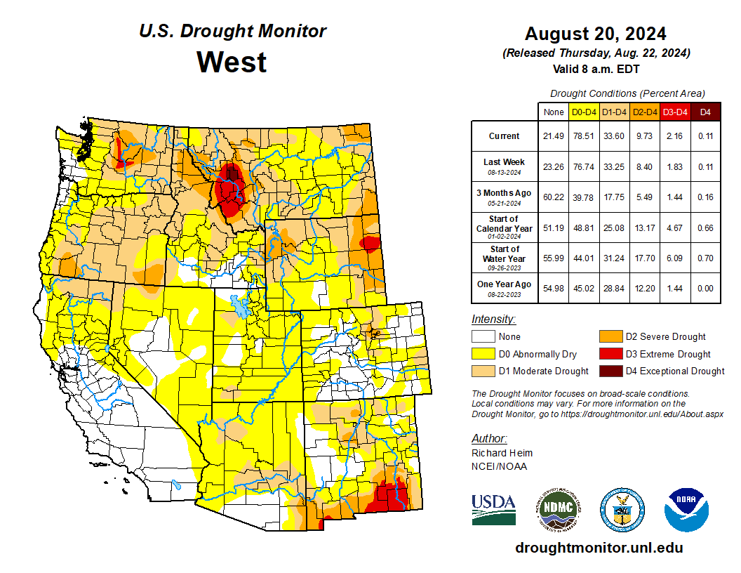
A high-pressure ridge continued across the southern Plains during this U.S. Drought Monitor (USDM) week (August 14-20), bringing dry and very hot weather, especially to Texas. Pacific weather systems moving in the jet-stream flow brought above-normal precipitation to parts of the West Coast, the northern to central Rockies, and parts of the central to northern Plains, the Midwest, and Northeast. The rain was frequently hit-or-miss, with large parts of the Pacific Northwest to Plains, and Midwest to Northeast, receiving little to no precipitation. In addition, much of the Southwest, and southern Plains to Southeast, were drier than normal this week. An upper-level trough kept the Far West cooler than normal, while a large cold front brought cooler-than-normal temperatures to much of the Midwest to East Coast. The rain contracted drought and abnormal dryness in parts of the Rockies to central Plains, and a few parts of the Midwest and East Coast. But drought or abnormal dryness expanded or intensified in parts of the West that missed out on the precipitation, parts of the Great Plains, from the Tennessee Valley to central Gulf of Mexico coast, and parts of the Midwest to central Appalachians. The lack of rain continued to dry out soils across large parts of the West (especially the Pacific Northwest), in the southern Plains, the Lower Mississippi Valley, and central Appalachians. Numerous wildfires were burning across the West with some sparking up in the southern Plains and western High Plains. The most severe drought areas included the central Appalachians to Upper Ohio River Valley, the Rio Grande River Valley, eastern Wyoming, western Montana, and central Washington…
Like other parts of the country, there were wet areas and dry areas this week in the High Plains region. Weekly rainfall totals ranged from zero in parts of Wyoming to locally over 2 inches in the Dakotas, Nebraska, and Kansas. Eastern parts of the Dakotas and Nebraska averaged near to cooler than normal for the week, but areas to the west and south were warmer than normal, with some areas 2 to 4 degrees above normal. There was expansion of drought and abnormal dryness in most states in the region, more in the north, and contraction in mostly southern states. The more notable changes were expansion of moderate to severe drought in Kansas and Wyoming with extreme drought being introduced in Wyoming and adjacent South Dakota, and contraction of abnormal dryness and drought in Colorado and Kansas, especially southeast Kansas where locally up to 5 inches of rain fell. Reports of significant hay loss and early cattle sales in South Dakota may be due to a combination of drought and a June 19 freeze event; other drought impacts include surface water shortage and poor water quality for livestock. According to USDA reports, in Wyoming, 75% of the topsoil moisture and 81% of the subsoil moisture are short or very short and 66% of the pasture and rangeland was rated in poor or very poor condition. More than 40% of the topsoil moisture was short or very short in Nebraska, Colorado, and Kansas, with 55% of the subsoil moisture so rated in Kansas…
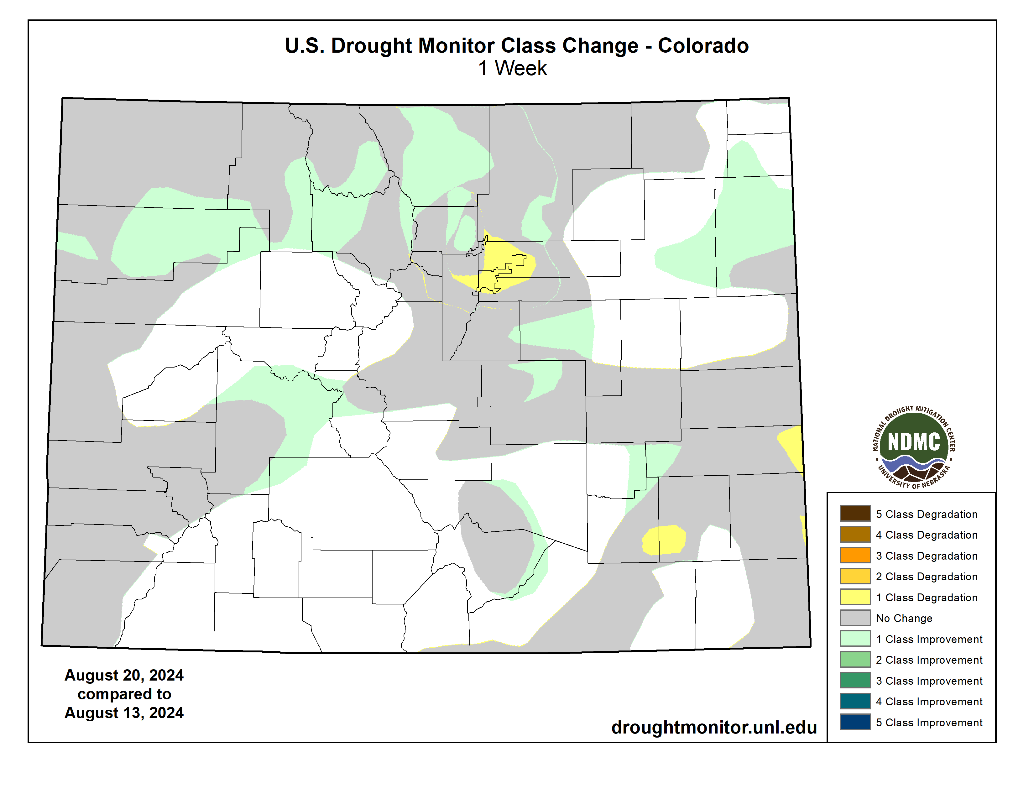
Colorado Drought Monitor one week change map ending August 20, 2024.
Half an inch of rain or more fell this week along the Washington and Oregon coast, in the Rockies, and parts of the Southwest (Four Corners States), with little to no rain falling across most of California, Nevada, and interior portions of the Pacific Northwest. Temperatures were cooler than normal in the Far West to Great Basin, averaging as low as 4 to 6 degrees below normal, but warmer than normal in southern and eastern areas, averaging 2 to locally 8 degrees above normal in Arizona, New Mexico, and Montana. Contraction of abnormal dryness or drought occurred in a few parts of New Mexico, Utah, and Montana, but drought or abnormal dryness expanded in the Pacific Northwest, California, and Nevada. The most notable changes occurred in Washington and Oregon, where moderate to severe drought expanded. More than 60% of the topsoil/subsoil moisture was rated short or very short in Oregon (81%/75%), Washington (69%/65%), Idaho (65%/62%), Montana (78%/79%), and New Mexico (70%/70%). Almost two-thirds of the pasture and rangeland was rated in poor to very poor condition in Oregon (62%) and Washington (63%)…
The keywords for the South region are hot and dry. Most of the region was warmer than normal, with only eastern Tennessee near normal. Parts of northern Texas had weekly temperatures 6 to 10 degrees above normal, with daily high temperatures over 100 degrees F all week and exceeding 110 on some days. Parts of Arkansas and eastern Oklahoma received over 2 inches of rain this week, with locally over 5 inches, and there was a smattering of showers in Louisiana, Mississippi, and Tennessee, with rainfall mostly half an inch or less. All of Texas and most of Oklahoma received little to no rain this week. With dry soils, high evaporation, and deficient rainfall, abnormal dryness expanded in parts of most of the South region states. Moderate drought expanded in Texas, especially in north central Texas where the fire danger was high and several large wildfires were burning; extreme drought expanded in the Texas Trans Pecos. Moderate to severe drought expanded in Oklahoma, Mississippi, and Tennessee. Abnormal dryness and moderate drought were trimmed where the heaviest rains fell in eastern Oklahoma and western Arkansas. Soils were very dry: USDA topsoil/subsoil percentages short or very short include 75%/65% for Texas, 65%/50% for Louisiana, 62%/59% for Mississippi, 53%/49% for Arkansas, 50%/52% for Tennessee, and 47%/49% for Oklahoma. Mississippi experienced a 70% loss of field corn in the east-central portion of the state during the mid-June through early July dry period. Extension agents are reporting a likely significant loss of cotton and soybeans in this region as well. Cotton plants are dying, and soybeans in many locations set pods without beans. According to the USDA Crop progress report for Mississippi, pasture land, soybeans, and cotton are currently worse than 2023 levels. In Tennessee, there were reports of a pond drying up, lack of forage growth (in June and July), and tree stress (early browning and dropping of leaves). The USDA reported 46% of the pasture and rangeland in Texas was in poor to very poor condition…
Looking Ahead
In the two days since the Tuesday valid time of this USDM, scattered showers and thunderstorms brought areas of rain to parts of the Southwest, Pacific Northwest, and Plains, but the rest of the contiguous U.S. (CONUS) was mostly dry. For August 22-27, the upper-level ridge will slowly shift east, bringing warmer-than-normal temperatures to much of the CONUS between the Plains and Appalachians, while an upper-level trough will move into the West, bringing cooler-than-normal temperatures. An inch or more of rain is predicted for the Cascades, much of the Southwest (Four Corners States), and parts of the northern Rockies and central Plains. A stalled frontal boundary will bring an inch to locally 3 inches or more of rain to the Florida peninsula. Half an inch of precipitation is forecast for areas in the central to northern Plains, Middle to Upper Mississippi Valley, parts of New England, and northern parts of the West. Large parts of California and Nevada, the southern Plains, and Lower Mississippi Valley to Mid-Atlantic coast can expect little to no precipitation.
For much of the next 2 weeks, the ridge and trough pattern will continue to slowly move east. The Climate Prediction Center’s (CPC) 6-10 Day Outlook (valid August 27-31) and 8-14 Day Outlook (valid August 29-September 4) favor warmer-than-normal temperatures across the CONUS east of the Rockies, shifting to the East Coast as the ridge moves east. Odds favor below-normal temperatures over the Pacific Northwest and northern Rockies at first, then over the northern Plains as the trough moves east. The West Coast and southern tier states are likely to be warmer than normal through the period. Alaska may see cooler-than-normal temperatures in the southwest to warmer-than-normal temperatures in the northeast. Odds favor below-normal precipitation across parts of the Pacific Northwest and a large area centered over the Mid-Mississippi and Ohio Valleys, while above-normal precipitation is favored from the Southwest to northern Plains and parts of the Gulf Coast states, in the northern Rockies early in the period, and along the extreme East Coast late in the period. Most of Alaska could see wetter-than-normal conditions.
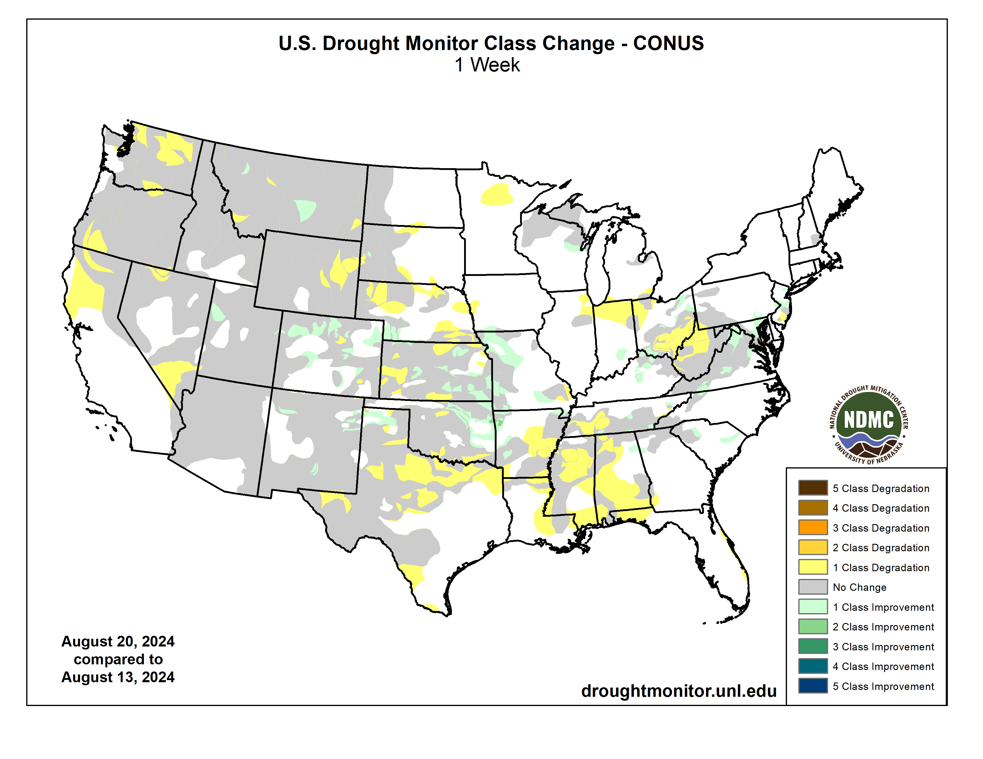
US Drought Monitor one week change map ending August 20, 2024.
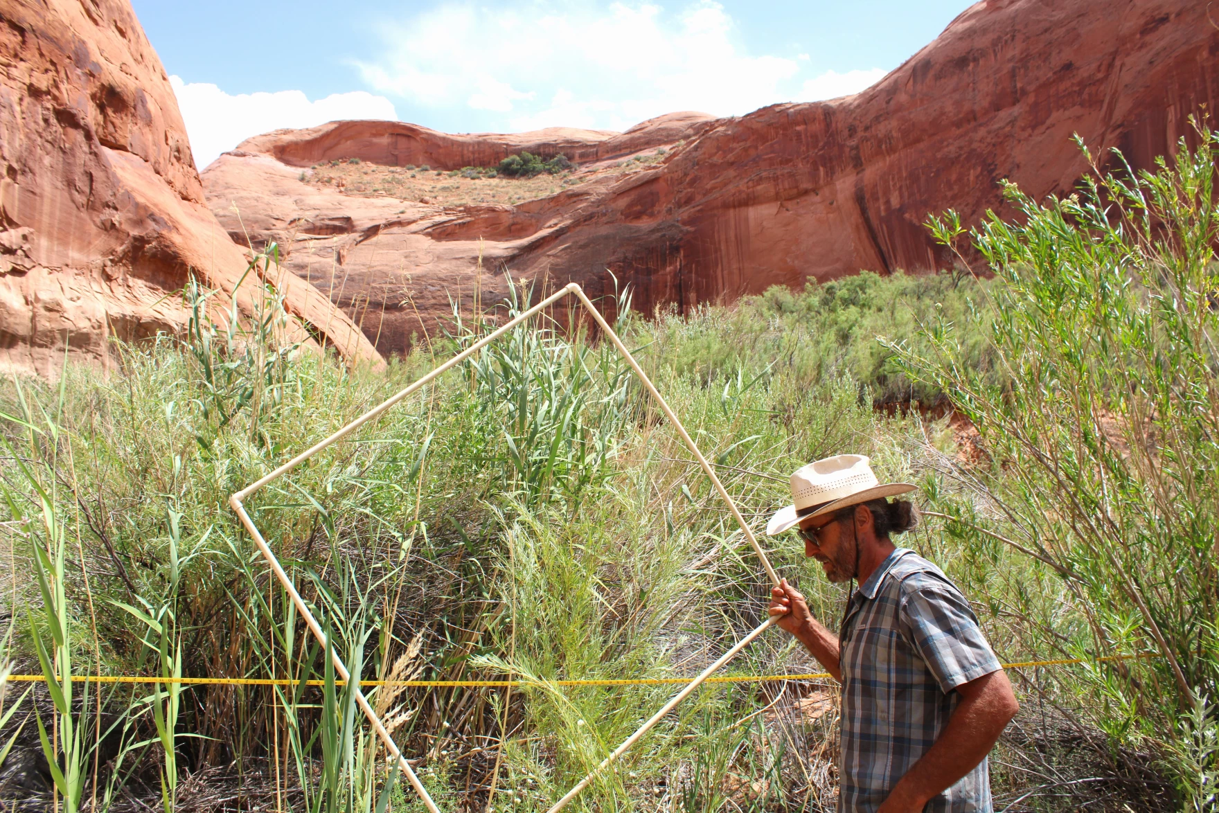
Researcher Seth Arens prepares to count plants in Glen Canyon on July 16, 2024. His study shows that many plants in areas once submerged by Lake Powell are the kind of native species that lived in the area before the reservoir. Alex Hager/KUNC
Click the link to read the article on the KUNC website (Alex Hager):
August 20, 2024
This story is part of ongoing coverage of the Colorado River, produced by KUNC and supported by the Walton Family Foundation. KUNC is solely responsible for its editorial coverage.
Seth Arens has all the adventurous swagger of Indiana Jones. His long hair is tied up in a bun, tucked neatly under a wide brimmed hat. His skin bears the leathery tan of someone who has spent the whole summer under the desert sun.
But as Arens pushed his way through a taller-than-your-head thicket of unforgivingly dense grasses, he explained why he doesn’t carry a machete, betraying his differences from the whip-cracking tomb raider.
“I guess, as an ecologist, I can’t quite bring myself to just hack down vegetation,” Arens said.
Arens is a scientist with Western Water Assessment and the Cooperative Institute for Research in Environmental Sciences, both environmental research groups headquartered at the University of Colorado Boulder.
He has spent weeks traversing the smooth, twisting red rock narrows of Glen Canyon in search of his own kind of treasure: never-before-collected data about plants.
Glen Canyon is perhaps best known for the reservoir that fills it. Lake Powell, the nation’s second-largest reservoir, has kept much of the canyon underwater since the 1960s and 70s. The 21st Century has changed that. Climate change and steady demand have brought its water levels to record lows, putting once-submerged reaches of the canyon above water for the first time in decades.
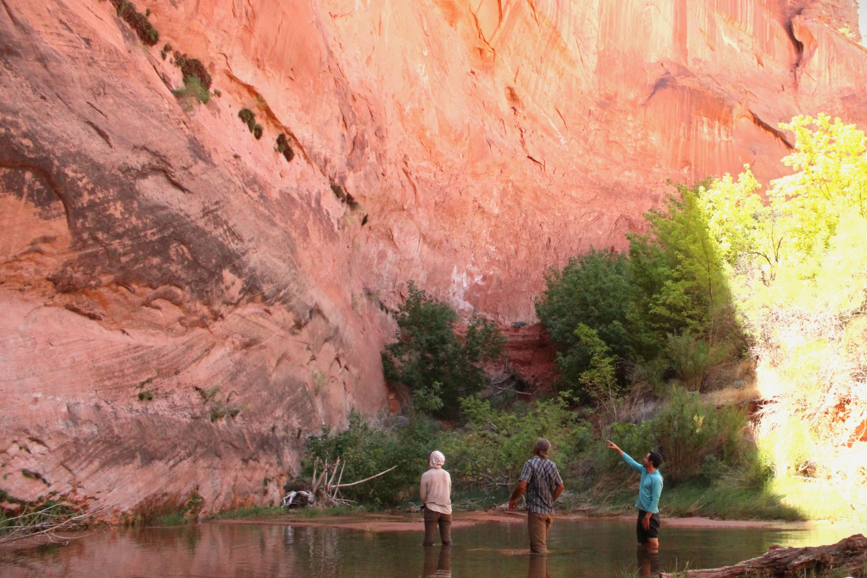
Katie Woodward, Seth Arens and Eric Balken stand in a stream-fed pool in Glen Canyon on July 16, 2024. This area was once completely submerged by Lake Powell, but now thrives with native plants. Alex Hager/KUNC
What happens next is still up in the air. Some environmental advocates want to see the reservoir drained so plants, animals, and geologic features can come back. Boaters and other recreators want to maintain the status quo – keep storing water in Lake Powell and sustain a tourism site that brings in millions of visitors each year.
In the snaking side canyons that were once under Lake Powell, Arens is methodically counting plants at different sites over the course of multiple years. He is creating a record of which species are taking root, and what might be lost if the reservoir were to rise again.
“Nature has given us a second chance to reevaluate how we’re going to manage this place,” Arens said.
While the study is still underway, Arens said native species dominate the landscape alongside the area’s creeks. The same kinds of plants that lived in Glen Canyon before Lake Powell have taken root again — even after their habitats were drowned — filled in with towering piles of sediment deposits, and then shown the light of day once more.
“It turns out nature is doing a pretty good job by itself,” Arens said, “Of coming back and establishing thriving ecosystems.”
‘Old assumptions’ and new policies
The data produced by this study is going public during a pivotal time for the Colorado River and its major reservoirs.
Decisions made over the next two years will shape who gets how much water from the shrinking river, which supplies roughly 40 million people. Cities and farms from Wyoming to Mexico are all trying to make sure they get their fair shares, and environmental advocates are trying to make sure the region’s plants and animals aren’t an afterthought.
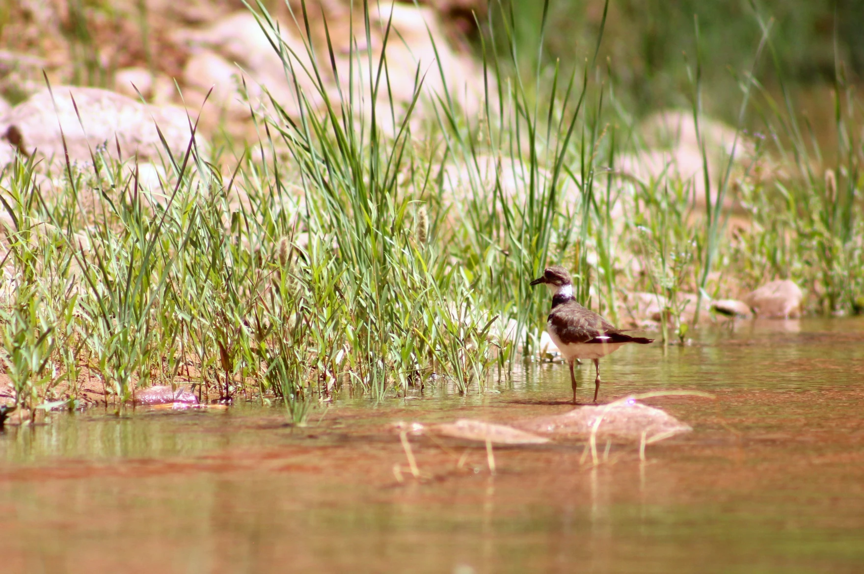
A killdeer stands in a spring-fed stream in Glen Canyon on July 17, 2024. The native plants alongside the canyon’s streams are host to a variety of birds and other animals such as beavers, toads, lizards and insects. Alex Hager/KUNC
The current guidelines for managing the river expire in 2026. Right now, policymakers are working on a set of replacements. Eric Balken, director of the nonprofit Glen Canyon Institute, wants those new rules to factor in the wellbeing of plants around Lake Powell.
“If the old assumption was that we can store water in Glen Canyon because there’s nothing there, that assumption is wrong,” he said. “There is a lot here. There is a serious ecological consequence to putting water in this reservoir, and we cannot ignore that anymore.”
Balken’s group, which advocates for draining Lake Powell and storing its water elsewhere, provided some funding for the plant study being conducted by Seth Arens. Glen Canyon Institute is hoping it will provide data that proves the value of the canyon’s plant ecosystems to policymakers.
That’s extra important, Balken said, because federal water managers aren’t doing enough for Glen Canyon’s plants right now.
The Bureau of Reclamation, the federal agency that manages the West’s reservoirs, outlined its current strategy for river management in an October 2023 document called the “Draft Supplemental Environmental Impact Statement.” Balken called that document’s assessment of Glen Canyon plants “demonstrably false.”
In short, Reclamation describes an environment dominated by invasive plants that only stand to cause problems.
“When I read that,” Balken said, sitting near a patch of native willow plants feet from Lake Powell’s edge. “I just thought, ‘Had these people even been to Glen Canyon?’” This place is a vibrant, burgeoning ecosystem.”
Reclamation’s report mentions some native species that form “unique ecosystems within the desert,” but appears to conclude that rising reservoir levels – which are partially the result of the agency’s own management decisions – would ultimately be good for plant life around Lake Powell.
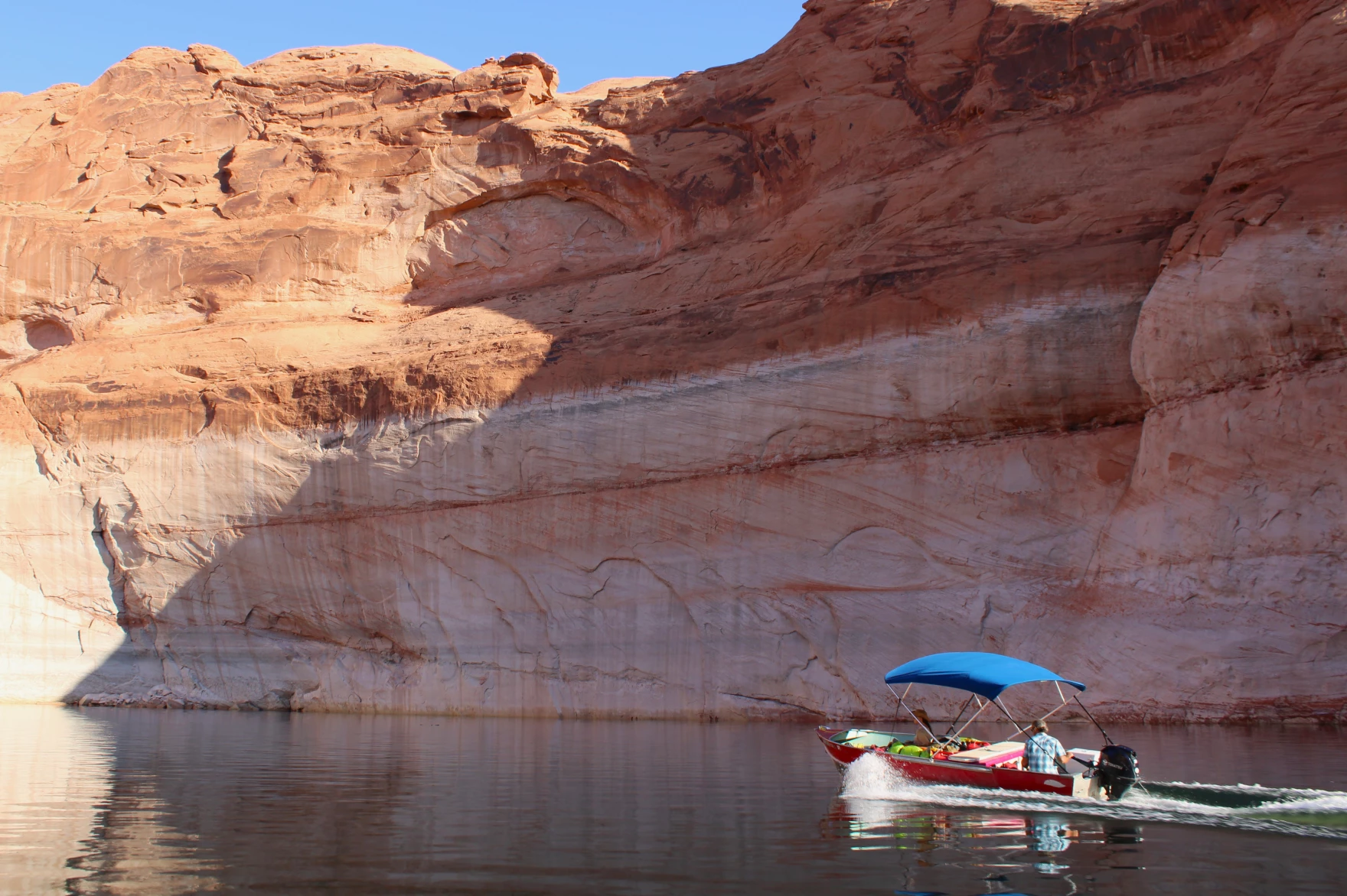
Seth Arens pilots a boat across Lake Powell between research sites on July 17, 2024. Some environmental advocates want to see the reservoir drained and its water stored elsewhere, while proponents of Lake Powell hail its value as a recreation area. Alex Hager/KUNC
It highlights the presence of invasive plant species and says “any additional acreage of exposed shoreline around Lake Powell has the potential to be invaded by invasive plant species such as tamarisk and Russian thistle.”
Balken and Arens argue the opposite, pointing to early survey findings that include widespread native plant life in areas that have been exposed by declining reservoir levels.
Reclamation declined to be interviewed for this story, but a spokeswoman for the agency wrote in an email to KUNC, “Reclamation’s consideration of impacts to vegetation are primarily for resources downstream of Glen Canyon Dam that are affected by dam releases.”
The spokeswoman wrote that “most of the releases, even on the annual time scale, have negligible effects on lake levels and vegetation,” and pointed to inflows, such as annual snowmelt, as having a bigger impact on water levels in the reservoir than Reclamation’s releases of water from Glen Canyon Dam.
Balken suspects that Reclamation lacks data about Glen Canyon’s plants and hopes that the ongoing study will fill in those gaps and help shape management plans going forward.
The National Parks Service, which manages recreation on Lake Powell and gathers some data about the surrounding environment, was not able to provide comment for this story in time for publication.
‘A chance for survival’ around Lake Powell
While Arens’ study hasn’t produced any hard data yet, he is taking a mental tally of plants every time he trudges through the lush, winding creekbeds that channel spring-fed streams into Lake Powell.
These riverside ecosystems were shaped by their years spent underneath the reservoir, and little signs of that reality are everywhere.
Seth Arens looks at plants growing from crevices in a rock wall in Glen Canyon on July 16, 2024. These “hanging gardens” thrive in shady canyon bends where water seeps from the wall. Alex Hager/KUNC
Standing in the baking desert sun, Arens poked at a digital map on his phone screen while trying to find his next research site, and the map showed that he was standing underwater. Much of the canyon is lined with banks of sediment, sometimes more than a dozen feet tall, that were left behind by the still waters of Lake Powell. Those banks now provide heaps of soil for the roots of native plants.
Now that some of those areas have been left to grow for more than two decades, in some cases, they abound with life.
In one canyon, frogs and toads hop along the clear trickle just downstream of a beaver pond while birds flit in and out of tall, shady cottonwoods. In another, ferns sprout from crevices where water seeps onto a damp rock wall.
It’s a veritable oasis in the desert – the kind of cool, spring-fed Eden that populated the heat-induced daydreams of thirsty cowboys traversing the expanses of the Old West.
Katie Woodward, Arens’ research assistant, is finding inspiration in these canyons, too.
“It’s very obvious that nature can take care of its own and turn a highly disturbed landscape, a landscape that was disturbed because of the follies of man, and change that into something that is diverse and productive,” she said. “I would have never believed how possible that was until I came down here.”
The researchers hope their findings about that recovering landscape end up in front of policymakers, whose decisions could shape the future of Glen Canyon’s native ecosystems.
Katie Woodward takes notes on plant species in Glen Canyon on June 16, 2024. She and researcher Seth Arens trek through remote desert canyons to tally the plants within, and have found mostly native vegetation in the canyon’s riparian ecosystems. Alex Hager/KUNC
“As Glen Canyon resurfaces, there’s an incredible moment for species that are feeling the pressures of both human-induced and naturally driven change on water resources in riparian areas in the west, to have a chance for survival in a future that feels really unknown and kind of scary.”
Some of those unknowns might get settled soon, as the next rules for Colorado River management are likely to include new plans for storing water in Lake Powell. State water negotiators have projected optimism that policy meetings will result in a new agreement for water management before the 2026 deadline.
Less than 12 hours after the Biden Administration and the Imperial Irrigation District approved an unprecedented deal to conserve 700,000 acre feet of Colorado River water through 2026, the flow of river water to the rural valley three hours south of Los Angeles slowed. District personnel moved out before sunrise to install more than 1,600 locks on gates to canals supplying hundreds of farm fields, cutting off water deliveries for up to 60 days this year. The process will be repeated over the next two summers.
In exchange, the powerful agency and farmers who volunteer to not receive the water and hold off on growing hay in hot summer months will be paid nearly $700 million in federal funds — by far the largest of numerous agreements struck with water agencies and tribes to prop up the overused, drought-ravaged river and its reservoirs. For irrigation district officials, the agreement, which will conserve a huge amount of water, about as much as the state of Nevada uses annually, caps years of arduous negotiations and multiple federal reviews…
But the way the deal was finalized and its potential impacts on the also rapidly dwindling Salton Sea and local public health angered numerous environmental justice and policy groups. They said the U.S. Bureau of Reclamation and the powerful water agency rushed through cursory approvals and ignored much of their lengthy comments, including ideas on how to monitor and reduce air quality and wildlife impacts that they say will occur from holding back such a huge amount of water.
The irrigation district board on Sunday hastily scheduled a special meeting for Monday night to approve the agreement, before reclamation staff had even released their final determination that cutting so much agricultural runoff into the sea would have “no significant environmental impacts.” Five hours before the meeting on Monday afternoon, the feds released their final determination and posted 150 pages of responses to the lenghty comments submitted by more than half a dozen groups and several individuals who have studied the Salton Sea for decades, including a major annual transfer of water to suburban San Diego that is rapidly depleting the water body, California’s largest.
In an email headed “IID’s quickie action,” Joan Taylor, chairperson of the Sierra Club’s California/Nevada Desert Committee wrote, “It’s commendable that IID recognized a responsibility to cut down on water use to help protect the water supply for the West, but what they’re doing is akin to doubling the water transfer to San Diego. We know that already has profound impacts. So this is a very big deal … and will suddenly increase dusty lakebed exposure around the Salton Sea by 13,000 acres.”
These hay bales stand ready to be collected on a ranch outside of Carbondale. Upper Colorado River Basin officials are working on a memorandum of understanding with the U.S. Bureau of Reclamation so water saved as part of conservation programs can be tracked and stored in Lake Powell. Credit: Heather Sackett/Aspen Journalism
Colorado River water managers are moving forward with a plan to track and get credit for conserved water.
The Upper Colorado River Commission on Monday voted unanimously to move ahead with the creation of a memorandum of understanding with the U.S. Bureau of Reclamation that would provide accounting and credit to the Upper Basin states (Colorado, New Mexico, Utah and Wyoming) for water saved through conservation programs. It would also identify qualifying criteria for water conservation projects. A draft of the MOU is expected by the end of September.
The states and the bureau would conduct this provisional accounting of water saved in Lake Powell and other Upper Basin reservoirs through 2026.
“The provisional accounting is exactly that,” said UCRC Executive Director Chuck Cullom. “It is not an operational guide for Reclamation; it is a means for folks to understand how much water would be available in that account upon the implementation of a formal agreement or credit program.”
Credit for the stored water could be formalized in one of two ways: as part of the post-2026 guidelines for reservoir operations, which the seven Colorado River basin states are in the midst of negotiating, or by implementing the demand management storage agreement, which was part of the 2019 Drought Contingency Plan.
For the past two years, some Upper Basin water users have been participating in a federally funded program known as the System Conservation Pilot Program, where they are paid to voluntarily use less water. The program is projected to save about 101,000 acre-feet of water at a cost of $45 million.
Despite one of the stated intentions of SCPP being to protect critical reservoir levels, the program does not track the conserved water to see how much of it ultimately ended up in Lake Powell. This lack of accounting has been one of the criticisms of the program, with some water users saying water conserved in the Upper Basin was simply being sent downstream to enable what they say is overuse by the Lower Basin states (Arizona, California and Nevada). The MOU would be a step toward remedying that.
“If we’re reducing demand and using taxpayer money to do it, then we have to make sure that it’s meaningful,” said Anne Castle, UCRC chair and the body’s federal representative. “It needs to provide benefit to the states that created that conserved water. That’s particularly important right now when the basin states are in difficult discussions about how to allocate the reductions in use that we all know are needed in the future.”
Upper Basin states are interested in “getting credit” for stored water because it could protect them in the event of a compact call. As the effects of demand, drought and climate change push the Upper Basin closer to not being able to deliver the required amount of water to the Lower Basin under the terms of the 1922 Colorado River Compact, water managers have been grappling with the idea of an insurance pool in Lake Powell. From 2019 to 2022, the state of Colorado explored the contentious concept of demand management, which would pay water users to temporarily cut back and store the conserved water in Lake Powell. Water could be released from this pool instead of shutting off cities and irrigators.
There is urgency to figure out how the Upper Basin states can track, measure and get credit for conserved water because there will soon be more opportunities for water conservation programs. This fall, the Bureau of Reclamation plans to announce funding for what officials are calling “Bucket 2 Water Conservation” projects. These are projects that would achieve verifiable, multiyear reductions in use or demand for water supplies.
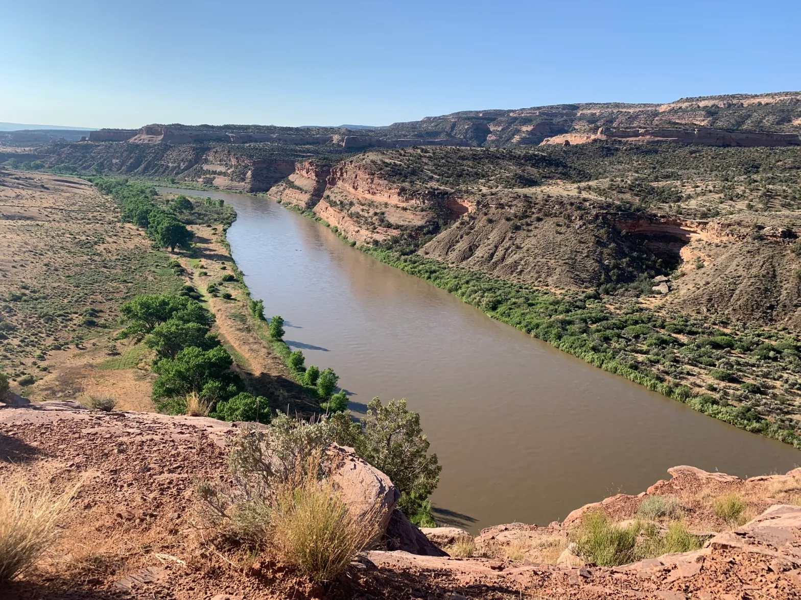
The Colorado River near the state line in western Colorado. Representatives from the seven basin states that use the river are negotiating how future cuts will be shared in dry years. Credit: Heather Sackett/Aspen Journalism
Seven-state negotiations
Commissioners also gave an update on those difficult discussions with the seven basin states on how the river will be managed after 2026. Representatives from the UCRC, as well as from California, Nevada and Arizona, are in the midst of figuring out how the nation’s two largest reservoirs will be operated after 2026 and which water users will be cut by how much in dry years.
In their proposal to the Bureau of Reclamation, the Lower Basin states demanded that the Upper Basin share in future cuts when reservoir levels dip. But Upper Basin commissioners stood by the counterproposal they offered in March, called the Upper Basin Alternative, which does not include mandatory cuts for Upper Basin water users.
“The upper division states continue to stand behind the alternative that we submitted and know that it provides a reasonable alternative for sustainable operations of Lake Powell and Lake Mead,” said Colorado Commissioner Becky Mitchell.
Although the Upper Basin’s proposal does not commit to sharing in cuts when reservoir levels fall, it does offer “parallel activities,” which would include voluntary, temporary and compensated reductions in use (as the SCPP does), which are separate from the post-2026 guidelines process.
“We’re moving forward with our parallel actions like we have committed to do,” said Utah Commissioner Gene Shawcroft. “I think that’s significant.”
Although the Upper Basin and Lower Basin states have competing proposals, Upper Basin commissioners said Monday they are still committed to finding a consensus with their Lower Basin counterparts.
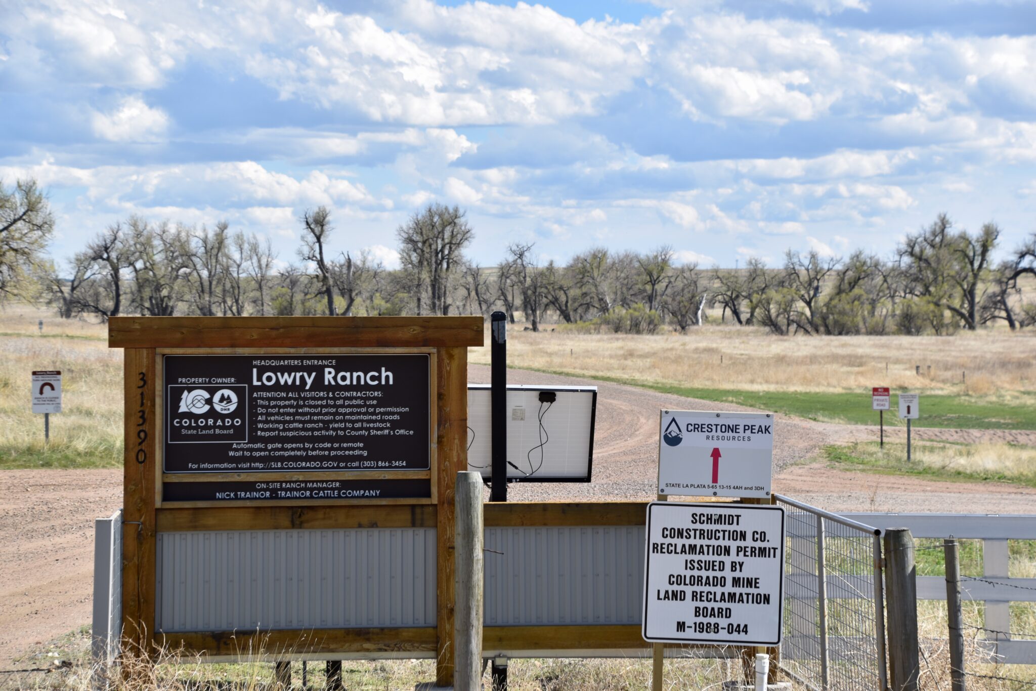
The entrance to the Colorado State Land Board’s Lowry Ranch property in Arapahoe County is pictured on May 16, 2024. (Chase Woodruff/Colorado Newsline)
Colorado regulators on Wednesday gave the go-ahead to a sweeping oil and gas drilling plan on a large tract of state-owned land east of Aurora, with several conditions aimed at addressing concerns from nearby residents opposed to the project.
On a 3-1 vote, members of the Colorado Energy and Carbon Management Commission approved the 32,000-acre “comprehensive area plan” proposed by Denver-based Civitas Resources, which aims to streamline permitting for 156 new oil and gas wells at seven drilling locations in Arapahoe County. But they moved to require that Civitas use emissions-reducing electric drilling equipment, and left the door open to denying permits for proposed well pads nearest to several southeast Aurora subdivisions.
“I do see concerns with the CAP, and I do think there’s additional work that could have and probably should have been done,” said ECMC Commissioner Mike Cross. “But I still do think that it does meet our rules, and is approvable.”
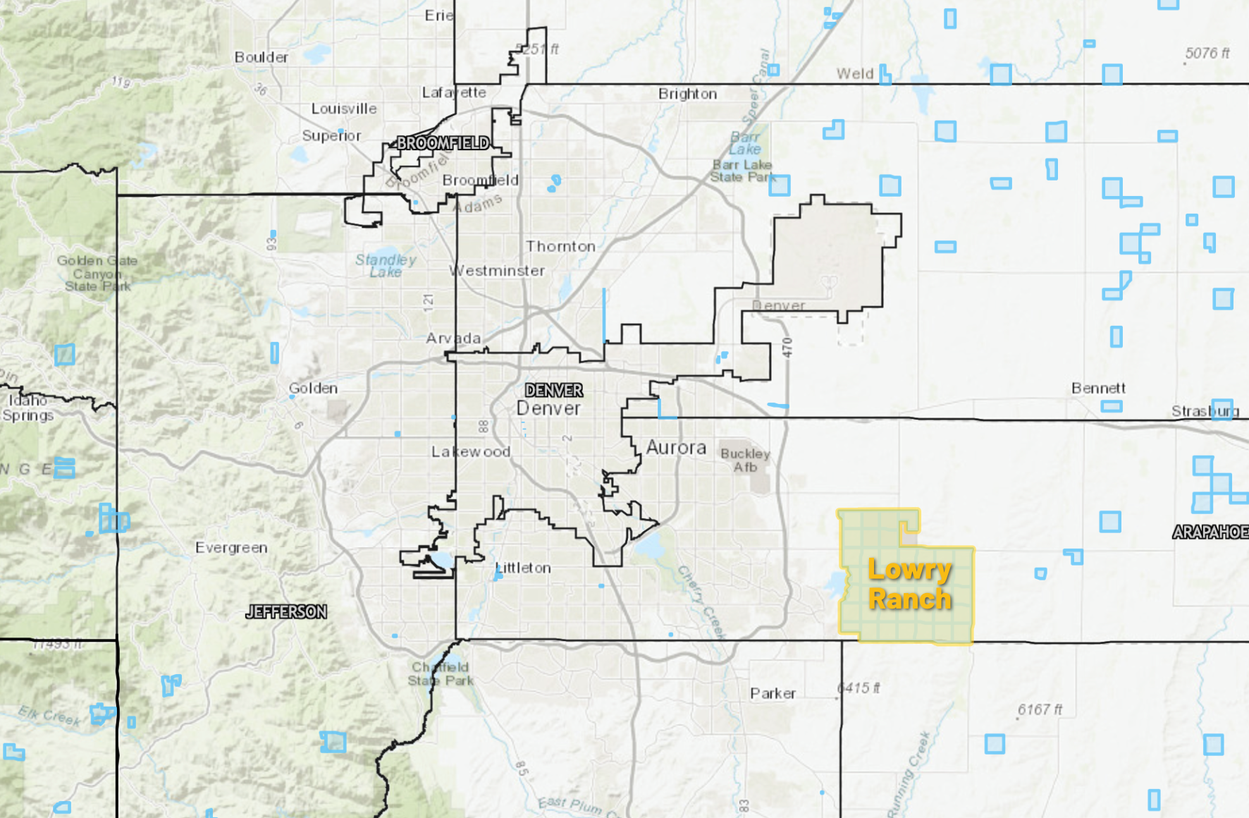
Most of the area in Civitas’ CAP proposal consists of the sprawling Lowry Ranch property, a former U.S. Air Force missile launch site and gunnery range acquired by the Colorado State Land Board in the 1960s. Limited drilling has taken place on the property since the Land Board first issued a lease for oil and gas development in 2012, but the CAP’s approval could fast-track drilling in the area for the next six years.
Save the Aurora Reservoir, a community activist group formed to oppose the project, made their case against its approval in a two-day hearing last week, citing concerns about increased noise, truck traffic, air pollution and wildfire risk. They also worry about the proximity of the Lowry Landfill Superfund Site, on the northwest corner of the project area. Civitas agreed not to drill under the Superfund site at the Environmental Protection Agency’s request.
“We are devastated by the Commission’s decision,” Marsha Goldsmith Kamin, STAR’s president, said in a press release. “This is without doubt the wrong decision for the health, safety, and environment of our community.”
The approval also drew condemnations from state and national environmental groups, including the Sierra Club, which called the plan “reckless.”
“The grassroots efforts in Aurora have been powerful, passionate and persistent,” Ben Jealous, the Sierra Club’s executive director, said in a statement. “Members of this community deserve access to healthy air and clean water, and shouldn’t have to live in fear of fracked gas operations beneath their homes and schools.”
The 26,500-acre Lowry Ranch, a former U.S. Air Force missile site and bombing range, was acquired by the Colorado State Land Board in the 1960s. (Colorado Newsline illustration/State Land Board map)
Two-year process
Civitas first submitted its CAP application in 2022. Jamie Jost, an attorney representing Civitas, told commissioners Wednesday that the company’s proposal had “evolved for the better” over the course of two years of community outreach and feedback, “including input and influence from STAR.”
“It’s a comprehensive area plan that’s the result of thousands of hours of consultation, cooperation and collaboration with multiple federal, state and local governmental stakeholders, oil and gas operators, mineral owners, community groups and citizens,” Jost said of the proposal.
But Jost also criticized the testimony from STAR and its expert witnesses during last week’s hearings, accusing the group of spreading “misinformation intended to incite fear.” Civitas was particularly adamant throughout the proceedings that STAR’s fears about induced seismic activity — a phenomenon that has been documented elsewhere but is considered a low risk in the geological formations drilled in northeast Colorado — are unfounded.
In a statement, Kait Schwarz, director of the Colorado branch of the American Petroleum Institute, called it “disappointing and revelatory” that environmental groups continue to offer “significant resistance” to drilling proposals following the passage of stricter laws and regulations in recent years.
“Our operators are proud to produce in Colorado, yet it is disheartening to encounter such opposition even when the regulations and requirements are strictly adhered to,” Schwartz said. “This application and decision should serve as a model for addressing future projects.”
None of the drilling sites proposed in the Lowry Ranch CAP would be closer than 3,000 feet from the nearest subdivision — satisfying the 2,000-foot setback requirement adopted by the ECMC in 2020 — but the plan’s opponents say it’s still far too close to neighborhoods, schools, recreation areas like the Aurora Reservoir and environmentally hazardous sites like the Lowry Landfill.
The Lowry Landfill superfund site east of Aurora in Arapahoe County is pictured on May 16, 2024. (Chase Woodruff/Colorado Newsline)
Commissioner John Messner was the lone vote against the plan’s approval. Trisha Oeth, the commission’s newest member, did not take part in the proceedings because they began prior to her appointment to the panel by Gov. Jared Polis in June.
Messner objected to the “vague and noncommittal efforts” made in the proposal to minimize the project’s cumulative impacts on public health and the environment.
“The CAP application as a whole, as presented, does not meet the intent and requirements of our rules, and has not shown that it is protective,” Messner said.
ECMC staff recommended the Lowry Ranch plan’s approval earlier this year. It’s the fourth CAP considered by the commission since its 2020 rules overhaul, and Wednesday’s vote marks the fourth consecutive approval. But Commissioner Brett Ackerman said prior to the vote that “this one felt close.” Commissioners debated whether to delay a decision on the plan, but ultimately moved forward with an approval with the attached conditions.
“Like Commissioner Cross, I do not believe it’s perfect,” Ackerman said. “Like Commissioner Messner, I do have some concerns that it can more closely comply with the intent and specificity of our regulations with a little more work.”
Civitas will still be required to seek ECMC approval for each proposed drilling location in the plan through a process known as an “oil and gas development plan,” or OGDP. That process could include revisions to the proposed sites as a result of a required “alternative locations analysis,” commissioners said Wednesday.
“In order of the things that cause me the most concern, first and foremost would be the proximity of the primary line of well pads to the line of residential developments,” said Ackerman. “They feel a little deaf to some of the concerns of the nearby residents, as opposed to promoting maybe a couple of opportunities for working together with those residents to minimize impacts.”