
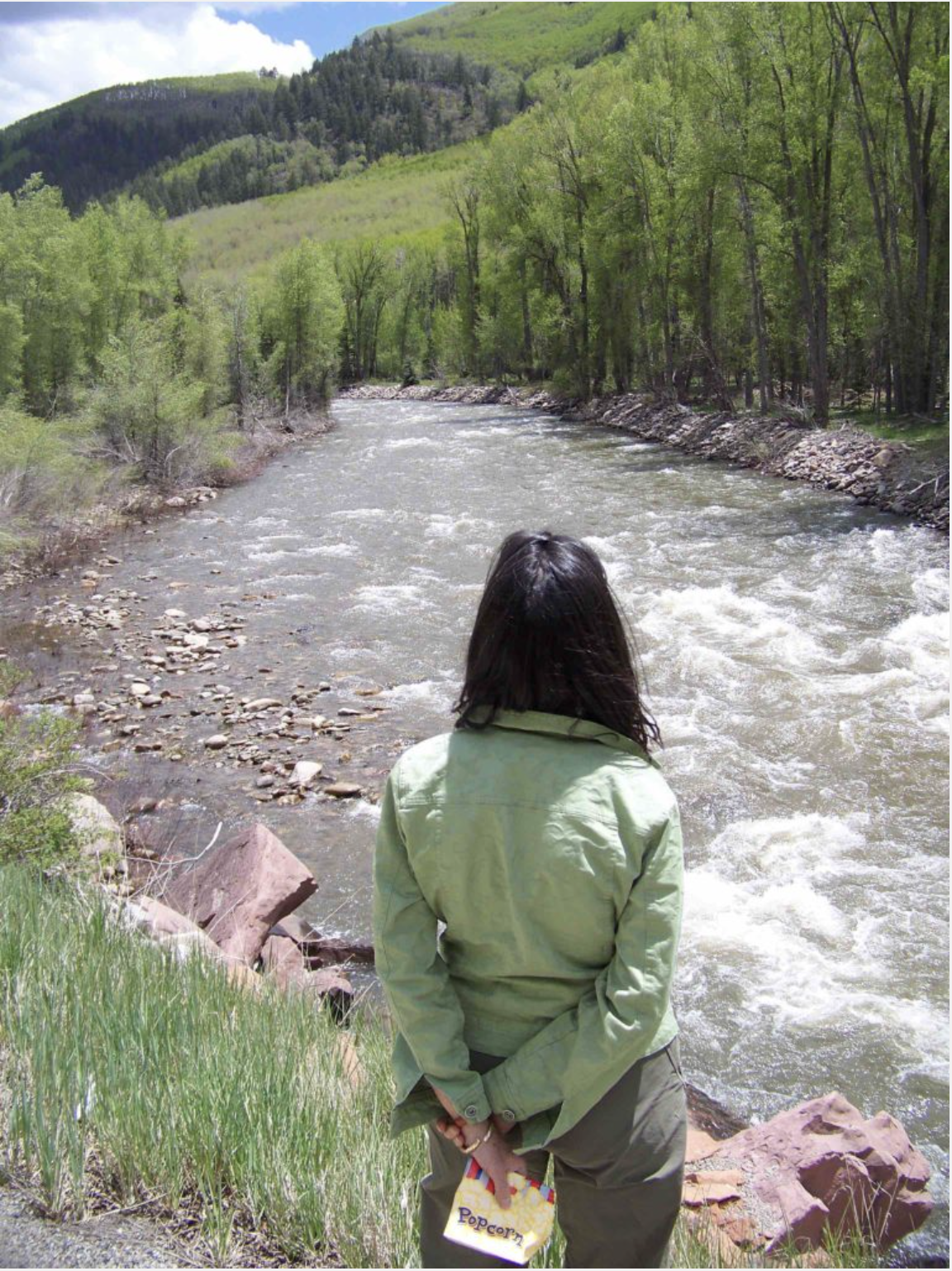
Happy 148th Birth Anniversary #Colorado!

Click on a thumbnail graphic to view a gallery of drought data from the US Drought Monitor website.

Click the link to go to the US Drought Monitor website. Here’s an excerpt:
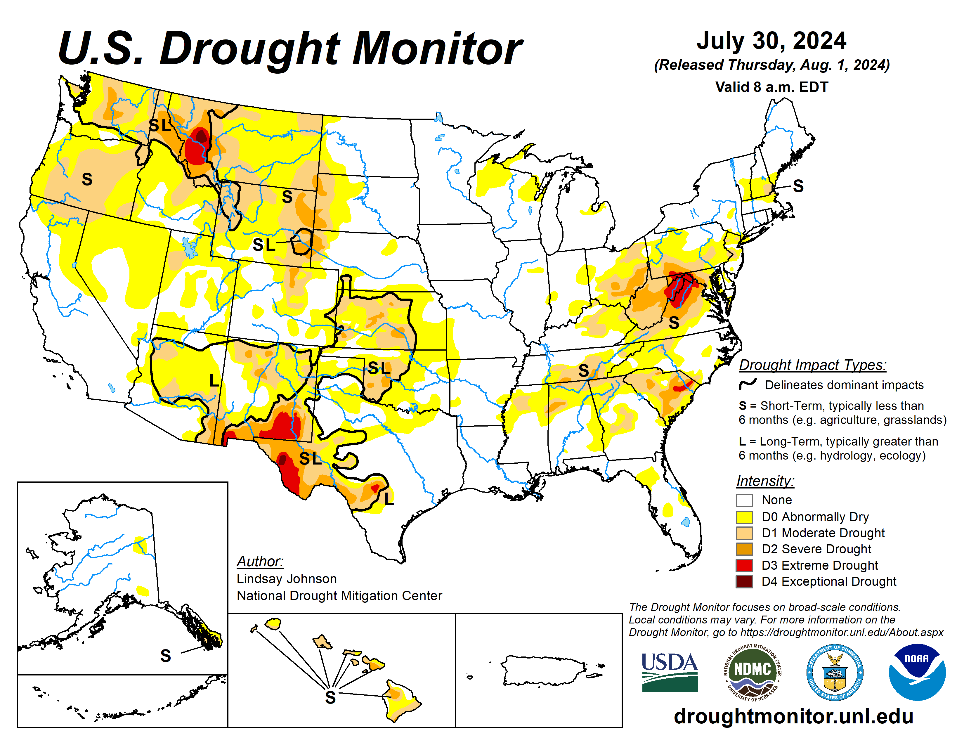
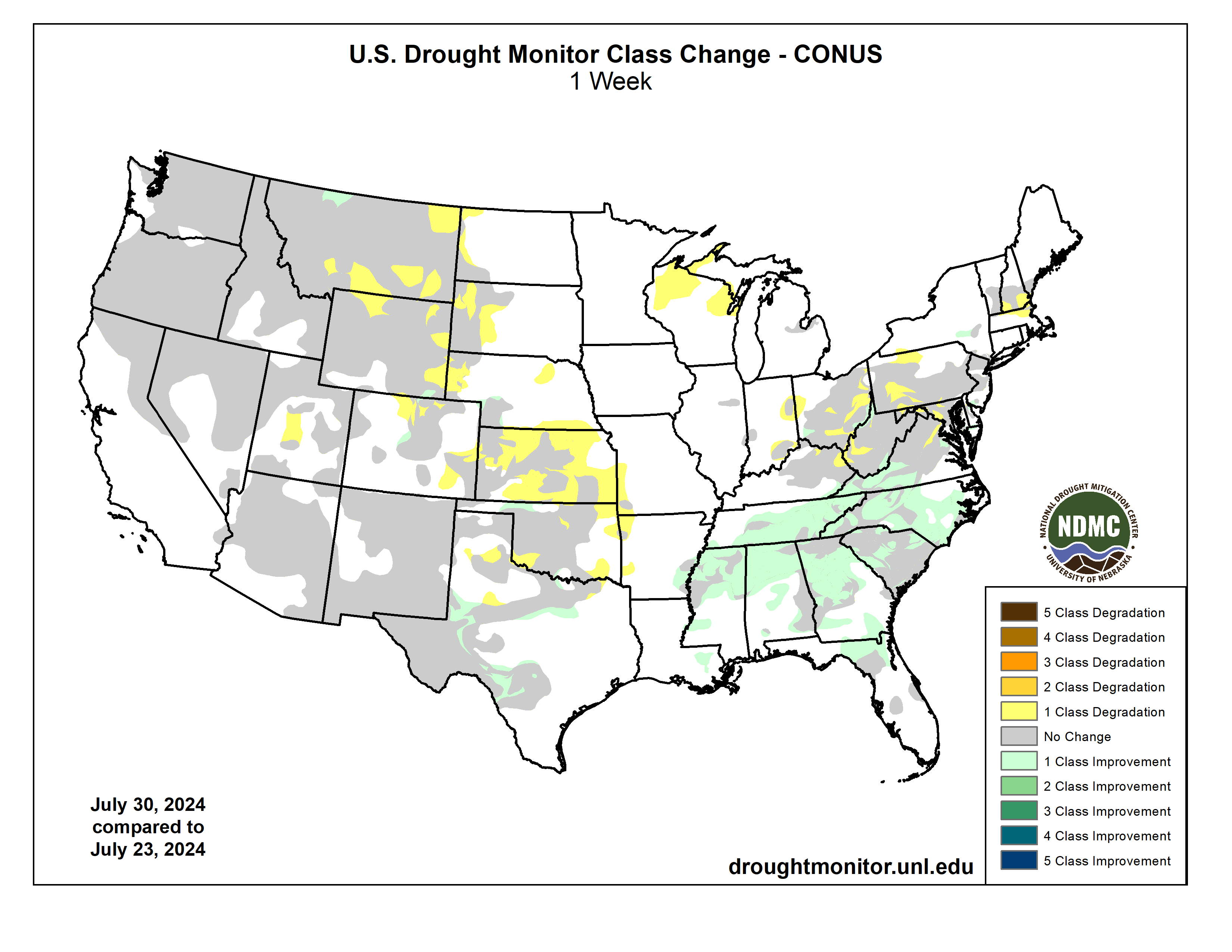
This Week’s Drought Summary
Heat continued to be the dominating feature in the Southwest and Plains. Temperatures were 2 to 6 degrees above normal, with isolated areas seeing temperatures of 6 to 8 degrees above normal. The Southwest reached near record temperatures once again, with the highest 1-day maximum temperature for the week reaching 120 degrees in Death Valley and 110 degrees in surrounding areas. The West and Plains missed out on much of the precipitation that fell this week. These hot and dry conditions have leant themselves to increased fire potential and wildfires. The southern Plains, missing out on the precipitation and experienced above-normal temperature, leading to more drying and degradation. Similar degradations occurred along the western border of the High Plains due to the lack of precipitation, poor soil moisture, and declining streamflows. The Southeast on the other hand received substantial precipitation, vastly improving lingering dryness in the area. The northern Appalachian region saw 1-category degradations where streamflows in north-central West Virginia are critically low…
High Plains
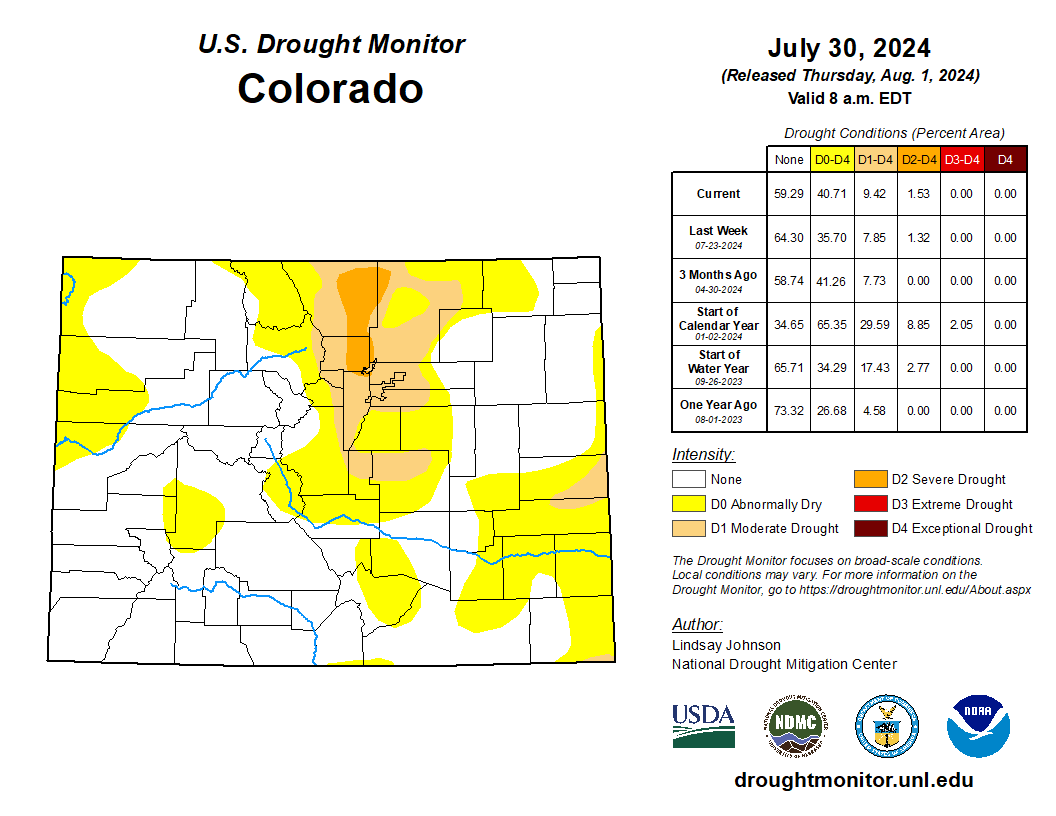
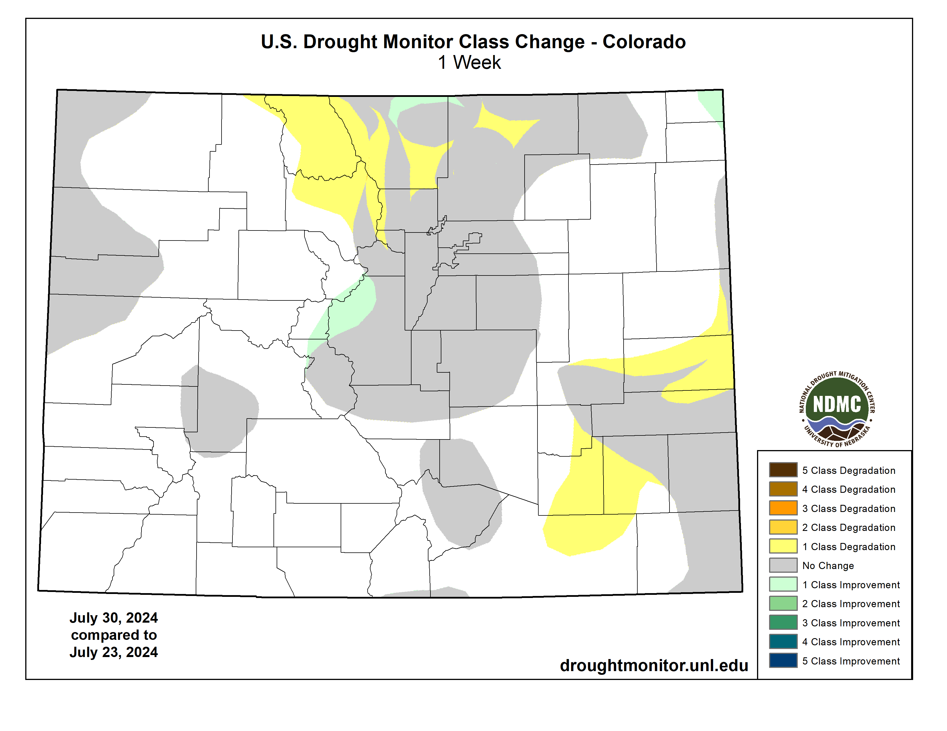
The High Plains received trace amounts of precipitation, leading to already dry conditions in the western and southern High Plains to further deteriorate. Poor soil moisture in much of Kansas brought about widespread 1-category degradations. In eastern Kansas, along the Missouri border there have been reports dryness and heat stress. Central Kansas has also seen reports of dry ponds and fear of total crop failures. Some of these drier conditions spilled northward into southern Nebraska, which also saw areas of the northeast and western Panhandle deteriorate because of an extended period of dry conditions, dry vegetation, and low streamflow values. Similar conditions were seen across western South and North Dakota and Wyoming. Colorado saw deterioration in the northern Front Range, where extreme temperatures and low humidity made for perfect conditions for wildfires. Two fires were reported on Monday July 29: the Alexander Mountain Fire west of Loveland, the Stone Mountain Fire southeast of Estes Park…
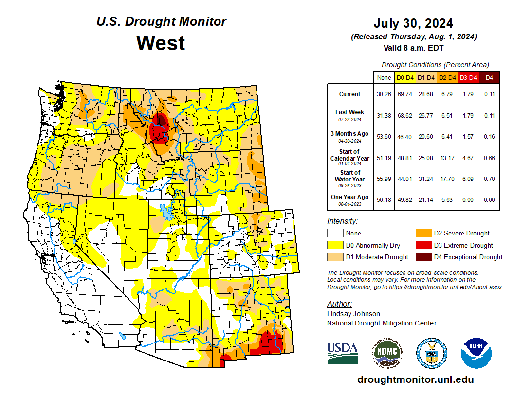
West
The Northwest saw some relief from the extreme heat this week, with temperatures in Nevada, California, Oregon, and Washington being 2 to 6 degrees below normal. Conversely, the Southwest saw more extreme heat. Southern California, the southern tip of Nevada, and western Arizona saw temperatures of over 90 degrees this week with the highest 1-day maximum temperature reaching over 110 degrees. In the northern West, Montana saw slight improvements in the far north where temperatures were slightly below normal but saw similar conditions as North and South Dakota conditions in the central and eastern parts of the state. Central Utah saw minor expansion of abnormal dryness as streamflow began to drop and vegetation is looking dry…
South
Eastern portions South saw much of the heavy precipitation seen in the Southeast. Southeastern Texas into western Louisiana recorded areas of over 8 inches of rain falling this week. There was a sharp line of where the precipitation fell and did not. West of south-central Texas, northeastward to central Arkansas saw trace amounts of rain. Temperatures were also between 1 and 4 degrees below normal, with eastern Texas and western Louisiana having temperatures of 6 to 8 degrees below normal. Except for north-central Texas and parts of Oklahoma, and western Arkansas, 1-categoy improvements were made. Oklahoma saw a mixture of above- and below-normal temperatures, with hot temperatures heating up at the end of the week (July 23 to 30). Reports of “cover crops being cooked” and “no soil moisture for native grasses to draw from and large pastures have lost much green color and have shrunk considerably” in central Oklahoma’s Logan County…
Looking Ahead
Over the next five days (August 1-6), the Midwest, Northeast, and eastern Southeast are expected to see 1 to 2 inches of rain with heavier amounts predicted in the eastern Midwest and southern Florida. The rest of the Southeast will see more modest amounts of precipitation, deviating from their previous weeks of heavy precipitation. There is currently an Atlantic Disturbance that the National Hurricane Center show a greater than 60 percent chance of developing into a tropical cyclone within the next two days (August 1-2) which could bring heavy rainfall along the Atlantic Coast in the coming week. Isolated areas from Wisconsin, Minnesota, and Iowa to Kansas and higher elevations of Colorado, New Mexico, and Arizona are expected to receive around 1 inch of precipitation. Otherwise, precipitation will be light and spotty leading to much of the West, Texas, southern Oklahoma and Arkansas missing out on the precipitation.
The National Weather Service Climate Prediction Center’s 6-10 day outlook heavily favors above-normal temperatures from the Pacific Northwest across to the Southeast with conditions becoming near normal across the central U.S. and leaning to below normal temperatures further north toward Canada. Much of Alaska is expected to be above normal with below-normal temperatures possible to the southwest. Similarly, Hawaii is leaning towards above-normal temperatures. Many of the lower 48 states are leaning towards above-normal precipitation, centering around Wyoming and Colorado, along with the Atlantic Coast, which could see remnants of the Tropical Disturbance currently in the Caribbean. Alaska’s border with Canada is seeing up to a 70 percent chance of below normal precipitation, with the probability increasing in the west and southwest. Hawaii probability of seeing below-normal precipitation is 33 to 40 percent.

Click the link to read the article on The Washington Post website (Maxine Joselow). Here’s an excerpt:
July 30, 2024
More than 350 prominent climate advocates on Tuesday endorsed Vice President Harris for president, a sign that environmental leaders believe hercampaign will energize like-mindedvoters in a way that President Biden could not. In a letter shared first with The Washington Post, big names in the environmental movement — including former U.S. climate envoy John F. Kerry, former secretary of state Hillary Clinton and Washington Gov. Jay Inslee (D)— wrote that Harris has long prioritized climate action and would continue to do so as president.
“We know that protecting our planet for ourselves and future generations requires the kind of bold leadership that Kamala Harris has demonstrated her whole life,” they wrote. “We are proud to support her and be in the fight against climate change with her.”
Inslee, whose ambitious climate proposals during his 2020 presidential campaign influenced Biden’s climate policies, said Harris could help mobilize young voters, a crucial Democratic constituency. Polls show that climate change is a top concern for young people, who are more likely than older generations to face raging wildfires, rising seas and stronger storms in their lifetimes.
“Her candidacy instantly lit an electric spark under young people across the country,” Inslee said. “That’s going to bode well for our fortunes.”
Kerry, who left the Biden administration in March, said in an interview that Harris was a “terrific ally” on climate policy. He noted that she was an early advocate of the United States reaching net-zero emissions by mid-century, and she delivered a forceful speech at the U.N. Climate Change Conference in Dubai last fall.
Click the link to read the article on The Land Desk website (Jonathan P. Thompson):
July 30, 2024
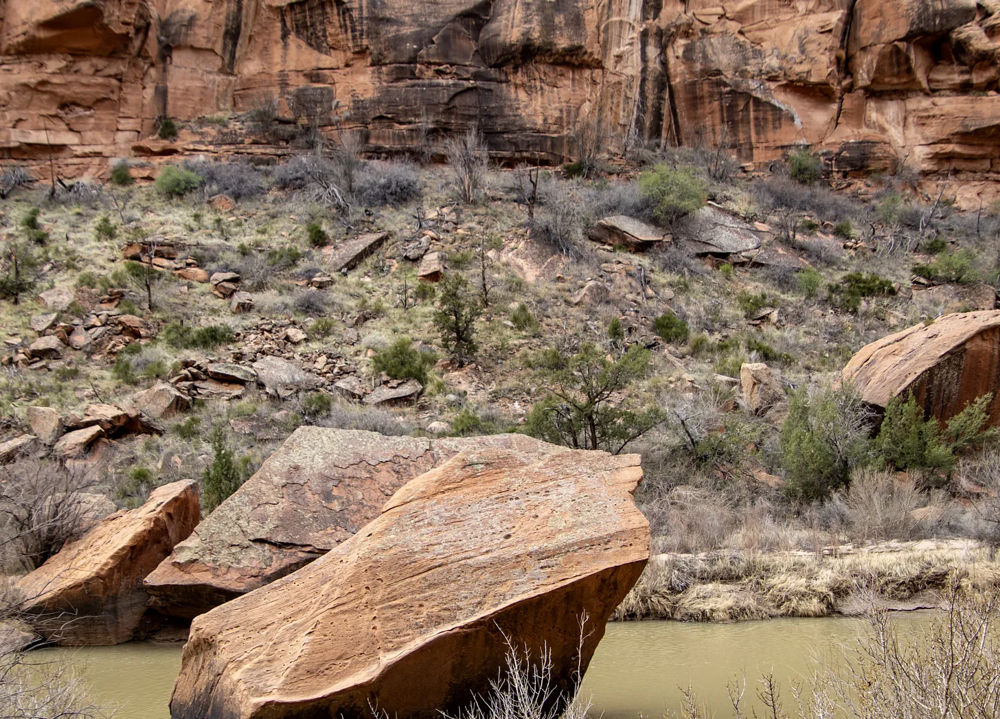
The News: Western Colorado’s Mesa and Montrose counties propose a 30,000-acre national conservation area for the Lower Dolores River corridor as an alternative to the proposed 400,000-acre national monument. While this may look like a peace offering or compromise of sorts from counties that have opposed protections of any kind, it is just as likely an attempt to block any sort of designation and will probably only further fan the flames of controversy. It’s the latest volley in a half-century-long battle over the fate of the beleaguered river.
The Context: The current controversy over the Dolores River takes me back to when I was a youngster in the early ‘80s. McPhee Dam was under construction on the Dolores River, its proponents having vanquished a movement that sought to block the dam and keep the river free. My parents had been on the losing side of the fight, and I can distinctly remember my father blaming the defeat, at least in part, on outsider environmentalists — including Ed Abbey — deriding the pro-dam contingent as a bunch of “local yokels.
I’m sure my dad took it personally. He was a fourth-generation rural Coloradan, had graduated from Dolores High School, and his mom and sisters still lived in Dolores — apparently making him a “yokel,” even though he opposed the dam. But also he saw it as a major strategic misstep. Not only were these people insulting locals, but they were falling into the pro-dam contingent’s trap, bolstering the dam-building effort in the process.
More often than not, these land protection fights are framed as well-heeled elitist outsiders and Washington D.C. bureaucrats imposing their values on and wrecking the livelihoods of rural, salt-of-the-earth local ranchers and miners. And in almost every case it is a gross oversimplification, at best, and at worst is an inaccurate portrayal and a cynical attempt to disempower locals — and anyone else — who favor land protection. So when those anti-dam folks caricatured the pro-dam contingent as local yokels, they were not only alienating locals who may have been on their side, but also validating the false depiction of the situation.

We saw this play out in the battle over the Bears Ears National Monument designation and Trump’s shrinkage of it in a gross way. The anti-monument contingent insisted that all “locals” were opposed to the monument — and the media largely bought into it — never mind the fact that effort to establish a monument in the first place was driven by local Navajo Nation and Ute Mountain Ute citizens, and was taken up by tribal nations who have inhabited the landscape in question since time immemorial. Never mind that the anti-monument “locals” were backed by mining corporations, right-wing think tanks, and conservative politicians from all over (including a Manhattan real estate magnate and reality TV personality who became President). Utah’s congressional delegation even had the gaul to attempt to disenfranchise and silence the voices of tribal leaders because they happened to be based on the other side of a state or county line that was arbitrarily drawn based on arbitrary grids by dudes in Washington D.C.
The movement to protect the Dolores River has been portrayed in much the same way over the last several decades. It has its roots in 1968, when U.S. Rep. Wayne Aspinall, a Democrat from Colorado’s Western Slope, pushed through the Colorado River Basin Project Act, authorizing the construction of five Western water projects. One of them was the Animas-La Plata Project, a byzantine tangle of dams — including one on the Animas River above Silverton — along with canals, tunnels, and even power plants. Another was the Dolores Project, which included building McPhee Dam several miles downstream of the town of Dolores, which would impound water to lengthen the irrigation season for the Montezuma Valley and allow water to be sent, via canal, to the dryland bean farmers around Dove Creek.

The prospect of another river being stilled by another giant monolith sparked a movement to block the dam and to designate the Lower Dolores River corridor as a Wild and Scenic River, which would have prohibited mining and oil and gas leasing, while also ensuring enough water would be left in the stream to keep the river “wild and scenic,” which is to say a lot more water than zero, which was the lower river’s flow from mid-summer into fall due to irrigation diversions.
Local farmers were generally in favor of the dam — and against Wild & Scenic designation, since it would likely deprive them of some irrigation water during dry times. But their cause was also backed by powerful agricultural interests on the state level, the pugnacious Durango attorney Sam Maynes, Sen. Gary Hart, the Colorado Democrat, and, probably most importantly, the Ute Mountain Ute Tribe, which would receive a portion of the vast amounts of water to which they were entitled from the Dolores Project. The project was ultimately authorized (though I doubt the local yokel comment had all that much to do with it, really). Construction of McPhee Dam began in 1979 and the reservoir began filling in 1983.

No matter how one feels about dams, you have to admit it had some benefits. In 1978 the federally funded Dolores Archaeological Program was launched to survey, excavate, and study the rich cultural sites that were spread out across the area to be inundated by the reservoir. It was a huge project that brought a slew of researchers to the area, significantly advanced scientific knowledge of the Ancestral Puebloan people who inhabited the region for centuries, and provided the seeds for future archaeological work and organizations, including the Crow Canyon Archaeological Center.
And, contrary to opponents’ fears, the dam didn’t kill the river. Rather it was like putting the river’s manic-depressive flows on lithium. The massive spring runoffs were tempered, but water managers released enough water in most years to scour beaches and preserve Snaggletooth’s whitewater snarl. And for the first time in a century the lower Dolores didn’t run dry in July. In fact, the year-round flows were enough to build and sustain a cold-water fishery for trout in the first dozen or so miles below the dam and a habitat for native fish below that. The Ute Mountain Ute Tribe got both drinking water from the project as well as enough to irrigate a major agricultural enterprise near the toe of Ute Mountain, providing much needed economic development. The Town of Dove Creek receives water from the project as do the formerly dryland farmers, allowing them to diversify their crops. The dam’s completion happened to coincide with the demise of the domestic uranium mining industry, meaning that threat mostly went away as well, along with the need for added protections.
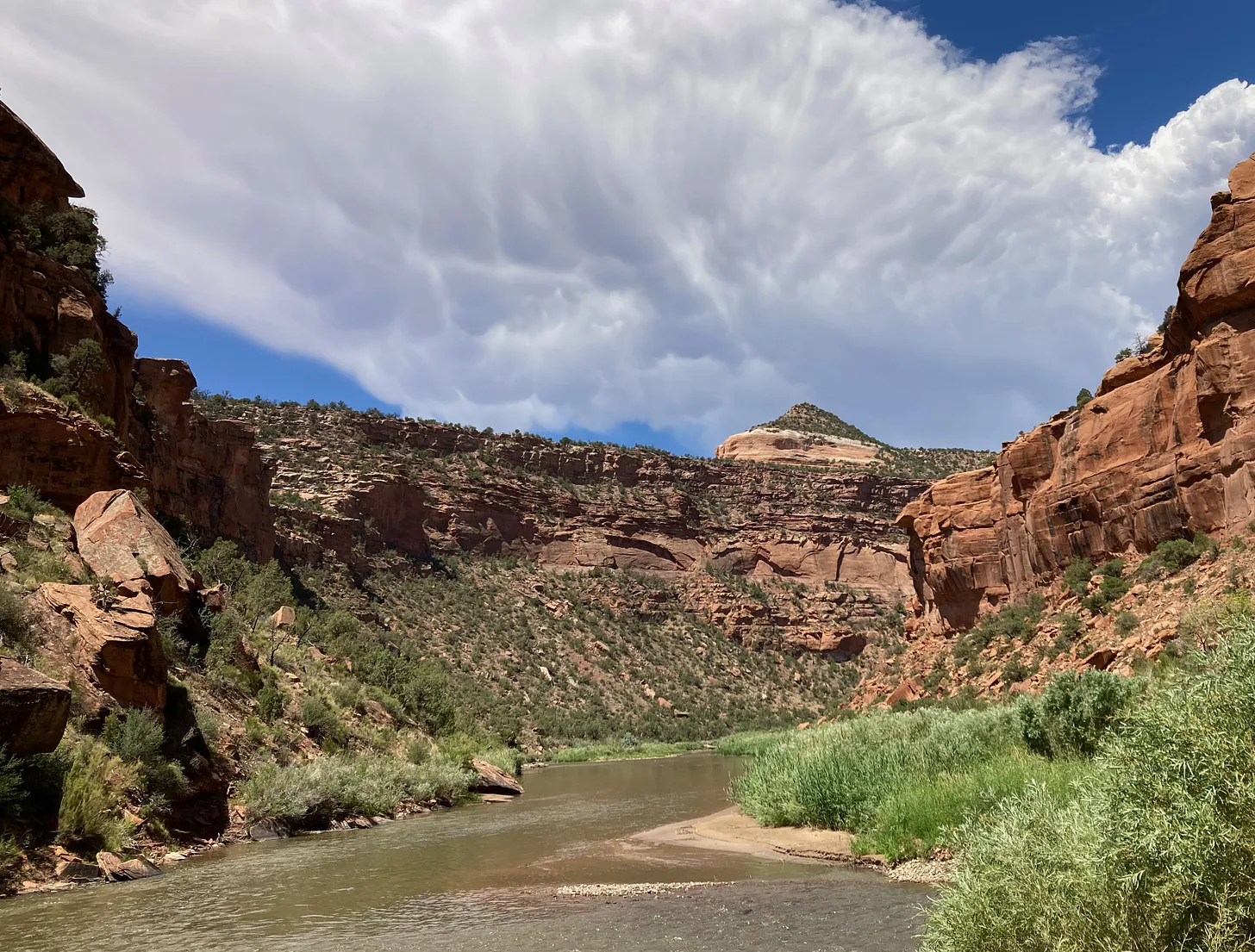
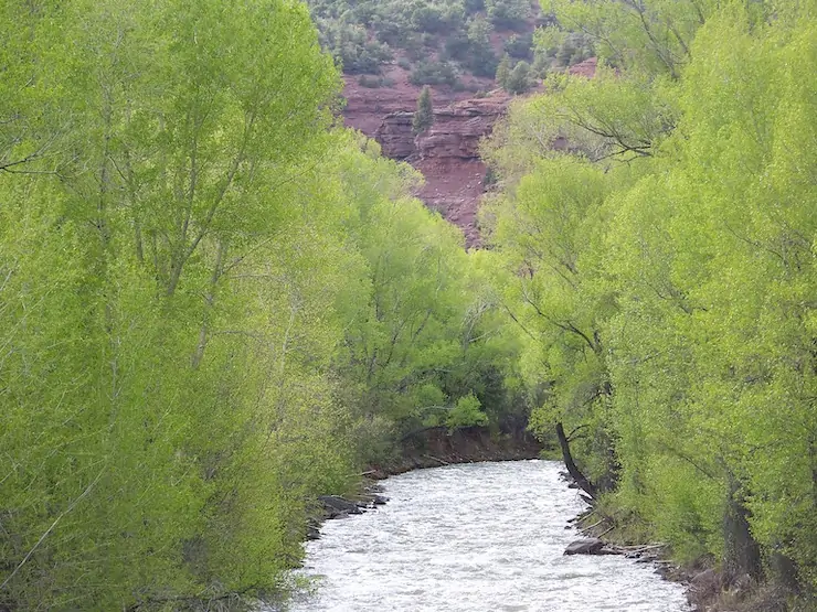
Unfortunately, drier times set in and the current megadrought, now going on a quarter century, has depleted the river’s flows and reservoir levels. In order to keep the irrigation ditches flowing as deep into the summer as possible, dam managers have released almost no water during 14 of the last 24 years, essentially desiccating the stream bed below the dam and throwing the riparian ecology out of whack. In the midst of it all the uranium industry made a short-lived comeback between 2006 and 2012. Now it seems to be emerging from its zombified state once again and is targeting numerous sites along the Dolores River. The river runs through the Paradox Formation, as well, meaning it could be targeted by lithium and potash miners. Meanwhile, visitation to the Lower Dolores River has ramped up — along with the impacts — as social media posts reveal the canyons to more people and as the Moab crowd seeks new places to play.

All of that spawned new Wild & Scenic campaigns for the Lower Dolores, but after it became clear they couldn’t get past political hurdles, stakeholders came together to work on a compromise, resulting in a proposal to create a national conservation area on 60 miles of river corridor below the dam, which would withdraw the land from new mining claims and oil and gas leases, bring more attention to the plight of this sorrowful and spectacular river, and possibly more funding to river restoration efforts. But it would leave another 100 miles of the Lower Dolores unprotected, in part because Mesa and Montrose Counties withdrew their support for the plan. Thus the proposal for President Biden to designate 400,000 acres as a national monument.
That proposal, perhaps predictably, has sparked a backlash and an anti-national monument campaign partly fueled by disinformation. And, just as predictably, it’s being falsely framed as a fight pitting locals vs. outsiders. It’s true that a survey commissioned by Mesa County of about 1,200 registered voters in Mesa, Montrose, and San Miguel Counties found that 57% of respondents oppose the national monument proposal. That shows that more locals oppose it, but that quite a few support the initiative, as well. And Center for Western Priorities director Aaron Weiss found that the survey may be biased since its creators consulted with national monument opponents, but not proponents, about which questions to ask and how to word them. And it shows.
For example, the survey precedes one set of questions with: “Currently, uranium mining in the Dolores River Canyon area in the west end of Montrose County impacts the local economy by providing tax dollars and jobs. The current national monument proposal would allow some but not all existing permit holders to continue to operate, but it has not been decided if the proposal would allow new permits or permit renewals in the future.” But this is misleading, because the uranium mining industry remains virtually dead, so the economic impact is zero to negligible. Furthermore, a national monument grandfathers in all existing valid mining claims and has no effect on patented (private) claims. So even if there were operating mines, a monument wouldn’t hamper operations. [ed. emphasis mine] Other questions were similarly misleading by implying that a national monument designation would remove management from the BLM or Forest Service.
Tellingly, the survey also found that 72% of respondents support existing national monument designations “such as Browns Canyon, Chimney Rock, and Colorado National Monument.” Why? Because they value conservation and they’ve seen that national monuments don’t hurt the economy or agriculture or significantly restrict access. That they are less sure about a new national monument might have something to do with the opponents’ simplistic and unfounded argument against it, which is that it could “impose severe economic hardships,” without explaining how.
Nevertheless, Mesa County used the survey to justify a resolution opposing the national monument and supporting its proposal for a vastly scaled down national conservation area. Again, this tactic is an echo of ones used by Bears Ears National Monument opponents. National Conservation Areas don’t inherently offer more or less protections or restrictions than national monuments, but they do need to be passed by Congress. Given how dysfunctional our Congress is, that could take years or even decades.
Yet the Lower Dolores River needs help now. No, a national monument won’t solve all its problems; it may not help the river, itself, at all. Already the fight over the proposal has shone a spotlight on a remote, largely unknown area, which will surely draw more visitors and more damage. A national monument designation at least would provide the possibility of protection against future development and burgeoning crowds.
Our River of Sorrow Jonathan P. Thompson October 27, 2021


Click the link to read the article on The Revelator website (Juliet Grable):
July 22, 2024
“What do you think about this?” My friend, Sonya Daw, had called out to me from where she was standing at the edge of Beaver Creek. I joined her. I had just scrambled over a massive log and was grateful for an excuse to catch my breath.
“Hmm,” I said, still breathing hard. In front of us, water burbled over some branches that had fallen across the creek. Had they fallen, though? Or had they possibly been placed there by beavers?
As one of 11 teams taking part in a “beaver scavenger hunt” across the Cascade-Siskiyou National Monument in southwest Oregon, we were looking for any sign of beavers — willow stumps, sticks with “corn-on-the-cob”-style teeth marks, or even scent mounds, which beavers use to mark territories. What we and the other teams discovered would help the nonprofit Project Beaver focus their beaver-restoration efforts.
My team included Sonya, who writes for the National Park Service, her husband Charlie Schelz, the former monument ecologist, and Barb Settles, a spry 78-year-old and avid naturalist.

Charlie joined us, and we contemplated the creek. “I don’t think that’s anything,” he said. “But look how the sediment is piling up behind the branches; how cool is that?”
It was June 1 — not just a beautiful time to be hiking through the forest but the ideal window for beaver activity. Beaver moms have their babies in late spring and then send their older offspring packing. These dispersing youngsters are on the move, exploring new creeks and sampling the buffet of plants.
We took our time in flatter areas, especially where willows or red osier dogwood — beaver “dessert plants” — grew in clumps near the banks. We weren’t likely to find beavers along this steep stretch, but it was still fun to look and marvel at the enormous sugar pines, Douglas firs, and incense cedars that had escaped loggers’ chainsaws last century.
Wanted: Ecosystem Engineers
The Cascade-Siskiyou National Monument encompasses 114,000 acres, mostly in southwest Oregon. The Klamath and Cascade Mountains converge here, creating a patchwork of oak woodlands, forests, grasslands, and wetlands support a dazzling array of butterflies, bees, birds, and plants, including many that are found nowhere else.
President Bill Clinton designated the monument in 2000, not for its stunning canyons or breathtaking vistas but its “outstanding biological diversity.” In 2017 President Barack Obama expanded the monument by another 48,000 acres.
Beavers undoubtedly once populated the many streams and meadows, but by the time the monument was designated, they had been all but eradicated — the case all over Oregon. Now there is only one known established beaver family in the entire monument, says Jakob Shockey, executive director at Project Beaver. There could be others; Shockey says he’s seen evidence of random individuals on several creeks.
The Bureau of Land Management manages the monument but has partnered with the nonprofit to help bring beavers back. The task has become more urgent in the face of recent drought, which has left its mark in swaths of dead conifers. This part of southwest Oregon is dry and hot in summer, and getting more so. Beaver dams could help hold more moisture on the landscape, attracting more birds in the process. Wet meadows engineered by beavers could even serve as a firebreak, helping tame the spread of catastrophic wildfires.
Friends of the Cascade-Siskiyou National Monument, the group that hosted the scavenger hunt, is a key player in the project.
“We see our role as letting people know what makes the monument special and what’s needed to support the ecological integrity of this special place,” says Friends’ executive director Collette Streight.
Friends has hosted several “bio-blitz” events, where volunteers fan out in search of butterflies or reptiles. Streight wanted to create an event with the “juicy” energy of a bio-blitz that produced data with practical applications. After talking with Schelz, Shockey, and others, she honed in on beavers.
Pond of Dreams
Ultimately, the key to attracting beavers — and more importantly, convincing them to stay and set up shop — is restoring habitat. This “build it and they will come” approach can attract beavers from miles away.
“One of the first steps is to get information: Where are the beavers, and what are they doing right now?” says Streight.
Last summer, they beta-tested the scavenger hunt with a “Hike and Learn” led by Shockey.
“We need to know this information, and it really will impact future restoration work,” says Shockey. “What I don’t have is the ability to walk a bunch of creeks by myself.”
We didn’t find any evidence of beavers on our steep stretch of creek, but after clambering back to the car, we had just enough time to check out a meadow on the upper portion of Beaver Creek, where last fall Project Beaver installed a series of post-assisted log structures, or PALS.
The broad, flat meadow was a totally different landscape from where we’d been searching. Our boots squished as we wandered through clumps of sodden grass. Soon Sonya and I were reaching for our binoculars. Birdsong filled the meadow: Lazuli buntings called from the willows; robins chortled from a massive pine at the meadow’s edge. I broke out the Merlin bird-identification app to sort through the confounding songs of warblers.
Charlie pointed out one of the PALS — several small posts pounded into the creek bottom, with willows woven between them. Water had pooled behind the structure, creating a shallow, murky pond full of bugs.

“This is great to see,” he said, as he bent low to admire butterflies dancing across the surface and examine willow stakes that had been planted there. They were starting to leaf out. It wasn’t difficult to imagine a beaver setting up shop here, and not just for the scenery.
“Beavers like to surround themselves with water; it helps keep them from being eaten,” Charlie told us. Without that buffer, beavers are an easy (and meaty) target for a host of predators, including cougars, bobcats, bears, coyotes, wolves, and of course, humans.
A Rebranding Campaign
Beavers, once pilloried as pests, have undergone an image makeover in the Beaver State, thanks in part to legislative champions. Last year Oregon’s governor signed the “Beaver Believer” bill, which recognizes the rodent’s potential role in mitigating climate change. Beavers, whom the state had perplexingly classified as predators (they’re vegetarians), have now been rebranded as furbearers. As of this July, private landowners must obtain a permit before they can trap or kill so-called “nuisance” beavers. For the first time, the Oregon Department of Fish and Wildlife will also begin collecting data on all beavers killed in Oregon.
Some conservationists have been lobbying the Biden administration to ban hunting and trapping of beavers on federal lands. More locally, advocates have pushed for a trapping ban within the monument’s borders. They hoped it would be included in a new draft “Resource Management Plan” released by the BLM this year, but it was nixed.
Shockey has mixed feelings about such a proposal.
“Traditionally, trapping bans have been used as a wedge issue between those who hunt and those who don’t,” says Shockey. Increasingly, anglers and hunters are coming to appreciate beavers’ good work in streams and meadows — the places they fish and hunt.
And, as Shockey points out, a trapping ban won’t matter if beavers are shot out of spite. Having more beaver advocates actively monitoring in the monument might be the most effective way to protect the animals. Events like the scavenger hunt help by elevating their profile, making more people aware of their presence and importance.
“Beavers are so interesting in the way that people relate them,” says Shockey. “They’re kind of a charismatic animal and they’re easy to find compared to a lot of wildlife that people care about, yet they’re still pretty invisible.”
Setting the Stage
Late in the afternoon, after the scavenger hunt had run its course, 50 or so tired but happy citizen scientists reconvened at the local elementary school to share their findings. A few teams had discovered fresh sign, including along one stretch of creek where Shockey had never detected beavers before. Teams that found no fresh beaver signs shared other sightings — a snake skin, a junco nest, blooming lilies, chewed willow stumps from years past.
Shockey was pleased. “The data are going to directly inform where we’re going to do restoration,” he said, after he’d thanked the volunteers.
“I’m incredibly proud about what we accomplished,” says Streight. From the fundraising campaign to last-minute scrambling when two team leaders cancelled, the scavenger hunt had required a huge amount of effort. Best of all, no one had twisted an ankle or succumbed to heatstroke.
She hopes to capitalize on the scavenger hunt’s momentum. “We feel we could have volunteers at the ready” to help Shockey’s crew monitor sites or plant willow stakes, she says. “They are really jazzed.”
Project Beaver and the BLM have secured $227,000 for beaver restoration, which is enough to support an eight-person crew for three years. Each spring and fall, they will spend two weeks building and repairing structures in creeks, with the ultimate goal of enticing beavers back. They hope to allow beavers to find the habitat on their own and start breeding.
“Can we increase the amount of beaver activity through our restoration work? That’s how we’re going to measure success,” says Shockey.