Click on a thumbnail graphic to view a gallery of drought data from the US Drought Monitor website.


Click the link to go to the US Drought Monitor website. Here’s an excerpt:
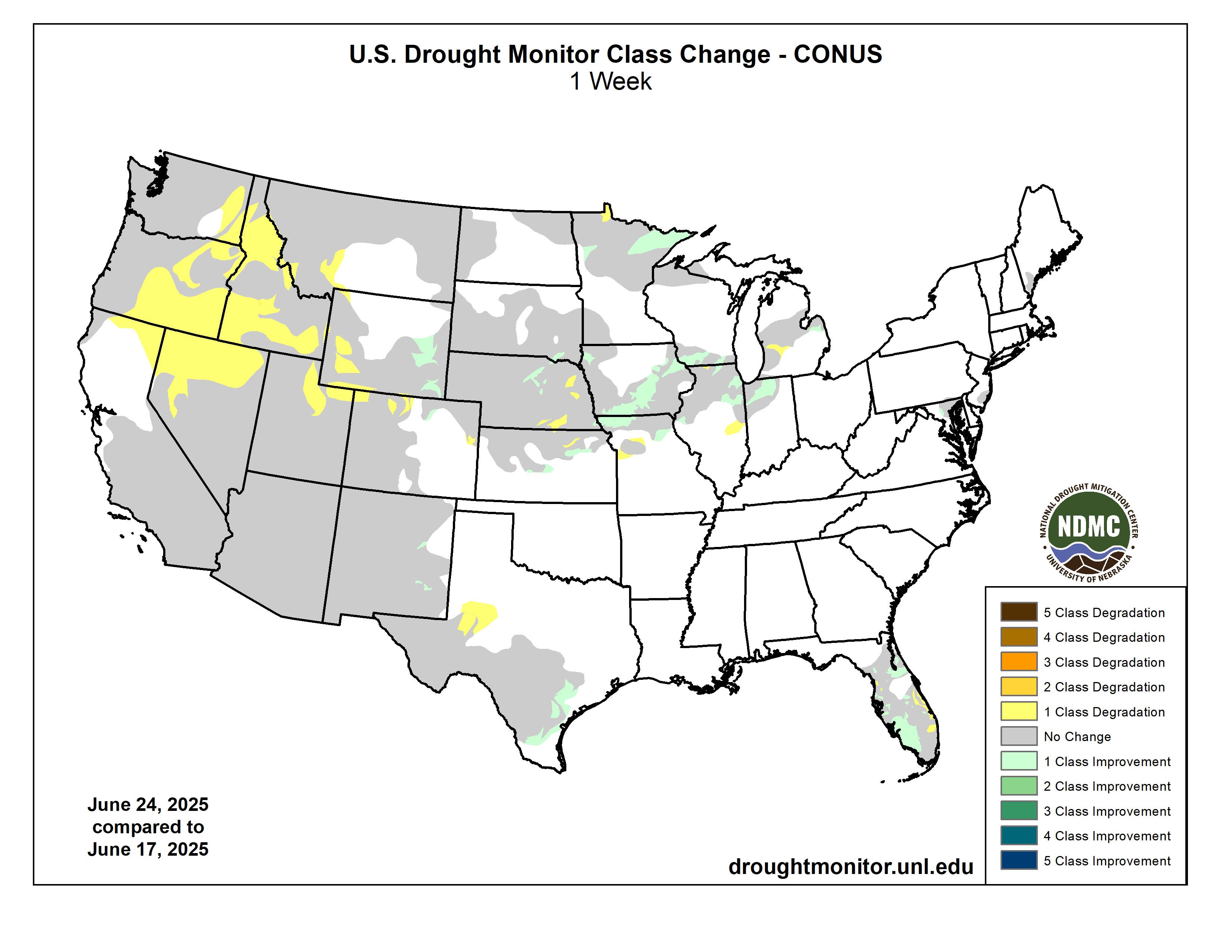
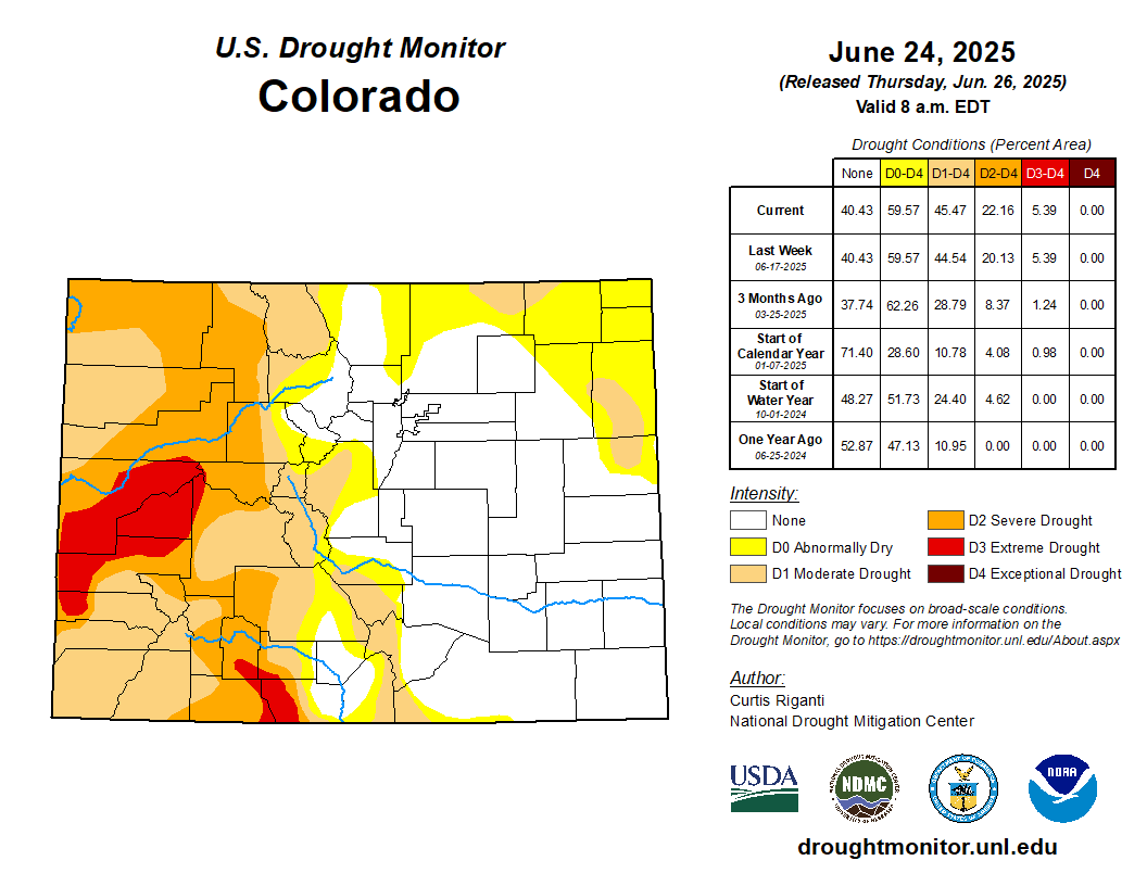
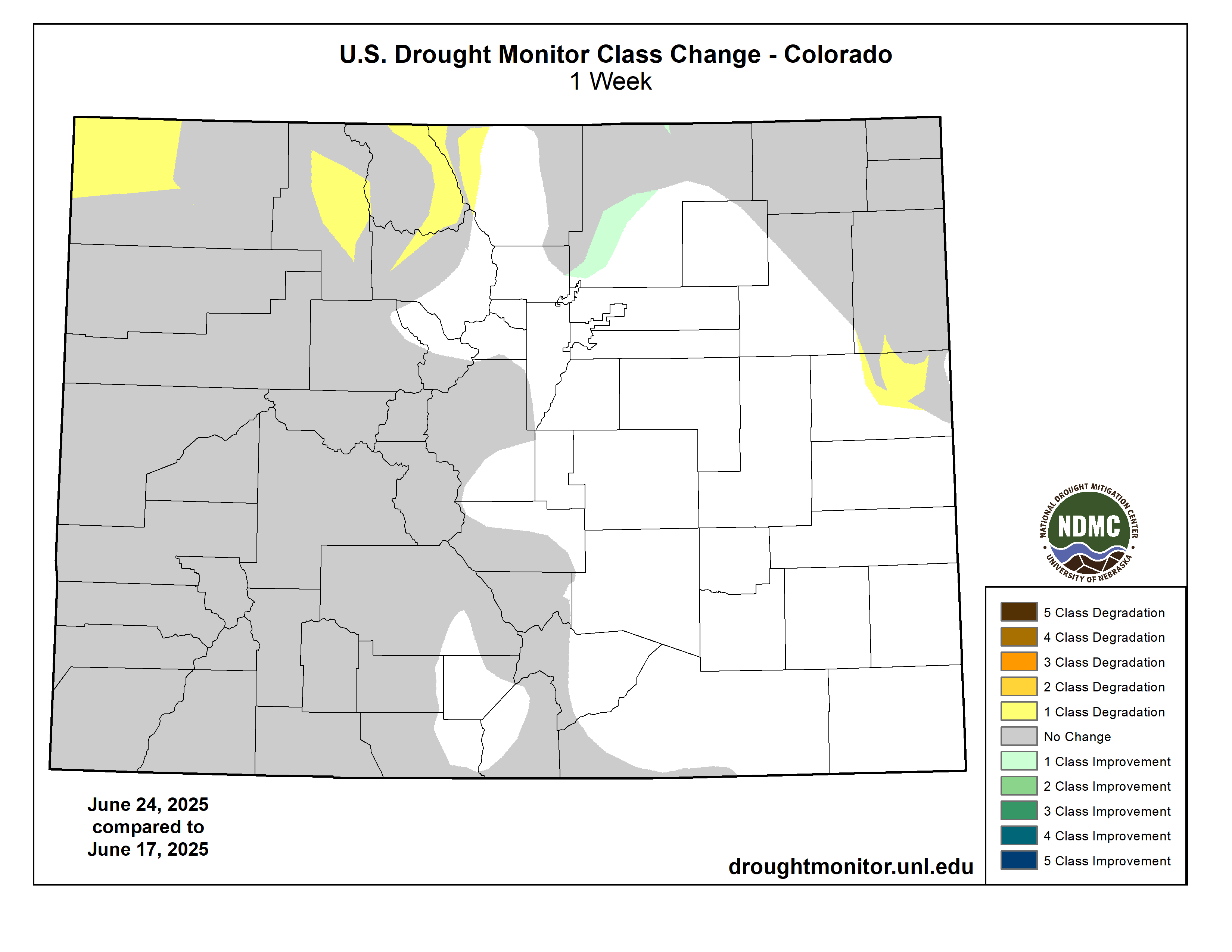
This Week’s Drought Summary
This week, widespread degradations occurred in the Northwest United States, where despite slightly cooler and wetter conditions this week, rapid drying continued to be a problem. In the central Great Plains and Midwest, scattered heavier rains led to improving drought or dryness conditions in some areas, especially in northern Missouri and Iowa, while some others who missed out on the heavier rains saw degrading conditions amid hotter-than-normal temperatures. In Florida, a mix of localized improvements and degradations occurred; scattered heavy rains improved the situation for some, while other areas that missed the heavy rain saw short- and long-term precipitation deficits grow amid worsening fire danger. After recent heavy rain, a small area west of Baltimore saw improvement to long-term moderate drought, while the most of the rest of the Northeast remained free of drought or abnormal dryness, with a small area of long-term moderate drought on Cape Cod continuing this week. A mix of improvements and degradations occurred in Texas following heavier rains last week in the south-central part of the state but drier weather in the Midland-Odessa area this week. Localized improvements occurred in areas of heavy rainfall on the eastern plains of New Mexico. Please note that any rain that fell from mid-Tuesday morning onward will be considered in next week’s map.
In Alaska, short-term abnormal dryness and moderate drought developed and expanded in parts of central Alaska, where short-term precipitation deficits built and fire danger increased.
In Hawaii, localized improvements and degradations occurred after an overall drier week with trade-wind showers on the windward sides of the islands.
In Puerto Rico, abnormal dryness developed along the northwest and south-central coasts where short-term precipitation deficits grew amid crop stress and decreasing groundwater levels…
High Plains
In Nebraska and Kansas, scattered heavy rains fell in parts of both states, especially in central and eastern areas, leading to localized improvements to ongoing drought and abnormal dryness. In some areas that missed heavier rains this week, temperatures ranging from 4-8 degrees hotter than normal led to degrading conditions, as streamflow and soil moisture levels dropped. Long-term drought over the last few years has continued to take a toll on trees in eastern Nebraska, as the bur oak, elm, hackberry, ash and red oak populations saw increased mortality or significant loss in canopy. Short- and long-term precipitation deficits continued to grow in parts of northern Colorado, which along with drops in soil moisture and streamflow led to localized worsening of drought or abnormal dryness. Meanwhile, heavier rains in the last couple of weeks in southeast Wyoming led to improving conditions there. The western half of Wyoming, in contrast, has continued to see rapid drying, leading to poor vegetation health and locally decreasing streamflow and soil moisture. Moderate and severe drought grew in coverage in parts of southwest Wyoming, while abnormal dryness grew in coverage northeast of Yellowstone National Park..
West
Predominantly cooler temperatures occurred in the West this week, with many areas west of Utah, Arizona and Wyoming seeing temperatures range from 2-8 degrees cooler than normal. Despite the cooler weather this week, the drying trend continued across much of the Northwest states, with abnormal dryness and moderate and severe drought significantly growing in coverage in northern portions of Utah and Nevada, northeast California, far western Montana, Idaho and southeast portions of Oregon and Washington. In these areas, short-term precipitation deficits are growing, streamflow is lower in spots, vegetation is struggling and soil moisture deficits are developing. Near the end of the week, scattered heavy rains fell in the eastern plains of New Mexico, leading to localized improvements in drought and abnormal dryness. The impact of these rains on the rest of the water cycle, as well as any further rain, will be further evaluated next week…
South
Temperatures across the South region this week ranged from near-normal to 2-6 degrees warmer than normal in most of the region. Heavy rains fell in parts of central and northern Oklahoma, Tennessee, northeast Arkansas, Mississippi, and the western Texas and Oklahoma Panhandles. Most of central and south-central Texas had drier weather this week. Despite the dry weather there, some improvements to the Drought Monitor occurred in south-central Texas as the impact of recent heavy rains continued to be evaluated. A small increase in abnormal dryness and moderate drought occurred in the Midland-Odessa area due to growing short-term precipitation deficits and decreasing soil moisture and streamflow. Outside of Texas, the rest of the South remained free of drought or abnormal dryness…
Looking Ahead
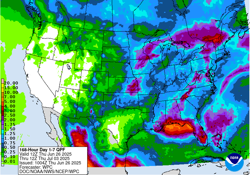
The National Weather Service Weather Prediction Center forecast through the evening of Monday, June 30, shows mostly dry weather in the West, especially for areas west of the Continental Divide. Drier weather is also expected in western North Dakota and Montana, most of Texas, Arkansas and western Louisiana, and in the eastern Carolinas. Rainfall in excess of 1 inch is forecast in parts of eastern Kansas and Nebraska, the eastern Dakotas, the Upper Midwest, the Northeast, the eastern half of the Gulf Coast and the Florida Peninsula.
For July 1-5, the National Weather Service Climate Prediction Center outlook favors above-normal precipitation across Alaska, Hawaii and most of the Contiguous United States. The highest confidence for above-normal precipitation during this period is centered on Arizona, New Mexico, southwest Texas, Utah and Colorado as monsoonal moisture streams into the region. Cooler-than-normal temperatures are favored in southeast Arizona, New Mexico, western Texas and southern Colorado, while near-normal temperatures are favored from the central Great Plains into the Great Lakes. Within the Contiguous United States, warmer-than-normal temperatures are favored elsewhere, with the highest confidence for this residing in the Northwest, western Gulf Coast, and Mid-Atlantic. Warmer-than-normal temperatures are favored across most of Hawaii. Warmer-than-normal temperatures are also favored from southwest to north-central Alaska (excluding the Aleutian Islands), while cooler-than-normal weather is favored in the extreme northwest reaches of Alaska and in the southeast portion of the state.