
Happy #ColoradoRiver Day!


Click the link to read the article on the Water Education Colorado website (Shannon Mullane):
July 17, 2025
Federal officials reported Tuesday that the water level in Lake Powell, one of the main water storage reservoirs for the Colorado River Basin, could fall low enough to stop hydropower generation at the reservoir by December 2026.
The reservoir’s water levels have fallen as the Colorado River Basin, the water supply for 40 million people, has been overstressed by rising temperatures, prolonged drought and relentless demand. Upper Basin officials sounded the alarm in June, saying this year’s conditions echo the extreme conditions of 2021 and 2022, when Lake Powell and its sister reservoir, Lake Mead, dropped to historic lows.
The basin needs a different management approach, specifically one that is more closely tied to the actual water supply each year, the Upper Colorado River Commission’s statement said.
The seven basin states, including Colorado, are in high-stakes negotiations over how to manage the basin’s water after 2026. One of the biggest impasses has been how to cut water use in the basin’s driest years.
“You can’t reduce what doesn’t come down the stream. And that’s the reality we’re faced with,” Commissioner Gene Shawcroft of Utah said in the statement. “The only way we’re going to achieve a successful outcome is if we’re willing to work together — and not just protect our own interests.”

Lake Powell, located on the Utah-Arizona border, collects water from Colorado, New Mexico, Utah, Wyoming, part of Arizona and tribal reservations in the Colorado River’s Upper Basin. Glen Canyon Dam releases the reservoir’s water downstream to Lake Mead, Native American tribes, Mexico, and Lower Basin states, including Arizona, California and Nevada.
Lake Powell and Lake Mead make up about 92% of the reservoir storage capacity in the entire Colorado River Basin.
The U.S. Bureau of Reclamation’s July report, called a 24-month study, shows the potential for Lake Powell to decline below two critical elevations: 3,525 feet and 3,490 feet.
It could drop below 3,525 feet in April 2026, which would prompt emergency drought response actions. That’s in the most probable scenario, but the federal agency also considers drier and wetter forecast scenarios. The dry forecast shows that the reservoir’s water levels would fall below this elevation as soon as January.
Lake Powell would have to fall below 3,490 feet in order to halt power generation.
Planning for emergency water releases
In 2021 and 2022, officials leapt into crisis management mode and released water from upstream reservoirs — including Blue Mesa, Colorado’s largest reservoir — to stabilize Lake Powell’s water levels.
The emergency releases prompted some concerns about recreation at Blue Mesa.
The July 24-month study triggered planning for potential emergency releases, called drought response operations, at Lake Powell, and Flaming Gorge, Blue Mesa and Navajo reservoirs, said Chuck Cullom, executive director of the Upper Colorado River Commission.
“The Upper Division States and Reclamation have been monitoring the risks to Lake Powell since January 2025 due to the declining snowpack and runoff, and are prepared to take appropriate actions as conditions evolve through 2025 and spring of 2026,” he said in an email to The Colorado Sun.

At-risk hydropower
Hydroelectric power generation takes a hit with lower water levels at Lake Powell and Lake Mead.
Reclamation’s dry conditions forecast says Lake Powell could fall below 3,490 feet by December 2026, and Lake Mead’s water level could fall below a key elevation, 1,035 feet, by May 2027. At that point, Hoover Dam would have to turn off several turbines and its power production would be significantly reduced, said Eric Kuhn, a Colorado water expert.
In more typical or unusually wet forecasts, neither reservoir would fall below these critical elevations in the next two years, according to the report.
Lake Powell and other federal reservoirs provide a cheap and consistent source of renewable energy. Without that, electricity providers would have to look to other, more expensive sources of energy or nonrenewable supplies. Some of those costs can get handed down to customers in their monthly utility bills.

Glen Canyon’s hydropower is normally pooled with other power sources to serve customers in Wyoming, Colorado, Arizona, New Mexico, Nevada, Texas and Utah. Its power generation has already been impacted: Fourteen of the lowest generation years at the dam have occurred since 2000.
A strong monsoon season this summer could help elevate the water levels in the major reservoirs, as could a heavy winter snowpack in the mountains this coming winter.
“If next year is below average, then we’re setting ourselves up for some very difficult decisions in the basin,” said Kuhn, former general manager of the Colorado River District and author of “Science Be Dammed,” a book about the perils of ignoring science in Western water management.

An interstate legal mire
Kuhn has also been tracking the releases from Lake Powell with big, interstate legal questions in mind.
If the river’s flow falls below a 10-year total of about 82.5 million acre-feet, it could trigger a legal mire. In that scenario, the Lower Basin could argue that the Upper Basin would be required to send more water downstream in compliance with the foundational agreement, the 1922 Colorado River Compact.
Some Upper Basin lawyers disagree about the terms of when states, like Colorado, would be required to send more water downstream. That’s a big concern for water users, including farmers and ranchers, who say they already don’t have enough water in dry years.
From 2017 to 2026, the 10-year cumulative flow is expected to be about 83 million acre-feet, Kuhn said.
“We’re OK through 2026,” Kuhn said. “But under the most probable and minimum probable [forecasts], it’s almost a certainty that the flow will drop below 82.5.”
Lake Powell’s ecosystems feel the strain
Bridget Deemer, a research ecologist for the U.S. Geological Survey, keeps her eye on how lower water levels impact ecosystems in Lake Powell.
In a recent study, she found that low dissolved oxygen zones grow larger as water levels fall and more sediment gets backed up in the reservoir over time. This sediment can spur more decomposition, which uses up oxygen in the water.
The zones can cut down on fish habitat. Fish don’t want to be in the warm surface waters of the lake, but as they search for their preferred temperature and food source, they can end up in an area with low oxygen, Deemer said.
The effect is greatest right below Glen Canyon Dam. In 2023, there were 116 days when the oxygen was below 5 milligrams per liter, which is the threshold for trout. At 2 to 3 milligrams per liter, the fish can die.
Deemer also studies how these zones are impacted by algae blooms.
Lake Powell researchers noted toxic algae blooms around the Fourth of July and last fall. They don’t know definitively what caused either bloom event, but research does show that warming water temperatures and increased nutrients are two leading causes of harmful algae blooms.
These blooms can impact fish, people, pets or anything that ingests the algae.
“In general, Lake Powell is doing well,” she said. “Its waters are really clear without a lot of nutrients and algal growth. These blooms are smaller scale and localized.”

Click the link to read the article on The Land Desk website (Jonathan P. Thompson):
July 22, 2025
🌵 Public Lands 🌲
Remember back in the pre-Trump II days, when every six months or so the environmental community would harp on Biden for issuing more oil and gas drilling permits than Trump did during his first term? If so, you probably also remember the Land Desk harping on the greens for making the comparison in the first place, saying it doesn’t really mean anything.
Well, it looks like it does mean something to Trump. And, wanting to demonstrate his fondness for those big fat drill rigs, his administration has been handing out drilling permits at a mind-bending rate. Between Jan. 21 and Jul. 21 of this year, the BLM has issued 2,660 permits, or about 524 per month. And since everyone likes comparisons: That eclipses Biden’s biggest year of 2023, when he issued 317 per month.

But do you know who likes drill rigs more than Trump? George W. Bush and Dick Cheney, who issued a whopping 569 per month in 2007. Yet this is a good example of why these comparisons are not really meaningful.
Most of George W.’s APDs (approved permit to drill) were for coalbed methane wells (which is just natural gas extracted from coal seams) in places like New Mexico’s and Colorado’s San Juan Basin, Wyoming’s Sublette County, or Colorado’s Piceance Basin. They are smaller and lower-producing than the horizontal “fracking” wells that sparked the “shale revolution” in about 2008, altering the industry and the geography of oil and gas extraction. Most new wells are aiming for oil rather than gas with drilling centered in the Permian Basin. The Farmington office of the BLM has issued just 48 APDs in the past six months, while the Carlsbad office has handed out 2,565.
Whether these permits are ever used is another question altogether. So far this year, the rig count is down from last year. There certainly are not enough rigs operating to burn through all of these new permits anytime soon, meaning the companies will just sit on them until oil prices increase again and then go on a frenzy.
Back in the San Juan Basin, where the natural gas industry pretty much collapsed in 2009 and has stayed that way since, rig activity is beginning to pick up just a bit, according to Hart Energy. But it’s all relative: There are only about six rigs operating in the basin currently, compared to more than 90 in the Permian.

Fresh off legislatively pillaging the public lands — and so much else — in the “One Big Beautiful” law, MAGA is looking to rub a little bit of acid in those wounds with the House’s 2026 fiscal year budget. Last week, they released their appropriations bill for Interior, environment, and related agencies, and it robs the public lands of cash and environmental protections, while handing concessions to the extractive and fossil fuel industries. It is, like so much that this administration and its lackeys do, straight out of Project 2025, the radical right wing’s roadmap for crushing democracy and turning America into a a corporate-run oligarchy.
Basically every public lands and environment related agency is getting its funding cut, not out of some sort of fiscal responsibility (Defense and Homeland Security are getting massive infusions of additional taxpayer funding), but because today’s GOP is dead set on taking out their resentment on the planet and in offsetting a small portion of tax cuts for corporations and the wealthy. The only good news is that some of the cuts are less than what Trump asked for. Some examples:
- The Bureau of Land Management would take a $110.4 million cut below fiscal year 2025’s level, or an 8% decrease.
- The U.S. Geological Survey’s budget will be slashed by 5.6%, or $82 million.
- The National Park Service will see it’s budget cut by about $176 million, a 6% decrease.
- The Environmental Protection Agency will have its funding slashed by $2.12 billion, or a whopping 23%. That includes huge cuts to Science and Technology, Environmental Programs and Management, and State and Tribal Assistance Grants.
- The U.S. Forest Service’s budget will be reduced by $16.8 million.
- The National Institute of Environmental Health Science will see a budget cut of $27.9 million, or 35%.
- Some good news: The Indian Health Service would get a $182 million increaseunder the bill and the Bureau of Indian Affairs is getting about the same funding as last year, in defiance of Trump’s request to slash its budget by more than 30%.
- Also taking deep cuts under the Interior et al appropriations bill: Smithsonian, National Gallery of Art, National Endowment for the Arts, National Endowment for the Humanities, and the Woodrow Wilson International Center for Scholars. The Presidio Trust’s funding will be totally eliminated, after receiving $90 million last year. This could open the way for the Presidio to be developed or become a “Freedom City.”
But this is more than just about bean counting. It’s also a way for lawmakers to exert their will over federal agencies by way of funding.
For example, since the Trump administration has yet to shrink or eliminate any national monuments, congressional Republicans are doing some de facto national monument shrinkage of their own. The appropriation bill would freeze funding for Grand Staircase-Escalante National Monument’s new management plan, forcing the relevant agencies to revert back to the February 2020 plan enacted under the previous Trump administration and applying only to the vastly reduced, Trump I-era monument boundaries. This effectively voids Biden’s restoration of the monument’s original boundaries and trashes the new management plan and all of the work that went into it.
The GOP’s bill also would suffocate the BLM’s 2024 Conservation and Landscape Health Rule, aka the Public Lands Rule, which aims to put conservation on a par with drilling, mining, and grazing on public lands.
Can a new rule fix the Bureau of Livestock and Mining? (Jonathan P. Thompson)
The appropriation bill is also a sort of MAGA love letter to the fossil fuel industry, including provisions such as:
- Cutting off funding for — and thereby killing — the Biden administration’s Fluid Mineral Leasing rule, which increased oil and gas royalty rates from 12.5% to 16.67% to reflect modern times and give taxpayers a slightly better deal; increased minimum leasing bids to $10 per acre; established an “expression of interest” fee for leases; eliminated non-competitive leasing; increased minimum reclamation bonds for oil and gas wells from $10,000 to $150,000 and eliminated blanket nationwide operator bonds. It also directed leasing towards areas with high oil and gas potential and away from more sensitive cultural, wildlife, and recreation resources. In other words: All very common sense, some might say watered-down, provisions.
- Cutting off funding for and killing the Biden administration’s methane fee aimed at incentivizing oil producers to sell natural gas — a byproduct of oil drilling — on the market rather than simply venting or flaring the potent greenhouse gas into the atmosphere. The bill would also eliminate the greenhouse gas reporting system for the oil and gas industry.
- Mandating quarterly oil and gas leases on public lands in nine states (WY, NM, CO, UT, MT, ND, OK, NV, AK) and expanding the definition of lands eligible for leasing.
- Cutting off all funding for the Biden administration’s environmental protections in the National Petroleum Reserve-Alaska.
- Cuts off funding for a 2024 coal combustion waste disposal rule that had been in the works for decades as part of an effort to tackle one of the nation’s largest and nastiest solid waste streams.
The GOP isn’t too fond of wildlife. The bill takes aim at numerous endangered species — from the lesser prairie chicken and grizzly, to the gray wolf, wolverine, and long-eared bat — and blocks funding for bans or restrictions on lead ammunition, even though that’s a leading killer of condors and some birds of prey.
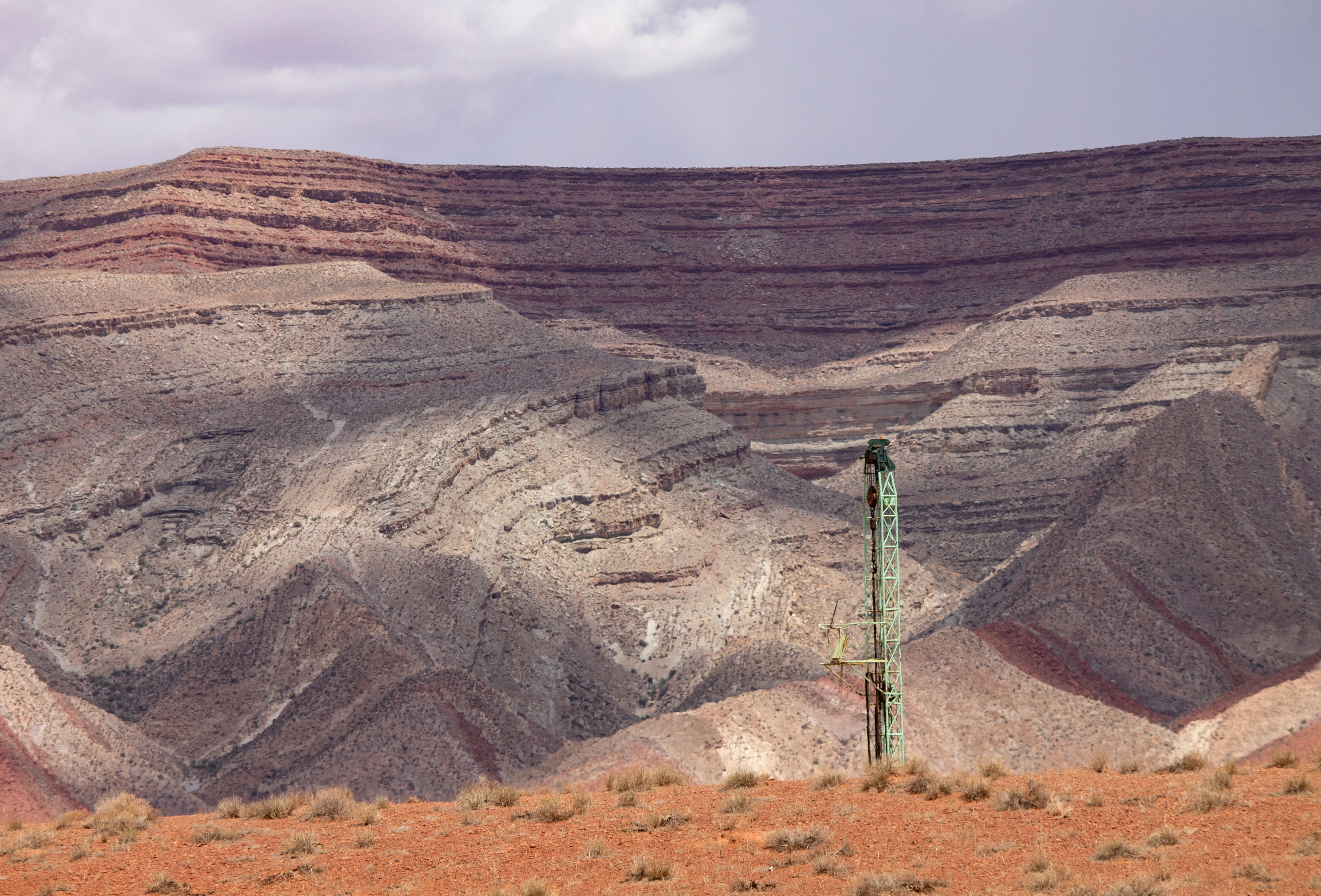
The condors of Marble Canyon — Jonathan P. Thompson

I’ve been really curious about how the Trump administration’s policy chaos might affect visitation at national parks. Would the threat to privatize public lands through various means (from selling it off to turning reservation systems over to private concessionaires) inspire folks to get to their parks while they’re still around? Would the administration’s hostility towards non-Americans (tariffs and trade wars, deportations) keep international tourists at bay? Or would the declining value of the U.S. dollar bring more foreign tourists to America?
We’re six months in to this nightmare … er … administration, and there aren’t any obvious trends in the year-to-date visitation statistics. A lot of parks have actually seen an increase in visitation over the last couple of years so far. Drill down a bit, however, and something else becomes apparent: While visitation was unusually high in the winter and spring in Zion, Grand Canyon, Arches, Bryce Canyon, Capitol Reef, Chaco Canyon, and other parks, it dropped off relative to previous years in May and June.
This may be due to heat and drought, but it also may be tied to the drop in international tourism into the U.S. Federal data show that incoming international air travel during the first half of the year is down 3.6% from the same period last year. (Meanwhile, more U.S. citizens are flying overseas, despite the weak U.S. dollar. Perhaps they are fleeing something?).
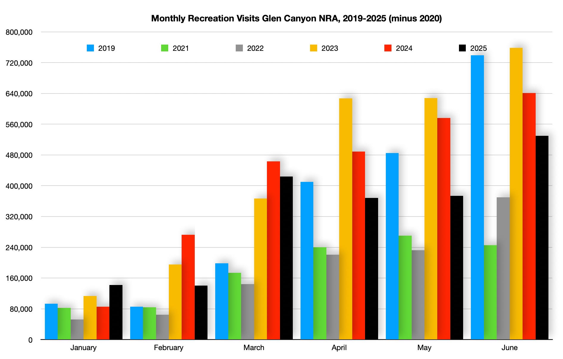
I’ve always been interested in visitation patterns at Glen Canyon National Recreation Area, as well. It seems like it used to correlate with water levels: No one wants to visit Lake Powell when many of the boat ramps are high and dry, the shores are mudflats, and Rainbow Bridge isn’t accessible by boat. Or that’s what I used to think. But more recently it seems that visitation rates are driven by other factors, perhaps because people are coming to the recreation area for different reasons, such as the spectacular landscape that surrounds the reservoir.
That said, visitation this year is down again along with the water levels.

🤯 Annals of Inanity 🤡
Dumb, dumb, dumb, dumb … One of the many, many stupid, ugly provisions in the Big Beautiful (I cringe every time I write it) law was a royalty reduction for coal production on federal lands. The rate has been at 12.5% for about a century. If you think of that as the wholesale price that Peabody, Arch, Oxbow, and other corporations have been paying to purchase Americans’ coal, then you could say they are marking the product up by about 800%.
It seems like a pretty good deal for the corporations — and a crappy one for us taxpayers. But it wasn’t enough, apparently, so the Republicans lowered the royalty rate to a measly 7%. And just so you understand, this isn’t just for new coal leases, it’s for all existing and future coal leases on public lands and for the public’s coal.
What that means is that all of those coal mines in the Powder River Basin, Colorado, and Utah are now paying the federal government only about 56% as much as they paid before the bill was signed into law. So that means if production levels remain flat and coal prices remain steady — which is not a given — then the federal government will bring in about $250 million from coal royalties this year, which is about $200 million less than last year. What about that is fiscally responsible, may I ask?
But here’s the kicker: The states where the coal is mined get 50% of that royalty revenue back. This means Wyoming will receive something like $50 million less per year from coal royalties, according to a report by Wyoming Public Radio’s Caitlin Tan. That’s My estimates say Wyoming could take an even bigger hit of more like $80 million annually, depending on the price of coal and production levels. That’s $50 million to $80 million less for the state to spend on schools, public services, roads, and so forth. Heck, it may even spur Wyoming to finally implement a corporate and individual income tax!
The pushers of this plan claim to be doing it to boost production, which would then offset some of the losses. But that’s not how it works. Coal mines aren’t going to produce more just because it’s cheaper to do so; they produce more when demand goes up. Production will remain the same or, more likely, drop, since fewer and fewer utilities are interested in burning coal. The corporations will make more profit. Everyone else will get screwed.

Click the link to read the article on the Big Pivots website (Allen Best):
July 20, 2025
Center, as its name implies, lies at the center of the San Luis Valley. The valley is among the nation’s two most prominent places for growing potatoes. Among the growers is a fourth-generation family operation, Aspen Produce LLC.
Jake Burris married into the family. In addition to spuds, the family grows barley and alfalfa on 3,500 acres. Some neighboring farmers also grow canola. Burris is president of the board of managers of one of six subdistricts in the San Luis Valley’s Rio Grande Water Conservation District. His subdistrict — called Subdistrict No. 1 — was formed in 2006 in response to a declining water table. What’s known as the unconfined aquifer supports this area, the most agriculturally productive in the San Luis Valley. With just seven inches of annual precipitation, irrigation in the San Luis Valley is everything. And in Subdistrict 1, much of that water comes from 3,617 wells..

Alfalfa is the thirstiest crop, using 24 to 36 inches of water to get three cuttings. The strong sunshine and cooler temperatures found above elevations of 7,000 feet produce a high-quality hay that draws orders from dairies as far as California. Alfalfa is grown on 21,100 acres in the district. Potatoes cover 51,100 acres. Barley is grown on 28,000 acres. Some have replaced barley with rye. Several thousand acres have together been devoted to canola, lettuce, and other crops. A recent census found about 25,000 acres had been fallowed.
The San Luis Valley has two primary aquifers. Lower in the ground, separated by relatively impermeable beds of clay from what lies above, is the confined aquifer. The first well into the confined aquifer was bored in 1887. Because of the pressures underground, it was an artesian well. No pumping was needed to bring water to the surface. Louis Carpenter, a professor at the Colorado Agriculture College (now Colorado State University), estimated the valley had 2,000 artesian wells when he visited in 1891.
The unconfined aquifer lies above the confined aquifer. The unconfined aquifer existed prior to major water development in the valley but water volumes rose greatly when farms began using Rio Grande water in the 1880s. Four ditches deliver Rio Grande water to the farms and hence to the aquifer. Introduction of high-capacity pumps in the 1950s and center-pivot sprinklers in the 1970s accelerated groundwater extraction. In 1972, the state engineer imposed a moratorium on new wells from the confined aquifer, followed in 1981 by a moratorium on new wells in the unconfined aquifer. These moratoria acknowledge that groundwater drafting had to be limited.
Then came 2002, hot and dry, escalating the challenge. Impact to the unconfined aquifer was drastic with rising temperatures causing growing water demand even as snowpack declined.
The unconfined aquifer “has been dropping overall since about 2002,” says Craig Cotten, the Colorado Division of Water Resources engineer for Division 3, which encompasses the San Luis Valley. “We just have not had a real good series of years as far as the surface water.”
In 2004, state legislators passed a law that sets the San Luis Valley’s aquifers apart from those of the Republican River and Denver Basin groundwater stories. That law, SB04-222, explicitly orders both the confined and unconfined aquifers in the San Luis Valley be managed for sustainability. The Colorado law governing the Denver Basin aquifers requires a “slow sip” but does not imagine sustainability. In the Republican River Basin, no law speaks to sustainability. There, only the interstate compact insists upon limits.

Here’s another difference. Water from aquifers create the Republican River and its tributaries. In the south-metro area, surface streams cause little recharge to the Denver Basin aquifers. In the San Luis Valley, the Rio Grande as well as some surface streams coming off the San Juans contribute water to both the unconfined and confined aquifers. The hydrogeology is more complex.
This 2004 law also encouraged the formation of groundwater subdistricts within the Rio Grande Water Conservation District. The thinking was that very local groups of farmers could work together to figure out how to keep their portions of the aquifers sustainable. They could also be more effective in this pursuit by working together than doing so individually.
Six subdistricts have been created in the Rio Grande Water Conservation District and one in the Trinchera Water Conservancy District. Subdistrict No. 1 began operations in 2012 after the state approved its operating plan.
All these groundwater districts have the goal of reducing water consumption as necessary to replenish the aquifers or by introducing water into the aquifer from the Rio Grande or other sources.

Exactly how much restoration of the aquifers is needed? The state law specified a return to volumes that approximate those of 1976 to 2001 in the confined aquifer. But there’s some guesswork about how much water the confined aquifer had then. Detailed records on Subdistrict No. 1 were not kept until 1976.
In August 2024 the unconfined aquifer in Subdistrict 1 was estimated to have averaged almost 1.2 million acre-feet less water during the five preceding years than it had in 1976. The rules approved by the Colorado Supreme Court in 2011 in a document called the Plan for Water Management call for the unconfined aquifer recovery within 200,000 to 400,000 acre-feet of where it was in 1976. That would be deemed sustainable, as ordered by the 2004 law.
To achieve this, the state engineer said that Subdistrict No. 1 would need to recover 170,000 acre-feet each year between now and 2031. Initially, Subdistrict No. 1 aimed to take 40,000 acres out of irrigation per year, or about 80,000 acre-feet of annual groundwater pumping, to allow the unconfined aquifer to recover. That goal is unattainable, say water officials, and hence a rethink is needed. Success has occurred, though. In 2024, for example, roughly 176,000 acre-feet were pumped from the confined and unconfined aquifers in Subdistrict No. 1, the fewest since groundwater metering began in 2009. That’s about a 30% reduction.
More sustained success will be necessary. “You don’t recover that unconfined aquifer through single years of good runoff,” says Ullmann, the state engineer. “There are difficult decisions that have to be made in order to recover and restore the aquifers, but that’s what these subdistricts are trying to do.”

This success is at least partly due to efforts to modify irrigation practices and taking land out of production. Amber Pacheco, deputy general manager of the Rio Grande Water Conservation District, explains that it’s difficult to quantify the reductions.
“Some farmers, for example, have simply reduced the number of alfalfa cuttings (and hence the irrigation required), for example. Or they only irrigate when they need to do so. Others have changed the cover crops planted after a potato harvest to reduce the amount of water needed.”
As in the Republican River District, local efforts to take land out of production use the foundation of federal programs, particularly CREP, or Conservation Reserve Enhancement Program. The subdistrict provides 20% of funds and the federal government 80%.
As did the Republican district in 2022, the Rio Grande district got an additional $30 million allocation of federal money funneled through the state. That money allows $3,000 in payment per acre-foot of curtailed groundwater use.
More must be done to recover the aquifer. The current proposal assembled by Burris and other directors of Subdistrict No. 1, their fourth iteration, would require aquifer recharge as a condition of pumping on a one-to-one basis. Water for recharge would come from water secured from the Rio Grande or native flows into the unconfined aquifer. This new plan allows subdistrict members with surface water credits to pump from the aquifer, because they are resupplying it.
The pumping allowed under the plan would be cut drastically. The Rio Grande district does not have authority to shut down wells, but it does have authority to assess fees for over-pumping. That fee stands at $150 per acre-foot. The plan would elevate that to $500. And, if aquifer recovery is not achieved, it would rise to $1,000.
Ultimately, the state engineer has authority to curtail wells that do not provide replacement water pursuant to an approved groundwater management plan or some other augmentation plan.
Some farmers in the subdistrict disagree with this plan. Opponents banded together as the Sustainable Water Augmentation Group, or SWAG, and filed a lawsuit to block implementation of the plan. A five-week trial has been scheduled for early 2026. Nobody expects that court’s decision to be the end of it. Whoever loses might well appeal the decision to the Colorado Supreme Court, a process likely to continue into 2028.
Might the problem of the depleted unconfined aquifer be resolved by diverting more water from the Rio Grande? The river has long been over-appropriated. This year, for example, rights junior to 1880 were being curtailed in May. As with the Republican River, water must be allowed to flow downstream as required by the Rio Grande Compact.
For the unconfined aquifer to recover quickly, Mother Nature would need to quickly step up. “It would take multiple years of above-average flows [in the Rio Grande] to recover to the level that we need,” says Pacheco. In fact, 19 of the last 20 years have been sub-average as compared to 1970 to 2000. This year’s runoff in mid-May was forecast to be 61% of the average from 1890 through 2024.
Part IV: “It’s like the clock is ticking when it comes to sustainability,” said Rod Lenz, chair of the Republican River Water Conservation District, at a recent board meeting. This and other parting thoughts about the three groundwater basins examined in this story. Also, a study is underway to provide a better estimate of the groundwater remaining in Baca County. You can also download the entire story here in a magazine format.
