Mail-in ballots for the Colorado primary election are in the mail. (Mine arrived yesterday.) Please consider moving the environment to the top of the list of issues when you vote.
Fact: The Western U.S. is drying out and the more arid environment is exacerbating wildfires.
Fact: Action is required now to reduce global warming in the decades ahead.
CIRES-led team uncovers series of wildfire triggers that culminated in the big burn of 2017
Western wildfire seasons are worse when it’s dry and fuel-rich, and the chances of ignition are high—and all three factors were pushed to their limits last year, triggering one of the largest and costliest U.S. wildfire seasons in recent decades, according to a new paper. Climate change likely helped exacerbate fuels and dryness, the paper found, and people’s behavior contributed the sparks.
“Last year we saw a pile on of extreme events across large portions of the western U.S., the wettest winter, the hottest summer, and the driest fall—all helping to promote wildfires,” said Jennifer Balch, director of CIRES/CU Boulder’s Earth Lab and lead author on the study published today in Fire with INSTAAR, Columbia University, and University of Idaho coauthors.
The 2017 wildfire season cost the United States more than $18 billion in damages. That year, 71,000 wildfires scorched 10 million acres of land—destroying 12,000 homes, evacuating 200,000 people and claiming 66 lives. For comparison, 2016 saw only 5.4 million acres burned.
The research team sought to pinpoint the precursors that led to these fires, to support decision makers considering policies that might prevent or minimize future fire disasters. The study found that the three major “switches” affecting fire—fuel, aridity, and ignition—were either flipped on or kept on longer than expected last year.
It started with a wet winter. Increased precipitation early in 2017 fed the growth of fine grasses across the western United States—grasses that would later serve as fuel for fire. Summer and fall then swept in a wave of dry, arid conditions, baking the dense fields of grasses into dehydrated kindling.
With the fuel growth and aridity switches flipped on, the scene was set for the third switch: ignition. Nearly 90 percent of total wildfires last year were caused by people; previous work by Balch and her team has illuminated just how extensively humans exacerbate wildfire. Human activity triples the length of the average fire season.
Computer climate models project an increased risk of extreme wet winters in California, the paper notes, and a decrease in summer precipitation across the entire West Coast. Those models also tend to project a delay in the onset of fall rain and snow.
“We expect to see more fire seasons like we saw last year, and thus it is becoming increasingly critical that we strengthen our wildfire prediction and warning systems, support suppression and recovery efforts, and develop sustained policies that help us coexist with fire,” said Megan Cattau, Earth Lab researcher and a coauthor on the study.
Although naturally occurring climate variability influences environmental conditions that affect the wildfire season, that variation is superimposed on an anthropogenically warmer world, so climate change is magnifying the effects of heat and precipitation extremes, Balch says.
The authors conclude by noting many ways that policy makers have already taken action to build better and burn better in the face of increasingly flammable landscapes; and they urge continued attention to policies that address the challenge of wildfire.
“The 2018 wildfire season is already underway and here at home in the southern Rockies fuels are very dry,” said Balch. “It is forecasted that June will be a busy month in terms of wildfires due to severe drought and low snowpack.”
Student showcase their winning design at a recent Board of Trustees meeting. Photo: Mark Stahl
From Metropolitan State University of Denver (Matt Watson):
Sometimes putting plastic in the river can be a good thing.
That was the idea put forth by the MSU Trash Getters, one of eight student teams from the Colorado School of Mines, MSU Denver and the University of Colorado Denver to participate in the Clean River Design Challenge.
The Trash Getters designed 3D-printed fish heads to float atop a waterway and collect trash in their mouths. The brightly colored bits of plastic, printed on campus at the Auraria Library, sit in the water and call attention to the very problem the design challenge hopes to combat: trash in our water.
The Greenway Foundation, a nonprofit helmed by Executive Director and MSU Denver Trustee Jeff Shoemaker, works to advance the South Platte River and surrounding tributaries as a unique environmental, recreational, cultural, scientific and historical amenity that links Denver’s past and its future. The foundation held its first-ever student design challenge in 2015-16 and a second competition in 2017-18. The competition is coordinated and led by TGF’s policy and water-resources arm, the Water Connection (TWC).
“The basis of this is to continue to bring awareness that trash in my neighborhood is trash in my waterways,” Shoemaker said. “That’s the education aspect; the other, more pragmatic aspect is we’re trying to create devices that can be taken from a scale version, put into a working prototype and actually be placed in Cherry Creek or the South Platte River.”
MSU Denver faculty, staff and community members pitch in to clean up the Cherry Creek as part of the recent Roadrunners Give Back Day in partnership with the Greenway Foundation.
The student teams were scored in Round 1 on their trash-collection designs in December, with two teams from Mines placing first and third and an MSU Denver team second. The teams with the top six designs were given $1,000 to build scale models, which were then put to the test for Round 2 in April in a flume at the U.S. Bureau of Reclamation. In addition to educating people and looking for innovative solutions, the design challenge provides students with hands-on, competitive experience.
“For students to spend a semester coming up with a concept, then have to stand up in front of a dozen working professionals in the world of water and defend their model – in a competitive way, where there are actually winners and losers – is a very valuable experience,” Shoemaker said.
In the BOR Hydraulics Lab testing, which was Round 2 of the competition, MSU Denver students shined. The first-place team was the Water Association of Student Steward Urban Program, the student water-education club associated with the One World One Water Center. The Trash Getters’ fish-head design finished third behind the Colorado School of Mines, which took second.
The top three models will be displayed July 26 at the 15th annual Reception on the River, where students will get a chance to network with more than 200 people from the water industry. The hope is that one of the models, or a combination of them, will work its way into the water in the coming years. TGF/TWC just got the first draft of professional engineering drawings based on the 2015-16 contest winner and will develop a prototype in the coming months for planned testing in Cherry Creek .
The water-cleanup efforts at the Greenway Foundation and MSU Denver aren’t limited to design and engineering, either. Foundation volunteers regularly pick up trash from Denver waterways, while the WASSUP club has adopted a section of Cherry Creek for a monthly cleanup project and University faculty, staff and students partnered with the Greenway Foundation as part of Roadrunners Give Back Day.
To learn more about Denver’s waterways, contact the Greenway Foundation at info@greenwayfoundation.org.
I recently visited a tailwater stream known for its capacity to produce lots of brown trout, some of them quite large. The reservoir feeding this stream is operated exclusively for downstream agricultural users, the result of which is that the fishery is also renowned for its poor conditions in winter, when dam releases are curtailed and the stream becomes a thin vein of shallow puddles, trickles, and exposed spawning redds. Since this stream is in the coldest corner of New Mexico, anchor ice is common.
I was pleased to see the latest work of the beaver population, knowing that their ponds would provide winter refuge for fish. But I was there to see the leveling device (beaver deceiver) installed by the New Mexico Game and Fish department to mitigate the legitimate though misplaced concern of downstream irrigators, who felt that the beavers were holding back valuable water from ranches and farms. The deceiver was working as intended, sending water downstream while limiting the pond’s depth and expanse so as not to inundate an adjacent parking lot.
My next stop was a nearby fly shop. I proudly reported my observations to the proprietor, who proceeded to give me an earful. The stretch of stream occupied by the beavers had always been a money spot for his guides and their clients. Until, that is, the beavers took up residence. The pond had since become a bugless sucker hole devoid of trout, and though he acknowledged the positive impact of the beaver impoundment on riparian storage and late season flows, the shop owner judged the local beavers as a net detriment to the fishery. Beavers are either good or bad, he opined, never both.
The beaver is a keystone species, generally defined as an organism that exerts an outsized influence on the function and even formation of an ecosystem. Beaver dams capture peak flows, prolong spring runoff, while supporting and extending baseflows with water stored in riparian aquifers. Their deep ponds concentrate nutrients and macroinvertebrates; they provide shelter and security for trout, especially in winter.
Understandably, the perceived downside of beavers comes with the keystone package. Like wolves, another disproportionately influential animal, beavers disrupt on a landscape scale. They not only plug up streams, but ditches, culverts, and bridges. Their dams inundate yards, fields, and pastures used by livestock and campers. Beavers kill and eat prized trees. The disgruntled fly shop owner hypothesized that his favorite run-turned-hated-beaver-pond might have warmed too much to harbor the trout it once did and, along with possibly consuming too much oxygen, accumulated silt may have buried insect production.
For what little it’s worth, I’ve personally witnessed few instances where beavers have negatively impacted trout. I don’t doubt that it happens, certainly not in this case, but I think such stories should be viewed in the broader context of watershed health. Consider how many of our highest quality fisheries (and grazing pastures) were literally made by beavers. They cleared trees to build their dams, which filled with trapped sediment and forced channel migration across floodplains. Over time, floodplains expanded and thickened thanks to further beaver-induced sediment deposition. This long process created thick, spongy meadows, essentially grass-skinned reservoirs feeding streams with cooled groundwater.
In addition to logging, mining, grazing, floodplain development, and road building, our large scale beaver extirpation in the late 1800s contributed greatly to watershed degradation. Without beavers, natural and man-made “nick points” went unrepaired, leading to channel incision and headcutting. By armoring and straightening streams for flood control, we actually intensified flooding by concentrating flow and increasing its cutting force. As a result, our beaver-created meadow reservoirs have been drying from within for many decades.
As climate change tightens its unpredictable yet certain grip on our landscapes, it falls on us, the ultimate keystone species, to restore the land’s capacity to absorb disturbance while maintaining function. To hedge against drought, we must lift and spread water tables and reconnect streams with their floodplains, especially in headwater regions. Reconnected floodplains will also enable our streams to de-energize high intensity precipitation events, particularly important in this era of common wildfire.
Where beavers live, we must make them welcome, as they are the cheapest and most efficient means of restoring the greatest acreage of watershed in the shortest timeframe. They work around the clock and accept food as payment; no matter how hard we try, we will never find a better deal than that.
And where they don’t live, we must imitate them; thanks to conservation groups in New Mexico, including the Truchas Chapter of TU, imitating beavers may soon become the hottest trend in stream restoration. Volunteer-made beaver dam analogs (BDAs) employ natural materials and are designed to pass water, trap sediment, and raise riparian water tables. Combined with willow and cottonwood plantings, which provide stream shading and future beaver food, BDAs create true beaver habitat and often attract the real animals to continue this important work.
As a wise man I know once said, “In times of flood, prepare for drought. In drought, prepare for flood.” I’m not sure, but I think this guy may have been a beaver in a previous life.
Toner Mitchell is TU’s New Mexico Water and Habitat Program coordinator for New Mexico.
Click here to read the essay from Jason A. Otkin. Here’s the abstract:
Given the increasing use of the term “flash drought” by the media and scientific community, it is prudent to develop a consistent definition that can be used to identify these events and to understand their salient characteristics. It is generally accepted that flash droughts occur more often during the summer owing to increased evaporative demand; however, two distinct approaches have been used to identify them. The first approach focuses on their rate of intensification, whereas the second approach implicitly focuses on their duration. These conflicting notions for what constitutes a flash drought (i.e., unusually fast intensification vs short duration) introduce ambiguity that affects our ability to detect their onset, monitor their development, and understand the mechanisms that control their evolution. Here, we propose that the definition for “flash drought” should explicitly focus on its rate of intensification rather than its duration, with droughts that develop much more rapidly than normal identified as flash droughts. There are two primary reasons for favoring the intensification approach over the duration approach. First, longevity and impact are fundamental characteristics of drought. Thus, short-term events lasting only a few days and having minimal impacts are inconsistent with the general understanding of drought and therefore should not be considered flash droughts. Second, by focusing on their rapid rate of intensification, the proposed “flash drought” definition highlights the unique challenges faced by vulnerable stakeholders who have less time to prepare for its adverse effects.
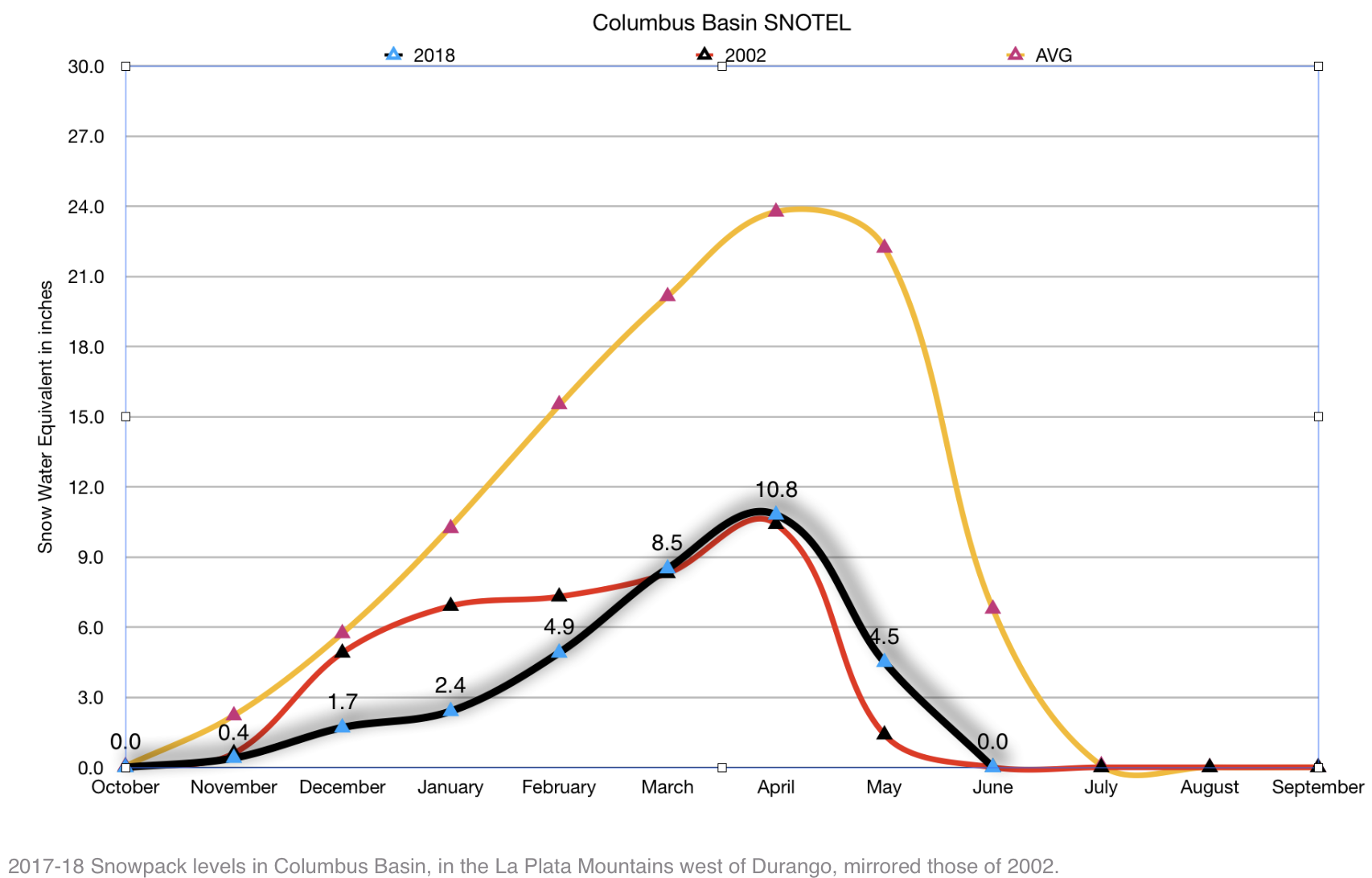
Someone noticed a puffy cumulonimbus cloud rising up in the gap formed by the Animas River gorge and gave a little cheer. Winter and spring had been freakishly dry and warm, and we really could have used the rain. Something was off about the cloud, however, and we all grew quiet. It wasn’t a cloud at all, but a billowing tower of smoke.
That was 2002 and the smoke was from the Missionary Ridge Fire, ignited that afternoon on a slope about 35 miles south of where we sat. Over the coming weeks, the blaze would eat through 73,000 acres of parched scrub oak and aspen and conifer forest along with 83 structures. The local tourism economy, already dampened by the Dotcom bust and the 9/11 attacks of the previous year, was battered. It would be remembered as southwest Colorado’s summer of discontent.
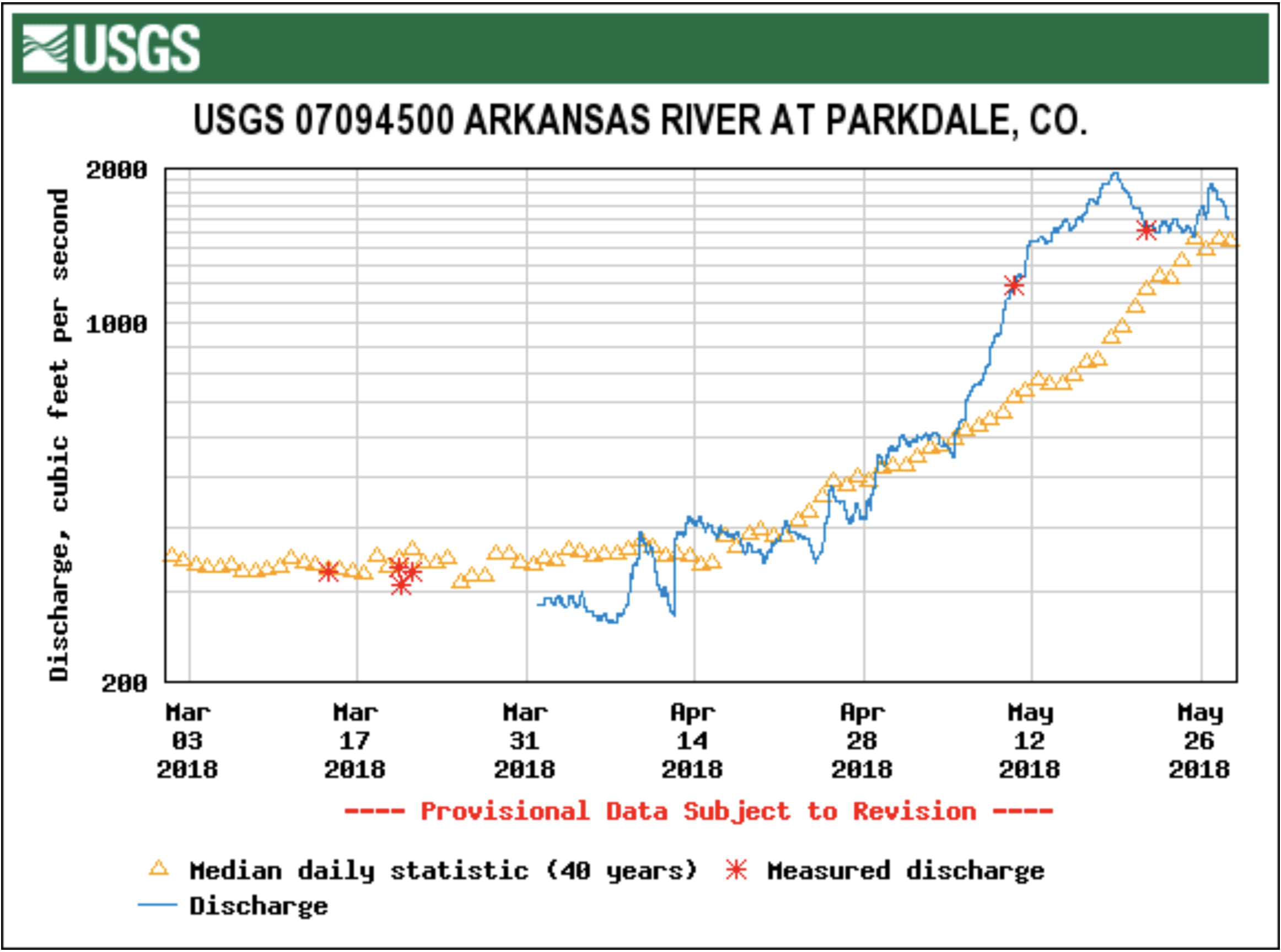
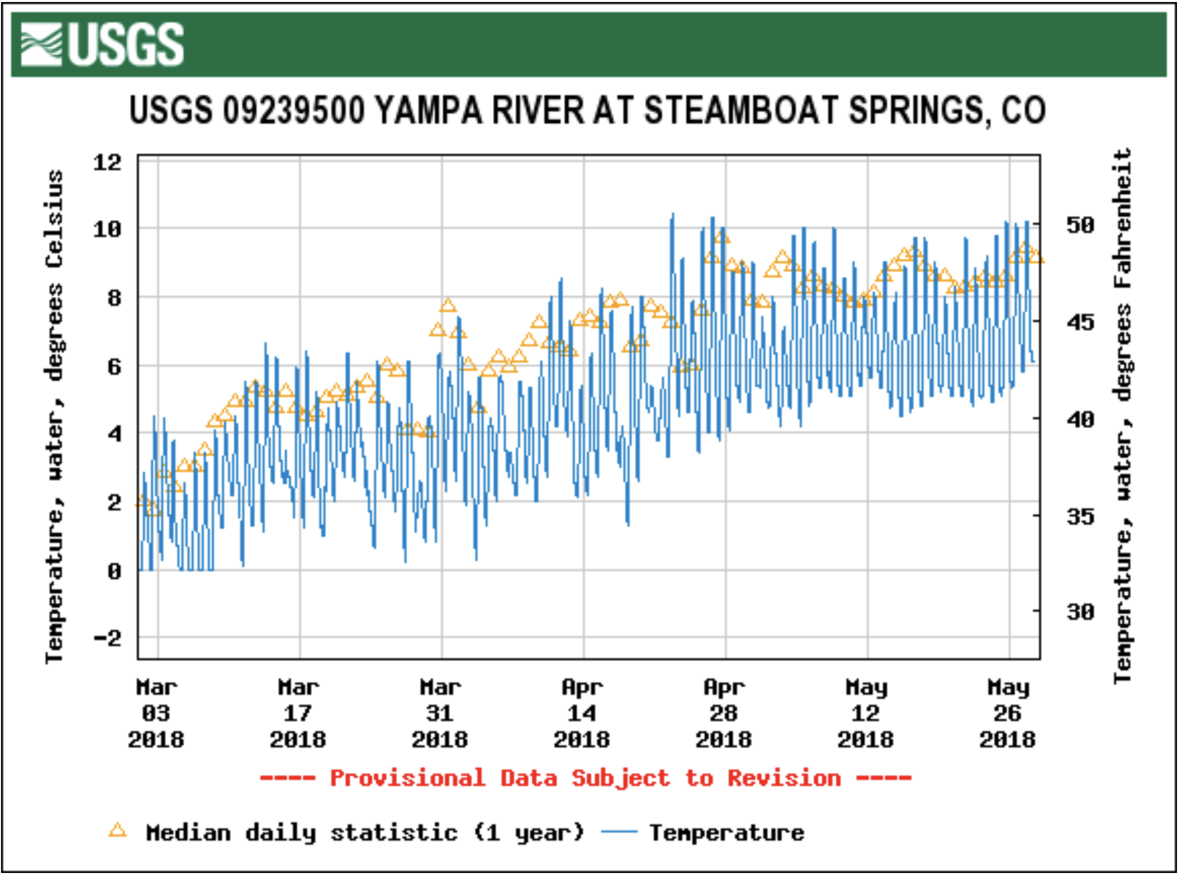
Memories of and comparisons to that summer emerged last week when the 416 Fire broke out just across the valley from where the Missionary Ridge Fire was sparked 16 years earlier. The comparisons, unfortunately, are apt. Precipitation for the 2018 water year (which started Oct. 1, 2017) has thus far mostly mirrored 2002. Flows on the Animas River are slightly better than they were 16 years ago, but only slightly (see accompanying graphs). The conditions are therefore in place for a rerun of that smoky summer.
At this point, however, the 416 Fire does not appear to be a Missionary Ridge repeat, at least in terms of severity. The 2002 blaze was started by an errant spark, possibly from a car’s exhaust pipe, in the early afternoon of June 9, and it had blown up to 6,500 acres within hours. As I write this, the 416 Fire is spreading much more slowly, having charred 2,400 acres — and no homes — after four days of burning. High winds and hot temperatures could change all of that, of course.
The cause of the 416 Fire remains unknown. Embers from the coal-fired narrow gauge train that travels between Durango and Silverton are a fire hazard, yet the US Forest Service has reported the ignition point as being in the right of way of Highway 550, meaning the fire just as easily could have been started by a motorist’s tossed cigarette butt. In any event, the railroad and the tourism economy that depends on it will be affected. Durango & Silverton Narrow Gauge RR officials say they won’t run the train until June 10 at the earliest, and after that will use a diesel locomotive — to the displeasure of authenticity-seeking passengers. (UPDATE 6/6: InciWeb continues to list fire cause as “unknown,” but the coordinates it gives for the fire, and witness accounts, indicate that the fire started near the railroad tracks, not long after the train passed, far from Hwy 550. Also, the D&SNGRR announced on 6/5 that train service will be suspended until at least June 17.)…
It’s certainly too early to guess how big of a blow the 416 Fire — and any other fires to follow — will have on the regional economy. Still, it’s a tough break coming after a thin ski season and at the beginning of what will surely turn out to be a rough one for commercial rafters, with or without any more fires. It’s also a potent reminder that climate change is bad for a lot of things, including the local economy.
While 2018 is shaping up to mirror 2002, it also closely resembles another dry and disastrous time — the summer of 1879. No one was keeping official tabs on the weather or snowpack or streamflows back then, but from anecdotal and newspaper reports, we can gather that the 1878-79 winter was just as dry and warm as 2017-18. And the results were equally smoky: In early June of that year, a blaze broke out a few miles north of where the current 416 Fire is burning. It ended up charring 26,000 acres of relatively high-altitude forests.
FromThe Durango Herald (Shane Benjamin) via The Cortez Journal:
Federal firefighters have not released the cause of the 416 Fire. A federal wildfire information database, InciWeb, lists the cause as “unknown.” A longitude and latitude entered into the database pinpoints the fire just west of the train tracks in an area where nothing else is around. Chione confirmed that is about where the fire started.
The Durango & Silverton Narrow Gauge Railroad is not taking responsibility for the fire, but that could change based on the outcome of local and federal fire investigations, General Manager John Harper told The Durango Herald on Tuesday…
The U.S. Forest Service in conjunction with the La Plata County Sheriff’s Office and the Bureau of Land Management are conducting the investigation, according to an email sent Tuesday from Cam Hooley, acting spokeswoman for San Juan National Forest.
“A team of trained investigators was on scene as soon as Friday night, the day of ignition,” she wrote in the email to the Herald. “USFS investigators include both local and regional personnel. Because of the size of the fire, the cost of suppression and the impact on the community, the investigation team will take the time needed to conduct a comprehensive and thorough investigation before any determinations are released. No timeline has been given for release of information.”
Chione and his neighbors often spot fires started by the Durango & Silverton Narrow Gauge Railroad. The Meadowridge subdivision, with eight houses, sits only a couple hundred feet east of the train tracks and is located on a steep grade between Hermosa and Rockwood – an area known locally as Shalona Hill.
Locomotives work hard to power up the mountain, and some hot cinders from the coal-fired engine land on the ground and start little fires. A pop car typically follows each train three to five minutes behind the train to look for fires. Five minutes behind the pop car is a water tender that can douse flames, if necessary.
It is not unusual for the train to start spot fires through this section of track, Chione said. In fact, residents are so aware of the fire danger that they converted an old insecticide spray truck into a brush truck that can spray water to help douse the spot fires.
When he sees a fire, Chione typically calls his neighbor, Cres Fleming, who either walks down to the tracks to help extinguish flames, or if the fire is more serious, drives the water truck to the tracks to help douse the blaze.
“I got a call on Friday morning after the second train had come by that there was a small fire at the bend in the tracks,” Fleming said. “I high-tailed it over there with the truck, and as I came up on the railroad tracks, I saw the fire was probably 35 feet up the hill from the tracks. The railroad patrolman was there on his radio, I guess letting dispatch know what was going on. The fire at that point was really too much for his small sprayer that he had on that first pop car.”
Flemming unraveled the hose on his make-shift water truck, but he had a water-pressure problem. By the time the hose was working, the fire had advanced 80 or 90 feet up the hill – beyond the reach of his sprayer.
“It was moving incredibly fast,” Fleming said. “I fired a stream of water and dragged a hose up the hill, which is hard for me because I’m not exactly young any more.
“I feel sort of heartbroken that I just missed putting that fire out because I know it has really caused a lot of problems for a lot of people,” Fleming said. “If I had been there a minute earlier, I think I could have gotten it.”
Click here to read the newsletter. Here’s an excerpt:
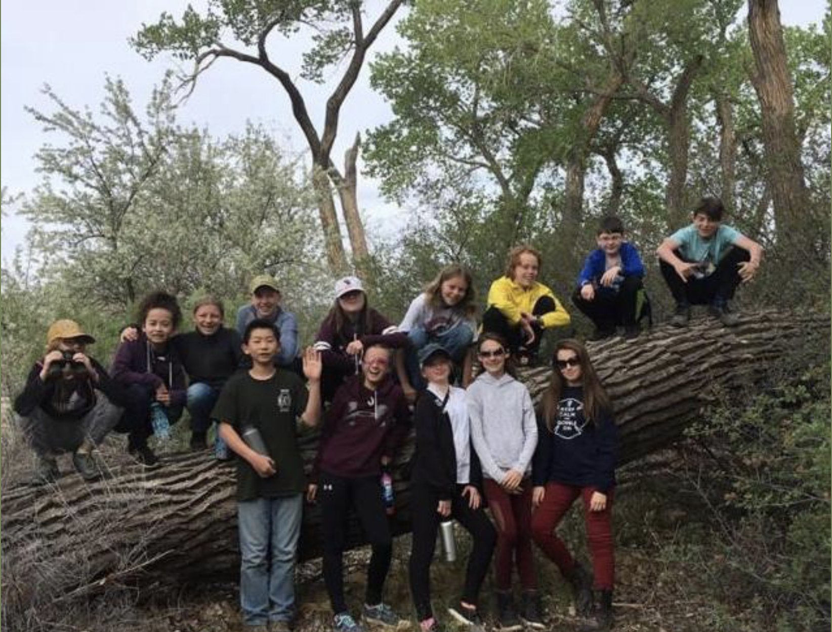
Kids learn about conservation and birding on conserved land
Last month East Middle School 6th graders enjoyed a morning bird-watching hike at Avant Vineyards conserved property on East Orchard Mesa. Thanks so much to Nic Korte from the Grand Valley Audubon Society for leading the hike and Neil Guard at Avant Vineyards for hosting!
Mail-in ballots are in the mail for Colorado’s primary election.
Fact: To combat climate change humankind must end the burning of fossil fuels.
Fact: The means to replace fossil fuels are at hand, economic and effective.
Please consider voting for candidates that put the environment at the top or near the top of their list of issues. You can find their positions on the environment and in particular climate change on their websites.
The 2015 Paris Agreement on climate change was a landmark moment in human history. It crystallized decades of negotiations into a framework embraced by every country in the world to confront the existential threat of climate change and work together to solve the challenge.
President Trump’s announcement exactly one year ago that he intended to withdraw from the Paris Agreement raised global concerns that the agreement could weaken or unravel. Instead, Trump’s retreat has catalyzed leaders in America and around the world to stand shoulder to shoulder and press forward with climate solutions.
June 1 is not the anniversary of an end to one of the world’s greatest acts of consensus; it is a celebration of what Americans have done to fill the federal void. On the same day Trump abdicated climate leadership last year, we formed the U.S. Climate Alliance to uphold the Paris Agreement commitment in our states. In just one year, the alliance has grown into a bipartisan coalition of 17 governors representing 40% of the U.S. population and a $9 trillion economy — larger than that of every country in the world but the U.S. and China.
President Trump’s announcement last year centered on his allegation that the Paris Agreement hurts the U.S. economy. The fact that our collective economies are stronger than non-alliance states proves just the opposite. Alliance states are not only reducing emissions more rapidly than the rest of the country, but we are also expanding our per capita economic output twice as fast. Alliance states are attracting billions of dollars in climate and clean energy investments that have created 1.3 million clean energy jobs. The Alliance states are not alone: meeting the most ambitious goals of the Paris Agreement is projected to save the world $30 trillion in avoided economic damages.
While the Paris Agreement is one of the greatest tests in global collaboration, this interstate effort stands as one of the biggest and most important experiments in American policymaking. From modernizing power grids to scaling up renewable energy and reducing pollution, we are saving money and cleaning our air.
We will do everything in our power to defend and continue our climate actions. This includes continuing to oppose any federal proposal to cancel the Clean Power Plan, weaken clean car and appliance standards or expand offshore drilling. One year after President Trump’s abdication, the rapid economic growth of states within the U.S. Climate Alliance remain a beacon to all Americans and to every other nation that Americans are still in the Paris Agreement and will not retreat.
Despite President Trump’s Paris Agreement decision, the world continues to move forward and not backward on climate. One year after the president’s announcement, every other nation on earth has signed onto the Paris Agreement. China canceled plans for more than 100 coal-fired power plants in 2017, offshore wind energy is competing without subsidy in northern Europe, and several countries are making plans to shift cars from gas and diesel to electric, including China, France, India, the Netherlands, Norway and the United Kingdom.
We will work in lockstep with the nations of the world and continue our work to uphold the Paris Agreement. However, it is clear that we cannot meet the climate challenge alone. We need commitment from every U.S. state and we need the federal government to get back in the game. We invite others to join us and mark June 1 not as an anniversary of retreat, but as the moment when a bold, new movement of climate action took root in America.
Democratic Govs. Jerry Brown of California, Andrew Cuomo of New York and Jay Inslee of Washington are co-chairs of the U.S. Climate Alliance. Follow them on Twitter: @JerryBrownGov, @NYGovCuomo and @GovInslee.
FromThe Canon City Daily Record (Carie Canterbury):
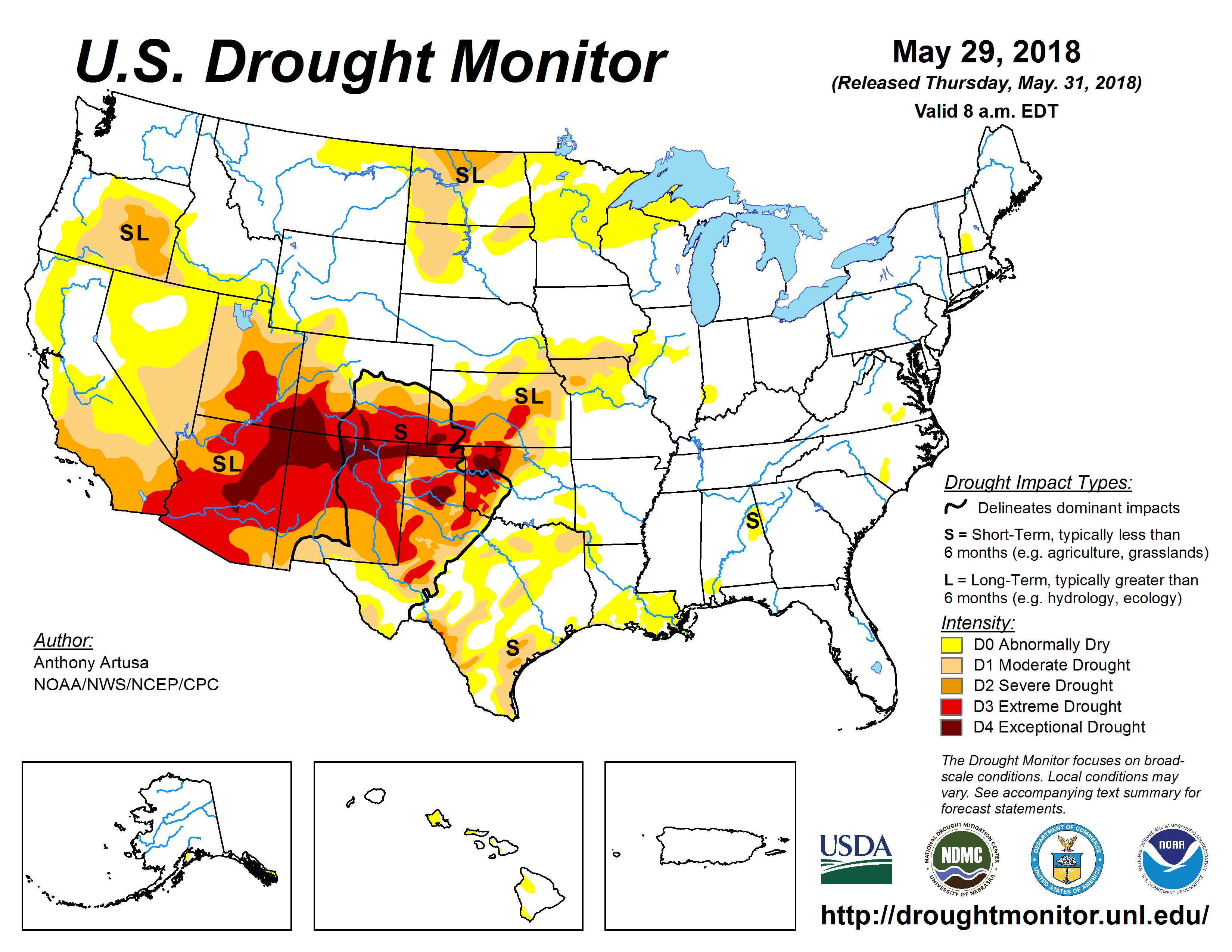
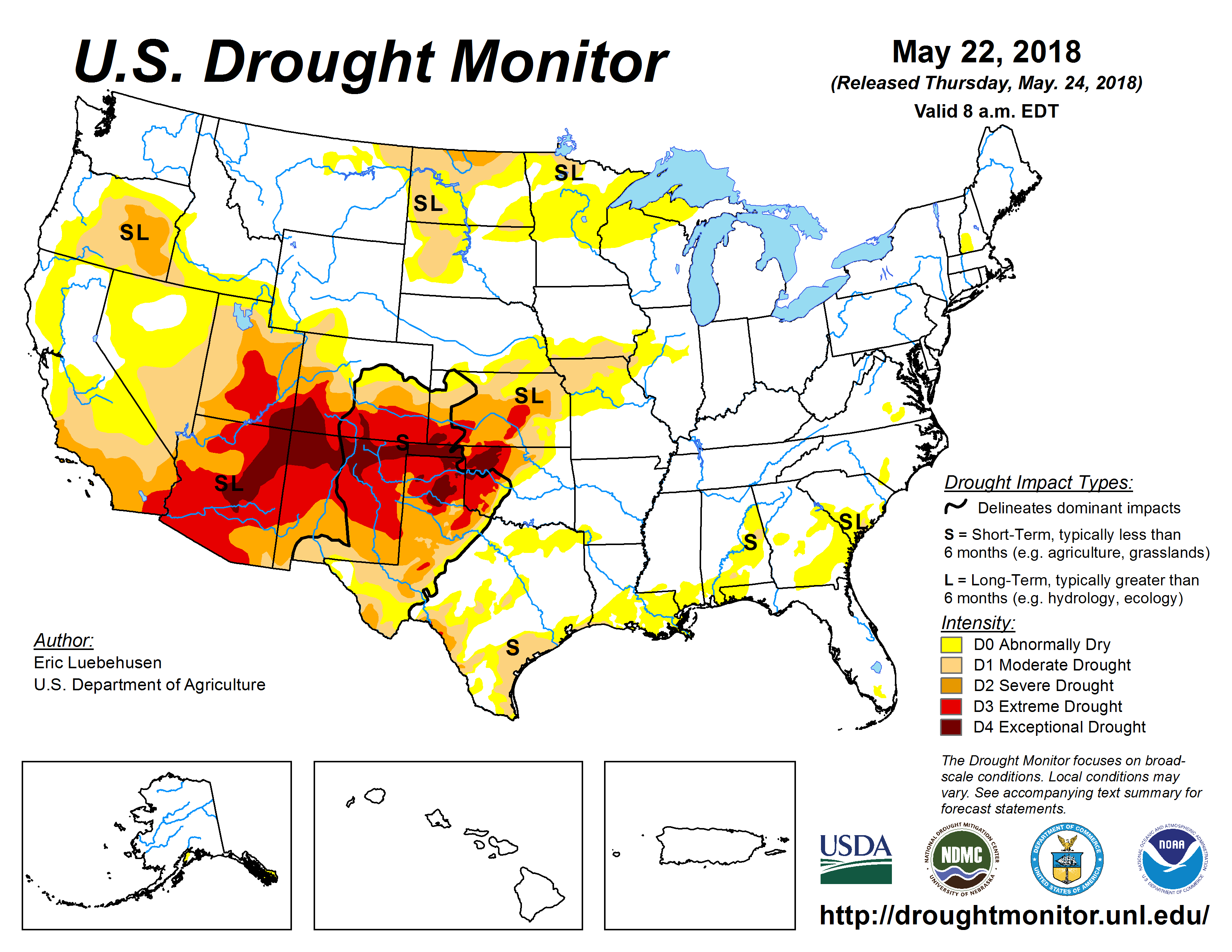
Currently, Colorado is experiencing the third lowest snowpack on record, with only 2002 and 1981 being drier, according to CPW. Extreme drought has expanded to cover most of the southern half of Colorado, with the worst conditions being in the southwest corner.
The Water Availability Task Force reports that in order to respond to persistent and prolonged drought conditions throughout the southern half of the state and along the western border, the Governor activated the Colorado Drought Mitigation and Response Plan for the agricultural sector on May 2 in 33 counties that are experiencing severe, extreme or exceptional drought as classified by the U.S. Drought Monitor. Fremont County is not included in this list, but if present trends continue, other regions and sectors of the state’s economy may also be affected, the report indicates.
As of May 15, exceptional drought continues to affect southwest Colorado and has also been introduced in the Sangre de Cristo mountains, covering eight percent of the state. Extreme drought covers 23 percent of the state; severe drought 20 percent and 14 percent is classified as moderate drought, including most of Fremont County. An additional 14 percent of the state is currently experiencing abnormally dry conditions.
The May 2018 Drought Update issued by the WATF states that October 2017 through April 2018 was the fifth warmest and the fifth driest on record for the state as a whole. Some locations throughout southern Colorado have experienced their driest and/or warmest October-April period on record.
“Most regions of Southern Colorado reached their snow accumulation peak two to three weeks early and have experienced rapid snowmelt, resulting in melt out occurring three weeks earlier than normal,” the report states. “Streamflow forecasts in the southern half of the state are extremely low, with multiple sites showing below 15 percent of normal.”
Additionally, the report states that reservoir storage statewide is at 111 percent of normal, with all but the southwest basins above average. The Arkansas basin is reporting the highest average storage at 129 percent. Front Range water providers mainly draw water resources from areas of the state that received near normal winter precipitation, and are therefore expecting reservoirs to fill, and are not anticipating any water use restrictions outside normal operations.
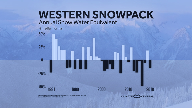
Western spring snowpack has been below normal six of the past seven years, meaning less water during the traditionally dry summer months. Graphic credit: Climate Central
Notably though unsurprisingly, due to consistent expressions of concern about climate change from senior defense leaders over the past year, the Department of Defense (DoD) on Sunday reaffirmed its stance on the growing national security risks associated with a changing climate. In a statement to the Washington Times, DoD spokesperson Heather Babb noted:
The effects of a changing climate continue to be a national security issue with potential impacts to missions, operational plans and installations…DOD has not changed its approach on ensuring installations and infrastructure are resilient to a wide range of challenges, including climate and other environmental considerations.
The article also quotes the Center for Climate and Security’s Director, John Conger, who commented on the practical, mission-based rationale for the military’s concern:
There are mission reasons to do these kinds of things. … If sea level rise is going to impact infrastructure, if a runway gets flooded, that’s a mission impact and that’s the kind of thing you’ve got to pay attention to.
It’s not like they’re doing some altruistic thing…They’re not trying to be good about climate change. They just recognize the reality that’s in front of you.
From email from the Uncompahgre Watershed Partnership:
11th Annual Ridgway RiverFest, Saturday, June 30, 10 a.m. to 6 p.m. Rollans Park, Ridgway. Enjoy a community watershed celebration with live music, river races, food booths, arts & crafts, beer, margaritas, silent auction, and more. Funds raised support activities of the Uncompahgre Watershed Partnership. For info: http://ridgwayriverfest.org…
River of Lost Souls Reading, Monday, Aug. 13, Sherbino Theater, 604 Clinton St., Ridgway. Come meet and ask questions of author Jonathan P. Thompson about the gripping story behind the 2015 Gold King Mine disaster that turned the Animas River orange with sludge and toxic metals. Organized in cooperation with the Uncompahgre Watershed Partnership. For info: http://www.uncompahgrewatershed.org/events/…
Ouray Ice Park – Uncompahgre River Canyon Cleanup & BBQ, Saturday, September 15, 9 a.m.-3 p.m. Join the Ouray Ice Park and Uncompahgre Watershed Partnership volunteers to pick up litter and debris in the ice climbing areas of the Uncompahgre River Canyon in Ouray. Then, enjoy a BBQ party to celebrate our efforts. For info: http://www.uncompahgrewatershed.org/events/
From the San Luis Valley Conservation Fund via The Conejos County Citizen:
The San Luis Valley Conservation Fund (SLVCF), a partnership between Colorado Open Lands, Rio Grande Headwaters Land Trust, Western Rivers Conservancy and the LOR Foundation, announced its third round of grant awards for organizations working in Colorado’s San Luis Valley.
A total of $540,000 was awarded recently by the SLVCF to bolster conservation efforts within the Valley and to help preserve the region’s rich cultural heritage while enhancing livability for local communities.
A total of 21 organizations received grants that ranged from $5,000 to $50,000.
“There is great work being done by the organizations and communities in the San Luis Valley, and the most recent round of grants from the SLVCF will only strengthen that work, maintaining the rich culture and natural beauty of this region for future generations,” said Jake Caldwell, program officer at the LOR Foundation. “We are proud that we are able to make these grants to 21 different local organizations in partnership with Colorado Open Lands, Rio Grande Headwaters Land Trust and Western Rivers Conservancy.”
Local grants follow:
Conejos Clean Water
Preserving Community: Sustaining Community Engagement and Construction of Facilities for Promotion –$30,000
This project will sustain programs that CCW has developed to enhance livability and health of San Luis Valley communities, especially through outdoor recreation and environmental education opportunities for valley youth and families; additional preservation of local communities and their rich cultural heritage; and conservation of valley land and water through sustainable natural resource management practices.
Costilla County Conservancy District
Upper Culebra Watershed Planning Project – $35,000
This project aims to engage stakeholders in an inclusive process to develop a scope of work and prepare an RFP for a watershed assessment of the Culebra Watershed. Stakeholders will determine the needs of the ecological conditions of the area, identify problems, and develop a list of prioritized objectives needed for the assessment.
Costilla County Economic Development Council, Inc.,
Funding for project coordinator – $12,000
This award will fund the Project Coordinator position, which complements the work of the Hispano Farm Curriculum project by developing a signature exhibit at the Sangre de Cristo Heritage Center on acequias and the Hispano farm. The Coordinator will collaborate with public and private agencies and individuals to enhance collaborative partnerships for CCEDC projects and other projects such as Congreso de las Acequias.
Sangre de Cristo Acequia Association
Developing Strategies for the Sustainability of the Traditional Acequia Culture – $50,000
The Developing Strategies for the Sustainability of the Acequia Culture will be centered on the practices that were adopted through the Association’s ongoing strategic planning process for 2018. This includes employment of the association’s executive director, identifying member acequias, and developing training sessions for acequia producers, as well as collaborating with partners to develop needed programs.
Volunteers for Outdoor Colorado
Sustaining and Growing Our Valley Organizations – $30,000
As the San Luis Valley grows and evolves, its nonprofit organizations will be challenged to step up their community support. This project offers tools and techniques to sustain current operations and to position organizations for future growth.
The partners’ efforts are focused on the Rio Grande and the open space surrounding and dependent upon the river and its tributaries. The Rio Grande provides crucial habitat for fish and wildlife, including pronghorn, elk, bighorn sheep, over 200 bird species and 95 percent of the Rocky Mountains’ greater sandhill crane population.
The Rio Grande and its tributaries sustain the working ranches and farms that form the base of the region’s agricultural economy. They are also the primary source of water for the valley’s historic acequias, a system of communal irrigation in the southern portion of the valley that predates Colorado’s statehood and has connected local communities for generations.
The river also provides some of the best recreation opportunities for people throughout the San Luis Valley.
With the support of the LOR Foundation, COL, RiGHT and WRC are working together to help preserve the valley’s rich heritage, balancing agricultural needs with conservation and recreation along and around the Rio Grande.
San Luis Valley Local Foods Coalition, Environmental and Regenerative Farming Education at the Rio Grande Farm Park – $35,000
This award will support RGFP’s initiative to enhance its environmental and regenerative farming educational offerings, which help visitors draw connections between the environment, recreation, and conservation. Park staff will create construction documents for an education pavilion and work with many partners to ensure that the plan meets the needs of local youth, families, residents, and other community stakeholders. In addition, the San Luis Valley Local Foods Coalition, Valley Roots Food Hub Regenerative Soil Farmer Project was awarded $5,000
The project will build on the burgeoning soil health movement in the SLV. This phase will feature participating farmers in a soil health marketing campaign aimed at area restaurants, schools, and other retailers. This will be accomplished by going to participating farms, touring the land, documenting and interviewing the farmer, and constructing the results into an effective marketing campaign.
Walk2Connect, Caminos del Valle Capacity Building – $13,000
This project is an investment in capacity building and new program development alongside a diverse list of partners for the San Luis Valley’s Caminos del Valle connection-focused walking community. The project will support development of meaningful walking events, walking leader training and community outreach throughout the Valley.
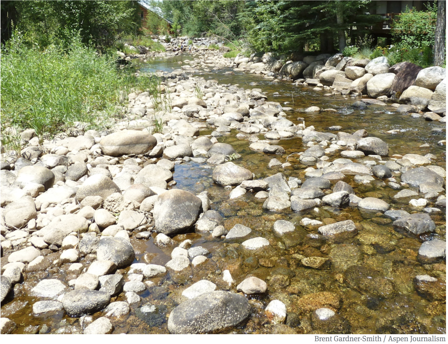
Penstock blowout at Shoshone hydro plant. Photo: Brent Gardner-Smith/Aspen Journalism
FromAspen Journalism (Heather Sackett) via The Aspen Times:
The Colorado River District is renewing its efforts at preserving a major Western Slope water right: the Shoshone hydropower plant.
But this time around, under the new leadership of general manager Andy Mueller, the district’s discussions with plant owner Xcel Energy are focusing on finding a way to maintain the water right instead of purchasing outright the plant or associated water rights.
The Shoshone plant is located on the Colorado River in Glenwood Canyon, upstream of Glenwood Springs and the popular Shoshone boating stretch of the river.
The plant began operating in 1909, and has a senior water right dating to 1902. That water right keeps 1,250 cubic feet per second flowing down the Colorado River. That means upstream junior water rights holders must leave enough water in the river for Shoshone to receive its full decreed amount. It also means that full amount becomes available for downstream users.
Some Western Slope water managers fear that if Xcel were to sell the plant or discontinue generating power at the site, the guaranteed 1,250 cfs could be lost. It would be a major blow for Western Slope water users.
At the Colorado River Basin Roundtable’s meeting in May in Glenwood Springs, Colorado River District general counsel Peter Fleming delivered a history of the Shoshone hydropower plant and an update on the efforts of the river district to preserve the flows associated with the plant.
“Simply by virtue of its very senior priority and large size, it is the controlling water right on the river upstream of Glenwood Springs,” Fleming said.
He said river district officials have met with Xcel officials about five times over the past few months to talk about ways to preserve the Shoshone water right for the Western Slope, and he anticipates additional meetings in the future.
In the past, conversations have centered around the Colorado River District potentially purchasing the hydro plant from Xcel. But those talks have shifted to ways of preserving the flow without ownership changing hands.
“A lot of it is explaining to [Xcel] why this is an important issue for the West Slope and that we are not out to interfere with their business,” Fleming said. “We don’t have any interest in operating a power plant. But maybe there’s a win-win concept out there to achieve the permanency of the Shoshone flows.”
Michelle Aguayo, Colorado media relations representative for Xcel, said in a statement the company has begun discussions with the river district, 20 West Slope water providers, and government entities about the possibility of achieving permanent management of the flow of the Colorado River so that it mimics current and historic flows.
“Although Xcel Energy is willing to talk with parties that express interest, Xcel Energy wants to reiterate that this does not signal any desire or commitment to transfer or sell any rights related to the company’s assets,” the statement reads.
Mueller said he does not view Xcel’s statement as a closing of the door and remains optimistic a solution can be found.
The Minneapolis-based energy company provides electricity and natural gas to customers in eight states, including 1.5 million people in Colorado.
Preserving flows of the Shoshone plant has long been priority for Western Slope water managers and the Colorado River District. In 2007, Xcel and Denver Water reached an agreement that during drought conditions, Xcel would “relax” Shoshone’s call on the river down to 704 cfs, cutting it roughly in half. The agreement allows Denver Water to fill its reservoirs earlier, which made some Western Slope water managers nervous.
Then came the 2012 Shoshone Outage Protocol, a 40-year agreement between Front Range and Western Slope water managers. It says that when the Shoshone plant is shut down for repairs, maintenance, or other reasons, the flows must still be maintained.
Colorado River Basin Roundtable member Chuck Ogilby said the Colorado River District should have played a bigger role in negotiating these deals and that the organization has not taken a strong enough lead in protecting the Shoshone flows.
Ogilby would like to see a group of Western Slope water managers attend an Xcel board meeting to lobby for protection of the Shoshone flows.
“It’s maddening to me,” Ogilby said. “They have missed the boat on this entire activity. … Now here we are trying to make up for their lack of engagement. We all pay taxes to the river district and this is the most important thing they can do and they are dragging their feet.”
That may be changing under the new leadership of Mueller, who took over in December.
“I was specifically requested by the board to lead that charge on behalf of the district, so I think yes, the discussions are reinvigorated and we feel reasonably optimistic about it,” Mueller said. “And we appreciate the willingness of Xcel to sit down and have discussions with us.”
Aspen Journalism is collaborating with The Aspen Times on the coverage of rivers and water. More at http://www.aspenjournalism.org.
As the owners of the largest coal-burning power plant in the West map out the details of closing in the next two years, the Navajo Nation has taken its next step in its energy development by starting operations at a new 27-megawatt solar farm not far from the source of the coal that fuels Navajo Generating Station. The Kayenta solar project, owned by the Navajo Tribal Utility Authority and operated by First solar, is the first large-scale solar energy facility on the reservation. The electricity is sold to the Salt River Project for distribution. The project’s 120,000 photovoltaic panels sit on 200 acres and are mounted on single-axis trackers that follow the movement of the sun. It provides enough electricity to power approximately 7,700 households. The tribe entered a lease agreement with NTUA in 2015 for the location, a groundbreaking ceremony was held in April 2016, followed by six months of construction that started last September. The $60 million facility was built using a construction loan from the National Rural Utilities Cooperative Finance Corporation.
In December, the state’s largest utility — Xcel Energy — released a short report summarizing the responses to the solicitation it had issued to power suppliers for bids to bring new sources of electricity to the grid. The utility received 430 bids, and 350 of those were for renewable energy projects.
That was remarkable on its own, but what surprised people even more were the bids for projects that added battery storage to the mix. They were cheaper than anyone expected.
“It’s a testament to how quickly the market is changing,” Pierce says.
Changing Attitudes
For years, renewable energy advocates have pushed utilities and regulators to consider adding battery storage to their electrical generation portfolios for flexibility and to reduce intermittency problems that come with solar and wind. Until recently, it wasn’t considered a realistic option: Batteries were expensive and largely untested by utilities, and risk-averse regulators mostly let grid managers ignore them in their bids, statements and long-term planning documents.
Analysts say that’s starting to change as batteries come down in price, as momentum builds behind renewables and as renewables create a natural market for storage. Utilities are increasingly looking at batteries as a tool for leveling out power available over the course of the day and for replacing bulky and expensive peaking power plants that have high costs but only occasionally run at or near full capacity to meet peak demand (in the Southwest, this might be one hot day in the summer when everyone has their air conditioning turned up).
Some see the Xcel Energy report as the most recent case in a growing trend. Xcel’s preliminary analysis from December (a more thorough report is expected to come out June 6) showed that the median bids for battery storage projects coupled with solar and wind generation came in at about US$36 and US$21 per megawatt-hour, respectively. The prices of projects that combined solar or wind with storage, according to the report, were still more expensive than conventional fuels but only marginally more expensive than bids for standalone solar or wind projects. What it shows, analysts say, is that utilities can use batteries without adding huge costs to renewable projects.
Xcel is not alone. Utilities across the country appear to be more receptive to the idea of adding storage to their portfolios. Tucson Electric Power’s decision to build a solar-plus-storage project for US$45 per megawatt-hour generated dozens of headlines last year — and that price-point is higher than the Xcel median. Earlier this year, NV Energy, an affiliate of Berkshire Hathaway Energy, announced it would include battery storage in its bidding process for the first time. Around the same time, California regulators pushed a utility to procure energy storage as a replacement to natural gas. A few months later, Florida Light & Power announced a project adding storage to an existing solar plant.
Kate McGinnis, the Western U.S. market director for Fluence Energy, a global battery storage provider that Siemens and AES Corporation launched last year, says it’s clear that attitudes toward storage are changing. “We’re seeing utilities talk directly to us to learn more about what storage can do and how it can help them to meet the various grid challenges they are experiencing,” McGinnis says.
But she also offered the following warning: The Xcel numbers, as medians, reveal difficulties in comparing different energy storage projects. Batteries are diverse and complex. Different batteries have different capacities — some might be able to hold enough energy so they could discharge power over five hours. Others might be able to store enough for 10 hours…
Boosting Efficiency, Replacing Gas
A big driver of the shift in energy storage is cost, says Yayoi Sekine, an analyst for Bloomberg New Energy Finance. She notes that the price of lithium-ion batteries has dropped from about $1,000 per kilowatt-hour in 2010 to about $209 per kWh in 2017. The decreases came as more batteries were produced at a more efficient scale to accommodate a growing electric vehicle market.
“That’s a massive decrease in prices over not that long of a period,” she says.
Utilities, Sekine says, see an opportunity to use storage to make the grid more efficient. Adding more solar to the grid has created big issues for how grid operators manage a utility’s generation portfolio, the biggest of which is commonly known as the “duck curve” (the name comes from the a graph of net load on the grid; it forms what looks like the outline of a duck). It occurs when so much solar power is produced during the day that it creates a slew of issues for meeting demand at night. The thinking is that if some of that solar power were stored in a battery, it could be dispatched with more flexibility and deployed more gradually to better balance supply and demand.
Others want to take storage and solar a step further. They believe that, as prices become more competitive, the two together can obviate the need for some natural gas plants. According to a new report from Greentech Media, solar and storage together are expected to compete directly with natural gas peakers — plants built to meet peak electricity demand — by 2022.
“That is an application where we think [battery] storage can be highly competitive,” says Ravi Manghani, an industry analyst who directs Greentech Media’s energy storage research.
The industry still faces some headwinds. Analysts say costs need to decrease even more for batteries plus renewables to compete head-on with most conventional fuels. David Hart, a professor at George Mason University and a co-author on a recent working paper on energy storage, says that more research and development is necessary. He proposes that government mechanisms encourage innovation, especially research in battery types other than lithium-ion.
Another challenge, Hart says, is the fact that electricity prices vary based on time and location.
From the Northern Colorado Water Conservancy District via The Loveland Reporter Herald:
Residents can learn about landscaping that requires less water in Colorado’s semiarid climate during a Conservation Gardens Fair at Northern Water on Saturday.
The free event, held June 9, will feature demonstrations and seminars on lawn and garden practices that are ideal for Colorado’s climate. Residents also can explore Northern Water’s conservation gardens, which showcase hundreds of plants and turf grasses that flourish in this region.
“Northern Water’s staff collectively has decades of experience in water-efficient landscaping and best practices for our climate, and we want to share that knowledge with the public,” Lyndsey Lucia, Conservation Gardens public outreach coordinator, said in a press release. “We encourage anyone who’s interested to join us at this event, as the wide variety of information provided at the Conservation Gardens Fair will be valuable for homeowners, businesses and green industry professionals alike.”
Joining Northern Water’s experts are representatives from Colorado State University’s Extension Office and master gardeners program, Colorado Vista Landscape Design, EWING Irrigation, Gardens on Spring Creek, Green Hills Sod Farm, Loveland Youth Gardeners, Plant Select and Turf Master.
Activities for children also are on tap at the Conservation Gardens Fair, the first 400 people will receive a free perennial and a gift from the prize wheel, and there will be a limited number of free sandwiches during the lunch hour, 11:30 a.m. to 1 p.m.
The event is open 9 a.m. to 2 p.m. June 9 at Northern Water’s headquarters, 220 Water Ave., in Berthoud. More information on the fair, including a list of how-to seminars and activities, is availalbe at http://northernwater.org.
Looking east toward the Chimney Hollow Reservoir site, which is just this side of the red ridge. On the other side is Carter Lake Reservoir and beyond that, the Loveland area.
In western Larimer County a sedimentary rock ridge runs parallel to the gradual beginnings of the Rocky Mountain foothills, forming a large valley known as Chimney Hollow.
In May 2017, federal agencies approved plans to flood the valley — which is between Longmont, to the south, and Loveland, to the north — to create a 90,000 acre-foot reservoir.
But while the 14-year federal permitting process has now come to an end and construction slated to begin early next year, a federal lawsuit from six environmental groups could stop the project from moving forward.
“We are just trying to inject some sanity and stop the madness,” said Gary Wockner, director of Save the Colorado, an environmental nonprofit based in Ft. Collins that supports the Colorado River and is the lead petitioner in the case. “The Colorado River is the most dammed, drained, depleted river on the planet.”
The construction of Chimney Hollow Reservoir is the foundation for the $400 million Windy Gap “firming project,” a supplemental storage plan tied to the existing Windy Gap dam and reservoir, which is on the main stem of the Colorado River in Grand County. The firming project also includes construction of a bypass channel at Windy Gap’s original diversion point in order to help mitigate existing impacts on fish and water quality.
The relatively modest Windy Gap reservoir, which holds 445 acre-feet, was built in 1985 to draw water from the Colorado River and pump it uphill to Lake Granby and into the Colorado-Big Thompson project. The water is then sent under the Continental Divide and into Larimer and other Front Range counties.
The Northern Colorado Water Conservation District based in Berthoud, owns the Windy Gap reservoir, operates the Colorado-Big Thompson system, and is intent on constructing Chimney Hollow reservoir to store additional Colorado River water.
Fourteen municipalities and water districts throughout the Front Range are signed up to help pay for the Chimney Hollow reservoir, based on the share of the water they intend to use.
Though the existing Windy Gap Project can today draw as much as 90,000 acre-feet of water from the Colorado River, due to junior water rights and a lack of storage, the project is often unable to provide any water at all to the Front Range.
With the Chimney Hollow Reservoir in place, the Windy Gap project could supply a guaranteed 30,000 acre-feet of water per year to its customers.
A graphic from Northern Water showing the lay out of Windy Gap Firming Project.
Other alternatives?
Wockner and Save the Colorado have been joined by five other environmental groups — Save the Poudre, Wildearth Guardians, Living Rivers, Waterkeeper Alliance and the Sierra Club — in suing the Bureau of Reclamation and the Army Corps of Engineers over their environmental review of the Windy Gap firming project.
The petitioners allege that the agencies violated the National Environmental Protection Act and the Clean Water Act by failing to consider alternatives, like water conservation, instead of building a new project.
“Rather than rigorously exploring and objectively evaluating ways to meet (Northern’s) actual water supply needs, the federal agencies accepted (Northern’s) claimed need at face value and only considered reservoir options that would further (Northern’s) preconceived goal of “firming” Windy Gap water supplies,” says the petitioner’s complaint.
Both the Bureau of Reclamation and the Army Corps of Engineers declined interview requests for this story, but according to the Bureau’s Final Environmental Impact Statement, the firming project would supply only about 10 percent of its customers projected 2050 water demand.
Because conservation cannot account for the entire projected gap, the FEIS states that the agency did not consider conservation as an alternative to the firming project.
The agencies’ assumptions about the demand gap are consistent with those of the 2015 Colorado Water Plan the state’s official water strategy document, which estimates that water demand in 2050 could exceed supplies by as much as 560,000 acre-feet.
To make up for this gap, the plan calls for conservation measures and also the significant expansion of water storage facilities.
Because of the water plan’s call for storage, the Windy Gap firming project is considered a critical storage project by the state and received endorsements from both the Colorado Water Conservation Board and Gov. John Hickenlooper.
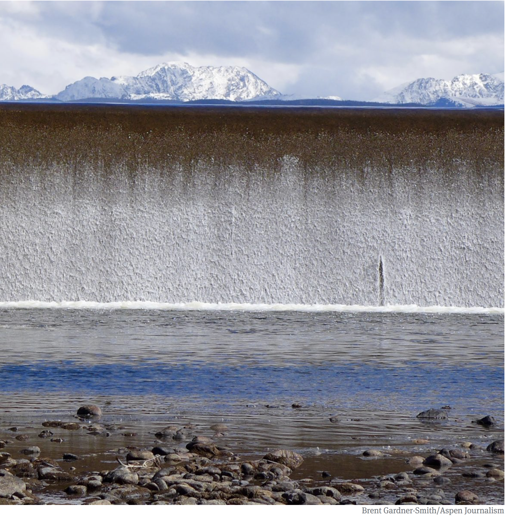
Outflow from the dam across the Colorado River that forms Windy Gap Reservoir. Taken during a field trip the reservoir in September, 2017.
Conservation included
Northern, which is not a defendant in the lawsuit, filed a motion in March to intervene on behalf of the defendants in the lawsuit to help defend the permit process.
When asked why conservation was not considered as an alternative, officials from Northern said that the demand estimates already assume that municipalities will increase water conservation.
“We did not count conservation as an alternative. We built conservation into our demand projection,” said Jeff Drager, Northern’s director of engineering and the project manager for the Windy Gap firming project. “So when we looked at how much water our participants need we figured we factored in some level of conservation already.”
Though Northern and the state use the projected demand gap to justify the firming project, the petitioners say the demand estimates are inflated.
On May 3, the petitioners filed a motion to add a statistics report to the case’s administrative record.
According to the report, the Bureau of Reclamation and the Army Corps failed to update the estimated water use statistics in their impact statements with the actual water use data as it became available over the course of the 14-year permitting process.
The report found that the agencies’ estimates for municipal water use were between 9 and 97 percent higher than the actual water use figures.
“The thrust of our claim is that the federal government just took the project participants word for how much water they would need,” said Kevin Lynch, the attorney for the petitioners. “The agency has a duty to independently verify that need and they didn’t do anything. They took projections from 2005 and that data was wildly over-inflated.”
The court is now reviewing the petitioners’ administrative motions as well as motions by both Northern and the Colorado Department of Natural Resources to intervene on behalf of the defendants.
These changes will likely delay court proceedings for at least several months.
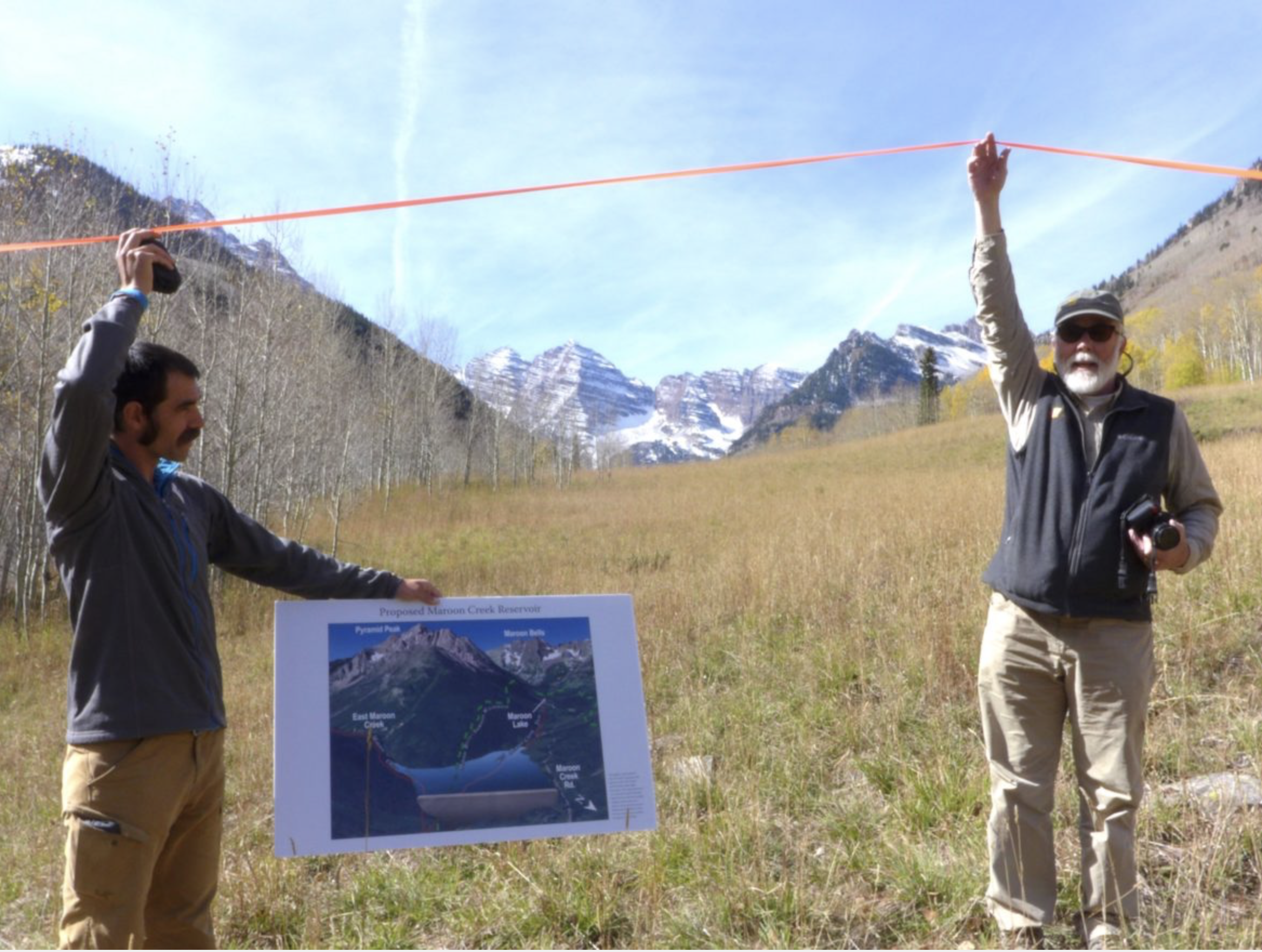
Will Roush, left, of Wilderness Workshop, and Ken Neubecker, right, of American Rivers, hold up tape on Sept. 7, 2016 showing where the base of a 155-foot-tall dam would be located on Maroon Creek if the City of Aspen were to build the potential Maroon Creek Reservoir.
May 8, 2018, a status conference is held in the two cases in front of the water court referee. The city must respond to opposer’s settlement proposals by June 1. The next status conference is set for June 29. Meanwhile, the City of Aspen’s two due diligence applications remain before the water court referee, in a quasi-administrative, non-trial-track status.
May 9, 2018, Aspen Journalism and The Aspen Times report that city has reached agreement with one of the opposing parties in the dam cases.
May 24, 2018, A staff memo regarding stipulation agreements on the water rights is published by the city. The packet for a May 29 staff meeting also includes a proposed resolution.
The title of the resolution is “A RESOLUTION OF THE CITY COUNCIL OF THE CITY OF ASPEN, COLORADO, AUTHORIZING THE CITY’S ATTORNEYS TO EXECUTE STIPULATIONS WITH OPPOSERS TO THE DILIGENCE CASES FOR CONDITIONAL WATER STORAGE RIGHTS ON CASTLE AND MAROON CREEKS ON BEHALF OF THE CITY OF ASPEN, COLORADO.”
The Aspen Daily News reports on the city council’s pending vote related to moving its move water rights out of Castle and Maroon creek valleys, as does The Aspen Times, Aspen Journalism, and Aspen Public Radio. APR’s story was headlined “Aspen agrees to never build dams on Castle and Maroon.”
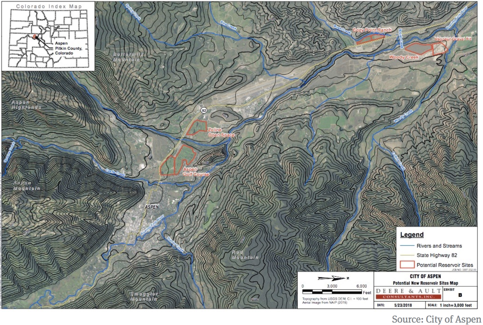
A map prepared for the City of Aspen that shows the five potential water-storage sites in the Roaring Fork River valley.
May 29, 2018, The Aspen city council votes unanimously to approve agreements with five opposing parties in the Castle and Maroon creek cases. Agreements have yet to be reached with the other five opposing parties.
The city issues a press release with the headline, “City Council Votes to Support Moving Conditional Water Rights off Wilderness Areas.”
As of May 29 there were stipulation agreements signed by five parties. Three of those parties are in both the Castle and Maroon creek cases. Below is a list, with links to the agreements signed to date, and made public by the city.
The Pitkin County stipulation is listed at the top, as it is the most restrictive of the stipulation agreements yet signed. It eliminates the use of the county-owned Moore Open Space as a potential storage site, while the earlier agreements with other parties include it.
Agreements were not signed by May 29 with five other opposing parties, three of whom are in both cases:
USFS – Maroon Creek Reservoir
USFS – Castle Creek Reservoir
American Rivers – Maroon Creek Reservoir
American Rivers – Castle Creek Reservoir
Trout Unlimited – Maroon Creek Reservoir
Trout Unlimited – Castle Creek Reservoir
Larsen Family LP – Maroon Creek Reservoir
Roaring Fork Land and Cattle Co. – Maroon Creek Reservoir
May 30, 2018, Western Resource Advocates issues a press release about the city’s vote, with the headline, “Conservationists reach settlement with Aspen to permanently move water rights for dams out of Maroon & Castle Creeks.”
WRA is also encouraging people to sign a thank you card to the city of Aspen, saying “We’re celebrating a landmark agreement two years in the making: the City of Aspen has agreed not to build dams on Maroon and Castle Creeks!”
Steamboat Springs area residents will soon get a chance to pick the brains of scientists and conservationists on how to prevent the Yampa River from being ravaged by extreme weather conditions.
A community discussion, “The Yampa Basin: Snow, Weather, Water and Our Future,” will be offered on Wednesday night at the end of a weekend workshop, which is being hosted by Colorado Mountain College and the University of California, San Diego’s Scripps Institution of Oceanography.
The Yampa River Rendezvous on June 5 and 6 will involve about 80 graduate students, post-doctoral scholars, researchers and water resource experts, who are traveling to Steamboat to study the Yampa River’s unique role in the Colorado River system as one of its wildest tributaries.
“In San Diego, we get about 70 percent of our tap water from the Colorado River,” said Atmospheric Scientist Leah Campbell, a postdoctoral researcher with UC, San Diego and a scholar at the Center for Western Weather and Water Extremes. About 20 post-graduate students will be attending the workshop with Campbell.
IF YOU GO
What: Community discussion: “The Yampa Basin: Snow Weather, Water and our Future”
When: 5:30 to 7:30 p.m. Wednesday, June 6
Where: Albright Auditorium at Colorado Mountain College Steamboat Springs, 1275 Crawford Ave.
Exceptional drought conditions could force the town of Bayfield to tap into its reserve water storage this summer in Vallecito Reservoir.
The town usually relies on water in the Los Pinos Ditch, but by July, there may not be enough water to fulfill the town’s water rights in the ditch, Town Manager Chris LeMay said. La Plata County is in the most critical drought listing by the U.S. Drought Monitor.
The town’s reserves in Vallecito and its own reservoir are somewhat limited, which may necessitate purchasing additional water rights this summer, LeMay said.
Bayfield spends $11,385 annually to lease 90 acre-feet of water in Vallecito, enough to meet the town’s average summer consumption for 45 days, he said. It can also store 30 acre-feet of water in the town’s reservoir, which could meet average consumption needs for about 15 days, he said. The town consumes an average of 2 acre-feet of water a day during the summer, he said.
“We would definitely have to ratchet down our consumption,” he said.
The need to tap into those reserves hinges on the monsoon, or the rainy season. The Climate Prediction Center released a report earlier this month predicting “above-average” precipitation in July, August and September…
Drought conditions prompted the town to consider purchasing one-time water rights from the Pine River Irrigation District, as it did in 2002. A decision about purchasing similar rights this year has not been made.
Annual irrigation limits began May 15 in Bayfield, which limits residents to watering their yards only every other day. A persistent drought could force Bayfield to institute more stringent irrigation restrictions. Residents are also prohibited from watering during the day from 9 a.m. to 6 p.m.
As the town has grown, annual water restrictions have helped Bayfield make due with existing water rights, he said.
To serve a growing population, the town filed a case in water court to convert agricultural water rights in the Los Pinos Ditch to municipal and industrial water rights. If those rights can be converted, it would be enough to meet the town’s needs for the next 30 years. The water case, filed in 2015, could be decided this year, LeMay said.
The National Weather Service in Boulder warned about high fire danger in South Park and the southern foothills along with portions of the eastern San Juan and La Garita mountains, Chaffee and Lake counties, the San Luis Valley, Fremont, Teller, El Paso, Pueblo, Huerfano and western Las Animas counties…
“Conditions will be favorable for the rapid growth and spread of fires,” the weather service said.
Sugar Loaf said it drilled the well near Fire Station 1 in March 2017 and voluntarily tested the water in April 2018. It found levels, particularly of PFOS, to be 10 times above the Environmental Protection Agency’s health advisory levels.
A second sample was submitted to confirm test results, which it expects to have soon.
Boulder County Environmental Health Division Manager Joseph Malinowski said the county notified nearby residents and is in the process of testing well water for PFCs at approximately 10 homes within 1,300 feet of the volunteer fire station.
“At this time it’s difficult to say how far the plume may have spread. It may just be contained to the fire department’s property itself. That’s part of what we’re trying to do is doing water testing to see if we have some other contaminated wells nearby,” Malinowski said.
Boulder County has advised the homeowners not to drink their well water until they see test results.
“We have multiple firefighters that live near the station. We are the community,” said Sugar Loaf Chief Andrew Goldman. “We’re moving as quickly as we can”
[…]
Right now in Boulder County, Van Dyke said that the scope of the contamination remains an open question. Key to the findings will be water well samples taken from the about 10 nearby homes. But it could take weeks to get data.
Click here to read the newsletter. Here’s an excerpt:
CALL FOR ABSTRACTS – DUE 6/30
The Hutchins Water Center at CMU will hold the 8th annual Upper Colorado River Basin Water Forum on Nov 7-8, with the theme “Bridging Science, Policy and Practice.” In the interest of promoting fresh, lively and informative discussion, we encourage presentation proposals from from water managers, engineers, policy makers, scholars, policy analysts, citizen groups, industry representatives, farmers, water attorneys, graduate and undergraduate students, artists and writers. Please submit by June 30. The Call for Abstracts is here; general information and programs and presentations from past Forums are here.
Click here to read the newsletter. Here’s an excerpt:
Central’s Board Considering Bond Proposal
Central Colorado Water Conservancy District, through its Groundwater Management Subdistrict, is reviewing a potential bond question for voters in 2018. Although the proposal is in its earliest stages, Central’s board and management believe it’s important to start discussing the next steps to secure both water storage and water rights for the region.
Central’s 10-year outlook includes the development of additional reliable water supplies, including storage projects, recharge projects and senior water rights. A portion of the GMS water supply has been leased from municipal water supplies; however, as municipalities grow and can use these excess supplies, GMS will have less and less certainty that these leases will be available in the future. Additionally, as the buy and dry of irrigated lands downstream of the Denver area continue, agricultural water needs from groundwater will increase.
The possible bond projects for GMS may include 5,000 acre-feet of additional reservoir storage—which will increase Central’s holdings by 25 percent—in the Fort Lupton and Greeley/Kersey areas. The bonds may also help construct a very large recharge project near the Weld and Morgan county line named the Robert W. Walker Recharge Project. The Walker Project will divert surface and groundwater at the rate of 100 cubic feet per second from the South Platte and divert those flows to recharge basins as far as five miles from the river. In addition, Central is looking at the purchase of several senior water rights that are becoming available for the district’s portfolio. This includes the purchase of waters currently being leased by Central, which will ensure this water stays in the community to be used by local farms and businesses.
Over the coming months, Central will be reviewing different policy decisions as it builds a potential GMS bond proposal. This process will continue community outreach and communications efforts in order to get critical feedback to understand the public’s support for Central’s water-management efforts. If you have any questions about GMS and this project, please contact the Central offices at (970) 330-4540.
Fontenelle Dam and power plant. Photo credit: USBR
Here’s the release from the U.S. Bureau of Reclamation (Marlon Duke):
On May 24, Bureau of Reclamation Commissioner Brenda Burman, together with Wyoming Governor Matthew H. Mead, Senators John Barrasso and Mike Enzi, and Representative Liz Cheney, announced collaborative plans to expand operational capacity at Fontenelle Reservoir. Governor Mead developed the Wyoming Water Strategy in 2015, which highlighted the Fontenelle Project.
For several years, Wyoming has sought to place riprap (rock or other material that protects against erosion) to expand the operating capacity of Fontenelle. The expansion will increase flexibility in operating the dam and reservoir – bolstering the region’s ability to resist frequent droughts in the arid West – all without increasing the footprint of the reservoir. Additional reservoir capacity will also make possible the creation of new water supplies which would be available for contracting and sale.
“Water is Wyoming’s most important natural resource,” said Governor Mead. “It is critically important to not only Wyoming but to our country. We need to address water challenges using all the best tools – like conservation, planning and infrastructure. As a headwaters state we recognize the need to protect and develop our water.”
“I applaud Commissioner Burman’s announcement that the Bureau of Reclamation will increase operational flexibility at Fontenelle Reservoir in southwest Wyoming,” said Senator Barrasso. “For years, I’ve been working to expand storage at Fontenelle. This announcement brings us one step closer to that goal. In order to start construction on this project, we must pass the Fontenelle Reservoir legislation. As chairman of the Senate Environment and Public Works Committee, I included this bill in the bipartisan America’s Water Infrastructure Act. I’m confident we will pass this important water infrastructure legislation and make sure that communities in Wyoming have access to a reliable source of water.”
“I am glad that the Bureau of Reclamation and Wyoming are working together to help expand capacity at the Fontenelle Reservoir,” Senator Enzi said. “Water storage projects like this are vital to meet today’s water needs and keep water supplies secure and flexible into the future. I am also hopeful that Congress will act soon and Pass the Wyoming delegation’s legislation designed to help further along the Fontenelle project.”
“I’m pleased the Bureau of Reclamation is moving forward to expand the operational capacity of the Fontenelle Reservoir to help protect one of Wyoming’s most important resources,” Representative Cheney said. “The Fontenelle Reservoir expansion will help combat the effects of drought, help ensure our water infrastructure is properly developed and provide the potential for new commerce and recreation activity by creating new water supplies to be available for contracting and sale. This decision by the Bureau of Reclamation is an important and welcome step for Wyoming.”
Under existing law, Wyoming can apply for project funding under the Colorado River Storage Project Basin Fund Memorandum of Agreement. On April 30, Reclamation concluded that it would consider funding the project under this authority, and invited Wyoming to submit a funding request. Under the MOA, many Western water storage projects have received funding from Reclamation for operation, maintenance, and replacement activities. This federal funding can only be used to improve Colorado River Storage Project facilities and operations.
As an alternative to expanding operational flexibility under MOA funding, Wyoming is seeking Congressional approval to create additional water supply for contracting. Two bills which would authorize this plan, Senate Bill 199 and House Resolution 648, have been introduced by the members of the Wyoming Congressional Delegation.
“Reclamation is pleased to be a partner in the state and the delegation’s efforts to upgrade crucial water infrastructure at the Fontenelle Project,” said Commissioner Burman. “Improving access to reliable water supplies is a key priority for Reclamation and the Administration.”
“This is a great project,” said Governor Mead. “I am pleased to see it move forward.”
The authority will now pay residents and business owners $3 for every square foot of thirsty grass they rip out and replace with desert landscaping. The $1 increase, approved by authority board members Thursday, represents the first significant change to the agency’s Water Smart Landscapes Program in three years.
Agency officials hope raising the rebate will spur more participation in the 19-year-old program, which has seen a steady decline in turf conversions over the past decade…
The problem isn’t that the valley is running out of grass to replace, said Colby Pellegrino, director of water resources for the authority.
She said there could be as much as 200 million square-feet of purely ornamental turf still out there, not including the stuff that actually gets used at parks and schools and people’s yards.
Low flows in the Roaring Fork River just above Rio Grande Park, in July 2012. City of Aspen officials say the Roaring Fork runs below environmentally-sound levels on this stretch about eight weeks of the year now.
Warm, dry weather has essentially gobbled the snowpack below 11,500 feet in the Fryingpan Valley, according to Tim Miller, a hydrologist with the U.S. Bureau of Reclamation who oversees the vast plumbing system that fills Ruedi Reservoir…
At this time last year, about 79 percent of the 133 square miles of the Fryingpan River Basin had some level of snow coverage, according to the National Operational Hydrologic Remote Sensing Center. That produced a mean of 10.3 inches of snow-water equivalent — in layman’s terms, the amount of water in the snow.
This year, only 51 percent of the terrain in the basin has some level of snow coverage. The mean snow-water equivalent is only 2 inches…
Reduced runoff can have broad implications including low streamflows that affect everything from the health of fish to the quality of whitewater rafting and kayaking. There also will be less water available for irrigation.
The dry conditions mean Ruedi probably won’t reach its capacity of 102,000 acre-feet…
The drought was obviously a hot topic last night at the Colorado River District’s Roaring Fork Valley State of the River forum in Carbondale.
Heather Tattersall-Lewin, watershed action director for Roaring Fork Conservancy, said there are spots in local rivers that create special concerns in low-water years. The Roaring Fork River through Aspen is often “dewatered in dry years.” The city government worked on an agreement to put water from the Wheeler Ditch into the river when it drops to certain levels, she said.
The Roaring Fork River also tends to drop to especially low levels just above the confluence with the Fryingpan River in low-water years, Tattersall-Lewin. Pitkin County Healthy Rivers and Streams developed a whitewater park with junior water rights to try to increase the water level in that stretch in lean years, she said.
The low runoff prevented the reclamation bureau from dumping a high amount of water from the Ruedi dam into the lower Fryingpan River this spring.
“We didn’t see a flushing flow go through the Fryingpan this year,” Tattersall-Lewin said.
That could lead to proliferation of a particularly nasty type of algae called Didymosphenia geminate but often just referred to as didymo or rock snot. Roaring Fork Conservancy will monitor the presence of the algae.
The Crystal River, which often is affected by low flows during the summer, faces a tougher than usual year. The snowpack at McClure Pass was well below average all winter long and melted completely out prior to May 1.
Zane Kessler, communications director for the Colorado River District, said snowpack at numerous measuring stations throughout the Colorado mountains have melted out already. Statewide the snowpack is at 30 percent of average, he said.
Far western Pitkin County, including McClure Pass, is considered in severe drought, according to the U.S. Drought Monitor released by the federal government Thursday. Far eastern Pitkin County, which includes Independence Pass, is considered “abnormally dry.”
Most of Pitkin County is in the moderate drought classification, the second in five classes.
Click here for all the inside skinny and to register:
In 2016, it became legal to collect water from your gutters to water your lawn, garden, and flowers on your own property. Since then, rain barrels have been all the rage, and Colorado residents are all getting excited about this new way to garden and save on their water bill at the same time! Water Education Colorado is partnering with Ute Water Conservancy District and the River Network to host a rain barrel workshop where participants will actually build their own rain barrel and get to take it home!
For only $40.00 per barrel, you can come make one of your own! Additional friends and family may join in the fun and help build your barrel for $10. Kids can attend for free. We will have all of the tools and materials that you will need to start watering your lawn with rain water.
A couple things you need to know:
We are more than just fun – If you do not know how to use a rain barrel, or the benefits of having a rain barrel, then no worries! We will have a short educational session for all participants on how rain barrels play a role in managing water in Colorado and how you can do your part to be a responsible water citizen.
Rain barrels are large – The rain barrels are 35 to 55 gallons. You will need to have an appropriate vehicle, and any straps needed to contain the barrel for its ride home at the end of the evening.
We have the tools – You will not need to bring any power tools with you. However, if you have a cordless drill and would like to bring it, please do so.
*Note: If you are not at the workshop to claim your rain barrel by 5:30 pm, then your barrel will be given away with no refund.
Cost:
Rain Barrel Builders: $40
Additional Friends and Family: $10 per person. If you want to help a friend or family member build their barrel and enjoy some drinks and appetizers, then please join us! We are asking for $10 to help cover appetizers. Kids attend for free.
It’s time! The 6th annual South Platte RiverFest presented by Elitch Gardens Revesco Properties takes place on Saturday, June 23 from 11 am-8 pm. We are moving the festival back to Confluence Park for even more access to water sports and activities!
Admission is free and provides access to live music, SUP races, SUP demos, and tube rides through the whitewater park. Food and beverages will be available for sale throughout the festival including our new food truck court!
Activity bracelets will be available for kids for unlimited fun all day long. Bracelets will be $5/child or $12/family and give unlimited access to a climbing wall, face painting, balloon animals, and trolley rides…
Be sure to invite all of your friends to Denver’s Premier River Festival. We hope to see you there!
Click on a thumbnail graphic to view a gallery of drought data from the US Drought Monitor.
US Drought Monitor May 29, 2018.
West Drought Monitor May 29, 2018.
Colorado Drought Monitor May 29, 2018.
Click here to go to the US Drought Monitor website. Here’s an excerpt:
Summary
Hot weather (daytime high temperatures in the 90’s) stretched from Arizona eastward to Louisiana early in the drought week, before spreading rapidly northward over the Great Plains and much of the Mississippi Valley. Some locations reported triple-digit heat during the week, associated with an amplifying ridge in the middle troposphere over the central contiguous U.S. Though the observed weekly precipitation pattern was largely convective in nature, both AHPS and ACIS depict the heavier precipitation amounts (over an inch) generally across the Southeast, the central Gulf Coast area, and the northern and central High Plains. These areas of heavier rainfall were associated with Subtropical Storm Alberto and baroclinic activity. Alberto developed early in the drought week over the western Caribbean Sea and tracked north over the eastern Gulf of Mexico. By early Monday evening (May 28th, Memorial Day), the center of Alberto crossed the Florida panhandle near Panama City. Preliminary wind reports indicated 40 mph sustained winds at Panama City, with a gust to 59 mph. Near and along Alberto’s path northward, rainfall amounts of 3-8 inches were generally received, with locally heavier amounts…
Abnormal dryness was erased from southern Mississippi this week, thanks to Alberto’s rains. In contrast, recent heat and dryness promoted the expansion of D0 across northwest Louisiana and western Arkansas. The 30-day ACIS SPI has values of -1 to -2 in general across the Arklatex region. A major overhaul of the drought depiction in Texas was rendered this week, with some areas showing improvement and others showing deterioration. Recent rain in parts of western Oklahoma favored small-scale improvements in the core drought region, while the lack of significant rain in parts of eastern Oklahoma warranted one-category deterioration…
In south-central and southeastern Nebraska, recent triple-digit heat and dryness has been an issue, especially for pastures and alfalfa. Where 90-day SPIs were less than -1.5, moderate drought (D1) was introduced. This included a small area south of Omaha, which was linked to the D1 area in nearby Iowa. Moderate drought (D1) was also expanded across northern Fillmore and northwest Saline counties. Incidentally, Omaha matched or set four days of high temperature records during the long Memorial Day weekend (Friday through Monday). The highs ranged between 97 and 101 degrees F. Across northwest Kansas, widespread heavy rain (3 inches or greater, with some isolated CoCoRaHS totals of about 9 inches) warranted a one-category improvement in the depiction. Next week, once the rainwater has a chance to either percolate into the soil or run off into streams, additional alteration of the Kansas depiction may be needed. Across the Dakotas, D0, D1, and D2 categorical areas were generally expanded in coverage, due mostly to recent precipitation deficits. There was one area of improvement (D0 was removed) in the Black Hills of South Dakota due to rainfall this past week…
Recent rain warranted a one-category improvement in drought conditions (D1 to D0) across northeast Montana, and the two areas of abnormal dryness in this region were consolidated into one. For now, despite recent heat and dryness, it was decided to hold off on introducing any D0 into extreme northwest Montana. Continuing snowmelt runoff and above average river and stream flows provide plenty of water in that area for irrigation. In addition, in nearby Idaho, some areas are coming out of their worst flooding in years. Bonner County continues to experience flooding, and farmers in adjacent Boundary County will be struggling with crop loss from the saturated soils in that region. In Colorado, some improvement in the drought depiction was made from approximately the Front Range just west of Denver eastward through Kit Carson and Cheyenne Counties near the Kansas border. Relatively small adjustments were made in New Mexico this week as well, especially in central and east-central portions of the state…
Looking Ahead
For the ensuing 5-day period (May 31-June 4, 2018), most predicted heavy rain areas (1.5-3.0 inches or greater) are expected to be east of the Mississippi River, where little dryness and drought currently exist. West of the Mississippi River, smaller-scale heavy rain areas of a convective nature are forecast over North Dakota, Nebraska, and southwestern Missouri. For the subsequent 5-day period (June 5-9, 2018), CPC predicts elevated odds of near to below normal precipitation for most of the Lower 48 states. Exceptions include in and around the Florida Panhandle, Minnesota and parts of adjacent states, and much of Arizona and New Mexico, where odds favor above normal precipitation.
The latest chapter is a March 25 letter obtained by the Indy from the DOJ to the state Health Department and Colorado Attorney General’s Office. In it, DOJ Acting Assistant Attorney General Jeffrey Wood says the federal government will “welcome and anticipate the full involvement of the State and intervenors in any such discussions with the City.”
That contrasts with the EPA’s unilateral action to reopen settlement negotiations with the city recently — without consulting other plaintiffs — after a year-long settlement discussion failed last year. The lawsuit is set for trial in August.
There already are six projects being pursued in the South Platte Basin to extend the water supply. These are not included in the recent South Platte Storage Survey, but have been considered and under way for some time:
Northern Integrated Supply Project (NISP) map July 27, 2016 via Northern Water.
• The NISP/Glade project — The Northern Integrated Supply Project is a proposed water storage and distribution project that will supply 15 Northern Front Range water partners with 40,000 acre-feet of new, reliable water supplies.
Map from Northern Water via the Fort Collins Coloradan.
• Chimney Hollow Reservoir — A 360-foot high dam that will hold 90,000 acre feet to help supply the thirsty Thompson Valley urban area. The water will come from the Windy Gap Project, a diversion dam and pumping station completed in 1985 to provide extra irrigation and municipal water out of the Colorado River. The water originally was stored in Grand Lake, but when that is full, the water cannot be stored. Chimney Hollow, also known as the Windy Gap Firming Project, solves that problem.
Reservoirs NW of Fort Collins
• Halligan reservoir enlargements — Halligan Reservoir near Fort Collins is about 100 years old. Its capacity is about 6,400 acre feet of water and the City of Fort Collins wants to add 8,125 acre feet to the reservoir by raising its dam about 25 feet.
• Milton Seaman Reservoir enlargement — Greeley originally had wanted to expand Seaman Reservoir in conjunction with Halligan, but because of diverging goals Greeley withdrew from the joint project. The expansion of Seamon now is targeted for design in 2028 and construction by 2030.
Gross Dam enlargement concept graphic via Denver Water
• Gross Reservoir enlargement — Gross Reservoir is one of 11 reservoirs supplying water to the City of Denver and surrounding urban areas. It is on the city’s Moffat System, which diverts water from the Western Slope to the metro area. Denver Water has proposed raising the dam height by 131 feet, which will allow the capacity of the reservoir to increase by 77,000 acre feet.
Proposed reallocation pool — Graphic/USACE
• Chatfield Reallocation Plan — The U.S. Army Corps of Engineers has determined that Chatfield Reservoir, built primarily for flood control after the 1965 South Platte River flood, can accommodate an additional 20,600 acre feet of water storage for water supply without compromising its flood control function. This additional storage space will be used by municipal and agricultural water providers to help meet the diverse needs of the state. No actual construction is required, but the legal, environmental, and engineering concerns of allowing the reservoir to hold more water all have to be satisfied.
The problems faced by the wastewater system have become more urgent, as the city is now non-compliant with its existing discharge permit. Failure to move forward with upgrades could result in stiff penalties from the Colorado Department of Public Health and Environment, to the tune of $10,000 a day assessed from the first date of the violation last November.
The Sterling City Council has long known about deficiencies in the system; two years ago, Rob Demis of engineering firm Mott MacDonald gave a preliminary overview of some of the problems presented by the aging infrastructure. In short, the system suffers from flooding and leakage issues, and also is incapable of meeting new environmental standards…
According to Demis, the system lacks the capacity to handle heavy rainfall events or river flooding, and also suffers from leaks at multiple points that allow groundwater to seep into the wastewater stream. That excess water damages equipment, overloads the system and can lead to costly permit violations, as well as disrupting the biological process that breaks down the organic material in the water.
The system also is incapable of meeting its existing compliance schedules or new regulations that are slated to be implemented by 2022. It suffers from a lack of redundancy, leaving the city vulnerable to failures that would be “catastrophic,” Demis said, and also uses obsolete and dangerous equipment and processes.
Demis explained that much of the system has reached, or exceeded, its useful life and the problems the city is facing will only get worse over time. As an example, he said the four clarifiers that are in place had been banned by the time they were installed in 1995, begging the question of how Sterling ended up with them in the first place, and one of the tanks has failed and can’t be used.
As part of the presentation, Demis went over the estimated costs, 80 percent of which was for construction and the other 20 percent for legal, administrative, engineering, permitting and other costs associated with such a project. The cost of installing a new force main and improvements to the treatment system itself make up about half of the $31 million price tag.
Demis also spoke about possible funding sources. Grants are not reliable, he said; they looked at six possible grant sources and one they identified as a possibility has not received the expected funding because of low oil prices. A review of potential loan sources showed that the State Revolving Fund would provide a lower total cost in the long run versus private loans, because of the reduced interest rate. Either way, the city charter requires voter approval for taking on debt.
The city’s existing sewer rates have not kept up with the rate of inflation, Demis said. Using simple math, he estimated that residential sewer users’ rates would increase by $23, but noted that the city would have to complete a rate study to look at the more complex issues involved in determining the revenue necessary to make the recommended improvements, operate the system and invest in other needed infrastructure. The council is awaiting a report on such a rate study that was funded in the city budget last year.
During his October 2016 presentation, Demis gave credit to the operators at the wastewater treatment plant, saying they were “willing to make their job a little bit harder to try to find the value for the city” by reusing existing equipment and infrastructure where possible. He estimated that the cost to completely start over with a new wastewater system would be between $45 and 50 million. “We think there’s very good value for the city of Sterling there.”
Sterling residents for the past two years have seen increases on both water and wastewater services in an attempt to build up the enterprise funds and address infrastructure needs. According to City Manager Don Saling, the rate hikes were intended to narrow the gap between where rates were and where they’ll need to be, pending the outcome of the rate study. One big change he expects to see from the study is a recommendation to base sewer rates on usage; the rate would be calculated from water usage in cooler months, when users are not watering outdoors. A variable rate would be more equitable — a family of four would presumably pay more than a single retiree on a fixed income — and could also encourage water conservation to lower both water and sewer bills.
Join the Barr Milton Watershed Association, Water Education Colorado, Metro Wastewater Reclamation District and the Colorado Stormwater Council on June 5th or June 6th for a fun and interactive day learning about the history of the Sand Creek Waterway and efforts to reclaim it. Explore this waterway by bicycle along with citizen leaders, scientists, planners and water managers. To register for the June 5th date, click here. To register for the June 6th date, click here…
When we think about Colorado waterways, our minds often wander to the larger rivers that traverse the state, like the Arkansas, Rio Grande and Colorado Rivers. However, our smaller, local waterways also play a significant role in providing important ecosystem benefits, as well as water to communities and industries, and habitat areas for wildlife. Join the Barr Milton Watershed Association, Water Education Colorado, Metro Wastewater Reclamation District and the Colorado Stormwater Council for a fun and interactive day learning about the history of the Sand Creek Waterway and efforts to reclaim it. Explore this waterway by bicycle along with citizen leaders, scientists, planners and water managers.
Register today – space is limited. Both the June 5 (morning) and June 6 (afternoon) bike tours are exactly the same.
Sure, it’s late May, and normally by now the mountain snows have all but wrapped up for their annual three-month-or-so summer hiatus. But in a typical year, snowpack hangs around well into June, and sometimes even into July and August. In southern Colorado, there’s virtually no snow left, even on peaks, and further north, there’s barely a third of the snow you’d typically expect this time of year.
The drought has gotten so bad in southern Colorado that several counties have been declared disaster zones by the United States Department of Agriculture, making those areas eligible for emergency financial assistance. Conditions in the San Juan Mountains of southwest Colorado are at the highest level of drought, according to the United States’ official drought monitor.
The drought in the south began with an absolutely horrendous winter. Purgatory Ski Resort, near Durango in the San Juans, saw only 125 inches of snow this season, less than half of the 260 inches it averages. Telluride saw only 171 inches in the 2017-’18 winter, also only about half of the 309 inches it normally sees in a full winter. A bit further north, Crested Butte only saw 145 inches compared to the 300 inches or so it typically sees in a winter.
Particularly for the hardest hit areas of southern Colorado, half of the snow means half of the spring snowmelt. A quick scan through statewide stream flow levels already shows below average water discharge through most of Colorado (there are localized exceptions), thanks to a warm May that’s already melted off much of the meager snowpack.
What does this all mean? For starters, camping season is already feeling the pinch of burn bans for much of the southern half of the state. Barring big summer rains, these are unlikely to be lifted anytime soon.
The biggest concern will be the possibility for wildfires this summer. We’ve written extensively about the looming danger of a dry winter and how that can help fuel a nasty summer. With a quick melt and the snow water tap already running dry in much of the state, we’ll need steady rain to keep the ground moist enough to avoid fires. Heat waves, such as the horrific 2012 one that helped start the Waldo Canyon Fire, and gusty, dry winds can set the stage for dangerous fire conditions.
Conditions are even nastier in southern Utah, Arizona and New Mexico. Flagstaff, Arizona, saw one of its worst winters on record, picking up just 38 inches of snow for the season, a fraction of the 101.7 inches it averages. Taos Ski Area in New Mexico saw 78 inches of snow, significantly less than the 300 inches it would see in an average year. Albuquerque already has water restrictions in place this summer.
Recent rains have helped in the Denver area and northern parts of the state. Year-to-date precipitation in Denver is around three-quarters of an inch below average, which is a deficit, but not a huge one. On the eastern plains, Akron has seen more than double its typical May rainfall, helping ease some of the worst drought conditions in Colorado’s breadbasket. Reservoir levels are above average, and a wet June could help ease drought conditions.
The California-Nevada Drought Early Warning System (CA-NV DEWS) May 2018 Drought & Climate Outlook Webinar is part of a series of regular drought and climate outlook webinars designed to provide stakeholders and other interested parties in the region with timely information on current drought status and impacts, as well as a preview of current and developing climatic events (i.e. El Niño and La Niña). The webinar took place at 11 a.m. PT, Tuesday May 29, 2018.
The U.S. Department of Agriculture announced Tuesday that farm operations in areas eligible for the Farm Service Agency emergency loans have until January 2019 to apply for loans to help cover losses related to the drought.
Since April, La Plata County has been listed in an “exceptional drought” – the most intense category of drought according to the U.S. Drought Monitor.
As of Tuesday, a weather station at the Durango-La Plata County Airport has recorded 1.41 inches of precipitation since Jan. 1, nearly 4 inches below the historic average of 5.38 inches in that same time period…
Nearly all of Colorado, with exception to the northeast corner of the state, is listed in some form of drought.
The USDA designated seven counties as “primary natural disaster areas” because of drought: Alamosa, Archuleta, Conejos, Gunnison, Hinsdale, Mineral and Rio Grande.
Eleven counties were not deemed natural disaster areas, but farm operations in these counties can apply for emergency assistance: Chaffee, Costilla, Delta, Huerfano, La Plata, Mesa, Montrose, Ouray, Pitkin, Saguache and San Juan.
The news release said Rio Arriba, San Juan and Taos counties in New Mexico also qualify.
It’s unclear why Dolores, Montezuma and San Miguel counties, which are also in the exceptional drought category, were not included on the list. Calls to USDA spokeswoman Latawnya Dia were not immediately returned Tuesday.
The USDA said each loan application is considered on its own merits, “taking into account the extent of losses, security available and repayment ability.”
The Farm Service Agency has other programs to help farmers recover from the impacts of drought, the news release said. Interested farmers and ranchers should call their local USDA office for further information.
The disaster declaration covers Alamosa, Archuleta, Conejos, Gunnison Hinsdale, Mineral and Rio Grande counties. All but Gunnison County are served by the Upper Rio Grande River. Gunnison County is served by the Gunnison River.
But the NRCS map shows pretty much all of southern Colorado is in bad shape because of drought.
The USDA is also making disaster assistance available to farmers and ranchers in 11 counties contiguous to those in the declaration area: Chaffee, Costilla, Delta, Huerfano, La Plata (Durango), Mesa (Grand Junction), Montrose, Ouray, Pitkin (Aspen), Saguache and San Juan.
The declaration means farmers and ranchers are eligible for emergency loans and other disaster assistance from the USDA’s Farm Service Agency. Those applying for emergency assistance have eight months from May 25, the date of the declaration, to apply for loans to cover actual losses.
The USDA has other financial assistance available that does not require a disaster declaration, including emergency loans for livestock, honeybees and farm-raised fish; operating loans for farm ownership; and a tree assistance program. More information on those programs is available from the USDA.
According to the U.S. Drought Monitor, more than 40 percent of Colorado, primarily the south and southwest, is in extreme or exceptional drought. Only the northern part of the state, served by the North Platte River, and northeastern Colorado, served by the South Platte, have so far been spared from drought. It’s a dramatic turn-around from a year ago at this time when only 6 percent of the state was in drought.
It’s unusual to have a drought declaration this early in the year, according to Colorado Commissioner of Agriculture Don Brown. “Typically we will have enough moisture to get into growing season,” but that’s not happening this year, he told Colorado Politics. In those drought areas, winter wheat didn’t even come up this season. “It’s been bone-dry,” Brown said.
Brown also pointed out that U.S. Secretary of Agriculture Sonny Perdue heard first-hand about Colorado’s drought problems when he toured the state two weeks ago.
The council voted 5-2 to allow city staff to negotiate, with Councilmembers Ross Cunniff and Bob Overbeck against, and those in agreement largely arguing it couldn’t hurt anything. City staff would need to go to council to approve any final deals.
“We need to be in the game and to negotiate and look out for Fort Collins’ best interests,” Mayor Wade Troxell said.
The agreement to negotiate doesn’t affect the city council’s overall negative disposition toward the Northern Integrated Supply Project. NISP would lead to the creation of two reservoirs, the Glade to the northwest of the city and the Galeton near Greeley. It would divert nearly 40,000 acre feet of water from the Poudre River. Fort Collins Water Resources Engineer Adam Jokerst noted for comparison that the city typically treats about 25,000 acre feet of water a year, about half of which is from the Poudre.
From the Colorado Springs Independent (Pam Zubeck):
The renewed negotiations come as U.S. District Judge Richard Matsch scheduled an August trial in the lawsuit on May 22, the day after the state’s lead attorney in the case was reportedly fired for a reason the Colorado Attorney General’s Office won’t discuss.
That lead attorney, Margaret “Meg” Parish, first assistant attorney general in the Natural Resources & Environment Section, wrote at least two scathing letters to the EPA and the Department of Justice (DOJ) in recent months, calling the EPA’s action “shocking and extraordinary” and expressing “deep concern and disappointment” that the agency unilaterally reopened settlement talks without consulting co-plaintiffs. Besides the Colorado Department of Public Health and Environment (CDPHE), those include Pueblo County and the Lower Arkansas Valley Water Conservancy District.
The move was particularly alarming, she noted, because the state and EPA signed an agreement not to communicate with the city without the presence of the other.
Some who couldn’t comment on the record due to confidentiality rules labeled the latest moves “pure politics” in an era when the EPA’s reputation is pivoting from protecting the environment to serving polluters…
EPA’s reopening of negotiations has sown suspicion among co-plaintiffs who already distrust the city due to sewage discharges, raging stormwater flows and sediment in Fountain Creek that befoul the creek, threaten levees and block irrigation headgates interfering with raising crops.
The possibility of a settlement was suggested to voters last fall when Mayor John Suthers campaigned for passage of stormwater fees, saying their adoption would help the city end the lawsuit, filed by the EPA and CDPHE in November 2016 after the city flunked compliance inspections in 2013 and 2015 for its MS4 permit (Municipal Separate Storm Sewer System). The lawsuit alleges ongoing violations of the Clean Water Act, saying the city failed to force developers to install proper storm drainage infrastructure, gave waivers to others and didn’t adequately inspect and monitor its waterways. The city spent only $1.6 million a year on those tasks from 2011 to 2014, a pittance considering the city’s drainage needs are estimated at $1 billion.
Approved by voters in November, the fees go into effect July 1 and replace general fund money used to satisfy an April 2016 deal the city made with Pueblo County to spend $460 million over 20 years on stormwater. The agreement grew from Pueblo County’s demands after the city adopted stormwater fees in 2007 and abolished them in 2009 and came as the city activated its $825-million water pipeline from Pueblo Reservoir.
The West faces a water supply gap, and the reasons are simple. Our quickly growing cities and towns are adding demands on our already stretched water supplies. Water reuse can help us fill the gap.
So what is water reuse and why is it important? First, it’s important to understand the difference between the two primary types of reuse: potable and non-potable reuse. Many states in the West currently allow for non-potable – or purple pipe – reuse for things like landscape irrigation, industrial purposes, commercial laundries, and fire protection, among other things. But a majority of purple pipe reuse is for outdoor landscape irrigation which really only benefits us during irrigation months (less than half of the year). But with potable reuse – where water is treated to very high quality standards to ensure it’s safe and often blended with other supplies – that water can be used anytime, anywhere and for anything. Potable reuse helps stretch supplies and meet more demand with the same volume of water. And it doesn’t require an entirely separate set of pipes (purple) to deliver it.
Western Resource Advocates is working with water utilities, local and state agencies, and other organizations to help increase water reuse around the West to address this growing problem. In Colorado specifically, WRA is working with a diverse group of stakeholders to help develop regulations for direct potable reuse and advance legislation to increase reuse to help the state’s water supplies. Recycled water has been used for decades in Colorado and states across the nation and has long been proven to be a safe, cost-effective tool for additional water supply. In fact, the State of the Rockies Poll found that 78% of westerners “support using our current water supply more wisely by encouraging more conservation and increasing water recycling.“
Currently, WRA and our partners are working to advance four bills in the Colorado legislature that would allow recycled water to be used for:
toilet flushing
marijuana cultivation
edible crop and community garden irrigation
growth of industrial hemp
Other states, like Florida, Washington, Oregon, and Idaho, currently allow for recycled water to be used for toilet flushing and edible crop irrigation, and have successfully supplemented their water supplies this way. Colorado’s Water Plan also specifically calls for state agencies to identify how the state can foster increased reuse to help address growing demands, and these initiatives are a great step in that direction. By embracing water reuse for these applications and others we can help bolster our stretched water supplies, and work to help, shrink the gap between those supplies and the demands of our growing cities and towns. Water reuse, in concert with other water-smart tools and strategies, can help us provide for our communities while also protecting our beloved rivers and lakes, keeping them healthy and preserving the quality of life that they afford for all of us.
This year’s “Shed ’18” Watershed Summit is going to be better than ever! With over 200 water utility executives, business leaders, conservation experts, and other professionals coming together and sharing tested solutions, you will surely come away with new insights and ideas to help position your organization for success.
This year’s event will highlight… Resiliency: Preparing and Recovering from Fire, Flood, & Drought
Colorado Water Plan Funding
Activating Communities for Change
Responsible Growth in Agriculture and Urban Water
Technology Innovation
And much more!
The “Shed ’18” Watershed Summit is produced through a collaborative partnership between the Colorado Water Conservation Board, Denver Water, the City of Boulder, the One World One Water Center, Resource Central, and the Denver Botanic Gardens. Building on the success of the last 3 years, this one-day summit helps you connect with industry leaders from across Colorado.
The “Shed ‘18” Watershed Summit Scholarship covers registration fees and conference meals. The application information and questions must be submitted by June 1st !
With a key final report looming for two proposed Poudre River-fueled reservoirs, Fort Collins City Council will weigh whether staff will try to negotiate over the city’s remaining concerns.
Past city comments helped steer the Northern Integrated Supply Project in a more agreeable direction, according to a staff report for Tuesday night’s City Council meeting. But concerns still remain. Staff members hope a negotiation might quell, or at least mitigate, some of them…
According to city staff, the prime concerns are:
a reduction of peak flows in the river, and related loss of river health and increased flood risk;
the unknown effect the project may have on water quality;
an unclear and “inadequately funded” adaptive management plan;
concerns that there’s not enough money gong to mitigation or river enhancement.
Officially, the city does not support NISP, but it has engaged in conversations with project organizer Northern Water on the project that has been talked about for more than a decade.
City staff is pushing for more formal negotiations — the City Council stripped that specific language in a similar resolution in February 2017 — because the permitting process is nearing its end. The Army Corps of Engineers is poised to release its final environmental impact statement at the end of June, according to the city.
The city isn’t a direct participant in the Northern Integrated Supply Project, though it is considered a stakeholder. The Corps doesn’t usually accept public comment on final environmental impact statements but is poised to do so this time, according to city staff. However, it will also likely be late enough in the process that public comment alone won’t be able to make change much.
Any negotiations would likely include a give-and-take with Northern Water, such as the city’s help in expediting remaining permits, though staff didn’t speculate about what else it may be.
“As with any such discussions regarding complex matters and potential agreements, there are no guarantees of success,” according to the staff report [ed. Click through to the Coloradoan to read the report]. “Furthermore, the approach will depend on Northern Water’s willingness to participate.”
Birds and fish struggle with less water, but bears benefit from warmer weather
Some animals, such as birds, do not need to drink much water because they metabolize water from the food they eat, said Colorado Parks and Wildlife spokesman Joe Lewandowski.
But drought conditions decrease the moisture in vegetation, which is detrimental to animals’ hydration. This can be problematic for lactating females, for instance, because they need extra water to produce milk.
For this reason, Parks and Wildlife hopes monsoons this summer will bring moisture to the vegetation, creating a larger inventory of food for animals.
The warm spring, which has so far stayed clear of a major freeze, has been beneficial for bears, Lewandowski said.
Last year, there was a late freeze that affected bears’ natural food supply. Bears then came into town to forage in humans’ trash. This year, food such as plants and berries are growing and available for the bears to eat.
Dry years also affect fish habitats. Low river and creek water levels mean fewer places for fish to go. Fish eat bugs, and the more water there is, the more bugs there are. When water is warmer, there is less oxygen available in the water.
At the Durango fish hatchery, Parks and Wildlife is releasing fish into the wild earlier than normal because there is less water available for the hatchery to use.
Species have adapted to different climates for thousands of years, so there is no threat of a mass extinction, Lewandowski said. However, biologists are worried that long-term drought will have harmful effects on wildlife.
“Swim, or hike, or watch birds, if you have a boat you can go boating,” said Polly [Reetz].
Yet the couple fears a construction project to build additional areas to hold water will ruin the place in the near future.
It’s a project that supporters argue is necessary in order to store water in a state that is in the midst of a population boom and a drought.
“I think aesthetically, it’s going to be a very different kind of park with mud flats instead of this rich riparian vegetation,” said Gene.
Along with the Audubon Society, they fear that by getting rid of the green space around the reservoir, all of nature will be hurt… including the animals.
“When you destroy the habitat, or alter it, so that it’s no longer usable for them, there really isn’t any other place to go, because other areas are already full too,” said Polly.
Which is why the Audubon society has gone to court.
They want a judge to throw out a previous decision allowing the project to move forward, saying among other things, that it violates the Clean Water Act.
A hearing will take place in September.
The Army Corps of Engineers is not commenting as the case is in litigation
“Audubon recognizes the region is growing, and so were not against developing additional water supplies,” said Gene [Reetz]. He is pushing for more water conservation and alternative storage sites other than Chatfield.
Despite protests from fellow plaintiffs, the Environmental Protection Agency has agreed to revisit a possible settlement with the city Colorado Springs over alleged Clean Water Act violations caused by the city’s longterm neglect of stormwater management, according to documents obtained by the Independent.
The renewed negotiations come as U.S. District Judge Richard Matsch scheduled an August trial in the lawsuit on May 22, the day after the state’s lead attorney in the case was reportedly fired for a reason the Colorado Attorney General’s Office won’t discuss.
Margaret “Meg” Parish, first assistant attorney general in the Natural Resources & Environment Section, wrote several scathing letters to the EPA in recent months, calling the EPA’s action “shocking and extraordinary” and expressing “deep concern and disappointment” that the agency would unilaterally reopen settlement discussion without consulting co-plaintiffs. Besides the Colorado Department of Public Health and Environment (CDPHE), those include Pueblo County and the Lower Arkansas Valley Water Conservancy District.
The move was particularly alarming, she noted, because the state and EPA had signed an agreement in which both agreed not to communicate with the city without the presence of the other.
Some who couldn’t comment on the record due to confidentiality rules called the latest moves — reopening negotiations and the firing of Parish — as “pure politics” in an era when the EPA’s reputation is pivoting from protecting the environment to serving polluters.
EPA Administrator Scott Pruitt, who has long-standing and close ties to the oil and gas industry and is under investigation for multiple alleged ethics breaches, met with the Housing and Building Association of Colorado Springs in October when the HBA paid for his night’s stay at The Broadmoor.
A few months later, on March 19, the EPA wrote a letter to the city “as a follow up to the City’s recent request to re-initiate settlement negotiations.”
The EPA’s co-plaintiffs were given two days notice that the letter would be sent to the city’s legal counsel, reportedly fueling outrage among those partners. Pueblo County has harbored distrust of the city of Colorado Springs for decades regarding sewage discharges and raging stormwater flows in Fountain Creek, which befouls the creek and threatens levees at Pueblo where the creek joins with the Arkansas River. Farmers in the Lower Ark region have complained for years that sediment blocks their irrigation headgates interfering with raising crops.
The hope is that this will lead to approval by year’s end of a proposed Drought Contingency Plan for the Lower Basin states of Arizona, Nevada and California, to conserve more water now to prevent catastrophic declines at Lake Mead later.
At stake is the future of your drinking water supply — the CAP’s canals bring river water to Phoenix and Tucson — and that of the 40 million people in seven states and Mexico who also depend on the Colorado River for water.
Here are six things to know about this future:
1. President Trump has called concerns about human-caused climate change bad science. But out West, his Bureau of Reclamation officials are saying the seven basin states must act to avert a crisis on the Colorado that many scientists have traced to climate change…
2. CAP officials are concerned that conserving “too much” water in Lake Mead could trigger a premature shortage in water deliveries first for Arizona farms, and later for Phoenix and Tucson’s drinking water. Others say that isn’t valid…
3. Without a drought plan, the bad tidings that many fear will befall Lake Mead in the distant future could arrive much sooner…
4. The drought’s additional threat to Lake Powell could threaten Western power production as well as Lake Mead, which supplies water to Arizona…
5. Arizona’s water agencies are making nice now, and a top CAP official sounds almost contrite. But approval of a drought plan remains uncertain…
6. The drought plan is only a band-aid, but putting an end to the fighting is considered essential.
[Bob] Hurford’s general sentiment about this year’s drought was shared by all who presented reports at the Ouray State of the Rivers meeting at the Ouray County 4H Event Center May 16. The presentations came two weeks after Gov. John Hickenlooper activated the Colorado Drought Mitigation and Response Plan for the agricultural sector in 34 of the state’s 64 counties, including San Miguel, Ouray, Montrose, and Delta counties…
Hurford explained that over half of the Rocky Mountains’ water supply is in its snowpack. As of April 1, Colorado’s snowpack was 68 percent of average and 64 percent of last year’s. Data maps show that the April 1 snowpack was between 50 percent and 69 percent for Ouray and Montrose counties, and below 50 percent for San Miguel County. Division 4, the eastern area around Gunnison, has the most snowpack; the San Juan Mountains have the least, with snowpack above Ridgway Reservoir at just 46 percent of average.
Colorado, Utah, Arizona and California had the lowest amount of precipitation in the U.S. this winter, and those four states — plus Nevada and New Mexico — had the highest temperatures from November 2017 to January 2018, according to statistics in Hurford’s report.
Data from reservoirs in October 2017 show that Colorado had one of its best years with close to 120 percent of average water levels statewide, 100 percent of average in Division 4 and around 116 percent of average in Ridgway Reservoir. Over the last two decades, reservoirs were at or above 100 percent for 11 years.
“We can survive one bad drought. Two bad droughts in a row and that gets us,” Hurford said.
Ridgway Reservoir Dam Superintendent Tony Mitchell, of Tri-County Water Conservancy District, showed National Weather Service forecast data that estimated January-April 1 flows into the reservoir at 88 percent of average in 2016, 111 percent in 2017 and 49 percent in 2018. For the period of April 1 through July, the main runoff season, flow estimates were 92 percent of average in 2016, 96 percent in 2017 and 40 percent in 2018.
Responding to a question about why the reservoir has looked lower than usual this spring, Tri-County Water Conservancy District Manager Mike Berry said late-season releases to the Uncompahgre Valley Water Users Association (UVWUA) were larger than usual last year, precipitation was low last summer and storage levels are kept lower than normal to avoid water spilling over the dam, which would send non-native fish into the Uncompahgre River, endangering the trout there.
UVWUA Manager Steve Andersen, who is also a director on the Colorado Water Conservation Board, said, “My association will be OK this year. There’s not as much water as we would like to have, but we will be able to make a crop this year.”
However, to ensure its downstream water users have enough water, the association in Montrose may have to put a call on water use later in the season, shutting headgates to irrigators upstream in Ouray County (who have junior water rights). Andersen does not expect to make a similar call on water on the upper Gunnison River side because of better snowpack, which should maintain higher flows there. He said the association would use that Gunnison water before resorting to a call on the Ouray side…
The last time that Ouray irrigators had to shut their headgates due to low stream flows and obligations to more senior water rights holders downstream was in 2012. That is when the Ouray County Water Users Association was founded…
With the drought conditions came concerns about wildfires, and Ouray and Montrose counties implemented Stage 1 Fire Restrictions on [May 21, 2018]. Stage 1 limits the areas where fires, smoking and spark-igniting activities can take place, according to the State of Colorado Department of Fire Prevention. Stage 2 adds more restrictions, while Stage 3 is the strictest, limiting entry into closed areas and setting fines as high as $10,000 for violators, or imprisonment for six months.
Peak flows on the Arkansas River apparently happened May 18, more than a month earlier than usual. The water levels peaked at 1,870 cubic feet per second, far below the average 2,500 to 3,000 cfs and have fallen to 1,500 cfs…
A deal has been done with downriver farmers and cities to help the whitewater industry get through difficult years like this one — by setting up a reserve of 10,000 acre-feet of water held in Turquoise Lake, Twin Lakes and Clear Creek Reservoir.
CPW officials this week said they’ve notified agricultural water users and federal Bureau of Reclamation operators of the reservoirs that rafting companies probably will need to draw on that reserve to keep the river flowing at a level no lower than 700 cfs — crucial for boating — through Aug. 15.
“They said they will have the 10,000 ace-feet available,” White said. “That feels great. It is invaluable. It is the difference between having a lousy summer and having a good summer.”
[…]
Earlier high flows on rivers caused by earlier melting of reduced mountain snowpack — which this year measured as low as 40 percent of normal in some areas — exemplify the changes scientists have linked to a buildup of heat-trapping greenhouse gas pollution in the atmosphere.
“Adapting to climate variability is something we are going to have to wrap our heads around in the future,” American Whitewater president Mark Singleton said Friday in an interview. That group represents boaters nationwide and serves as a central source of statistics on matters such as deaths. (Along the Arkansas River since 1986, only 13 rafting deaths on commercial rafting trips were reported, Singleton said, lauding careful state management of the river under a partnership with the federal Bureau of Land Management.)
“These are all fundamental changes in the river systems,” Singleton said. “And if there’s no water in the reservoirs, there’s no river flow. … What we have seen is these really big swings. In all of our climate systems, we are seeing greater variability.”
Yampa River at Steamboat Springs May 28, 3018 via the USGS.
“I think the main stem of the Yampa has peaked,” forecast center senior hydrologist Ashley Nielson said Wednesday. “There is a chance for some rain this weekend, but it would take heavy precipitation over the Yampa and Elk rivers,” to send them to a new level.
That means the Yampa reached its zenith for the season at 12:45 a.m. May 14, when the flow was 2,570 cubic feet per second. If that figure is confirmed, it would be the lowest peak since 2012 when the river topped out at 1,570 cfs on April 27.
Lake Superior is big, all right. It and the other Great Lakes contain one-fifth of the whole world’s fresh water and, get this, hold enough to submerge the continental U.S. under 10 feet.
Those far-off onlookers thirst mightily for the Lakes’ 6.5 million billion gallons of fresh water that, to them, just sits there before running off to the ocean. Wasted.
It’s easy for us lake-landers to dismiss such thoughts, but those in the American Southwest are up against a 17-year drought that keeps getting worse. After an unusually warm winter, it’s expected to worsen still more this summer due to a dearth of mountain snow that will again leave Colorado River flow far below normal, with forecasts of dry and very hot weather à la La Niña.
What’s beyond scary is that NASA computer models indicate that the West could be facing a 50-year megadrought, the first such event since long before Europeans even knew North America existed. Moreover, higher temperatures and wind wrought by climate change dry things out and increase demand for irrigation water while at the same time increasing already problematic evaporation rates from reservoirs and canals.
Primary water sources in Arizona, Nevada and Southern California are dangerously low. Benchmarks are the historically low Lake Mead reservoir behind Hoover Dam (built in 1930) and similar low levels of Lake Powell on the upstream end of the Grand Canyon. Las Vegas, which draws 90 percent of its water from Lake Mead, has twice lowered its intake “straw” due to falling levels.
One relief option is desalination of ocean water, but scaling up that technology has proved frustratingly difficult and outrageously expensive. The largest existing plant, at San Diego, provides only 7 percent of that city’s needs.
Another option is to strictly restrict water use, but that’s politically dicey and can’t get much beyond talk.
Then there’s a plan to spend gazillions to capture several of Alaska’s free-flowing rivers with a grand network of dams, canals and tunnels to divert water south to the Colorado basin. It seems that the drought is getting serious enough so that even far-fetched ideas get a look.
So OK, now what?
To desert dwellers, an idea that makes intuitive sense is to pipe Lake Superior water to where it’s “needed.” Such a project would be staggeringly expensive but technically doable; besides, the Great Lakes surely wouldn’t miss, say, 50 billion gallons — would they?
The populace all around the Lakes is rock-solid against shipping any water anywhere, and advancing any diversion plan would set off political warfare.
Or perhaps one should say “renew hostilities.” This story isn’t new. In 2007, New Mexico’s then-Gov. Bill Richardson suggested a Great Lakes diversion when the Western drought was only six years old. Following bloodcurdling protest, fellow Democrat Jennifer Granholm, then Michigan’s governor, told Richardson to zip it. A year later the eight Lakes states, including Minnesota, adopted — and President George W. Bush signed — a compact banning diversions without concurrence of all signatories.
Plus, an international pact gives Canada (along with the federal government in D.C.) a veto over any transfer.
But because the ultimate power rests with Congress and the president, multistate compacts and international accords can be false security. What’s done can be undone, as evidenced by all the undoing from today’s Washington crowd. What’s more, some scholars say the compact could be vulnerable to legal challenge, especially if a national emergency were declared.
A political knockdown would pit the Midwest vs. Westerners accustomed to no-holds-barred combat for water (to the death in the Wild West) and who have tended, when all else failed, to get what they wanted by simply taking it (for example, the lands of indigenous tribes).