A Record Number of Scientists Are Running for Congress, and They Get #ClimateChange


From Inside Climate News (Marianne Lavelle):

[Joseph] Kopser is one of more than a dozen scientists running for Congress this November—a record number that reflects a groundswell of political activism in the scientific community triggered by the anti-science agenda of President Donald Trump’s administration, especially on climate change.

Kopser is quick to point out that the political attacks on science pre-date Trump. His district is a prime example: He’s running to fill the congressional seat of retiring Republican Rep. Lamar Smith, who spent the past six years using his power as chairman of the House Science, Space, and Technology Committee to cast doubt on consensus climate and environmental science…

The scientist candidates and their supporters say the political movement has the potential to transform Congress, injecting a critical mass of evidence-based thinkers who could lessen the influence of ideology on decision-making. It could help catalyze real debate on solutions to address climate change and a host of other issues, they say.

Already, the scientists are having an impact, forcing some GOP opponents to attempt to rebrand themselves to appeal to voters who are concerned about the environment. But the collective clout of the engineers, physicians and other scientists running for Congress ultimately will depend on getting elected, and their odds vary widely depending on the political landscape of their states and local districts…

Many of the more than 60 scientist candidates who were running for Congress lost in the primaries, but that hasn’t discouraged Naughton or other supporters.

“I think that’s just a reflection that a lot of scientists are not strong on political skills,” said Rush Holt, chief executive officer of the American Association for the Advancement of Science (AAAS), a physicist who himself made the transition from the lab to legislative chamber. Representing New Jersey’s 12th district in the U.S. House of Representatives for 16 years, at a time a handful of scientists served in Congress, Holt said he saw first-hand how their presence could make a difference.

“Almost every issue that comes before a legislature has some science, somewhere,” Holt said. “If there’s not a scientist in the room—and the way things are on Capitol Hill, there usually isn’t—the facets of an issue that could be illuminated by science won’t even be noticed.”

#ColoradoRiver Crisis Demands Focus on Farm #Conservation Programs #COriver #aridification

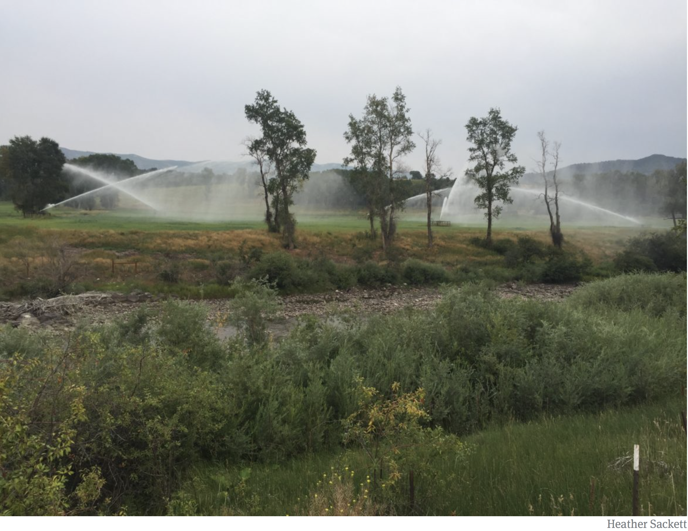
Sprinklers irrigate land on the east side of the Crystal River (in foreground), which is facing one of its driest years in recent history. Low flows on the Crystal have spurred action from the state, including curtailment and a call for instream flows. Photo credit: Heather Sackett via Aspen Journalism

From Water Deeply (Hannah Holm):

Small programs can go a long way to save water and help farmers survive the coming shortages on the Colorado River. These should be the next focus for policymakers now wrestling with drought contingency plans.

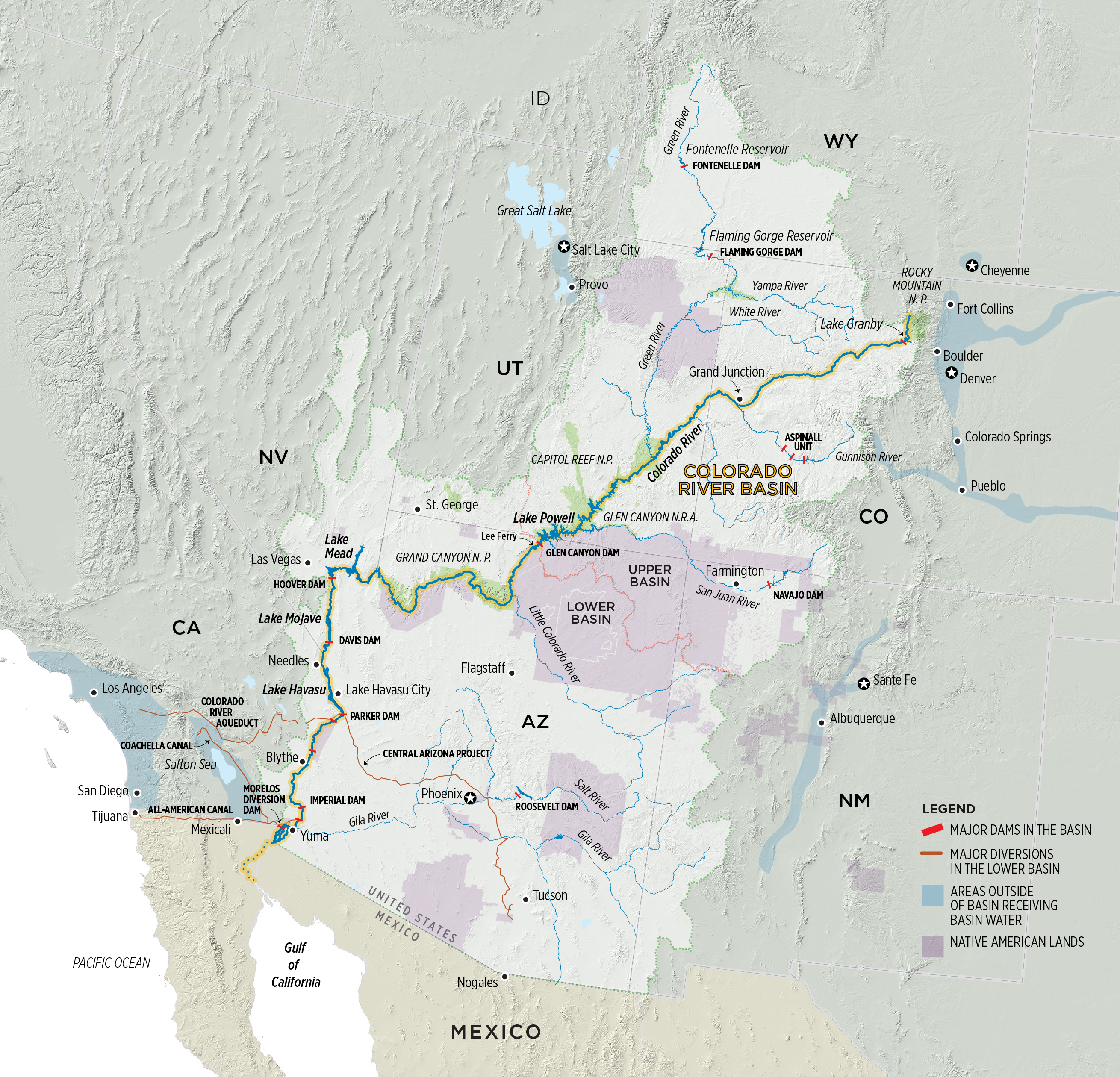
Recently, policymakers in the states that share the Colorado River have made headlines for their progress toward developing a drought contingency plan. This plan is intended to keep water levels in the river’s two major reservoirs, lakes Mead and Powell, from falling too low to keep water flowing to all the people and farms that rely on it. Within Colorado and the other upstream states, the plan also seeks to preserve the ability to produce hydropower at Glen Canyon Dam and fulfill legal obligations to the downstream states.

There is significant concern that water use cuts may be required if ongoing drought makes it difficult to keep honoring those obligations. Regional water leaders have strongly advocated that any use cuts to protect reservoir levels should be voluntary, temporary and paid for.

This matters to farmers such as [Tom] Kay, because they don’t want to be legally required to cut their water use. It also matters to communities like Hotchkiss, because their economies depend on farms using water to grow crops. So a drought contingency plan that prevents a crisis in the big reservoirs and avoids legally required water use cuts would be good for Kay and good for Hotchkiss, as well as for many others in Colorado and the rest of the upstream states.

However, what about when water delivery cuts are mandated by nature rather than laws and policies? When the snow doesn’t come, and you aren’t downstream from a big reservoir, or your reservoir is already tapped out, you sometimes have to make do with less, regardless of how good your water rights are or what the policy documents say. That was the case for many irrigators this past year, and is likely to be the case more often in the future as temperatures continue to warm.

When there is simply less water to go around, infrastructure investments such as the cost-share program that helped Kay buy his sprinklers can make the difference between viability and non-viability for farms and ranches and their rural communities. There are lots of scattered programs that can help with this, some focused on water quality and habitat improvements, and others focused on irrigation efficiency. They’ve brought millions of dollars to rural communities and done a lot of good. But some programs have also suffered from excessive red tape and poor planning.

As policymakers are working to keep Lake Powell and Lake Mead functioning, it would be worth sparing some time to also think about the programs supporting drought resilience in headwaters communities, and how to make them more effective.

@USGS and Colorado School of Mines announce long-term partnership

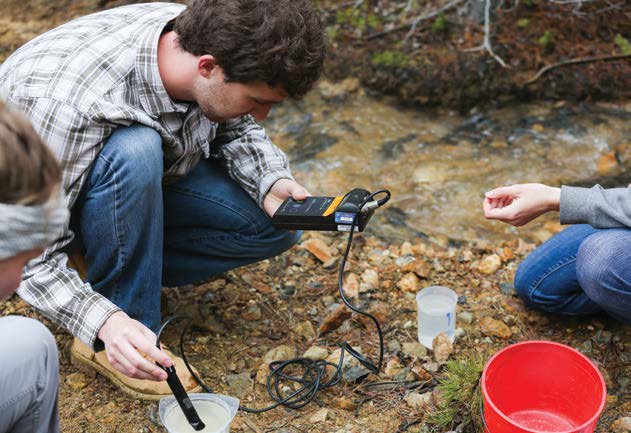
Junior environmental engineering students measure water quality parameters for their field session client, Clear Creek Watershed Foundation. (Credit: Deirdre O. Keating)

Here’s the release from the USGS (David Ozman):

CSM to be new home of USGS labs, 150 government scientists

Today, U.S. Secretary of the Interior Ryan Zinke joined Paul C. Johnson, president of Colorado School of Mines, to announce a long-term partnership between the university and the U.S. Geological Survey (USGS). The partnership will bring more than 150 USGS scientists and their minerals research labs to the university’s Golden, Colorado, campus where government scientists and Mines faculty and students will work together in a new state-of-the-art facility. Johnson and Zinke were joined at today’s announcement by Senator Cory Gardner and Congressman Ed Perlmutter, as well as Mines Board of Trustees Chairman Thomas E. Jorden and Roseann Gonzales-Schreiner, USGS Associate Director for Administration and Acting Director of the Southwest Region.

“This is a great day for the USGS and for Colorado School of Mines,” said Secretary Zinke. “The majority of USGS’s work is on federal lands in the west, but their research is also used by government agencies, the private sector, universities, nonprofits and partners all over the world. Partnering with Colorado School of Mines, a world-class earth science research institution, and co-locating our scientists and researchers creates incredible opportunities to spur innovation and transformational breakthroughs, while also providing an incredible pool of talent from which to recruit.”

“With this new facility, the USGS and the School of Mines will have a revolutionary shared workspace for the world-class research and education that the USGS and the Colorado School of Mines are famous for delivering to the country,” said USGS Director Jim Reilly. “We look forward to this expansion of our efforts in the great State of Colorado and I’m distinctly honored to be the Director at the time of this development.”

“The expanded USGS presence at Mines will capitalize on our collective expertise to address the availability of mineral and energy resources, environmental challenges and geo-environmental hazards, all of which are of critical importance to national security and the economies of Colorado and the nation. It will also create an incredibly unique educational environment that will produce the leaders we need to tackle future challenges related to exploration and development of resources here on Earth and in space, subsurface infrastructure and sustainable stewardship of the Earth,” said Mines President Paul C. Johnson. “We want to thank our Colorado congressional delegation, especially Rep. Ed Perlmutter and Sen. Cory Gardner, for their help in forging this exciting partnership with the USGS.”

“I’ve been working hard to convince everyone that Colorado and the School of Mines are a perfect match for the United States Geological Survey,” said Senator Cory Gardner (R-CO). “This move highlights the scientific leadership of our state. We will be putting USGS in a modern facility in a state where research on their core mission areas can be performed right out their back door. Their water resource research will be particularly useful to Colorado and other western states as we continue to grapple with long-term drought. I’d like to welcome Dr. Reilly and his team to the campus and thank Secretary Zinke for his leadership on this issue.”

“This new Subsurface Frontiers Building on the Mines Campus will be a tremendous asset for their faculty and students, and housing USGS staff and lab space will further cement the strong relationship between Mines, USGS and the Department of the Interior,” said Congressman Ed Perlmutter (D-CO-7). “This was a team effort, and I want to thank everyone for their hard work to make this happen.”

USGS and Mines, renowned for their expertise in the earth sciences and engineering, are expanding a long-standing relationship to catalyze even greater collaboration among USGS scientists and Mines faculty and students in the name of tackling the nation’s natural resource, security and environmental challenges, and exploring frontiers where the next innovations in earth and space resources, technology and engineering will occur. The relationship between Mines and the USGS goes back more than 40 years, with the USGS Geologic Hazards Science Center and its National Earthquake Information Center already calling the Mines campus home.

The Yampa River set records for low flow in water year 2018

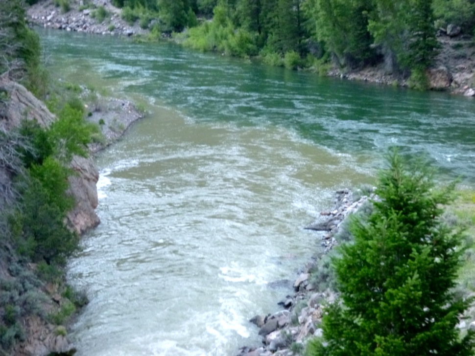
Floating the tiger, Yampa River, 2014. Photo: Brent Gardner-Smith/Aspen Journalism

From Steamboat Today (Eleanor C. Hasenbeck) via The Craig Daily Press:

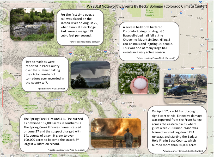
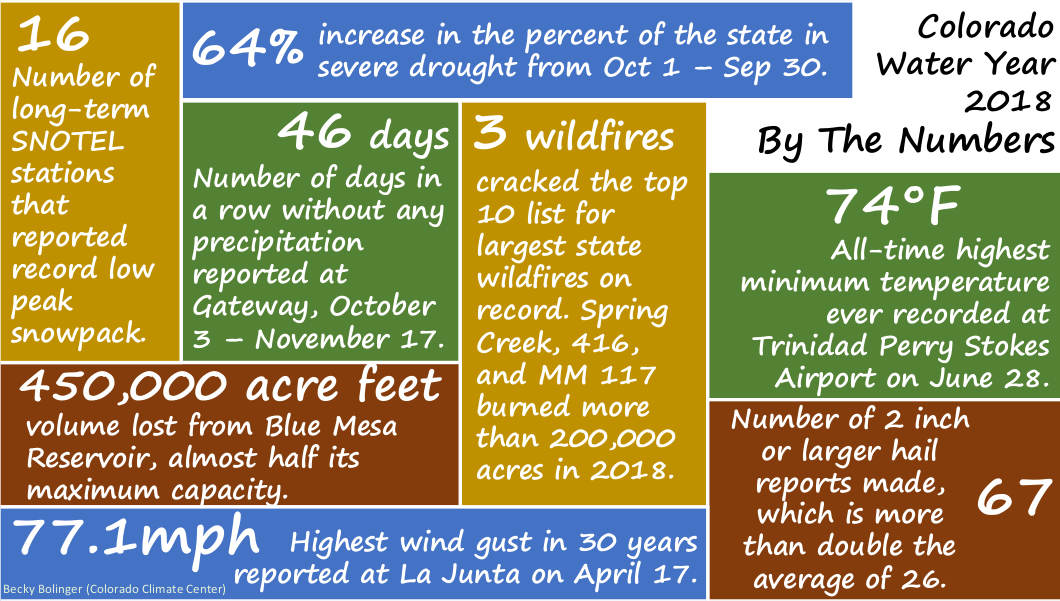
The past water year, which began in October 2017 and ended in September, broke records on the Yampa. Average temperatures in much of the Yampa River basin were the warmest on record, and for the first time ever, the main stem of the Yampa River was placed on call, meaning use of Yampa water was curtailed.

This summer, the portion of the Yampa River in Steamboat Springs city limits was open to summer recreation — including tubing, fishing, and paddling — for about 40 days, one of the shortest summer seasons on this stretch of river. For much of the summer, the river was under a voluntary closure as the water was too hot, too low or without enough dissolved oxygen to meet streamflow standards set by the city and Colorado Parks and Wildlife to protect river habitat.

Warm and dry summer

The Yampa and Colorado rivers peaked in mid-May, and according to long-term averages of daily flows, both rivers normally peak in June. This led to the second earliest start to tubing season on the Yampa in 10 years.

A warm spring played a role in this — as snow melted off the mountains earlier, water flowed downhill into the river and its tributaries earlier. This water year was the warmest on record in the state, according to the Colorado Climate Center.

In Routt County, about half of the county saw its warmest water year on record, while parts of central and south Routt saw temperatures in ranges that placed it among the top 10 percent of the record.

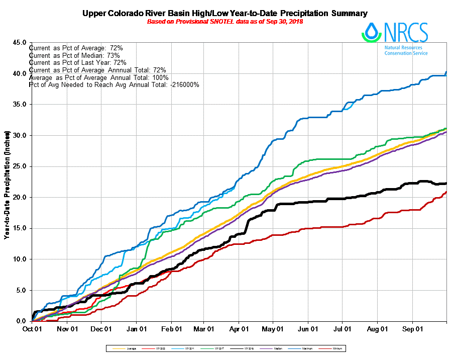
Most of Routt County received below normal precipitation this year, though the area fared better than other parts of Colorado. The National Weather and Climate Center’s snow telemetry sites in the Routt County area received 70 to 80 percent of average precipitation this year, through July, August and September saw lower rainfall compared to historic averages.

“Statewide, this was the fourth driest year in the 123-year record,” said Kelly Romero-Heaney, water resources manager for the city of Steamboat Springs. “It was fourth only to 2012, 1934 and 2002.”

This year was the driest water year on record in southwest Colorado, western Moffat County and parts of the San Luis Valley, according to the Colorado Climate Center.

Human-caused temperature increases and drought have caused earlier spring snowmelt and shifted runoff earlier in the year across the southwest, according to the 2014 National Climate Assessment.

“Not only are we in situations where we get less water, but we get it earlier, which makes for a longer season of need,” said Kevin McBride, district manager of the Upper Yampa Water Conservancy District.

His agency operates Stagecoach and Yamcolo reservoirs.

The early runoff means producers kicked off the irrigation season earlier, too. Producers are also seeing longer growing seasons in Colorado, according to the U.S. Environmental Protection Agency.

Reservoir water keeps flows up

Drought conditions and warm temperatures have made supplementing the Yampa River’s natural flow with releases of reservoir water a consistent practice in recent years.

Since 2012, the Colorado Water Trust has purchased reservoir water to supplement flows in the Yampa River. This year, Tri-State Generation and Transmission also released water from Elkhead Reservoir to keep up power generation at Craig Station.

The Upper Colorado River Endangered Fish Recovery Program releases water from Elkhead Reservoir to provide habitat for bonytail, razorback suckers, and humpback chub. These releases are determined based on the amount of water flowing by the U.S. Geological Survey’s stream gauge near Maybell in western Moffat County.

“Obviously, when you have low flow years, you have warmer stream temperatures and then less habitat available to aquatic life,” Romero-Heaney said.

In Steamboat, the river dropped to 50 cubic feet per second — low flow — during spawning season for brown trout, she added. That made habitat more difficult to come by, and Romero-Heaney said it could have impacts to fish populations in the upper Yampa.

The Yampa Valley suffered major droughts in 2002 and 2012. In 2002, the USGS reported less than 10 cubic feet per second of flow at the Maybell gauge at the Yampa River’s lowest points in the summer, said Erin Light, area division engineer for the Colorado Division of Water Resources.

Reservoir releases likely kept the water higher than that mark this summer. The USGS streamflow gauges can’t show how much water is natural flow and how much is reservoir water, so stream gauge measurements don’t reflect the full picture when it comes to water…

When the call was administered for about two weeks in September, the water at the Yampa’s lower reach through Dinosaur National Monument fell to about 18 cfs — its long-term average for the same time frame is about 260 cfs. At Lily Park, near the Little Snake River’s confluence with the Yampa, irrigators’ pumps were sweeping the river, Light said earlier this year.

Planning for the future

Romero-Heaney said flows on the Yampa in Steamboat were “extremely low,” falling below 34 cfs at the gauge at the Fifth Street Bridge in Steamboat…

The city outlined its plans to purchase reservoir water on contract to boost flows in dry periods in the Yampa River Streamflow Management Plan released this summer. The plan also seeks to implement voluntary projects that would pay water users to participate in projects enhancing the health of the river.

Earlier this year, some of the city’s water rights were curtailed in the call. As droughts and warm temperatures become more common, releases to augment river health will likely have to be balanced with releases to augment municipal water.

Miliken turns dirt on brine treatment process infrastructure in effort to bring their water treatment plant back online

Photo credit: By Jeffrey Beall – Own work, CC BY-SA 3.0, https://commons.wikimedia.org/w/index.php?curid=21001564 via Wikipedia

From The Greeley Tribune (Sara Knuth):

The $3.4 million Frontier Water System, which will improve [water quality in water discharged] to the South Platte River and bring the town into compliance with state standards, is on track to be completed in June.

Once the system is up and running, it will give officials the ability to treat one-fourth of the town’s water. Right now, Milliken relies on Greeley and the Central Weld County Water District to provide the town’s water…

When the town officials are finished with the plant, the reopening will happen just more than five years after the Colorado Department of Public Health and Environment closed it, citing violations in the amount of selenium the town was releasing into the South Platte River. After receiving multiple warnings, the town faced fines of up to $10,000 per day. The fine was ultimately reduced to $140,000, but the town had to shut down the facility, stop treating its own water and look for another solution to meet the state’s standards.

“This will be treating the return water, the brine that comes off in the treatment process,” said Milliken town administrator Leonard Wiest. “When you treat the water, you get some drinking water and then you get the junk that is collected in the treatment process. Now, that has to be treated.”

As part of the project, the town contracted with Golden-based Stanek Constructors, Inc., Frontier Water Systems and JVA Consulting Engineers.

“The water around a Utah uranium mine is growing more polluted” — Salt Lake Tribune #ActOnClimate

White Mesa Mill. Photo credit: Energy Fuels

From The Salt Lake Tribune (Emma Penrod):

The following was researched and written by Emma Penrod for The Utah Investigative Journalism Project in partnership with The Salt Lake Tribune.

There once was a time when the children of White Mesa played outdoors without their parents fearing for their health.

But for as long as Yolanda Badback can remember, the remote town in southeastern Utah has worried about the smell emanating from the plant to the north and the trucks that signal the plant’s awakening after periods of dormancy.

“I see the trucks that go in and out every day now,” Badback said. “I don’t know what they’re hauling, but they go in and out.”

Badback is more familiar with the White Mesa uranium mill than many within her community. As a child, she tagged along with her uncle and longtime critic of the mill, Norman Begay, as he went to meetings in his quest to understand what the mill was doing and whether it was safe to live just over 5 miles downwind of such an operation. She later picked up where her uncle left off, searching for answers among confusing, and sometimes conflicting, information state, tribal and company officials have to offer.

“I’ve been going to these meetings for a long while,” she said. “I don’t trust them anymore.”

The mill’s current owners, Colorado-based Energy Fuels Resources, tout the plant as one of the last capable of milling ore into purified uranium. As such, they say, the mill is a critical national asset — an argument they’ve leveraged to garner political support for the shrinking of Bears Ears National Monument and for tariffs on imported uranium.

But the Ute Mountain Ute Tribe — White Mesa is a part of the reservation — watches the polluted groundwater beneath the mill with growing concern, though state officials insist the pollution comes from other sources.

The contaminated water appears to be moving toward the town, said Scott Clow, environmental programs director for the tribe, and concentrations of potentially harmful substances such as heavy metals are on the rise. The acidity of the groundwater has increased. And state regulators, Clow said, don’t appear to share the tribe’s interest in addressing the pollution.

At this point, Clow said, “I think it would be the tribe’s preference that the facility shut down. But that’s a big ask there.” So instead, the tribe has focused on persuading the mill’s owners to phase out some of its older waste facilities, which they believe are more prone to leaking.

There’s one problem: Records from a yearslong court battle indicate that the newer waste-holding facilities, which are not in use currently, may have been built improperly.

As of now, the town’s drinking water remains clean, but Clow worries unchecked pollution will jeopardize the tribe’s relationship to its ancestral home.

“The mill has been there for 38 years now, and that’s a pretty short window of time compared to how long the tribe was there before,” he said, “and how long the tribe is going to be there after the mill, and all of that contamination.”

‘Giant bathtub’

In fall 2009, second-generation mine excavator Mark Kerr scored a gig at the White Mesa mill. The job involved the construction of a 40-acre tailings cell, a sort of retention pond Kerr described as a “giant bathtub in the ground” in which the mill would store its waste product. At nearly $5 million, the contract was a midsize project for Kerr’s company, KGL Associates. But the company was in financial trouble and struggling to make payroll.

“It was a nice job,” Kerr said. “We wanted the job.”

They wanted the job badly enough, transcripts from a later lawsuit suggest, that Kerr likely shaved his bid to razor-thin margins to undercut competitors’ prices.

At first, the job seemed to go as planned. The mill’s engineering contractor, Geosyntec Consultants, had laid out what seemed to be a pretty straightforward process: Kerr’s company was to remove the topsoil for later applications, blast a 40-foot-deep hole in the ground, and then clear away the majority of the debris, leaving at least 3 feet of dirt to line and smooth the bottom of the cell.

About six months in, Kerr received notice from Geosyntec that all the loose debris from the blasting needed to be removed “at no cost to the [mill’s] owner,” according to a May 5 memo.

“And I refused,” Kerr said, estimating that the free rock removal could have cost his company somewhere between $400,000 and $800,000. “I said we’re following the specs. … That’s when further blowups started happening.”

Kerr continued to argue with the mill’s owners and consultants about compensation. The engineers, as Kerr and staff he had on site recall, repeatedly insisted that all loose rock must be removed. If not, Kerr said they told him, the gaps between the rocks could collapse under the weight of the cell when it was filled with water and eventually waste.

Two weeks later, Kerr received a second memo from Geosyntec. He could leave the loose rock in place, but, “to provide a firm and unyielding surface,” the memo states, Kerr’s employees must compact the rock by wetting it down and driving over it repeatedly with heavy machinery.

Again, this memo said the work should be done “at no additional cost.”

Kerr proceeded as directed, but his previous arguments with the engineers weighed on him. A cave-in beneath the cell could puncture the liner that, like a kitchen trash bag, prevents waste from leaking. But unlike a plastic trash bin, the excavated “bathtub” Kerr built would allow liquid waste to escape, potentially polluting the groundwater beneath the mill site. How could he be sure this rock compaction would prevent the mill’s “trash” from poking a hole in the liner?

He began peppering Geosyntec staff with questions via email and through the company’s standard request for information forms. Where is the documentation proving this methodology is safe and effective? Does this meet the requirements of the mill’s operating permits? Do state regulators know about these changes?

Instead of answers, Kerr received a letter from Geosyntec’s attorneys objecting to his use of the request for information process and asking him to “revise or rescind” his questions. “It is not our experience to be cross-examined on the grounds of an engineering determination by means of an [sic] request for information,” the letter states.

Kerr’s company walked off the job a few months after the dispute began, leaving at least 4 acres of the cell covered in loose rock. By August 2010, he said, KGL Associates was broke.

State, federal regulators weigh in

The mill’s current owners, Energy Fuels Resources, consider Kerr’s claims “completely unfounded” but did not answer specific questions.

“KGL is a disgruntled former contractor who walked off the job, owes us a lot of money, and simply appears to be harassing us,” the company’s spokesman, Curtis Moore, said in an email. Kerr, Curtis said, is expressing “sour grapes” after losing a $4 million lawsuit.

That series of court actions began when subcontractors sued the mill for nonpayment, causing the mill to sue Kerr’s KGL.

According to the mill’s complaint, Kerr’s company not only walked away from the project without paying its subcontractors, but also failed to comply with requested changes to the cell, which resulted in construction defects.

A court arbitrator ultimately concluded that Kerr owed the mill nearly $4 million in damages, plus attorney fees. And the arbitrator found that the mill’s decision to withhold payment from Kerr was justified, given his company’s poor performance, which forced Energy Fuels to hire a second contractor to complete and correct KGL’s work, including, Curtis said, the 4 acres Kerr claims remain unfinished.

However, the court laid the blame for any environmental contamination related to the cell’s poor construction at the feet of both parties. “The contamination issue is one of shared fault,” the arbitrator concluded.

Kerr repeatedly appealed until he ran out of money. The judgment against him stands, though his concerns about the excavation remain.

As his case wound through the courts, Kerr began contacting the state Division of Radiation Control. Division engineers, he hoped, would have documentation to prove that the mill had made significant changes to his original job specs. But, in a late 2011 letter, the division told him only that the mill’s engineers had not notified the state of changes in their excavation plan — probably because the changes weren’t considered significant.

Next, Kerr approached the federal Nuclear Regulatory Commission, which conducted a brief investigation and determined his fears were partially substantiated: State regulators needed more stringent requirements when there were changes in construction specifications. The NRC reassured Kerr, however, that Utah had promised to tighten its reporting requirements.

The NRC concluded that the change did not appear to pose a safety concern. According to the agency, state regulators assured federal overseers that their review of the cell’s quality had taken the new excavation methods into account. To Kerr, this assertion flew in the face of the state’s written letter to him that the changes were not reported to the Division of Radiation Control.

A review of the state’s records shows a quality assurance report produced by Geosyntec that describes several changes to the cell’s design, but the change in excavation specifications is not mentioned. And current division leadership continues to hold the position originally stated to Kerr. Any changes were probably deemed by the on-site engineers — including a state engineer — to be insignificant.

“We haven’t seen any issues with the tailings cell since,” said Phil Goble, who oversees the radioactive materials section within the now-combined Utah Division of Waste Management and Radiation Control.

Tribe isn’t convinced

That’s not necessarily the way environmental officials with the Ute Mountain Ute tribe see it. They point to state-collected data that show “a fair amount” of fluid escapes the new cells’ liners and enters a leakage containment system. The fluid has been pumped out and hasn’t entered the environment, but the leaks leave tribal authorities wary.

Even with superior liner technology, “it’s still releasing fluids,” Clow said. “So when we hear that the three legacy cells north of it, which have … inferior liners, that those can’t possibly be leaking, it doesn’t seem to make sense.”

The White Mesa mill sits atop several plumes of groundwater contaminated with heavy metals, including uranium and other concerning pollutants. The pollution predates the construction of the new tailings cells — including the cell Kerr excavated, which is not currently in use. But the contamination is spreading toward the White Mesa community, Clow said, and concentrations of some pollutants are increasing.

The state holds that the contaminants aren’t coming from the mill — or, at least, that there isn’t proof the tailings cells have leaked. The groundwater contains chloroform, which, if consumed, can cause damage to the brain, liver and kidneys, from a metals-testing operation that once operated on the mill site. Employees there used to put the chloroform down the drain, where it entered an unlined septic system that ultimately leaked into the groundwater, Goble said.

A separate plume of nitrates, a class of acidic salts that in certain circumstances may cause cancer, beneath the mill does appear to be a result of what Goble described as “poor housekeeping within the mill.” But it didn’t come from the tailings cells, he said.

And the overall increase of acidity in the water below White Mesa — that’s not coming from the waste cells, either, Goble said, because it occurs in groundwater both uphill and downhill from the cells.

But Clow remains concerned about the rising concentrations of heavy metals, especially those that don’t occur naturally in the White Mesa area.

One of the issues in trying to tie the pollution to the mill, Clow said, is that neither the state nor the tribe — which maintains its own test wells to monitor groundwater independently — has the historic data necessary to make the case that the metals do not occur naturally in the groundwater.

To their credit, Clow said, state scientists have conducted detailed studies and data reviews to try to determine what the area’s background levels may be. Baselines based on these analyses have been established. But when the amount of pollution exceeds the baselines, Clow said, the state has simply invalidated its own baselines and establishes new ones, rather than attempt to regulate the mill.

“The concentrations just go up, and then that’s what they call background,” Clow said, “and that’s where we tend to diverge from the state’s interpretation.”

Asked whether state regulators have revised background levels at White Mesa, Goble explained a legal process by which Energy Fuels could request to have the background information tied to the mill revised. He indicated Energy Fuels has initiated this process, but did not elaborate.

A 2013 letter to Energy Fuels shows the Division of Radiation Control agreed to revise several background levels for groundwater at the site, including the benchmark for uranium. According to the letter, the amount of uranium in the groundwater had increased gradually, but the division agreed with the company that the increase was the result of natural causes.

The tribe also diverges from Utah officials’ assessment of the health risk posed by the contamination. State officials have repeatedly argued that the contaminated water is not used by the tribe — that the community of White Mesa draws its drinking water from a deeper source that remains clean.

While it’s true that the town wells draw from the cleaner, deeper water, Clow said, the tribe worries the drinking water supply could, eventually, become contaminated. And tribal members do use springs fed by the shallow aquifer for traditional ceremonies.

“The statement that the tribe doesn’t use the water … is patently false,” he said. “The tribe was there for centuries before anyone else, and so they have traditionally used those springs and seeps, and collected plants for food and medicine on White Mesa, and harvested animals around White Mesa.”

Town’s troubles

Clow holds that the town of White Mesa, which predated the mill, will surely outlast the operation — and therefore that the mill should be more concerned about potential impacts for thousands of years to come. But the town may not be such a permanent fixture. Its 2010 population of 242 has decreased by half since that tally, according to U.S. Census data.

Despite being a lifelong resident, Badback said she sees no future there for her three sons.

“I encourage my kids to go forward, go out,” she said. “I don’t want them to be stuck in White Mesa.”

While environmental issues are part of her rationale, the town’s economic hardships and poor living conditions also factor in. According to 2016 U.S. Census figures, just 49 percent of the town’s adults are employed; Badback herself is without work. Her own living conditions are better than most, she said — she stays in a five-bedroom house with nine immediate and extended family members. At night, three people sleep in an outbuilding with electricity but no running water.

When the mill first arrived in White Mesa, company officials touted it as a job creator, Badback said. But the mill has only ever employed a handful of tribal members, she said, and the work is unsteady, with frequent layoffs.
Even if there were jobs, Badback said, she would never allow her sons to work at the mill. Her oldest recently moved to New Mexico to find work, and her middle child will soon join him.

Though she would have liked to leave the town as a youth, Badback said she stayed because her grandparents did not speak English and needed an interpreter. She became a caretaker for her mother, who had been the family breadwinner, and then she had children of her own.

These days she’s absorbed with trying to educate her neighbors about the mill. She holds community workshops and leads annual protests. But not everyone in town supports her, citing the civic facilities such as a community recreation center that the mill has donated and its unfulfilled promises about jobs.

Badback doesn’t buy it. Instead, she helps organize surveys to evaluate the health of White Mesa children.

“We only live one time; when we go, we’re not going to come back,” she said. “Our health is more important than a building. A building can stand for many years.”

White River Basin: Proponents of storage on Wolf Creek now looking for financial backing

The site of the potential off-channel Wolf Creek Reservoir on the White River. Photo: Brent Gardner-Smith/Aspen Journalism

From The Grand Junction Daily Sentinel (Dennis Webb):

The Rio Blanco Water Conservancy District wants to build the reservoir northeast of Rangely on Wolf Creek, a tributary of the White River on the Moffat County border, and pump water from the White River to fill it.

The district is looking at two options, one with a working pool of 20,000 acre-feet, the second with a working pool of 90,000 acre-feet, at estimated costs of $119 million and $191 million respectively.

The district envisions the reservoir meeting a variety of uses, including providing water to the town of Rangely, supporting oil and gas and oil shale development, providing water for endangered fish, and serving as a recreational attraction. In terms of total size, it is considering a reservoir holding 41,000 or 130,000 acre-feet of water. That would account for an additional nonworking pool that would continue to serve recreation needs at times of low water, provide an insurance water supply in circumstances such as during work on the pumping system, and make room for accumulation of silt.

The problem of sedimentation has beset Kenney Reservoir, which sits upstream of Rangely on the White River. That is threatening its viability as a continued source of water for Rangely and as a recreational amenity.

Dredging the reservoir would cost an estimated $700 million. Siltation is expected to be less of a problem in the case of a Wolf Creek reservoir because it’s off the main White River channel and the water would be pumped into it.

Rio Blanco Water Conservancy District officials discussed their proposal in Glenwood Springs last week with the board of the Colorado River District, a taxpayer-funded entity consisting of 15 counties. The Rio Blanco district is hoping the river district will contribute $50,000 toward the cost of seeking permits for the project, which would be built largely on federal Bureau of Land Management land. It’s also seeking technical and other support from the river district.

The district board plans to consider the request and act on it at a future board meeting. But Tom Gray, the Moffat County representative on the river district board, voiced general support for the reservoir proposal…

Representatives of the Rio Blanco district pointed to dry years such as this one, and concerns about longer-term drought, in arguing on behalf of building new storage in the White River basin…

The district plans to pursue funding from potential users and other sources such as the federal and state governments to pay for the project.

International climate report warns of drastic, irreversible changes — @LauraPaskus #ActOnClimate #KeepItInTheGround

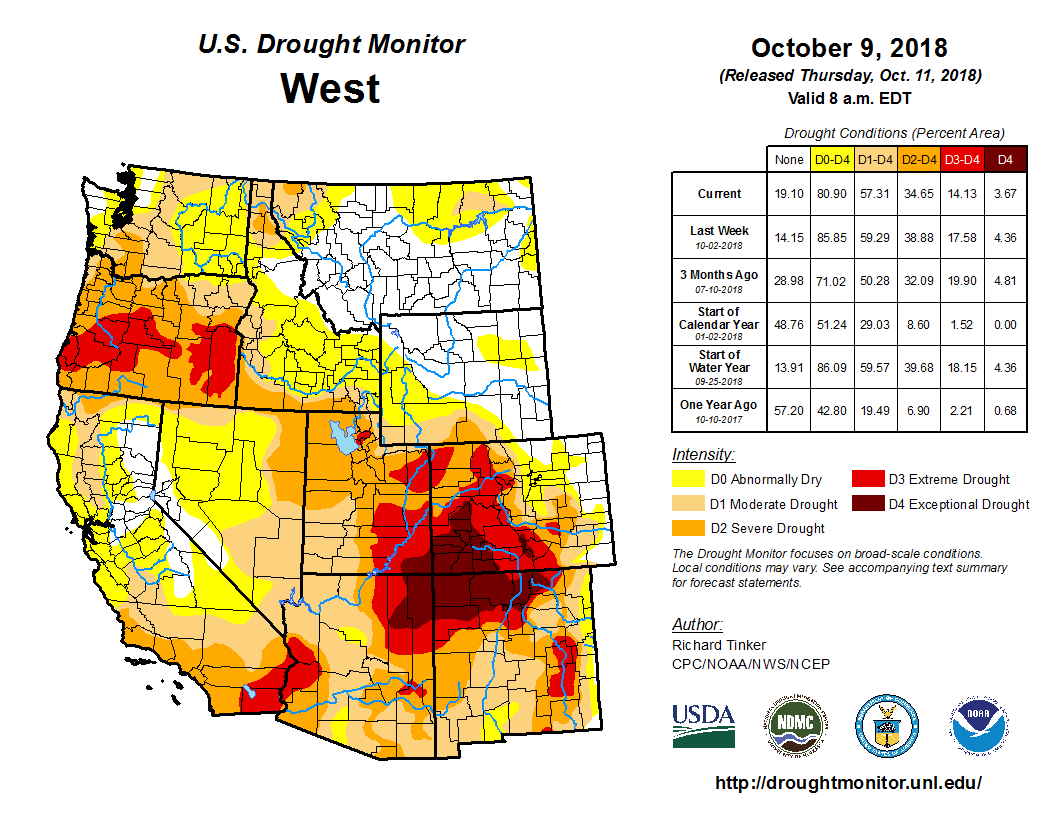
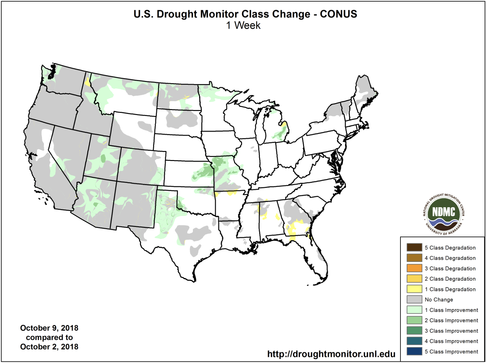
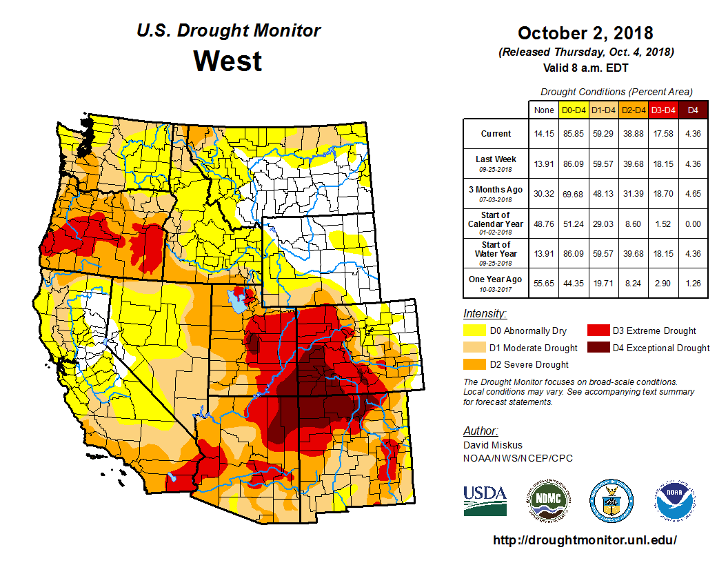
West Drought Monitor October 16 2018.

From The New Mexico Political Report (Laura Paskus):

If humans don’t drastically reduce greenhouse gas emissions in the next decade, we will not stop warming that’s expected to have widespread and catastrophic impacts upon the Earth’s ecosystems.

That’s one of the most pointed findings in a special report from the Intergovernmental Panel on Climate Change (IPCC), which was tasked with studying how a 2.0° Celsius rise in global temperature will affect the planet, its ecosystems and human communities, compared with a 1.5°C temperature increase.

According to the IPCC’s special report, if the Earth’s temperature increases by more than 1.5°C, the changes will be “long-lasting” and “irreversible.”

Already, the global temperature—averaged between land and sea temperatures—has risen 1° Celsius, or 1.8° Fahrenheit, since 1880. That change has contributed to sea level rise, the melting of Arctic sea ice, coral bleaching of ocean reefs and ocean acidification. In places like the American Southwest, warming is already affecting snowpack, forest dieoffs, water supplies and wildfire season.

“The more warming that we cause, the broader and more intense are the impacts in general,” said University of New Mexico Earth and Planetary Sciences Professor David Gutzler, in summing up the main message of the report. “So, even for regions or components of the climate system for which the difference between 1.5° and 2° doesn’t represent a big threshold or tipping point, the impacts of climate change get considerably bigger.”

That’s true here in New Mexico, where average annual temperatures have already increased by 2°F just since the 1970s, according to a number of sources, including a recent report from the National Oceanic and Atmospheric Administration.

The faster rate of temperature increase here is due to the fact that continents warm more quickly than oceans, Gutzler explained: “The world is mostly ocean, and we are in the middle of a continent, so when people talk about global warming of one, two or three degrees, for our region, we’re thinking about double those numbers.”

The #ColoradoRiver reservoir system is starting the water year at record low storage #COriver #aridification

From KUNC (Luke Runyon) via Aspen Public Radio:

Key reservoirs along the Colorado River are collectively at their lowest point at the start of a new water year since the last one filled nearly 40 years ago.

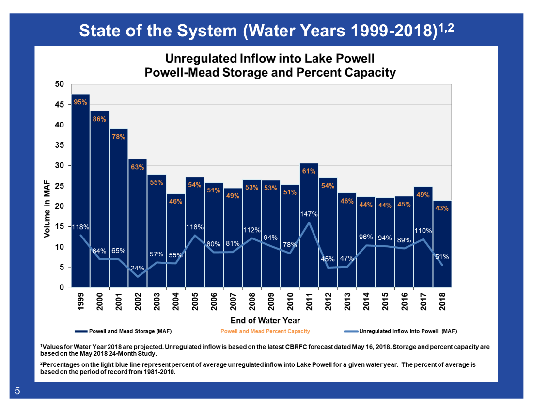
As of Oct. 1 reservoirs that store the Colorado River’s water are at just under 47 percent of their capacity, according to recently released data from the U.S. Bureau of Reclamation. Put another way: Reservoirs that provide water to 40 million people and irrigate 5.5 million acres of farmland in the southwest are less than half full.

The previous low point for the river’s collective reservoir storage was recorded in 2004 after years of dry conditions within the southwestern watershed caused the combined storage to drop to 50 percent of capacity…

The combined storage figure takes into account the amount of water in ten of the river’s reservoirs, many built as part of the Colorado River Storage Project:

  • Fontenelle Reservoir, Wyoming
  • Flaming Gorge Reservoir, Wyoming and Utah
  • Blue Mesa Reservoir, Colorado
  • Morrow Point Reservoir, Colorado
  • Crystal Reservoir, Colorado
  • Navajo Reservoir, New Mexico and Colorado
  • Lake Powell, Utah and Arizona
  • Lake Mead, Nevada and Arizona
  • Lake Mohave, Nevada and Arizona
  • Lake Havasu, California and Arizona
  • Dry weather and warm temperatures have reduced the amount of water flowing into these reservoirs. But the Colorado River is also overallocated, where more water has been promised to farmers and cities than actually exists in reality. Year-to-year demands for the river’s water consistently outstrip the supply.

    Water managers throughout the seven states that rely on the river are currently trying to sell cities, farmers and tribal leaders on so-called drought contingency plans, which are meant to cajole water users to conserve more and fill the river’s reservoirs. Federal officials have given state leaders an end of year deadline to finish those plans.

    Funding Available for Agricultural Hydropower Projects — #Colorado Department of Agriculture

    Hydropower sprinkler system via Homelink Magazine

    Here’s the release from the Colorado Department of Agriculture:

    The Colorado Department of Agriculture (CDA) and the U.S. Department of Agriculture’s Natural Resources Conservation Service (NRCS) are seeking applicants for on-farm agricultural hydropower projects. The total amount of available assistance for this round is $1,200,000. The funding is available to Colorado agricultural irrigators with appropriate hydropower resources.

    “This program gives producers a way to cut their costs and use their resources efficiently. It’s about water quantity, water quality, and energy resources,” said Sam Anderson, CDA’s Energy Specialist, “We focus on helping farmers upgrade outdated and labor-intensive flood-irrigation systems to more efficient pressurized-irrigation systems using hydropower, or retrofit existing sprinkler systems with a hydropower component.”

    The funding is part of the NRCS Regional Conservation Partnership Program (RCPP). Within RCPP, the Colorado irrigation hydropower program provides funding to agricultural producers to help them add hydropower to new or existing irrigation systems.

    For example, past projects have helped farmers use irrigation water to generate electricity, offsetting some of the cost of power for those farms. Other projects have allowed farmers to run large center-pivot sprinkler systems on hydro-mechanical power without the need for any electricity.

    The overall hydro program is funded and assisted by 14 agencies and groups, collectively contributing $3 million to the effort for project funding and technical assistance for Colorado agricultural producers.

    CDA is currently accepting applications for the next round of RCPP irrigation hydro projects. The application deadline is October 19, 2018. Applicants must be eligible to receive funding from the NRCS EQIP program. For more information and to submit an application, visit the Colorado Department of Agriculture’s ACRE3 hydropower website: http://www.colorado.gov/agconservation/hydro-navigation-guide or contact Sam Anderson at 303-869-9044 or CDA_hydro@state.co.us.

    Udall, Heinrich Announce USDA Grants to Support Acequia Associations & Traditional Communities, Hispanic Farmers and Ranchers, and Tribal Communities

    An acequia along the Las Trampas in northern New Mexico is suspended on a trestle. (Eddie Moore/Albuquerque Journal)

    Here’s the release from Senator Tom Udall’s office:

    Nearly $525,000 in grants come from USDA’s Socially Disadvantaged and Veteran Farmers & Ranchers Program

    Today, U.S. Senators Tom Udall and Martin Heinrich announced three grants totaling nearly $525,000 from the U.S. Department of Agriculture to benefit New Mexico’s traditional communities and acequia associations, Hispanic farmers and ranchers, and tribal agricultural communities in the state. The grants were made through the USDA’s Outreach and Assistance for Socially Disadvantaged and Veteran Farmers and Ranchers Program, which Udall and Heinrich have long supported to help socially disadvantaged farmers, ranchers, and foresters in New Mexico and across the country who have historically experienced limited access to USDA loans, grants, training, and technical assistance.

    “New Mexico’s traditional communities have been stewards of our state’s water and land for generations, and this new funding will support acequia farmers and ranchers as they continue to manage our resources for generations to come. These grants will empower farmers and ranchers from Hispanic and tribal communities across New Mexico to continue producing for our state and the nation,” said Udall. “As a senior member of the Appropriations Committee, I have worked hard to preserve the Socially Disadvantaged and Veteran Farmers & Ranchers Program and to secure additional funding for these grants – because this program provides essential support to the farmers and ranchers who help make New Mexico strong, but who too often are overlooked or left behind when it comes to federal assistance. I look forward to working with our land grants, acequias, and other traditional New Mexico farming communities to build on this progress.”

    “Our farmers help drive New Mexico’s economy, especially in rural communities,” said Heinrich. “Acequia users, land grants, and tribal communities have cultivated land in New Mexico for centuries. I will continue fighting for New Mexico’s farmers and ranchers so they can continue our state’s long tradition in agriculture and promote long-term, sustainable use of our land and water.”

    The USDA grants announced by Udall and Heinrich include:

    Support for New Mexico Acequias and Traditional Communities: Udall and Heinrich announced a $135,964 grant for the New Mexico Acequia Association (NMAA) for the New Mexico Acequia Farmer and Rancher Education Project, to strengthen the agricultural operations of the farmers and ranchers who use acequias or community ditches in New Mexico. According to USDA, “through a statewide membership network, NMAA will provide education and technical assistance to improve agricultural operations through irrigation efficiency, to train new and beginning farmers and youth, and to increase participation in USDA programs. NMAA will work with organizational and agency partners to ensure farmers, ranchers, and acequias meet eligibility requirements for USDA programs and to assist with USDA applications which will benefit over 300 producers. NMAA will also provide education and training through workshops and demonstration sites for new and beginning farmers and youth benefiting over 150 participants.”

    Support for Native farmers and ranchers from New Mexico tribes and pueblos: Udall and Heinrich announced two grants totaling $388,492 to benefit farmers and ranchers from tribal and pueblo communities. One grant will help expand access for Northern New Mexico pueblos to key USDA programs to benefit the ownership, operation, and profitability of family farms and ranches for pueblo farmers and ranchers. The second grant will help fund agricultural workshops, training, resources, and free consultations for farmers and ranchers on the Navajo Nation.

    More information can be found here.

    “Things are pretty dry” — Patrick Tyrell #ColoradoRiver #COriver #aridification

    From WyoFile (Angus Thuermer Jr.):

    Wyoming’s water czar warned residents in the Green River drainage that an unprecedented 19-year drought could force regulators to shut off water diversions if users don’t voluntarily limit their use first.

    The Colorado River basin reservoir system that supports 40 million persons and a $1.4 trillion economy is at risk of severe disruption, State Engineer Patrick Tyrrell told stakeholders last week in Baggs, Rock Springs and Pinedale. Tyrell unveiled draft agreements among seven western states that could lead to voluntary, instead of mandatory, reductions in water use when that time comes.

    Demand management and associated programs, said Senior Assistant Attorney General Chris Brown, could conserve enough water on a voluntary basis “so I don’t have to go turn somebody off upstream.”

    A demand-management program would be “an alternative to that hard regulation,” Tyrrell said, in which those with the most recent water rights would be curtailed first.

    “We’re doing it so we maintain control of our own destiny,” Tyrrell said of the proposed agreements.

    Although Colorado River system reservoirs can hold four years worth of runoff from Wyoming mountains and other ranges across the 250,000 square-mile basin, persistent drought has reduced lakes Powell and Mead to 42 and 38 percent of their respective capacities…

    “Things are pretty dry,” Tyrrell told more than 40 persons in Rock Springs on Wednesday. August saw 2 percent of normal flow into Lake Powell, and September saw “well below” 1 percent of normal.

    “To save the West’s forests, scientists must first learn how trees die” — @HighCountryNews

    Pinon and juniper forests that burned in the early 2000s show little sign of regeneration. Pony Fire, Happy Camp, Siskiyou County, California. Photo credit AWeekOrAWeekend.com.

    From The High Country News (Cally Carswell):

    There are few better places than Frijoles Mesa to study the mortality of trees. This tongue of land lies partly within the grounds of Los Alamos National Laboratory in northern New Mexico’s Jemez Mountains. To the west rises Cerro Grande, a mountain riddled with the charred skeletons of fir and pine trees. To the southwest are the lingering scars of another fire, one so intense that its heat alone killed trees that weren’t consumed by the flames themselves.

    The mesa itself is an exceptionally tough place to be a tree, even where the land has escaped conflagration. This summer, many ponderosas were so short of water that their weakened limbs snapped like pretzel sticks. The trees that sit behind a padlocked gate off State Road 4 were also struggling. This is tree physiologist Nate McDowell’s outdoor laboratory. Here, he’s enclosed piñon and juniper trees in transparent silos, cranked up the heat and deprived many of water – in order to watch them die.

    McDowell spent his early career studying the towering conifers of his native Pacific Northwest and came to Los Alamos in 2003, eager to begin a U.S. Department of Energy job that would allow him to set his own research agenda. But looking out his office window at New Mexico’s characteristic piñon-juniper woodlands, he had second thoughts. “This is not a forest,” he scoffed. The stout, pear-shaped junipers – one of the most common species here – resembled ill-kept hedges more than trees, all arms and twisted torsos, barely showing any leg. “They were like a weed to me,” he remembers.

    Like weeds, junipers are durable. Those outside McDowell’s window were still green, but the piñon around them were dead. During the deep drought of 2002 and 2003, piñon died throughout the Southwest in historic numbers. Had the Old Testament told stories of forest die-off, as it did of floods, the carnage around Los Alamos would have been called “biblical”: More than 90 percent of the area’s piñon succumbed. “What a bummer,” McDowell sulked. “I’m a tree physiologist, and the trees are all dead. What am I gonna do?”

    At first, the cause of the trees’ demise seemed obvious. The punishing drought badly weakened them, and when beetles bored through their bark, the trees couldn’t muster enough sap to pitch them out. Once inside, the beetles mated, multiplied, dug tiny tunnels and spread a fungus that cut off the flow of water and nutrients, killing the tree.

    But Dave Breshears, a University of Arizona professor and arid lands ecologist who had studied the woodlands for years, suspected that the truth was more complicated. During the 1950s drought, tree death seemed less extensive, even though that drought was longer and drier than the more recent one. What was different about this drought was temperature: It was a degree or two hotter.

    Breshears’ observations inspired McDowell to take a second look at the struggling forest. It’s common knowledge that trees die during and after a drought, McDowell says, but “nobody can predict where it will happen, when it will happen, what trees it will happen to. That means we don’t understand it. That was exciting to me – there’s a science question there.”

    Why do trees die? It’s a deceptively simple question in urgent need of answers: Trees are dying at alarming rates not only in the Southwest but in Colorado, the Northern Rockies, Alaska and elsewhere. This summer in northern New Mexico, even junipers began to expire in droves.

    It might seem surprising that, in 2013, we don’t know how trees die. We understand tree growth so well that we can decipher its code – tree rings – and reconstruct droughts thousands of years in the past. So why is tree mortality such a mystery?

    “There has been a long tradition in plant science where, if your plant died during your experiment, you were bummed out,” McDowell explains. “It was like, ‘Ugh, we’ve gotta start over.’ The question was never, ‘Why did it die?’ ” Besides, he adds, tree death didn’t seem particularly pressing. “I think people inherently look at trees as these stable things in our lives, like mountains. We didn’t know there was a problem.”

    Western forests are confronting new versions of familiar foes. In the 1990s, a series of warm winters and summers in south-central Alaska allowed bark beetle populations to explode and kill millions of old spruce trees. Beetles gained similar strength in the Rockies during mild winters in the late ’90s and early 2000s, killing not only their usual victims but also entire hillsides of ancient whitebark pines, which live at altitudes once too frigid to support the insects.

    Farther south, piñons were also attacked, but by a beetle that, unlike its fellows in the Rockies, typically preys only on the weak. Here, scientists believed the industrious insects were less the cause of death than the final straw: a strong shove to trees with one foot already dangling over the cliff.

    The piñons died during what Breshears dubbed a “global-change-type-drought.” It’s impossible to blame any particular weather event on climate change. Still, the drought was a glimpse of the future, when droughts are predicted to be hotter and drier. Breshears and his colleagues found that it took 15 months in extremely dry soils to kill the piñons around McDowell’s office. The heat, they believed, had increased the overall death toll by siphoning more water from soil and plants, though they couldn’t yet prove it.

    Dramatic changes in Southwestern forests had been expected – eventually. Desert edges are already marginal tree habitat, and were predicted to become especially vulnerable to the future’s hotter, more intense droughts. Still, the amount of dead wood around Los Alamos was startling. Piñons didn’t die only at the ecological boundary between woodland and grassland, the dry end of their range where Breshears and others believed climate change impacts would first become visible. Instead, piñons died almost everywhere they grew.

    No community can comfortably afford to lose its forests. Besides being nice places to hike and ski, forests provide food and shelter for birds and wildlife. Leaves scrub the air of pollutants humans saturate it with. And forests shelter winter snow, the source of most Westerners’ water supply, filtering it to rivers and streams in spring.

    More important from a global perspective is the fact that forests ingest an estimated quarter to a third of the carbon dioxide released by fossil fuels, effectively keeping the earth’s burner turned down. When trees die, they not only stop absorbing CO2, but they also decompose, gradually releasing the carbon stockpiled in their wood. If enough forests collapse, the flame on the planetary heating element could turn from “low” to “high.” Instead of slowing global warming, forests could start to make it worse.

    Computer models either don’t account for future tree death caused by climate change, or they do so simplistically. These shortcomings worry scientists, and with good reason: The most troubling thing it could mean is that the dramatic forecasts the models currently produce – the ones predicting not only a warmer climate, but also the fundamental transformation of life on earth – are understated.

    Before scientists can more accurately predict our future climate, they have to complete a simpler task – at least, one that sounds simpler. They need to understand, in mechanistic detail, how trees meet their end.

    After Nate McDowell spent a few years studying the inner lives of junipers, his attitude toward the trees softened. What junipers lack in majestic height and open, shady understories, they make up for in pluck and perseverance. McDowell, a spry, 41-year-old former endurance runner, began to appreciate these qualities. “They’re just so tough,” he says. “You have to respect someone who’s tough.”

    Juniper doesn’t cower in the face of drought. Even when extremely short on water, it doesn’t close its stomata – the tiny pores on its needles that regulate the tree’s basic bodily functions. Stomata allow trees to consume carbon dioxide and photosynthesize. They also let water escape, creating the tension that pulls water upward through the tree’s circulatory system. If there’s too little water in the soil, a tree’s pipes can fill with air and break.

    To prevent this, many trees close their stomata during droughts. Juniper, with its deep roots and sturdy build, doesn’t. When extremely stressed, it begins severing the water supply to entire limbs – reducing the amount of water the whole tree needs to survive. This is why smooth, naked branches – the desert’s version of driftwood – often protrude from living junipers otherwise covered in stringy bark and sharp needles.

    Piñon is more cautious, slamming its stomata shut during drought. Perusing data Breshears and another colleague collected during the drought, McDowell had an epiphany: For a year, the piñons that died endured a level of water stress that should have kept their stomata shut. Photosynthesis is to trees what cooking is to people. It’s how they eat. In trying to protect themselves from dying of thirst, he thought, maybe piñons had starved to death instead.

    McDowell hypothesized that drought could kill trees either through thirst or starvation, and that owing to their different coping strategies, juniper would die of thirst while piñon would starve. Since the hypothesis is based on fundamental plant biology, and because juniper and piñon manage risk so differently, studying them could reveal basic mechanisms of death that can be tested and tweaked to model mortality elsewhere.

    McDowell first tested his hypothesis in a drought experiment in central New Mexico. One set of trees was irrigated, another deprived of water, a third received whatever the sky provided, and all were poked and probed. The piñons in the “droughted” plots, nudged by beetles, perished first, but within a few years junipers, which beetles ignored, died too. Apparently, neither strategy was enough to protect the trees from long-term drought. Rather than perishing of thirst or hunger alone, both species died from some combination of both.

    The Frijoles Mesa experiment adds another variable: heat. On the mesa in mid-August, McDowell pried open an acrylic cylinder enclosing a diminutive, maybe 6-foot-tall juniper, and invited me to wedge myself inside. The tree was alive, but had the scrappy look of Charlie Brown’s Christmas tree. A fan roared on and off. The air was warm, the experience claustrophobic. After a minute or two, I showed myself out.

    The chambers are kept at a consistent 9 degrees Fahrenheit above ambient temperatures, the sort of weather all these trees may have to cope with in the latter half of this century, especially during a drought. The study is young, but McDowell has found evidence of heat’s disruptive effects. Elevated temperatures seem to cause both piñon and juniper to devour their carbohydrate reserves more quickly, for instance. “But it’s not that clean,” he says. During winter, extra warmth can boost photosynthesis.

    Tree mortality is a complex and dynamic process. But despite all the remaining questions, a flurry of research over the last five years has helped crystallize an important message, says Breshears. “We have gained a huge amount of confidence that, under warmer conditions, we’re going to get a lot more mortality.”

    In mid-August, I hiked into the Sangre de Cristo Mountains outside Santa Fe with Park Williams, a 32-year-old climatologist who, until recently, worked out of the Los Alamos National Laboratory with McDowell. When we strolled past Hyde Park Lodge, his eyes began to dance. In two weeks, the California native would marry his girlfriend at the lodge. He had proposed to her underneath a coast redwood, his favorite tree.

    A half-mile or so up a steep trail, we gained a sweeping view of the fortresses of pine and fir on facing hills. Williams wore a navy trucker hat and aviator sunglasses with blue-blocking lenses. “When I first look at this mountainside, it looks totally green,” he remarked, handing me his sunglasses. The lenses made it easier to see red-orange flecks in the blanket of green, like the first autumn leaves snagged in a lawn. “I think we’re seeing the beginning of something that in another one or two years will be much more widespread.”

    Williams hasn’t studied this forest, but his offhand prediction has some basis. Last fall, he authored a high-profile study concluding that if climate models’ temperature projections are correct, and if carbon emissions remain at current levels, most mature conifers in the Southwest could die by 2050 or soon after. The tall ponderosa haunted by Mexican owls? Mostly gone. The old piñon that produce sweet nuts prized by New Mexicans? For the most part, toast. Douglas fir, the largest conifers native to Arizona and New Mexico? Them, too.

    Williams made a convincing – and frightening – case that warmer temperatures alone could kill the trees, even without changes in rain and snowfall. Using tree rings from piñon, ponderosa and Doug fir – the species that occupy the Southwest’s warm and dry, and cool and wet niches – Williams created something called a “forest drought stress index.” It showed, surprisingly, that drought stress is driven as much by growing season temperatures as winter snowpack.

    Drought is not always a problem of scarce rain or snow, though that’s how we usually think of it. Hot weather can also impose drought conditions on plants. Minor temperature increases have an outsized effect on the amount of water the atmosphere can hold: When the temperature goes up, the atmosphere gets a lot spongier. The relationship is exponential. Stubbornly set on fulfilling its potential, warm air sucks water more greedily from both plants and soil. If the water supply it’s drawing on becomes depleted, the tension begins to strain a tree’s water columns. Picture an eager child sucking the last drops of a milkshake from a straw: The water columns, like the straw, collapse. That’s bad news for trees, no matter their coping strategy.

    Williams also found a strong correlation between water stress and the forested acreage killed by beetles and wildfire in the past 30 years. “Even if we think of a couple degrees of warming as relatively minor,” Williams says, “forests notice a couple of degrees, and they express it by dying.”

    Because the atmosphere’s sponginess is so strongly dictated by temperature, climate models can help predict how fast it will climb. “I considered a scenario where we begin curbing emissions significantly yesterday,” Williams says. “Even in that most optimistic scenario, we’re looking at megadrought conditions by the 2070s.” In other words, even if we began to aggressively control carbon pollution tomorrow, the heat guaranteed by past and ongoing emissions could still devastate Southwestern conifers.

    “By 2050, it doesn’t matter if it’s wet or dry, it’s just too damn hot out,” McDowell explains. The sense of inevitability that accompanied Williams’ conclusions changed how McDowell views his work. At first, he was intrigued by the novel scientific questions involved in tree mortality. “Now I feel like I have a moral obligation to speak up,” he says. “We’re not just going to lose a bunch of trees, we’re going to lose most of them in the Southwest. By 2050, we could be looking at Albuquerque vegetation in Los Alamos,” a landscape now surrounded by forests. “Albuquerque has grass and creosote bush.”

    Such radical changes are unlikely to be confined to the Southwest. A newer modeling effort that Williams and McDowell participated in estimates that the Pacific Northwest could lose 60 percent of its conifers to heat-induced water stress by 2100 – an especially sobering finding for McDowell, whose love of forests was lit at an early age by the old Doug firs on Puget Sound and the Olympic Peninsula. “Can you imagine the Olympic Peninsula without trees?” he asks.

    Such a future is hard to imagine. Many Western forests still look healthy, with plump, verdant canopies. But even some of the healthiest-looking stands may already be stressed.

    In mid-July, U.S. Geological Survey forest ecologist Nate Stephenson drove me to a long-term forest-monitoring plot in Sequoia National Park, a few hours north of Los Angeles. As we left the shrubby foothills, where one could break a sweat standing still at 9 a.m., the temperature dropped 20 degrees, shadows painted the pavement, and giant sequoia appeared – the titans of the Sierra Nevada. The plot itself was blanketed with ferns, and full of soaring sequoias and lichen-covered sugar pines.

    Stephenson helped establish the network in 1982, measuring off the first plots with string. He is wildly passionate about the Sierra Nevada: In graduate school, he designed a thesis project that allowed him to hike 500 “glorious” miles a summer in Sequoia’s backcountry. After he earned his Ph.D., he returned to Sequoia with no promise of permanent employment. He wasn’t interested in going where the jobs were. Stephenson has now studied this place for 34 years. But it can still surprise him. When he expanded the plot network across different elevations in the early ’90s to study how climate affects forests, he says, “It didn’t occur to me that by the mid-2000s, we would already be able to detect an increase in tree mortality.”

    Around that time, Phil van Mantgem, a scientist who worked in Stephenson’s shop, began analyzing growth and mortality in the plots. He expected dull results – birth and death rates usually reach equilibrium in old growth – but something peculiar appeared in his data: Background mortality rates – the rate at which trees die in a healthy forest – had doubled. “We thought we did something wrong,” Stephenson says. “We tried to make it go away. We couldn’t.” The only possible cause they couldn’t eliminate was the average temperature, which had risen almost 2 degrees F since the 1980s.

    Stephenson and van Mantgem ran the same analysis for old-growth forests West-wide. They found the same pattern: At many high-, mid- and low-elevation plots, from California to Idaho, Arizona and Colorado –– even in Washington’s Hoh Rainforest –– conifers were dying at double the rate they used to.

    “Every year, you expect some people to die in your hometown,” Stephenson analogizes. “If that death rate started to creep up slowly, it doesn’t create a dead landscape all at once, but you would sit up and go, ‘Oh my gosh, what’s happening?’ ”

    As in so many ecological stories, what’s happening is complicated. “There is something tied to temperature that is probably responsible for what we’re seeing,” says van Mantgem. But exactly what that something is may vary from forest to forest. At mid-elevations in the Southern Sierra, where the sugar pines and sequoias live, the increase in mortality seems to be tied primarily to a temperature-induced increase in the atmosphere’s demand for water – the same thing Park Williams expects to happen more in the Southwest. But at higher elevations and in wetter forests, like the Hoh, warmer temperatures may instead be favoring the fungi and insects that attack trees.

    What the uptick in background mortality ultimately portends is also uncertain. But the forests’ response to mild temperature increases, van Mantgem says, indicates their vulnerability. “(The results) might be telling us that they have chronic stress as things get warmer. Then if you get an acute stress, like a severe drought, it might be something that hits you over the head.” That is, it might be something that takes out a centuries-old forest in a year, or two – or, in the case of a forest fire, overnight.

    The Southwest has already experienced such sudden shocks. One of the most dramatic occurred just a few miles from McDowell’s outdoor lab. There, in 2011, an aspen tree fell onto a power line, sparking a fire stoked by hot, dry weather and drought-seasoned fuels that burned 43,000 acres in its first 14 hours. The Las Conchas blaze raged through pine and fir canopies on the Jemez Mountains’ eastern flank, killing entire stands. Some are unlikely to regenerate, ever, and are already being replaced by oak and locust shrubs. The worst-hit and driest areas have yet to sprout much of anything at all.

    “That is the land manager’s worst nightmare,” Stephenson says of the Las Conchas Fire. “The biological potential has been lost, there’s going to be soil loss, erosion, the trees’ seed source has been killed off. That was not an easy transition.”

    If the warming trend continues – as it surely will without heroic intervention – Stephenson hopes land managers can slow the pace of change and influence its outcome for key forests in the Sierra. The Giant Forest in Sequoia National Park, for instance, contains the most massive tree on the planet – known the world over as the General Sherman. “It’s a place of high social value,” Stephenson says. To help protect the Giant Forest from sudden death in an insect outbreak or a big wildfire, managers can thin trees and set small, controlled fires to reduce competition and increase the resilience of individual trees. If research begins to show that certain species can’t survive the future climate, Stephenson says, managers may decide to let those trees go, assisting their migration to more hospitable terrain and perhaps planting new species in their place.

    So far, though mortality among many of the area’s tree species is increasing, the giant sequoias seem unchanged. There’s too little information to draw strong conclusions about the whole population, but preliminary studies suggest that, in their prime habitat, the trees are actually thriving, benefiting perhaps from an extended growing season. Coast redwoods also appear to be growing vigorously, perhaps basking in extra sunlight as coastal fog declines.

    Of course, this trend could change. These two iconic giants slurp more water than any other trees on earth, and future changes in water supply could hurt. Desperate measures to save them – like installing sprinkler systems – are already being discussed. “Mortality of big trees is a one-way street,” says Stephenson. “You can’t replace them once they’re gone.”

    Models are useful in planning for the future, but we needn’t wait for them to be perfected in order to start grappling with the effects of climate change on forests. The mechanisms and trends scientists like Nate McDowell, Park Williams and Nate Stephenson are uncovering are already in motion – and gaining momentum. The future is all around us, plain to see.

    That’s especially true in the Jemez Mountains. USGS research ecologist Craig Allen has spent his career in this landscape, never growing bored. Allen is a whip-smart man with boyish, straight-cut bangs whom McDowell calls “one of the godfathers of tree mortality.” Like Stephenson, a colleague and friend, he’s studied the same place for 30-plus years.

    Change itself does not surprise him. But some of the changes he’s seeing now are painful. “Because trees live longer than we do, we tend to view them as timeless,” Allen says. “It’s unsettling when these landscapes flip overnight.” Asked about his favorite tree species, Allen deflects the “unfair question,” but acknowledges that he loves old trees the most. The longer a tree lives, the more visible its history becomes – in gnarled bark, fire scars, and in the case of conifers, flattened tops. “You can feel this sense of endurance,” Allen remarks. “In human terms, we would call it wisdom.”

    Allen has spent a lot of time thinking – and publishing papers – about the global significance of the rapid changes in the Jemez. “I don’t want to overstate the lessons of the Southwest for the rest of the world,” he says. “But it’s a preview of what could happen.” Drought won’t kill all of the world’s trees; some forests may get wetter and grow better. Still, the expected increase in global temperature is so extreme that it could easily convince most trees that they’ve moved to a new planet, and outweigh the potential upsides of climate change for plants, such as more carbon dioxide to consume.

    Forests’ widespread vulnerability is already evident. A hot, dry spell in Europe in the mid-2000s wiped out oak, fir, spruce, beech and pine. Drought has picked off aspen, jack pine, and black and white spruce in Western Canada’s boreal forest – at both high and low elevations. A once-in-a-century drought in 2005, followed by another five years later, killed vast numbers of trees in the Amazon rainforest.

    “One thing we are going to lose, and it might be in most places later this century, is old trees,” Allen says. “Even if the system can still grow abundant vegetation, the historically dominant old trees are dominant because they’re tuned to that historic climate window – which is already not the climate that we’re in.”

    As grim a prospect as that is, it is also an opportunity to make the forests we still have more resilient – and to start doing so now. It is possible, even in the Southwest. The region goes through natural wet and dry cycles, and within the next 10 years, says Allen, the current dry spell is likely to let up. That will ease the pressure on trees from wildfires, beetles and the weather itself, and allow land managers to more safely thin forests with low-intensity fires. Combined with landscape-scale mechanical thinning, these measures could soften the blow of the next drought, and reduce the risk of future catastrophic fires or insect outbreaks. If managers want to plant trees – perhaps more drought-hardy species from other places – the wetter cycle will give seedlings an opportunity to establish themselves.

    Most of the old trees we love may still perish, but there are better and worse ways for that to happen. When landscapes change incrementally, they are more likely to maintain species diversity, soil health, and basic functions like erosion control. Past droughts that killed trees in what seemed like apocalyptic fashion, Allen says, in fact caused a gradual reshuffling of the landscape. The 1950s drought, for instance, killed most ponderosa at the dry end of the tree’s range, but not all. It didn’t leave a treeless landscape, prone to the kind of erosion and soil loss that follows severe wildfire. “It didn’t leave a desert,” Allen says. Piñon and juniper replaced the dead ponderosa. Going forward, change of this sort may represent a best-case scenario. The question is: How fast can new trees colonize landscapes as the old trees die?

    If his daughter or his twin boys have children, Allen wonders, what will they want to know about the forests he knew? He is brainstorming a new project: documenting the size, age, diversity and three-dimensional structure of trees in old forests, archiving tree-ring samples and the histories they hold, and recording the sounds of birds and wind blowing through the canopy. He also hopes to document what ancient forests mean to people by involving artists, poets, ethnographers and the elders of cultures for whom forests are important. Such a project, he is starting to think, might be just as important as scientific research. Someday, even if only through a virtual experience, his grandchildren could still walk through the Jemez Mountains’ ponderosa or the Olympic Peninsula’s rainforest, and hear the whisper of the breeze through the treetops.
    #ColoradoRiver District wants state policy on potential water-use cutbacks — @AspenJournalism #COriver #aridification @ColoradoWater @CWCB_DNR

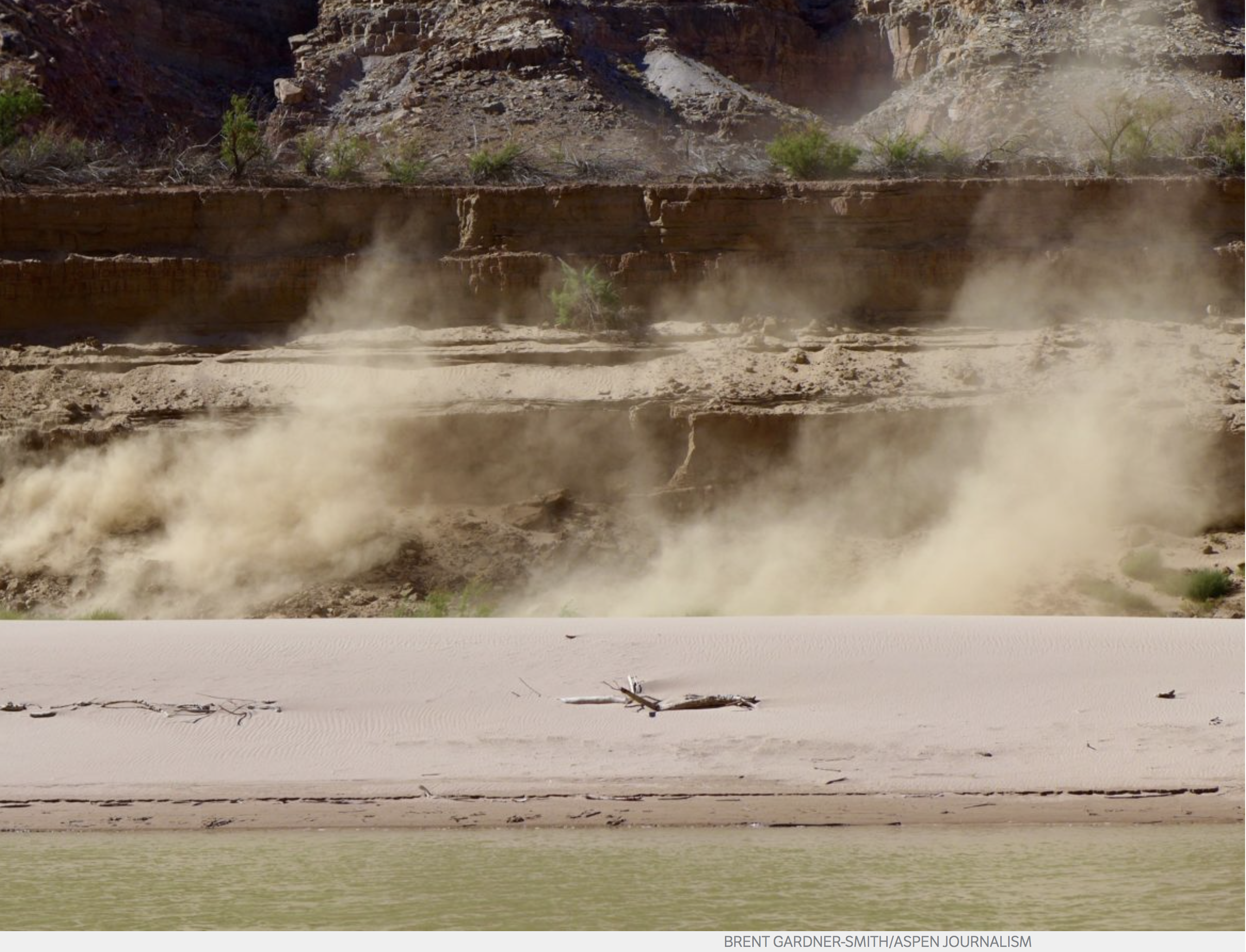
    A big beach on the lower Green River in late September is indicative of the low flows in 2018, which have caused water levels in Lake Powell to continue to drop. Plans to bolster flows in the reservoir by sending water down the Green and Colorado rivers is raising hard questions for Western Slope irrigators.

    From Aspen Journalism (Brent Gardner-Smith):

    Before the Colorado River District will support pending federal legislation allowing drought contingency plans in both the upper and lower Colorado River basins to proceed, it wants the state of Colorado to adopt a policy putting limits on a new water-use reduction program designed to bolster water levels in Lake Powell.

    That was the clear message from the River District board that general manager Andy Mueller said he received during a passionate discussion during a district meeting Tuesday.

    “Most of the board is saying that at a bare minimum we have to have the state, the Colorado Water Conservation Board, affirm that there are in fact some sideboards and protections from the risks we face,” Mueller said, in summarizing the board’s discussion. “We’ve got to have some principles that guide the way this program is set up, and its consistency with the state water plan.”

    Mueller said the program has to be consistent with the state water plan, there has to be an equitable distribution of wet water coming from both the Front Range and the Western Slope, and the program has to be voluntary, temporary and compensated.

    “This board is not OK with the idea of a mandatory curtailment to fill a demand management pool,” Mueller said. “We don’t feel that there is legal or statutory authority for such a program.”

    The concerns of the River District directors stem from an ongoing multi-state effort to create and gain approval for “drought contingency plans” in the lower and upper basins.

    The lower basin states include California, Arizona and Nevada, and the upper basin states include Colorado, Wyoming, Utah and Nevada.

    And as part of the regional “DCP” effort, it is anticipated that federal legislation will be required to implement changes to how water is managed in the upper and lower basins, with the goal of keeping enough water in Lake Mead and Lake Powell to keep those massive reservoirs functioning in the face of an ongoing 18-year drought.

    The proposed changes include modifying the current regulations that guide how much conserved, or saved, water can be stored in Lake Mead by lower basin entities.

    The changes include developing a plan to release water in a coordinated fashion from Flaming Gorge, Blue Mesa and Navajo reservoirs, which can send water down the Green, Colorado and San Juan rivers, respectively, to Lake Powell.

    And the changes include creating a legally secure pool of water in Lake Powell to be filled with water conserved after fallowing fields, primarily, in Colorado, Wyoming and Utah.

    Officials from Los Angeles to Salt Lake City who are working on the drought contingency plans say legislation will be submitted to Congress during the lame-duck session after the midterm elections.

    And it’s widely assumed that such legislation will pass only if there is no opposition from entities that would be affected, such as the Colorado River District, which represents 15 Western Slope counties.

    Mueller said Wednesday he was “cautiously optimistic” that the CWCB, a state agency that manages water planning, will adopt a guiding policy at its November board meeting about the creation of a demand management program.

    And a senior CWCB official Wednesday offered reasons for Mueller’s optimism, including that such a policy is now being drafted for the board’s consideration.

    “The policy statement will be informed by the public testimony, letters received, and the feedback we’ve heard from stakeholders around the state in the past year of aggressive public outreach,” said Brent Newman, who is the section chief of CWCB’s Interstate, Federal and Water Information Section and the state agency’s point person on Colorado River issues. “Because we’re hoping to respond and provide CWCB leadership to concerns that our partners and stakeholders have raised, it will likely address these issues.”

    Newman also emphatically told the river district’s directors Tuesday that the state is not working on a mandatory curtailment program to avoid a call on the river system under the 1922 Colorado River Compact.

    “Not myself, not the CWCB staff, not our board, not the Attorney General’s Office, not the division of water resources, not the state engineer, none of us at the state are assessing or recommending any kind of mandatory anticipatory curtailment scenario,” Newman said. “That is not in our books. Yes, we’ve had some water users say that if voluntary, temporary and compensated isn’t sufficient, you may have to look at this. We are not doing that.”

    It was also made clear during the river district’s meeting that “anticipatory mandatory curtailment” of water rights in Colorado is seen as a direct threat to family-run farms and ranches on the Western Slope.

    “If we want to push the Western Slope to the brink, where people start to actually sit down at the kitchen table and consider whether or not they ought to sell the farm to some outside-the-Western-Slope interest, this is how we get there,” said Marc Catlin, who represents Montrose County on the River District’s board, and also represents District 58 in the Colorado House.

    After Catlin’s comments, many other River District board members said they agreed.

    “This just shows how important it is to get the demand-management program right, and that we don’t rush into a demand-management pool in Lake Powell before we’ve had this discussion and before we’ve agreed to a policy and principles to guide us,” said Tom Alvey, the current president of the district’s board, who represents Delta County. “From all the perspective of water users on the Western Slope, there is huge concern about this.”

    Aspen Journalism is covering rivers and water in the Colorado River basin in collaboration with The Aspen Times and other Swift newspapers. The Times published this story on Thursday, Oct. 18, 2018.

    “It happened stunningly fast…From absolutely silent, just the wind or the hiss of snowfall hitting the ground, to an industrialized landscape” — John Dahlke #ActOnClimate

    From National Geographic (Hannah Nordhaus):

    As the morning light grows over the eastern mountains, the outlandish mating ritual comes into view. The knee-high males strut around, puffing their white-feathered chests and splaying their tails. They chase one another and spar in a flurry of beating wings, heaving chests, and loud thunking. Meanwhile the females—smaller birds with brindled gray feathers that blend with sage and soil—stand around looking bored. It’s a ridiculous spectacle, and the human analogies are inescapable: singles bar, Venice Beach boardwalk, Senate hearing.

    Leaves and flowers of Artemisia tridentata.
    By Stan Shebs, CC BY-SA 3.0, https://commons.wikimedia.org/w/index.php?curid=4424733

    The greater sage grouse is “unquestionably the most comical-looking bird I have ever seen,” ornithologist Charles Bendire noted in 1877. Back then there were millions of sage grouse across the American West. Native peoples and Anglo settlers alike hunted them for feathers and food. Camping in one Wyoming valley in the 1880s, naturalist George Bird Grinnell found it so crammed with grouse that it became a “moving mass of gray.”

    Such scenes are hard to find today. Less than 10 percent of the bird’s original population remains, about half a million birds scattered across 11 western states and two Canadian provinces. Sage grouse need undisturbed sagebrush; the tough, drought-resistant shrub feeds the birds, especially in winter, and shelters them and their nests. But sagebrush is in retreat everywhere. Massive overgrazing a century ago cleared the way for invasive grasses that now fuel devastating fires in the western part of the bird’s range. Roads and subdivisions, transmission lines, farms, gas fields, and wind turbines—all disrupt what was once an unbroken sea of sage.

    Preserving sagebrush for grouse would help other animals that depend on the same habitat, such as pronghorn, mule deer, pygmy rabbits, and burrowing owls. But it might prove costly to ranchers, miners, oil and gas developers, and real estate brokers. In 2015 then President Barack Obama’s administration brokered what it hailed as a historic collaboration among those competing interests. Now President Donald Trump’s administration is weakening provisions that steered oil and gas drilling away from areas that had been reserved for sage grouse.

    It’s the age-old battle between those who want to preserve western lands and those who want to extract a living from them—only in this case, the burden falls on a comical, knee-high bird. As the sage grouse goes, so goes the West.

    One of the biggest factors in the grouse’s decline these days may be the astonishing increase in natural gas production in places such as the Green River Basin, south of Pinedale, Wyoming. In 1984, when biologist John Dahlke first visited, the basin contained sagebrush, a few fence posts, some two-track roads, and not much else—except the largest known winter concentration of sage grouse. They would lift from the sage in lumbering waves, Dahlke recalls: “The sky was full of them, bumping into each other, falling down.”

    That basin is now home to one of the most productive gas fields in the region. Called the Jonah Field, it’s crisscrossed with roads and cluttered with chugging, groaning infrastructure: gas wells, drill rigs, pipelines, sage-camouflaged service huts. Nearly all of that is on federal land.

    “It happened stunningly fast,” says Dahlke, who works as a wildlife consultant in Pinedale. “From absolutely silent, just the wind or the hiss of snowfall hitting the ground, to an industrialized landscape.”

    The breakneck change has proved particularly hard on sage grouse because of their fidelity to ancestral mating and nesting grounds. Males return each spring to the same leks—clearings where they do their mating dances. Females usually nest within 500 yards or so of the previous year’s nest. Their chicks settle nearby.

    “Sage grouse are very poor pioneers,” Dahlke says. Rather than set off for better habitat—which is more and more limited—they dance doggedly on and nest among the bulldozers and flaring gas wells. Most birds survive in the short term, Dahlke says, but “incremental impacts” take their toll. The number of leks has dwindled. “The enormous winter flocks are now gone from the Jonah Field,” Dahlke says. “They are gone.”

    Only in the early 1990s did scientists start to realize the extent of the sage grouse’s decline across the West. In 1999 conservation groups filed the first petition requesting that the bird be protected under the Endangered Species Act. But for years the federal government, hamstrung by tight budgets and pressure from business interests, put off a reckoning. Listing sage grouse as endangered would sharply limit economic activity on the 173 million acres of public, state, and private land where sage grouse live.

    Greater sage grouse range map via the USFWS.

    But the threat of a listing motivated states to take action. In 2007 Wyoming, which houses more than a third of the remaining sage grouse and has an economy that depends on fossil fuel extraction, brought together a broad coalition—ranchers, industry representatives, conservation groups, land managers, and politicians—to create a policy to halt the bird’s decline.

    “We battled it out mightily,” says Paul Ulrich, director of government affairs at Jonah Energy, which operates on the Jonah Field. “And then we put our interests aside and asked, ‘What is best for Wyoming?’ ”

    The group ultimately agreed to limit any development and restore disturbed areas within “core” grouse habitat—not including the Jonah Field, where the grouse population was already diminished—while allowing more intensive development elsewhere.

    The Obama administration’s $60 million federal plan was modeled on Wyoming’s. No faction got everything it wanted. But, Ulrich says, “it’s demonstrably working.” Industry got certainty: The administration promised it wouldn’t list sage grouse as endangered. Conservationists, says Brian Rutledge of the Audubon Society, got limits on development in important habitat. “Do we have issues?” Rutledge asks. “Of course. But we set standards and are measuring impacts. To me this is the future of conservation.”

    Not everyone agreed. Groups on left and right filed suit, arguing, respectively, that the plan would not adequately protect grouse or that the restrictions were “draconian.” “The certainty of not being able to develop is not the kind of certainty we want,” says Kathleen Sgamma of Western Energy Alliance, an industry group.

    The Trump administration agrees: For the sake of energy independence and not “destroying local communities,” as Interior Secretary Ryan Zinke put it, the Bureau of Land Management has proposed lifting some restrictions on development in key sage grouse habitat. Under another proposed policy, which could affect many species, the administration would allow regulators to consider not only the science but also the economic impact of listing species as endangered.

    The latest seasonal outlooks are hot off the presses from the CPC — above average temperatures likely through January 2019

    #Drought news: SE #Colorado depiction improves

    Click here to go to the US Drought Monitor website. Here’s an excerpt:

    Summary

    A wet weather pattern persisted across most of the nation, as the active Atlantic and Eastern North Pacific Hurricane Seasons continued. Hurricane Michael rapidly intensified just prior to slamming ashore in the Florida Panhandle, producing heavy rain across portions of the Southeast but causing fatalities as well as widespread, locally catastrophic damage to homes, businesses, infrastructure, and agriculture. Out west, moisture associated with Hurricane Sergio triggered additional moderate to heavy rain across the lower Four Corners Region. Abundant moisture associated in part with the remnants of Sergio also led to another round of heavy rain from Texas northeastward into the middle Mississippi Valley. Likewise, rain and snow afforded drought relief from the central and northern Rockies into the upper Midwest. The unsettled conditions continued across the southern U.S. after the period ended; any rain that fell after 12z Tuesday morning (8 am, EDT) will be incorporated into next week’s analysis…

    High Plains

    The overall trend toward improving conditions continued, with rain and snow on top of last week’s precipitation offering many of the region’s lingering driest areas additional much-needed moisture. In the Dakotas, moderate to heavy snow (nearly 6 inches reported at the NWS office in Grand Forks, ND, on October 10th) afforded a reduction to Abnormal Dryness (D0) to Extreme Drought (D3); two-week precipitation (liquid equivalent) has totaled 1 to 3 inches across the central and eastern Dakotas. Farther south, another wet week in Kansas pushed two-week totals to locally as high as 10 inches, supporting an additional reduction to the state’s Moderate (D1) and Severe Drought (D2). The western flank of this week’s rain added to the recent totals in southeastern Colorado, with 60-day precipitation surpluses of 1 to 4 inches supporting the reduction of D0, D1, and D2. Across the region, the recent rain and snow are helping to recharge water reserves and soil moisture while aiding pasture recovery and improving prospects for winter wheat establishment…

    West

    The favorable start to the 2018-19 Water Year continued, with rain and mountain snow reported across much of the region. Abundant moisture associated in part with the remnants of Hurricane Sergio led to 1 to 3 inches of rain in southern portions of California and Arizona, while precipitation amounts locally more than an inch (liquid equivalent) were noted from the southern Rockies northward into Montana and the Blue Mountains of northeastern Oregon. The recent rain and mountain snow led to notable reductions of Abnormal Dryness (D0) and Moderate to Exceptional Drought (D1-D4) in Arizona and environs. Furthermore, additional assessment from experts in the field supported reductions to the drought intensity and coverage across eastern New Mexico as well as an adjustment (expansion) of Extreme Drought (D3) in central Utah. Coordination with local experts also supported a reduction of D0 and D2 in southern and northern Idaho, respectively, as impacts begin to subside due to the arrival of seasonably colder weather; furthermore, recent beneficial rain and snow in southcentral portions of the state (30-day precipitation up to 125 percent of normal) further supported the improvement. Despite the generally favorable start to the Water Year, however, areas from the Pacific Northwest southward into central California and the western Great Basin were mostly dry. In particular, Northwestern dryness remained particularly acute in the Cascade Range, with 6-month precipitation departures averaging 4 to 10 inches (locally more than 12 inches below normal)…

    South

    Another round of moderate to heavy rainfall — partly associated with remnants of Hurricane Sergio in the eastern Pacific — was responsible for additional widespread reductions of drought intensity and coverage. Much of central and eastern Texas was doused with 2 to 10 inches of rain, with amounts locally more than 12 inches from the Edwards Plateau to Lufkin. This rain fell on top of last week’s downpours, pushing 30-day totals to locally more than 20 inches. During the 7-day monitoring period, the axis of heavy rainfall (2-6 inches) extended east-northeastward across southeastern Oklahoma, Arkansas, northern Louisiana, into western Tennessee; widespread 1- and 2-category reductions were made to the drought analysis, and with more rain falling after the Tuesday-morning cutoff, additional reductions in the lingering Abnormal Dryness (D0) are likely…

    Looking Ahead

    Mostly dry conditions will prevail across the contiguous U.S., with the threat of additional heavy rain confined to Texas. Showers will accompany a strong cold front over the eastern third of the nation Friday into Saturday, but amounts will be generally light. This same front will bring sharply colder weather on gusty winds as well rain and high-elevation snow showers to the northeastern quarter of the nation. In contrast, high pressure will maintain mostly dry weather across the central and western U.S., save for lingering rain and snow showers over the Four Corners States. The NWS 6- to 10-day outlook for October 23 – 27 calls for near- to above-normal precipitation over much of the nation, with the greatest likelihood of wetter-than-normal conditions in the Pacific Northwest, southern Plains, and eastern Gulf Coast. Drier-than-normal weather will be limited to the Great Lakes and Northeast. Warmer-than-normal weather across the eastern half of the nation — save for warmth across the central and eastern Gulf Coast — will contrast with above-normal temperatures from the northern Plains to the Pacific Coast States.

    Aspen officials finalize all agreements on Castle Creek and Maroon Creek dam cases — @AspenJournalism

    The dam site of the potential Maroon Creek Reservoir, in the Roaring Fork River basin. Under conditional water rights held by the city of Aspen since 1965, a 155-foot-tall dam would be built in this location on Maroon Creek to store 4,567 acre-feet of water. The city of Aspen has reached agreements with 10 opposing parties in water court to move the water rights to other locations. Photo: Brent Gardner-Smith/Aspen Journalism

    From Aspen Journalism (Brent Gardner-Smith):

    The city of Aspen announced Tuesday it has reached settlement agreements with all 10 of the opposing parties in two water court cases where the city was seeking to maintain conditional water rights tied to large potential dams on upper Castle and Maroon creeks.

    Craig Corona, the water attorney for Larsen Family LP, signed the last of the settlement agreements with the city Oct. 11. The other nine parties in the cases had all signed agreements by August.

    The city has filed all of the settlement agreements, or stipulations, with the Division 5 water court in Glenwood Springs, along with a motion asking for a water court judge to approve them.

    If the judge approves the stipulations as expected, it would mean that the issues raised in the cases by opponents, and the state, would not be contested in a trial setting.

    Under the agreements, the city has agreed to walk away from the potential dam locations, roughly 2 miles below Maroon Lake in the Maroon Creek valley and 2 miles below Ashcroft in the Castle Creek valley, and instead pursue the right to store water in five other identified locations.

    Those locations include the city’s golf course, the Maroon Creek Club golf course, which is partially on open space property owned by the city, the Cozy Point open space, the gravel pit in Woody Creek operated by Elam Construction, and a parcel of land next to the gravel pit purchased by the city specifically for future potential water storage.

    A map prepared for the City of Aspen that shows the five sites in the Roaring Fork River valley where the city of Aspen is proposing to store up to 8,500 acre-feet in water, based on its conditional rights to store water in the upper Maroon and Castle creek valleys.

    Moving the rights

    The city’s conditional water storage rights on Castle and Maroon creeks carry a 1971 decree date and the city plans to file a new application with the state water court to transfer the rights to the new locations, with their 1971 priority date intact.

    Under the agreements, the city could file for rights to store as much as 8,500 acre-feet of water in the new locations, without any opposition in water court from the entities in the Castle and Maroon creek cases.

    However, parties outside of the two cases could still file statements of opposition in the city’s expected change case.

    Under the agreements, if the city is not successful in moving the water rights, it cannot return and claim the water rights in their original locations on upper Castle and Maroon creeks.

    The city filed its two diligence applications for Castle Creek Reservoir and Maroon Creek Reservoir in October 2016.

    The city’s conditional water storage rights on Maroon Creek are tied to a potential 155-foot-high dam backing up 4,567 acre-feet of water below the confluence of East and West Maroon creeks, in a pristine meadow within view of the Maroon Bells.

    The dam and reservoir would have been on Forest Service land and would have flooded portions of the Maroon Bells-Snowmass Wilderness.

    On Castle Creek, the city has conditional rights to store 9,062 acre-feet of water behind a 170-foot-tall dam, mostly on private land but also flooding a corner of USFS property and the wilderness.

    Margaret Medellin, a utilities portfolio manager with the city, said once the water court judge approves the signed settlements, the city will begin to study in earnest exactly how much water it feels it needs to store in the potential new locations.

    And while the city would have six years to file its change case under the agreements, Medellin said she expects the city will file the application as soon as it is ready.

    Two news releases, one from the city and one from the four environmental groups in the cases, were sent out Tuesday heralding the settlements.

    “Throughout this process, City Council was acting in the best interest of its current and future water customers as part of prudent water management, Aspen Mayor Steve Skadron said in the city’s release. “I am proud we were able to safeguard our future water storage needs while also collaborating to protect sensitive wilderness areas.”

    And a release from the four environmental groups in the cases carried the subheadline, “Final agreement means Aspen will abandon plans to build dams on Maroon and Castle creeks.”

    Medellin acknowledged, however, that a key next step still needs to occur for the city in the cases, and that’s approval by the water court judge of the signed agreements.

    “We still need to hear what the judge has to say,” she said.

    Editor’s note: Aspen Journalism is covering rivers and water in the Colorado River basin in collaboration with The Aspen Times. The Times published this story on Wednesday, Oct. 17, 2018.

    Maroon Bells reflected in Maroon Lake. Photo credit: Wikipedia

    Here’s the release from Western Resource Advocates (Jennifer Talhelm, Will Roush, Matt Rice, David Nickum):

    “This agreement is a huge victory for the Maroon Bells Wilderness and the Maroon and Castle creeks. The city of Aspen deserves tremendous credit for agreeing not to build these dams and instead pursue smart water alternatives that will enable the city to respond to future needs and to climate change, while preserving this amazing natural environment that draws visitors from all around the world,” said Western Resource Advocates President Jon Goldin-Dubois. “Communities throughout the Colorado River basin face similar dilemmas; Aspen is showing true leadership by demonstrating that it’s possible to find solutions that protect our rivers, preserve our quality of life, and enable future growth.”

    “The signing of this final document means the end of conditional water rights that would have allowed dams to be built across Castle and Maroon creeks. The city of Aspen played a leadership role in working to find a set of solutions that will both protect Castle and Maroon creeks and ensure continued water for the citizens of Aspen,” said Will Roush, Executive Director at Wilderness Workshop. “Castle and Maroon creeks have tremendous ecological and community values, this is a moment to celebrate both the continuation of their free-flowing character and the partnership and collaboration with the city of Aspen that led to this outcome.”

    “This is a significant victory for rivers in the Roaring Fork Valley,” said Matt Rice, Colorado River Basin Director for American Rivers. “We applaud the city of Aspen for working with the community to find more sustainable and cost-effective water supply solutions. Thanks to the hard work and persistence of so many people who love this special place, these creeks will forever flow free.”

    “Sacrificing the places that make Colorado great is the wrong answer for meeting future water needs,” said David Nickum, Executive Director of Colorado Trout Unlimited. “We appreciate the city of Aspen’s commitment to meet its water supply needs in ways that protect these much-loved valleys and creeks, and the wild trout that call them home.”

    If built, the dams proposed on Maroon and Castle creeks would have flooded important wildlife and recreation areas in addition to portions of the Maroon Bells-Snowmass Wilderness Area, forever changing two of the most beautiful, visited, and photographed valleys in Colorado.

    The plans were opposed by Wilderness Workshop, Western Resource Advocates, American Rivers, and Trout Unlimited, as well as several other parties, including Pitkin County and the U.S. Forest Service. This spring, after extensive negotiations, the conservation organizations signed agreements with the city, requiring it to relocate its water rights and abandon plans to build reservoirs with dams on Castle and Maroon creeks, regardless of whether it is successful in moving these rights to alternative locations. However, the agreements were contingent on the city reaching accord with other opposers in the case. Final agreement ending plans for a dam and reservoir on Castle Creek was reached in late summer. Today, the city announced a final settlement regarding the dam and reservoir on Maroon Creek.

    The agreements commit Aspen to pursuing more river-friendly water storage strategies. The city will seek to move a portion of its water rights to a suite of more environmentally friendly water storage locations within and downstream of the city limits, including a site near the gravel quarry at Woody Creek. The city of Aspen played a critical role in helping find solutions to protect the two creeks while maintaining an important source of water for the community.

    @NOAA: September 2018 and year to date were 4th hottest on record for the globe #ActOnClimate

    From NOAA:

    Warmth continued its steady march across the world last month, making for the fourth hottest September on record for the globe and the fourth warmest year to date, according to the latest analysis by scientists from NOAA’s National Centers for Environmental Information.

    In fact, the 10 warmest September global land and ocean surface temperatures have occurred since 2003 with the last five Septembers (2014, 2015, 2016, 2017 and 2018) ranking as the five warmest on record.

    Let’s take a closer look at highlights from our most recent report:

    Climate by the numbers

    September 2018
    The average global temperature in September was 1.40 degrees F above the 20th-century average of 59 degrees. This was the fourth highest global temperature (tied with 2017) for September in the 139-year record (1880-2018). Last month was also the 42nd consecutive September and the 405th consecutive month with temperatures above average.

    The year to date // January through September
    The year-to-date average global temperature was 1.39 degrees F above the average of 57.5 degrees. This is the fourth highest on record for the January-through-September period (YTD) and 0.43 of a degree lower than the record high set in 2016 for the same period.

    An annotated map of the world showing notable climate events that occurred in September 2018. For details, see the bulleted list below in our story and on the Web at http://www.ncdc.noaa.gov/sotc/global/2018/09.

    More notable climate facts and stats

  • Land and seas warming continued: The globally averaged land-surface temperature was the sixth highest on record for September and the fourth highest for the YTD period. The globally averaged sea-surface temperature was fourth highest on record for September and fourth highest for the YTD.
  • Record-warm continents: Parts of the Atlantic and Indian Oceans, North and South America, Europe, Africa and Asia experienced record warmth. Temperatures were at least 3.6 degrees F above average across southern South America, Alaska, the southwestern and eastern U.S., much of Europe, the Middle East and parts of Russia.
  • Sea ice coverage remained smaller than average at the poles: The average Arctic sea ice coverage (extent) in September was 26.5 percent below the 1981-2010 average, the seventh-smallest extent for September on record. The Antarctic sea ice extent last month was 3.3 percent below average, the second smallest for September on record.
  • The latest “Freshwater News” is hot off the presses from @WaterEdCO

    Roman lead pipe — Photo via the Science Museum

    Click here to read the newsletter from Water Education Colorado. Here’s an excerpt:

    Dozens of public water systems on state watch list for lead contamination (Jerd Smith)

    Forty small communities, school districts and day care centers serving 51,000 people statewide are being monitored by state health officials because of concerns about potential lead contamination.

    It does not mean that these entities are violating rules governing lead contamination, only that small amounts of lead have been detected in their water samples at some point, according to Nicole Graziano, a water quality specialist at the Colorado Department of Public Health and Environment.

    Once that occurs, under state and federal guidelines, water suppliers must embark on a rigorous sampling program that sometimes requires new water treatment and replacement of lead service lines.

    “If they’re on our list, it means they are active in our process, “ Graziano said. The rule has a long timeline, meaning that water providers can remain on the list for years as the problem is monitored, treated, and then monitored again to ensure treatment is working.

    The CDPHE regulates some 2,000 public water systems statewide. Roughly 1,000 of these are subject to the federal Lead and Copper Rule (LCR), Graziano said.

    Concern over the issue has risen dramatically since 2015, when Flint, Michigan, switched water sources, pushing millions of gallons of highly corrosive water through aging lead pipes, leading to a wave of contamination and a public health crisis.

    Under the LCR, more than 90 percent of samples must show lead levels of 15 parts per billion (ppb) or higher in order to trigger an action order. During the Flint crisis, lead levels of 27 ppb were found, with one sample registering 158 ppb, according to published reports.

    These numbers are concerning, according to public health officials, because lead isn’t considered safe at any level, particularly for children, and levels as low as 5 ppb can be dangerous. Treating lead and copper in water systems is a complex undertaking governed by the federal Lead and Copper Rule. Often these metals aren’t found in water once it leaves a treatment plant. But they can leach into the supply via corrosion as water passes through copper pipes as well as lead service lines in older homes and schools. To learn more about protecting your home or office from lead contamination here.

    By far the largest entity on Colorado’s watch list is Denver Water. The utility serves some 1.4 million customers in metro Denver and has been required to sample water from its customers’ taps, conduct extensive public education efforts on protecting against lead contamination, and change out thousands of lead service lines, which are major contributors to the problem.

    Earlier this year Denver Water, along with Aurora Water, the Metropolitan Wastewater Reclamation District and the Denver Greenway Foundation, sued the state health department over a new requirement that it add phosphorous to its water treatment processes to reduce the potential for lead contamination. Denver Water has asked the state to use a PH-based protocol instead. Talks to settle the lawsuit are underway now.

    Dozens of small communities are confronting the same problem, often with limited resources and big fears that a new, likely tougher, set of federal lead regulations is coming in response to the crisis in Flint. A draft set of these new rules is set to come out early next year, according to the U.S. Environmental Protection Agency.

    According to the CDPHE, the systems on its watch list serve more than 51,000 Coloradans.

    Among them is the scenic Idaho Springs, population 1,746. Lead showed up in its tap water more than a decade ago, according to Dan Wolf, manager of the town’s water and wastewater system.

    Since being directed by the state in 2008 to boost the PH levels in its water treatment system, lead and copper levels in routinely collected samples of its tap water have been negligible, according to state records.

    But the higher PH levels are causing problems with other aspects of the system, Wolf said. Increasing the PH, for instance, has created an organic reaction with the chlorine used for disinfection, resulting in a set of carcinogenic byproducts known as haloacetic acids (HAAs).

    “Lead is not a significant issue for us anymore,” Wolf said. “But treating for lead and copper is causing higher levels of disinfection byproducts.”

    In response, Idaho Springs has asked the state to allow it to operate at a lower PH level, a request the state hasn’t ruled on yet, Wolf said.

    Two other entities on the list, Elk Creek Elementary School in Pine and Bearly Tawl Day Care Center in Evergreen, have shown elevated levels of lead at some locations in their buildings in 2016 and 2017 respectively, and both are being closely watched. Subsequent tests at both facilities have shown lead levels well below the action targets, according to state records.

    Bearly Tawl did not return a call seeking comment. But Jefferson County Schools’ spokeswoman Diana Wilson said the school district has moved quickly to replace faucets and drinking fountains at Elk Creek and other schools to reduce lead levels and that all of its schools are now on a rotating sample schedule so that any elevated lead levels can be identified and addressed.

    Like hundreds of other school districts across the state and the nation, Jefferson County opted to use state grant money to test for lead.

    “We were concerned about the age of our buildings,” said Diana Wilson, executive director of communications at Jefferson County Public Schools. “Most of them are more than 50 years old.”

    In general, 50 years ago is when lead piping was outlawed, due to health concerns. Buildings constructed since then aren’t likely to have lead pipes, although some may contain copper pipe fittings.

    As drinking water concerns continue to echo across the state, some communities have opted to move forward and replace all lead service lines even though they are not on the watch list. Two years ago, the town of Paonia in Delta County, which relies on underground springs for its water, saw its water source reclassified under a new set of regulations designed to address concerns over groundwater contamination.

    The new classification meant it had to redo a significant portion of its water system, using bonds and grants. As part of that $4 million redo, it opted to go ahead and replace all of its lead service lines, according to Paonia Town Administrator Ken Knight.

    “In a lot of small communities, their infrastructure is at the end of its life expectancy. But the fact of the matter for us is that we are going to be in very good shape.”

    Jerd Smith is editor of Fresh Water News. She can be reached at 720-398-6474, via email at jerd@wateredco.org or @jerd_smith.

    @ColoradoClimate: Weekly Climate, Water and #Drought Assessment of the Intermountain West

    Click here to read the current assessment. Click here to go to the NIDIS website hosted by the Colorado Climate Center.

    @ColoradoSun: A Q&A with former Colorado Supreme Court Justice Gregory Hobbs, one of the state’s top water experts #aridification #ColoradoRiver #COriver

    Friend of Coyote Gulch, Greg Hobbs, sat down with John Ingold of the Colorado Sun to talk water history and the future of the Colorado River Basin. Here’s an excerpt:

    Colorado’s system governing water use predates the state itself — the oldest water rights in Colorado date to the 1850s. And it is so closely linked to the state that, even when it is used elsewhere, it is often called the “Colorado Doctrine.”

    But can it survive perhaps the greatest challenge in its history — a double-whammy of drought and population growth?

    To answer that question, The Colorado Sun sat down with retired state Supreme Court Justice Gregory Hobbs, one of Colorado’s foremost minds on water law. Hobbs has 45 years of experience practicing water law in Colorado, and he continues to serve as a senior water judge and mediator.

    First, some background: This spring, an influential water think tank, the Colorado River Research Group, released a report calling on water wonks to stop using the term “drought” to describe what is happening in the West. Drought implies something temporary, the report argued. But these changes show no sign of being temporary.

    “For that, perhaps the best available term is aridification, which describes a period of transition to an increasingly water scarce environment,” the group stated in its report.

    Meanwhile, the Colorado State Demography Office projects that Colorado will add 3 million people by 2050, bringing the population above 8 million.

    This is a worrying prospect for water in Colorado — party to nine interstate water compacts and home to thousands of individual water rights, each meticulously ordered in priority from oldest to youngest. And the strain may already be starting to show.

    The fiscal year that ended in June 2017 — the most recent for which data is available — had the most claims and filings in state water court since the similarly parched year of 2012, according to a Colorado Sun analysis. Thornton and Fort Collins are currently locked in a testy battle over how to move water that Thornton has the rights to out of the Poudre River, lifeblood of Fort Collins. And, according to reporting by Water Education Colorado, a New York hedge fund has spent millions buying up senior water rights on Colorado’s Western Slope — apparently betting on future shortages.

    Does Hobbs think the Colorado Doctrine is built to withstand this kind of stress? The following Q&A has been condensed and edited for clarity, readability and brevity. At one point, Rob McCallum, a spokesman for the Colorado Judicial Branch who helped arrange the interview and sat in on it, also chimes in.

    Hobbs talks about complicated water compacts and delivery systems as casually as discussing high school memories with an old friend, and it can be hard to keep up. So there are a few Colorado Water 101 explainers sprinkled in to help out.

    Gregory Hobbs: The (Colorado River) Compact has really been tested in recent years with sustained drought. But it’s working.

    Colorado Sun: At what point does it break?

    GH: It doesn’t.

    CS: It can’t?

    GH: No. Not unless one of the states convinces the other six to renegotiate the compact; it’s perpetual. … Congress could try to override it. But I just don’t see it happening because Congress agreed to the compact.

    So this is the essence of state-federal sovereignty, these nine interstate compacts that Colorado is a part of. The alternative is litigating in the U.S. Supreme Court for an allocation. It’s an amazing thing that in this 16-year drought, the target release of 8.25 (million acre-feet per year) out of (Lake) Powell has been met or exceeded.

    Beware the privatization of your town’s water — @HIghCountryNews

    From The High Country News (Karen Knudsen):

    President Donald Trump has unveiled a $1.5 trillion plan to rebuild our nation’s crumbling infrastructure, including the pipes and treatment plants that keep clean water flowing from our taps. But if you read the fine print, his plan offers just $200 billion in federal funds; the remaining $1.3 trillion is expected to come from other sources, including private investors.

    Private investment in water systems might look like a good deal to those who want to limit federal spending; it certainly appeals to cash-strapped cities and towns. And the need is great: The American Society of Civil Engineers gives our nation’s drinking water facilities a “D” grade, and says $1 trillion will be needed to fix them over the next 25 years.

    But private investment comes at a cost. Fundamentally, it means handing over our most essential resource to those who put profits before the public interest. That’s what we learned here in Missoula, Montana, where we recently wrested control of our water system away from a multinational corporation.

    Missoula is unusual in that our water system was privately owned since the town’s founding in the 1870s. Our first water entrepreneur was “One-Eyed Riley,” whose delivery method involved a yoke and two buckets. Since then, the system passed through many hands, but was never well managed. Compared to neighboring towns with public utilities, Missoulians endured high rates and poor service. Necessary capital improvements were not made, and the system steadily deteriorated.

    Kayakers enjoy the Clark Fork River next to downtown Missoula, Montana. Photo credit: Micah Sheldon/Flickr

    When the Carlyle Group purchased our water system in 2011, we hoped the situation would improve. But we soon realized the fundamental tension that lay between Carlyle’s goal of generating a short-term profit and Missoulians’ need for safe, clean water over the long haul. After a four-year court battle, we purchased our water system from Carlyle for $84 million. Now, for the first time in our town’s history, ownership of our water system — its pipes, pumps, wells, water rights, wilderness lakes and dams — has landed where it belongs, in the hands of the people, where it can be managed for the public good, for all time.

    Unfortunately, other cities seem headed the other way, seeking private financing as the answer to their water woes. Many will be disappointed: Private investors require high rates of return, so they are unlikely to support projects that won’t pay off sufficiently.

    If there is money to be made from water, look out. Population, pollution and climate change are squeezing global drinking water supplies, so investors — including commercial bottling plants — are rushing in. There are disturbing accounts of bottling plants targeting a town’s good water source, only to deplete local water wells, dry up wetlands and drain streams.

    Some people assume that private management means greater efficiency and lower rates. Yet the reverse is often true. The New York Times analyzed three communities where private equity firms manage water or sewer services. In all three places — Bayonne, New Jersey, and Rialto and Santa Paula in California — rates rose more quickly than in comparable towns. In Bayonne, the price of water skyrocketed by nearly 28 percent after the private equity giant Kohlberg Kravis Roberts took charge of the city’s system.

    That’s why some cities that had gone private — from Ojai, California to Fort Wayne, Indiana — have seized their water systems back from private ownership.

    While the price tag can be daunting, public investment is the better option. State and local governments already provide the lion’s share of money for water infrastructure, and federal funding is available through the Clean Water and Drinking Water State Revolving Funds (though those funds are flat-lined in the president’s proposed 2019 budget). There are also collateral benefits from public investment. The Economic Policy Institute found that spending $188.4 billion on water infrastructure would yield $265 billion in economic activity and create 1.9 million jobs.

    In Missoula, we are reaping the benefits from public ownership of our priceless water assets. Decisions about our water are made right here in town, not in a distant boardroom. Instead of short-term profits, our priority is long-term water security, a critical concern in the era of climate change. We don’t have to worry about rates going up to fatten investors’ wallets, and there are less tangible benefits, including a more intimate connection to the resource on which all life depends.

    So here’s our advice: If your community hopes Trump’s infrastructure bill will fix your water system, be sure to read the fine print. And if you’re lucky enough to control your own water, never give it up without a fight.

    Karen Knudsen is a contributor to Writers on the Range, the opinion service of High Country News. She is the director of the Clark Coalition, based in Missoula, Montana.

    Montrose: The Value of Water & Time for Collaboration, October 25th — @AudubonRockies #Colorado

    Click here for all the inside skinny and to RSVP:

    Colorado’s hardworking rivers provide economic and environmental bounty. The value of West Slope water reaches all four corners of Colorado and flows beyond the Stateline. As we close out an extremely dry water year and look toward a new water year, water users in the Colorado River Basin grapple with how to react to looming shortages and meeting demands.

    However, collaborative work is underway aimed at reducing the risk of shortage while supporting Colorado’s flowing rivers and working lands.

    We all play a role in Colorado’s sustainable water solution. Join Audubon Rockies, Black Canyon Audubon Society, Trout Unlimited, the Business for Water Stewardship, Mayfly Outdoors, and the Colorado River District for an evening of community, food and discussion about charting Colorado’s water future.

    Central Colorado Water Conservancy District $48.7 million bond issue

    Recharge pond graphic via the Central Colorado Water Conservancy District.

    From The Greeley Tribune (Sara Knuth):

    The district, which has boundaries that stretch through parts of Weld, Adam and Morgan counties, serves about 550 farmers who operate about 1,000 irrigation wells. As part of the ballot question, proposed through Central’s Groundwater Management Subdistrict, the district is planning for long-term projects officials said would give farmers and ranchers a reliable source of water, even during drought conditions.

    According to the district, taxpayers living in a $500,000 home would pay $1.90 per month or $22.80 per year.

    If approved, the money would go three places:

  • Construction of 5,000 acre-feet of additional reservoir storage near Fort Lupton, Greeley and Kersey.
  • Purchasing additional senior water rights, including those currently leased by the district.
  • Construction of the Robert W. Walker Recharge project in Wiggins, near the Weld and Morgan county line.
  • In September, executive director Randy Ray said the recharge project, the biggest of the three, would claim $15 million of the funding to divert water from the South Platte River and send flows to groundwater basins about 5 miles away from the river. Officials said the storage would increase drought resiliency for the district’s water users.

    #ColoradoRiver: “Somebody’s going to have to use less” — @R_EricKuhn #COriver #aridification

    Photo of Lake Powell in extreme drought conditions by Andy Pernick, Bureau of Reclamation, via Flickr creative commons

    From KUNC (Luke Runyon):

    In 2007, years into a record-breaking drought throughout the southwestern U.S., officials along the Colorado River finally came to an agreement on how they’d deal with future water shortages — and then quietly hoped that wet weather would return.

    But it didn’t.

    Those states are now back at the negotiating table to hammer out new deals to avoid a slow-moving crisis on the river system that supports 40 million people in seven Western states…

    The canyon beyond the dam is stained with a stark white ring. For the past 20 years, Pitt says, demands for water have outstripped the supply, meaning Lake Powell and its sister reservoir — Lake Mead further downstream — continue to drop. Both are less than half full.

    Pitt says without changes to how the two human-made lakes are managed, they could plummet to levels where no water can be released, referred to as “dead pool.”

    “If that happened, that would be a catastrophe for this region’s economy, for all of the people who depend on the Colorado River, and for all of the wildlife that depends on it as well,” Pitt says…

    It’s not about blame

    That dystopian future of shuttered farms, dried up streams and water-stressed cities is one water managers, like the Upper Colorado River Commission’s James Eklund, are attempting to avoid.

    “Take Lake Mead,” Eklund says. “More is being taken out than comes into it. Like your bank account, if you do that over a sustained period you will run a deficit, and if you’re talking about water for 40 million people and economies that are massive — fifth largest economy in the world, the Colorado River Basin represents — then that’s significant.”

    They’re attempting to boost reservoir levels with a suite of agreements under the umbrella of “drought contingency planning.” The premise is simple: Cut water use now, use that saved water to bump up Powell and Mead, and doing so will help to avoid bigger problems in the future, when supplies are likely to be even tighter.

    Water officials in Colorado, Utah, New Mexico and Wyoming are working on a plan that covers the river’s Upper Basin and focuses on boosting snowpack with weather modification, better managing existing reservoirs and creating a water bank in Lake Powell.

    The Lower Basin plan, being worked on by officials in Arizona, California and Nevada, is meant to create new incentives for water users like farmers and cities to conserve water in Lake Mead and to agree to earlier, deeper cuts to water use so the reservoir can avoid dropping to dead pool levels.

    “There is clearly enough evidence that if we were to have another 2000 to 2004 kind of a multi-year drought, the system is in very serious trouble,” says Eric Kuhn, the former general manager of the Colorado River District, a Glenwood Springs, Colorado-based water agency.

    When the current guidelines for river management were written back in 2007, he says people were feeling optimistic.

    “Historically we’ve always said, ‘Well, next year will be better,’” Kuhn says. “And that’s the easy way out.”

    After just finishing one of the driest and hottest water years on record, much of that optimism is gone.

    Kuhn says Arizona has had the hardest time coming to an agreement due to intrastate battles over who will take cuts to water allocations and when they’ll take them. But states in the river’s Upper Basin — like Colorado — have had issues, too.

    Like with the concept of demand management.

    “It’s the difficult one,” Kuhn says. “Somebody’s going to have to use less.”

    […]

    Climate change is just one factor to get these deals done quickly. Another is pressure from the federal government. Officials with the U.S. Department of the Interior have given states an end-of-year deadline to get things done. If not, the assumption is the feds will step in and do it for them.

    “That’s I think a fear of everybody on the river especially in the Upper Basin,” says Jennifer Gimbel, a former Interior undersecretary, now with Colorado State University. “And the last thing we want is interference by the federal government in that role.”

    Gimbel says the fate of the entire region hangs in the balance.

    Back at Glen Canyon Dam, the National Audubon Society’s Jennifer Pitt says it’s more than just the fates of people and economies tied up in river politics. An entire ecosystem is at stake.

    “I think a lot of people who care about wildlife in this region are concerned,” she says. “And it’s not just birds. Seventy percent of all wildlife in the arid West rely on rivers at some point in their life cycle. So it has outsized importance for anyone who appreciates nature in this part of the country.”

    This story is part of a project covering the Colorado River, produced by KUNC and supported through a Walton Family Foundation grant. KUNC is solely responsible for its editorial content.

    From The Summit Daily News (Deepan Dutta):

    In order to avoid that shortage, which has never been declared before, the Bureau asked the seven basin states to come together in 2018 to form drought contingency plans that will avoid triggering shortages. This past Wednesday, the Bureau released a draft plan formed by the Upper Basin and Lower Basin states.

    The draft contingency plan would see Lower Basin states agree to conserve more water and curtail use and keep more water in storage if Lake Mead reaches the critical level. The Upper Basin states agreed to keep Lake Powell at least 30 feet above the 3,525 feet trigger level and gain the ability to keep a certain amount of excess water in storage, instead of losing it to Lower Basin states.

    In a joint statement, the Bureau’s Lower Colorado Regional Director Terry Fulp and Upper Colorado Regional Director Brent Rhees lauded the landmark draft agreements.

    “The seven Colorado River Basin States have taken an important step forward by releasing draft drought contingency plans for the Upper and Lower Basins,” the statement read. “The Bureau of Reclamation commends the work of the many partners in the Basin. We are encouraged by their progress in responding to ongoing drought conditions that continue to threaten reservoir elevations at an unprecedented rate.”

    The statement goes on to say that the Bureau hopes the draft agreements will be finalized and adopted by the end of 2018. However, states will need to have a framework for how to distribute water cuts, which may require dealing with painful realities while tightening belts.

    Colorado River District leaders to discuss idea of mandatory water cuts across state — @AspenJournalism

    Drying in process on the Colorado River, where Lake Powell once stood, in early October 2018. Photo credit: Aspen Journalism/Brent Gardner-Smith

    From Aspen Journalism (Brent Gardner-Smith) via The Aspen Times:

    How Colorado may respond to a growing call to reduce water uses on the Colorado River system will be the subject of a robust discussion today in Glenwood Springs as the Colorado River District board gathers for its fall quarterly meeting.

    Andy Mueller, the district’s general manager, said he expects the prospect of the state developing a mandatory program to reduce water use to generate “a very lively and upfront discussion” among the district’s board members, who represent 15 Western Slope counties, including Pitkin, Eagle and Garfield.

    Last week, four draft agreements were unveiled by various entities that provide the basis for drought contingency plans being developed in the upper and lower Colorado River basins.

    The upper basin’s plans include seeking federal approval to store water in Lake Powell to bolster the reservoir’s dropping water level without the water being released to the lower basin under existing guidelines and regulations.

    The ability to develop a secure “demand management pool” of water in Lake Powell and other upper basin reservoirs is seen as a key element by water managers working to create a program in Colorado that would pay water users to reduce the amount of water they use on a “voluntary, temporary and compensated” basis.

    However, such storage also is key to developing a demand management program that is mandatory and uncompensated, which Front Range water users recently told the state they expect may be necessary in the face of declining natural water supplies due to global carbon burning.

    To date, officials at the state’s Colorado Water Conservation Board who are working on a demand management program insist they are only considering a voluntary, temporary and compensated program. They are reluctant to discuss the possibility of a mandatory program.

    But there is increasing recognition on both sides of the Continental Divide that a mandatory program may, in fact, be necessary if the ongoing drought persists.

    “While our district has opposed the mandatory demand management model without a proper public discussion and consensus, we recognize that the overuse in the lower basin, coupled with the continuation of extremely poor hydrology, may in the future cause us all to support or at least be willing to endure an anticipatory mandatory curtailment,” Mueller said in a Oct. 5 memo to the district’s board of directors.

    He also said in his memo that officials with various Front Range water providers recently told the Colorado Water Conservation Board “a voluntary program was a fine goal but that they believed the state needed to roll out a program which includes rules and requirements for mandatory anticipatory curtailment.”

    John McClow, a former CWCB member, the general counsel for the Upper Gunnison Water Conservancy District in Gunnison and an alternate representative from Colorado on the Upper Colorado River Commission, said in an interview last week that the view of the Front Range water providers about the potential necessity of a mandatory program has some merit.

    “The temporary, voluntary, compensated reduction in consumptive use is the way we have looked at since 2014, and that’s what the public is accustomed to,” McClow said. “And most of us think that’s a good idea. The problem we have, though, is what if it isn’t enough? What if it doesn’t work? There has to be a backup.

    “Many people who are experienced and competent water managers are saying, ‘Look, it’s just not possible to make up the amount of the deficit through this voluntary program,'” McClow said. “There just aren’t players out there, and there isn’t enough money.”

    But Mueller and McClow feel that the state, via the conservation board, has an obligation to try to reduce water use in the Colorado River system in a way that is equitable to agriculture and cities, on both sides of the Continental Divide.

    “They have an obligation to work toward protecting all water users, East Slope, West Slope, etc.,” McClow said. “That’s the responsibility of the state.”

    Mueller said last week he was heartened that the directors of the conservation board agreed Oct. 4 to draft a policy shaping a potential demand management program for Colorado that may address the River District’s concerns.

    “I view that as a positive outcome and appreciate them taking that step,” Mueller said. “If we allow that (demand management) pool to be set up without a commitment by our state to stand by those principles that their staff has been out there talking about and endorsing, it gives great concern.”

    Editor’s note: Aspen Journalism is collaborating with The Aspen Times on coverage of rivers and water in the Colorado River basin. More at http://www.aspenjournalism.org.

    The latest El Niño/Southern Oscillation (ENSO) diagnostic discussion is hot off the presses from the Climate Prediction Center

    Click here to read the discussion. Here’s an excerpt:

    ENSO Alert System Status: El Niño Watch

    Synopsis: El Niño is favored to form in the next couple of months and continue through the Northern Hemisphere winter 2018-19 (70-75% chance).

    ENSO-neutral continued during September, but with increasingly more widespread regions of above-average sea surface temperatures (SSTs) across the equatorial Pacific Ocean. Over the last month, all four Niño index values increased, with the latest weekly values in each region near +0.7C. Positive subsurface temperature anomalies (averaged across 180°-100°W) also increased during the last month, due to the expansion and strengthening of above-average temperatures at depth across the equatorial Pacific. Convection was increasingly suppressed over Indonesia and around the Date Line. Low-level westerly wind anomalies were evident over the western and east-central Pacific, with some of the strongest anomalies occurring over the eastern Pacific during the past week. Upper-level wind anomalies were easterly over the east-central Pacific. Overall, the oceanic and atmospheric conditions reflected ENSO-neutral, but with recent trends indicative of a developing El Niño.

    The majority of models in the IRI/CPC plume predict El Niño to form during the fall and continue through the winter. The official forecast favors the formation of a weak El Niño, consistent with the recent strengthening of westerly wind anomalies and positive temperature trends in the surface and subsurface ocean. In summary, El Niño is favored to form in the next couple of months and continue through the Northern Hemisphere winter 2018-19 (70-75% chance; click CPC/IRI consensus forecast for the chance of each outcome for each 3-month period).

    Impacts of NIÑOs that form in winter on the CONUS, 1950 through 2009 via NOAA.

    The latest “Intermountain West Climate Dashboard” is hot off the presses from the Western Water Assessment

    West Drought Monitor October 9, 2018.

    Click here to read the dashboard. Here’s an excerpt:

  • Water Year 2018 ended with a whimper, as extremely dry and very warm conditions prevailed over the region in September. Water-year precipitation and streamflows ended up at record- or near-record-low levels across most of Utah and Colorado, accompanied by record- or near-record-high average temperatures and evaporative demand. The cool and wet start to October dampened wildfire danger and raised hopes for the new water year, but deep deficits in soil moisture and water supply persist.
  • Dozens of stream gages in the Upper and Lower Green, White, Yampa, Colorado headwaters, Gunnison, Uncompahgre, Dolores, and San Juan basins saw their lowest September monthly flows on record. In late September, the Animas River ran below 100 cfs at Durango for the first time in 107 years of record. Water-year total streamflows were the lowest or 2nd-lowest on record at many gages in southwest Colorado, and at several gages in southern and eastern Utah. Unregulated water-year inflows to Lake Powell were the 3rd-lowest on record, after 1977 and 2002.
  • Statewide, Utah is at 54% of average reservoir storage for this time of year, versus 70% one year ago; Colorado is at 46% of average, versus 68% one year ago. As of October 9th, Blue Mesa Reservoir had dropped to its lowest level, 263 KAF, since 1987. Lake Powell held 11.0 MAF as of October 9th, the lowest level since 2014, and per the September 24-Month Study, the most-probable forecast for April 2019 is 9.0 MAF, which would be Powell’s lowest level since 2005.
  • September was an extremely dry month for the region, capping off a historically dry water year for most of Utah, Colorado, and southern Wyoming. Statewide, Water Year 2018 was the driest on record (since 1896) for Utah, while it was the 2nd-driest on record for Colorado, just ahead of 2002. September was much warmer than average for Utah, Colorado, and southern Wyoming, cinching a historically warm water year. For Colorado statewide, Water Year 2018 tied with 1934 and 2000 as the warmest on record, while for Utah, it was the 2nd-warmest on record, just behind 1934. Both states were 2.8 degrees F above the 1981-2010 normal.
  • Drought conditions emerged or worsened in multiple areas in Utah, Wyoming and Colorado during September. D3 and D4 conditions now cover virtually all of eastern Utah and Colorado’s Western Slope. As of October 2, 88% of Utah is in D2 or worse, and the remainder in D0 or D1; in Colorado, 64% is in D2 or worse, and 22% in D0-D1; and in Wyoming, 3% is in D2 or D3, and 37% in D0-D1. The 12-month EDDI map shows that relative to previous water years, evaporative demand over Water Year 2018 was the highest (ED4) or 2nd-highest (ED3) on record (since 1980) for much of the region.
  • The CPC seasonal precipitation outlooks for the month of October shows very strongly enhanced chances for above-normal precipitation for the region, largely reflecting the wet short-term forecasts as of October 1, i.e., precipitation that now has already fallen as of the 11th. The precipitation outlook for the October-December period shows slightly enhanced chances for above-normal precipitation for Colorado and southern Utah, consistent with the elevated odds of El Nino development by winter. Those odds are still at about 70%, per the IRI/CPC Probabilistic ENSO Forecast.
  • Water year 2018 closes as one of driest on record for upper #ColoradoRiver Basin — @AspenJournalism #COriver #aridification

    Drying in process on the Colorado River, where Lake Powell once stood, in early October 2018. Photo credit: Aspen Journalism/Brent Gardner-Smith

    From Aspen Journalism (Heather Sackett):

    Colorado water managers are saying good riddance to water year 2018. It enters the history books alongside 2002 and 1977 as one of the driest on record for the Upper Colorado River Basin.

    According to preliminary numbers from the Bureau of Reclamation, water year 2018, which ended Sept. 30, had the third-lowest unregulated inflow into Lake Powell at 4.62 million acre-feet. That’s just 43 percent of average.

    Only 1977 and 2002 saw less water flow into Lake Powell from the upper basin, at 3.53 million acre-feet and 2.64 million acre-feet, respectively.

    The average yearly inflow is 10.8 million acre-feet.

    The months of August and September 2018 were the third- and fourth-worst months for unregulated inflows into Lake Powell behind only July and August of 2002.

    The unregulated flow in August was just 2 percent of average. Lake Powell is currently 46 percent full.

    “We know if we have another drought, the risk of draining Lake Powell is real,” said Jim Pokrandt, director of community affairs for the Colorado River Water Conservation District and chairman of the Colorado Basin Roundtable. “If we have another year as bad as this one, you’re going to see lots of discussions about who’s going to take reductions. We really need three, four, several years of average or above-average snow years to get us out of this pickle.”

    Low flows in the Roaring Fork River just above Rio Grande Park, in July 2012. Water year 2018 surpassed 2012 as third driest in terms of inflow into Lake Powell from the Upper Colorado River Basin. Photo credit: Aspen Journalism/Brent Gardner-Smith

    Roaring Fork conditions

    Locally, the Roaring Fork watershed was extremely dry this water year. The region was plagued by record-low snowpack — the lowest snow-water equivalent ever recorded for some dates at the McClure Pass and Independence Pass SNOTEL sites — sparse runoff, record-low streamflows and a hot, dry summer.

    Low flows were prevalent across Colorado during the last two weeks of the water year, which runs from October through September. According to the National Oceanic and Atmospheric Administration’s drought information system, 30 percent of U.S. Geological Survey stream gauges in the intermountain West reported record-low seven-day-average stream flows for the last two weeks of September, including some in the Roaring Fork watershed.

    On Sunday, the last day of the water year, the USGS river gauge on the Roaring Fork at Stillwater Road just east of Aspen showed the river flowing at 19 cubic feet per second, beating the previous minimum flow of 21 cfs in 1977.

    Flows on the Crystal River were similarly low. Above Avalanche Creek and above a series of diversion structures, the river was running at nearly 46 cfs, lower than the previous record low of 48 cfs in 1977.

    At the river gauge near the state fish hatchery and downstream from several diversion structures just outside of Carbondale, flows dribbled down at just under 7 cfs Sunday.

    Colorado Department of Water Resources Engineer for Division 5 Alan Martellaro said the summer’s weak monsoons exacerbated conditions caused by little snowfall.

    “We had a bad snowpack,” Martellaro said. “It was not the worst, but then we have had an incredibly dry summer, a total lack of rain. I think when we start analyzing it, we are going to find the flows in late summer are unprecedented. We have done some things we have never done before.”

    Martellaro is referring to curtailment on the lower Crystal in late July. Amid rapidly dropping flows, the district 38 water commissioner turned down the headgate of the Lowline Ditch, which he determined was diverting too much water. The ditch diversion did not exceed its legally decreed amount; the problem was that it was violating new state guidelines regarding wasting water.

    According to data from the Natural Resources Conservation Service, many sites around western Colorado rank as the driest since recording began for water-year precipitation, including McClure Pass, Schofield Pass and Independence Pass.

    Statewide, the water year precipitation average at all SNOTEL sites measured just 21.4 inches, which is 64 percent of average — the second-lowest on record behind only 2002.

    “It was pretty consistently dry throughout the entire year,” said Karl Wetlaufer, a hydrologist with the NRCS Colorado Snow Survey. “February may have been the only month where we had near-normal precipitation across the state.”

    Paonia Reservoir was at 7 percent full at the end of September. Water year 2018 ranked as the third driest in the Colorado River Basin. Photo credit: Heather Sackett/Aspen Journalism

    Reservoirs low

    In some instances, reservoir releases have come to the rescue of downstream anglers, fish and ecosystems.

    Releases from Ruedi Reservoir will continue through October to bolster flows for endangered fish in what’s known as the 15-mile reach, a notoriously dry section of the Colorado River between the Palisade area and the confluence with the Gunnison River in Grand Junction.

    [Reclamation has been releasing water from] Ruedi Reservoir.

    Periodic releases from Green Mountain Reservoir near Kremmling also boosted summer flows in the Colorado River. But that water will need to be replaced this winter by snowfall, Martellaro said. Ruedi Reservoir is currently 63 percent full while Green Mountain Reservoir is nearly 46 percent full.

    “Where we have large reservoirs that can supplement the flows, yeah, we’ve gotten by,” Martellaro said. “But even that is coming to an end. We are running out. It remains to be seen what the snowpack is like to refill these large holes we’ve put in these reservoirs.”

    Water year 2018 Upper Colorado River Basin precipitation accumulation via the NRCS.

    “The days of water abundance are gone” — Jen Pelz

    Rio Grande Silvery Minnow via Wikipedia

    From The Santa Fe New Mexican (Andy Stiny):

    The Santa Fe-based organization [Wild Earth Guardians] filed notice that it wants the New Mexico Court of Appeals to review a district judge’s refusal to force the Office of the State Engineer to prove that the Middle Rio Grande Conservancy District is entitled to water it uses under permit.

    “The appeal looks to compel the State Engineer to require the District actually prove it has used the large quantity of water it claimed upon receiving its permits from the State in 1925,” WildEarth Guardians said in a news release. “Despite the clear mandate under its permits, the District has long avoided confirming its use with the hope of continuing to control and divert the entire flow over the river in perpetuity.”

    The district’s diversion of water from the Rio Grande for hundreds of farmers has been a source of contention, especially in dry years when the riverbed has gone mostly dry below the Albuquerque area, threatening the survival of species such as the Rio Grande silvery minnow…

    “The days of water abundance are gone,” Jen Pelz of WildEarth Guardians said in a statement. “The reality of these times demands that the basic limitations on water use are met. Our litigation seeks just that, to enforce key provisions of state water law to safeguard and conserve water for our rivers.”

    Latest: Wildfire smoke deaths could double by century’s end — @HighCountryNews #ActOnClimate

    Waldo Canyon Fire. Photo credit The Pueblo chieftain.

    From The High Country News (Carl Segerstrom):

    BACKSTORY

    Wildfire smoke is creating a public health crisis. Last year, nearly every county in Montana was declared a disaster area. As wildfires raged, respiratory-related visits to emergency rooms spiked (“Montana’s tough summer,” HCN, 12/11/17). In Lolo, Montana, officials installed new air filters in schools to improve air quality. But without dedicated government programs to combat smoke, Western communities could be taxed by the impacts of future fire seasons, which are projected to worsen with climate change.

    FOLLOWUP

    This year, scientists from Colorado State University and other institutions analyzed the situation and made a grim prediction. A study published in August in the journal GeoHealth estimates that the number of deaths related to wildfire smoke in the United States could be as high as 44,000 per year by 2100 — more than double the current rate of about 17,000 deaths per year. Even as humanity reins in similar pollution from industry and car emissions, climate change will further boost wildfires’ deadly smoke.

    Carl Segerstrom is an editorial fellow at High Country News. Email him at carls@hcn.org.

    The Lower South Platte Water Conservancy District tentatively approves the proposed $1.35 million 2018 budget

    Illustration shows water availability, in blue circles, compared with demand at various places along the South Platte River. The yellow area is the study area. (Illustration by Stantec).

    From The Sterling Journal-Advocate (Jeff Rice):

    The Lower South Platte Water Conservancy District’s board of directors tentatively accepted the 2019 budget. Technically, the district’s budget will soar to $1.35 million next year, but like the 2018 budget, much of that is in the form of grants for specific water study projects.

    The district will manage almost $350,000 in Colorado Water Conservation Board grant funds to create the South Platte Regional Development Concept. The project, being done by the South Platte Regional Opportunities Working Group, would help identify viable water storage projects in the South Platte basin.

    Another grant, this one for $236,245 from the U.S. Bureau of Reclamation, would be used by the Northeast Colorado Water Cooperative to find ways to develop infrastructure for water exchanges, primarily when water augmentation plans are involved.

    The $1.35 million figure also includes $316,312 in leftover funds from the 2018 budget. Actual operating expenses for the conservancy district are budgeted at just under $760,000 for 2019.

    #Arizona cuts from the #drought contingency plan = moving target #ColoradoRiver #COriver #aridification

    Gila River watershed. Graphic credit: Wikimedia

    From The Phoenix New Times (Elizabeth Whitman):

    Arizona’s efforts to deal with the effects of drought on the Colorado River hit a rough patch Wednesday, after the Central Arizona Project shared updated and previously undisclosed data indicating that possible water cuts would be more extensive and severe than expected.

    Farmers and ranchers remain first in line to lose water, but tribal communities and cities, which were slated previously to lose some water from the Non-Indian Agriculture, or NIA, pool, would now likely lose much more under Arizona’s Drought Contingency Plan.

    Based on the new numbers, “a Drought Contingency Plan would cut about half of the NIA pool,” said Cynthia Campbell, water resource manager adviser for the city of Phoenix, who is an alternate on the steering committee and was present at Wednesday’s meeting. “Not a small sliver. A big chunk.”

    As water levels at Lake Mead continue to decline, the federal Bureau of Reclamation gives it a 52 percent chance of slipping below 1,075 feet — that is, hit an official shortage — by 2020. Arizona is part of a multistate effort to negotiate water cuts that would prevent reservoir levels from falling further.

    Within Arizona, these contentious Drought Contingency Plan talks have centered around figuring out ways to lessen the impacts of water cuts, especially on agriculture. These negotiations, in turn, are based on a list of water orders provided by the Central Arizona Project that shows how much water CAP’s customers plan to buy.

    Those water orders matter because the amount of water that’s distributed to agriculture depends on how much water other users, who get priority, consume first. The more water they use, the less remains for agriculture and the NIA pool, which is next in line. But the order numbers weren’t all there until this week…

    By using numbers from previous years, when customers ordered less water, CAP had been understating the impact of drought cuts on the NIA category, from which many cities, including Phoenix, draw water, Campbell added.

    It all became clear at a working group meeting Wednesday, when CAP revealed the new numbers.

    Broken down by year, the numbers showed that water orders for 2019, which were finalized just last week, are slated to rise in the coming year. CAP also shared the figures for water orders in 2016, 2017, and 2018, previously undisclosed, showing that these orders steadily have ticked upward in recent years. Those numbers, shown below in photocopies, were presented during the closed working group meeting. They were also shown on screens during the steering group meeting, which is open to the public, but they were not made available online with other materials from the open meeting.

    In 2016, users in two priority categories, Indian and Municipal/Industrial, ordered a total of 807,000 acre-feet of water from CAP; in 2017, 882,000 acre-feet, and in 2018, 907,000 acre-feet…

    Draft numbers for next year sit at 933,000 acre-feet for users in the two categories. If orders for water remained around 2017 and 2018 levels, water cuts under the Drought Contingency Plan would take out just a splash of the NIA pool. Using the projected 2019 numbers, they would gobble up more than half of the pool — and the overall trend is that usage is rising…

    So the Drought Contingency Plan is supposed to bridge the gap between the 2007 guidelines and the year 2026, the year those guidelines end. But negotiations over the rights to water from the Colorado River are beyond contentious, and they are excruciatingly complex…

    Imagine a pitcher of water and five cups. Which cups are filled first and how much water each one receives is dictated by a pecking order, defined by an amalgam of laws, rules, negotiations, and lawsuits.

    Now imagine that the source of the water starts to dry up, and you’re not going to have as much water as you expected. The cups that are first in line are ordering more water than ever, as is their legal right. What do you do? Do you try to make sure all five glasses still get some water? Or do you let the last cups in line run dry? If the people drinking from the first-filled cups don’t drink everything, should you pour that excess into a separate pitcher and redistribute it among the glasses that are last in line? What about using excess water you stored away over the course of years?

    That is the simplified version of what the Drought Contingency Plan is trying to figure out. The pitcher of water is the Colorado River, and the five glasses are groups that include, in order of priority, tribal communities and municipalities/industries, non-Indian agriculture, and agriculture, which gets whatever is left over after the others have quenched their thirst.

    The newly revealed numbers prompted fierce comments on Wednesday. Steering committee members and other stakeholders argued over the ramifications of the number and vowed to protect their access to water.

    Some suggested that the new numbers showed that an agriculture mitigation pool, already a point of contention, would grant farmers more water than they would have received under the 2007 guidelines.

    “I think the principle of mitigation is to mitigate, not to ameliorate,” said Don Pongrace, an attorney for the Gila River Indian Community, who spoke at but does not sit on the steering committee. He suggested that the new numbers indicated that creating a mitigation pool for agriculture under the DCP would give them more water than they would have received under the 2007 guidelines and thus undermine the entire point of the DCP.

    Agricultural interests vehemently disagreed.

    “That would be the end of the agricultural economy in Pinal County,” Paul Orme, representing Pinal County agriculture, declared during the meeting. “In 2019, we have for some reason, some drastic change in these water orders that has some potentially devastating impacts on the ag pool. We should drill down. … Why were those orders made in 2019, and what is those extra water going to be used for?”

    It’s not clear why CAP made these detailed numbers public only on Wednesday, and an explanation from CAP about the numbers it had been using was not clear. DeEtte Person, a spokesperson for CAP, told Phoenix New Times that CAP had been providing numbers from 2018, and that it was only last week that CAP finalized orders for 2019.

    “The question was raised, ‘Oh, are you now using the numbers from your most current numbers you just got last week?’” Person said. “The answer was, ‘No, we’ve been using the numbers we’ve been using all along.’ And so I think that just confused people.”

    A first-ever ‘call’ on the #YampaRiver as the climate veers warmer & weirder — The Mountain Town News

    Floating the tiger, Yampa River, 2014. Photo: Brent Gardner-Smith/Aspen Journalism

    From The Mountain Town News (Allen Best):

    In late August, as reservoirs levels declined across the American Southwest, Erin Light issued something common in most river basins of Colorado but which had never been done on the Yampa River. She issued a “call.”

    When a call is issued, those with newer or younger water rights must cease their diversions from the river and its tributaries until the older or more senior rights are satisfied. This system is called prior appropriation. Eighteen states in the West use aspects of prior appropriation to sort out who gets how much water and when.

    Light, as the division engineer for Colorado Division of Water Resources, administers the labyrinth of water rights in the Yampa River Valley. Water goes to ranches, a power plant, and other purposes, each occupying a specific place in the pecking order as determined by volumes, locations and, above all, date of adjudication. That’s the way it works when a river is under administration. Some Colorado rivers have been under administration since the late 1800s.

    Until this summer, the Yampa was different. Those with legally adjudicated water rights took what they thought was theirs. Calls had been placed on tributaries, but not the river itself.

    Then in late August, Light announced that those with water rights on the rivers’ main stem awarded since 1951 would have to cease diversions until those older, or seniors, had been satisfied. By mid-September, as irrigators slowed their demands and cooler temperatures eased losses from evaporation and transpiration, Light edged the call back to those rights junior to 1960. Last week, she suspended the call altogether.

    Droughts hit the Yampa and many other river basins in Colorado hard this year. But this drought may best be viewed as part of an extended 21st century drought caused more by temperature increases than precipitation declines. It’s part of a clear trend of a warming and more erratic climate.

    Ted Kowalski says the water call on the Yampa should be understood within the context of these hotter, drier times in the American Southwest. A former Colorado water official who is now senior program officer for the Walton Family Foundation’s Colorado River Initiative, Kowalski calls the Yampa River the first domino to fall.

    Lower streamflows in all the rivers of the Colorado River Basin that produce declining reservoir levels represent the additional dominoes.

    This is starkly demonstrated, says Kowalski, by the fact that reservoir storage in the Colorado River Basin has reached its lowest level since the late 1960s. That’s when the newly created Glen Canyon Dam was starting to create Lake Powell.

    “All of this underscores the importance of developing and adopting and agreeing to drought contingency plans so that we can effectively manage if and when there is less water in the system,” says Kowalski. The work begins, he says, with conservation.

    Conserving water in the 20th century

    Far into the 20th century, conservation had a different connotation in the West. Managing water in the Colorado River Basin meant building dams and creating reservoirs, all with the intent of ensuring none of the water was “wasted” by flowing into the ocean.

    Hoover Dam plugs the Colorado River on the Nevada-Arizona border. Photo December 2012/Allen Best

    Nearly all this major hydraulic engineering was done on the tab of the federal government. Downstream, first Powell and then Mead, the second largest and largest reservoirs in the nation, respectively, provide most of the storage. If separated by 300 miles and the Grand Canyon National Park, the two reservoirs fundamentally operate in tandem, as a Colorado River Research Group report in August noted. They are “essentially one giant reservoir (bisected by a glorious ditch),” the report said in a nod to the Grand Canyon.

    Reservoir levels rise after big snow years, but in the 21st century the more common trend has been decline.

    Evidence emerging in recent years suggests the Colorado River’s decline can best be explained by rising temperatures instead of reduced precipitation. In a 2017 paper, Brad Udall, a senior water and climate research scientist at Colorado State University, and Jonathan Overpeck, the dean of the School for Environment and Sustainability, attributed two-thirds of water declines to temperature rather than precipitation. Not only is more water evaporating, they said, but plants have been transpiring more water.

    “This is the kind of drought we will have to deal with in the future,” Overpeck said at a water conference in Santa Fe during April.

    Doug Monger testifies to the warmer weather. A native of the Yampa Valley, he remembers 45-below temperatures, once in the 1980s for two days straight. Down the valley in Maybell, the temperature in that same cold spell hit 61 below. (It had also hit that same low in 1979.)

    “I always prayed for climate change and global warming,” he jokes.

    Now, he’s getting that warming. “We never had 90 degrees, and now it’s nothing to have 90-plus days for five or six days in a row.”

    That heat has been taking a toll on the snow. About three-quarters of the precipitation in the Colorado River Basin originates as snow. Colorado itself provides 70 percent of the water in the river.

    In the Yampa Basin, most of the snow collects in an elevation band of between 8,000 to 10,000 feet. The river originates on the flanks of the Flattops Wilderness Area as the Bear River, gurgles playfully along at the foot of the Gore Range and then, drawing more water from the usually snow-laden Park Range, hooks westward at Steamboat Springs for a 100-mile journey to Dinosaur National Monument.

    Beyond Dinosaur, the Yampa’s water eventually flows into the Utah desert and Lake Powell.

    The Park Range has a reputation as the snowiest place in Colorado. A gauge at 10,285-foot Buffalo Pass, located northeast of Steamboat Springs, reported 80 inches of water contained in the much deeper snowpack by early May on a recent, snow year.

    When spring arrives in years such as that, the Yampa gushes through Steamboat Springs well into summer. Flows needed for commercial tubing during summer represent one measure of winter’s legacy. Tubers are not allowed to use the river until flows drop below 700 cubic feet per second. That commonly isn’t possible until after the Fourth of July.

    This year, snowpack was better than in Southwest Colorado. Still, it came weeks early and was altogether modest in its surge. Tubing season in Steamboat began June 11. Commercial tubing season ended a month later, when it is usually starting. City and state wildlife officials asked all tubers and others river users to stay out. The river was dropping to 85 cfs, considered a critical threshold, and warming as it did, hitting 75 degrees, reported the Steamboat Pilot at the time.

    “If the river’s getting above 75 degrees Fahrenheit, the aquatic life is severely stressed, and this is the time of year when they’re feeding, and they’re getting ready for winter,” said Kelly Romero-Heaney, the city water resources manager for Steamboat Springs.

    No relief came with summer, hot and dry. Clouds produced just a few drops.
    Water infrastructure in 21st century

    Light, the water engineer on the Yampa since 2006, tells a complicated story of why the first call was made this year and not during prior years. Water rights always get complicated. The immediate repercussion will be that investments will necessarily be made in the devices that assure flows. In the Yampa River it was a point of pride that there was no call, unlike places like the South Platte Basin. But almost everybody agrees it was inevitable.

    The Yampa River had almost no flows at Deerlodge Park, at the entrance to Dinosaur National Park, when this photo was taken in mid-August. Photo/Erin Light via The Mountain Town News

    That inevitably stems in large part to trends in hydrology. In 20th century hydrologic records, three drought years stand out: 1935, 1955, and 1977. Now, in this still young century, there have been three more: 2002, 2012 and 2018.

    “When you look at temperatures that were 5 to 10 degrees above average every day, that has to raise eyebrows about what the climate is saying,” she says.

    Changes in the Yampa River Basin have not been well documented, but anecdotally at least comport with statewide trends reported in a 2015 report to the Colorado Water Conservation Board. That report, “Climate Change in Colorado,” says statewide average temperatures had increased 2 degrees F during the previous 30 years, with daily minimum temperatures warming more than maximum temperatures. Timing of snowmelt and peak runoff had shifted earlier in spring by one to four weeks. Snowpack as measured by April readings had been mainly below-average since 2000.

    Anecdotal evidence of this abounds around Steamboat. Local ranchers long measured a winter’s severity by how deep it accumulated on their barbed wire fences. The 20th century produced many three-wire winters, enough snow to hit the top strand. Three-wire winters seldom come anymore. Last winter snow failed to reach the bottom wire. In some places, the was no snow at all on the ground, says Ken Brenner, who grew up on a ranch south of Steamboat Springs and is now president of the Upper Yampa River Water Conservancy District Board of Directors.

    Light says the Snotel automated snowpack measuring sites fail to tell the full story. The stations maintained by the federal government’s Natural Resources Conservation Service record snow and water content at 8,000 to 10,000 feet. Some years, they report robust snow that cannot be seen in snow depths on the valley floor. This leaves locals wondering how this snowpack could be anywhere near normal. The rising levels for snowpack argue for a different monitoring system, says Light, one that captures dynamics of the low-elevation snowpack.

    Water infrastructure for 21st century climate

    Climate change models predict sharply increased temperatures in coming decades, Models also predict greater variability of precipitation, more extremes of both wet and dry. That could provide an argument for more reservoirs. The Yampa River has just 2 percent of Colorado’s reservoir capacity, but the river provides a much larger percentage of the state’s overall flows. The Gunnison River, with about the same runoff on average, has three giant federal dams, part of the same Congressional authorization in 1956 that created Lake Powell.

    The Yampa, White, and Green Basin Roundtable, a decision-making body created by the Colorado Legislature, agree that instead of giant reservoirs, the basin could benefit from smaller reservoirs, discretely located, such as on tributaries, to serve specific needs, reports Light, the state’s liaison to the roundtable.

    Monger does see the need for storage on the Yampa River. It could help Colorado manage its water so as to ensure it can meet its commitments to other states in the Colorado River Basin. “Let’s keep it in my backyard rather than sending it down to Lake Powell and have it be subject to the Bureau of Reclamation and the Department of Interior,” says Monger, a Routt County commissioner as well as a delegate to the Colorado River Water Conservation District. Higher elevation storage, he says, will reduce evaporative losses from Lake Powell, about six and a half feet a year off the surface.

    About 90 percent of the Yampa’s total annual flows go downstream out of Colorado, ultimately to Lake Powell. That reservoir provides Colorado and other upper-basin states in the Colorado River Basin the ability to meet requirements for delivery of 8.3 million acre-feet annually to Arizona, California, and Nevada at Lake Mead.

    That obligation of 7.5 million acre-feet plus the upper basin’s share for Mexico was derived by negotiators who met at a resort near Santa Fe in 1922. Disregarding contrary evidence, they assumed at least 16.5 million acre-feet average annual flows in the river and probably more. That rarely has been the case. In the hotter, drier 21st century, flows have been just 12.4 million acre-feet, say Eric Kuhn, former general manager of the Colorado River Water Conservation District.

    At a recent conference called “Risky Business on the Colorado River,” Kuhn warned against overdrawing Lake Powell, Lake Mead, and other reservoirs.

    “When you build reservoirs, you have to have some water. You have to have a little bit of money in the bank. We can’t bankrupt the system. We have to find ways to cut back before we bankrupt the system.”

    In Vail on Wednesday, Kuhn took his vision of difficulty for the Colorado River a step further. As long as greenhouse gas emissions go untamed, he said, “there is no bottom” to how hot and how dry the Colorado River Basin could become.

    It’s not that the past hasn’t also been drier. Kuhn looks to the past to warn against even more difficult times on the Yampa River and in the Colorado River Basin altogether. The evidence comes from examinations of batches of trees at eight different sites in the Colorado River Basin above Lee Ferry, located just above the Grand Canyon and below Lake Powell.

    Dendrochronologists can estimate precipitation by the growth of tree rings. Using that technique, they have charted wet and dry periods since 1434.

    Tree-ring research indicates there have been much more severe 19-year droughts in the Colorado River Basin than the current one—and without the impact of human-induced higher temperatures. Graphic via The Mountain Town News

    “A number of folks claim that the current 19-year period of 2000-2018 is the driest 19 year period on the Colorado River. That’s nonsense,” says Kuhn, pointing to the graph. In the past there have been droughts both longer and deeper. (Above, see estimated river flows at Lee Ferry, at the top end of the Grand Canyon, from 1434 to 2018. For underlying data, see http://treeflow.org).

    Those droughts occurred without the rising temperatures of today. “If these past 19-year droughts were to happen with today’s temperatures,” he adds, “things could be much worse.”

    This article was published in the Oct. 4 issue of Mountain Town News, a weekly e-magazine. To subscribe, see options in the red boxes in the top-right corner of the http://mountaintownnews.net webpage.

    #ColoradoRiver Basin Contingency Planning Webinar – 10/9/2018 — @CWCB_DNR #COriver #aridification #drought

    In case you missed the webinar the other day.

    “Failure is not an option” — James Eklund

    Colorado River Basin. Graphic credit: Water Education Colorado

    Arizona holds up the Colorado River drought agreement — @HighCountryNews

    From The High Country News (Paige Blankenbuehler):

    This week, the Bureau of Reclamation released the draft Colorado River Drought Contingency Plan, drawn up by the states within the river’s watershed.

    The seven states that rely on Colorado River water are nearing completion of an ambitious two-part plan to protect water in the West, as the already over-allocated Colorado River faces further shrinking due to drought and climate change. The draft plan could spread the burden of exceptionally dry years across all communities that draw from the overtaxed river — if only warring factions inside Arizona could finalize their own portion of the agreement.

    The plan aims to conserve more water and store it in Lake Powell so that the Colorado River system, which supports the water needs of more than 40 million people, doesn’t collapse. Seven states plus Mexico need to agree to the plan. Documents released this week lay out two drought-contingency plan proposals. One is from the Upper Basin states — Colorado, New Mexico, Utah and Wyoming— which has already been signed. The second part of the agreement is the proposal from the Lower Basin states: Arizona, Nevada and California. Those states still need to finish hammering out an agreement.

    While the release of the draft plan signifies a step toward a final agreement, Arizona remains mired in within-state negotiations. The plan requires cutbacks in water use, and Arizona water managers are still negotiating to determine how cities, farming districts and tribes could spread around the impacts of the deal.

    Glen Canyon Dam June 2013 — Photo / Brad Udall

    The most difficult hurdle the state has yet to clear is the fate of a relatively small group of farmers in central Arizona, who share some of the lowest priority water rights in the Lower Colorado River Basin. In 2004, Pinal County farmers signed an agreement that gave up permanent contracts for Colorado River water in return for temporary access at a steep discount. As a result, they stand to lose their water if there is a shortage, which could be declared as soon as 2020. Now, those farmers hope to negotiate for stipulations in the final agreement that will prevent them from losing their water supplies all together.

    Despite the delay, local water managers who have been meeting regularly to hash out plan details feel optimistic that by January, Arizona will be able to sign off on the agreement. Tom Buschatzke, the director of the state Department of Water Resources, told the Arizona Republic that the idea is to reach a compromise that “more equitably spreads around the pain and the benefits” of the proposed Drought Contingency Plan. “I think the vast majority of people are trying to find ways to make this happen,” Buschatzke said.

    Paige Blankenbuehler is an assistant editor for High Country News. Email her at paigeb@hcn.org or submit a letter to the editor.

    From The Nevada Independent (Daniel Rothberg):

    After more than three years of negotiations, Southwest water managers this week released the first public draft of their short-term plan to manage the Colorado River as overuse and drought continue to strain a water supply that supports 40 million people from Wyoming to Nevada.

    The complex plan is meant to defer more severe shortage conditions on the river as negotiators in the seven-state Colorado River Basin work out an even more complex long-term framework for a century-old system challenged by higher temperatures and changes in precipitation.

    Infighting and a wet start to 2017 had put the plans on hold, but discussions resumed again this year with abysmal snowpack across the basin and forecasts of a shortage as early as 2020 led federal water managers at the Bureau of Reclamation to call for a plan by the end of the year.

    Water managers said releasing the draft “Drought Contingency Plan” on Wednesday was a milestone, particularly after a spring of public sparring between different factions on the river.

    The Southern Nevada Water Authority’s board will consider the plan and vote on it next month.

    The plan asks Colorado River water users to make cuts to their supply in an effort to store more water in reservoirs like Lake Mead, the country’s largest storage pool and a symbol of drought across the West. The reservoir, impounded behind the Hoover Dam outside of Las Vegas, is lined by an eerie bathtub ring that shows where the water line used to be, about 140 feet higher.

    “I think it shows that we are on track to try to get [a drought plan] done by the end of the year,” said John Entsminger, the general manager of the Southern Nevada Water Authority. “The [drought plan] is an incredibly important set of documents. It demonstrates that the seven states are still capable of coming together and managing this river in the case of changing conditions.”

    No easy way to conserve

    During a prolonged drought, the plan requires water users to double down on voluntary cuts as a way to keep more water in Lake Mead and Lake Powell, the system’s second-largest reservoir upstream of Lake Mead. If the reservoirs dry up, the seven states risk running afoul of multiple laws that govern the river — the incentive driving everyone to come up with a proactive plan.

    If Lake Mead drops another 55 feet, the federal government could throw out the playbook and force even deeper cuts. Most water users want to avoid the uncertainty that comes with that…

    If Lake Powell drops even lower, Glen Canyon Dam will produce less hydropower, the revenue of which supports operations and endangered species compliance. More importantly, low levels at Lake Powell put the Upper Basin (Colorado, New Mexico, Utah and Wyoming) in a precarious long-term position. The river’s upper division is required to send a certain amount of water from Powell to Lake Mead every year to fulfill their obligations under the 1922 Colorado River Compact. If they don’t, downstream users in the Lower Basin (Arizona, California, Nevada) can force the Upper Basin to curtail water use. This tool is referred to as a “Compact Call.”

    Without steps like the drought plan, “the system is going to crash,” said Andy Mueller, who runs the Colorado River District, which focuses on protecting river water in Western Colorado…

    But as Mueller also concedes, the devil is in the details. Asking users to conserve more water — and in turn, use less — is a challenging, expensive, and often unpopular proposition. Now that a public draft of the plan is out in public, water districts across the basin must review the plans and sign off on them. Even though Nevada is ready to sign off on the plan and has been ready for more than a year, other water users still have concerns about the conservation measures.

    In Arizona, where the cuts would be steepest, state officials are still working on an intra-state agreement that would be palatable for its state legislature, which must approve the plan. To get there, Arizona officials are looking to find ways to mitigate cuts that would disproportionately fall on low-priority agricultural users in Pinal County outside of Phoenix. Paul Orme, a lawyer for the farming community, said that Arizona officials presented a mitigation plan on Wednesday, but it faded corners from other water users — cities and tribes — that would have to sacrifice their water.

    “I can’t really answer your question: Where do we go from there?” said Orme.

    But he added that Pinal County farmers have significant leverage in the state’s legislature.

    “There are folks in the Arizona legislature who are very much interested in seeing Pinal County agriculture survive,” Orme said.

    California is also working toward an intra-state agreement between the Metropolitan Water District and agricultural users over how the cuts would work. Kightlinger said there had been some back-and-forth over what percentage Metropolitan and each agricultural district would conserve to boost Lake Mead’s elevation, but the parties are close to a tentative agreement.

    “There’s a high likelihood we are going to complete this,” he said.

    There are still key details to work out in Colorado too. Although Mueller agrees with the concept of sending more water to Lake Powell, he said conservation should not fall disproportionately on the backs of farms, ranches and orchards in Western Colorado. Mueller said he wants to see a commitment from cities that they contribute an equal amount to boost reservoir levels at Powell.

    “[Conservation] water should come equally from both,” he said.

    The arid state’s counterintuitive role

    Although Las Vegas gets 90 percent of its water supply from the Colorado River, Entsminger said the utility will be able to easily absorb the cuts, which kick in once the lake dips below a certain elevation. The region, Entsminger argues, has a more secure supply than other water users because it can access water through a pumping system, even if the lake falls so low that no water can be delivered out of the Hoover Dam to Arizona or California.

    In drought negotiations, that puts Nevada in a unique situation. Even though it is the most arid state in the country’s most arid region, it has less to lose than others. In a recent podcast with The Nevada Independent, Entsminger likened the state’s position to that of Switzerland.

    In these negotiations, Entsminger said Nevada helped bridge a divide between the Upper Basin and the Lower Basin. The agreement Nevada helped hammer out is a key part of the drought plan. It allows states like Colorado to “bank” conserved water in Lake Powell without sending it to Lake Mead under the reservoir’s current operating rules; it avoids the weird situation in which the benefit of the Upper Basin’s conserved water is enjoyed by the Lower Basin.

    That was at the crux of a disagreement earlier this year, when the Upper Basin states released a letter to the Central Arizona Project, which controls Arizona’s Colorado River canal, of placing water orders to manipulate in such a way that they could take more water from Lake Powell.

    “We saw that the water that was being saved was pulled down the river by convenient timing of orders from the Central Arizona Project,” Mueller said. “We weren’t very happy with that.”

    The recent deal, Entsminger said, could go a long way in improving the historically tense relationship between an Upper Basin that has the right to use more water than it does and a Lower Basin that operates with a “structural deficit,” using more water than it takes each year.

    “It’s very big from an Upper Basin, Lower Basin relationship perspective that we are going to set aside some of the dogma of the river,” Entsminger said during an interview this week…

    But creating a “bank” in the Upper Basin comes with its own legal and funding challenges. Who pays to incentivize conservation? Who gets title to the conserved water? How do you account for it? And how do you shepherd it to Lake Powell without other users diverting it along the way?

    […]

    On second thought, it’s not “drought plan”

    How complicated is all of this?

    The drought plan is so complex and involves so many side agreements that it has come to mean something different to different groups. Almost everyone agrees that it is a short-term fix to a long-term problem — climate change and overuse mean there is less water to go around.

    Water managers are not even sure what to call it.

    It’s about drought, yes. But some take issue with that word because it suggests that the system will recover from the conditions that have drawn down Lake Mead to its lowest elevation since it was fully filled. Eklund said that a more suitable name could be the “Climate Contingency Plan.”

    […]

    Eric Kuhn, a former general manager of the Colorado River District who is working on a book about the history of Colorado River hydrology, agreed that using the term “drought” is flawed.

    He asked: “Is this a Drought Contingency Plan or is this thing what we need to do for the rest of our lives? I personally think it’s kind of a joke to call it a Drought Contingency Plan.”

    In many ways, the drought plan is a first step. For conservation groups, it is a way to create the reliability needed to tackle other important issues, like habitat and the general health of the river.

    “Reliability of the Colorado River water supply is important both to people and to nature,” said Jennifer Pitt, who works on river issues for the Audubon Society. “We are very encouraged to see the progress that is being made toward adopting this [plan] and we know that is not the end of the story. That’s the beginning of the story. There’s more work to do.”

    For others, it’s a prelude to future negotiations. Once the conservation plan is finalized, the conversation will shift to long-term planning. Right now, water managers are operating under a set of guidelines completed in 2007. Those expire in 2026 but negotiations for new guidelines begin in 2020. The plans will likely go through an extensive environmental review. The purpose of the drought plan, Entsminger and others said, is to ensure water users can get to 2026 without severe shortages.

    #Drought news: Beneficial precipitation improves conditions in the Upper #ColoradoRiver Basin

    Click here to go to the US Drought Monitor website. Here’s an excerpt:

    High Plains

    Precipitation has been generally above normal in the Dakotas for a few months (extending into Minnesota), and 1.5 to 3.0 inches fell this past week on central and eastern North Dakota, with light to moderate totals reported elsewhere. Much of these states are covered by dryness and drought of varying intensities. Precipitation was insufficient to bring any changes to South Dakota, but most of the dry areas in North Dakota, ranging from D0 to a small area of D3, all retracted a bit.\

    Farther south, existing areas of dryness and drought in east-central and northeastern Kansas were inundated by the heavy to excessive rainfall from the same system that impacted Missouri. And, also like Missouri, the areas of dryness and drought improved dramatically, with 2-category Drought Monitor improvements common.

    Looking westward, areas of moderate precipitation were observed in Colorado and Wyoming, most notably in western Colorado (1.5 to locally 3.5 inches). A more broken pattern of moderate to heavy precipitation existed elsewhere; light precipitation was most prevalent in northern and eastern Wyoming.

    The precipitation was beneficial in the Upper Colorado River Basin and in southeastern Colorado, where a good hydrologic response to the precipitation was observed. Dry soils were recharged somewhat, and streamflows notably increase. The large, intractable areas of extreme to exceptional drought remain entrenched, but a few areas showed mild improvement, and this is reflected in parts of the D3 to D4 areas in the Drought Monitor. Adjacent D0 to D2 areas, where dryness is less protracted and intense, showed a bit more recovery…

    West

    Unsettled weather dominated the region. Outside southern California and adjacent Nevada, most areas recorded at least a few tenths of an inch of rain, with scattered locations reporting multiple inches. Heavier precipitation was most prevalent in western Washington and much of Utah, but especially in much of Arizona. There, the remains of Hurricane Rosa brought unseasonably heavy precipitation (1.5 inches to locally over one-half foot) to a large region centered on the middle of the state. Most other sections of Arizona recorded 0.5 to 1.5 inches.

    Drought usually changes slowly in the west, but this past week in Arizona is a marked exception. Broadscale 1-category improvements were made almost statewide, with a few small spots of 2-category improvements introduced where the heaviest rains fell.

    In other parts of the West, conditions almost universally persisted or improved, with only isolated deterioration observed. Numerous areas of improvement (the size of one to a few counties) were made across New Mexico as well as western Washington, as the rainy season finally got underway in the form of one to several inches of precipitation, particularly in orographically-favored areas. A few spots in Utah experienced notable improvement from recent precipitation, and farther north, a number of improvements were made in Montana and adjacent Idaho. Improved areas have surpluses accumulated over the course of at least a few months…

    South

    Little precipitation fell on Tennessee, Arkansas, Mississippi, and Louisiana this week. As a result, most of the D0 and D1 patches were unchanged, but isolated areas (from one to a few counties in size) in northeastern Mississippi, south-central Tennessee, and northern Arkansas did deteriorate. In most cases, D0 expanded into the region.

    Western Louisiana, the southeastern half of Texas, and eastern Oklahoma saw more precipitation than the states farther east, but only scattered small areas recorded over 1.5 inches of rain, insufficient to bring any notable improvement to the D0-D2 areas in that part of Texas.

    Farther west, a strong upper-level trough and frontal system brought heavy rain to western Texas and much of Oklahoma. Areas just east of the Texas Panhandle recorded the most rainfall (5 to 10 inches prevailed), but most locations saw recorded over two inches. This substantially alleviated dryness and drought across the region, and most areas of dryness and drought improved from last week by one category. D0-D1 conditions now prevail, with a few areas of D2-D3 remaining in the central Texas Panhandle and west-central Texas…

    Looking Ahead

    During the next 5 days (October 11-15), Tropical Storm Michael is forecast to rapidly track northeast from Georgia to the southern mid-Atlantic on October 11.Michael is then likely to move away from the East Coast on October 12. A swath of heavy to excessive rainfall (locally more than 5 inches) is expected to occur across the flood prone areas of the Carolinas that received extremely heavy rainfall from Hurricane Florence. Meanwhile, Tropical Storm Sergio is forecast to track northeast towards the California Baja Peninsula with its remnant low merging with a strong cold front. Moderate to heavy rainfall (0.5 to 2 inches) is expected from southeast Arizona northeast to the southern Great Plains and Ozarks region. An amplifying upper-level ridge is likely to result in dry weather across the Pacific Northwest during this period.

    For the CPC 6-10 day extended range outlook (October 16-20), indicates that a high amplitude pattern is likely to persist through mid-October. An upper-level ridge (trough) is forecast over western (eastern) North America. This predicted upper-level pattern yields an increased chance for below-normal temperatures across the central and southern Rockies, Great Plains, Mississippi Valley, Corn Belt, and Northeast. Increased chances of above-normal temperatures are forecast across the Pacific Northwest and California, while above-normal temperatures are expected to persist over Florida. A drier pattern is likely over much of the continental U.S. due to the high amplitude ridge. However, a slight tilt in the odds for above-normal precipitation is forecast across the Southwest and along the East Coast. Enhanced odds for above-normal precipitation and above-normal temperatures are forecast throughout Alaska.

    One week US Drought Monitor change map October 9, 2018.

    @USBR: #ColoradoRiver Basin Drought Contingency Plans #COriver #aridification

    Photo credit: Bureaus of Reclamation

    Here’s the release from the Bureau of Reclamation:

    Colorado River Basin States make important progress towards adopting effective Drought Contingency Plans in 2018

    In December 2017, Reclamation Commissioner Brenda Burman called on the seven Colorado River Basin States and water entitlement holders in the Lower Colorado Basin to continue developing Drought Contingency Plans (DCPs) in response to ongoing historic drought conditions in the Basin and reduce the likelihood of Colorado River reservoirs – particularly Lake Powell and Lake Mead – further declining to critical elevations. All seven Colorado River Basin States have been working diligently throughout 2018 on a set of draft DCP agreements that would implement Drought Contingency Plans in the Upper and Lower Basins. The agreements include an Upper Colorado River Basin Drought Contingency Plan and a Lower Colorado River Basin Drought Contingency Plan.

    The Upper Basin DCP is designed to: a) protect critical elevations at Lake Powell and help assure continued compliance with the 1922 Colorado River Compact, and b) authorize storage of conserved water in the Upper Basin that could help establish the foundation for a Demand Management Program that may be developed in the future.
    The Lower Basin DCP is designed to: a) require Arizona, California and Nevada to contribute additional water to Lake Mead storage at predetermined elevations, and b) create additional flexibility to incentivize additional voluntary conservation of water to be stored in Lake Mead.

    The Upper and Lower Basin DCPs contain actions in addition to the provisions of the December 2007 Colorado River Interim Guidelines for Lower Basin Shortages and the Coordinated Operations for Lake Powell and Lake Mead. The Upper and Lower Basin DCPs are available for download here: Upper and Lower Basin DCPs – Final Review Draft. (PDF – 668 KB)

    Detailed Colorado River Basin map via the U.S. Bureau of Reclamation.

    From The Los Angeles Times (Bettina Boxall):

    After years of stop-and-go talks, California and two other states that take water from the lower Colorado River are nearing an agreement on how to share delivery cuts if a formal shortage is declared on the drought-plagued waterway.

    Under the proposed pact, California — the river’s largest user — would reduce diversions earlier in a shortage than it would if the lower-basin states strictly adhered to a water-rights pecking order. California’s huge river take would drop 4.5% to 8% as the shortage progressed.

    With occasional years of relief, the river that greens farm fields and fills faucets from Colorado to California has been stuck in drought since 2000. A shortage declaration has been looming over the seven-state basin for more than a decade, only to be narrowly averted time and again when rain and snow in the upper basin pushed reservoir levels above the trigger point.

    But flows into Lake Powell — one of the Colorado’s two massive reservoirs — fell to a little more than a third of the average for the April-through-July period this year. And September’s inflow was negligible, less than 1% of the average. Looking at those numbers, federal officials say the U.S. Interior Department could declare a shortage in 2020.

    “It’s pretty clear we’re in a deepening long-term drought cycle,” said Jeffrey Kightlinger, general manager of the Metropolitan Water District of Southern California, which has been importing Colorado River water to the region since the early 1940s. “It’s in everybody’s interest to prevent the system from cratering.”

    The basin’s entire storage system is 47% full. Lake Powell, which stores runoff from the upper basin and releases it to Lake Mead, is 45% full. Mead, the source of Southern California’s river water, is 38% full.

    The Interior secretary has never declared a shortage on the Colorado. But it has been known for years that the river is over-allocated. The basin states divvied up the flows in the early 20th century — a period that in hindsight was unusually wet and presented an unrealistic picture of what the Colorado could produce year in and year out.

    Diversions are regulated by a complicated system of river compacts and water rights that call for Arizona and Nevada to take the first cuts in times of a lower-basin shortage. California, with some of the oldest river rights, is further down the line.

    The sprawling Imperial Irrigation District and other farm districts in southeastern California control roughly 75% of California’s 4.4 million-acre-foot share. Imperial is the single largest user on the entire length of the river, which starts at the Continental Divide in the Colorado Rockies and has an average annual flow of roughly 15 million acre-feet.

    Metropolitan has nearly doubled its base allocation of 550,000 acre-feet through agreements with Imperial and other irrigation districts that fallow crop land and sell their unused river supplies. Those deals would help cushion Metropolitan, which serves Southern California, if a shortage is declared. (An acre-foot is enough to supply more than two households for a year.)

    Metropolitan would also benefit from water it has been able to bank in Lake Mead under 2007 drought guidelines that have allowed states to leave unused portions of their river allocations in the reservoir. Under the previous use-it-or-lose-it rules, states had to take their full allocation every year.

    The 2007 framework specified that the Department of the Interior would declare a shortage when Lake Mead’s elevation hit 1,075 feet. Nevada and Arizona, which have rights junior to California, would then start delivery reductions.

    Under the proposed drought contingency plan, Arizona and Nevada would continue to take the first cuts, which would be deeper than outlined in 2007. At the same time, California would reduce its river diversions when Mead levels hit 1,045 feet — earlier in the shortage than previously envisioned.

    California’s cuts, shared by Imperial and Metropolitan, would increase as the lake level dropped but be no greater than 350,000 acre-feet a year.

    Arizona is still working out the details of how to apportion its cuts among in-state users. And the lower-basin water districts have yet to approve the drought plan, which parties are hoping to finalize by December.

    From Water Edcuation Colorado (Jerd Smith):

    Colorado and three other states could set aside up to 500,000 acre-feet of water in Lake Powell in coming years, enough to serve 1 million homes, under a far-reaching agreement to protect the drought-stricken Colorado River and water supplies for 40 million people in the American West.

    “We are in a very dire situation in the Colorado River Basin and it could be more dire if this year’s snowpack looks like last year’s snowpack,” said James Eklund, who represents Colorado on the Upper Colorado River Commission.

    Eklund’s comments came Tuesday in a conference call with more than 200 people, including water officials from across the Colorado Basin and members of the public. The call unveiled a series of agreements that will, if formally approved by Congress and others, constitute a first-ever basin-wide drought plan designed to avoid mandatory water cutbacks among those who rely on the Colorado River.

    Seven states comprise the Colorado River Basin: Wyoming, Colorado, Utah, New Mexico, Arizona, Nevada and California.

    Among the agreements is a drought plan covering the Lower Basin states, which include Nevada, Arizona and California. A second drought plan covers the Upper Basin States, which include Colorado, Wyoming, Utah and New Mexico. Additional agreements that involve collaboration among all seven states, Mexico, Indian tribes with claims to the river, and the federal government are also included.

    In the announcement Tuesday, the Lower Basin and Upper Basin states agreed to one another’s drought plans and to take steps to begin implementing them. The announcement has been months in the making, stalled at various times by political disputes.

    “The Lower Basin has taken off any hold that it had in the negotiations, and we have done the same with them,” Eklund said. “We’ve progressed to the point where we’re holding hands now and moving forward together.”

    The Upper Basin Drought Contingency Plan has two components: The first involves new storage in Powell and an aggressive 500,000-acre-foot water savings plan, in which water users in each of the four Upper Basin states would voluntarily agree to reduce water use. Their saved water would then be stored in a protected pool in Lake Powell. Any farmer or city that contributes to the drought pool would be paid.

    How those water savings would be achieved and who would pay for them has yet to be determined and each Upper Basin state would have to agree to participate, said Karen Kwon, an attorney with the Colorado Attorney General’s Federal and Interstate Water Unit who has been helping write and negotiate the agreements.

    The second component involves a new operating agreement that would allow water to be released from Blue Mesa Reservoir in Colorado, Navajo Reservoir in New Mexico and part of Colorado, and Flaming Gorge Reservoir in Wyoming and Utah and sent down to Powell in times when it is needed.

    Officials hope the agreements can be approved by water users, the states and Congress and finalized next year, Kwon said.

    “I think this is really hopeful,” said Melinda Kassen, senior counsel at the Theodore Roosevelt Conservation Trust who also sits on Colorado’s Interbasin Compact Committee, a group that monitors water issues within the state and between its major river basins.

    “We’ve been talking about this kind of account in Lake Powell for a number of years, but the Lower Basin would never consider it. They didn’t want us to be able to store water in Powell that wasn’t subject to [use by the Lower Basin]. That position has changed now. That’s what makes this announcement so important,” Kassen said.

    The agreements come after a devastating year in which Colorado and other states saw some of the lowest snowpacks and streamflows on record. Flows into Lake Powell were roughly one-third of average and Powell and Mead are now just 44 percent full on a combined basis.

    Since 2007, the Colorado River Basin has been operating under a set of interim rules designed to protect Powell and Mead from dropping so low that either power production or expected water deliveries would be impacted.

    But those rules were based on much higher projected river flows than have materialized since then.

    “The drought we’re in is actually drier than we had anticipated under the 2007 guidelines,” Kwon said.

    As water levels in Powell and Mead have dropped, alarm among water officials has been rising.

    Colorado and other Upper Basin states are legally required to deliver 8.23 million acre-feet of water from Lake Powell in any given year. Because this year was so dry, even more was needed, and under the 2007 interim guidelines the Upper Basin states had to release 9 maf from their dwindling supplies in Powell.

    At the same time, Lower Basin states have watched supplies in Lake Mead decline as well. Under the plan unveiled Tuesday, these states would have to take additional steps to use less water and leave more in Lake Mead. All told, they hope to store an additional 100,000 acre-feet of water in Mead, an amount they hope will keep the giant reservoir operational.

    Kwon describes the drought agreements as a Band-Aid designed to keep the river system functioning until a new set of interim guidelines are written in 2026 that better reflect the lower snowpacks the region is now routinely seeing.

    How successful Colorado will be in creating a water-saving program is unknown. The trick will be getting Front Range and West Slope water interests on the same page. The state’s Western Slope interests have been concerned for years that they would be the first forced to give up water in a situation such as the one the state faces now.

    Andy Mueller, general manager of the Colorado River Water Conservation District in Glenwood Springs, said he’s grateful the process is moving forward. But he said the West Slope would have to see the state formally adopt a policy that would, in effect, guarantee that any water conservation plan is voluntary, that users are paid, that it is temporary in nature, and that it draws water equally from the Front Range and the West Slope. Without such a policy, Mueller said it would be difficult to support Colorado’s drought contingency plan.

    Jerd Smith is editor of Fresh Water News. She can be reached at 720-398-6474, via email at jerd@wateredco.org or @jerd_smith.

    From Western Resource Advocates:

    Today, Western Resource Advocates welcomed the release of tentative agreements shared by the seven states in the Colorado River Basin, an effort to provide water security to the 40 million people who rely on the river.

    According to the latest hydrologic reports, 2018 has been one of the driest years on record, adding to the stresses on the river, which supplies water to some of the fastest-growing communities in the United States. In August, the Bureau of Reclamation reported that water levels in Lake Mead are falling so fast that mandatory cutbacks of the water delivered to Arizona and Nevada could be required by 2020.

    Western Resource Advocates is among the group of businesses, water experts, local governments, and conservation organizations working together to find the best ways to protect the health of the Colorado River while meeting the needs of cities, farms, and businesses.

    Bart Miller, Healthy Rivers Program Director for Western Resource Advocates, issued the following statement about the progress:

    “The proposed Drought Contingency Plans shared this week are a significant step in the right direction for the farmers, communities, and businesses who depend on the Colorado River for drinking water, recreation, and irrigation. While much work remains to be done, we applaud the progress that has been made so far, and we encourage all of the major parties to stay at the negotiating table and continue to be transparent as the documents move toward becoming final.

    “After years of drought and over-use, the Colorado River is at a crisis point. We must take decisive, proactive steps now, or states across the West will lose water they rely on. We believe that collaborative solutions can be found to mitigate impacts to water users, protect our communities, encourage appropriate economic growth, and preserve the iconic rivers, habitat, and species of the American West.”

    @ColoradoClimate: Weekly Climate, Water and #Drought Assessment of the Intermountain West

    Click here to read the current assessment. Click here to go to the NIDIS website hosted by the Colorado Climate Center.

    Yesterday, Becky Bollinger (@ClimateBecky) from the Colorado Climate Center sent out a A Recap of Colorado’s Water Year 2018.

    America’s Water Infrastructure Act of 2018 passed in both the House and Senate: Bill Includes Authorization of EPA WaterSense — @A4WE

    From the Alliance for Water Efficiency:

    The WaterSense® program, a voluntary public-private partnership that has saved American consumers more than $46 billion on their water and energy bills since 2006, is about to become part of federal law for the first time ever.

    That important change is included in America’s Water Infrastructure Act of 2018, which has now passed in both the House and Senate and is on its way to the President for his expected signature into law. This legislation lifts WaterSense from its status as a “discretionary” program at the Environmental Protection Agency (EPA) to federal legal status.

    The Alliance for Water Efficiency (AWE) was instrumental in the creation of the WaterSense program and has been a major supporter of the program ever since. Along with its members and partners, AWE has been a leader in urging Congress to make WaterSense part of federal law.

    When signed by the President, the water infrastructure bill will incorporate WaterSense into the federal Energy Policy and Conservation Act. (42 U.S.C. 6201) as a new Section 324b. It will then qualify for annual appropriations rather than having to rely on the EPA administrator’s discretionary funds each year. Until separate funding measures are enacted, both the House and Senate have included instructions in the pending EPA spending bills directing the EPA to continue funding WaterSense from available funds.

    “We are ecstatic that Congress is giving its stamp of approval to WaterSense,” said Mary Ann Dickinson, AWE president and CEO. “We continue to believe that this successful public/private partnership is the most effective and efficient way to help Americans save water by choosing water efficient products and services certified to carry the WaterSense label.”

    Clean Water Act dramatically cut pollution in U.S. waterways — @ucberkeley

    From Phys.org (Kara Manke):

    The 1972 Clean Water Act has driven significant improvements in U.S. water quality, according to the first comprehensive study of water pollution over the past several decades, by researchers at UC Berkeley and Iowa State University.

    The team analyzed data from 50 million water quality measurements collected at 240,000 monitoring sites throughout the U.S. between 1962 and 2001. Most of 25 water pollution measures showed improvement, including an increase in dissolved oxygen concentrations and a decrease in fecal coliform bacteria. The share of rivers safe for fishing increased by 12 percent between 1972 and 2001.

    Confluence of the Cimmaron and Gunnison rivers. Photo: Brent Gardner-Smith/Aspen Journalism

    Despite clear improvements in water quality, almost all of 20 recent economic analyses estimate that the costs of the Clean Water Act consistently outweigh the benefits, the team found in work also coauthored with researchers from Cornell University. These numbers are at odds with other environmental regulations like the Clean Air Act, which show much higher benefits compared to costs.

    “Water pollution has declined dramatically, and the Clean Water Act contributed substantially to these declines,” said Joseph Shapiro, an associate professor of agricultural and resource economics in the College of Natural Resources at UC Berkeley. “So we were shocked to find that the measured benefit numbers were so low compared to the costs.”

    The researchers propose that these studies may be discounting certain benefits, including improvements to public health or a reduction in industrial chemicals not included in current water quality testing.

    The analyses appear in a pair of studies published in the Quarterly Journal of Economics and the Proceedings of the National Academy of Sciences.

    Cleaning up our streams and rivers

    Americans are worried about clean water. In Gallup polls, water pollution is consistently ranked as Americans’ top environmental concern – higher than air pollution and climate change.

    Since its inception, the Clean Water Act has imposed environmental regulations on individuals and industries that dump waste into waterways, and has led to $650 billion in expenditure due to grants the federal government provided municipalities to build sewage treatment plants or improve upon existing facilities.

    However, comprehensive analyses of water quality have been hindered by the sheer diversity of data sources, with many measurements coming from local agencies rather than national organizations.

    To perform their analysis, Shapiro and David Keiser, an assistant professor of economics at Iowa State University, had to compile data from three national water quality data repositories. They also tracked down the date and location of each municipal grant, an undertaking that required three Freedom of Information Act requests.

    “Air pollution and greenhouse gas measurements are typically automated and standard, while water pollution is more often a person going out in a boat and dipping something in the water.” Shapiro said. “It was an incredibly data and time-intensive project to get all of these water pollution measures together and then analyze them in a way that was comparable over time and space.”

    In addition to the overall decrease in water pollution, the team found that water quality downstream of sewage treatment plants improved significantly after municipalities received grants to improve wastewater treatment. They also calculated that it costs approximately $1.5 million to make one mile of river fishable for one year.

    Comparing costs and benefits

    Adding up all the costs and benefits — both monetary and non-monetary — of a policy is one way to value its effectiveness. The costs of an environmental policy like the Clean Water Act can include direct expenditures, such as the $650 billion in spending due to grants to municipalities, and indirect investments, such as the costs to companies to improve wastewater treatment. Benefits can include increases in waterfront housing prices or decreases in the travel to find a good fishing or swimming spot.

    The researchers conducted their own cost-benefit analysis of the Clean Water Act municipal grants, and combined it with 19 other recent analyses carried out by hydrologists and the EPA. They found that, on average, the measured economic benefits of the legislation were less than half of the total costs. However, these numbers might not paint the whole picture, Shapiro said.

    “Many of these studies count little or no benefit of cleaning up rivers, lakes, and streams for human health because they assume that if we drink the water, it goes through a separate purification process, and no matter how dirty the water in the river is, it’s not going to affect people’s health,” Shapiro said. “The recent controversy in Flint, MI, recently seems contrary to that view.”

    “Similarly, drinking water treatment plants test for a few hundred different chemicals and U.S. industry produces closer to 70,000, and so it is possible there are chemicals that existing studies don’t measure that have important consequences for well-being,” Shapiro said.

    Even if the costs outweigh the benefits, Shapiro stresses that Americans should not have to compromise their passion for clean water — or give up on the Clean Water Act.

    “There are many ways to improve water quality, and it is quite plausible that some of them are excellent investments, and some of them are not great investments,” Shapiro said. “So it is plausible both that it is important and valuable to improve water quality, and that some investments that the U.S. has made in recent years don’t pass a benefit-cost test.”

    Catherine L. Kling, professor of agricultural and life sciences and environmental economics and Cornell University, is a co-author on the Proceedings of the National Academy of Sciences paper.

    Research funding was provided by the U.S. Department of Agriculture through the National Institute of Food and Agriculture Hatch Project IOW03909 and Award 2014-51130- 22494 and a National Science Foundation Award SES-1530494. Much of the research was completed while Shapiro was at Yale University.

    #ColoradoRiver: “But the fact that we seem to be getting something of this sort, or at least an agreement on the general outline of how it might work, is a big deal” — @JFleck #COriver #aridification

    From The Arizona Republic (Ian James):

    The documents, which were released Tuesday, lay out a framework for cuts in water deliveries to prop up the levels of the river’s two biggest reservoirs, Lake Mead and Lake Powell.

    The documents included proposed drought-contingency plans for the Upper Basin states — Colorado, New Mexico, Utah and Wyoming — as well as the Lower Basin states — Arizona, Nevada and California.

    The details of how much water each state would leave in Lake Mead have been negotiated over the past couple of years, and the proposed numbers haven’t changed since the outlines of an agreement were circulated earlier this year.

    Negotiations are still underway in Arizona to determine how cities, farming districts and tribes could share in the cutbacks to spread around the impacts of the deal.

    Jennifer Pitt, the Colorado River program director for the National Audubon Society, expressed optimism about the states reaching the agreements.

    “This news puts us closer than we’ve ever been to a more secure water future for the Colorado River,” Pitt said in a statement. “Arizona is the last piece of the puzzle before the Drought Contingency Plan is a done deal.”

    Pitt noted that once the Lower Basin states sign an agreement, it will trigger parallel efforts by Mexico under a deal signed last year for the country to also store more water in Lake Mead.

    “More water in Lake Mead means reduced risk of severe water shortage declarations,” Pitt said. Plus, she said, having a deal in place would allow for more of a focus on efforts to direct some water toward environmental purposes, including habitat restoration efforts in the dry Colorado River Delta and the shrinking Salton Sea.

    With the states seemingly close to wrapping up the agreements, drafts of the agreements were posted online by Utah’s Division of Water Resources and the Upper Colorado River Commission.

    From The Associated Press (Dan Elliott):

    The agreements are tentative and must be approved by multiple states and agencies as well as the U.S. government. But they are seen as a milestone in the effort to preserve the river, which supports 40 million people and 6,300 square miles (16,300 square kilometers) of farmland in the U.S. and Mexico.

    “I think it’s a critical step,” said Pat Mulroy, former manager of the Southern Nevada Water Authority, which serves Las Vegas and other cities, and now a senior fellow at the University of Nevada-Las Vegas law school.

    The agreements create a collection of drought contingency plans designed to manage and minimize the effects of declining flows in the Colorado and its tributaries. Some plans were made public Tuesday. The U.S. Bureau of Reclamation, which manages major reservoirs across the West, is expected to release others Wednesday.

    A nearly two-decade-long drought has drained the river’s two largest reservoirs, Lake Mead and Lake Powell, to alarmingly low levels. The Bureau of Reclamation says the chances of a shortfall in Lake Mead are 57 percent by 2020. If that happens, mandatory cutbacks would hit Arizona, Nevada and Mexico first.

    The reservoir never has fallen low enough to trigger a shortage.

    California agreed to soften the blow by voluntarily reducing its Colorado River use by about 6 percent if conditions are bad enough, said Jeffrey Kightlinger, general manager of the Metropolitan Water District of Southern California, a wholesaler serving 19 million people.

    Kightlinger said California wanted to avoid having Congress or the U.S. Department of Interior step in and dictate a solution. “We wanted to control our own destiny and not leave things up to a political process,” he said.

    Even with the plans in place, the impacts will be painful for some.

    “We’ve been letting farms know they are undoubtedly going to have to change their irrigation practices,” said Paul Orme, an attorney who represents four Arizona irrigation districts in that state’s internal discussions on drought planning. “Irrigate less land with less water.”

    Orme said farmers in the districts fear they will be affected disproportionately under the plan…

    The two major components of the plans cover the Upper Basin, where most of the water originates as Rocky Mountain snowfall, and the Lower Basin, which consumes more of the water because it has more people and farms.

    Colorado, New Mexico, Utah and Wyoming are in the Upper Basin. Arizona, California and Nevada are in the Lower Basin.

    It will likely be next year before all seven states and the U.S. government approve the plans, said Karen Kwon, Colorado’s assistant attorney general. Mexico agreed last year to participate in drought planning…

    Water managers have warned for months that a shortage could have catastrophic effects on agriculture and the economy of the Southwest. But the states were always expected to reach agreements on drought plans because of their history of cooperating on Colorado River issues.

    “This is the way things should be done,” said Ted Kowalski, who heads the Colorado River Program for the Walton Family Foundation, which has funded river restoration projects in the U.S. and Mexico.

    “It’s a much preferred method of solving water management decisions than litigation or politics,” he said…

    The drought plans rolled out this week are a first step, but the states must find ways to put water back into the river, said Mulroy, the former southern Nevada utility chief.

    Desalinizing seawater and recycling wastewater are possibilities, she said.

    “As important as the drought contingency plan is, it’s a tourniquet, it’s a Band-Aid, it is not the be-all and end-all that would solve the structural deficit that exists in the river,” Mulroy said.

    From InkStain (John Fleck):

    The most interesting bit now seems to be the halting progress toward a new set of rules that allows the states of the Upper Colorado River Basin – Wyoming, Colorado, Utah, and New Mexico – to create a conservation storage pool in Lake Powell. One of the sticking points in planning for water reductions up here (in the Upper Basin) is that if we conserve water and prop up Lake Powell in the process, under the current rules, we risk simply increasing the release to Lake Mead. We risk losing a chunk of the water we conserve.

    The idea under DCP would be to create a separate accounting category in Powell for conserved water that’s “invisible” (the word people have been using) to the Powell->Mead water sharing rules. The details here are hairy, in terms of ensuring that conservation is really happening and accounting for it in a way that’s transparent and agreeable to the states of the Lower Basin.

    But the fact that we seem to be getting something of this sort, or at least an agreement on the general outline of how it might work, is a big deal.

    From The Grand Junction Daily Sentinel (Dennis Webb):

    Officials on Tuesday released draft agreements that include a drought contingency plan for Upper Colorado River Basin states, including Colorado and another such plan for Lower Basin states.

    They come as the Colorado River Basin is in a drought dating back nearly two decades, including one of the driest years on record in the 2018 water year, which ended Sept. 30.

    For Upper Basin states, the agreements they are seeking to reach are intended to assure water levels don’t fall too low in Lake Powell. Low levels in the reservoir would threaten hydropower production and raise the threat of a curtailment of Upper Basin water use to avoid reducing flows to the Lower Basin below levels allowed under the 1922 Colorado River Compact.

    The agreements involving the Upper Basin focus on operating the Blue Mesa, Flaming Gorge and Navajo reservoirs in a way to help shore up water levels in Powell, and on addressing the need for a place to store any water conserved through demand-management efforts. Crucially, such water would be released from Lake Powell downstream only for interstate compact compliance, and couldn’t just be released to meet the terms of an existing agreement that coordinates operations between Powell and Lake Mead in the Lower Basin.

    In a webinar by state water officials Tuesday, James Eklund, Colorado’s representative on the Upper Colorado River Commission, said doing nothing would mean there would be no way to protect conserved water, and Upper Basin officials have been working hard to get Lower Basin agreements on the matter.

    “Here we are. We have a suite of agreements they have indeed agreed to, and we are on this path to getting this win for the Upper Colorado River Basin and state of Colorado,” he said.

    The drought contingency plan negotiations altogether include seven basin states and involve other entities including the Department of Interior. Officials hope to finalize the agreements early next year and also plan to pursue companion federal legislation that will be required.

    The negotiations also have produced a draft agreement among Lower Basin states aimed at boosting water levels in Lake Mead, including through additional voluntary water conservation…

    The work to finalize the agreements has led to some tensions within Colorado. The Western Slope’s Colorado River District has been concerned that by reaching an interstate agreement on storage, Colorado could be facilitating creation of a demand management program in the state that lacks the criteria the river district thinks it should contain.

    The river district wants any such program to be voluntary, compensated and temporary, with the impacts not disproportionately burdening any part of the state. Some Front Range water interests have raised the prospect of it possibly including mandatory curtailment of uses.

    Last week, the Colorado Water Conservation Board directed its staff to work on developing a draft policy guiding development of any demand management program in the state.

    Becky Mitchell, director of the CWCB, told the roughly 250 participants in Tuesday’s webinar that all state efforts at this point are geared toward assessing the capability of a temporary, voluntary, compensated program.

    “We plan to continue to work with stakeholders on how such a program could be operated,” she said.

    That work involves an ongoing, extensive outreach effort, including at an Oct. 23 workshop in Grand Junction hosted by the Grand Valley Water Users Association, she said.

    Colorado River District General Manager Andy Mueller hopes the Colorado Water Conservation Board will adopt a demand management program policy in November with the criteria the Western Slope has been seeking. If it doesn’t, the river district may have to oppose the interstate drought contingency planning documents and associated legislation, he said.

    Speaking at a water forum in Grand Junction in September, Mueller voiced concerns that the state appeared to be headed toward finalizing interstate drought contingency documents within a matter of weeks, without having released them for public review. He’s been glad to see instead that the process is moving more slowly, with the opportunity to provide comment…

    Mueller said the river district is reviewing the documents released Tuesday and will be submitting comments on them, but they contained no surprises based on an initial reading of them.

    Meanwhile, Mueller said the river district understands a time may come when drought conditions become so horrendous the state might need to consider looking at mandatory, uncompensated curtailment of water uses in Colorado to avoid curtailment under the interstate compact.

    “But it should only happen after that concept has been subject to very clear public discussion and very informed public discussion,” he said.

    @ColoradoStateU, et al., researchers score a $4.9 million grant from @USDA in order to create an economic model of how water rights should be allocated in the long term

    Prior appropriation example via Oregon.gov

    Here’s the release from The Rocky Mountain Collegian (Julia Trowbridge):

    With the “Arid West” experiencing climate change and a growing population, it’s time to look at water rights. Colorado State University professors are joining up with researchers across universities and disciplines in Colorado, Nevada and Arizona to do just that.

    In partnership with the University of Nevada Reno, Arizona State University, Northern Arizona University and the Desert Research Institute, CSU researchers received a $4.9 million grant from the United States Department of Agriculture in order to create an economic model of how water rights should be allocated in the long term.

    This topic has come up due to changes in population growth and climate change, especially in sustaining and increasing agricultural productivity, according to the research proposal.

    The research centers around the concept of water rights. Water rights refer to a business’s right to irrigate water. Dale Manning, an agricultural and resource economics professor at CSU, said the longer the business has had the water right, the more secure the business’s water supply claim is. This is important because people with more secure rights get priority access to water resources.

    “What happens is, if you’re a senior water right and can’t get the water you’ve historically used, you can tell all the people who are more junior to you, who started diverting water after you, to stop diverting,” Manning said.

    The research project focuses on the water basins that the researchers are around: the South Platte river basin, the Verde River basin and the Walker river basin. Although the economic models are being designed around these basins, the research team wants these models to be tailored to any area that relies on surface water, Manning said.

    Agriculture diverts the most water in the west, and it diverts anywhere from 70 to 90 percent of the water supply each year, said Christopher Goemans, an agricultural and resource economics professor at CSU. With the expansion of population, agricultural, municipal and industrial areas are forced to compete for the water resources available.

    “Any institution that we come up with is tricky because you want to have reliability built into the system so that if I’m a city or a group of cities … I know what my rights are to certain amounts of water,” Goemans said. “But at the same time, we also want fluidity, no pun intended, in the system because as conditions change, whether on the demand or the supply, we want the system to be adaptable to those conditions.”

    The demand for water changes in relation to population changes in an area. Manning said through potential options like conservation and reservoirs, the research team is looking into how in the future the amount of water needed can be best maintained.

    “Having those different options is actually good, we aren’t limited to one thing to adapt,” Goemans said. “It’s not only building infrastructure, it’s not only telling people to use less, but it’s a combination of all that.”

    The side of demand not only involves economic thought, but also social sciences and hydrology engineers. This is where the importance of interdisciplinary work comes in, Manning said.

    “You can’t really do this without doing interdisciplinary work,” Manning said. “We don’t model hydrology, but somebody on this project will, and that’ll help us create the supply side of our economic model.”

    The research group aims to make a long-lasting impact on how water resources are allocated in the future. With the increased uncertainty of the supply of water, they want to create a reliable yet fluid system for the balance between agricultural, municipal and industrial water needs.

    “It’s not just academics and it’s not just one state,” Goemans said. “There’s this huge outreach component. We’re working with local water authorities and each of the states to try to make sure (the research) is as useful for them as possible.”

    Collegian reporter Julia Trowbridge can be reached at news@collegian.com or on twitter @chapin_jules.

    @NOAA: Snow during El Niños from 1950 to 2009

    From NOAA (Rebecca Lindsey):

    If you’ve been reading Climate.gov’s ENSO blog, then you’ve heard by now that forecasters think the tropical Pacific climate phenomenon known as El Niño is likely to visit this winter. One of El Niño’s common “downstream” impacts is above-average winter precipitation across the southern United States, the result of a stronger than usual Pacific jet stream.

    When it comes to winter precipitation, of course, what most of us are really curious about is the snow. Is El Niño likely to mean or less of it where you live? These maps provide a hint. They show the difference from average snowfall during the cold season (October-April) during the ten strongest El Niño winters from 1950-51 through 2008-09 (top) and during all El Niño winters (21 events, bottom). Places where cold season snowfall was above average are colored blue, while places where snowfall was below average are shades of brown.

    Most of the areas that experienced snowier-than-average cold seasons during strong El Niño years are in the southern half of the country, with the biggest departures from average west of the Mississippi: California, Nevada, Utah, Colorado, New Mexico, and Arizona. That north-south split is consistent with the influence of a strong Pacific jet stream driving winter storms across the southern United States. In the region’s high country—California’s Sierra Nevadas, Arizona’s Colorado Plataea, New Mexico’s Sangre de Cristos and Sacramento Range—precipitation carried by those storms will often fall as snow.

    The tricky thing about using El Niño to forecast winter climate impacts is that El Niño doesn’t guarantee a given snow or temperature pattern; it’s just tilts the odds that way. Another wrinkle is that the strength of the El Niño event doesn’t really predict the strength of the impacts. A strong El Niño makes it more likely that there will be a snowier than average winter in the northern Colorado Front Range and eastern plains, for example, but whether that means a little snowier or a lot isn’t predictable based on the strength of El Niño alone.

    Another thing we have to remember is that statistically speaking, the 20 or so El Niño events that we have to work with are not all that many, especially when we further sort them into “strong” and “weak” categories. With only ten years to analyze, even one unusual winter storm during a strong El Niño year could leave a confusing fingerprint on the overall pattern. Meanwhile, during weak El Niño years, other natural variability may drown out the El Niño signal.

    The most reliable impacts of El Niño on U.S. snowfall, therefore, may not necessarily be the biggest ones on the “strong events” map, but rather any of the above- or below-average patterns that show up on both maps, regardless of their strength. That would include patterns such as the below-average snowfall from the Pacific Northwest to the Great Lakes, for example, and the snowier-than-average conditions across the high plains of eastern Colorado, Nebraska, Kansas, and northern Texas, as well as in the Mid-Atlantic and the southern Appalachians of West Virginia, Virginia, and North Carolina.

    The analysis was done by Stephen Baxter of NOAA’s Climate Prediction Center, using satellite-based snow data from the Rutgers Snow Lab. (It’s an encore to a similar analysis he did for the ENSO blog, showing snow patterns during La Niña winters.) He and his colleagues are working to expand the seasonal snow anomaly datasets to include measurements up through last winter. The more events scientists have for their analysis, the more confident they can be that the patterns they find are really connected to El Nino, and are not just due to chance. Baxter thinks the update may prove particularly interesting for teasing out possible connections between El Niño and snowfall in the Northeast: it will incorporate two prominent El Niño events (2009-10 and 2015-16) during which there were also major winter storms in the Northeast.

    Citizens put #renewable energy on this year’s ballots — @HighCountryNews #ActOnClimate

    From The High Country News (Jessica Kutz):

    The fossil fuel-friendly Trump administration has been busy rolling back environmental regulations and opening millions of acres of public land to oil and gas drilling. Just last week, the Interior Department announced plans to gut an Obama-era methane pollution rule, giving natural gas producers more leeway to emit the powerful greenhouse gas.

    With the GOP controlling the executive branch and Congress, that means state-level ballot initiatives are one of the few tools progressives have left to advance their own energy agendas. Twenty-four states, including most Western ones, permit this type of “direct democracy,” which allows citizens who gather enough petition signatures to put new laws and regulations to a vote in general elections.

    “In general, the process is used — and advocated for — by those not in power,” explains Josh Altic, the ballot measure project director for the website Ballotpedia. Nationwide, 64 citizen-driven initiatives will appear on state ballots this November, and in the West, many aim to encourage renewable energy development — and reduce reliance on fossil fuels.

    Proposition 127 would require utility companies to get half their energy from renewable energy sources like the Sandstone Solar project in Florence, AZ, by 2030. Photo credit: Stephen Mellentine/Flickr CC

    Arizona

    Proposition 127, known as the Renewable Energy Standards Initiative, would require electric utilities to get half of their power from renewable sources like wind and solar — though not nuclear — by 2030. California billionaire Tom Steyer has contributed over $8 million to the campaign through his political action organization, NextGen Climate Action, which is funding a similar initiative in Nevada.

    The parent company of Arizona Public Service, the state’s largest utility, tried to sabotage the initiative with a lawsuit arguing that over 300,000 petition signatures were invalid and that the petition language may have confused signers into thinking the mandate includes nuclear energy. APS gets most of its energy from the Palo Verde nuclear plant, and the initiative could hurt its revenue.

    Colorado

    The progressive group Colorado Rising gathered enough signatures to put Proposition 112 — the Safer Setbacks for Fracking Initiative — to a vote this year. It would prohibit new oil and gas wells and production facilities within 2,500 feet of schools, houses, playgrounds, parks, drinking water sources and more. State law currently requires setbacks of at least 500 feet from homes and 1,000 feet from schools. It’s opposed by the industry-backed group Protect Colorado, whose largest funder, Anadarko Petroleum Corporation, attracted scrutiny last year after two people died in a home explosion linked to a leaking gas flow line from a nearby Anadarko well.

    Amendment 74, sponsored by the Colorado Farm Bureau, would allow citizens to file claims for lost property value due to government action. It is largely seen as a response to Proposition 112, which the Colorado Oil and Gas Conservation Commission says would block development on 85 percent of state and private lands. The Farm Bureau’s Chad Vorthmann says Amendment 74 would amend the state Constitution to protect farmers and ranchers who wish to lease their land for oil and gas from “random” setbacks.

    Critics argue that the amendment could lead to unintended consequences. In Oregon, for example, a similar amendment passed in 2004, resulting in over 7,000 claims — totaling billions of dollars — filed against local governments, according to the Colorado Independent. Voters then amended the constitution in 2007 to overturn most aspects of the amendment and invalidate many of these claims.

    Nevada

    Two energy-related questions will appear on Nevada’s ballot: Question 6, known as the Renewable Energy Promotion Initiative, and Question 3, the Energy Choice Initiative. Funded by Steyer’s NextGen Climate Action, Question 6, which would require utilities to get 50 percent of their electricity from renewable sources by 2030, faces little formal opposition.

    Question 3, however, has attracted more attention — and controversy. The initiative was approved in 2016, but because it would amend the state constitution, voters must approve it a second time. It would allow consumers to choose who they buy power from. It’s spearheaded by big energy consumers, including Switch, a large data company, and luxury resort developer Las Vegas Sands Corporation, which want the freedom to buy cheaper power on the open market without penalty. But environmental organizations, including the Sierra Club and Western Resource Advocates, say the initiative threatens clean energy development. NV Energy, the regulated monopoly that provides 90 percent of Nevada’s electricity, has several solar projects planned but has said it would abandon some of these projects if the initiative passes due to costs.

    Washington

    Washington could become the first state to pass a so-called “carbon fee.” Initiative 1631 would create funding for investments in clean energy and pollution programs through a fee paid for by high carbon emitters like utilities and oil companies. In 2016, a similar initiative lost by almost 10 points. However, many former opponents are now supporters.

    What changed? The 2016 initiative would have imposed a revenue-neutral tax instead of a fee, meaning the money generated by the tax would have been offset by a sales tax cut. Environmental groups felt that the initiative didn’t do enough to promote clean energy or to address the impacts of climate change on vulnerable communities. But the new fee would bankroll clean energy projects, as well as help polluted communities. The oil and gas industry is funding the opposition campaign, with Phillips 66 contributing $7.2 million so far.

    Jessica Kutz is an editorial fellow at High Country News. Email her at jessicak@hcn.org

    #Drought/#snowpack news: “We really do need a good water year to replenish [Upper #ColoradoRiver reservoirs] — Jim Pokrandt #COriver

    Colorado River Basin in Colorado via the Colorado Geological Survey

    From The Grand Junction Daily Sentinel (Dennis Webb):

    A shift in the weather pattern in the West has made for a welcome dose of moisture locally, with Grand Junction getting 1.72 inches of rain for the first seven days of October and snow showing up in the high country, including on Grand Mesa.

    The Grand Junction precipitation is more than the 1.56 inches the city received for all of May through September, said Chris Cuoco, a senior forecaster at the National Weather Service in Grand Junction.

    “We’ve had over 10 percent — well over 10 percent — of our annual precipitation average just in the first seven days of October,” he said…

    He said the moist weather is expected to linger, with a chance of showers each day through Thursday.

    Then, after a forecasted brief break with the possible exception of a few mountain showers, potentially more moisture could arrive if the eventual remnants of Hurricane Sergio, now off the Baja California coast, push far enough north, Cuoco said.

    Cuoco said the weather change has occurred because a big high-pressure ridge in the West that kept moisture from moving into the area during the summer was pushed off the West Coast and a low-pressure trough has taken its place.

    “Most of these storms are riding through that trough and that trough is staying there,” he said.

    He said storms that had been going through Montana and into the Midwest are now plunging down into the Great Basin, Utah and Colorado…

    Numerous entities have stepped up to contribute water from Ruedi Reservoir above Basalt for downstream late-season agricultural needs and to help endangered fish in the Colorado River in Mesa County. The donors include the river district, Ute Water Conservancy District in Mesa County, ExxonMobil, Carbondale, Palisade, Aspen, Garfield County and the Snowmass Water & Sanitation District.

    The contribution agreements included a contingency that if a change in weather makes some of the water releases unnecessary, it will be kept in the reservoir for future needs.

    “This moisture right now has taken some pressure off the reservoirs for sure, both Ruedi and Green Mountain,” Pokrandt said.

    The Ruedi water donations have been designed to substitute for water that typically comes from what’s called a historic users pool in Green Mountain Reservoir outside Kremmling and is used to meet the needs of those holding senior water rights in the valley.

    Pokrandt said western Colorado reservoirs “got used for what they’re supposed to be” during the dry water year that has just ended.

    “We really do need a good water year to replenish them,” he said.

    A snowpack season that will continue into next spring is only getting started, but it’s hard to ask for much better of a start.

    Mike Wenner, owner of the Grand Mesa Lodge, said about a foot of snow has fallen there, with about eight inches on the ground as the snow has settled and melted…

    The National Weather Service Climate Prediction Center is forecasting an above-average chance of precipitation in Colorado through December, but also an even better chance of higher-than-normal temperatures in the state during that same time frame.

    If the latter forecast holds, “that raises the snow line,” Pokrandt said.

    Lower-elevation precipitation would fall as rain rather than as snow that is stored until next year when it melts and is released in the form of runoff.

    Still, Pokrandt said, rain going into winter can boost soil moisture, meaning that soil absorbs less moisture during spring runoff and more water makes it to streams.

    “Soil moisture is always important,” he said.

    Electrofishing near Grand Junction

    Upper Colorado River Endangered Fish Recovery Program

    From KUNC (Luke Runyon):

    The temperature is hovering right around 90 degrees the day Dale Ryden and I float down the Colorado River near Grand Junction, Colorado. The water looks so inviting, a cool reprieve from the heat, but if either of us jumped in we’d be electrocuted.

    “It can actually probably be lethal to people if you get in there,” Ryden, a fish biologist with the U.S. Fish and Wildlife Service, says.

    Next to us, Ryden’s coworkers cruise by in grey and blue inflatable rafts, outfitted with a metal sphere — the size of a disco ball — hanging off the front. A generator on the back of the raft sends an electric charge through the ball into the turbid water. Ryden compares the color to a glass of Ovaltine. What lies beneath the surface of the sediment-laden water is a mystery.

    “To get at the animal we’re studying we have to actually find ways to capture them and take them out of their natural habitat,” Ryden says. “And so one of the ways we can do that is electrofishing.”

    The fish that venture near the electrified rafts are momentarily stunned and pulled out of the water with nets. Today’s mission is to remove nonnative fish — like small mouth bass — which feed on the young progeny of the four endangered species found in the river. The bass will be collected, measured, weighed, stored in bags and eventually discarded in a local landfill.

    Meanwhile, any of the four endangered species — bonytail, razorback sucker, Colorado pikeminnow, and humpback chub — we encounter will be treated with care and released back into the river.

    Ryden has a tough, and some would say impossible, job. Everyday he tries to find ways to help the fish that evolved to live only in this river system — one of the most engineered ecosystems in the world — survive.

    Ancient species

    Fish in the Colorado River are a product of harsh conditions.

    Over millions of years the rushing, sediment-laden water sculpted their bodies with characteristic ridges and bumps, making them well-equipped to handle its highs and lows. But human interference in the rivers they call home has caused a few to nearly go extinct.

    “They’ve survived three explosions of the Yellowstone supervolcano. They were here when mastodons and woolly mammoths went extinct,” Ryden says.

    He ticks off the historical events that upended human civilization while the fish just kept swimming. The razorbacks and humpback chubs didn’t bat an eye while Roman and Egyptian empires collapsed, while America was colonized, while soldiers fought the Civil War.

    It was the era of big dam building that fundamentally altered the fish species’ home. Within the last 100 years or so, Ryden says, dams and other water diversions have made life close to impossible for these fish. Then people started adding in toxic chemicals, pharmaceuticals and a suite of invasive fish.

    “Call it the death by a thousand cuts,” Ryden says. “So they could survive any one of those problems probably fairly well. When you start throwing them all on top of them, then it becomes a lot more problematic.”

    #Drought news: “We need a winter, we need a wet winter” — Larry Bailey

    West Drought Monitor October 2, 2018.

    From KOAA.com (Bill Folsom):

    In Huerfano County, Colorado. Rivers, streams and reservoirs are also low. Some living in rural areas fear it will not be long before they have no near-by access to water.

    There are homes in the area without hook-ups to city water infrastructure. The solution is tanks on trucks and trailers. People pull up, punch in a code and fill tanks with hundreds of gallons of water. In the town of Walsenburg city leaders are cracking down on who can get water from the town water haul station. Kancilia is not happy with fees raised last year and the tighter restrictions. “They give the marijuana people all the water they want, but people that have houses and kids and going to school they want to cut them off if they’re more than ten miles out of town.” City leaders say they are abiding by rules dictated by the city’s water rights. Water is for people within the town’s zip code or who live within10 miles of the city’s boundary.

    Enforcement of water rules is likely part of growing drought concerns. Reservoirs supplying water to Walsenburg are low. It is the same for reservoirs holding water for the town of La Veta. The mayor of La Veta, Doug Brgoch is also the Colorado Water Commissioner for the region. “What we’ve got to really realize here is that this area of Colorado hasn’t received a significant amount of moisture, wide spread moisture since May of last year, 2017.” It is pushing 18 months of little to no snow or rain.

    Brgoch has 30 years experience in this region and says there’s no doubt it is why wells are going dry. “It’s a bad, bad situation.” Many make the mistake of thinking their well water comes from an aquifer. He says there is not an aquifer for most of Huerfano County. Instead underground water is from rivulets. They are the underground equivalent of a stream.

    They are hard to tap and so narrow they are rarely shared with other wells. “It’s water that’s generated in mountains, gathered at higher elevations that are seeping into the ground, traveling rather rapidly through the ground,” said Brgoch.

    The Cucharas River through La Veta is running at just two cubic feet a second. More than low, it is nearly dry. Reservoir storage is best at two to three years of available water. In La Veta it is at one year. “Those numbers are probably at an all time low. They’re as low as I’ve ever seen them in the last 30 years,” said Brgoch.

    The town of La Veta is on restrictions. Walsenburg is getting tougher about rules. Town leaders have an obligation within their borders to make sure there is water for homes, business, fire protection and sewer systems. “There’s going to come a time when they’re just going to have to say to all external customers that we can no longer service you until times get better,” said Brgoch. It means people in unincorporated parts of the county will have few options for water.

    It is a tough situation. Local resident, Larry Bailey knows what caused the problem and he knows the solution. He closely monitors snow and rainfall. “I got 22 inches of snow. I keep track of it and usually we’ll get 100 inches. I’m hoping we’ll get 150 inches.” Brgoch agrees, “We need a winter, we need a wet winter.” It is a resolution no one can predict or control.